new nature : shifting paradigm
DESCRIPTION
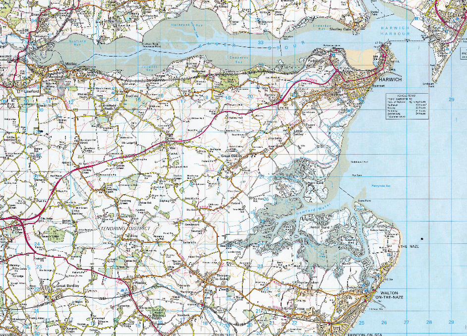
Contemporary landscapes are not a product of a single intention, but numerous converging processes. The traces of the changing views and treatments of landscape throughout history, influenced by social, economic and environmental changes – obsolete ancient infrastructures, traces of cultivation and old fortifications become part of modern landscapes, acquiring new meanings and uses. This study attempts to provide a portrait of a landscape, the Walton backwaters; a complex environment made through both endogenous and anthropogenic influences. Lewis BenmoreTRANSCRIPT

New Nature: A Shift ing ParadigmLewis Benmore
2
3
Contents
Introducti on
Environmental Positi on
Landscape Character
Explorati ve Mapping
Phenomenological Approach
The Desalinati on Plant
Conclusion
Appendix 1: Geomorphology
Bibliography
4
8
15
23
68
74
81
83
85
4
reintegrati on of the material and the spiritual, infl uencing poetry, art and music displaying a heightened sense of awareness to mans connecti on to nature. Consequently a pragmati c understanding of nature through developments in science and mathemati cs has enriched a poeti c and spiritual view of the natural world. Biese states that the “present intensity”…(1905) of the feeling for nature…“is due to the growth of science, for although feeling has become more realisti c and matt er-of-fact in these days of electricity and the microscope, love for nature has increased with knowledge.”2
In the 20th Century advances in science and technology allowed man a bett er understanding of the natural environment and the eff ect development was having on climate change as a result of exploiti ng natural resources in an unsustainable way. Ecologists have recently proposed a new ‘non equilibrium paradigm’ that states ecological systems are open and have multi ple pathways of change that are eff ected by process. The process includes both human and natural acti vity, creati ng disturbances that encourage the eco-system to adapt. 3
A symbioti c relati onship between man and nature is evident in almost all natural landscapes. The confl ict is most apparent in acti ve landscapes; this thesis will explore the coastal region around the Walton backwaters, an area of ti dal salt marshes and mudfl ats protected from the
‘Managed Landscape’- ‘Britain is a landscape altered by man. There is very litt le, if anything, that remains untouched and primiti ve within it, and its sense of place has been generated as much by the hand of man as by the way in which nature has responded to the management of the land.’ 1 Throughout history man has intervened with the land in order to live, farm and travel. The physical cooperati on with the natural environment is necessary to humankind’s survival while the symbolic relati onship represents a consciousness of our positi on within the ecosystem. This thesis investi gates how man relates to the environment through the process of building, dwelling and thinking.
Throughout the development of the modern world mans percepti on of nature has altered. Construing nature as a resource and applying to it all the latest scienti fi c and mathemati cal techniques has helped man to understand and control the natural world. In doing so, man has become disengaged with nature and the landscape. The spiritual world, characterized by imaginati on as opposed to reason, feeling rather than logic, has also become detached from the world of nature. In the early nineteenth century the Romanti cs believed that the emphasis on mathemati cs failed to recognize the richness of the natural world or the imaginati ve powers of human understanding. This led to a
Introducti on
1. Pearson, Dan. Spirit. UK: Murray & Sorrell FUEL, 2009. p23
2. Biese. The Development of the Feeling for Nature in the Middle Ages and Modern Times. UK: Hard Press Publishers, 2006. p357
3. Clarke.J. Nature in Questi on. UK: Earthscan Publicati ons, 1993. P12
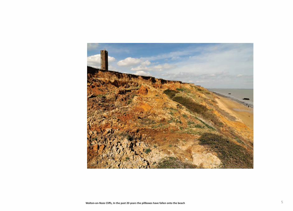
5Walton-on-Naze Cliff s, In the past 20 years the pillboxes have fallen onto the beach
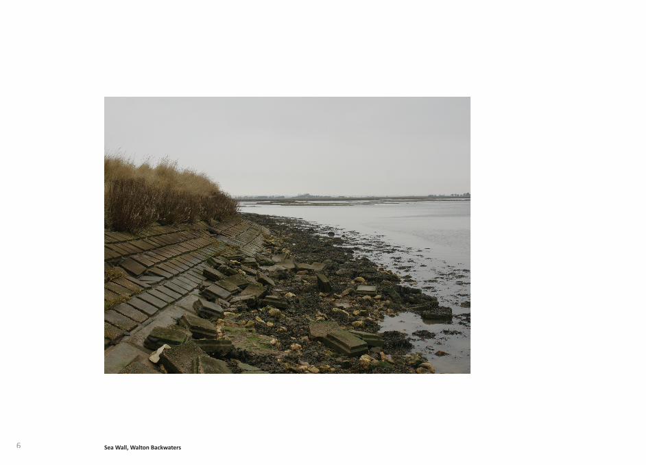
6 Sea Wall, Walton Backwaters
7
with the geomorphological processes that characterize the landscape, creati ng a symbioti c relati onship with nature and the spiritual roots of place and ti me. By engaging with the landscape the Desalinati on plant will att empt to render visible natural processes, challenging the romanti c idea of the ‘natural landscape’.
Contemporary landscapes are not a product of a single intenti on, but numerous converging processes. The traces of the changing views and treatments of landscape throughout history, infl uenced by social, economic and environmental changes – obsolete ancient infrastructures, traces of culti vati on and old forti fi cati ons become part of modern landscapes, acquiring new meanings and uses. This study att empts to provide a portrait of a landscape, the Walton backwaters; a complex environment made through both endogenous and anthropogenic infl uences.
Maps are used to analyse the landscape at Walton from an experienti al and cartographic perspecti ve, mapping is employed to gain an understanding of ‘place’. Using four ways to map as defi ned by Edward Casey (mapping of, mapping for, mapping with/in and mapping out) it is possible to explore the diff erent methods on a micro and macro scale, and how they change the percepti on of a landscape. Maps, a subject oft en explored by arti sts, can embody the
North Sea by a spit of land. The coastal region is a fragile and restless landscape, constantly in fl ux. For centuries man has adapted to this shift ing landscape however recently att empts have been made to control the natural process of erosion and preserve the landscape. It is only recently, in geological terms, that mankind has become disengaged with the land through the development of the built environment. The process of erosion along with the threat of a rising sea level leaves many coastal regions under threat.
“The disaster is not that the shoreline moves- the disaster is the fact that it is expected not to. The disaster is the percepti on of the land.” 4
The principles established in this thesis are expressed through a landscape management strategy, a series of structures that form a seawater desalinati on plant located in the ti dal backwaters north of Walton-on-Naze. As a precursor to the desalinati on plant, a smaller interventi on, a ti dal observatory, will investi gate how a structure can engage with the process of ti de and manipulate the percepti on of a fl uxing landscape. The desalinati on plant aims to re-establish a community within the fragile ecology that exists on the site, shaping how a culture evolves and challenge the disengagement between man and nature that exists. The physical manifestati on of the plant will engage
relati onship between man and nature. The research investi gates the Walton Backwaters with the intenti on to arrive at a more holisti c viewpoint, with specifi c reference to the pragmati c and the poeti c.
4. Kristi n Schuster. 306090 Landscape within Architecture. USA: Princeton Architectural Press, 2004. P167
Sea Wall, Walton Backwaters
8
change. The principal implicati ons of global warming in Essex are likely to be sea level rises, esti mated at 80cm by 2100 (6), threatening important coastal habitats through coastal squeeze and increasing the risk of fl ooding in low-lying areas. Along with sea level rise, isostati c post-glacial rebound is the term used to describe the ti lti ng of the Briti sh Isles. The ti lti ng is a result of Scotland’s mountain valleys rising steadily upwards due to them decompressing from the weight of melti ng ice caps. This rebound of Scotland is in turn pushing the South of England into the sea. The Environment Agency has been able to monitor and accurately measure this subsidence at a rate of 1-2mm per year. Rainfall levels will also change with winters expected to be 30% wett er and summer rainfall to decrease by up to 60% compared with current patt erns.
These environmental predicti ons suggest that whether in the near future or in the next century the landscape of the South of England will change drasti cally despite mans att empts to defend it. This creates an opportunity for architectural responses, that questi on how society and the built environment can evolve, exploring the relati onship between the man-made and the natural world.
The study considers the implicati ons of three approaches; defence, the structure will protect the fragile landscape,
In order to explore the relati onship between man and nature it is important to highlight the historical social developments and current views on the environment. J.J Clarke states:
“The dominant world-view of modern ti mes regards nature as a machine and human beings as isolated and fundamentally separate from nature, superior to and in some sense in charge of the rest of the natural world, and in competi ti on with each other, values arising solely from the needs and rights of human beings. In this world-view the mental and the material, the spiritual and the physical, are sharply divided from one another, with the mental and the spiritual realm completely excluded from the realm of nature, a view usually known as dualism.” 5
This view signifi es mans disengagement with nature, and a belief that we have a right to dominate and exploit nature. Clarke suggests that while we might be concerned with questi ons about the environment, this concern is wholly anthropocentric and does litt le to challenge the general world-view.
It is widely acknowledged that global climate change is inevitable, and that it is likely to have signifi cant physical impacts on the landscape. The South East region including Essex is parti cularly sensiti ve to the eff ects of climate
Environmental Positi on
5. Clarke.JJ. Nature in Questi on. UK: Earthscan Publicati ons Ltd, 1993. P12
6. Wigley and Raper, Thermal expansion of sea water. Nature 330. 1993. p127-131
9
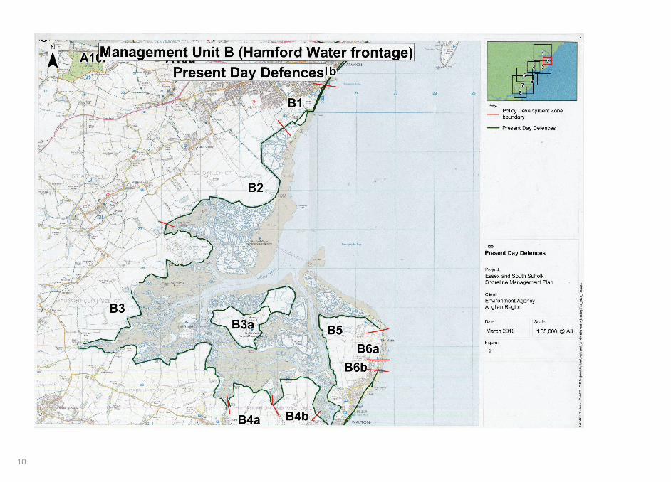
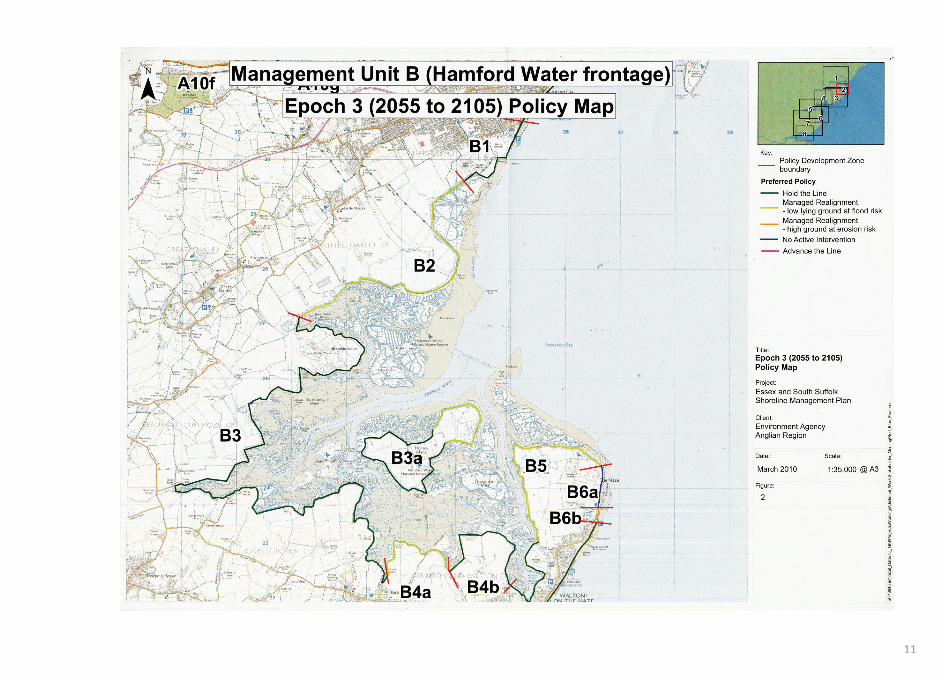
The strategy for defence contradicts the proposed shoreline management plans drawn up for the Essex coast by the Environment agency. The plan phases a managed retreat over 100 years according to sea level rise predicti ons. The existi ng sea wall is breached in places and maintained where the built environment requires. This method is more economically and environmentally sustainable. The land behind the breached sea wall then becomes salt marsh; a natural defence against the sea. Through absorbing the wave energy salt marsh can signifi cantly reduce the cost of sea defences further inland. An example of this managed retreat is already under way at Abbots hall farm, the 700-acre coastal farm aims to demonstrate how the recreati on of salt marsh can act as a more cost-effi cient, sustainable sea defence whilst supporti ng a rich ecology.
An adapt strategy is demonstrated by the RIBA Building Futures project ‘Living with water: vision of a fl ooded future’ by Paul Ruff and Glen Moorley. The project imagines infrastructural shift s for East London; which include school boats, preventi ng a disrupti on to a childs educati on during prolonged periods of fl ooding. Vast reservoirs that retain fl ood waters unti l levels go down, along with Archi-gram inspired ‘bolt on’ architecture, allowing people living in fl ood zones to increase fl oor area above ground level. This proposes an architectural fl exibility
maintaining existi ng sea defences; adapt, the built environment will allow erosion and sea level change to take place and simply adapt to the changing conditi ons, retreati ng inland; or att ack, new inhabited structures over the sea will be developed, allowing man to become independent of the land.
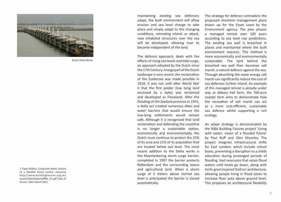
The defence approach, deals with the eff ects of rising sea levels and ti dal surge, an approach adopted by the Dutch since the 17th Century. A large part of the Dutch landscape is very recent, the reclamati on of the Zuiderzee was made possible in 1918, it was not unti l aft er World War II that the fi rst polder (low lying land enclosed by a dyke) was reclaimed and developed as Flevoland. Aft er the fl ooding of the Zeeland province in 1953, a delta act created numerous dikes and water barriers that would ensure the low-lying sett lements would remain safe. Although it is recognised that land reclamati on and defending the coastline is no longer a sustainable opti on, economically and environmentally, the Dutch must conti nue to protect the 25% of its area and 21% of its populati on that are located below sea level. The most recent additi on to the Delta works is the Maeslankering storm surge barrier; completed in 1997 the barrier protects Rott erdam and the surrounding towns and agricultural land. When a storm surge of 3 meters above normal sea level is anti cipated the barrier is closed automati cally.
7. Ewan Willars, Living with water, Visions of a fl ooded future (online resource) http://www.buildingfutures.org.uk/assets/downloads/pdffi le_57.pdf Date of Access: 10th March 2011
Dutch Delta Works
10
11
12
(1947), a professor at Delft University is developing a stabilizing platf orm that will allow communiti es to live comfortably on the sea. He expects that due to high density on land and the threat of rising sea level, man will colonize the live and work on the platf orm by 2020.
as an alternati ve to hard fl ood defences.
A more ambiti ous conceptual approach to adapt is explored in the project ‘Retreati ng Village’ by Architectural fi rm Smout Allen. The project is a response to the erosion of a coastal shoreline where the village of Happisburgh in Norfolk, formerly located inland is at risk of falling into the sea. The proposal sees the village mounted on rails of “steel and concrete” that allow each house to be dragged across the landscape”. The houses become machines, att ached to devices that mimic techniques for hauling boats from the sea, allowing them to retreat further inland. “The village is slipped, dragged, and rotated by a mechanism of anchors, ground beams, and concreted arcs” with each house “manipulated by no fewer than three pulleys that are anchored in the landscape”8. The project adopts an architectural language of impermanence that complements and contributes to the nature of the restless landscape.
The att ack approach is realized in the Netherlands where constructi on fi rm Dura Vermeer has built a development of ‘amphibious’ houses fl oati ng on the River Meuse in Holland. Each house is moored to a metal pole and sits on a set of hollow concrete pontoons. When the river fl oods the houses respond by fl oati ng, as the water recedes the house will lower back down. Taking the concept of att ack further, Frits Schoute
8. Smout, Mark. Augmented Landscapes. NY: Princeton Architectural Press, 2007. P72
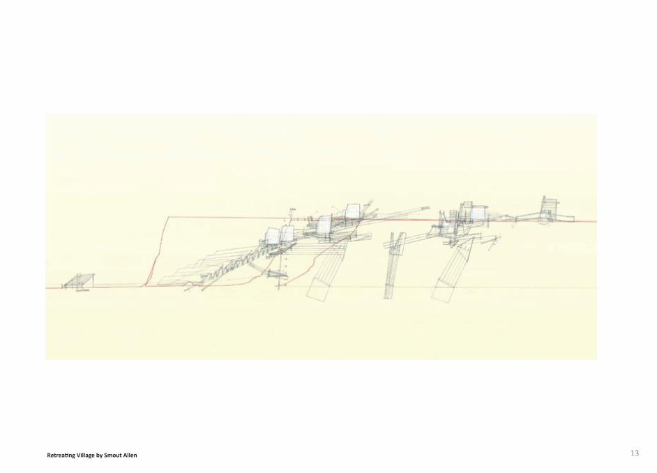
13Retreati ng Village by Smout Allen
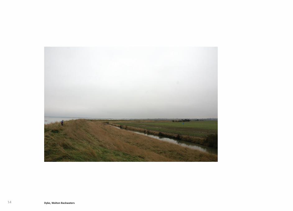
14 Dyke, Walton Backwaters
15
were already living in most parts of Essex. Evidence from what were dry-land sites along the coast suggest that communiti es at this ti me were mobile, undoubtedly exploiti ng resources from the sea, as well as the land, vulnerable coastal sett lements were abandoned each year.
Populati on and sett lement during the Iron Age (800-50 BC) and Roman periods (44BC-500AD), gradually increased, with resulti ng pressure on land, agriculture intensifi ed and deforestati on transformed the landscape. Essex’s coast, close to Europe, made it vulnerable to invasion from across the channel. From Roman ti mes to the twenti eth century there is evidence of military defence along the coast, an early example is the Roman fort of Bradwell on sea. In post-medieval ti mes Martello towers were constructed, imposing structures standing out over the low lying marshlands. Forti fi cati ons between Point Clear and Harwich were crucial during the invasion of Napoleon. Second World War pillboxes are located along the sea wall at pivotal access points between the marshland and the surrounding sett lements. These monolithic concrete structures, although no longer in use, observe the shift ing landscape. Built into the sea wall the low-lying pillboxes sit in harmony with the horizontal mudfl ats.
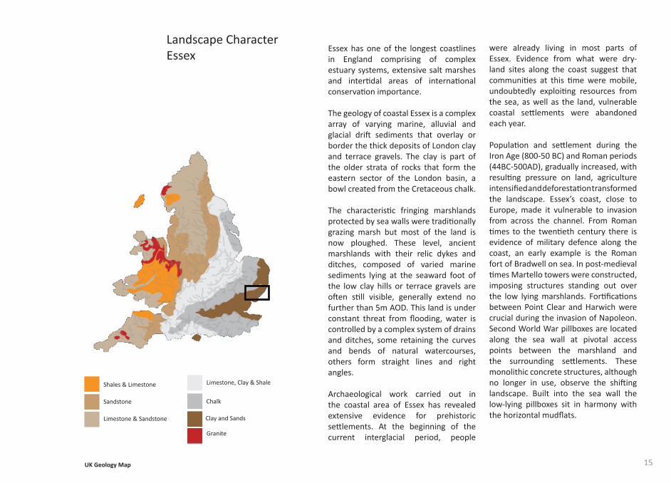
Essex has one of the longest coastlines in England comprising of complex estuary systems, extensive salt marshes and interti dal areas of internati onal conservati on importance.
The geology of coastal Essex is a complex array of varying marine, alluvial and glacial drift sediments that overlay or border the thick deposits of London clay and terrace gravels. The clay is part of the older strata of rocks that form the eastern sector of the London basin, a bowl created from the Cretaceous chalk.
The characteristi c fringing marshlands protected by sea walls were traditi onally grazing marsh but most of the land is now ploughed. These level, ancient marshlands with their relic dykes and ditches, composed of varied marine sediments lying at the seaward foot of the low clay hills or terrace gravels are oft en sti ll visible, generally extend no further than 5m AOD. This land is under constant threat from fl ooding, water is controlled by a complex system of drains and ditches, some retaining the curves and bends of natural watercourses, others form straight lines and right angles.
Archaeological work carried out in the coastal area of Essex has revealed extensive evidence for prehistoric sett lements. At the beginning of the current interglacial period, people
Landscape CharacterEssex
Shales & Limestone
Sandstone
Limestone & Sandstone
Limestone, Clay & Shale
Chalk
Clay and Sands
Granite
UK Geology Map
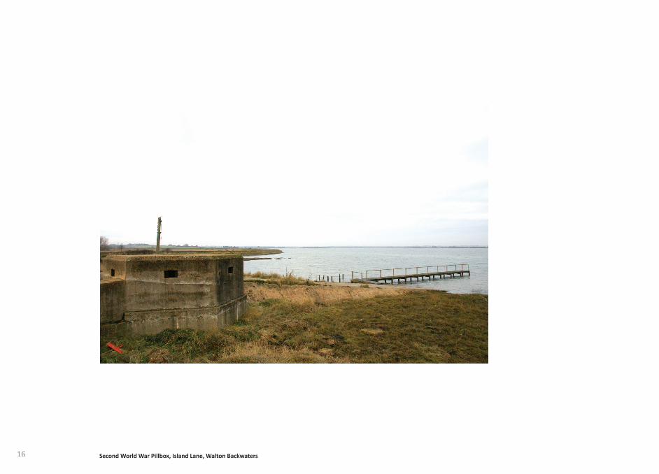
16 Second World War Pillbox, Island Lane, Walton Backwaters
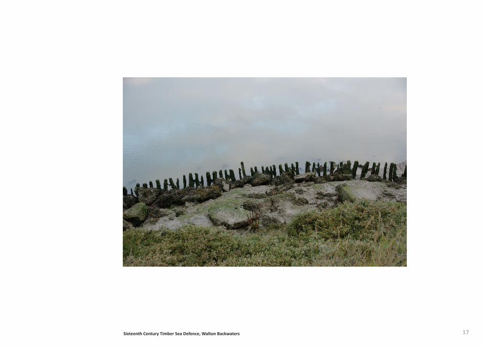
17Sixteenth Century Timber Sea Defence, Walton Backwaters
18
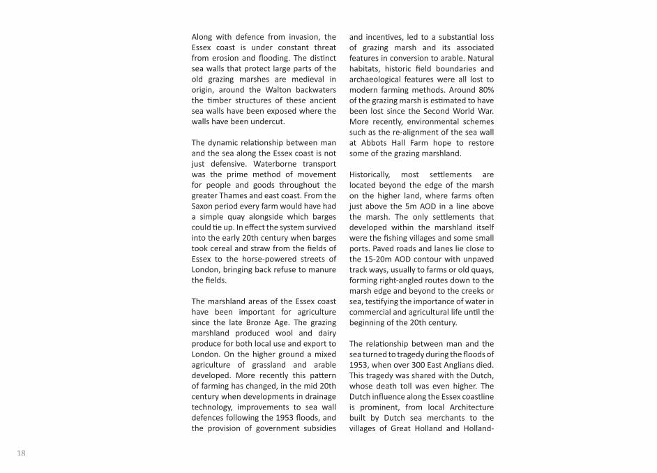
and incenti ves, led to a substanti al loss of grazing marsh and its associated features in conversion to arable. Natural habitats, historic fi eld boundaries and archaeological features were all lost to modern farming methods. Around 80% of the grazing marsh is esti mated to have been lost since the Second World War. More recently, environmental schemes such as the re-alignment of the sea wall at Abbots Hall Farm hope to restore some of the grazing marshland.
Historically, most sett lements are located beyond the edge of the marsh on the higher land, where farms oft en just above the 5m AOD in a line above the marsh. The only sett lements that developed within the marshland itself were the fi shing villages and some small ports. Paved roads and lanes lie close to the 15-20m AOD contour with unpaved track ways, usually to farms or old quays, forming right-angled routes down to the marsh edge and beyond to the creeks or sea, testi fying the importance of water in commercial and agricultural life unti l the beginning of the 20th century.
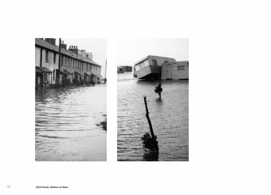
The relati onship between man and the sea turned to tragedy during the fl oods of 1953, when over 300 East Anglians died. This tragedy was shared with the Dutch, whose death toll was even higher. The Dutch infl uence along the Essex coastline is prominent, from local Architecture built by Dutch sea merchants to the villages of Great Holland and Holland-
Along with defence from invasion, the Essex coast is under constant threat from erosion and fl ooding. The disti nct sea walls that protect large parts of the old grazing marshes are medieval in origin, around the Walton backwaters the ti mber structures of these ancient sea walls have been exposed where the walls have been undercut.
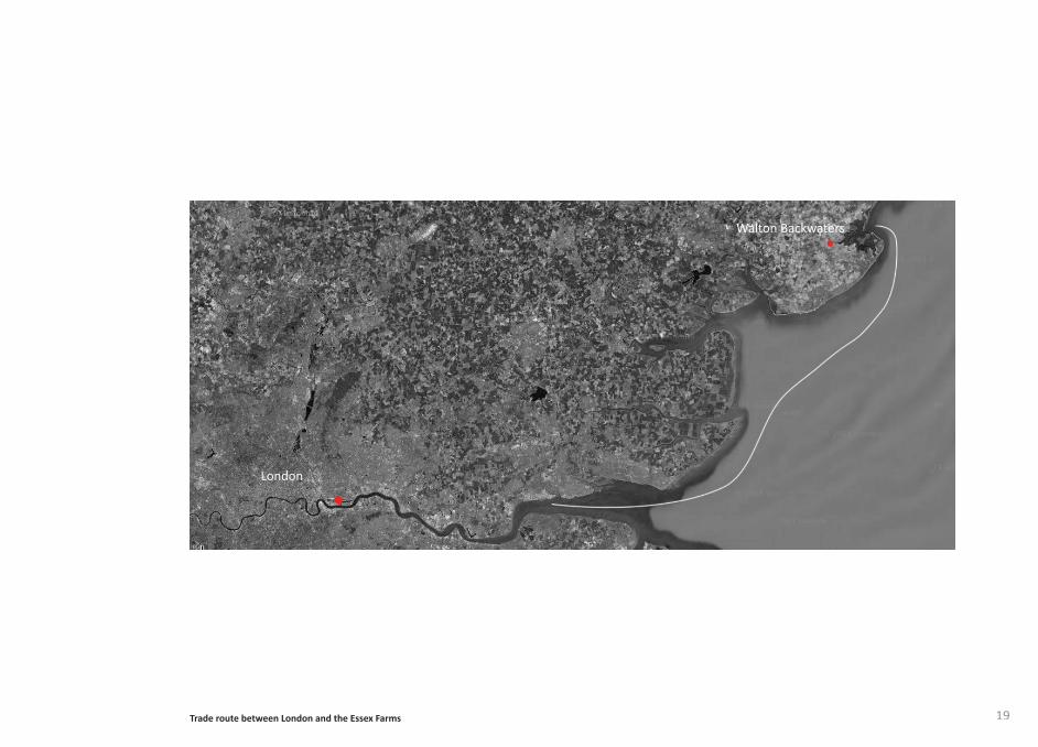
The dynamic relati onship between man and the sea along the Essex coast is not just defensive. Waterborne transport was the prime method of movement for people and goods throughout the greater Thames and east coast. From the Saxon period every farm would have had a simple quay alongside which barges could ti e up. In eff ect the system survived into the early 20th century when barges took cereal and straw from the fi elds of Essex to the horse-powered streets of London, bringing back refuse to manure the fi elds.
The marshland areas of the Essex coast have been important for agriculture since the late Bronze Age. The grazing marshland produced wool and dairy produce for both local use and export to London. On the higher ground a mixed agriculture of grassland and arable developed. More recently this patt ern of farming has changed, in the mid 20th century when developments in drainage technology, improvements to sea wall defences following the 1953 fl oods, and the provision of government subsidies
19
Walton Backwaters
London
Trade route between London and the Essex Farms
20 1953 Floods, Walton-on-Naze
21
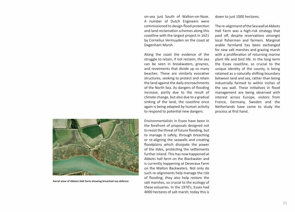
down to just 1000 hectares.
The re-alignment of the Sea wall at Abbots Hall Farm was a high-risk strategy that paid off , despite reservati ons amongst local fi sherman and farmers. Marginal arable farmland has been exchanged for new salt marshes and grazing marsh with a proliferati on of returning marine plant life and bird life. In the long term the Essex coastline, so crucial to the unique identi ty of the county, is being retained as a naturally shift ing boundary between land and sea, rather than being industrially farmed to within inches of the sea wall. These initi ati ves in fl ood management are being observed with interest across Europe, visitors from France, Germany, Sweden and the Netherlands have come to study the process at fi rst hand.
on-sea just South of Walton-on-Naze. A number of Dutch Engineers were commissioned to design fl ood protecti on and land reclamati on schemes along this coastline with the largest project in 1621 by Cornelius Vermuyden on the coast at Dagenham Marsh.
Along the coast the evidence of the struggle to retain, if not reclaim, the sea can be seen in breakwaters, groynes, and revetments that divide up so many beaches. These are similarly evocati ve structures, seeking to protect and retain the land against the daily encroachments of the North Sea. As dangers of fl ooding increase, partly due to the result of climate change, but also due to a gradual sinking of the land, the coastline once again is being adapted by human acti vity to respond to potenti al new dangers.
Environmentalists in Essex have been in the forefront of proposals designed not to resist the threat of future fl ooding, but to manage it safely, through breaching or re-aligning the seawalls and creati ng fl oodplains which dissipate the power of the ti des, protecti ng the sett lements further inland. This has now happened at Abbots hall farm on the Blackwater and is currently happening at Deveraux Farm on the Walton Backwaters. Not only do such re-alignments help manage the risk of fl ooding; they also help restore the salt marshes, so crucial to the ecology of these estuaries. In the 1970’s, Essex had 4000 hectares of salt marsh; today this is
Aerial view of Abbots Hall Farm showing breached sea defence
22
23
the photograph presents a stronger impression of the character of the landscape. Maps and aerial photographs capture a landscape at a specifi c point in ti me but both fail to depict the constant changes.
Lars Kordetzky states “The unpredictable cannot be decoded, real places are never on a map, they keep updati ng themselves, and they are the diff erence of diff erence ceaseless transformati on, constant disintegrati on and renewal. Real places proceed in infi nite movement.” 10
It is possible with the use of satellite imagery to conti nuously update a map, with the use of sensors it is possible to measure movements, tremors, diff erences in pressure and temperature, these are recorded and compiled in ephemeral maps. These maps relay data from a past event, however they do not provide informati on on possible events that will occur in the future.
In the past 50 years cartographers have used air photography as a way of surveying the land. An air photograph however depending on the angle it was taken distorts the landscape. The science of photogrammetry, which is concerned with the making of maps from measurements taken from air photographs, has developed from the need to remove these distorti ons of shape.
“Maps are graphic representati ons that facilitate a spati al understanding of things, concepts, conditi ons, processes, or events in the human world” 9
Man’s relati onship with the land in which he dwells has been represented through various forms of maps for centuries. From early impressionist landscape painti ng to modern cartography and O.S maps, each aims to depict features within a place that characterise it. Landscape painti ng as a form of map derived from mans need to control the land, it was an expression of power and wealth. Similarly cartography has developed as man’s uti lizati on of the world’s resources has increased, he has sought to control them as well as use them. The Ordnance survey was fi rst established in 1791 and aimed at mapping the whole of Britain in one scale with a uniformity that could be read by anyone, developed by the army the map has a recognisable style and illustrates parti cular elements within the landscape.
By their very nature, Ordnance survey maps fail to portray the experienti al character of the landscape and topography. To gain a bett er understanding of the landscape aerial photographs or satellite images can be used. An aerial photograph could be argued to be more accurate than an Ordnance survey map. Simply by the level of detail, materiality and texture,
Explorati ve Mapping
9. Harley. J.B, History of Cartography, 1987:xvi
10. (Kordetzky.L, Transient Sedimentati on, 2006:12)
24
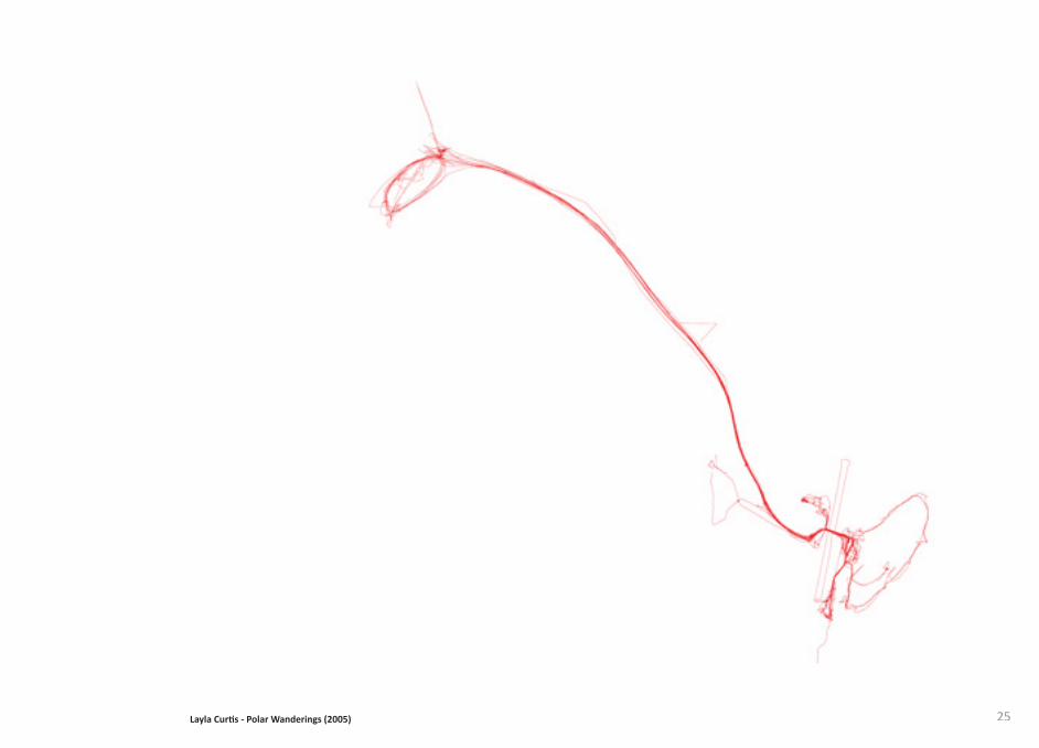
with scienti sts. She used GPS tracking equipment that recorded her whereabouts every few seconds. The GPS recorded her locati on and the resultant drawings are performati ve, relaying Curti s’ experience as imaginary lines. The lines describe diff erent journeys that Curti s takes throughout the three months, daily trips become repeated lines and special journeys are depicted by long solitary lines. The established paths, roads and architecture of the base camp along with the geography of the landscape defi ne the journeys Curti s takes; these characteristi cs become manifested in the lines.
Tim Abrahams describes the act of mapping as ‘disengaged’. The use of satellite images and digital surveying means modern cartographers are not required to experience the landscape fi rst hand in order to record it. This suggests a map depicts ‘site’ rather than ‘place’. In order to gain a bett er sense of place other methods of mapping need to be explored. Arti sts such as Richard Long and Layla Curti s navigate the space between cogniti ve mapping and Cartesian coordinates to consider mapping in terms of permanence, impermanence, identi ty of place, human emoti on and creati ve expression.
Richard Long explores the cogniti ve and the Cartesian through the act of walking, believing that walking - as art - provides an ideal means to explore relati onships between ti me, distance, geography and measurement.
“I create walks and land-based sculptures as a way of inhabiti ng the rich territory between two ideological positi ons, namely that of making ‘monuments’ or conversely, of ‘leaving only footprints’.” 11
Long’s use of words, photographs and installati ons record a journey and portray the experience to the viewer in the gallery.
The arti st Layla Curti s created maps of Antarcti ca during an expediti on
11. Long.R, Heaven and Earth, 2009:146
25Layla Curti s - Polar Wanderings (2005)
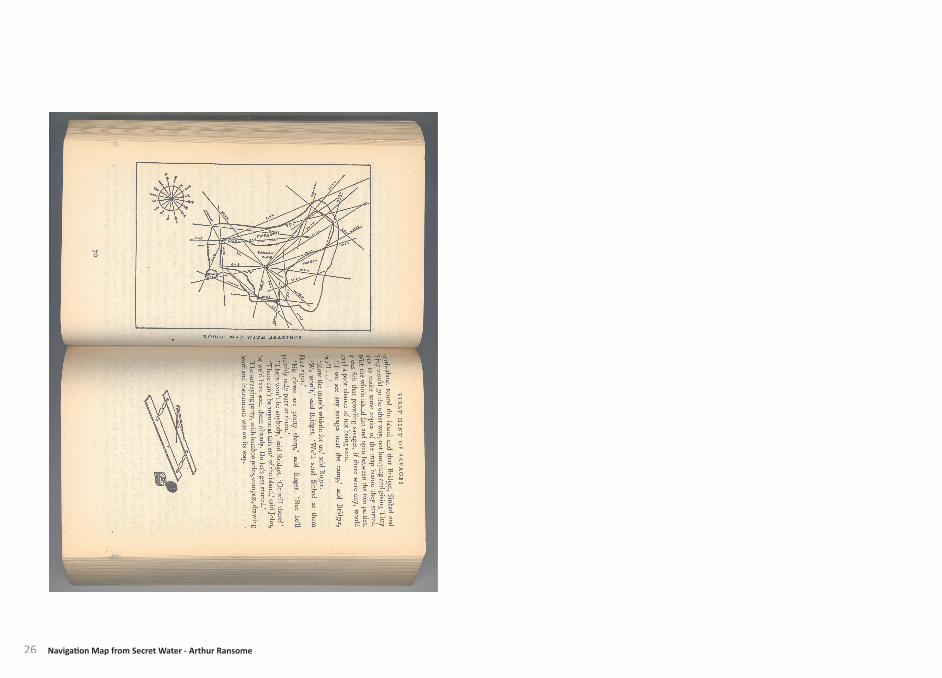
26 Navigati on Map from Secret Water - Arthur Ransome
27
that depicts a changing landscape, unlike an O.S map or an aerial photograph that captures a specifi c moment in ti me.
Mapping with/in is concerned with the experience of place. Rather than an indicati ve map, the aim is to portray how it feels to be in a specifi c locale. Arti st Nigel Peake creates maps through the memory and experience of place. The maps become poeti c ‘fi cti onal reality’. He uses pen and ink to describe patt ern and texture and he uses text to represent the narrati ve of place. “Nigel’s maps are playful, evocati ve and humane.” 12
Arthur Ransom’s Secret Water is a story of fi ve children marooned on an island in the Walton Backwaters, with basic provisions, a compass and a blank map, their challenge is to explore and map the islands. The blank map is given to the children for them to fi ll in as they discover a place; the place is then named by its salient features or by a memory or event that happened there. Before they begin to explore the islands they start by orientati ng themselves in the landscape using the bearings on the compass. This method of mapping is similar to early cartographic techniques; the use of triangulati on was used in order to positi on elements in the landscape accurately. Since the measuring of angles was more accurate than lengths it is possible to map a point, fi xed by intersecti on from two other points whose relati ve positi on are known.
The four ways to map as defi ned by Edward Casey include mapping of, mapping for, mapping with/in and mapping out.
Mapping of can be used to describe the O.S map, to map a parti cular place or territory in the eff ort to capture its exact geography and structure. The science of Cartography in this form represents disengagement with specifi c locales of place and topography.
Mapping for a specifi c purpose, rather than being cartographically accurate. These maps indicate how to get to a specifi c locati on in relati on to where the viewer is standing as they read the map itself. An early example being the ‘Strip Maps’ drawn in 1675 by John Ogilby, these were based on a survey of all the main roads in the United Kingdom. The maps show suffi cient informati on to guide travellers along roads and are in half plan, half pictorial style. Another defi niti on includes mapping for the specifi c purpose of predicti ng the future changes in the landscape, this can be done through understanding the natural and man-made processes that take place and by observing how the landscape changed due to these processes in the past. These long and short-term processes can be recorded and measured; creati ng an ephemeral ‘map’
Using Maps to explore ‘Place’
12. Abraham.T, Maps, 2009:13
28
The Nonsites highlight a tension between the outdoors and indoors, and were examples of Smithson’s explorati ons into site, displacement and locati on. The displaced material refers the viewer back to the site where the materials were originally collected.
“My non-sites in a sense are like large, abstract maps made into three dimensions. You are thrown back on the site.” 13
The fi rst two types of mapping are concerned with the scienti fi c act of cartography and orientati on whereas the two last methods are concerned with the experienti al and emoti ve relati onship with the land. In order to use mapping as a tool to gain a greater understanding of place these methods will be applied to the Walton Backwaters and their relevance will be discussed.
Details surveyed on the landscape were then sketched in relati on to the points. In the case of Secret Water it was their experiences that were mapped.
Mapping out is to immerse oneself in the landscape, once in the landscape, boundaries that appear in cartographic maps become porous. In order to express this experience it is important to take yourself out of the landscape and represent this immersion through a format that moves others in signifi cantly similar ways to the ways in which you been moved by being in a parti cular landscape.
Land arti sts such as Richard Long and Robert Smithson were among the fi rst to bring the experience of landscape into a gallery. Moving away from the pictorial, they aimed to create a diagrammati c representati on of landscape, more material than visual. Whether like Long through photographs and text or like Smithson who went further by creati ng his ‘Non Sites’ (indoor earthworks). A Non Site – Pine Barrens, New Jersey, was Smithson’s fi rst Non Site. The disrupted state of the site appealed to him, he was looking for a denaturalisati on rather than a scenic beauty. The Non Site acts as a map rather than a picture; it was constructed from natural materials he chose from remote, unpopulated areas. The materials from the site were brought into the gallery and placed alongside an Ordnance Survey map.
13. Smithson.R, The Collected Writi ngs, 1996:181
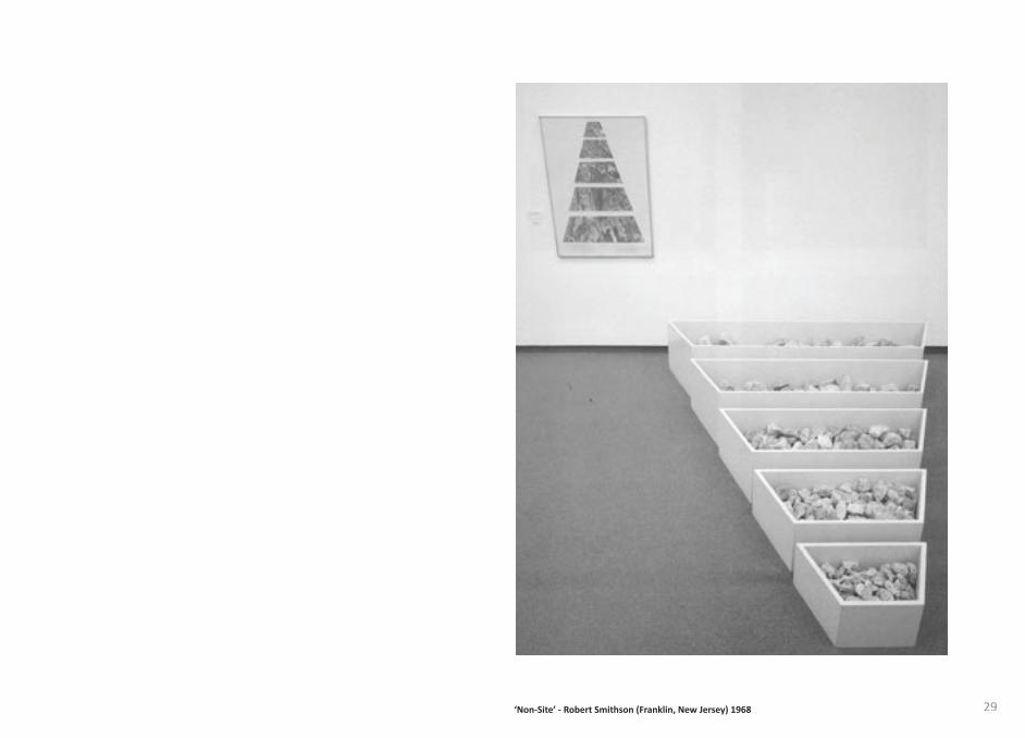
29‘Non-Site’ - Robert Smithson (Franklin, New Jersey) 1968
30
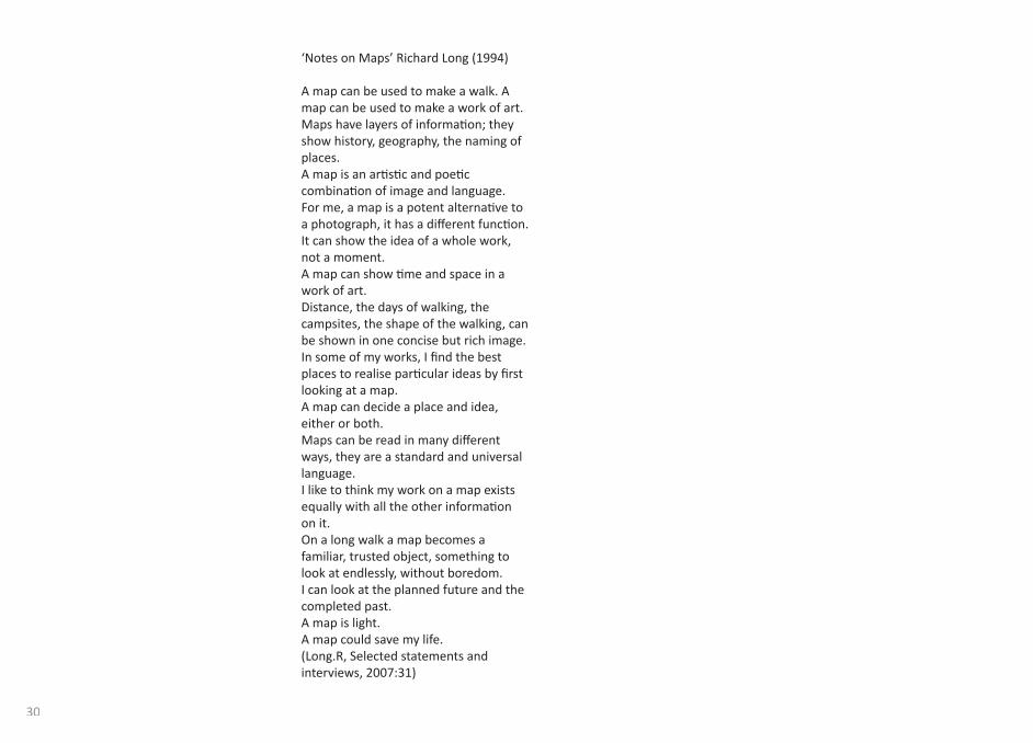
‘Notes on Maps’ Richard Long (1994)
A map can be used to make a walk. A map can be used to make a work of art.Maps have layers of informati on; they show history, geography, the naming of places.A map is an arti sti c and poeti c combinati on of image and language.For me, a map is a potent alternati ve to a photograph, it has a diff erent functi on.It can show the idea of a whole work, not a moment.A map can show ti me and space in a work of art.Distance, the days of walking, the campsites, the shape of the walking, can be shown in one concise but rich image.In some of my works, I fi nd the best places to realise parti cular ideas by fi rst looking at a map.A map can decide a place and idea, either or both. Maps can be read in many diff erent ways, they are a standard and universal language. I like to think my work on a map exists equally with all the other informati on on it.On a long walk a map becomes a familiar, trusted object, something to look at endlessly, without boredom. I can look at the planned future and the completed past.A map is light.A map could save my life.(Long.R, Selected statements and interviews, 2007:31)
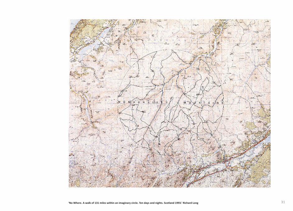
31‘No Where. A walk of 131 miles within an imaginary circle. Ten days and nights. Scotland 1993.’ Richard Long
32
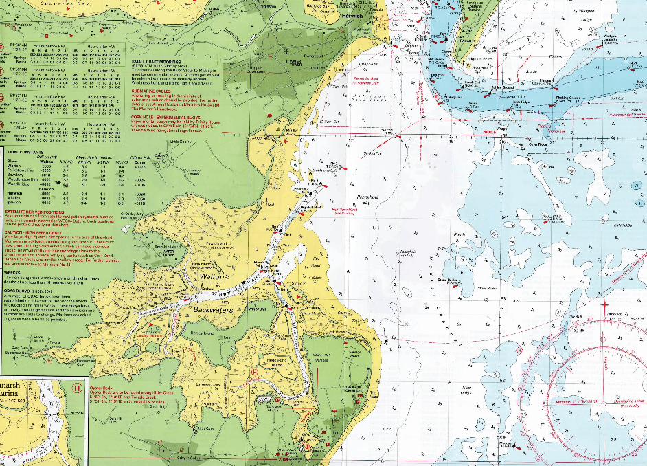
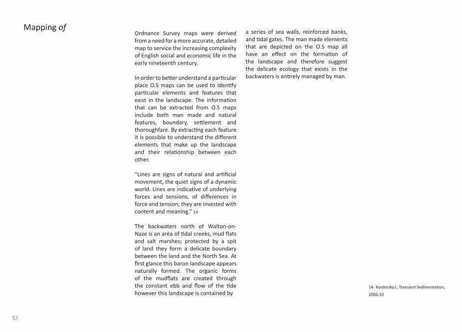
a series of sea walls, reinforced banks, and ti dal gates. The man made elements that are depicted on the O.S map all have an eff ect on the formati on of the landscape and therefore suggest the delicate ecology that exists in the backwaters is enti rely managed by man.
Ordnance Survey maps were derived from a need for a more accurate, detailed map to service the increasing complexity of English social and economic life in the early nineteenth century.
In order to bett er understand a parti cular place O.S maps can be used to identi fy parti cular elements and features that exist in the landscape. The informati on that can be extracted from O.S maps include both man made and natural features, boundary, sett lement and thoroughfare. By extracti ng each feature it is possible to understand the diff erent elements that make up the landscape and their relati onship between each other.
“Lines are signs of natural and arti fi cial movement, the quiet signs of a dynamic world. Lines are indicati ve of underlying forces and tensions, of diff erences in force and tension; they are invested with content and meaning.” 14
The backwaters north of Walton-on-Naze is an area of ti dal creeks, mud fl ats and salt marshes; protected by a spit of land they form a delicate boundary between the land and the North Sea. At fi rst glance this baron landscape appears naturally formed. The organic forms of the mudfl ats are created through the constant ebb and fl ow of the ti de however this landscape is contained by
Mapping of
14. Kordetzky.L, Transient Sedimentati on,
2006:10
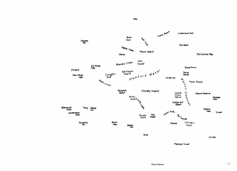
47Place Names
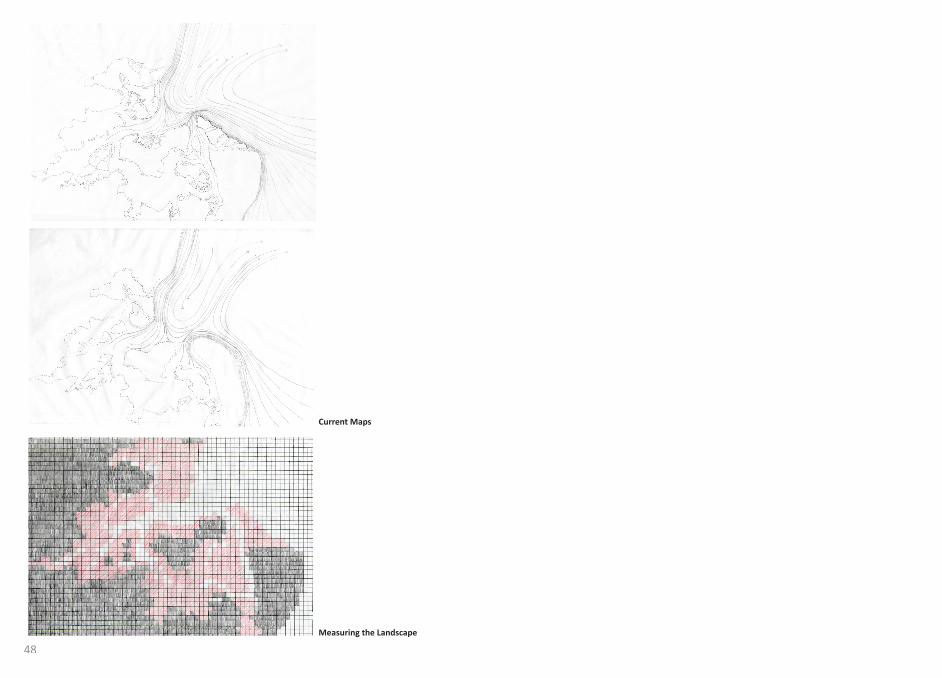
48Measuring the Landscape
Current Maps
49
long term, through reclamati on of land and rising sea levels. Any interventi on will have an impact on the landscapes character, in order to measure this impact a grid is employed. By laying a grid over the landscape it is possible to measure the percentage of each element. This can then be used to record the changing structure of the landscape through ti me. The grid is drawn on tracing paper; 5mm squares ensure that the grid can be accurate in relati on to the scale of the map. The inaccuracy in applying this method arises when squares are only parti ally occupied. This problem is overcome by counti ng the squares that are more than half full, ignoring the remainder.
The results at low ti de: Managed Land 44.7% Mudfl ats 26.9% Water 28.3%
By measuring the three elements an abstract map is created, the landscape becomes a solid element, a built form. The organic forms of mud are no longer visible. Placing a grid over the landscape suggests the dependence geometry has on the planet and the resistance of earth itself to explicit cartographic representati on.
Coastal landscapes are in constant fl ux, to gain an understanding of place it is important to understand the geographical processes that have formed and are impacti ng on the landscape.
Man is in constant batt le with the forces of the sea. The North Sea currents that exist off the coast of Walton-on-Naze are changing land through the process of erosion. In order to predict how the landscape might change, land erosion needs to be understood. The eff ect of two converging currents, from the North Sea and the English Channel are represented through a current map, solid lines depict the directi on of the strong currents reforming the land by the North Shore Drift , the land is shown as a fragile dott ed line constantly changing. In comparison to O.S maps the current maps, presented as a series, represent the relati onship between the diff erent elements over a certain ti me period.
Measuring the character of a landscape is described in the Phenomenology of Architecture. “Through the interacti on of surface relief, vegetati on and water, characteristi c totaliti es or places are formed which consti tute the basic elements of landscape.” 15
The elements that make the Walton Backwaters include the managed land, the inaccessible mud fl ats and the ti dal creeks. Each element changes on a daily basis through the ti dal movement and
Mapping for
15. Schulz.C, Genius Loci: Towards a Phenomenology of Architecture, 1991:30
50
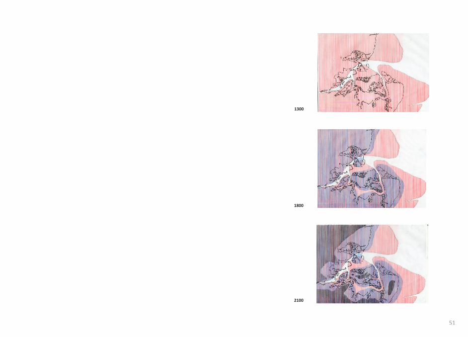
Using historical maps it is possible to trace the changing landscape. A map from 1300, 1800 and 2000 are overlaid to show how the landscape has changed over ti me. Humanity has been adapti ng through history to a fragile landscape. The predicted rise in sea levels and coastal erosion allows us to imagine what the landscape will be like in 100 years. This method can illustrate the impact on local communiti es, towns and farmland lost to the sea. This is speculati ve and cannot accurately indicate the impact further sea defenses might have or how intervening in a landscape might eff ect its appearance and form.
51
1300
1800
2100
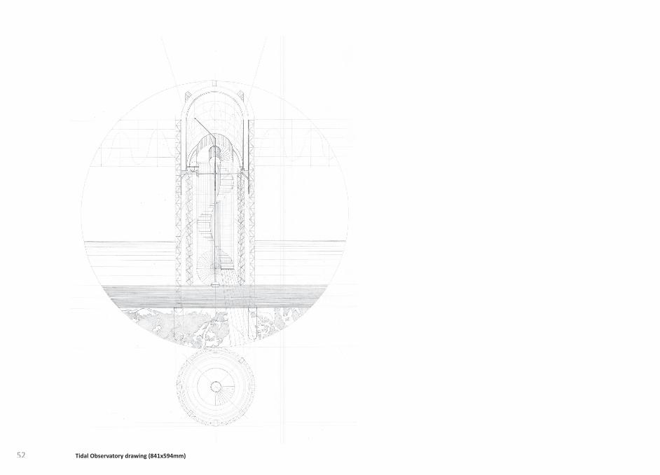
52 Tidal Observatory drawing (841x594mm)
53
the connecti on between the sea and lunar acti vity.
The observatory sets up a relati onship with other landmarks seen on the horizon; it becomes a tool for positi oning oneself in a fl at expansive landscape.
In 1953 a ti dal surge in the North Sea caused one of the most devastati ng natural disasters ever recorded in the UK. Events like this demonstrate nature’s strength, it is important for people to re-engage with the landscape and the processes that eff ect their environment.
As a monument for the 1953 fl oods the ti dal observatory is a device for recording the traces of the ti de. Similar to the Munro Gauge the ti dal observatory produces sea level elevati ons, recording coastal processes; ti dal response, storm surge behaviour and the rise in sea level. The ebb and fl ow of the ti de draws lines, the rhythmic forces are recorded becoming a map that periodically highlights the instability of nature.
The observatory portrays a landscape in fl ux on a daily basis as the ti dal elevati on is scribed into the metal drum that forms the top of the tower. The lightweight skeletal frame exposes the user to the environment; with a feeling of impermanence the tower touches the mudfl at lightly allowing a conti nual movement of silt. The rigid structure sits on the ever-changing landscape emphasising the movement of the ti de. The spiral staircase off ers a 360° view of the landscape, as the user ascends up into the observatory drum; the line of the ti dal elevati on replaces the horizon. The fl oor and the roof are open, emphasising
Tidal Observatory
54
derived from mans desire to control the land, it was an expression of power and wealth. Where maps and cartography were developed to depict the enti re world from a new perspecti ve, landscape painti ng remains regional and oft en depicts ‘place’ in a local sense. The term ‘Landscape’ fi rst entered the English language from the Netherlands in the 16th Century, at the ti me when the Dutch were acti vely reclaiming land with new engineering methods for drainage. ‘Landschap’, like the German ‘Landschaft ’, meant both a place where people lived, as well as a pleasing object.
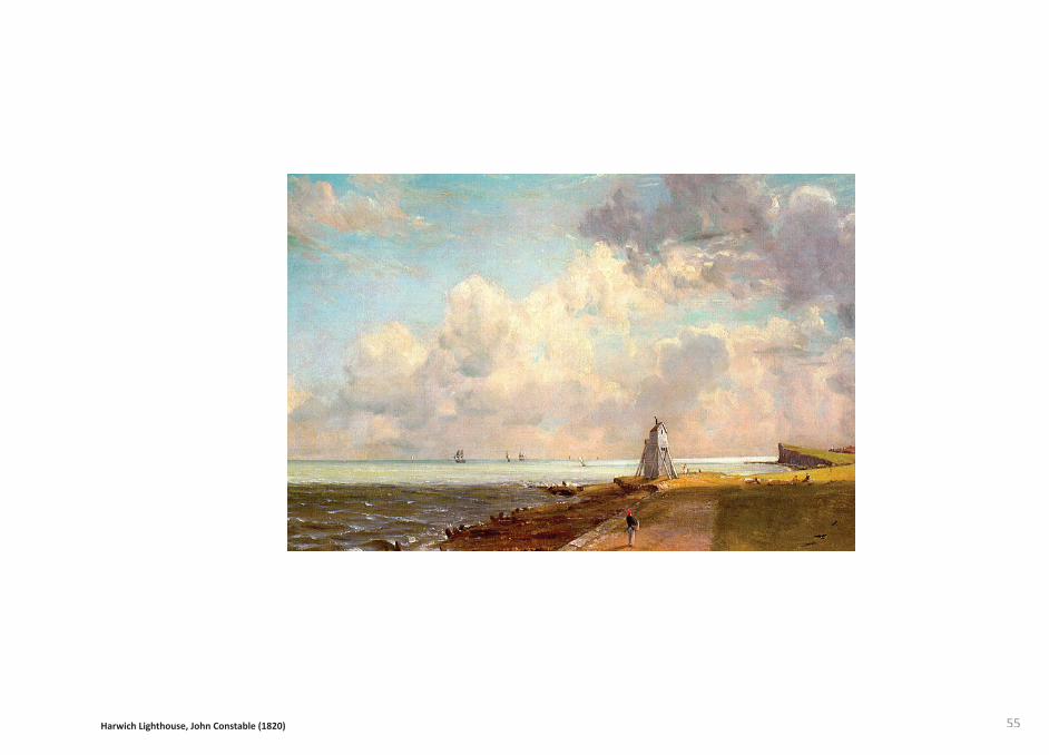
The landscape painti ngs by John Constable depict the picturesque region surrounding the Stour Valley on the Essex/Suff olk border. By concentrati ng on the characteristi cs of the region and understanding the elements of land, sky and water that impact on the landscape, Constable gained an inti mate knowledge of the region. This deep understanding of the landscape and a parti cular technique meant Constable was successful in capturing a sense of ‘place’.
The drawing of the backwaters describes a place in ti me and its form, atmosphere and texture that are otherwise ignored in conventi onal cartographic maps. Similar to the traced map the process of drawing forces a stronger engagement with the landscape than simply observing a photograph.
A satellite image can be understood as a more honest representati on of a landscape than an O.S map. Although not as useful for orientati ng oneself in relati on to specifi c features, the satellite image has a diff erent purpose, it is capturing the landscape at a certain moment in ti me. By drawing this image a bett er understanding of form, process, texture and boundary can be achieved. The process of drawing forces a considered representati on of details and characteristi cs that O.S maps do not include. However, due to the perspecti ve, an aerial photograph removes the infi nite sense of landscape created by the horizon line and the sense of ti me and scale. Translati ng the photograph into a drawing abstracts the sense of place; it is therefore more the process of the drawing/tracing rather than the outcome that leads to a bett er understanding of ‘place’.
Robert Smithson discusses aerial photography, “The landscape begins to look more like a three dimensional map than a rusti c garden. Aerial Photography and air transportati on bring into view the surface features of this shift ing world of perspecti ves...The world seen from the air is abstract and illusive.”16
Drawing the landscape
Landscape painti ng as a form of mapping
Mapping with/in
16. Smithson.R, The Collected Writi ngs, 1996:130
55Harwich Lighthouse, John Constable (1820)

56
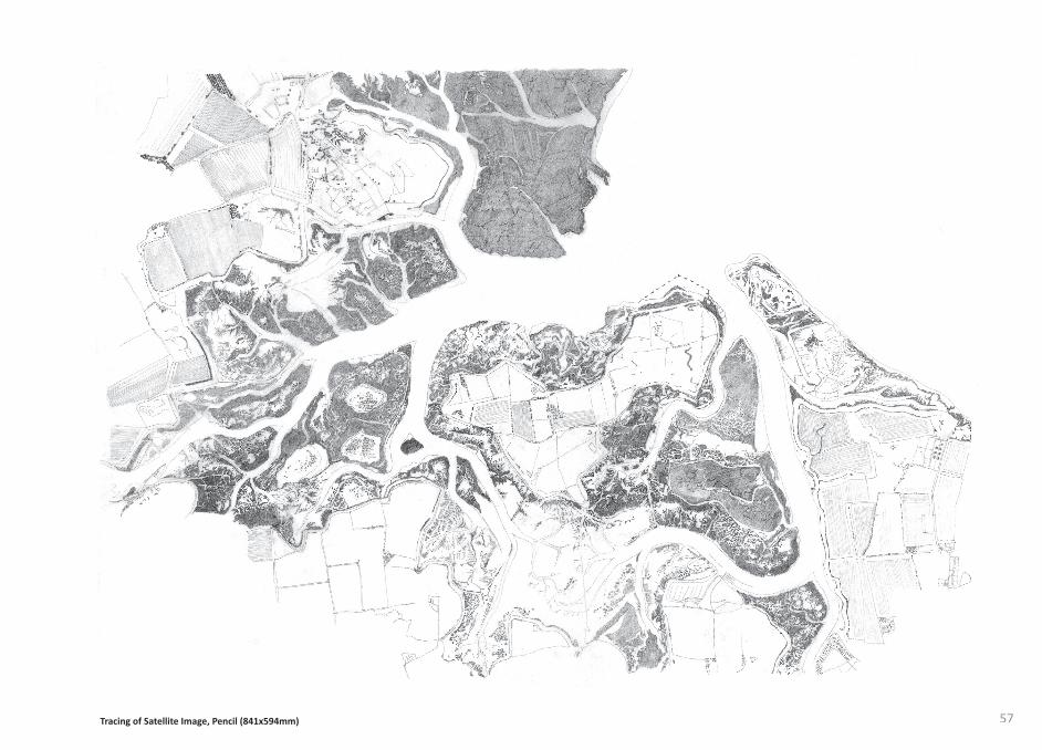
57Tracing of Satellite Image, Pencil (841x594mm)

58
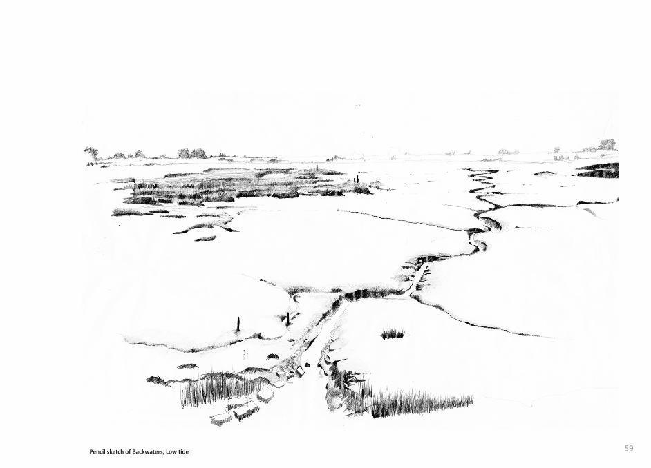
Pencil sketch of Backwaters, Low ti de 59
60
The airti ght jars create a physical barrier between the viewer and the landscape; this separati on symbolises man’s disengagement with the landscape.
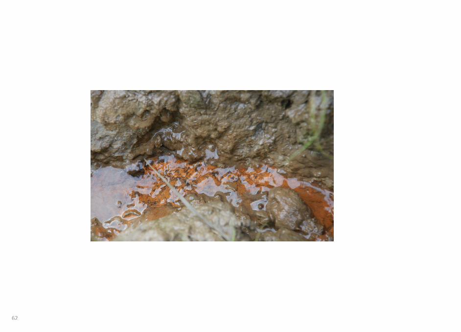
Collecti ng the landscape
In order to represent the materiality of the Walton backwaters samples of the earth are collected. The changing state of the earth from mudfl at to culti vated arable farmland characterises the landscape. The state of the earth also dictates the route through the landscape, the mudfl at being inaccessible and the sea wall path having a harder surface more suitable for walking.
Collecti ng a sample of the landscape is similar to Robert Smithson’s ‘Non Site’, the samples are then placed in a preserving Jar. The displaced material is then identi fi ed with a coordinate from the locati on it was collected. The coordinate creates a reference to the conventi onal cartographic maps. The juxtapositi on of the coordinate against the organic matt er within the jar highlights the confl ict between the organic processes of nature and the geometry of man.
The displacement of the landscape in the jar symbolises a process of preservati on. The material is removed from the ‘place’ and separated from the natural processes that created it, although there is a visual resemblance the preserved landscape could be considered dead. This suggests a landscape is more than its physical matt er, its character is also defi ned by geology, biology, geography and environment.
Mapping out
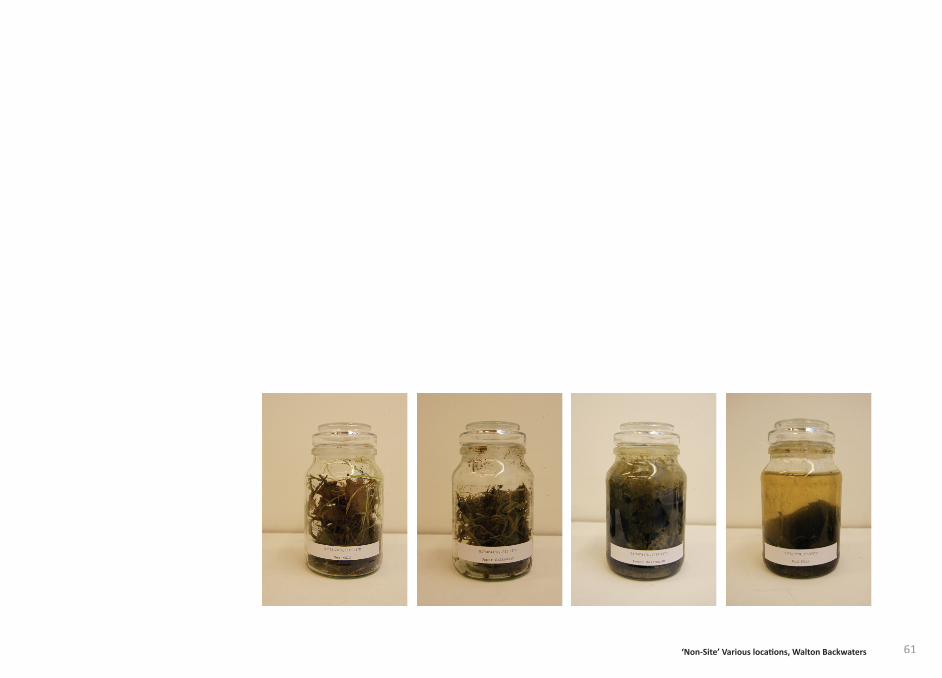
61‘Non-Site’ Various locati ons, Walton Backwaters
62
63
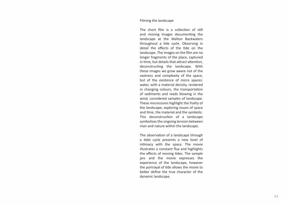
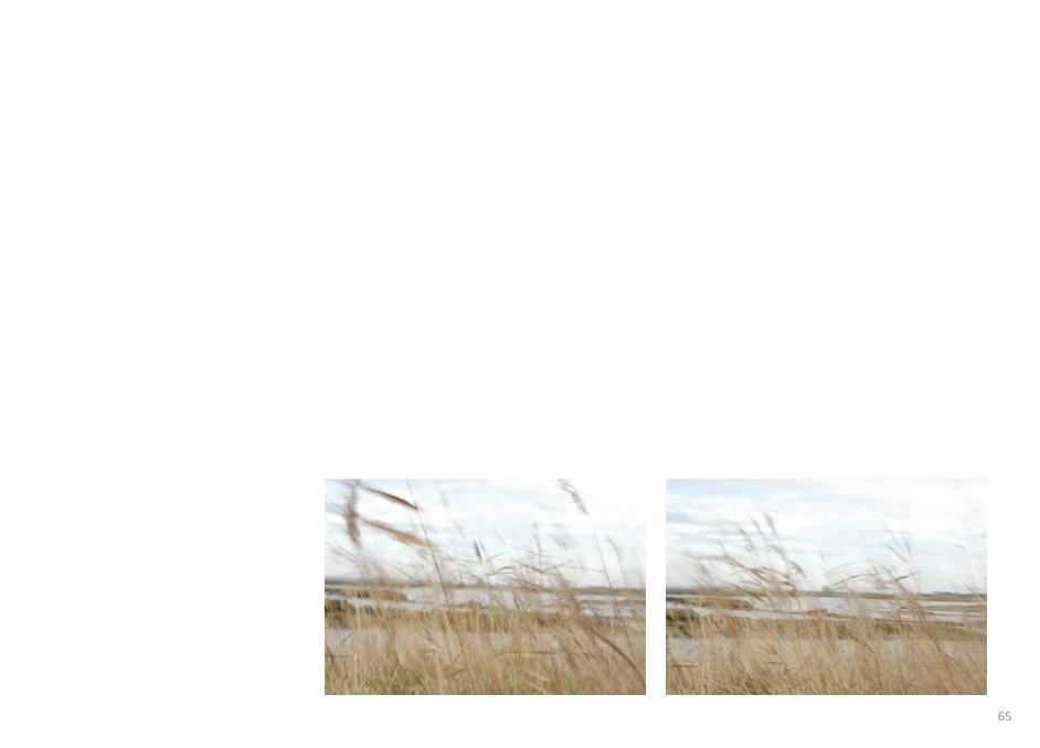
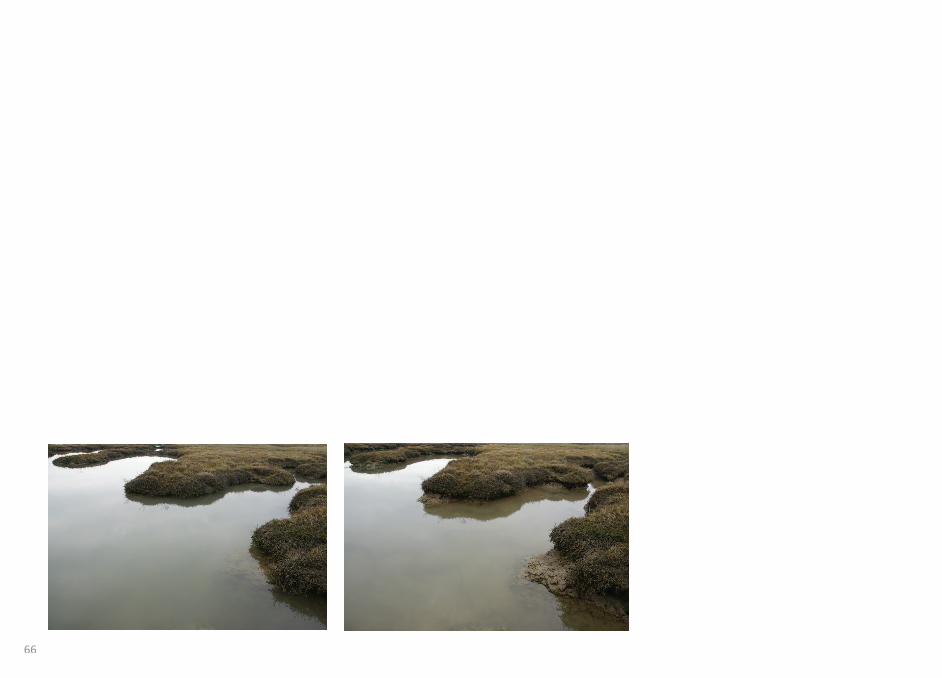
Filming the landscape
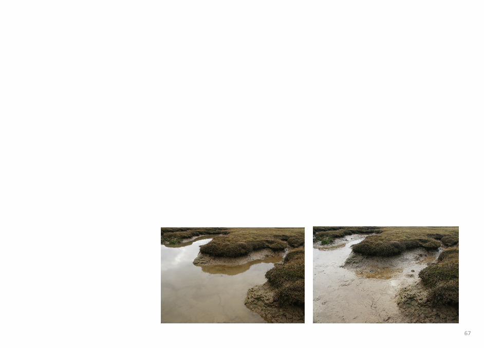
The short fi lm is a collecti on of sti ll and moving images documenti ng the landscape at the Walton Backwaters throughout a ti de cycle. Observing in detail the eff ects of the ti de on the landscape. The images on the fi lm are no longer fragments of the place, captured in ti me, but details that att ract att enti on, deconstructi ng the landscape. With these images we grow aware not of the vastness and complexity of the space, but of the existence of micro spaces: water, with a material density, rendered in changing colours, the transportati on of sediments and reeds blowing in the wind, considered samples of landscape. These microcosms highlight the frailty of the landscape, exploring issues of space and ti me, the material and the symbolic. This deconstructi on of a landscape symbolises the ongoing tension between man and nature within the landscape. The observati on of a landscape through a ti dal cycle presents a new level of inti macy with the space. The movie illustrates a constant fl ux and highlights the eff ects of moving ti des. The sample jars and the movie expresses the experience of the landscape, however the portrayal of ti de allows the movie to bett er defi ne the true character of the dynamic landscape.

64
65
66
67
68
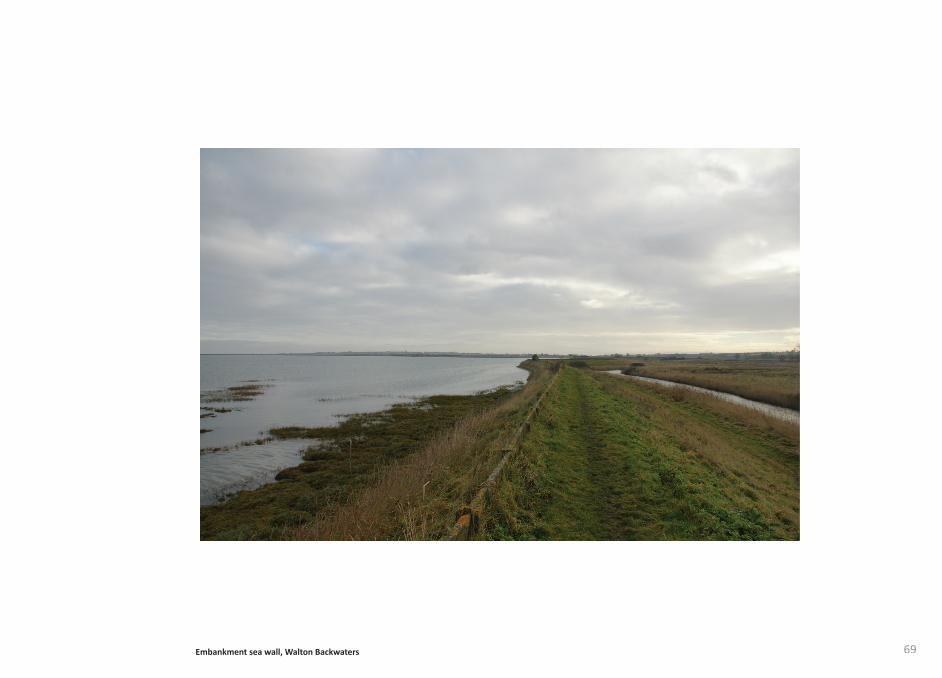
(above) and the only line inhabitable to man, the horizon. In the backwaters the sea wall embankment, at ti mes acti ng as the horizon, forms a restricti ve path allowing access between the inaccessible mudfl ats and the culti vated land, this gives clear defi niti on between where you have come from (back) and where you are looking to (front). The sea wall disconnects the visitor from the surrounding landscape, allowing them to look and survey both the earth and the sky from an elevated positi on. The stability of the sea wall emphasises the fl uxing landscape below and the changing light of the sky above.
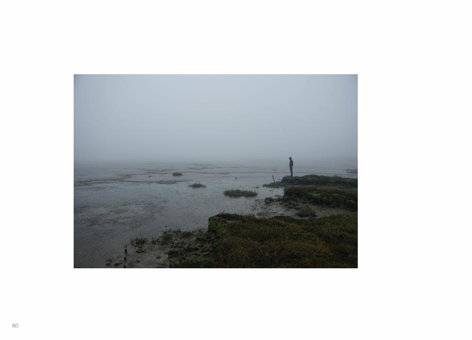
Phenomenology att empts to describe the world as it is experienced by a subject as opposed to how we might theoreti cally assume it to be. The investi gati on of the landscape from a phenomenological perspecti ve will allow for a more inti mate understanding of the landscape and how man experiences the ‘place’. Phenomenology does not att empt to explain the geology and historical characteristi cs of a landscape; it is an alternati ve descripti on that may lead to new knowledge of what exists in the landscape and how it impacts human consciousness.
The area surrounding the Walton backwaters is a fl at, featureless landscape. Christopher Tilley states that “The body, in relati on to the experience of place and landscape. Has six basic and concrete dimensions: above/below or up/down; in front/behind and to the right/left .”17 These dimensions extend beyond the body itself and connect the body with the world: bodily dimensions are not limited to the body itself but relate to the space around it constantly changing and repositi oning. If we apply this theory to the Walton backwaters it is possible to understand how the structure of the landscape aff ects our experience and vice versa.
The landscape can be divided into three elements, the earth (below), the sky
Phenomenological Approach
Earth and Sky, The Body Matrix Rudolf Schwarz
17. Tilley, C. Materiality of Stone, 2004: 4
69Embankment sea wall, Walton Backwaters
70Monk by the Sea, Casper David Friedrich (1810) topView of Haarlem, Jacob Van Ruisdael (1675) bott om
71Monk by the Sea, Casper David Friedrich (1810) topView of Haarlem, Jacob Van Ruisdael (1675) bott om
all important because only they stand out.”19
themselves it is possible to experience man as superior in the encounter with a large over powerful nature.
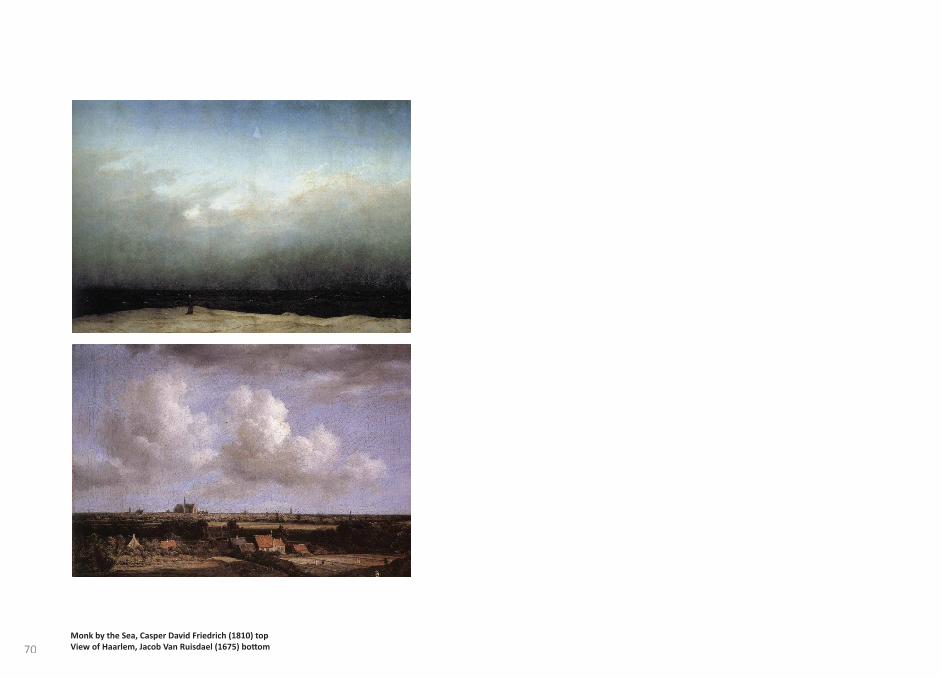
Whilst walking along the sea wall the eye is drawn to the horizon in the distance. The shipping cranes at Felixstowe port act as landmarks on the horizon. Whilst the sea wall dictates the route across the landscape the landmarks are necessary for orientati on. The horizon is perceived as an open expanse, an unbounded and formless fi eld, creati ng a suggesti on of possibility. Firmly placed on the landscape, towers establish centres, rest place from space, reaching up to heaven. This can be seen in the fl at Dutch landscape where arti st Jacob Van Ruisdael painted objects and structures amidst the vast horizons that created a sense of escapism. The vast low-lying Dutch landscape coupled with a low horizon line gives the viewer a sense that they are looking down on the landscape, a feeling of power. The church spires located along the horizon line connect the earth with the sky, a reference to religion. The spires dominate the fl at landscape and become a tool for navigati ng the eye around the painti ng. Similarly in the landscape itself the spires aid orientati on.
“They stand in in awe-inspiring immutability where the great tracts of land (from below) and clouds (from above) meet; they provide the main verti cal accent – relati vely small, but
Looking out over the fl at uninhabitable landscape creates a sense of danger; this is something the painters of the sublime att empted to portray. Caspar David Friedrich was a German romanti c arti st, the Monk by the sea is considered one of the fi rst ‘abstract’ landscape painti ngs. Heinrich von Kleist wrote:
“Nothing can be sadder and more uncomfortable than this positi on in the world: the only spark of life in the wide realm of death, the lonely centre in a lonely circle. With its two or three mysterious objects the painti ng lies before us like the Apocalypse, as if it had Young’s night thoughts, and since in its uniformity and boundlessness it has no foreground except the frame, when one looks at it, it is as if ones eyelids had been cut away.”18
The landscape is reduced to three horizontals: the low-lying dune, the dark oppressive sea and an expansive sky. Standing in the foreground a monk, the only verti cal element, looks out into the horizon. The low horizon creates a sense of depth and contributes to the overall feeling of the sublime. The imminent sense of danger is juxtaposed with the beauty of nature. The expression of the sublime in the context of landscape painti ng makes the overwhelming experience of nature the subject of discussion and embodies it in the painti ng. With the inclusion of the monk, in whose place the viewer imagines
18. Kleist.H, Empfi ndungen vor Friedrichs Seelandschaft . Stutt gart: Phaidon, n.d. p836
19. Stechow.W, Dutch landscape painti ng of the seventeenth century. Ithaca: Cornell University Press, 1981. P47

72
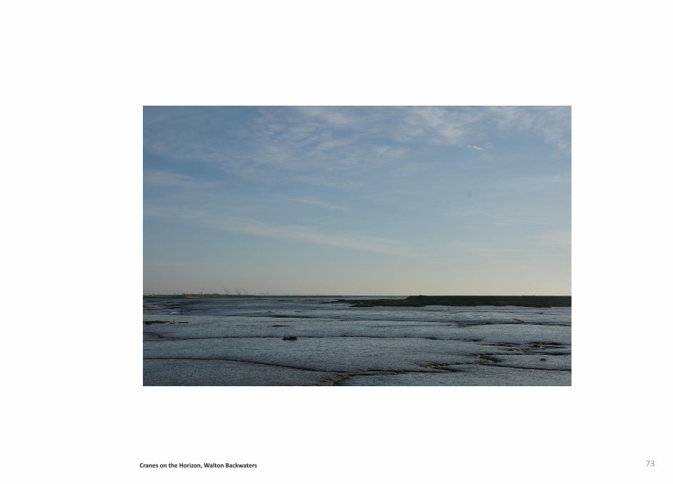
73Cranes on the Horizon, Walton Backwaters
74
for drinking and irrigati on. By returning nutrients extracted from the sea during the process of desalinati on back on to the land, it reduces the need for chemical ferti lisers, creati ng an ecological loop. The plant will reestablish a community within the fragile ecology that exists on the site, shaping how the culture evolves and challenging the disengagement between man and nature that has developed.
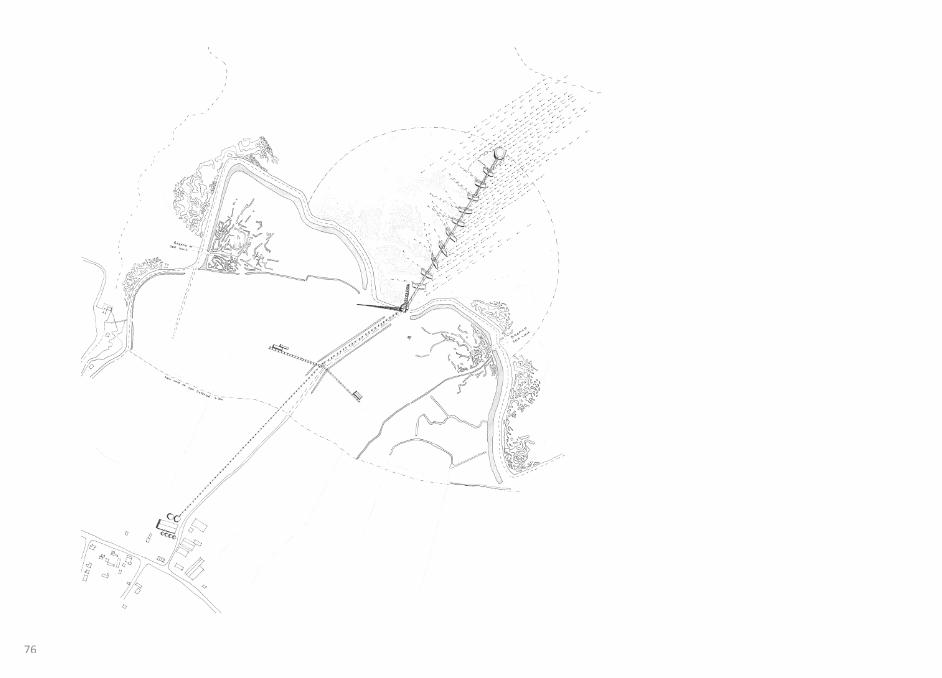
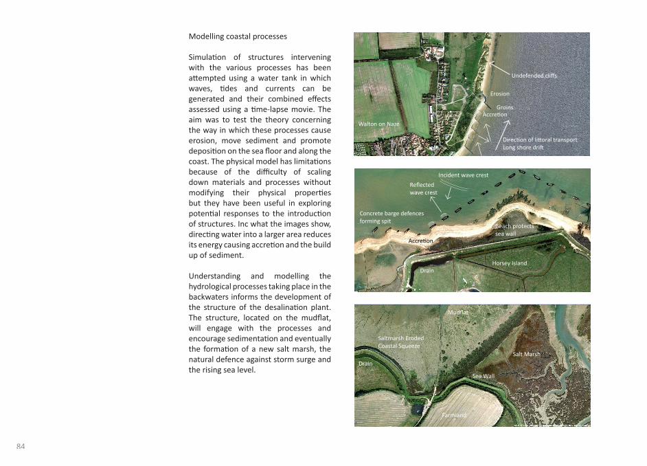
The structure of the desalinati on plant intervenes with the coastal geomorphology. Coastal geomorphology deals with the evoluti on of coastal landforms, the processes at work on them and the changes taking place. (Ref Appendix 1) The pipeline structure is supported over the mudfl at by a series of sunken concrete barges; placed at varying angles these manipulate the fl ow of water to create areas of accreti on and erosion. This will encourage the formati on of new salt marsh. Salt marshes can be used to absorb the sea’s energy, in collaborati on with sea defence; they are valuable in the protecti on of the land from high ti des and storm surges. A sea wall with no salt marsh in front of it costs £5 million per km to construct, but only a tenth of that if there is a salt marsh. (21)
The Desalinati on plant explores the physical and psychological experience of dwelling in the fl at expansive landscape of the Essex salt marshes. The water tower, located on the existi ng
The seawater desalinati on plant exists as part of a landscape management strategy, a series of structures located in the Walton backwaters that facilitate the ‘managed retreat’ approach. Challenging the threat of sea level rise and ti dal surge, the plant turns seawater into a manageable resource, creati ng a more symbioti c relati onship between man and nature.
Since the 1960s, the populati on of Essex has grown by 18%. Today, as this growth conti nues, the demand for water supply is predicted to rise by around 6% over the next 25 years, almost enti rely due to populati on needs. Essex is the driest county in the UK receiving less than 60mm of rain a year, which is two thirds of the average for England and Wales. Only half the water supplied in the Essex area is sourced from within the county. The other half being sourced from the Ely Ouse, water is transferred 60 miles via pipelines and pumping stati ons to the River Stour and River Blackwater in Essex. Low average rainfall and the rising demand for water creates signifi cant challenges to fulfi l the needs of a growing populati on. (20)
The sea water desalinati on plant aims to meet the demand for water in Essex, taking advantage of the coastal locati on, the process of desalinati on takes saline water and uses reverse osmosis to fi lter the nutrients and salt, providing potable water that can be distributed locally
The Desalinati on Plant
20. Author Unknown, Water resources planning (online resource) htt p://www.eswater.co.uk/Waterresourcesplanning.aspx Date of Access: 12th April 2011.
21. Prett y.J, Guide to a green planet. UK: University of Essex Press, 2002. P103
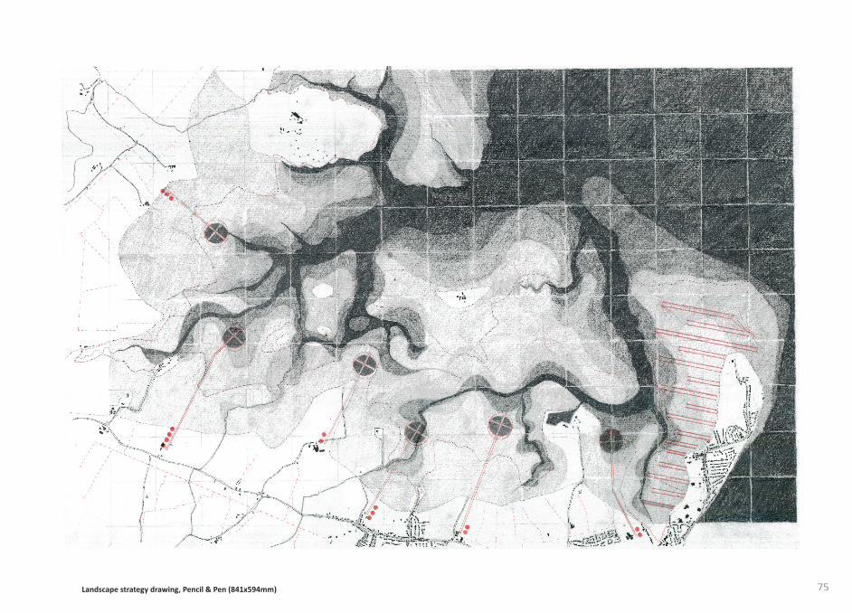
75Landscape strategy drawing, Pencil & Pen (841x594mm)
76
77
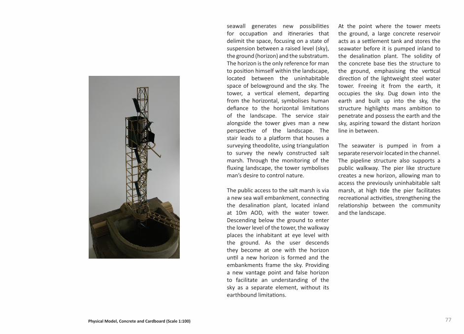
At the point where the tower meets the ground, a large concrete reservoir acts as a sett lement tank and stores the seawater before it is pumped inland to the desalinati on plant. The solidity of the concrete base ti es the structure to the ground, emphasising the verti cal directi on of the lightweight steel water tower. Freeing it from the earth, it occupies the sky. Dug down into the earth and built up into the sky, the structure highlights mans ambiti on to penetrate and possess the earth and the sky, aspiring toward the distant horizon line in between.
The seawater is pumped in from a separate reservoir located in the channel. The pipeline structure also supports a public walkway. The pier like structure creates a new horizon, allowing man to access the previously uninhabitable salt marsh, at high ti de the pier facilitates recreati onal acti viti es, strengthening the relati onship between the community and the landscape.
seawall generates new possibiliti es for occupati on and iti neraries that delimit the space, focusing on a state of suspension between a raised level (sky), the ground (horizon) and the substratum. The horizon is the only reference for man to positi on himself within the landscape, located between the uninhabitable space of belowground and the sky. The tower, a verti cal element, departi ng from the horizontal, symbolises human defi ance to the horizontal limitati ons of the landscape. The service stair alongside the tower gives man a new perspecti ve of the landscape. The stair leads to a platf orm that houses a surveying theodolite, using triangulati on to survey the newly constructed salt marsh. Through the monitoring of the fl uxing landscape, the tower symbolises man’s desire to control nature.
The public access to the salt marsh is via a new sea wall embankment, connecti ng the desalinati on plant, located inland at 10m AOD, with the water tower. Descending below the ground to enter the lower level of the tower, the walkway places the inhabitant at eye level with the ground. As the user descends they become at one with the horizon unti l a new horizon is formed and the embankments frame the sky. Providing a new vantage point and false horizon to facilitate an understanding of the sky as a separate element, without its earthbound limitati ons.
Physical Model, Concrete and Cardboard (Scale 1:100)
78
instance translated into a building whose properti es somehow make the character manifest. The purpose of symbolizati on is to free the meaning from the immediate situati on, whereby it becomes a ‘cultural object’.”
The desalinati on plant aims to make a provocati ve contributi on to how our contemporary landscapes are designed, made and culturally valued. Underlying this aim is the belief that the landscape is not simply a refl ecti on of culture but an acti ve instrument in the shaping of modern culture. Landscape reshapes the world not only because of its physical and experienti al characteristi cs but also because of its eideti c content, its capacity to contain and express ideas and so engage the mind.
Shift ing away from mono-functi onal infrastructure, the proposed desalinati on plant merges existi ng landscapes with emergent infrastructures in order to catalyze new ecologies, economies and most signifi cantly, a new social infrastructure. Combining processes with spati al experience. Christi an Norberg Schulz states:
“Man-made places are related to nature in three basic ways. Firstly, man wants to make the natural structure more precise. That is, he wants to visualize his understanding of nature, expressing the existenti al foothold he has gained. To do this he: builds what he has seen, he adds what is lacking, he has to symbolize his understanding and he has to translate its meaning: A natural character is for
22. Schullz, C. Genius Loci: Towards a Phenomenology of Architecture. UK: Rizolli:31
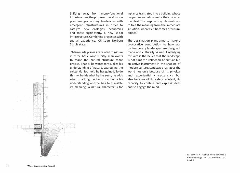
Water tower secti on (pencil)
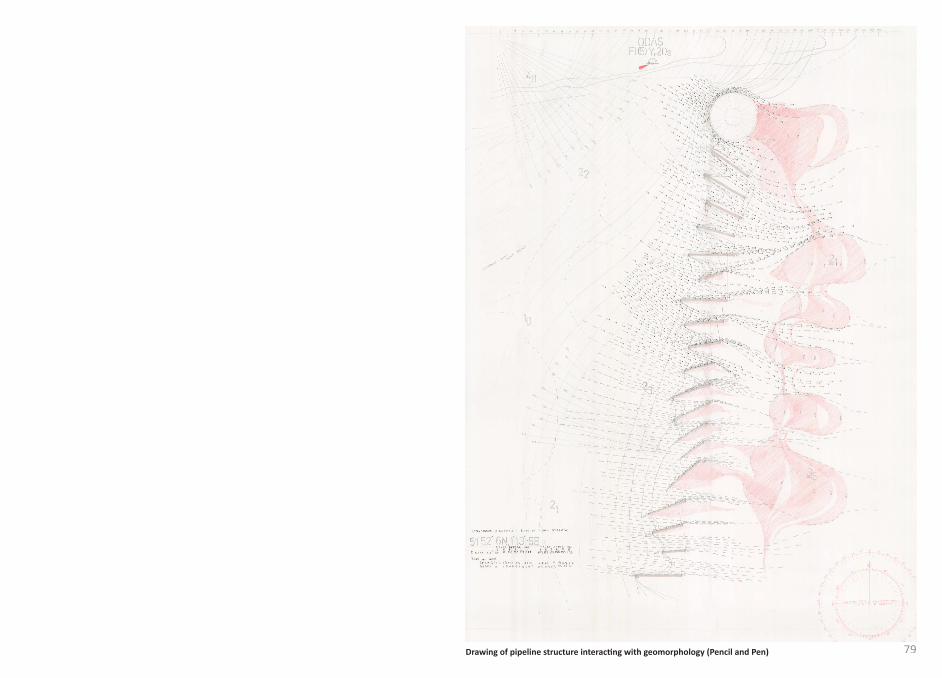
79Drawing of pipeline structure interacti ng with geomorphology (Pencil and Pen)
80
81
feelings towards new developments in a landscape that can stand in the way of our rati onal knowledge about what is really happening. Even if we accept the concept of intervening with nature, we sti ll may not be ready to accept its consequences on the land. The proposal for a desalinati on plant forces us to acknowledge the inescapable fact that landscapes have been changing throughout history, and that modern developments are just another episode in that process.
It is widely acknowledged that global climate change is inevitable. In order for man to adapt to climate change and reengage with nature, it is important that our percepti on returns to a rejecti on of dualism, a view that perceives nature as a living whole, recognizing mans positi on within the ecology as interdependent.
Today’s politi cal and social arrangements are inadequate to deal with the populati on resource environmental crisis, oft en involving short-term soluti ons that aggravate the problem in the future. It is required that our politi cal, economic and philosophical views that exist within a modern society, for future generati ons, are revised in order to create a more sustainable relati onship between mankind and the environment.
Exploring the landscape in a pragmati c as well as poeti c sense has resulted in a loss of senti mentality; this research has highlighted the physical and psychological constructi on of landscape, altering the generic percepti on of the picturesque.
What was previously perceived as natural is now understood as almost enti rely man made. Interventi ons throughout history have created a ‘new’ nature, an arti fi cial landscape that we now relate to and perceive as natural. There has been a shift in the percepti on of landscape since the industrial revoluti on of the late eighteenth and early nineteenth century, the inventi ons of this period, the steam engine, electric power, advances in extracti ve industry and agriculture, were directly translated into landscape features. These infrastructures were designed independently of the existi ng landscape terrain, informed by functi onalism. Infrastructure was built on the landscape having no considerati on of the long-term eff ects of the environment or the natural processes that existed. These engineered structures, like the sea walls, dykes and drains on the Walton backwaters have informed and created the present landscapes on a physical and visual level.
Investi gati ng the Walton backwaters, a site of special scienti fi c interest and natural beauty, challenges our emoti onal
Conclusion
82
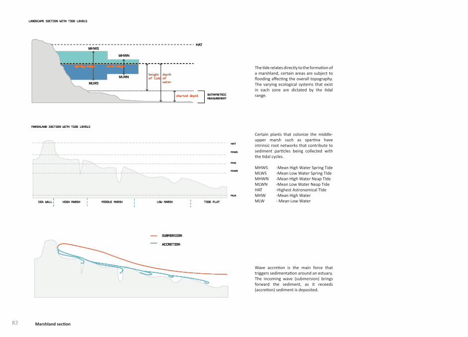
The ti de relates directly to the formati on of a marshland, certain areas are subject to fl ooding aff ecti ng the overall topography. The varying ecological systems that exist in each zone are dictated by the ti dal range.
Certain plants that colonize the middle- upper marsh such as sparti na have intrinsic root networks that contribute to sediment parti cles being collected with the ti dal cycles.
MHWS -Mean High Water Spring TideMLWS -Mean Low Water Spring TIdeMHWN -Mean HIgh Water Neap TIdeMLWN -Mean Low Water Neap TideHAT -Highest Astronomical TIdeMHW -Mean High WaterMLW - Mean Low Water
Wave accreti on is the main force that triggers sedimentati on around an estuary. The incoming wave (submersion) brings forward the sediment, as it receeds (accreti on) sediment is deposited.
Marshland secti on
83Marshland secti on
Alternati vely on a rising ti de, sediment in suspension can be carried forward by waves for depositi on in the upper interti dal zone on the salt marsh.
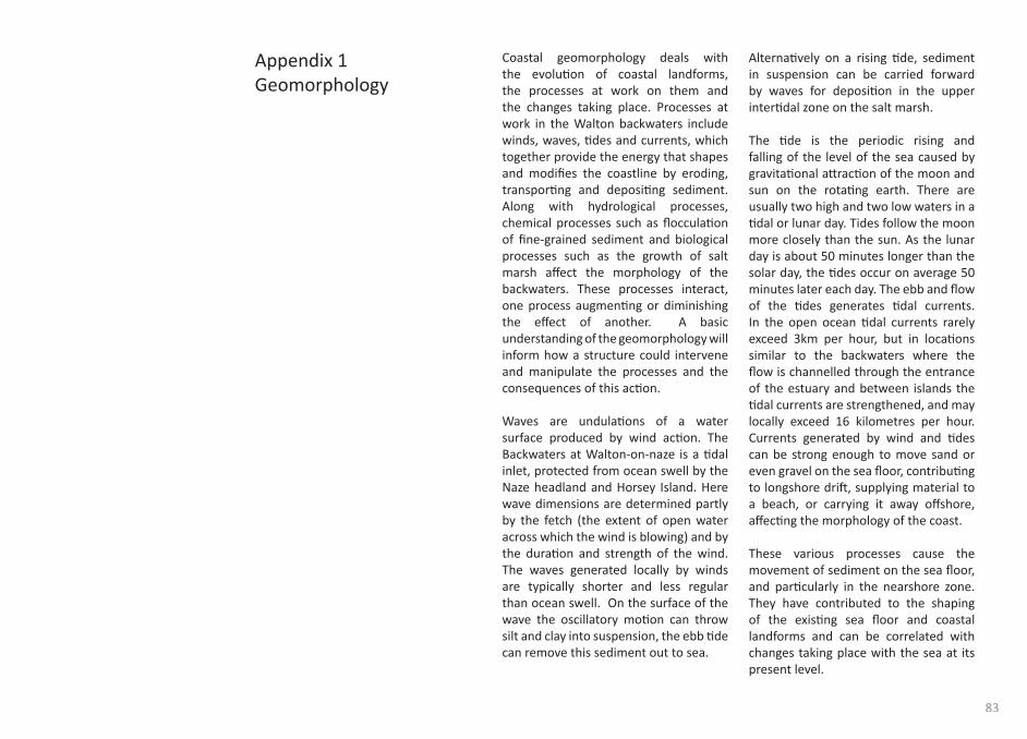
The ti de is the periodic rising and falling of the level of the sea caused by gravitati onal att racti on of the moon and sun on the rotati ng earth. There are usually two high and two low waters in a ti dal or lunar day. Tides follow the moon more closely than the sun. As the lunar day is about 50 minutes longer than the solar day, the ti des occur on average 50 minutes later each day. The ebb and fl ow of the ti des generates ti dal currents. In the open ocean ti dal currents rarely exceed 3km per hour, but in locati ons similar to the backwaters where the fl ow is channelled through the entrance of the estuary and between islands the ti dal currents are strengthened, and may locally exceed 16 kilometres per hour. Currents generated by wind and ti des can be strong enough to move sand or even gravel on the sea fl oor, contributi ng to longshore drift , supplying material to a beach, or carrying it away off shore, aff ecti ng the morphology of the coast.
These various processes cause the movement of sediment on the sea fl oor, and parti cularly in the nearshore zone. They have contributed to the shaping of the existi ng sea fl oor and coastal landforms and can be correlated with changes taking place with the sea at its present level.
Coastal geomorphology deals with the evoluti on of coastal landforms, the processes at work on them and the changes taking place. Processes at work in the Walton backwaters include winds, waves, ti des and currents, which together provide the energy that shapes and modifi es the coastline by eroding, transporti ng and depositi ng sediment. Along with hydrological processes, chemical processes such as fl occulati on of fi ne-grained sediment and biological processes such as the growth of salt marsh aff ect the morphology of the backwaters. These processes interact, one process augmenti ng or diminishing the eff ect of another. A basic understanding of the geomorphology will inform how a structure could intervene and manipulate the processes and the consequences of this acti on.
Waves are undulati ons of a water surface produced by wind acti on. The Backwaters at Walton-on-naze is a ti dal inlet, protected from ocean swell by the Naze headland and Horsey Island. Here wave dimensions are determined partly by the fetch (the extent of open water across which the wind is blowing) and by the durati on and strength of the wind. The waves generated locally by winds are typically shorter and less regular than ocean swell. On the surface of the wave the oscillatory moti on can throw silt and clay into suspension, the ebb ti de can remove this sediment out to sea.
Appendix 1Geomorphology
84
Modelling coastal processes
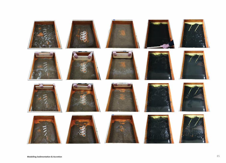
Simulati on of structures intervening with the various processes has been att empted using a water tank in which waves, ti des and currents can be generated and their combined eff ects assessed using a ti me-lapse movie. The aim was to test the theory concerning the way in which these processes cause erosion, move sediment and promote depositi on on the sea fl oor and along the coast. The physical model has limitati ons because of the diffi culty of scaling down materials and processes without modifying their physical properti es but they have been useful in exploring potenti al responses to the introducti on of structures. Inc what the images show, directi ng water into a larger area reduces its energy causing accreti on and the build up of sediment.
Understanding and modelling the hydrological processes taking place in the backwaters informs the development of the structure of the desalinati on plant. The structure, located on the mudfl at, will engage with the processes and encourage sedimentati on and eventually the formati on of a new salt marsh, the natural defence against storm surge and the rising sea level.
Directi on of litt oral transportLong shore drift
Undefended cliff s
Groins
Erosion
Accreti on
Walton on Naze
Incident wave crest
Accreti on
Horsey Island
Concrete barge defencesforming spit
Beach protects sea wall
Drain
Refl ectedwave crest
Drain
Farmland
Salt Marsh
Saltmarsh ErodedCoastal Squeeze
Sea Wall
Mudfl at
85Modelling Sedimentati on & Accreti on
Writi ngs, USA: University of California Press, 1996.Peake, Nigel. Maps, UK: Analogue Books, 2009.
Schulz, Christi an Norberg. Genius Loci: Towards a Phenomenology of Architecture, UK: Rizolli, 1991.
Long, Richard. Selected Statements and Interviews, UK: Haunch of Venison, 2007.
Sheffi eld, Graham. Radical Nature. Art and Architecture for a changing planet 1969-2009. London: Walther Koenig, 2009.
Pearson, Dan. Spirit. UK: Murray & Sorrell FUEL, 2009.
Beardsley, John. Earthworks and Beyond. USA: Cross River Press, 1998.
Allen, Smout. Augmented Landscapes. USA: Princeton Architectural Press, 2007.
Jackowski, Nannett e and de Ostos, Ricardo. Ambiguous Spaces. USA: Princeton Architectural Press, 2008.
Wigley, T and Raper, S. Thermal expansion of sea water associated with global warming. Nature 330. USA: Nature Publishing Group, 1993.
Sanford, Rhonda. Maps and memory in early Modern England. USA: Palgrave, 2002.
Ransome, Arthur. Secret Water. UK: Puffi n Books, 1969.
Casey, Edward S. Representi ng Place Landscape painti ngs and maps. USA: University of Minnisota Press, 2002.
Corner James. Recovering Landscapes. USA: Princeton Architectural Press, 1999.
Various Authors. 306090 Landscape within Architecture. USA: Princeton Architectural Press, 2004.
Curti s, Layla. Layla Curti s. UK: Locus + Publishing, 2006.
Casey, Edward S. Earth-Mapping Arti sts Reshaping Landscape. USA: Princeton Architectural Press, 2005.
Dickinson, G.C. Maps and Air Photographs. UK: Edward Arnold Publishers, 1969.
Long, Richard. Heaven and Earth. UK: Tate Publishing, 2009.
Kordetzky, Lars. Transient Sedimenati on. UK: Springer, 2006.
Smithson, Robert. The Collected
Bibliography
86
87
Harries, K. The Ethical Functi on of Architecture. USA: MIT Press, 1997.
Clarke, J.J. Nature in Questi on. UK: Earthscan Publicati ons, 1993.
Biese, A. The Development of the Feeling for Nature in the Middle Ages and Modern Times. UK: Hard Press Publishers, 2006.
Lorzing, H. The Nature of Landscape. Rott erdam: 010 Publishers, 2001.
Crowe, Norman. Nature and the idea of a man-made world. USA: MIT Press, 1995.
Carlson, Allen. Aestheti cs and the environment - the appreciati on of nature, art and architecture. London: Routeledge, 2000.
Bird, Eric. Coastal Geomorphology An introducti on. UK: John Wiley and Sons, 2000.
Various Authors (Infranet Lab). Coupling - Strategies for Infrastructural Opportunism. USA: Princeton Architectural Press, 2011.
Tillet, C. Materiality of Stone explorati ons in Landscape Phenomenology. UK: Berg Publishers, 2004.