new york state canal corporation
TRANSCRIPT

NATIONAL FIRM. STRONG LOCAL CONNECTIONS.
New York State Canal Corporation
New York State Canal Corporation
EMBANKMENT INSPECTION & MAINTENANCE GUIDE BOOK
March 2021

March 2021 NYSCC Embankment Inspection & Maintenance Guide Book
ii
TABLE OF CONTENTS
List of Attachments .............................................................................................................................................................................. v
Revision Summary Table .................................................................................................................................................................. vi
General Limitations ............................................................................................................................................................................ vii
Preface ................................................................................................................................................................................................... viii
Glossary of Terms and acronyms .................................................................................................................................................. xi
1 Embankments Overview ...................................................................................................................................................... 1-1
1.1 Overview and Manual Content .............................................................................................................................. 1-1
1.2 Canal and Canal Feeder Embankments .............................................................................................................. 1-2
1.3 Distinction Between Levees and Canal Embankments ................................................................................. 1-3
1.4 Vegetation Management and the Experience of Other Agencies ........................................................... 1-3
1.4.1 US Army Corps of Engineers ............................................................................................................................. 1-4
1.4.2 California Urban Levee Design Criteria ......................................................................................................... 1-7
1.5 New York State Regulatory Recommendations for Vegetation Management ................................ 1-11
1.6 Summary ....................................................................................................................................................................... 1-12
2 NYSCC Dam Safety Program ............................................................................................................................................. 2-1
2.1 Organizational Structure of NYSCC ..................................................................................................................... 2-1
2.2 General Organizational Structure of NYSCC Operations Staff .................................................................. 2-2
3 Embankment Rating System .............................................................................................................................................. 3-1
3.1 Hazard classification .................................................................................................................................................. 3-1
3.2 Condition Rating ......................................................................................................................................................... 3-2
3.3 FEMA Risk Urgency Rating System ...................................................................................................................... 3-3
3.4 Modified Risk Urgency Rating System for Use on Canal Assets .............................................................. 3-4
4 Embankment Inspections .................................................................................................................................................... 4-1
4.1 Summary of Inspections ........................................................................................................................................... 4-1
4.1.1 Bank Walk Inspections ......................................................................................................................................... 4-1
4.1.2 Informal Inspections & Enhanced Embankment Monitoring ............................................................... 4-2
4.1.3 formal Inspections ................................................................................................................................................. 4-2
4.1.4 Special Inspections ................................................................................................................................................ 4-3
4.2 Identification, Review, and Programming of Corrective Actions ............................................................. 4-3
4.3 Related Items Concerning Inspections ............................................................................................................... 4-7
4.4 Emergencies .................................................................................................................................................................. 4-7
4.5 Safety Requirements .................................................................................................................................................. 4-7
5 Isolation and Dewatering of Embankment Segments ............................................................................................. 5-1
5.1 Isolation of Canal and Feeder Sections .............................................................................................................. 5-1
5.2 Locations of Embankment Segments ................................................................................................................. 5-1
5.3 Dewatering .................................................................................................................................................................... 5-2
6 Embankment Features ......................................................................................................................................................... 6-1
6.1 Typical Canal embankment Sections ................................................................................................................... 6-1
6.2 Embankment Features .............................................................................................................................................. 6-3
6.2.1 Embankment Zones .............................................................................................................................................. 6-3
6.3 Outboard Slope Embankment Features ............................................................................................................. 6-5

March 2021 NYSCC Embankment Inspection & Maintenance Guide Book
iii
6.3.1 Erosion and Bank Protection ............................................................................................................................. 6-5
6.3.2 Drainage Channels and Ditches ....................................................................................................................... 6-6
6.4 Inboard Slope Embankment Features ................................................................................................................ 6-6
6.5 Crest Embankment Features ................................................................................................................................... 6-6
6.6 Structures Integrated within the Embankment ............................................................................................... 6-6
7 Embankment Maintenance ................................................................................................................................................ 7-1
7.1 Maintenance Categories .......................................................................................................................................... 7-1
7.2 Best Management Practices .................................................................................................................................... 7-3
7.3 Vegetative Maintenance .......................................................................................................................................... 7-5
7.3.1 Why It’s Necessary ................................................................................................................................................. 7-5
7.3.2 How It’s Done Safely ............................................................................................................................................. 7-6
8 Environmental Considerations .......................................................................................................................................... 8-1
8.1 Erosion and Sediment Control ............................................................................................................................... 8-1
8.2 Rare, Threatened and Endangered Species ...................................................................................................... 8-1
8.3 Surface Waters and Wetlands ................................................................................................................................ 8-5
8.3.1 Surface Waters ........................................................................................................................................................ 8-5
8.3.2 Wetlands .................................................................................................................................................................... 8-6
8.4 Cultural Resources ...................................................................................................................................................... 8-7
8.5 Control of Invasive Species ..................................................................................................................................... 8-9
8.6 Hazardous Wastes / Contaminated Materials ............................................................................................... 8-11
8.7 Light Pollution ............................................................................................................................................................ 8-12
8.8 Scenic Management Guidelines .......................................................................................................................... 8-13
8.9 Noise .............................................................................................................................................................................. 8-15
8.10 Dust Control ................................................................................................................................................................ 8-17
8.11 Floodplains .................................................................................................................................................................. 8-18
8.12 Recreational Traffic ................................................................................................................................................... 8-20
8.13 Access, Easements and Temporary Work Space .......................................................................................... 8-20
8.14 Permitting Requirements ....................................................................................................................................... 8-20
8.15 SEQR Thresholds and decision procedure ...................................................................................................... 8-23
9 Public Relations & Community Outreach ..................................................................................................................... 9-1
9.1 Communications & Notifications ......................................................................................................................... 9-1
9.2 Public Meetings ........................................................................................................................................................... 9-1
9.3 FAQ Sheets .................................................................................................................................................................... 9-1
10 References ......................................................................................................................................................................... 10-2

March 2021 NYSCC Embankment Inspection & Maintenance Guide Book
iv
Table of Tables
Table 3.1-1: NYSCC Hazard Classification for Embankments ........................................................................................ 3-1
Table 3.2-1: NYSCC General Condition Rating for Embankments ............................................................................... 3-2
Table 3.3-1: FEMA Risk Urgency Rating ................................................................................................................................. 3-3
Table 3.4-1: NYSCC Preliminary Risk Urgency Rating for Embankments .................................................................. 3-4
Table 7.1-1: Frequency, Risk Priority, and Category for Typical Maintenance Tasks ............................................ 7-2
Table 8.2-1: Federally Listed Species Potentially Present in EEIP Project Area (as of December 2020) ........ 8-1
Table 8.2-2: State Listed Species Potentially Present in EEIP Project Area (as of February 2021) ................... 8-1
Table 8.2-3: Avoidance and Minimization Measures ........................................................................................................ 8-3
Table 8.3-1: Freshwater Classifications ................................................................................................................................... 8-5
Table 8.5-1: Commonly Encountered Invasive Species in New York State ............................................................ 8-11
Table 8.14-1: Permits, Thresholds and Requirements ..................................................................................................... 8-21
Table 8.15-1 Regulatory and Community Thresholds .................................................................................................... 8-23
Table of Figures
Figure 1.1-1: Example Failure Modes for Embankments ..................................................................................................... ix
Figure 1.2-1: Typical Canal Embankment Section – 60 Mile Pool ................................................................................ 1-2
Figure 1.2-2: Overbuilt Canal Embankment Section – 60 Mile Pool ........................................................................... 1-2
Figure 1.4-1: USACE Guidance - Vegetation-Free Zone (Figure A-1 of EP 1110-2-18) ..................................... 1-5
Figure 1.4-2: USACE Guidance - Levee Section with Planting Berm Showing Root-Free Zone (Figure A-13 of
EP 1110-2-18) ................................................................................................................................................................................... 1-6
Figure 1.4-3: California Guidance –Vegetation Management for Existing Levee Section (Figure 7-7 of
California Urban Levee Design Criteria) ............................................................................................................................... 1-10
Figure 4.2-1: Inspection Maintenance and Approval Flow Chart ................................................................................. 4-5
Figure 5.3-1: Parts of an Impounded Canal .......................................................................................................................... 6-1
Figure 5.3-2: Embankment Features ........................................................................................................................................ 6-1
Figure 6.1-1: Earthen Embankment Canal Section: Erie Canal – Waterford to Three Rivers ............................. 6-2
Figure 6.1-2: Earthen Embankment Canal Section: Erie Canal – Three Rivers to Tonawanda and Champlain
Canal ..................................................................................................................................................................................................... 6-2
Figure 6.2-1: Embankment Zones ............................................................................................................................................. 6-4
Figure 6.6-1: Western Embankment Dive Culvert Profile ................................................................................................ 6-8
Figure 6.6-2: Erie Canal Waste Weir (and Sluice Gates) at Albion, NY ....................................................................... 6-8
Figure 6.6-3: Concrete Wall along Canal ................................................................................................................................ 6-9
Figure 8.15-1: Maintenance Solutions Decision Tree ...................................................................................................... 8-25

March 2021 NYSCC Embankment Inspection & Maintenance Guide Book
v
LIST OF ATTACHMENTS
Attachment 1
NYSCC Embankment Maintenance Best Mangement Practices (BMPs)
Attachment 2
Map of NYSCC Region and Section Limits
Attachment 3
Tables of Canal Sections for Isolation and Dewatering

March 2021 NYSCC Embankment Inspection & Maintenance Guide Book
vi
REVISION SUMMARY TABLE
This manual shall be updated, at minimum, every 2 years, or as necessary to ensure accurate mapping,
procedures, best practices and environmental regulations. The following table describes the revisions of the
manual development.
Revision No. Date Description
0 03-12-2021 Initial Issue

March 2021 NYSCC Embankment Inspection & Maintenance Guide Book
vii
GENERAL LIMITATIONS
This Guide Book has been developed by drawing upon current guidance from various groups including both
professional societies and regulatory agencies. Note that the canal is a legacy system that has been built
and maintained through a century where the dam safety knowledge base has greatly expanded. Because of
this, the conditions of the canal do not always conform to current dam safety best practices in many
instances. In some cases, implementing those best practices may be difficult or impossible due to factors
outside of the control of Canals. Because of this, compromises must be made in the implementation of the
Guide Book. Those compromises will be made to prioritize public safety and reduce the inherent risk of the
embankments.
As with any operations and maintenance program dealing with infrastructure with an impact on the
safety of the public at large, the contents of this Guide Book should be overseen by a competent
licensed professional engineer with familiarity of the overall system as well as the specific conditions
at the location where the maintenance is taking place.
The best practices and suggested details contained within this manual are general and may
require modification based on specific site conditions. As such, some of the recommendations,
procedures and details must be reviewed by a licensed professional prior to implementation
which are noted as such. Other recommendations may be less critical in terms of potential
consequence from an engineering perspective; however, there are other important factors such
as environmental, health, safety, historic preservation, etc. that must be considered. Impacts of
these recommendations must be considered by the individual(s) overseeing and performing the
work as not all situations can be addressed explicitly.
All recommendations herein must be considered as general guidance that may require
adjustment depending on actual site conditions.

March 2021 NYSCC Embankment Inspection & Maintenance Guide Book
viii
PREFACE
Public safety is a critical component to the New York State Canal Corporation’s (NYSCC) Engineering
Operation and Maintenance program and its mission to provide reliable operation of a safe and secure
Canal system. This Embankment Management Guide Book (Guide Book) establishes good practices and
guidelines for the management of water impounding earthen embankments, focusing on the top priority
of reducing risk of embankment failure, while supporting asset preservation, environmental protection and
existing community character. Both the modernized Erie Canal System (the Erie, Oswego, Cayuga-Seneca,
and Champlain Canals) and the feeders and remnant canals have embankments located on one side, both
sides or adjacent to the canal to retain water. Although these earthen embankments1 primarily serve to
provide water for navigation, they also provide ancillary benefits including water supply, agriculture, energy
and recreation. Should an embankment fail resulting in an uncontrolled loss of water, lives, property and
the environment could be at risk. To minimize the risk of an embankment failure, the NYSCC includes the
embankments in its water impounding structure and dam safety (Dam Safety) program. A Dam Safety
program recognizes the causes and possible impacts related to a dam failure and develops procedures for
early identification of these problems. Similar to earthen dams, embankments have the potential to fail in
several modes, as illustrated in Figure 1.1-1, developed by the American Society of Civil Engineers [ASCE,
2010]2.
1 For the purposes of the Embankment Maintenance Guide Book, the term “embankment” is defined as those earthen
embankments that retain or impound water as opposed to earthen embankments constructed for other purposes that
do not retain water (e.g. to raise roadways or trails, or to dispose of earth spoil material). The general term
“embankment” will be used in lieu of the more specific terms such as “water-impounding embankment” or “earthen
embankment” throughout the body of this Embankment Maintenance Guide Book (Guide Book) for simplicity. 2 References are called out with square brackets and italics and full bibliographic listing is provided in Section 10.

March 2021 NYSCC Embankment Inspection & Maintenance Guide Book
ix
Source: ASCE 2010
Figure 1.1-1: Example Failure Modes for Embankments
The failure modes shown in Figure 1.1-1 often exhibit early signs that can warn the owner of a potential risk
of an embankment failure. Regular inspections and maintenance are integral parts to identifying and
remedying the risk to an embankment failure before an uncontrolled release occurs, potentially impacting
Canal operations and causing loss of life, property and significant environmental impacts.
The scope of the embankment management program and this Guide Book includes water impounding
earthen embankments or features that abut and are parallel to the earthen embankments, but not individual
structures located along the embankments or under the embankments. Therefore, spillways, waste weirs,
fixed crest dams, retention dams, vertical walls, culverts and dive culverts are excluded features. The scope
includes all embankment material and impairments, and turf, vegetation, armoring or paving that’s parallel
to the embankment slopes and surfaces from outside the toe of the outboard slope on one side to the toe
of the outboard slope on the other side. It includes water recording and management features used in
regulation of water levels in the canal, and geotechnical instrumentation devices. Recognizing that certain
areas may have environmental attributes important to nearby residents, the scope also includes identifying
means to ensure embankment safety, but where feasible, also preserves existing character through cost-
effective alternatives to vegetation removal. Where alternatives to vegetation removal are not feasible, as
determined by the Canal Corporation, mitigation such as supplemental vegetation or visual screening may
be installed to reduce the community character impacts of the work.
All work covered under the embankment management program and this Guide Book will be performed on
lands under jurisdiction of the NYSCC or on lands where the NYSCC has permanent easements or permits
that allow the work of the Guide Book to be carried out. Should temporary easements or permits for

March 2021 NYSCC Embankment Inspection & Maintenance Guide Book
x
purposes of construction access be required or desired to facilitate the implementation of the embankment
management program, they would be obtained on a site-specific basis by the NYSCC or its contractors.
The purpose of this document is to provide a reference to NYSCC staff and consultants to understand the
basic components and features of an embankment; the reasons for, and frequency of, inspection
surveillance and monitoring of embankments on the NYS Canal System; and to provide direction to staff,
consultants, and contractors as to the appropriate measures and actions to address observed deficiencies
or concerns. This document is to be used by all NYSCC employees and consultants having responsibility for
the maintenance and operation of embankments throughout the NYS Canal System with the understanding
that the Canal system includes approximately 120 miles of currently mapped water impounding earthen
embankments that exhibit great variance in adjacent land use and community character, which in some
specific cases, may require modification of the best management practices described in this Guide Book.
Modifications should be made only with appropriate approval and should reflect sound engineering
judgment.
The embankment maintenance Best Management Practice (BMP) sheets (Attachment 1) are intended to:
• Prevent conditions that could lead to embankment failure;
• Prevent conditions that impair inspections and early identification of hazardous conditions;
• Maintain access to facilitate repairs in case of emergencies; and
• Without compromising safety or regulatory compliance, maintain embankments consistent with
existing community character to the maximum extent practicable.

March 2021 NYSCC Embankment Inspection & Maintenance Guide Book
xi
GLOSSARY OF TERMS AND ACRONYMS
ABUTMENT – The interface between two
differing components of a dam or embankment
system or the dam/embankment and the natural
ground surface. Right and left abutments are
those on respective sides of the dam when an
observer looks downstream (or, more generally, is
facing away from the impounded water).
ANTI-SEEPAGE COLLAR – A projecting collar of
concrete or other material built around the
outside of a tunnel or conduit within an
embankment, intended to reduce the seepage
potential along the outer surface of the conduit.
This type of seepage protection method is no
longer recommended for installation within newly
constructed dams and embankments.
APPURTENANT STRUCTURE – Any structures
built of materials placed and/or maintained, in
connection with a dam or embankment. They
may include, but are not limited to, such
structures as spillways, waste weirs, valves, low
level outlet works, fish ladders, and conduits.
AUXILIARY SPILLWAY – See SPILLWAY –
AUXILIARY (EMERGENCY).
BERM – A nearly horizontal step in the sloping
profile of an embankment. Also, a step in a rock
or earth cut.
BMP – Best Management Practice – In this
document, BMP is used to refer to the
embankment maintenance Best Management
Practice sheets (Attachment 1)
BOIL – A disturbance in the surface layer of soil
caused by water escaping under pressure from
behind a water retaining structure such as a dam
or levee. The boil may be accompanied by
deposition of soil particles (usually sand) in the
form of a conical-shaped mound (miniature
“volcano”) around the area where the water
escapes.
BREACH – A break or opening in a dam or
embankment which releases impoundment water
either deliberately or accidentally. A breached
dam (or embankment) permanently lowers the
normal impoundment level by the formation of a
channel through or around the dam (or
embankment).
CHANNEL – A general term of any natural or
artificial facility for conveying water.
COMMUNITY CHARACTER – The man-made
and natural features surrounding and including
an earthen embankment location. It includes the
visual character of a town, village or city, and its
audio-visual landscape.
CONDUIT – A closed channel to convey the
discharge through or under a dam or
embankment, typically a pipe or culvert.
CORE – A zone of material of low permeability,
within an embankment, the purpose of which is
to reduce the quantity of seepage through the
embankment.
CORE WALL – A wall of substantial thickness built
of impervious materials, usually of concrete or
asphaltic concrete, within an embankment to
prevent leakage.
CREST OF DAM OR EMBANKMENT – The
elevation of the uppermost surface of a dam or
embankment, usually a road or walkway (often
the canal trail), excluding any parapet walls,
railings, etc. Also, the Top of Dam.
CREST LENGTH – The measured length of the
dam or embankment along the crest.

March 2021 NYSCC Embankment Inspection & Maintenance Guide Book
xii
CUTOFF WALL – A wall of impervious material
usually of concrete, asphaltic concrete, or sheet
piling constructed in the embankment or its
foundation or abutments to reduce seepage
through, beneath or adjacent to the
embankment.
CANAL PRISM – A term used to refer to the
actual wetted area of the canal in section. This
term originates from the fact that the top surface
of the canal is wider than at the base making it
prism-shaped.
DAM – Any artificial barrier, including any earthen
barrier or other structure, together with its
appurtenant works, which impounds or will
impound waters. By way of example only, waters
may be impounded by directly intercepting
drainage over land, by placing a structure in or
across a watercourse, or by diverting or pumping
waters to an impoundment or reservoir. A lagoon
or storage facility, with one or more
impoundment structures, that stores waste, or
that treats, disposes or contains materials, other
than waters, is not a dam.
DBH –Diameter at Breast Height – Standard for
measurement of trees size defined by the trunk
diameter measured 4.5 feet above the ground.
DIVE CULVERT – A culvert structure that conveys
a stream or drainage underneath the canal prism.
DRAINAGE AREA – The area that drains to a
particular point on a river or stream.
DRAWDOWN – The resultant lowering of water
surface level due to release of water from the
impoundment.
EM – Engineer Manual – A US Army Corps of
Engineers document that provides technical
guidance for a specific subject or structure type.
EMBANKMENT – Any form of earthen
construction for impounding water. May be
constructed of excavated natural materials, such
as earth fill and/or rockfill. More generally,
Embankments may also be constructed for the
purpose of raising a roadway or other structure
above the surrounding terrain and may not
impound water. This manual only covers
embankments that impound water.
Furthermore, for the purposes of this manual,
three types of embankments are differentiated:
CANAL EMBANKMENT – A water-
impounding earthen structure, usually
constructed in a parallel alignment to the
Canal, raising the water surface elevation of
the Canal above the adjacent land surface
elevation. Such embankments can be on one
or more sides of the Canal. These
embankments may retain water only during
the canal operating season for areas where
the canal is drained in the winter, or they may
retain water year-round in areas where the
canal is not drained or only partially drained.
EMBANKMENT DAM – A water impounding
earthen structure, typically constructed
across a waterway or natural valley, to create
a raised water surface or reservoir. Dams
typically include spillways and outlet works
for water level regulation and are
permanently watered.
LEVEES AND OTHER EMBANKMENTS –
Embankments that are only infrequently
watered by flood events and are generally
associated with rivers and run-of-river
portions of canal. Levees typically are meant
to protect adjacent areas from flood events.
EMBANKMENT FAILURE – A loss of the integrity
of the embankment through any means (slope
stability, seepage and piping, or overtopping). A

March 2021 NYSCC Embankment Inspection & Maintenance Guide Book
xiii
failure of the embankment may or may not be
accompanied by breaching and loss of the
impounded water. A failure can be of varying
sizes from a minor slough to a complete loss of
the embankment.
EMERGENCY ACTION PLAN (EAP) – A dam
owner’s written plan of methods and procedures
pursuant to 6 NYCRR 673.7 that is implemented
to detect, identify, mitigate or prevent the causes
and consequences of adverse dam incidents,
including failures.
ENERGY DISSIPATOR – Any device constructed
in a waterway to reduce the energy of fast-
flowing water. Typically located at the outfall of a
pipe or spillway.
ENGINEER – For the purposes of this document,
refers to an individual who is a professional
engineer currently licensed and registered to
practice engineering under Article 145 of the
Education Law of the State of New York and
possesses sufficient specific education, training,
and experience necessary to exercise professional
judgement in the development of opinions and
conclusions regarding, and is otherwise
competent in areas related to, the investigation,
design, construction, operation, and maintenance
of a dam or embankment of the type, size, and
location that is to be addressed, and in areas
related to adverse incidents, failures and the
potential causes and consequences of failures
related to dams and embankments, sufficient to
meet the objectives and performance factors for
the areas of practice identified by 6 NYCRR Part
673.
EP – Engineer Pamphlet – A US Army Corps of
Engineers document that provides functional,
instructional, or procedural guidance needed to
implement programs or systems directed in
regulations.
EROSION – Wear or scouring caused by the
abrasive action of moving water.
ETL – Engineer Technical Letter – A US Army
Corps of Engineers document that Contains
advance information on planning, design,
engineering, construction, and operations and
maintenance projects. ETLs are considered
intermediary publications that will eventually be
republished in a more permanent form. ETL
documents remain active for no more than five
years from the date of issuance.
FACE – The external surface of a structure (e.g.,
the surface of a wall or a dam).
FEMA – Federal Emergency Management Agency
– Federal agency that provides guidance for
disaster preparedness and reduction. Improving
the safety of dams and levees is part of its
mission.
FERC – Federal Energy Regulatory Commission –
Agency that licenses and regulates hydropower
dams.
FILTER (FILTER ZONE) – One or more layers of
granular material graded (either naturally or by
selection) to allow seepage through or within the
layers while preventing the migration of material
from adjacent zones.
FLASHBOARDS – Structural members of timber,
concrete, or steel placed in channels or on the
crest of a spillway to raise the reservoir water level
but intended to be quickly removed, tripped, or
fail in the event of a flood.
FLOOD – A temporary rise in water surface
elevation resulting in inundation of areas not
normally covered by water. Hypothetical floods
may be expressed in terms of average probability
of exceedance per year, such as 1% annual chance
(100-year) or expressed as a fraction of the

March 2021 NYSCC Embankment Inspection & Maintenance Guide Book
xiv
probable maximum flood (PMF) or other
reference flood.
FLOODPLAIN – An area adjoining a body of
water or natural stream that has been or may be
covered by water in the event of a flood.
FOUNDATION – The natural material on which
the dam or embankment structure is placed.
FREEBOARD – The vertical dimension between
the top of the dam or embankment at its lowest
point and the water surface elevation behind the
dam or embankment.
GATE – A water barrier for the control of water.
GRAVITY DAM – A dam constructed of concrete
or masonry, which relies on its own weight for
stability.
GROIN AREA – The area at the intersection of
either the upstream or downstream slope of an
embankment and the valley wall or abutment.
GULLY – A landform created by running water,
eroding sharply and deeply into soil, typically on
a hillside, to depths of greater than about 3 ft. See
also RILL.
HAZARD CLASSIFICATION – Refers to the
damage or hazard that may be posed by the
failure of a dam. One of four Hazard
Classifications may be assigned to a dam in
accordance with 6 NYCRR Part 673.5. The Hazard
Classifications are: Class “A” (low hazard); Class
“B” (intermediate hazard); Class “C” (high hazard);
and Class “D” (negligible or no hazard).
HEIGHT – the measurement of the vertical
dimension from the downstream toe of a dam or
embankment at its lowest point to the top of the
dam or embankment.
INTAKE – Any structure in a reservoir, dam, river,
or canal through which water can be drawn from
the impoundment or river to a discharge point.
INUNDATION MAP – A map delineating the area
that would be inundated in the event of a dam or
embankment failure.
LEAKAGE – Uncontrolled loss of water by flow
through a hole or crack.
MAXIMO - A work order management system
used to manage NYSCC structure assets, create,
and fulfill work requests for maintenance and
operation work.
MAXIMUM DESIGN WATER LEVEL – The
maximum water level, including the flood
surcharge, the dam or embankment is designed
to withstand.
NAVIGATION SEASON – Period of the year that
the water level in the Canal is elevated to allow
for boat traffic, generally mid-May to mid-
November each year.
NORMAL WATER LEVEL (NORMAL POOL) –
Elevation at which the water within the
impoundment is normally kept. For a reservoir
with a fixed overflow spillway crest, it is the lowest
level of that crest.
NYCRR – New York Codes, Rules and Regulations
– The Official Compilation of Codes, Rules and
Regulations of the State of New York. ‘6 NYCRR’
means Title 6 of the NYCRR.
NYPA – New York Power Authority
NYSCC – New York State Canal Corporation
NYSDEC – New York State Department of
Environmental Conservation
NYSDOT – New York State Department of
Transportation
March 2021 NYSCC Embankment Inspection & Maintenance Guide Book
xv
OUTLET – An opening through which water can
be freely discharged from a reservoir to a
downstream channel.
PARGE COATING – A parge coat is a thin coat of
a cementitious or polymeric mortar applied to
concrete or masonry for refinement of the
surface. The typical parge coat is 1/4"-1/2" in
thickness; this may be less than the minimum
thickness allowed by many mortar types.
PERMEABILITY – A material property which
defines the material’s capacity to transmit water.
PHREATIC SURFACE – The upper surface of
seepage in an embankment. All the soil below this
surface will be saturated when the steady-state
seepage condition has been reached.
PIEZOMETER – A device used to measure pore
water pressure in soil. (See also Standpipe
Piezometer)
PIO – Public Information Office
PIPING – Progressive erosion and removal of soil
by concentrated seepage flows through an
embankment, dam, dike, or levee, its foundation,
or its abutments. As material is eroded, the area
of the “pipe” increases and the quantity and
velocity of flow increase; these changes in turn
result in the erosion of more material. The process
continues at a progressively faster rate. Failure
can result if the piping cannot be brought under
control.
RESERVOIR – An impoundment of water created
by a dam.
RETENTION DAM – An impoundment structure
used on the Canal system at locations where
streams enter the Canal. These structures are
used to trap sediments from the stream before
they enter the Canal. Retention dams may or may
not be classified as dams under 6NYCRR Part 673.
RILL – A shallow channel (no more than a few feet
deep) cut into soil by the erosive action of flowing
water. Similar but smaller incised channels are
known as microrills; larger incised channels are
known as gullies.
RIPRAP – A layer of large stone, broken rock, or
precast blocks placed in random fashion on the
slope of an embankment dam, on a reservoir
shore or in a channel as a protection against
erosive flows, waves and ice.
SEEPAGE – The slow percolation of water
through a dam, its foundation, or abutment.
Some amount of seepage will normally occur in
any dam or embankment that retains water.
SLIDE – The movement of a mass of earth down
a slope. In embankments and abutments, this
involves the separation of a portion of the slope
from the surrounding material.
SLOUGH – The separation of the surrounding
material and downhill movement of a small
localized portion of an earth slope. Usually this
refers to a shallow earth slide.
SPALLING – Breaking (or erosion) of small
fragments from the surface of concrete, masonry
or stone under the action of weather or erosive
forces.
SPILLWAY – A structure over or through a dam
or embankment by which normal or flood flows
are discharged.
PRINCIPAL – The principal spillway conveys
normal flows, sometimes referred to as
service spillway.
AUXILIARY (EMERGENCY) – A secondary
spillway designed to operate only during
large floods to pass flows and is in addition
to a principal/service spillway.

March 2021 NYSCC Embankment Inspection & Maintenance Guide Book
xvi
SPILLWAY CHANNEL – A channel conveying
water from the spillway crest to the water course.
SPILLWAY CREST – The lowest level at which
water can flow over or through the spillway.
STANDPIPE PIEZOMETER – Used to measure
saturation levels and hydrostatic pressures to
monitor slope stability and seepage.
STORAGE – The retention of water or delay of
runoff either by planned operation, as in a
reservoir, or by temporary filling of overflow
areas, as in the progression of a flood through a
natural stream channel.
TAILWATER LEVEL – The level of water in the
discharge channel immediately downstream of
the dam or spillway.
TOE DRAIN – A system of pipe and/or pervious
material along the downstream toe of a dam used
to collect seepage from the foundation and
embankment and convey it to a free outlet.
TOE OF DAM/EMBANKMENT – The base
portion of a dam or embankment which intersects
with natural ground.
TOP OF DAM/EMBANKMENT – See CREST OF
DAM OR EMBANKMENT.
TOWPATH – A road or trail on the bank of the
Canal. The original purpose of which was to allow
mules or other animals to tow a boat along the
Canal. Current use is often recreational. Paths also
allow vehicular access to Canal embankment for
maintenance purposes.
TRASH RACK – A device located at the intake of
a conduct inlet or waterway to prevent entrance
of some floating or submerged debris.
USACE – United States Corps of Engineers
USBR – United States Bureau of Reclamation
VALVE – A device fitted to a pipe or orifice to
control or stop flow.
WASTE WEIR – A longitudinal structure used on
the Canal, with a crest elevation that is usually
lower than the top of Canal embankment, that
allows excess water to be discharged from the
Canal to streams or other tributaries. These
structures often include valves or gates that
permit additional water to be drawn from the
canal at levels lower than the crest of the waste
weir.
WEEP HOLE – A small pipe opening into
structures such as concrete abutments,
downstream mortared stone wall or concrete
aprons to relieve any buildup of water pressure
from seepage or groundwater.
WEIR – A type of spillway in which flow is
constricted and caused to fall over a crest.
Sometimes specially designed weirs are used to
measure flow amounts.

March 2021 NYSCC Embankment Inspection & Maintenance Guide Book
1-1
1 EMBANKMENTS OVERVIEW
1.1 OVERVIEW AND MANUAL CONTENT
For the purposes of the Guide Book, embankments are defined as those earthen embankments that
retain or impound water as opposed to earthen embankments constructed for other purposes that
do not retain water (e.g. to raise roadways or trails, or to dispose of earth spoil material). The general
term “embankment” will be used in lieu of the more specific term “water-impounding earthen
embankment” or “earthen embankment” throughout the Guide Book for simplicity.
This document is intended for use by the New York State Canal Corporation (NYSCC) and its consultants,
contractors and other associated parties to:
1. Explain the proper function and features of embankments,
2. Provide the risks associated with embankments and ways to mitigate and manage those risks,
3. Identify the appropriate inspection and maintenance activities to be performed on a regular basis
at all NYSCC embankments,
4. Perform the various inspection and maintenance activities in a uniform and consistent manner
throughout the Canal system as defined by the Guide Book,
5. Document the inspections and the performance of maintenance in maintenance logs,
6. Clarify the decision-making process for addressing maintenance activities either through in-house
maintenance, contract maintenance or capital program maintenance,
7. Clarify the roles and responsibilities of various individuals in the organization in relationship to
processing of the various types of inspections that are conducted,
8. Explain the embankment features,
9. Provide best management practices,
10. Provide guidance on maintenance activities including isolation and dewatering, environmental
considerations, public relations, and community outreach.
This Guide Book applies to all embankments under the jurisdiction of the NYSCC with the following
exceptions:
• It does not apply to dams (which are covered by the Dam Maintenance Guidebook).
• It does not apply to embankments under FERC jurisdiction, which are maintained by other private
or public entities (not under NYSCC maintenance jurisdiction).
All sections of the Guide Book including the NYSCC embankment maintenance Best Management Practice
(BMP) sheets (Attachment 1) are intended to be reviewed and updated as necessary, approximately every
2 years, to reflect the current conditions at each embankment and the current state of practice for dam and
embankment maintenance.
The NYSCC is in the process of mapping and completing hazard classifications for all embankment
segments. The NYSCC has also developed a multi-level inspection program unique to embankments in the
Canal system. Both the hazard classification system and the inspection program are explained in subsequent

March 2021 NYSCC Embankment Inspection & Maintenance Guide Book
1-2
sections of the Guide Book. Lastly, the NYSCC has identified typical embankment repair types, and
developed a series of embankment maintenance BMP guides (see Attachment 1 and Section 7.2).
This document is intended to supplement existing structure maintenance and inspection technical
documents already in use by the NYSCC.
1.2 CANAL AND CANAL FEEDER EMBANKMENTS
The quintessential example of the “typical” canal embankment would be those on one or both sides of the
“60-mile pool” which stretches from Rochester west to Lockport. These embankments vary depending on
location and adjacent features, but are typically roughly 18 feet tall, with a 16-foot top width, with slopes
that vary somewhat depending on location typically 1V:2H to 2V:3H both waterside and landside. A typical
section is shown in the figure below.
Figure 1.2-1: Typical Canal Embankment Section – 60 Mile Pool
At some locations along the 1918 Barge Canal improvement, the original designers provided embankment
sections that are wider than required for water retention. A typical example of an overbuilt canal
embankment is shown in the figure below. In this case, additional spoil (material excavated from the canal
prism) was disposed of landward of the canal embankment. For these situations, it is logical to account for
this extra material when evaluating risk and maintenance needs. This is an example of an important factor
that reinforces the need for a site-specific evaluation of alternatives instead of a one-size-fits-all approach.
Figure 1.2-2: Overbuilt Canal Embankment Section – 60 Mile Pool
Feeder embankments are of a similar arrangement to the canal embankments described above except that
they are now used on waterways that supply or at one time supplied water to a canal or reservoir (feeders).

March 2021 NYSCC Embankment Inspection & Maintenance Guide Book
1-3
1.3 DISTINCTION BETWEEN LEVEES AND CANAL EMBANKMENTS
Water-impounding embankments are typically divided into two main categories: earth dams and levees.
The canal embankments do not neatly fit into either category. Although they are similar to levees in some
respects, (mainly that they are both linear features that retain water on one side protecting adjacent low
ground on the other), there are important differences between levees and canal embankments including:
• Levees are temporary barriers to protect for infrequent, short-term duration rises in rivers and
only function with full water loading in high recurrence interval storm events. In contrast to this,
the canal embankments perform for the entire navigation season (6 months of the year) year after
year. This difference has the following major impacts:
1. the frequency that the levee embankments function is far less than for the canal
embankments, so the risk of failure is correspondingly less (canal embankments function
every year, levees may function only once in a period of decades),
2. the period during which the levees must function is only when the flood waters rise, the
canal embankments perform for the entire period when there is water in the canal
(roughly 6 months per year from mid-April to the mid-October),
3. because the levees are needed for known storm conditions and for shorter duration, a
heightened awareness and increased monitoring of the levees is possible and cost-
effective since the period of monitoring is infrequent and short-term (maintaining this
heightened awareness and enhanced monitoring for the entire time the canal is watered
every year is unrealistic), and
4. because the period that the levees hold back water is significantly less than for the canal
embankments, there is less time for the phreatic surface to develop into a steady-state
condition and less time for any flaws within the embankment to be compromised.
The important distinction between relatively infrequently loaded levees is recognized within US Army Corps
of Engineers (USACE) guidance (Engineering Monograph [EM] 1110-2-1913 “Design and Construction of
Levees”) which states the following:
Embankments that are subject to water loading for prolonged periods (longer than normal flood
protection requirements) or permanently should be designed in accordance with earth dam
criteria rather than the levee criteria given herein.
This distinction is critical. The USACE guidance indicates that the canal embankments should be treated as
earth dams. Vegetation management practices for earth dams are universally accepted within the
engineering community with the rule that woody vegetation is not permitted on earth dams.
1.4 VEGETATION MANAGEMENT AND THE EXPERIENCE OF OTHER AGENCIES
The risk reduction strategy for the embankments that likely has the most impact on the community is the
management of the vegetation that currently exists on the embankment. The dam safety engineering
community recommends clearing of all woody vegetation from the embankments to eliminate concerns of
seepage paths created by tree roots, the possibility of tree blowdowns creating large depressions that could
weaken the embankment or cause a breach and the difficulty the vegetation causes to embankment
inspection, among other factors. Adjacent landowners and canal users view the trees and vegetated slopes

March 2021 NYSCC Embankment Inspection & Maintenance Guide Book
1-4
as beneficial to the canal setting for such things as shade, visual site barrier to adjacent properties, wildlife
refuge, and more. Finding a solution that addresses the needs and desires of both sides is critical. Reducing
the risk of a catastrophic embankment failure is a clear need. Developing a cost-effective option that allows
some woody vegetation to remain is a goal. This same dilemma exists in many other locations where water
impounding embankments exist in close proximity to recreational and residential areas. The guidance
developed by the governing agencies in those locations can be useful for the canal embankments.
The experience and resulting design criteria from two agencies are summarized in the sections below. The
two agencies were chosen because of their specific technical reputation and the similarity of the issues
covered. The NYS regulating agency requirements for dam embankments is covered in Section 1.5.
1. The USACE, whose guidance may be considered the best practice relating to vegetation
management on embankment dams and levees.
2. The California Department of Water Resources which has dealt with the issue of balancing the
risk and benefits of having woody vegetation on their levee embankments, particularly those
within urban environments.
1.4.1 US ARMY CORPS OF ENGINEERS
The current guidance for vegetation management on water impounding embankments is contained in EP
1110-2-18 Guidelines for Landscape Planting and Vegetation Management at Levee, Floodwalls, Embankment
Dams and Appurtenant Structures.
The Corps’ guidance makes it clear that vegetation may remain on and around embankment and related
infrastructure, provided that “the safety of the structure is not compromised, and effective surveillance,
monitoring, inspection, maintenance, and flood-fighting of the facility are not adversely impacted.”
A key aspect of the Corps’ guidance is the establishment of a vegetation-free zone which is a “three-
dimensional corridor surrounding all levees, floodwalls, embankment dams, and critical appurtenant
structures in all flood damage reduction systems.” No vegetation, other than approved grasses may
penetrate the vegetation-free zone. The primary purpose of the vegetation-free zone is to “provide a
reliable corridor of access to, and along, levees, floodwalls, embankment dams, and appurtenant structures.”
1.4.1.1 LEVEES
For levees, this vegetation-free zone is indicated in the figure below (Figure 1.4-1). The Corps also indicates
that a secondary benefit of the vegetation-free zone is to provide distance between root systems and the
protection structures thereby moderating risks associated with seepage and piping due to root penetration
and structural damage from wind-driven tree overturning (windthrow). They note that the vegetation-free
zone does not provide adequate protection for all situations. Note that in the case of the typical canal
embankment, this vegetation-free zone extends across the entire embankment and a minimum of 15 feet
past the toe.

March 2021 NYSCC Embankment Inspection & Maintenance Guide Book
1-5
Figure 1.4-1: USACE Guidance - Vegetation-Free Zone
(Figure A-1 of EP 1110-2-18)
To provide protection against seepage, piping and concerns with windthrow on levees, the Corps defines a
root-free zone. This root-free zone is used in conjunction with planting berms which are overbuilt levee
sections upon which plantings are permitted. Depending on the specific location and embankment
characteristics, it could be appropriate to consider the spoil portion of the overbuilt canal embankments as
planting berms upon which woody vegetation could be permitted. Vegetation must be carefully chosen to
ensure compatibility. Factors such as vegetation density, size, expected root penetration depth, and location
are important factors in the expected performance (i.e. risk) of the embankment.

March 2021 NYSCC Embankment Inspection & Maintenance Guide Book
1-6
Figure 1.4-2: USACE Guidance - Levee Section with Planting Berm Showing Root-Free Zone
(Figure A-13 of EP 1110-2-18)
1.4.1.2 EMBANKMENT DAMS
The Corps’ policy as it relates to embankment dams is clear. The guidelines require the following five areas
to be vegetation-free zones:
1. The dam and the dam-toe area.
2. Areas in or around seepage monitoring systems, or critical downstream areas where seepage
observation must be vigilant and continuous.
3. Groin abutments and areas immediately adjacent to groin abutments.
4. Spillways and spillway channels, including spillway slopes and approaches to spillways where
vegetation could, in any way, impede the operation of the spillway.
5. The outlet works discharge channel.
The Corps further clarifies that for embankment dams, the entire embankment surface from the upstream
toe of the dam to a minimum distance of 50 ft from the downstream toe3 shall be a vegetation-free zone.
3 It should be noted that applying a uniform 50-ft required vegetation-free zone at the toe of all earth dams regardless
of size is in all likelihood an over-simplification. Other than the recommendations for an access corridor, the vegetation-
free zone should be based on the size of dam and the size of tree. Reducing this 50-ft limit for the canal embankments
would seem justifiable.

March 2021 NYSCC Embankment Inspection & Maintenance Guide Book
1-7
1.4.1.3 VARIANCES
The Corps also allows for a formal process for requesting a variance from the Guidelines. Any such request
must include information to demonstrate the following:
• No significant tree roots (those greater than ½ in. diameter) will enter the levee prism.
• No potential tree overthrow pit will penetrate the levee prism.
• No roots or tree overthrow pit will significantly impact the function of any appurtenant structure,
such as those designed to control seepage. Such features include filters and drains.
These three bullets can be considered the guiding principles of when vegetation is permissible on water-
impounding embankments from a safety and risk perspective. If vegetation is allowed to remain on the
embankments, these principles can be used to help assess and manage the risk.
1.4.2 CALIFORNIA URBAN LEVEE DESIGN CRITERIA
A good deal of information regarding maintenance, inspection and vegetation on water retaining
embankments exists for the levee system protecting Sacramento, California and the San Joaquin Valley (the
Central Valley Flood Protection Plan). Recent pertinent information can be found dealing with many aspects
of risk management relating to maintenance and inspection of the levees. Much of this information has
been prepared in response to a reaccreditation process for the federal levee system and the Army Corps of
Engineers guidance regarding vegetation management for levees. Like the controversy surrounding the
vegetation management on the NYSCC canal embankments, vegetation management on and adjacent to
levees became controversial when the Corps released updated guidance for vegetation management for
levees in April 2009.4 Much of the research and lessons learned can be leveraged to develop guidance for
the canal embankments.
However, there are important differences between the California levee system and lessons learned and the
NYSCC canal embankments. In addition to the differences between canal embankments and levees as
detailed in Section 1.3, the Sacramento Levees are constructed with and in sandy soils. The NYSCC canal
embankments are constructed of many different material types.
As referenced above, California has dealt extensively with the challenges of balancing the risks associated
with vegetation on levee embankments and the detrimental effects of removing vegetation. California’s
Department of Water Resources published guidance5 for levee construction and maintenance which strives
for a balance between the two goals. Because California’s objectives align closely with those of NYSCC, their
guidance is generally applicable keeping in mind the important difference that the canal embankments are
typically more critical than levees since they function for a 6-month duration every year.
4 The guidance released was ETL 1110-2-571 Guidelines for Landscape Planting and Vegetation Management at Levee,
Floodwalls, Embankment Dams and Appurtenant Structures (April 2009). ETL 1110-2-571 was replaced by two
subsequent documents having the same title as the original 2009 document – ETL 1110-2-583 (in April 2014) and EP
1110-2-18 (in May 2019). The first two ETL documents are largely the same, and the final EP document is identical to
the 2014 ETL except for formatting. 5 State of California, The Natural Resources Agency, Department of Water Resources, Urban Levee Design Criteria, May
2012.

March 2021 NYSCC Embankment Inspection & Maintenance Guide Book
1-8
Section 7 of California’s Urban Levee Design Criteria includes requirements for many aspects of the levee
system. The document’s relevant sections covering vegetation are summarized below. Other sections
covering such things as embankment geometry seepage design criteria, slope stability criteria, and required
right of way are included and may be useful for other aspects of the embankment engineering and
maintenance program, but they are not directly applicable to this document.
1.4.2.1 VEGETATION [SECTION 7.16]
The California policies have been developed around a commitment to:
“developing flood risk reduction solutions that also integrate environmental stewardship.
Guidance for levee vegetation management is focused on improving public safety by
providing for levee integrity, visibility, and accessibility for inspections, maintenance, and
flood fight operations, while at the same time protecting important and critical environmental
resources.“
Section 7.16 of the California guidance says:
Policies and criteria regarding removing trees and other woody vegetation that have grown
and matured on levees are evolving and will be informed by ongoing and future research.
Engineers and levee maintaining agencies are encouraged to consider the results of this
research when deciding how to manage trees and other woody vegetation on levees.
It goes on the say:
The criteria provide significant flexibility for engineers and levee maintaining agencies to
remove or retain existing trees and other woody vegetation. Because of the importance of
these critical resources, it is anticipated that implementation of these criteria will result in
near-term retention of the vast majority of existing trees and other woody vegetation that
provide important and critical habitat. In the long-term, it is anticipated that the vast majority
of trees and other woody vegetation on the lower waterside levee slope6 would continue to
grow with little or no management.
Section 7.16 of the California Urban Levee Design Criteria requires an engineering evaluation to identify
unacceptable vegetation and a routine inspection program to identify changes that effect vegetation
management. Criteria are provided for vegetation management for new levees and at locations where
repairs or improvements are planned. For existing levees with vegetation, a “vegetation management zone”
is defined that allows some vegetation to remain subject to trimming and thinning to provide access for
maintenance and inspection. The following sections are paraphrased from the California document:
6 Note that the lower waterside slope is applicable only to levees (this is the portion of the slope that is at or near
normal river elevation and then becomes submerged when flood waters rise). It is not applicable to the canal
embankments.

March 2021 NYSCC Embankment Inspection & Maintenance Guide Book
1-9
1.4.2.1.1 ENGINEERING EVALUATION
The California guidance requires an engineering inspection and evaluation to identify tree and other woody
vegetation that pose an unacceptable threat. Any such tree shall be removed along with the root balls and
roots. The California guidance requires a minimum of all roots larger than 1.5 inches in diameter that are
within 3 feet of the tree trunk be removed.7 The California guidance varies somewhat from the typical
practice for earth dams which is to remove all roots down to 1-inch or even ½-inch diameter. Though not
included in the California guidance, it is recommended that the typical earth dam criteria for root removal
be followed for the canal embankments.
1.4.2.1.2 ROUTINE INSPECTION
The California guidance dictates that any trees and other woody vegetation that are not removed must be
monitored to identify changed conditions that cause any of these remaining trees and other woody
vegetation to pose an unacceptable threat to levee integrity.
1.4.2.1.3 NEWLY CONSTRUCTED LEVEES
California requires that new levees be designed, constructed, and maintained according to USACE criteria.
These standards limit vegetation to native grass species on levee crown (top), slopes, and within 15 feet of
the levee toe. Trees and other woody vegetation may be allowed on portions of the landside slope for a
newly constructed levee only if a specially designed planting berm is added. This overbuilt section must be
of sufficient size and configuration to mitigate potential negative impacts to levee safety with respect to
seepage, stability, and erosion criteria should either windfall or root decay occur.
Trees and other woody vegetation that are within 20 feet of the landside toe should be trimmed up 5 feet
above the ground and thinned for visibility and access.
1.4.2.1.4 LEVEE REPAIR OR IMPROVEMENT
The California guidance dictates that vegetation shall be removed as required to meet objectives of the
specific project. Any vegetation removed may not be replaced in the vegetation management zone.
However, vegetation on other sections of the levee, not affected by the construction activity may remain in
place, natural revegetation may be allowed outside of the vegetation management zone, and replanting
may be allowed (see Section 1.4.2.1.7); for levees regulated by USACE, their approval is required for planting.
Engineers and levee maintaining agencies should also consider preserving trees and other woody
vegetation within the vegetation management zone that provide important or critical habitat in consultation
with the appropriate resource agencies by including the following root mitigation alternatives as part of any
levee improvement program:
• The overall width of the levee is overbuilt landward by at least 15 feet beyond the standard
minimum levee dimensions, or
7 The guidelines point out that more extensive root removal may be required depending on the type of tree; the
quantity, size and orientation of roots; the dimensions of the embankment; and the levee features that address seepage.

March 2021 NYSCC Embankment Inspection & Maintenance Guide Book
1-10
• An effective root or seepage barrier is installed within the levee to mitigate potential impacts by
tree roots.
1.4.2.1.5 LEVEES WITH EXISTING VEGETATION
California’s guidance is that levees with existing vegetation are to be maintained according to the bullets
below. With respect to California’s guidance and its applicability to the NYSCC canal embankments, it is
important to consider the differences between levees and canal embankments noted in Section 1.3. In
particular, the fact the canal embankments retain water at a frequency and duration that far exceeds that
which levees are considered safe. This is recognized in the Corps’ guidance dictating that canal
embankments be designed using earth dam criteria8. Standard guidance and best practices dictate that
the levee criteria below are not appropriate for canal embankments.
• An established vegetation management zone in which trees are trimmed up to 5 feet above the
ground (12-foot clearance above the crown road) and thinned for visibility and access (see Figure
1.4-3).
• Brush, trees and other woody vegetation less than four inches in diameter at breast height, weeds
or other such vegetation over 12 inches high are to be removed.
• Trees and other woody vegetation that are within the 20-foot-wide landside right-of-way, but
outside of the vegetation management zone, must be trimmed up 5 feet above the ground and
thinned for visibility and access.
Figure 1.4-3: California Guidance –Vegetation Management for Existing Levee Section
(Figure 7-7 of California Urban Levee Design Criteria)
8 From USACE EM 1110-2-1913 Design and Construction of Levees, April 2000, Section 1-5 a. (1) which states “The term
levee as used herein is defined as an embankment whose primary purpose is to furnish flood protection from seasonal
high water and which is therefore subject to water loading for periods of only a few days or weeks a year. Embankments
that are subject to water loading for prolonged periods (longer than normal flood protection requirements) or
permanently should be designed in accordance with earth dam criteria rather than the levee criteria given herein.”

March 2021 NYSCC Embankment Inspection & Maintenance Guide Book
1-11
1.4.2.1.6 LIFE-CYCLE VEGETATION MANAGEMENT
California uses life-cycle management (LCM) to achieve visibility and accessibility criteria while progressing
gradually (over many decades) toward the USACE vegetation policy goal of eventually eliminating woody
vegetation from the vegetation management zone of levees (landside slope, crown, and upper waterside
slope). Life-cycle management on the California levees involves:
• Removal of immature trees and other woody vegetation less than four inches in diameter at
breast height.
• Trees and other woody vegetation beyond this size (that do not pose an unacceptable threat to
levee integrity) may live out their normal lives on the levee.
• Periodically evaluating the trees and other woody vegetation remaining. Should any of these be
found to pose an unacceptable threat to levee integrity, remove them at that time.
1.4.2.1.7 VEGETATION PLANTING (FOR OVERBUILT EMBANKMENTS)
California’s guidance for overbuilt embankments states that trees and other woody vegetation may be: (1)
planted, and (2) allowed to naturally revegetate on a landside planting berm. Only the portion of the
landside planting berm that is both 15 feet or more from the landside levee slope and 15 feet or more from
the landward top of the planting berm may be planted or allowed to naturally revegetate. All trees and
other woody vegetation in this area of the planting berm must be trimmed up 5 feet above the ground and
thinned for visibility. Any landside berm can be a planting berm if its top is more than 30 feet wide (as
measured perpendicular to the levee centerline) and the berm is at least 3 feet9 thicker than required for
levee integrity (to account for potential overturning of trees from windthrow) (see Figure 7-8). For levees
regulated by USACE, their approval is required for any plantings on the levee. Before planting, consideration
should be given to the possibility that some or all vegetation may need to be removed in the future.
1.5 NEW YORK STATE REGULATORY RECOMMENDATIONS FOR VEGETATION MANAGEMENT
Today, in New York State, dams that are not otherwise regulated by the FERC or USACE, are regulated by
the NYSDEC. Although canal and feeder embankments are not regulated as dams, these embankments do
retain water for certain parts of the year and uncontrolled breaches could result in damage to life and
property. As such, guidance documents related to earthen dam maintenance and inspections are used by
the NYSCC as part of its inspection and maintenance program of these earthen structures and referenced
in this Guide Book. NYSDEC regulations include requirements for the inspection, operation, and
maintenance of dams. The NYSDEC Owners Guidance Manual for the Inspection and Maintenance of Dams
in New York State [NYSDEC, 1987], originally published in June 1987 remains the current guidance. This
document states:
• The entire dam should be kept clear of unwanted vegetation such as brush or trees.
9 The 3-foot thickness is based on research specific to the California soil types and the specific type and size of trees
found on the levees and may vary for the soil and tree types found along the canal. This guidance also does not consider
the seepage potential caused from roots within the levee embankment (presumably due to the shorter-term duration
loading for the levee). Seepage and potential for piping is a major concern for the canal. It is for these reasons that a
more conservative depth and distance criteria be used for the overbuilt canal embankments.

March 2021 NYSCC Embankment Inspection & Maintenance Guide Book
1-12
• When brush is cut down, it should be removed from a dam to permit a clear view of the
embankment.
• Stumps from trees or woody brush with a diameter less than 4” diameter may be left in place.
• Following removal of large brush or trees (with a diameter greater than 4”), the left-over root
systems should also be removed to a root diameter of 1” or less and the resulting holes filled.
1.6 SUMMARY
This chapter provided:
• An overall introduction to this Guide Book and its objectives.
• Background on the NYSCC canal embankments regarding their construction and configuration.
• A comparison between water impounding canal embankments, earth dam and levees and how that
distinction is critical when considering the applicability of regulatory requirements, industry and
engineering guidance, and dam and levee best practices.
• Information and background on what other agencies do for their dam and levee assets.
As indicated in the sections above, it is critical to understand the important differences between levees,
dams, and canal embankments. As the USACE’s guidelines indicate, due to the duration and frequency of
water loading, canal embankments should not be maintained using guidance developed for levees.

March 2021 NYSCC Embankment Inspection & Maintenance Guide Book
2-1
2 NYSCC DAM SAFETY PROGRAM
2.1 ORGANIZATIONAL STRUCTURE OF NYSCC
Pursuant to Public Authorities Law Section 1005-b, the NYSCC is a public benefit corporation and subsidiary
corporation of the New York Power Authority.
The NYSCC operations are divided into two regions: Eastern and Western. Work forces and responsibilities
for individual structures are divided into Sections within each Region as follows:
EASTERN REGION
Section 1 - Fort Edward
Champlain Canal between Waterford (junction with Erie Canal) and Whitehall (north end of Lock C12)
[Locks C1 thru C12]
Section 2- Waterford
Erie Canal between Waterford (junction with Champlain Canals) and the East end of Lock E-8 (Rotterdam)
[Locks E2
-E7]
Section 3 - Fonda
Erie Canal between and including Lock E8 (Rotterdam) to the east end of Lock E16 (Minden)
[Locks E8-E15]
Section 4 - Utica
Erie Canal from the east end of Lock E16 (Minden) to the west end of the Sylvan Beach breakwater
[Locks E16-E22]
WESTERN REGION
Section 5 - Lysander
Erie Canal from the western end of the Sylvan Beach breakwater to Cayuga/Seneca County line at
Montezuma; and the entire Oswego Canal from Three Rivers to Lake Ontario
[Locks E23, E24, & O1-O8]
Section 6 - Lyons
Erie Canal from Cayuga/Seneca County line to the Wayne/Monroe County line; and entire Cayuga/Seneca
Canal, from the south end of Cayuga Lake and Seneca Lake to the junction with the Erie at Montezuma
[Locks E25-E30, & CS1 – CS4]

March 2021 NYSCC Embankment Inspection & Maintenance Guide Book
2-2
Section 7 - Pittsford
Erie Canal from Wayne/Monroe County line to east end of Ingersol Street Lift Bridge, Albion
[Locks E32-E33]
Section 8 - Lockport
Erie Canal from east end of Ingersol Street Lift Bridge to Tonawanda Creek (500’ west of Webster St.
Bridge)
[Locks E34/35]
See Attachment 2 for a Map of NYSCC Region and Section boundaries. The inspection and maintenance
plans shall be retained by the NYSCC electronically in Canal Infrastructure Management System (CIMS), kept
in good order and updated as necessary to reflect any changes in the current condition of the
embankments. The following contact information can be used for questions related to the embankment
segments.
NYSCC Eastern Region
Regional Canal Engineer
30 South Pearl Street
Albany, NY 12207
(518) 449-6036
NYSCC Western Region
Regional Canal Engineer
4950 Genesee Street, Suite 190
Cheektowaga, NY 14225
(716) 686-4400
Administrative Headquarters
Deputy Director30 South Pearl Street
Albany, NY 12207
(518) 449-6000
NYSCC Syracuse Office
Director of Waterways Maintenance
149 Northern Concourse
Suite 400
Syracuse, NY 13212
(315) 423-2081
2.2 GENERAL ORGANIZATIONAL STRUCTURE OF NYSCC OPERATIONS STAFF
The general reporting structure for the Canal Corporation Operations staff in the Regions is as follows (note
that not all staff categories are included):
Engineering:
• One Regional Canal Engineer (RCE) per Canal Region. The RCE is a management position requiring
a professional engineering license who manages the work in the Canal Region.
• Two Transportation Maintenance Engineers (TMEs) per Region who each oversee two Canal
Sections. The TME is a management position requiring a professional engineering license and
reports to the Regional Canal Engineer.

March 2021 NYSCC Embankment Inspection & Maintenance Guide Book
2-3
Operations:
• One Section Superintendent per Canal Section who is in charge of the entire section including
maintenance, operations, and the Section maintenance shop. The Section Superintendents report
to the Regional Canal Engineer.
• Canal Maintenance Supervisor 2 (CMS2) who functions as a maintenance general foreman and is
the senior maintenance supervisor in the Canal Section. The CMS2 reports to the Section
Superintendent.
• Canal Maintenance Supervisor 1 (CMS1) who functions as a maintenance foreman responsible for
a single work crew.

March 2021 NYSCC Embankment Inspection & Maintenance Guide Book
3-1
3 EMBANKMENT RATING SYSTEM
With approximately 120 miles of embankment presently identified in the Canal system, it is necessary to
identify and prioritize those sections most in need of maintenance. In order to create a prioritization, a
matrix was developed based on two metrics: hazard classification, and condition rating to assign a resulting
risk urgency rating. The matrix prioritizes risk urgency by assigning the highest risk urgency to those
segments with the highest hazard classification and lowest condition rating.
Sections 3.1 through 3.4 describe the three classifications and ratings used to classify the embankment
sections.
3.1 HAZARD CLASSIFICATION
The NYSCC uses the following hazard classifications for embankments, based on NYSDEC and FEMA
guidelines [NYSDEC, Undated; FEMA, 2004].
Table 3.1-1: NYSCC Hazard Classification for Embankments
Class "A" or "Low
Hazard"
An embankment failure is unlikely to result in damage to anything more than
isolated or unoccupied buildings, undeveloped lands, minor roads such as town
or county roads; is unlikely to result in the interruption of important utilities,
including water supply, sewage treatment, fuel, power, cable or telephone
infrastructure; and/or is otherwise unlikely to pose the threat of personal injury,
substantial economic loss or substantial environmental damage.
Class "B" or
"Intermediate
Hazard"
An embankment failure may result in damage to isolated homes, main
highways, and minor railroads; may result in the interruption of important
utilities, including water supply, sewage treatment, fuel, power, cable or
telephone infrastructure; and/or is otherwise likely to pose the threat of
personal injury and/or substantial economic loss or substantial environmental
damage. Loss of human life is not expected.
Class "C" or
"High Hazard"
An embankment failure may result in widespread or serious damage to
home(s); damage to main highways, industrial or commercial buildings,
railroads, and/or important utilities, including water supply, sewage treatment,
fuel, power, cable or telephone infrastructure; or substantial environmental
damage; such that the loss of human life or widespread substantial economic
loss is likely.

March 2021 NYSCC Embankment Inspection & Maintenance Guide Book
3-2
3.2 CONDITION RATING
Periodic inspections have been performed for some of the Canal embankment sections. Inspections were
performed by NYS Department of Transportation (NYSDOT) personnel in 2015 and prior years. Starting in
2017, the Canal Corporation and its consultants took over the inspection program. Minor revisions to the
rating system have been made over time to include dam safety best practices and risk reduction measures.
Table 3.2-1: NYSCC General Condition Rating for Embankments
1 - SERIOUS/EMERGENCY
Serious Deficiencies Exist, Repairs Needed Urgently, Consider
Emergency Remedial Action. Dam Safety Review Warranted to
Determine the Embankment Integrity. Enhanced Monitoring
Required
2 - VERY POOR Advanced Safety Deficiencies Exist. Begin Monitoring and
Consider Interim Stabilization Measures.
3 - POOR
Safety Deficiencies Exist that Signify Potential Progression of
Deterioration under Existing or Increased Loading Conditions.
May Need Condition-Based Preventative Maintenance. Place in
Priority Scheduling for Improvement.
4 - FAIR Moderate Safety Deficiencies Exist. Improve as Part of Normal
Scheduling.
5 - GOOD Minor Safety Deficiencies Exist. Satisfactory but Shows Signs of
Aging.
6 - VERY GOOD
Normal Aging.
7 - EXCELLENT/NEW
No Appreciable Deterioration or Deficiencies Exist.
Key elements that are examined in the inspection include:
• the presence of embankment seepage (including standing water and other indicators such a lush
vegetation or even the presence of wetland vegetation),
• the presence of vegetation on the embankment including trees or other vegetation that can
negatively affect the embankment or hinders the inspection (refer to Section 7.3),
• geometry of the embankment including height, top width, and inboard and outboard slope,
• embankment settling or slope failure,
• presence of animal burrows,
• missing or deteriorated inboard slope protection (riprap) with erosion potential, and
• the presence of development or residential properties near the embankment (an indicator of
hazard class).

March 2021 NYSCC Embankment Inspection & Maintenance Guide Book
3-3
3.3 FEMA RISK URGENCY RATING SYSTEM
The FEMA risk urgency system assigns different levels of urgency to dam corrective actions. It reflects an
assessment of the likelihood of failure with five risk categories. Risk urgency classifications listed below are
as defined in the FEMA publication P-1025 Federal Guidelines for Dam Safety Risk Management [FEMA,
2015].
Table 3.3-1: FEMA Risk Urgency Rating
I - Very High
Urgency
CRITICALLY NEAR FAILURE: Direct evidence that failure is in progress, and the
dam is almost certain to fail during normal operations if action is not taken
quickly.
OR
EXTREMELY HIGH RISK: Combination of life or economic consequences and
likelihood of failure is very high with high confidence.
II - High Urgency
RISK IS HIGH WITH HIGH CONFIDENCE OR IT IS VERY HIGH WITH LOW TO
MODERATE CONFIDENCE: The likelihood of failure from one of these
occurrences, prior to taking some action, is too high to delay action.
III - Moderate
Urgency
MODERATE TO HIGH RISK: Confidence in the risk estimates is generally at
least moderate but can include facilities with low confidence if there is a
reasonable chance that risk estimates will be confirmed or potentially increase
with further study.
IV - Low Urgency
LOW TO MODERATE RISK: The risks are low to moderate with at least
moderate confidence, and there is a potential for the risks to increase with
further study.
V - No Urgency
LOW RISK: The risks are low and are unlikely to change with additional
investigations or studies.
Depending on the urgency of the risk, remedial actions may range from routine risk management measures
to heightened monitoring and evaluation, up to immediate action to avoid failure and implementing the
emergency action plan. FEMA Risk urgency ratings for NYSCC embankment sections began in 2016. It is the
intent to assign Risk Ratings to all embankments as part of the inspection program.

March 2021 NYSCC Embankment Inspection & Maintenance Guide Book
3-4
3.4 MODIFIED RISK URGENCY RATING SYSTEM FOR USE ON CANAL ASSETS
The NYSCC uses a modified FEMA risk urgency scale which includes one additional urgency classification to
better fit with the General Condition Rating and Hazard Class system that has been established. The new
rating of “Va - Very Low Urgency” is used in between FEMA’s IV and V classifications. This new rating is
beneficial to differentiate between a classification of “Low Urgency” and a classification of “No Urgency.”
The NYSCC uses the General Condition Rating and Hazard Class to develop a preliminary Risk Urgency
Rating as per the matrix below. This matrix has been established to prioritize the risk urgency of the various
assets according to their condition and the consequence of the asset’s failure. Higher hazard structures
generally receive a higher preliminary Risk Urgency Rating for the same condition. This ranking matrix places
the highest priority to the structures that would have the greatest consequence of failure and exhibit the
worst condition. The preliminary Risk Urgency Rating assigned by the matrix is reviewed by the inspecting
engineer for appropriateness considering the actual observations made prior to assigning a final Risk
Urgency Rating. Allowing the engineer to apply judgment in assigning the final Risk Urgency Rating allows
for consideration of factors that are difficult to quantify in the general matrix and eliminates the “black box”
assignment of the final Risk Urgency Rating.
Table 3.4-1: NYSCC Preliminary Risk Urgency Rating for Embankments
GCR\Hazard Low Hazard Intermediate Hazard High Hazard
7 - Excellent/New V - No Urgency V - No Urgency V - No Urgency
6 - Very Good Va - Very Low Urgency Va - Very Low Urgency Va - Very Low Urgency
5 - Good Va - Very Low Urgency IV - Low Urgency IV - Low Urgency
4 - Fair IV - Low Urgency III - Moderate Urgency III - Moderate Urgency
3 - Poor III - Moderate Urgency III - Moderate Urgency II - High Urgency
2 - Very Poor II - High Urgency II - High Urgency I - Very High Urgency
1 - Serious/Emergency I - Very High Urgency I - Very High Urgency I - Very High Urgency

March 2021 NYSCC Embankment Inspection & Maintenance Guide Book
4-1
4 EMBANKMENT INSPECTIONS
NYSCC is responsible for periodically inspecting embankments under its jurisdiction. Inspections and
maintenance are important to the ongoing serviceability and operability of embankments, the safety of
people and facilities downstream of the embankments, and the continued operation of the Canal System.
Identifying signs of failure early is critical to the prevention of hazardous situations for the surrounding
people and infrastructure as well as aiding the NYSCC in gauging risks and priorities when planning and
scheduling maintenance activities and capital improvements. Annual embankment inspection training is
provided to Canal staff who perform embankment inspection work. Additional training, such as seepage
monitoring and dam safety training, is provided annually to Maintenance Supervisors and staff who are
licensed professional engineers. Training requirements are evaluated annually and revised as needed.
4.1 SUMMARY OF INSPECTIONS
The NYSCC performs various types of inspections at its embankments. Further description of the inspection
requirements is included in the following sections. The frequencies identified below are targets NYSCC
strives to meet based on resource availability. Additional inspections for appurtenant structures including
spillways, weirs, sluice gates and culverts are coordinated by the Asset Management & Inspection Engineer
separately from the embankment inspection program.
4.1.1 BANK WALK INSPECTIONS
Bank Walk Inspections are routine scheduled inspections performed by NYSCC staff. It is also the
minimum level of inspection to be performed any time staff visits an embankment site. The inspection
consists of visually identifying areas of immediate concern for the functionality of the embankment. The
primary focus of the visual inspection is the embankment and its appurtenant structures to observe
defects and changes in condition.
Items to Monitor:
• Crest alignment • Toe drain flow
• Seepage • Trash rack debris/ culvert flow
• Reservoir pool • Condition of any appurtenant or adjacent
structures (e.g., spillways, dive culverts,
waste weirs)
• Wet areas
• Slides/sloughs
• Cracks
Minimum Frequency:
• Assigned by the Regional Canal Engineers or Transportation Maintenance Engineers based on the
embankment’s condition and hazard class
• Typically performed on a more frequent interval as often as weekly to bi-monthly
Inspection Personnel:
• NYSCC Section Staff
Responsible Reviewers:
• Canal Maintenance Supervisor 1,
• Canal Maintenance Supervisor 2, and/or
• Section Superintendent

March 2021 NYSCC Embankment Inspection & Maintenance Guide Book
4-2
4.1.2 INFORMAL INSPECTIONS & ENHANCED EMBANKMENT MONITORING
Informal Inspections and Enhanced Embankment Inspections are conducted to monitor any devices or
conditions related to seepage at the embankment in addition to the normal requirements of a Bank Walk
Inspection. Previous observations should be compared to current observations to determine if there are
any significant changes in conditions at the embankment. All changes in condition, changes in readings
from instrumentation devices, and maintenance practices implemented since the previous inspection are
documented. Informal Inspection may also document any new deficiencies, instabilities, or notable
conditions.
Items to Monitor
• Areas of Concern (AOCs) identified in
Safety Inspections
• Monitoring Weirs (discharge)
• Monitoring wells (level) • Rodent activity
• Piezometers (level) • Vegetation
• Observation manholes (level) • Concrete surfaces
• Outfalls (discharge) • Vandalism
• Monitoring Devices
Minimum Frequency:
• Enhanced Embankment Monitoring intervals vary and are assigned by the Regional Canal
Engineers based on the embankment’s condition, hazard class, and specific areas of concern
being monitored
• Informal inspection frequencies are completed according to the Dam Safety Program Policy CC-
POL-DS as follows:
Hazard (See Section 3.1) Inspection Interval1
Class A Semiannually
Class B Quarterly
Class C Monthly 1 Inspection intervals are applicable only during periods when embankment retains water)
Inspection Personnel:
• NYSCC Engineering Staff
• Licensed Professional Engineers
Responsible Reviewers:
• Regional Canal Engineer
• Dam Safety Engineer
4.1.3 FORMAL INSPECTIONS
Formal Inspections are conducted regularly by qualified licensed engineers. A report is generated by a
Licensed Professional Engineer in the State of New York experienced in dam safety. The report compares
conditions of the embankment to previous conditions assigns a condition rating, performs a visual
assessment of apparent hazard class, assigns a risk urgency rating, and provides recommendations for
necessary maintenance.

March 2021 NYSCC Embankment Inspection & Maintenance Guide Book
4-3
Items to Monitor:
• The formal inspection is a detailed inspection of all aspects of the embankment including general
condition, apparent hazard classification and overall risk.
Minimum Frequency:
• Minimum frequency for formal inspections is set by Dam Safety as follows:
Hazard (See Section 3.1) Inspection Interval
Class A Every 5 years
Class B Every 3 years
Class C Every 2 years
Inspection Personnel:
• Licensed Professional Engineers trained in dam safety
Responsible Reviewers:
• Dam Safety Engineer
4.1.4 SPECIAL INSPECTIONS
Refer to NYSCC Post Event Inspection Procedures; K118-EMP-0008 [NYSCC, 2018] for instructions on post
event or emergency (earthquake, flood) inspection criteria.
4.2 IDENTIFICATION, REVIEW, AND PROGRAMMING OF CORRECTIVE ACTIONS
Figure 4.2-1 summarizes the means by which embankment safety issues are identified, and corrective
actions are reviewed, approved and programmed for implementation. Embankment safety issues may be
identified through the inspections discussed in Section 4.1. Other sources of information may come from
boaters, trail users or residents along the canal who observe seepage, sloughing or other anomalies. The
recommendation of corrective actions is initiated by the reviews of inspection reports by one or more
NYSCC leadership team members. These include: Section Superintendent, Regional Canal Engineer, Dam
Safety Engineer, and Asset Management & Inspection Engineer.
The Regional Canal Engineer, Dam Safety Engineer, and Asset Management & Inspection Engineer
determine the appropriate vehicle for implementing the corrective actions. . In making their determination,
they shall consult with Environmental Health & Safety (EH&S) for required maintenance work. The Regional
Canal Engineer will determine when consultation with and/or involvement of the Public Information Office,
Legal and/or Real Property is also required. Such instances include when corrective actions may require
mitigation to address environmental impacts. Corrective actions that can be performed as in-house or
contract maintenance are then progressed back through the appropriate Regional Canal Engineer and
Section Superintendent for implementation via generation of work orders in NYSCC’s work order
management system Maximo.
When programming corrective actions, the property ownership rights of the NYSCC must be confirmed to
determine whether sufficient space to perform the maintenance work or to provide sufficient access to
perform the required maintenance work described in this Guide Book. When corrective actions result in
ground disturbance, a review of potential sources of contamination (e.g. State Superfund sites, etc.), as
further described in Section 8, should also be performed. Presence of contaminated soils could

March 2021 NYSCC Embankment Inspection & Maintenance Guide Book
4-4
significantly extend timeframes for action or trigger special material handling requirements. For this
reason, the limits of NYSCC property, or rights to access the property to perform maintenance work must
be confirmed. Access to adjacent lands to perform maintenance work, or to provide access, may be
obtained through a Site Access/Vegetation Management Permit or permanent easement. Refer to Section
8.13 - Access, Easements and Temporary Work Space for more information.
Figure 4.2-1 depicts a flow chart for the inspection review, maintenance recommendation and approval
process for embankment maintenance activities.

March 2021 NYSCC Embankment Inspection & Maintenance Guide Book
4-5
Figure 4.2-1: Inspection Maintenance and Approval Flow Chart

March 2021 NYSCC Embankment Inspection & Maintenance Guide Book
4-6

March 2021 NYSCC Embankment Inspection & Maintenance Guide Book
4-7
4.3 RELATED ITEMS CONCERNING INSPECTIONS
Inspection records and log readings are kept in CIMS and Dam Safety files.
The Regional Canal Engineer, Asset Management & Inspection Engineer, and Dam Safety Engineer shall
receive copies of inspection reports for Enhanced Embankment Monitoring and Dam Safety Inspections.
The Regional Canal Engineer, Asset Management & Inspection Engineer, and Dam Safety Engineer shall be
contacted with any relevant findings (e.g. new or suspected seepage, settlement, sinkholes, sloughing, etc.)
from Bank Walk Inspections and Informal Inspections.
4.4 EMERGENCIES
In the event that an emergency condition is observed that appears to imminently jeopardize the integrity
of any of the NYSCC’s embankments, the observer should call the Thruway State Operations Center (TSOC)
at 1-866-691-8282 immediately to begin the duty notification process.
4.5 SAFETY REQUIREMENTS
All NYSCC employees are required to follow the appropriate safety procedures while engaged in work
related to embankment inspections and maintenance activities.
Procedures and Policies relating to health and safety include, but are not limited to, those listed below.
Refer to the Canals Intranet: “Publications” → “Environmental, Health and Safety” → “Safety” for a listing of
all current safety policies and procedures.
• Canal Corporation Safety Rules; CCHQ-1000.04 R01
• Canal Corporation Employee Safety Policy; 25-2-23C
• Confined Space Entry & Permit Program; 322-0-01
• Safety-Toe Footwear; SP-00 2018 R03
• Lockout/Tagout Program; SD 90-4

March 2021 NYSCC Embankment Inspection & Maintenance Guide Book
5-1
5 ISOLATION AND DEWATERING OF EMBANKMENT SEGMENTS
Maintenance activities associated with embankments are preferentially performed under dewatered
conditions. Dewatering embankment segments prior to conducting excavation work is a risk-reduction
practice to limit both the likelihood and resultant consequence of an embankment failure. During the non-
navigation season, many embankment segments are dewatered when water levels are drawn down.
However, dewatered access to an embankment area occasionally may be required during the navigation
season and some embankments may be located within segments that are not dewatered or where the water
level is not fully lowered during non-navigation season.
5.1 ISOLATION OF CANAL AND FEEDER SECTIONS
During the navigation season it is a priority to maintain the navigable pool in the operating canal segments
adjacent to a required dewatering. Sections of the canal can be isolated for dewatering between existing
structures. The primary limits of dewatered sections are provided by the existing guard gates and navigation
locks on the canals. See the Isolation and Dewatering Tables in Attachment 3 for listings of sections of the
canals between guard gates and locks and their associated dewatering features in each segment. During
the non-navigation season, isolation points may be constructed in the canals away from existing structures
by using cofferdams. In an emergency, cofferdams may be installed during the navigation season, however,
additional evaluation would be required to ensure maintenance pools in adjacent segments are unaffected.
The feeders and remnant canals have water depths typically between 4 and 6 feet, and most lack control
structures like guard gates and frequent outlets. Isolation of these sections would typically require
installation of cofferdams and potential pumping or siphoning after identifying permissible discharge
locations other than adjacent segments, if needed. See the Isolation and Dewatering Tables in Attachment
3 for listings of sections of the feeders and remnant canals with the associated water control and dewatering
features in each segment.
5.2 LOCATIONS OF EMBANKMENT SEGMENTS
Identification and mapping of embankment segments is an ongoing process. Embankment maps are
updated as new embankment segments are identified. In the NYSCC’s asset portfolio, there are two
categories of embankments as described below.
Canal Embankments – Embankments that are associated with portions of the modern Erie Canal System
(Erie, Champlain, Cayuga-Seneca, and Oswego). Only man-made water-retaining embankments whether on
natural riverine sections or the artificial canal sections of the waterway are included in this category. The
portions of the canal system that traverse lakes, such as Onondaga, Oneida, Cayuga and Seneca Lakes do
not include man-made water retaining embankments and are therefore not included.
Remnant Canal and Feeder Embankments – Embankments that are associated with feeders and remnant
canals. The natural streams and rivers that convey water from feeders and remnant canals and that were
not modified by construction of embankments, are not included.

March 2021 NYSCC Embankment Inspection & Maintenance Guide Book
5-2
5.3 DEWATERING
Most sections of canal between identified isolation points include one or more water outlet structures to
discharge water from the canal. Canal locks may be used to dewater by cross feeding.10 These features have
limited capacity and will generally perform best in sections where flows are small, and where the canal is
not combined with river flows. Sluice gates and valves in waste weirs and drains in the bottom of the canal
which outlet into culverts under the canal also provide drainage points in some sections, again typically
away from canalized river sections. At some locations, powerhouses may also be used to provide additional
outflow from an isolated section; however, coordination with other owner-operator entities would likely be
required.
Many sections of remnant canals and feeders have limited existing infrastructure to allow isolation of
segments. Generally, dewatering will require closure of inflow at headworks control structures and either
installation of cofferdam systems or longer extents of dewatering beyond the location of interest. In some
instances, it may be necessary to provide downstream cofferdams to prevent backflow from the
downstream canal being fed.
If an event occurs at a location that prevents the operation of a usual dewatering feature, alternate points
in the same segments may be used and/or supplemental methods such as pumping or siphoning may be
considered. Breaching is not considered a safe or effective means to dewater as it could result in release of
flow to undesirable areas away from usual canal discharge or stream flows.
10 Cross feeding is a method that involves passing flow through a lock using the filling and emptying system. Cross
feeding is accomplished by opening the upper valve on one side of the lock and the lower valve on the opposite side
of the lock. Specific procedures and functionality may vary by lock and should be done only in consultation with staff
experienced with the procedures at the particular lock.

March 2021 NYSCC Embankment Inspection & Maintenance Guide Book
6-1
6 EMBANKMENT FEATURES
Figure 5.3-1 and Figure 5.3-2 help identify the various parts of an embankment. The figures identify common
elements of embankments; however, each embankment is unique and many of NYSCC’s embankments have
elements that may differ from what is shown.
This manual and the figures focus on the earthen portion of the canal embankments. There are many other
types of structures that may be inline or adjacent to these earthen features, however, they are not
represented here. Items such as concrete spillways, waste gates, waste weirs, dive culverts, and concrete or
masonry walls are not shown nor described in this manual.
Figure 5.3-1: Parts of an Impounded Canal
Figure 5.3-2: Embankment Features
6.1 TYPICAL CANAL EMBANKMENT SECTIONS
There are two typical canal prisms in the modern Erie Canal system. The size of the canal prism has an
obvious impact on the required embankment dimensions (a deeper canal requires higher embankments).

March 2021 NYSCC Embankment Inspection & Maintenance Guide Book
6-2
On the Erie Canal from Waterford to Three Rivers (where the Oswego, Seneca and Oneida confluence), the
typical canal prism and generalized embankment section is shown in Figure 6.1-1.
Figure 6.1-1: Earthen Embankment Canal Section: Erie Canal – Waterford to Three Rivers
On the Erie Canal from Three Rivers to Tonawanda, and on the Champlain Canal, the typical canal prism
and generalized embankment section is shown in Figure 6.1-2.
Figure 6.1-2: Earthen Embankment Canal Section: Erie Canal – Three Rivers to Tonawanda and
Champlain Canal
The typical inboard slope of the canal prism as shown on Figure 6.1-1 and Figure 6.1-2 are 2H:1V. The
outboard slopes are variable. There are locations where the embankment is much wider than 16 ft. due to
material disposal requirements during construction.

March 2021 NYSCC Embankment Inspection & Maintenance Guide Book
6-3
6.2 EMBANKMENT FEATURES
There are three main parts to an earthen embankment. These features are also shown in Figure 5.3-2 above.
Outboard Slope: This refers to the landward side of the embankment beginning at the top,
landward crest edge.
Inboard Slope: This refers to the water-ward side of the embankment, beginning at the
top, water-ward crest edge.
Crest: This refers to the top, typically flat portion of the embankment.
6.2.1 EMBANKMENT ZONES
Five dam safety inspection and evaluation zones have been identified within the geometric configuration
of a typical earthen embankment. The delineated zones, illustrated in the figure below, have been numbered
from upstream (inboard side) to downstream (outboard side). These zones have been delineated based on
typical seepage characteristics. Descriptions of the zones, as adapted from and outlined in FEMA 534
Technical Manual for Dam Owners – Impacts of Plants on Earthen Dams and FEMA 473 Impacts of Animals
on Earthen Dams are listed below (zone designations have been modified slightly from the FEMA references
to simplify and reduce overlap of some zones).

March 2021 NYSCC Embankment Inspection & Maintenance Guide Book
6-4
Figure 6.2-1: Embankment Zones
EMBANKMENT ZONE DESCRIPTIONS:
Zone 1: Zone 1 begins on the upstream slope (inboard slope) of the earthen embankment
at about four feet below normal pool elevation and extends to the embankment
crest.
Zone 2: Zone 2 includes the entire width of the crest of the embankment. Zone 2 extends
across the entire top of embankment from shoulder break to shoulder break and
is further subdivided into equal length zones - Zones 2A and 2B by the centerline
of embankment. The subdivision has been made to more clearly differentiate the
portions that overlap with other zones and to emphasize the more critical areas of
the zone upstream of the centerline.
Zone 3: Zone 3 extends from the crest of the embankment to a point on the downstream
(outboard) embankment slope that is about one-third of the structural height
below the crest of the dam. Zone 2B overlaps Zone 3 to emphasize it as the most
critical portion of Zone 3 – the downstream crest of the embankment.

March 2021 NYSCC Embankment Inspection & Maintenance Guide Book
6-5
Zone 4: Zone 4 extends from a point on the downstream (outboard) embankment slope
that is about one third the structural height of the embankment to the toe of the
downstream embankment slope. Zone 4 is subdivided to more clearly differentiate
the portion that overlaps Zone 5, designated as Zone 4B, which is the most critical
area of the zone.
Zone 5: Zone 5 extends from the mid-height of the downstream (outboard) embankment
slope to a distance of one-half the structural height or a minimum of 15 feet
beyond the toe of the downstream embankment slope, but work shall not occur
beyond the NYSCC property limit without an easement or access agreement (refer
to Section 8.13).
For land not currently owned by canals but where best practices dictate that the work on the property is
recommended (vegetation clearing, filter and toe drainage installation, etc.), Canals will endeavor to work
with those land owners to accomplish the dam safety best practices to the greatest degree practical.
6.3 OUTBOARD SLOPE EMBANKMENT FEATURES
The following describes some of the features either present from the original construction or rehabilitation,
or enhancements added to maintain the embankment in a safe condition on the outboard slope of the
Canal embankment.
6.3.1 EROSION AND BANK PROTECTION
Filter Blankets: A blanket of granular material, sometimes on a granular bedding, placed
on the slope in the location of a known seep through the embankment.
Filter blankets allow for water to continue to flow through the seep but
prevents transport of the smaller grain embankment materials (piping).
This filter blanket is typically covered with either riprap protection or
vegetation.
Riprap Protection: In some instances, the outboard slope is protected by riprap stone
protection. One such example is where the canal is adjacent to a pond,
ditch, stream or other waterbody. Erosion can occur from these water
sources due to high velocity/shear stress conditions or wave action. Riprap,
large diameter, angular, quarried stone, may be placed in these locations
to protect the embankment from erosive forces.
Vegetated Slopes: The majority of the embankment outboard slopes are vegetated with turf
grass. Some locations may have additional reinforcement including rolled
erosion control products or turf reinforcement matting. For the reasons set
forth in Section 7.3, woody vegetation should not be present on
embankment slopes.

March 2021 NYSCC Embankment Inspection & Maintenance Guide Book
6-6
6.3.2 DRAINAGE CHANNELS AND DITCHES
Toe Ditch: A drainage swale running parallel to the embankment at the toe, where
the embankment meets original ground. The ditch allows for collection
and conveyance of seepage and surface drainage.
Toe Drain/Rock Toe: An area of stone material at the toe of the embankment. The stone allows
seepage to be directed to the toe of the embankment.
6.4 INBOARD SLOPE EMBANKMENT FEATURES
Riprap Protection: Riprap is angular, quarried stone of varying sizes. Typically, NYSDOT
standard specifications for Stone Fill are used. The riprap should be placed
on a layer of smaller grain filter material. The size of the riprap should be
designed to accommodate the canal flow and potential boat and wind
generated waves at the site.
Concrete Linings: Concrete linings are located on some sections of embankment covering a
portion of or the entire wetted perimeter of the canal. This concrete lining
can serve multiple functions including water cutoff of varying degrees or
erosion protection.
Wave Wash Protection: Wave wash protection is a general term for materials placed to prevent
erosion of the embankment resulting from the wake of passing vessels.
Concrete, riprap and stone linings all can be used for this purpose.
Stone Paved Linings: Stone paved linings consist of laid up stone or mortared stone. These are
typically installed to address erosion, flow velocities, and waves.
6.5 CREST EMBANKMENT FEATURES
Geometry: The crest top width varies. Often the crest is crowned (nearly flat with a
slight high point in the center) or sloped to one edge to promote drainage.
Surfacing: The crest surface is normally turf with asphalt paving or stone dust path.
6.6 STRUCTURES INTEGRATED WITHIN THE EMBANKMENT
Structural features are located adjacent to and within the embankment. The maintenance of these features
other than cleaning debris, is outside of the scope of this Guide Book. These structural features are descried
below in the context of the embankment systems. Detailed inspection of these features is also outside of
the scope of this Guide Book; however, descriptions of the features is included so that their function is
understood. Often, failures initiate at the interface of the embankment with other features. Detailed
investigation and careful maintenance of the interface areas is crucial to embankment performance. Cursory
inspection of the features and the interface with the embankment should be included in all categories of
embankment inspections. Depending on the structure type, detailed inspection of the structures is

March 2021 NYSCC Embankment Inspection & Maintenance Guide Book
6-7
conducted under the auspices of either the Canal Structure Inspection program or the Dam Safety
Inspection program, and the results coordinated between the Asset Management & Inspection Engineer
and the Dam Safety Engineer.
Dive Culverts/Culverts: When the Canal crosses over natural channels, culverts or dive culverts are
installed to pass the stream flow underneath the canal and its
embankments. Dive culverts and culverts have a variety of shapes, sizes
and construction materials. Inspection relating to the embankment would
be to look for flow condition (color or flow rate) in the culvert that appear
inconsistent with general conditions at the inlet (if observable), the
presence of sinkhole in the embankment near the culverts, any signs of
whirlpooling in the canal, or any unexplained flow at or in the vicinity of
the culvert. Figure 6.1-1 shows a profile of a dive culvert in the Western
Embankment section of the Erie Canal.
Waste Weirs/Spillways: In general, the Canal’s water surface elevation is relatively constant
between locks. It is regulated by a series of dams and locks across the state.
In the event additional flow enters a segment of the Canal and the water
surface rises, there are waste weirs and spillways located along the Canal
embankment that allow water to flow out of the impoundment and into
adjacent streams. The waste weirs / spillways are typically concrete or
stone and in-line with the earthen embankment. Some of these features
have sluice gates or valves that can be used to lower the Canal pool level
below the crest of the weir. Figure 6.6-2 shows a view of a waste weir in
the Village of Albion.
Concrete / Masonry Walls: Portions of the impounded sections of the Canal include concrete or
masonry walls with the embankment or in lieu of embankment. Masonry
walls consist of stacked stone with a mortar binder. Concrete walls may be
reinforced or unreinforced concrete. Figure 6.6-3 shows a view of a
concrete retaining wall on the canal.

March 2021 NYSCC Embankment Inspection & Maintenance Guide Book
6-8
Figure 6.6-1: Western Embankment Dive Culvert Profile
Figure 6.6-2: Erie Canal Waste Weir (and Sluice Gates) at Albion, NY

March 2021 NYSCC Embankment Inspection & Maintenance Guide Book
6-9
Figure 6.6-3: Concrete Wall along Canal

March 2021 NYSCC Embankment Inspection & Maintenance Guide Book
7-1
7 EMBANKMENT MAINTENANCE
Maintenance of embankments is necessary to protect against the embankment’s deterioration, to prolong
its service life and to reduce the risk of failure. A proper maintenance program is essential when considering
the potential loss of life, property, economic and environmental damage, and major repairs required to
mitigate the impacts that can occur from a failure.
7.1 MAINTENANCE CATEGORIES
Table 7.1-1 below identifies common maintenance tasks associated with embankments as well as their
general frequencies of occurrence, the risk priority as compared to other maintenance tasks in need of
attending to, and the maintenance category. Many of these maintenance tasks are capable of being
completed by NYSCC in-house staff as part of their normal workload. Other items that require special
equipment, staff or larger work force or allocation of funds are recommended to be completed by either
contractual agreement with an outside entity or through capital improvements. The table categorizes
maintenance items; however, it should be noted that the scale and complexity of many of these items could
alter their predicted funding source. All maintenance plans should be developed by the Regional Planners
and Section Superintendents to ensure the most effective use of time and proper prioritization of work.

March 2021 NYSCC Embankment Inspection & Maintenance Guide Book
7-2
Table 7.1-1: Frequency, Risk Priority, and Category for Typical Maintenance Tasks
Common Problem, Maintenance Task or Embankment Feature
Frequency of Operation
Risk* (E, H, M, L)
Embankments
Vegetation Establishing Turf Grass As Needed L
Vegetative Screening Plantings As Needed L
Pollinator Plantings As Needed L
Mowing 2X per year, minimum11 L
Control/Removal/Disposal of Japanese Knotweed As Needed L
Tree and Brush Removal As Needed M
Aquatic Vegetation As Needed L
Debris Collection & Removal As Needed H
Erosion, Settlement, & Effects of Animals Gullies / Rilling As Needed L
Sloughs/Sliding As Needed H
Settlement Voids/Sinkholes/Subsidence As Needed H
Embankment Cracks As Needed H
Rodent Burrows As Needed H
Beaver Dams As Needed H
Upstream Slope Protection (Inboard Side) As Needed M
Rutting Along Crest As Needed L
Isolated Settlement As Needed L
Paved Path / Roadway Along Crest As Needed L
Seepage Boils in the Foundation As Needed E
Seepage from Embankment Contacts As Needed M
Wet Bulging on Embankment As Needed H
Whirlpools As Needed E
Drainage Blanket/Filter As Needed M
Toe Drains As Needed M
Cut Off Walls As Needed M
Monitoring Devices Piezometers / Wells / Standpipes As Needed L
Flow Measurement As Needed L
Staff Gauges As Needed L
Concrete Repairs Concrete Spalling As Needed L
Concrete Joint Seepage As Needed M
Concrete Joint Vegetation Annually L
Concrete Cracking As Needed L
Masonry Repairs Joint Vegetation Removal and Repointing As Needed L
Parging As Needed L
Displaced Stones As Needed L
*Depending on the severity of the issue, the risk prioritization [Emergency, High, Medium, Low (E, H, M, L)] can vary.
Serious issues may require more urgent response and an immediate supervisor should be contacted when
encountered. In the event of an emergency condition that appears to imminently jeopardize the integrity of an
embankment, the observer should call the Thruway State Operations Center (TSOC) at 1-866-691-8282
immediately to begin the duty notification process. Such issues include whirlpools; boils in the foundation; seepage
11 Mowing twice per year is intended to prevent establishment of woody vegetation and provide minimum standard
for visual inspection. In areas of high importance (e.g., high hazard embankment, poor condition, known seepage, etc.)
mowing at a more frequent interval may be required to allow for periodic inspection.

March 2021 NYSCC Embankment Inspection & Maintenance Guide Book
7-3
from embankment contacts and others as noted in the embankment maintenance Best Management Practices
(Attachment 1).
7.2 BEST MANAGEMENT PRACTICES
To help standardize certain maintenance activities, various embankment maintenance Best Management
Practice (BMP) sheets have been developed. These BMPs are to act as the NYSCC standard for in-house or
contract maintenance activities. Activities that cannot be conducted as directed in the BMP sheets should
be put forth for special consideration as an item needed for contract or capital improvements.
Common maintenance activities have been categorized by the type of embankment feature (vegetation,
erosion, etc.) and detrimental issue (trees and brush, cracks, etc.). Each BMP has been developed to cover
generic repair needs that should accommodate most embankments. At any time, if the work cannot be
done in accordance with the BMP sheets, consultation with the Section Superintendent and Regional Canal
Engineer will be required.
Any maintenance activities conducted during each embankment visit should be recorded and reviewed by
the appropriate reviewer (See Section 4 for a full list of reviewer responsibilities). The entire collection of
BMP sheets is included in Attachment 1.

March 2021 NYSCC Embankment Inspection & Maintenance Guide Book
7-4
TABLE OF CONTENTS OF EMBANKMENT MAINTENANCE BEST MANAGEMENT PRACTICES (BMPs)
1. GENERAL
1.1. INTRODUCTION
1.2. EMBANKMENT ZONES
1.3. EXCAVATION
2. VEGETATION
2.1. ESTABLISHING TURF GRASS
2.2. VEGETATIVE SCREENING PLANTINGS
2.3. POLLINATOR PLANTINGS
2.4. MOWING
2.5. CONTROL, REMOVAL & DISPOSAL OF JAPANESE KNOTWEED
2.6. TREE AND BRUSH REMOVAL
2.7. AQUATIC VEGETATION
2.8. DEBRIS COLLECTION & REMOVAL
3. EROSION, SETTLEMENT, & EFFECTS OF ANIMALS
3.1. GULLEYS / RILLING
3.2. SLOUGHS / SLIDING
3.3. SETTLEMENT VOIDS / SINKHOLES / SUBSIDENCE
3.4. EMBANKMENT CRACKS
3.5. RODENT BURROWS
3.6. BEAVER DAMS
3.7. UPSTREAM SLOPE PROTECTION (INBOARD SIDE)
3.8. RUTTING ALONG CREST
3.9. ISOLATED SETTLEMENT
3.10. PAVED PATH / ROADWAY ALONG CREST
4. SEEPAGE
4.1. BOILS IN THE FOUNDATION
4.2. SEEPAGE FROM EMBANKMENT CONTACTS
4.3. WET BULGING ON EMBANKMENT
4.4. WHIRLPOOLS
4.5. DRAINAGE BLANKET/FILTER
4.6. TOE DRAINS
4.7. CUTOFF WALLS
5. MONITORING DEVICES
5.1. PIEZOMETERS / WELLS / STANDPIPES
5.2. FLOW MEASUREMENT
5.3. STAFF GAUGES
6. CONCRETE REPAIRS
6.1. CONCRETE SPALLING
6.2. CONCRETE JOINT SEEPAGE
6.3. CONCRETE JOINT VEGETATION
6.4. CONCRETE CRACKING
7. MASONRY REPAIRS
7.1. JOINT VEGETATION REMOVAL AND REPOINTING
7.2. PARGING
7.3. DISPLACED STONES

March 2021 NYSCC Embankment Inspection & Maintenance Guide Book
7-5
7.3 VEGETATIVE MAINTENANCE
Of particular importance for safety is the proper maintenance of vegetation on embankments. For
embankment maintenance, vegetative cover is divided into two general categories:
• Compatible vegetation – this includes grasses and other similar plant cover. This vegetation is low
growing, is easy to mow, and develops shallow root systems.
• Non-compatible vegetation – this category includes most brush, bushes and trees. This vegetation
can develop deeper root systems and is typically prevented by regular mowing, after initial removal
by clearing and grubbing.
While there are some positive benefits of woody vegetation and tree cover, these benefits do not outweigh
the substantial risks associated with embankment failure that could be initiated by the presence of the
vegetation such as flooding, property damage, environmental damage and loss of life. In contrast, grass or
“soft” vegetation is beneficial to the embankment. The grass and its root system prevent erosion damage
from rain events, foot traffic, and even from minor overtopping events that are small and of short duration.
7.3.1 WHY IT ’S NECESSARY
Proper maintenance of embankments and their ancillary features is of utmost importance in protecting lives
and reducing the flood risk of adjacent communities. This includes the proper maintenance of vegetation
on embankments and ancillary structures. Non-compatible vegetation can harm the structural integrity of
these impoundment structures, obscure visibility of the ground surface (necessary for inspections for other
types of failures), impede access for maintenance and inspection, and encourage burrowing by rodents by
providing habitat. Woody vegetation with robust root systems can disturb the soil structure in the
embankment. Roots that penetrate the phreatic surface in the embankment increase the risk of internal
erosion known as piping, the early stages of which can go undetected for decades resulting in a sudden
failure of an earthen embankment. Animal burrows pose a similar piping potential – the animal burrow
shortens the seepage path potentially leading to piping at the burrow location. Additionally, shade caused
by woody vegetation can impede growth of more compatible grassy vegetation. Furthermore, large trees
can be uprooted by winds/erosion and leave large holes in the embankment, root systems can decay and
rot creating passageways for water through the embankment. Once a significant seepage pathway is
initiated, catastrophic embankment failure could be expected to occur within one to two hours. The
presence of brush and trees can also hinder critical emergency responses to flooding or repair operations.
The proper maintenance of vegetation for water impounding structures is well understood and accepted
by the dam safety community and the various regulatory and advisory agencies tasked with dam safety
including the USACE, FERC, USBR and FEMA. In addition, all federal flood protection projects including
embankment dams and levees in New York State must maintain a woody vegetative free zone on the
embankment.
The woody vegetative free zones for the Canal System embankments, are based on Figure 6.2-1, adopted
from FEMA 534 [FEMA, 2005]. All woody, non-compatible vegetation should be removed in Zones 1, 2A, 4
and 5 of the embankment including to a distance of H/2 (where H is the height of the embankment from

March 2021 NYSCC Embankment Inspection & Maintenance Guide Book
7-6
its outboard toe to the crest) but not less than 15 feet from the toe of the embankment. In Zones 2B and 3,
other than turf grass, only woody, non-compatible vegetation approved by the NYPA Regional Manager –
Canals or designee to remain, or new, replacement vegetation approved by the NYPA Regional Manager –
Canals or designee shall be allowed. Refer to Sections 8.7, 8.8, and 8.9 for information regarding potential
reasons to retain or install vegetation and types of compatible vegetation.
In many cases, the ownership rights of the NYSCC do not include the full area in Zone 5 described above,
or do not include sufficient space for access to perform the required maintenance work described in this
Guide Book. For this reason, the limits of NYSCC property must be confirmed prior to performing any
vegetation maintenance or other work on the embankments or outside the toe of the embankments.
Access to adjacent lands to remove woody vegetation or to perform other maintenance activities, or to
provide access, may be obtained through a Site Access/Vegetation Management Permit or permanent
easement (refer to Section 8.13).
7.3.2 HOW IT ’S DONE SAFELY
The NYSDEC Owners Guidance Manual for the Inspection and Maintenance of Dams in New York State
[NYSDEC, 1987], originally published in June 1987 is still referred to by dam safety experts and dam owners.
It states that:
• The entire dam should be kept clear of unwanted vegetation such as brush or trees.
• When brush is cut down, it should be removed from a dam to permit a clear view of the
embankment.
• Stumps from trees or woody brush with a diameter less than 4” diameter may be left in place.
• Following removal of large brush or trees (with a diameter greater than 4”), the left-over root
systems should also be removed to a root diameter of 1” or less and the resulting holes filled.
The NYSDEC guidance is specific to dams. More recent guidance for vegetation maintenance that has been
developed for longitudinal embankments such as levees, canals and feeders, is found in:
• FEMA 534, Technical Manual for Dam Owners Impacts of Plants on Earthen Dams [FEMA, 2005]; and
• USACE EP 1110-2-18, Guidelines for Landscape Planting and Vegetation Management at Levees,
Floodwalls, Embankment Dams, and Appurtenant Structures, [USACE, 2019].
The FEMA document, in addition to espousing that woody growth should be prevented on dams and
embankments in the first place, provides good information on the considerations and general processes to
follow in order to remove woody vegetation once established. The location of the woody vegetation on the
embankment (see Figure 6.2-1) dictates different methods of removal. Due to the general characteristics of
seepage through the embankment, each zone of the embankment has somewhat different characteristics.
Therefore, the criticality of the removal procedures and the extent of removal required varies by zone (e.g.
requiring removal of the entire root system or just the portion above ground). One of the major concerns
with tree and brush cover is the potential for a piping failure. Those zones that intersect the phreatic surface
of the water within the embankment are the most critical with respect to maintenance and removal
techniques. It is recommended that any excavation work on Canal embankments occur once the

March 2021 NYSCC Embankment Inspection & Maintenance Guide Book
7-7
embankment segment is dewatered and no longer retaining water. Since the majority of the Canal
embankments are (or can be) dewatered in the non-navigation season, it is possible in most cases to do
earthwork (such as stump removal and regrading) when the embankment is not retaining water. ANY
EMBANKMENT EARTHWORK SHOULD BE PERFORMED ONLY UNDER THE GUIDANCE OF A LICENSED
PROFESSIONAL ENGINEER AND WITH THE APPROVAL OF THE DIRECTOR OF WATERWAYS
MAINTENANCE, REGIONAL CANAL ENGINEER, OR TRANSPORTATION MAINTENANCE ENGINEER.
Referring again to Figure 6.2-1,
Zone 1: Tree and woody vegetation growth in Zone 1 is more critical relative to
embankment safety in the case of embankments having a narrow crest width
than those with a wide crest width. Zone 1 also includes that area subject to
damage resulting from wave erosion and frequently recurring rapid drawdown
events. The most critical portion of Zone 1 is the area downslope of the overlap
with Zone 2. NYSCC policy is to remove all woody vegetation growth
located in Zone 1.
Zone 2: Zone 2 is typically considered to be one of the least critical zones relative to
embankment safety issues associated with tree and woody vegetation growth.
However, careful inspection of Zone 2 often reveals evidence of serious safety
issues such as tension cracks, slope failure, scarps, and erosion features that may
or may not be related to tree and woody vegetation growth originating in other
embankment safety inspection and evaluation zones. Maintaining vegetation
such that inspection is not hindered is critical. Ideally this is low grass or other
similar materials. Isolated plantings with shallow root systems may be
permissible on a case by case basis. On the Canal System, Zone 2 contains
access roads and recreational trails, both of which must be considered when
managing existing vegetation and providing replacement vegetation. Zone 2
extends across the entire top of embankment from shoulder break to shoulder
break and is further subdivided into equal length zones - Zones 2A and 2B by
the centerline of embankment. NYSCC policy is to remove all woody
vegetation growth located in Zone 2A. NYSCC will consider retaining
existing vegetation in Zone 2B following the Scenic Management
Guidelines (see Section 8.8) with the approval of the NYPA Regional
Manager – Canals or designee.
Zone 3: Zone 3 is typically considered the least critical zone relative to embankment
safety issues associated with tree and woody vegetation growth. The seepage
line and zone of saturation in this portion of an earthen embankment are
typically far enough below the surface to allow excavation of tree root balls on
the downstream (outboard) slope of the embankment without installation of a
drain or filter system. The most critical portion of Zone 3 is downslope of the
overlap of Zone 2. Maintaining vegetation such that inspection is not hindered
is critical. Ideally this is low grass or other similar materials. Isolated plantings of

March 2021 NYSCC Embankment Inspection & Maintenance Guide Book
7-8
compatible vegetation with shallow root systems may be permissible on a case-
by-case basis. Due to the relatively small dimensions of the canal
embankments in relationship to the size and influence of root
penetration,12 NYSCC policy is that woody vegetation in Zone 3 shall be
removed except in very limited instances, following the Scenic
Management Guidelines(see Section 8.8) with the approval of NYPA
Regional Manager – Canals or designee.
Zone 4: Zone 4 is one of the two most critical zones relative to embankment safety
issues associated with tree and woody vegetation growth as well as other
potential embankment safety issues. This zone typically contains the
interceptions of both the zone of saturation and the seepage line with the
downstream slope. The close proximity of the zone of saturation and seepage
line to the surface of the downstream (outboard) slope in this zone causes there
to be a heightened risk of piping in this area. This increased risk is a critical
factor to relative embankment safety issues associated with tree and woody
vegetation growth. Tree and woody vegetation growth in Zone 4 creates a
major concern regarding the safety of an earthen embankment and must be
evaluated carefully. NYSCC policy is to remove all woody vegetation
growth located in Zone 4.
Zone 5: This zone typically contains the interception of the seepage line with the
downstream (outboard) slope and there is potential for boiling (soil piping)
action beyond the toe of the downstream embankment slope. As such, this zone
is critical relative to long-term, steady-state seepage and stability
considerations. Tree and woody vegetation growth in this zone rapidly develops
into serious conditions that directly affect the safety of an earthen embankment.
Zone 5 is one of the two most critical zones relative to embankment safety
issues associated with tree and woody vegetation growth. Tree and woody
vegetation growth in Zone 5 creates a significant concern regarding the safety
of an earthen embankment. Maintenance must be undertaken if tree and
woody vegetation growth is significant within Zone 5. NYSCC policy is to
remove all woody vegetation growth located in Zone 5. For the proper
control of vegetation growth, the landward extent of Zone 5 should extend a
distance of half the embankment height (H/2) or 15 feet minimum whichever is
greater, but not beyond the NYSCC property limit without easement or access
agreement (refer to Section 8.13). Control of tree and woody vegetation growth
well beyond the toe of the downstream embankment slope cannot be over-
emphasized. This area of an earthen embankment is critical to overall stability
12 Based on an embankment height of 15 feet (which is common for the 60-mile pool between Rochester and Lockport)
leads to a 5-foot depth for the Zone 3 area. The zone of influence from trees and other mature woody vegetation far
exceeds this 5-foot area of lower risk.

March 2021 NYSCC Embankment Inspection & Maintenance Guide Book
7-9
and potential embankment safety issues associated with embankment and
foundation seepage. Because the Canal property line is often located in this
zone, it is essential to verify property limits prior to performing maintenance
in this zone.
Detailed vegetation maintenance measures are outlined in the BMP Sheets (Attachment 1).
The removal of stump and roots involves excavation and earthwork on the embankment. Some general
rules for this work include13:
• Excavation should be completed only after the impounded water has been drawn down below the
bottom of the planned excavation. Usually this is during the non-navigation season.
• Fill placement during winter requires special precautions due to concerns with frozen soil.
These two rules usually mean that earthwork on embankments occurs soon after the navigation season
ends after the canal is drained and before the weather turns cold or else late in the spring after the weather
warms up and before the canal is filled for the season.
13 Any exceptions to these rules require careful consideration, review by a professional engineer and approval by the
Deputy Director, Engineering, Construction and Maintenance. Any such work should be monitored during construction
by a professional engineer.

March 2021 NYSCC Embankment Inspection & Maintenance Guide Book
8-1
8 ENVIRONMENTAL CONSIDERATIONS
Potential environmental effects of the routine maintenance activities covered in this Guide Book are usually
negligible or minor in scale and are temporary in nature. Environmental regulations may apply to some or
all maintenance activities in a specific location. Please refer to the most current version of “General
Guidelines for Determining if Proposed Work May have an Environmental Impact” (CCHQ- 2000.01
R00) for guidance as to when permits may be required. Obtaining permits must be coordinated through
the Director of Environmental, Health & Safety. The following describes typical types of best management
practices that should be used when performing maintenance activities on embankments.
8.1 EROSION AND SEDIMENT CONTROL
All work that involves earth disturbance should provide best management practices to minimize the
potential for erosion and sediment-laden runoff into adjacent waterbodies or onto neighboring properties.
Two types of projects are to be considered:
Disturbances < 1.0 acre:
• Project does not require formal permit notice or Stormwater Pollution Prevention Plan (SWPPP)
development.
• Workers must provide best management practices (see commonly used practices below) to
minimize erosion and potential for sediment laden runoff.
• Workers should minimize excessive compaction of soils and removal of grasses & vegetation
outside the necessary work area.
Disturbances ≥ 1.0 acre:
• The maintenance activity requires a formal Notice of Intent for coverage under the NYSDEC State
Pollutant Discharge Elimination System (SPDES) General Permit for Stormwater Discharges from
Construction Activity, GP—0-20-01 (or current permit number). To obtain coverage under the
General Permit, a Notice of Intent (NOI) must be filed with NYSDEC prior to ground disturbance.
The NOI preparer must be able to certify that the project is in compliance with all aspects of the
General Permit. Preparation of the NOI must be coordinated with the Director of Environmental,
Health & Safety.
• The maintenance activity requires the development of a SWPPP prepared by a licensed Professional
Engineer, Registered Landscape Architect or other NYSDEC endorsed individual.
• Should the maintenance activity also involve the development of new or redevelopment of
existing impervious surfaces, Post-Construction Stormwater Management (PCSM) facilities may be
required.
The NYSCC may elect to reduce this threshold to 0.75 acres for the planning and design of projects where
the limits of disturbance cannot be precisely defined, due to project constraints.

March 2021 NYSCC Embankment Inspection & Maintenance Guide Book
8-2
Best Management Practices for Erosion Control Measures
The following is a list of commonly used best management practices for erosion and sediment control.
These practices, or any other used during the course of a maintenance activity, should follow the
requirements of the New York State Standards and Specifications for Erosion and Sediment Control [NYSDEC,
2016] and any subsequent revisions.
• Silt Fence
• Dust Control
• Rolled Erosion Control Product
• Seeding and Mulching
• Construction Access Entrance / Roads
• Turbidity Curtain
• Cofferdam Structure
• Fiber Rolls
• Compost Filter Sock
• Dewatering Device
• Geotextile Filter Bag

March 2021 NYSCC Embankment Inspection & Maintenance Guide Book
8-1
8.2 RARE, THREATENED AND ENDANGERED SPECIES
Some areas of the Canal System are located in areas where State or Federally listed rare, threatened or
endangered (RTE) species are known to exist or have potential for sufficient habitat. Prior to the
commencement of any maintenance activity that would require permit authorization or approval by a state
or federal agency, qualified personnel must evaluate the project area for the potential for RTE species and,
if necessary, consult with US Fish and Wildlife Service (USFWS) and/or NYSDEC Natural Heritage Program.
If a review for a specific area is more than 12-months old, a new review must be conducted to ensure
updated information is used.
A review of the USFWS website, Information for Planning and Conservation (IPaC)14 may be used to
determine if there is a potential to encounter Federally listed species, which may require further consultation
with USFWS to be coordinated by the Director of Environmental, Health & Safety.
A review of the NYSDEC’s website, The Environmental Resource Mapper (ERM)15 may be used to determine
if there is a potential to encounter State listed species. If the ERM indicates that there are no species listed,
no further review for State listed species is needed. If the ERM indicates that there are species, contact the
Director of Environmental, Health & Safety.
The following summarizes the types of federally and state listed species that may be encountered.
Table 8.2-1: Federally Listed Species Potentially Present in EEIP Project Area (as of December 2020)
Common Name Scientific Name
Indiana Bat Myotis sodalis
Northern Long-eared Bat Myotis septentrionalis
Eastern Massasauga Rattlesnake Sistrurus catenatus
Chittenango Ovate Amber Snail Succinea chittenangoensis
Karner Blue Butterfly Lycaeides melissa samuelis
American Hart’s-tongue Fern Asplenium scolopendrium var. americanum
Table 8.2-2: State Listed Species Potentially Present in EEIP Project Area (as of February 2021)
Common Name Scientific Name
Birds
Short-eared Owl Asio flammeus
Black Tern Chlidonias niger
Northern Harrier Circus hudsonius
Sedge Wren Cistothorus platensis
Peregrine Falcon Falco peregrinus
14 http://ecos.fws.gov/ipac/ 15 http://www.dec.ny.gov/gis/erm/

March 2021 NYSCC Embankment Inspection & Maintenance Guide Book
8-2
Common Name Scientific Name
Trumpeter Swan Cygnus buccinator
Bald Eagle Haliaeetus leucocephalus
Least Bittern Lxobrychus exilis
Pied-billed Grebe Pied-billed Grebe
Dragonflies and Damselflies
Midland Clubtail Gomphurus fraternus
Cobra Clubtail Gomphurus vastus
Umber Shadowdragon Neurocordulia obsoleta
Russet-tipped Clubtail Stylurus plagiatus
Fish
Lake Sturgeon Acipenser fulvescens
Eastern Sand Darter Ammocrypta pellucida
Northern Sunfish Lepomis peltastes
Black Redhorse Moxostoma duquesnei
Freshwater Mussels
Threeridge Amblema plicata
Wabash Pigtoe Fusconaia flava
Fragile Papershell Leptodea fragilis
Eastern Pondmussel Ligumia nasuta
Pink Heelsplitter Potamilus alatus
Lilliput Toxolasma parvum
Deertoe Truncilla truncata
Paper Pondshell Utterbackia imbecillis
Rainbow Villosa iris
Mammals
Northern Long-eared Bat Myotis septentrionali
Indiana Bat Myotis sodalis
Mosses
Rolled-leaf wet ground moss Hyophila involuta
Reptiles
Spiny Softshell Apalone spinifera
Timber Rattlesnake Crotalus horridus
Vascular Plants
Side Oats Grama Bouteloua curtipendula var. curtipendula
Davis' Sedge Carex davisii
False Hop Sedge Carex lupuliformis
Schweinitz's Sedge Carex schweinitzii
Big Shellbark Hickory Carya laciniosa
Salt-meadow Grass Diplachne fusca ssp. fascicularis
Wright's Spike Rush Eleocharis diandra
Rough Pennyroyal Hedeoma hispida
Olive Green Water Nymph Najas olivacea
Straight-leaved Pondweed Potamogeton strictifolius
Culver's Root Veronicastrum virginicum
Northern Bog Violet Viola nephrophylla

March 2021 NYSCC Embankment Inspection & Maintenance Guide Book
8-3
Best Management Practices for Threatened and Endangered Species
Management practices vary depending on the species in question. Through the consultation process,
specific protection measures may be requested by USFWS or NYSDEC depending on the maintenance
location, habitat conditions, proximity of the maintenance activities to the potential habitat, and time of
year. Table 8.2-3 provides some generic types of management actions required by USFWS and/or NYSDEC
to avoid and minimize impacts to frequently encountered species. Where such conditions cannot be
adhered to, Federal and/or State permits may be required and should be coordinated through the Director
of Environmental, Health & Safety.
Table 8.2-3: Avoidance and Minimization Measures
Species Avoidance and Minimization Measures
Indiana Bat (Myotis sodalis) • Restrict tree removal (≥ 4” diameter at breast
height (dbh)) to between October 31 and
March 31
• Use bright flagging/marking to identify trees
for removal
Northern Long-eared Bat (Myotis septentrionalis) • Restrict tree removal (≥3” dbh) to between
November 1 and March 31
• Use bright flagging/marking to identify trees
for removal
Bald Eagle (Haliaeetus leucocephalus) Restrict activities within 660 feet of a Bald Eagle
nest during nesting season (January 15 to August
15).
RTE Plant Species considered as compatible
vegetation
• Avoid and mark (if in Zones 2B or 3 and not a
tree) or relocate.
• Restrict use of pesticides.
Consult with other agencies.
Timber Rattlesnake (Crotalus horridus)
Provide exclusion fencing to minimize possible
construction interactions with snakes
Direct impacts on plants and animals have the potential to occur as a result of vegetation altering activities
contemplated under the EEIP. Direct impacts to RTE species are organized into two distinct classes: those
that require an incidental take permit and those that do not.
When a specific project cannot fully avoid adverse impacts to listed animal species, the regulations
regarding issuing a permit under 6 NYCRR Part 182 come into play. The NYSDEC refers to “listed species”
as threatened or endangered animal species.16 The regulations require an incidental take permit for any
“taking” of threatened or endangered animal species. “Take or taking means the pursuing, shooting,
hunting, killing, capturing, trapping, snaring and netting of any species listed as endangered or threatened
16 All federally listed species are also state listed species.

March 2021 NYSCC Embankment Inspection & Maintenance Guide Book
8-4
in this Part, and all lesser acts such as disturbing, harrying or worrying.”17 It should be noted that listed
plants are not subject to these regulations.
The NYSDEC's authority to regulate activities involving the taking of threatened or endangered animal
species is based upon appellate court decisions that have ruled that the term "take," as used in the State's
Endangered Species Act, includes adverse modification of the occupied habitat of protected species. The
term “occupied habitat” is defined as “a geographic area in New York within which a species listed as
endangered or threatened is in this Part has been determined by the department to exhibit one or more
essential behaviors.”18
Examples of essential behaviors include:
• breeding
• hibernation
• reproduction
• feeding
• sheltering
• migration
• movement
• overwintering
The NYSDEC works with the New York Natural Heritage Program to map verified reports and provide
screening tools for both the public and NYSDEC staff to identify areas where listed species are known to
occur. NYSCC has direct access to this database and trained staff use it in the process of determining if any
listed species may be present within the proposed project area. Once habitat is verified to be occupied by
a protected species, the location will be assumed to remain occupied unless the habitat is no longer suitable
and there have been recent surveys confirming that the species is no longer present. No incidental take
permit would be required if appropriate surveys confirm that the species is no longer present in the habitat.
• The criteria applied by NYSDEC in determining whether or not to issue an incidental take permit
are set forth in NYCRR Part 182.12. Generally, in order to obtain an incidental take permit, an
applicant must provide the NYSDEC with a mitigation plan that commits the applicant to perform
measures that will result in a net conservation benefit to the protected species impacted by the
proposed activity. Examples of mitigation plans approved by the NYSDEC include: purchase and
protection by conservation easement of existing occupied habitat;
• permanent protection of migration corridors;
• creation of new suitable breeding habitat; and
• other land management activities designed to enhance survival and recovery of the protected
species.
17 6 NYCRR 182.2(x) 18 6 NYCRR 182.2(o)

March 2021 NYSCC Embankment Inspection & Maintenance Guide Book
8-5
State and Federally listed plants are not afforded the same level of protection as listed animals. In
accordance with ECL Article 9 Title 15 and 6 NYCRR Part 193, protected plants may be destroyed with
permission of the landowner, thus agency coordination is not necessary. Regardless, when protected plants
are identified during screening, a concerted effort should be made to avoid and minimize impacts to them
to the maximum extent practicable.
8.3 SURFACE WATERS AND WETLANDS
8.3.1 SURFACE WATERS
Article 15 of the Environmental Conservation Law regulate the protection of waterbodies. The NYSCC is
exempt from Article 15 but does comply with the substantive requirements. As such, all work within
waterbodies of the Canal System itself (e.g., canal, or feeder) or work within the NYSCC owned lands or
where the NYSCC has easements that abut other waterbodies, has the potential to require a permit. Any
maintenance activities that require work within a waterbody, or on the banks of a waterbody, should be
reviewed by qualified environmental personnel to determine the need for a permit, and any additional
protection measures, work conditions, appropriate safety measures and best management practices (e.g.,
closure periods, maintenance of flow). Waterbodies in New York State are classified by NYSDEC according
to their best usage. Their classification aids in identifying the level of protection NYSDEC will require when
working in the vicinity of these waterbodies. The NYSDEC ERM can be used to determine the classification
of any State waterbody. Table 8.3-1: Freshwater Classifications below summarizes the classifications applied
to freshwaters.
Table 8.3-1: Freshwater Classifications
Freshwater
Classification Usage
N
Enjoyment of water in its natural condition and where compatible, as a source
of water for drinking or culinary purposes, bathing, fishing, fish propagation,
and recreation. Waters suitable for fish, shellfish and wildlife propagation and
survival.
AA-Special (AA-S)
Source of water supply for drinking, culinary or food processing purposes;
primary and secondary contact recreation; and fishing. Waters suitable for fish,
shellfish and wildlife propagation and survival.
A-Special (A-S)
Source of water supply for drinking, culinary or food processing purposes;
primary and secondary contact recreation; and fishing. Waters suitable for fish,
shellfish and wildlife propagation and survival.
AA
Source of water supply for drinking, culinary or food processing purposes;
primary and secondary contact recreation; and fishing. The waters shall be
suitable for fish, shellfish and wildlife propagation and survival.
A
Source of water supply for drinking, culinary or food processing purposes;
primary and secondary contact recreation; and fishing. The waters shall be
suitable for fish, shellfish and wildlife propagation and survival.
B Primary and secondary contact recreation and fishing. These waters shall be
suitable for fish, shellfish and wildlife propagation and survival.

March 2021 NYSCC Embankment Inspection & Maintenance Guide Book
8-6
Freshwater
Classification Usage
C
Fishing. These waters shall be suitable for fish, shellfish and wildlife propagation
and survival. The water quality shall be suitable for primary and secondary
contact recreation, although other factors may limit the use for these purposes.
D Fishing.
Symbols may also be applied to a classification, elevating the protection to that classification.
Symbol (T) Trout waters. Any water quality standard, guidance value, or thermal criterion
that specifically refers to trout or trout waters applies.
Symbol (TS)
Trout spawning waters. Any water quality standard, guidance value, or thermal
criterion that specifically refers to trout, trout spawning, trout waters, or trout
spawning waters applies.
Ref: https://www.dec.ny.gov/chemical/23853.html
Best Management Practices for Surface Waters
All work in, or adjacent to perennial, intermittent or ephemeral streams may require Federal and/or State
permits. The process of investigating avoidance, minimization and mitigation of impacts to surface waters
will be completed as a part of the design process for each individual embankment project. All work near or
adjacent to a waterbody must provide protection from pollutants entering the waterbody. Pollutants can
include, but are not limited to, sediment laden runoff, concrete mix or leachate, oils or gasoline, pesticides
and chemicals, trash, weeds and debris, or other materials that may impact the water quality or cause
potential problems downstream. Care shall be taken when working in the proximity of a waterbody.
Protection measures, such as those described in Section 8.1 should be used to avoid and minimize any
impacts to the adjacent waterbody. In addition, where permits are required to perform the maintenance
activities, the conditions of the permit must be followed in the performance of the work.
8.3.2 WETLANDS
Wetland features are commonly found adjacent to the embankment sections of the Canal. All disturbance
or work within, or sometimes near, a federal or state jurisdictional wetland requires one or more permits.
All project areas should be reviewed, and wetlands should be delineated by qualified personnel to
determine the need for a permit, any additional protection measures, any mitigation requirements, or
restoration activities.
Certain wetlands may fall under federal jurisdiction. To aid in the study of wetlands, the USFWS developed
an inventory of potential wetland locations across the country. This National Wetland Inventory (NWI) can
be viewed at https://fwsprimary.wim.usgs.gov/wetlands/apps/wetlands-mapper/. For jurisdictional
purposes, the NWI mapping is for reference only and can only provide an indication of the wetlands at any
particular location. It cannot be used to determine the presence or absence of jurisdictional wetlands within
an area. The determination of wetland areas may only be made by qualified wetlands specialists. All work
within a federal wetland will require a permit from the US Army Corps of Engineers (USACE). Coordinate
with the Director of Environmental, Health & Safety to obtain any permits that may be required.

March 2021 NYSCC Embankment Inspection & Maintenance Guide Book
8-7
Some wetlands may also be under the jurisdiction of New York State. The NYSDEC has jurisdiction over
wetlands that are generally greater than 12.4 acres in size, as well as a 100-ft adjacent area (buffer zone)
surrounding these wetlands. Most activities within these areas or within 100 feet of these areas requires an
Article 24 Freshwater Wetlands permit from NYSDEC. The approximate location of the State Wetlands can
be found on NSYDEC’s ERM website (http://www.dec.ny.gov/gis/erm/). Unlike the NWI maps, the NYSDEC
Freshwater Wetlands mapping has regulatory authority; however, the precise extents of the wetlands shown
on the mapping are subject to change and must be verified by the NYSDEC and/or by qualified personnel.
Furthermore, unlike federally regulated wetlands, the NYSDEC has jurisdiction of a 100-foot adjacent area
to the NYSDEC Freshwater Wetland. The NYSDEC suggests consultation with that agency prior to any
activity within a 500-foot buffer zone of a mapped NYSDEC freshwater wetland. Any such consultation with
the NYSDEC should be done in coordination with the Director of Environmental, Health & Safety.
Best Management Practices for Surface Waters and Wetlands
All work in, or adjacent to Federal or State wetlands will require Federal and/or State permits. The process
of investigating avoidance, minimization and mitigation of impacts to wetlands will be completed as a part
of the design process for each individual embankment project. All work near or adjacent to a Federal or
State wetland must provide protection from pollutants entering the wetland. Pollutants can include, but are
not limited to, sediment laden runoff, concrete mix or leachate, oils or gasoline, pesticides and chemicals,
trash, weeds and debris, or other materials that may impact the water quality or cause potential problems
downstream. Care shall be taken when working in the proximity of a wetland. Protection measures, such as
those described in Section 8.1 should be used to avoid and minimize any impacts to the adjacent wetland.
Additional protection / protection measures include:
• Prior to commencing any physical work on the site, adjacent wetlands must be fenced off to prevent
accidental access over wetland areas by construction equipment.
• Investigate the use of timber matting or some other protection from construction vehicular access
over wetland areas.
• Temporary impacts to wetlands should be restored with vegetation / seed mixes similar to the
existing vegetation.
• All measures should be in conformance with the permit requirements.
8.4 CULTURAL RESOURCES
Federal permits require that the permitted activities do not have the potential to cause effects to properties
listed, or eligible for listing, in the National Registers of Historic Places. State permits have similar
requirements. Section 106 of the National Historic Preservation Act requires consultation with the State
Historic Preservation Office (SHPO), which is part of the NYS Office of Parks, Recreation and Historic
Preservation. The “New York State Barge Canal” was recently listed as a National Historic Landmark (NHL).
The listed New York State Barge Canal is a twentieth-century network of canals, canalized rivers, and lakes
that allows commercial and pleasure vessels to pass from the Atlantic Ocean to the Great Lakes. It is
composed of four branches: the Erie Canal, 340 miles from the tidal Hudson River near Waterford to the
Niagara River at Tonawanda; the Champlain Canal, 60 miles from the Hudson River at Waterford to

March 2021 NYSCC Embankment Inspection & Maintenance Guide Book
8-8
Whitehall on Lake Champlain; the Oswego Canal, 24 miles connecting the Erie Canal to Lake Ontario at
Oswego; and the Cayuga & Seneca Canal, 17 miles connecting the Erie Canal to Cayuga and Seneca Lakes.
Constructed between 1905 and 1918, these waterways are direct successors to the canals that New York
State first built during the 1820s. The 543-page nomination form notes earlier structures that may be listed
separately on the National Register or have been determined to be eligible but are not included in this
historic district. They include “19th century water supply features that continue to feed the Barge Canal
include Feeder Dam, Glens Falls Feeder Canal, and a portion of the old Champlain Canal that supplies the
summit level of the Champlain Canal above Fort Edward; Erie Canal feeders include Lake Moraine, Eaton
Brook Reservoir, and Lebanon Reservoir, and portions of the disused Chenango Canal; Jamesville Reservoir,
DeRuyter Reservoir, Reservoir, Cazenovia Lake, Tuscarora Reservoir, portions of the old Erie Canal in
Madison and Oneida counties and Forestport Reservoir, Forestport Feeder, and portions of the former Black
River Canal in Herkimer and Oneida Counties.”
Besides the canal, there are other historic properties located adjacent to some of the areas where
embankment maintenance is to be done. The Cultural Resource Inventory System (CRIS) may be checked
to get an indication of such resources (See https://cris.parks.ny.gov).
The NYSCC plans to enter into a Programmatic Agreement (PA) with the Advisory Council on Historic
Preservation and the New York State SHPO to implement a Historic Properties Management Plan (HPMP)
for managing historic resources in the New York State Barge Canal NHL. The HPMP has been designed to
address both the federal and state laws and regulations applicable to the NHL as well as ensure the
involvement of both federal and state agencies in the implementation of the HPMP. NYSCC will designate
an Agency Preservation Officer (APO) who is responsible for overseeing, to professional standards, the
implementation of the HPMP. Among their responsibilities, the APO will coordinate the review of potential
effects of project operation, maintenance, and construction activities on historic properties and
maintenance of records that document review and decision-making. For most maintenance activities, it is
anticipated that review by the APO will be sufficient and the proposed work would not need to be reviewed
by the SHPO.
Permits that may be needed from the USACE and NYSDEC for a maintenance activity may also require
consultation/coordination with the SHPO as one of the conditions of the permit. Should permits issued by
the USACE or NYSDEC be required for a maintenance activity, as described in other parts of this section,
coordinate with the Director of Environmental, Health & Safety to request a review of the maintenance
activity area from the SHPO. In some cases, surveys by a professional archaeologist may be required as well.
Best Management Practices for Cultural Resources
Best management practices will be dictated by the type of work and the requirements of SHPO. The
following are some commonly used practices that may be investigated in potentially impacted areas.
• Use timber mats or gravel for access paths and staging areas to minimize the amount of ground
disturbance
• Minimize earth disturbance

March 2021 NYSCC Embankment Inspection & Maintenance Guide Book
8-9
• Keep all work within the NYSCC right-of-way or within the limits of the Site Access / Vegetative
Management Permit.
8.5 CONTROL OF INVASIVE SPECIES
The control of invasive species is regulated by Presidential Executive Order 1311219 and NYS Environmental
Conservation Law Article 9, Title 17. Agencies are required to prevent the introduction and spread of invasive
species, as well as provide for their control, where practicable. Management activities should be context
appropriate and consistent with landscape-scale and long-term strategic planning efforts. Management
activities should follow NYS Invasive Species Council recommendations and include priorities established
by approved Partnerships for Regional Invasive Species Management (PRISMs). Table 8.5-1 is a list of
commonly encountered invasive species in New York State. Factors to consider in determining context
appropriate management include:
• Whether the species in question is a national, statewide, PRISM priority;
• The character of the infestation:
o Does the NYSCC control the entire infestation?
o Is the infestation isolated?
o Is this the leading edge of the invasion?
o Is the species located at a critical environmental nexus, e.g. stream crossing, critical habitat,
etc.?
NYSCC will train personnel to identify common invasive species to assist in characterizing the invasive
species that are present in a particular area.
NYSCC should not attempt to control small portions of larger contiguous infestations. Qualified personnel
should be consulted to determine the extent of an infestation and recommend best management practices,
if necessary.
Best Management Practices for Invasive Species
Best management practices can be utilized to minimize the spread of invasive species. These practices
should be made part of the contract documents where an embankment project is to be bid for construction.
The following specifies protocols for the disposal of contaminated material and the cleaning of
contaminated equipment; both tasks which are critical to minimizing the spread of invasive species from a
project site.
Disposal of Material:
Specifications for typical invasive species removal include the following: Cut plant material shall be placed
in (0.1mm minimum thickness) black plastic bags for transportation out of the area. Bags shall be securely
tied or sealed. Soil containing seeds, roots and/or rhizomes shall be wrapped in black plastic sheeting (0.1
19 Any Federal agency that may issue a permit is subject to a Presidential Executive Order.

March 2021 NYSCC Embankment Inspection & Maintenance Guide Book
8-10
mm minimum thickness) and transported in a manner which prevents the spread of the contaminated
material during transport. Acceptable disposal methods can be one of the following or approved equivalent:
• Bury – Soil containing invasive plant material shall be buried either in an excavated pit or fill section
and covered with at least 6 feet of uncontaminated fill material (e.g., embankment material, topsoil,
etc.). Soil containing invasive plant material shall not be buried within 100 feet of a water body
(including wetlands).
• Approved NYSCC Disposal Facilities – Where available, plant material or spoil containing invasive
plant material may be disposed in a pre-approved NYSCC disposal facilities.
Invasive species spoil stockpiled on site shall be identified as such so that it will not be inadvertently used
in a manner that is not appropriate. Stockpiles shall be stabilized to prevent erosion and transport of invasive
material.
Where invasive species need to be removed as part of the work, the Director of Environmental, Health &
Safety should be contacted to determine the current specifications for removal and disposal of the involved
species.
Equipment Cleaning
Equipment used in areas containing invasive plant species shall be pressure washed (1000 psi minimum)
and cleaned with clean water (without using cleaning soaps or chemicals) before leaving the invasive
control/removal area to prevent the spread of seeds, roots, or other viable plant parts. Water may be
supplied by a municipal water source or may be pumped from an on-site or local surface water source
under certain conditions. If water is drawn from a local water source, to protect aquatic life, there shall not
be any loss of water elevation at the site of withdrawal or immediately downstream of the site. Withdrawal
from surface waters may be subject to USACE, NYSDEC and other regulations.
Loose plant and soil material that has been removed from clothing, boots and equipment, or generated
from cleaning operations, shall be disposed of as described above.
A full list of Prohibited and Regulated Invasive Species can be found in NYCRR Part 575 or on NYSDEC’s
website https://www.dec.ny.gov/animals/99141.html. The following lists some of the more commonly
encountered species:

March 2021 NYSCC Embankment Inspection & Maintenance Guide Book
8-11
Table 8.5-1: Commonly Encountered Invasive Species in New York State
Plants
Garlic Mustard (Alliaria petiolata)
Porcelain Berry (Ampelopsis brevipedunculata)
Giant Hogweed (Heracleum mantegazzianum)
Japanese Hops (Humulus japonicus)
Hydrilla (Hydrilla verticillata)
Japanese Honeysuckle (Lonicera japonica)
Tartarian Honeysuckle (Lonicera tatarica)
Purple Loosestrife (Lythrum salicaria)
Broadleaf Water-milfoil (Myriophyllum
heterophyllum)
Broadleaf Water-milfoil Hybrid (Myriophyllum
heterophyllum x M. laxum)
Eurasian Water-milfoil (Myriophyllum spicatum)
Mile-a-minute Weed (Persicaria perfoliate,
Polygonum perfoliatum)
Common Reed Grass (Phragmites australis)
Golden Bamboo (Phyllostachys aurea)
Japanese Knotweed (Reynoutria japonica, Fallopia
sachalinensis, Polygonum sachalinensis)
Common Buckthorn (Rhamnus cathartica)
Mulitflora Rose (Rosa multiflora)
Water Chestnut (Trapa natans)
Norway Maple (Acer platanoides)
Burning Bush (Euonymus alatus)
Black Locust (Robinia pseudoacacia)
Aquatic Invertebrates
Zebra Mussel (Dreissena polymorpha)
Terrestrial Invertebrates
Hemlock Wooly Adelgid (Adelges tsugae) Asian Longhorn Beetle (Anoplophora glabripennis)
8.6 HAZARDOUS WASTES / CONTAMINATED MATERIALS
Management of hazardous and contaminated materials in accordance with local, state and federal laws and
regulations is needed to minimize the risks of employee and contractor exposure, to protect the public, to
prevent further environmental degradation due to the contaminants, and to the extent possible, reduce
NYSCC liability for contamination. It is possible that such materials may be located within or below earthen
embankments, as embankments were generally constructed with compactable fill materials. It is more likely
to find such materials in canal prisms or on adjacent properties with existing environmental impacts.
Materials from adjacent properties could migrate to NYSCC properties or could have been mistakenly left
or placed within NYSCC property. Therefore, screening, for hazardous and contaminated materials should
be done prior to performing work on an embankment segment if any portion of a reach includes excavation
either on NYSCC lands or adjacent lands beyond the NYSCC right-of-way where a Site Access/Vegetation
Management Permit has been obtained.
Screening
Where work on embankment segments include the conditions discussed above, screening is to be
conducted following the NYSDOT’s “The Environmental Manual,” Section 4.4.20 Contaminated Materials
and Hazardous Substances. The screening is a modified form of standard practice for Phase I Environmental
Site Assessments (ESAs), which generally fits the needs of the NYSDOT and the NYSCC. The Director of
Environmental, Health & Safety should be consulted with in regard to the specific information needed for
the screening. The screening will provide site-specific information for the embankment segment, and
include three components that are typically advanced concurrently:

March 2021 NYSCC Embankment Inspection & Maintenance Guide Book
8-12
• a review of public and reasonably ascertainable records within standard search radii;
• a site reconnaissance or visit to the project corridor; and
• interviews with current and former owners, employees and occupants of the property, and local
government officials such as firefighters, building codes enforcement officers, and local health
department staff.
The screening should include conclusions that summarize the findings of the assessment and
recommendations for handling each finding that represents an environmental concern. After reviewing the
screening report and observing the project location or corridor, the Director of Environmental, Health &
Safety may determine that additional information is needed to adequately evaluate the segment, determine
the contaminant levels at an area of concern (AOC), or fill in information gaps about possible or suspected
contamination. A Phase II Environmental Site Assessment (ESA) can confirm the presence of hazardous
substances or petroleum byproducts, help determine the type(s), extent, and magnitude of contamination
and allow for an accurate estimate of costs that will be associated with the required remediation. A Phase II
ESA includes a surface and subsurface evaluation to identify and delineate impacts. Media samples, such as
surface and subsurface soil, groundwater, soil vapor, and/or surface water are frequently obtained for
laboratory analysis during Phase II ESA in order to confirm and evaluate potential contamination.
Contaminants selected for laboratory analysis may include, but not be limited to Volatile Organic
Compounds (VOCs), Semi-Volatile Organic Compounds (SVOCs), metals, pesticides, and Polychlorinated
Biphenyls (PCBs).
If contamination is confirmed in Phase II ESA findings, NYSCC would implement preventive or
corrective/remedial measures prior to the start of work as well as involvement of appropriate environmental
professionals and regulatory authorities, if applicable. Such measures may include preparation of an
Environmental Management Plan (EMP) and/or Soil Management Plan (SMP) for identification, testing, and
disposition of impacted soils/solid waste prior to or during EEIP activities. The EMP/SMP would be intended
to provide guidance to minimize EEIP activity delays as a result of addressing environmental conditions
within the activity area.
8.7 LIGHT POLLUTION
Permanent effects on lighting may result from the loss of vegetation which, especially during the growing
season, may serve to obscure or block artificial lighting along either side of the Canal or beyond the project
area. The extent of the effects may in some cases be noticeable to affected facilities, particularly residential
neighborhoods.
The NYSCC will, on a project-by-project basis perform a trespass light pollution evaluation in places where:
1. There are locations, identified through the public relations and community outreach program (see
Section 9), adjacent to the project area that could be adversely affected by significant existing
artificial light sources during nighttime hours. Such locations would only include places that are
occupied by humans during nighttime hours. These include residential land uses whether single
family, or multi-family units; and

March 2021 NYSCC Embankment Inspection & Maintenance Guide Book
8-13
2. The proposed removal of dense vegetation under the EEIP would significantly increase light
pollution in these residential areas.
A two-part approach will be used to evaluate the potential effects that the removal of vegetation from the
embankments of the canal and outside the toe of embankments would have on trespass light pollution to
residents.
The first part will be to visit the site before sunset to evaluate the potential parking lots, pathway and
building mounted security lighting. Existing luminaire types will be determined or estimated based on the
site visit and available information. Part of this trip will continue in the evening to measure with an
illuminance meter the amount of light measured in foot-candles that currently exists at residents’ property
line.
The second part will be to produce a photometric model of the area using a lighting software program (ex.
Lighting Analyst AGi32). Lighting software programs will be used to model the calculation points at different
elevations to track natural topography and make a more accurate lighting model. Before models, with
vegetation, and after models, with the vegetation removed, will be prepared to understand the adverse
effects of particular existing vegetation removals. Recommendations may be made to replace or adjust
luminaires if that would reduce or eliminate the trespass light pollution to particular residents who are
determined to be adversely affected.
As part of this effort, outside entities owning the light sources will be contacted by the NYSCC prior to
entering those properties to assess luminaires and lighting. The NYSCC will also develop a strategy for
working with outside entities to replace or adjust luminaires.
8.8 SCENIC MANAGEMENT GUIDELINES
To minimize impacts to aesthetic resources for embankment segments where any of the regulatory and
community thresholds are exceeded, the procedures described in Section 8.15 would be followed. Those
thresholds pertaining to scenic management include:
1. NYSCC property where EEIP activities are contemplated is also a public park, and those maintenance
activities would significantly impair the park’s aesthetic, historic or recreational function.
2. Where an aesthetic resource of local importance has previously been identified through an adopted
comprehensive plan or zoning and is located on lands where EEIP activities are contemplated and
those activities would significantly damage the aesthetic character of the resource.
3. Where EEIP activities would have a significant adverse effect an aesthetic resource of Statewide
Significance derived from one or more of the categories identified in Section VI.A., of NYSDEC
Program Policy DEP-00-2 “Assessing and Mitigating Visual and Aesthetic Impacts.”
Scenic Management Guidelines will be applied as appropriate where embankment sections meet specific
criteria based on their location, usage, and adjacent land use and activities. EEIP activities will occur in a
planned manner that allows for an assessment to save a minimal quantity of trees, determined to be
compatible, within certain portions of Zone 2B and Zone 3 of the embankments. In all other embankment
zones (Zone 1, Zone 2A, Zone 4, and Zone 5), establishing turf grass would be the primary means of

March 2021 NYSCC Embankment Inspection & Maintenance Guide Book
8-14
restoring embankment surfaces, except where seepage controls (Attachment 1) are required, and beyond
the toe of embankment slope where wetlands vegetation may be provided to comply with permit
requirements.
The Scenic Management Guidelines include:
1. An on-site visual assessment of the embankment cover to identify the trees in Zones 2B and 3. If
it is just herbaceous and shrub cover, no further action is required with regards to preserving
existing vegetation, as this vegetation would be removed.
2. If a mix of semi- to mature trees are identified in Zones 2B and 3, a site visit would be performed
with an arborist, landscape architect, and engineer to assess the potential of preserving any trees.
The arborist would determine the tree’s health and viability; the landscape architect would
determine the aesthetic suitability of the preserved tree within the context of the overall project
limits; and the engineer would determine the feasibility of its retention with respect to its effect on
embankment integrity and trail user safety. Specifically, where a recreational trail is present, no tree
in Zone 2B will be allowed to remain within the allowable clear zone distance specified outside the
edge of travel way in accordance with AASHTOs Guide for the Development of Bicycle Facilities
(AASHTO, 2012). Select vegetation may be retained only on the landward side of the embankments
in Zone 2B and Zone 3.
3. Assuming the tree vegetation (> 3” DBH) is not an invasive species, is healthy, is not a danger tree,
is appropriately located, and falls within Zones 2B or 3, it would be a candidate for preservation.
No trees located within Zone 2A which are lands on the canal side of the center line of the
embankment crest, or in Zone 1 will be allowed to remain.
4. In areas where there is a very wide Zone 2B relative to embankment height, vegetation should be
preserved to the greatest extent possible, whether or not the embankment section falls within a
threshold area as identified in Section 8.15.
5. If it is determined that no suitable vegetation exists in Zones 2B and 3, compatible vegetation
(Pollinators and Supplemental Plantings) would be installed in Zones 2B and 3 following the plant
list of suitable species found in the Attachment 1.
6. Where stone lining occurs within the viewshed of the trail or waterway a blend of standard dolomite
stone meeting NYSDOT material and size specifications, and Medina stone or some other suitable
stone would be installed above the normal waterline to minimize the visual impact. This would
match treatment in other historic sections of the canal. High priority areas for this treatment would
be similar to those recommended for selective vegetation management – popular sections of the
trail and urbanized population centers that have a community, civic, and development pattern focus
on the canal.
7. In locations where regulatory or community thresholds identified above are exceeded, and seepage
controls are required, NYSCC will make all possible efforts to provide seepage controls (typically
located in Zones 4 and 5) that do not include exposed gravel surfaces but buried gravel covered
with new turf.

March 2021 NYSCC Embankment Inspection & Maintenance Guide Book
8-15
8.9 NOISE
Noise is defined as unwanted sound that may interfere with communication, or that may disturb the
community. Three characteristics of noise have been identified as being important to analyzing subjective
community response to noise: intensity, frequency and the time-varying characteristics of the noise.
Numerous environmental factors determine the level or perceptibility of noise at a given point of reception.
These factors include distance from the noise source to receptor; the surrounding terrain; ambient sound
level; time of day; season of the year (for indoor activities); wind direction; temperature gradient; and relative
humidity. Certain adjacent land uses are more sensitive to noise than others. Noise is likely to be a matter
of concern to adjacent residential land uses. In the development of embankment projects, consideration
should be given to both indirect permanent impacts resulting from removal of existing tall, dense vegetation
and temporary direct noise impacts associated with construction noise.
Best Management Practices for Indirect Permanent Noise Level Increases
Table B of Assessing and Mitigating Noise Impacts (NYSDEC, 2001) classifies noise level increases of less than
or equal to 5 dBA as “unnoticed” to “tolerable.” It has been demonstrated in previous National Cooperative
Highway Research Program (NCHRP) research that 5 dBA of noise attenuation can be provided by tall, dense
vegetation that exceeds 200 feet depth. The Federal Highway Administration has adopted that research as
guidance for Federal-aid highway projects. The guidance on tree zones is summarized in National
Cooperative Highway Research Program Report 25-34, Supplemental Guidance on the Application of FHWA’s
Traffic Noise Model, Appendix I – Tree Zones (NCHRP 2014). There may be unique situations, however,
where the line of sight between loud noise sources and noise sensitive receivers passes through tall, dense
vegetation, planned for removal, that exceeds the threshold depth of 200 feet.
The NYSCC will conduct a screening of individual embankment projects to identify lines of sight where
more than 200 feet of tall, dense vegetation between sensitive adjacent noise sensitive receivers and loud
noise sources is planned for removal, to identify any situations that exceed that threshold. For those loud
noise source and noise sensitive receiver situations where a line of sight through more than 200 feet of tall,
dense vegetation is planned for removal, a noise analysis including calculations and noise measurements,
as appropriate, will be performed and impacts, if any, will be documented. The screening will consist of the
following steps:
1. A desktop evaluation, using recent aerial imagery, land use maps and other web-based resources,
to identify potentially loud noise sources (major, high speed and high-volume roadways;
warehouses; industrial complexes; mining operations, etc.); noise sensitive receivers (residences,
public parks and other land uses where outdoor active use is evident; and stands of tall, dense
vegetation. The combinations of loud noise sources and noise sensitive receivers potentially
of concern may include:
a. Noise receivers on the side of the embankment adjacent to where removal of tall, dense
tree vegetation could increase noise levels from existing noise sources on the other side of
the canal;
b. Noise receivers on the other side of the canal from where removal of tall, dense tree
vegetation could increase noise levels from existing noise sources adjacent to
where embankment vegetation removal is being performed; and
c. Situations where sources and receptors are adjacent to an embankment on the same side
of the canal along a curve where a direct line is opened from the vegetation removal.

March 2021 NYSCC Embankment Inspection & Maintenance Guide Book
8-16
2. A field visit during the growing season that includes:
a. Confirmation of noise sensitive receivers, loud noise sources and the density and depth of
tall, dense vegetation that exceeds 200 feet depth, and intersects the line of sight between
loud noise sources and sensitive noise receivers. The line-of-sight break provided by the
earthen embankment will also be determined.
b. Noise measurements using a Type I integrating sound level meter:
i. For noise sensitive receivers, to obtain a background (or baseline) noise level; and
ii. For loud noise sources, to obtain a direct noise measurement at a measured
distance from the point, area or line source.
3. Acoustics calculations to determine the before and after growing season noise levels at the sensitive
receivers due to removal of tall, dense vegetation.
4. Communication, through NYSCC Public Affairs, of that information to the impacted sensitive
receivers and discussion of measures that could be provided in Zones 2B and 3 of the embankments
where the work is being conducted as an amenity. The options available to the impacted sensitive
receivers that could be incorporated into embankment Zones 2B and 3 include: retaining some
existing, mature vegetation consistent with the aesthetic management guidelines; providing
supplemental plantings; and providing pollinator plantings.
Information and methods for conducting the noise analysis include:
1. Assessing and Mitigating Noise Impacts (NYSDEC, 2001);
2. NYSDOT Noise Analysis Policy and Procedures, TEM 4.4.18;
3. FHWA Roadway Construction Noise Model (RCNM), Version 2.0; and
4. FHWA Highway Noise Model, Version 2.5
Best Management Practices for Temporary Construction Noise Impacts
There are three major categories of noise sources for any construction operation: (1) fixed equipment or
process operations; (2) mobile equipment or process operations; and (3) transport movements of products,
raw materials or waste.
It is anticipated that none of the maintenance activities would cause a permanent change in operational
noise levels. Some maintenance activities may cause changes in noise levels during construction. Projects
that involve excessive construction noise, nighttime work, and work involving a significant degree of
material transport on local roads and along the canal embankments may require a noise analysis.
The following provides a series of noise abatement techniques, modified from the NYSDEC noise guidelines
[NYSDEC, 2001], that are available for reducing frequency of sound, duration of sound or sound pressure
levels at noise sensitive receptor locations. The mitigation techniques given below are listed according to
what sound characteristic they mitigate. The practices should be employed to the maximum extent
practicable to lessen the potential temporary noise impact to nearby noise sensitive receptors.
• Reduce noise frequency and impulse noise at the source of generation by:

March 2021 NYSCC Embankment Inspection & Maintenance Guide Book
8-17
o Replacing back-up beepers on machinery with strobe lights (subject to other requirements,
e.g., OSHA and MINE Safety and Health Administration, as applicable). This eliminates the
most annoying impulse beeping;
o Use appropriate mufflers to reduce the frequency of sound on machinery that pulses, such
as diesel engines and compressed air machinery;
o Changing equipment: using electric motors instead of compressed air driven machinery;
using low speed fans in place of high-speed fans;
o Modifying machinery to reduce noise by using plastic liners, flexible noise control covers,
and dampening plates and pads on large sheet metal surfaces; and
• Reduce noise duration by:
o Limiting the number of days of operation, only working during business days and non-
holidays, and restricting the hours of operations between 7 a.m. and 7 p.m.
• Reduce noise sound pressure levels by:
o Increasing setback distances;
o Moving equipment during operation further from noise sensitive receptors;
o Substituting quieter equipment;
o Using mufflers selected to match the type of equipment and air or gas flow on mechanical
equipment;
o Ensuring that equipment is regularly maintained;
o Erecting temporary sound barriers or screens around a portion of the noise generating
equipment or near the point of reception. The angle of deflection also increases as the
height of a screen or barrier increases. Screens or barriers should be located as close to the
noise source or the receptor as possible. The closer the barrier is located to the source or
the receptor, the greater the angle of deflection of the sound waves will be creating a larger
“sound shadow” on the side opposite the barrier. Stockpiles of raw material or finished
product can be an effective sound barrier if strategically placed.
o Phasing operations to preserve natural barriers as long as possible;
• Where local noise ordinances have been enacted, the NYSCC will make all reasonable attempts to
comply with substantive requirements of local noise ordinances.
• Public notification of upcoming loud events should also be considered as a form of mitigation,
although it does not physically reduce the noise or perception of the noise.
8.10 DUST CONTROL
NYSCC maintenance personnel and/or contracted personnel shall schedule and conduct activities to
minimize impacts to air quality and to prevent hazardous or objectionable air quality conditions within the
project area or surrounding areas.
Best Management Practices for Dust
The following best management practices shall be used when controlling dust:
• Buffer areas of vegetation should be left in place, where practical.
• For areas not subject to traffic, the following materials may be applied to minimize dust:

March 2021 NYSCC Embankment Inspection & Maintenance Guide Book
8-18
o Vegetative cover – provides the most practical method of dust control
o Mulch (including rolled erosion control products)
o Spray adhesives – generally composed of polymers in a liquid or solid form mixed with
water to form an emulsion that is sprayed on the soil surface. The mixing ratios and
application rates shall be in accordance with the manufacturer’s recommendations for the
specific soils on the site. Adhesives shall not be applied to wet soils or if there is a
probability of precipitation within 48 hours.
• For areas subject to traffic, (e.g., access roads, haul roads), the following materials may be applied
to minimize dust:
o Water sprinkling – the site, especially haul roads and gravel access routes, may be sprayed
with water until the surface is wet.
o Polymer additives – polymers mixed with water may be applied to driving surface using
mixing ratios and application rates in accordance with the manufacturer’s
recommendations. Polymers shall not be applied if there is a probability of precipitation
within 48 hours of its proposed use. Polymers must be used in accordance with the NYSDEC
issued conditions for use and application instructions.
o Barriers – woven geotextiles or stone may be placed on the driving surface to effectively
reduce dust throw and particle migration of haul roads.
o Windbreak – a silt fence or similar barrier may be installed to control air currents at
horizontal intervals equal to ten times the barrier height. Existing vegetation that acts as a
wind barrier should be preserved as much as practical.
o Wheel washing – on-road construction vehicle tires may be cleaned by mechanical or
manual wet method prior to leaving the site.
o Tarps – haul trucks carrying fine materials should be covered with tarps, securely fastened,
when transporting materials off of the project site.
o Covering stockpiles – stockpiles of may be covered with a plastic barrier to prevent wind-
blown transport from the piles.
8.11 FLOODPLAINS
For maintenance activities, where any part of the work is known to be located within a FEMA floodplain,
and where construction (i.e., excavation, fill, grading, paving) within the floodplain is planned, further
screening of the project site is needed to assure compliance with applicable State and Federal regulations.
Although the NYSCC is not required to obtain a local community Floodplain Development Permit, it is
required to comply with the provisions of 6 NYCRR 502 - Flood Plain Management for State Projects, and
with EO 11988 where federal permits are involved.
The screening begins with a site-specific review of the effective FEMA Flood Insurance Rate Map (FIRM).
The most recent FIRMs (as well as preliminary FIRMs can be obtained online from the FEMA Map Services
Center (https://msc.fema.gov/portal/home). From this review, the extents of the floodplain and floodway (if
one exists), relative to the work limits should be determined. Previous hydrologic and hydraulic studies that
have been conducted for the NYSCC for hydraulic planning and designs for canal facility improvements
should also be reviewed.

March 2021 NYSCC Embankment Inspection & Maintenance Guide Book
8-19
For a few recommended actions, hydrologic and hydraulic analysis including HEC RAS modeling may be
used to evaluate impacts on the 100-year water surface elevation resulting from a proposed EEIP activity.
The primary location where a HEC-RAS model may be used is where an embankment outboard slope is to
be flattened or an abutting stream is to be relocated to provide stability or to control seepage, and the
repair area is located within the 100-year floodplain of a waterway that crosses the Canal or runs parallel
and immediately adjacent to it.
If analysis determines that placing fill for embankment repair would increase the water surface elevation for
the 100-year flood in the mapped floodplain adjacent to the Canal, alternatives would be investigated to
eliminate the rise in water surface elevation. Once floodplain effects, if any, have been determined, NYSCC
should document the following actions and statements concerning each of the relevant regulations.
6 NYSCRR Part 502
The maintenance activity is within the Special Flood Hazard Area (SFHA) of the [waterbody], as indicated
by FEMA on [map reference number].
To the extent that the following apply, plan and conduct the maintenance activities so that they are:
• designed and adequately anchored to prevent flotation, collapse or lateral movement;
• constructed with materials and utility equipment resistant to flood damage; and
• constructed by methods and practices that minimize flood damage.
The maintenance activities must be conducted so that:
• the flood carrying capacities within any altered or relocated watercourses are maintained;
• they are consistent with the need to minimize flood damage within the special flood hazard area;
• any relocated public utilities and facilities, such as sewer, gas, electric and water systems, are located
and constructed to minimize or eliminate flood damage; and
• adequate drainage is provided to reduce exposure to flood hazards.
The NYSCC needs to document the following:
In accordance with the provisions of 6 NYCRR 502 - Flood Plain Management for State Projects, this
action has considered and evaluated the practicality of alternatives to any floodplain encroachments. As
a result of this evaluation, it is concluded that: (1) a significant encroachment does not exist; (2) there is
no significant potential for interruption or termination of a transportation facility which is needed for
emergency vehicles; and (3) there are no significant impacts on natural beneficial floodplain values.
Executive Order 11988
In the event that the proposed maintenance activity requires the use of a floodplain, and approval of a
Federal agency, the activity must also comply with Executive Order 11988.
The regulations and procedures vary depending on the federal agency granting approval of the activity,
however, the NYSCC should consider alternatives to avoid adverse effects and incompatible development
in the floodplains. If the only practicable alternative consistent with the law and with the policy of the federal
approval agency requires siting in a floodplain, the NYSCC should design or modify its maintenance activity
in order to minimize potential harm to or within the floodplain, consistent with the guiding federal

March 2021 NYSCC Embankment Inspection & Maintenance Guide Book
8-20
regulations. The approving federal agency will prepare and circulate a notice containing an explanation of
why the action is proposed to be located in the floodplain.
8.12 RECREATIONAL TRAFFIC
Recreational traffic must be notified during embankment maintenance. Depending on the level of
maintenance and the time of year for that maintenance, boat or other waterborne traffic within the affected
area of the Canal System and/or foot/bike traffic on the towpaths and embankment crests may need to be
diverted or prohibited. Signs shall be placed at either end of the work limits notifying users of the on-going
maintenance. Notifications may also be posted by the NYSCC Public Information Office (PIO) at
www.canals.ny.gov as well as messaging through the Notice to Mariners (NTM) system,
Boat/Waterborne Traffic: In the event of significant in-Canal System work during the navigation season,
locks and guard gates should be used to prevent boat and waterborne traffic
from entering the work area, unless expressly permitted and accompanied by
NYSCC staff. Where temporary closure of the Canal is not required, warning
signage and buoys may be provided for boaters.
Pedestrian/Bike Traffic: If possible, detour routes should be established allowing users alternate routes
safely around the construction area without impeding travel. Where temporary
trail closures are required, work zone traffic control would be provided in
accordance with NYSDOT Standard Sheet 619.0.
8.13 ACCESS, EASEMENTS AND TEMPORARY WORK SPACE
All work must be conducted on NYSCC property or on lands where NYSCC has easement rights unless
access to adjacent lands beyond the NYSCC right-of-way is obtained through a Site Access/Vegetation
Management Permit. If the property owner is agreeable to work that Canals desires to do, then a permit
can be used. These permits should be placed on the shared drive Design/DESIGN/Agreements for future
reference. Permits though State Agencies and Corporations can be used to obtain permission to do work
on an owner’s property. Site Access/Vegetation Management Permits and Permits though State Agencies
and Corporations cannot confer title to the property. Any proposed work that requires a permanent
easement or acquisition of areas not on NYSCC property will require NYPA Real Property involvement and
additional environmental review as a separate SEQR action.
8.14 PERMITTING REQUIREMENTS
The following section describes several of the permitting thresholds that may be met during maintenance
activities, thus requiring authorization from a federal and/or state agency. All maintenance activities should
be reviewed by qualified personnel prior to commencement to ensure all environmental permitting
requirements and regulations are met.
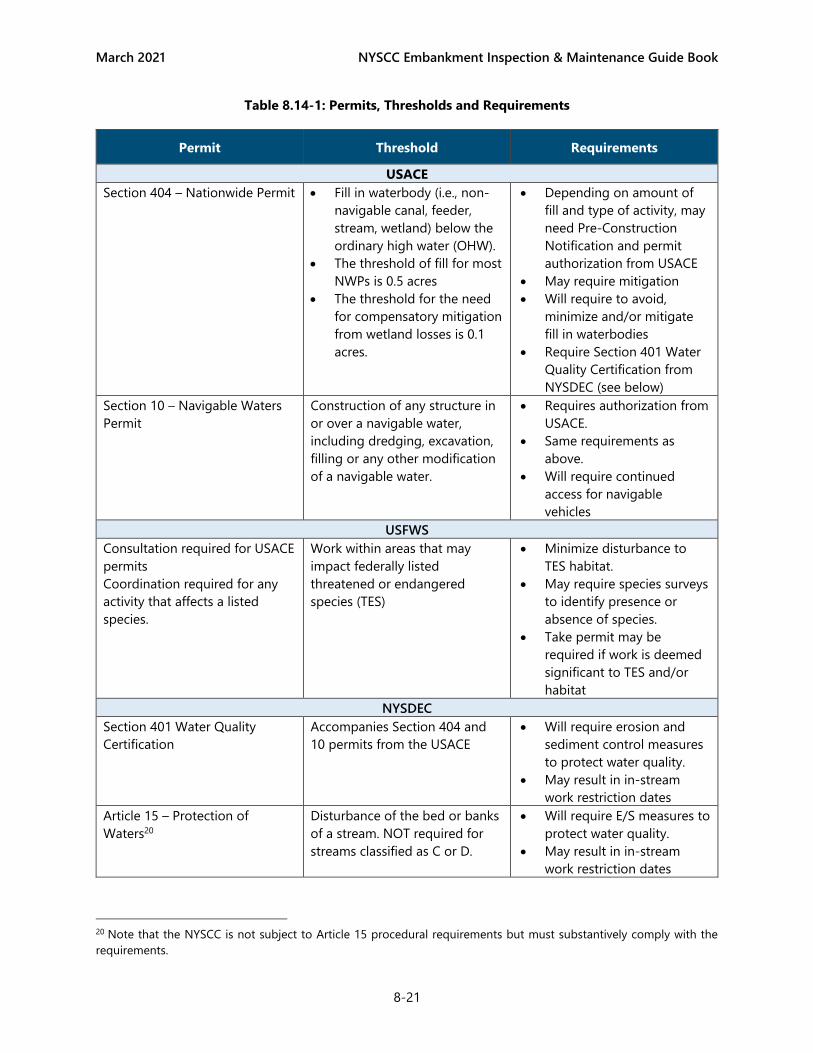
March 2021 NYSCC Embankment Inspection & Maintenance Guide Book
8-21
Table 8.14-1: Permits, Thresholds and Requirements
Permit Threshold Requirements
USACE
Section 404 – Nationwide Permit • Fill in waterbody (i.e., non-
navigable canal, feeder,
stream, wetland) below the
ordinary high water (OHW).
• The threshold of fill for most
NWPs is 0.5 acres
• The threshold for the need
for compensatory mitigation
from wetland losses is 0.1
acres.
• Depending on amount of
fill and type of activity, may
need Pre-Construction
Notification and permit
authorization from USACE
• May require mitigation
• Will require to avoid,
minimize and/or mitigate
fill in waterbodies
• Require Section 401 Water
Quality Certification from
NYSDEC (see below)
Section 10 – Navigable Waters
Permit
Construction of any structure in
or over a navigable water,
including dredging, excavation,
filling or any other modification
of a navigable water.
• Requires authorization from
USACE.
• Same requirements as
above.
• Will require continued
access for navigable
vehicles
USFWS
Consultation required for USACE
permits
Coordination required for any
activity that affects a listed
species.
Work within areas that may
impact federally listed
threatened or endangered
species (TES)
• Minimize disturbance to
TES habitat.
• May require species surveys
to identify presence or
absence of species.
• Take permit may be
required if work is deemed
significant to TES and/or
habitat
NYSDEC
Section 401 Water Quality
Certification
Accompanies Section 404 and
10 permits from the USACE
• Will require erosion and
sediment control measures
to protect water quality.
• May result in in-stream
work restriction dates
Article 15 – Protection of
Waters20
Disturbance of the bed or banks
of a stream. NOT required for
streams classified as C or D.
• Will require E/S measures to
protect water quality.
• May result in in-stream
work restriction dates
20 Note that the NYSCC is not subject to Article 15 procedural requirements but must substantively comply with the
requirements.

March 2021 NYSCC Embankment Inspection & Maintenance Guide Book
8-22
Permit Threshold Requirements
Article 24 – Freshwater Wetlands Activities within a State Wetland
and most activities within its
100-foot buffer zone
• Will require permit
authorization from NYSDEC.
• Will require E/S measures to
protect water quality.
• Will require to avoid,
minimize and/or mitigate
fill in waterbodies
SPDES GP 0-20-001 Earth disturbance of 1 ac or
more
• Requires E/S measures and
plan
• Requires development of
SWPPP
• Requires NOI to be
submitted to NYSDEC
• May require post-
construction stormwater
management measures
(only if impervious area
involved)
Consultation w/ National
Heritage Program – Required for
NYSDEC permits
Work within an area identified as
having the potential for RTEs
• May require avoidance and
minimization measures
• May required additional
protection measures
• May require additional
species surveys
Endangered/Threatened Species
(Incidental Take) Permit
Where the “take” of listed
species cannot be avoided
• Specific Net Conservation
Benefits will be required, as
negotiated with NYSDEC
NYSDOS
Coastal Consistency – Required
for any State or Federal permits
Any work in areas within Coastal
Zones (i.e., Erie Canal between
Niagara River and 900 feet
upstream of SR 62, and Oswego
Canal between Lake Ontario and
150 feet upstream of Varick
Dam21) and within municipalities
that have Local Waterfront
Revitalization Programs
approved by the NYSDOS
• Requires review by NYSDOS
for consistency with State
Coastal Policies and/or
Local Waterfront
Revitalization Program
(LWRP) Policies
21 Varick Dam which Canals refers to as Curved Dam, creates the headwater pond of Lock O7

March 2021 NYSCC Embankment Inspection & Maintenance Guide Book
8-23
Permit Threshold Requirements
SHPO
Consultation Submit project information to
SHPO via CRIS if the work will
require a State or Federal Permit
or if it will require additional
SEQR review. All submittal to
SHPO must be coordinated
through the NYSCC Cultural
Resources Coordinator
• Will require review by SHPO
• May require studies by
historic preservation
professionals.
• May require additional
protection/avoidance
measures.
• May require special
documentation or
construction practices
NYSCC
State Environmental Quality
Review
Any work not consistent with
that described in this Guide Book
or beyond the scope or
parameters of the SEQR GEIS.
• Will require additional
environmental review by
qualified personnel
8.15 SEQR THRESHOLDS AND DECISION PROCEDURE
There are site-specific situations where the proposed maintenance activities would result in significant
social, economic, and environmental impacts. Such situations are listed in Table 8.15-1 Regulatory and
Community Thresholds.
Table 8.15-1 Regulatory and Community Thresholds
Federal or State rare, threatened, or endangered plant species are located on NYSCC property or on
adjacent lands that would experience an incidental take as defined in 6 NYCRR Part 182 as a result of
being disturbed by EEIP activities.
EEIP activities would significantly reduce or degrade occupied habitat (as defined in 6 NYSCRR Part 182)
used by any rare, threatened or endangered species.
EIPP activities would significantly reduce the quantity or quality of the resource or characteristic which
was the basis for its designation as Critical Environmental Area.
EEIP activities that would cause the loss of any wetlands in the Montezuma Marshes National Natural
Landmark as identified in Section 3.2 of the Generic EIS.
NYSCC property where EEIP activities are contemplated involves or is adjacent to a public park, and
those activities would significantly impair the park’s aesthetic, historic or recreational function.
Where historic resources listed or eligible for inclusion in the State or National Registers of historic
places, are located on or in close proximity to NYSCC property where EEIP activities are contemplated,
and the EEIP activities would result in a determination of an adverse effect on the historic resource by
the Agency Preservation Officer or the SHPO.
Where an aesthetic resource of local importance has previously been identified through an adopted
comprehensive plan or zoning and is located on lands where EEIP activities are contemplated and those
activities would significantly damage the aesthetic character of the resource.

March 2021 NYSCC Embankment Inspection & Maintenance Guide Book
8-24
Where EEIP activities would significantly adversely affect an aesthetic resource of Statewide Significance
derived from one or more of the categories identified in Section VI.A., of NYSDEC Program Policy DEP-
00-2 “Assessing and Mitigating Visual and Aesthetic Impacts,”
http://www.dec.ny.gov/docs/permits_ej_operations_pdf/visualpolicydep002.pdf.
Where EEIP activities are inconsistent with an approved Local Waterfront Revitalization Program (LWRP)
in accordance with the New York State Waterfront Revitalization of Coastal Areas and Inland Waterways
Act (NYS Executive Law, Article 42).
For embankment segments where any of the community thresholds in Error! Reference source not
found.are exceeded, the following actions, listed in Figure 8.15-1, would be taken:
1. Remove trees and brush smaller than 3 inches in diameter at breast height (DBH) that impede
inspections and trees larger than 3 inches DBH that are dead, diseased, and imminently dangerous to
property and people. Provide, as necessary, emergency response to stabilize embankments.
2. Perform a tree inventory and an embankment condition survey. Identify the limits of Zones 2B and 3
on the involved earthen embankment.
3. Engage with stakeholders based on specific thresholds identified.
4. Evaluate the effectiveness of potential mitigation measures from the Guide Book. If any are appropriate,
these measures would be implemented and the EEIP activities would continue as prescribed in Figure
8.15-1. If none of the mitigation measures are appropriate, continue with Action Item 5.
5. Perform more detailed inspections, including detection of embankment seepage and embankment
stability monitoring. The prescribed content and frequency of inspections is provided in the Guide Book.
These include bi-weekly to monthly Bank Walk Inspections and quarterly Enhanced Embankment
Monitoring for a more detailed investigation.
6. If the results of the detection and monitoring of embankment seepage and embankment stability
suggest that the embankment is stable, a seepage and monitoring program would be developed and
implemented. Monitoring may include: piezometers, slope indicators, observation wells and seepage
weir boxes. Seepage and stability monitoring would continue for an additional 5 years if the gathered
information suggests that the embankment is stable. At the conclusion of the 5-year period, the earthen
embankment would be reassessed and the Guide Book procedure would commence again as shown on
Figure 8.15-1.
7. If the results of the seepage and stability monitoring indicate instability or that safe conditions are
deteriorating, corrective engineering solutions would be implemented. Such solutions are not
addressed in the Guide Book. Implementation of corrective engineering solutions would be considered
a separate site-specific action under SEQR and would be reviewed accordingly.
A decision tree is shown in Figure 8.15-1 below, illustrating the evaluation and corrective action process for
Canal embankments, where regulatory or community thresholds are exceeded.

March 2021 NYSCC Embankment Inspection & Maintenance Guide Book
8-25
Figure 8.15-1: Maintenance Solutions Decision Tree

March 2021 NYSCC Embankment Inspection & Maintenance Guide Book
9-1
9 PUBLIC RELATIONS & COMMUNITY OUTREACH
Public relations and community outreach for maintenance projects will be handled on a project-by-project
basis. Projects should be reviewed by the NYSCC Public Information Office (PIO) for further direction.
9.1 COMMUNICATIONS & NOTIFICATIONS
All maintenance activities, except those considered routine (e.g., mowing, clearing debris) should include,
where prudent:
• Notification to adjacent property owners
• Notification to local municipalities if necessary
• Trail closure signs and detour routes
• Boater and waterborne traffic warning signs, and Notice to Mariners
Projects that include work in the water or closure of canal sections must also include:
• Advanced notification of closure, if feasible
• Boater and waterborne traffic warning signs and closure signs
The following notification formats will be used as determined by NYSCC PIO:
• Physical signs posted at the project site and upstream and downstream control structures,
• All closures should also be notified at www.canals.ny.gov and social media accounts, and
• Long-term closures (>5 days) may also be referred to local television and radio stations.
When possible, the notifications should include the following information:
• Estimated time of completion / closure period,
• Brief description of the type of work to be performed.
• Alternate routes / access points if a closure is required, and
• Point of contact for questions.
9.2 PUBLIC MEETINGS
Some maintenance projects may require public meetings. This determination and meeting coordination will
be at the discretion of NYSCC PIO along with recommendation from Canal Operations Staff and any
environmental permitting requirements.
9.3 FAQ SHEETS
NYSCC PIO has developed FAQ sheets for vegetation management, other maintenance activities and for
capital improvement projects. As the embankment management program progresses, both FAQ sheets will
be amended or developed, as appropriate and posted at www.canals.ny.gov. Some maintenance activities,
depending upon their location, footprint, and types of work activities may require public meetings. This
determination and meeting coordination will be at the discretion of NYSCC PIO.

March 2021 NYSCC Embankment Inspection & Maintenance Guide Book
10-2
10 REFERENCES
1. ASCE, 2010. American Society of Civil Engineers, So, You Live Behind a Levee! What you should know
to protect your home and loved ones from floods.
2. AASHTO 2012. AASHTO Task Force on Geometric Design. AASHTO Guide for the Development of
Bicycle Facilities. Fourth Edition. Washington, DC: American Association of State Highway and
Transportation Officials, 2012.
3. FEMA, 2004. Federal Emergency Management Agency, Federal Guidelines for Dam Safety – Hazard
Potential Classification System for Dams
4. FEMA, 2005. Federal Emergency Management Agency, FEMA 534, Technical Manual for Dam
Owners – Impacts of Plants on Earthen Dams
5. FEMA, 2015. Federal Emergency Management Agency, FEMA P-1025, Federal Guidelines for Dam
Safety Risk Management
6. NYSCC, 2018. New York State Canal Corporation K118-EMP-0008, Post Event Inspection
Procedures.
7. NYSCC, 2017. New York State Canal Corporation, Dam Maintenance Guide Book
8. NYSDEC, Undated. New York State Department of Environmental Conservation, DOW TOGS 3.1.5,
Guidance for Dam Hazard Classification, DRAFT.
9. NYSDEC, 1987. New York State Department of Environmental Conservation, Owners Guidance
Manual for the Inspection and Maintenance of Dams in New York State
10. NYSDEC, 2001. New York State Department of Environmental Conservation, Assessing and
Mitigating Noise Impacts (DEC Program Policy).
11. NYSDEC, 2016. New York State Department of Environmental Conservation, New York State
Standards and Specifications for Erosion and Sediment Control
12. USACE, 2019. US Army Corps of Engineers EP 1110-2-18, 2019. Guidelines for Landscape Planting
and Vegetation Management at Levees, Floodwalls, Embankment Dams, and Appurtenant Structures