newberry volcano—central oregon’s sleeping giant · newberry last erupted about 1,300 years...
TRANSCRIPT

Newberry Volcano—Central Oregon’s Sleeping Giant
U.S. Department of the InteriorU.S. Geological Survey
USGS Fact Sheet 2011-31452011
the largest volcano in the Cascades volcanic arc and covers an area the size of Rhode Island. Unlike familiar cone-shaped Cascades volcanoes, Newberry was built into the shape of a broad shield by repeated eruptions over 400,000 years. About 75,000 years ago a major explosion and collapse event created a large volcanic depression (caldera) at its summit. Newberry last erupted about 1,300 years ago, and present-day hot springs and geologically young lava flows indicate that it could reawaken at any time. Because of its proximity to nearby communities, frequency and size of past eruptions, and geologic youthfulness, U.S. Geological Survey scientists are working to better understand volcanic activity at Newberry and closely monitor the volcano for signs of unrest.
H idden in plain sight, Oregon’s massive Newberry Volcano is
Rising gradually southward to 4,000 feet above the City of Bend, Oregon, Newberry Volcano appears from Bend as a broad ridge on the horizon. Extending approximately 75 miles north to south and 27 miles east to west, the shield-shaped volcano and its extensive apron of lava flows cover almost 1,200 square miles, an area about the size of the State of Rhode Island, making it the largest volcano of the Cascades volcanic chain. This giant volcano is unlike a typical Cascade Range cone-shaped volcano (called a “stratocone”), such as South Sister to the west of Bend or Mount Rainier in Washington. Instead, Newberry is a “composite volcano” formed by diverse styles of eruption and has as many as 400 volcanic vents scattered across its
slopes. Numerous lava flows drape its flanks, and some that were very fluid when erupted—like those typical of Hawaiian volcanoes—extend well beyond its base.
Very explosive eruptions, similar to that of Mount St. Helens in 1980, have occurred near Newberry’s summit and produced high plumes and flows of hot volcanic gases and ash (jagged tiny particles of rock and volcanic glass). A much bigger explosive eruption produced the large volcanic depression or “caldera” at the summit; its associated volcanic-ash deposits can be found as far away as the San Francisco Bay Area in California.
Volcanic activity at Newberry has created a unique and spectacular landscape, and in 1990 the Newberry National Volcanic Monument was
established within Deschutes National Forest. Operated by the U.S. Forest Service, the monument encompasses all of the Newberry caldera, parts of the upper slopes of the volcano, and most of the volcano’s “Northwest Rift Zone.” Newberry caldera holds two beautiful lakes, Paulina Lake and East Lake, popular for fishing, boating, swimming, and camping.
How Did Newberry Grow to be the Largest Volcano in the Cascades?
Newberry Volcano lies east of the Cascades volcanic crest at the west margin of a broad volcanic region known as the High Lava Plains. The high-standing part of Newberry covers
U.S. GEOLOGICAL SURVEY and the U.S. FOREST SERVICE—OUR VOLCANIC PUBLIC LANDS
Newberry Volcano, Oregon, is the largest volcano in the Cascades volcanic arc. This north-facing view taken from the volcano’s peak, Paulina Peak (elevation 7,984 feet), encompasses much of the volcano’s 4-by-5-mile-wide central caldera, a volcanic depression formed in a powerful explosive eruption about 75,000 years ago. The caldera’s two lakes, Paulina Lake (left) and the slightly higher East Lake (right), are fed in part by active hot springs heated by molten rock (magma) deep beneath the caldera. The Central Pumice Cone sits between the lakes. The mostly treeless, 1,300-year-old Big Obsidian Flow, youngest lava flow on the volcano, is surrounded by forest south of the lakes. (Photograph by Robert Jensen.)
FOREST SERVICE
DE
PA
RTMENT OF AGRICULTURE
U S
2
about 40 miles north-south by 25 miles east-west and encompasses nearly all of the volcano’s vents. However, Newberry’s lava flows extend much farther than this high part and to the north include the area of what is now downtown Bend, as well as the Redmond Municipal Airport. About 350,000 years ago, an early lava flow erupted from Newberry and flowed north until it reached Smith Rock, where it filled and moved down the channel of the Crooked River and also shifted the channel of the Deschutes River.
Growth of the broad Newberry shield began about 400,000 years ago. Newberry caldera was created about 75,000 years ago by a major explosive eruption and collapse event. This was the most recent of at least three caldera-forming eruptions that lofted pumice (frothy volcanic glass) high into the air and spread flows of extremely hot gases, ash, and pumice, called “pyroclastic flows,” across the volcano’s surface. Later lava flows have partly buried the deposits from this eruption, but one exposure can be seen at Paulina Creek Falls, where a deposit of pyroclastic flow and fall material was so hot that ash and pumice particles were welded together and then cooled into solidified rock.
flow that underlies downtown Bend and the Redmond airport is from that same eruption. Once the caldera was formed, more eruptions began to fill it with lava flows, and lava also erupted at numerous sites outside the caldera, covering much of the volcano’s north and south flanks. Between the end of the last Ice Age (about 12,000 years ago) and 7,700 years ago, Newberry Volcano erupted at least a dozen times.
Eruption that Formed Crater Lake Covers Newberry with Ash
About 7,700 years ago, a massive eruption caused the collapse of ancient “Mount Mazama,” forming a caldera that holds present-day Crater Lake, Oregon. Winds blew volcanic ash from that eruption northeast over Newberry Volcano, which is 75 miles away, covering much of it in a blanket of dusty ash and pumice as much as 6 feet thick on the volcano’s south flank. In Newberry caldera, the foundation of a Native American house was discovered underneath this ash layer, known as the Mazama ash, suggesting that the eruption disrupted an ancient human occupation. The ash sharply separates lava flows of Newberry’s older eruptions from lava flows produced by the volcano’s younger eruptions. The
Newberry Volcano Quick Facts
Volcano type: shield-shaped compositeArea: 1,200 square miles—about the size of Rhode IslandNearby Towns: Bend, Sunriver, LaPine, and RedmondPopulation on or near Newberry lavas: about 200,000Caldera area: 17 square miles
Elevation: 7,984 feet above sea level—Paulina Peak summitHeight above Bend: About 4,000 feetLast eruption: about 1,300 years ago—Big Obsidian FlowOldest lavas: about 400,000 yearsNumber of volcanic cones and vents: more than 400Estimated total volume: 120 cubic miles (mi3) (for example, South Sister is 5 mi3 and Mount St. Helens is 6 mi3)Volume of Lava Butte cone and flow: Less than 1 cubic mile
Before formation of the caldera, Newberry’s summit was 500 to as much as 1,000 feet higher than present-day 7,984-foot Paulina Peak. Shortly after the most recent caldera-forming eruption, vents on the north side of Newberry fed large lava flows westward, which created and then flowed through Lava River Cave, diverting the Deschutes River. The lava
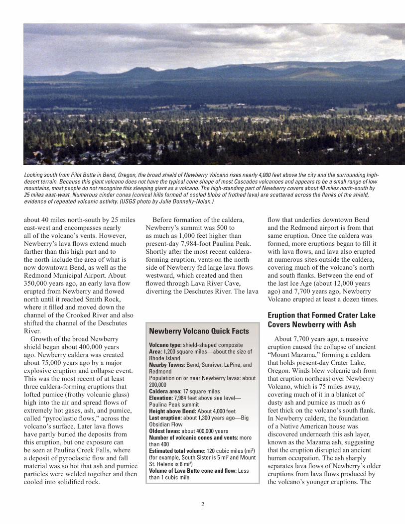
Looking south from Pilot Butte in Bend, Oregon, the broad shield of Newberry Volcano rises nearly 4,000 feet above the city and the surrounding high-desert terrain. Because this giant volcano does not have the typical cone shape of most Cascades volcanoes and appears to be a small range of low mountains, most people do not recognize this sleeping giant as a volcano. The high-standing part of Newberry covers about 40 miles north-south by 25 miles east-west. Numerous cinder cones (conical hills formed of cooled blobs of frothed lava) are scattered across the flanks of the shield, evidence of repeated volcanic activity. (USGS photo by Julie Donnelly-Nolan.)
3
CalderaRim
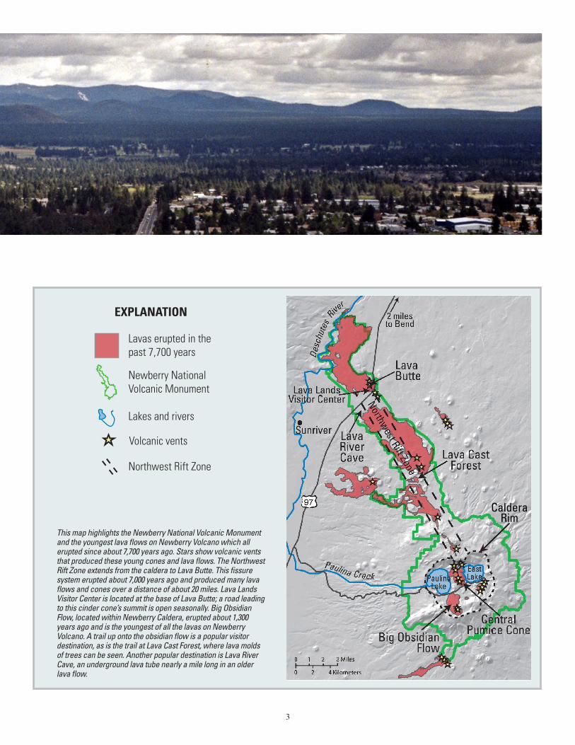
This map highlights the Newberry National Volcanic Monument and the youngest lava flows on Newberry Volcano which all erupted since about 7,700 years ago. Stars show volcanic vents that produced these young cones and lava flows. The Northwest Rift Zone extends from the caldera to Lava Butte. This fissure system erupted about 7,000 years ago and produced many lava flows and cones over a distance of about 20 miles. Lava Lands Visitor Center is located at the base of Lava Butte; a road leading to this cinder cone’s summit is open seasonally. Big Obsidian Flow, located within Newberry Caldera, erupted about 1,300 years ago and is the youngest of all the lavas on Newberry Volcano. A trail up onto the obsidian flow is a popular visitor destination, as is the trail at Lava Cast Forest, where lava molds of trees can be seen. Another popular destination is Lava River Cave, an underground lava tube nearly a mile long in an older lava flow.
Lavas erupted in thepast 7,700 years
Newberry National Volcanic Monument
Lakes and rivers
Volcanic vents
Northwest Rift Zone
EXPLANATION
4
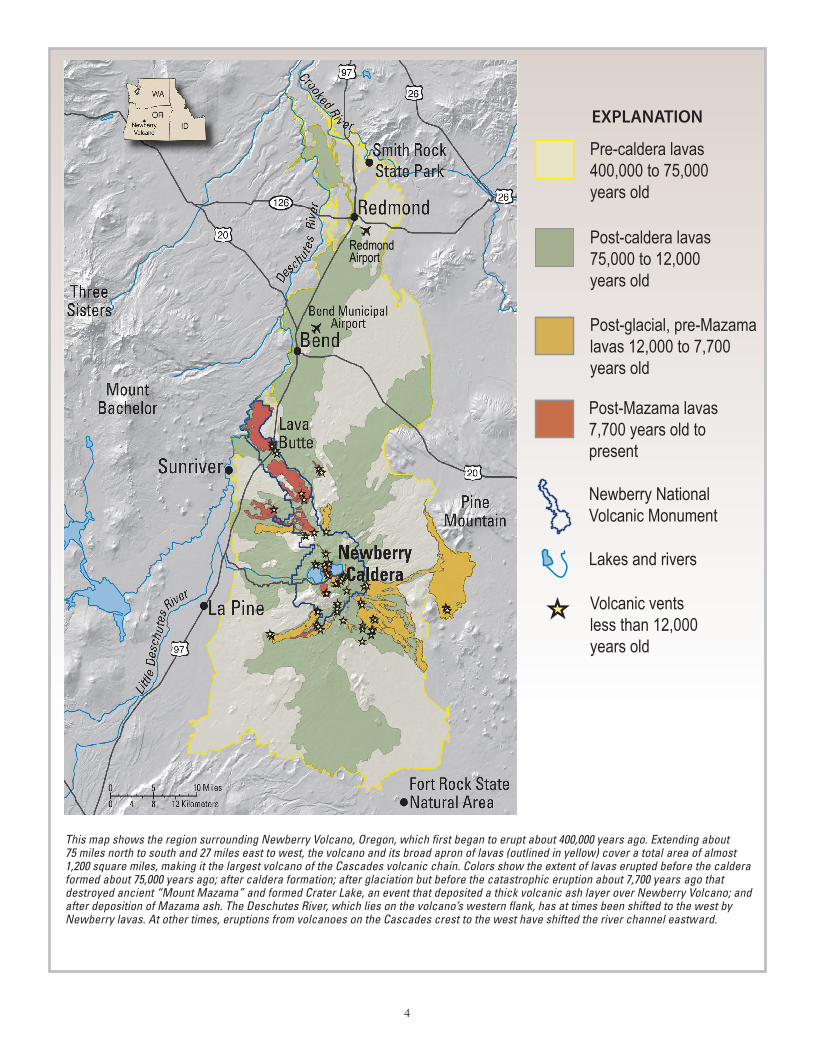
This map shows the region surrounding Newberry Volcano, Oregon, which first began to erupt about 400,000 years ago. Extending about 75 miles north to south and 27 miles east to west, the volcano and its broad apron of lavas (outlined in yellow) cover a total area of almost 1,200 square miles, making it the largest volcano of the Cascades volcanic chain. Colors show the extent of lavas erupted before the caldera formed about 75,000 years ago; after caldera formation; after glaciation but before the catastrophic eruption about 7,700 years ago that destroyed ancient “Mount Mazama” and formed Crater Lake, an event that deposited a thick volcanic ash layer over Newberry Volcano; and after deposition of Mazama ash. The Deschutes River, which lies on the volcano’s western flank, has at times been shifted to the west by Newberry lavas. At other times, eruptions from volcanoes on the Cascades crest to the west have shifted the river channel eastward.
Post-glacial, pre-Mazama lavas 12,000 to 7,700 years old
Post-caldera lavas75,000 to 12,000 years old
Pre-caldera lavas400,000 to 75,000 years old
Post-Mazama lavas7,700 years old to present
Newberry National Volcanic Monument
Lakes and rivers
Volcanic vents less than 12,000 years old
EXPLANATION
RedmondAirport
5
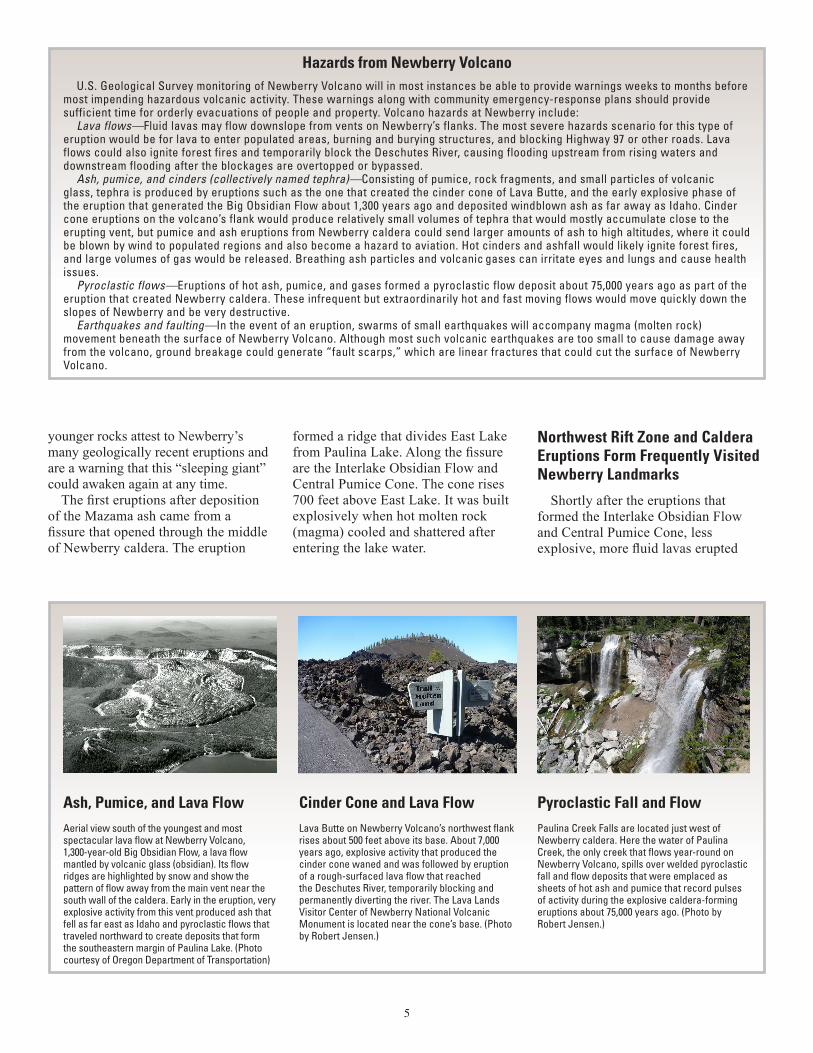
Cinder Cone and Lava FlowLava Butte on Newberry Volcano’s northwest flank rises about 500 feet above its base. About 7,000 years ago, explosive activity that produced the cinder cone waned and was followed by eruption of a rough-surfaced lava flow that reached the Deschutes River, temporarily blocking and permanently diverting the river. The Lava Lands Visitor Center of Newberry National Volcanic Monument is located near the cone’s base. (Photo by Robert Jensen.)
Ash, Pumice, and Lava FlowAerial view south of the youngest and most spectacular lava flow at Newberry Volcano, 1,300-year-old Big Obsidian Flow, a lava flow mantled by volcanic glass (obsidian). Its flow ridges are highlighted by snow and show the pattern of flow away from the main vent near the south wall of the caldera. Early in the eruption, very explosive activity from this vent produced ash that fell as far east as Idaho and pyroclastic flows that traveled northward to create deposits that form the southeastern margin of Paulina Lake. (Photo courtesy of Oregon Department of Transportation)
Pyroclastic Fall and FlowPaulina Creek Falls are located just west of Newberry caldera. Here the water of Paulina Creek, the only creek that flows year-round on Newberry Volcano, spills over welded pyroclastic fall and flow deposits that were emplaced as sheets of hot ash and pumice that record pulses of activity during the explosive caldera-forming eruptions about 75,000 years ago. (Photo by Robert Jensen.)
U.S. Geological Survey monitoring of Newberry Volcano will in most instances be able to provide warnings weeks to months before most impending hazardous volcanic activity. These warnings along with community emergency-response plans should provide sufficient time for orderly evacuations of people and property. Volcano hazards at Newberry include:
Lava flows—Fluid lavas may flow downslope from vents on Newberry’s flanks. The most severe hazards scenario for this type of eruption would be for lava to enter populated areas, burning and burying structures, and blocking Highway 97 or other roads. Lava flows could also ignite forest fires and temporarily block the Deschutes River, causing flooding upstream from rising waters and downstream flooding after the blockages are overtopped or bypassed.
Ash, pumice, and cinders (collectively named tephra)—Consisting of pumice, rock fragments, and small particles of volcanic glass, tephra is produced by eruptions such as the one that created the cinder cone of Lava Butte, and the early explosive phase of the eruption that generated the Big Obsidian Flow about 1,300 years ago and deposited windblown ash as far away as Idaho. Cinder cone eruptions on the volcano’s flank would produce relatively small volumes of tephra that would mostly accumulate close to the erupting vent, but pumice and ash eruptions from Newberry caldera could send larger amounts of ash to high altitudes, where it could be blown by wind to populated regions and also become a hazard to aviation. Hot cinders and ashfall would likely ignite forest fires, and large volumes of gas would be released. Breathing ash particles and volcanic gases can irritate eyes and lungs and cause health issues.
Pyroclastic flows—Eruptions of hot ash, pumice, and gases formed a pyroclastic flow deposit about 75,000 years ago as part of the eruption that created Newberry caldera. These infrequent but extraordinarily hot and fast moving flows would move quickly down the slopes of Newberry and be very destructive.
Earthquakes and faulting—In the event of an eruption, swarms of small earthquakes will accompany magma (molten rock) movement beneath the surface of Newberry Volcano. Although most such volcanic earthquakes are too small to cause damage away from the volcano, ground breakage could generate “fault scarps,” which are linear fractures that could cut the surface of Newberry Volcano.
Hazards from Newberry Volcano
younger rocks attest to Newberry’s many geologically recent eruptions and are a warning that this “sleeping giant” could awaken again at any time.
The first eruptions after deposition of the Mazama ash came from a fissure that opened through the middle of Newberry caldera. The eruption
formed a ridge that divides East Lake from Paulina Lake. Along the fissure are the Interlake Obsidian Flow and Central Pumice Cone. The cone rises 700 feet above East Lake. It was built explosively when hot molten rock (magma) cooled and shattered after entering the lake water.
Northwest Rift Zone and Caldera Eruptions Form Frequently Visited Newberry Landmarks
Shortly after the eruptions that formed the Interlake Obsidian Flow and Central Pumice Cone, less explosive, more fluid lavas erupted
6
Julie M. Donnelly-Nolan, Wendy K. Stovall, David W. Ramsey, John W. Ewert, and Robert A. Jensen
Edited by James W. Hendley IIGraphic design by Stephen L Scott, Wendy K. Stovall,
and David W. Ramsey
COOPERATING ORGANIZATIONU.S. Forest Service
For more information contact:
U.S. Geological SurveyDavid A. Johnston Cascades Volcano Observatory
1300 SE Cardinal Court, Bldg. 10, Suite 100Vancouver, WA 98683-9589
Tel: (360) 993-8900, FAX: (360) 993-8980e-mail: [email protected]
http://volcanoes.usgs.gov/
This Fact Sheet and any updates to it are available online at http://pubs.usgs.gov/fs/2011/3145/
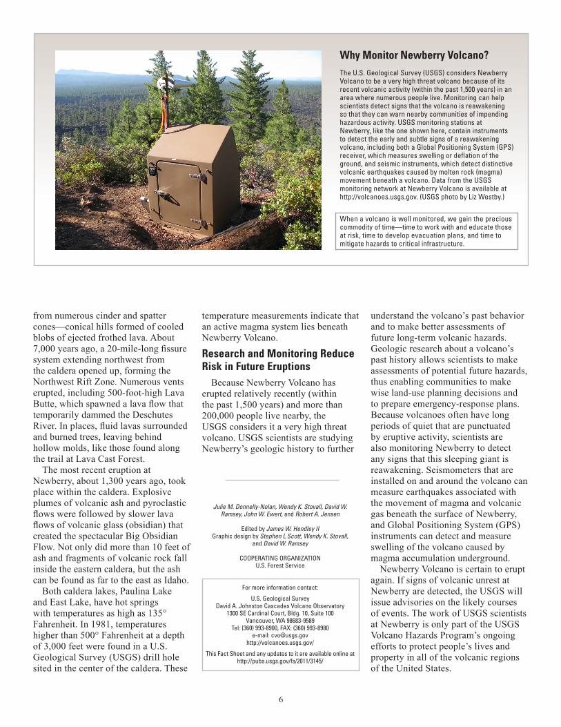
Why Monitor Newberry Volcano? The U.S. Geological Survey (USGS) considers Newberry Volcano to be a very high threat volcano because of its recent volcanic activity (within the past 1,500 years) in an area where numerous people live. Monitoring can help scientists detect signs that the volcano is reawakening so that they can warn nearby communities of impending hazardous activity. USGS monitoring stations at Newberry, like the one shown here, contain instruments to detect the early and subtle signs of a reawakening volcano, including both a Global Positioning System (GPS) receiver, which measures swelling or deflation of the ground, and seismic instruments, which detect distinctive volcanic earthquakes caused by molten rock (magma) movement beneath a volcano. Data from the USGS monitoring network at Newberry Volcano is available at http://volcanoes.usgs.gov. (USGS photo by Liz Westby.)
When a volcano is well monitored, we gain the precious commodity of time—time to work with and educate those at risk, time to develop evacuation plans, and time to mitigate hazards to critical infrastructure.
from numerous cinder and spatter cones—conical hills formed of cooled blobs of ejected frothed lava. About 7,000 years ago, a 20-mile-long fissure system extending northwest from the caldera opened up, forming the Northwest Rift Zone. Numerous vents erupted, including 500-foot-high Lava Butte, which spawned a lava flow that temporarily dammed the Deschutes River. In places, fluid lavas surrounded and burned trees, leaving behind hollow molds, like those found along the trail at Lava Cast Forest.
The most recent eruption at Newberry, about 1,300 years ago, took place within the caldera. Explosive plumes of volcanic ash and pyroclastic flows were followed by slower lava flows of volcanic glass (obsidian) that created the spectacular Big Obsidian Flow. Not only did more than 10 feet of ash and fragments of volcanic rock fall inside the eastern caldera, but the ash can be found as far to the east as Idaho.
Both caldera lakes, Paulina Lake and East Lake, have hot springs with temperatures as high as 135° Fahrenheit. In 1981, temperatures higher than 500° Fahrenheit at a depth of 3,000 feet were found in a U.S. Geological Survey (USGS) drill hole sited in the center of the caldera. These
temperature measurements indicate that an active magma system lies beneath Newberry Volcano.
Research and Monitoring Reduce Risk in Future Eruptions
Because Newberry Volcano has erupted relatively recently (within the past 1,500 years) and more than 200,000 people live nearby, the USGS considers it a very high threat volcano. USGS scientists are studying Newberry’s geologic history to further
understand the volcano’s past behavior and to make better assessments of future long-term volcanic hazards. Geologic research about a volcano’s past history allows scientists to make assessments of potential future hazards, thus enabling communities to make wise land-use planning decisions and to prepare emergency-response plans. Because volcanoes often have long periods of quiet that are punctuated by eruptive activity, scientists are also monitoring Newberry to detect any signs that this sleeping giant is reawakening. Seismometers that are installed on and around the volcano can measure earthquakes associated with the movement of magma and volcanic gas beneath the surface of Newberry, and Global Positioning System (GPS) instruments can detect and measure swelling of the volcano caused by magma accumulation underground.
Newberry Volcano is certain to erupt again. If signs of volcanic unrest at Newberry are detected, the USGS will issue advisories on the likely courses of events. The work of USGS scientists at Newberry is only part of the USGS Volcano Hazards Program’s ongoing efforts to protect people’s lives and property in all of the volcanic regions of the United States.