next: foreword a guide to the mother lode country (1948) by c
TRANSCRIPT

Next: Foreword
A Guide to the Mother Lode Country (1948) by C. Frank Brockman
Doorway, Adams Express Office, Volcano, California
• Foreword

• The Origin of the Gold
• Gold in California Before Marshall’s Discovery
• How the Argonauts Came to California
• The Average Miner
• Famous Names From the Mother Lode Country
• Significant Towns of the Mother Lode Country
• Selected References
• Map of the Mother Lodge Country [back cover image]
About the Author
• C. Frank Brockman biographical sketch
• “C. Frank Brockman,“ biography from Mt. Ranier National Park website
• “C. Frank Brockman,” short biographical sketch from Guardians of the Yosemite
• “Yosemite’s New Park Naturalist” [C. Frank Brockman], Yosemite Nature Notes 20(5):37-38 by M. E. Beatty
Bibliographical Information
C. Frank Brockman (Christian Frank) (1902 - 1985), A Guide to the Mother Lode Country. Maps by Katharine J. Parker. From YosemiteNature Notes 27(1) (January 1948). Copyright 1948 C. Frank Brockman. 49 pages. Illustrated. 24 cm. Saddle-stitched paper wrappers.Library of Congress Category F859.3.
Digitized by Dan Anderson, September 2006, from a personal copy. These files may be used for any non-commercial purpose, providedthis notice is left intact. —Dan Anderson, www.yosemite.ca.us
Next: Foreword
YOSEMITE NATURE NOTES
THE MONTHLY PUBLICATION OFTHE YOSEMITE NATURALIST DEPARTMENT
AND THE YOSEMITE NATURAL HISTORY ASSOCIATION, INC.
VOL. XXVII January, 1948Reprinted September, 1948
NO. 1
A Guideto theMother Lode Country
ByC. FRANK BROCKMAN

Copyright 1948Frank Brockman
SPECIAL NUMBER — PRICE 50 CENTS


Sutter’s Mill, Coloma. “Where it began”, January 24, 1848.Copy of Nahl painting in State Library, Sacramento.
McCurry Photo
FOREWORD
The epic story of the “days of ’49” which centered in this region is amply documented in a number of more elaborate volumes (see listof references on page 49) but such books were designed for a purpose quite apart from this one. Since they treat the subject in greaterdetail they are necessarily of more formidable size and cost. Thus they have their greatest appeal to those whose interest in this regionhas already been aroused.
This booklet has been designed primarily for those whose interest in the Mother Lode Country is still dormant. It is offered as a sort of“appetizer for a more complete and satisfying “historical banquet” that one may enjoy by more detailed reading on the subject. And forthose who wish to make personal explorations of the old towns of the Mother Lode area it is arranged to serve as a convenient readyreference for the motorist. Some such help is required by the uninitiated, for today, in driving through the region which contributed such adramatic chapter to American history, one might otherwise fail to recognize the significance of its component parts. Many former townswhich once resounded to the boisterous activity of thousands of gold seekers are now non-existent. Others appear only as skeletonsof their former selves, or else their vigorous beginnings and vital heritage has been engulfed and submerged by the advancements andimprovements of modern times.
Thus, this booklet has been designed merely as a “key” which, it is hoped, will unlock the door to the many interests of the MotherLode Country. If it fulfills that purpose it may help its readers to peer into the dim recesses of the past and catch a brief glimpse of itshistory. Perhaps such a glimpse will be sufficiently revealing to encourage many to step boldly over that figurative threshold; to explorein greater detail and with greater understanding the epic chapter of those stirring times.
COVER ILLUSTRATION: Doorway, Adams Express Office, Volcano. Unless otherwise specified, all photos are by the author.The maps were drawn by Katharine J. Parker
THE ORIGIN OF THE GOLD
What was the origin of the riches that characterized the region known as the Mother Lode Country? How and why was it concentratedin this relatively limited area? By what processes was it distributed?
The answers to these and similar questions lie rooted in an understanding of the geological story of this region; a story that goes backthrough time to a period over 200,000,000 years ago when this entire region lay beneath the sea. Through long periods various typesof sediments—mud, silt, and sand— were gradually deposited in layer-fashion upon the ocean floor from nearby land masses. Theselayers were interspersed with beds of limestone. Eventually these sedimentary rocks accumulated to a thickness of thousands of feet.
Upon at least two occasions this long process of deposition was interrupted by the folding of these stratified layers. By suchmeans the original submarine rocks were slowly folded, twisted, and uplifted above the sea to form a series of roughly parallel,northwestward-trending mountain ranges, occupying the approximate position of the present Sierra Nevada. The second uplift tookplace some 125,000,000 to 150,000,000 years ago and was associated with the presence of hot magma or molten rock which welledup from deep within the earth. This magma or molten rock was prevented from breaking through the surface by the great thicknessof the older, overlying surface materials which they invaded and penetrated. Thus imprisoned by the “roof” of older rocks the magmacooled very slowly and eventually formed a granite “core” beneath the surface of these mountains. The tremenduous pressures and heatgenerated by the process of forming these mountains, as well as the presence of great volumes of hot, slowly cooling magma, modifiedthe character of the original overlying rocks. For instance shales, originally mud on the ocean floor, became slates and limestone wastransformed into marble.
With the passage of time these pre-Sierra mountains were largely destroyed by various forces of erosion. Eventually the area wascharacterized by ridges of only moderate height and the granite core lay exposed over wide areas. During this period the principal

drainage pattern in the area was more or less at right angles to what it is today; the principal streams flowed from north to south insteadof from east to west as is the case at present. Finally, about 60,000,000 years ago, a great block of the earth’s surface was slowly tiltedto the west. The culmination of this uplift brought the Sierra Nevada into being. It is a great block range composed largely of granite,from 60 to 80 miles wide, about 420 miles long, and with a crest averaging about 13,000 ft. above the sea. Its gradual westward slopeis sharply contrasted with the abrupt, precipitous eastern escarpment. As the tilting of this granite block progressed the drainage patternof the area was transformed from a general north-south pattern to the east-west character of the present time. All of these events wereto have a profound effect, not only on the formation of gold in this region but on its eventual distribution and, thus, on the manner bywhich it was reclaimed.
The formation of metals, and gold is no exception, is intimately associated with rocks that are derived from the cooling of moltenmagma deep within the earth. Such magma is the source of metals. But the gold in the Mother Lode Country was not found in thegranites—which were originally molten magmas, and which were eventually exposed to view following the destruction of the older,overlying strata. It was in the foothills, bordering the exposed granite core, where the roots of these older mountains still remained, thatthe precious metal was recovered. What then is the connection between these geological processes?
While some metals form directly by concentration as the magma cools, others, particularly gold, are carried off from the molten rock byhighly heated gases and vapors. These gases penetrate cavities, fissures, and pores of adjoining and overlying rocks, cooling graduallyas they extend themselves into the surrounding mass. As temperatures are lowered the mineral substances contained are depositedby various means along the sides of cracks, fissures, and cavities. One might roughly compare this process to the deposition of saltas sea water evaporates. Most of the world’s gold, and this is particularly true of that in the Mother Lode Country, was formed bylow temperature deposits at relatively shallow depths. Thus, roughly as outlined, the gold of the Mother Lode was deposited in older,overlying rocks adjoining the granite core as veins, or pockets, in cracks, fissures, pores, and cavities, or through the replacement ofcertain material such as limestone, which was readily soluble in the mineralized solutions. Such deposits were reclaimed by lode mining,by following a vein of gold-bearing quartz by means of shafts or tunnels which were sunk into the earth. It was a process that requiredtechnical knowledge, great skill, ample equipment, and sizable capital. Consequently it did not come into prominence here until placermining was well developed. But unlike the placer deposits which were eventually worked out, lode mining continues to the presentday in many sections of the Mother Lode Country. The free gold is reclaimed from the ores by pulverizing the gold-bearing rocks andseparating the metal from the associated valueless materials by various technical processes.
But much of the gold obtained from the Mother Lode Country in the early days came from placer deposits. It was panned from thestreams or washed from the surface gravels. Where gold-bearing gravels were not adjacent to water flumes were constructed or thegravels were carried laboriously to the nearest stream for washing. The history of this region is replete with interesting and often amusingincidents resulting from the destruction of buildings, and even entire sections of towns, as the miners undermined them in their searchfor gold-bearing gravels.
Placer deposits were responsible for the quick development of numerous boom camps. As the deposit was worked out they quicklydeclined. In consequence many famous old-time camps, dependent wholly upon rich placer deposits, are now no longer in existence.The origin of such placer deposits resulted from the gradual disintegration—by natural means—of the original gold-bearing rocks whichonce overlaid the captured magma. As the original surface layers which formed the pre-Sierra terrain were slowly destroyed the morevaluable minerals were separated by nature and transported by gravity or water to other nearby sections. The disintegrating materialsmoved slowly down the slopes to the nearest stream. Here the water carried the lighter, valueless materials away at a rapid rate, but theheavier free gold readily sank to the stream bed and was carried for only short distances. This process went on for long periods of time,eventually resulting in the concentration of free gold at places where the currents were not sufficiently strong to transport it—such asin eddies of other quiet position of the streams. It was in such places—the placer deposits—where free gold derived in that fashion waswashed from the gravels by sluicing, by the use of the pan, the rocker, or the “long tom.” Unlike lode mining it required little previousmining experience, only relatively crude equipment, and little if any capital.

Old metamorphic rocks infoothill region. It was inthese strata that the goldwas found.
Anderson Photo
GOLD IN CALIFORNIA BEFORE MARSHALL’S DISCOVERY
January 24, 1848, the California gold rush had its origin in the accidental discovery of the yellow metal on the south fork of the AmericanRiver near the present town of Coloma (see page 40) by James Marshall who was supervising the construction of a sawmill there forJohn A. Sutter. Matters concerned with the event in American history are well known. But the fact that Marshall’s discovery was notthe first evidence of gold in California is not so generally recognized by the average person.
To the early Spaniards, California was early linked with fabulous legends of gold, but these stories were the product of fancy ratherthan fact. Yet it seems rather amazing that Spain which controlled this area for so long and whose dominions were extended so largelythrough conquests aimed at the acquisition of gold, did not make some effort to explore the possibilities here. Had they done so and hadthe gold been discovered one can but speculate upon the changes in historical events that would have resulted.
Undoubtedly the Jesuit fathers at a number of the early Spanish Missions must have had an inkling of the presence of gold in this regionfor, it is said, numbers of their Indian converts occasionally brought in small quantities of gold dust for inspection. Yet, if this is thecase, there is no evidence of such acts having elicited anything more than a disinterested response.
But in 1842 gold in California became a tangible reality. In that year a small placer deposit was discovered in San Francisquito Canyonnot far from the Mission San Fernando. However, it was not rich enough nor extensive enough to last long and while it was worked forseveral years, and while a small amount of gold was even shipped to the Philadelphia mint, little more than local interest was aroused.
Another segment of this portion of the story relating to the pre-Marshall discoveries is also of interest. It is said that about 1844 JohnBidwell had his chance at fame but unknowingly permitted the opportunity to go down in history as the spark for the great gold rush, toescape his grasp. Bidwell, like Marshall, was an employee of Sutter. He was highly regarded by his employer and, in fact, was Sutter’sright hand man in the management of his vast agricultural holdings. In the spring of the year one of Sutter’s Mexican employees, workingunder Bidwell, informed his immediate superior that gold was to be found in the Sierra Nevada. It must be recognized that many of theMexican inhabitants of California at that time had come from Sonora, in Old Mexico, where mining was actively engaged in. Thesepeople had a practical understanding of the nature of this business. Bidwell was interested and checked further on the story but his

informant insisted that he would require a “batea” in order to determine whether or not his supposition was correct. A “batea” wasmerely a wooden bowl which was used in washing gold bearing gravels as later American miners used the pan. But Bidwell, none toofamiliar with Spanish, thought a “batea” must be a complicated instrument and did not take action soon enough. Busy with his dutiesas an overseer for Sutter, he delayed. By the time he became aware of the significance of the term four years had passed and Marshall’sdiscovery had electrified the world.


Routes of the Argonauts
HOW THE ARGONAUTS CAME TO CALIFORNIA
In the ’40s, although still under Mexican domination, California had already attracted a number of adventurous Americans. A thin streamof emigrants were annually braving the perils of the long overland journey, following the routes previously pioneered by that redoubtablegroup of trappers and frontiersmen known as “the mountain men.” Jedediah Smith, Joseph Walker, Sylvester Pattie, Benjamin Wilson,Peter Lassen, and Kit Carson were the most noted leaders of the small bands of adventurers who, for a period of about ten years, beginningin 1826, extended their explorations westward from the Rockies into California. Their coming shook the Mexican inhabitants from thecomplacent belief that they were amply protected through isolation behind that great mountain barrier—the Sierra Nevada—and thetremenduous expanse of desert country immediately to the east. But America was looking west and subsequent events, including thegradually increasing tide of emigration, the Bear Flag Revolt and the establishment of the short-lived but significant California Republic,and the Mexican War finally established American sover[e]ignty over this area just before Marshall’s discovery of gold in 1848.
Within a relatively short time after Marshall’s discovery the thin trickle of California-bound emigrants was transformed into a flood.They came in prodigious numbers by land and sea, but regardless of the route used their journey was long and arduous, and repletewith hardship and danger.
Many of those who chose to come overland followed the famous Oregon Trail to Fort Hall (near the present town of Pocatello, Idaho), atwhich point the California “road” branched south to Salt Lake. From this point most of the emigrants pushed west along the Humboldt(across the present State of Nevada), eventually reaching the base of the Sierra Nevada on the east in plain view of its rugged, imposingcrest. During the summer months a number of high mountain passes, such as Donner and Carson, enabled them to effect a crossing ofthis last formidable barrier. Some, however, chose to follow south along the east side of the Sierra through Owens Valley, crossing themountains via Walker Pass east of the present city of Bakersfield. Others left the main route at Salt Lake and struck south to the Virginand Sevier Rivers before turning west and eventually reaching San Bernardino. The most southerly overland route crossed Texas, thenfollowed along the approximate southern border of the United States to the junction of the Colorado and Gila Rivers, from which pointthe emigrants reached the vicinity of Los Angeles via San Gorgonio Pass. A few came in from the north, working their way south byvarious routes from the western terminus of the Oregon Trail on the Columbia River.
The principal routes by sea were the long, tedious passage “round the horn” or via the Isthmus of Panama. In the latter case, afterdisembarking from the ship on the eastern side of the Isthmus, it was necessary to cross that fever-ridden, miasmatic land to the Pacificshore and there engage passage on a second vessel for California.
But Americans were not the only ones affected by the gold fever. Marshall’s discovery had literally inflamed the world. People frompractically every corner of the earth set out for the California gold fields, giving the population of this area a unique, cosmopolitancharacter. From Europe came Englishmen, Frenchmen, Germans, Cornishmen, Welshmen, Italians, and many others. The originalMexican population of California was enhanced by great numbers of their countrymen who pushed northward across the border. SouthAmerica contributed numbers from Chile, Peru, and Bolivia. From across the great expanse of the Pacific came men from Australia, aswell as great numbers of Chinese. It is also interesting to note that many of the Americans from the southern states came with numbersof their slaves. Many of these negroes were freed voluntarily by their masters upon arrival. Others were permitted to purchase theirfreedom by means of their success in mining. Eventually all these people achieved their freedom for California, in 1850, was finallyadmitted into the Union as a free state.
Thus the “call of gold” appealed to all races and to all creeds throughout the world, resulting in a migration to this area which in manyrespects was without parallel in the annals of history.
THE AVERAGE MINER
Contrary to the generally accepted opinion of the present day the typical miner during the period of the California gold rush was not alawless, uncouth individual whose days were spent in gun fights and his nights in robbery or debauchery. True, there were “bad actors”in the region—both male and female and many of their escapades are notorious. Yet, in addition to not being typical of the populationhere at that time, the antisocial elements did not assume any degree of prominence until the richness of the area was proven. By thattime lawless elements from the world over had arrived in quest of the “easy pickings” which can always be obtained from the moregullible of an established citizenry. Their prominence in the historical tapestry of the Mother Lode Country is due primarily to the factthat their exploits were “news.” And because they were “good copy” they have been played up with the passing of the years while themore prosaic activities of the great majority, somewhat colorless by comparison, were neglected.
Generally speaking the average miner was an honest, law abiding individual concerned primarily with ways and means of obtaininggold; of realizing the hopes that had brought him to California, which had required so much effort and personal sacrifice. True, hisoutward manner was often harsh and rough and in the mines he usually presented a rugged appearance —booted, bearded, with a thatchof unkempt hair crowned by the typical black slouch hat of the day, and wearing homespun trousers and a calico or flannel shirt—allof which were generally and unmistakably in need of washing and repair. But then the rough life he led and the heavy labor it requiredprecluded the possibility of anything but occasional washing. And beards—well, it was the custom of the day for men to be bearded.Besides who had time to shave anyway, or wash clothes for that matter, as long as gold was to be reclaimed from the earth? Cleanlinesswas practically a luxury under such circumstances. The niceties of civilization could wait! Yes, the average miner was rough and readyin manner and appearance, and while he was anything but gentle his character was infused with a high regard for honesty and the lawsof common decency. His opportunities, his difficulties and troubles, his victories and disappointments, his constant battle against theelements in a comparatively primitive land, and the dealings of his fellowmen were all direct and unbending in nature., Thus his reactionswere equally direct. There was no established legal procedure in operation here when the horde of gold seekers arrived. The better

elements set such procedures up for the protection of their rights in accordance with local needs. If they dealt harshly with offenderssuch actions were usually the only solution under the conditions at the time.
Soft dispositioned men would not have been attracted to the gold fields in the first place. The miner of the time would little affordto give much consideration to the fine points of what we feel are essential in a definition of the term “civilization,” but he was notunappreciative of those factors. He merely adapted himself to conditions as he found them, met them on their own terms, accepted themwhen necessary, and improved them when—and if—possible. The great majority of the men who came to California during the goldrush had been reared in established communities. They had thus been “exposed” at least to the social customs of the times and had grownup in an atmosphere of respect for the practical values embodied in an adherence to law and order.
Most of the argonauts were in the prime of early manhood—young, vigorous, and adventurous. They were the only ones who wouldbe inclined to gamble their future in a distant land. They were also the only kind of men who could hope to cope with the numerousproblems involved. Thus the type and character of these gold seekers was screened at the source. They came from all walks of life andfrom all grades of society. There were rich and poor, highly educated as well as those with little formal schooling, skilled and unskilled.But in the mines they were merged into a common picture of men grubbing for gold or serving those who so labored.
The miner worked long and arduous hours at backbreaking labor. Those who had expectations of an easy avenue to fabulous wealthwere quickly and rudely disappointed. A few “struck it rich.” Many had only broken health and bitter failure as their reward. And whilethe average return was greater than that which they would have achieved at home on the prevailing wages of the day their costs werealso high. Many sought their living here in the more prosaic but generally more certain and less exhausting manner of supplying theminers with their varied needs—food, clothing, tools and equipment, transportation, and amusement.
With respect to the latter the miner’s tastes—except in the larger towns— were satisfied by simple and impromptu means. A largeshare of his time not immediately occupied by mining was spent in ministering to his physical needs—that is by washing and mendingclothes, repairing equipment, and preparing the meager and often unbalanced, indigestible requirements of the “inner man.” But whenhe did relax his activities generally took a turn toward group singing, and a miner who could play a fiddle, guitar, or banjo was muchin demand. The songs they sang usually featured the trials and tribulations of their existence, gave vent to thoughts of home, or playedup the more amusing events and personalities of the region. Practical jokes figured prominently in their relaxation also. Occasionallythe miner felt the need of letting down in grander style. For this he journeyed to the nearest larger settlement where opportunity forready made diversion was greater. Here he found the inevitable saloon, the fandango hall, an occasional theatrical performance by oneof several troupes that toured the Mother Lode towns in the ’50s, and—during a brief period until outlawed or until the humbuggeryof the spectacle became too evident for even the tastes of recreation starved miners—perhaps a bull and bear fight. Lodges and othercommunity activities of a similar character figured prominently in the recreational picture, and the constant danger of disastrous firesbrought about the development of fire companies that competed with one another and thus served a social and recreational as well asprotective need in various communities.
During the early days of the gold rush women were scarce in the Mother lode Country. Most miners were single or had left their familiesat home. Thus miners’ dances in the early days were often characterized by the humorous spectacle of booted, bewhiskered men dancingwith one another. The “ladies” in such affairs were usually designated by simply tying a handkerchief about one arm of a requirednumber of individuals. Under such conditions it was inevitable that the Mexican fandango halls would prosper. Such was especiallytrue in the Southern Mines. Although most of these places were conducted with a fair degree of proprie[t]y, events that occasionallytranspired were the source of some trouble and for these lapses the fandango halls were widely condemned in the press of the time.
But as time wore on the Mother Lode Country gradually stabilized. Many miners who had families at home sent for them and otherswho had known girls in distant places did likewise. The few marriageable women in the region were, of course, quickly snapped up andnot a few girls made the long journey west with the avowed purpose of husband hunting as their objective. The effect of this trend isobvious. The Mother Lode Country was gradually transformed from a rugged, almost womanless, pioneer region to one that could atlast afford to consider and develop the “niceties” of civilization that it had lacked in the first days of the gold rush.
FAMOUS NAMES FROM THE MOTHER LODE COUNTRY
The Mother Lode Country during the days of the gold rush produced things other than gold that were of importance to the nation. Manywhose names were to be well known in later years “got their start” in this region at that time. Others, already well known, were attractedto this area and added their bit to the luster of its history by their presence.
Everyone is familiar with those two outstanding American literary figures —Mark Train and Bret Harte. Both of these men owe muchto the background that they obtained here during their brief stay in the mines. Although it is difficult definitely to establish the exactlocale of many of their stories which relate the Mother Lode Country they nevertheless gave us a clear and interesting word picture oflife here at that time. Mark Train’s “Jumping Frog of Calaveras Couny” and Bret Harte’s “Luck of Roaring Camp”—to mention but twoare regarded as classics of their type and, like most of their works, relate to that area of the Southern Mines in the vicinity of Sonora,Angel’s, Chinese Camp, and nearby towns. Thus, this section can be regarded as the center of the Mark Train-Bret Harte country.
Columbia can boast of the fact that it was the virtual birthplace of the Mills fortune for here Darius Ogden Mills, co-founder of the Bankof California and father of the man who was, for a time, Secretary of the Treasury, operated a bank and assay office in the early ’50s.
Seeing the almost non-existent town of Sheep Ranch today one would hardly select it as a likely springboard for fame. Yet, duringthe gold rush George Hearst, father of William Randolph, lived and worked in this vicinity. Here he laid some of the initial stones inthe foundation of his career which led to the United States Senate (1886-1893), the purchase of the San Francisco Examiner, and theeventual development of the Hearst newspaper dynasty.
The country ’round about Mariposa is rich in the lore of “the Pathfinder,” Colonel John C. Fremont, and his fabulous estate (LasMariposas or the Mariposa Grant), within the original boundaries of which the town of Mariposa is located. Col. Fremont—soldier,

explorer, first senator from California, and Republican presidential nominee in 1856—was one of the most colorful and romantic figuresin America at that time. In the ’50s he was actively associated with the operation of his vast landholdings here which contained some ofthe richest gold deposits in the Mother Lode. The exact boundary of the Grant, and even its general location, was subject to early disputebut even after these facts were determined and confirmed his rights to the mineral wealth on his lands were contested by local miners.His claims were upheld by the courts but the litigation was long and costly and, at least partially because of this, his efforts to reap theanticipated rich rewards were in vain. Many of the legal battles concerned with the Mariposa Grant centered in the present MariposaCounty Court House. Fremont himself established his home and headquarters for the operation of his property at Bear Valley.
Near Mariposa one also finds the town of Hornitos. Here, among other historic structures, stands a dilapidated ruin—all that is left ofthe store once operated by G. Ghiradelli. Here he launched himself on a career that was to establish him as a “chocolate king” and makehis name a household word.
James D. Fair first operated along the Mother Lode in such towns as Shaw’s Flat, Angel’s, and Nevada City. Through shrewd analysisof varied mining opportunities he eventually placed himself in a position that, with John Mackay, enabled him to reap a rich harvest inconnection with the Comstock Lode in Nevada. Shaw’s Flat is also glorified by the fact that John B. Stetson, whose name is a bywordwherever men’s hats are mentioned, operated a store here.
Farther north one finds the town of Sutter Creek near which the rich Union Mine (later re-named Lincoln) was located. One of itsprincipal stockholders was Leland Stanford, then operating a successful grocery store in Sacramento—the eventual development ofa more modest venture of a similar character in the more remote town of Michigan Bluff. When the mine lanquished Stanford tookover and prepared to liquidate, but he was finally persuaded to give the property another chance. It was a fortunate decision, for “ladyluck” smiled. The rich lead was picked up again and the mine became a heavy producer once more, thus improving Stanford’s financialcondition to the extent that he was able to continue broadening his interests and career which eventually led into many varied paths—asrailroad builder (with Crocker, Huntington, and Hopkins), statesman, and founder of a great University.
It was at Placerville that J. M. Studebaker operated a blacksmith shop and turned to the manufacture of wheelbarrows which weregreatly prized by miners for their durability. This proved to be a stepping stone to his wagon and carriage works (later established in theEast), and eventually to the automobiles that today bear his name. Placerville was also the site of the grocery store operated by MarkHopkins who eventually, with Stanford, Crocker and Huntington, became one of the “big four” hi the building of the Central PacificRailroad. Here, also, Phillip Armour operated a butcher shop which was to serve as a figurative “leg up” toward his later success. asa packer of nationwide fame.
Grass Valley, to the north of Placerville, attracted the beauteous and notorious Lola Montez—actress, dancer, and one-time favorite ofLudwig, King of Bavaria—upon her arrival in California in 1853. Here she built a house which still stands, in which she lived for twoyears. One of her principal contributions during her residence at Grass Valley was her interest in a local youngster named Lotta Crabtreewho, even as a child, gave promise of future theatrical greatness. Lola tutored her and aided in launching the stage career of one of theforemost American actresses of that time. Lotta’s Fountain in San Francisco commemorates her memory.
Perhaps at least one of the “bad men” should also be mentioned. If so, one cannot neglect the name of Joaquin Murietta, the fabulousand legendary “Robin Hood of the Mother Lode.” With a number cf his henchmen most noted of whom was his bloodthirsty lieutenant“Three Fingered Jack”, and their paramours, he operated throughout the region and rare is the town in this section that can not boast ofits being the locale of some episode in his hectic and diabolic career.
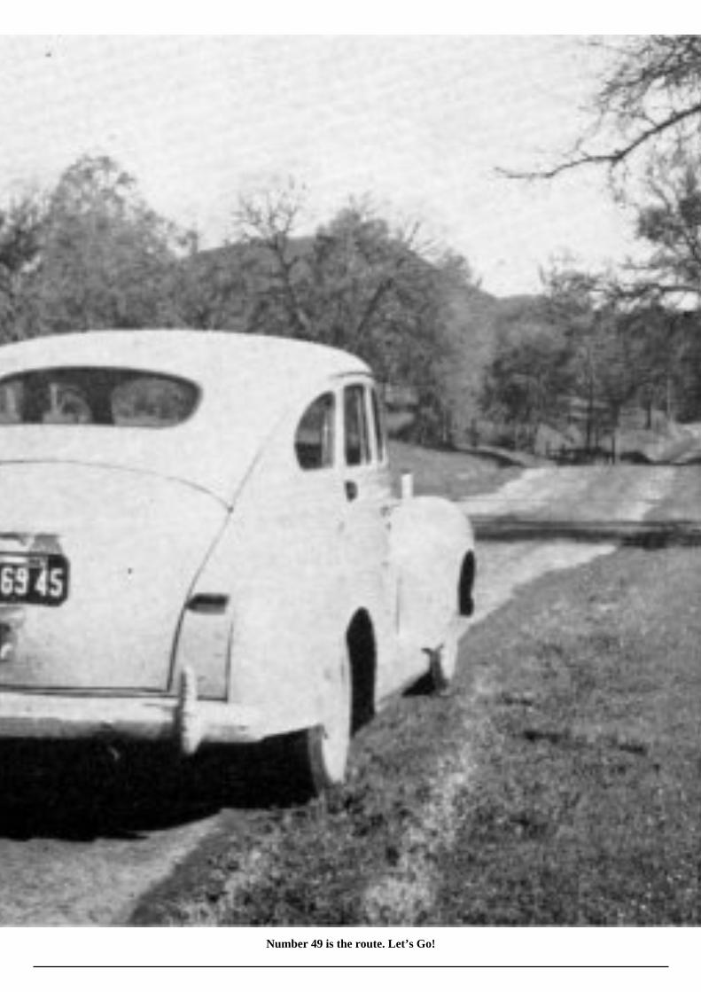
Number 49 is the route. Let’s Go!
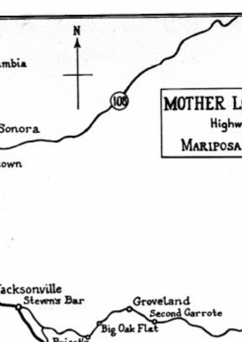

SIGNIFICANT TOWNS OF THE MOTHER LODE COUNTRY
Mariposa, located at the southern extremity of the Mother Lode, is also the southern terminus of Highway 49; the Mother Lode Highway.Its rich historical associations with the “days of ’49” are enhanced by its connection with Colonel John C. Fremont and his famousMariposa Grant; the fact that the first gold quartz was mined in the State here; and with events linked with the Mariposa Indian War(1850-51) which was responsible for the formation of the Mariposa Battalion and the first entrance into, and effective discovery of,Yosemite Valley by white men.
The town had its origin in the spring of 1849 when prospectors, seeking gold along the streams and in the gulches of the MariposaHills, settled along the flat bordering Mariposa Creek—about one half mile below the present townsite. This embryo community waslargely destroyed by floods early in the following year but it was quickly re-built on higher ground, at which time it was given theundistinguished name of “Logtown.” The name “Mariposa” (Spanish for butterfly) was applied a short time later when, about 1852,the community assumed the dignity of the county seat.
Gold was plentiful in the vicinity and the growth of Mariposa, like other boom towns in the area at that time, was phenomenal. In additionto the placer deposits in the area the region was characterized by the rich gold bearing quartz veins of the Mother Lode. The possibilityof the removal of the gold from this material was not recognized until Fremont demonstrated its practicability.
Col. Fremont, who arrived at Mariposa in the spring of ’49 with a group of Mexican miners, was one of the earliest citizens of thiscommunity.

Mariposa —R. Radanovich Photo

Lloyd Photo
Historic Mariposa County Court House
He had come to define the boundaries of and lay claim to his estate of “ten square leagues” (approx. 45,000 acres) which he hadpurchased several years previously and before the presence of gold in the Sierra became an established fact. His attention was directedto the quartz veins in this area by his Mexican miners and a stamp mill was erected at Mariposa in August, 1849 for separating the goldfrom the ore. It was operated by Palmer, Cook and Co. of San Francisco, with whom Fremont had entered into a partnership agreementfor the purpose of financing his proposed mining ventures.
Today, although Mariposa is but a shadow of its former vigor, it is far from a “ghost town.” Here one finds an active mountaincommunity. Modern improvements, however, have not obliterated evidence of Mariposa’s historic past. Many of the buildings withtheir characteristic thick masonry walls and heavy iron shutters date from the ’50s. Just off the main street stands the picturesquecourthouse, built in 1854 and still in use. This building is notable in that the timbers of its framework are fitted together with mortiseand tenon, and held together with wooden pegs. Logs from nearby forests were whip-sawed in order that material could be obtainedfor its construction. The lumber used in finishing the building was planed by hand and is held in place by square-cut nails. Its archivescontain many important and interesting records of the early days. The courtroom on the second floor remains unchanged from the dayswhen it witnessed many famous cases, most noteworthy of which was the long series of litigations concerned with the Mariposa Grant.Nearby is the office of the Mariposa Gazette (originally the Mariposa Chronicle), a weekly established in 1854 and the oldest newspaperin continuous publication in the State.
About Mariposa are a number of once prosperous mining camps which were in their heyday in the ’50s. To the south on a branch roadone finds two of these—villages with such picturesque names as Mormon Bar and Bootjack.
About six miles west of Mariposa, just north of the point where the Merced-Yosemite highway crosses Aqua Fria Creek, the locationof the once-prosperous mining camp of Aqua Fria may be found. During the early days of the gold rush it was a thickly populatedcommunity. For a time, following the establishment of Mariposa County under the Territorial Government, it was the first countyseat—although it was soon replaced by Mariposa in that capacity. Today, however, there is no indication of its former presence. It existsonly in the memory of the oldest inhabitants or upon the fading pages of history. The answer to this lies in the fact that the placer depositsof the area, although rich, were soon worked out. Thereafter the town quickly declined to eventual oblivion. Its history is typical ofmany of the old camps that are now no longer in existence.
Mount Bullion, located about five miles north of Mariposa on Highway 49, was first known as La Mineta and then, until about theturn of the century, as Princeton. There is little about this town today to indicate that it was once one of the more important miningcommunities in Mariposa County. Originally a placer mining center, its importance was enhanced by the fact that rich quartz veins werediscovered in the vicinity. The Princeton Mine, developed from a discovery in 1852, was one of the largest producers in the region andthe original locators reaped handsome profits until forced to relinquish possession of the property when Colonel Fremont establishedhis title to the Mariposa Grant in 1856.
Mount Ophir. The historic mint, established in 1851 by J. L. Moffat, was located a few miles north of Mount Bullion on Highway 49.This mint, and the rich mine nearby, was responsible for the development of a thriving town here in the ’50s which has since passedinto memory. Fifty dollar hexagonal slugs, officially sanctioned by Congress as legal United States coins, were manufactured here.Although a number of other private concerns in California issued gold coins at about this same time such activities, although permitted,were not officially recognized by the Federal Government. Thus the Mount Ophir mint was the first authorized establishment of its kindin California. Until a few years ago the crumbling walls of the structure marked the site. Since then even those have secumbed to theravages of time and today a metal marker near the highway is the sole indicator of this structure.
The issuance of coins by private concerns grew out of the need for a more convenient means of exchange than the traditional gold dust,since no U. S. Mint existed in the State at that time.
Bear Valley, about eleven miles north of Mariposa, presents an appearance today that is a far cry from its opulence in the ’50s when itwas the headquarters of Colonel Fremont and his Mariposa Grant, the virtual metropolis of the region and the hub of many exciting andimportant events. At one time it had a population of more than 3,000. Many miners were employed to work the nearby claims and theindustry of numerous others in and about the community supplemented those activities. Col. Fremont had envisioned a self-sufficientcommunity. The town was once characterized by the presence of the Oso House, a well known hotel, as well as a large company store,numerous other business establishments, and his own charming residence attractively furnished and staffed with servants from France.Storekeepers were encouraged to establish themselves here and a large garden provided fresh vegetables, an extreme rarity in these partsat that time. In short the Grant resembled an old time feudal domain and Bear Valley was its busy, active capital. Today all this hasvanished. The crumbling walls of the original Trabucco store, built by Louis Trabucco (pioneer merchant of Mariposa County), whofirst settled here in 1850, is the most tangible link between the present and Bear Valley’s historic past.
Hornitos. Narrow streets and crumbling masonry walls with their characteristic heavy iron shutters speak eloquently of this town’shectic past. The name, which in Spanish means “little ovens,” refers to the oven-like tombs of stone in which the original Mexicaninhabitants placed their dead.
The town was established in 1850 by a group of lawless miners, largely Mexicans, who had been “requested” to leave Quartzburg bya law and order committee of that earlier but now defunct community. The offenders merely transferred their activities to a point onBurns Creek two miles farther west.
For a time—until law abiding citizens settled here in sufficient numbers to gain control of the town government—Hornitos wasconsidered to be one of the wildest spots in the region. Its early history is spiced with bloody and almost unbelievable tales. Includedamong these are a number of escapades of Joaquin Murietta, the bandit, who had many friends among his countrymen here; the goryknife duel fought in the plaza by two daughters of the town; and of the unfortunate Chinaman who was lynched in jail by a group oftownsmen who, unable to break into the stout stone structure, tossed a noose through the small window and over the prisoner’s head,then literally bashed his brains out by jerking him repeatedly against the inside wall.

But Hornitos’ fame is based upon more prosaic happenings as well. It is the only incorporated town in Mariposa County. At one timeit had a population of nearly 15,000 and $40,000 in gold was shipped daily from the old Wells Fargo Express Office, the first WellsFargo office in the county. For many years Hornitos
Ruins of Ghiradelli store — Hornitos

was an important point on the old road between Los Angeles and Stockton. It was here that G. Ghirardelli began his career that waseventually to establish him as a “chocolate king” and one of California’s outstanding business leaders. Here, also, one finds the onlyMasonic Lodge at one time permitted to meet on the ground floor. Yes, though dimmed by time there is color aplenty in Hornitos!
Quartzburg. Today, like Aqua Fria, this town exists only in memory. Although the date of its establishment preceeded that of Hornitosby one year it passed gradually into oblivion when the placer deposits in the vicinity were worked out. Most of the populace moved tonearby Hornitos. The site of Quartzburg may be seen along the Hornitos-Bear Valley road.
Bagby (originally Ridley’s Ferry) lies at the bottom of a long, sinuous grade through “Hell’s Hollow,” where Highway 49 crosses theMerced River. Although there is but little of interest here today it was once the site of the power dam (first in California) and stampmill erected by Col. Fremont. For many years it was known as Benton Mills, after Senator Thomas H. Benton of Missouri, Fremont’sfather-in-law and counselor. The name Bagby was applied when the now defunct Yosemite Valley R.R. was built (1907), after the ownerand operator of the hotel there at that time.
Coulterville. Nestling placidly in a beautiful valley along Maxwell’s Creek one finds the remnants of what once was a prosperous townof several thousand people and the center of a rich and extensive mining district. The town bears the name of George B. Coulter, firststorekeeper in the region.

Hornitos Jail

In 1849 Coulter was operating a store farther west along the Merced River. Hearing that a large number of miners were at work in arich and recently discovered placer area farther back in the hills along Maxwell’s Creek and that no store existed in the area, he quicklyrecognized his opportunity. Early in 1850, after procuring a round, blue canvas tent and a supply of merchandise, he arrived at theMaxwell’s Creek “diggings.” He set up business by merely swinging his tent from the limb of a convenient tree. From the apex of the tenthe flew a small American flag and because of this the Mexican miners, who were in the majority here at that time, dubbed the locationBanderita (little flag). The settlement was known by that name until it became more pretentious, when it was re-christened Coulterville.
Although the original impetus for the development of Coulterville stemmed from the discovery of the rich placer diggings, the townitself is directly on the Mother Lode. Consequently it was in the immediate vicinity of some of the largest ledges of gold bearing quartzin the region. When the placer deposits had been largely worked over the town assumed importance as a “hard rock” mining center.
Coulterville suffered several disastrous fires (1857, 1879, and 1899) which destroyed much of its original character. The original JeffreyHotel, a unique two story structure of adobe, has been replaced by a later and larger building. Most of the other original buildings, guttedby fire, have either been razed or have gradually succumbed to the vagaries of time. A number of roofless walls remain, however, togive indication of this community’s former importance.
Worthy of note is an amusing incident concerned with the removal of one of these fire-gutted ruins which occurred about the turn of thecentury. The original owner, probably for safe keeping and unknown to the rest of the populace had sealed a quantity of gold coins inthe wall. Following the fire of 1899 the walls with their unknown treasure were pulled down and the refuse was used to fill several largechuck holes in the street. A few days later, following a heavy rain, a few of these old coins were exposed to view. Further explorationsturned up additional gold pieces and soon the entire populace dropped their ordinary tasks and turned out in full force to “prospect” theformer chuck holes with implements of every conceivable type—including butcher knives. In
Old Locomotive — Coulterville
the words of one former resident who was present on that occasion, “A fellow had to look sharp to keep from having an arm, or atleast a few fingers, amputated in the confusion!”

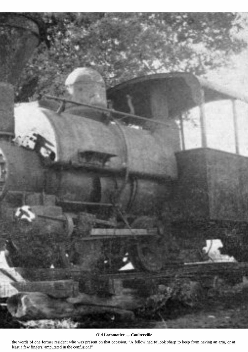
On Highway 49, at the center of the town (incidently a rather grandiose statement for Coulterville) one finds the walls of several ruinedbuildings and an interesting old narrow gauge engine with a few of its cars. This engine was used about the turn of the century to haulore from the Mary Harrison mine. Although the track was but four miles long it was widely known as the “crookedest railroad in theworld.” Shading this relic of Coulterville’s past is a large oak tree which old timers say was used on the occasion of several impromptu“necktie parties.”
Today Coulterville dozes complacently in the past. The “good old days” are kept alive in the yarns that are swapped endlessly by thevillage patriarchs who congregate daily under the shade of the trees at the main corner of the town.
Priests. Near the Moccasin Creek Power House one comes to the junction of Highways No. 49 and No. 120. That section of the latterroad which winds its tortuous way eastward from this point is known as the Big Oak Flat Road. It passes through several interestingold mining centers enroute to Yosemite National Park.
From the junction the Big Oak Flat Road makes a long, steady, sinuous climb for several miles up the famous Priest Grade. Priest’sHotel, originally operated by W. C. Priest, formerly stood at the top of the hill. In the ’80s and ’90s it was a famous stopping place forhorse-drawn stages carrying early day visitors to Yosemite.
Big Oak Flat. In the early ’50s what is now a sleepy village along the Big Oak Flat Road, 49 miles west of Yosemite Valley, was avigorous, roistering community. Its story begins about 1848 when James D. Savage, best remembered as the leader of the MariposaBattalion which was the first group of white men to enter Yosemite Valley (1851), and James Woods discovered the rich gravels whichhere overlaid the bed rock granite.
The town’s name is derived from the fact that in the early days an oak tree, over eleven feet in diameter, was the distinguishing featureof the area. So intent were the miners in their search for gold that they eventually worked over the gravels of the flat and reduced its levelby at least five feet. As the earth about the tree was removed its support was eventually des[t]royed and it finally toppled over. Later itsprostrate trunk was almost completely destroyed during a disastrous fire that swept the town. Today only a few sections of wood fromthis tree remain, preserved in a stone monument along the highway at the west end of the town.
Disastrous fires were a common and almost accepted part of life in the old mining towns of the Mother Lode Country during the earlydays. Buildings were hastily built, flimsily constructed for the most part, and crowded together. Streets were narrow and crooked andin many instances no means of fighting fire was at hand except the old fashioned, hastily organized bucket brigade. The dilapidatedappearance of many of these towns, and Big Oak Flat is no exception, is largely the result of having been burned out on numerousoccasions.
Groveland. One mile east of Big Oak Flat is this small but energetic mountain community. The closely crowded buildings which hug theedges of the road serving as the main street, are reminiscent of this town’s past history as an important mining center. It was originallycalled Garrote, derived from the fact that a horse thief met death here by hanging.
Hangman’s Tree or Second Garrote. This location on the Big Oak Flat Road was first termed San Ignacio. It is characterized by a hugeold oaken snag which is reputed to have served in sixty hangings. However, that seems a prodigious number even for the days whensuch occurrences were not uncommon. Nearby is a small frame dwelling designated as the “Bret Harte Cabin” but the title is erroneous,although it is said that the famous writer did frequent this area on occasion. The characters of the unforgettable story, “Tennessee’sPardner,” were supposedly taken from two inseparable friends (Jason P. Chamberlain and James A. Chaffee) who, after settling herein 1852, built this house. Here they lived for many years and their loyalty to each other, as well as their kindness to travelers using theBig Oak Flat Road, became legendary. Neither of the men married. About 1912 Chaffee, when 80 years of age, took sick and died.Chamberlain, lonely and unable to adjust himself


Big Oak Flat — I. O. O. F. Hall
to the fact of his friend’s passing, sought solace in suicide several years later.
Jacksonville. Although gold was found here in important quantities, and although by 1850 this town rivaled Sonora and Columbia inimportance, Jacksonville was more widely known for the agricultural rather than mineral productivity of its soil. Here Julian Smart, firstsettler in the area, developed a garden and orchard that became the talk of the Southern Mines. In 1852 his vegetable plate dinners, at$2.50 each, were eagerly sought after by miners of the region. His orchard, started in that year, soon became famous for its great varietyof luscious fruits— peaches, pears, apples, cherries, grapes, and many others—which had been carefully selected so that a continuouscrop would be forthcoming from April until November. In later years, however, the diligent search for gold by Chinese miners, whocarefully worked over the entire area, destroyed its productivity.
Jacksonville was named for Col. A. M. Jackson, Mexican War Veteran, who established a trading post here in the spring of 1849.
South of Jacksonville, along the Tuolumne River, stands Red Mountain which is said to be the locale of Smith’s Pocket which figuresin one of Bret Harte’s most famous famous stories, “M’liss”.
Chinese Camp. Once prosperous and important, the appearance of this community today is a picture of desolation. One finds little toindicate how rich in history and tradition it is. Table Moun[t]ain, on the skyline to the north, is mentioned on numerous occasions inthe tales of Bret Harte and

Hangman’s Tree on Big Oak Flat Road

the locale of some of his most famous stories is laid in this section.
The rich gravels about Chinese Camp were being worked early in 1849. While most towns of the Mother Lode had a considerablenumber of Chinese residents during the mining days, this was even more the case here. Many Chinese were employed by a group ofEnglishmen to work the claims in this region and at one time they made up the bulk of the population here. Differences between twotongs of these people were responsible for the notorious “Chinese War” which consisted of one engagement fought near the base ofTable Mountain (September 26, 1856). Several thousand Chinese fought with a variety of weapons, from pikes to firearms. Althoughthere was considerable excitement and noisy-skirmishing the casualties were considerably lower than one would expect, consideringthe number of participants. Four Chinese were killed and four wounded.
The location of this town made it a logical center in the region and for many years it was the hub of several stage and pony expressroutes. In its heyday it had a population of 5,000. It was not without its moments of lawlessness. Robberies, murders and lynchingswere not uncommon. “Chinese” as it was nicknamed, continued to be rather broadminded in matters of this kind long after other townshad worked out a satisfactory system of law and order. But today this sleepy village, drowsing peacefully in the foothill sunshine, giveslittle indication of its boistrous past.
Jamestown. This town, founded about 1848 by Col. George James, a San Francisco lawyer, was familiarily known as “Jimtown” in theold days. It was strategically located in the center of a rich mining district which also provided considerable background for a numberof Bret Harte’s stories. Quartz and Stent which lie along a picturesque “cutoff” road between Jacksonville and Jamestown, about twomiles south of the latter town, are said to have been the mining camps described by Bret Harte as Quartz Mountain and Poverty Hill.
During the mid-fifties Jamestown boasted of a population of 6,000, at which time it made a determined but unsuccessful attempt towrest the county seat from nearby Sonora. Today the traveler will find that the modern trend has all but erased obvious evidence ofits character during the “days of ’49”.

Bret Harte Cabin at “Second Garrote”
Sonora. Here, in spite of the fact that progress has bestowed many favors—for Sonora is the county seat of Tuolumne County,the commercial center of a wide area, and a bustling, energetic town—the evidences of its robust past are not entirely submerged.

Interspersed with modern public buildings, beautiful homes, and wide awake business establishments one finds many reminders ofSonora’s beginnings. Pictureesque, narrow streets thread their way along the hillsides. A few buildings still carry the flavor of the olddays. One of the most interesting of these early structures is St. James’ Episcopal Church which stands at the intersection on top of thehill at the north end of the business district. Built in 1857, it is the oldest Episcopal Church in California. It was built after the town hadachieved some degree of permanence for originally it consisted merely of an accumulation of brush huts and canvas shelters. These crudeaffairs were later replaced by adobe structures that were themselves supplanted by buildings fashioned from more modern materials.
Sonora’s beginnings occurred during the summer of 1848. Here a rich placer “diggings” was discovered by a group of Mexican miners.The original discoverers were soon joined by many of their countrymen and, since they were largely from the State of Sonora in OldMexico, the locality became known as Sonoran Camp. As the rich strike became known it quickly developed into one of the mostimportant and populous camps of the California gold region. Before another year had passed it was the largest town and the metropolisof the area, boasting of a population of between 15,000 and 20,000.
Since no roads were available to this point at that time, travel to

Sonora Pitts Studio
Sonora was entirely by horse or mule back. Large pack trains brought in the necessary supplies, chiefly from Stockton, 70 miles distant,and it is said that for a time travel along this route was so heavy that at night this trail could be traced by the almost countless, glowingcampfires. Freight wagons, however, soon superceded the pack trains. A toll road was completed from Stockton in 1854 and Sonora(for its original designation had been modified by that time) became accessible to horse-drawn stages which required about nine hoursto make the trip. Four and six horse teams were changed enroute every few miles.
Under the impact of the tremenduous influx of people the original Mexican population was submerged. In 1849 a town governmentwas established. Sonora’s beginnings as an organized metropolis, however, were not auspicious. The crowded town was soon besetby numerous troubles. The rugged, unbalanced diet upon which the people subsisted brought on a serious epidemic of scurvy which

claimed the lives of many inhabitants. So severe was this plaque that a hospital, Sonora’s first civic enterprise, was opened late in ’49.In addition the first of several disastrous fires (’49, ’52, and ’53) all but obliterated the town. However, the event that probably affectedthe character of the community most was the law, passed in 1850 by the State Legislature, which imposed a tax of $20.00 per monthon foreign miners. This touched off a series of violent acts. A “war” between the Mexican and American miners was averted only atthe last moment by the hasty departure of the former from the town. These men scattered about the countryside and as a result Sonoraand its immediate vicinity was the


Pitts Studio
St. James’ Episcopal Church — Sonora
scene of numerous bloody reprisals for several years.
But in spite of scurvy, fire, feuds, and the eventual decline of mining activity Sonora’s destiny could not be denied. Law abidingcitizens worked continuously for improvement and the town boasts of a number of “firsts.” The Sonora Herald, the first newspaper tobe published in the California mining region, was initiated in July 1850. The first issues were printed on wrapping paper and were butnine by thirteen inches in size. Churches and schools were established in 1852 and the Sonora Theatre, in which many artists of thetime played, was opened in that year.
A short distance from Sonora one finds what is left of Shaw’s Flat. Still


standing is the old Mississippi House, built in 1850 when this camp was in its prime. This building originally served as an inn andstage station.
Squabbletown, Sawmill Flat, and Yankee Hill—all meaningful names to the fortyniners during the days when these places werecharacterized by sufficient population to deserve names—exist today largely in memory. They are found on a minor road to the eastof the main highway between Sonora and Columbia.
Columbia. Although but a shadow of its former self the latent charm and basic characteristics of this town most adequately express thespirit of the “fabulous fifties.” It is the best preserved of the entire galaxy of the old mining camps along the Mother Lode and, largelydue to that fact, was designated a State Park in 1945.
Many of its early buildings are gone, having succumbed to the ravages of time. However, those along the main street as well as manyon the side avenues have withstood the years and by this means one can, with a bit of imagination, reconstruct the warp and woof of thepattern of the original tapestry. Walking along the main street one immediately steps back into the early ’50s. Arching trees shade thisthoroughfare. Picturesque old brick buildings excite the imagination so that one can readily fabricate adventures which may likely haveoccurred behind their solid iron shutters. Stone steps descending below the street level to mysterious basement fandango halls speakeloquently of the past so that, standing in the quiet of the present day, one can almost hear the thump of miner’s boots, their boisterouslaughter, and the shrill music of violins as pioneer musicians “sawed out” their tunes.

Columbia — Main Street
Columbia was one of the last of the old mining towns to be founded. The discovery of the rich placers here was, as is often the case,the result of chance. Although some Mexican miners had turned up some “color” in the area a few days previously the almost unlimited

richness of the area did not really become known until March 26, 1850 when Thaddeus Hildreth and four companions spent a rainynight here. The next day, while waiting for their blankets to dry, the party tried their luck in panning the earth. Their casual effortswere richly rewarded.
News of the strike soon spread about the country and a vertiable stampede to Hildreth’s Diggins, as the place was originally known,resulted. Within a month the camp boasted of a population of 6,000. A short time later 15,000 people had gathered here and the nameof Columbia was adopted.
However, in spite of the rich nature of the surrounding area Columbia was essentially a “dry diggings.” Reclaiming the riches fromthe earth was an extremely laborious process due to the lack of sufficient water with which to work the gravel. Thus, for several yearsColumbia’s population was seasonal. Miners would flock in during the period of spring freshets and as quickly leave when the longdry summer season set in. In 1852 water companies were organized, flumes and ditches were constructed, and water from permanentstreams in the vicinity was diverted to this section. Henceforth Columbia took on stability and some degree of permanence. The town,laid out in 1852, was incorporated in 1854. Meanwhile schools, newspapers, express offices, banks and stage lines had been established.It also had its
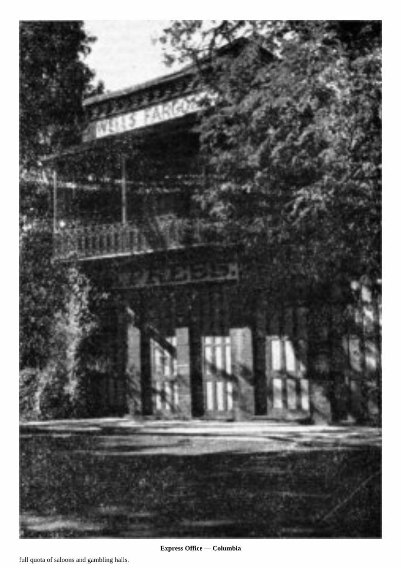
Express Office — Columbia
full quota of saloons and gambling halls.

Like all of the original towns the first buildings were flimsily constructed so it is not su[r]prising that in 1854 Columbia was almost totallydestroyed by fire. Thus made aware of the need for more satisfactory buildings a new Columbia, characterized by brick and masonrystructures, rose immediately—almost from the still smoldering ashes of the old town. Most of the structures found today date from thatperiod and except for its weatherbeaten appearance the main street of Columbia remains essentially unchanged. Further, although peoplehave continued to live and work here, this has not fostered the development of a “modern trend” that has obliterated the evidences of itspicturesque past— so often the case in so many of the more prosperous towns of the Mother Lode Country.
On a prominence at the west side of town one sees St. Anne’s Catholic Church, built in 1856 and still in use. In the churchyard is a littlecemetery that had a narrow escape from destruction at the hands of greedy gold seekers. As one enters the town the old Fallon Hotel isseen and at the corner, on the main street, stands the most picturesque of Columbia’s buildings—the Wells Fargo Express office—fromwhich it is reputed over $50,000,000 in gold was shipped. A grand total of approximately $90,000,000 in gold was recovered from theearth in the immediate Columbia area, the soil being washed. from between the limestone deposits which now appear as wierd, fantastic,gray knobs in the surrounding landscape.
On the main street of the town one also finds the Stage Driver’s Retreat in which the original bar and piano, which was shipped around“the horn,” are found. There is also the Knapp Grocery Store which was saved in one of Columbia’s numerous fires by the timely use oftwo barrels of vinegar in the absence of sufficient water to quench the flames, and the old fire house with its two historic, hand-operatedfire engines (“Papete” and “Monumental”) together with the unique fire hose fashioned of riveted buffalo hide. On a prominence on thenortheast side of town stands the red brick school, built in 1862. This was in use until comparatively recent years. Adjoining the schoolis Columbia’s pioneer cemetery where many of the town’s early citizens are buried.
Truly, in spite of the faded nature of its present appearance, one can prime most certainly deserved the title of “Gem of the SouthernMines.”

St. Anne’s Catholic Church — Columbia. Note limestone knobs in foreground.

Swerer’s Store — Tuttletown
Tuttletown. Originally known as Mormon Gulch, the present name was applied shortly after gold was discovered here, in honor ofJudge A. H. Tuttle who constructed the first log cabin on this site in 1848. Like other towns, or former towns, in this area it lies in theheart of the Bret Harte-Mark Twain country, and owes its fame principally to that fact. Physically it is but a shadow of its former selfwhen, during the gold rush, it could boast of several thousand inhabitants. Only a few buildings, with thick masonry walls and heavyiron shutters, remain. Swerer’s Store, where Mark Twain is supposed to have traded during the period when he lived on nearby JackassHill, may be found along the highway. This building was built in 1852. The main highway between Melones and Sonora, which passesthrough Tuttletown, is considered as the “Slumgullion Road” described by Bret Horde in his “Idyll of Red Gulch.”
Jackass Hill owes its interest today to the existence of the Mark Twain Cabin, reached via a side road which branches from the highwayabout a mile north of Tuttletown. The cabin that one sees today is a faithfully reconstructed version of the original which was destroyedby fire. Bill

Mark Twain’s Cabin — Jackass Hill

Gillis and his partner Dick Stoker resided in the original cabin for many years. They were close friends of Sam Clemens who, for aperiod of several months, resided with them. Jim, another of the Gillis boys, who was highly regarded as a story teller, lived nearby andthe four intimates often gathered in the evening to “swap yarns.”
Sam Clemens’ prowess as a miner left much to be desired but he struck “pay dirt” in the material that he picked up in the region, and whichwas destined to launch him on his career as one of the most famous of American writers and humorists. It is reputed that he obtainedthe basis for his famous “Jumping Frog of Calavaras County” from a loquacious bartender at Angel’s Camp, and that the original draftof that manuscript was prepared in the original cabin on Jackass Hill. Others of his California stories were undoubtedly born here.
Except for this shrine of American literature Jackass Hill today would be known merely as a natural stopping place, during the olddays, along the Robinson’s Ferry-Tuttletown trail. Numerous jacks, tethered here by miners traveling to and from various points in theregion, would make their presence known by their raucous “music.” Often there were as many as 200 animals in the vicinity at onetime, thus accounting for the name.
Melones (Spanish for “melons”), lies near the point where Highway 49 crosses the Stanislaus River. It derives its name from the fact thatMexican miners, the first arrivals here, found free gold about the size of melon seeds in the stream. It was later re-named “Slumgullion”and then, upon the establishment of a ferry here, as Robinson’s Ferry. It is said that during the height of the gold rush $10,000 in tollswere collected during a period of about six weeks from the swarms of miners who used the ferry in crossing the river. Now a modernbridge spans the stream and the original name has again been applied. Two picturesque old structures characterize the area.
Carson Hill, immediately north of the Stanislaus River, was named for James H. Carson who in 1848 first prospected in this region.He did not remain long enough, however, to discover its rich values. These came to light in 1850 when rich ore was uncovered, butthe discoverers—Hance and Morgan were beset with difficulties over its operation and troubles with other miners in the area. In duetime it passed into the hands of James Fair who, it seems, was quite often ready at hand with the ability and the nerve to take over somelanquishing operation and turn it to his profit. The Morgan mine was one of the stepping stones to Fair’s success.
As the road winds over the hill toward Angel’s the motorist sees much evidence of recent mining activity in the numerous buildingsand the scarred hillsides. The entire area was fabu[l]ously rich. There is an amusing story credited to Carson Hill during the early dayswhich, if true, emphasizes that fact. A miner was being buried. As services were being held one of those who had come to pay their lastrespects noticed “pay dirt” in the newly opened grave. The ceremonies were rudely and quickly terminated while everyone, includingthe minister, hastily located claims. It is persumed that the deceased was interred in another location.
Angel’s Camp. Here, in 1848, James H. Carson and Henry Angel, for whom the town is named, made the discovery of startlingly richplacer deposits in a ravine which was later to become the nucleus of the town. So rich were these diggings that claims which producedless than two ounces of gold per day (gold was then valued at $16.00 per ounce) were ignored. It is also said that one claim but ten feetsquare yielded $9,003 from its surface workings and when these were removed a quartz vein valued at $200 per ton was exposed.
Under the impact of such values Angel’s Camp soon became one of the largest and most important towns of the Southern Mines.Some of the most famous literary efforts of Bret Harte and Mark Twain refer to this area, notably Twain’s “Jumping Frog of CalavarasCounty.” Here too the rough, uninhibited humor of the miners prompted the famous hoax known as the “Pliocene Skull” which for atime confounded many of the eminent geologists of the day. This fraud is kept alive in the poem of the same name by Bret Harte.
But although the golden era of Angel’s Camp became tarnished when the rich deposits in the region were diminished, and although theyears have slightly dimmed its association with those two famous writers, its destiny was not to be denied. Progress has smiled upon it.Today, straddling the Mother Lode Highway, its face has been lifted by modem improvements. Yet its past has been kept alive by a fewof the older buildings and the picturesque names of some of the streets, not to mention the annual jumping frog contest which, althoughcommercialized, retains some of the flavor of the event depicted by Mark Twain.

Vallecito — Bell and Monument
Vallecito. The name of this locality (Spanish for little valley) is an adequate description of its charming location. But it was not alwaysknown by that phonetic title, nor was the placid, peaceful character which it presents today always typical. The rich placer diggingshere were originally discovered in 1849 by the Murphy brothers and, as was typical of the time, the town was known for many yearsby the uneuphonious title of “Murphy’s Old Diggings.”

Entering the village from the south one sees only a few old buildings. The Dinkelspeil Store, built in 1852, is the most typical. At theintersection here one can turn off the main highway and after a drive of but one block a historic monument, surmounted by an old bell,will be found. Originally this bell was hung from the branches of an oak tree which grew nearby. It served as a means of calling theminers’ to meetings of all sorts. A number of years ago the oak was felled by a high wind. The bell was then mounted in its modernsetting to serve as a memento of Vallecito’s golden era which is receding ever more rapidly into the past.
Douglas Flat, between Vallecito and Murphy’s, exhibits little of its original character, except for the old Gilleado building which is apicturesque landmark with thick walls and iron shuttered windows and doors. During the town’s heyday the safe within this buildingwas used as a vault for large quantities of gold. But in order that the treasure might be more adequately protected a guard was stationedhere constantly and a “shot gun window” which was cut through the thick wall beside the rear door can still be seen.
Murphy’s. In spite of the placid dignity which characterizes this town one can, with but little imagination, picture it in the romanticperiod of the gold rush. It was founded by John and Daniel Murphy who discovered gold here in 1848 and it was one of the mostimportant earlier settlements of the region. Consequently, it is not surprising to learn that many interesting episodes of those picturesquetimes occurred here.
Along the main highway, which still forms the principal street, rolled horse-drawn stages and freight wagons. Clouds of dust billowedthrough the leafy branches of the trees lining this thoroughfare. The Mitchler Hotel, originally the Sperry Hotel, is a fine and picturesquestructure and was built in 1856. Many famous people stopped here, as the old registers indicate. It is said to be the hostelry referredto in Bret Harte’s “A Night in Wingdam.”
Murphy’s exudes the color of the “days of ’49” by its picturesque setting

Mitchler Hotel — Murphy’s
and its many fine, stoutly constructed old buildings.

As one might expect not everyone who profited by his contact with the gold rush secured his “stake” by digging it from the earth. Therewere other ways. The old Rollens store here is an excellent reminder of that fact. Its thick masonry walls and heavy iron shutters havebeen little affected by time. Rollens, a French army officer, was one of the horde cf argonauts who journeyed to America in search ofwealth. Here he conducted a general merchandise store and ministered to the needs of the miners in the surrounding country. Whenthe Franco-Prussian War began he was recalled for service in the French army and sold his enterprise for the reputed sum of $15,000before his departure. Numerous other old structures, such as the Wells Fargo Express building and the I.O.O.F. Hall, also add characterto this delightful village.
North of Murphy’s a minor road winds through the foothills east of San Andreas to Mokelumne Hill on Highway 49. It passes throughseveral localities that were once important gold camps with names such as Sheep Ranch (where the father of the present publisherworked and laid the foundation for the Hearst fortu[n]e), Poverty Flat (considered by some as the locale of one of Bret Harte’s stories,the “Iliad of Sandy Bar), Whisky Slide, Jesus Maria (an important camp in the ’50s populated chiefly by Mexicans), and Happy Valley(originally an important French community. Few tangible evidences of the original character of these settlements remain, yet the drive,if one does not object to narrow and tortuous roads, is of interest in its own right if conditions are favorable.
Another narrow mountain road, roughly parallel to and several miles east of Highway 49, affords an alternate route between Altavilleand San Andreas. It passes through the locations of camps originally known as Dogtown, Calavaritas, Scratch Gulch, and BrandyFlat. There is little of significant tangible evidence left at these points but in rolling these names off one’s tongue one can taste a bitof the flavor of those lusty days which fostered their unique names.
San Andreas. This town disputes Angels’ claim to notoriety as the site of the jumping frog contest depicted in the story by Mark Train.But San Andreas is famous in other ways. It was here that the notorious bandit, Black Bart, was finally brought to justice and sentencedto prison, ending his career of 27 stage robberies over a period of seven years. He met his waterloo near Copperopolis when he haltedthe Milton-Sonora stage. The unexpected appearance of a small boy so unnerved the highwayman that he left in haste, losing a bit ofwearing apparel with a laundry mark upon it that eventually served as the means of his identity. He was arrested in San Francisco wherehe had posed as a respectable mining man whose journeys out of town were prompted by the need to visit mythical mining properties.
San Andreas was also frequented on occasion by Joaquin Murietta whose numerous escapades left a bloody trail throughout the MotherLode Country
Mexicans were the original settlers here. In 1849, when gold was discovered in this region, Americans flocked to San Andreas andeventually crowded the original settlers out. In the ’60s, by which time the placer deposits were largely depleted, Chinese settled herein great numbers and laboriously worked over the areas abandoned by the American miners.
One of the interesting points in this vicinity is the pioneer cemetery, several miles out of town along the Son Andreas-Stockton road.
Mokelumne Hill. In the “good old days” this was one of the wildest towns of the Mother Lode, prompted by the richness of the variousdiggings and the temperaments of miners of many nationalities.
It had its origin in the fall of 1848 as a single store. Ls word of the rich gold-bearing areas here spread, a town of considerable proportionssoon developed. Today, although a shadow of its former importance, its rather run-down and dilapidated appearance presents a numberof mementos of its former glory. There is the I.O.O.F. Hall, one of the first three story buildings in the State. When it was constructed itwas a veritable skyscraper, since most buildings in this region at that time were of one story. The memory of the inevitable Chinatownis kept alive by the presence of an iron shutter partly imbedded in a tree near the main corner of the town. It was placed there followinga fire that destroyed that section. Left undisturbed in that

Butte City — Ginocchio Store

I. O. O. F. Hall — Mokelumne Hill

position for many years the tree gradually increased in diameter and enfolded a portion of the old shutter.
Chile Gulch, a short distance to the south of “Mok Hill,” was the site of the “Chilean War” between Chilean and American miners in1849 which embodied explosive complications. In a “Mok Hill” saloon, it is said, Joaquin Murietta, his identity unknown, was playingcards when he heard a braggart boast of what he would do if he and Murietta ever met. Murietta jumped upon a table, announced hisidentity, and before the astounded assemblage could gather their wits, rushed outside with his followers, mounted horses and gallopedaway in typical movie thriller fashion.
Butte City. The location of this once-busy community is marked only by the stout remains of the Ginocchio store which fronts onthe main highway between Mokelumne Hill and Jackson. It was built well and apparently with high hopes for the permanency of thecommunity but today it stands forlorn and deserted among the rolling hills of the countryside — a figurative shroud for the temporaryqualities of man’s most earnest efforts.
Jackson. Before this town took its place among the other localities of the Mother Lodge Country as a gold producing center it was animportant transportation hub for traffic to and from various towns of the Southern Mines and the two most important supply centers inthe region— Stockton and Sacramento. It also served as one of the main stopping points between the southern and northern portionsof the California mining region.
Settled originally by Mexicans in 1848 it was originally known as Botellas (Bottle Springs) presumably because of the bottles left besidea spring here. The name Jackson was applied later in honor of Col. A. M. Jackson, Mexican War veteran, by a number of his formersoldiers who had settled here.
In spite of modern changes Jackson remains a picturesque town of winding, narrow streets and many old buildings dating from the ’50s.Its geographic location which has continued to sustain it as an important center along the Mother Lode Highway is enhanced by the factthat in the surrounding hills there existed rich veins of gold-bearing quartz. Inevitably the placer areas of the region were exhausted andby 1851 lode mining began. Such activity, although not without difficulty and disappointment, has imparted a degree of permanence tothis community. Some of the most famous gold mines of the State are located in Amador
Volcano jail
County (of which Jackson is the county seat). Near Jackson are the justly famous Argonaut and Kennedy mines which are among thedeepest gold mines in the world and which boast of a production record dating from the early ’50s. Thus, this is one of the select fewamong California towns that can point to a continuous association with the production of gold since the time of its origin.
Volcano once boasted of a population of 8,000. Today the town can muster less than 100 souls. But it is one of the most picturesque ofthe ghost towns of the Mother Lode Country and is well worth the necessary side trip from the main highway at Jackson. It is distinctivein that the first rental library in California was started here and the fact that here the “little theater” idea first blossomed into reality.This is mute evidence of the fact that the populace of the gold era was concerned with something beside the more rowdy and lawlessactivities with which those times are so often associated.

Although many of the old buildings have deteriorated with the passing of time a few remain in good condition—including the fine oldSt. George Hotel, once the pride of the Mother Lode Country. It is still operating. Also of interest is the jail, constructed of steel platessandwiched between two-inch, wooden planks which adequately defied the efforts of the most determined jailbreakers. The old AdamsExpress building, located on one of the main corners, and the inevitable I.O.O.F. Hall are also picturesque landmarks of the “days of ’49”.
The surrounding area yielded $90,000,000 in gold. Many of the original buildings were undermined and consequently destroyed as theminers extended their feverish activities into the town inself. Although the St. George Hotel today stands out conspicuously on the edgeof town, bordering the river bar, old photos depict it as occupying a location near the center of the community.
One event of interest, prompted by developments which led up to the Civil War, is kept alive in Volcano by an old cannon (known as “OldAbe”) displayed in an inclosure adjoining the Adams Express building. Northerners and southerners were about equally represented inthis region. When southern sympathizers organized in order to present a solid front for the furtherance of their cause those with leaningstoward the Union did likewise. The latter reinforced their organization by the acquisition of this cannon. Iron cannon balls being all butunobtainable, round boulders were used instead. But the impending trouble did not materialize. Undoubtedly the presence of the cannonhad the desired effect and the southern sympathizers allowed discretion to be the better part of valor.
Sutter Creek. This town takes its name from John A. Sutter who, having despaired in his attempt to divert the stream of argonautsfrom his vast agricultural domain, attempted to recoup his fortunes by also following the call of gold. He mined here for a time buthis abilities lay in other

Old Adams Express Office. Volcano. See cover photo.
lines and he was not too successful. He soon withdrew from the scene.

Placer gold was discovered here in 1848 and by the time the gravels were on their way to exhaustion quartz mining came into the picture.It was from the Lincoln mine (originally the Union) here that Leland Stanford, then operating a grocery store in Sacramento, obtained themeans which enabled him to join with Huntington, Crocker, and Hopkins in the building of the Central Pacific—first transcontinentalline to the Pacific Coast.
Beyond Sutter Creek is Amador City, which dates from the ’50s, Drytown, founded in 1848 and the oldest town in Amador County,and Plymouth, which was originally called Pokerville. These names, like many others, were memorable in their time but today thereis little at these points to hold the interest of the visi[t]or for very long.
Five miles east of Plymouth is Fiddletown or Oleta which apparently fascinated Bret Harte, as indicated by his story “An Episode ofFiddletown.” Legend has it that the original name of Fiddletown was applied because of the musical interests and activities of a groupof inhabitants. The town had its origin in 1849. Some time after its establishment Oleta apparently appealed to its citizens as being moredignified. This name was adopted in 1878 and is a white man’s derivation of the Indian word meaning “old home spring.” Recently thepopulace, aware that dignity and local color do not always go hand in hand, again adopted the town’s original name for their community.
Approaching Placerville one passes through El Dorado, originally known as Mud Springs, which was founded in 1848. For many yearsit served as a business center for the miners of the surrounding area, as indicated by the gaping walls of a once pretentious businessblock. This structure was built in 1851.
Placerville. Ideally situated at the junction of Highways No. 49 and No. 50 this town, although favored by the march of progress, retainssome of the color of its beginnings. In the office of the Chamber of Commerce— also the home of the El Dorado County HistoricalSociety—are some interesting materials relating to this region. It is well worth a visit.
Placerville had its origin in the early part of the summer of 1848. The region of the original gold discovery about Coloma was quicklyoverrun with miners and later arrivals went farther afield. Among the first to arrive at this point were Perry MaCoon, William Daylor,and a man named Beaner. A rich find was made along what is now Weber Creek. News of this soon spread and a prosperous town soondeveloped which was originally known by a variety of names— Dry Diggings, Old Dry Diggings, Ravine City, and finally Hangtown.The latter term was applied when, due to its rapid growth, a number of men of ill repute were attracted to the spot. The law abidingcitizens, enraged by the boldness of a number of their acts, finally took justice into their own hands in the customary, effective frontierfashion. The more delicate but equally descriptive name of Placerville was adopted as the town’s name in 1850.
The gravels along the nearby creeks and gulches were rich and produced prodigious quantities of gold but the town owes its fame andits present importance to other related features—particularly its geographical situation. It was on the route of the Overland Mail andthe Pony Express. Here Phillip Armour operated a butcher shop, a modest start in a career that was destined to flower into the greatChicago packing firm. John Studebaker, a wheelwright by trade, arrived here in 1853. He operated a blacksmith shop and engaged inthe manufacture of wheelbarrows which were prized throughout the region because of their sturdy construction. This was the nucleousof his later career which eventually developed into the manufacture of automobiles. Mark Hopkins, the railroad builder for whom theSan Francisco hotel is named, also “got his start” here as a grocer. Then there was the famous “snowshoe Thompson” who carried themail over the Sierra for twelve winters (from 1854) between Placerville and Carson Valley, using skiffs of his own manufacture.
In 1856 a fire ravaged the town but it was soon rebuilt. A number of buildings dating from that period are still in use today. Yes,Placerville is famous in the story of California’s epic gold rush—and justly so. It is a busy, pleasant, and friendly town that wiselycherishes its historic past.
At Kelsey, a few miles from Placerville, is the Marshall Museum.
Coloma. As everyone knows, this town was the “cradle” of the famous California gold rush. January 28, 1848, on the south fork of theAmerican River, James W. Marshall found the first yellow flakes of gold in the tail-race of the sawmill that he was building for JohnA. Sutter. His find, in spite of efforts to keep it quiet, literally inflamed the world.
The site of Marshall’s discovery


Placerville —Wininger Studio
will be found a short distance below (west) of the bridge which spans this historic stream. Marshall is buried atop a prominent hillnearby, his grave marked by an impressive shaft which is crowned with his statue, one hand pointing toward the spot in the valley belowwhere his epic discovery was made. Marshall’s cabin still stands at the base of the hill, protected from the elements and vandalism bya supplementary roof and a heavy wire screen. The entire area in this vicinity is a State Park.
About Sutter’s mill, following the discovery of gold, developed the town of Coloma which was, for a time, the lively center for thousandsof miners who flocked to this region. Today it is but a hollow shell of its former importance. Only a few of the early buildings surviveand, by and large, the beautiful valley, through which winds the famous American River, presents an appearance which


Marshall Monument — Coloma
Sutter’s Mill. From Nahi Painting in the State Library —McCurry Photo

is certainly not unlike the scene that was familiar to Marshall and Sutter 100 years ago.
Everyone traveling the Mother Lode Highway should visit this town —not only for its historic significance but for its peaceful charm.Coloma seems secure in the realization of the far that it was the nucleus of the entire California gold region, the spot where the greatgold rush began.
North of Coloma the region traversed by Highway 49 presents a striking change in its character and appearance. The rolling, grassyhills dotted with venerable oaks, which typify the section south of Placerville, quickly give way to a region severely broken up by deepcanyons, and with the slopes clothed with dense evergreen forests—except where the hand of man has cleared portions of the terrain forfarms or orchards. The highway alternately climbs to the ridges and descends into the deep canyons, threading its way at times alongthe steeply inclined canyon walls to such streams as the north fork of the American River, the Bear, and the south, middle, and northforks of the Yuba. Along portions of this section of the route the road is narrow and tortuous and as one proceeds with caution alongthe winding highway the picturesque ruggedness of this region invariably causes him to speculate upon the hardihood and fortitude ofthose miners who first penetrated this remote mountain wilderness. In many respects the difficulties presented by the terrain with itsheavy forests and tempestuous mountain streams seem almost insurmountable. Yet the possibility of finding gold exerts a powerfulinfluence upon the mind of man and in spite of obstacles this region was penetrated and explored. It yielded some of the richest “finds”of the California gold rush.

Marshall’s Cabin — Coloma
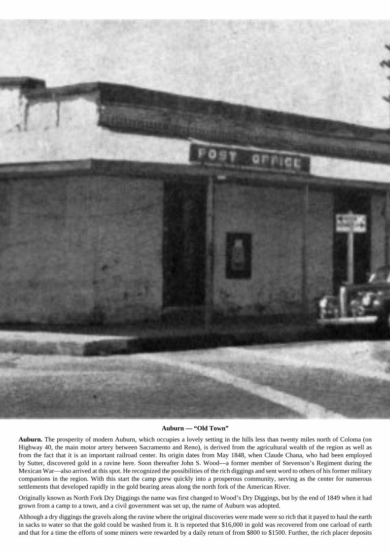
Auburn — “Old Town”
Auburn. The prosperity of modern Auburn, which occupies a lovely setting in the hills less than twenty miles north of Coloma (onHighway 40, the main motor artery between Sacramento and Reno), is derived from the agricultural wealth of the region as well asfrom the fact that it is an important railroad center. Its origin dates from May 1848, when Claude Chana, who had been employedby Sutter, discovered gold in a ravine here. Soon thereafter John S. Wood—a former member of Stevenson’s Regiment during theMexican War—also arrived at this spot. He recognized the possibilities of the rich diggings and sent word to others of his former militarycompanions in the region. With this start the camp grew quickly into a prosperous community, serving as the center for numeroussettlements that developed rapidly in the gold bearing areas along the north fork of the American River.
Originally known as North Fork Dry Diggings the name was first changed to Wood’s Dry Diggings, but by the end of 1849 when it hadgrown from a camp to a town, and a civil government was set up, the name of Auburn was adopted.
Although a dry diggings the gravels along the ravine where the original discoveries were made were so rich that it payed to haul the earthin sacks to water so that the gold could be washed from it. It is reported that $16,000 in gold was recovered from one carload of earthand that for a time the efforts of some miners were rewarded by a daily return of from $800 to $1500. Further, the rich placer deposits

held up remarkably well and many miles of flumes were built to transport water to the rich claims in the vicinity. Placer County, ofwhich Auburn is the county seat, produced a total of $75,000,000 in gold.
The original structures of the town were built of logs but these were destroyed by disastrous fires early in the history of this community(1854 and 1859). However, “old town” still occupies a site in the ravine and retains a bit of its original flavor in its
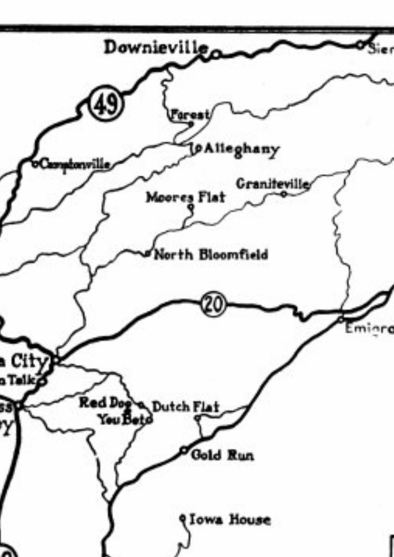

numerous old and often dilapidated buildings and its narrow, crooked streets. Modem Auburn, characterized by neat, up-to-date businessbuildings and attractive homes, is superimposed upon the old site—occupying the upper slopes of the hills surrounding the originallocation.
Slightly less than 30 miles east of Auburn, upon a secondary road, one finds Michigan Bluff where Leland Stanford operated his firststore in the Mother Lode Country. In this section one finds a number of additional old towns, now pretty much ‘down at heel,” suchas Todd Valley and Forest Hill.
From Auburn one can follow Highway 40 east to Donner Summit and Donner Lake, site of the ill-fated Donner Party’s tragic experienceduring the winter of 1846. In so doing one passes through Gold Run. Along the Bear River in the same general region are the sites ofDutch Flat, Red Dog, and You Bet—all early mining camps of importance during the “days of ’49”.
Grass Valley. The name of this town is not suggestive of its importance as a mining center but it was —and still is—important inthat regard.
In 1848 a party of Oregonians, south bound for the gold fields, found a welcome camping spot here— hence the name. In the summerof ’49 placer gold was discovered and about one year later rich deposits of gold bearing quartz were also found. These were greatlydeveloped as mining methods advanced and improved and even today much of the prosperity of the town is based upon its importanceas a gold producing center.
Grass Valley is noted for a number of interesting episodes and personalities which date back to the ’50s. By 1854 its status had changedfrom a camp to a town. Like other towns throughout the region it was swept by fire on several occasions. From the desire to develop amore fire resistant type of architecture was evolved the characteristic heavy masonry walls and iron shutters which soon typified mostof the early Mother Lode mining towns. Lola Montez, one time favorite of the King of Bavaria and famous actress and dancer of thetime, was attracted to this area. She arrived here in 1853, built a house (which still stands) in which many worldly notables of the periodwere entertained. Lola’s exploits are legendary in the Grass Valley region. It was she who discovered, fostered, and developed the latenttalents of Lotta Crabtree, a local youngster who soon flowered into one of the most famous and popular theatrical personalities of thetime. It was here, also, that the career of the famous woman gambler, widely known as “Madame Moustache,” attained its highest level.
In spite of the modern trend toward neon signs, pavements, plate glass store fronts, an aura of the early mining days, as exemplified bythe narrow, winding streets and the existence of a number of early structures, still clings to this active but interesting town.
Rough and Ready, a few miles west of Grass Valley, was originally settled and named by a group of men from Wisconsin. This groupwas known as the Rough and Ready Company, after President Zachary Taylor—hence the name. It was the center of a rich gold bearingarea but by the end of the 50s the region was largely worked out, following which the town disintegrated almost as quickly as it haddeveloped. Today there is little evidence about this town to indicate the nature of its former importance.
One of the events in the history of Rough and Ready which seems to be best remembered is the fact that during its heyday a large groupof local miners organized in protest to a proposed Federal tax on mining and threatened to secede from the Union.
Continuing west on the road that passes through Rough and Ready one eventually reaches Marysville. This town had its origin in 1850and because of its location at the junction of the Feather and the Yuba rivers developed rapidly into a supply center for a large andprosperous mining region. North of Marysville lies Oroville (originally Ophir City) which had a rapid development and an equally rapiddecline as a mining center. Near this latter town is Bidwell’s Bar, once a prosperous community during the gold rush, as well as the siteof many another old gold camp in the rugged and highly scenic Feather River country. One can also continue northward to Weavervillein Trinity County, the center of a contemporary gold rush, but that section is somewhat beyond the scope of this publication and henceits description and interesting history are omitted.
Nevada City. Contrary to what might be imagined this town did not take its name from the State of Nevada. The State did not comeinto existence until thirteen years after the town had adopted that name. Located on Deer Creek, a tributary of the south fork of the YubaRiver and but four miles from Grass Valley, its origin dates back to September of 1849. At that time a Doctor Caldwell erected a storeat this point. Originally known as Deer Creek Diggings, the name of the camp was later changed to “Caldwell’s Upper Store.” Sinceit was centered in a rich gold bearing region it grew rapidly and by July 1850 about 5,000 people lived and worked in and about thelocation. Little more than six months later it was estimated that from 15,000 to 35,000 people resided within a radius of seven miles. Inthe spring of 1850, by which time the town had taken on a more permanent character, a local government was established and the nameNevada adopted. The “city” was appended when the State of Nevada was formed.
It was in Nevada City that the rich find of the Comstock Lode was authenticated and formally announced to the world. The result ofthis discovery near the present Virginia City, Nevada, was to foster a continuation of western mining excitement that has loomed solarge in the history of this area.
The country northeast of Nevada City, off Highway 49, is rough, rugged, and accessible only by means of rather mediocre roads. Yet anumber of interesting old camps may be found in this area if one has sufficient interest to take the time and trouble to visit them. In thissection one finds Sweetland, Cherokee, North Bloomfield (originally termed Humbug), Graniteville, Moore’s Flat, and Bloody Run.
North San Juan is found on Highway 49 sixteen miles north of Nevada City. It had its origin in 1853 and owes its early developmentto the placer operations in the rich gravels in the. vicinity. When these were worked out hydraulic mining activities became of greatimportance. Many of the early buildings of this town were constructed of brick and a few still remain in good repair. North San Juan isof particular note in that it served as the central office of one of the first long distance telephone lines in the State. This line extendedfor a distance of about sixty miles and served a number of mining camps in the region.
Camptonville. A short distance after leaving North San Juan the road descends into the deep canyon of the middle fork cf the Yuba,then once again ascends to the high ridge on the opposite side of that stream and eventually reaches Camptonville. This town lies but ashort distance from the main road. It presents an appearance that certainly must be quite different from that of the ’50s when it was theterminus of the road in this region. At that time, all wheeled traffic carrying passengers and supplies to the more remote mining centers

farther into the mountains ended at this point. Camptonville then was a busy, active, and lively town. However, in 1859 the road wascompleted to Downieville and Camptonville began its inevitable decline.
The region is also characterized by the presence of a number of other old mining camp sites such as Bullard’s Bar, Forest, andAlleghany but they are relatively difficult of access on poor roads.
Downieville. This pleasant little community nestles deep in the mountains of the High Sierra at the junction of two branches of thenorth fork of the Yuba River. It is still an active mining center but its appearance today is a far cry from that during the ’50s when itsstreets were crowded with many miners from the surrounding region, and stages and freight wagons passed to and from the town in busyregularity. Yet it possesses nostalgic reminders of those days in its narrow main street and the two bridges which span the tempestuouswaters of the streams which converge at this point. A number of old structures characterize this town—notably the St. Charles Hotelwhich was built in 1853, and which miraculously escaped a fire a few years later as well as a number of floods in later years.
While the gulches and creek bottoms in the lower country were being widely prospected and worked numbers of the more adventurousminers pushed farther back into the hills in an effort to search the more remote areas. Among these was Major William Downie andtwelve companions who, in November 1849, pushed up the north fork of the Yuba. Arriving at the forks of the stream and faced withthe rapid approach of winter they decided to make camp and await the coming of spring. After building log cabins in anticipation of asojourn of several months they began prospecting in the area in an effort profitably to occupy their time. They were pleasantly surprisedto find that the region was rich in gold. By the end of spring “The Forks,” as the camp was originally known, was growing rapidly, fornews of the rich strike had spread to outlying regions as soon as trails into the remote wilderness had become passable. By June, 1850,about 5,000 people had established themselves here and the town’s name was changed to Downieville. An indication of the richness ofthe area is the story that one claim but sixty feet square yielded $80,000 in gold during the first six months that it was worked.
Downieville, like many of the other early towns of the California gold rush, was not without its episodes of lawlessness. The mostfamous of these cases was the lynching of Juanita, a Mexican dance hall girl, in 1851 after she had resisted the advances of and fatallystabbed a well known local gambler.
Highway 49 continues east from Downieville to Sierra City and its terminus with its junction with Highway 89, by means of which onemay travel south toward Lake Tahoe and the main cross-state route (No. 40) near Donner Pass.
Many of the trails originally traveled by miners during that period in California history known generally as the “days of ’49” are nowhighways—many of them main line trunk roads over which thousands of people shuttle rapidly from place to place in this region. Thisepic chapter of American history is rapidly receding ever farther into the distant past but its effect upon the region will remain everinscribed in memory as a foundation for the present nature of this area’s prosperity. The following list of references will enable one todig deeper into the rich historical background of the California gold country to unearth rich gems of humor, pathos, tales of sacrificeand fortitude which form a background for the present.

Downieville

SELECTED REFERENCES
Bancroft, Hubert Howe, History of California (7 vols.). San Francisco, California, A. L. Bancroft & Co.; 1884.
Benson, Ivan, Mark Train’s Western Years. Stanford University, California, Stanford University Press; 1938.
Buckbee, Edna Bryan, The Saga of Old Tuolumne. New York, N. Y., Press of the Pioneers; 1935.
Chamberlain, Newell D. The Call of Gold. Mariposa, California, Gazette Press; 1936.
Cleland, Robert Glass. From Wilderness to Empire. New York, N. Y., Alfred A. Knopf; 1944.
Coy, Owen Cochrane. Gold Days. Los Angeles, California, Powell Publishing Co.; 1929.
Dane, G. Ezra and Beatrice J. Ghost Town. New York, N. Y., Alfred A. Knopf; 1941.
Drury, Aubrey. California: An intimate Guide. New York, N. Y., Harper and Brothers; 1947.
El Dorado County Chamber of Commerce. El Dorado County, California—History, Industry, Recreation. Placerville, California,Hangtown Press; 1944.
Farquahar, Francis P. The Life of Joaquin Murietta, The Brigand Chief of California (California Police Gazette, 1859). San Francisco,California, Grabhorn Press; 1932.
Gillis, Steve. Memories of Mark Twain. Sonora, California, The Sonora Banner; second edition.
Glasscock, C. B. A Golden Highway. Indianapolis, Indiana, Bobbs-Merrill Co.; 1934.
Gudde, Erwin G. Sutter’s Own Story. New York, N. Y., G. P. Putnam’s Sons; 1936.
Holmes, Roberta Evelyn. The Southern Mines of California; Early Development of the Sonora Mining Region. San Francisco, California,Grabhorn Press; 1930.
Jackson, Joseph Henry. Anybody’s Gold. New York, N. Y., D. Appleton-Century Co.; 1941.
Kazmarek, F. A. Ghost Towns and Relics of ’49. Stockton, California, Stockton Chamber of Commerce; 1946.
Lindgren, Waldemar. Tertiary Gravels of the Sierra Nevada of California (U.S.G.S. Prof. Paper No. 73). Washington, D. C., GovernmentPrinting Office; 1911.
Longwell, C. R., Knopf, A., Flint, R. F. Textbook of Geology (Vol. 1). New York, N. Y., John Wiley and Sons; 1939.
Matthes, Francois. Geologic History of the Yosemite Valley. (U. S. Geological Survey Professional Paper No. 160). Washington, D.C., U. S. Government Printing Office; 1930.
Nevins, Allen. Fremont—Pathmaker of the West. New York, N. Y., Press of Pioneers; 1935.
Otheto. The Story and Sketches of Columbia. Columbia, California, Published by Otheto’s Studios; 1945.
Pegttie, Roderick, Editor. Sierra Nevada: The Range of Light. University of California Press, Berkeley and Los Angeles; 1947
Rensch, H. E. Historic Spots in California, Valley and Sierra Counties. Stanford University, California, Stanford University Press; 1933.
Rourke, Constance. Troupers of the Gold Coast; or the Rise of Lotta Crabtree. New York, N. Y., Harcourt-Brace; 1928.
Russ, Carolyn Hale. The Log of a Forty-niner. Boston, Mass., B. J. Brimmer Co.; 1923.
Russell, C. P. One Hundred Years in Yosemite. University of California Press, Berkeley and Los Angeles; 1947.
Stewart, George R. Bret Harte, Argonaut and Exile. Boston, Mass., Houghton-Mifflin; 1931.
Turner, Henry W. Further Contributions to the Geology of the Sierra Nevada. Government Printing Office, Washington, D. C.; 1896.
Underhill, Reuben L. From Cowhides to Golden Fleece. Stanford University California, Stanford University Press; 1939.
DIGEST OF THE PURPOSES OF THE
YOSEMITENATURAL HISTORY
ASSOCIATION
Yosemite National Park, California
INCORPORATED for the purpose cf cooperating with the National Park Service by assisting the Naturalist Departmentof Yosemite National Park in the development of a broad public understanding of the geology, plant and animal
life, history, Indians and related interests in Yosemite National Park and nearby regions. It aids in the developmentof the Yosemite Museum and library, fosters scientific investigations along lines of greatest popular interest,
offers books on natural history applicable to this area for sale to the public, and cooperates in the publication of
Yosemite Nature Notes
$1.00 per year
Subscription includes allregular and special numbers.

Revenue derived from the activitiesof the Yosemite Natural History Asso-ciation is devoted entirely to further-ing the progress of research and in-terpretation of significant interests inYosemite National Park.
CROWN PRINTING & ENGRAVING CO.
5
http://www.yosemite.ca.us/library/mother_lode_country/