ngs.opus@noaa · pdf fileonline positioning user service ... – opus processing . ......
TRANSCRIPT

OPUS:
Online Positioning User Service
http://www.ngs.noaa.gov/OPUS/

WHAT IS OPUS?
•On-line Positioning User Service
•Fast & easy access to the NSRS
(National Spatial Reference System)
for GPS users

http://www.ngs.noaa.gov/OPUS
You’ve got mail!
OPUS solution


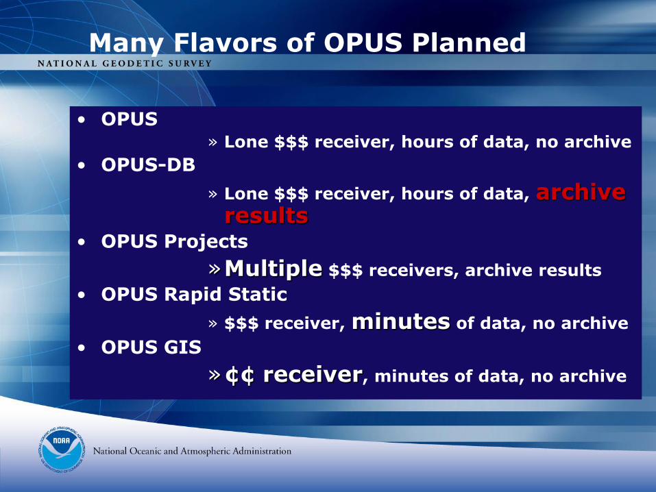
• OPUS» Lone $$$ receiver, hours of data, no archive
• OPUS-DB
» Lone $$$ receiver, hours of data, archive results
• OPUS Projects
»Multiple $$$ receivers, archive results
• OPUS Rapid Static
» $$$ receiver, minutes of data, no archive
• OPUS GIS
»¢¢ receiver, minutes of data, no archive
Many Flavors of OPUS Planned

NGS-modeled
antenna
GPS data
OPUS websitehttp://geodesy.noaa.gov/OPUS
your
datasheet
QA/QC
OPUS Concept
observation
notes
control station
photo *
control station
description *
control station
monument
NGS-modeled
antenna
GPS data (4+hours)
OPUS websitehttp://geodesy.noaa.gov/OPUS
for registered users
public
datasheet
QA/QC2
reviews
OPUS Datasheet Concept
observation
notes
*optional for “existing” stations.

OPUS
1. upload
3. verify (NGS)2. process
4. verify (agency)
5. publish
Data Flow

Why reinvent bluebooking?

How to Access NSRS
1) Passive monuments– Datasheets http://geodesy.noaa.gov/cgi-
bin/datasheet.prl
2) Active GPS– CORS data http://geodesy.noaa.gov/CORS
– OPUS processing http://geodesy.noaa.gov/OPUS

How to Maintain NSRS
1) Passive monuments
– Add observations via BLUEBOOKING
– Online recovery recvy_entry_www.prl
– Online GPS observations via OPUS-DB
2) Active GPS
– Join Cooperative CORS http://geodesy.noaa.gov/CORS/Coop/

Simple is better!
A comparison: Files used:
(create, sort, maintain)
Required Metadata
(input)
Programs used:
(learn, run, maintain)
BLUEBOOK 16 filesxxxxxxxxxxx
xxxxx
378 elementsxxxxxxxxxxx
xxxxxxxxxxx
xxxxxxxxxxx
xxxxx
26 programsxxxxxxxxxxxx
xxxxxxxxxxxx
xx
OPUS-DB2 files
xx
(GPS data + photo)
15 elementsxx
1 programx
(internet browser)

Stable
Permanent
Unique
Recoverable
Safe
Z 125
1935--|--
control station
monument
control station requirements

GPS data requirements
“OPUSable”4+ hours of dual frequency data
NGS-calibrated antenna
OPUS must achieve:
≥ 90% observations used
≥ 80% ambiguities fixed
≤ 0.02m peak-to-peak horizontal
≤ 0.04m peak-to-peak vertical
NGS-modeled
antenna
GPS data (4+hours)

*optional for “existing” stations.
control station
description *control station
photo *
metadata requirements
observation
notes
Simplified bluebooking


OPUS websitehttp://geodesy.noaa.gov/OPUS
for registered users
OPUS registry
Registration stores the following:
•Name
•Address
•Agency
•Experience- GPS & OPUS


OPUS statistics checked by computer
Photos reviewed by NGS
Datasheet reviewed by agency
QA/QC2
reviews
quality control

Identical to normal datasheet
PLUS agency attribution
PLUS links to OPUS reports & statistics
public
datasheet
OPUS datasheet

Bench mark elevation retained
Position accuracy improved 95 feet!
One more tie between GRS80-NAVD88.
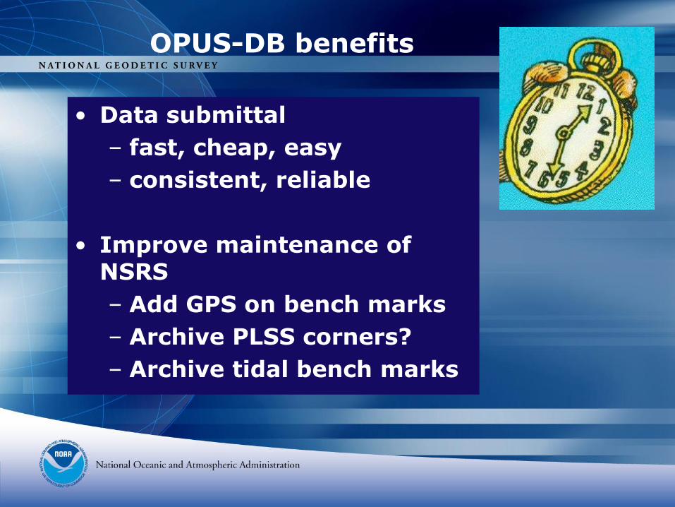
OPUS-DB benefits
• Data submittal
– fast, cheap, easy
– consistent, reliable
• Improve maintenance of NSRS
– Add GPS on bench marks
– Archive PLSS corners?
– Archive tidal bench marks

• GPS data only
• PAGES software only
• No direct tie to adjacent monuments
• No redundancy
• Reduced oversight
• Idiot-proofing?
• Field logs are not archived
OPUS-DB limitations

OPUS-DB data quality
• Registered, trained users
• 4+ hours of static GPS
• OPUS error checking
• NGS reviews each submittal
• Datasheet includes:
– “Caveat emptor” warning
– Datasheet includes DQA statistics
– Agency attribution
• Coordinates: first, best, average

• OPUS» Lone $$$ receiver, hours of data, no
archive
• OPUS-DB
» Lone $$$ receiver, hours of data, archive results
• OPUS Projects
»Multiple $$$ receivers, archive results
• OPUS Rapid Static
» $$$ receiver, minutes of data, no archive
• OPUS GIS
»¢¢ receiver, minutes of data, no archive
Many Flavors of OPUS Planned

OPUS Projects
•

• OPUS
» Lone $$$ receiver, hours of data, no archive
• OPUS-DB
» Lone $$$ receiver, hours of data, archive results
• OPUS Projects
»Multiple $$$ receivers, archive results
• OPUS Rapid Static
» $$$ receiver, minutes of data, no archive
• OPUS GIS
»¢¢ receiver, minutes of data, no archive
Many Flavors of OPUS Planned


FILE: txarO-RS.06o 000004405
1008 NOTE: Antenna offsets supplied by the user were zero. Coordinates
1008 returned will be for the antenna reference point (ARP).
1008
6011 Warning!!! OPUS-RS was able to find a set of reference stations
6011 with data suitable for use with your dataset. However, your
6011 position does not fall within the polygon enclosing these reference
6011 stations. This means that the geographic interpolation algorithms
6011 performed within OPUS-RS must instead perform extrapolation.
6011 Extrapolation, especially if your position is far from the
6011 reference stations, is prone to error. Use this solution with
6011 caution.
Distance to polygon enclosing the reference stations is 5 KM
NGS OPUS-RS SOLUTION REPORT
========================
USER: [email protected] DATE: September 01, 2006
RINEX FILE: txar223o.06o TIME: 17:34:22 UTC
SOFTWARE: rsgps 0.91 RS23.prl START: 2006/08/11 14:01:00
EPHEMERIS: igs13875.eph [precise] STOP: 2006/08/11 14:15:00
NAV FILE: brdc2230.06n OBS USED: 924 / 1008 : 92%
ANT NAME: TRM41249.00 QUALITY IND. 40.60/ 10.48
ARP HEIGHT: 0.0 OVERALL RMS: 0.424
REF FRAME: NAD_83(CORS96)(EPOCH:2002.0000) ITRF00 (EPOCH:2006.61110)
X: -659935.002(m) 0.002(m) -659935.682(m) 0.002(m)
Y: -5328392.049(m) 0.014(m) -5328390.624(m) 0.014(m)
Z: 3431593.066(m) 0.008(m) 3431592.908(m) 0.008(m)
LAT: 32 45 32.50006 0.002(m) 32 45 32.51912 0.002(m)

• NGS OPUS SOLUTION REPORT
• ========================
• USER: [email protected] DATE: September 01, 2006
• RINEX FILE: txar2230.06o TIME: 15:01:54 UTC
• SOFTWARE: page5 0601.10 master28.pl START: 2006/08/11 00:00:00
• EPHEMERIS: igs13875.eph [precise] STOP: 2006/08/11 23:59:00
• NAV FILE: brdc2230.06n OBS USED: 52174 / 53338 : 98%
• ANT NAME: TRM41249.00 NONE # FIXED AMB: 130 / 175 : 74%
• ARP HEIGHT: 0.0 OVERALL RMS: 0.023(m)
• REF FRAME: NAD_83(CORS96)(EPOCH:2002.0000) ITRF00 (EPOCH:2006.6096)
• LAT: 32 45 32.49988 0.013(m) 32 45 32.51893 0.013(m)
• E LON: 262 56 23.00951 0.012(m) 262 56 22.97685 0.012(m)
• W LON: 97 3 36.99049 0.012(m) 97 3 37.02315 0.012(m)
• EL HGT: 144.015(m) 0.023(m) 142.810(m) 0.023(m)
• ORTHO HGT: 171.230(m) 0.034(m) [Geoid03 NAVD88]
24 hr OPUS vs. 15 min OPUS-RS
North 0.0058 m
East 0.0121 m
Up -0.0256 m

• OPUS» Lone $$$ receiver, hours of data, no archive
• OPUS-DB
» Lone $$$ receiver, hours of data, archive results
• OPUS Projects
»Multiple $$$ receivers, archive results
• OPUS Rapid Static
» $$$ receiver, minutes of data, no archive
• OPUS GIS
»¢¢ receiver, minutes of data, no archive
Many Flavors of OPUS Planned


OPUS-GIS output• Station #: 1 File: zzyy2230.06o
• 2006/ 8/11 1: 1: 0 -659935.745 0.286 32 1 32.5158 0.314
• 2006/ 8/11 2:15: 0 -5328390.873 0.484 -97 3 37.0249 0.260
• #sec: 4440 #pts: 146 3431592.952 0.401 143.0226 0.558
• Station #: 2 File: zzyy2230.06o
• 2006/ 8/11 2:15:30 -659935.581 0.281 32 15 32.5078 0.296
• 2006/ 8/11 2:20: 0 -5328391.041 0.626 -97 3 37.0178 0.292
• #sec: 270 #pts: 10 3431592.750 0.424 143.0372 0.692
• Station #: 3 File: zzyy2230.06o
• 2006/ 8/11 2:33:30 -659935.568 0.344 32 33 32.5096 0.266
• 2006/ 8/11 2:38:30 -5328391.003 0.586 -97 3 37.0175 0.365
• #sec: 300 #pts: 11 3431592.792 0.361 143.0265 0.623
• Station #: 4 File: zzyy2230.06o
• 2006/ 8/11 2:41:30 -659935.598 0.488 32 41 32.5175 0.259
• 2006/ 8/11 2:52: 0 -5328390.395 0.757 -97 3 37.0215 0.431
• #sec: 630 #pts: 22 3431592.697 0.428 142.4706 0.861
• Station #: 5 File: zzyy2230.06o
• 2006/ 8/11 2:52:30 -659935.747 0.421 32 52 32.5170 0.280
• 2006/ 8/11 3:35: 0 -5328390.635 0.682 -97 3 37.0260 0.361
• #sec: 2550 #pts: 86 3431592.843 0.425 142.7651 0.784