ni 43-101 technical report on the asuogya licence, … · ni 43-101 technical report on the asuogya...
TRANSCRIPT
NI 43-101 Technical Report on
The Asuogya Licence, Ghana
Report Prepared for:
Castle Peak Mining Ltd
510 - 999 West Hastings Street,
Vancouver,
BC V6C 2W2
File Ref: Asuogya NI 43-101-final.docx 30 December 2011
NI 43-101 Technical Report on
The Asuogya Licence, Ghana
Report Prepared for: Castle Peak Mining Ltd
510 - 999 West Hastings Street,
Vancouver,
BC V6C 2W2
SRK ES 7431
SRK Exploration Services Ltd.
12 St Andrew’s Crescent,
Cardiff,
UK
CF10 3DD
Tel: +44 29 20 233 233
Fax: +44 29 20 233 211
www.srkexploration.com
FILE REF: Asuogya NI 43-101-final.docx 30 December 2011
Report Authors Reviewed by:
Gareth O'Donovan
Agatha Lacey S Bateman
SRK Exploration Services Ltd
Asuogya NI 43-101 - Summary Page ii
File Ref: Asuogya NI 43-101-final.docx 30 December 2011
1 SUMMARY
SRK Exploration Services Ltd (“SRK ES”) was instructed by Castle Peak Mining Ltd
(“CPM”) to prepare a NI43-101 compliant technical report on the Asuogya Licence in Ghana.
The Asuogya Licence forms part of Castle Peak‟s larger Akorade Project. This report has
been produced following a site visit by Mr Gareth O‟Donovan and Miss Agatha Lacey of
SRK ES between the 1st and the 4
th of November 2011, and discussions with senior CPM
personnel and field geologists.
Netas Mining Ltd (“Netas”), were awarded the Asuogya Licence in 1990. Following various
renewals Netas entered into a Joint Venture agreement with Canterbury Mining Ltd
(“Canterbury”), a wholly owned subsidiary of CPM in 2005. Netas transferred 95% ownership
in the Asuogya Licence to Canterbury under an assignment agreement on April 5th 2011.
The Asuogya Licence covers an area of 2675Ha and is located in the Western Region of the
Republic of Ghana, 24km southeast of Tarkwa within the Wassa–West District (Tarkwa-
Nsuaem municipality). The Licence is one of nine licence areas that form CPM‟s Akorade
Project. Asuogya is centred on coordinates 2.0000° W – 5.0628° N (WGS84).
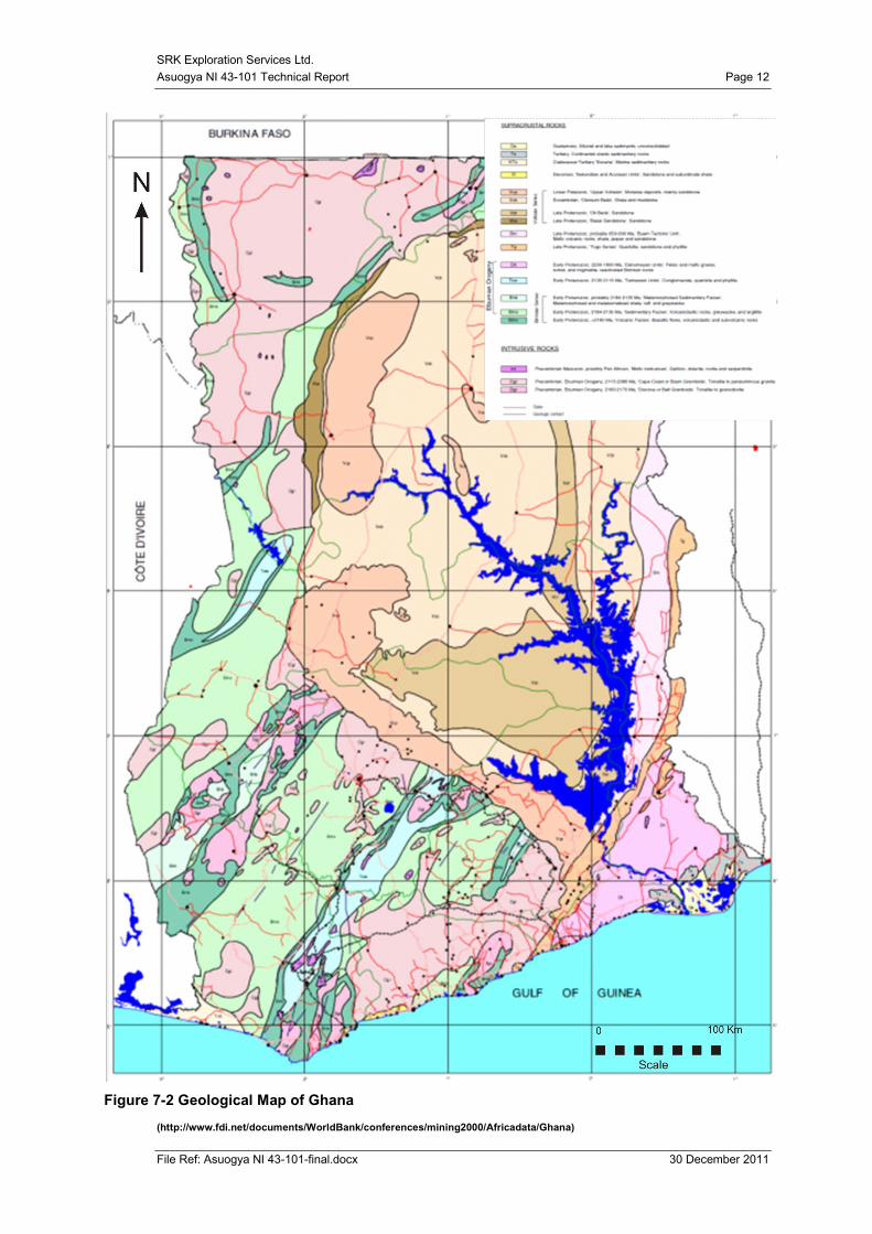
Asuogya is situated on the southwest margin of the Ashanti Volcanic Belt and the geology is
dominated by the Birimian Supergroup metasedimentary and metavolcanic rocks, along with
sedimentary rocks of the Tarkwaian Group and various granitoid intrusions.
Geochemical and geophysical exploration has delineated a 7km long anomalous zone,
coincident with the metasedimentary – metavolcanic contact. Local artisanal miners are also
exploiting parts of this linear zone.
CPM has conducted a preliminary diamond drilling programme over one part of the anomaly
at Asuogya. A total of 3,571 metres were drilled from 18 holes. This drilling has intersected
gold mineralisation but has thus far not delineated a major mineralised zone.
Further work is recommended at Asuogya.

SRK Exploration Services Ltd
Asuogya NI 43-101– Table of Contents Page iii
File Ref: Asuogya NI 43-101-final.docx 30 December 2011
Table of Contents
1 SUMMARY ii
2 INTRODUCTION 1
2.1 Background 1
2.2 Qualifications of Consultants 1
2.3 Basis of the Technical Report 2
3 RELIANCE ON OTHER EXPERTS 2
4 PROPERTY DESCRIPTION AND LOCATION 3
4.1 Property location 3
4.2 Mining Code 4
4.3 Mineral titles 5
4.4 Environmental Liabilities and Permitting 6
4.5 Risks to Access, Title or Ability to Conduct Work 6
5 ACCESSIBILITY, CLIMATE, LOCAL RESOURCES, INFRASTRUCTURE AND
PHYSIOGRAPHY 7
5.1 Access 7
5.2 Climate 7
5.3 Local resources 7
5.4 Physiography 7
6 HISTORY 9
6.1 Past and Present Ownership 9
6.2 Previous Exploration Activities 9
6.3 Historic Production 9
7 GEOLOGICAL SETTING AND MINERALISATION 10
7.1 Regional Geology 10
7.2 Geology of southwest Ghana 13
7.3 Structural geology in southwest Ghana 13
7.4 Gold mineralisation in southwest Ghana 13
7.5 Licence Geology 14
8 DEPOSIT TYPE 16
9 EXPLORATION 17
9.1 Stream sediment sampling 17
9.2 Soil sampling 17
9.3 Rock chip sampling 17
9.4 Auger sampling: 17
9.5 Airborne Geophysics 17
SRK Exploration Services Ltd
Asuogya NI 43-101– Table of Contents Page iv
File Ref: Asuogya NI 43-101-final.docx 30 December 2011
9.6 Topographic survey 18
10 DRILLING 20
11 SAMPLE PREPARATION, ANALYSIS AND SECURITY 22
11.1 Sample Preparation and Analyses – Streams and Soils 22
11.2 Sample Preparation and Analyses – Drill cores 23
11.3 Security 24
11.4 Sample Analysis 24
11.5 Quality Control Measures 24
12 DATA VERIFICATION 25
13 MINERAL PROCESSING AND METALLURGICAL TESTING 26
14 MINERAL RESOURCE ESTIMATES 26
15 ADJACENT PROPERTIES 26
16 OTHER RELEVANT DATA AND INFORMATION 27
17 INTERPRETATION AND CONCLUSIONS 27
17.1 Interpretation 27
17.2 Conclusions 28
18 RECOMMENDATIONS 28
19 REFERENCES 30
SRK Exploration Services Ltd
Asuogya NI 43-101– Table of Contents Page v
File Ref: Asuogya NI 43-101-final.docx 30 December 2011
List of Figures
Figure 4-1: Map of Ghana showing the Asuogya Licence location and the
Greenstone belts (supplied by Castle Peak) 4
Figure 7-1: Major Tectonic Domains of West Africa (Klein and Moura 2008) 10
Figure 7-2 Geological Map of Ghana 12
Figure 7-3 Geological map of the Akorade project area 15
Figure 9-1 Exploration Licence overview of Asuogya and Ayiem (Compiled from
Castle Peak Mining Ltd data) 19
Figure 15-1 Location of known gold deposits in proximity to the Asuogya Licence. 27
List of Tables
Table 4-1: Coordinates for the Asuogya Licence 3
Table 10-1 Table of the collar locations for the Asuogya diamond drilling 20
Table 10-2: Table of the best drill core intersections, Asuogya. 20
Table 11-1 Drill Core Sampling protocols (supplied by Castle Peak mining) 23
Table 12-1: SRK ES verification sample results. 26
Appendices
Appendix I 31
Appendix II 34
File Ref: Asuogya NI 43-101-final.docx 30 December 2011
Asuogya NI 43-101-final.docx
30 December 2011
NI 43-101 Technical Report on The Asuogya Licence,
Ghana
2 INTRODUCTION
2.1 Background
SRK Exploration Services Ltd (“SRK ES”) was instructed by Castle Peak Mining Ltd
(“CPM”) to prepare a NI43-101 compliant technical report on the Asuogya Licence in Ghana.
The Asuogya Licence forms part of CPM‟s larger Akorade Project. This report has been
produced following a site visit by Mr. Gareth O‟Donovan and Miss Agatha Lacey of SRK ES
between the 1st and the 4
th of November 2011, and discussions with senior CPM personnel and
field geologists.
2.2 Qualifications of Consultants
SRK ES is part of an international group (SRK Group) that comprises over 1,200 professional
staff offering expertise in a wide range of geological and engineering disciplines.
The SRK Group‟s independence is ensured by the fact that it holds no equity in any project
and that its ownership rests solely with its staff. The SRK Group has a demonstrated track
record of undertaking independent assessments of mineral resource and reserve estimates,
project evaluations and audits, competent person‟s reports and independent feasibility studies
on behalf of exploration and mining companies and financial institutions worldwide. The
SRK Group has specific experience in transactions of this nature.
This report has been prepared by a team of Geologists from the SRK ES office in Cardiff
(United Kingdom) that has extensive experience in gold mineralised systems, management of
grass roots exploration through to resource definition drilling, QA/QC issues and application
of best exploration practice.
SRK Exploration Services Ltd
12 St Andrew’s Crescent,
Cardiff,
United Kingdom
CF10 3DD.
e-mail: [email protected]
URL: www.srkexploration.com
Tel: + 44 (0)29 20 233 233
Fax: + 44 (0)29 20 233 211
SRK Exploration Services Ltd.
Asuogya NI 43-101 Technical Report Page 2
File Ref: Asuogya NI 43-101-final.docx 30 December 2011
Neither SRK ES nor any of its employees involved in the preparation of this report have any
beneficial interest in CPM. SRK ES will be paid a fee for this work in accordance with
normal professional consulting practice.
Mr. Gareth O’Donovan is a Corporate Exploration Consultant with over 25 years experience
in mining and exploration projects in Africa, South America, the Russian Federation, Europe
and Asia. He specialises in the design, implementation and management of exploration
projects from grassroots to pre-feasibility in all terrains and environments, mobilising multi-
disciplinary field teams, also technical reviews, competent person‟s reports, audits and
valuations of exploration and mining properties world-wide and in a variety of commodities.
For the past eight years he has been Managing Director of SRK Exploration Services Ltd.
(SRK ES). Mr. O‟Donovan is the principal author and Qualified Person for this report.
2.3 Basis of the Technical Report
In summary, this technical report has been based on:
a site visit by Mr. Gareth O‟Donovan, carried out between the 1st and 4
th of November
2011 to review the geology and prospectivity of the area;
access to key personnel at the project site in Ghana for discussion and enquiry;
a review of Castle Peak data collection procedures and protocols; and
a review of published and unpublished material outlined in the reference sections.
While SRK ES has reviewed the exploration permits to assess the extent to which these may
influence the technical status and development of the asset, SRK ES has not undertaken a legal
due diligence study such as would be required to confirm that all statutory consents are in
force and current.
All assay results and data pertaining to the Asuogya Licence has been received from Castle
Peak in good faith by SRK ES.
3 RELIANCE ON OTHER EXPERTS
The report is based on a site visit by the author and a compilation of proprietary and publicly
available information. The author, in writing this report, used sources of information as listed
in the references section.
Cited reports were prepared by qualified persons holding post secondary geology, or related
university degree(s), and are therefore deemed to be accurate. For reports written by
personnel who are not qualified persons, the author must rely upon the professional measures
used by the employees of the companies who completed the work. The information in those
SRK Exploration Services Ltd.
Asuogya NI 43-101 Technical Report Page 3
File Ref: Asuogya NI 43-101-final.docx 30 December 2011
reports is assumed to be accurate based on the data review conducted by the author, but is not
NI 43-101 compliant.
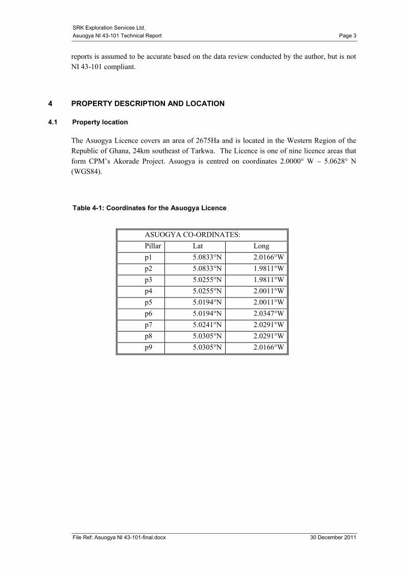
4 PROPERTY DESCRIPTION AND LOCATION
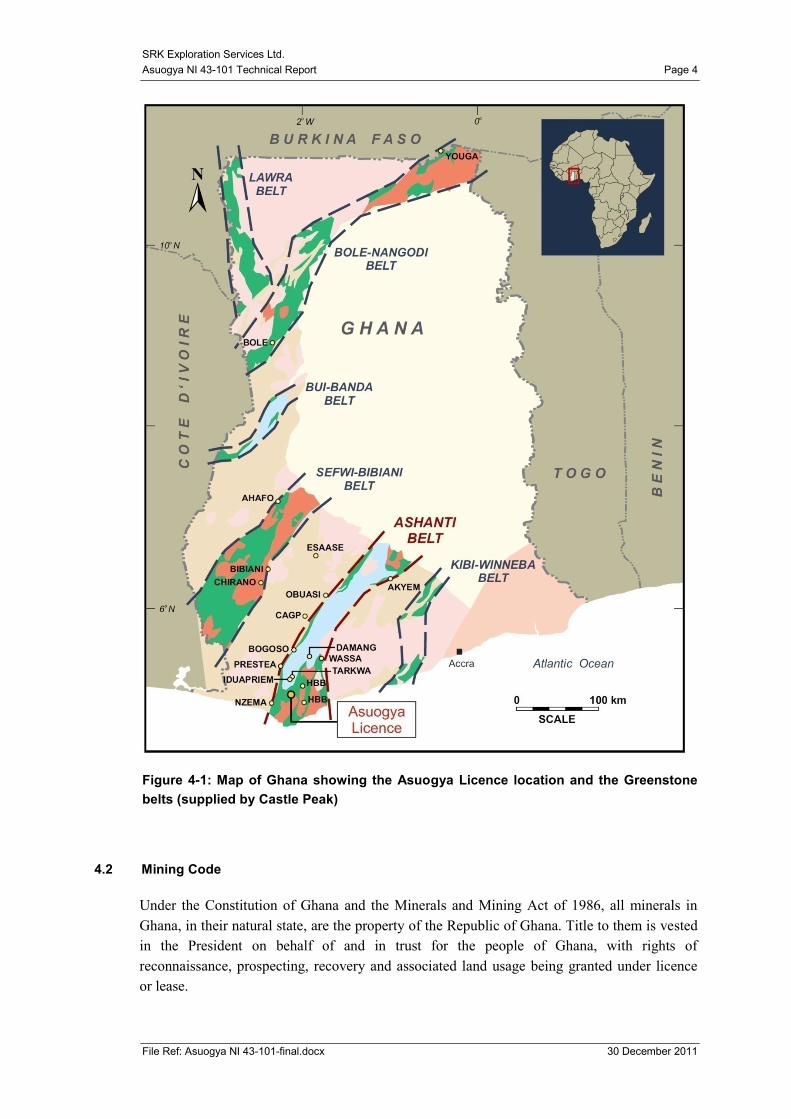
4.1 Property location
The Asuogya Licence covers an area of 2675Ha and is located in the Western Region of the
Republic of Ghana, 24km southeast of Tarkwa. The Licence is one of nine licence areas that
form CPM‟s Akorade Project. Asuogya is centred on coordinates 2.0000° W – 5.0628° N
(WGS84).
Table 4-1: Coordinates for the Asuogya Licence
ASUOGYA CO-ORDINATES:
Pillar Lat Long
p1 5.0833°N 2.0166°W
p2 5.0833°N 1.9811°W
p3 5.0255°N 1.9811°W
p4 5.0255°N 2.0011°W
p5 5.0194°N 2.0011°W
p6 5.0194°N 2.0347°W
p7 5.0241°N 2.0291°W
p8 5.0305°N 2.0291°W
p9 5.0305°N 2.0166°W
SRK Exploration Services Ltd.
Asuogya NI 43-101 Technical Report Page 4
File Ref: Asuogya NI 43-101-final.docx 30 December 2011
Figure 4-1: Map of Ghana showing the Asuogya Licence location and the Greenstone
belts (supplied by Castle Peak)
4.2 Mining Code
Under the Constitution of Ghana and the Minerals and Mining Act of 1986, all minerals in
Ghana, in their natural state, are the property of the Republic of Ghana. Title to them is vested
in the President on behalf of and in trust for the people of Ghana, with rights of
reconnaissance, prospecting, recovery and associated land usage being granted under licence
or lease.
SRK Exploration Services Ltd.
Asuogya NI 43-101 Technical Report Page 5
File Ref: Asuogya NI 43-101-final.docx 30 December 2011
Either a licence or lease is required to explore or prospect for minerals in Ghana. The Minister
of Mines has the power to negotiate, grant, revoke, suspend or renew any mineral rights,
subject to a power of disallowance exercisable by the Cabinet within 30 days of such grant,
revocation, suspension or renewal.
The Government acquires, without payment, a 10% carried interest in the rights and
obligations of the mineral operations in relation to a mineral right for reconnaissance,
prospecting or mining. It also has the option to acquire an additional 20% equity interest where
any mineral is discovered in commercial quantities. Both the Government and the holder of the
mining lease must agree to terms associated with the acquisition of the additional twenty
percent or either party can seek arbitration.
In Ghana, there are three types of mineral rights: Reconnaissance Licences, Prospecting
Licences and Mining Leases:
• Reconnaissance Licence – is issued for a large area, with no specific limit on size, and is
normally granted for a maximum 12 month period subject to renewal for an additional 12
months. This type of licence is intended for regional geochemistry, geophysics and
mapping. It does not allow trenching and drilling;
• Prospecting Licence – is issued for areas covering a maximum of 150 sq km in
aggregate. Individual blocks need not be contiguous. This type of licence is initially
granted for a period of three years and is renewable for an additional two years but after
the release of 50% of the original granted area. This right allows all forms of exploration
and development;
• Mining Lease – is normally granted for a period of 30 years on a maximum 50 sq km or
an aggregate area of up to 150 sq km if more than one lease is held. The specific terms
and conditions are negotiated with the Minister of Mines.
Licences may only be transferred with the written approval of the Minister of Mines. All
licence agreements have a requirement for employment and training of local people and local
sourcing of supplies.
4.3 Mineral titles
Castle Peak retains a prospecting licence for the Asuogya property that was originally awarded
in 1990 to Netas Mining Company Limited (Netas). In 2005, Netas entered in to a JV with
Canterbury Mining Limited (Canterbury), a wholly owned subsidiary of CPM, Netas
transferred 95% ownership in the Asuogya Licence to Canterbury under an assignment
agreement on April 5th 2011.
Asuogya has no payments or royalties. The vendor, Netas, retains a 5% free carried interest as
long as Asuogya carries an exploration status.
SRK Exploration Services Ltd.
Asuogya NI 43-101 Technical Report Page 6
File Ref: Asuogya NI 43-101-final.docx 30 December 2011
4.4 Environmental Liabilities and Permitting
Exploration work on a prospecting licence requires a permit from the Environmental
Protection Agency (EPA). A new permit must be applied for annually and an annual report
must be submitted to the EPA.
A permit to operate in Forest Reserves must be obtained from the Forestry Commission and
renewed every six months. The Forestry Department personnel regularly inspect exploration
sites.
To obtain the mining lease an Environmental Impact Statement must be accepted by the EPA.
To the best of SRKES‟s knowledge, all EPA permits are up to date, and no forestry permit is
required for the Asuogya Licence. No environmental liabilities are known to exist from
previous or current works on the Asuogya Licence.
4.5 Risks to Access, Title or Ability to Conduct Work
To the best of SRKES‟s knowledge there are no known risks to access, title or ability to
conduct work on the property.
SRK Exploration Services Ltd.
Asuogya NI 43-101 Technical Report Page 7
File Ref: Asuogya NI 43-101-final.docx 30 December 2011
5 ACCESSIBILITY, CLIMATE, LOCAL RESOURCES, INFRASTRUCTURE AND
PHYSIOGRAPHY
5.1 Access
The Asuogya Licence is accessible via a network of footpaths and roads. Located in the
Western Region of Ghana, the Licence is a 40 minute drive southeast of Tarkwa along the
Takoradi-Tarkwa main road. Takoradi is a 4 hour drive along the main road to Accra or a 30
minute flight connection from Accra to Takoradi running twice daily.
The Town of Tarkwa is the nearest population centre (~33,466 people) 24km to the northwest
of the project and readily accessible by a network of asphalt and dirt roads. Settlement within
and around the Licence includes traditionally built villages with little or no infrastructure and
individual houses with varying degrees of habitation and amenities. The villages of Nkwanta
and Ayiem are less than 2km‟s outside of the Asuogya Licence.
5.2 Climate
South western Ghana experiences two rainy seasons; one in early April to July, (greater) and
one from September to October (lesser). The remainder of the year is hot, (25-32°C). Humid
weather prevails across the country, apart from in the north and the very southern coastal areas
where the climate is marginally warmer and drier. Exploration can be conducted year round
with only minor problems encountered during the rainy seasons in low lying or swampy areas.
5.3 Local resources
Castle Peak has administrative offices in Accra, a site office and core storage facilities in a
small hamlet on the main Tarkwa road south of the licence near the town of Busua, and an
established field camp on the Nkwanta Licence.
Due to the nature of the current exploration phase, the need for water and electricity is
minimal. There are numerous streams across the Licence from which water can be pumped for
drilling purposes when needed. Power is supplied by grid power and diesel generators.
The Ashanti region‟s strong historical connections with the mining and exploration industries
has made Tarkwa one of southern Ghana‟s hubs for mining and there is an abundance of
educated technical people as well as an extensive manual labour force, laboratory facilities and
a number of contractors and mining companies.
5.4 Physiography
The area is of low gentle topography not exceeding approximately 90 metres above sea level
and is divided by a network of river drainage systems. The land use is predominantly
SRK Exploration Services Ltd.
Asuogya NI 43-101 Technical Report Page 8
File Ref: Asuogya NI 43-101-final.docx 30 December 2011
secondary forestry re-growth and subsistence farming of crops such as cocoyam, plantain,
cassava and maize. There are some areas of small scale commercial farming which include
crops such as rubber, cocoa and palm oil.
SRK Exploration Services Ltd.
Asuogya NI 43-101 Technical Report Page 9
File Ref: Asuogya NI 43-101-final.docx 30 December 2011
6 HISTORY
Ghana has a long history of gold production dating back 2000 years. Arab traders travelled to
and traded with Ghana for gold from the 7th Century, accompanied later by European colonials
which aptly named Ghana the „Gold Coast‟. During this time, 14 million oz were produced.
Two further gold rushes during the 1900‟s established Obuasi, Tarkwa and Prestea as gold
producing regions.
6.1 Past and Present Ownership
Netas Mining Ltd (Netas), were awarded the Asuogya Licence in 1990. Following various
renewals, Netas entered into a Joint Venture agreement with Canterbury Mining Ltd
(Canterbury), a wholly owned subsidiary of CPM in 2005. Netas transferred 95% ownership
in the Asuogya Licence to Canterbury under an assignment agreement on April 5th 2011.
6.2 Previous Exploration Activities
Recent exploration activities on the Asuogya Licence commenced in 2005 with a desk study
and a stream sediment survey conducted by the Netas/Canterbury JV, to verify potential gold
occurrences on the Licence. The results of the stream sediment survey defined three north-
trending stream sediments anomalies (Asuogya east; Asuogya west and Asuogya south) which
were then followed up by soil sampling, geological mapping and an auger drilling campaign to
delineate a 7km long anomalous zone coincident with the projected phyllite/volcanic
boundary.
No previous resources or reserves have been estimated as the project is still in the exploratory
stages.
6.3 Historic Production
There has been no commercial historic production recorded on the Asuogya Licence however
indigenous exploitation was evident during the SRK ES visit and is likely to have been
ongoing at a small scale for decades.
SRK Exploration Services Ltd.
Asuogya NI 43-101 Technical Report Page 10
File Ref: Asuogya NI 43-101-final.docx 30 December 2011
7 GEOLOGICAL SETTING AND MINERALISATION
7.1 Regional Geology
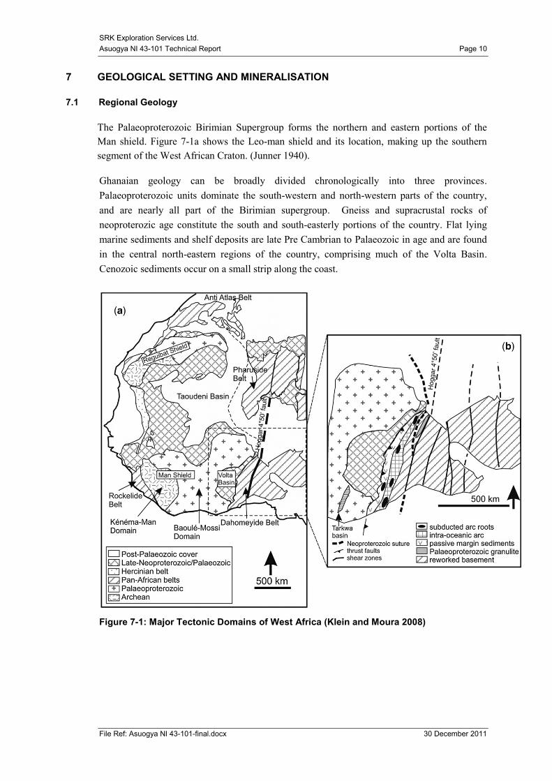
The Palaeoproterozoic Birimian Supergroup forms the northern and eastern portions of the
Man shield. Figure 7-1a shows the Leo-man shield and its location, making up the southern
segment of the West African Craton. (Junner 1940).
Ghanaian geology can be broadly divided chronologically into three provinces.
Palaeoproterozoic units dominate the south-western and north-western parts of the country,
and are nearly all part of the Birimian supergroup. Gneiss and supracrustal rocks of
neoproterozic age constitute the south and south-easterly portions of the country. Flat lying
marine sediments and shelf deposits are late Pre Cambrian to Palaeozoic in age and are found
in the central north-eastern regions of the country, comprising much of the Volta Basin.
Cenozoic sediments occur on a small strip along the coast.
Figure 7-1: Major Tectonic Domains of West Africa (Klein and Moura 2008)
SRK Exploration Services Ltd.
Asuogya NI 43-101 Technical Report Page 11
File Ref: Asuogya NI 43-101-final.docx 30 December 2011
The Birimian Supergroup can be broadly subdivided into two coeval assemblages; the
volcanoclastic assemblages that have been emplaced as a series of evenly spaced belts with a
north-east, south-west strike (Upper Birimian) and a set of folded metasediments intruded by a
variety of granitoids as basinal units between the belts (Lower Birimian). These belts are
hundreds of kilometres long and 20-60km wide consisting of low grade metamorphosed lavas.
From south to north the belts are named: Kibi Winiba, Ashanti, Sefwi-Bibiani, Bui-Banda,
and Lawra. Lawra is the only belt not to exhibit the same NE, SW strike (see Figure 4-1). The
belts are separated by basins of Lower Birimian isoclinally folded dacites, volcanoclastics,
greywackes and argillites, as well as intruded granitoids. Closer to the Lower and Upper
Birimian boundary, weakly metamorphosed tuffs are exhibited. Some of the phyllites contain
pyrite and mineralisation along with finely divided carbonaceous matter and silicification is
also common among the units closer to the Upper Birimian boundary (Wright 1985).
The transitional zones between the basins and belts are characterized by interbedded cherts,
exhalites and fine manganese deposits. During the Eburnean orogeny (2130-1980 Ma) the
Birimian units were folded, intruded, uplifted and eroded. The eroded Birimian material was
subsequently deposited as Tarkwaian units in grabens as molasse facies sediments.
Most Ghanaian Birimian gold occurrences and mines are concentrated in narrow corridors of
10–15 km width in the transition zone between volcanic belts and sedimentary basins, as are
the chemical facies and regionally extensive shear zones at the volcanic-sediment boundary.
Birimian gold in Ghana is present as two major types: (1) the disseminated sulphide type
which is generally lithofacies controlled, i.e. controlled by chemical sediments, and to a lesser
extent by selvages of gold-quartz veins; and (2) the quartz vein type which is exclusively
structurally controlled (Leube 1990).
SRK Exploration Services Ltd.
Asuogya NI 43-101 Technical Report Page 12
File Ref: Asuogya NI 43-101-final.docx 30 December 2011
Figure 7-2 Geological Map of Ghana
(http://www.fdi.net/documents/WorldBank/conferences/mining2000/Africadata/Ghana)
SRK Exploration Services Ltd.
Asuogya NI 43-101 Technical Report Page 13
File Ref: Asuogya NI 43-101-final.docx 30 December 2011
7.2 Geology of southwest Ghana
The Akorade Project is situated on the southwest margin of the Ashanti Volcanic Belt and the
geology is dominated by the Birimian Supergroup metasedimentary and metavolcanic rocks,
along with sedimentary rocks of the Tarkwaian Group and various granitoid intrusions.
The Birimian Supergroup is characterised by northeast striking mafic volcanic belts separated
from intervening sedimentary (dominantly turbiditic) basins by major faults that probably
controlled early syn-Birimian sedimentary basin down-faulting.
The Tarkwaian Group comprises sedimentary rocks that include conglomerates, various
quartzose and arkosic sandstones, siltstones, and minor shales. Tarkwaian rocks are generally
confined to Birimian volcanic belts where they occur as either fault-bounded slices or
unconformably overlying sedimentary rocks. Rocks of the Tarkwaian Group are distinctively
highly magnetic and can be easily recognised on aeromagnetic images.
7.3 Structural geology in southwest Ghana
Two discrete orogenic cycles are recognised in southwest Ghana; An earlier “Eburnian I”
orogeny, associated with the eruption of the Birimian volcanic rocks, intrusion of Belt type
granitoids, and associated metamorphism between ca. 2200 and 2150 Ma. The second and later
orogeny was the “Eburnian II” orogeny which involved deformation and metamorphism of
Birimian and Tarkwaian rocks, and intrusion of Basin type felsic intrusions between 2116 and
2088 Ma.
Deformation related to the Eburnian II orogeny dominates the structural geology of southwest
Ghana with five distinct and successive deformation phases represented.
7.4 Gold mineralisation in southwest Ghana
Two broad styles of gold mineralisation are present in southwest Ghana: (a) palaeo-placer
disseminated gold deposits hosted in Tarkwaian conglomerates (Banket deposits), and (b)
structurally controlled lode gold deposits hosted in a wide range of lithologies.
Most gold mineralisation is associated with major northeast striking, 5 to 40 m wide graphite-
chlorite-sericite fault zones. In particular, gold mineralisation is developed where the northeast
fault zones intersect major east-northeast striking fault zones and especially where they are
recognised to have influenced granite emplacement. Such faults are commonly associated with
pervasive hydrothermal alteration.
As the gold mineralisation is related to faulting which post-dates the formation of the host
rocks, it is termed epigenetic. Typically the gold is associated with pyrite, arsenopyrite and
other sulphide minerals and the veins themselves are often characterised by zones of iron-rich
hydrothermal alteration of the adjacent wall-rocks. Silicification, sulphidation and potassium
metasomatism of the host rocks are also characteristic of these deposits.
SRK Exploration Services Ltd.
Asuogya NI 43-101 Technical Report Page 14
File Ref: Asuogya NI 43-101-final.docx 30 December 2011
Gold bearing structures of the Ashanti Belt region are classically steeply dipping and have a
north-south strike. Mineralisation of the Ashanti Belt has an off normal to en-echelon steeply
dipping configuration.
7.5 Licence Geology
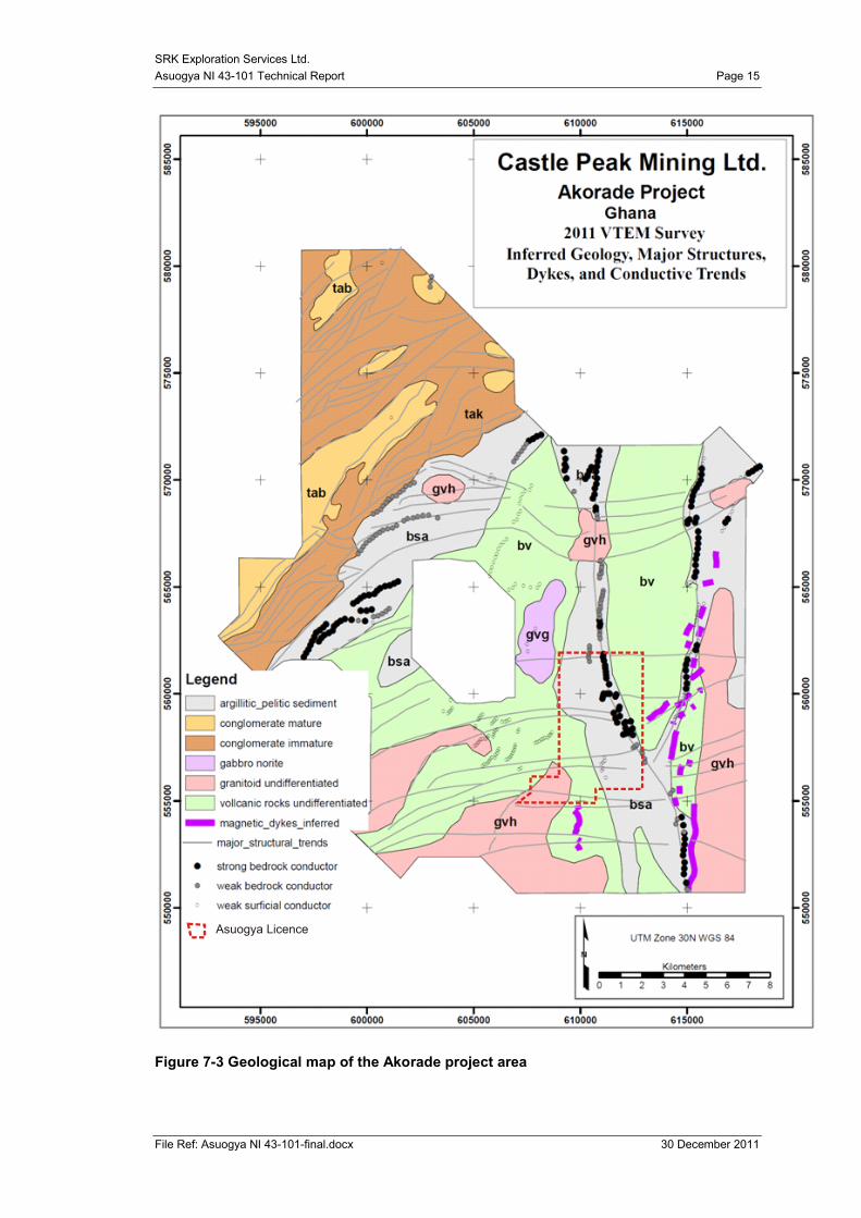
The Asuogya property is located on a south eastern extension of the Ashanti belt and
predominantly underlain by N-S trending pelitic units and undifferentiated metavolcanics, see
Figure 7-3.
Mineralisation at Asuogya is associated with quartz veins in metamorphosed volcanics on
metasedimentary contacts, observed within a N-S trending graphitic shear zone.
As
uo
gy
a
A
y
i
e
m
SRK Exploration Services Ltd.
Asuogya NI 43-101 Technical Report Page 15
File Ref: Asuogya NI 43-101-final.docx 30 December 2011
Figure 7-3 Geological map of the Akorade project area
Asuogya Licence
SRK Exploration Services Ltd.
Asuogya NI 43-101 Technical Report Page 16
File Ref: Asuogya NI 43-101-final.docx 30 December 2011
8 DEPOSIT TYPE
The geological model applied to much of the Tarkwa area is of Greenstone-hosted quartz-
carbonate vein deposits. Dubé and Gosselin (2007) provide an overview of the model type as
below;
“Greenstone-hosted quartz-carbonate vein deposits are structurally controlled, complex
epigenetic deposits that are hosted in deformed and metamorphosed terranes. They consist of
simple to complex networks of gold-bearing, laminated quartz-carbonate fault-fill veins in
moderately to steeply dipping, compressional brittle-ductile shear zones and faults, with
locally associated extensional veins and hydrothermal breccias. They are dominantly hosted
by mafic metamorphic rocks of greenschist to locally lower amphibolites facies and formed at
intermediate depths (5-10 km).Greenstone-hosted quartz-carbonate vein deposits are typically
associated with iron-carbonate alteration. The relative timing of mineralization is syn- to late-
deformation and typically post-peak greenschist-facies or syn-peak amphibolite facies
metamorphism. They are formed from low salinity environments .Greenstone-hosted quartz-
carbonate vein deposits are distributed along major compressional to transpressional crustal-
scale fault zones in deformed greenstone terranes of all ages.”
The focus for the Asuogya Licence has been the structural controls influencing the epithermal
gold mineralization associated with greenstone hosted quartz-carbonate vein deposits. Due to
the proximity of the granitic intrusions there is the possibility that the magmatism has had an
influence on the distribution and remobilization of mineralization. The mineralization
currently being targeted is largely associated with disseminated pyrite in affiliation with
deformed boundinaged quartz veins within metasedimentary packages of greywackes,
phyllites, graphitic phyllites and localized amphibolitic intrusions. These structures are likely
to follow the overall structural trends on both the regional and local scale of NE, SW
deformation and shear.
SRK Exploration Services Ltd.
Asuogya NI 43-101 Technical Report Page 17
File Ref: Asuogya NI 43-101-final.docx 30 December 2011
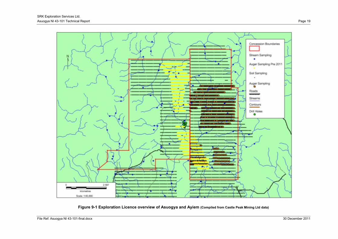
9 EXPLORATION
Exploration in the Asuogya Licence is still in the early stages, however the following work has
been conducted over the licence area since exploration commenced in 2005;
Stream sediment sampling
Geochemical soil sampling
Rock chip sampling
Auger sampling
Airborne geophysics – Mag – EM
Diamond drilling
Topographic surveying
Figure 9-1 provides an overview of the exploration conducted thus far at Asuogya.
9.1 Stream sediment sampling
Stream sediments samples were taken from both dry and flowing first and second order
streams. The sample sites were pre-determined from 1:50000 topographic maps and located
in the field by means of handheld GPS. At each location composite stream sediment samples
were collected over a distance of 50 m and bagged. The weight of each sample ranged
between 3 and 5 kg. Each sample was logged and a sample database created containing spatial
and non-spatial information.
9.2 Soil sampling
Soils samples were collected from the B-horizon (between 0.4 and 1.0 m depth) Samples with
an average weight of 2 kg were bagged, numbered and sealed and submitted for Bulk Liquid
Extractable Gold (BLEG) analysis. Regular grids were cut over the delineated stream sediment
anomalies. The initial grid was spaced at 200m x 50m. Sample locations were systematically
pegged and numbered.
9.3 Rock chip sampling
Grab samples were collected from the artisanal workings (where present).
9.4 Auger sampling:
Auger sampling (up to 4m deep or point of refusal) on a 100 x 200 m grid was conducted in
2011. Samples were collected from established grids (Geophysical/soil anomaly). Spatial and
non-spatial sampling information were then taken at each station
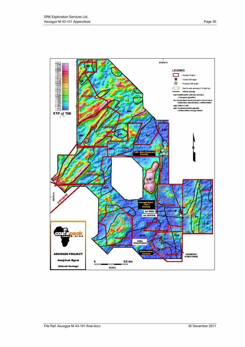
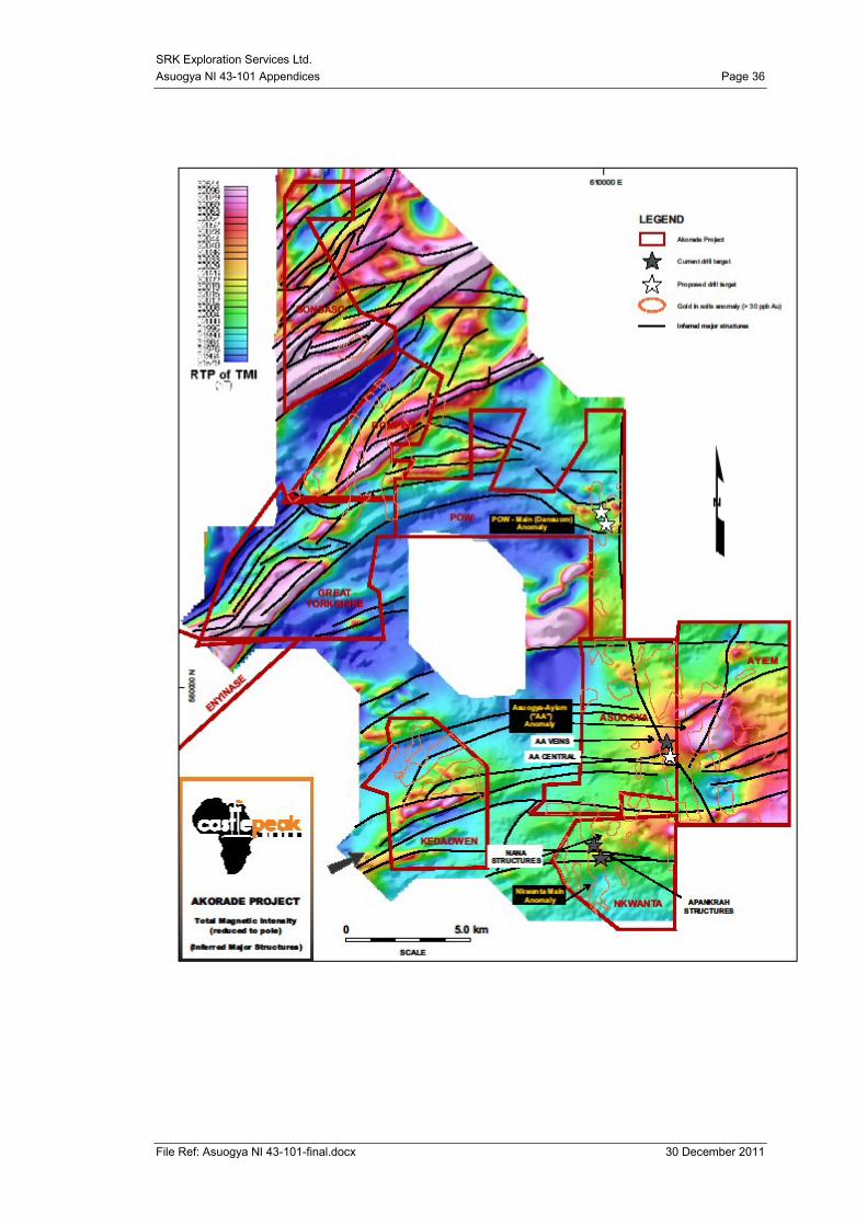
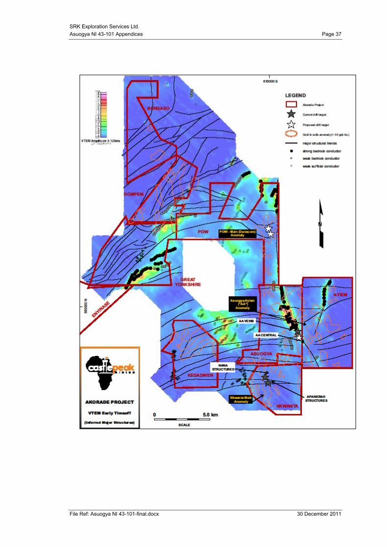
9.5 Airborne Geophysics
The airborne geophysical surveys were conducted across the whole Akorade Project by
Geotech Airborne Ltd in March 2011 and interpretation of the data was conducted by Geo-
Digit-Ex. Geo-Digit-Ex identified 8 structural targets within the Akorade Project area, one of
which has been the focus for exploration within the Asuogya Licence as it is concurrent with
SRK Exploration Services Ltd.
Asuogya NI 43-101 Technical Report Page 18
File Ref: Asuogya NI 43-101-final.docx 30 December 2011
Au soil anomalies and proximally located to the sediment volcanic unit boundary. (See
Appendix II for geophysical maps) Figure 7-3 shows the interpreted geology from the
geophysical survey.
9.6 Topographic survey
The topographic survey was conducted by Tomlee Survey Consult Ltd. In order to produce a
topographic and digital terrain map of the Asuogya drill site in August 2011.
SRK Exploration Services Ltd.
Asuogya NI 43-101 Technical Report Page 19
File Ref: Asuogya NI 43-101-final.docx 30 December 2011
Figure 9-1 Exploration Licence overview of Asuogya and Ayiem (Compiled from Castle Peak Mining Ltd data)
SRK Exploration Services Ltd.
Asuogya NI 43-101 Technical Report Page 20
File Ref: Asuogya NI 43-101-final.docx 30 December 2011
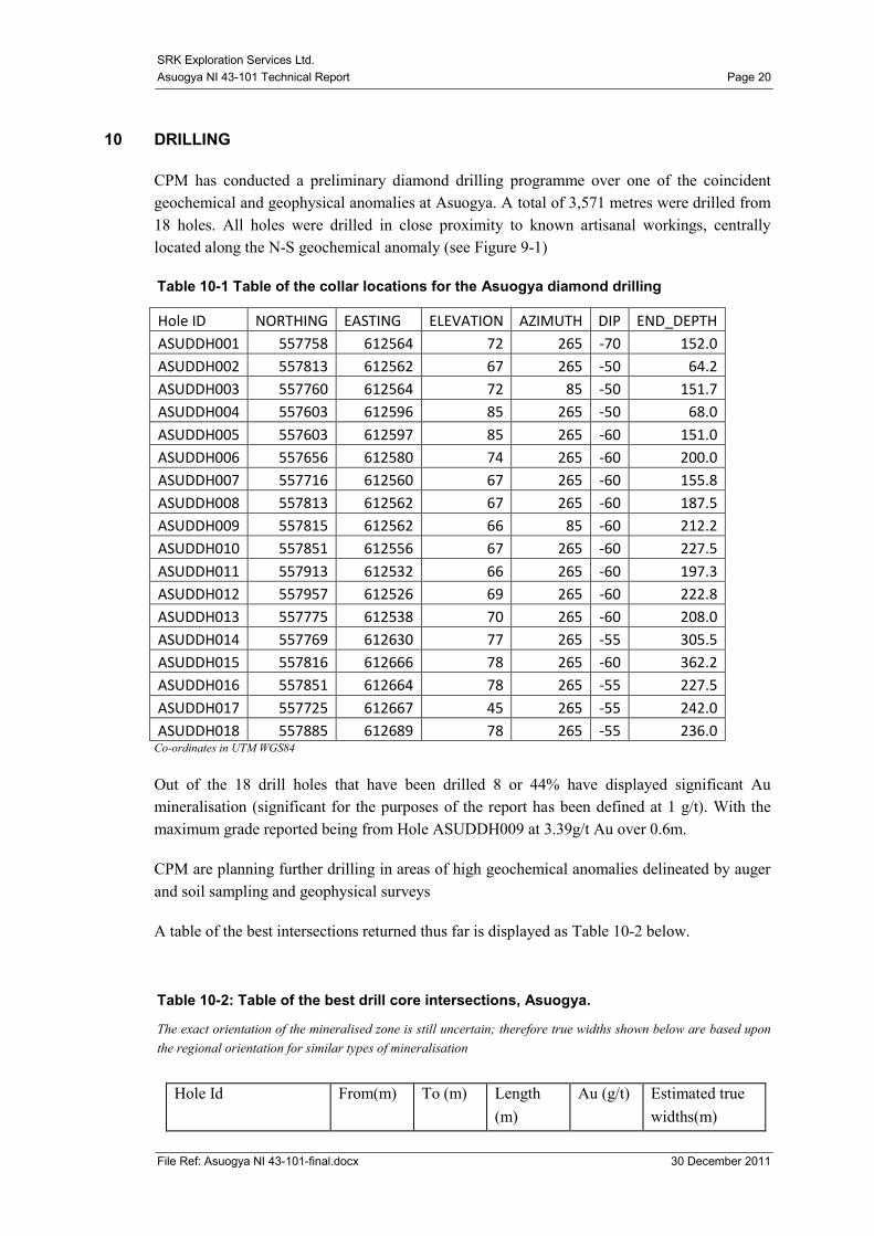
10 DRILLING
CPM has conducted a preliminary diamond drilling programme over one of the coincident
geochemical and geophysical anomalies at Asuogya. A total of 3,571 metres were drilled from
18 holes. All holes were drilled in close proximity to known artisanal workings, centrally
located along the N-S geochemical anomaly (see Figure 9-1)
Table 10-1 Table of the collar locations for the Asuogya diamond drilling
Hole ID NORTHING EASTING ELEVATION AZIMUTH DIP END_DEPTH
ASUDDH001 557758 612564 72 265 -70 152.0
ASUDDH002 557813 612562 67 265 -50 64.2
ASUDDH003 557760 612564 72 85 -50 151.7
ASUDDH004 557603 612596 85 265 -50 68.0
ASUDDH005 557603 612597 85 265 -60 151.0
ASUDDH006 557656 612580 74 265 -60 200.0
ASUDDH007 557716 612560 67 265 -60 155.8
ASUDDH008 557813 612562 67 265 -60 187.5
ASUDDH009 557815 612562 66 85 -60 212.2
ASUDDH010 557851 612556 67 265 -60 227.5
ASUDDH011 557913 612532 66 265 -60 197.3
ASUDDH012 557957 612526 69 265 -60 222.8
ASUDDH013 557775 612538 70 265 -60 208.0
ASUDDH014 557769 612630 77 265 -55 305.5
ASUDDH015 557816 612666 78 265 -60 362.2
ASUDDH016 557851 612664 78 265 -55 227.5
ASUDDH017 557725 612667 45 265 -55 242.0
ASUDDH018 557885 612689 78 265 -55 236.0 Co-ordinates in UTM WGS84
Out of the 18 drill holes that have been drilled 8 or 44% have displayed significant Au
mineralisation (significant for the purposes of the report has been defined at 1 g/t). With the
maximum grade reported being from Hole ASUDDH009 at 3.39g/t Au over 0.6m.
CPM are planning further drilling in areas of high geochemical anomalies delineated by auger
and soil sampling and geophysical surveys
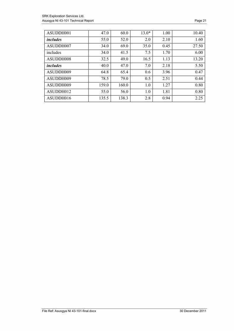
A table of the best intersections returned thus far is displayed as Table 10-2 below.
Table 10-2: Table of the best drill core intersections, Asuogya.
The exact orientation of the mineralised zone is still uncertain; therefore true widths shown below are based upon
the regional orientation for similar types of mineralisation
Hole Id From(m) To (m) Length
(m)
Au (g/t) Estimated true
widths(m)
SRK Exploration Services Ltd.
Asuogya NI 43-101 Technical Report Page 21
File Ref: Asuogya NI 43-101-final.docx 30 December 2011
ASUDDH001 47.0 60.0 13.0* 1.00 10.40
includes 55.0 52.0 2.0 2.10 1.60
ASUDDH007 34.0 69.0 35.0 0.45 27.50
includes 34.0 41.5 7.5 1.70 6.00
ASUDDH008 32.5 49.0 16.5 1.13 13.20
includes 40.0 47.0 7.0 2.18 5.50
ASUDDH009 64.8 65.4 0.6 3.96 0.47
ASUDDH009 78.5 79.0 0.5 2.51 0.44
ASUDDH009 159.0 160.0 1.0 1.27 0.80
ASUDDH012 55.0 56.0 1.0 1.81 0.80
ASUDDH016 135.5 138.3 2.8 0.94 2.25
SRK Exploration Services Ltd.
Asuogya NI 43-101 Technical Report Page 22
File Ref: Asuogya NI 43-101-final.docx 30 December 2011
11 SAMPLE PREPARATION, ANALYSIS AND SECURITY
11.1 Sample Preparation and Analyses – Streams and Soils
The treatment of gold exploration samples with alkaline cyanide solutions can be successfully
applied to soil and stream sediment samples. The cyanide solutions are very dilute and as a
result it is economically feasible to leach large samples (up to 2.5kg) in contrast to fire assay.
The ability to leach large samples using the Bulk Liquid Extractable Gold (BLEG) technique
helps counteract the problem of sample heterogeneity. This method is a very cost effective
grassroots exploration tool to detect low grade gold dispersions as low as 0.1 ppb.
Sample preparation and BLEG analysis (on 1.0 kg samples with a fraction of -75μm) were
performed by the Transworld Laboratory in Ghana (now Intertek). The procedure was as
follows:
- Sample received and sorted
- Controlled oven drying at 120º
- Entire sample jaw crushed and sieved to 6mm
- Entire sample pulverised to 0.75mm (-200#)
- Homogenised by mat rolling and weighed 1kg placed into BLEG roll bottle, residual
pulp retained
- 30g Ca(OH), 1.5/1g NaCN and 1000ml water added and rolled for 24 hours
- Removed from roller and allowed to settle for 2 hours
- 50ml of clear sub sample liquor filtered into flask and tails discarded
- 3ml or 5ml of DIBK extracted
- Au determine by AAS
There was no systematic quality assurance or quality control (QA/QC) programme for the soil,
stream sediment, and rock chip sample programmes. This was largely the result of cost saving
measures to limit the number of assay samples required for analysis. It could be argued that the
sample size required for the BLEG method is adequately representative, even after accounting
for the approximately 90% recovery that is typical of this method. SRK ES do not consider the
lack of a QA/QC protocol for this stage to be material as this data has been treated as
qualitative only and would not form part of any Mineral Resource Estimate.
Quality control measures at Transworld Laboratory, where the BLEG analyses were carried
out, include a number of direct and indirect procedures. Direct procedures include internal and
external standards, internal duplicates and repeats, reagent and sample blanks, refilters, check
assays and sieving tests on pulverised material. However, it should be noted that these quality
control measures are created to assess the analytical equipment analysing the samples only. It
does not account for the systematic irregularities in the sample preparation stage of the
assaying process
SRK Exploration Services Ltd.
Asuogya NI 43-101 Technical Report Page 23
File Ref: Asuogya NI 43-101-final.docx 30 December 2011
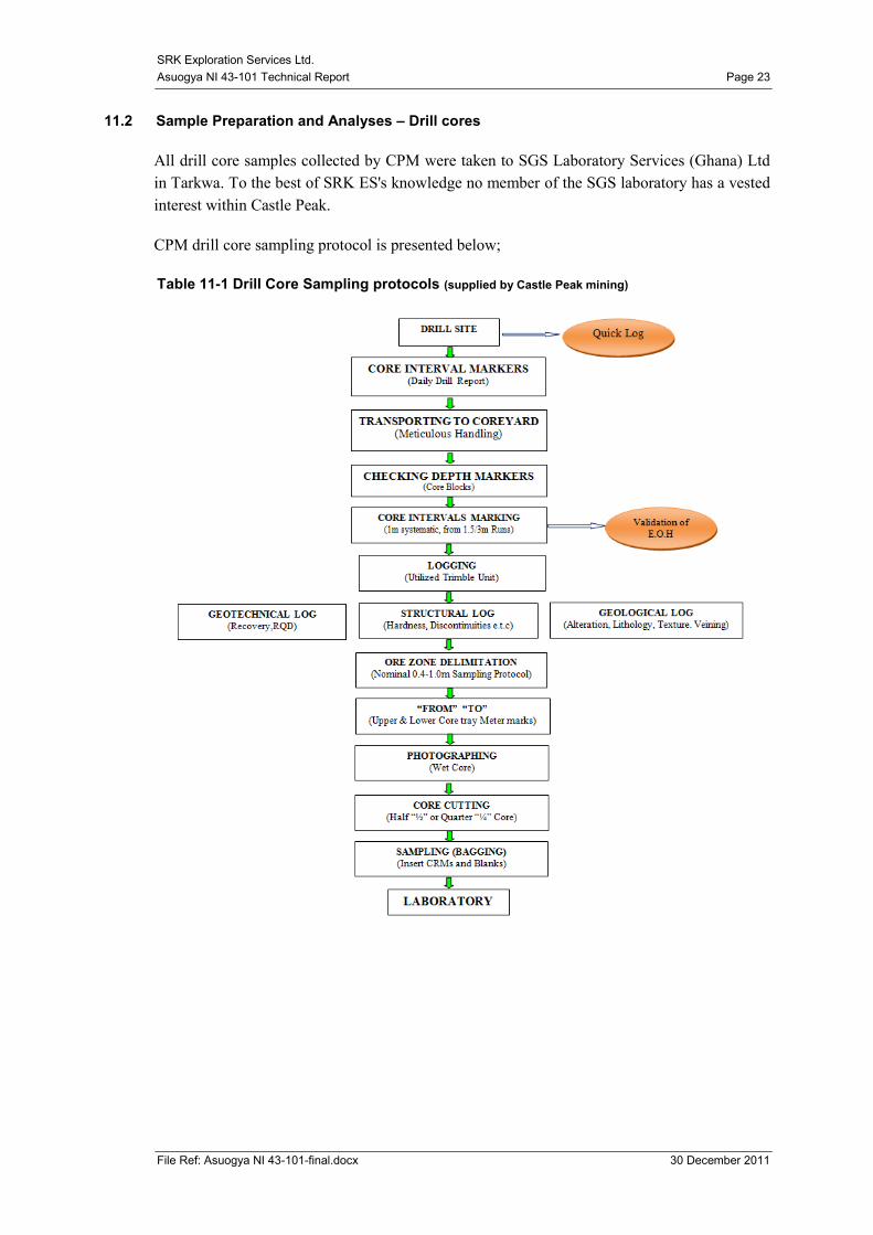
11.2 Sample Preparation and Analyses – Drill cores
All drill core samples collected by CPM were taken to SGS Laboratory Services (Ghana) Ltd
in Tarkwa. To the best of SRK ES's knowledge no member of the SGS laboratory has a vested
interest within Castle Peak.
CPM drill core sampling protocol is presented below;
Table 11-1 Drill Core Sampling protocols (supplied by Castle Peak mining)
SRK Exploration Services Ltd.
Asuogya NI 43-101 Technical Report Page 24
File Ref: Asuogya NI 43-101-final.docx 30 December 2011
11.3 Security
Drill core samples were prepared and sealed by a CPM geologist, samples were then kept on
site at the core shed which has gates and a perimeter wall. The samples are then transported by
CPM to SGS Laboratories in Tarkwa by truck. Once checked into the laboratory they are
listed, numbered and CPM retains a carbon copy of the receipt.
11.4 Sample Analysis
CPM used the SGS Mineral Laboratory Tarkwa for the analysis of the drill core samples. Their
chosen method is a 50g fire assay with AA finish (Au -FAA505), lower detection limit of 0.01
ppm and upper limit of 1000 ppm as outlined below;
Fire Assay:
Sample post pulverisation is weighed and mixed with a fluxing agent.
Lead is added as a collector of the precious metal and the sample is heated to ~1000°C
As the Pb settles in the melt it scavenges the precious metals from the melt to form a
lead 'button'
The button is separated from the slag, and precious metals are extracted through
cupellation . During cupellation the lead oxidises and dissolves into the cupel to leave
a precious metal bead (prill).
The prill composition is then determined by dissolving it in aqua regia and selecting a
finishing technique.
AA Finish:
Once the gold is in solution it is analysed with flame atomic absorption (AA).
The solution is aspirated in an acetylene flame
A beam of light with a wavelength matching that of gold is passed through the flame.
The gold in the sample absorbs the light proportionately depending on the
concentration of the element in solution.
The absorption is compare to standard samples to determine gold concentration in
samples.
11.5 Quality Control Measures
CPM insert a series of Certified Reference Materials (“CRM”), ST 528, ST 16-5357and ST
403 as well as blank material (locally obtained voltaian rocks). No field duplicates are inserted.
Due to the accreditation attached to both the laboratories used the authors are confident the
sample results are relatively reliable. This is further enforced by the inspection of the SGS
laboratory in Tarkwa by SRK ES whilst on the site visit in Ghana.
A total of 182 blanks were submitted, and 84 delivered results greater than 0.00g/t Au,
approximately 46%. However the levels of Au that are present are very low with only one
above 0.09ppm. The traces of gold within the samples may relate to minor contamination of
the laboratory equipment from previous sample or low levels of gold within the material used
SRK Exploration Services Ltd.
Asuogya NI 43-101 Technical Report Page 25
File Ref: Asuogya NI 43-101-final.docx 30 December 2011
as blanks. A preliminary review of the data suggests that slightly elevated values are observed
following higher grade field samples. This would suggest that laboratory contamination could
be the source of this variance. However at this stage, SRK ES does not consider this to have a
significant impact on the project thus far.
Of the 90 samples of Standard ST403 submitted to the SGS laboratories, Tarkwa, 32 samples
or 35.5% came back outside of the acceptable 2 standard deviations from the mean values. Of
the 40 samples of Standard ST528, 10 samples or 25% came back out of the acceptable range
of two standard deviations of the mean. Of the 51 samples of Standard ST16-5357, 10 samples
or 19.6% came back out of the acceptable range of two standard deviations of the mean.
Overall this is a poor performance for the CRM‟s however as there is no obvious bias in any
particular direction this may be due to the nature of the CRM rather than inherent problems in
the laboratory. Again due to the early stage of the project and the fact that these data are not
being used in a quantitative manner SRK ES does not consider this to be a material issue at
this stage. SRK ES would however strongly recommend that a detailed study of the CRMs is
conducted, with particular reference to the matrix material and that more robust protocols are
maintained as the project goes forward.
12 DATA VERIFICATION
SRK ES collected samples during the November site visit in order to conduct independent
verification of the drill results presented by CPM. A total of 10 samples were selected by SRK
ES. Two of the samples were quarter core samples and the remaining 8 were selected from
coarse rejects. The quarter core was cut from stored half core with a rock saw and re-sampled
by SRK ES.
The coarse rejects were located either at the CPM core shed or at SGS laboratories, split and
re labelled by SRK ES. The samples were then delivered by hand to Intertek Minerals
Services laboratory in Tarkwa where they were analysed for gold by a 50g fire assay with AA
finish. Results are presented in Table 12-1 below.
SRK Exploration Services Ltd.
Asuogya NI 43-101 Technical Report Page 26
File Ref: Asuogya NI 43-101-final.docx 30 December 2011
Table 12-1: SRK ES verification sample results.
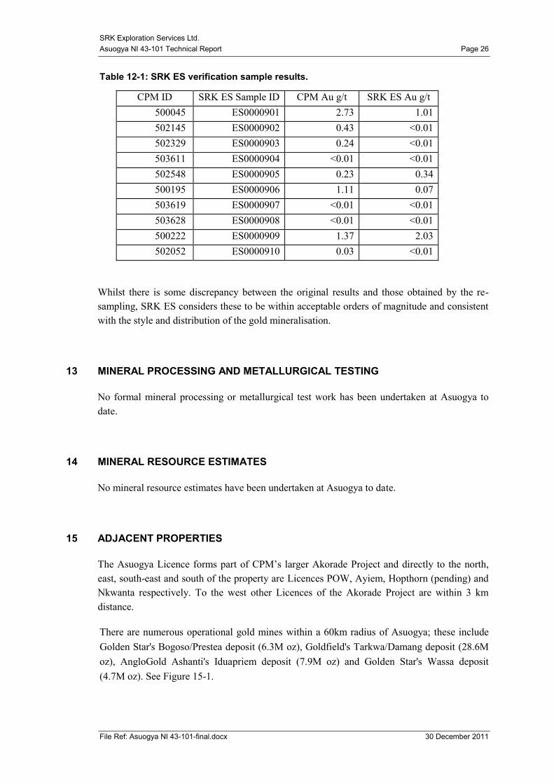
CPM ID SRK ES Sample ID CPM Au g/t SRK ES Au g/t
500045 ES0000901 2.73 1.01
502145 ES0000902 0.43 <0.01
502329 ES0000903 0.24 <0.01
503611 ES0000904 <0.01 <0.01
502548 ES0000905 0.23 0.34
500195 ES0000906 1.11 0.07
503619 ES0000907 <0.01 <0.01
503628 ES0000908 <0.01 <0.01
500222 ES0000909 1.37 2.03
502052 ES0000910 0.03 <0.01
Whilst there is some discrepancy between the original results and those obtained by the re-
sampling, SRK ES considers these to be within acceptable orders of magnitude and consistent
with the style and distribution of the gold mineralisation.
13 MINERAL PROCESSING AND METALLURGICAL TESTING
No formal mineral processing or metallurgical test work has been undertaken at Asuogya to
date.
14 MINERAL RESOURCE ESTIMATES
No mineral resource estimates have been undertaken at Asuogya to date.
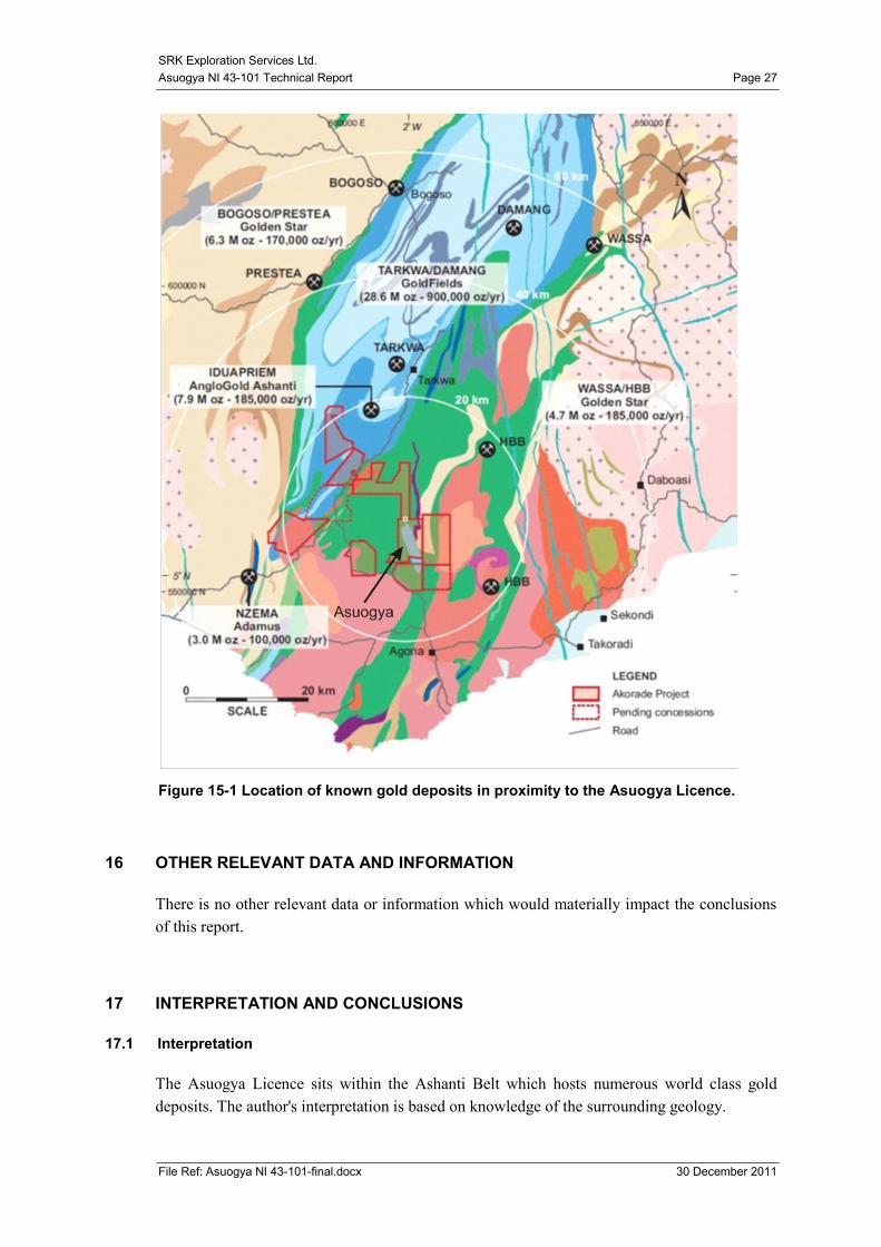
15 ADJACENT PROPERTIES
The Asuogya Licence forms part of CPM‟s larger Akorade Project and directly to the north,
east, south-east and south of the property are Licences POW, Ayiem, Hopthorn (pending) and
Nkwanta respectively. To the west other Licences of the Akorade Project are within 3 km
distance.
There are numerous operational gold mines within a 60km radius of Asuogya; these include
Golden Star's Bogoso/Prestea deposit (6.3M oz), Goldfield's Tarkwa/Damang deposit (28.6M
oz), AngloGold Ashanti's Iduapriem deposit (7.9M oz) and Golden Star's Wassa deposit
(4.7M oz). See Figure 15-1.
SRK Exploration Services Ltd.
Asuogya NI 43-101 Technical Report Page 27
File Ref: Asuogya NI 43-101-final.docx 30 December 2011
Figure 15-1 Location of known gold deposits in proximity to the Asuogya Licence.
16 OTHER RELEVANT DATA AND INFORMATION
There is no other relevant data or information which would materially impact the conclusions
of this report.
17 INTERPRETATION AND CONCLUSIONS
17.1 Interpretation
The Asuogya Licence sits within the Ashanti Belt which hosts numerous world class gold
deposits. The author's interpretation is based on knowledge of the surrounding geology.
SRK Exploration Services Ltd.
Asuogya NI 43-101 Technical Report Page 28
File Ref: Asuogya NI 43-101-final.docx 30 December 2011
Stream sediment, soil and auger geochemistry has delineated a 7km long zone of anomalous
gold values, coincident with the projected contact of Birimian metasediments and
metavolcanics.
Artisanal workers are exploiting the same zone at several locations and appear to be recovering
gold from quartz veins associated with carbonaceous shears.
Geophysical data suggests a linear zone of bedrock conductivity in keeping with the typical
mineralisation styles in the district.
Diamond drilling conducted to date has targeted one section of the anomalous trend where
local miners are active. This drilling has intersected mineralisation but does not appear to have
intersected a major mineralised zone.
17.2 Conclusions
SRK ES consider the work conducted at Asuogya has been conducted in accordance with
industry norms and that the results returned to date support the geological model proposed.
The resolution of the exploration work conducted to date has been sufficient to outline a broad
zone of anomalous gold content which when combined with other geological data provides an
exciting exploration target. Future work should focus on obtaining higher resolution geological
data within the target zone prior to testing with diamond drilling. The Asuogya Licence
continues to be prospective for gold mineralisation and is worthy of continued exploration.
The mineralised intersections observed in the diamond drill cores occur within sheared zones
of pelitic/graphitic metasediments on a contact with metavolcanics within quartz veins. This is
indicative of the region and is likely to be related to N-S trending steeply dipping en-echelon
vein systems. SRK ES consider that the drilling has located mineralised structures but has yet
to locate a mineralised zone of sufficient size to be economic.
18 RECOMMENDATIONS
The delineation of this style of mineralisation is notoriously difficult, and extensive drilling is
normally required to delineate mineralised zones of a size that could prove economic. The
Asuogya Licence is one of a number of licences that CPM has in its portfolio and must be
prioritised accordingly.
The mineralised zones encountered in this part of Ghana are often narrow and structural
discontinuous and thus often difficult to trace with any accuracy, particularly when covered by
deeply weathered tropical soils. Diamond drilling, provides the best geological data but is
expensive and needs to be accurately located for the best results.
The main target zone has been delineated by the previous work but locating the main
mineralised structures within the target zone has proved elusive, as the recent drilling has
shown.
SRK Exploration Services Ltd.
Asuogya NI 43-101 Technical Report Page 29
File Ref: Asuogya NI 43-101-final.docx 30 December 2011
SRK ES would recommend that a detailed structural study is conducted on the core that has
been recovered to date, to try and establish the main controls on the mineralisation. As the core
is not orientated 3D modelling may prove difficult however applying regional trends to the
data may be still be useful.
In order to get better resolution over the target areas SRK ES recommends that detailed ground
geophysics is conducted. Ground magnetics on 50-100 metre line spacing should provide
sufficient resolution to assist with a more detailed structural interpretation. Trenching
conducted over the target zones may also assist in locating the mineralised zones and provide
more robust targets for diamond drilling.
Further drilling will be required at Asuogya but this should only be conducted after all
reasonable efforts have been made to assure its success.
For and on Behalf of SRK Exploration Services Ltd.
A.G O’Donovan, MSc, CEng, FIMM, FGS
Corporate Exploration Consultant and Managing Director
SRK Exploration Services Ltd.
Asuogya NI 43-101 Technical Report Page 30
File Ref: Asuogya NI 43-101-final.docx 30 December 2011
19 REFERENCES
Ayensu. E.S., (1997) Ashanti gold: the African legacy of the world's most precious metal.
Illustrated, Marshall editions
Hilson. G., (2002) Harvesting mineral riches: 1000 years of gold mining in Ghana., Resources
policy, 28 (1-2) pp. 13-26.
Harcouet. V et al. (2004) Pre-mineralization thermal evolution of the Palaeoproterozoic gold-
rich Ashanti belt, Ghana. Geological Society, Special Publications, 248,103-118 p
Hilson. G., (2001) A contextual Review of the Ghanaian Small-scale Mining Industry.,
Mining, Minerals and Sustainable Development, 76 (September)
Junner, N.R (1940: Geology of the Gold Coast and western Togoland, with revised Geological
Map (1:1,000,000).-Bull.Geol.Surv.Gold Coast11,9-19;Accra
Klein, E.L., and Moura, C. A. (2008) São Luís Craton and Gurupi Belt (Brazil): possible
links with the West African Craton and surrounding Pan-African belts. Geological Society
London, Special Publications 298, 137-151
Leube, A., Hirdes, W., Mauer, R.& Kesse, G.O (1900):The Early Proterozoic Birimian
Supergroup of Ghana and Some Aspects of its associated Gold Mineralization- Precambrian
Research 46, 139 - 165; Amsterdam.
Oberthür, T, Weiser.T , Amanor, J.A., and Chryssoulis S. L., (1997): Mineralogical sitting and
distribution of gold in quartz veins and sulphide ores of the Ashanti mine and other deposits in
the Ashanti belt of Ghana: genetic implications. Mineralum Deposita, 32,1, 2-15pp
Poulsen, K.H., Robert, F., and Dubé, B., 2000, Geological Classification of Canadian Gold
Deposits: Geological Survey of Canada, Bulletin 540,106 p
SRK Exploration Services Ltd.
Asuogya NI 43-101 Appendices Page 31
File Ref: Asuogya NI 43-101-final.docx 30 December 2011
Appendix I
Author Certificate and consent
SRK Exploration Services Ltd.
Asuogya NI 43-101 Appendices Page 32
File Ref: Asuogya NI 43-101-final.docx 30 December 2011
CERTIFICATE Of Qualified person
To Accompany the report entitled: NI 43-101 Technical Report on the Asuogya Licence,
Ghana. dated December 30th 2011.
1 I, Anthony Gareth O‟Donovan residing at The Old Vicarage, Vicarage Terrace, Maesteg CF34
9PF, UK, do hereby certify that: I am a Corporate Exploration Consultant with the firm of
SRK Exploration Services Ltd (“SRK ES”) with an office at 12 St. Andrews Crescent, Cardiff,
CF10 3DD, UK;
2 I am a graduate of the University of Keele, UK in 1983 and Rhodes University, South Africa
in 1992, I obtained bachelors and Masters degrees respectively. I have practiced my profession
continuously since 1986, as a mine geologist, exploration geologist and 12 years as a
consultant with the SRK Group;
3 I am a Professional Exploration Consultant registered with the Engineering Council and the
FIMMM 533068;
4 I have personally inspected the Asuogya Licence during November 2011;
5 I have read the definition of “qualified person” set out in National Instrument 43-101 and
certify that by virtue of my education, affiliation to a professional association and past relevant
work experience, I fulfill the requirements to be a “qualified person” for the purposes of
National Instrument 43-101.
6 I, as a qualified person, am independent of the issuer as defined in Section 1.5 of National
Instrument 43-101;
7 I am the author of this report and accept professional responsibility for this technical report.
8 Prior to my appointment as independent QP to the Asuogya project in September 2011, I
visited the property in 2008.
9 I have read National Instrument 43-101 and confirm that this technical report has been
prepared in compliance therewith;
10 I have not received, nor do I expect to receive, any interest, directly or indirectly, in the
Asuogya Licence or securities of Casle Peak Mining; and
11 That, as of the date of this certificate, to the best of my knowledge, information and belief, this
technical report contains all scientific and technical information that is required to be disclosed
to make the technical report not misleading.
[“signed and sealed”]
A.G O’Donovan, MSc, CEng, FIMM, FGS
Corporate Exploration Consultant and Managing Director
SRK Exploration Services Ltd.
SRK Exploration Services Ltd.
Asuogya NI 43-101 Appendices Page 33
File Ref: Asuogya NI 43-101-final.docx 30 December 2011
Project number: ES 7431
CONSENT of AUTHOR
I, Anthony Gareth O‟Donovan, do hereby consent to the public filing of the technical report
entitled “Ni 43-101 Technical Report on the Asuogya Licence, Ghana,” (the “Technical
Report”) and dated December 29th 2011, and any extracts from or a summary of the Technical
Report under the National Instrument 43-101 disclosure of Castle Peak Mining Ltd. and to the
filing of the Technical Report with any securities regulatory authorities.
I further consent to the company filing the report on SEDAR and consent to press releases
made by the company with my prior approval.
I also confirm that I have read the Disclosure and that it fairly and accurately represents the
information in the Technical Report that supports the Disclosure.
Dated this 30th day of December 2011.
[“signed and sealed”]
A.G O’Donovan, MSc, CEng, FIMM, FGS
Corporate Exploration Consultant and Managing Director
SRK Exploration Services Ltd.
SRK Exploration Services Ltd.
Asuogya NI 43-101 Appendices Page 34
File Ref: Asuogya NI 43-101-final.docx 30 December 2011
Appendix II
Airborne Geophysics for the Akorade project
SRK Exploration Services Ltd.
Asuogya NI 43-101 Appendices Page 35
File Ref: Asuogya NI 43-101-final.docx 30 December 2011
SRK Exploration Services Ltd.
Asuogya NI 43-101 Appendices Page 36
File Ref: Asuogya NI 43-101-final.docx 30 December 2011
SRK Exploration Services Ltd.
Asuogya NI 43-101 Appendices Page 37
File Ref: Asuogya NI 43-101-final.docx 30 December 2011