nic maps - census of india website : office of the...
TRANSCRIPT

Dr.(Mrs.) Vandana Sharma Deputy Director General
National Informatics Centre [email protected]
NIC MAPS

Spatial Data Repository of NIC
• National GIS
• Rich seamless nation-wide spatial data repository created with
support of Planning Commission.
• Integrating datasets from different organization through
standardization.
• Administrative database up to village/ habitations level.
• Transportation network, Natural Resources eg. Water bodies,
soil, forest cover etc.
• Satellite imageries of IRS - LISS III and PAN, Digital Globe etc
• Utility Mapping Services:
• Utility mapping infrastructure for Delhi, Ahmedabad,
Bangalore, Chennai, Hyderabad, Kolkata and Mumbai.

NIC GIS implementation strategy
SOI • Base frame work
data
• Surveying
DOS • Satellite Images
• Wasteland Mapping
Others
• FSI- Forest Cover
• SLUSI- Soil
• CGWB-Ground Water
Non- Spatial Data
• RGI- Census 2001
• Educational Survey
• Health Survey
• NREGA
• Rural Roads
National GIS
• Facilitator • Integrator • Standardization • Dissemination-
Enterprise
NIC Internet
Cloud
External GIS
Services

Sl.No Layers Source organization 1 Administrative Boundaries SOI
2 Village Boundaries SOI
3 Major Towns/Cities SOI/NIC
4 Settlements SOI/NIC
5 Roads SOI/NIC
6 Railway/ Railway Stations SOI/NIC
7 Forest Cover FSI/NIC
8 Soil NBSS&LUP/NNRMS
9 Watershed AISLUS/CGWB/NRSA
10 Land Use/Land Cover(NRSA) NRSA/CGWB/NIC
11 Wasteland NRSA/NIC
12 Wetland NRSA/NIC
13 Waterbodies SOI/NIC
14 Drainage(SOI) SOI
15 Groundwater CGWB
16 Agriculture DOS/NRSA/NIC
17 Geology GSI/CGWB/NIC
18 Hydro Geomorphology/Geology GSI/CGWB/NRSA/NIC
19 Misc point data sets with attributes Hq, PO,PS, Airports etc. SOI/NIC/NNRMS
20
Satellite image- Multispectral data Georeferenced mosaic
across the country from AWIFS (56m),LISS III(23m), for
extraction of Natural Resources features. NRSA/NIC
21
IRS Satellite 5.8 m Pancromatic image mosaic of entire
country NRSA/NIC
22 Quik Bird high resolution satellite image for 580 district Hq. SOI
23 Contours, Elevation, Height, Slope/Aspect etc. SOI
SPATIAL DATA LAYERS ( 1:50K Scale )

GIS Solution needs to consider Service Oriented
Architecture to integrate the following
• Data Services – Maps, Satellite images, Topography,
Thematic etc.
• Processing Services – Network Analysis, Geo-coding,
Measurements and Modeling etc.
• Sector specific data through use of GPS and mobile
devices.
• Attribute datasets.
• Service level agreements and regulations

NIC – GIS Application Services
National GIS Implementation
Mapping of
Demography
and Amenities
National GIS
web Portal
Rural Post
office mapping
Atlas
Benchmark GIS Applications
Value Add MIS
Integration of Raster and Vector Services
Mash up / collaborative Setup
Total
Sanitation
Campaign
Agmarknet
CGWB
NHWIS
Election GIS
NSDB
Delhi Sports
Election GIS
NRCP
GEPR
Telecom GIS
Telecom
Appl.
MHA- GIS
Spatial Data
Update
Spatial Data Development
Vector Data
processing
Image
Processing
Maps
Data
Conversion
……..

NIC – GIS Application Services

NIC GIS Portal
NICMAPS is a GIS web service comprising of seamless Country wide base maps,
satellite images and hybrid Maps aligned as per the global geo-spatial standards. –
http://nicmaps.gis.nic.in

Robust and scalable framework based on service
oriented architecture (SOA). Incorporated OGC standards based spatial data
repository .
Tiled maps at 12 different scales starting from 1:40
M to 1: 18 k
Seamless mosaics of IRS satellite images of varying
resolutions like AWiFS (56 m), LISS-III (23.5 m) and
PAN ( 5.80 m)
NIC GIS Portal- Salient Features

Mash up with external global services like Bing
Maps, Google Maps and ESRI using open API’s.
Cross platform rich internet application (RIA)
based on Flex open API
Basic GIS tools for navigation, query , buffer , print
and distance measurement.
Advanced geo processing models for elevation
profile, swipe and spotlight.
Linkage to attribute data like census etc.
NIC GIS Portal- Salient Features

Layers
National/ State/ District Village HQs & Boundaries Census Town Habitations Settlements and Its footprints Roads Railway lines and stations Airports Surface water features Historical Places National Parks Forests
Map Scales
1: 40 M 1: 20 M 1: 10 M 1: 5 M 1: 2.5 M 1: 1 M 1: 500 K 1: 250 K 1: 150 K 1: 72 K 1: 36 K 1: 18 K

NIC GIS Portal - Comparison
NICMAPS-
NIC GIS Portal
BING - NIC
GIS Portal
Google Maps –
NIC GIS Portal
BHUVAN –
IRS Sat. Images


1:10 Million

1:5 Million

1:2.5 Million

1:1 Million

1:2.5 Million
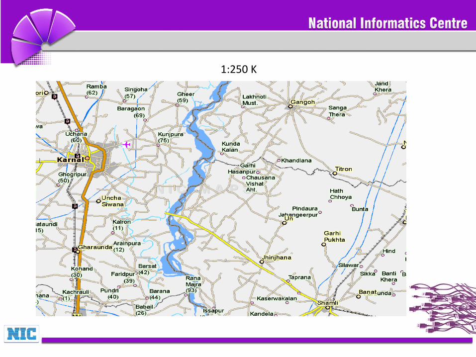
1:250 K
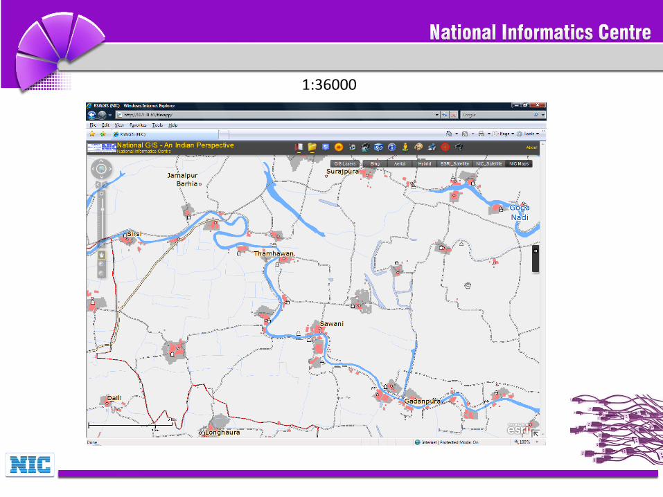
1:36000

1:72K
NIC GIS Portal

Thank You