nisqually transmission line relocation project · transmission lines. the transmission lines move...
TRANSCRIPT
Nisqually Transmission Line Relocation Project
Preliminary Environmental Assessment
Bonneville Power Administration
Fort Lewis Military Reservation
Nisqually Indian Tribe
Bureau of Indian Affairs
October 2004
Nisqually Transmission Line Relocation Project
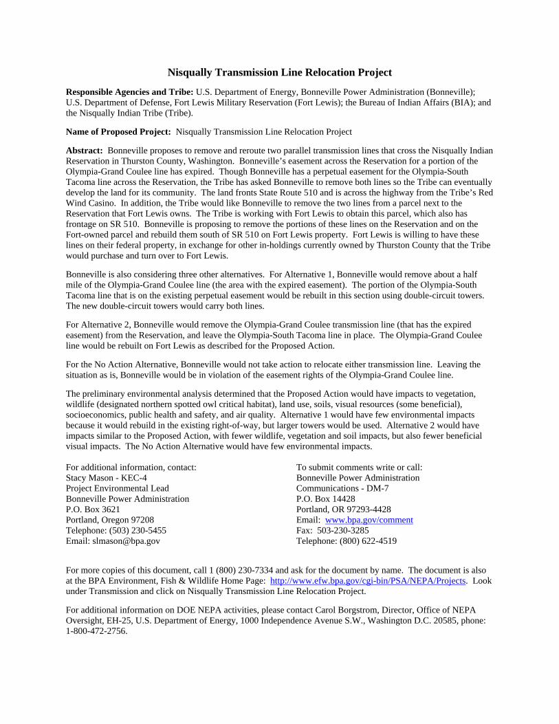
Responsible Agencies and Tribe: U.S. Department of Energy, Bonneville Power Administration (Bonneville); U.S. Department of Defense, Fort Lewis Military Reservation (Fort Lewis); the Bureau of Indian Affairs (BIA); and the Nisqually Indian Tribe (Tribe).
Name of Proposed Project: Nisqually Transmission Line Relocation Project
Abstract: Bonneville proposes to remove and reroute two parallel transmission lines that cross the Nisqually Indian Reservation in Thurston County, Washington. Bonneville’s easement across the Reservation for a portion of the Olympia-Grand Coulee line has expired. Though Bonneville has a perpetual easement for the Olympia-South Tacoma line across the Reservation, the Tribe has asked Bonneville to remove both lines so the Tribe can eventually develop the land for its community. The land fronts State Route 510 and is across the highway from the Tribe’s Red Wind Casino. In addition, the Tribe would like Bonneville to remove the two lines from a parcel next to the Reservation that Fort Lewis owns. The Tribe is working with Fort Lewis to obtain this parcel, which also has frontage on SR 510. Bonneville is proposing to remove the portions of these lines on the Reservation and on the Fort-owned parcel and rebuild them south of SR 510 on Fort Lewis property. Fort Lewis is willing to have these lines on their federal property, in exchange for other in-holdings currently owned by Thurston County that the Tribe would purchase and turn over to Fort Lewis.
Bonneville is also considering three other alternatives. For Alternative 1, Bonneville would remove about a half mile of the Olympia-Grand Coulee line (the area with the expired easement). The portion of the Olympia-South Tacoma line that is on the existing perpetual easement would be rebuilt in this section using double-circuit towers. The new double-circuit towers would carry both lines.
For Alternative 2, Bonneville would remove the Olympia-Grand Coulee transmission line (that has the expired easement) from the Reservation, and leave the Olympia-South Tacoma line in place. The Olympia-Grand Coulee line would be rebuilt on Fort Lewis as described for the Proposed Action.
For the No Action Alternative, Bonneville would not take action to relocate either transmission line. Leaving the situation as is, Bonneville would be in violation of the easement rights of the Olympia-Grand Coulee line.
The preliminary environmental analysis determined that the Proposed Action would have impacts to vegetation, wildlife (designated northern spotted owl critical habitat), land use, soils, visual resources (some beneficial), socioeconomics, public health and safety, and air quality. Alternative 1 would have few environmental impacts because it would rebuild in the existing right-of-way, but larger towers would be used. Alternative 2 would have impacts similar to the Proposed Action, with fewer wildlife, vegetation and soil impacts, but also fewer beneficial visual impacts. The No Action Alternative would have few environmental impacts. For additional information, contact: Stacy Mason - KEC-4 Project Environmental Lead Bonneville Power Administration P.O. Box 3621 Portland, Oregon 97208 Telephone: (503) 230-5455 Email: [email protected]
To submit comments write or call: Bonneville Power Administration Communications - DM-7 P.O. Box 14428 Portland, OR 97293-4428 Email: www.bpa.gov/commentFax: 503-230-3285 Telephone: (800) 622-4519
For more copies of this document, call 1 (800) 230-7334 and ask for the document by name. The document is also at the BPA Environment, Fish & Wildlife Home Page: http://www.efw.bpa.gov/cgi-bin/PSA/NEPA/Projects. Look under Transmission and click on Nisqually Transmission Line Relocation Project.
For additional information on DOE NEPA activities, please contact Carol Borgstrom, Director, Office of NEPA Oversight, EH-25, U.S. Department of Energy, 1000 Independence Avenue S.W., Washington D.C. 20585, phone: 1-800-472-2756.
Table of Contents
CHAPTER I NEED FOR AND PURPOSE OF ACTIONUNDERLYING NEED FOR ACTION................................................................................................1-1 PURPOSES ...............................................................................................................................1-2 COOPERATING AGENCIES..........................................................................................................1-3 PUBLIC INVOLVEMENT ...............................................................................................................1-3
CHAPTER 2 PROPOSED ACTION AND ALTERNATIVESPROPOSED ACTION – RELOCATE TRANSMISSION LINES AND EXCHANGE LAND ............................2-1
Description .......................................................................................................................2-1 Phases .............................................................................................................................2-3 Transmission Towers .......................................................................................................2-3 Conductors and Fiber Optic Cable...................................................................................2-4 Right-of-Way and Tree Clearing ......................................................................................2-4 Access Roads ..................................................................................................................2-5 Staging Sites ....................................................................................................................2-5 Conductor-Pulling Sites....................................................................................................2-6 Line Removal ...................................................................................................................2-6 Costs ................................................................................................................................2-6 Construction .....................................................................................................................2-6 Maintenance.....................................................................................................................2-7 Land Exchange ................................................................................................................2-7
ALTERNATIVE 1 – DOUBLE-CIRCUIT TOWERS ON EXISTING EASEMENT........................................2-8 ALTERNATIVE 2 – RELOCATE THE OLYMPIA-GRAND COULEE LINE ONLY .....................................2-8 NO ACTION ALTERNATIVE..........................................................................................................2-9 ALTERNATIVES CONSIDERED BUT ELIMINATED FROM DETAILED STUDY.......................................2-9
Remove the Olympia-Grand Coulee Line from Service...................................................2-9 Relocate Both Lines on Fort Lewis Across the Rainier Training Area.............................2-9 Relocate the Olympia-Grand Coulee Line around Fort Lewis .......................................2-11 Right-of-way Location ....................................................................................................2-11 Land Exchange Option...................................................................................................2-11
COMPARISON OF ALTERNATIVES ................................................................................. 2-11
CHAPTER 3 AFFECTED ENVIRONMENT, ENVIRONMENTAL IMPACTS AND MITIGATION MEASURES VEGETATION.............................................................................................................................3-1
Affected Environment.......................................................................................................3-1 Environmental Impacts.....................................................................................................3-4 Cumulative Impacts..........................................................................................................3-6 Mitigation Measures .........................................................................................................3-7 Unavoidable Impacts Remaining After Mitigation ............................................................3-7
WILDLIFE..................................................................................................................................3-8 Affected Environment.......................................................................................................3-8 Environmental Impacts...................................................................................................3-11 Cumulative Impacts........................................................................................................3-14 Mitigation Measures .......................................................................................................3-15 Unavoidable Impacts Remaining After Mitigation ..........................................................3-15
Nisqually Transmission Line Relocation Project Table of Contents - i
GEOLOGY AND SOILS ..............................................................................................................3-16 Affected Environment.....................................................................................................3-16 Environmental Impacts...................................................................................................3-16 Cumulative Impacts........................................................................................................3-18 Mitigation Measures .......................................................................................................3-19 Unavoidable Impacts Remaining After Mitigation ..........................................................3-20
WATER RESOURCES AND FISH ................................................................................................3-20 Affected Environment.....................................................................................................3-20 Environmental Impacts...................................................................................................3-21 Cumulative Impacts........................................................................................................3-21 Mitigation Measures .......................................................................................................3-21 Unavoidable Impacts Remaining After Mitigation ..........................................................3-21
LAND USE AND TRANSPORTATION............................................................................................3-22 Affected Environment.....................................................................................................3-22 Environmental Impacts...................................................................................................3-24 Cumulative Impacts........................................................................................................3-27 Mitigation Measures .......................................................................................................3-27 Unavoidable Impacts Remaining After Mitigation ..........................................................3-27
VISUAL QUALITY .....................................................................................................................3-28 Affected Environment.....................................................................................................3-28 Environmental Impacts...................................................................................................3-30 Cumulative Impacts........................................................................................................3-34 Mitigation Measures .......................................................................................................3-35 Unavoidable Impacts Remaining After Mitigation ..........................................................3-35
CULTURAL RESOURCES ..........................................................................................................3-35 Affected Environment.....................................................................................................3-35 Environmental Impacts...................................................................................................3-36 Cumulative Impacts........................................................................................................3-36 Mitigation Measures .......................................................................................................3-36 Unavoidable Impacts Remaining After Mitigation ..........................................................3-37
SOCIOECONOMICS ..................................................................................................................3-37 Affected Environment.....................................................................................................3-37 Environmental Impacts...................................................................................................3-40 Cumulative Impacts........................................................................................................3-43 Mitigation Measures .......................................................................................................3-43 Unavoidable Impacts Remaining After Mitigation ..........................................................3-43
NOISE ....................................................................................................................................3-43 Affected Environment.....................................................................................................3-43 Environmental Impacts...................................................................................................3-44 Cumulative Impacts........................................................................................................3-46 Mitigation Measures .......................................................................................................3-46 Unavoidable Impacts Remaining after Mitigation ..........................................................3-47
PUBLIC HEALTH AND SAFETY...................................................................................................3-47 Affected Environment.....................................................................................................3-47 Environmental Impacts...................................................................................................3-48 Cumulative Impacts........................................................................................................3-52 Mitigation Measures .......................................................................................................3-52 Unavoidable Impacts Remaining after Mitigation ..........................................................3-53
AIR QUALITY...........................................................................................................................3-55 Affected Environment.....................................................................................................3-55 Environmental Impacts...................................................................................................3-55 Cumulative Impacts........................................................................................................3-58 Mitigation Measures .......................................................................................................3-58 Unavoidable Impacts Remaining After Mitigation ..........................................................3-58
Nisqually Transmission Line Relocation Project Table of Contents - ii
CHAPTER 4 CONSULTATION, REVIEW, AND PERMIT REQUIREMENTS NATIONAL ENVIRONMENTAL POLICY ACT....................................................................................4-1 VEGETATION AND WILDLIFE .......................................................................................................4-1 WATER RESOURCES .................................................................................................................4-2 CULTURAL RESOURCES ............................................................................................................4-3 LAND USE ................................................................................................................................4-3 ENVIRONMENTAL JUSTICE .........................................................................................................4-4 NOISE ......................................................................................................................................4-4 HEALTH & SAFETY LAWS...........................................................................................................4-4 AIR QUALITY.............................................................................................................................4-5
CHAPTER 5 REFERENCES
Appendix A Public Involvement Appendix B Resource Impact Ratings Appendix C Wildlife Species Found in Thurston County Appendix D Cultural Resources
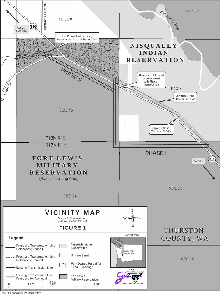
List of Figures Figure 1 Vicinity Map...............................................................................................follows page 1-2
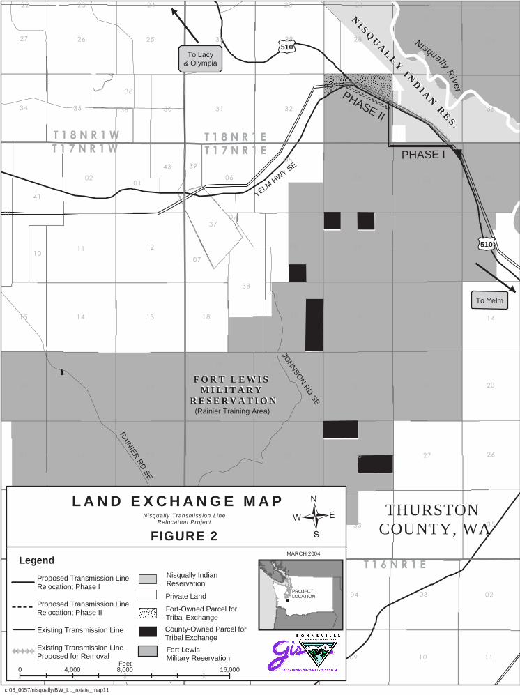
Figure 2 Land Exchange Map.................................................................................follows page 1-2
Figure 3 Route Alternatives......................................................................................................... 2-2
Figure 4 Proposed Action Relocate Transmission Lines and Exchange Land ......follows page 2-2
Figure 5 Tower Types ................................................................................................................. 2-3
Figure 6 Proposed Action Right-of-Way ..................................................................................... 2-5
Figure 7 Alternative 1 Double-Circuit Towers on Existing Easement ......................................... 2-8
Figure 8 Alternatives Considered but Eliminated from Detailed Study..................................... 2-10
Figure 9 Average Magnetic Fields of Existing and Proposed Rights-of-Way with Lattice Steel Towers .......................................................................................................................3-50
Figure 10 Average Magnetic Fields of Proposed Right-of-Way with Steel Poles .....................3-51
Figure 11 Magnetic Fields of Existing and Alternative 1 Rights-of-Way................................... 3-53
Figure 12 Magnetic Fields of Alternative 2 – New Right-of-Way ...............................................3-54
Figure 13 Magnetic Fields of Alternative 2 - Existing Right-of-Way with One Line Removed..............................................................................................................................3-54
Nisqually Transmission Line Relocation Project Table of Contents - iii
List of Tables Table 1 Comparison of Alternatives by Construction Requirements .........................................2-12
Table 2 Comparison of Alternatives by Project Need and Purposes.........................................2-13
Table 3 Plant Species on Rainier Training Area within the Proposed Project Area ....................3-2
Table 4 Noise Levels..................................................................................................................3-44
Table 5 Audible Noise Levels ....................................................................................................3-45
Table 6 Typical Magnetic Field Strengths..................................................................................3-48
List of Photos
Photo 1 Existing Transmission Lines .........................................................................................3-29
Photo 2 View of Proposed Route from Existing Residences .....................................................3-30
Photo 3 Simulation of Phase II along SR 510............................................................................3-32
Photo 4 Simulation of Existing Transmission Lines Removed...................................................3-33
Nisqually Transmission Line Relocation Project Table of Contents - iv
Chapter I Need for and Purpose of Action
This chapter explains why the Bonneville Power Administration (Bonneville) needs to take action. The chapter also explains the background to this need and the purposes we, and the other federal agencies involved in this project, are trying to achieve. (Chapter 2 explains how Bonneville and the other federal agencies are proposing to address the need; it describes the Proposed Action and the alternatives being considered.)
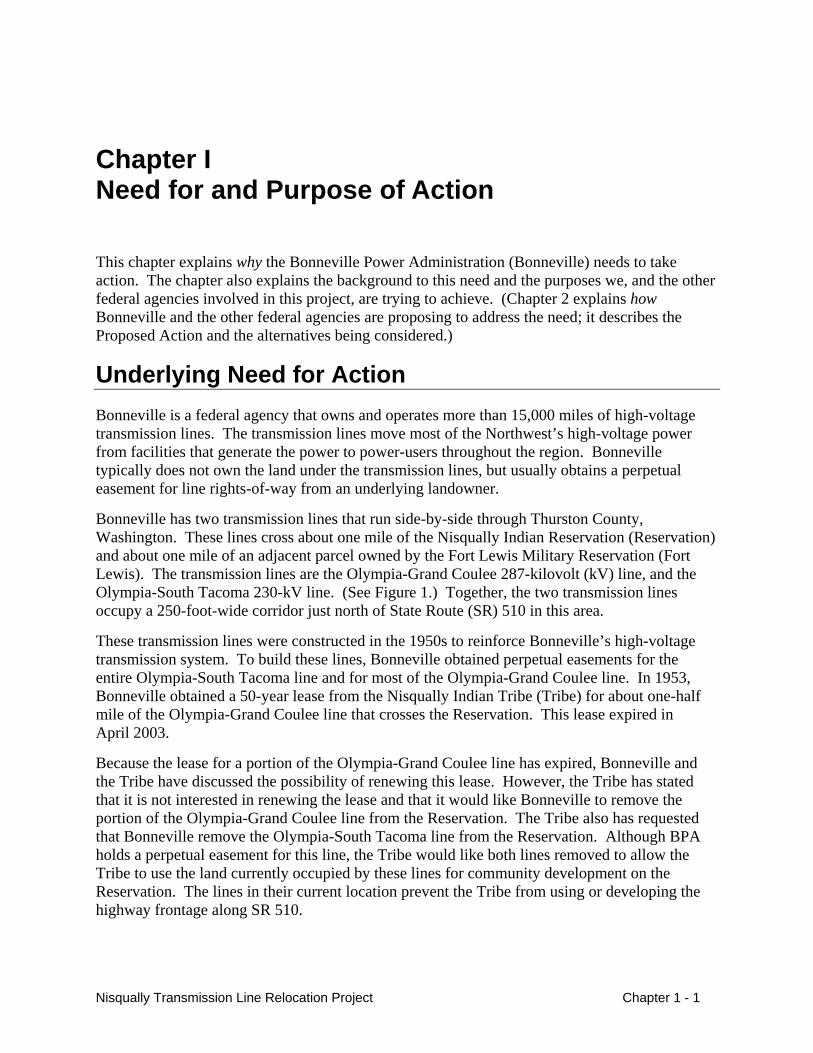
Underlying Need for Action Bonneville is a federal agency that owns and operates more than 15,000 miles of high-voltage transmission lines. The transmission lines move most of the Northwest’s high-voltage power from facilities that generate the power to power-users throughout the region. Bonneville typically does not own the land under the transmission lines, but usually obtains a perpetual easement for line rights-of-way from an underlying landowner.
Bonneville has two transmission lines that run side-by-side through Thurston County, Washington. These lines cross about one mile of the Nisqually Indian Reservation (Reservation) and about one mile of an adjacent parcel owned by the Fort Lewis Military Reservation (Fort Lewis). The transmission lines are the Olympia-Grand Coulee 287-kilovolt (kV) line, and the Olympia-South Tacoma 230-kV line. (See Figure 1.) Together, the two transmission lines occupy a 250-foot-wide corridor just north of State Route (SR) 510 in this area.
These transmission lines were constructed in the 1950s to reinforce Bonneville’s high-voltage transmission system. To build these lines, Bonneville obtained perpetual easements for the entire Olympia-South Tacoma line and for most of the Olympia-Grand Coulee line. In 1953, Bonneville obtained a 50-year lease from the Nisqually Indian Tribe (Tribe) for about one-half mile of the Olympia-Grand Coulee line that crosses the Reservation. This lease expired in April 2003.
Because the lease for a portion of the Olympia-Grand Coulee line has expired, Bonneville and the Tribe have discussed the possibility of renewing this lease. However, the Tribe has stated that it is not interested in renewing the lease and that it would like Bonneville to remove the portion of the Olympia-Grand Coulee line from the Reservation. The Tribe also has requested that Bonneville remove the Olympia-South Tacoma line from the Reservation. Although BPA holds a perpetual easement for this line, the Tribe would like both lines removed to allow the Tribe to use the land currently occupied by these lines for community development on the Reservation. The lines in their current location prevent the Tribe from using or developing the highway frontage along SR 510.
Nisqually Transmission Line Relocation Project Chapter 1 - 1
In addition, the Tribe has asked Bonneville to remove the two lines from a parcel next to the Reservation that Fort Lewis owns. Fort Lewis owns land surrounding much of the Reservation. As part of the Tribe’s long-term planning for the Reservation’s development, the Tribe is working with Fort Lewis to obtain this Fort-owned parcel. This parcel is next to the western boundary of the Reservation and is generally north of SR 510. (Please see Figure 1.) Much of the parcel has frontage along SR 510, but Bonneville’s transmission lines restrict its potential development. Bonneville currently holds permits from the Army for these transmission lines and their associated rights-of-way. Because the Tribe would like to have the option to develop the highway frontage along SR 510 occupied by these lines when it acquires this parcel, the Tribe has asked Bonneville to also remove the two transmission lines from this portion of the parcel.
Within the boundaries of the Fort Lewis are parcels of land owned by others, called in-holdings. In the interest of efficient property management, Fort Lewis has established a goal of reducing the amount of in-holdings. Fort Lewis has received express Congressional authorization to transfer title of the Fort-owned parcel to the Tribe in exchange for eight parcels of land the Tribe plans to purchase from Thurston County. The County-owned parcels are within the boundaries of Fort Lewis (see Figure 2). Fort Lewis currently leases these parcels from the County and would like to consolidate the parcels into Fort Lewis ownership.
Fort Lewis is willing to have portions of Bonneville’s Olympia-Grand Coulee and Olympia-South Tacoma transmission lines relocated onto their federal property, contingent on receiving the Thurston County parcels from the Tribe. The property where the lines are proposed to be relocated is just south and west of the Reservation on Fort Lewis’ Rainier Training Area.
In summary, the following are underlying needs for Bonneville’s Proposed Action:
• the need to address the expired easement of the Olympia-Grand Coulee transmission line, and
• the need to consider the request from the Nisqually Indian Tribe to remove both transmission lines from the Reservation and from the Fort-owned parcel next to the Reservation.
Purposes In satisfying the underlying need for action, Bonneville would like to achieve the following purposes:
• Minimize costs.
• Minimize impacts to the natural and human environment.
• Maintain transmission system reliability.
• Honor federal tribal trust responsibilities (“Department of Defense American Indian and Alaska Native Policy, October 20, 1998,” BPA Tribal Policy, April 1996).
• Facilitate Fort Lewis’ goal to consolidate, under fee ownership, parcels within the Fort Lewis boundaries.
Chapter 1 - 2 Nisqually Transmission Line Relocation Project
����������������������������������������������������������������������������������������������������������������������������������������������������������������������������������������������������
N I S Q U A L L Y N I S Q U A L L Y I N D I A N I N D I A N
R E S E R V A T I O NR E S E R V A T I O N
F O R T L E W I S F O R T L E W I S M I L I T A R Y M I L I T A R Y
R E S E R V A T I O NR E S E R V A T I O N
PHASE I
PHASE II
YE
LM H
WY
SE
��510
��510
�����
�����
�����
�����
��������
�����Olympia-Grand Coulee 287-kV
Olympia-South Tacoma 230-kV
To Lacy & Olympia R
ES
ER
VA
TIO
N R
D
To Yelm
Join Phase II into existing transmission lines at this location
R1E
Nisqually Transmission Line Relocation Project
cr03_0057/nisqually/BW_map8_rotate
MARCH 2004
V I C I N I T Y M A P
Legend
Fort-Owned Parcel forTribal ExchangeExisting Transmission Line
Proposed Transmission LineRelocation; Phase II
Proposed Transmission LineRelocation; Phase I
Nisqually IndianReservation
Fort LewisMilitary Reservation
Existing Transmission LineProposed for Removal
�����
PROJECT LOCATION
Nisqually River
THURSTON THURSTON COUNTY, WACOUNTY, WA
Private Land
Extension of Phase Ito be removed with Phase IIconstruction
0 2,250 4,5001,125Feet
��� ������ ���
�
(Rainier Training Area)
FIGURE 1
���������������������������� ������
�������������������
���
NI S Q
UA
LL
Y I N
DI A
N R
ES .
NI S Q
UA
LL
Y I N
DI A
N R
ES .
F O R T L E W I S F O R T L E W I S M I L I T A R Y M I L I T A R Y
R E S E R V A T I O NR E S E R V A T I O N
PHASE I
PHASE II
� � � � � � �� � � � � � � � � � � � � �
� � � � � � �
� � � � � �
��510
��510
JOH
NSO
N R
D SE
YELM HW
Y SE
RAIN
IER R
D SE
To Yelm
��
��
��
��
����
��
��
��
�� �
�
�
��
��
��
��
��
��
�
��
�
��
�
��
�
��
��
��
��
���
�
��
�
��
��
��
��
��
��
��
��
�� ��� ��
�
�
��
�
��
��
�
��
��
��
�
���� ��
��
���� ��
�
��
��
��
��
��
��
��
� ��
��
��
��
�
����
��
��
��
��
��
��
�
�� ������ ���� ��
��
��
��
��
cr03_0057/nisqually/BW_LL_rotate_map11
Nisqually River
THURSTON THURSTON COUNTY, WACOUNTY, WA
R1E
Nisqually Transmission LineRelocation Project
MARCH 2004
L A N D E X C H A N G E M A P
Legend
Fort-Owned Parcel forTribal Exchange
Existing Transmission Line
Proposed Transmission LineRelocation; Phase II
Proposed Transmission LineRelocation; Phase I
Nisqually IndianReservation
Fort LewisMilitary Reservation
Existing Transmission LineProposed for Removal
�����
PROJECT LOCATIONPrivate Land
0 8,000 16,0004,000Feet
County-Owned Parcel forTribal Exchange
To Lacy& Olympia
�FIGURE 2
(Rainier Training Area)
Bonneville will use these purposes to decide whether the Proposed Action or alternatives would be implemented.
Cooperating Agencies The Nisqually Indian Tribe, The Department of Defense, Fort Lewis Military Reservation, the Bureau of Indian Affairs (BIA), and Bonneville have held discussions for several years to address the following: 1) the expiring easement, 2) Fort Lewis acquiring County-owned parcels within the Rainier Training Area, and 3) the Tribe’s request to reclaim lands encumbered by the lines.
Fort Lewis is a cooperating agency in the development of this environmental assessment (EA) because the alternatives being considered cross Fort Lewis (see Chapter 2), and Fort Lewis has decisions to make regarding exchanging lands with the Tribe. The BIA is a cooperating agency because it may have trustee decisions to make for the Tribe regarding alternatives for removing the lines from the Reservation, and for planned land exchanges. The Tribe is involved because they have requested the relocation of the transmission lines and they would fund portions of that relocation.
Public Involvement Early in this environmental process, we contacted people who may be interested in or affected by the project to learn what issues should be studied in the EA. We contacted people by letter who live near the existing transmission lines and the proposed reroute, and near the borders of the Fort-owned parcel. We also contacted others who may be interested in the project: federal, state, and local agencies, Indian tribes and interest groups. In addition, we held two public meetings to receive comments:
• Public meeting in Yelm, Washington on October 22, 2003;
• Tribal Meeting at Nisqually Tribal Headquarters on October 21, 2003.
In all, we received about 100 comments. The issue that received the most comments was concern about future development in the area, in general and on the Fort-owned parcel by the Tribe. Commenters also wanted more information about the project and the decision-making process; this received slightly fewer comments than the development issue. The four resources that drew the most comments about impacts were the following:
• Wildlife (endangered species and other animals).
• Water quality (potential impacts to wells and the local protected aquifer).
• Public Health and Safety (effects of electric and magnetic fields from transmission lines).
• Soils (erosion potential during construction).
Many other issues also received comments:
• Concerns about public vs. private or Reservation land ownership (potential development and access changes).
Nisqually Transmission Line Relocation Project Chapter 1 - 3
• Need for the project.
• Alternatives considered.
• Compensation for the transmission line easement, any development, and impacts on property values.
• Transportation (increased use of existing roads).
• Hazardous waste.
• Visual impacts.
• Wetland impacts.
• Noise.
• Tribal relationships.
Please see Appendix A for mailings and a list of the comments we received.
Chapter 1 - 4 Nisqually Transmission Line Relocation Project
Chapter 2 Proposed Action and Alternatives
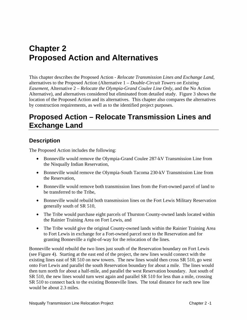
This chapter describes the Proposed Action - Relocate Transmission Lines and Exchange Land, alternatives to the Proposed Action (Alternative 1 – Double-Circuit Towers on Existing Easement, Alternative 2 – Relocate the Olympia-Grand Coulee Line Only, and the No Action Alternative), and alternatives considered but eliminated from detailed study. Figure 3 shows the location of the Proposed Action and its alternatives. This chapter also compares the alternatives by construction requirements, as well as to the identified project purposes.
Proposed Action – Relocate Transmission Lines and Exchange Land
Description The Proposed Action includes the following:
• Bonneville would remove the Olympia-Grand Coulee 287-kV Transmission Line from the Nisqually Indian Reservation,
• Bonneville would remove the Olympia-South Tacoma 230-kV Transmission Line from the Reservation,
• Bonneville would remove both transmission lines from the Fort-owned parcel of land to be transferred to the Tribe,
• Bonneville would rebuild both transmission lines on the Fort Lewis Military Reservation generally south of SR 510,
• The Tribe would purchase eight parcels of Thurston County-owned lands located within the Rainier Training Area on Fort Lewis, and
• The Tribe would give the original County-owned lands within the Rainier Training Area to Fort Lewis in exchange for a Fort-owned parcel next to the Reservation and for granting Bonneville a right-of-way for the relocation of the lines.
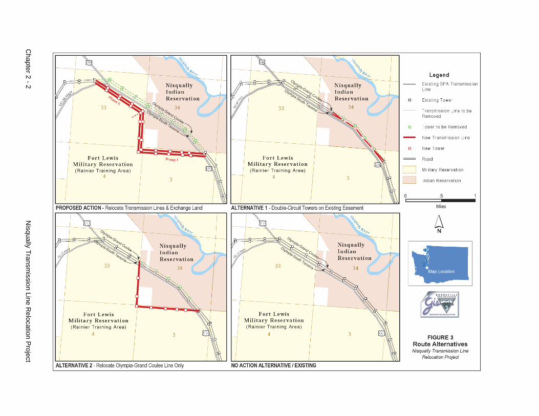
Bonneville would rebuild the two lines just south of the Reservation boundary on Fort Lewis (see Figure 4). Starting at the east end of the project, the new lines would connect with the existing lines east of SR 510 on new towers. The new lines would then cross SR 510, go west onto Fort Lewis and parallel the south Reservation boundary for about a mile. The lines would then turn north for about a half-mile, and parallel the west Reservation boundary. Just south of SR 510, the new lines would turn west again and parallel SR 510 for less than a mile, crossing SR 510 to connect back to the existing Bonneville lines. The total distance for each new line would be about 2.3 miles.
Nisqually Transmission Line Relocation Project Chapter 2 -1
Chapter 2 - 2
N
isqually Transmission Line R
elocation Project
")")
")
")
")")
")
")")
")")
")
")
")")
")")
")
")
")
")
")")
") ")
")
")
")
")
")
")
")
")
")
")
")
")
")
")
") ") ") ") ") ") ")
")
")
")
")
")
")
")
")
")
")
")
")")
")
")
")
")
")
")
")
")
£�510
Red WindRed WindCasinoCasino
WILDHORSE
WELL
SASKATO
ON
PRAIRIE
GALLUP
RESERVATION
YELM
MUCK CREEK
NISQUALLY
SHE NAH NUM
MUK SUT WEI
PETER KALAMA
Ni squ ally R
iver
ELDERS
T18N R01E SEC33
T18N R01E SEC32
T18N R01E SEC28
T18N R01E SEC34
T18N R01E SEC27
T17N R01E SEC03
T17N R01E SEC04
THURSTON COUNTY, WA
FORT LEWIS FORT LEWIS MILITARY RESERVATIONMILITARY RESERVATION
NISQUALLY INDIAN NISQUALLY INDIAN RESERVATIONRESERVATION
Olympia-Grand Coulee 287 kV
Olympia- South Tacoma 230 kV
TO LACYTO LACY
TO YELMTO YELM
Nisqual ly Transmission LineRelocat ion Project
/
0 0.3 0.60.15 Miles
MAY 2004
CR03_0057/NISQUALLY/WORKINGMAP/11x17ortho_edge_impact_area
0 1,500 3,000750 Feet
Approximate Tree Clearing Boundary
Legend
Fort-Owned Parcel
Land Ownership
2000 Thurston County parcelsExisting Transmission Line
Proposed Transmission LineRelocation; Phase II
Proposed Transmission LineRelocation; Phase I
Existing Towers
Nisqually Indian Reservation
Existing Transmission LineProposed for Removal
US Government
Proposed TowersPulling Site
PROPOSED ACTION RELOCATE TRANSMISSION LINES
AND EXCHANGE LAND
FIGURE 4
(Rainier Training Area)
Existing Access RoadNew Access Road
Washington
Area of Detail
This map is for informational purposes only. It is not intended
to represent legal or survey boundaries
After the relocated lines were constructed, the existing lines (21 towers, conductors, fiber optic cables) would be taken down. About one mile of corridor (10 towers) on the Reservation would be removed, about one-half mile of corridor (9 towers) on the Fort-owned parcel would be removed, and 2 towers on Fort Lewis at the east end of the project would be removed.
Phases The removal and rebuild of both lines could be completed in two phases depending on funding. Phase I would include the removal of the existing lines from the Reservation and construction of the new lines on Fort Lewis from the east end of the proposed project to where the new lines would meet up with SR 510 as explained above. Phase II would remove the existing lines from the Fort-owned parcel (see Figure 4) and new lines would be constructed just south of SR 510 as explained above. If Phase II were constructed at a later date (i.e., one or more years apart), then Phase I would connect to the existing transmission lines just west of the Reservation boundary. When Phase II was constructed, this connection would be removed and the lines would continue through Phase II.
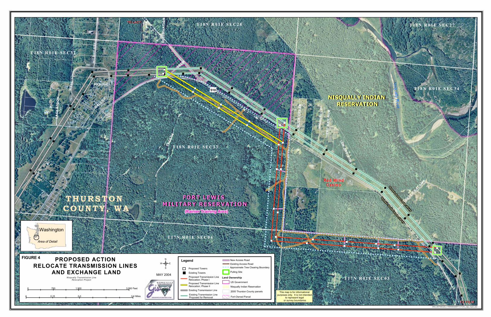
Transmission Towers The proposed relocation would require about 26 new towers. There are two different tower types that could be used for the relocated lines; lattice steel or steel poles (see Figure 5). Both types of towers would be made of galvanized steel.
The lattice-steel towers would be the same tower type that is used on much of the existing lines and would be 70- to 120-feet tall (depending on the terrain). The towers would have four footings with a total footprint of about 50-feet by 50-feet (0.06 acre). The metal legs of the tower go directly into the ground, and each one attaches to a grillage footing. A trackhoe would be used to excavate an area about 7 to 13-feet deep, and about 8 to 12 feet in diameter for each footing; all soil and rock removed during excavation would be used to backfill the areas once the
Nisqually Transmission Line Relocation Project Chapter 2 -3
footings were installed. To assemble and erect the towers, an area about 150-feet by 150-feet (0.5 acre) would be disturbed at each tower site for construction equipment maneuvering, tower assembly, etc.
The steel-pole towers would be 80 to 140-feet tall (depending on the terrain). Steel poles would be directly embedded in the ground and would require holes about 15 to 40-feet deep. The diameter of the pole at ground level would be between 4½ and 6½ feet. A drill rig would be used to auger the holes for the poles. To assemble and erect the towers, an area about 70-feet by 70-feet (0.1 acre) would be disturbed at each tower site.
Conductors and Fiber Optic Cable Conductors are the wires on the towers that carry the electrical current. Each transmission line would carry three conductors. The conductors would be treated to reduce the shininess of the metal. Conductors are attached to the transmission towers by insulators. Insulators are bell-shaped devices that prevent the electricity from jumping from the conductors to the tower and going to the ground. The insulators would be made of porcelain or fiberglass and would be non-reflective, reducing the sun glare that some older glass insulators create.
In addition to the three conductors, the relocated Olympia-South Tacoma line would carry a fiber optic cable, which is a smaller wire above the conductors. This fiber optic cable is currently on the existing Olympia-South Tacoma line and is used for communications to control the power system.
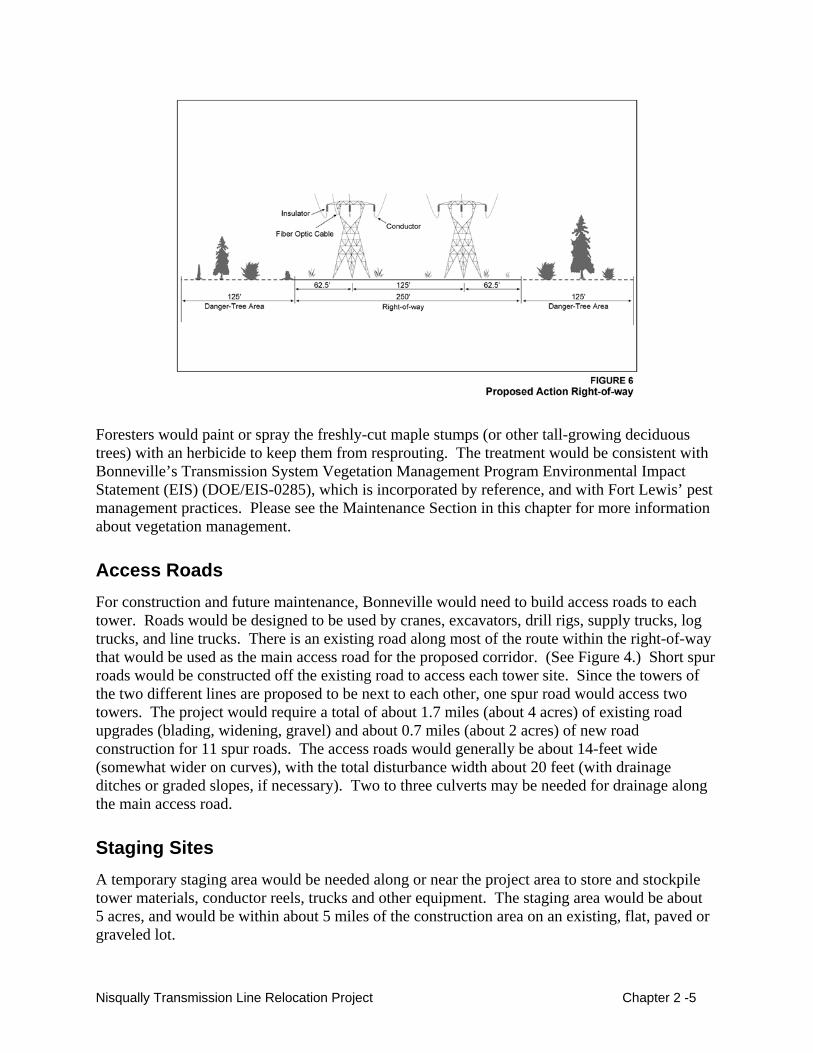
Right-of-Way and Tree Clearing Bonneville would obtain a permit from Fort Lewis for a 250-foot wide right-of-way for the two transmission lines. The right-of-way edge would be located 125 feet from the edge of the Fort Lewis property line. (See Figure 6.)
The 250-foot right-of-way would require all tall-growing vegetation to be cut (about 62 acres) to prevent vegetation from coming close enough to the conductor to cause an electrical arc (which could injure people, start fires, and put the line out of service).
On either side of the right-of-way, danger trees (i.e., trees from the area next to the right-of-way that could potentially grow, fall, or bend close enough to the lines to cause an electrical arc) also would need to be cut. Based on the height of trees in this area, about half of the trees within about 125 feet of either side of the right-of-way would need to be removed (up to 36 acres). To selectively identify danger trees for the initial clearing, Bonneville and Fort Lewis foresters would measure the tree height, stability, growth rate and other factors.
Chapter 2 - 4 Nisqually Transmission Line Relocation Project
Foresters would paint or spray the freshly-cut maple stumps (or other tall-growing deciduous trees) with an herbicide to keep them from resprouting. The treatment would be consistent with Bonneville’s Transmission System Vegetation Management Program Environmental Impact Statement (EIS) (DOE/EIS-0285), which is incorporated by reference, and with Fort Lewis’ pest management practices. Please see the Maintenance Section in this chapter for more information about vegetation management.
Access Roads For construction and future maintenance, Bonneville would need to build access roads to each tower. Roads would be designed to be used by cranes, excavators, drill rigs, supply trucks, log trucks, and line trucks. There is an existing road along most of the route within the right-of-way that would be used as the main access road for the proposed corridor. (See Figure 4.) Short spur roads would be constructed off the existing road to access each tower site. Since the towers of the two different lines are proposed to be next to each other, one spur road would access two towers. The project would require a total of about 1.7 miles (about 4 acres) of existing road upgrades (blading, widening, gravel) and about 0.7 miles (about 2 acres) of new road construction for 11 spur roads. The access roads would generally be about 14-feet wide (somewhat wider on curves), with the total disturbance width about 20 feet (with drainage ditches or graded slopes, if necessary). Two to three culverts may be needed for drainage along the main access road.
Staging Sites A temporary staging area would be needed along or near the project area to store and stockpile tower materials, conductor reels, trucks and other equipment. The staging area would be about 5 acres, and would be within about 5 miles of the construction area on an existing, flat, paved or graveled lot.
Nisqually Transmission Line Relocation Project Chapter 2 -5
Conductor-Pulling Sites Conductors and fiber optic cable would be strung in travelers (pulleys) from tower to tower with a large piece of equipment pulling the conductor and a truck holding the reel of conductor or fiber cable. Two conductor-pulling sites would be needed for the Proposed Action, one at either end of the line to tighten the conductor. The pulling sites typically disturb an area of about 1 acre (clearing of woody vegetation, possible grading). One site would be on the east end of the proposed line just off the existing right-of-way (see Figure 4). The other site would be on the west end of the project, just west of the existing right-of-way. If Phase II was built at a later date, then a third pulling site would be needed for the completion of Phase I. This site would be at the northwest end of Phase I, just north of the existing right-of-way.
Line Removal After the relocated lines were constructed and energized (switched on), the existing towers would be removed. The soil around the tower legs would be dug away; the tower legs would be cut about 2 or 3 feet below the ground surface, and a crane would lower the tower to the ground. The tower would be dismantled with cutters and a torch into pieces small enough to be hauled away on the back of a large truck.
The towers would not be reused for the line relocation for several reasons:
• The 50-year old towers show signs of deterioration and rust; taking them apart and putting them back together (with rusty bolts, warping) would be difficult and not cost effective.
• Existing towers are not the correct height for the new line location.
• Construction would be planned so the new lines would be built first, and the wires switched over and energized before taking down the old towers. If the old towers were taken down first to be reused, the transmission lines would have to be turned off for 6 months during construction, and these lines are needed to help maintain the reliability of the transmission system serving the Puget Sound area.
Costs The line removal and relocation of the Proposed Action would cost about $6 to 7 million if constructed with lattice steel towers; Phase I would cost about $4-5 million, Phase II about $2 million. Steel pole towers would increase the cost of the project by about $400,000.
Construction The schedule for construction is dependent on funding and the timeframe needed to complete the environmental process. At this time, it is anticipated that construction of the Proposed Action would be scheduled to start in spring 2005 and finish in fall 2005, for a total construction period of about 6 months. However, if the Proposed Action were constructed in phases, the construction schedule could potentially be delayed or prolonged. The following bullets show the general construction sequence.
Chapter 2 - 6 Nisqually Transmission Line Relocation Project
• Existing access roads would be upgraded.
• Trees would be cleared from the 250-foot right-of-way, the pulling sites, and from the danger tree areas. The trees would be cut using conventional logging practices. Merchantable timber would be stacked for loading onto trucks. The Army would sell the decked logs. Slash and nonmerchantable timber would be lopped and scattered (cut trunks and branches scattered on the ground and left to decompose).
• Spur roads would be constructed, tower sites leveled, as needed, and erosion control devices put in place. Transmission line materials would be stockpiled at the staging site.
• Holes would be excavated for tower footings, and the footings put in place and backfilled. Tower pieces would be brought to each site, constructed, lifted into place using a crane and bolted to the footings.
• Each towers site would be contoured and topsoil would be spread. Reseeding would be done after all activity is completed at each site.
• Conductors would be strung, tightened at pulling sites, connected to the existing line and energized.
• After the line is energized, the existing line proposed for removal would be dismantled as explained earlier in the Line Removal section.
Though not usually used for short line construction in relatively flat areas such as the Proposed Action, helicopters could potentially be used for tower construction, logging and/or line stringing.
Maintenance Maintenance of the lines would be the same as that carried out on the existing lines - routine, periodic maintenance and emergency repairs. Maintenance usually involves replacing insulators. Every two months, an inspector would fly over the lines in a helicopter looking for potential problems.
Vegetation is maintained for safe operation and to allow access to the towers. The vegetation would be managed as guided by Bonneville’s Transmission System Vegetation Management Program EIS. This program includes ongoing consultation between Bonneville, landowners (Fort Lewis) and the U.S. Fish and Wildlife Service, as appropriate. A number of different vegetation management methods may be used: manual (hand-pulling, clippers, chainsaws), mechanical (roller-choppers, brush-hog), biological (insects or fungus for attacking noxious weeds), and chemical (herbicides). Danger trees would be identified and removed in consultation with Fort Lewis. Bonneville would work with the Thurston County Weed Board and Fort Lewis on area-wide plans for noxious weed control.
Land Exchange The Nisqually Indian Tribe would purchase eight parcels of land totaling 410 acres from Thurston County (County-owned parcels). The County-owned parcels are within the boundaries of the 17,000 acre Fort Lewis Rainier Training Area south of SR 510 and the transmission line
Nisqually Transmission Line Relocation Project Chapter 2 -7
project (see Figure 2). The land is currently leased by Fort Lewis and is used for training maneuvers. The County harvests timber on the lands.
After the County-owned parcels are purchased, the Tribe would exchange the parcels with Fort Lewis for a 168-acre parcel (Fort-owned parcel) adjacent to the Reservation just north of SR 510. Assuming Phase II is built, about 0.3 mile of transmission corridor (consisting of both lines, five towers) would remain on the Fort-owned parcel.
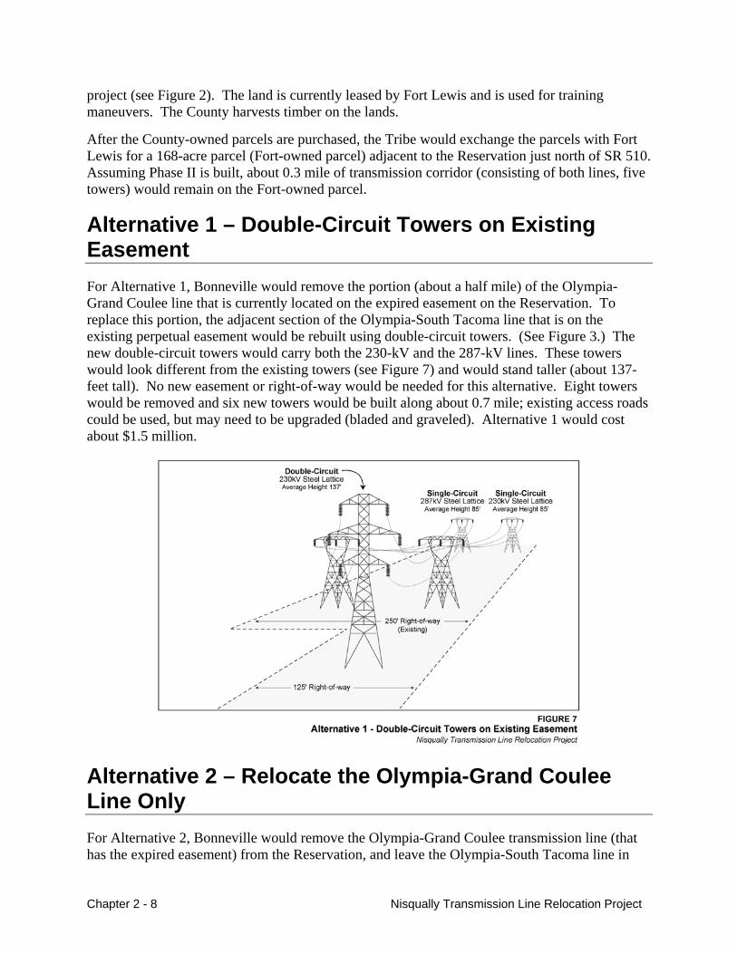
Alternative 1 – Double-Circuit Towers on Existing Easement For Alternative 1, Bonneville would remove the portion (about a half mile) of the Olympia-Grand Coulee line that is currently located on the expired easement on the Reservation. To replace this portion, the adjacent section of the Olympia-South Tacoma line that is on the existing perpetual easement would be rebuilt using double-circuit towers. (See Figure 3.) The new double-circuit towers would carry both the 230-kV and the 287-kV lines. These towers would look different from the existing towers (see Figure 7) and would stand taller (about 137-feet tall). No new easement or right-of-way would be needed for this alternative. Eight towers would be removed and six new towers would be built along about 0.7 mile; existing access roads could be used, but may need to be upgraded (bladed and graveled). Alternative 1 would cost about $1.5 million.
Alternative 2 – Relocate the Olympia-Grand Coulee Line Only For Alternative 2, Bonneville would remove the Olympia-Grand Coulee transmission line (that has the expired easement) from the Reservation, and leave the Olympia-South Tacoma line in
Chapter 2 - 8 Nisqually Transmission Line Relocation Project
place. The Olympia-Grand Coulee would be rebuilt on Fort Lewis as described for the Proposed Action (Phase I section only). (See Figure 3.) The one line would require a new 125-foot right-of-way (21 acres of tree clearing), and danger tree removal within about 125 feet on either side of the right-of-way (about 24 acres). Six towers would be removed from the Reservation and nine new towers would be built on Fort Lewis. Staging area and access roads requirements would be the same as the Proposed Action Phase I. Alternative 2 would cost about $2.5 million.
No Action Alternative For the No Action Alternative, Bonneville would not take action to relocate either transmission line. Leaving the situation as is, Bonneville would be in violation of the easement rights of the Olympia-Grand Coulee line. It is unclear how this would be accomplished. One option would be for Bonneville and the Tribe to renegotiate the easement. However, the Tribe has expressed that it is not interested in negotiating a long-term easement, but is only willing to extend the easement in the short-term to complete the process to relocate the lines. For purposes of this analysis, it is assumed that the No Action Alternative involves the continuation of the status quo (lines remain in their existing location).
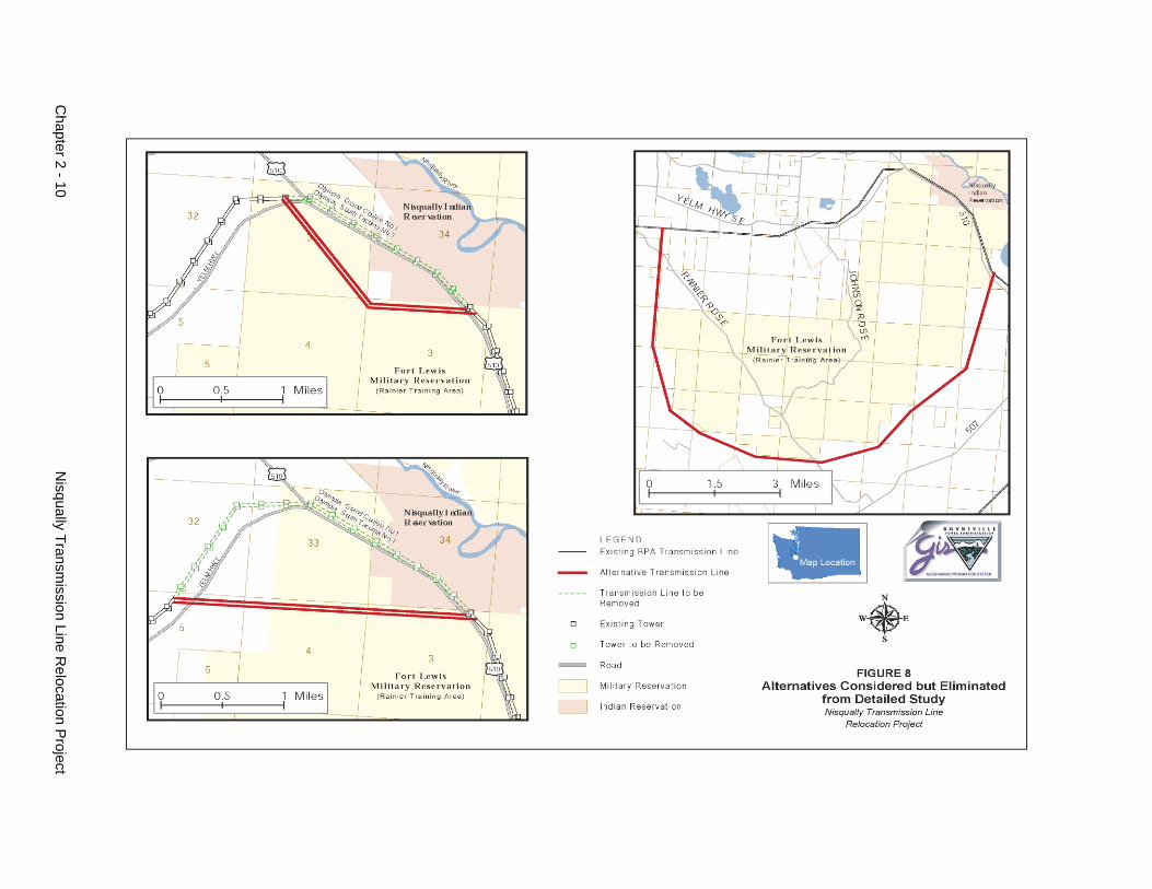
Alternatives Considered But Eliminated From Detailed Study Several other alternatives, discussed below, were considered early in the planning stage for addressing the expired easement and the request from the Tribe to relocate the transmission lines. These alternatives were eliminated from detailed study because they were either much more expensive, had much greater environmental or land use impacts, or were not feasible for electrical reasons. (See Figure 8.)
Remove the Olympia-Grand Coulee Line from Service Bonneville considered taking the Olympia-Grand Coulee line out of service (removing it and not using it for electrical transmission). This alternative was eliminated from consideration because the line is needed to help serve the Olympic Peninsula and it helps support transfer of power across the Cascade Mountains to the Puget Sound area.
Relocate Both Lines on Fort Lewis Across the Rainier Training Area We considered two other routes for relocating the lines on the Rainier Training Area (see Figure 8). These routing alternatives would have resulted in approximately the same amount of surface disturbance as the Proposed Action. The alternatives were eliminated from further consideration primarily because they would have required cutting a swath through the Rainier Training Area, which would cause greater disruption to Fort Lewis army maneuvers than the Proposed Action, which follows the edge of Fort Lewis. These routes also would have greater impacts to designated spotted owl critical habitat than the Proposed Action since the Proposed Action would be located on the fringe of this habitat, while the routes would divide the habitat. (See Chapter 3.)
Nisqually Transmission Line Relocation Project Chapter 2 -9
Chapter 2 - 10
N
isqually Transmission Line R
elocation Project
One of the routes would have required purchasing land from private landowners on the west end, with the potential to significantly increase the costs of line construction.
Relocate the Olympia-Grand Coulee Line around Fort Lewis An alternative to route the Olympia-South Tacoma transmission line around Fort Lewis on all private land was considered. The shortest route would have been to the south of Fort Lewis (see Figure 8). This alternative was eliminated from further consideration because it would have required about 15 miles of new transmission line (with associated access roads, the removal of about 10 miles of line, substantially more tree clearing than the Proposed Action, at least three creek crossings, the purchase of all new right-of-way, and the disruption of a number of private landowners).
Right-of-way Location Bonneville considered early in the process the option of placing the new right-of-way on Fort Lewis directly adjacent to the edge of the Fort Lewis property (compared to 125 feet from the property edge, as proposed). This option was eliminated from detailed study because the tree clearing requirements for the transmission lines would encumber the Reservation, residents of the Reservation and two private landowners. Danger trees would have been cleared on those properties, both during construction and in the long-term as new trees were identified as danger trees. In addition, the right-of-way would have been located adjacent to SR 510, not allowing for any potential tall-growing vegetation to provide a visual buffer to travelers of the road.
Land Exchange Option During the public involvement process, it was suggested that Fort Lewis retain the portion of the Fort-owned parcel to the west of SR 510 in the land exchange. This option was considered but eliminated from further consideration because it would isolate a small section of Fort Lewis property, would not involve a fair amount of land exchange for the Tribe, and would not be consistent with Congressional intent authorizing the land exchange.
Comparison of Alternatives This section compares the alternatives described in this chapter by the construction requirements and by the project need and purposes (see Tables 1 and 2).
Nisqually Transmission Line Relocation Project Chapter 2 -11
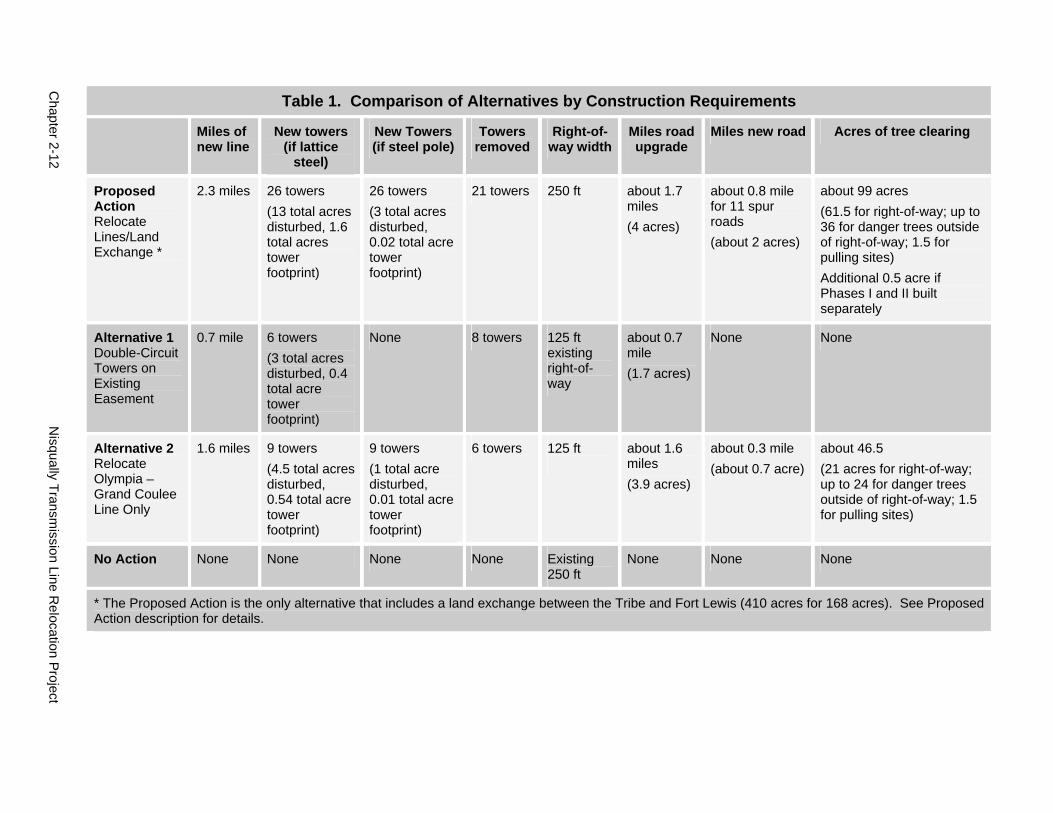
Chapter 2-12
N
isqually Transmission Line R
elocation Project
Table 1. Comparison of Alternatives by Construction Requirements
Miles of new line
New towers (if lattice
steel)
New Towers (if steel pole)
Towers removed
Right-of-way width
Miles road upgrade
Miles new road Acres of tree clearing
Proposed Action Relocate Lines/Land Exchange *
2.3 miles 26 towers (13 total acres disturbed, 1.6 total acres tower footprint)
26 towers (3 total acres disturbed, 0.02 total acre tower footprint)
21 towers 250 ft about 1.7 miles (4 acres)
about 0.8 mile for 11 spur roads (about 2 acres)
about 99 acres (61.5 for right-of-way; up to 36 for danger trees outside of right-of-way; 1.5 for pulling sites) Additional 0.5 acre if Phases I and II built separately
Alternative 1 Double-Circuit Towers on Existing Easement
0.7 mile 6 towers (3 total acres disturbed, 0.4 total acre tower footprint)
None 8 towers 125 ft existing right-of-way
about 0.7 mile (1.7 acres)
None None
Alternative 2 Relocate Olympia – Grand Coulee Line Only
1.6 miles 9 towers (4.5 total acres disturbed, 0.54 total acre tower footprint)
9 towers (1 total acre disturbed, 0.01 total acre tower footprint)
6 towers 125 ft
about 1.6 miles (3.9 acres)
about 0.3 mile (about 0.7 acre)
about 46.5 (21 acres for right-of-way; up to 24 for danger trees outside of right-of-way; 1.5 for pulling sites)
No Action None None None None Existing 250 ft
None None None
* The Proposed Action is the only alternative that includes a land exchange between the Tribe and Fort Lewis (410 acres for 168 acres). See Proposed Action description for details.
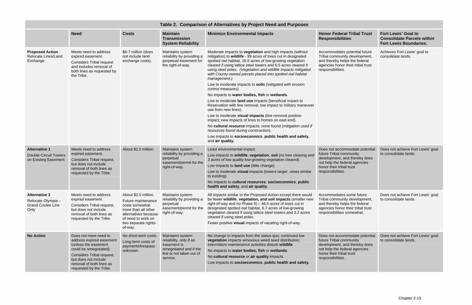
Table 2. Comparison of Alternatives by Project Need and Purposes
Need Costs Maintain Transmission System Reliability
Minimize Environmental Impacts Honor Federal Tribal Trust Responsibilities
Fort Lewis’ Goal to Consolidate Parcels within Fort Lewis Boundaries.
Proposed Action Relocate Lines/Land Exchange
Meets need to address expired easement. Considers Tribal request and includes removal of both lines as requested by the Tribe.
$6-7 million (does not include land exchange costs).
Maintains system reliability by providing a perpetual easement for the right-of-way.
Moderate impacts to vegetation and high impacts (without mitigation) to wildlife - 99 acres of trees cut in designated spotted owl habitat, 16.5 acres of low-growing vegetation cleared if using lattice steel towers and 6.5 acres cleared if using steel poles. (Vegetation and wildlife impacts mitigated with County-owned parcels placed into spotted owl habitat management.) Low to moderate impacts to soils (mitigated with erosion control measures). No impacts to water bodies, fish or wetlands. Low to moderate land use impacts (beneficial impact to Reservation with line removal, low impact to military maneuver use from new lines). Low to moderate visual impacts (line removal positive impact; new impacts of lines to homes on east end). No cultural resource impacts, none found (mitigation used if resources found during construction). Low impacts to socioeconmics, public health and safety, and air quality.
Accommodates potential future Tribal community development, and thereby helps the federal agencies honor their tribal trust responsibilities.
Achieves Fort Lewis’ goal to consolidate lands.
Alternative 1 Double-Circuit Towers on Existing Easement
Meets need to address expired easement. Considers Tribal request, but does not include removal of both lines as requested by the Tribe.
About $1.5 million. Maintains system reliability by providing a perpetual easement/permit for the right-of-way.
Least environmental impact. Low impacts to wildlife, vegetation, soil (no tree clearing and 3 acres of low quality low-growing vegetation cleared). Low impacts to land use (little change). Low to moderate visual impacts (towers larger, views similar to existing). No impacts to cultural resources, socioeconmics, public health and safety, and air quality.
Does not accommodate potential future Tribal community development, and thereby does not help the federal agencies honor their tribal trust responsibilities.
Does not achieve Fort Lewis’ goal to consolidate lands.
Alternative 2 Relocate Olympia – Grand Coulee Line
Meets need to address expired easement. Considers Tribal request,
About $2.5 million. Future maintenance costs somewhat
Maintains system reliability by providing a perpetual
All impacts similar to the Proposed Action except there would be fewer wildlife, vegetation, and soil impacts (smaller new right-of-way and no Phase II) – 46.5 acres of trees cut in
Accommodates some future Tribal community development, and thereby helps the federal
Does not achieve Fort Lewis’ goal to consolidate lands.
Only but does not include removal of both lines as
more than all other alternatives because
easement/permit for the right-of-way.
designated spotted owl habitat, 6.7 acres of low-growing vegetation cleared if using lattice steel towers and 3.2 acres
agencies honor their tribal trust responsibilities somewhat.
requested by the Tribe. of need to work on two separate rights-of-way.
cleared if using steel poles. Fewer positive visual impacts of vacating right-of-way.
No Action Does not meet need to address expired easement (unless the easement could be renegotiated). Considers Tribal request, but does not include removal of both lines as requested by the Tribe.
No short-term costs. Long-term costs of payments/trespass unknown.
Maintains system reliability, only if an easement is renegotiated and if the line is not taken out of service.
No change in impacts from the status quo; continued low vegetation impacts w/noxious weed seed distribution; intermittent maintenance activities disturb wildlife. No impacts to water bodies, fish or wetlands. No cultural resource or air quality impacts. Low impacts to socioeconmics, public health and safety.
Does not accommodate potential future Tribal community development, and thereby does not help the federal agencies honor their tribal trust responsibilities.
Does not achieve Fort Lewis’ goal to consolidate lands.
Chapter 2-13
Nisqually Transmission Line Relocation Project Chapter 3 - 1
Chapter 3 Affected Environment, Environmental Impacts and Mitigation Measures
This chapter describes the impacts to the environment that could occur if the Proposed Action or any of the alternatives were carried out. The potential impacts described were determined through research and field observation by environmental specialists and information provided by public comment. The impact analysis is based on the project descriptions provided in Chapter 2. Please see Appendix B for the ratings used to determine the impact levels for each resource.
Vegetation
Affected Environment The vegetation in the project area that could be affected by the project includes native plant communities (canopy tree species and understory), rare or protected plants, and noxious weeds.
The proposed project area is located in the lower section of the Puget Lowland ecoregion, and falls within the Western Hemlock vegetation zone (Jackson and Kimerling 1993). The native plant community of this zone is characterized by coniferous forests, comprised mostly of Douglas fir (Pseudotsuga menziesii).
The proposed project is made up of two major vegetation types: forested and nonforested. The nonforested section consists of the existing transmission line right-of-way and developed areas. The forested area includes Fort Lewis’ Rainier Training Area. Each area is discussed below.
Rainier Training Area
The proposed right-of-way, the Fort-owned parcel and the County-owned parcels are all within Fort Lewis’ 17,000-acre Rainier Training Area. Almost all of this training area was logged and burned before Fort Lewis acquired it at the beginning of World War II. The forest now found on the training area is primarily native plant communities of even-age conifer stands approximately 64-74 years old, though some of the County-owned parcels have been logged more recently and contain some younger tree stands ranging from 0-30 years, as well as unstocked areas and wetlands. Older remnant trees are scattered throughout the training area. Dense vegetation covers much of the proposed right-of-way area with a nearly closed forest canopy of conifers (Douglas fir, hemlock, and cedar) and deciduous trees (alder and maple). In the older forested areas, the average height of the tree leaf canopy is approximately 116 feet, with about 82 percent
of the forest floor shaded by the canopy. The average tree diameter at breast height (dbh) is approximately 10 inches (Mayer and Welch 2003), which reflects the large number of younger trees mixed in with older stands of trees with dbh’s of 15 – 54 inches. The average height of the understory plants is slightly over 14 feet. In most places the understory is exceptionally thick, consisting primarily of ferns, salal, and trailing blackberry. Considerable woody debris (rotting stumps and tree limbs) is hidden in the understory.
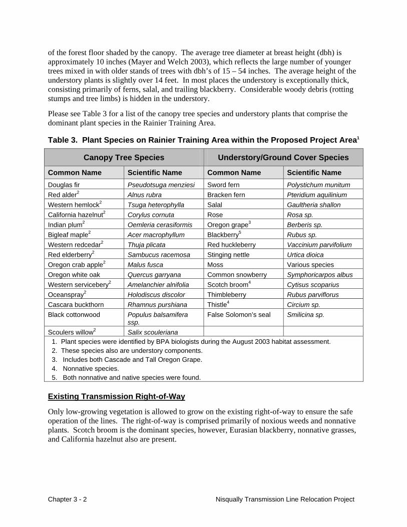
Please see Table 3 for a list of the canopy tree species and understory plants that comprise the dominant plant species in the Rainier Training Area.
Table 3. Plant Species on Rainier Training Area within the Proposed Project Area1
Canopy Tree Species Understory/Ground Cover Species
Common Name Scientific Name Common Name Scientific Name Douglas fir Pseudotsuga menziesi Sword fern Polystichum munitum Red alder2 Alnus rubra Bracken fern Pteridium aquilinium Western hemlock2 Tsuga heterophylla Salal Gaultheria shallon California hazelnut2 Corylus cornuta Rose Rosa sp. Indian plum2 Oemleria cerasiformis Oregon grape3 Berberis sp. Bigleaf maple2 Acer macrophyllum Blackberry5 Rubus sp. Western redcedar2 Thuja plicata Red huckleberry Vaccinium parvifolium Red elderberry2 Sambucus racemosa Stinging nettle Urtica dioica Oregon crab apple2 Malus fusca Moss Various species Oregon white oak Quercus garryana Common snowberry Symphoricarpos albus Western servicebery2 Amelanchier alnifolia Scotch broom4 Cytisus scoparius Oceanspray2 Holodiscus discolor Thimbleberry Rubus parviflorus Cascara buckthorn Rhamnus purshiana Thistle4 Circium sp. Black cottonwood Populus balsamifera
ssp. False Solomon’s seal Smilicina sp.
Scoulers willow2 Salix scouleriana 1. Plant species were identified by BPA biologists during the August 2003 habitat assessment. 2. These species also are understory components. 3. Includes both Cascade and Tall Oregon Grape. 4. Nonnative species. 5. Both nonnative and native species were found.
Existing Transmission Right-of-Way
Only low-growing vegetation is allowed to grow on the existing right-of-way to ensure the safe operation of the lines. The right-of-way is comprised primarily of noxious weeds and nonnative plants. Scotch broom is the dominant species, however, Eurasian blackberry, nonnative grasses, and California hazelnut also are present.
Chapter 3 - 2 Nisqually Transmission Line Relocation Project
Nisqually Transmission Line Relocation Project Chapter 3 - 3
Noxious Weeds
Noxious weeds are nonnative plants that have been designated as undesirable plants by federal or state law. Noxious weeds can degrade farm and rangeland, injure people and animals, and threaten native plant communities by displacing native species and decreasing species diversity. Under Washington state law, county noxious weed control boards are primarily responsible for controlling noxious weeds. Washington state law divides noxious weeds into three categories and requires each category be addressed differently.
• Class A noxious weeds must be eradicated;
• Class B noxious weeds must be controlled or designated for control - if already abundant, control is determined at the local level; and
• Class C noxious weeds must be controlled at a local level, depending on certain factors including feasibility of control.
There are several documented occurrences of Class B and C state-listed noxious weeds in and around the proposed project area.
• Meadow knapweed (Centaurea jacea x nigra), Class B - has been documented on the Nisqually Indian Reservation, in or adjacent to the existing right-of-way;
• Tansy ragwort (Senecio jacobaea), Class B - has been documented on or near the existing right-of-way on the Fort-owned parcel;
• Poison hemlock (Conium maculatum), Class C - has been found along the area of the proposed Phase II right-of-way.
• Scotch broom (Cytisus scoparius), Class B – is widespread on the existing right-of-way, with small amounts on the proposed right-of-way and specific areas of infestation on the Fort-owned parcel and the County-owned parcels.
Currently, Thurston County actively controls all the species listed above except Scotch broom. Given that Scotch broom infestations are widespread throughout the county, control is encouraged with containment of the species being the goal (Johnson 2003).
Protected Plants
Both federal and state governments list plants they have designated for protection. No federally-listed, proposed, or candidate plant species are known to occur in or adjacent to the proposed project area. Two federal “species of concern,” white-top aster (Aster curtus) and rose checker-mallow (Sidalcea malviflora ssp. virgata), have been documented in Thurston County. White-top aster is only found in (endemic to) the Puget Lowland and has been documented as occurring on Fort Lewis. This species is found primarily in high-quality native prairie. Since it grows in open areas, its main threat is from the infestation of invasive, nonnative plant species. Rose checker-mallow is often found in meadows, fields, and along roadsides. There are no known occurrences of either plant within a mile of the proposed project area.
There are nineteen state-listed species for Thurston County, including white-top aster. A search of the Washington Natural Heritage database indicated that there were no known occurrences of these state-listed plants in or adjacent to the proposed project area (WDNR 2003).
Environmental Impacts Vegetation could be impacted by the Proposed Action or alternatives by the following:
• Tree and plant removal and damage,
• Changes in the plant habitat,
• Loss of native seed, and
• Noxious weed infestation.
Proposed Action – Relocate Transmission Lines and Exchange Land
Transmission Line Construction and Maintenance
The overall impact of the Proposed Action on vegetation would be moderate, as it would cause the permanent removal of the native plant community in the right-of-way and the possible spread of a Class B noxious weed (Scotch broom), which is present in some areas, though fairly suppressed. (Please see Appendix B for impact ratings). There are no documented protected plants in the proposed project area; those plant species likely to be impacted are common, similar to the surrounding areas, and not in danger of needing protection.
Tree Clearing
The Proposed Action would require about 99 acres of trees to be cleared (63 acres of trees within the right-of-way and up to 36 acres of dangers trees along the edges of the right-of-way). If Phases I and II were built at separate times, an additional half acre would be cleared. The trees that would be cleared include those species listed in Table 3. Routine vegetation maintenance of the line would discourage tree re-growth in the right-of-way and remove subsequently identified danger trees.
Clearing and tree removal could damage adjacent trees not needing to be removed, and equipment could crush low-growing vegetation as trees are felled, and logs are salvaged.
Indirect impacts from clearing activities include increased sunlight penetration to the understory (see Table 3 for species), which is currently a shade-tolerant plant community. Some of these plants may not survive the increased sunlight and the plant community would likely change to more light-tolerant species. Many noxious weeds do extremely well in light, open areas, especially on disturbed sites. Noxious weeds tend to be extremely resilient and opportunistic species, with quick germination and regeneration rates. It is likely that Scotch broom, already present in the proposed right-of-way, would increase and spread.
Additionally, as trees are removed, precipitation reaching the ground is increased and the amount of water up-take is decreased. Trees use large quantities of water; their absence would result in more water availability. Increasing the amount of water in areas, especially low areas that can hold water, could potentially create long-term changes to the plant community (Kimmins 1987).
The removal of trees could result in a decrease in stand stability of adjacent trees. Trees that were previously protected would be exposed to wind and sun scold. This could lead to future tree
Chapter 3 - 4 Nisqually Transmission Line Relocation Project
blowdowns during high winds and storm events until the stand becomes more stable over time (Kimmins 1987).
Tree clearing would create moderate impacts.
Brush Removal and Soil Disturbance
Understory (low-growing vegetation) would be left along the right-of-way, except where construction would be required. The construction of towers and access roads, and the development of tension sites would require removing native vegetation and disturbing soil (grading). For lattice steel towers, about 16.5 acres would be disturbed (2 acres for new access road construction, 1.5 acres for pulling sites and 13 acres for tower sites). For steel pole towers, about 6.5 acres would be disturbed (2 acres for new access road construction, 1.5 acres for pulling sites and 3 acres for tower sites). Vegetation on access roads and at the tower footing sites would not be allowed to grow back. Grading and vegetation removal would disturb the soil. With soil disruption and removal of vegetation, noxious weeds would likely invade. Any change in the environment that affects the composition of vegetation or exposes the soil can allow noxious weeds to invade and dominate. As mentioned above, small amounts of Scotch broom are already present in the proposed right-of-way. Scotch broom or other weed seed could also be brought in with construction or maintenance vehicles previously working in areas of infestations, like the existing right-of-way.
Any removal of topsoil during construction would result in the loss of native seed and microbes and minerals that are essential to healthy plant growth. Topsoil removal would therefore result in less natural resurgence of native plants.
Heavy equipment used to dig footing holes, assemble towers, or pull conductor may compact the soil at tower assembly and pulling sites, making re-growth and recovery of vegetation difficult. Compaction of the soil could increase precipitation runoff. This could result in changes to vegetation as those species that adapt to higher precipitation levels become more prevalent. Runoff could lead to increased erosion (see Soils and Geology section) and loss of native seeds that would be found in the eroded topsoil. Increased water could result in decreased seed viability. Changes in water availability could occur with access road improvements and construction by directing water through ditches and culverts to other areas.
Brush removal and soil disturbance would create moderate impacts.
Line Removal
Vegetation would be cleared to allow access to the tower footings and to clear space to disassemble the tower on the ground. Vegetation impacted would be primarily nonnative plants and noxious weeds; impacts would be low. Over the long-term tall-growing vegetation could be allowed to reestablish, if compatible with Tribal and landowner use of the area.
Land Exchange
No short-term impacts to vegetation would result from transferring the ownership of the Fort-owned parcel to the Tribe. The Tribe does not have any immediate plans for the parcel. Potential long-term moderate impacts could include development or timber harvest, which would cause impacts to vegetation similar to the construction of the transmission line (tree
Nisqually Transmission Line Relocation Project Chapter 3 - 5
clearing, grading, etc.) and could convert the land from forest to developed properties. Areas on the Fort-owned parcel, where the existing right-of-way would be vacated, would no longer be managed to suppress tall-growing vegetation.
There would be low, potential positive, impacts to vegetation if the County-owned parcels were owned by Fort Lewis. The ownership may change how timber is harvested on the parcels. Any timber harvest by Fort Lewis would be in accordance with Fort Lewis’ management plans. For the parcels that could be managed for spotted owl habitat, timber harvest would be in accordance with the “Northern Spotted Owl Habitat Management Plan for Designated Conservation Area WA-43 Fort Lewis, Washington” (Owl Plan), the “Fort Lewis Integrated Natural Resources Management Plan,” and “A Forest Management Strategy for the Fort Lewis Military Reservation, Washington.”
Alternative 1 – Double-Circuit Towers on Existing Easement
This alternative would not remove any native vegetation or impact any protected species; impacts would be low. Only nonnative vegetation would be removed from a short section of the existing right-of-way for the construction of the double-circuit towers and removal of existing towers. The vacated portion of the right-of-way could be developed by the Tribe or tall-growing vegetation could be allowed to reestablish for a potential beneficial impact.
Alternative 2 – Relocate the Olympia-Grand Coulee Line Only
The impacts of this alternative would be similar, but somewhat less than the Proposed Action (moderate impacts). Fewer acres of vegetation (about 46.5 acres tree clearing) would be impacted because just one line would be constructed along Phase I only. The potential for the reestablishment of tall-growing vegetation on the existing right-of-way would be less than the Proposed Action since one line would remain.
No Action Alternative
The existing line would continue to operate and current vegetation management practices would continue. No plant communities would be disturbed and no protected species would be impacted. However, there may be indirect impacts as the right-of-way may continue to act as a seed bank for noxious weeds, allowing them to spread to other areas. Overall, impacts would be low.
Cumulative Impacts Vegetation in the general area could be cumulatively impacted by other actions occurring in the area or actions that could occur in the future. As development increases, a slow shift may occur from a primarily coniferous forest to one that is more dominated by deciduous trees. As urban expansion continues, and areas are logged and converted to other land uses, large blocks of native plant communities may slowly be replaced by more aggressive nonnative species. This is particularly evident as demonstrated by the continued spread of noxious weeds. However, Fort Lewis holds large tracts of lands in this area and the management of the Rainier Training Area is guided by its Owl Plan and other management plans. This management may allow for the
Chapter 3 - 6 Nisqually Transmission Line Relocation Project
establishment and maintenance of older forest communities in these areas. Also, Tribal, state, county and municipal planning may slow the rate of urban development and its impacts on native plant communities.
Mitigation Measures The following mitigation measures would help avoid, minimize, or compensate for the identified impacts to vegetation. Implementation of these mitigation measures would reduce the described impacts to low.
• Coordinate weed control activities with the Thurston County Weed Control Agency to reduce the threats of noxious weeds on the native plant community.
• Manage some of the County-owned parcels according to the Owl Plan, which would help maintain the integrity of native plant communities in the larger Rainier Training Area by only allowing timber harvest that benefits potential spotted owl use (such as thinning, creating mixed-age stands) and preserving the parcels from future clear-cutting. (See Wildlife Section.)
• Clean all construction vehicles before entering the Proposed Action right-of-way during construction to prevent the spread of noxious weeds.
• Save topsoil removed for tower and new access road (spur road) construction and use onsite for restoration activities, to promote re-growth from the native seed bank in the topsoil.
• Reseed tower sites as soon after disturbance as possible and when conditions are most conducive to germination.
• Break up compacted soils by tilling and scarifying soils before re-seeding.
• Use seed of native plant species where possible for vegetation restoration efforts.
• Plant tree seedlings in danger tree clearing areas to help control the spread of noxious weeds and restore native plant communities.
• Limit grubbing in the area around tower sites to lessen the impact on the roots of low-growing vegetation, so they may resprout.
• Monitor for revegetation and restoration success.
Unavoidable Impacts Remaining After Mitigation Based on the prolific nature of noxious weeds, their unintentional spread to areas not currently colonized may not be fully mitigated.
Nisqually Transmission Line Relocation Project Chapter 3 - 7
Wildlife
Affected Environment The proposed project area is made up of two fairly distinct habitat types. Fort Lewis lands are primarily forested habitat, while the existing right-of-way is kept as early-successional edge habitat (a recently cleared or young developing forest that provides an “edge” or change from an adjacent more dense, older forest). The proposed project area lacks wetlands (except on two of the County-owned parcels) and riparian areas. Appendix C lists wildlife species that were either determined to be present in the project area based on observations or signs (tracks, songs) or are potentially found in the area based on habitat type and occurrence in the general vicinity.
Rainier Training Area
Wildlife species associated with the mostly forested habitat of the Rainier Training Area (the proposed right-of-way, Fort-owned parcel and the County-owned parcels) can be divided into mammals, birds, reptiles and amphibians, and insects. Common mammals documented during habitat assessments included coyote, Columbia blacktail deer, Douglas squirrel, raccoon, and striped skunk. The area also contains a small mammal component that specialists were unable to document during surveys. Other mammals that are uncommon to the area (more sensitive species), but have been documented include black bear and the western gray squirrel. Some common bird species documented include black-capped chickadee, common raven, dark-eyed junco, purple finch, red-breasted nuthatch, great horned owl, barred owl, and red-tailed hawk. Common reptiles and amphibians observed include northwestern garter snake, Pacific treefrog, and western toad. Common insects include western thatching ant, western yellow jacket, and bald-faced hornet. Some wildlife are prey species (small mammals such as Douglas squirrel and mice species) that are food sources for predatory species (e.g., great-horned owl, coyote). Please see Appendix C for a more complete list of species and their scientific names.
The Rainier Training Area is designated as critical habitat for the northern spotted owl. Please see the section on Protected Wildlife Species and Habitat for more details.
Existing Transmission Right-of-Way
The existing right-of-way consists of early-successional edge habitat characterized by Scotch broom, nonnative grasses, and low-growing shrubs. Many of the wildlife species common to the forested areas are likely to use the existing right-of-way. Species like coyote and deer often use rights-of-way for foraging or as travel corridors between foraging areas. The existing right-of-way likely supports a small mammal population, though the species composition may be different from the forested area and densities may be higher. Perching birds (e.g., song sparrow) likely make up a large part of the wildlife component of the right-of-way. Studies have shown that powerline rights-of-way can be important habitats for early-successional scrubland birds (Askins 1994; King and Byers 2002). Since rights-of-way are maintained in an early successional stage, it provides the cover (low brushy areas) and food resources (e.g., berries and seeds) required by these species. However, due to the level of Scotch broom in the right-of-way, habitat quality may be marginal.
Chapter 3 - 8 Nisqually Transmission Line Relocation Project
Protected Wildlife Species and Habitat
The Washington State Department of Fish and Wildlife establishes a list of habitats and species that are considered priorities for conservation and management within the state. Priority species require protection and management to ensure their continued existence. Priority species include state endangered, threatened, sensitive, and candidate species; animal aggregations considered vulnerable; and vulnerable species valuable for their recreational, commercial, or tribal importance. The state also has monitor species, species that have no protection but are being monitored because of the potential need to protect them. Priority habitats are those areas (habitat types or elements) that are important to a diversity of species. A priority habitat may include a unique vegetation type, dominant plant species, a described successional stage, or specific structural element (WDFW 2003a).
There are no documented state endangered or threatened priority species in the proposed project area; however, the western gray squirrel (Sciurus griseus griseus), a state threatened species, has been documented within a mile north and southeast of the area (WDFW 2003b). Pileated woodpecker (Dryocopus pileatus) activity has been documented within the proposed project area (Mayer and Welch 2003); however, there are no detected nests. The pileated woodpecker, a state candidate species, has large home ranges and potential nesting habitat includes large snags (Carnevalia 2003). The closest documented pileated woodpecker nest is located north of the project area in the Nisqually National Wildlife Refuge. Osprey (Pandion haliateus), a state monitor species, has been documented in the project area, nesting in the Fort-owned parcel proposed to be transferred to the Nisqually Indian Tribe and in areas adjacent to the Rainier Training Area. Bald eagles and marbled murrelets are also priority species. They are discussed below under the federally-protected species section. Appendix C shows which species in the area have state protection.
There are currently no state-designated priority habitats in the proposed project area. The nearest priority habitats are located to the south and southwest. A waterfowl concentration area is located over two miles to the southwest of the proposed project area. In addition, two wood duck (Aix sponsa) priority habitat areas are approximately 1 and 1.5 miles away.
Federally-Protected Species
The Endangered Species Act (ESA) of 1973, as amended, protects species that are listed as endangered or threatened, or proposed for listing, from activities that may harm or harass them. Pursuant to the act, a federal agency must consult with the appropriate federal agency (United States Fish and Wildlife Service or National Oceanic and Atmospheric Administration) to ensure that its actions will not jeopardize the continued existence of the listed species. ESA-listed wildlife near the proposed project area include the bald eagle (Haliaeetus leucocephalus) and marbled murrelet (Brachyramphus marmoratus), both listed as threatened. In addition, the mardon skipper (Polites mardon) is listed as a federal candidate species. There are a number of federal species of concern documented in Thurston County. However, candidate species and species of concern do not receive any formal ESA protection. Appendix C shows which species in the area are federally listed.
Nisqually Transmission Line Relocation Project Chapter 3 - 9
Bald Eagle
Bald eagles have been protected since the passage of the Bald Eagle Protection Act in 1940. Protection for the species heightened in 1978 when the bald eagle was listed as endangered under the Endangered Species Act throughout its entire range within the lower 48 states (USFWS 1978). In 1995, the bald eagle was down listed to threatened due to population increases (USFWS 1995).
Bald eagles are usually attracted to bodies of water that provide foraging opportunities for fish and waterfowl. Nesting habitat normally consists of dominant trees within a line-of-sight of water. The bald eagle breeding, nesting, and rearing season extends from February 1 through August 15. The wintering period extends from October 31 through March 31. There are four bald eagles nests adjacent to the proposed project area. These nests are located along the Nisqually River. The two nests closest to the project area are approximately 0.8 mile away. The remaining nests are over 1 mile away. There are two wintering sites. One site is on the west side of the Nisqually River on the Reservation less than ¼ mile away from the existing right-of-way. The other wintering site is located along Muck Creek approximately 2.3 miles from the existing right-of-way.
Marbled Murrelet
The marbled murrelet, a small ocean bird that nests in inland areas, was federally listed as threatened in 1992 in Washington, Oregon, and northern California (USFWS 1992). One factor in determining to list the marbled murrelet was the loss of late-successional and old-growth forests—its preferred nesting habitat. During the nesting season, which extends from late March through mid-September, the murrelet lays one egg on the limb or nesting platform of a large conifer tree. These platforms are often formed by moss or mistletoe deformities. During the nesting season, the adults make daily trips to the marine environment to forage for food. Both adults take turns incubating the egg and providing food to the chick (USFWS 1997). There has only been one documented murrelet observation adjacent to the proposed project area, approximately 1.65 miles southeast of the project along the Nisqually River. The proposed project area lacks marbled murrelet nesting habitat, as there are few suitable trees.
Mardon Skipper
The mardon skipper is a small, orange butterfly found in Washington, Oregon, and California. It is known to inhabit only nine sites in Washington: in glacial outwash prairies of the south Puget Sound and in areas of the southern Cascades. The loss of native grasslands to development, invasive species, and the suppression of fire are the primary reasons for the species’ decline. The proposed project area does not contain suitable habitat to support mardon skipper populations.
Spotted Owl Designated Critical Habitat
On June 26, 1990, the northern spotted owl (Strix occidentalis caurina) was listed as threatened under the Endangered Species Act. In 1992, critical habitat units were designated to aid in the conservation and recovery of the species. In 1991, Fort Lewis was surveyed for areas of potential spotted owl habitat (Bottorff et al. 1991). The U.S. Fish and Wildlife Service later classified about 52,000 acres of Fort Lewis as critical habitat in recognition of its ability to serve
Chapter 3 - 10 Nisqually Transmission Line Relocation Project
as a corridor between two currently isolated populations of spotted owl found in the Cascade and Olympic ranges (ENSR 2003).
The Rainier Training Area is designated as critical habitat for the northern spotted owl. Fort Lewis actively manages these areas under its Owl Plan and other management plans.
The Owl Plan is designed to “accelerate the development of nesting, roosting, foraging, and dispersal habitat over what would occur without intervention” (DOA 1994). However, it does allow for some limited timber harvest if the harvest will have “a long-term positive effects on development and maintenance of owl habitat with stand and landscape units” (DOA 1994). There are no current or historically documented detections of northern spotted owl in the proposed project area (ENSR 2003).
Environmental Impacts Wildlife could be impacted by the Proposed Action or alternatives by the following:
• Removal of wildlife habitat (tree and brush clearing) causing animals to either permanently or temporarily move elsewhere, or experience increased exposure to predators, and/or lack of food and shelter;
• Removal of designated critical spotted owl habitat;
• Noise from construction or maintenance activities causing disturbance during wintering, breeding, or nesting seasons;
• Heavy equipment and logging killing or injuring wildlife unable to flee during construction activities; and
• Presence of conductors or fiber optic cable that could create hazards for birds.
Proposed Action – Relocate Transmission Lines and Exchange Land
If no mitigation measures were implemented, the overall impact of the Proposed Action on wildlife would be high, because it would permanently remove designated northern spotted owl critical habitat. There are no documented state-priority habitat or federally-protected wildlife in the proposed project area, though bald eagle wintering sites are about ¼ mile away from the existing right-of-way. Pileated woodpeckers, a state candidate species, use the proposed project area and would likely be disturbed during construction. Forest-specific prey species and food resources may be permanently destroyed as the right-of-way is constructed and a change in available habitat occurs.
Transmission Line Construction and Maintenance
Changes in Habitat Along the Proposed Right-of-Way
About 99 acres of forest habitat would be permanently changed to early succession habitat. These clearing activities would result in the destruction and adverse modification of designated northern spotted owl critical habitat as well as habitat for other species within the 17,000 acres that are designated for protection in the Rainier Training Area.
Nisqually Transmission Line Relocation Project Chapter 3 - 11
With the change from forested habitat to an early-successional habitat (tall-growing vegetation would not be allowed to grow within the right-of-way), the wildlife species composition should shift. More forest-dependant species would be replaced by those species that respond well to development and edges (right-of-way habitat). These species are often considered invasive (nonnative) species because they establish in disturbed areas, increase in number, and then disperse into undisturbed areas, further impacting forest species (Primack 1993). For example, the nonnative opossum are highly adaptable to different habitats, are opportunistic omnivores (eating both plant and animal material), and will eat native invertebrates, small mammals, amphibians, reptiles, and groundnesting birds, nestlings, and eggs.
New and improved roads could result in long-term disturbance to wildlife. Improved access could potentially result in increased illegal hunting and collecting activities. However, the existing access roads are used sporadically now by both Fort Lewis personnel and some members of the public.
Construction (access road work, tower site development and tree clearing) could potentially change the hydrology of the area. There are no wetlands along the proposed right-of-way, but some standing water could create habitat during wet times of the year. Ditches and culverts could direct water runoff from roads to new areas, which could change the distribution of species that require seasonally wet areas for breeding, especially amphibians (the Pacific treefrog, or Western toad). Because trees hold much water, tree removal could result in more runoff and standing water in low areas. This would likely change potential suitable habitat for certain species and create improved habitat conditions if it resulted in the collection and holding of water, which is almost nonexistent in the proposed right-of-way.
Habitat changes (without mitigation) would create high impacts. See Mitigation Measures for proposed mitigation.
Transmission Line and Bird Collisions
Electrocution of birds is not an issue with high-voltage transmission lines. Conductors on transmission lines are spaced far enough apart that the wingspan of even large birds cannot touch two wires at one time (which is required to cause electrocution).
The presence of the transmission line may result in the injury or death of individual birds due to collisions during poor light or flying conditions. Migratory waterfowl have the highest incidence of mortality from collision with transmission lines, particularly near areas of high waterfowl use (rivers, lakes, wetlands). However, during migration, waterfowl usually fly well above the level of transmission lines (APLIC 1994). A waterfowl concentration area is located over two miles to the southwest of the proposed project area. Waterfowl likely use the Nisqually River, however, the proposed transmission line does not appear to be in an established flight path. Mortality or injury due to collisions would not be expected to be higher than what currently occurs with the existing transmission line. Raptors can be injured or killed by collisions with transmission lines, however less frequently than waterfowl. Raptors are agile flyers and usually do not fly in poor light or weather conditions (APLIC 1994), so are less likely to collide with transmission lines. The towers may provide benefits to raptors by providing roosting and hunting platforms (APLIC 1996), although this would result in indirect adverse impacts to species the raptors prey upon.
Transmission line and bird collisions would create no to low impacts.
Chapter 3 - 12 Nisqually Transmission Line Relocation Project
Construction and Maintenance
During construction, wildlife could be injured or killed by heavy equipment or tree clearing. Wildlife most likely to be directly impacted would be species that have small home ranges and would not be able to leave the area, such as small mammals, amphibians, reptiles, and insects. Of the wildlife species that would be impacted, it is expected that no protected species would be killed or injured.
In addition, the removal of trees could result in the incidental death of birds, especially young still in nests. Most bird species and medium to large mammals would be temporarily disturbed by construction activities (noise, implosive fittings, human presence, helicopter use) and move out of the area. As clearing and construction work would most likely be done during the spring/summer-breeding season, nests may be destroyed and some species may fail to breed or abandon young as a result of the disturbances.
Construction would create moderate impacts.
Temporary disturbances to wildlife could occur over time due to periodic routine maintenance of the roads and lines. Noise (helicopter flights, human presence) and limited removal of habitat (vegetation management on the right-of-way or danger tree removal) could have similar impacts as described above, though to a lesser extent since the maintenance activities and vegetation removed would be much less than during construction.
Maintenance would create low impacts.
Line Removal
The limited removal of early-successional habitat to remove the existing transmission lines would primarily impact certain bird and small mammal species. Larger species that occasionally use the area would be temporarily displaced during construction activities, and there would be a temporary decrease in prey and food resources. Removal of the line during the breeding season could result in the failure of some individuals to breed and young to be abandoned. Any disturbed species would likely recover quickly. Since the wildlife species currently found along the existing right-of-way are accustomed to a certain level of disturbance, impacts to them should be low.
A bald eagle wintering area is currently located with ¼ mile of the existing right-of-way. Activities (presence of helicopters and increased noise) that would take place during the wintering period, which extends from October 31 through March 31, could result in a temporary moderate disturbance impact for bald eagles. However, helicopter restrictions would greatly reduce potential bald eagle impacts.
The removal of the line could result in allowing tall-growing vegetation to reestablish, and encourage the colonization and use by associated wildlife species.
Land Exchange
No short-term impacts to wildlife would result from transferring the ownership of the Fort-owned parcel to the Tribe. The parcel would no longer be managed under the Owl Plan, such that potential long-term impacts could include development or timber harvest on those 133.5
Nisqually Transmission Line Relocation Project Chapter 3 - 13
acres, with impacts similar to those described for the construction of the transmission lines (tree clearing, grading, wildlife disturbances, etc.).
There would be low to potentially positive impacts to wildlife if the County-owned parcels were owned by Fort Lewis because they would most likely be managed for spotted owl habitat improvement under the Owl Plan. These parcels have been logged, which created more interior edge habitat. Conserving and managing these lands under the Owl Plan would preserve the parcels from future clear-cut logging activities. Though the focus of the plan is on developing spotted owl habitat, other wildlife that required similar forest habitat characteristics would benefit.
Alternative 1 – Double-Circuit Towers on Existing Easement
This alternative would not result in the loss of any additional wildlife habitat, and could slightly increase available habitat if the small strip of vacated right-of-way was rehabilitated or if tall-growing vegetation grew back.
The conductors of the double-circuit towers would have a “stacked” configuration, such that the conductors are strung above one another at different heights. (The existing towers have a “flat” configuration so the conductors are strung adjacent to one another at the same height.) The stacked configuration of the double-circuit towers would be taller, would create a fence-like effect, and could increase the likelihood of bird collisions along that 0.7-mile stretch.
Impacts due to construction would be similar to those described for the line removal section of the Proposed Action (small animals killed or injured by heavy equipment, birds displaced, disturbance during breeding or nesting season, potential bald eagle disturbance, etc.). Impacts would be moderate without mitigation.
Alternative 2 – Relocate the Olympia-Grand Coulee Line Only
The impacts of this alternative would be similar to the Proposed Action, but with a lesser impact on habitat (45 acres of forest habitat permanently changed to early succession habitat). The impacts would still be considered high without mitigation because northern spotted owl designated critical habitat would be permanently destroyed.
No Action Alternative
The existing line would continue to operate where it is located and current vegetation management practices would continue. No habitat would be destroyed and no protected species would be impacted. Wildlife would periodically be temporarily disturbed and prey/food (forage) resources reduced due to routine maintenance practices for the transmission line. This alternative may result in low impacts to wildlife due to continued maintenance activities.
Cumulative Impacts Cumulative impacts to wildlife could result from the continuation of habitat degradation and destruction. Generally, wildlife distributions will change as habitats shift from forest to disturbed, edge areas. As urban expansion continues, wildlife species composition includes
Chapter 3 - 14 Nisqually Transmission Line Relocation Project
more common species like opossum, raccoon, skunks, coyotes, and rats. Pressures of development could further reduce the number of already rare and sensitive species requiring the need for legal protection. However, Fort Lewis holds large tracts of lands in this area and its Owl Plan and other management plans guide the management of these lands for the establishment and maintenance of older forest habitat. Because of the limited public access to Fort Lewis, it can serve as a type of refuge for many species sensitive to development. Wildlife areas near the proposed project area include the Nisqually National Wildlife Refuge, as well as conservation areas along the Nisqually River and west of the Rainier Training Area. Also, Tribal, State, county and municipal conservation planning may slow the rate of development and help ensure that many impacts to wildlife are mitigated.
Mitigation Measures The following mitigation measures would help avoid, minimize, or compensate for identified potential impacts to wildlife. Implementation of these mitigation measures would reduce the described impacts to low.
• Manage some of the County-owned parcels according to the Owl Plan to compensate for habitat removed along the proposed right-of-way and for the Fort-owned parcel being taken out of spotted owl habitat management.
• Limit removal of forest habitat to those trees that would interfere with transmission lines or the construction and upgrade of access roads.
• Re-vegetate disturbed areas with native plant seed.
• Create habitat piles with woody debris to enhance small animal habitat.
• Restrict helicopter flight patterns to reduce disturbance to sensitive species. Instruct helicopter crew during pre-construction meetings about flight restrictions,
specifically bald eagle and marbled murrelet sensitive areas. Restrict helicopters from areas east of the existing transmission line right-of-way,
specifically the Nisqually River area. Restrict helicopter ingress and egress to avoid the Nisqually River area. Maintain helicopter altitudes no less than 1,300 feet above ground level until over the
project area pursuant to Fort Lewis regulations (IAW FL Reg. 420-5).
• Do not locate staging areas near any known protected species.
Unavoidable Impacts Remaining After Mitigation Potential increases of nonnative wildlife species in response to disturbed habitat may result in increased predation and competition with more sensitive, native wildlife species. This could result in an overall decrease of sensitive species in the proposed project area.
Nisqually Transmission Line Relocation Project Chapter 3 - 15
Geology and Soils
Affected Environment The soils and geology of the project area include: types of soils present and their potential for erosion, fertility and drainage; terrain; and seismic activity of the area.
The project area is within the Puget Lowland (U.S Department of Agriculture, 1982). Soils formed primarily in glacial outwash on glacial terraces, moraines, and terrace escarpments. Some formed in a mixture of glacial outwash and volcanic ash. In general, soils are deep, coarse textured and somewhat excessively drained throughout the project area; however, an area within one of the County-owned parcels has deep, poorly drained muck soils formed in organic material derived from sedges. Well-drained coarse textured soils (sands and gravels) have a low potential to erode, though removing the shallow upper biological layer could increase that potential. Soil compaction is low in coarse textured soils relative to finer textured soils (clays and silts).
The proposed right-of-way rises from flatter areas along SR 510 (about 260 feet above sea level), to a series of low hills and ridges interspersed by swales. On the east portion (Phase I) there is a hill rising to 440 feet. Runoff is slow and the hazard of water erosion is slight along the right-of-way, except on slopes over 15 percent (on the eastside of the Phase I hill), where runoff is medium and the potential for water erosion is moderate.
The terrain of the Fort-owned parcel and Reservation is flat. This area likely represents an abandoned floodplain of the Nisqually River, which flows from southeast to northwest about 0.75 mile northeast of the project area. The County-owned parcels have varying terrain with some steep slopes, from 300 to 550 feet above sea level.
The project area is a seismically active area (Puget Lowland is a Class 3 seismic risk zone on a scale of 0-4, with 4 being the highest risk) that may experience some level of earthquake activity in the future. Bonneville designs transmission lines to withstand most earthquake activity.
Environmental Impacts Soils could be impacted by the Proposed Action or alternatives by the following:
• Ground disturbing activities (logging, grading, road building) that could expose soils to rain and cause erosion,
• Heavy equipment that could compact soils, reducing soil productivity and ability to absorb water, and
• Soil removal (grading tower sites, access roads) that would remove productive topsoil.
Proposed Action – Relocate Transmission Lines and Exchange Land
Overall, the impact on soils from the Proposed Action would be low to moderate without mitigation because much of the Proposed Action is on level ground, but there would be some work on slopes.
Chapter 3 - 16 Nisqually Transmission Line Relocation Project
Transmission Line Construction and Maintenance
Grading of tower sites and access roads and to a lesser extent, tree clearing, would expose soils to rain, possibly resulting in erosion. Soil would be exposed at tower sites (13 acres, if using lattice steel towers and 3 acres if using steel pole towers) and for access road construction and upgrades (about 6 acres). Holes would be dug for each tower to embed the footings or pole. Soil from these holes would be piled and then used for backfilling the holes once the footings were put in place. The piles of exposed soil could be a source of sediment during rain.
Tree clearing would expose soils to more weather (direct rain, wind), but lower-growing vegetation should continue to provide some cover. The extent for tree clearing to expose soils would depend on how much lower-growing vegetation was impacted during logging activities.
On most of the right-of-way, where the terrain is level, little erosion would occur. In areas of hilly terrain, (the east end of Phase I), where greater water flows are possible, the potential for stormwater runoff and erosion could cause moderate impacts. Two adjacent tower sites on this hill would be on a slope over 15 percent, with spur roads built from the upslope of the sites to the main access road. Potential impacts on exposed soils would continue to occur if soils were left bare or were slow to re-vegetate after construction.
Localized changes in runoff and erosion patterns could occur due to placement or removal of soil for new access roads and leveling of the tower sites.
The existing roads on the proposed right-of-way are susceptible to erosion because there is no vegetation growing on the roadbeds and the roadbeds have been compacted. Most water runs off or down the surface of the road, causing some erosion. Existing roads would be improved with water bars or similar water diversions. Two to three new culverts would probably be required along the existing access road (on the north-south portion of Phase I), to provide drainage from the adjacent slopes to low areas. Well-designed and maintained roads could potentially decrease soil erosion in the project area. New spur roads would slightly increase the amount of non-vegetated land in the area. Spur roads built across the hill would require roadcuts, which could interrupt subsurface water flow and cause erosion on the new road or road failure. The new roads would be graveled, which would help hold soil.
Heavy machinery (logging trucks, graders, excavators) and log movement would compact soils, reducing soil productivity and making it harder for plants to re-vegetate or grow back. Construction or tree clearing occurring in early spring, when the soils are usually very wet, would make rutting and compaction worse than if construction occurred in the dry season.
Throughout the life of the line, there would be low impacts to soils due to periodic line maintenance and vegetation management. Maintenance vehicles on access roads or around towers sites would cause minor soil disturbance. Vegetation management could result in low to moderate impacts depending on the timing of removal, amount of vegetation cleared, soil compaction, and subsequent erosion.
Line Removal
Soil impacts from line removal would be localized around tower sites (20 towers) and would be low. Because the tower’s legs would be cut 2-3 feet below ground level (with only small
Nisqually Transmission Line Relocation Project Chapter 3 - 17
amounts of digging needed around each footing), there would be minor soil disturbance that most likely would not cause an increase in erosion or stormwater runoff. The vegetation clearing would include cutting brush to create space to lay the towers down for disassembly and would not necessarily disturb the soil. The terrain is level along the existing right-of-way (less than 3 percent slope), further lessening the possibility of runoff or erosion.
Land Exchange
No immediate impact on soils is expected within the Fort-owned parcel because the Tribe has no current plans for development. If the Tribe developed the parcel or logged it, impacts to soils would be similar to that of the proposed line – soil disturbances, potential erosion, compaction and possible loss of soil productivity (if topsoil is removed).
No impact on soils within the County-owned parcels due to the change of ownership is expected; they would continue to be used for army maneuvers, with some timber management consistent with the Owl Plan.
Alternative 1 – Double-Circuit Towers on Existing Easement
Soil impacts from Alternative 1 would be low. Vegetation clearing would be minor (noxious weeds), tower removal would be similar to the line removal activities of the Proposed Action (though less because only eight towers would be removed), and about 3 acres of soil would be exposed for the construction of the new towers. Excavated soil piles and exposed soil could increase the potential of erosion during rain; however, the terrain is level (slopes less than 3 percent). Much of the productive topsoil may have been removed when the existing line was constructed so impacts to soil productivity would be low, and re-vegetation may be relatively slow.
Alternative 2 – Relocate the Olympia-Grand Coulee Line Only
This alternative would have low impacts on soil. The impacts would be similar to the Proposed Action although soil disturbance area would be considerably less; about 4.5 acres of soil exposed for tower sites and about 6 acres for access road construction and upgrades. Line removal would create fewer impacts than the Proposed Action; six towers would be removed with localized soil excavation.
No Action Alternative
Construction impacts on soils would be avoided. Continued operation and maintenance of the existing right-of-way would have no-to-low soil impacts because soil would rarely be disturbed.
Cumulative Impacts Past actions that may have adversely impacted soils in the project area include logging activities, military operations, transmission line construction, and commercial and residential development. Present designation of the proposed right-of-way and Fort-owned parcel as northern spotted owl critical habitat has most likely decreased adverse impacts on soil through restrictions on development and limited timber harvest. Future impacts on soils such as reduced productivity
Chapter 3 - 18 Nisqually Transmission Line Relocation Project
and compaction could increase as the area develops. The immediate area, where development would most likely occur, is relatively flat so erosion is not a concern if erosion control measures are used. Future commercial or residential development of the existing right-of-way could impact soils through grading, excavation, or potential chemical spills.
Mitigation Measures The following mitigation measures or best management practices (BMP) would reduce identified potential adverse soils impacts. Implementation of these mitigation measures would reduce the described impacts to low to moderate.
• Prepare a Stormwater Pollution Prevention Plan.
• If possible, construct during the dry season (summer-fall) to minimize erosion, sedimentation, and soil compaction.
• Save topsoil removed for tower and new access road (spur road) construction and use onsite for restoration activities, to promote re-growth from the native seed bank in the topsoil.
• Cover exposed piles of soil (or use other erosion control measures) if there is a threat of rain, to reduce erosion potential.
• Limit grubbing to the area around tower sites to lessen the impact on the roots of low-growing vegetation, so they may resprout.
• Minimize vegetation clearing at sides of access roads to two feet or less, where possible, to minimize impacts to adjacent forested areas.
• Install sediment barriers and other suitable erosion and runoff control devices prior to ground-disturbing activities at construction sites along Phase I to minimize off-site sediment movement.
• Leave erosion and sediment control devices in place and monitor their effectiveness until the site becomes stable.
• Retain existing low-growing vegetation where possible to prevent sediment movement offsite.
• Design access roads to control runoff and prevent erosion by using low grades, outsloping, intercepting dips, water bars, or ditch-outs.
• Rock all new access roads to prevent erosion and rutting.
• Re-vegetate or seed all disturbed areas with a native (where possible) plant/grass seed mixture suited to the site, to promote re-vegetation that will hold soil in place.
• Break up compacted soils where necessary by tilling or scarifying before re-seeding.
• Monitor erosion control BMPs to ensure proper function and nominal erosion levels.
• Monitor re-vegetation and site restoration work for adequate growth; implement contingency measures as necessary.
Nisqually Transmission Line Relocation Project Chapter 3 - 19
Unavoidable Impacts Remaining After Mitigation Unavoidable impacts remaining after mitigation include potential for increased erosion throughout the proposed right-of-way, soil compaction, and loss or changes in soil productivity next to and under new towers and on roadbeds.
Water Resources and Fish
Affected Environment There are no streams, lakes or ponds located along the existing transmission line corridor, the proposed new corridor, or on the Fort-owned land. There are many unnamed seasonal creeks that flow through various tracts of the County-owned parcels.
No floodplains would be crossed or affected by the Proposed Action or any of the alternatives. The project area is outside of the 100-year floodplain for the Nisqually River. The river is at an approximate elevation of 100 feet and the lowest areas of the project are about 260 feet.
With no water bodies within the project, there is no fish habitat. The closest body of water, the Nisqually River, is approximately 0.35 miles northeast of the project area. The only other water body within one mile of the project area is Lake St. Claire.
Wetlands are areas of transition between aquatic and terrestrial systems, where water is the dominant factor determining the development of soil characteristics and associated biological communities. They are important communities that have declined over the years due to an increase in agriculture practices and urban development. Though there are some wet areas within the proposed right-of-way, they seem to be a result of seasonal runoff and collection in low spots and are not determined to be actual wetlands. There are no wetlands within the existing right-of-way. There are a number of wetlands within one of the County-owned parcels and two wetlands (as mapped by the National Wetlands Inventory) within the Fort-owned parcel. During a field visit to the Fort-owned parcel, the two mapped wetlands were not found.
The proposed right-of-way, Fort-owned parcel, and County-owned parcels are located above a critical aquifer recharge zone. A Thurston County wellhead protection zone underlies the west end of the Fort-owned parcel and is adjacent to the west terminus of Phase II on the existing right-of-way. The wellhead protection zone was designed to protect recharge areas near municipal water supplies, such as wells and springs. The groundwater in this area of Thurston County supplies water to McAllister Springs, a major source of high quality drinking water, which serves about 30,000 people. There are approximately six Thurston County wells outside of the wellhead protection zone along the Yelm Highway, east of the project area. These public wells are generally between 200 and 300 feet deep, while most privately owned wells are about 100 feet deep.
Chapter 3 - 20 Nisqually Transmission Line Relocation Project
Environmental Impacts
Proposed Action, Alternative 1, and Alternative 2
No impacts to water bodies, floodplains or fish are expected from the Proposed Action or any of the alternatives because no water bodies are present with the project area.
No impacts to wetlands would be expected; none are present on the proposed or existing rights-of-way.
The two mapped wetlands on the Fort-owned parcel are not expected to be impacted by the change in ownership to the Tribe; the wetlands were not found in the field, most likely do not exist and any development that could occur in the future on the property would need to take into account impacts on wetlands.
The wetlands on the County-owned parcels most likely would not be impacted by the change in ownership to Fort Lewis since the Fort Lewis staff is aware of the wetlands and would manage the land to minimize impacts.
No impact to the groundwater would be expected from the Proposed Action or any of the alternatives because although soils are course-grained and porous, depth to groundwater used for drinking water is deep (public wells in the general area tend to be over 90-feet deep). Excavations could potentially reach a seasonal perched water table. If there were fuel or oil spills from construction equipment, there would be a slight risk of contamination of the seasonal perched water table.
Cumulative Impacts No cumulative impacts would occur since no impacts to water resources would occur.
Mitigation Measures The following mitigation measures would help ensure there would be no impacts to groundwater:
• Develop and implement a Spill Prevention, Control and Countermeasure Plan to minimize the potential for spills of fuels, oils, or other potentially hazardous materials to reach the seasonal perched water table or surface water bodies.
• Keep vehicles and equipment in good working order to prevent oil and fuel leaks.
No mitigation measures are needed for water bodies since no impacts would occur.
Unavoidable Impacts Remaining After Mitigation No unavoidable impacts would remain after mitigation since no impacts to water resources would occur.
Nisqually Transmission Line Relocation Project Chapter 3 - 21
Land Use and Transportation
Affected Environment Land uses in the area include a military reservation used for military operations, wildlife habitat, forest land, rural residential land, and dispersed recreation land; Reservation and tribal trust land used for administrative, commercial and residential facilities; private land; and a transportation corridor (SR 510 and other connected roads) (see Figure 4). Land potentially affected by the project includes land owned by the Tribe, Fort Lewis, Thurston County, private landowners and the state.
Rainier Training Area
Fort Lewis is an 86,176-acre military reservation used for weapons qualification and field training. The Fort Lewis land affected by this proposal is within the Fort’s 17,000-acre Rainier Training Area. The section of the Rainier Training Area that would be affected by the proposed project is forest and cleared forest land that is used for light infantry maneuvers and other military training (U.S. Department of the Army, July 2001). The Fort-owned portions of the Rainier Training Area are managed for spotted owl habitat (see Wildlife Section) with selective timber harvesting. The proposed right-of-way and the Fort-owned parcel have gravel and dirt roads authorized for Fort Lewis use only. In addition to military operations, the land has been used for dispersed recreation such as walking and wildlife viewing, forest products gathering (floral greens, edible plants, and medicinals), cedar tree bark stripping, and illegal dumping.
Fort Lewis leases the County-owned parcels (which are located within the boundaries of the Rainier Training Area) for military operations and the County harvests the timber on the lands.
The land within Fort Lewis (including the County-owned parcels) is zoned “Military Reservation District” by Thurston County. This designation recognizes that the “primary purpose of the military reservation is the military mission of training and national defense. A secondary purpose is natural resource production” (Thurston County Code, November 18, 2003). The County has no regulatory authority over federal land use.
Nisqually Indian Reservation
The Nisqually Indian Tribe of the Nisqually Reservation, Washington, is a federally-recognized Indian Tribe.
The original Nisqually Indian Reservation was established by the Medicine Creek Treaty of December 26, 1854 (South Puget Intertribal Planning Agency, October 20, 2003). The treaty set aside 1,280 acres on Puget Sound. In 1856, an Executive Order enlarged the reservation to 4,717 acres on either side of the Nisqually River. The Tribe lost much of that land when Fort Lewis was expanded during World War I.
Presently, the total Tribal land holdings, on and near the Reservation, are more than 1,000 acres and have been acquired in the past 25 years (South Puget Intertribal Planning Agency, October 20, 2003). The Tribe is a sovereign nation and though the County has zoned land within
Chapter 3 - 22 Nisqually Transmission Line Relocation Project
the Reservation, the County does not have regulatory authority over land use on the Reservation (Thurston County Planning Department, November 1992).
The land just north of the existing transmission line on the Reservation is zoned R1/5 (one dwelling unit per 5 acres) or R1/2 (one dwelling unit per 2 acres) and is used for residential housing and for tribal administrative office buildings. There is a subdivision adjacent to the Nisqually Tribal Offices that is zoned R1/2 because it meets the County’s Comprehensive Plan criteria for highest rural density and was a pre-existing subdivision when the Nisqually Sub-Area Plan was developed (Thurston County Planning Department, 1992). There are other scattered houses near the transmission lines (see Figure 4). For safety reasons, Bonneville prohibits the construction or maintenance of structures within the right-of-way.
Land ownership on the Reservation is mixed. Because of the complicated history of federal Indian policy, parcels of land on the Reservation are owned by the Tribe, individual tribal members, in trust by the Federal Government, and by non-Indians. There are also Indian trust lands located adjacent or near the Reservation.
South of SR 510 the Tribe has administrative offices, a law enforcement facility, a casino and a gas station complex. The Red Wind Casino is an Indian-owned gaming facility. The Tribe is in the process of expanding the casino. The gas station to the east of the casino includes a convenience store. The land being used for commercial development is zoned Arterial Commercial District (Thurston County Code, November 18, 2003), which allows for improvements to existing strip development and high-density residential uses. This is the only area where this zoning designation applies (Thurston County Code, November 18, 2003).
South of the administrative tribal facilities is a residential subdivision. Near the eastern end of the Proposed Action, there are two houses near the Reservation boundary with Fort Lewis. The portions of the Reservation that have not been developed for residential, commercial or administrative use are in forest land.
Rural Residential Land
The existing transmission lines cross one parcel (zoned R1/2) of private land north of SR 510 within the Reservation boundary. There are two other private parcels between the Reservation and the Fort Lewis boundary south of SR 510. These parcels are zoned R1/5. (See Figure 4.)
The area to the west of the Fort Lewis boundary is zoned McAllister Geologically Sensitive Area District. Development is restricted in this zoning district. This designation only allows future development of 1 unit per 5 acres to protect McAllister Springs, a municipal water supply for Olympia. Residential development is allowed at a density that will “minimize the potential for contamination or significant loss in recharge capacity of a vulnerable groundwater aquifer and potable water source of great importance to the general public” (Thurston County Code, November 18, 2003). An existing subdivision was established before this zoning designation took effect (1988); new development is limited by this restriction. A new subdivision that meets this restriction is being built west of the existing lines.
The land north of the Fort-owned parcel is zoned R1/5 and is not within the McAllister Springs Geologically Sensitive Area District. Some parcels have been developed for housing. Other parcels are currently in forest land.
Nisqually Transmission Line Relocation Project Chapter 3 - 23
Transportation
Principal roads in the area are the Yelm Highway (a county road), State Route 510 (a rural arterial state highway), and Reservation Road (a county collector). Other main roads in the area are She-Nah-Num Drive, the main road into the Nisqually Reservation, Elders Road, and unnamed roads on the Fort Lewis Military Reservation.
The Yelm Highway and SR 510 are both two-lane arterial roadways that have 60-foot wide rights-of-way. The existing transmission line corridor closely parallels SR 510 for about 2 miles. It crosses SR 510 near the intersection of the Yelm Highway and SR 510.
Environmental Impacts Land use could be impacted by the Proposed Action or alternatives by the following:
• Placement of transmission lines and roads that would prevent or limit existing or potential land uses, and
• Construction or maintenance activities that could disrupt existing uses through noise, dust, and traffic.
Proposed Action – Relocate Transmission Lines and Exchange Land
Transmission Line Construction and Maintenance
Removal of the existing transmission lines, and construction of the new transmission lines would cross land use categories and create brief, temporary, low impacts to residents. Most construction activities would take place either on existing right-of-way and access roads, or would be on Fort Lewis away from residences (with a few exceptions, see Figure 4). Impacts would include noise, dust and traffic disruption. Impacts to residents near, but not immediately adjacent to the corridor would be limited to temporary inconveniences associated with traffic delays on SR 510, equipment movement on nearby access roads, and from dust and noise from construction activity, including tree removal. The construction of the new lines would mostly affect the residences south of SR 510. No construction would take place on private property.
Construction activities would temporarily generate a small increase in vehicular movement over the six-month construction period, and may alter circulation patterns and increase traffic hazards on local roads for a short period of time.
Operation and maintenance of the new transmission lines would create brief, temporary disturbances in most instances, because most activities would take place on Fort Lewis, away from residences with a few exceptions.
The proposed transmission line and right-of-way would change land use somewhat on the Rainier Training Area; the impact would be moderate. The Fort would grant Bonneville a permit to build, operate and maintain the right-of-way. Fort Lewis would be able to continue to use the underlying land for military operations as long as they were consistent with the protection and safety of the transmission facilities and military personnel and equipment. Minimum height-clearance for the 230-kV line is 41 feet and 43 feet for the 287-kV line. Fort Lewis would retain the rights for the trees cut for the proposed right-of-way and for danger tree
Chapter 3 - 24 Nisqually Transmission Line Relocation Project
removal. About 125 acres of forest land on Fort Lewis would be converted to a transmission line corridor and access roads.
The new transmission lines would not be expected to interfere with or limit adjacent residential land uses. There would be a 125-foot buffer from the edge of the fence line separating the residential and Fort property. Please see the Visual Resources, Noise, Socioeconomics, and Public Health and Safety sections for more information about potential impacts to these properties.
Authorized personnel who use the existing roads along the proposed right-of-way would still be able to access this part of Fort Lewis. The presence of the transmission lines would not prohibit access by unauthorized personnel, though some of the unauthorized use (recreational walking and gathering of forest products) would be impacted by the removal of vegetation.
Staging areas would be located on already developed land, so no land use change would occur.
The Thurston Regional Planning Council recently reported that the traffic volumes on SR 510 are increasing and the state may widen the highway from the current two-lane width to four or five lanes within the next 20 to 25 years. The largest expansion design would include a divided, multi-lane facility, with a right-of-way width of 190 feet. The edge of the proposed transmission line right-of-way along the southern edge of the SR 510 right-of-way is far enough away so the proposed project should not interfere with any future plans for widening SR 510 in this area.
Phase I of the Proposed Action would cross SR 510 twice (if the phases were built at different time frames) (see Figure 4). If Phase II is implemented at a later date, the SR 510 crossing near Elders Way would be removed. Phase II would cross Yelm Highway (see Figure 4). Bonneville would design the transmission lines to meet the standards of the National Electric Safety Code (NESC). The NESC requires a minimum ground-to-wire-clearance of 41 feet for 230-kV lines and 43 feet for 287-kV lines. The heights of these transmission lines would meet the state and county minimums and the conductor height would have no impact on traffic and transportation that would use these public roads.
Line Removal
Because existing transmission lines would be removed from the Reservation, the easements would be returned to the Tribe, tribal members and one private landowner. With the transmission lines removed, existing restrictions would be lifted from the 250-foot width of land and the land could be used for whatever purposes the Tribe or other landowners desire. Impacts would be considered moderate, and beneficial to the Tribe and other landowners.
Line removal would occur on a portion of the Fort-owned parcel; the Tribe would acquire that parcel, and thus would be able to use the vacated right-of-way.
Land Exchange
No short-term impacts to land use would result from transferring the ownership of the Fort-owned parcel to the Tribe. The Tribe has no immediate plans for this parcel, though it could be developed in the future.
Nisqually Transmission Line Relocation Project Chapter 3 - 25
Because the parcel is currently in federal ownership, Thurston County has no authority over land use of the parcel. After the land exchange, the parcel would, after a 2-3 year process, be held in trust for the Tribe by BIA. Since BIA is a federal agency, the county would have no authority over land use of the parcel. Between the time of transfer and the end of the BIA process, the land would be required to conform to county zoning requirements.
After the land exchange, a small portion of the Fort-owned parcel would continue to have transmission lines on it and use within Bonneville’s right-of-way would have some limitations (including that no structures could be built). The land use of the rest of the parcel could change in the long term if the Tribe chooses to develop or log this land in the future. Impacts would be low to moderate depending on what the development included.
During the scoping period, some commentors expressed concerns about the potential development of the Fort-owned parcel with a change to tribal ownership. Local residents use the parcel for dispersed recreation and enjoy having the undeveloped “open space” adjacent to their properties; they would prefer that the parcel remain accessible and forested. Residents who use the Fort-owned parcel may lose access to this parcel when ownership changes. Impacts would be low.
Land use of the County-owned parcels would essentially remain the same under Fort Lewis ownership (continued military operations); however it would be managed under the Fort’s plans, which, for some of the parcels, would include timber harvest consistent with spotted owl conservation. Impacts would be low.
Alternative 1 – Double-Circuit Towers on Existing Easement
This alternative would only involve land use on the Reservation. Towers from the expired 125-ft. wide easement would be removed and the easements would be returned to the underlying landowners (the Tribe and tribal members). The land would have no restrictions and could be used for whatever purposes the Tribe or other landowners desire. The allowed land use under the perpetual easement (adjacent to the road) would not change as the towers are converted to double-circuit; however the double-circuit towers would be built in different locations than the existing towers. Short-term impacts of dust, noise and construction activities would be similar to the tower removal of the Proposed Action, but fewer towers would be removed. Impacts would be low.
Alternative 2 – Relocate Olympia- Grand Coulee Line Only
With Alternative 2, the easement for the Olympia-Grand Coulee line would be removed so the underlying landowners (tribe, tribal members and one private landowner) could use the land without the restriction of the line. As with Alternative 1, use of the land would be limited by the continued existence of the Olympia-South Tacoma perpetual easement adjacent to the road.
The short-term impacts from line removal and construction would be the same as the Proposed Action (dust, noise, traffic congestion). Land use changes would be similar to the Proposed Action (military operations would need to be consistent with the protection and safety of the lines and personnel; forest land would be converted to corridor, limiting timber harvest, spotted owl management, and military operations on Fort Lewis), but fewer acres of new land would be
Chapter 3 - 26 Nisqually Transmission Line Relocation Project
encumbered, as only one right-of-way would be needed. Land exchanges most likely would not take place. The Tribe would be able to use the land where the Olympia-Grand Coulee line was removed for other uses, but since the Olympia-South Tacoma line would remain, those uses might be limited. Impacts would be moderate.
No Action Alternative
Line removal and construction-related impacts would not occur. The existing lines would continue to limit potential land use or development of the right-of-way. Impacts would be low.
Cumulative Impacts Land use of the general area appears to be slowly changing from rural and forested to scattered commercial and residential development. The proposed project could potentially add to the change, if the Tribe develops the existing right-of-way or the Fort-owned parcel.
Mitigation Measures The following mitigation measures would reduce identified potential adverse impacts on land use. Implementation of these mitigation measures would help maintain impacts to low to moderate:
• Ensure that Bonneville’s Project Manager was available to meet with concerned landowners to discuss issues and concerns to avoid potential land use conflicts.
• Distribute a proposed schedule of construction activities to all potentially-affected landowners and nearby residents along the corridor so they know when they might experience construction-related disruptions.
• Work with the Washington Department of Transportation on the construction activities and a proposed schedule to identify any traffic advisories needed.
• Use traffic safety signs and flaggers to inform motorists and manage traffic during construction activities along SR 510.
• Use traffic controls during construction activities to conform with industry safety standards.
Unavoidable Impacts Remaining After Mitigation Some short-term construction impacts would be unavoidable, such as traffic delays, and noise and dust for those close to construction activity. They would cease once construction is completed. The Proposed Action would change existing land uses on Fort Lewis for the long term because military operations would have to be carried out in consideration of safety around the new lines.
Nisqually Transmission Line Relocation Project Chapter 3 - 27
Visual Quality
Affected Environment The visual resources of the project area that could be affected include: forest land, rural residential land, and limited commercial land; views from SR 510 and local roads; views from houses and commercial development; and views by residents, motorists, army personnel, customers and workers at the casino, store and other buildings.
Existing Right-of-Way
The local topography of the proposed project has some relief and areas of tall vegetation, which obstruct long-distance views from most locations. The project area is bisected by SR 510, which provides the main transportation corridor through the area. The area is generally a rural residential landscape, with scattered homes and stretches of open space or forest land and a small commercial area next to SR 510. The existing right-of-way, which parallels SR 510, is flat, with scattered low-growing vegetation including Scotch broom. Tall trees along part of SR 510 provide some screening of the existing lines. The existing transmission line corridor is a dominant visual feature of the setting, providing contrasts with the surrounding forest land, residential and commercial land, and creating a cleared linear feature defined by the form and texture of the existing lattice steel towers. Photo 1 shows the existing right-of-way.
The existing transmission lines are visible to travelers on SR 510, from the residential housing and tribal office buildings north and south of SR 510, and from the Tribe’s commercial development (Red Wind Casino, gas station and convenience store) south of SR 510. For about ½ mile, motorists’ views are screened by tall trees on each side of SR 510.
Viewers have foreground, middle and background views of the lines. Some residents north of SR 510 have the right-of-way next to their back or side yards. Just north of SR 510, several residential streets (Muck Creek, Nisqually, She-Nah-Num, Muk Sut Wei) cross the right-of-way. Residents can see the lines from many of their homes and when crossing under the lines to access SR 510. A few residents south of SR 510 and east of the commercial development (on Leschi Road) have “front yard” views of the existing lines across SR 510. The right-of-way and the resulting open space that clearing for the right-of-way has created is sometimes used for temporary fireworks stands, fish-selling and other tribal activities. These viewers are near the towers or under the existing lines.
Proposed Right-of-Way
The proposed right-of-way is forest land dominated by coniferous species, with some nearby residences on and off the Reservation. The topography is varied, with flat slopes along SR 510 and steeper, more varied slopes south of SR 510 and the Reservation.
South of SR 510 are tribal administrative offices, residences for tribal members, and private land with residences. Most of the occupants of these structures do not have views of the existing lines because their views are screened by other structures or vegetation. These viewers, and other
Chapter 3 - 28 Nisqually Transmission Line Relocation Project
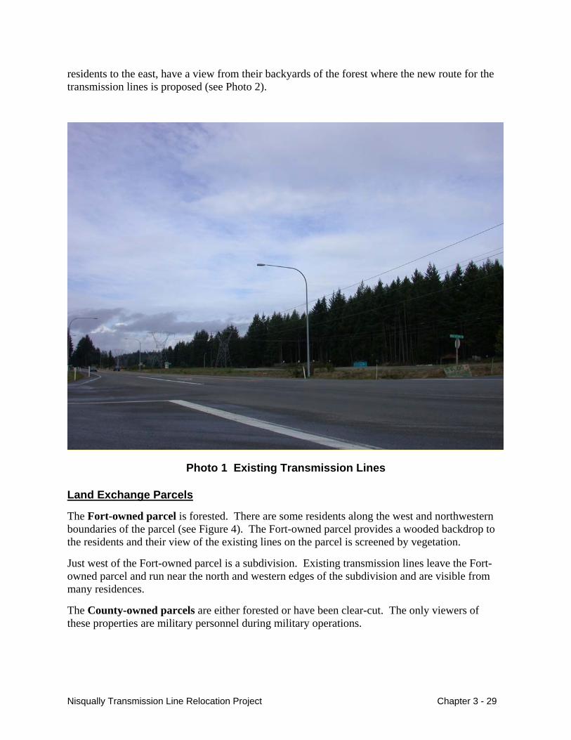
residents to the east, have a view from their backyards of the forest where the new route for the transmission lines is proposed (see Photo 2).
Photo 1 Existing Transmission Lines
Land Exchange Parcels
The Fort-owned parcel is forested. There are some residents along the west and northwestern boundaries of the parcel (see Figure 4). The Fort-owned parcel provides a wooded backdrop to the residents and their view of the existing lines on the parcel is screened by vegetation.
Just west of the Fort-owned parcel is a subdivision. Existing transmission lines leave the Fort-owned parcel and run near the north and western edges of the subdivision and are visible from many residences.
The County-owned parcels are either forested or have been clear-cut. The only viewers of these properties are military personnel during military operations.
Nisqually Transmission Line Relocation Project Chapter 3 - 29
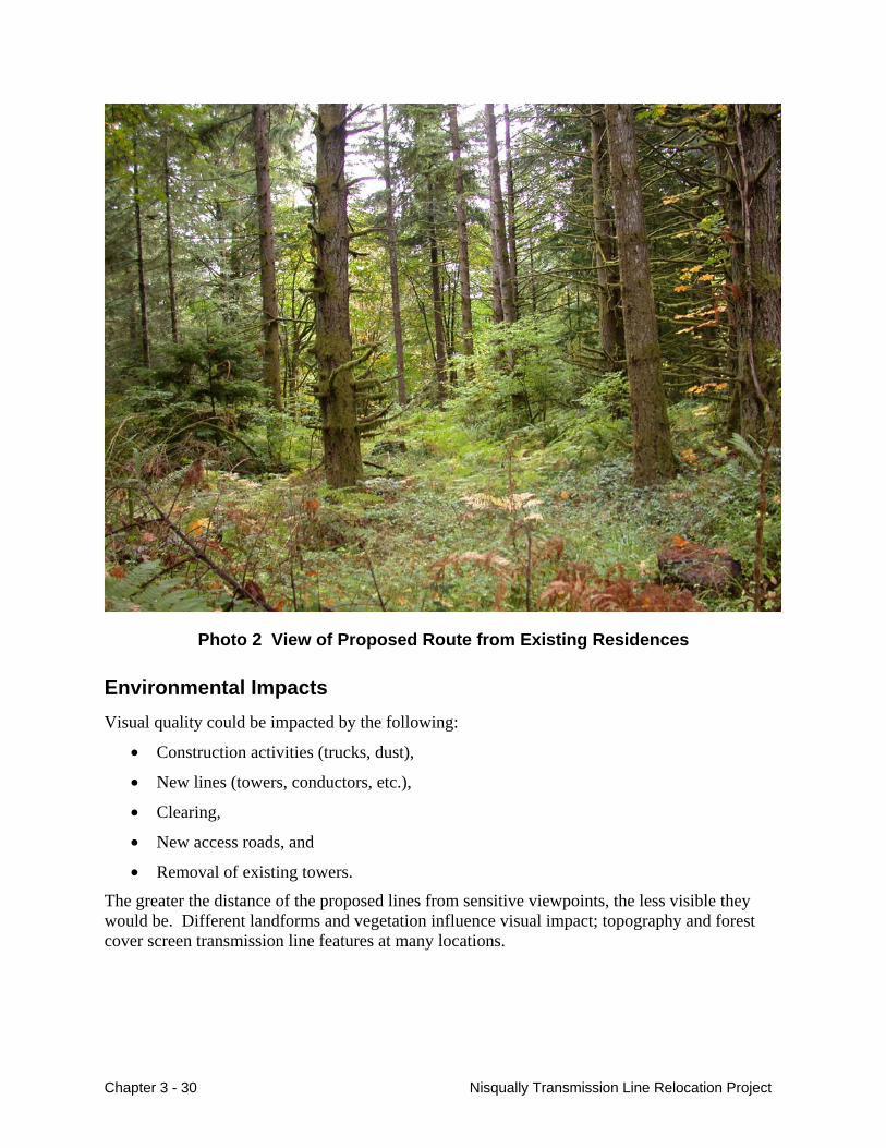
Photo 2 View of Proposed Route from Existing Residences
Environmental Impacts Visual quality could be impacted by the following:
• Construction activities (trucks, dust),
• New lines (towers, conductors, etc.),
• Clearing,
• New access roads, and
• Removal of existing towers.
The greater the distance of the proposed lines from sensitive viewpoints, the less visible they would be. Different landforms and vegetation influence visual impact; topography and forest cover screen transmission line features at many locations.
Chapter 3 - 30 Nisqually Transmission Line Relocation Project
Proposed Action – Relocate Transmission Lines and Exchange Land
Transmission Line Construction and Maintenance
Construction activity within the corridor would cause short-term impacts on the visual environment. Workers and large equipment would be visible along the existing and new right-of-way for about 6 months. Construction could create some dust. Access to towers would be from SR 510; motorists would be exposed to construction activity and there may be intermittent lane closures while construction takes place at the highway crossings. Construction activities and temporary lane closures along SR 510 represent a low impact to motorists, because views would be brief and the effect short-term.
Potential long-term impacts would result in the development of a new corridor on previously undeveloped forest land.
Military personnel would see the new transmission lines each time they entered this part of the Rainier Training Area for training. Training in this area is intermittent, and military personnel would be focused on their maneuvers and would not be as sensitive to the change in views. Impacts would be low.
Residents are generally sensitive to changes in their surrounding environments and views. Some residents south of SR 510 would be able to see the new lines and corridor. Clearing required for the right-of-way and danger trees could remove the existing tall vegetation on Fort Lewis behind their residences. The views of the lines and the cleared right-of-way would mostly be in the middleground and background, but some would have foreground views from their backyards. Existing or added vegetation on their property would help screen the view and lessen impacts. Impacts would be low to moderate.
The new lines would not be visible to the south from the casino because a ridge and tall Douglas fir trees behind the casino screen the view of Phase I. To the west other vegetation would screen Phase I. Workers in the tribal administrative offices south of SR 510 would be able to see the new transmission lines (Phases I and II). Their view would be partially screened by existing vegetation on their side of the boundary with Fort Lewis. Impacts would be low to moderate.
Motorists would continue to view the transmission lines and towers in the areas where the new transmission lines would cross SR 510 and Yelm Highway (see Figure 4). Phase I would cross SR 510 twice. Views to motorists would be brief. Most of the rest of the right-of-way would not be visible from SR 510, except on the eastern end where the line would be visible briefly climbing the ridge along the Fort boundary.
Phase II would remove the Phase I SR 510 crossing and the lines would be built parallel to SR 510, then cross the Yelm Highway. There would be a 125-foot strip of land between the transmission line right-of-way and the highway right-of-way. Many of the trees in this 125-foot strip would most likely be identified as danger trees and would have to be removed. However, there may be some trees that could be left to help screen views of the transmission lines. Over the long term, trees would be allowed to re-grow within this strip, as long as the trees are stable and do not become a threat to the lines. The lines would be visible to motorists for almost 1 mile (see Photo 3). The crossing at Yelm Highway would be visible to motorists, but would be similar to their view of the existing transmission lines in this part of the project area.
Nisqually Transmission Line Relocation Project Chapter 3 - 31
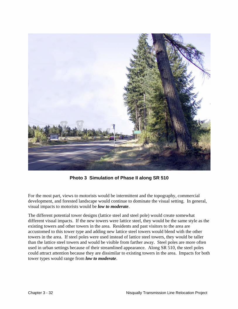
Photo 3 Simulation of Phase II along SR 510
For the most part, views to motorists would be intermittent and the topography, commercial development, and forested landscape would continue to dominate the visual setting. In general, visual impacts to motorists would be low to moderate.
The different potential tower designs (lattice steel and steel pole) would create somewhat different visual impacts. If the new towers were lattice steel, they would be the same style as the existing towers and other towers in the area. Residents and past visitors to the area are accustomed to this tower type and adding new lattice steel towers would blend with the other towers in the area. If steel poles were used instead of lattice steel towers, they would be taller than the lattice steel towers and would be visible from farther away. Steel poles are more often used in urban settings because of their streamlined appearance. Along SR 510, the steel poles could attract attention because they are dissimilar to existing towers in the area. Impacts for both tower types would range from low to moderate.
Chapter 3 - 32 Nisqually Transmission Line Relocation Project
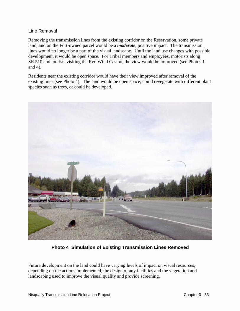
Line Removal
Removing the transmission lines from the existing corridor on the Reservation, some private land, and on the Fort-owned parcel would be a moderate, positive impact. The transmission lines would no longer be a part of the visual landscape. Until the land use changes with possible development, it would be open space. For Tribal members and employees, motorists along SR 510 and tourists visiting the Red Wind Casino, the view would be improved (see Photos 1 and 4).
Residents near the existing corridor would have their view improved after removal of the existing lines (see Photo 4). The land would be open space, could revegetate with different plant species such as trees, or could be developed.
Photo 4 Simulation of Existing Transmission Lines Removed
Future development on the land could have varying levels of impact on visual resources, depending on the actions implemented, the design of any facilities and the vegetation and landscaping used to improve the visual quality and provide screening.
Nisqually Transmission Line Relocation Project Chapter 3 - 33
Land Exchange
There are some residences that border the Fort-owned parcel. These residences have an existing forest screen between their homes and the existing and proposed transmission lines. There would be no to low impacts to these residents as long as the vegetative screen remains. If at some point timber is removed from this land and the land is developed, there could be resulting visual impacts to motorists, some residents of a subdivision west of SR 510, and residents north of this parcel.
The land use of the County-owned parcels would not change. Viewers of these lands are military personnel and their visual experience would not immediately change from existing conditions. Over time, trees would continue to grow on areas that may have been clearcut; no impacts would occur.
Alternative 1 – Double-Circuit Towers on Existing Easement
The double-circuit towers for this alternative would be larger than the existing towers (about 137 ft. tall compared to the existing 85-foot tall). (See Figure 7.)
A 125-foot wide area of the existing right-of-way would become vacant open space (for about 0.7 mile), until possible development by the Tribe and other owners. The taller towers would be more visible to motorists, residents, and workers, but views would be visually similar to the existing towers. Impacts would be low to moderate.
Alternative 2 – Relocate Olympia-Grand Coulee Line Only
In Alternative 2, a 125-foot wide area of the existing right-of-way (for about 1.6 miles) would become vacant open space, until possible development by the Tribe. This would be a low impact.
Development of the single-line right-of-way on Fort Lewis would have similar impacts to the Proposed Action to residents adjacent to the proposed right-of-way, except there would be less clearing involved and only one line in the potential view. Impacts would be low to moderate.
No Action Alternative
Motorists, residents, and workers would continue to experience visual impacts of the existing transmission line corridor. There would be no impacts.
Cumulative Impacts The visual quality of the area appears to be slowly changing as the area becomes more developed. Removing the existing lines could reverse this trend by creating open space along SR 510. However, if the existing right-of-way is developed, development would hasten the change in character from a rural community to a more urban community. Adding new towers or steel poles south of SR 510 that would be visible to motorists would change the area’s character from forest land to transmission line right-of-way.
Chapter 3 - 34 Nisqually Transmission Line Relocation Project
Mitigation Measures If the project is implemented, the following mitigation would help the transmission lines blend more effectively with the surrounding environment and would potentially reduce visual impacts to low:
• Use non-lustrous insulators (i.e., non-ceramic insulators) and non-reflective conductors.
• Maintain corridor free of debris resulting from transmission line construction.
• Leave as many trees as possible to screen the line from view.
• Plant tree seedlings in danger tree clearing areas to promote vegetative screen.
Unavoidable Impacts Remaining After Mitigation Construction activities would be visible, resulting in temporary impacts. The new transmission towers and conductors would become part of the visual setting and the highway crossings would be visible to motorists, workers and residents, a permanent impact but similar to the existing transmission lines.
There would be a permanent beneficial impact from removing the existing transmission lines from the present Reservation and the Fort-owned parcel.
Cultural Resources
Affected Environment Cultural resource is a general term used to refer to a wide range of archeological sites, historic structures, or traditional cultural places. Whether cultural resources are present in an area is dependent on the historical use of the area. For a general history of the area and the Nisqually Tribe, please see Appendix D.
Cultural Resource Surveys
The project area was surveyed for cultural resources in October 2003 (Wilt 2003). In addition to literature reviews and background research, archeologists walked the project area and dug holes looking for cultural resources. The area surveyed included a 500-foot wide impact area encompassing the Proposed Action’s 250-foot right-of-way and danger tree clearing areas, the areas where the existing towers would be removed, and the access roads to those towers. Archeologists dug holes about 1.6 x 1.6 feet, from about 4 inches to 3.6 feet deep. No cultural resources or evidence of possible resources were found in the area.
A grouping of culturally modified cedar trees was observed on the northwest end of Phase I. Culturally-modified trees are trees that have signs that they have been used for traditional Native American Indian uses. Evidence of this use is shown as a strip of bark that has been peeled from the tree. The bark is used for basket-weaving, hats, and other uses. Culturally-modified trees can be considered a cultural resource because they represent historic use of the tree. However,
Nisqually Transmission Line Relocation Project Chapter 3 - 35
the culturally–modified trees found along the northwest end of Phase I are less than 50-years old, so they are not considered archaeological resources.
Eleven historic-period archaeological sites have been recorded within 1 mile (1.6 km) of the project area, all to the east and south. No prehistoric sites have been recorded in the project area or immediate vicinity. The recorded sites consist of former homes or homesteads, historical dumps, orchards and collapsed bridges, historic-period artifact scatters, modern military structures, and a narrow gauge railroad grade associated with logging activities from ca. 1910-20.
Environmental Impacts
Proposed Action, Alternative 1, and Alternative 2
Since no archaeological resources were found during the cultural surveys, no impact to cultural resources would be expected for construction of any of the alternatives or the removal of existing lines. There is the potential that subsurface resources that were not detected during the surveys could be exposed and impacted during construction (please see Mitigation Measures).
No impact to cultural resources would be expected with the Fort-owned parcel changing into Tribal ownership. As stated above, the change in management itself does not involve ground disturbance. At this point it is not known if the land would be developed by the Tribe, where the development would occur, and what the potential impacts would be. Impacts to cultural resources on the parcel would be considered at the time of development.
No impact to cultural resources would be expected with the County-owned parcels changing to Fort Lewis ownership. The change in ownership itself does not involve ground disturbance, and if Fort Lewis does have future activities that would involve potential impacts to cultural resources, they would conduct surveys and analysis at that time.
No Action Alternative
Because no construction would occur with this alternative, there would be no cultural resource impacts.
Cumulative Impacts Because no cultural resources have been identified in the project area, there would be no potential for cumulative impacts on cultural resources.
Mitigation Measures If the project is implemented, the following mitigation would be used to prevent impacts to cultural resources:
• Immediately stop all construction activities in the vicinity should any previously unknown artifacts be discovered during construction until the resource can be evaluated by a qualified archaeologist. Prehistoric site indicators include, but are not limited to,
Chapter 3 - 36 Nisqually Transmission Line Relocation Project
chipped stone, obsidian tools and tool manufacture debitage (waste flakes), grinding implements such as mortars and pestles, and darkened soil that contains organic remains of food production such as animal bone and shellfish remains. Historic site indicators include, but are not limited to, ceramic, glass, wood, bone, and metal remains.
• If previously unknown artifacts are identified during construction, immediately contact representatives of the affected tribes.
• Immediately stop all construction activities in the vicinity should human remains and/or burials be encountered. Secure the area, placing it off limits for anyone but authorized personnel and immediately notify proper law enforcement, Bonneville archeologist, and appropriate tribes.
Unavoidable Impacts Remaining After Mitigation None.
Socioeconomics
Affected Environment The Thurston County socioeconomic environment that could be affected by the project includes population, ethnicity, employment, taxes, lodging, property values, and government services.
The proposed project is located in rural Thurston County, Washington. Thurston County serves as the regional center for much of the economic and business activity of southwest Washington.
Population
Thurston County has experienced exceptionally strong growth from the early seventies to the late 1990s that has far exceeded population growth in the state as a whole. Since 1998, however, this trend has subsided somewhat, and the growth rate in Thurston County more closely mirrors that of the state since that time (Washington State Employment Security, December 1999). The most current estimate (2003) of county population is 214,800 persons (Washington State Department of Financial Management, October 29, 2003).
Population centers in the project area include the cities of Olympia (42,530), Lacey (31,600), Yelm (3,400), Tenino (1,460) and the unincorporated community of Rainier (1,485) (Washington State Department of Financial Management, April 15, 2002).
Ethnicity
The resident population of Thurston County is primarily Caucasian (85.4 percent), followed by Asian (4.5 percent), blacks (2.3 percent), American Indian (1.5 percent), and other (6.2 percent). The “other” category includes native Hawaiians, other Pacific Islanders, and other races (U.S. Census Bureau, Census 2000). The area of the proposed project has a proportionally high American Indian population because of the vicinity of the Nisqually Indian Reservation.
Nisqually Transmission Line Relocation Project Chapter 3 - 37
Employment
The economy in the area is heavily weighted toward government employment, since Olympia, the County seat, is also the State capital with two state colleges located there. Although the percent of government sector has grown smaller as the rest of the economy has evolved over the last four decades, it remains the largest employment sector in the County with over 40 percent of non-agricultural employment (Washington State Employment Security, April 2003).
Manufacturing, while still an important sector in the County, continues to diminish relative to employment in the government, services, and trade sectors. Lumber and wood products are the largest manufacturing industry, followed by food and kindred products, then plastics (Washington State Employment Security, December 1999).
Unemployment
Employment trends in Thurston County from the mid-1990s through 2002 mirrored that for the state as a whole. The jobless rate dropped from a very high unemployment rate of 8 percent in 1996 fluctuating to the most recent employment rate for Thurston County of 5.9 percent (September, 2003); this is lower than the 7.6 percent rate for the state and the 6.1 percent rate for the nation (Washington Office of Financial Management, October 2003).
Per capita Income
Personal income is generally viewed as an important measure of regional economic vitality. This income captures all forms of income (salaries, wages, self-employed income, farm income, transfer payments, dividends, proprietors’ income, interest, and rent). Business and corporate incomes are not included. Per capita income is obtained by dividing personal income by population. The per capita income for Thurston County in 2000, the most recent information available, was $26,460, compared to $31,230 for the state as a whole (Washington Office of Financial Management, October 2003).
Property Values
When BPA acquires new rights-of-way on private land, landowners are offered fair market value, established through the appraisal process, for the rights acquired. The appraisal accounts for all factors affecting property value, including the impact the transmission line right-of-way would have on the remaining portion of the property. Where existing rights-of-way would accommodate new transmission facilities, and no new acquisition would be made, no additional compensation would be paid.
Government Services
State and local government provides basic services to the immediate project vicinity including fire protection, law enforcement, schools, roads, and disposal of solid waste at the Thurston County Landfill. The County provides water and sewer services in rural areas only where there are water quality or health problems from existing development.
Chapter 3 - 38 Nisqually Transmission Line Relocation Project
Taxes
Sales/Use Tax
The retail sales tax is Washington State’s principal single source of tax revenue. Together with the related use tax, over $5.8 billion in state revenue was realized during fiscal year 2002, the latest information available. This represented nearly 50 percent of state taxes deposited in the general fund during that year (Washington State Department of Revenue, October 2003).
As a federal government agency, Bonneville is exempt from paying sales taxes in Washington, but its contractors are not exempt. Bonneville pays a use tax on materials produced outside of the State that would be used within the State. The local tax rate for the unincorporated Thurston County Public Transportation Benefit Area, where the proposed project is located, is 19 percent, and the State sales/use tax rate is 6.5 percent. So, the combined sales/use tax within the project area is currently 8.4 percent (Washington State Department of Revenue, October 2003).
Washington’s Forest Excise Tax
Since 1971, State law has excluded timber from property taxation. In place of property tax on trees, timber owners pay a 5 percent excise tax on the stumpage value of their timber when it is harvested. In 1982, the Forest Tax was extended to timber harvested from all government-owned land, including school district property (RCW 84.33.04) (Kunth Plong, October 28, 2003).
Business and Operations Tax
All those conducting business in Washington State pay a Business and Operations (B&O) tax. The current B & O tax rate for federal agencies is 0.004864, or just under 0.5 percent. The tax is assessed on the total cost of a project, before any sales/use taxes are assessed. In 2001, the most recent information available, the total B & O tax collected in Washington was just over $2 billion (Washington State Employment Security, April 2003).
Public Utility Tax
The Public Utility tax is a tax placed on gross operating revenue of public and privately owned public service firms, such as railroads, water, gas, and electricity providers. This tax is not applicable to federal agencies, therefore, Bonneville, does not pay this tax.
Property Tax
Property taxes help support local government services such as police, fire and schools, and are levied on real property (land and improvements) unless either the land or improvements are tax-exempt. The local property tax, which varies by local taxing district, is assessed at a rate around $3 per thousand dollars of evaluation. Bonneville, a federal agency, is exempt from this tax on land that it owns in fee (RCW 84.36.010).
Nisqually Transmission Line Relocation Project Chapter 3 - 39
Temporary Housing
There are a number of motels in the area and over 225 RV campground sites at five RV campgrounds in the project vicinity, primarily in the Olympia and Tenino area. Additionally, the local housing market includes single and multi-family housing units that could be used for temporary housing.
Environmental Impacts Socioeconomics of the area could be impacted by the project by the following:
• Money coming into the area through the purchase of goods, employing local workers, non-local workers paying for lodging and food,
• Potential disruption of existing business due to construction activities, and
• Changes in tax base.
Proposed Action – Relocate Transmission Lines and Exchange Land
Short-term Construction Impacts
Construction is expected to begin in spring 2005 and to conclude in fall 2005.
Bonneville could use its own crews or hire a prime contractor to construct the project. Since the nature of constructing high voltage transmission lines is highly specialized, contractors could come from the local area (if available) or from Portland, Seattle, Boise, or Denver. Subcontractors would most likely come from the local area, such as Olympia, Tacoma, or Tumwater.
Subcontractors would be hired to clear the right-of-way and to construct any needed access and spur roads. The prime contractor would typically have a crew of about 40, and the subcontractors would number about 20.
Three crews (clearing crew, road crew and electrical crews) would undertake the work. Depending on where the construction workers would reside, and whether construction involved a five or six-day workweek, crewmembers would likely stay in the project area until the project was finished. Non-local workers would either stay in temporary lodging facilities (hotels/motels/apartments/single family dwellings), or bring their own accommodations (camper/trailer) and stay in RV parks or campgrounds. Because of the large number of temporary lodging facilities in the area, and the relatively small number of construction workers who would be building the project, the impact on local lodging facilities would be low, and would be considered a beneficial impact on the local economy.
Construction of the proposed project should not impede access to the Red Wind Casino nor to the Tribe’s administrative buildings. Though traffic on SR 510 may be periodically halted for safety reasons during construction, any interruption to traffic would be brief and short term.
Chapter 3 - 40 Nisqually Transmission Line Relocation Project
Income Effects and Economic Activity
Total payroll for the project (Phases 1 and 2) would be approximately $2-2.5 million based on an hourly wage of $30-$60/hour. Since non-local construction workers typically spend about 40 percent of their pay locally (Mountain West Research, Inc., 1981), the construction workers would put about $800,00 to 1,000,000 into the local economy during project construction.
Cost of the Proposed Action would be approximately $4-5 million for Phase I, and $2 million for Phase II. Assuming a 50/50 split between labor and materials, the project would generate a little under a half million dollars in State sales taxes. For a $4 million project cost, $76,000 would be the local share and $260,000 would be the State share of a total State sales tax of $336,000. For a $5 million project cost, $95,000 would be the local share and $325,000 would be the State share of a total of $420,000 State sales tax.
Other taxes that the proposed project would generate include about $30,000 for the B&O tax and revenue raised under the Washington Forest Excise Tax program, as a result of the merchantable timber that would need to be taken. However, since the timber value is not yet known, the amount of taxes that would need to be paid is unknown at this time. Although not large, these taxes would be considered a positive impact for the State and for the local taxing entities.
Some short-term adverse impacts on property value and salability of land with new transmission line rights-of-way can occur on individual properties. However, these impacts are highly variable, individualized, and unpredictable. Since the proposed line would be located on government property, short-term private landowner property values would not be affected.
Ethnicity
Because the existing transmission lines are located on the Nisqually Indian Reservation and the Tribe has requested Bonneville to relocate those lines, this project would generally impact Native Americans more than other populations. However, the impacts would mostly be positive with proposed removal of the lines from the Reservation. Three Native American households would continued to be impacted where the lines would be relocated and trees would be cleared behind their houses (compared to the existing location of the lines across the road in front of their houses). Impacts to these households would mostly be visual. Impacts would be low. Please see Chapter 4 for information on Environmental Justice and Executive Order 12898.
Long-term Impacts
The proposed vacated right-of-way and the Fort-owned parcel could be used for economic development by the Nisqually Tribe. This would be considered a beneficial impact to the Tribe. The Tribe has no development plans for the property at the present time, so the long-term impacts of economic development taking place are unknown.
The private landowners within the Reservation boundaries, on whose land the Olympia-Grand Coulee 287-kV presently crosses, could use the vacated right-of-way. Because few property owners would be affected, the impact would be low.
Nisqually Transmission Line Relocation Project Chapter 3 - 41
Alternative 1 – Double-Circuit Towers on Existing Easement
The short-term construction impacts of this alternative would be similar to the Proposed Action, with the exception that the construction period would be shorter and fewer construction workers would be involved. The impact to the temporary housing market would be less than that of the Proposed Action, and it would be a beneficial impact to the local business community, although on a smaller scale.
The amount of taxes collected by the State of Washington would be far less than the Proposed Action and the expenditures by the contractors into the local economy would decrease. With the construction cost of approximately $1.5 million, the amount of sales/use tax paid to the State of Washington would be about $63,000, and the B&O tax would be about $7,500. Local expenditure of the construction expenditures would be about one third of that of the Proposed Action, or about $225,000. Since there would be no clearing of merchantable trees associated with this action, no Forest Excise Taxes would be collected.
The long-term impact of the alternative would be that the amount of land available for economic development within the Reservation along SR 510 would be less than if one line was completely relocated (Alternative 2) or both lines were relocated (Proposed Action) off the Reservation. Only a portion of the land (about one third) currently in developed transmission line right-of-way across the Reservation would be available for development as opposed to relocating both lines onto Fort Lewis, and near the main entrance to the Nisqually Tribal Headquarters off She-Nah-Num Drive, there would be no change from the present configuration. Although the amount of land that would be made available for economic development would be less than what could be made available with the Proposed Action or Alternative 2, moving a portion of the single-circuit 287-kV line to the other right-of-way would have a slight beneficial impact to the Tribe over the present configuration with the two single-circuit transmission lines. Although a positive impact, the impact would be considered to be low.
Alternative 2 - Move Olympia-Grand Coulee Line Only
The short-term construction impacts would be similar to the Proposed Action, with the exception that the construction period would be shorter, fewer construction workers would be involved, the amount of taxes collected by the State of Washington would be smaller, and the expenditures by the contractors into the local economy would be less.
With the construction cost of approximately $2.5 million, the amount of sales/use tax paid to the State of Washington would be about $105,000, and the B&O tax would be about $12,500. Local construction expenditures would be about two thirds of the Proposed Action, or about $375,000. Other taxes that the proposed project would generate include revenue raised under the Washington Forest Excise Tax program from merchantable timber removed. However, the timber value and the amount of taxes to be paid is unknown. Although not large, this tax would be considered a positive impact for the State and for the local taxing entities.
Removing one transmission line off the Reservation would provide a slight positive impact for the Tribe since that land could be used for economic development. However, the usage would be limited and much less than if both lines were relocated. This impact would be low.
Chapter 3 - 42 Nisqually Transmission Line Relocation Project
No Action Alternative
The No Action Alternative would not change the existing tax base or bring money into the community through purchase of goods, because no construction would take place. The Tribe and tribal allotee landowners would most likely receive compensation if a new easement were negotiated. Impacts would be low.
Cumulative Impacts The economy around Yelm and the project area has been improving as new residents and businesses come to the area. New development includes the Tribe’s Red Wind Casino expansion. The proposed relocation of the transmission lines has the potential to contribute to development (economic or population growth) if the vacated right-of-way and/or Fort-owned parcel are developed.
Mitigation Measures No mitigation measures are needed; impacts would be low.
Unavoidable Impacts Remaining After Mitigation As described above for impacts since no mitigation measures would be used.
Noise
Affected Environment The environment that could be affected by noise includes the existing noise levels of the area and the people that would be impacted by environmental noise.
The existing noise levels in the area are influenced by traffic on SR 510 and by periodic artillery fire from the Rainier Training Area.
Transmission lines generate some corona noise. Corona is the partial electrical breakdown of the insulating properties of air around the transmission line wires. Corona-generated noise can be characterized as a hissing, crackling sound that is accompanied by a hum under certain conditions, especially wet weather (rain, fog, snow, or icing).
Environmental noise, including transmission line noise, is usually measured in decibels on the A-weighted scale (dBA). This scale models sound as it corresponds to human perception. Table 4 shows typical noise levels for common sources expressed in dBA.
Nisqually Transmission Line Relocation Project Chapter 3 - 43
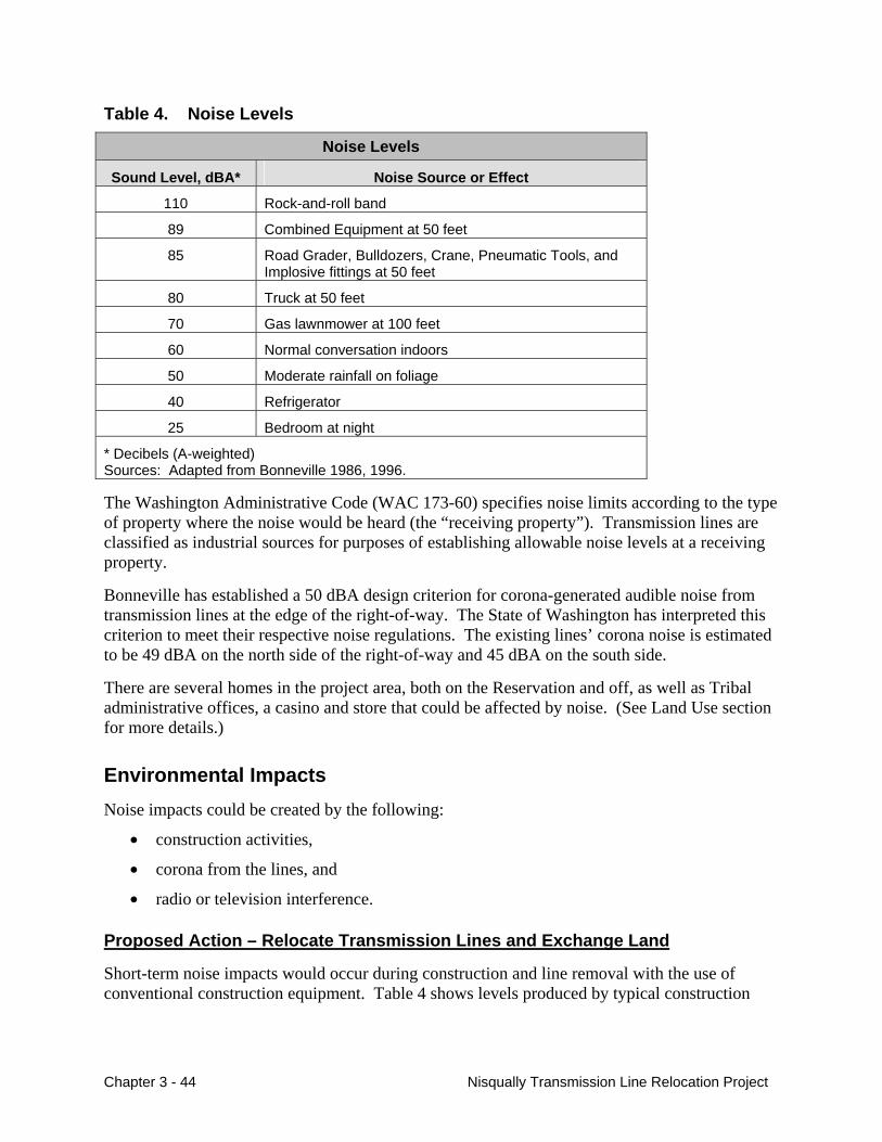
Table 4. Noise Levels
Noise Levels
Sound Level, dBA* Noise Source or Effect
110 Rock-and-roll band
89 Combined Equipment at 50 feet
85 Road Grader, Bulldozers, Crane, Pneumatic Tools, and Implosive fittings at 50 feet
80 Truck at 50 feet
70 Gas lawnmower at 100 feet
60 Normal conversation indoors
50 Moderate rainfall on foliage
40 Refrigerator
25 Bedroom at night
* Decibels (A-weighted) Sources: Adapted from Bonneville 1986, 1996.
The Washington Administrative Code (WAC 173-60) specifies noise limits according to the type of property where the noise would be heard (the “receiving property”). Transmission lines are classified as industrial sources for purposes of establishing allowable noise levels at a receiving property.
Bonneville has established a 50 dBA design criterion for corona-generated audible noise from transmission lines at the edge of the right-of-way. The State of Washington has interpreted this criterion to meet their respective noise regulations. The existing lines’ corona noise is estimated to be 49 dBA on the north side of the right-of-way and 45 dBA on the south side.
There are several homes in the project area, both on the Reservation and off, as well as Tribal administrative offices, a casino and store that could be affected by noise. (See Land Use section for more details.)
Environmental Impacts Noise impacts could be created by the following:
• construction activities,
• corona from the lines, and
• radio or television interference.
Proposed Action – Relocate Transmission Lines and Exchange Land
Short-term noise impacts would occur during construction and line removal with the use of conventional construction equipment. Table 4 shows levels produced by typical construction
Chapter 3 - 44 Nisqually Transmission Line Relocation Project
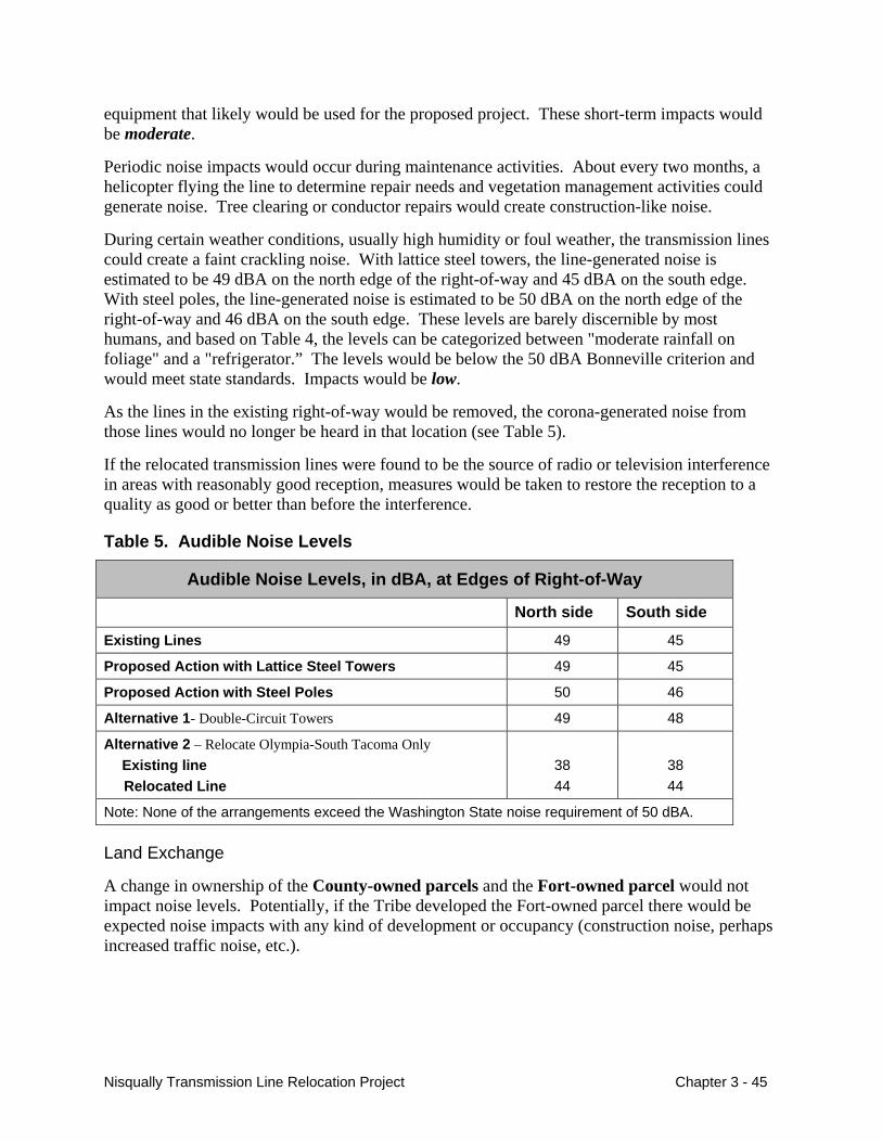
equipment that likely would be used for the proposed project. These short-term impacts would be moderate.
Periodic noise impacts would occur during maintenance activities. About every two months, a helicopter flying the line to determine repair needs and vegetation management activities could generate noise. Tree clearing or conductor repairs would create construction-like noise.
During certain weather conditions, usually high humidity or foul weather, the transmission lines could create a faint crackling noise. With lattice steel towers, the line-generated noise is estimated to be 49 dBA on the north edge of the right-of-way and 45 dBA on the south edge. With steel poles, the line-generated noise is estimated to be 50 dBA on the north edge of the right-of-way and 46 dBA on the south edge. These levels are barely discernible by most humans, and based on Table 4, the levels can be categorized between "moderate rainfall on foliage" and a "refrigerator.” The levels would be below the 50 dBA Bonneville criterion and would meet state standards. Impacts would be low.
As the lines in the existing right-of-way would be removed, the corona-generated noise from those lines would no longer be heard in that location (see Table 5).
If the relocated transmission lines were found to be the source of radio or television interference in areas with reasonably good reception, measures would be taken to restore the reception to a quality as good or better than before the interference.
Table 5. Audible Noise Levels
Audible Noise Levels, in dBA, at Edges of Right-of-Way
North side South side
Existing Lines 49 45
Proposed Action with Lattice Steel Towers 49 45
Proposed Action with Steel Poles 50 46
Alternative 1- Double-Circuit Towers 49 48
Alternative 2 – Relocate Olympia-South Tacoma Only Existing line Relocated Line
38 44
38 44
Note: None of the arrangements exceed the Washington State noise requirement of 50 dBA.
Land Exchange
A change in ownership of the County-owned parcels and the Fort-owned parcel would not impact noise levels. Potentially, if the Tribe developed the Fort-owned parcel there would be expected noise impacts with any kind of development or occupancy (construction noise, perhaps increased traffic noise, etc.).
Nisqually Transmission Line Relocation Project Chapter 3 - 45
Alternative 1 – Double-Circuit Towers on Existing Easement
This alternative would have much less construction noise impacts than the Proposed Action; the noise would only be located on the existing right-of-way and would be of shorter duration since less construction would be required; moderate short-term impacts. The corona-generated noise would be 49 dbA on the north side of the right-of-way and 48 dbA on the south side of the right-of-way, below the Washington state noise requirements. The south side noise levels would be slightly higher than the existing lines, with low long-term noise impacts.
Alternative 2 – Relocate the Olympia-Grand Coulee Line Only
This alternative would have similar construction noise impacts as the Proposed Action (moderate short-term). However, these short-term construction noise impacts would be for a somewhat shorter duration of time since there is less construction that would take place. The corona-generated noise would be 44 dBA on both sides of the new right-of-way, and 38 dBA on both sides of the existing right-of-way (where the Olympia-Grand Coulee line would remain). Impacts would be low to moderate, but would potentially affect more residences because there would be two rights-of-way.
No Action Alternative
Under the No-Action Alternative, existing background noise levels in the project vicinity would continue without influence of the proposed project.
Cumulative Impacts Noise in the area is created by traffic on SR 510, as well as local traffic, military training activities, corona noise from the transmission lines, and human activities. Noise could increase if traffic volumes increase. Construction activities would increase noise levels in the short-term. The relocation of the lines would not contribute to any increase noise levels, but would change the location of the localized corona noise.
Mitigation Measures The following mitigation measures would reduce identified potential adverse noise impacts to short-term low-to-moderate, and long-term low:
• Use mufflers on all equipment with exhaust.
• Do not conduct noise-generating construction activities within 1,000 feet of a residential structure between the hours of 10:00 p.m. and 7:00 a.m (Washington Administrative Code).
• Restore radio or television reception to a quality as good or better than before project, if the relocated transmission lines were found to be the source of interference.
Chapter 3 - 46 Nisqually Transmission Line Relocation Project
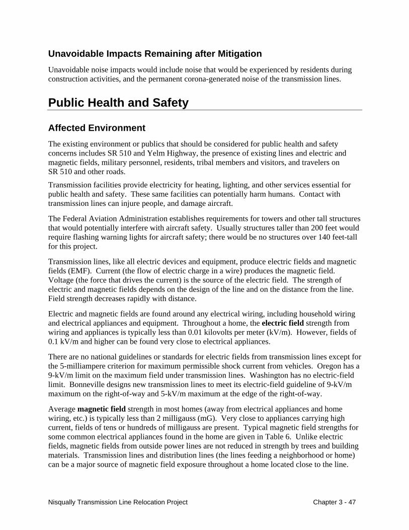
Unavoidable Impacts Remaining after Mitigation Unavoidable noise impacts would include noise that would be experienced by residents during construction activities, and the permanent corona-generated noise of the transmission lines.
Public Health and Safety
Affected Environment The existing environment or publics that should be considered for public health and safety concerns includes SR 510 and Yelm Highway, the presence of existing lines and electric and magnetic fields, military personnel, residents, tribal members and visitors, and travelers on SR 510 and other roads.
Transmission facilities provide electricity for heating, lighting, and other services essential for public health and safety. These same facilities can potentially harm humans. Contact with transmission lines can injure people, and damage aircraft.
The Federal Aviation Administration establishes requirements for towers and other tall structures that would potentially interfere with aircraft safety. Usually structures taller than 200 feet would require flashing warning lights for aircraft safety; there would be no structures over 140 feet-tall for this project.
Transmission lines, like all electric devices and equipment, produce electric fields and magnetic fields (EMF). Current (the flow of electric charge in a wire) produces the magnetic field. Voltage (the force that drives the current) is the source of the electric field. The strength of electric and magnetic fields depends on the design of the line and on the distance from the line. Field strength decreases rapidly with distance.
Electric and magnetic fields are found around any electrical wiring, including household wiring and electrical appliances and equipment. Throughout a home, the electric field strength from wiring and appliances is typically less than 0.01 kilovolts per meter (kV/m). However, fields of 0.1 kV/m and higher can be found very close to electrical appliances.
There are no national guidelines or standards for electric fields from transmission lines except for the 5-milliampere criterion for maximum permissible shock current from vehicles. Oregon has a 9-kV/m limit on the maximum field under transmission lines. Washington has no electric-field limit. Bonneville designs new transmission lines to meet its electric-field guideline of 9-kV/m maximum on the right-of-way and 5-kV/m maximum at the edge of the right-of-way.
Average magnetic field strength in most homes (away from electrical appliances and home wiring, etc.) is typically less than 2 milligauss (mG). Very close to appliances carrying high current, fields of tens or hundreds of milligauss are present. Typical magnetic field strengths for some common electrical appliances found in the home are given in Table 6. Unlike electric fields, magnetic fields from outside power lines are not reduced in strength by trees and building materials. Transmission lines and distribution lines (the lines feeding a neighborhood or home) can be a major source of magnetic field exposure throughout a home located close to the line.
Nisqually Transmission Line Relocation Project Chapter 3 - 47
There are no national guidelines or standards for magnetic fields. The states of Washington and Oregon do not have magnetic field limits. Bonneville does not have a guideline for magnetic field exposures.
Table 6. Typical Magnetic Field Strengths (1 foot from common appliances)
Appliance Magnetic Fields (mG)1
Coffee maker 1-1.5
Electric range 4-40
Hair dryer 0.1-70
Television 0.4-20
Vacuum cleaner 20-200
Electric blanket2 15-100
mG = milligauss 1 The magnetic field from appliances usually decreases to less than 1 mG at 3 to 5 feet from
appliances. 2 Values are for distance from blanket in normal use (less than 1 foot away). Source: Miler 1974; Gauger 1985
Environmental Impacts The potential health and safety impacts of the Proposed Action and the alternatives would include the following:
• Construction activity Heavy equipment safety, Potential fuel spills, Traffic entering and existing
SR 510.
• Electric and magnetic fields Shocks, Electrocution, Magnetic field exposure.
Proposed Action – Relocate Transmission Lines and Exchange Land
During construction and installation of towers and conductor, there is a risk of fire and injury associated with the use of heavy equipment, working near high-voltage lines, and hazardous materials such as fuels. Conductors may be connected using implosion bolts, which could be a source of injury to construction personnel.
There would be potential safety issues with more traffic on the highways and roads in the project area during construction. State Route 510 is heavily used and traffic moves relatively fast. Without mitigation measures, construction trucks and vehicles turning off and onto SR 510 could cause potential safety hazards for vehicles and travelers using the road. Impacts would be low to moderate.
Chapter 3 - 48 Nisqually Transmission Line Relocation Project
Possible effects from transmission line electric and magnetic fields interactions with people on and near a right-of-way fall into two categories: short-term immediate effects that can be perceived or may represent a nuisance, and possible long-term health effects.
Power lines, like electrical wiring, can cause serious electric shocks if certain precautions are not taken. These precautions include building the lines to minimize shock hazard. All Bonneville lines are designed and constructed in accordance with the National Electrical Safety Code (NESC). NESC specifies the minimum allowable distance between the lines and the ground or other objects. These requirements determine the edge of the right-of-way and the height of the line, that is, the closest point that houses, other buildings, and vehicles are allowed to the line.
People must take precautions when working or playing near power lines. It is extremely important that a person not bring anything, such as a TV antenna, irrigation pipe, or water streams from an irrigation sprinkler too close to the lines. Bonneville provides a free booklet that describes safety precautions for people who live or work near transmission lines. Electric fields from high-voltage transmission lines can cause nuisance shocks when a grounded person touches an ungrounded object under a line or when an ungrounded person touches a grounded object. Transmission lines are designed so that the electric field will be below levels where primary shocks could occur from even the largest (ungrounded) vehicles expected under the line. Fences and other metal structures on and near the right-of-way would be grounded during construction to limit the potential for nuisance shocks.
The proposed right-of-way with lattice steel towers would have electric fields of 5.5 kV/m maximum on the right-of-way and 2.0 kV/m or less at the right-of-way edges. With steel poles, the electric fields would be 4.5 kV/m maximum on the right-of-way and 1.0 kV/m or less at the right-of-way edges. Either tower design meets Bonneville’s electric-field guidelines of 9-kV/m maximum on the right-of-way and 5 kV/m at the edge of the right-of-way. Impacts would be low.
Magnetic fields are subject to controversy. After decades of research, the issue of whether there are long-term health effects associated with transmission-line fields remains controversial. Magnetic fields are most in question as possible sources of long-term effects, although studies sometimes lump the two (electric and magnetic) fields together. For the latest information, Bonneville defers to the determinations of the National Institute of Environmental Health Science (NIEHS) and to the related web site denoted by EMFRAPID (website at http://www.niehs.nih.gov/emfrapid/home.htm). Scientific reviews of the research on EMF health effects have found that there is insufficient evidence to conclude that EMF exposures lead to long-term health effects. However, some uncertainties remain for childhood exposures at levels above 4 mG.
An increase in public exposure to magnetic fields could occur if field levels increased or if residences or other structures draw people to these areas. The predicted field levels are only indicators of how the proposed project may affect the magnetic-field environment. They are not measures of risk or impacts on health.
Bonneville has predicted the magnetic fields of the proposed right-of-way and of the existing right-of-way. For lattice steel towers, magnetic field levels at the edge of right-of-way would be about 10 to 13 milligauss (same as the existing right-of-way). See Figure 9. For steel poles, magnetic field levels at the edge of right-of-way would be about 5 milligauss. See Figure 10.
Nisqually Transmission Line Relocation Project Chapter 3 - 49
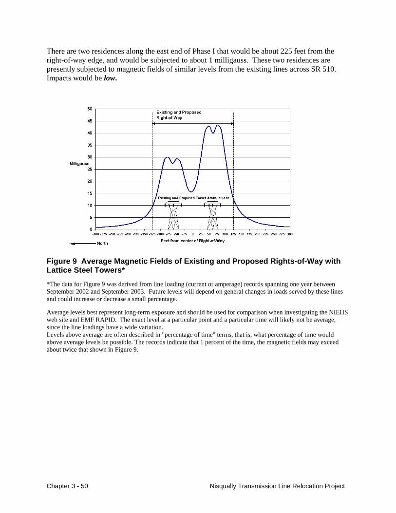
There are two residences along the east end of Phase I that would be about 225 feet from the right-of-way edge, and would be subjected to about 1 milligauss. These two residences are presently subjected to magnetic fields of similar levels from the existing lines across SR 510. Impacts would be low.
Figure 9 Average Magnetic Fields of Existing and Proposed Rights-of-Way with Lattice Steel Towers*
*The data for Figure 9 was derived from line loading (current or amperage) records spanning one year between September 2002 and September 2003. Future levels will depend on general changes in loads served by these lines and could increase or decrease a small percentage.
Average levels best represent long-term exposure and should be used for comparison when investigating the NIEHS web site and EMF RAPID. The exact level at a particular point and a particular time will likely not be average, since the line loadings have a wide variation. Levels above average are often described in "percentage of time" terms, that is, what percentage of time would above average levels be possible. The records indicate that 1 percent of the time, the magnetic fields may exceed about twice that shown in Figure 9.
Chapter 3 - 50 Nisqually Transmission Line Relocation Project
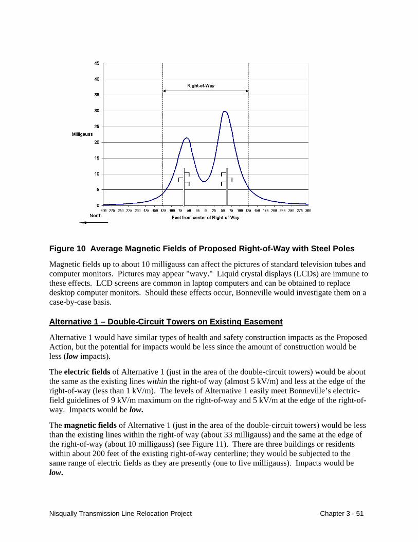
Figure 10 Average Magnetic Fields of Proposed Right-of-Way with Steel Poles
Magnetic fields up to about 10 milligauss can affect the pictures of standard television tubes and computer monitors. Pictures may appear "wavy." Liquid crystal displays (LCDs) are immune to these effects. LCD screens are common in laptop computers and can be obtained to replace desktop computer monitors. Should these effects occur, Bonneville would investigate them on a case-by-case basis.
Alternative 1 – Double-Circuit Towers on Existing Easement
Alternative 1 would have similar types of health and safety construction impacts as the Proposed Action, but the potential for impacts would be less since the amount of construction would be less (low impacts).
The electric fields of Alternative 1 (just in the area of the double-circuit towers) would be about the same as the existing lines within the right-of way (almost 5 kV/m) and less at the edge of the right-of-way (less than 1 kV/m). The levels of Alternative 1 easily meet Bonneville’s electric-field guidelines of 9 kV/m maximum on the right-of-way and 5 kV/m at the edge of the right-of-way. Impacts would be low.
The magnetic fields of Alternative 1 (just in the area of the double-circuit towers) would be less than the existing lines within the right-of way (about 33 milligauss) and the same at the edge of the right-of-way (about 10 milligauss) (see Figure 11). There are three buildings or residents within about 200 feet of the existing right-of-way centerline; they would be subjected to the same range of electric fields as they are presently (one to five milligauss). Impacts would be low.
Nisqually Transmission Line Relocation Project Chapter 3 - 51
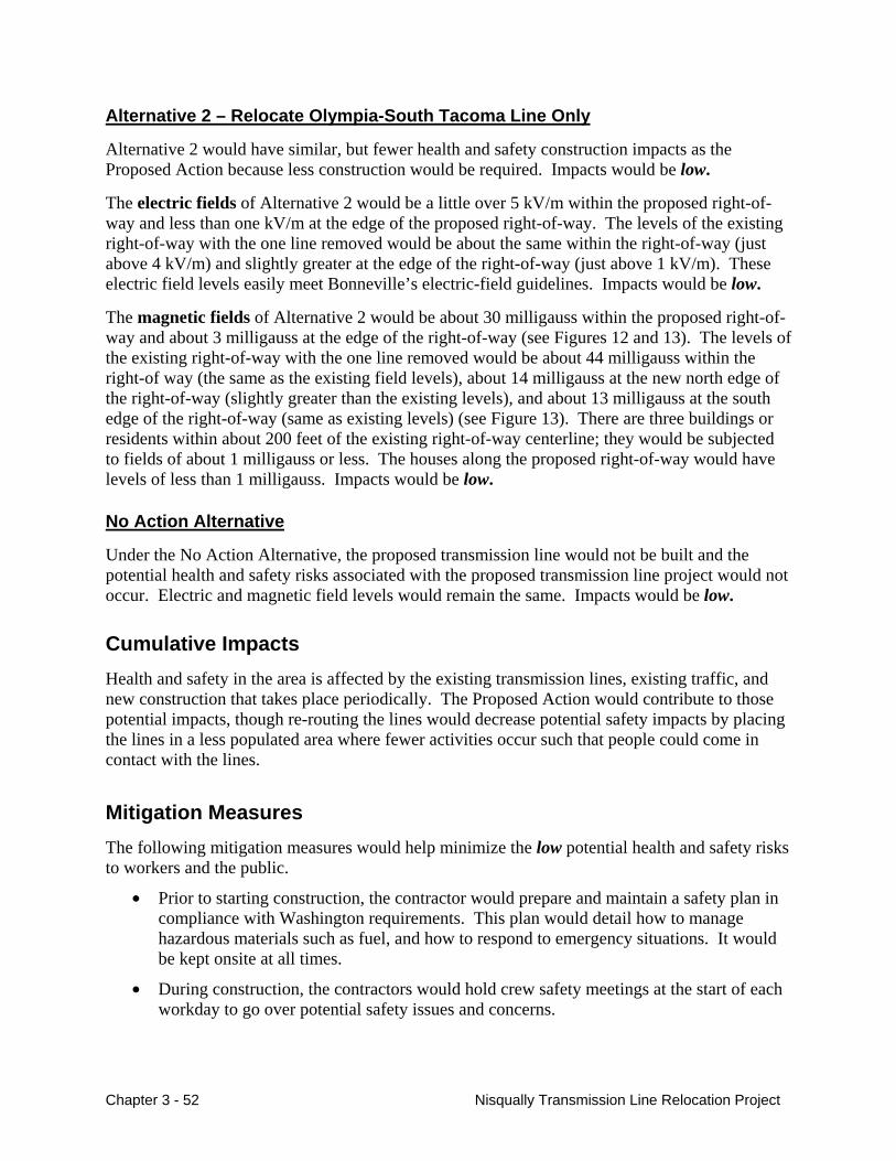
Alternative 2 – Relocate Olympia-South Tacoma Line Only
Alternative 2 would have similar, but fewer health and safety construction impacts as the Proposed Action because less construction would be required. Impacts would be low.
The electric fields of Alternative 2 would be a little over 5 kV/m within the proposed right-of-way and less than one kV/m at the edge of the proposed right-of-way. The levels of the existing right-of-way with the one line removed would be about the same within the right-of-way (just above 4 kV/m) and slightly greater at the edge of the right-of-way (just above 1 kV/m). These electric field levels easily meet Bonneville’s electric-field guidelines. Impacts would be low.
The magnetic fields of Alternative 2 would be about 30 milligauss within the proposed right-of-way and about 3 milligauss at the edge of the right-of-way (see Figures 12 and 13). The levels of the existing right-of-way with the one line removed would be about 44 milligauss within the right-of way (the same as the existing field levels), about 14 milligauss at the new north edge of the right-of-way (slightly greater than the existing levels), and about 13 milligauss at the south edge of the right-of-way (same as existing levels) (see Figure 13). There are three buildings or residents within about 200 feet of the existing right-of-way centerline; they would be subjected to fields of about 1 milligauss or less. The houses along the proposed right-of-way would have levels of less than 1 milligauss. Impacts would be low.
No Action Alternative
Under the No Action Alternative, the proposed transmission line would not be built and the potential health and safety risks associated with the proposed transmission line project would not occur. Electric and magnetic field levels would remain the same. Impacts would be low.
Cumulative Impacts Health and safety in the area is affected by the existing transmission lines, existing traffic, and new construction that takes place periodically. The Proposed Action would contribute to those potential impacts, though re-routing the lines would decrease potential safety impacts by placing the lines in a less populated area where fewer activities occur such that people could come in contact with the lines.
Mitigation Measures The following mitigation measures would help minimize the low potential health and safety risks to workers and the public.
• Prior to starting construction, the contractor would prepare and maintain a safety plan in compliance with Washington requirements. This plan would detail how to manage hazardous materials such as fuel, and how to respond to emergency situations. It would be kept onsite at all times.
• During construction, the contractors would hold crew safety meetings at the start of each workday to go over potential safety issues and concerns.
Chapter 3 - 52 Nisqually Transmission Line Relocation Project
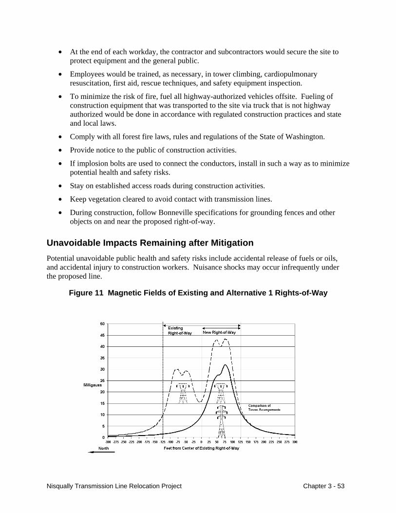
• At the end of each workday, the contractor and subcontractors would secure the site to protect equipment and the general public.
• Employees would be trained, as necessary, in tower climbing, cardiopulmonary resuscitation, first aid, rescue techniques, and safety equipment inspection.
• To minimize the risk of fire, fuel all highway-authorized vehicles offsite. Fueling of construction equipment that was transported to the site via truck that is not highway authorized would be done in accordance with regulated construction practices and state and local laws.
• Comply with all forest fire laws, rules and regulations of the State of Washington.
• Provide notice to the public of construction activities.
• If implosion bolts are used to connect the conductors, install in such a way as to minimize potential health and safety risks.
• Stay on established access roads during construction activities.
• Keep vegetation cleared to avoid contact with transmission lines.
• During construction, follow Bonneville specifications for grounding fences and other objects on and near the proposed right-of-way.
Unavoidable Impacts Remaining after Mitigation Potential unavoidable public health and safety risks include accidental release of fuels or oils, and accidental injury to construction workers. Nuisance shocks may occur infrequently under the proposed line.
Figure 11 Magnetic Fields of Existing and Alternative 1 Rights-of-Way
Nisqually Transmission Line Relocation Project Chapter 3 - 53
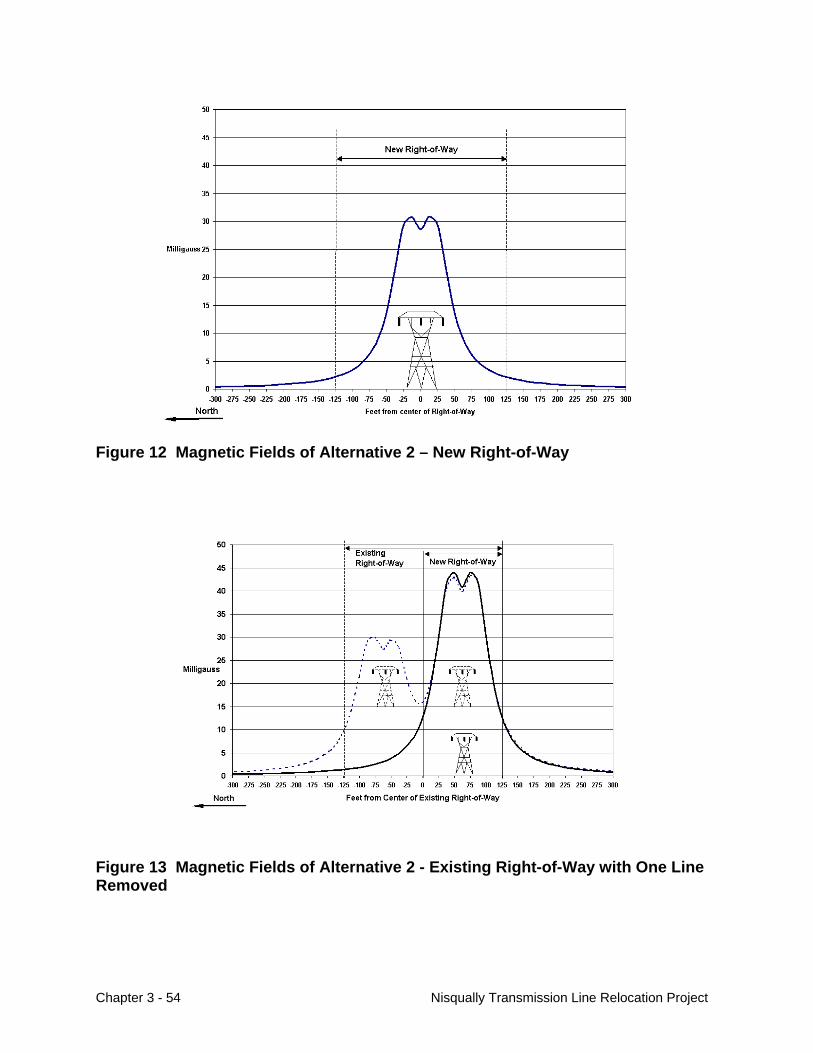
Figure 12 Magnetic Fields of Alternative 2 – New Right-of-Way
Figure 13 Magnetic Fields of Alternative 2 - Existing Right-of-Way with One Line Removed
Chapter 3 - 54 Nisqually Transmission Line Relocation Project
Air Quality
Affected Environment Air quality of the project area could be affected by the amount of pollutants released, potentially exceeding acceptable air quality levels, and the surrounding physical and natural environment contributing to the air quality of the area (trees, car traffic, industry, etc.).
The U.S. Environmental Protection Agency has established air quality standards for six ‘criteria’ air pollutants: ozone, carbon monoxide (CO), lead, nitrogen dioxide, particulate matter (PM-10), and sulfur dioxide. According to Washington State Department of Ecology (WA DOE), which regulates Washington’s air quality program, “Air quality concerns come in three forms: public health, environment, and quality of life.” WA DOE states that studies have proven that short- and long-term exposure to air pollutants may cause lung, respiratory, and cardiopulmonary diseases, which can lead to emergency room visits, hospitalizations, decreased lung function, absences from school and work, and restricted activities. Environmentally, air pollution can: damage soils, water, crops, vegetation, manmade materials, property, animals and wildlife, impair visibility, affect climate and weather, and create transportation hazards (Washington State Department of Ecology, 2003).
For each of the six criteria pollutants, the EPA has determined a maximum concentration above which adverse effects on human health may occur. These threshold concentrations are called National Ambient Air Quality Standards (NAAQS), and it is when an area exceeds these standards that it is designated as a nonattainment area. Pollution control measures are mandated for federal actions in nonattainment areas.
A nonattainment area can be listed for any one, or more, of the criteria pollutants. An area that was once a nonattainment area, but has since improved its air quality enough so that it now meets the EPA established air quality standards, is up-graded to a maintenance area designation. Maintenance areas also have pollution controls imposed on them, but because the air quality is not as poor as in nonattainment areas, the control standards are not as strict in maintenance areas. All other areas not listed by the EPA for air quality degradation are considered attainment areas.
The entire project area lies within Thurston County and is not within an EPA-listed nonattainment area or maintenance area for any of the criteria pollutants.
Environmental Impacts Air Quality could be impacted by the Proposed Action or alternatives by the following:
• Heavy equipment emitting pollutants,
• Construction activities creating dust, and
• Electric field corona causing minor releases of ozone and nitrogen oxides.
Nisqually Transmission Line Relocation Project Chapter 3 - 55

Proposed Action – Relocate Transmission Lines and Exchange Land
Air quality for this project would primarily be impacted during the construction phase, and slightly during operation and maintenance of transmission facilities. Overall, the air quality impacts from construction and operation and maintenance of the Proposed Action would be low.
Of the six ‘criteria’ air pollutants, particulate matter is the main concern of transmission line construction activity. Particulate matter are particles with aerodynamic diameter smaller than 10 micrometers and include: “dust, dirt, soot, smoke and liquid droplets directly emitted into the air by sources such as factories, power plants, cars, construction activity, fires, and natural windblown dust” (Environmental Protection Agency, September 2003). Fugitive dust could be created during project site preparation including road building, on-site travel on unpaved surfaces, and soil disrupting operations. Wind erosion of disturbed areas would contribute to fugitive dust.
The amount of dust ‘kicked-up’ on unpaved roads is relative to the amount of small particle silt and moisture found in the roads’ soil. Generally, the coarser the surface road material and the higher the moisture content, the lower the amount of surface dust that will enter the air. Soil in the proposed project area is a well-drained, coarse material (see the Soils and Geology section for further detail). Proposed construction would take place over a six-month period, starting in early spring 2005 while soils are still seasonally very moist. The moist and coarse soil conditions during tree clearing and blading, coupled with using large gravel as surface material on unpaved access roads, would minimize particulate matter that would be released into the air.
The removal of trees, as well as the removal of the existing towers, would emit fugitive dust. According to the construction schedule, removal of trees and site preparation would occur during spring 2005 when soils in the proposed project area are naturally moist from precipitation and when the risk of fugitive dust is very low. Removal of the existing 23 towers would involve construction vehicles traveling over existing graveled access roads and minimal, short-term soil digging and disturbance with revegetation immediately following.
Based on the acres affected and construction timing, construction of the Proposed Action would emit about 28.6 tons of emissions, well below the most strict emission standards placed on serious nonattainment areas, which is mandated at no more than 70 tons/acre. The 28.6 tons of PM-10 emissions accounts for activities surrounding temporary land clearing, road construction, and vehicle use and travel over unpaved roads.
Emissions from woody debris disposal are not accounted for in the 28.6 tons. Clearing of trees and vegetation can produce debris that would need to be disposed of by lop and scatter, chipping, or burning. Burning of woody debris releases a large number of pollutants including, but not limited to: carbon monoxide, nitrogen dioxide, PM-10, PM-2.5, and volatile organic compounds (VOCs), which can be irritating, toxic, and/or cancer-causing substances. Washington State forbids burning when a reasonable alternative to burning is found to exist (WAC 173-425-040). According to the state, reasonable alternatives include chipping, woodwaste recycling, and landfilling. If Bonneville decides to burn woody debris, a permit would be obtained from the State and Bonneville would abide by the rules and regulations outlined in the permit. Woody debris from lop-and-scatter would be left on the right-of-way to degrade gradually. Carbon contained in the debris would either be reabsorbed by new vegetation growth or gradually released into the air as carbon dioxide. Chipping would produce the same air emissions as lop-
Chapter 3 - 56 Nisqually Transmission Line Relocation Project
and-scatter, except that the carbon contained in chips would be released over a shorter period of time.
Heavy equipment and vehicles, including those with diesel internal combustion engines, would emit pollutants such as carbon monoxide, carbon dioxide, sulfur oxides, particulate matter less than 2.5 microns in diameter (PM 2.5), oxides of nitrogen, volatile organic hydrocarbons, aldehydes, and polycyclic aromatic hydrocarbons. Vehicle and equipment emissions would be relatively small and comparable to current conditions in agricultural and urban areas.
The transmission lines themselves cause limited air emissions. These limited air emissions would be the same for the new lines as with the existing lines. The high electric field strength of transmission lines causes a breakdown of air at the surface of the conductors called corona. Corona has a popping sound that is most easily heard during rainstorms. When corona occurs, small amounts of ozone and nitrogen oxides are released. These substances are released in such small quantities that they are generally too small to be measured or to have any significant effect on humans, plants, or animals. In the long term, emissions would be low, limited to vehicle emissions traveling on the access roads and maintenance activities.
Land Exchange
A change in land ownership of the Fort-owned parcel to the Tribe would not have any immediate impact on air quality since the Tribe has no immediate plans for development. If the Tribe developed the parcel, construction or logging actives would have a similar low impact on air quality as the Proposed Action. If development included commercial uses, it could subsequently increase future traffic levels, potentially causing some degradation in air quality. Automobiles emit hydrocarbons, nitrogen oxides, carbon monoxide, carbon dioxide, and other toxic emissions. Economic development along SR 510 would not be so great that the resulting increased traffic would pose a serious health threat.
A change in land ownership of the County-owned parcels to Fort Lewis would not have an impact on air quality since the land use would essential remain the same.
Alternative 1 – Double-Circuit Towers on Existing Easement
Alternative 1 would have similar types of impacts to air quality as the Proposed Action (construction activities causing dust, vehicle emissions), but on a much smaller scale. Only 0.66 tons of particulate matter would be emitted. Impacts would be low.
Alternative 2 – Relocate Olympia-Grand Coulee Line Only
Alternative 2 would have similar types of impacts to air quality as the Proposed Action (construction activities causing dust, vehicle emissions), but somewhat less particulate matter would be emitted (13.6 tons PM-10). Impacts would be low.
No Action Alternative
The No Action Alternative would have no impacts on air quality.
Nisqually Transmission Line Relocation Project Chapter 3 - 57
Cumulative Impacts Human activities, such as industry and fossil fuel burning, are changing the composition of the earth’s atmosphere. On a global scale, increasing levels of greenhouse gasses, such as carbon dioxide, methane, and nitrous oxide, are strengthening the Earth’s natural greenhouse effect. A global warming trend is being documented and is evidenced by melting glaciers and climatic changes. According to the EPA, local vulnerabilities to global warming may occur in public health, agriculture, water resources, forests, wildlife and coastal areas. The short-term activities associated with this proposed project would have no-to-low impact on global warming. Particulate matter created from the short-term construction activities would not contribute to regional or local haze.
Mitigation Measures The following mitigation measures would help avoid, minimize, or compensate for identified potential low impacts to air quality.
• Use water trucks on an as-needed basis to minimize dust.
• Gravel or rock access roads before tower construction to minimize dust.
• Drive all construction vehicles at low speeds (5 mph) to minimize dust.
• Limit burning of woody debris.
• Comply with Washington State tailpipe emission standards for all on-road vehicles.
• Keep off-road vehicles in good running condition to minimize emissions.
• Use low sulfur fuel for on-road diesel vehicles. • Re-seed and re-vegetate the right-of-way to minimize exposed soil prone to erosion to
minimize dust.
Unavoidable Impacts Remaining After Mitigation Some particulate matter and exhaust emissions would be emitted during construction and later during routine maintenance of the lines, though the impacts would be very low. Trace amounts of ozone would be given off the high-voltage power lines, but the amounts would be too small to measure and have negligible impacts.
Chapter 3 - 58 Nisqually Transmission Line Relocation Project
Chapter 4 Consultation, Review, and Permit Requirements
This chapter addresses federal statutes, implementing regulations, and Executive Orders potentially applicable to the proposed project. This EA is being sent to Tribes, federal agencies, and state and local governments as part of the environmental review process for this project.
National Environmental Policy Act
This EA has been prepared by Bonneville, Fort Lewis and the BIA pursuant to regulations implementing the National Environmental Policy Act (NEPA) (42 U.S.C. 4321 et seq.), which requires federal agencies to assess the impacts that their actions may have on the environment. Bonneville’s proposal to relocate two miles of transmission line corridor requires that we assess the potential environmental effects of the proposed project, describe them in an EA, make the EA available for public comment, and determine if the impacts would be significant.
Vegetation and Wildlife
The Endangered Species Act of 1973 (16 U.S.C. 1536) as amended in 1988, establishes a national program for the conservation of threatened and endangered species of fish, wildlife, and plants and the preservation of the ecosystems on which they depend.
The Act is administered by the U.S. Fish and Wildlife Service and, for salmon and other marine species, by the National Oceanic and Atmospheric Administration. Section (7a) requires federal agencies to ensure that the actions they authorize, fund, and carry out do not jeopardize endangered or threatened species or their critical habitats.
Bonneville requested and received a list of potential threatened and endangered species that could occur in the project area (Bonneville, June 2, 2003; and USFWS, July 17, 2003). A countywide species list was downloaded from the USFWS web site on August 10, 2004. A biological assessment was then prepared and submitted to the U.S. Fish and Wildlife Service requesting concurrence with an “no effect” on bull trout, golden paintbrush, or the mardon skipper; “may affect, but is unlikely to adversely affect” on bald eagles and marbled murrelet; and “destruction and/or adverse modification” of designated critical habitat for the northern spotted owl (Bonneville, et. al, August 24, 2004). Potential impacts to threatened and endangered plant, animal, and fish species are discussed in Chapter 3 in the Vegetation and Wildlife sections (there are no water bodies in the project area, so fish are not affected).
Nisqually Transmission Line Relocation Project Chapter 4 - 1
The Fish and Wildlife Conservation Act of 1980 (16 U.S.C. 2901 et seq.) encourages federal agencies to conserve and promote the conservation of nongame fish and wildlife species and their habitats. Mitigation measures designed to conserve wildlife and their habitat are listed in Chapter 3 in the Vegetation and Wildlife sections.
The Migratory Bird Treaty Act implements various treaties and conventions between the United States and other countries, including Canada, Japan, Mexico, and the former Soviet Union, for the protection of migratory birds (16 U.S.C. 703-712, July 3, 1918, as amended 1936, 1960, 1968, 1969, 1974, 1978, 1986, and 1989). Under the Act, taking, killing, or possessing migratory birds or their eggs or nests is unlawful. Most species of birds are classified as migratory under the Act, except for upland and nonnative birds.
The proposed project could potentially impact birds through collisions with power lines and habitat removal. Potential impacts to migratory birds are discussed in the Wildlife Section in Chapter 3.
Under Executive Order 13186, Bonneville is developing an agreement with the U.S. Fish and Wildlife Service to help conserve migratory bird populations.
Water Resources
The Clean Water Act (33 U.S.C. 1251 et seq.) regulates discharges into waters of the U.S. There are no water bodies or wetlands in the project area.
Section 402 of the act authorizes storm water discharges associated with industrial activities under the National Pollutant Discharge Elimination System (NPDES). For Washington, EPA has a general permit authorizing federal facilities to discharge storm water from construction activities disturbing land of 5 acres or more into waters of the U.S., in accordance with various set conditions. Bonneville would comply with the appropriate conditions for this project, such as issuing a Notice of Intent to obtain coverage under the EPA general permit and preparing a Storm Water Pollution Prevention (SWPP) plan.
The Safe Drinking Water Act (42 U.S.C. Section 200f et seq.) protects the quality of public drinking water and its source. The proposed project would not affect any sole source aquifers or other critical aquifers, or adversely affect any surface water supplies.
The Spill Prevention Control and Countermeasures Act, Title III of the Superfund Amendments and Reauthorization Act, and the Resource Conservation and Recovery Program potentially apply to the proposed project, depending on the exact quantities and types of hazardous materials stored onsite. Regulations would be enforced by the Washington Department of Ecology. In addition, development of a Hazardous Materials Management Plan in accordance with the Uniform Fire Code may be required by the local fire district. Small amounts of hazardous wastes may be generated (paint products, motor and lubricating oils, herbicides, solvents, etc.) during construction or operation and maintenance. These materials would be disposed of according to state law and Resource Conservation and Recovery Act requirements.
Chapter 4 - 2 Nisqually Transmission Line Relocation Project
Cultural Resources
Regulations established for the management of cultural resources include the following:
Antiquities Act of 1906 (16 U.S.C. 431-433);
Historic Sites Act of 1935 (16 U.S.C. 461-467);
Section 106 of the National Historic Preservation Act (NHPA) of 1966 (16 U.S.C. 470 et seq.), as amended;
Archaeological Data Preservation Act (ADPA) of 1974 (16 U.S.C. 469 a-c);
Archaeological Resources Protection Act (ARPA) of 1979 (16 U.S.C. 470 et seq.), as amended;
Native American Graves Protection and Repatriation Act (NAGPRA) (25 U.S.C. 3001 et seq.); and
Executive Order 13007 Indian Sacred Sites.
For this project, Bonneville has undertaken the Section 106 consultation process with the State Historic Preservation Officer for Washington, the Advisory Council on Historic Preservation, and the affected Native American tribes. For this project the Nisqually Indian Tribe, Squaxin Island Tribe, Puyallup Tribe, Yakama Nation, Wanapum, and the Chehalis Tribe were consulted.
The Cultural Resources Section in Chapter 3 describes that no evidence of cultural resources were found along the proposed right-of-way or existing right-of-way. The State of Washington Office of Archaeology and Historic Preservation concurred with Bonneville’s determination that no historic properties would be effected (State of Washington, May 7, 2004).
Land Use
The Nisqually River Management Plan (Nisqually River Task Force, 1987) establishes two management zones for the basin: the Core Management Zone and a Stewardship Management Zone. The Core Management Zone is essentially a corridor 200-feet wide on each side of the river. The Stewardship Management Zone is a viewshed corridor along the Nisqually River a minimum of ¼ mile and a maximum of ¾ mile each side of the river. The viewshed corridor is defined as what could be seen by a person walking along the river on either bank. Because there is a steep bluff between the project area and the Nisqually River, the project area is outside of these two zones.
The Proposed Action crosses the Fort Lewis Military Reservation. Bonneville would obtain permits as appropriate for the right-of-way across this public land.
Nisqually Transmission Line Relocation Project Chapter 4 - 3
Environmental Justice
In February 1994, Executive Order 12898, Federal Actions to Address Environmental Justice in Minority and Low-Income Populations, was released to federal agencies. This order states that federal agencies shall identify and address as appropriate, disproportionately high and adverse human health or environmental effects of its programs, policies, and activities on minority populations and low-income population. Minority populations are considered members of the following groups: American Indian or Alaskan Native; Asian or Pacific Islander; Black, not of Hispanic origin; or Hispanic if the minority population of the affected area exceeds 50 percent, or is meaningfully greater than the minority population in the project area.
The proposed project has been evaluated for potential disproportionately high environmental effects on minority and low-income populations (see the Socioeconomics Section in Chapter 3).
Noise
The Noise Control Act of 1972 as amended (42 U.S.C. 4901 et seq.) sets forth a broad goal of protecting all people from noise that jeopardizes their health or welfare. It places principal authority for regulating noise control with states and local communities. The allowable hourly noise levels under state law, and potential noise impacts associated with the project, are described in the Noise Section in Chapter 3.
Health & Safety Laws
As part of the transmission line design, Bonneville seeks to comply with Federal Aviation Administration procedures. Final locations of structures, structure types, and structure heights would be submitted to the Federal Aviation Administration for the project. The information includes identifying structures taller than 200 feet above ground and listing all structures within prescribed distances of airports listed in the Federal Aviation Administration airport directory. General Bonneville policy is to follow Federal Aviation Administration recommendations for airway marking and lighting.
Federal Communications Commission regulations require that transmission lines be operated so that radio and televisions reception will not be seriously degraded or repeatedly interrupted and that interference is mitigated. While none of the proposed alternatives are expected to increase electromagnetic interference above existing levels, complaints about electromagnetic interference will be investigated.
The Spill Prevention, Control and Countermeasures Act, Title III of the Superfund Amendments and Reauthorization Act, and the Resource Conservation and Recovery Program potentially apply to the proposed project, depending on the exact quantities and types of hazardous materials stored onsite. Regulations would be enforced by the Washington Department of Ecology. In addition, development of a Hazardous Materials Management Plan in accordance with the Uniform Fire Code may be required by the local fire district. Small amounts of hazardous wastes may be generated (paint products, motor and lubricating oils,
Chapter 4 - 4 Nisqually Transmission Line Relocation Project
herbicides, solvents, etc.) during construction or operation and maintenance. These materials would be disposed of according to state law and Resource Conservation and Recovery Act requirements.
Air Quality
The Clean Air Act as revised in 1990 (PL 101-542, 42 U.S.C. 7401) requires EPA and states to carry out programs intended to ensure attainment of National Ambient Air Quality Standards. Air quality impacts of the proposed project would be low, as discussed in the Air Quality Section in Chapter 3.
Nisqually Transmission Line Relocation Project Chapter 4 - 5

Chapter 4 - 6 Nisqually Transmission Line Relocation Project
Chapter 5 References
Askins, R.A. 1994. Open corridors in heavily forest landscape: Impact on shrubland and forest interior birds. Wildlife Soc. Bull. 22:339-347.
Avian Power Line Interaction Committee (APLIC). 1994. Mitigating bird collisions with power lines: The state of the art in 1994. Edison Electric Institute. Washington, D.C.
Avian Power Line Interaction Committee (APLIC). 1996. Suggested practices for raptor protection on power lines: The state of the art in 1996. Edison Electric Institute and the Raptor Research Foundation. Washington, D.C.
Beck, Gary. September 24, 2003. Personal communication.
Body, Steve. November 17, 2003. EPA, Region X, PM-10 and SO2 Expert, Seattle, WA. Personal communication.
Bonneville Power Administration. May 2000. Vegetation Management Program Final Environmental Impact Statement. USDOE/BPA EIS-0285.
Bonneville Power Administration. June 2, 2003. Letter to the USFWS. Request for Species List for the Nisqually Transmission Line Relocation Project.
Bonneville Power Administration and the U.S. Department of Defense, Fort Lewis Military Reservation Washington. August 24, 2004. Biological Assessment for Aquatic and Terrestrial Species, Nisqually Transmission Line Relocation Project.
Bottorff, J.A., B. Gilbert, and T. Williams. 1991. Northern Spotted Owl Survey: Fort Lewis Military Reservation, Pierce County, Washington. Unpublished Report by the U.S. Fish and Wildlife Service, Olympia, Washington, for U.S. Department of Defense, U.S. Army. 32 pp.
Carnevali, D. D. November 3, 2003. Personal Communication.
ENSR. 2000. Final Integrated Natural Resources Management Plan. Contract No. DACA67-97-D-1004, Delivery Order No. 17. Report Prepared for the Department of the Army, Fort Lewis, Washington. Redmond, WA.
ENSR International. September 2003. Draft Northern Spotted Owl Survey 2002-2003. Report prepared for U.S. Army Fort Lewis.
Nisqually Transmission Line Relocation Project Chapter 5 - 1
Environmental Protection Agency (EPA). September 1998. “Compilation of Air Pollutant Emissions Factors. Chapter 13: Miscellaneous Sources. Supplement E: Unpaved Roads.” Accessed on November 6, 2003: Available at http://www.epa.gov/ttn/chief/ap42/ch13/final/c13s02-2.pdf.
EPA. September 2003. “U.S. Environmental Protection Agency Green Book: Criteria Pollutants.” Accessed November 4, 2003: Available at http://www.epa.gov/oar/oaqps/greenbk/o3co.html#Particulate%20Matter.
Federal Register. July 12, 2002. (Volume 67, Number 134) Notices [Page 46327-46333].
Indian Land Working Group. November 5, 2003. Available at http://www.ilwg.net/allotmentact.htm.
Johnson, R. November 7, 2003. Coordinator for Thurston County Noxious Weed Control Agency, Olympia, Washington. Personal Communication
Kimmins, J.P. 1987. Forest Ecology. Macmillan Publishing Co. New York.
King, D.I and B.E. Byers. 2002. An evaluation of powerline rights-of-way as habitat for early-successional shrubland birds. Wildlife Soc. Bull. 30: 868-874.
Lycos. November 3, 2003. Available at http://membres.lycos.fr/allevrig/nisqually/nisqually.htm.
Mayer, M.S. and D.W. Welch. 2003. BPA Fish and Wildlife Biologist Habitat Assessment. August–November.
Mountain West Research, Inc. 1981.
National Wetlands Inventory. 2002. National Wetlands Inventory Data, Wier Prairie 7.5 minute Quadrangle, Washington.
National Wetlands Inventory. 2003. National Wetlands Inventory Data, Nisqually 7.5 minute Quadrangle, Washington.
Nichols, Dave. November 3, 2003. Thurston County Road Department. Email communication.
Nisqually River Council. November 3, 2003. Available at http://www.nisquallyriver.org.
Nisqually River Task Force. 1987. Nisqually River Management Plan. Shorelands and Coastal Zone Management Program, Washington Department of Ecology. Olympia, WA.
Plong, Kunth, and Lawrence Reeves. October 28, 2003. Excise Tax Specialist and Tax Policy Specialist, respectively, Washington Department of Revenue. Telephone communication.
Primack, R. B. 1993. Essentials of Conservation Biology. Sinaure Associates, Inc. Sunderland, MA.
Chapter 5 - 2 Nisqually Transmission Line Relocation Project
South Puget Intertribal Planning Agency. October 20, 2003. Available at http://www.spipa.org/nisqually.htm.
State of Washington, Office of Archaeology and Historic Preservation. May 7, 2004. Letter to Ms. Stacy Mason. Nisqually Transmission Line Relocation Project.
Sutmiller, Forest. September 18, 2003. Washington State Department of Transportation. Personal communication.
Sutmiller, Forest. November 20, 2003. Washington State Department of Transportation. Personal communication.
Thurston County Board of Commissioners. December 2002 (updated). Thurston County Comprehensive Plan.
Thurston County Code. November 18, 2003. Available at http://ordlink.com/codes/thurston/_DATA/TITLE20/index.html.
Thurston County Noxious Weed Control Agency (TCNWCA)). 2003. Thurston County Noxious Weed List. Available at <http://www.co.thurston.wa.us/tcweeds.htm>.
Thurston County Planning Department. November 1992. Nisqually Plan. Sub-Area Land Use and Zoning.
Thurston County Public Health and Social Services Department. 2001. Results of 1998-2001 Sampling for EDB, 1,2-DCP and DBCP Pesticide Contamination near Lake Pattison and Lake St. Claire, Thurston County, Washington. Available at http://www.co.thurston.wa.us/health/ehrp/index.html#Water%20Quality%20Program
Thurston Regional Planning Council. 2003. Natural Hazard Mitigation Plan for the Thurston Region. Available at http://www.trpc.org/programs/environment/hazards/hazardmitigationplan.htm.
Thurston Regional Planning Council. 2003. Thurston County Water Resources Home Page. Available at http://www.trpc.org/programs/environment/water/thurston+county+water+resources+home+page.htm.
Tribal Court Clearinghouse. November 5, 2003. Available at http://www.tribal-institute.org/codes/part_one.htm.
U.S. Census Bureau. Census 2000.
U.S. Department of Agriculture, Soil Conservation Service*. 1982. Soil Survey of Thurston County, Washington. *Now the National Resources Conservation Service.
U.S. Department of the Army. July 2001. Interim Brigade Combat Transformation at Fort Lewis, Washington Environmental Analysis and Finding of No Significant Impact.
Nisqually Transmission Line Relocation Project Chapter 5 - 3
U.S. Department of the Army, Fort Lewis Military Reservation. October 1994. Northern Spotted Owl Management Plan for Designated Conservation Area WA-43. Fort Lewis, Washington.
U.S. Department of the Army, I Corps. November 2001. A Forest Management Strategy for the Fort Lewis Military Reservation, Washington.
U.S. Fish and Wildlife Service. 1978. Endangered and Threatened Wildlife and Plants; Determination of Certain Bald Eagle Populations as Endangered or Threatened 43 Fed. Reg. 6230, 6233 (Feb. 14, 1978).
U.S. Fish and Wildlife Service. 1992. Endangered and Threatened Wildlife and Plants; Determination of Threatened Status for the Washington, Oregon, and California Population of the Marbled Murrelet, 57. Fed. Reg. 45328, 45337 ( Oct. 1, 1992).
U.S. Fish and Wildlife Service. 1995. Endangered and Threatened Wildlife and Plants; Final Rule to Reclassify the Bald Eagle from Endangered to Threatened in all of the Lower 48 States, 60 Fed. Reg. 35999, 36010 (July 12, 1995).
U.S. Fish and Wildlife Service. 1997. Recovery Plan for the Threatened Marbled Murrelet (Brachyramphus marmoratus) in Washington, Oregon, and California. Portland, Oregon. 203 pp.
U.S. Fish and Wildlife Service. July 17, 2003. Letter to Bonneville Power Administration. Species list for the Nisqually Transmission Line Relocation Project.
U.S Geological Survey. 1990. 7.5 minute Tenalquot Prairie Quadrangle, Washington. U.S. Geological Survey. 1997. 7.5 minute Nisqually Quadrangle, Washington.
Washington Department of Fish and Wildlife (WDFW). 2003a. Washington State Species of Concern Lists [online report]. Olympia, WA. Available at <http://www.wa.gov/wdfw/wlm/diveristy/soc.htm.
WDFW. 2003b. 2003 Priority Habitat and Species Database Search. Olympia, WA.
WDFW. 2003c. Mardon Skipper Status Report: Executive Summary. Olympia, WA. Available at <http://www.wa.gov/wdfw/wlm/diveristy/soc/status/mskipper.htm>.
Washington Department of Natural Resources (WDNR). 2002. Washington Natural Heritage Database of Threatened and Endangered Species [database search]. Olympia, WA.Washington State Department of Ecology. 2003. Accessed November 3, 2003. Air Quality Program. Available at http://www.ecy.wa.gov/pubs/0101005/0101005_Air.htm or http://www.ecy.wa.gov/pubs/0101005/0101005_air.pdf.
Washington Noxious Weed Control Board (WNWCB). 2003. Washington State Noxious Weed List 2003. Available at <http://www.nwcb.wa.gov>.
Chapter 5 - 4 Nisqually Transmission Line Relocation Project
Washington State Department of Financial Management. April 15, 2002. 2001 Estimate.
Washington State Department of Financial Management. Accessed October 29, 2003. Available at workforceexplorer.com.
Washington State Department of Natural Resources. 2002. Division of Geology and Earth Resources. Available at http://www.dnr.wa.gov/geology/.
Washington State Department of Revenue. October 2003. Local Sales and Use Tax Rates, effective October 1, 2003.
Washington State Employment Security. December 1999. Thurston County Profile, Labor Market and Economic Analysis Branch.
Washington State Employment Security. April 2003. Labor Market and Economic Analysis Branch, Washington State Labor Area Summaries, Volume 18, Number 4.
Wilt, Julie J. Applied Archaeological Research. November 2003. Results of a Cultural Resources Survey of the Bonneville Power Administration’s Proposed Nisqually Transmission Line Relocation Project, Thurston County, Washington.
Nisqually Transmission Line Relocation Project Chapter 5 - 5

Chapter 5 - 6 Nisqually Transmission Line Relocation Project
Appendix A
Public Involvement
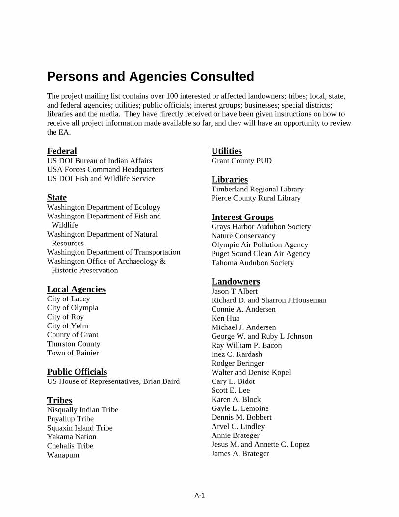
Persons and Agencies Consulted The project mailing list contains over 100 interested or affected landowners; tribes; local, state, and federal agencies; utilities; public officials; interest groups; businesses; special districts; libraries and the media. They have directly received or have been given instructions on how to receive all project information made available so far, and they will have an opportunity to review the EA. Federal US DOI Bureau of Indian Affairs USA Forces Command Headquarters US DOI Fish and Wildlife Service State Washington Department of Ecology Washington Department of Fish and
Wildlife Washington Department of Natural
Resources Washington Department of Transportation Washington Office of Archaeology &
Historic Preservation Local Agencies City of Lacey City of Olympia City of Roy City of Yelm County of Grant Thurston County Town of Rainier Public Officials US House of Representatives, Brian Baird Tribes Nisqually Indian Tribe Puyallup Tribe Squaxin Island Tribe Yakama Nation Chehalis Tribe Wanapum
Utilities Grant County PUD Libraries Timberland Regional Library Pierce County Rural Library Interest Groups Grays Harbor Audubon Society Nature Conservancy Olympic Air Pollution Agency Puget Sound Clean Air Agency Tahoma Audubon Society Landowners Jason T Albert Richard D. and Sharron J.Houseman Connie A. Andersen Ken Hua Michael J. Andersen George W. and Ruby L Johnson Ray William P. Bacon Inez C. Kardash Rodger Beringer Walter and Denise Kopel Cary L. Bidot Scott E. Lee Karen A. Block Gayle L. Lemoine Dennis M. Bobbert Arvel C. Lindley Annie Brateger Jesus M. and Annette C. Lopez James A. Brateger
A-1
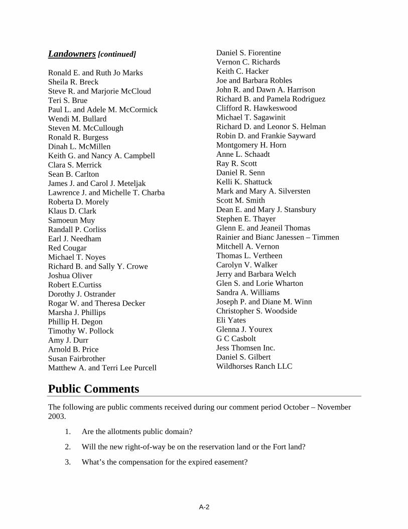
Landowners [continued] Ronald E. and Ruth Jo Marks Sheila R. Breck Steve R. and Marjorie McCloud Teri S. Brue Paul L. and Adele M. McCormick Wendi M. Bullard Steven M. McCullough Ronald R. Burgess Dinah L. McMillen Keith G. and Nancy A. Campbell Clara S. Merrick Sean B. Carlton James J. and Carol J. Meteljak Lawrence J. and Michelle T. Charba Roberta D. Morely Klaus D. Clark Samoeun Muy Randall P. Corliss Earl J. Needham Red Cougar Michael T. Noyes Richard B. and Sally Y. Crowe Joshua Oliver Robert E.Curtiss Dorothy J. Ostrander Rogar W. and Theresa Decker Marsha J. Phillips Phillip H. Degon Timothy W. Pollock Amy J. Durr Arnold B. Price Susan Fairbrother Matthew A. and Terri Lee Purcell
Daniel S. Fiorentine Vernon C. Richards Keith C. Hacker Joe and Barbara Robles John R. and Dawn A. Harrison Richard B. and Pamela Rodriguez Clifford R. Hawkeswood Michael T. Sagawinit Richard D. and Leonor S. Helman Robin D. and Frankie Sayward Montgomery H. Horn Anne L. Schaadt Ray R. Scott Daniel R. Senn Kelli K. Shattuck Mark and Mary A. Silversten Scott M. Smith Dean E. and Mary J. Stansbury Stephen E. Thayer Glenn E. and Jeaneil Thomas Rainier and Bianc Janessen – Timmen Mitchell A. Vernon Thomas L. Vertheen Carolyn V. Walker Jerry and Barbara Welch Glen S. and Lorie Wharton Sandra A. Williams Joseph P. and Diane M. Winn Christopher S. Woodside Eli Yates Glenna J. Yourex G C Casbolt Jess Thomsen Inc. Daniel S. Gilbert Wildhorses Ranch LLC
Public Comments The following are public comments received during our comment period October – November 2003.
1. Are the allotments public domain?
2. Will the new right-of-way be on the reservation land or the Fort land?
3. What’s the compensation for the expired easement?
A-2
4. What can be done with the land when lines are out (short range/ long range)?
5. Concern with children and grandchildren what will happen in the future?
6. Concerned that some kind of contamination (something unknown) would be left, and not know for 10 years out.
7. With 2 generations growing up with the lines there what if something pops up, what will BPA do? What will the tribe do?
8. Having the Fort Lewis reservation keeps development from surrounding the Nisqually Reservation.
9. Tribes still have concern for one another, they want other tribes to do well, relationships still there.
10. What happens here will affect other Tribes/relations that may move back to Nisqually.
11. Where is the new Tribal land from Fort Lewis?
12. Can the land be used to build on once the line is gone, has it been damaged?
13. We have not gotten much information on the project.
14. I did not get a letter and I live by the line.
15. Can we get a map showing the allotments?
16. Would like to see the line cross, section 04 and not cross section 33 so the Tribe can use section 33 also.
17. How much is the Fort Lewis property worth?
18. Why is BPA moving the line?
19. Will there be a new frontage road along the tribal easement? Parallel to SR510?
20. How is the Tribe going to reimburse the landowners?
21. The Tribe should only have a voice in some of the requests to move the line.
22. BPA needs to talk with homeowners near the new right-of-way.
23. As one of the allottees, I never asked BPA to leave.
24. Doesn’t seem right to move the lines all the way around.
25. Seems that all the benefits will go to the Nisqually Tribe- not the allottee’s/others.
26. How long will the line be used before the new line is built?
27. If the landowners don’t come to you, you need to go to them to tell them the proposal and ask them if they have concerns.
28. With the existing lines the tribe is pinned in.
A - 3
29. SR 510 is very dangerous/car wrecks.
30. Under the existing lines you get shocked touching the fireworks packages.
31. The effects of the lines are not good for the children based on everything we’ve read.
32. Been living next to the line for the past 50+ years.
33. “Proposing to obtain parcel from Fort Lewis” should be changed to “land should be returned to Tribe”.
34. The Reservations are prison camps, but called Reservations.
35. This is really going to help the tribe a lot.
36. There are nesting eagles are on the northeast side of the existing line.
37. Near Reservation Rd. there are endangered woodpeckers.
38. What are the Tribes plans to develop the lands traded w/ the Fort?
39. Is there going to be more houses or commercial development?
40. What about impact to wildlife?
41. Need to look more closely at double circuit.
42. What will the impact be to our water if the Tribe develops?
43. I don’t care about the wildlife so much.
44. I was concerned that the lines would come closer to housing developments.
45. The proposal will not affect me much
46. I would prefer not to see the lines; I drive 510 often.
47. What would the double circuit lines look like?
48. How are you going to get others contacted, Evergreen students (tree-sitters) and others in Olympia are interested in this type of project.
49. As homeowners abutting Fort Lewis, we are wondering what the Tribe will do with the land?
50. We like that all this land around has no development.
51. We walk along access in Fort Lewis.
52. Can hear lines crackling.
53. State Route 510 is the deadliest in state. How will more development impact it?
54. Eagles nest on snags behind our house.
55. Big difference in traffic since the casino was built.
A - 4
56. Every weekend there is an accident.
57. The Crossroads would be a perfect development spot.
58. My house might be good rental property if casino and workers increase.
59. Hoping someone/ BPA would buy us out.
60. What is going to happen to the Tribal exchanged land up North? Are they going to cut down all the trees and develop?
61. What is the tribe going to do with their exchanged land? We heard they are proposing a liquor/cigarette /porn shop somewhere on the reservation.
62. What causes the noise? Will it be more?
63. I’m sure the tribe will do development, hotel, casino, conference center along HWY on the exchanged land.
64. We might have to sell our house, it’s getting too crowded.
65. I don’t like that there will be much more Reservation.
66. I’m afraid that once the Tribe has that land they will make the rest of the lines move to Fort Lewis and cross the housing development.
67. Heard that electrical effects might affect the suicide rate.
68. I can see why the tribe would want the line moved for development.
69. Why don’t you cut straight across Army land instead of such a long route?
70. Why don’t you put the lines underground like they do in Europe, prevent icing.
71. I personally don’t like seeing the lines it’s not very appealing. (Phase 2 option 1&2)
72. Our property abuts Fort Lewis (North).
73. Concerned about wildlife deer, bear, cougar, eagles, possum, etc., all have come through our yard.
74. More than one bear within a mile, they will get squeezed into smaller areas.
75. Concerned about Spotted Owl habitat.
76. Concerned w/ tribal development and water use, we have well that serves about seven homes.
77. In the summer our wells get lots of use.
78. What would development do to the aquifer in the area?
79. Erosion control measures must be in place prior to any clearing, grading, or construction.
A - 5
80. These control measures must be effective to prevent soil from being carried into surface water by stormwater runoff.
81. Sand, silt, and soil will damage aquatic habitat and are considered pollutants.
82. Any discharge of sediment-laden runoff or other pollutants to waters of the state is in violation of Chapter 90.48, Water Pollution Control, and WAC 173-201A, Water Quality Standards for Surface Waters of the State of Washington, and is subject to enforcement action.
83. During construction, all releases of oils, hydraulic fluids, fuels, other petroleum products, paints, solvents, and other deleterious materials must be contained and removed in a manner that will prevent their discharge to waters and soils of the state.
84. The cleanup of spills should take precedence over other work on the site.
85. Placement of fill in wetlands may require an individual or general (nationwide) permit from the U.S. Army of Corps of Engineers.
86. We advise the applicant to contact the Corps to determine if a permit is needed.
87. Should an individual U.S. Army of Corps Engineers permit be required, a water quality certification will also be required from Ecology. We will therefore provide additional review at that time.
88. Should this move involve impacts to wetlands or streams, the applicant should contact the Army Corps of Engineers at (206) 766-6438 for information on required permits.
89. Will my concerns and objections regarding the change in land use from "military training land" to "land for Nisqually Tribe community development" be considered by the Army?
90. Who is the Army decision-maker regarding this action and the land exchange?
91. My property is currently subject to Thurston County restrictions limiting options for development, e.g., density limited to < 1 house/5 acres. Will the Nisqually Tribe be subject to similar limitations?
92. Will development by the Nisqually Tribe be subject to NEPA review or other environmental review processes?
93. What types of development will be open to the Nisqually Tribe: commercial, residential, etc.?
94. What protections will be put in place to protect the McAllister aquifer?
95. An alternative for the project that should be considered would be to exclude the property north of Yelm Highway and west of SR510 from the land exchange.
96. The moratorium states a number of issues, one of which applies to the development of new homes. To my understanding, only one home can be built per every 5 acre parcel. The moratorium went into effect primarily to protect the McAlister Springs Aquifer
A - 6
that lays beneath that region, but it also is meant to help slow the lowering of the water table that has seen significant reduction, due to increased development.
97. All homes in the area affected by the relocation project are dependent on the water thru the use of private wells, or by community reservoirs, filled by a community well.
98. The information letter I received states that the Tribe wants to use the proposed area for “Reservation Community Development”. What specifically is meant by “community development”?
99. Is the Tribe planning to build a housing project, another casino, stores, gas station, etc..?
100. Does the tribe have cart blanch to do virtually whatever it wants for “community development”?
101. We oppose it due to the reasons for the moratorium and also because we are concerned for the likelihood of our property values dropping, as a result of the land transfer.
102. However, should somehow the moratorium be overridden, or an exception be made, regarding the moratorium, we propose another alternative. As a compromise, we suggest that the portion of the area proposed for transfer located between Hwy. 510 and the Yelm Highway be left as is, as far as land transfer purposes are concerned, but that the transmission line relocation in that area still be conducted as BPA deems necessary.
A - 7
Appendix B
Resource Impact Ratings
Impact Ratings for Vegetation
A high impact would be expected where one or more of the following would occur:
• A unique, high quality, or entire native plant community would be permanently removed.
• One or more populations of protected plant species would suffer losses that result in decreased viability.
• Removal of vegetation would result in the need for regulatory protection of one or more plant species currently not protected.
• One or more Class A or B noxious weeds would be introduced from outside the area and become established.
A moderate impact would be expected where one or more of the following would occur:
• Part of a native plant community would be permanently removed and/or a unique, high quality native plant community would be temporarily disturbed.
• Protected plant species would be affected minimally and recover quickly.
• Removal of vegetation would not result in the need for regulatory protection of one or more plant species.
• One or more Class C noxious weeds would be introduced from outside the area and become established as a result.
A low impact would be expected where one or more of the following would occur:
• Part of a native plant community would be temporarily disturbed.
• No protected plant species would be affected.
• Some Class C noxious weeds already established in the vicinity would colonize disturbed sites.
There would be no impact if vegetation remains undisturbed, and no noxious weeds would be spread or introduced.
Impact Ratings for Wildlife
A high impact would be expected where one or more of the following would occur:
• Habitat, essential for a particular species, is permanently destroyed.
• Protected wildlife species are killed, injured, or permanently disturbed.
• Wildlife mortality or injury results in the need for regulatory protection.
• Permanent or continued intermittent destruction of prey populations/food resources occurs.
B - 1
A moderate impact would be expected where:
• Habitat, essential for a particular species, is temporarily destroyed.
• Protected species are temporarily disturbed.
• Wildlife mortality or injury does not result in the need for regulatory protection.
• Temporary destruction of prey populations/food resources occurs.
A low impact would be expected where:
• Habitat, essential for a particular species, is temporarily disturbed.
• Protected species are not affected.
• Temporary disturbances to wildlife occur.
• Temporary reductions in prey populations/food resources occur.
There would be no impact when wildlife remains undisturbed, and there is no reduction in habitat or prey populations or food resources.
Impact Ratings for Geology and Soils
A high impact to soils would be expected where:
• Clearing, grading, excavation, and compaction of soils leads to long-term accelerated erosion, an increase in stormwater runoff and accumulation of sediment offsite.
A moderate impact to soils would be expected where:
• Clearing, grading, excavation, and compaction of soils leads to a temporary increase in stormwater runoff.
• Erosion is limited to erosion via shallow channels at a few sites, and most sediment is intercepted before flowing offsite.
A low impact to soils would be expected where:
• Clearing, grading, excavation, and compaction of soils are minimal and lead to little or no stormwater runoff.
• Erosion of slopes is limited to minor sheet erosion and occasional small channels; erosion and sedimentation levels would remain near present levels during and following construction.
No impact would be expected where there is no clearing, compaction, or other soil disturbance.
Impact Ratings for Water Resources and Fish
There would be a high impact where:
• A water body that supports fish, wildlife habitat, or human uses would be extensively altered, in and beyond the project area, so as to affect its uses or integrity.
B - 2
• State or federal chronic ambient water quality criteria (AWQC) probably would be exceeded for weeks or longer in a large portion of the water body.
• Disturbance of wetland hydrology, wetland vegetation, or wetland soils is extensive and wetland functions are permanently lost or impaired beyond recovery.
There would be a moderate impact where:
• A water body that supports fish, wildlife habitat, or human uses would be altered only locally (within the project area) so as to affect its uses or integrity.
• There is a possible short-term alteration of water quality, such as exceeding federal or state AWQC, which is confined to the local project area.
• Disturbance of wetland hydrology, vegetation, or soils is slight (small portions of wetlands are permanently filled) or temporary (as from temporary road fill) and wetland functions would be modestly impaired.
There would be a low impact where:
• A water body that supports fish, wildlife habitat, or human uses would be slightly altered only locally (part of the project area) so as to affect its uses or integrity.
• Normal background water quality parameters would be altered without exceeding federal or state AWQC.
• Disturbance of wetlands is temporary and affects only small patches of wetland vegetation that may be crushed or cut and small areas of wetland soils that may be compacted and wetland functions are temporarily and slightly impaired.
There would be no impact when surface water and groundwater are unaffected by construction activities or operation and maintenance of the transmission line, or wetlands or directly adjacent uplands are not altered or disturbed, although transmission lines may span or run adjacent to wetlands.
Impact Ratings for Land Use and Transportation
Land use impacts would be high where the Proposed Action or alternatives would:
• Require acquisition of new right-of-way and access roads and installation of new towers outside of existing electrical transmission corridors, precluding existing or planned use of land in an area not previously directly affected by the presence of electrical transmission lines.
• Displace residences.
• Remove transmission lines from an existing corridor, but not rebuild the transmission lines on another corridor.
• Create a hazard from clearances of the conductors over public/private roads to those who would be using the roads under the transmission lines.
• Interfere with existing plans that the County or State Highway Department (WSDOT) would have for any road improvement projects in the area.
B - 3
• Create noise, dust and traffic disruption over most of a year or years so that normal land use activities are interrupted by construction activities.
• Change land ownership so that the land would be unavailable for current land uses.
Impacts would be moderate where the Proposed Action or alternatives would:
• Require acquisition of new right-of-way and access roads and installation of new towers outside of but immediately adjacent to existing electrical transmission corridors, precluding existing or planned use of land in an area already affected by the presence of electrical transmission lines.
• Require acquisition of new right-of-way and access roads and installation of new towers outside of existing electrical transmission corridors, but allow continued existing or planned use of land in an area not previously directly affected by the presence of electrical transmission lines.
• Remove transmission lines from an existing corridor, but rebuild the lines on another corridor.
• Remove transmission lines from an existing right-of-way, but the vacated land is still encumbered by adjacent transmission facilities.
• Create noise, dust and traffic disruption over many months so that normal land use activities are interrupted by construction activities.
• Change land ownership so that the current land uses continue for a short time, but planned land uses would be implemented in the near term.
Impacts would be low where the Proposed Action or alternatives would:
• Occupy existing right-of-way and access roads and require rebuilding or replacement of existing towers or the installation of new towers within the existing right-of-way.
• Create brief, temporary, noise, dust and traffic disruption so that normal land use activities are interrupted by construction activities.
• Change land ownership, but current land uses essentially continue with minor modifications and future land uses are speculative.
• Keep the right-of-way in its present location, thereby restricting future land changes.
There would be no impacts if the proposed alternatives did not interfere with the present or future road plans or land use in the area, and the clearances met the state and local government clearance requirements for overhead power lines.
Impact Ratings for Visual Quality
A high level of impact to views would occur if:
• The transmission lines right-of-way would become the dominant feature or focal point of the view.
B - 4
• A large number of sensitive viewers would see the right-of-way in predominantly the foreground and middle ground of the view.
• An existing line or lines would be removed from the view and the lines would not be rebuilt in another location.
A moderate impact would occur if:
• The right-of-way would be clearly visible in the view but would not be the dominant feature in the view.
• A large number of sensitive viewers would see the right-of-way mostly in the middleground of the view.
• An existing line or lines would be removed, and the lines would be rebuilt in another nearby location where the right-of-way would be visible.
A low impact would occur if:
• The right-of-way would be somewhat visible but not evident in the view.
• Few sensitive viewers would see the right-of-way because it is screened, or predominantly viewed in the middleground and background of the view.
• An existing line or lines would be removed, but the lines would be rebuilt in another location with few sensitive viewers.
No impact would occur if:
• The right-of-way would be isolated, screened, not noticed in the view or only seen from a great distance.
• No visually sensitive resources would be affected.
Impact Ratings for Cultural Resources
A high impact would occur if:
• Activities related to the construction operation, or maintenance of the proposed project adversely affected a historic resource eligible for listing in the National Register of Historic Places (NRHP) by directly or indirectly altering any of the characteristics of the resource in a manner that would diminish the integrity of the property’s location, design, setting, materials, workmanship, feeling, or association and adverse effects could not be mitigated.
A moderate to low impact would occur if:
• NRHP-eligible historic resources are adversely affected, but it is determined through the Section 106 consultation process that impacts would be reduced through the use of mitigation measures or avoidance.
No impacts would occur if a known historic resource would not be affected directly or indirectly by construction, operation, or maintenance of the proposed project; or, if resources are present,
B - 5
the project is modified to ensure there would be no adverse effects to cultural resources, as concurred by the SHPO through the Section 106 consultation process.
Impact Ratings for Socioeconomics
An impact would be high if an action:
• Increases (or decreases) jobs or spending in a county by more than one percent.
• Impairs access to a particular business or landowner for up to one week of regular business days.
• Creates demand for hotel/motel rooms and RV sites in a county that is more than 5 percent of the available supply.
• Produces changes in population more than 5 percent where the population increase is projected to occur.
An impact would be moderate if an action:
• Increases (or decreases) jobs or spending in a county by between 0.5 and 1 percent. • Impacts access to a particular business or landowner for more than one business day but
less than a week. • Creates demand for hotel/motel rooms and RV sites in a county that is between 1 and 5
percent of the available supply. • Produces changes in population between 1 and 5 percent of any local community’s
population (where the population increase is projected to occur). • Causes an influx of construction workers that would place a significant burden on the
local communities ability to provide services, or that these communities would experience significant costs for having done so.
An impact would be low if an action:
• Increases (or decreases) jobs or spending in a county by less than 0.5 percent.
• Impairs access to a particular business or landowner for less than one regular business day.
• Creates demand for hotel/motel rooms and RV sites in a county that is less than 1 percent than the regular supply.
• Produces changes in population totaling less than 1 percent of any local community’s population (where the population change is projected to occur).
No impact would occur if an action:
• Would not affect increases or decreases in jobs or spending in the County.
• Would not inhibit a business or landowner’s access by the proposed project.
• Would not impact the demand for hotel/motel/RV by the proposed project.
B - 6
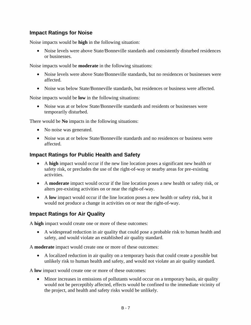
Impact Ratings for Noise
Noise impacts would be high in the following situation:
• Noise levels were above State/Bonneville standards and consistently disturbed residences or businesses.
Noise impacts would be moderate in the following situations:
• Noise levels were above State/Bonneville standards, but no residences or businesses were affected.
• Noise was below State/Bonneville standards, but residences or business were affected.
Noise impacts would be low in the following situations:
• Noise was at or below State/Bonneville standards and residents or businesses were temporarily disturbed.
There would be No impacts in the following situations:
• No noise was generated.
• Noise was at or below State/Bonneville standards and no residences or business were affected.
Impact Ratings for Public Health and Safety • A high impact would occur if the new line location poses a significant new health or
safety risk, or precludes the use of the right-of-way or nearby areas for pre-existing activities.
• A moderate impact would occur if the line location poses a new health or safety risk, or alters pre-existing activities on or near the right-of-way.
• A low impact would occur if the line location poses a new health or safety risk, but it would not produce a change in activities on or near the right-of-way.
Impact Ratings for Air Quality
A high impact would create one or more of these outcomes:
• A widespread reduction in air quality that could pose a probable risk to human health and safety, and would violate an established air quality standard.
A moderate impact would create one or more of these outcomes:
• A localized reduction in air quality on a temporary basis that could create a possible but unlikely risk to human health and safety, and would not violate an air quality standard.
A low impact would create one or more of these outcomes:
• Minor increases in emissions of pollutants would occur on a temporary basis, air quality would not be perceptibly affected, effects would be confined to the immediate vicinity of the project, and health and safety risks would be unlikely.
B - 7

There would be no impact when no increases in emissions of pollutants would occur during construction or operation/maintenance.
B - 8
Appendix C
Wildlife Species Found in Thurston County
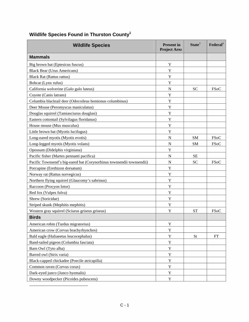
Wildlife Species Found in Thurston County1
Wildlife Species Present in Project Area2
State3 Federal4
Mammals
Big brown bat (Eptesicus fuscus) Y Black Bear (Urus Americans) Y Black Rat (Rattus rattus) Y Bobcat (Lynx rufus) Y California wolverine (Gulo gulo luteus) N SC FSoC Coyote (Canis latrans) Y Columbia blacktail deer (Odocoileus hemionus columbinus) Y Deer Mouse (Peromyscus maniculatus) Y Douglas squirrel (Tamiasciurus douglasi) Y Eastern cottontail (Sylvilagus floridanus) Y House mouse (Mus musculus) Y Little brown bat (Myotis lucifugus) Y Long-eared myotis (Myotis evotis) N SM FSoC Long-legged myotis (Myotis volans) N SM FSoC Opossum (Didelphis virginiana) Y Pacific fisher (Martes pennanti pacifica) N SE Pacific Townsend’s big-eared bat (Corynorhinus townsendii townsendii) N SC FSoC Porcupine (Erethizon dorsatum) Y Norway rat (Rattus norvegicus) Y Northern flying squirrel (Glaucomy’s sabrinus) Y Raccoon (Procyon lotor) Y Red fox (Vulpes fulva) Y Shrew (Soricidae) Y Striped skunk (Mephitis mephitis) Y Western gray squirrel (Sciurus griseus griseus) Y ST FSoC Birds American robin (Turdus migratorius) Y American crow (Corvus brachyrhynchos) Y Bald eagle (Haliaeetus leucocephalus) Y St FT Band-tailed pigeon (Columbia fasciata) Y Barn Owl (Tyto alba) Y Barred owl (Strix varia) Y Black-capped chickadee (Poecile atricapilla) Y Common raven (Corvus corax) Y Dark-eyed junco (Junco hyemalis) Y Downy woodpecker (Picoides pubescens) Y
C - 1
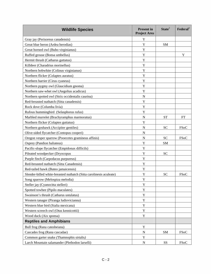
Wildlife Species Present in Project Area2
State3 Federal4
Gray jay (Perisoreus canadensis) Y Great blue heron (Ardea herodias) Y SM Great horned owl (Bubo virginianus) Y Ruffed grouse (Bonsa umbellus) Y Y Hermit thrush (Catharus guttatus) Y Killdeer (Charadrius morinellus) Y Northern bobwhite (Colinus virginianus) Y Northern flicker (Colaptes auratus) Y Northern harrier (Cirus cyaneus) Y Northern pygmy owl (Glaucidium gnoma) Y Northern saw-whet owl (Aegolius acadicus) Y Northern spotted owl (Strix occidentalis caurina) N Red-breasted nuthatch (Sitta canadensis) Y Rock dove (Columba livia) Y Rufous hummingbird (Selasphorus rufus) Y Marbled murrelet (Brachyramphus marmoratus) N ST FT Northern flicker (Colaptes guttatus) Y Northern goshawk (Accipiter gentiles) N SC FSoC Olive-sided flycatcher (Contopus cooperi) N Oregon vesper sparrow (Pooecetes gramineus affinis) N SC FSoC Osprey (Pandion haliateus) Y SM Pacific-slope flycatcher (Empidonax difficils) Y Pileated woodpecker (Dryocopus Y SC Purple finch (Carpodacus purpureus) Y Red-breasted nuthatch (Sitta Canadensis) Y Red-tailed hawk (Buteo jamaicensis) Y Slender-billed white-breasted nuthatch (Sitta carolinesis aculeate) Y SC FSoC Song sparrow (Melospiza melodia) Y Steller jay (Cyanocitta stelleri) Y Spotted towhee (Pipilo maculates) Y Swainson’s thrush (Catharus ustulatus) Y Western tanager (Piranga ludiovicianna) Y Western blue bird (Sialia mexicana) Y Western screech owl (Otus kennicottii) Y Wood duck (Aix sponsa) Y Reptiles and Amphibians Bull frog (Rana catesbeiana) Y Cascades frog (Rana cascadae) N SM FSoC Common garter snake (Thamnophis sirtalis) Y Larch Mountain salamander (Plethodon larselli) N SS FSoC
C - 2
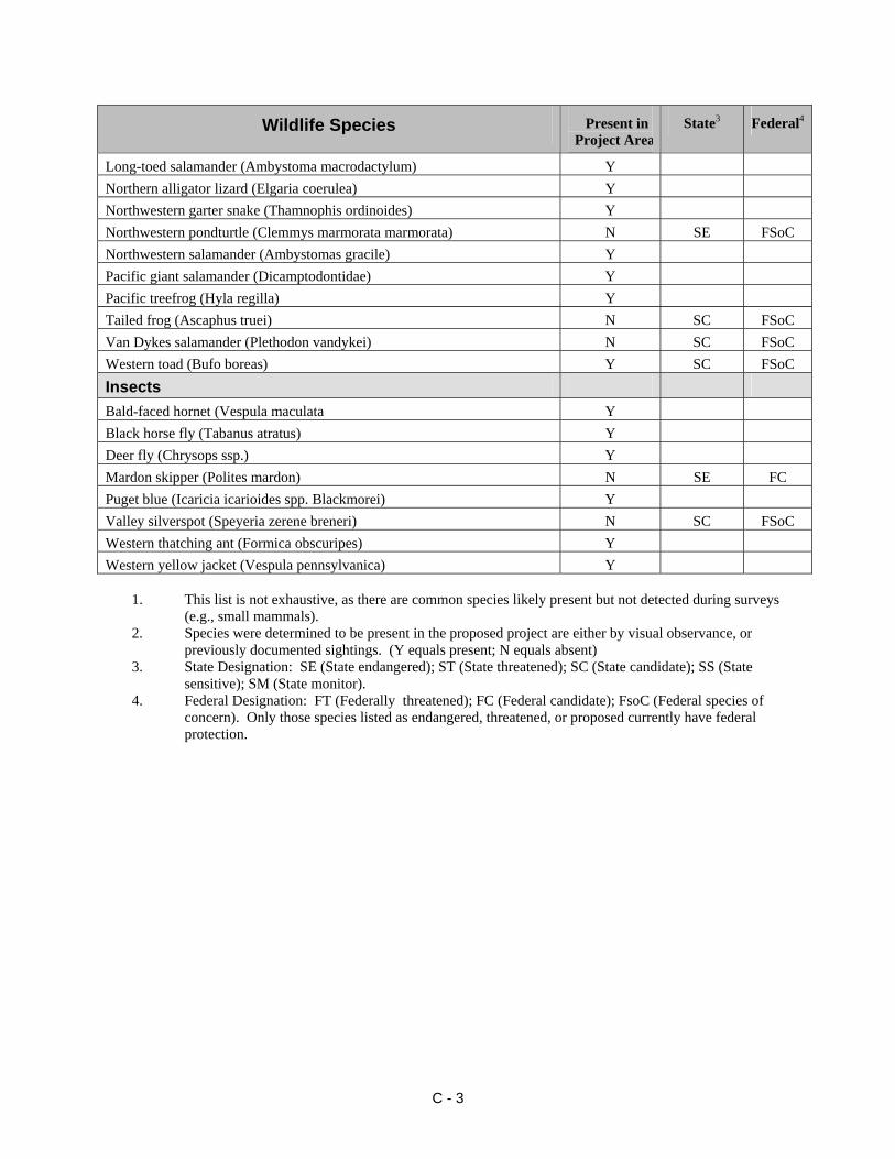
Wildlife Species Present in Project Area2
State3 Federal4
Long-toed salamander (Ambystoma macrodactylum) Y Northern alligator lizard (Elgaria coerulea) Y Northwestern garter snake (Thamnophis ordinoides) Y Northwestern pondturtle (Clemmys marmorata marmorata) N SE FSoC Northwestern salamander (Ambystomas gracile) Y Pacific giant salamander (Dicamptodontidae) Y Pacific treefrog (Hyla regilla) Y Tailed frog (Ascaphus truei) N SC FSoC Van Dykes salamander (Plethodon vandykei) N SC FSoC Western toad (Bufo boreas) Y SC FSoC Insects Bald-faced hornet (Vespula maculata Y Black horse fly (Tabanus atratus) Y Deer fly (Chrysops ssp.) Y Mardon skipper (Polites mardon) N SE FC Puget blue (Icaricia icarioides spp. Blackmorei) Y Valley silverspot (Speyeria zerene breneri) N SC FSoC Western thatching ant (Formica obscuripes) Y Western yellow jacket (Vespula pennsylvanica) Y
1. This list is not exhaustive, as there are common species likely present but not detected during surveys
(e.g., small mammals). 2. Species were determined to be present in the proposed project are either by visual observance, or
previously documented sightings. (Y equals present; N equals absent) 3. State Designation: SE (State endangered); ST (State threatened); SC (State candidate); SS (State
sensitive); SM (State monitor). 4. Federal Designation: FT (Federally threatened); FC (Federal candidate); FsoC (Federal species of
concern). Only those species listed as endangered, threatened, or proposed currently have federal protection.
C - 3
Appendix D
Cultural Resources
History of the Area
Tribal History
The project lies within the Northwest Coast culture area of North America. The Northwest Coast culture area extends from the Gulf of Alaska to near the border of Oregon and California and from the coast to inland mountain ranges. Northwest Coast peoples developed distinctive woodworking including plank houses, canoes, everyday domestic use items, and spiritual and ceremonial items.
Prior to Euro-american settlement, the Puget Sound area was occupied by the Southern Coast Salish people. Salt-water people lived along or near Puget Sound, and navigated on open water. River people lived on the lower courses of rivers. Prairie people also lived along rivers, but close to inland prairies and used horses for transportation. Inland people lived on the upper reaches of the major drainages.
The Nisqually Indians, who occupied the Nisqually basin from the Cascade Mountains to the Nisqually delta on Puget Sound, spoke a version of the Lushootseed dialect.
Villages were independent, but bound by ties of kinship to other villages. A village was usually composed of one or more households, each occupying a large plankhouse. A household was composed of several families, usually related by blood or marriage. The household was the economic and social foundation of Southern Coast Salish life. Within the house, each family had its own hearth and section of the house.
Villages were occupied through the winter rainy season, when people relied primarily on foods gathered and processed for storage during the summer months. In the spring, the winter houses began to be abandoned as families moved out to resource locations. During the spring and fall salmon runs, fish harvest was the main activity. Spring was the key season for collecting young sprouts, roots, and some species of clams. In late summer and fall, berries, nuts, game (deer, elk, and black beer), and roots (camas bulbs and bracken fern roots) were harvested.
To harvest far resources, summer camps were established. Harvesting areas were not viewed as exclusive to a certain village in the sense of being owned or controlled. Favored clam-digging areas, inland prairies with camas and oaks (acorns were a preferred food), and upland berry locations were usually open to all friendly, neighboring groups. Seasonal resource harvesting at these locations offered people the opportunity for socializing (Smith 1940:23-27).
The Nisqually maintained ties of marriage and exchange with other Southern Coast Salish/Lushootseed speaking groups and the Upper Chehalis. By the early 1800s, some of the villages of the upper Nisqually and Puyallup drainages included many Sahaptin speakers, reflecting intermarriage with Kittitas and Yakama people from the Columbia Plateau (Smith 1940:15-20; Suttles and Lane 1990:488). Contact with Sahaptin groups took place regularly in the passes of the Cascade Mountains, where both eastside and westside groups met while foraging for various resources. Groups traveled to the high mountain valleys each summer and fall to gather berries and hunt deer, goats, elk, and bear. They often camped near berry fields at altitudes between 3,000 and 5,000 ft (914-1,524 m). The forests and meadows around Mount
D - 1
Rainier were important summer hunting and gathering sites for the Nisqually, Puyallup, Upper Cowlitz, Muckleshoot, and Yakama people.
Europeans Arrive
In the late 1700s, European explorers arrived by sea to map the coast of Puget Sound. During this time they peacefully exchanged gifts with the Indians they met.
In 1824 a Hudson’s Bay Company (HBC) expedition came through the region, and in 1833 the HBC built Fort Nisqually. The original site of the Fort was on the beach and plains above the Nisqually River delta in the present town of DuPont, Washington, on the lands traditionally occupied by the Nisqually Indians. The HBC brought native Hawaiians and Iroquois to work at the Fort, and employed local Indians. Intermarriage became common between all groups at the Fort.
When the 1846 treaty between the United States and Great Britain established the boundary between the two country's claims at the 49th parallel, Fort Nisqually became American property. The Fort was shut down in 1869.
By 1847, the area of the northern Oregon Territory had some 275 British and United States citizens. Most lived in either Tumwater, Fort Nisqually, or Cowlitz Farm, near the present-day town of Toledo.
Nisqually Tribal History
By the 1850s, American settlement increased dramatically, putting new pressures on native communities. The settlers called for treaties to extinguish Native title to the land, and in 1854, Washington Territorial Governor Stevens negotiated terms with local Southern Coast Salish people under the Medicine Creek Treaty. Under the terms of the treaty, the Nisqually, Puyallup, and other bands ceded (gave) their territorial lands (most of Puget Sound and the Olympia Peninsula - just over 2.2 million acres) to the U.S. government. In exchange, the Indians received tracts of land, including the tract that became the Nisqually Reservation.
Some Indians refused to sign the treaty. The most famous was Chief Leschi, who with his brother Quiemuth, had been selected to represent the Nisqually people. Leschi objected to the proposed location of the reservation at the mouth of McAllister Creek, away from traditional gathering places on the Nisqually delta (Ruby and Brown 1986:151). Despite Leschi's misgivings, the Medicine Creek Treaty was ratified by Congress.
Following the treaty signing, Chief Leschi traveled to Olympia to talk with Secretary of State Charles Mason to try to change the location of reservation lands. Based on information from settlers that Chief Leschi and his brother were troublemakers, Mason attempted to take Leschi and his brother Quiemuth into custody. The two brothers fled east toward the Cascades, and a volunteer army composed of local settlers followed (Bagley 1929:164-165; Newell 1950:22).
While the army searched for the brothers, Indians killed two settlers and shortly attacked some Euro-american families living at White River. Officials blamed Chief Leschi, who claimed that he did not want to fight the settlers, only to resolve his concerns about the reservation (Bagley 1929:164-165). These violent events spawned the Indian War of 1855-1856, in which Leschi
D - 2
became a prominent war chief of the Puyallup and Nisqually tribes. The war was fought primarily in the valleys of the White and Puyallup rivers, and in Seattle (Newell 1950:22).
Governor Stevens called a Peace Council on Fox Island on August 4 and 5, 1856 and promised to call an end to fighting and create new, better reservations for the tribal peoples. Leschi was captured after his nephew, Slugia, revealed his whereabouts in exchange for 50 blankets, and was taken into custody at Fort Steilacoom (Newell 1950:23). When he heard of his brother’s capture, Quiemuth surrendered to the authorities. En route to the jail at Fort Steilacoom, Quiemuth and his jailors stopped for the night in Olympia. During the night, while sleeping in Governor Steven's unlocked office, Quiemuth was stabbed to death. His assailant was never officially identified nor brought to trial.
Leschi was tried for the murder of a soldier, A. B. Moses. The first trial resulted in a hung jury “ . . . and this is a telling point when it is considered that this was an all-white jury made up of settlers who had suffered bitterly in a long and vicious war, in an age when the life of a red man was of little importance at best" (Newell 1950:23). Though the jury at the second trial found him guilty and sentenced him to hang, the Pierce County sheriff refused to carry out the death sentence and the Army, which considered him a prisoner of war and regarded him innocent, refused to release him to the hangman (Newell 1950:23). The Washington Territory Supreme Court heard arguments in favor of Leschi's innocence, but nevertheless resentenced him to hang. The Thurston County sheriff was prevailed upon to carry out the sentence and Leschi was hanged on February 19, 1858, to the sorrow of his people and many others that respected him as a great leader, warrior, and orator. As a result of Leschi’s struggle, the Nisqually reservation was relocated to more suitable lands with access to the Nisqually River and the adjacent prairies. This reservation included about 4,700 acres, most of it in Pierce County. Allotment of reservation lands to individual tribal families began in 1884, prior to the passage of the Dawes Severalty Act of 1887. Nearly two-thirds of the Nisqually Reservation was lost in 1918, when Pierce County, through condemnation proceedings, took about 3,200 acres and donated the land to the United States to establish Camp Lewis as a World War I training camp (Marino 1990:175). The Tribe adopted a constitution in 1946 in accordance with the 1934 Indian Reorganization Act. However, by the 1940s and 1950s, only a few families subsisted on the Nisqually Reservation, which had no electricity or running water. Following lengthy court battles that culminated in a federal Supreme Court decision in 1979 that upheld a lower court ruling, the Nisqually and other western Washington tribes were granted under the 1854 Medicine Creek Treaty the right to half the salmon and steelhead from their traditional fishing grounds, even if these were off reservation lands (Marino 1990:175-177; Suttles and Lane 1990:501). The court decisions led to the establishment of tribal-based fishing industries, fishery enhancement projects, and increased control and management of fish-related resources. Funds from these enterprises have enabled the Nisqually to build a tribal headquarters in the 1980s, and more recently a natural resources department, a youth center, a health clinic, library, classrooms, jail, the Red Wind Casino, and an intergenerational center for elders and youth (Nisqually Tribal Profile 2003).
D - 3
Development of Ft. Lewis
In 1917 the federal government expanded its military strength in preparation for World War I. The Nisqually Prairie was selected for a new army cantonment, named Camp Lewis in honor of Meriwether Lewis. It was the largest of the cantonments built at this time, and the only one to be built west of the Rockies. A labor force of nearly 10,000 people erected 1,757 buildings and 422 incidental structures within 90 days during the summer of 1917. These facilities could accommodate 48,000 troops.
Following the Allied victory in World War I, Camp Lewis was virtually abandoned and its facilities fell into disrepair or were destroyed by fires. In 1927 Camp Lewis was rebuilt, modernized and renamed Fort Lewis. It held 37,000 troops at the beginning of World War II. Today, the military installation remains an important U.S. Army training center (Chapman et al. 1996:38).
References Bagley, C. 1929 History of King County. S. J. Clarke Publishing Company, Chicago, Illinois.
http://www.tpl.lib.wa.us/cgi-win/disastr2.exe/Connell's_Prairie_Battle|indian. bat/connells.pra.
Chapman, J.. S., D. V. Ellis, E. E. Forgeng, D. T. Francis, T. J. Hills, and J. J Wilt 1996 A Cultural Resources Inventory of the Proposed Worldcom Fiber Optic Cable Project,
Portland, Oregon to Seattle, Washington. Report No. 117. Archaeological Investigations Northwest, Inc., Portland, Oregon.
Marino, C. 1990 History of Western Washington Since 1846. In Northwest Coast, edited by Wayne Suttles, pp. 484-502. Handbook of North American Indians, Volume 7, W. G. Sturtevant, general editor. Smithsonian Institution, Washington D.C. Newell, G. R. 1950 So Fair a Dwelling Place: A History of Olympia and Thurston County, Washington. Olympia News Publishing Company, Washington. Nisqually Tribal Profile 2003 Website: http://www.npaihb.org/profiles/tribal_profiles/Washington/Nisqually% 20Tribal%20Profile.htm. Ruby, R. H., and J. A. Brown 1986 A Guide to the Indian Tribes of the Pacific Northwest. University of Oklahoma Press, Norman. Smith, M. W. S. 1940 The Puyallup-Nisqually. AMS Press, New York.
D - 4

Suttles, W., and B. Lane 1990 Southern Coast Salish. In Northwest Coast, edited by Wayne Suttles, pp. 484-502. Handbook of North American Indians, Volume 7, W. G. Sturtevant, general editor. Smithsonian Institution, Washington D.C.
D - 5