njdep - njgs - bulletin 12. annual administrative … manuscript of several reports setfifig forth...
TRANSCRIPT
GEOLOGICAL SURVEY OF NEW JERSEY
HENRY B. K[JMMEL, STATE GEOLOGIST
BULLETIN 12
Annual Administrative Report
O1," TPI_
STATE GEOLOGIST\\
FOR THE YEAR
1913
UNION HILL, N. J,DISPATCH P_INTI_G CO_PA_'
x914
NEW JERSEY GEOLOGICAL SURVEY

The. Geological Survey of New Jersey
BOARD OF MANAGERS.
HIS EXC_iLLEI_'Cy,JA_fES F. F[ELDEe, Governor and ex-officio Presidentof the Board, ................................................. Trenton.
Members at Large.
ALFRED A. WOODHULL, ....................... prlnceton, ................ 19_4
F_A_K VANVERPOEL, .......................... Orange, .................. 19_4T. F_A_K ArtLESS, .......................... Asbury Park, ............. I9_5DAVm E, T_SWORTH, . ....................... Plainfield, ................ I916
WI_ LI_ ............................. Prlnceto_, ................ 19_6HAR_SO_ VAN Duy_, ....................... Newark, ................. :I917
JOHN _ S_ocg, ............................ Trenton, .................. I9t8
Congress/ona/D_strict_.
L Sr'_P_ PF_L, ....................... Camden, .................. 1916
IIL H_NRY S. WAS_TON, ................ LOCUSt, ................... x914I_ W_SH_ON A. ROEBL_N_, ............. Trenton, .................. 1918V. F_cl_ A. C_n, ........ _ ....... Dover, ................... z9_5
VL G_OR_ W. W_En, .................. Haekensack, .............. I916VIL Jo_ I_ CaN_o_, ..................... Paterson, ................. 19_8
VIIL G_O_E F. R_v_, ...................... Newark, .................. 1918
IX. E. H. DVTC_E_, ...................... East Orange, ............. I9_4X. HE_ERT M. LLOYd, .................... Montclair, ................ _917
XL CL^_C_ G. M_Ks, .................. North Bergen, ............ 19z 5XIL JOSEPH D. B_r,_, ..................... Jersey City, .............. _9x8
Sgate Geologi_g .
HENRY B. Kt)MMEL.
(3)
NEW JERSEY GEOLOGICAL SURVEY
Letter of Transmittal
TRENTON, N. _., March 6, 19t4.
Hon. James F. Fielder, GoverEor and ex-officio President of theBoard of Managers o[ the Geological Survey:
SIg--I have the honor to submit my administrative report sum-marizing the work of tile Geological Survey for the year t9t 3. Thisreport is made in accordance with Chapter 46 of the Laws of 19Io.
The manuscript of several reports setfifig forth the results of thescientific work of the Survey are nearly completed and their pub-lication will be requested in the near future.
Respectfully submitted,
HENRY B. KfJMMEL,
State Geologist.(s)
NEW JERSEY GEOLOGICAL SURVEY
Administrative' Report
HENRY B, KU_tMF.L, State Geologist,
CONTENTS.
Administration,Scope of report.Organizatio_LPnhiicatior_,Distribution.Library.Note recording.Stlrx, ey q*aarler s.E:_penditures.
Topographic and EnglneeriJ_g Work.Bench marks.Revision of topographic maps,Improvement of Shark River I_let.
Geologic Work,Geologic map.Resum6 of the Geology of New Jersey.Mineral production.Report on the reptilian footprints of the _/'rlas.Studies on the stability of the New Jersey coast.Investigatiol_s by Prof, J Vob_ey Lewis.Stratigrapblc st_*dies,
Laboratory Work,Soil Survey.Archaeological S_wvey.Co-operatlve _.Vork,List of Publications.
ADMINISTRATION.
Scope of Report.--This report is pro'ely administrative, and does
not purport to set forth except very briefly the results of the scien-*ifie work of the Geological Survey. These results are publishedfrom time to time as bulletins and final reports, and can be ob-
tained upon al_plication to the State Geologist...Organigatioo.--The Geological Survey is under the general over-
sight and direction of the Board of Managers who are appointed by
(7)
NEW JERSEY GEOLOGICAL SURVEY

8 ADMINISTRATIVE REPORT.
the Governor and who serve without pay. The immediate direction
of all lines of work is in the hands of the State Geologist who is
appointed by the Board and holds office at their pleasure. The re-suit of this arrangement has been to insure stability in the policiesand continuity in the work of the department and the State hasbeen protected against cl'aanges in personnel which would result intile loss of much scientific training and experience.
Members of the Survey staff are of two classes---permanent andtemporary or intermittent assistants. The former are permanentin the sense that they give all their time to the Survey, receive anannual salary and hold their positions under the Civil Service law,
subject, of course, to removal by the Board of Managers for in-efficiency, and other proper causes. The latter are temporary or
intermittent in the sense that they are not continuously m_gagedin State work attd are on a per diem basis of payment for work
actually performed. Most of these are men of high standing as
geologists or engineers and their employment at low per diem ratespermits the Survey to obtain the services of specialists in various
lines, for specific investigations on extremely reasonable terms.
During the year the following appointments to the Board of
Managers were .made by the Governor:
John C. Smock, Trenton. Member at Large--Reappointed.M*raskingto*_ A. Roebting, Trent_m IV Distriet--Reappointed.Joseph D. Belle Jersey City, XII District--Reappolnted.John H. Cannon, Paterson, VII District; George F. Reeve, Newark, VIII
District--New Appointees.
Tile Survey staff comprised the followiug persons, those in the
first group being employed continuously:
Henry B. Kiimmel, State Geologist.M. W. Twitchell, Assistant State Geologist.R. B. Gage, Chemist.Henry Jennings, Assistant in Charge qf Soil Mapping.Henrietta L. Kruse, Clerk and StetaographerJohn S. Clark. Assista_t.R. _,\r Wildblood, Stenographer and Laboratory Assistant.
C. C. Vermeute, Topographer and Consulting Engineer.J. Volney Lewis, Professor of Geology, Rutgers College Geologist.D. W. Johnson, Professor of Physea Geography, Columb a Utfiversity,
Geographer.C. H. Hitcheock, Retired, Hoaolnlt_, Geologist.Max Sehrahlseh. Assistant, Archaeological Survey.Leslie Spler, Assistant, Archaeological Survey.
John G. Baumann, Janitor at Laboratory.
NEW JERSEY GEOLOGICAL SURVEY

ADMINISTRATION. 9
In addition to the above persons, Messrs. C. A. Weckerly and H.
L. Selden of the United States Geological Survey prepared somedrawings to illustrate one of the Survey reports.
Publicationg.--Publieatimzs during the year were as follows :
Bulletin 8. Administrative Report of the State Geologist for 19tz, by Henry13. Kiirnmel, State Geologist. Including a second report on Shark River Inlet byC. C. Vermeule, Consulting Engineer, and a list of new bench marks, pp. 1o3.
Bulletin 9. A Preliminary Report of the Archaeological Survey of the Stateof New Jersey, made by the Department of Anthropology in the American Museumof Nalural History, Clark Wissler. Ph.D., Curator, under the directiott of t)leState Geological Survey. Compiled by Alanson Skimier and Max Schrabiseh.
Bulletin Io. The Mechanical arid Chemical Composition of the Soils of theSussex Area, New Jersey, by A. W. Blair and Henry Jennings with a chapter oi1the Methods of Soil "A_alysis, hy R. B. Gage.
Bulletin :i. The Mineral Industry of New Jersey for 19_2 by Dr. M, W.Twitehelh
Ne_ / editions of atlas sheets.Newark, Scale 2,00o ft._I mile.Sheets Nos. 26, S t , 32 and 33, Scale r mile_ inch.
Distribation.--The demand for the maps of the Survey was notquite up to the mark of previous years, as shown below:
Sheets Sold191I I012 1913
Maps on scale of J inch per mile ................ :49: :718 r422Maps on scale of 2_ inches per mile ........... eo96 J658 Igo9Geologic folio_ ................................ 65 69 60
There is more or less steady demand for the back reports of the
Survey as well as for current issues. Some of the most valuable ofthose published in recent years are entirely exhausted in so far ascopies for free distribution are concerned. A list of all reportsheretofore published, with those still available accompanies this
report. The total number of all reports sent out during the fiscalyear was 4_221.
Library.--The library of the Survey is steadily increasing in sizeeach year, chiefly by exchange and now demands far more spacethan is available, in the cramped condition of the Siate House.
During the year an arrangement was made with the Librarian ofRutgers College at New Brunswick by which the least used portionof the Survey library cpuld be deposited there, subject to recall at
any time in whole or in part. This has resulted in freeing ourshelves of much material which has never been consulted, and basmade more accessible those volumes to which more or less frequentreference must be made.
NEW JERSEY GEOLOGICAL SURVEY

Io ADMINISTRATIVE REPORT.
Note ffecordi_lfj.--The combination number system for identifying
and recording localities in note taking has been continued in use andfound satisfactory• It has been suPl)Iemel_ted by the adoption ofloose-leaf note books, so that all notes, relating to "a given area, al-
though taken at different times by different workers can be as-sembled in one binder for final office reference. Since the atlas
sheet affords the most convenient unit of areas, the loose sheets are
grouped accordingly.5"ltrvey Quarters Iczadeq¢_ate.--The crowded condition of the sur-
vey rooms and laboratory described at length a year ago is iu no
way improved. (hx the contrary it is slightly worse, owing to thenatural increase in the work, particularly in the laboratory. It con-
tiuues to be necessary for one assistant to work in New Brunswickat the State Experiment Station, owing to lack of room in tbc sur-
vey offices at Trenton. The Assistant State Geologist {s compelledto bare his desk in the office of the Curator of the State Museum.
The loss of efficiency dt_e to the inadequate facilities is considerable.A laboratory with the necessary offices, weighing, testing and store
rooms, is the greatest need, and should be provided by the Stateattthorities as soon as possib e, particularly since the Survey occu-pies the prescott laboratory quarters only by courtesy•
E_rpe_lditures.--Tlle expenditures of the Survey duril_g the fiscal_,,,earending October 3r, were as follows:
FINANCIAL STATEMENT--FISCAL YEAR OCTOBER 31, I913.Credit
Regular Appropriation .................................. $ t8,5oo.ooTesting Road Materials ................................. 4,ooo.ooArchaeological Survey Appropriation ..................... x,ooo.oo
$23,500.o0Expenditures--
Salaries, clerical force ............................... $ _,825.43Salaries, scientific force .......................... :... I4,947,16Trave/ing expenses .................................. 1,S61.gsOffice supplies ....................................... _86 56Laboratory equipinellt ............................... I,o77.68Laboratory supplies .................................. 495.50Other scientific apparatus ................... : ......... 25.75Library .............................................. _o5.95Postage .............................................. 156._2Express and {relght .......................... ; ...... 88.72Telegraph and telepbm_e ............................. 95•08Er, gr_ving and printing maps ........................... 2,33i.o5Sundries ............................................. 58.63]_luse_m .................................. "........... 5•ooUrlexpended balance ................................. z39.42 $23,5oo.oo
NEW JERSEY GEOLOGICAL SURVEY
ADMINISTRATION. I f
CASH ACCOUNT,
Balance on hand November r, 191_ ...................... $ iz7.i 9Receipts from sales of maps a_d reports .................. 854.20Receipts from laboratory work ......................... Io.ooDisbursements--
Paid State Treasurer ................................ 9o4.39Balance on hand October 31, r9_3 ..... '................ 87.00
$99t.39 $99t.39
TOPOGRAPHIC AND ENGINEERING WORK.
Mr. C. C. Vermeule has continued, as Consulting Engineer, todirect the topographic and engineering work of the "Survey. Messrs.P. D. Staats, P. Cowdin and R. Lufburrow have been his chief as-
sistants employed in State work.
Bench Marks.--As rela_ed in the last administrative report (Bul-
letin 8, p. 19) the leveling parties, organized in September, I912 , toestablish new hench marks and reset old ones, continued their work
into the fiscal year covered by this report. They were in the fieldthrough November, i912 , and the early part of December. After
the field work was ended, Mr. Staats was eugaged for several weeksin checking and tabulating results for publication. The work was_limited to Bergen, Essex, Hudson, Morris, Passaic, Sussex, Union
and Warren counties, and the revised list of bench marks for thosecounties was published in Bulletin 8, pp. 55-93.
Revision of Topographic Maps._During the year *hoot 27, on ascale of a mile to an inch, and the Newark and Hackensack sheet_
on a scale of 2,ooo feet to an inch, were wholly or tn part' revised "
and" their culture brought up to date. The Iast two had not beenrevised since their first publication, and as they both represent re-
gions in which the growth of alI municipalities has been exceeding-ly rapid, the changes in culture have been so great that it has been
necessary to redraw entirely the sheets before photo!ithographi_gthem. The Hackensack sheet was not finished at the close of the
fiscal year. The revision of sl_eet 27 was restricted to the vicinityof the larger cities and towns, except that all relocations of improvedroads were noted. This data was obtained by _o-operation of theState Road Department.
Improvement of Shark River lnlet.--The Board of Managers ofthe Survey at its regular meeting held December 3, I9 I2, directed
NEW JERSEY GEOLOGICAL SURVEY

12 ADMINISTRATIVE REPORT.
the State Geologist to advertise for bids for the construction of
jetties at Shark River Inlet in accordance with the plans adopted,as soon as he was advised by the State Comptroller that 92o,o0o
had been deposited with the State Treasurer by the County of Mon-mouth, the Borough of Avon and the Borough of Belmar.
On December I3, i912 , iu accordance with the provisions ofchapter 3923, U. S. Statutes at Large, Fifty-ninth Congress, 19o6,p. Boo, copies of the plans and specifications were submitted to the
Secretary of \¥ar for examination and approval by tile Chief ofArmy Engineers. Oll January 14, I913, forulal approval was re-ceived from the .akssistant Secretary of War. On February 27, 1913,at a special meeting of the Board of Managers the following bidswere received :
Messrs. Young & Hyde ................................... $77,615.97Mr. H. Gardner ...: ...................................... S2,237.i 7
Since the estimated cost on the basis of these bids exceeded the
amount available under the appropriation they were rejected. The
engineer was requested to revise the plaus and spcifications, if pns-sibl, so as to reduce the cost without impairing the efficiency of theplan, and the State Geologist was directed to advise those interested
in the improvement that an additional appropriation of $15,ooowould probably be necessary. A bill authorizing an additional ap-propriation of $15,ooo was introduced in the Assembly by Speaker
Leon R. Taylor of Monmouth County, and after passing both
branches of the Legislature, was signed by the Governor on AprilI, 1913. This amount was included in the Aulmal Appropriationbill, and, after advertising, new bids were received Oll May 9 fromthe following persons:
Herbert O. Gardner.Bay Dredging and Contracting Co.MaeArthur Concrete Pile and Foundation Co.Young & Hyde, Inc.F. W. Schiers, Jr.P. J. Monahan.
The contract was thereupon awarded to the Bay Dredging andContracting Company of Brooklyn, N. Y., the lowest bidders, for$57,654.2o on the basis of the estimated quantities. The contractwas signed on May I6, 1913, and the required bond in the sum of
$29,o0o executed by The Title Guaranty & Security Company ofScranton, Pa., was furnished, both documents being approved by'
NEW JERSEY GEOLOGICAL SURVEY

GEOLOGIC \VORK, 13
the Attorney_GeneraFs department and filed with the Comptroller.Work was commenced within the time required by the contract,but up to the close of the fiscal year, had proceeded very slowly--
so slowly, in fact, that it was evident that it could not be completedwithin the time limit of the contract. About 60 per cent. of tileconcrete piles necessary had been made, but only a few had beenput in place.
The work has been in charge of a committee of the Board ofManagers, consisting of Harrison Van Duyne, Chairman; Clarence
G. Meeks, and T. Frank Appleby. C. C. Verme{de has been En-gineer in Charge and P. D. Staats Resident Engineer.
GEOLOGIC WORK.
Geologic Mc_p.--During the year proofs of the geologic map werereceived from the engravers mid carefully corrected. Owing to the
great detail with which the geology of New Jersey. has been studied,tile preparation and printing of this map has been a work of extremedifficulty, The map legend calls for fifty-eight patterns or colors
to represent the many different formations wbict_ have been recog-nized. It has been no easy task to choose patterns and colors whichwill harmonize and at the same time be suffÉciently distinctive to
permit each formation to show as a separate area upon the map.
It was found necessary to make extensive changes in the first proofs.both in the patterns chosen for some of the formations and in thecolor scheme, so that the completion of the map has been much de-
layed. It is expected, however, that it will be ready for distributionin March or early April, 19I 4,
R&um_ of the Geology of New ]ersey.--Pr9f. J, V. Lewis andthe State Geologist have co-operated in the preparation of a shortreport describing each of the formations represented on the geolgicmap and giving a brief outline of the successive steps in the geologichistory of the State. The reports of the Survey, although a mineof information regarding the mineral wealth and geology of theState, do not in any one place contain a condensed smnmary of the
geology of New Jersey such as this. It is believed that it will be avaluable help to mining-men, quarrymen, teachers, investors and toall others who wish this information but who have neither the time
NEW JERSEY GEOLOGICAL SURVEY

I4 ADMINISTRATIVE REPORT.
nor disposition to consult the more technical and elaborate reportsof the Survey. It is expected that this report will be publishedduring t9_4.
Mineral Production.--The statistics of the mineral production of
New Jersey during _9_2 Were collected in co-operation with theU. S, Geological Survey, Dr. TwitcheI1, Assistant State Geologist,
having immediate charge of this work. The results of this studywere published as Bulletin _ t of the Geological Survey. The resultswhen summarized showed that the total value of the mineral pro-
duction in I9_ _;:as $4o,391,548 , an increase of $2,675fl37 over theprevious year.
The distribution of these industries presents a number of featuresof interest.
The only operating _inc mines are near Franklin Furnace, SussexCounty. The active iron mines are in the Highlands and extend
from near Ringwood, Passaic County, by way of Hibernia andDover in Morris County, to Oxford Furnace, near Belvidere, inWarren County.
Limestone is quarried in Sussex, Warren, Morris and HunterdonCounties. Slate is quarried at only two points, both in SussexCounty. The trap-rock quarries are chiefly in the Triassic area,
and are scattered along the ridges, including the Palisades, the Wat-ehung Mountains, Rocky Hill, etc. The granite quarries are in theHzghlands, chiefly around Pompton, Passaic County; Waterloo,Sussex County, and Boontou, German Valley and Hibernia, Morris
County. The sandxtone quarries are chiefly in the Triassic area,especially near Stockton, Byram, Princeton and Wilburtha. Theonly talc and soapstone quarry is near Phillipsburg.
Most of the clay pits and day-working plants are located alongthe Cretaceous belt extending from Woodbridge, Middlesex County,
to Salem, in Salem County, although quite a number are scatteredover the rest of the State.
All of the operating portland ce_gent plants are in Warren
County, near Phillipsbt_rg. The only coke works reporting is lo-cated at Camden. The sand-lime brick works are at West Palmyra,
Burlington County, Penbryn and Haddonfield, Camden County, andRockaway, Morris County. The mlneral-paint plants are at New-
ark, Essex County, Lincoln, Middlesex County, and Grasselli, UnionCounty.
NEW JERSEY GEOLOGICAL SURVEY

GEOLOGIC WORK. I5
Tim sand and gravel pits are widely distributed throughout the
State, though the majority are locMed in the southern part. Iu1912 , there were pits in sixteen out of the twenty-one counti6s,
Essex, Hudson, Hunterdon, Salem and Somerset being the onlyones not reporting a production. Of tile 95 producers, 2I were in
Burlington, 17 in Middlesex, to in Cumberland, 8 ia Gloucester, 7in Camden, 6 in Morris, 5 in Sussex, 4 in Bergen, 3 each in \¥arren,Passaic and Cape May, 2 each in Union, Monmouth and Mercer,and I each in Atlantic and Ocean.
The statistics for 19I 3 will be collected and compiled as soon
as possible after the beginning of the new calendar year Find theresults will be published in a separate bulletin. The work will con-tinue undei" the direction of Dr. 71"witchell, as last year, and willbe (lone in co-operation with the United States Geological Survey.
Report on the Reptilian Foot-prh#s of the Trias.--During theyear Prof. C. /-I. Hitchcock, formerly of Dartmouth College, pre-
pared a brief paper for the Survey regarding the foot-prints ofextinct reptiles not infrequently found upon slabs of red shale andsandstone of the Triassic formation. Great nmnbers of these have
been 'found on the rocks of the Connecticut River valley, both inConnecticut and in Massachusetts. The discoveries in New Jersey
while not so numerous as in those states, are of sufficient import-ance {o warrant their collation and publication.
When these foot marks first arrested attention, every one referredthem to birds, so that the name "bird tracks" was the common col-
loquial expression for them. Although it has long been recognized
by scientists that they are the foot marks of ancient reptiles, longsince extinct, they are still by most people regarded as bird tracks,which, indeed, many of them very much resemble. The finest speci-
mens from New Jersey were excavated at a quarry near Towaco
station ifi.Morris County a numbr of years ago, and are now pre-served in the Museum at Rutgers College. Within a space of I 5feet in length the foot prints of least twelve different species of
reptiles are shown. Publication of Prof. Hitchcock's paper willprobably be somewhat delayed in the interests of a further consid-eration of the questions involved, but when printed will add one
more to the reports of the Survey in which the ancient life of the"State is described.
NEW JERSEY GEOLOGICAL SURVEY

16 ADMINISTRATIVE REPORT.
Studies of the Stability of the New Jerdey Coast.--The prepara-
tion of the report on the New Jersey shoreliue by Prof. D. \V.Johnson of Columbia University has progressed slowly during thelast few months on account of the press of regular academic duties
which required most of the author's time. The chapters coveringthe characters of waves, methods of wave erosion, currents and
their work, and a review of previous writings about the New Jer-sey coast, are completed. The entire manuscript will be ready, for
the printer some time during the summer, inasmuch as the workon the New Jersey coast was undertaken as a part of a much largerproblem, involving the supposed changes of level along the entireAtlantic coast, it has not been deemed advisable to push the New
Jersey studies to a conclusion before the detailed history of therest of the coast was known. This program has delayed the pub-
lication of the New Jersey report longer than would otherwise havebeen necessary; but its value nmst be very materially increased bythe close correlation with work on other parts of the coast.
When published, the report will furnish the citizens of the Statewith a careful review of the studies of wave action which have
been carried ou in different countries, in the hope that this will lead
to a better understanding of the methods of wave erosion and
deposition along our shores. Currents and current action @11 besimilarly treated, and the effects of waves and currents upon cliffsand beaches will be analyzed. The effects o{ the recent great storm
(January, I914 ) on the coast at Sea Bright and vicinity are to bedescribed briefly and a r6sum6 of older changes in the form of the
shoreline given. Then will follmv a critical discussion of the sup-
posed subsidence of the New Jersey coast, including a review ofall previous writings on the subject, and a careful analysis of all
the arguments in favor of the theory. It will be shown that theevidence does not really indicate a gradual sinking of the land, but
that local changes in tide levels along the shores are responsible for
ninny of the fictitious appearances of subsidence. Recent preciselevelling in the vicinity of New York confirms the surveys made insouthern New Jersey (referred to in the last Annual Report), byproving an absence of any tilting of the land, and shows furtherthat mean sea level in New York Bay is the same as it was more
than a quarter of a century ago when determined at Sandy Hook.The detailed results of these surveys and other evidences of coastal
stability will be fully discussed in the report.
NEW JERSEY GEOLOGICAL SURVEY

GEOLOGIC WORK. _7
]nvestigatio_ by Prof_ J. Volney Lewis._Prof J. v. Lewis of
Rutgers College, reports concerning his work for the Survey asfollows :
"During the greater part of the time that I have been able todevote to the work of the Geological Survey in the fiscal year end-
lug October 31 , t913, with the exception of a few weeks in thesummer, I have been engaged in the laboratory study of. the won-
derful variety of minerals found in many of the trap quarries, withparticular reference to their modes of occurrence, associations, andthe difficult question of their origin. In this work the extensivecollections that I had made in former seasous in com_ection with
other Triassic investigations for the Survey ha_e been used and
compared with collections in the Geological Museum of RutgersCollege, the American Museum of Natural History, the Ward-EricDisbrow Collection in the Newark Public Library, and the private
collections of Col. \¥2 A. Roebling and Mr, Frederick A. Canfield."Extensive search has been made in the literature of these occur-
rences and similar mineral associations elsewhere, both in this
eouutry and abroad. By this means a considerable number of wide-,
ly-scattered articles concerning these New Jersey minerals and hum:erous couiparative studies that have been made in connection withinvestigations of similar materials elsewhere, have been collected
and summarized. Many of these publications contain valuable
analyses and other information that have not been available here_tofore. In order to find many of the articles to which references
were obtained a considerable amount of library research was neces-sary. For this purpose, besides the library of Rutgers College, sev--eral days each were devoted to the libraries of New York City, theUnited States Geological Silrvey, the Smithsonian Institution, and
the Library of Congress. Shorter visits to other libraries and cor-respondence with authors also supplemented this work.
"In connection with the field work on these minerals, their asso-
ciation in several localities with the peculiar rock structure knownas _pillow lava' has led to a study of this also, and a r6sum6 of theliterature on the subject has been prepared, A preliminary paperon the 'Origin of Pillow Lavas' was presented, with the consent a;
the State Geologist at the meeting of the Geological Society ofAmerica, at Princeton, N. J., December-January, I913-I9t 4.
"Considerable progress has been made on the manuscript of areport on these topics for puMication by the Survey.
NEW JERSEY GEOLOGICAL SURVEY

18 ADMINISTRATIVE REPORT.
"Several weeks duri_g the past smumer were devoted to a fieldstudy of the Lockatong argiUite of Hunterdou, Mercer and Somer_set counties. The structures and field relations of this formation
were carefully examined and materials were conected for chemicaland microscopical investigation in the laboratory. "File greatly ex-tended use of this rock in all of tile recent buildings of Princet6nUniversity was noted with much interest, and the extensive quarry-
ing operations afforded considerable opportunity for stud3ing thecharacters and structures of the formation. It is hoped that fur-
ther investigation of the materials now in band may throw lig!lt onthe question of the real nature and origin of this peculiar rock."
Stratigraphical Stl_dies.--Dr. Twitchell has continued his studiesof the Eoeeue deposits and their faunas as noted in the last Ad-
ministrative Report, but owing to tile press of other duties, hasbeen able to give but comparatively little time to this line of inves-tigation.
Preparation of a new geologic folio in co-operation with the U. S.Geological Survey has necessitated additional field work by the
State Geologist in the area covered by the Eastou quadrangle. Inparticular, the relations of the Kittatinny limestone have been studied
with a view to determining to what extent the subdivisions of thisformation made in Eastern Pennsylvania are applicable to the form-
ation in New Jersey, It is apparent that along the Delaware twomembers can be recognized where conditions for observation are
favorable. Whether these subdivisions can be traced and mapped tothe northeast remains to be determined. If so, another step wilt
have been taken in working out the geologic history of northernNew Jersey.
LABORATORY WORK.
The laboratory has continued in charge of R. B. Gage, Chemist.assisted by F. H. Bauman and R. W. Wildblood. Its location in
the second story of a brick building built for a stable, the lowerstory of which is used as a garage, is unchanged. As set forth in
previous reports, the building is entirely inadequate for the workwhich the Survey is called upon to do, aud better accommodations
are greatly needed. Inadequate as these quarters are, the Surveywould not have even these, if ,it were not for the generous co-opera -
NEW JERSEY GEOLOGICAL SURVEY

LABORATORY WORK. x9
tion of a member of the Board of Managers who has permtted thedepartment to use these rooms rent free ever since the laboratory was
established. It is impossible to emphasize too strongly the fact that
proper accommodations should be provided for this work as soonis possible, since the conditions which hinder is become more acuteas the _-olume and variety of work increases and new apparatus isneeded. Further expansion in the present quarters is impossible,
but the volume of work which ought to be done isconstantly in-creasing.
When it is necessary to make determination of materials other
than those of ordinary routine work, the required space can besecured only by moving that appat:atus which just then happens tobe least h_ use. This compels a constant shifting of equipment witha corresponding loss of time which could be saved in a laboratory
located in a properly constructed building. This fact has made itnecessary to confine the work as much as possible to testing materialsbelonging to the ordinary routine.
Tbe regular work of the laboratory was carried on along severaldistinct lines: (I) testing material used in State road work, (o.9,)
analysis of soil in connection with the soil survey, (3) analysis ofcoal delivered to State institutions to determine its heat value as a
basis of payment.Early in the year some soil work was carried on. This was
mostly of an experimental nature on soils of known composition inorder to determine the availability of certain ingredients, About
twenty-five soils were thus tested. These determinations consumedmost of Mr. Gage's time during January and February.
Twenty samples of coal were tested to d6termine the percentageof ash and moisture. These determinations were all made in dupli-cate so that the examination o_ each sample necessitated six separ-ate determinations. Samples came to 'the laboratory unground andhad so be prepared for analysis. In a properly equipped laboratory,
the preparation of a sample for analysis is ordinarily quickly andeasily done. This is not the case in the Survey laboratory underpresent conditions. It not infrequently takes more time to shiftapparatus so the grinder can be used than it does to grind the
sample or make the analysis. Moreover, when a-sample is beingground, no other work can be done in that part of the laboratoryon accoun_ of the dust and vibration.
NEW JERSEY GEOLOGICAL SURVEY

20 ADMINISTRATIVE REPORT.
The greater part of the time of Mr. Gage and his assistants wasspent in testing road materials in co-operation with the State road
department. To examine all the road materials which might prop-erly have been tested to great advantage, would have needed the
assistance of two or three more analysts and a laboratory several,times the size of the present one. Of necessity their efforts wereconfined to those materials which under contracts in force had to be
tested before use. The road specifications required that all shipmentsof oil, asphalt, bitumen and other binders used in road construe-tion must be sampled and approved in the Survey laboratory beforeuse upon the road. They also provided for taking samples of thefinished pavement at frequent intervals-and for its examination todetermine whether the proper portlou of materials were used. Since
each shipment of material had to be separately tested a single con-tract called for a large amount of analytical work.
The immense amount of m6uey that is now being expended inroad construction has stimulated the invention of new methods of
construction and of new road cements and compounds. Although itis probable that the majority of these will prove to be of little valuefor road building, yet some of them possess merit aud it is not al-ways possible to distinguish the good from the bad without a test,
either in the laboratory or in aetuat practice. To test properly these
new compounds is often a laborious task, but it is necessary toexamine a large amount of chaff in the hope of finding a fewkernels of good grain.
Since the specifications governing road material and methods of
road construction are becoming each year more rigid and exacting,the work for the Iaboratow in this direction will unquestionablyincrease. Until recently, it was assumed that certain well knownroad compounds and methods of construction were of such standard
composition or quality that detailed and frequent testing of thesematerials _,vould not be necessa W. Experie_me, however, has dem-onstrated that such an assmnption was false and it has been found"
necessary to examine these materials, watch the construction ofthese roads, as frequently as is necessary for untried material
New road specifications for the coming year are under considera-tion which will define the composition of all classes of road pave-ments. It is profmsed to prepare a list of approved materials whichcontractors may use. The preparation of sucb a list will mean the
NEW JERSEY GEOLOGICAL SURVEY
LABORATORY WORK, 2_
examination .of many grades of material for sale by various manu-facturers. The specifications will also provide that {he contractor may
submit materials for examination and approval preparatory tb bid-ding on a contract. After road construction has commenced, fre-quent testing of the material will be necessary to determine whetherit conforms to the samples specified. It is certain that this willgreatly increase the amount of work, which Mr. Gage and his as-
sistants will be called upon to do, if nmeh new road constructionis undertaken.
Experience has demonstrated that a macadam base is not a properone on which to construct a bituminous' pavement. The use ofportland cement concrete for road foundations is rapidly increasing
and it will probably be the foundation eventually" used on our prin-cipal highways, where there is heavy traffic. The thickness of thisconcrete foundation and the quantity of cement that should be usedin an aggregate of a given composition are matters in which thereis as yet no well settled practice, but they are questions which shouklengage the attention of the chemist of the Survey as soon as pos-sible. Equipment to investigate these questions is on ha_d, but the
present laboratory affords no place for its installation.
The importance of the work which the Survey is doing for theroad department can Better be appreciated, if it is born in mind that
the loss on a single road contract, by the use of inferior materialor improper construction, may be more than the entire cost of main-taiuing the laboratory for a period of five or even ten years. If thework is to continue and the Survdy is to meet the demands in thisdirection which will probably be placed upon it in the near future,
a larger laboratory must be provided as soon as possible.
SOIL SURVEY.
In the soil survey which is carried on in co-operation with the
State Experiment Statiou at New Brunswick, and the Bureau ofSoils at Washington, D. C., field work was continued in MonmouthCounty under the direction of I-tenry Jemfings of the State Survey.t-q_ewas assisted by Jos. Dickey of the Bureau of Soils, \¥ashington,D. C., and for two and one-half months during mid-summer by Lin-wood Lee, a student at Rutgers College. in this field work th,._
NEW JERSEY GEOLOGICAL SURVEY

22 ADMINISTRATIVE REPORT.
soils were examined in detail and the areal distribution of different
types was carefully plotted on large scale maps. On hompletion ofthe _gork the map showed at a glance not'only the different kinds of
soil in an area but the location and boundaries of the various types,As the field work progressed, samples were collected of the differentsoils and will be analysed both chemically and mechanically. The
chemical analysis is important ill showing the total amount of plantfood present in the soil and by inference the plant food require-ments. By the mechanical analysis the relative proportions ofgravel, coarse sand, fine sand, silt, clay, etc., are determined and theclassification of a soil ag a loam, silt loam, and sandy loam, fine
sandy loam, sand, etc., is made. In connection with mapping the
soils and collecting samples, notes are taken of the agricultural valueof the different types. At the completion of this work a wealth of
information regarding the soil of the regio_ is at hand-informa-tion which is of inestimable value to the intelligent farmer and theagricultural expert and without which no adequate methods of soilhnprovement can be carried out.
Field work has been carried on iH northern Monmouth Countyfor two seasons and the region north of a line drawn east and westthrough Farmil_gdale and east of one drawn north and souththrough Tennant has been mapped in detail. At the close of the
field season, the preparation of office copies of the map and a reportdescriptive of the soil types was begun.
Late in the year the Survey published as Bulletin _o, a Report on
the Composition of the Soils of the Sussex Area. This region hadbeen surveyed in previous seasons. The Bureau of Soils at Wash-
ington undertook tile pubIication of tile soil map prepared by co-operative effort and of a report describing partKularly the physicalproperties of the soils. Bulletin Io, published by the State Survey..dealt more particularly with the chemieal cmnposifion of the soilsand discussed tile presence or lack o_ plato %ods. This workshowedthat the soils of the Sussex area are often very deficient in
time, although well supplied with potash, of which they contain inmany instances, enormous amounts. They are also well suppliedwith phosphoric acid, but frequently respond to applications of com-mercial fertilizer which contain this constituent in an available
form. The work of the soil survey has shown that the develop-ment of the soils of the Sussex area will depend upon the reeognl-
NEW JERSEY GEOLOGICAL SURVEY

SO1L SURVEY. 23
" tion by the farmers, that most of their soils are sour and are badlyin necd of lime. Neither are they so mellow as tbey should be,because of the insufficient amount of vegetable matter contaiaed inthem. For this reason lime and green manures nmst be used and
the prevailing rotations modified so as to permit more frequentgrowing of leguminous crops.
What is true of Sussex County is also true of western Passaic
County which was incl{_ded in the survey of the Sussex area, and
is probably true of a large part of \Varren County in which the
. geological formations are the same as in Sussex.Copies of the soil map of the Sussex Area and of Bulletin Io
regarding the composition of tbe soils of the region can be obtained
upon request of the State Geologist.Archa,,ological oCurvey.--Archmological investigations authorized
by the Legislature in 1912 were continued (!uring the past fi_ld sea-
so{1. As in the previous year the work centered about the locationof Indian village and .camp sites, burial places, etc. Mr. MaxSchrahisch spent about five months in Sussex County, and Mr.
Leslie Spier a mucb shorter time in central and southern New Jer-sey. Mr. Schrabisch was successful in finding many village and
camp sites, particularly along the upper Delaware, around Swarts-wood Lake, near Newton, on Germany FJats and near the borough
of Sussex (Deckertown). His work has brought out the fact thatthe sand and gravel terraces along the upper Delaware River aboveWalpack bend were much frequented by the aborigines, so muchso that for long distances hardly a field is without its evidence ofIndian occupation. Perhaps the most interesting feature of Mr.Schrabisch's work is his discovery of twenty-ram rock shelters which
were occupied more or less continuously by the Indians. Some ofthese may have been only camping places where they paused forshelter on their hunting trips or journeys. Others favorably located
and affording good shelter may have been occupied by one or morefamilies for months at a time. All of these shelters have been ex-
cavated by Mr. Scbrabisch and the relics carefully preserved. Largequantities of broken pottery, bones, stone chips and some imple-
ments, a few perfect but many of them broken, have been found.These discoveries of Mr. Schrabisch taken in connection with sim-
ilar finds by him in previous years have shed new light upon thecustoms of the early inhabitants of New Jersey.
NEW JERSEY GEOLOGICAL SURVEY

24 ADMINISTRATIVE REPORT.
Mr. Spier, in the short time he was ahle to give to this work,located a nmnber of sites near Plainfield, and many more along '
tributaries to the lower Delaware below Camden and along MauriceRiver.
Reports have been prepared by both workers and their publica-tion will be requested as a separate bulletin in the near future.
CO-OPERATIVE WORK.
It is the desire of the Geological Survey to co-operate in the full-est degree with other State departments and agencies, in whateverway it can. The State Geologist is ex-offidio Executive Officer of the
Forest. Commission, and is therefore in close touch with the workof that department and thus the activities of the Survey and of theForest Commission so far as they approach each other at all, are
in close lmrmony and there is no duplication of work.With other departments and State institutions co-operation is of
different types. With some it extends only to furnishing copies ofthe topographical atlas sheets which may be needed in their routine
work. The case of the Quartermaster General's Department may
be cited as an example. •In this instance large scale maps of theregion west of the State camp at Sea Girt were needed for use inthe officers' training school. Tracings were prepared on a scale of
3 inches per mire from which a special edition for military use wasprinted.
At the request of the Prison Labor Commission, which wascharged with the purchase of a stone quarry, where stone suitablefor road metal and for lime burning could be obtained, inspections
and surveys were made of various properties. Advice regard-ing the occurrence of ground-water supplies and possible pollution
of springs from sewage was given the State Hospital for the Insaneht Trenton. The State Tuberculosis Sanitarium at Glen Gardner
has for several years purchased its coal under specifications pro-viding for payment on the basis of per cent. of ash present. Alldeliveries are sampled and selected portions, after quartering down,are forwarded to the Survey laboratory for analysis. A deductionis made from or a bonus is added to the standard contract price,as the ash content is greater or less than the contract standard.
NEW JERSEY GEOLOGICAL SURVEY

CO-OPERATIVE WORK. 25
The pea coal furnished the sanitarium has almost uniformly beenfound to contain more than the standard ash content and deduc-
tions, in some cases amounting to over 30 cents per ton, have beenmade. The Survey so far as its laboratory facilities permit, willanalyze (make ash determinations) samples of anthracite coal, with-
out charge for any State institution. The only condition imposedis that the sampling shall be done according to approved methodsso as to obtain a representative specimen, which must be delivered
at the laboratory of the Survey, charges prepaid. No charge toState institu;dons is made by the Survey for this work,
The testing of road materials for the State Road Commissionerhas already been described (see under chemical work). Its im-
portance in road building cannot be overestimated, since it is onlyby work of this character that the proper standard of material canbe maintained, and the Legislature has recognized its importance by
making a special appropriation for it.
The co-operative agreement with the United States GeologicalSurv.ey in the collection of statistics of the mineral production andin the publication of geological folios has been maintained. Thework under the former head has already been discussed. No new
{olios were published, but the text for the Raritan folio was in partre'dsed and just after the close of the fiscal year the proof sheetswere read and corrected. The manuscript of the Greenwood Lake-
• Ramapo quadrangle is partially completed and will be forwardedto Washington as soon as possible. Under the terms of the agree-ment the U. S. Geological Survey bears the cost of engraving andprinting the maps and text, and the State Survey is at liberty topurchase at cost/)rice a special State edition. By this arrangement,
a complete geologic atlas with descriptive text will be in time avail-able at a minimum cost to the State.
Co-operation with the State Agricultural Experiment Station at
New Brut_swick and the Bureau of Soils at Washington in the soilssurvey of the State, has been set forth under the head of Soil Sur-
veys, on a previous page.March 4, I914.
NEW JERSEY GEOLOGICAL SURVEY

RECENT STORM EFFECTS
On the Northern New Jersey Shoreline,
and their Supposed Relation toCoastal S 1_[_i(_I.(_
BY
DOUGLAS W. JOHNSONandWARREN S. SMITH
(27
NEW JERSEY GEOLOGICAL SURVEY
Introduction.
In the winter of I913-I4 the coast of New Jersey was visited bya series of severe storms during which the ocean waves attackedthe. land with terttii)le force, removing large areas of land and de-
stroying much valuable property. The senior author of this papervisited the coast at Sea Bright, where the worst damage was doue,while the second and most disastrous storm was at its height. Two
days later both authors, in company with a party of Columbia Uni-versity students, traversed the shore from East Long Branch to
Highland Beach, a distance of slx miles or more along the zone t)fmaximum destruction. During the months of February and March
the junior author made a more detailed study of the shorelinechanges effected by the several storms, and collected the data upon
which much of this paper is 15ased.
P,tIYSIOGRAPHY OF THE REGION EXAMINED.
The region_involved in the present discussion lies on the AtlanticCoast just south of Sandy Hook and north of Long Branch. (See
Fig. i.) At the latter place the waves of the sea are attacking the
mainland of New Jersey and have cut a marine cliff some 20 feetin height in the seaward edge of the c6astal plain. The debris
eroded from these cliffs has been carried uorthward by long shorecurrents and 'built iuto a narrow bar which has extended acrossthe mouth of Shrewsbury and Navesink rivers, and out into the
Bay of New York to form the .Sandy Hook spit. Formerly thesea broke against the mainland just back of Sea Bright and at
Navesink Highlands ; and 'old marine cliffs, now grass covered, maybe seeu at these points. But the bar now lies a short distance infront of these old cliffs, and protects them from erosion. Shrews-
bury and Navesink rivers are really bays of the ocean formed by
a sinking of the land or a rising of the ocean level which permitted
(29)
NEW JERSEY GEOLOGICAL SURVEY

3° GEOLOGICAL SURVEY.
the seawater to flood pre-existing river valleys. They are "drownedvalleys," but not "rivers" in the true sense of the term.
It is important to realize, in connection with the discussion which '
follows, that the bar on which Sea Bright stands and its continua-
tion in the Sandy Hook sand spit, are wholly the work of ocean
waves and currents. There are, of course, many sand dunes formedby the winds which have tossed beach sands into low hillocks; andmany artificial deposits of stone and other material have been
FIG. i--Location Map.
formed by .man in his attempt to save the bar from erosion. But
the bar itself was built entirely by marine forces, the longshorecurrents bringing sand from the cliffs to the south, and waves cast-
ing it up above sea level to form the narrow ridge which rises afew feet out of the water and thus affords space for the erectionof many valuable summer cottages and hotels.
There is nothing to indicate that the relative level of land and
NEW JERSEY GEOLOGICAL SURVEY

RECENT STORM EFFECTS. 3i
sea has changed since the bar was built. The surface of the bar,
except where the winds have built sand dunes, is no higher thanordinary n-ayes can reach; hence there is no reason to believe thatan uf)lift of the sea bottom raised the bar any higher out of water
than it was when finished by the waves. On the other hand, thebar is as high as we should expect it to be built by the waves in
this vicinity, and there is nothing to iMieate a sinking of the coast
since it was formed. Tile submergence which drowned the valleysof the Shrewsbury and Navesink rivers occurred before this nar-row barrier was built.
Inasmuch as the waves built the bar across the umuths of the
embayed river valleys and in front of the old marine cliffs whilethe sea was at its present level, and since waves have the power toerode as well as to deposit material, it would seem reasonable toexpect that with a cl3angc in the conditions of wave action the sea
might some time remove the bar, without any change in the alti-tude of sea level. Indeed, we might expect the bar, or parts of it,
to be repeatedly removed, whenever wave erosion exceeded wavedeposition, and the missing portions to be restored whenever there
was an excess of deposition. Such appears to have been the case,for there is ample evidence that portions of the bar have been re-moved and restored within historic times. Previous to 1778 the
barrier was missing for three miles north of Sea Bright, Sandy
Hook connected directly with the Highlands of Navesink, and
Navesink River emptied directly into the sea by a widely openmouth. Shrewsbury River has repeatedly connected directly withthe ocean through breaches in the portion of the bar across its
mouth, and Sandy Hook has been temporarily left as an island bythe removal of that part of the bar connecting with its southernend.
OBJECTS OF THIS PAPER,
In tile presen_ paper we propose to indicate briefly the natureof the storms which brought so much damage to the coast of NewJersey, especially in the Sea Bright district; to review some of theconditions which affect the destructive power of waves and note
their operation during the recent disaster; to show the extent towhich waves eroded the coast between Sea Bright and Lbng Branch;
and to examine the processes by which the waves accomplished the
NEW JERSEY GEOLOGICAL SURVEY

32 GEOLOGICAL SURVEY.
damage to land, sea defences and buildings. The danger to whichthe coast is subjected through lack of a central controi of the
problem of mart*re protection is pointed out.There is a widely held opiuion that the Atlantic Coast of the
United States, and the coast of New Jersey in particular, is grad-
ually subsiding at a rate of from one to two feet per centu W.Vigorous wave erosion has often been cited as a proof of this sup-
posed sinking of the land, and not a few have regarded the dis-astrous erosion of the New Jersey shores during the recent stormsas a clear indication of the downward movement. Without enter-
ing into any general discussion of the theory o{ recent subsidence,
we shall endeavor to show in the present paper that such wave
erosion as the New Jersey coast has recently experienced affords nosupport for thag theory.
THE. STOR-_S.
Three mmsually severe storms with violent onshore winds visitedthe coast of New Jersey during the winter of I9t3-_4. The firstof these, known as "the Christmas storm," attained its maximum
strength early on the morning of December 26th, and was accom-panied by winds which attained a velocity of 123 miles an hour.
The second or "New Year's storm" was even more disastrous
than the first, partly because the coast had been left in an unpro-
tected coudition by the preceding attack. On January 4th the furyof the second storm reached ?ts maximum. Driven by a terrific
gale whose extreme velocity reached I2o miles per hour, the wavesbroke upon tbe beach with a thunderous roar. Bulkheads whichhad been destroyed or weakened during the earlier storm afforded
no protection 'for the unconsolidated sand of the beach, and every
wave seemed to sweep a little of if: out to sea. As the senior authorwalked through the streets of Sea Bright on this eventfui day hewitnessed an impressive illustration of the impotence of man in
the face of an angry ocean. Groups of dejected men, soaked tothe skin by driving rain and salt spray, stood belplessly by the shoreand watched the waves remove the land from under their houses,
the houses tip over into the sea, and the waves pound them to
kindling wood in the space of a few moments. Others labored toplace wooden rollers under some of the smaller cottages and drag
NEW JERSEY GEOLOGICAL SURVEY

RECENT STORM EFFECTS. 33
them farther back upon the beach before the waves demolished
them ; while still others hurriedly removed their furniture in wagons,
abandoning the buildings to their fate. A few men stood underthe corner of a partially undermined summer residence and strug-
gled in vain to erect a plank bulwark which would stop the advanc-ing sea, while the surging waters nearly swept them from theirfeet. Crowds of spectators waded knee-deep through the foam
blown up _rom the surf zone by the winds, and watched the waterof the sea leap high above three-story dwellings where waves were
breaking against some resisting bulkhead. Many observed withan:_iety the attack of the sea upon t_he beach under the large Octa-gon Hotel, and shortly before noon saw the great building collapseand become, in a short time, a tangled mass of splintered wood
rising and falling with the waves. Occasional waves sent wateracross the narrow bar, the streets of Sea Bright were inundated,and tbe mmsually high tide which accompanied the storm keptmany houses on the lower, back part of the beach surrounded by
water for hours. Fori_unately, the waters were quiet in the pro-tected bay, and the damage here was slight compared witb that on
the exposed outer shore, where for a couple of hours a large build-lug collapsed on an average every fifteen mifiutes. North of Sea
Bright the waves broke through the breakwater which protects t;he
railroad, s.wept part of the tracks out to sea, and buried other por-tions under masses of heavy stones.
On February I4th and _htb occurred the third and least destruc-
tive storm of the series, when the wind reached an extreme velocityof H6 miles per hour. At this time the waves completed the de-struction of the Sea Bright Beach Club-house and certain otherstructures badly damaged by the earlier storms. In the unpro-tected state of the shore some further damage has been sub-
sequently accomplished by normal wave erosion during compara-tively calm weather, at least one valnahte summer residence beingdemolished in this manner.
SOMF; CONDITIONS AFFEC'i'ING THE DESTRUCTI'VE POWER OF WAVES.
The destructiv6 power of a wave depends in part upon its size,and this in turn partly upon the water depth. Waves uS.ualiy breakand dissipate theii" energy when they come into water of a depth
NEW JERSEY GEOLOGICAL SURVEY

34 GEOLOGICAL SURVEY.
equal to the wave height. Hence,-_he deeper the water immediate-ly at the shore the larger the waves which can attack it, and the
greater tile damage they will effect at that point. It follows fromthis that the rise of the tide nmst increase tile destructive power
of storm waves on the coast, not only because it brings the zone of
wave activity further in upon the shore, but also because the deep-
ening of the water as the tide rises against the steeper upper partof the shore profile permits larger and more powerful waves to
break against the shore cliffs. In all the recent storms the chiefdamage to the New Jersey coast occurred at the high tide periods,and the citizens worked feverishly during low water to prepare forthe violent wave attack which they kr_ew would ensue at the next
high tide.
On-shore winds increase the destructive power of the waves in a
variety of ways. First of all, they raise the water level by blowingthe surface of the sea upon the coast faster than the water escapesseaward along the bottom as undertow. In the second place, on-
shore winds, by driving the surface of the sea landward, insure a
vigorous undertow seaward; this undertow carries the beach ma-terial out to deep water, thereby aiding beach destructiou. Vigor-ous on-shore winds drive in large waves, whereas off-shore winds.no matter how violent, cannot form large waves in the immediate
vicinity of the shore. During the recent storms on-shore windsraised the hlgh-tide level on the New .Jersey coast from one to sev-eral feet above its normal elevation, much beach sand was sucked
out to sea by the resulting undertow, and large waves were driven
upon the shore with terrific violence.
Other things being equal, the greatest damage will occur wherethe land exposed to wave erosion is lowest.. Waves may expend
their energy in two ways: in eroding the land or sea-bottom, or intransporting debris. If the land is high, the waves break at thebase of a high cliff which sheds much debris into the water as ifsbase is undermined. This debris must be removed by the waves ifeffective erosion is to continue, as otherwise the cliff would soon
be protected by the accumulated waste." Removal of the debris
requires much of the waves' energy, and leaves them less competentto wear back the cliff. If the land is low, the lo_" cliff sheds hut a
small amount of waste upon the shore, the waves quickly disposeof it, and energetically continue their landward advance. It is true
NEW JERSEY GEOLOGICAL SURVEY
RECENT STORM EFFECTS. 35
that the effect of cliff height may be more than offset by otherfactors, among which the form of the sea bottom off-shore is im-
portant. Of still greater importance for such a region as the onein question is the effect of artificial sea defences, such as break-
. waters, bulkheads, and similar devices. At Sea Bright and adja-cent towns the greatest damage was suffered where the bar waslowest, or where the defences were weakest• One of the lowest
places on the bar was occupied by the Octagon Hotel, which was
completely destroyed. For a long distance along this low region
the sbore was cut back from IOO to 15o feet, and the damage tobuildings was greater than elsewhere. Both north and south of
Low Moor station arc unusually high portions of the bar, a_ld here• the advance of the sea was not so great, even where the defences
were battered down and the houses partially undermined. On the
other hand, there are plenty of instances where unusually weakdefences failed to prevent fairly extensive erosion of comparativelyhigh areas, and where strong defences saved low areas from attack.
Variations in the ch_aracter of the material composing a coastnecessarily influence the rate of wave erosion. In the Sea Brightdistrict there is not enough of such variation in the material of the
bar to be of any importance. The bar first f_rmed some distanceseaward of its present position, and has been pushed landward bythe waves. A salt marsh formed back of the bar, and the sandsof the latter have been driven in over _he surface of the marsh
deposits. Hence the wave-cut cliff on the seaward edge of the Bar
shows at the base a layer of somewhat indurated black sand, inudand peat, projecting as a little terrace where recently exposed.Above this the yellowq_rown beach sands constitute the rest of a
cliff which stands nearly or quite vertical where recently cut into.
As these conditions appear to be essentially uniform along thelength of the bar under discussion, there is little difference in therate of erosion at different points which could be attributed tovariations in resistance of materials.
INROADS OF THE SEA.
For the regionunder discussion,good maps are availableshow-
ing property and street lines, and the tracks of the New JerseyCentral Railroad provide an addffional reference line from which
NEW JERSEY GEOLOGICAL SURVEY

36 GEOLOGICAL SURVEY.
measurements may be made. Along the shore, remains of bulk-heads often mark the former position of the seaward edge of the
low cliff upon which the buildings were situated; for whenever
property owners found that the waves were cutting into the beachthey placed bulkheads just in front of the low cliff made by the .cutting, to check its further retreat. It is true that in places these
protective devices were located a short distance in front of thecliff, and the intervening area filled artificially; hence measurementsfrom the bulkhead line to the present position of the storm cut
cliff include an uncertain, but probably not large, amount of erosionof artificial material. Care has been taken to calculate cliff retreat
from th6 actual front of the property formerly sufficiently elevated
for building purposes, and not from the protective lines of piling
frequently placed in front of the bulkheads either on the low shoreor in the edge of the water.
On certain parts of the bar it is much more difficult, if not im-
possible, to determine the exact amount of shoreline retreat, becausethe position of that line just before the first storm is not readilydetermined with accuracy. The position of the storm cliff after
the New Year's storm has been carefully plotted upon property
_ _ --- I_l II II II II II II II
Fro. 2.--Inroads of the sea at Sea Bright. shown hy broken line hack of former
shore" llne. By W. S. Smith.
maps of that portion of the bar between East Long Branch andHighland Beach; aud the difference between the shoreline of themap and the location of the low storm cliff might he assumed to
represeut .roughly the amount of erosion accomplished by the firsttwo storms. On this basis the encroachmen¢ of the sea varied from .
5o to I35 feet along three-fourths of a mile of the shore at Sea
Bright (Fig. 2) ; from nothing (where the bulkheads resisted theattack) to as much as 5° to 7o feet at various points along three-
NEW JERSEY GEOLOGICAL SURVEY
RECENT STORM EFFECTS. 37
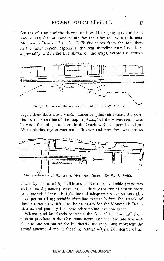
•fourths of a mile of the shore near Low Moor (Fig. 3) ; and from
/5o to 275 feet at most points for three-fourths of a mile nearMonmouth Beach (Fig. 4). Difficulty arises from the fact that,
in the latter region, especially, the real shoreline may have beenappreciably withit_ the line shbwn on the maps, before the storms
A f L_HrlC 0¢ffA_
FIG S---Inronds of tlm sea near Low Moor. By W. S, Smith.
began their destructive work. Lines of piling still mark the posi-tion of the shoreline of the map in places, but the waves cogld pass
between the pilings and erode the beach with comparative vigor.Much of this region was not built over and therefore was not as
..............Ji,_.!..................E__2c ,' ( - l0
Fxc. 4.--Inroads of tI_e sea at Monmouth _each. By W. S. Smith.
efficiently protected by bulkheads as the more valuable propertiesfarther north ; hence greater inroads during the recent storms were
to he expected here. But the lack of adequate protection may alsohave permitted appreciable shoreline retreat before /bhe attack ofthese storms, iu which case the estimates for the Monmouth Beach
district, and possibly for some other points, are too great.Where good bulkheads protected the face of the low cliff from
erosion previous to the Christmas storm, and the low tide line was
close to the bottom of the bulkheads, the map must represent theactual amount of recent shoreline retreat with a fair degree of ac-
NEW JERSEY GEOLOGICAL SURVEY

38 GEOLOGICAL SURVEY.
curacy. For several such places the following amounts of back-
ward cutting have been measured, all figures referring to the workof tile first two storms only, unless otherwise specified. In manylocalities the third storm made comparatively little change in thesboreJine :
One-third of a mile north of Sea Bright station, near Hall properties ........ i35"Twelve hundred feet north of Sea Bright station ......................... Ios'North of Church St,, Sea Bright ....................................... ion'
(After third storm) ....................................... _44'Opposite Low Moor station ............................................ 6o'North of Central Road, Monmouth Beach, near house shown iu Plate II, Fig i 9o",Just south of above ................................................... 16o'
3_ETHODS OF WAVE DESTRUCTION,
An examination of the Sea Bright shore indicates that the great-
est damage to bulkheads resulted from the direct impact of thewaves, whereas the buildings suffered most from the undermining
of the ground upon which they stood. When it is remembered thatocean waves strike a vertical face with a force of from a few hun-
dred pounds to more than 6,0o0 pounds per square foot, their enor-
mous destructive power may readily be appreciated. Solid blocksof granite have been shattered by wave impact upon the coast ofElol]and, and it is therefore not surprising that the wooden bulk--
beads of the Jersey Coast should yield to the attack of the sea,wherever they were not reinforced by parallel rows of piling with
heavy stone filliug, or otherwise rendered especially strong. Plate I.
shows one of the weaker bulkheads in the early stages of destruc-tion. Most of the bulkheads were surmounted by a broad board-
walk which served to shed falling wave crests back into the sea.
and thus protect the cliff from erosion. But the force generatedby masses of water falling from the great height to which they are
projected when a storm wave strikes a vertical wall, may be suf-ficient to crush very heavy timbers. During a severe gale at Buf-falo, New York, many large timbers, I2 x i2 inches in thickness, I2feet long, and Io feet between supports, were broken like match
sticks by the impact of falling water which had been hurled from75 to t25 feet into the air by breaking waves. \Ve observed severallocalities in the Sea Bright district where the demolishing of thebulkheads had been hastened in this manner.
Many of the bulkheads are protected by rows of piling set somedistance out in the sea to break the force of the on-coming waves.
NEW JERSEY GEOLOGICAL SURVEY

NEW JERSEY GEOLOGICAL SURVEY

RECENT STORM EFFECTS. 39
Even where the sea attack was powerless to break these pilings or
to tear them from their positions, the waves passed between thepilings and still retained sufficient force to destroy the bulkheads
which presented a more continuous surface to their impact. Plate
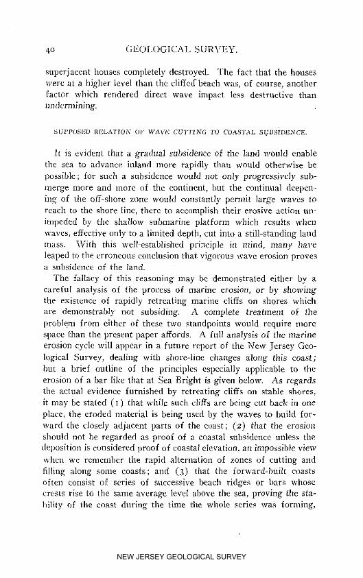
1, Fig. t shows such a series of protecting piling which remainedlargely intact; while the bulkhead immediately in front of tbe houselvas battered down and the house itself destroyed. (Plate I, Fig.
2, and II, Fig. i and 2.) Plate III, Fig. I, shows a series of pilingssurmounted by undamaged bathhouses, back of which the sbore has
heen so badly eroded that the superjaeent houses have collapsed.
In the last case mentioned, and indeed as a rule, the houses were
not damaged as much by direct wave impact as by the underminingof tbe beach upon which they stood. It is of course true that a
building from raider which most of the support was already re-mo_,ed by the sapping action of the waves, often received its "deathblow" from some extra large wave ; and a building wtlich was once
tipped over into the edge of the sea as a result of being underminedwas soon pounded to pieces by tbe waves. But the real damagewas largely accomplished independently of direct impact upon thestructures themselves. Where a house simply rested upon the
beach, and the latter was cut away by wave sapping, the housetoppled over bodily. Even where the beach was low and flat, as in
the town of Sea Bright, the foundations were sapped from under
dwellings (Plate IV, Fig. 2), allowing them to tip over toward thesea, instead of tbeir being crusbed in the first instance by the impactof the waves. Iu some cases the bouses collapsed piecemeal as the
sea advanced under them, or were crushed by the fall when they
tipped over into the sea. Where houses were built on pilings driveninto the beach sand tbe removal of the sand left the buildings pre-
cariously supported on the pilings alone until shaken clown by themoderate waves of some later storm. (Plate II).
One reason for the destructiveness of the undermining action as
compared with the direct wave attack is to be found in the factthat lines of piling and bulkheads were together able to break theforce of the waves to a large extent, but could not prevent the water
of each wave from washing against the foot of the cliff, removingpart of the sand, and carrying it back to sea. In many places thelines of piling, and even the bulkheads, are still in a state of partial
preservation, while the cliff back of them is badly eroded and the
NEW JERSEY GEOLOGICAL SURVEY
40 GEOLOGICAL SURVEY.
superjacent houses completely destroyed. The fact that the houses
were at a bigher level than the cliffed _beach was, of course, anotherfactor which rendered direct wave impact less destructive thanundermining.
SUPPOSED RELATION 0[." V_rAVIC CUTTING TO COASTAL SI.ZP,SIDIANCE,.
It is evident that a gradual subsidence of the land would enablethe sea to advance inland more rapidly than would otherwise be
possible; for such a subsidence would not only progressively sub-merge more and more of the continent, but the continual deepen-
ing of the off-shore aoue would constantly permit large waves toreach to the shore line, there to accomplish their erosive action un-
impeded by the shallow submarine platform which results when
waves, effective only to a limited depth, cut into a still-standing landmass. With this well established principle in mind, many haveleaped to the erroneous conclusion that vigorous wave erosion provesa subsidence of the /and.
The fallacy of this reasoning may be demonstrated either by a
careful analysis of the process of marine erosion, or by showingthe existence of rapidly retreating marine cliffs on shores whichare demonstrably not subsiding. A complete treatment of the
problem from either of these two standpoints would require morespace than the present paper affords. A full analysis of the marine
erosion cycle will appear in a future report of the New Jersey Geo-
logical Survey, dealing with shore-line changes along this coast;
but a brief outline of the principles especially applicable to theerosion of a bar like that at Sea Bright is given below. As regardsthe actual evidence furnished by retreating cliffs on stable shores,it may be stated (I) that while such cliffs are being cut back in one
place, the eroded material is being used by the waves to build for-ward the closely adjacent parts of the coast; (2) that the erosion
should not be regarded as proof of a coastal subsidence unless thedeposition is considered proof of coastal elevation, an impossible view
when we remember the rapid alternation of zones of cutting andfilling along some coasts; aud (3) that the forward-built coastsoften consist of series of successive beach ridges or bars whose
crests rise to the same average level above the sea, proving the sta-bility of the coast during the time the whole series was forming,
NEW JERSEY GEOLOGICAL SURVEY
NEW JERSEY GEOLOGICAL SURVEY

RECENT STORM EFFECTS. 4*
and hence during tile time the adjacent cliff was befng cut back tosupply the debris of which the ridges are made. The chalk cliffs
of southeastern England have been cut far back of their formerpositions durh_g the same time that the Dungeuess and other capesor forelands have been built out into the sea to form horizontal
beach plains of great breadth; and large areas of land on the islandsenclosing Boston Harbor have been cut away by the waves whilethe eroded debris was built into successive beach ridges, the com-
parative altitude of whose crests proves essential coastal stabilityduring their formation. Vigorous wave erosion is known to occuron lake shores where the mean water level remains constant.
lu order to appreciate the real significance of the shore changesat Sea Bright, we must consider for a moment the conditions underwhich a narrow Bar, like that on which tim town stands, is main-
taiued. Marine erosion is chiefly accomplished by wave action,
while transportation of the eroded debris is performed by the short,
pulsating currents of wave motion, tidal currents, wind-formed cur-rents or "wind drift," and a large number of other currents whichneed not here be specified. Neither is it necessary for us to take
up the disputed question as to which particular type of current ac-tion causes the long shore transportation toward the north in the
special region under investigation. It is enough for us to know thatsome kind of current or currents moves saud prevailingly north-.
ward along the seaward side of the bar, and that the oscillatory orhack-aud-forth movement of the water particles during wave actionproduces pulsating currents alternately laudward and seaward.
A study of wave action shows that sometimes the landward con>ponent of the pulsati1_g currents prevails, and material is swepttoward the coast to build the shore forward into the sea; at other
times, or in other places, the seaward component prevails, the beachis eroded, and the material dragged out into deep water. The
changing action is due to cl:mnges in the conditions of the marineforces, such as size of waves, direction of wave advance on .the
shore, strength and directiou of winds, depth of water, rapidity ofsupply of saud by longshore currents, etc. Under each set of cir-cmnstances the marine forces endeavor to produce a beach and off- .
shore slope so nicely adjusted to their action thai, the effect of thelandward component of wave action will exactly balance the ei_eetof the seaward component. A profile of the beach and sea bottom
NEW JERSEY GEOLOGICAL SURVEY
42 GEOLOGICAL SURVEY.
when rims nicely adjusted to the marine forces is calIed "the pro-file of equilibrium," because it is the profile which exists when nn-
shore and off-shore forces are just balanced, or in equifibrium.\Vhen the profile is not in equilibrium with the marine forces, these
forces automatically operate to change it until it is. If rapiddeposition by longshore currents makes the offshore bottom tooshallow, thereby making the profile too gentle, wave currents will
carry some of the bottom sand to the shore, thus deepening the bot-tom and building forward the shore until a profile of the propersteepness is estabfished. From that time on the effort of the waves
to bring, more material to the shore is just balanced by their ten-deney to sweep that material, with the aid of the undertow, backdown the steepened slope to deep water. The profile of equilibrium
is perfected. But a change in the size of the waves disturbs thebalance. Under the new conditions the profile may be too near
the water surface or too steeply inclined. Waves then cut into thebeach and deposit the material farther out until a new profile of
equilibrium, adapted to the new conditions, is established.
The constant shifting of debris back and forth in the shallow shore
zoue as a result of the changing conditions of equilibrium, grindsthat debris finer and finer, with the result that some of it is carried
in suspension by currents to far distant localities where it is de-posited in the quiet waters of the deep ocean. This constat_t lossof material from the shore means that more material must be se-
cured to keep up the conditions of equilibrium; and the additional
supply may be secured either hv the waves cutting farther inlandat the point in question, or by longshore currents bringing it fromsome otber point where the waves are eroding.
Applying the foregoing principles to the Sea Bright bar, it isevident that the seaward side of the bar. exposed to wave and cur-
rent action, must have a profile which keeps as nearly as possible
in equilibrium with the marine forces. Since those forces are con-stantly changing, the profile must change also. and the beach mustbe built forward at one time a1_d cut back at another, independently
of any movement of elevation or subsidence. Owing to the con-- stant loss of finer material from the shore zone, the cutting back
must prevail over the forward building, unless the northward mov-
ing current brings enough material from the Long Branch districtto fully compensate the loss. Even a general tendency for back-
NEW JERSEY GEOLOGICAL SURVEY
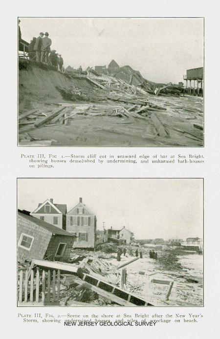
NEW JERSEY GEOLOGICAL SURVEY

RECENT STORM EFFECTS. 43
ward cutting to prevail is therefore no indication of coastal sub-
sidence. The longshore supply of material has been sufficient to
preserve the bar from complete destruction, although it has notbeen sufficient to build forward the shore, or even to prevent agradual retreat of the bar toward the land. Such retreat is provedby the fact that the marsh deposits, formed back of the bar, are
now exposed on its seaward sid_ under the beach sands; and bythe testimony of the inhabitants who have lost buildings formerl rlocated on land seaward of the present shoreline.
The loss of land during the recent storms represents exception-
ally rapid erosion of a purely temporary character, due to an un-usual disturbance of the profile of equilibrium by exceptional
storms. Longshore currents carried some of the eroded materialto Sandy Hook, but no extensive additions to its area have so farresulted from this action. Most of the material removed from the
bar was carried seaward to perfect the proper profile of equilibriumdemanded by the storms. Part of it, at least, should be carried
back to the beach as new conditions demand a new profile. In fact,this process is already in operation, and the shore has been built
so far forward in places as to obscure much of the erosive effectaccomplished a few weeks ago. Nothing in the nature of the ero-sion or the deposition indicate any change in the relative level ofland and sea.
If the land were sinking at the rate of one or two feet per cen-tury, the problem of maintaining sea defenses against the ravages
of the ocean in the Sea Bright district would be more serious thanit is. The tendency of storm waves to cut into the ]and wouht bemore marked than at present, and the tendency of marine forces
to repair th.e damage by deposition during calm weather would beless evident. Even as it is the problem is sufficiently serious. Thatthere is a prevailing tendency for the bar to retreat toward the
land as a result of wave cutting on the seaward side, has already
been shown. Alotig with the alternate erosion and accretion ill theshore zone, due to the varying effect of the marine forces, there isa slow loss of land which can only be arrested by superior methods
of artificial protection.That the damage of which the sea is capable iustifies the ex
penditure of large sums of money in improved sea defences is
abundantly proved by the recent storms. The actual value of
NEW JERSEY GEOLOGICAL SURVEY

44 GEOLOGICAL SURVEY.
property completely destroyed in the single town of Sea Brightwas enormous,.and the suffering of its citizens cannot be estimatedin money. Many who were unable to bear any loss saw the savingsof a lifetime swept out to sea by the merciless waves. It would bedifficult to estimate the depreciation in the value of property along
this part of the coast alone, a depreciation shared by lands not act-
ually eroded because of the apparent magnitude of the dangers towhich they are subjected.
So long as the defence of the land is in a large number of handsand every landowner is practically free to do as little or as muchas he pleases toward preventing the sea from gaining access to his
property, many must suffer from the failure of a few to take properprecautions against marine erosion. As soon as the sea finds a
point of weakness in the defences, it rapidly widens the breach andattacks adjoining property on either side. In some places wherethe bulkheads in front of one man's property resisted the direct at-
"tack, the property was badly damaged by erosion from one or bothsides after the sea had entered neighboring lots. Some method of
government supervision of marine defences would seem to be theonly satisfactory solution of this serious problem.
May I, 1914.
NEW JERSEY GEOLOGICAL SURVEY

Publications
The appended list makes brief mention of all the publications
of the present Survey since its inception in 1864, with a statement
of the editions now out of print. The reports of the Survey are
distributed without further expense than that of transportation.
Single reports can usually be sent more cheaply by mail than other-
wise, and requests should be accompanied by the proper postage.
On March I6, I914, books will be mailable at parcel post rates. The
postage rate as given in the follmv;ing lists applies to all points in
the first and second zones from Trenton, which includes all parts
of New Jersey. Applications from more distant points should be
accompanied by the proper amount of postage, based upon distance
from Trenton. If not so accompanied, reports will be sent express
collect. When the stock on hand of any report is reduced to 200
copies, the remahlhlcj volumes are w,ithdrawn from #co distribution
and are sold at cost price.
The maps are distributed only by sale, at a price, 25 cents per
sheet, to cover cost of paper, printing and transportation. In order
to secure prompt attention, requests for both reports and maps
shottld be addressed simply "State Geologist," Trenton, N. J.
CATALOGUE OF PUBLICATIONN,
G_:0L0C;_"IIF N_:w JERSE'¢. Newark. i868, 8 _'o., xxiv_-899 pp. Out of print.Po_t_o_._o OFMaPs accompanying the same, as follows:t. Aztec and paleozoic formations, including the irotl ore and limestone dis-
trig's; colored. Scale, 2 miles to sn inch.e. Triassic formation, including the red sandstone and tral_-roeks of Central
New Jersey. colored. Scale, a miles to an inch.3. Lretaceous formation, including the gree_sand-marl beds; coIored. Scale,
2 l_lil_s t0 :lrl HlC}I,
4. Tertiary and recent formations of Southern New Jersey; colored. Scale,2 miles to an inch.
5. Map of a group of iron mines in Morris County; printed in two colors.Scale. 3 .in'ches to r mile.
6. Map of the Ringwood iron mines; printed in two colors. Scale. 8 inchesto i mile.
(45)
NEW JERSEY GEOLOGICAL SURVEY

46 PUBLICATIONS.
7. Map of Oxford Furuace iron-ore veins; colored. Scale, 8 inches to I mile.8. Map of the zitm mines, Sussex County; colored. Scale, 8 inches to i mile.
A few copies can he distributed at $2.o0 per set.REPORT ON TtIE CLAY DEPOSITS of Woodbridge, South Amboy and other places
in New Jersey, together with their uses for firebrick, pottery, eta, Trenton,t878, 8vo_, viii+38I pp., with map. Out of print.
A PR}:LI_t_NA_V CATALOGUEof the Flora of New Jersey, compiled by N. L.Britton, Ph.D. New Brunswick, r88_, gyp., xi+233 pp. Out of print.
FINAL REPORT OF TIlE STATE GEOLOG)ST. Voh L Topography. Magnetism.Climate. Trenton, igS8, gyp., xi-_439 pP. Out of print.
FINAl, REPORToF rrlE STATE GEOLOGIST. Vol. IL Part I. Mineralogy. Botany.Trenton, 1889, 8re., x+642 pp. Unbound ¢oples, postage, 8 cents. Bound copies,$_.5o.
FtXAL REPORT OF TIlE STATE GEOLOGIST. VoL II. Part 1L Zoology. Tren-ton, _89o, 8re., x+824 pp. (Postage, 8 cents.)
R_POaT ON WATER-SUPFLY. V0L IIL of the Final Reports of the State Geologist.Trenton, 1894, 8_'o., xvi+352 and 96 pp. (Postage, 7 cents.)
REPORT 0X TItE PIIYSICAG GEOCRAP_IYof New Jersey Vol. IV. of the FinalReports of the State Geologist. Trenton, _898, 8re., xvi+xTo+2oo pp, Un-bound copies, _Loo; cloth bound, $1.35, with photo-reBef map of State, $2.85.Map separate, $r.5o.
REVOltT O_+ TtCE OLACI.:_I.GEOLOGy of New Jersey. Voh V. of the Final Reportsof the State Geologist. Trenton. _9o2, 8re., xxvii-bSo2 pp. (Sent by express,9 cents if prepaid, or charges collect0
REVOaT O_ CLAYS ago CLaY IX,USTRY of New Jersey. Vol.'VI. of the Final
Reports of the State Geologist. Trenton _9o4, gyp. xxviii+548 pp. (Priee, $I.6o.)REP0_T OX IR0X MI_ES AN_ M_'_G in New Jersey. Vok VII. of the F naReport of the State Geologist. Trenton, 19io , 8re., xv-}-5_2 pp., with two mapsin a separate envelope. (Postage, 8 cents.)
BRACItIOPODA ANO LAMELL1BIIANCIIIATA Of the Raritan Clays and GreensandMarls of New Jersey. Trenton, i886, quarto, pp. 338, plates, XXXV. and map.
(Paleontology, Vol. L) (To residents of New Jersey, postage, io cents; to non-residents, $_.5o, charges prepaid.)
GASTEROpODAAND CEPltALOPODA of the Raritan Clays and Greensand Marls ofNew Jersey. Trenton, t892 , quarto, pp. 4oz, Plates L. (Paleontology, Vol. IL)(To residents of New Jersey, postage, lo cents; to non-residents, $L4o, chargesprepaid.)
P,_LE0ZmC paLE0xr0t.OGV. Trenton. I9o3, gyp., xii+46z pp., Plates LIII.(Paleontology, Voh IIL) (Price, SLoe.)
CRETACEOt'S PALEONTOLOGy. Trenton, I9o7_ 8re., ix+Iio6 pp., Plates CXI.(Paleontology, Vol. IV.) (Price, $2.70. )
ANNUAL REPORTS;.R_vo_r ov PlmFnssol_ GEORGEH, COOK upon the Geological Survey of New Jer-
sey and its progress during the year 1863. Trenton, a864, gyp., I3 PP.Out of print.
THE ANNUAL REPORT of Prof. Gee. H. Cook State Geologist, to his ExcellencyJoel Parker, President of the Board of Managers of the GeoIog cat Survey ofNew Jersey, for the year _864. Trenton, I865, 8VO,, 24 pp. OUt of print.
A_u:x_. RgeO_T of Prof. Gee. H. Cook. State Geologist. to his E_cellency JoelParker, President of the Board of Managers of the Geological Survey of NewJersey, for tbe year _865. Trenton, r866, gyp., _2 pp. Out of print.
A_m'._L RaPORT Of Prof. Gee. H. Cook. State Geologist, on the Geological Sur-vey of New Jersey, for the year _866. Trenton, _862, gyp,. _8 pp.
Out of Drlnt.REPOtlT OF THE STATE GEOLOGIST, Prof. Gee. It. Cook, for the year _867. Tren-
ton, _86g. gvo., 28 pp. Out of print.ANNt;aL R_VOR* of the State Geologist of New Jersey for _869. Trentm_, x87o,
8vo., 57 PP.- with maps. Out of print.A.x'_-m. REVOLT of the State Geologist of New Jersey for _87o. New Bruns-
wick. _g7_, gyp., 75 Oil., with maps. Out of print.ANI_U^L Rg_0_w of the State Geologist of New Jersey for xg7x. New Bruns_
wick, _872, gyp.. 46 pp., with maps. Out of print.ANNUAL R_:POIZTof the State Geologist of New Jersey for _87a. Trenton, _872,
gyp.. 44 PP.. with map. Out of print.ANNUAl. REPORT of the State Geologist of New Jersey for _g73. Trenton, 1874,
8vo,, _28 pp,, with ma_s. Out of print.
NEW JERSEY GEOLOGICAL SURVEY

PUBLICATIONS. 47
ANNUAL RRPORT of the State Geologist of New Jersey for I874. TrentotL _874,8vo.) _Ig pp. Out of print.
ANNUAL REPORT Of the State Geologist of New Jersey for _g75. Trenton) I875,gvo., 41 pp., with map. Out of print.
ANNUAL REPORT Of the State Geologist of New Jersey for :876. Trenton, :876,gvo., 56 pp., with n:aps. Out of print.
ANNUAL REP0a'r of the State Geologist of New Jersey for 1877. '£renton, _87p)8vo., 55 pp, Out of print.
ANNUAL REPORT Of the State Geologist of New Jersey for I878. Trentot% 1878,8vo., x3i pp., with map. Out of print.
A._._'uaL REVORT of the State Geologist of New Jersey for :879. Trenton, x879,g_'o., :99 PP., _th maps. Out of prmt.
A_._UAL REPORT Of the State Geologist of New Jersey for t88o. Trenton, _88o,8%'O., 220 pp., with map. Out of print.
A,NNUAL REP01/'r Of the State Geologist of New Jersey for z88t. Trenton, I88b8vo., 87+lo7@xiv. ,_p., with maps. Out of print.
ANNUAL REPORT 0_ the State Geologist of New Jersey for rggz. Camden, x382,8vo., i9i pp., with maps. Out of pnnt.
ANNUAL REPORT Of the State Geologist of New Jersey for _883. Camden, :883,8vo., I88 pp. (Price, _o eents.)
ANNUAL REPORT Of the State Geologist of New Jersey for 1884. Trenton, 1884,8x'o., :68 pp., with maps. (Postage, 5 cents.)
A_NUaL REr0RT Of the State Geologist of New Jersey for 1885. Trenton, f885,gvo., 228 pp., with maps. (Postage, 6 cents.)
A_UAL REPORT of the State Geologist of New Jersey for x886. Trenton, 1887,8vo., 254 PP., with maps. (Postage, 6 cents.)
A_'NUaL REeoew of the State Geologist of New Jersey for i887. Trenton, 1887,8_'o., 45 PP., with maps. (Postage, 5 cents.)
ANNUAL REPORT of the State Geologist of New Jersey for x888, Camden, 1889,8vo. 87 pp. with map. (Postage, 5 cents.)
ANNUAL REPORT Of the State Geolog st of New Jersey for J889, Camden, x889.8vo., ::2 pp. fPostage, 6 cents.)
A_SUAL REe_)RT Of the State Geologist of New Jersey for :89 o, Trenton, _89_,8vo., 305 pp., with maps. (Postage, 6 cents.)
Auburn, R_o_ o( the StateGeologist _f New Jersey far ig9i. TrentotL :89z,8vo. xii+27o pp., with maps. Out of print.
ANNUAL REPORT Of the State Geo ogist of New Jersey for _892. Trenton, 1893,8vo. x+368 pp., with maps. (Price, $1._S.)
A_ua_ REV0RT Of the State Geo ogist of New Jersey for :893. Trenton, 1894,8_o. x-}-452 pp., with maps. (Postage, 7 eents.)
ASNUaL REPORT Of the State Geolog st of New Jersey for _894. Trenton, 1895,gvo. x-1-3o4 pp., with geological map. (Postage, 6 cents.)
A._._UA_, RE_0_r of the State-Geolog st of New Jersey for 1895. Trenton, _896,8vo., xlq-i98 pn., with geological nlap. (Postage, 5 cents.)
ANNUAL REPORT of the State Geologist of New Jersey for _896. Trenton, 1897,gvo. xxviii+377 pp. with map of Haekensaek meadows. (Postage, 6 cents.)
ANNUAL REPORT of the State Geolog st of New Jersey for :897. Trenton, :898,gvo., x1+_68 pp. Postage 6 cents.)
ANNUAL REPORT Of the State Geo og st /or I898, Trenton, :g99, gx'o., xxxii@244 PP., with Appendix, ioz pp. (Postage, 6 cents.)
ANNUAL REI'0I:T Of the State GeoIogist for i899 and RF._ORr O_" FO_eSrS. Tren-ton, _9oo, 2 vols.. 8vo.. Atmual eport, xliii+_92 pp. FORESTS, xvi+327 pp.,with sever_ maps in a roll. (Postage 5 and 7 cents.)
ANNUAL REPORT of the State Geologist for :9oo. Trenton i9oi, gvo., xl-I 23_pp. (Postage, 6 cents.)
ANNUAL REV0R'r of the State Geologist for zpoL Trenton, i9o2, gvo., xxviii+r78 pp.. with one map in pocket. (Postage, 6 cents.)
A_._Ua:, RaPoa_ o{ the State Geologist f_r :9az. Trenton, _903, 8vo., viii+_55 PP- (Postage, 5 cents.)
A.','NUAI, REP01:T of the State Geologist for _9o3. Trenton, r9o4, 8vo.) xxxvi-_-32 pp, with two maps in pocket. (Price, 40 cents.)
ANN_JAD Ree0gr Of the State Geologist for I9o4. Trenton, :9o5, 8vo., x@317pp. (Postage, 6 cents.)ANNUAL REPORT Of the State Geo ogist for I9O5. Trenton, 19o6, gvo., x+338
pp., with three maps in a pocket. (Price, 55 cents.)ANNUAL REPORT Of the State Geologist for t9o6. Trenton, _907, 8vo., vii+:p2
pp. (Postage, 6 cents.)Pgo. 28. Tree, toll a_ld P.astward--Trenton to Sayreville. Replaces Sheet 8.
NEW JERSEY GEOLOGICAL SURVEY
48 PUBLICATION S.
ANXUAL REPORT Of the State Geologist for I9o7. Trenton, i9o8, 8vo., ix+t9 app. (Postage, 6 cents.)
ANNUAL REPORT of the State Geolngist for _9o8- Trenton, x9o9, 8 vo., xi+I59pp. (Postage, 5 cents.)
A._'NUAL REVORT Of the State Geologist for i9og. Trenton, i91o , _VO,, _.'ii7t-I23
pp. (Postage, 5 cents.)
BULLET_N-S.
In i9xo the series of AnntmI Reports was replaced by a series of Bulletins,each being a separate report upon some subject. Up to date eleven Bulletlnshave been issued.
BULLET/N _.--Admluistrative Report of the State Geologist of New Jersey foripJo. Trenton, r9I], 43 pP. (Out of print.)
BULLETIN 2.--A report on the Approximate Cost of a Canal between Bay Headand the Shrewsbury River, by H. B. Kfimmel. Trenton, i91_, 2o pp., i map.
BL'LLET[_ 3.--The Flora of the Raritan Formation, by Edward W. Berry.Trentmh I9H, v+233 pp. and xxix plates.
BULLETLXI4. _A.Description of Fossil Fish Remains of the Cretaceous, Eoceneand Miocene Formations of New Jersey, by Henry W. Fowler. Trenton, r9H,19a pp.
BULr.ETIN 5.--The Mineral Industry of New Jersey for r91o, by H. B. Kfimmeland S. Percy Jones. Trenton, r9iJ, 24 pp. (Ore of print.)
BULLETIN 6.--Administrative Report of the State Geologist for _9 H, includingreport on Shark River Inlet by C. C. Vermeule. Trenton, _9r2, 82 pp. and iv
plates.Buu,e¢_,_ 7.--The Mineral Industry of New Jersey for I9H, by Henry B. grim-
meh Trenton, 1912, 37 PP-B_L_,_,'_ g.--Administrafive Report of tbe State Geologist for 1912 _ including
a second report on Shark River Inlet by C. C: Vermeule, Consulting Engitmer, anda List of New Bench Marks. Trenton, J9z3, 8vo., _o2 pp.
_ULLETIN 9.--A Breliminary Report of the Archzeologieal Survey _f the Stateof New Jersey, made by the Department of Anthropology in the American Musemn of Natural History. Clark Wissler, Ph.D., Curator. under the direction ofthe State Geological Survey. Compiled by Alanson Skinner and Max Sehrabisch.Trenton, i9_3, 8vo., 94 PP, one map.
BULLETIN io.--(In co-operation with the X*ew Jersey State Agricultural Experi-ment Station). The Mechanical and Chemical Composition of the Soils of theSussex Area, New Jersey, by A. IV. Blair and Henry Jennings. The Analysis ofSoils--Methods Used, by R. B. Gage. Trenton, _9_3, gx'o., x_o pp., two plates.
BI_LLETI3" H.--The Mineral Industry of New Jersey for i9_2, by M. iV. Twitch-el/. Trenton, I9_3, 8vo.. 43 PP., oue map.
TOPOGRAPHIC MAPS.
ATLAS OF NEW JERSEY. The complete work is made up of twenty sheets, eachabout 27 by 37 inches including margin. Seventeen sheets are on a scale of tinch per mile and three ou a scale of 5 miles per inch. Sheets numbered 2x to 37replace old sheets nmnhered I 17. which cannot longer be furnished. Thesesheets each cover the same territory as eight of the large maps, otx a scale of2,ooo feet per inch.No. _9. New Jersey Relief Map. Scale, 5 nfiles to the inch. Hypsometric.No. 20. New Jersey Geological Map. Scale, 5 miles to the inch. (Out of print.)No. eL Norther_ l'Varre_ and Wester_t Sussex counties. Replaces Sheet x.No. e2. Eastemt Sussex and IVestern Passaic counties. Replaces Sheet 4.No. 23. Norlhern Bergen and Eastern Passaic coftf*tie. S to West point, New "fork.
Replaces northern part o{ Sheet 7.No. 24, Southern [_Va_'ren, Northern Hu_tterdon and Western Morris co|lntles.
Replaces Sheet 2.No. 25. Morris and Somerset counties, from Lake Hopatcong to Somerville and
New Brunswick. Replaces Sheet 6.No. 26. Vicinity of Newark and Jerspy City--Paterson to Pe_'th Amboy. Replaces
in part Sheet 7.No. _7. Vicinity o[ Trentm_Raven Rock to Palmyra, with inset, Trenton to
Princeton. Replaces Sheet 5.
NEW JERSEY GEOLOGICAL SURVEY

NEW JERSEY GEOLOGICAL SURVEY