nnorth dakotaorth dakota ffishing guideishing … · ern pike statewide to 5 and 10 respectively....
TRANSCRIPT
North Dakota Game and Fish DepartmentNorth Dakota Game and Fish Department100 N. Bismarck Expressway100 N. Bismarck Expressway
Bismarck, ND 58501-5095Bismarck, ND 58501-5095701-328-6300701-328-6300
Email: [email protected]: [email protected]: gf.nd.govWebsite: gf.nd.gov
NORTH DAKOTANORTH DAKOTA
2012-20142012-2014(Effective April 1, 2012 through March 31, 2014)(Effective April 1, 2012 through March 31, 2014)
FISHING GUIDEFISHING GUIDE

2
TABLE OF CONTENTSSECTION PAGE
1 New For 2012-2014 Fishing Seasons .................... 4 2 Aquatic Nuisance Species Rules ............................ 5 3 Licenses.................................................................. 6 4 Transportation and Stocking ................................... 7 5 General Defi nitions and Regulations ...................... 8 6 Manner of Taking .................................................... 9
A. Hook and Line Fishing .............................. 10 Open Areas and Season Dates................. 10 Statewide Daily and Possession Limits..... 12 Exceptions to Statewide Fish Limits.......... 13 Specifi c Regulations and Defi nitions ......... 14 Fish Size Restrictions ................................ 15 Fish Length-Weight Table ......................... 17 Bait Regulations ........................................ 18 Live Baitfi sh Use Restrictions.................... 19 Ice Fishing Regulations ............................. 22 Fish Houses .............................................. 23
B. Darkhouse Spearfi shing ........................... 24 C. Archery and Spearfi shing ......................... 25 D. Underwater Spearfi shing .......................... 26 E. Paddlefi sh Snagging ................................. 27
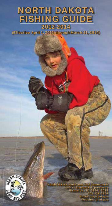
7 Fishing Contests ................................................... 29 8 Red and Bois de Sioux Rivers .............................. 29 9 Commercial Fishing .............................................. 30 10 Clam Season Closed ............................................ 30 11 Fish Consumption Advisory .................................. 30 12 Boat Motor Restrictions ........................................ 31 13 Boating Regulations.............................................. 31 14 Whopper/Catch and Release Requirements ........ 34 15 North Dakota State Record Fish Requirements ... 36 16 ANS Questions/Answers ..................................... 40 17 Devils Lake System Boating Access..................... 42 18 Missouri River System Boating Access ................ 44 19 North Dakota 2012-2014 Fishing Waters ............. 50 20 Important Phone Numbers.................................... 68 Cover photo by Paul Bailey (NDGFD)
3
STATE OF NORTH DAKOTAOffi ce of the Governor
North Dakota is well-known for its great angling opportunities. Our waters are home to a variety of species and anglers will fi nd choices in every season, from snagging paddlefi sh on the Missouri and Yellowstone rivers in the spring to drilling a hole in the ice at Devils Lake in search of jumbo yellow perch.
Our state is regarded as one of the top walleye fi shing destinations in the country. Catch rates for walleye and other game fi sh are high on popular fi shing waters such as Devils Lake, Lake Sakakawea, the Missouri River and Lake Oahe, and abundant water has created new fi sh habitat that will continue to enhance North Dakota’s fi sh-ing opportunities.
The North Dakota Game and Fish Department is working hard to ensure that all of our waters, large and small, have abundant fi sh populations and reasonable access. Game and Fish works with local operators to maintain more than 350 public boat ramps throughout the state, and just in the last few years, they have added more than 60 fl oating fi shing docks on smaller waters to improve shore-fi shing opportunities.
While walleye is the most popular fi sh for anglers to pursue in North Dakota, the state fi sh, the northern pike, is in the early stages of a population resurgence. North Dakota also has good fi shing for other species such as largemouth and smallmouth bass, white bass, yellow perch, catfi sh, crappie and trout, and even a few spots for muskie.
This guide provides important information regarding regula-tions to help you fi sh safely and legally on North Dakota waters. Visit the Game and Fish Department’s website at www.gf.nd.gov/fi shing for details on all of our fi shing waters, including contour maps, species present, directions and avail-able facilities.
So make North Dakota part of your next fi shing adventure and see for yourself what makes our state a legendary fi shing destination. I hope to see you on the water.
This guide is provided for informational purposes and is not intended as a complete listing of regulations. For more specifi c information on regulations and
laws, visit the Game and Fish Department website (for proclamations) or for North Dakota state laws go to www.legis.nd.gov/cencode/T201.html.
GovernorJack Dalrymple

4
1. NEW FOR 2012-2014 FISHING SEASONS(Summary of major changes)
Increased the daily and possession limits on north-• ern pike statewide to 5 and 10 respectively.Added all waters open to public fi shing statewide • are also open to darkhouse spearfi shing except for the following: Braun Lake (Logan County); New Johns Lake (Burleigh County); East Park Lake, West Park Lake and Lake Audubon (McLean County); McClusky Canal; Heckers Lake (Sheridan County); Red Willow Lake (Griggs County); Sweet Briar Dam (Morton County); Red River and Bois de Sioux rivers. Added the following lakes to a 14-inch minimum • walleye size restriction: Alkali Lake, Buffalo Lake (including connected waters north to Sargent Coun-ty Road 1), and Tosse Slough in Sargent County; and Lake Elsie, Lueck Lake and West Moran Lake in Richland County.Added Mott Watershed (Hettinger County) and • Nelson Lake (Oliver County) to the list of “no live baitfi sh” lakes. During the paddlefi sh snagging season, Sundays • are now “snag and release” days only.The minimum harvest length for a muskie is • increased to 48 inches.
Other useful fi shing information, including updates to North Dakota’s fi shing waters and stocking records, is found on the Game and Fish Department’s website – http://gf.nd.gov/ – and in the March-April issue of North Dakota OUTDOORS magazine. Readers are encouraged to use these valuable resources for additional information.

5
2. AQUATIC NUISANCE SPECIES RULESAquatic Nuisance Species are animals, plants and
even diseases that are not native to North Dakota and have the likelihood to become well established if intro-duced. They can displace native plants and animals, and cause serious economic and ecological damage. North Dakota has adopted a number of rules designed to mini-mize the threat of ANS. They include:1. All water must be drained from boats and other
watercraft, including bilges, livewells and motors before leaving a water body. This regulation means fi sh (including bait) may no longer be transported in a livewell containing water, after leaving a water body. Transportation of fi sh in or on ice is allowed. Potable (drinking) water and a boat’s sewage water are excluded from this regulation. Water used for in-state transportation of legal live bait is allowed, but only in bait buckets (containers) no larger than fi ve gallons.
2. All aquatic vegetation must be removed from boats, personal watercraft, trailers and associated equipment such as fi shing poles/lures before leaving a body of water. That means “vegetation free” when transporting watercraft and equipment including bait buckets away from a boat ramp, landing area or shoreline.
3. Live aquatic bait or aquatic vegetation may not be transported into North Dakota.
4. All water must be drained from watercraft prior to entering the state.
It is in North Dakota’s best interest that anglers, boaters and hunters understand and comply with these important regulations.

6
3. LICENSES These regulations are in effect for two years from April 1,
2012 through March 31, 2014. A fi shing year is defi ned as April 1 of one calendar year through March 31 of the following calendar year. NOTE: In the event of emergency changes to the 2012-2014 proclamation, Game and Fish will alert the media and public and post new information on the Department’s website.
Licenses are valid for one year starting April 1 and end-ing March 31 of the following year. An angler must possess a valid fi shing license for the respective season.
Residents and nonresidents age 16 and older need licenses. Residents under age 16 may take and possess a limit of fi sh without a fi shing license. Any nonresident under age 16 may take and possess a limit of fi sh without a nonresident fi shing license if accompanied by an individual possessing a valid fi shing license.
Anglers must have lived in and maintained their perma-nent residence in North Dakota for six months before quali-fying for a resident fi shing license. If you claim residency in another state, or have a permanent address in another state, you are not eligible for a North Dakota resident license. If you’ve permanently moved to North Dakota but have lived in the state for less than six months, you may qualify for a waiver to purchase a resident fi shing license. Call 701-328-6300 for more information and to request a waiver of residency form. The form is also available on the Game and Fish website.
North Dakota residents who are on leave from active duty with the United States military can fi sh without a license. Contact the Department for details.
Nonresident full-time students living in North Dakota, who are attending a state or tribal college, or a private insti-tution of higher education, may qualify for purchasing resi-dent fi shing licenses. Contact the Department for details.
Some licenses are in the form of stamps. Stamps must be pasted to a fi shing, hunting and furbearer certifi cate and signed in ink.
The fi shing license must be in the possession of the licensee at all times while fi shing.

7
License FeesResident Fishing, Hunting and Furbearer
Certifi cate .......................................................... $1Resident Individual ............................................ $10Resident Husband and Wife .............................. $14Resident, 65 years or older ................................. $3Resident, Disabled (from Bismarck offi ce only) ... $3Resident Combination License (16 years or
older – includes fi shing, small game, general game and habitat, and furbearer licenses)...... $32
Nonresident Fishing, Hunting and Furbearer Certifi cate .......................................................... $2
Nonresident Individual ....................................... $35Nonresident Husband and Wife......................... $45Nonresident 10 Days ......................................... $25Nonresident 3 Days ........................................... $15
All paddlefi sh snaggers must possess a paddlefi sh tag in addition to a valid fi shing license and certifi cate that may be required. A resident paddlefi sh tag is $3, a nonresident paddlefi sh tag is $7.50.
4. TRANSPORTATION AND STOCKINGTransportation of any live fi sh, live fi sh eggs, live
amphibians or other live aquatic organisms is illegal except for:
Anglers transporting legal live baitfi sh and bait (see • page 18). Dealers and buyers of tropical fi sh species for the pet • trade sold at commercial outlets. Individuals in possession of the appropriate license • or permit from the Game and Fish director.
Stocking of any live fi sh, live fi sh eggs, live amphib-ians or other live aquatic organisms into any waters of the state is illegal except with the appropriate license or permit issued by the Game and Fish director.
Free Fishing Days – Residents of North Dakota may fi sh without a resident fi shing license on June 2 and June 3, 2012 and on June 1 and June 2, 2013.

8
5. GENERAL DEFINITIONS AND REGULATIONSDaily limit is a limit of fi sh harvested from midnight to
midnight.No person may possess more than North Dakota’s
daily limit of fi sh while on the water or on the ice or actively engaged in any manner of fi shing.
Possession limit is the maximum number of each legally taken fi sh species that a person may have in his/her actual possession during any phase of any single fi shing trip of more than one day.
Storage limit at one’s personal permanent residence is unlimited; however, at no time may a person transport more than a possession limit.
Fish may be given (gifted) to another person but the fi sh must be counted in the donor’s daily limit.
Gifted fi sh including packages of fi sh must be accom-panied with the following information from the individual gifting the fi sh: name, fi shing license number, phone number, date, and number and species of fi sh gifted.
The packaging of fi sh away from one’s permanent residence must be done so that the number of fi sh in each package is easily determined.
Any person who possesses any game fi sh species must not waste, destroy or abandon the edible fl esh (fi llets).
Commercial processors, common carriers and com-mercial storage areas may possess any person’s legally taken possession limit of fi sh. Each package must be labeled with the owner’s name and address.
No person shall sell or take for the purpose of sale any fi sh except as allowed in commercial fi shing laws.
Game fi sh are bluegill, burbot, channel catfi sh, chinook salmon, crappie (black and white), largemouth bass, muskellunge (pure and hybrid), northern pike, paddlefi sh, sauger, saugeye, smallmouth bass, sturgeon (pallid, shovelnose and lake), trout (brown, lake, rainbow and cutthroat), walleye, white bass, yellow perch and zander.

9
6. MANNER OF TAKINGTaking or attempting to take fi sh from North Dakota
waters is limited to those methods listed below. Subse-quent pages provide regulation details.
Hook and Line FishingA. Darkhouse Spearfi shingB. Archery and Spearfi shingC. Underwater Spearfi shing D. Paddlefi sh SnaggingE.
Nongame fi sh are all species that inhabit and repro-duce in the state’s waters that are not listed as game fi sh.
It is illegal to take, possess or transport any of the following species of fi sh in North Dakota (they must be immediately released back into the water from which they were caught): pallid sturgeon, shovelnose sturgeon and lake sturgeon.
It is illegal to take paddlefi sh at any time except as pro-vided on pages 27-29.
Other than landing a fi sh caught on hook and line equip-ment, netting or trapping fi sh is illegal except as provided on page 19.
It is illegal to deposit, or cause to be deposited, any fi sh or parts thereof, upon the ice, in the water, or upon the shore of any water body in North Dakota.
It is illegal to introduce anything into waters of the state for the purpose of attracting fi sh that is not attached or applied to a lure as defi ned on page 14. Decoys used for darkhouse spearfi shing are excluded.
It is illegal to fi sh with any spring, lever, chemically, electrically or mechanically actuated hook at all times. The use of any mechanical device to automatically retrieve fi sh is also illegal.
The director may make reasonable accommodations to comply with the Americans with Disabilities Act.

10
A. Hook and Line Fishing
AREA SEASON
ALL WATERS of the state except for those listed below and on page 11.
Open to all fi shingApril 1 through March 31of each fi shing year.
OWLS PondState Fair Pond
Closed to fi shing at night (sunset to sunrise).
Lightning LakeMcDowell DamState Fair Pond
Open to all open-water fi shing. Closed to all ice fi shing.
Portions or all of the following waterfowl rest areas: Laretta, Mount Carmel, North Golden Lake, Sheyenne Lake
Open to all fi shing April 1 through September 23 and December 1 through March 31 of each fi shing year. Closed to all fi shing September 24 through November 30.
All national wildlife refuges and easement national wildlife refuges are closed to fi shing except the following (contact refuge headquarters for designated open areas and special restrictions):Arrowwood, J. Clark Salyer, Lake Darling (and all waters within the Upper Souris refuge boundary), Lake Ilo, Long Lake and Tewaukon national wildlife refuges.
Open to shore and/or ice fi shing April 1 through March 31 of each fi shing year in designated areas. Open to boat fi shing May 1 through September 30 of each fi shing year in desig-nated areas. Closed to all boating April 1 through April 30 and October 1 through March 31 of each fi shing year.
Lake Audubon National Wildlife Refuge (southern half of lake)
Open to ice fi shing only. Closed to all other fi shing.
Open Areas and Season Dates

11
Dakota Lake, Hobart Lake, and Sibley Lake (Griggs County) easement national wildlife refuges
Open to all fi shing April 1 through September 30 and December 1 through March 31 of each fi shing year. Closed to all fi shing and boating October 1 through November 30.
Lake Ardoch, Lake George, Rose Lake, and Silver Lake (Benson County) easement national wildlife refuges
Open to shore and/or ice fi shing from April 1 through March 31 of each fi shing year. Closed to all boating year round.
Closed to FishingThe Red River below the Drayton Dam for a • distance of 150 feet.From or within 100 feet of the bridge located between • North and South Lake Metigoshe.Areas near the Garrison Tailrace so posted by the • U.S. Army Corps of Engineers.No person shall fi sh or boat in areas posted and • designated by the Game and Fish Department.

12
SPECIES DAILY LIMIT
POSSESSION LIMIT
Walleye, Sauger, Saugeye or Combinationa 5 10
Northern Pike 5 10
Trout 3 3
Salmon 5 10
Yellow Perch 20 80
Bluegill 20 80
Crappie 20 80
White Bass 20 80
Burbot (Ling) 10 20
Channel Catfi sh
East of ND Hwy. 1b 5 5
West of ND Hwy. 1 no limit no limit
Largemouth Bass, Smallmouth Bass or Combination
3 6
Muskellunge (pure or hybrid) 1 1
Paddlefi sh See pages 27-29
Nongame Fish (other than legal live baitfi sh) no limit no limit
Legal Live Baitfi sh 150 150
Smelt 5 gallons 5 gallons
Frogs 24 24
Salamanders 24 24
Crayfi sh 48 48
Snapping Turtle (by hook and line only) Season limit of 2
a–Zander are included as part of the walleye, sauger, saugeye combination in Spiritwood Lake.
b–In the Red and Bois de Sioux rivers, the limit is 5 regardless of the number of state or provincial licenses purchased by the angler.
Statewide Daily and Possession Limits

13
Exceptions to Statewide Fish Limits
Red and Bois de Sioux rivers up to the fi rst vehicular bridge or crossing on any of their tributaries
NORTHERN PIKE – Daily 3, Possession 3
WALLEYE, SAUGER, SAUGEYE OR COMBINATION – Daily 3, Possession 3
Lightning LakeTROUT – Catch and release only from April 1 through June 30
OWLS Pond and State Fair Pond
ALL SPECIES – Catch and release only
Kraft Slough YELLOW PERCH – Daily 10, Possession 20
Lake Metigoshe BLUEGILL –Daily 10, Possession 20
Odland Dam
YELLOW PERCH – Daily 10, Possession 20BLUEGILL – Daily 10, Possession 20
Pipestem Dam and Creek
CRAPPIE – Daily 10, Possession 20
See page 16 for fi sh size restrictions

14
Specifi c Regulations and Defi nitions
Legal hook and line equipment for each angler is two poles statewide except:
One pole only is • legal at: Garrison Dam Tailrace – while fi shing from the -piers and wingwalls.Drayton Dam – while shore-fi shing between boat -ramp and area designated “closed to fi shing.”
Four poles• are legal while ice fi shing.Note: - When fi shing a water body where both open water and ice fi shing occur at the same time, an angler is allowed a maximum of four poles of which no more than two poles can be used in open water. (See page 22 for additional ice fi shing regulations.)
No pole may have more than two lures.A lure is defi ned as any man-made object comprised
of metal, plastic, wood and/or other nonedible materials made or used to catch fi sh. A lure may not contain more than three hooks and the maximum distance between any hooks on a lure may not exceed 10 inches. A single hook may not include more than three points, barbed or otherwise. Spinners and other live bait rigs and harnesses are considered a lure and are legal. Hookless dodgers or attractors used ahead of a lure or bait are legal.
An angler must remain within 150 feet of his/her fi shing poles that are in active use for fi shing. Fishing poles must be checked at least once per hour while fi shing.
After catching on hook and line, it is legal to return all fi sh to the water at the site of capture if done no longer than the time needed to unhook, measure and/or pho-tograph the fi sh immediately after being caught. Fish returned to the water should show no evidence of bleed-ing, be handled carefully, and not thrown or dropped. All fi sh released from bridges and wing-walls (e.g. Garrison Dam Tailrace) must be done immediately after being placed in a fi sh basket/open container to ensure fi sh survival; otherwise, no fi sh may be returned to the water

15
after held on a stringer or confi ned by or in any type of holding structure except with written permission from the Game and Fish director. No fi sh may be released into any waters other than the one from which it was originally caught.
Grass carp, sturgeon and paddlefi sh caught must be returned to the water immediately, regardless of condi-tion. All undersize or oversize fi sh (page 16) caught where there is a size limit must be returned to the water regardless of condition.
A foul hooked or snagged fi sh is defi ned as any fi sh hooked or caught in any area from behind the gill covers to the tail. Any foul hooked or snagged fi sh must imme-diately be returned to the water regardless of condition. Possession of foul hooked fi sh is illegal. Attempting to snag fi sh is illegal.
Landing a fi sh caught on hook and line equipment with aid of a gaff is legal except for sturgeon, paddlefi sh, mus-kellunge and species in waters in which there are size limits. No gaffed fi sh may be returned to the water.
It is illegal to tag or mark any fi sh prior to release except with written permission from the Game and Fish director.
Lake specifi c rules may exist. If so, information is posted at access areas and bridges.
Two snapping turtles may be taken annually by hook and line.
Fish Size Restrictions
It is illegal to remove more than gills, entrails and scales from fi sh species harvested in waters that are subject to a size limit while on the water or actively engaged in fi shing.
It is illegal to remove more than the gills and entrails from channel catfi sh east of ND Highway 1 while on the water, actively engaged in fi shing, transporting or until the fi sh is at the license holder’s permanent residence. Head, fi llets and tail must be attached.

16
WATER AREASIT IS ILLEGAL TO
TAKE OR POSSESS:
Anywhere in the stateMuskellunge
Less than 48 inches in total length
Lake Elsie, Lueck Lake, and West Moran Lake
Richland Co.
Walleye/Sauger
Less than14 inches intotal length
Alkali Lake, Buffalo Lake (including connected waters north to Sargent Co. Rd. 1), and Tosse Slough
Sargent Co.
Jamestown andPipestem Reservoirs and Pipestem Creek
Stutsman Co.
North and South Golden Lakes Steele Co.
Red Willow Lake Griggs Co.Northern Pike
Less than 24 inches intotal length
North and South Golden Lakes Steele Co. Largemouth Bass
Less than14 inches intotal lengthRed Willow Lake Griggs Co.
All waters east of ND Highway 1 including the Red and Bois de Sioux Rivers
More than 1Channel Catfi sh
Greater than 24 inches intotal length
Fish Size Restrictions
1 2 3 4 5 6 7 8 9 10 11 12 13 14 15 16 17 18 19 20 21 22 23 24
T O T A L L E N G T H
How to Measure the Length of a Fish
To determine the “total length” of a fi sh, lay it fl at on its side and measure from the nose to the tip of the tail.
17
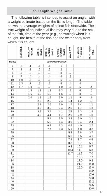
The following table is intended to assist an angler with a weight estimate based on the fi sh’s length. The table shows the average weights of select fi sh statewide. The true weight of an individual fi sh may vary due to the sex of the fi sh, time of the year (e.g., spawning) when it is caught, the health of the fi sh and the water body from which it is caught.
BLU
EGIL
L
YELL
OW
PER
CH
WH
ITE
BA
SS
SMA
LL-
MO
UTH
BA
SS
LAR
GE-
MO
UTH
BA
SS
WA
LLEY
E
CH
AN
NEL
CAT
FISH
NO
RTH
ERN
PIK
E
INCHES ESTIMATED POUNDS
6 .2 .1 .1 .1 .17 .3 .2 .2 .2 .28 .5 .3 .3 .3 .3 .29 .7 .4 .4 .4 .4 .3
10 1.0 .5 .5 .5 .6 .3 .311 1.3 .7 .7 .7 .8 .4 .412 1.7 1.0 .9 .9 1.0 .6 .5 .413 1.3 1.2 1.2 1.3 .7 .6 .514 1.6 1.5 1.5 1.6 .9 .8 .615 2.0 1.9 1.8 2.0 1.1 .9 .716 2.3 2.2 2.4 1.4 1.2 .917 2.7 2.6 2.9 1.7 1.4 1.118 3.3 3.2 3.4 2.0 1.7 1.319 3.8 3.7 4.1 2.4 2.3 1.520 4.3 4.4 4.7 2.9 2.9 1.821 5.1 5.5 3.3 3.0 2.122 5.9 6.4 3.9 3.4 2.423 6.8 7.3 4.5 4.0 2.724 7.7 8.3 5.1 4.8 3.225 5.8 5.8 3.726 6.6 6.5 4.127 7.4 8.7 4.628 8.3 9.7 5.129 9.3 10.1 5.730 10.4 11.2 6.331 12.7 11.9 7.032 13.5 7.734 17.0 9.236 21.0 11.038 26.0 13.040 15.242 17.644 20.346 23.248 26.550 30.0
Fish Length-Weight Table

18
Bait Regulations
Defi nitionsLegal • live baitfi sh – Subject to “use restrictions” listed on pages 19 and 20, fathead minnows, creek chubs, sticklebacks and white sucker (Red and Bois de Sioux rivers only) are the only legal live baitfi sh allowed.Other legal • live bait – Other legal live bait includes all amphibians, insects and/or other inver-tebrates or parts thereof.Prepared baitfi sh –• Nongame fi sh (see page 9 for defi nition) which have been preserved by freezing, salting or otherwise treated to inactivate reproduc-tive products are legal bait. Nongame fi sh which have been reduced to sections, pieces or parts thereof are considered cut fi sh and are legal.Yellow perch eyes and trout and salmon eggs are • legal bait. The use of other game fi sh and parts thereof is illegal.Manufactured and biodegradable bait –• Prod-ucts manufactured as edible fi shing bait and other inert biodegradable substances are legal bait.
Restrictions
Any container (e.g. bait bucket) used to hold bait • must be free of aquatic vegetation.All legal live aquatic organisms used by anglers, • including baitfi sh (e.g. fathead minnows), amphib-ians (e.g. salamanders and frogs), invertebrates (e.g. crayfi sh and leeches) and insects must have been purchased or trapped in North Dakota. No live aquatic organisms may be imported into the state by anglers.

19
It is illegal to use live rainbow smelt for bait any-• where except for: live smelt captured with a dip net or by hand in the Garrison Dam Tailrace and used only in the Tailrace from the Garrison Dam down-stream to the southern boundary of the U.S. Army Corps of Engineers Downstream Recreation Area.Each licensed angler may use no more than one • minnow trap and/or one dip net for taking smelt or legal live bait. The trap may not exceed 12 inches in diameter and 30 inches in length with a throat opening not to exceed 1 1/4 inches. Dip nets may not exceed 24 inches in diameter or 36 inches in depth. Legal live bait and legal live baitfi sh may be taken • in all public waters of the state and at all times except for the following:
Those water bodies listed on page 20 as “no -live baitfi sh” lakes.Water bodies designated as infested with -prohibited or regulated aquatic nuisance species (see North Dakota Game and Fish Department website at http://gf.nd.gov for current list of lakes). - Exception – rainbow smelt may be taken on the Missouri River System; however, all smelt taken must be dead when transported.
Live Baitfi sh Use Restrictions
Statewide – except as listed below and on page 20, fathead minnows, creek chubs and sticklebacks are the only legal live baitfi sh allowed in North Dakota waters.
Red River and Bois de Sioux rivers• up to the fi rst vehicular crossing on any of their tributaries – fathead minnows, creek chubs, sticklebacks and white suckers are the only legal live baitfi sh.

20
Absolutely • no live baitfi sh may be used or possessed while on the following waters:
WATER AREA COUNTYBelfi eld Pond Stark
Blumhardt Dam McIntosh
Bylin Dam/Dougherty Dam Walsh
Camels Hump Dam Golden Valley
Crown Butte Morton
Custer Mine Pond McLean
Davis Dam Slope
Dickinson Dike Stark
Fish Creek Morton
Harmon Lake Morton
Indian Creek Hettinger
Kettle Lake Williams
Leland Dam McKenzie
Lightning Lake McLean
McDowell Dam Burleigh
Mott Watershed Hettinger
Nelson Lake Oliver
North Lemmon Dam Adams
Nygren Dam Morton
Raleigh Reservoir Grant
Sather Dam McKenzie
Sheep Creek Dam Grant
Velva Sportsmen’s Pond Ward
It is illegal to possess, or possess with intent to sell, or to use as live baitfi sh any species of fi sh not allowed in this section. The penalty for fi shing with or possession of an illegal live baitfi sh is $250. All individu-als selling live bait must possess a bait vendor’s license.

21
This program encourages people to report fi sh and wildlife violations, remain anonymous if they prefer, and receive monetary rewards for convictions based on their information. Anonymous callers will be given a special code number and are not required to give their name. Rewards range from $100 to $1,000 depending on the nature and seriousness of the crime. Call 800-472-2121. Call this number only to report game and fi sh violations. Note: If calling from outside North Dakota, the number is (701) 328-9921.The reward fund is supported by private donations. If you wish to donate to the RAP program, tax deductible contributions can be sent to RAP, Box 188, Valley City, ND 58072-0188.
Poachers Steal Your Wildlife – Make the Call!

22
Ice Fishing Regulations
Ice fi shing is defi ned as hook and line fi shing that occurs while on the ice. See pages 10-11 for waters open to hook and line fi shing.
A maximum of four poles is legal for ice fi shing. How-ever, when fi shing a water body where both open water and ice occur at the same time, an angler is allowed a maximum of four poles, of which no more than two poles can be used in open water.
Tip-ups are legal for ice fi shing. Each tip-up is consid-ered a single pole.
There is no restriction on the size of the hole in the ice while ice fi shing. When a hole greater than 10 inches in diameter is left in the ice, the area in the immediate vicin-ity of the hole must be adequately marked with a natural object or a brightly painted or colored wooden lath. Mark-ers must be visible from a minimum of 150 feet.
Depositing or leaving any litter (including refuse, bottles, cans, etc.) or other waste material on the ice or shore is illegal.
Fishing holes outside a fi sh house may be placed no closer than 10 feet from the house without consent of the fi sh house occupant.
As a guideline, anglers should consider the following as the minimum thickness for safe loads on ice:
THINICE
DANGER
2” OR LESS:STAYOFF!
6” 8”-12” 12”-15”4”

23
Fish Houses
Licensing of fi sh houses is not required in North Dakota. However, any unoccupied fi sh house must have displayed on its outside in readily distinguishable char-acters at least three inches high, the owner’s name and address or the owner’s name and telephone number. Any unoccupied fi sh house left on the ice without having this proper identifi cation may be removed or destroyed by the Department, and its owner is guilty of a class 2 noncriminal offense.
While on the ice, any unoccupied structure used as a fi sh house shall be constructed of material that will allow it to fl oat. All ice houses must be readily removable from the ice at any time.
Fish houses may be of any size and may be con-structed with or without windows.
When in use, fi sh houses must be open for inspection at all times and hooks on doors are illegal.
Fish houses may be placed no closer than 50 feet in any direction from another fi sh house, without consent of the other fi sh house occupant.
Fish houses must be removed from all waters by mid-night March 15 of each year. Fish houses may be used after March 15 if they are removed daily.
It is illegal to leave fi sh houses on any federal refuge land or on any state-owned or managed land after March 15 of each year.
EVERY UNOCCUPIED STRUCTUREMUST HAVE
24
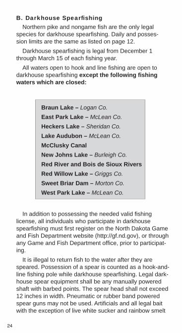
B. Darkhouse Spearfi shingNorthern pike and nongame fi sh are the only legal
species for darkhouse spearfi shing. Daily and posses-sion limits are the same as listed on page 12.
Darkhouse spearfi shing is legal from December 1 through March 15 of each fi shing year.
All waters open to hook and line fi shing are open to darkhouse spearfi shing except the following fi shing waters which are closed:
Braun Lake – Logan Co.East Park Lake – McLean Co. Heckers Lake – Sheridan Co.Lake Audubon – McLean Co.McClusky Canal New Johns Lake – Burleigh Co.Red River and Bois de Sioux Rivers Red Willow Lake – Griggs Co.Sweet Briar Dam – Morton Co.West Park Lake – McLean Co.
In addition to possessing the needed valid fi shing license, all individuals who participate in darkhouse spearfi shing must fi rst register on the North Dakota Game and Fish Department website (http://gf.nd.gov), or through any Game and Fish Department offi ce, prior to participat-ing.
It is illegal to return fi sh to the water after they are speared. Possession of a spear is counted as a hook-and-line fi shing pole while darkhouse spearfi shing. Legal dark-house spear equipment shall be any manually powered shaft with barbed points. The spear head shall not exceed 12 inches in width. Pneumatic or rubber band powered spear guns may not be used. Artifi cials and all legal bait with the exception of live white sucker and rainbow smelt

25
may be used as decoys. Any line used for a decoy will be considered a hook-and-line fi shing pole if a hook is attached to the line.
There is no restriction on the size of the ice hole while actively engaged in darkhouse spearfi shing. When a hole greater than 10 inches in diameter is left in the ice when a darkhouse is moved, the area in the immediate vicinity of the hole must be adequately marked by the spearer with a natural object or a brightly painted or colored wooden lath. Markers must be visible from a minimum of 150 feet.
C. Archery and Spearfi shingGame fi sh may not be taken with bow/arrows or
spears.It is illegal to return fi sh to the water after they are shot
or speared. All fi sh must be used and/or disposed of properly and not left in the water or on land.
Archery and spearfi shing is legal from May 1 through September 30 of each fi shing year.
Archery and spearfi shing is open in all waters as specifi ed on pages 10-11, except for the following areas which are closed:
That portion of the Missouri River from the Gar-• rison Dam downstream to the southern boundary of the U.S. Army Corps of Engineers Downstream Recreation Area.
Legal archery equipment is any bow to which an arrow is attached by a line and equipped with a harpoon style point or wire-barbed point. The use of night vision equip-ment or electronically enhanced light-gathering optics including all lights used for locating and shooting at fi sh is legal. Crossbows are prohibited except with a special director’s permit that may be issued if an individual is permanently disabled.
Legal spear equipment is any manually powered shaft with barbed points. The spear head shall not exceed 12 inches in width.

26
D. Underwater Spearfi shingThe following fi sh may not be taken with underwater
spearfi shing gear: muskellunge, paddlefi sh, smallmouth bass and sturgeon. All other species are legal. Daily and possession limits for legal fi sh are the same as listed on page 12.
Underwater spearfi shing is legal from May 1 through November 30 of each fi shing year.
Underwater spearfi shing is open only in the following waters:
The Missouri River except that portion from the • Garrison Dam downstream to the southern bound-ary of the U.S. Army Corps of Engineers Down-stream Recreation Area. Lake Oahe, Lake Sakakawea (except those areas • posted by the U.S. Army Corps of Engineers near the Intake and Spillway structures) and the open fi shing areas of Lake Audubon. Devils Lake and Stump Lake.• Spiritwood Lake.•
Legal underwater spear equipment is a rubber band powered or pneumatic powered spear gun with the spear attached to the gun with a lanyard not to exceed 20 feet. Underwater spears may be discharged only when the operator and equipment are entirely under the surface of the water.
Underwater spearfi shing is illegal within 150 feet of any individuals engaged in fi shing, designated swimming or water ski areas, boat docks or spillways.
The Diver’s Down Flag must be displayed on a fl oat or buoy during any underwater spearfi shing. Underwater spearers must stay within 100 feet of the vertical position of their Diver’s Down Flag. Individuals who underwater spearfi sh between sunset and sunrise must display a lighted Diver’s Down Flag and must carry a hand-held light that is visible from a distance of 150 feet. The hand-held light must be displayed when the diver is at the surface.

27
E. Paddlefi sh SnaggingSnagging of paddlefi sh is legal May 1 through May
31 for those with a valid paddlefi sh tag. The open area includes the Yellowstone River in North Dakota, and the Missouri River west of the U.S. Highway 85 bridge to the Montana border, excluding that portion from the pipeline crossing (river mile 1,577) downstream to the upper end of the Lewis and Clark WMA (river mile 1,565). Paddlefi sh snagging is legal only from 8 a.m. to 10 p.m. (Central Time) during each day of the paddlefi sh snagging season. Select days are set aside for harvest, and release only.
All paddlefi sh snaggers must obtain and have in their possession a valid paddlefi sh tag, in addition to a license and certifi cate that may be required. Only one tag per snagger will be issued and the tag is not transferable to another person. Any paddlefi sh tag that is locked shut prior to attachment, altered or modifi ed shall be voided and will not be replaced.
It is illegal for a person to use fi sh snagging equipment in the paddlefi sh area if that person does not possess his/her own unused paddlefi sh tag. Each paddlefi sh snagger must cast for, hook and reel in (retrieve) his/her own fi sh. The use of more than one snag hook per line is illegal. Snagging from a boat is illegal. It is illegal to gaff any spe-cies other than paddlefi sh.
The sale, barter, trade or purchase of paddlefi sh eggs is legal only for one qualifi ed and properly permitted paddlefi sh caviar operation. All fi sh delivered to the caviar operation must be done by the individual who snagged the fi sh and the same individual must obtain his/her pro-cessed fi sh from the caviar operation. Any fi sh left at the caviar operation will be considered abandoned and the snagger is subject to a fi ne.
E P ddl fi h S i

28
Depending on the overall harvest, an “in-season” closure may occur, with a 36-hour notice issued by the Game and Fish director. If this occurs, there will be no refunds for unused tags. If there is an early closure, snag-and-release-only will still be allowed for a seven-day period immediately following the harvest closure, but not to extend beyond May 31. Notice of an early closure and subsequent days set aside for snag-and-release-only will be issued by a special news release from the Department. Once a snagger harvests a paddlefi sh, they can no longer snag for paddlefi sh at any subsequent time during the current season (including snag-and-release-only and extended snag-and-release-only days).
HARVEST-ONLY DAYS are Wednesdays, Thurs-days, Fridays and Saturdays
On these days, all paddlefi sh caught must be tagged immediately with one’s own tag. Season creel limit is one paddlefi sh. The release of paddlefi sh after snagging is illegal. If a fi sh is cut up, the tag must accompany the dressed fi sh either by attachment to the bag containing the dressed fi sh or by placement within the bag. The snagger must keep that portion of the back and dorsal fi n (back fi n) necessary to maintain the tag sealed to the fi sh. The use or possession of any gaff hook for a dis-tance of one-half mile in either direction of the Highway 200 Bridge on the Yellowstone River is illegal.
SNAG-AND-RELEASE ONLY DAYS are Sundays, Mondays and Tuesdays
If snaggers have in possession their own unused and current year’s paddlefi sh tag, they can snag but must release immediately any and all paddlefi sh snagged on each Sunday, Monday and Tuesday throughout the open season. No harvest of any paddlefi sh will be allowed during these days. There is no limit on the number of fi sh that can be snagged during the day. The use or posses-sion of any gaff on snag-and-release days is illegal.

29
EXTENDED SNAG-AND-RELEASE ONLY DAYS
If the harvest season closes early, snag-and-release will be allowed for up to seven days immediately follow-ing the harvest closure, but not to extend beyond May 31.
If snaggers have in possession their own unused and current year’s paddlefi sh tag, they can snag but must release immediately any and all paddlefi sh snagged during the extended season. Snag-and-release will be open only in that area of the Missouri River start-ing on the north shore from the Confl uence boat ramp then east (downstream) one-half mile, and that area of the Missouri River starting on the south shore from the Confl uence with the Yellowstone River then east (downstream) one-half mile. No harvest of any paddle-fi sh will be allowed during these days and all snagged fi sh must be released immediately. There is no limit on the number of fi sh that can be snagged during the day. The use or possession of a gaff on snag-and-release days is illegal.
7. FISHING CONTESTSNo person or entity may conduct a fi shing contest on
any public waters without fi rst obtaining a permit issued by the Game and Fish director.
8. RED AND BOIS DE SIOUX RIVERSPersons fi shing the Red River and/or the Bois de
Sioux River in a boat or on the ice who possess a valid fi shing license from either North Dakota or Min-nesota may fi sh the river(s) between the banks of the river separating North Dakota and Minnesota. Persons fi shing the Red River and/or the Bois de Sioux River on the shoreline must have a valid fi shing license from the state in which they are fi shing. Those persons possessing the correct, valid license may transport caught fi sh by the most convenient and direct route to the state in which they are licensed. All anglers and boaters are required to comply with aquatic nuisance/invasive species and fi sh and bait transport regulations

30
of the state they are in, except while on the water, or ice anglers must comply with the regulations of the state for which they are licensed. (NOTE: this includes those who are not required to have a license).
From the Red and Bois de Sioux rivers (as well as all waters east of ND Highway 1) – the daily and possession limit on catfi sh is fi ve (including only one catfi sh that may exceed 24 inches) regardless of the number of state or provincial licenses purchased by the angler.
From the Red and Bois de Sioux rivers up to the fi rst vehicular bridge or crossing on any of their tributar-ies – the daily and possession limit for walleye, sauger, saugeye or combination is three. The daily and posses-sion limit for northern pike is three.
9. COMMERCIAL FISHINGNoncontract type commercial fi shing with use of
seines, hoop nets and set lines may be allowed by spe-cial license in certain waters at certain times.
Contact the Department for licensing information and regulations.
10. CLAM SEASON CLOSEDThe season on clams remains closed in North Dakota
due to continued concern over the impacts commercial harvest may have on clam populations.
11. FISH CONSUMPTION ADVISORYThe North Dakota Department of Health has issued
advisories for the consumption of fi sh from certain North Dakota lakes and rivers. These fi sh contain levels of mercury which may be harmful to certain segments of the population if they are eaten too often.
Information listing current consumption advice is avail-able from the North Dakota Department of Health (Divi-sion of Water Quality) website at: http://www.ndhealth.gov/wq/, or by calling (701) 328-5210.

31
12. BOAT MOTOR RESTRICTIONSPlease check for signs at access points or call the
Game and Fish Department. “Idle speed only” is defi ned as operating a boat at the slowest possible speed neces-sary to maintain steerage (i.e., trolling – with no wake).
Electric Motors Only: Casselton Reservoir, Davis Dam, Dickinson Dike, Heinrich-Martin Dam, J. Clark Salyer, Kettle Lake, Larimore Dam, Leland Dam, Light-ning Lake, McDowell Dam, Mooreton Pond, Rudolph Lake, Sather Dam, Spring Lake Park Ponds, Strawberry Lake (Turtle Mountains).
Idle Speed Only: Arroda Lakes, Lake Audubon (north arm), Baukol-Noonan Dam, Baukol-Noonan East Mine Pond, Belfi eld Pond, Brewer Lake, Camels Hump Dam, Carbury Dam, Clausen Springs Lake, Coal Mine Lake, Crown Butte, Dion Lake, Epping-Springbrook Dam, Fish Creek Dam, Fordville Dam, Gravel Lake, Harmon Lake, Harmony Lake, Heart Butte (Lake Tschida) (designated areas only), Hooker Lake, Lake Ilo, Indian Creek Dam, Jensen Lake, Kota-Ray Dam, Kraft Slough, McClusky Canal Proper, McGregor Dam, Mirror Lake, North Golden Lake, Pelican Lake, Raleigh Reservoir, Riverdale Spillway Pond, Sheep Creek Dam, South Carlson Lake, Sweet Briar Dam, and along the Missouri River at the mouths of the Heart River, Lakewood, Marina Bay, Misty Waters and Square Butte Creek.
25 Horsepower Maximum: Arrowwood, Jim Lake and Long Lake national wildlife refuges.
13. BOATING REGULATIONSClosed to fi shing from boats: On the Bald Hill
Creek, an area from the Wesley Acres Bridge down-stream a distance of 1/2 mile. This area is closed to boat fi shing from April 1 through May 24 of each fi shing year.
Where signed at Devils Lake, boats used for fi shing may not obstruct normal boat traffi c underneath bridges.
See pages 10-11 for federal refuge boating closures.

32
An owner of any watercraft propelled by a motor • must register that vessel with the North Dakota Game and Fish Department, or the state in which he/she resides. If your address changes, boat ownership changes, • boat is destroyed, abandoned, stolen or recovered – you are required to notify the Department within 15 days. The Certifi cate of Number is not transferable. Anyone • purchasing a boat must register the boat in his/her name. The Department can issue a new Certifi cate of Num-• ber to replace one that is lost. The cost is the same as for a new one. No person under 12 years of age may operate a • motorboat (includes personal watercraft, jetskis, etc.) propelled by a motor of more than 10 horsepower unless the operator is accompanied by a person 18 years of age or older. No person 12 through 15 years of age may oper-• ate a motorboat or personal watercraft propelled by a motor of more than 10 horsepower unless the operator is accompanied by a person 18 years of age or older, or the operator has taken and passed a Department approved boating course. All boats must have a Coast Guard approved life • preserver for each occupant, and those boats over 16 feet in length must also have an approved throw-able life preserver. Boat occupants age 10 and under must wear their life preserver.No person may operate any vessel in a reckless or • negligent manner such as:
Endangering the life or property of another. -Use of excessive speed during periods of -reduced visibility while in close proximity of other vessels. Operating in overloaded condition. -

33
Operating within swimming areas designated -by markers or by the presence of swimmers.Operating near dams and other hazardous -waters.Operating in such a manner as to cause a -dangerous or damaging wake.Operation in such a manner as to molest or -annoy a person lawfully engaged in fi shing.
No person may operate a motorboat (includes per-• sonal watercraft) within 100 feet of a person fi shing from a shoreline, a swimmer, swimming/diving raft, or an occupied, anchored or nonmotorized vessel, or within 250 feet of a reduced speed or slow or no-wake sign at greater than slow or no-wake speed.No person may operate any motorboat or vessel • while intoxicated or under the infl uence of alcohol or any narcotic drug, barbiturate or marijuana. No person may operate or permit operation of a per-• sonal watercraft (jetskis, etc.) without each person on board wearing an approved life preserver. All boats operating between sunset and sunrise must • display legal lights. The owner/operator of a vessel is required to fi le • a report in writing whenever an accident results in loss of life or disappearance from a vessel, an injury which requires medical treatment beyond fi rst aid, or property damage is in excess of $2,000 or complete loss of the vessel. Reports in death and injury cases must be submitted • within 48 hours. Reports in other cases must be submitted within fi ve • days.
For more information on boating regulations and safety, contact the Game and Fish Department.

34
14. WHOPPER/CATCH AND RELEASE CLUB REQUIREMENTS
Whopper ClubOnly species listed and meeting minimum weight
requirements will qualify for a patch and certifi cate. Only one application may be made for each species in a lifetime. Anglers receive a patch for the fi rst whopper of a species, an Expert patch for a whopper of another species, and a Master patch for a whopper of a third species. After that only certifi cates will be awarded for whoppers of additional species.
An application card must be fi lled out, giving weight and length of fi sh, date and where caught, signature of applicant, and signature of person weighing the fi sh.
All fi sh entered must have been harvested by legal methods as described in the North Dakota fi shing guide and come from North Dakota waters open to public fi sh-ing. Entries must be weighed on a scale used in trade.
Catch and Release ClubEighteen species of fi sh qualify for the Catch and
Release Club. Entries must meet minimum length requirements and be released unharmed back to the water. Another angler must witness and verify the mea-surement and release.
Anglers will receive an offi cial membership certifi cate and a choice of jacket patch or boat decal. A maximum of fi ve entries per year per species will be recognized.

35
Whopper and Catch and Release Minimums
Species Minimum Whopper Club
Minimum Catch and Release Club
GAME FISHNorthern Pike 20 lbs. 32 inchesWalleye* 8 lbs 25 inchesSaugeye 8 lbs. 25 inchesSauger 4 lbs. 20 inchesYellow Perch 13/4 lbs. 13 inchesBluegill 11/2 lbs. 11 inchesCrappie 11/2 lbs. 13 inchesWhite Bass 3 lbs. 16 inchesLargemouth Bass 5 lbs. 18 inchesSmallmouth Bass 3 lbs. 16 inchesTiger Muskie 25 lbs. 40 inchesMuskellunge 25 lbs. 40 inchesChannel Catfi sh 12 lbs. 30 inchesLing 8 lbs. 28 inchesRainbow Trout 5 lbs. 21 inchesBrown Trout 5 lbs. 21 inchesCutthroat Trout 5 lbs. 21 inchesLake Trout 5 lbs. 24 inchesChinook Salmon 12 lbs.Paddlefi sh 70 lbs.*This includes zander in Spiritwood Lake.
NONGAME FISHWhitefi sh 4 lbs.Cisco 13/4 lbs.Bullhead 2 lbs.Drum 6 lbs.Buffalo 15 lbs.Carp 15 lbs.Goldeye 2 lbs.

36
First Fish Award A FIRST FISH certifi cate is a great way to preserve a memory for a young angler. These colorful awards have space for photos and details of the memorable day. FIRST FISH certifi cates are available free by calling the Game and Fish Department at 701-328-6300; email at [email protected]; or writing 100 N. Bismarck Expressway, Bismarck, ND 58501.
15. NORTH DAKOTA STATE RECORD FISH REQUIREMENTS
1. All recognized fi sh must be harvested by legal methods for recreational fi shing and come from North Dakota waters that are open for public fi shing.
2. All new state record fi sh must be weighed on a scale used commercially and subject to certifi cation by the North Dakota Public Service Commission.
All weights must be rounded to the nearest ounce.3. The fi sh must be visually verifi ed by an employee of
the North Dakota Game and Fish Department.4. Angler must thoroughly complete and submit to the
Department a Whopper card application or a hand-written or typed note with all similar information.
5. A recognizable photo of the fi sh must be furnished to the Department.
6. A fi n sample may be required and collected for some species for genetic analysis.

37
North Dakota Record Fish
Species Weight Where When
GAME FISHNorthern Pike 37 lbs. 8 oz. Lake Sakakawea 1968Walleye 15 lbs. 12 oz. Wood Lake 1959Saugeye 11 lbs. 12 oz. Lake Sakakawea 1984Sauger 8 lbs. 12 oz. Lake Sakakawea 1971Yellow Perch 2 lbs. 15 oz. Devils Lake 1982Bluegill 2 lbs. 12 oz. Strawberry Lake 1963Crappie 3 lbs. 4 oz. Lake Oahe 1998White Bass 4 lbs. 8 oz. Devils Lake 2000Largemouth Bass 8 lbs. 8 oz. Nelson Lake 1983Smallmouth Bass 6 lbs. 13 oz. Lake Darling 2007Tiger Muskie 40 lbs. Gravel Lake 1975Muskellunge 46 lbs. 8 oz. New Johns Lake 2007Channel Catfi sh 42 lbs. 1 oz. Moon Lake 2009Ling 18 lbs. 4 oz. Knife River 1984Rainbow Trout 21 lbs. 4 oz. Garrison Tailrace 1998Brown Trout 31 lbs. 11 oz. Garrison Tailrace 2005Cutthroat Trout 10 lbs. 1 oz. Garrison Tailrace 2003Lake Trout 14 lbs. 4 oz. Garrison Tailrace 1982Chinook Salmon 31 lbs. 2 oz. Garrison Tailrace 1986
Paddlefi sh* 130 lbs.Upper
Missouri River2010
NONGAME FISHWhitefi sh 8 lbs. 11 oz. Garrison Tailrace 1984Cisco 2 lbs. 8 oz. Garrison Tailrace 2000Bullhead 4 lbs. 1 oz. Devils Lake 1988Drum 26 lbs. 2 oz. Lake Sakakawea 1988Buffalo 54 lbs. Heart Butte Tailrace 2011Carp 31 lbs. Sheyenne River 2003Goldeye 3 lbs. 13 oz. New Johns Lake 1998
Method of take is by hook and line fi shing unless –marked with * which indicates paddlefi sh snagging.

38
A Snapshot of Fishing Events From Yesteryear
1881 First fi sh law as the territorial legislature prohibited the use of nets in taking fi sh in certain waters at certain times.
1889 North Dakota became a state.1893 First documented fi sh stocking – black bass into Lake Metigoshe. 1908 North Lemmon Dam built (North Dakota’s oldest reservoir).1909 St. John (between Gravel and Upsilon (Fish) lakes) Fish Hatchery built.
1923 Spiritwood Fish Hatchery built; also the approximate time when St. John hatchery was closed.
1924 Authorized in 1923, fi shing licenses (274 sold) were fi rst required. 1934 About 14,000 resident and 10 nonresident fi shing licenses sold. 1939 Lake Ilo the state’s largest reservoir.1949 First fi sheries biologist hired.
1950 First North Dakota walleye eggs taken from Metigoshe in the early 1950s.
1953Garrison Dam completed. Little to no fi shing on the Missouri River System (and none on Devils Lake). Approximately 40-50 fi shing water bodies statewide.
1954 First boating regulations established. First trout were stocked by the Department. Fishing license increased to $1.
1960 First year of the Whopper Club. First year of mandatory boat registration.
1961 A total of 815 fi sh houses licensed. Heart Butte acclaimed as the walleye capitol of North Dakota.
1964 Lake Ashtabula noted as “the” perch lake in the state. 1965 First time license sales reached 100,000. 1966 Fishing license increased to $3.1969 Northern pike named (by legislative resolution) North Dakota’s state fi sh. 1970 Devils Lake fi rst stocked with walleye and yellow perch.1971 Rainbow smelt stocked into Lake Sakakawea.1975 Missouri River System opened to fi shing year round.
1976 First whopper catfi sh from the Red River. Chinook salmon stocked into Lake Sakakawea.
1978 Fishing license increased to $5.1980 139 fi shing water bodies managed.
1982 Record number of fi shing licenses sold in 1982 –184,000. Catch and Release program initiated.
1984 First year of the trout and salmon stamp. Department cost shared with the fi rst poured cement ramp.
1987 The fi rst fi sh cleaning station was built.
1989 Large expansion of Garrison Dam National Fish Hatchery (coldwater facility and 40 additional rearing ponds). Fishing license increased to $9.
1993 Year round fi shing season statewide beginning April 1 of each year.
1996 Pocketbook guide. Trout/salmon stamp eliminated. Four lines legal statewide for ice fi shing. Fishing license increased to $10.
2012 Fishing licenses still $10 but more than 350 fi shing lakes statewide.

39
Tagged Fish
The North Dakota Game and Fish Department tags numerous fi sh species to gain critical information for managing those fi sheries. Anglers can help fi sheries managers by reporting information from any tagged fi sh they catch. Important information to report includes species, length (inches), when and where the fi sh was caught, and the tag number/color. Please NOTE – if the fi sh is released, do not remove the tag (but do report the information noted above). In return for providing this important information, anglers who include their name and address will receive a brief history of the fi sh they caught from the local fi sheries biologist.
Most game fi sh, except paddlefi sh and salmon, are tagged with a small metal tag attached externally, near the dorsal fi n. Paddlefi sh have metal tags on their lower jaw bone. Tagged salmon have their adipose fi n removed and also have a microscopic coded wire tag embedded in their head. If you catch a salmon that’s missing its adipose fi n, you can drop off the entire head at Game and Fish offi ces or at bait shops in Riverdale and Pick City.
There are various means to report a tagged fi sh including accessing the Department’s website or simply calling any district offi ce.

40
16. ANS QUESTIONS/ANSWERSThe following includes some questions and answers
intended to provide additional insight into this vital matter. All aquatic vegetation must be removed from boats, motors, trailers and equipment before leaving a lake or river.
Why are ANS such a big deal? ANS can greatly degrade or ruin habitats and compete
with native and/or desirable species for food and space. Not only can recreational fi sheries suffer but so can indus-tries and communities that rely on lakes or rivers for their water supply. Once established, the cost of controlling the ANS would far exceed the minimal costs required to keep from spreading it into or within North Dakota.
Can ANS spread be stopped?If precautions are taken and everyone follows them, the
spread can be controlled. But it requires everyone’s partici-pation.
How do I make sure I’m doing the right thing? To comply with the regulations, you simply need to
remove all aquatic vegetation from your boat, trailer, bait bucket, etc., when you leave the water body. You need to drain all water from your boat at the ramp site before you leave the water body. Also, remember you cannot dump bait into a water body.
Do I have to run my motor dry also before I leave a lake?
No. As you exit a lake, lower the motor to let gravity drain the lower unit, then raise to transport. The intake screen should also be inspected and free of aquatic vegetation.
Can I drain water from my boat anywhere?No, you must drain the water (pull all plugs, etc) back into
the water from which it originated. This must be done at the access site before you leave.

41
What if I observe boats, trailers, jet skis, etc., that have weeds hanging from them away from a lake?
The best thing you can do is spread the word on the risk of ANS. If the boat owner/operator is present and willing, ask that they clean the boat and trailer. If the owner/opera-tor is not cooperative call the RAP line.
Do I need to dispose of the weeds in a trash container or can they be left on the ground/parking lot?
Dispose of weeds back into the water from which they originated, to keep parking lots and access areas clean.
As a resident who lives on the North Dakota border, and the nearest bait vendor is across the border in another state, can I cross the state line to purchase bait and import it back into North Dakota?
No. Aquatic bait, including fathead minnows and leeches, may not be imported into North Dakota.
What else can I do to help prevent the spread of ANS?You can disinfect your boat by adding hot water (110° F
or warmer) to the livewell along with enough household chlorine bleach to reach a solution of 1 part bleach to 20 parts water. Run the recirculation pumps and use a brush (a toilet brush works well) to scrub under the lid and in the corners. Drain the solution in an appropriate location, not into the lake. Air drying can also be effective in prevent-ing ANS transfer. The livewell, bilge and equipment must be allowed to completely dry, which may take a few days for the bilge. However, some ANS produce hardy seeds and eggs which can withstand extended periods out of the water; in these cases, air drying is not the answer. Power-washing can remove lake scum and unseen hitchhikers, such as small plant fragments or egg masses, from hard-to-reach places such as trailer frames and livewells. Use a commercial car wash that runs water through a sewage treatment system. If done at home, be careful that the wash water does not run down the street and into the storm sewer that empties into the local river or lake.

42
17. DEVILS LAKE SYSTEM BOATING ACCESS
Following is a list of boating access sites on the Devils Lake Basin (Lake Irvine, Devils Lake, and Stump Lake) in North Dakota. Refer to the map listed below. All sites have a boat ramp, courtesy dock and restrooms unless otherwise noted. Check the North Dakota Game and Fish Department’s website (gf.nd.gov) for updated access information or contact the appro-priate managing authority (found in parenthesis at the end of
each listing) for boating access status.1. ROUND LAKE BAY – 3 miles south
of Minnewaukan on U.S. Highway 281. (Paved
access road, trash receptacles – Min-
newaukan Com-munittee
Club).

43
2. PELICAN LAKE BAY – 15 miles west of Devils Lake on ND Highway 19. (Paved access road, no restrooms, trash recep-tacles – Devils Lake Access Committee).3. GRAHAMS ISLAND STATE PARK – 10 miles west of Devils Lake on ND Highway 19, then 6 miles south. (Paved access road, fi sh cleaning facility, developed and primitive camping, security lights, picnic shelter, trash receptacles, concession, lodging, access fee, telephone, RV dump station – ND Parks and Recreation).4. SCHWAB LANDING – 7 miles west of Devils Lake on ND Highway 19. (Paved access road, fi sh cleaning facility, devel-oped and primitive camping, security lights, picnic shelter, trash receptacles, concession – Devils Lake Access Committee).5. HENEGAR LANDING – 1 mile west of Devils Lake on ND Highway 19, then .75 miles south. (Paved access road, fi sh cleaning facility, security lights, trash receptacles – City of Devils Lake).6. CREEL BAY – 3 miles south of Devils Lake on ND Highway 20, then 2 miles west and .25 miles north. (Paved access road, fi sh cleaning facility, developed and primitive camping, security lights, picnic shelter, trash receptacles – Devils Lake Access Committee).7. SPIRIT LAKE CASINO – 6 miles south of Devils Lake on ND Highway 20/57. (Paved access road, fi sh cleaning facility, developed and primitive camping, security lights, trash recep-tacles, concession, lodging, boat rental, telephone, RV dump station – Spirit Lake Casino).
8. EAST BAY – 3 miles south of Devils Lake on ND Highway 20. (Paved access road, security lights, trash receptacles
– Devils Lake Access Committee).9. ESTENSON LANDING (BLACK TIGER BAY) – 15
miles south of Devils Lake on ND Highway 20. (Paved access road, no restrooms – Devils Lake
Access Committee).10. STUMP LAKE (TOLNA LANDING) – 3
miles north of Tolna. (Gravel access road, no restrooms – Tolna Commu-
nity Club).11. STUMP LAKE PARK – 11
miles south, 1 mile west of Lakota. (Gravel access road, fi sh cleaning facil-ity, developed and primi-tive camping, security lights, picnic shelter, trash receptacles, concession, lodging, RV dump station – Nelson County Park Board).

4444
MISSOURI RIVER SYSTEM
18. MISSOURI RIVER SYSTEM BOATING ACCESS
Following is a list of boating access sites on the Missouri River System in North Dakota. Refer to map shown below. All sites have a boat ramp, courtesy dock and restrooms unless otherwise noted. Due to damage from the summer of 2011 fl ooding, access at some of these sites may not be available. Check the North Dakota Game and Fish Department’s website (gf.nd.gov) for updated access information or contact the appropriate managing authority (found in parenthesis at the end of each listing) for boat-ing access status.
The map on these two pages shows Missouri River boating access points. Specifi c information on each access point is provided in the following pages.

45
1. SUNDHEIM PARK – 2 miles west of Cartwright on ND Highway 200, on west side of Yellowstone River and south side of ND Highway 200. (Paved access road, no courtesy docks, primitive camping, security lights, picnic shelter, trash receptacles – Sund-heim Park Board).2. CONFLUENCE AREA – 1.5 miles south of Buford on ND High-way 1804. (Paved access road, developed and primitive camp-ing, security lights, picnic shelter, trash receptacles – Williams County WRD).3. LEWIS AND CLARK BRIDGE – 4 miles west of Williston on U.S. Highway 2, 3 miles south on U.S Highway 85, on south side of Missouri River, and east side of U.S. Highway 85. (Paved access road, no courtesy docks, primitive camping, security lights, picnic shelter, trash receptacles – Williams County WRD).4. AMERICAN LEGION PARK (RAUMS) – 4 miles west of Williston on U.S. Highway 2, 6 miles south on U.S. Highway 85, then 4 miles east. (Gravel access road, no courtesy docks, developed and primitive camping, security lights, picnic shelter, trash recep-tacles – American Legion Post 37).5. LEWIS AND CLARK STATE PARK – 16 miles east of Williston
on ND Highway 1804, then 3 miles south. (Paved access road, fi sh cleaning facility, developed and primitive camp-
ing, security lights, picnic shelter, trash receptacles, concession, lodging, access fee, telephone, RV dump station – North Dakota Parks and Recre-
ation).6. WHITETAIL BAY (LUND’S LANDING) – 22
miles east of Williston on ND Highway 1804. (Paved access road, fi sh cleaning facility, developed camping, security lights, picnic shelter, trash receptacles,
concession, lodging, boat rental – Wil-liams County WRD).
7. TOBACCO GARDEN CREEK BAY – 2 miles east of Watford City on ND Highway 23, then 25 miles north and east on ND Highway 1806. (Paved access road, fi sh cleaning facility, developed and primitive camp-ing, security lights, picnic shelter, trash receptacles, concession, lodging, RV dump station – McK-enzie County Park Board).8. LITTLE BEAVER BAY – 32 miles northwest of New Town on ND Highway 1804, then 3 miles south. (Gravel access road, fi sh cleaning facility, developed and primitive camping, security lights, picnic shelter, trash recepta-cles – Williams County WRD).

46
9. WHITE EARTH BAY – 28 miles northwest of New Town on ND Highway 1804, then 2 miles south, 1 mile east, 3 miles south, 3 miles east. (Gravel access road, fi sh cleaning facility, devel-oped and primitive camping, security lights, picnic shelter, trash receptacles, concession, telephone, RV dump station – Moun-trail County Park Board).10. SANISH BAY (AFTEM) – 1 mile north, 2 miles west of New Town. (Gravel access road, no restrooms – New Town Park Board/Aftem Development).11. NEW TOWN MARINA – 2 miles west of New Town on ND Highway 23. (Paved access road, fi sh cleaning facility, devel-oped and primitive camping, security lights, picnic shelter, trash receptacles, concession, telephone, RV dump station – New Town Marina Association).12. FOUR BEARS – 4 miles west of New Town on ND Highway 23. (Paved access road, fi sh cleaning facility, developed and primitive camping, security lights, picnic shelter, trash recepta-cles, concession, lodging, telephone, RV dump station – Three Affi liated Tribes).13. POUCH POINT – 7 miles south, 2 miles east, 2 miles south, 1 mile east, 3 miles south of New Town. (Paved access road, developed and primitive camping, security lights, picnic shelter, trash receptacles, concession – Three Affi liated Tribes).14. LITTLEFIELD BAY – 5 miles south, 2 miles east of New Town. Gravel access road, no restrooms, no courtesy docks, primitive camping – ND Game and Fish Department).15. VAN HOOK – 5 miles east of New Town on ND Highway 23, then 2 miles south. (Paved access road, fi sh cleaning facility, developed and primitive camping, security lights, picnic shelter, trash receptacles, concession, telephone, RV dump station – Mountrail County Park Board).16. PARSHALL BAY – 3 miles west, 1 mile south, 3 miles west, 1 mile south, 2 miles west of Parshall. (Paved access road, fi sh cleaning facility, developed and primitive camping, security lights, picnic shelter, trash receptacles, concession, boat rental, telephone, RV dump station – Mountrail County Park Board).17. SKUNK BAY – 14 miles northeast of Mandaree. (Gravel access road, developed and primitive camping, concession, lodging – Three Affi liated Tribes/Roads Maker, Inc.).18. DEEP WATER CREEK BAY – 14 miles south of Parshall on ND Highway 37, then either 1 mile south to the corps ramp or 2.5 miles west and .5 miles south to the county ramp. (Gravel access road, primitive camping, security lights, picnic shelter, trash receptacles – U.S. Army Corps of Eng/McLean County Park Board).19. HALE MARINA – 18 miles southeast of Mandaree. (Gravel access road, no restrooms, no courtesy docks – Three Affi liated Tribes).20. MCKENZIE BAY – 22 miles southeast of Mandaree. (Gravel access road, fi sh cleaning facility, developed and primitive camping, security lights, picnic shelter, trash receptacles, concession, lodging, telephone, RV dump station – Watford City Park Board).

47
21. LITTLE MISSOURI BAY – 16 miles northeast of Dunn Center. (Gravel access road, security lights – Dunn County).22. CHARGING EAGLE BAY – 12 miles north of Halliday on ND Highway 8, then 10 miles west on BIA No. 22. (Gravel access road, no restrooms, fi sh cleaning facility, primitive camping, trash receptacles – Three Affi liated Tribes).23. INDIAN HILLS RESORT – 11 miles west of White Shield on ND Highway 1804, then 3 miles south. (Gravel access road, fi sh cleaning facility, developed and primitive camping, security lights, picnic shelter, trash receptacles, concession, lodging, boat rental, telephone, RV dump station – ND Parks and Recre-ation/Three Affi liated Tribes).24. BEAVER CREEK BAY – 12 miles north of Zap. (Paved access road, primitive camping, picnic shelter, trash recep-tacles – Zap City Park Board).25. DAKOTA WATERS RESORT – 15 miles north of Beulah. (Paved access road, fi sh cleaning facility, developed and primi-tive camping, security lights, picnic shelter, trash receptacles, concession, lodging, boat rental, telephone, RV dump station – Dakota Waters Resort).26. BEULAH BAY – 17 miles north of Beulah. (Paved access road, fi sh cleaning facility, developed and primitive camping, security lights, picnic shelter, trash receptacles, lodging, tele-phone, RV dump station – Beulah City Park Board).27. DOUGLAS CREEK BAY – 5 miles south, 4 miles east of Emmet to corps ramp or 2 miles south, 1 mile east, 1 mile south of Emmet to county ramp. (Gravel access road, primitive camping, trash receptacles – U.S. Army Corps of Eng/McLean County Park Board).28. CAMP OF THE CROSS – 4 miles west, 1.5 miles south, 1 mile west, 1 mile south, 1 mile west, .5 miles south of Garrison (Gravel access road, no restrooms, primitive camping – Camp of the Cross).29. HAZEN BAY – 14 miles north of Hazen. (Paved access road, fi sh cleaning facility, developed and primitive camping, security lights, picnic shelter, trash receptacles, concession, lodging, telephone, RV dump station – Hazen City Park Board).30. LAKE SAKAKAWEA STATE PARK – Just east and north of Pick City. (Paved access road, fi sh cleaning facility, developed and primitive camping, security lights, picnic shelter, trash receptacles, concession, lodging, boat rental, access fee, tele-phone, RV dump station – ND Parks and Recreation).31. GARRISON CREEK – 2 miles west of Garrison on ND Highway 37, 3 miles south, 1 mile east. (Gravel access road, no restrooms – Garrison Cabin Association).32. FORT STEVENSON STATE PARK – 3 miles south of Gar-rison. (Paved access road, fi sh cleaning facility, developed and primitive camping, security lights, picnic shelter, trash recep-tacles, concession, lodging, boat rental, access fee, telephone, RV dump station – ND Parks and Recreation).33. STEINKE BAY – 3 miles west of the junction of ND Highway 37 and U.S. Highway 83, then 2 miles south. (Gravel access road, primitive camping – McLean County Park Board).

48
34. SPORTSMENS CENTENNIAL PARK – 1 mile west of the junction of ND Highway 37 and U.S. Highway 83, then 2 miles south, 1 mile west. (Gravel access road, fi sh cleaning facility, developed and primitive camping, security lights, picnic shelter, trash receptacles, concession, telephone – McLean County Park Board).35. WEST TOTTEN TRAIL – 7 miles north of Coleharbor on U.S. Highway 83, then .5 miles west, or 2 miles south of the junction of U.S. Highway 83 and ND Highway 37, then .5 miles west. (Gravel access road McLean County Park Board).36. WOLF CREEK – 1 mile east of Riverdale on ND Highway 200, then 2 miles north, 1 mile east, 1 mile north, .5 miles east. (Gravel access road, fi sh cleaning facility, primitive camping, security lights, picnic shelter, trash receptacles, RV dump sta-tion – U.S. Army Corps of Engineers).37. GOVERNMENT BAY – Just north of Riverdale. (Paved access road, fi sh cleaning facility, developed and primitive camping, security lights, trash receptacles – U.S. Army Corps of Engineers).38. GARRISON DAM TAILRACE – Directly below Garrison Dam with the campground located south of the fi sh hatchery. (Paved access road, fi sh cleaning facility, developed camping, security lights, trash receptacles – U.S. Army Corps of Engineers).39. UPA SITE (STANTON) – Just west of UPA Power Plant on ND Highway 200A near Stanton. (Paved access road, security lights, trash receptacles – City of Stanton).40. WASHBURN – On the side of the Missouri River near Wash-burn, north of ND Highway 200A bridge. (Paved access road, fi sh cleaning facility, primitive camping, security lights, picnic shelter, trash receptacles, RV dump station – Washburn City Park Board).41. SANGER (CROSS RANCH) – Just east of Sanger townsite on west side of Missouri River. (Gravel access road, primi-tive camping, picnic shelter, trash receptacles – ND Parks and Recreation).42. STECKEL BOAT LANDING (WILTON) – 22 miles north of Bismarck on ND Highway 1804, or 5.5 miles west, 1 mile south, and 1.5 miles west of junction of U.S. Highway 83 and ND High-way 36. (Paved access road, primitive camping, picnic shelter, trash receptacles – Burleigh County Park Board).43. HOGE LANDING – On east side of the Missouri River near Bismarck, 6.4 miles north of I–94 bridge on River Road, then .7 miles west and 1.5 miles south/southwest. (Gravel access road, no courtesy docks, picnic shelter, trash receptacles – Bismarck Parks and Recreation).44. KNIEFEL LANDING – On east side of the Missouri River near Bismarck, 3 miles north of I–94 bridge on River Road, then 1 mile west. (Paved access road, security lights, picnic shelter, trash receptacles, concession – Burleigh County Park Board).45. GRANT MARSH BRIDGE – On the east side of the Missouri River near Bismarck, south side of the I–94 bridge on River Road. (Paved access road, security lights, trash receptacles – Bismarck Parks and Recreation).

49
46. FOX ISLAND PARK – From Washington Street, .75 miles west on Riverwood Drive (1 block south of Expressway), 1.5 miles south and .5 miles west. Heavy pleasure boat use in sum-mer. (Paved access road, fi sh cleaning facility, security lights, trash receptacles – Bismarck Parks and Recreation).47. LITTLE HEART BOTTOMS (SCHMIDT) – 11 miles south of Mandan on ND Highway 1806, then 1 mile north. (Paved access road, trash receptacles – Morton County Park Board).48. KIMBALL BOTTOMS (DESERT) – 8 miles south of Bismarck on ND Highway 1804, then 2 miles south. (Paved access road, primitive camping, security lights, picnic shelter, trash recep-tacles – Burleigh County Park Board).49. GRANER BOTTOMS (SUGAR LOAF) – 19 miles south of Mandan on ND Highway 1806, then 1 mile east, or about 3 miles north of Huff. (Paved access road, fi sh cleaning facility, developed and primitive camping, security lights, picnic shelter, trash receptacles, RV dump station – Morton County Park Board).50. MACLEAN BOTTOMS (GUN RANGE) – 14 miles south of Bismarck on ND Highway 1804, then 2 miles south. (Paved access road, primitive camping, security lights, picnic shelter, trash receptacles – Burleigh County Park Board).51. HAZELTON – 31 miles southeast of Bismarck on ND Highway 1804 or 13 miles west and 2 miles north of Hazelton. Campground located just south of boat ramp. (Paved access road, developed and primitive camping, security lights, picnic shelter, trash receptacles – U.S. Army Corps of Engineers).52. FORT RICE – 28 miles south of Mandan on ND Highway 1806, then .5 miles east. (Paved access road, fi sh cleaning facility, primitive camping, security lights, picnic shelter, trash receptacles – Morton County Park Board).53. WALKER BOTTOMS (PRAIRIE KNIGHTS MARINA) – 10 miles south of the Cannonball River on ND Highway 1806, then 3.5 miles east. (Gravel access road, fi sh cleaning facility, developed and primitive camping, security lights, picnic shelter, trash receptacles, lodging, telephone, RV dump station – Prairie Knights Casino).54. BEAVER BAY – 13 miles west of Linton on ND Highway 13, then 2 miles south on ND Highway 1804. (Paved access road, fi sh cleaning facility, developed and primitive camping, security lights, picnic shelter, trash receptacles, concession, telephone, RV dump station – U.S. Army Corps of Engineers).55. CATTAIL BAY (WINONA) – 10 miles west of Strasburg, 1 mile south, 7 miles west, then 1 mile north on ND Highway 1804, 2 miles west, 2 miles south, 1 mile west. (Gravel access road, primitive camping, trash receptacles, concession – U.S. Army Corps of Engineers).56. FORT YATES – North edge of Fort Yates. (Paved access road, primitive camping, picnic shelter, trash receptacles – Standing Rock Sioux Tribe).57. LANGELIERS BAY – 10 miles west of Strasburg, 1 mile south, 7 miles west, then 11 miles south on ND Highway 1804, and .75 miles west. (Paved access road, fi sh cleaning facility, primitive camping, security lights, trash receptacles – Emmons County Park Board).

50
M
o
n
t a
n
a
C a n a
S o u t h
DIVIDE
WILLIAMS
MCKENZIE
GOLDENVALLEY
BILLINGS
MOUNTRAIL
BURKE RENVILLEBOTTINEAU
WARD
MCHENRY
BURLEIGH
EMMOSIOUX
GRANT
MORTON
OLIVER
STARK
SLOPE HETTINGER
BOWMANADAMS
SHERIDAN
MCLEAN
MERCERDUNN
19. NORTH DAKOTA 2012-2014 FISHING WATERS (not including the Missouri River System)The following includes most of the public fi shing waters in North Dakota, listed alphabetically by county. If unsure of the location of a county or the code number, refer to the map on pages 50–51 which lists the county code numbers that coincide with this listing. Each lake listed includes travel directions, most common species present, and fi shing piers (listed if present). Most of North Dakota public fi shing waters have a boat ramp (concrete and/or metal). If a boat ramp is lacking at a specifi c water body, it is listed as ‘no ramp’.
Rivers and LakesBois De Sioux River – Southeast corner of state in Richland County (pike, walleye, catfi sh – no ramp).Cannonball River – In Slope, Hettinger, Grant and Sioux counties (pike, walleye, catfi sh – no ramp).GDU Canal Lakes – 9 miles south, 3 miles east and west of Mercer (walleye, perch, smallmouth bass – fishing pier).Heart River – In Stark, Grant, and Morton counties (pike, walleye, catfish – no ramp).James River – Southeastern part of the state (pike, walleye).Knife River – In Dunn and Mercer counties (pike, walleye, catfi sh – no ramp).Lake Oahe – Near the cities of Bismarck, Fort Yates, Hazelton, Linton and Strasburg (walleye, catfi sh, pike – fi shing pier).

51
M i n
n e
s o
t a
a d a
D a k o t a
ROLETTETOWNER
CAVALIER PEMBINA
WALSH
NELSON GRANDFORKS
RAMSEY
BENSON
EDDY
FOSTER
GRIGGS STEELE
TRAILL
KIDDER
BARNESSTUTSMAN CASS
RICHLANDRANSOM
SARGENT
LAMOURE
DICKEY
LOGAN
MCINTOSHONS
WELLS
N
PIERCE
Lake Sakakawea – Near the cities of Williston, New Town, Gar-rison and Riverdale (walleye, salmon, pike – fi shing pier).Little Missouri River – Southwestern part of the state (sauger, catfi sh – no ramp).McClusky Canal – Central part of state in McLean, Burleigh and Sheridan counties (walleye, smallmouth bass, perch – no ramp).Missouri River – Missouri River from near Riverdale to south of Bismarck (walleye, catfi sh, trout – fi shing pier).Red River – Eastern edge of state (pike, walleye, catfi sh – fi sh-ing pier).Sheyenne River – Southeastern part of state (catfi sh, walleye, smallmouth bass – fi shing pier).Souris River (Mouse River) – North central part of state (pike, walleye, perch – fi shing pier).Turtle River – In Grand Forks County (pike, catfi sh, trout – no ramp).Upper Missouri River – Missouri River from Williston to the Montana state line (paddlefi sh, sauger, catfi sh).Wild Rice River – Southeastern part of state (pike, walleye, catfi sh – no ramp).Yellowstone River – Near cities of Buford, Cartwright and Fairview (paddlefi sh, sauger, catfi sh – fi shing pier).

52
Adams CountyBolke Dam – 5 miles east, .5 miles north, .5 miles west, .5 miles north of Lemmon, South Dakota (trout – no ramp).Mirror Lake – South side of Hettinger (pike, perch, bluegill – fi sh-ing pier).North Lemmon – 5 miles north of Lemmon, South Dakota (trout, bluegill, largemouth bass – fi shing pier).
Barnes CountyBlumers Pond – 1 mile south of Valley City (trout – no ramp).Clauson Lake – .5 miles south, 3.5 miles west of Nome (perch – no ramp).Clausen Springs – 3 miles north, 1 mile east, .5 miles north of the junction of ND highways 46 and 1 (perch, largemouth bass, walleye – fi shing pier).Eckelson Lake North – 2 miles east of Eckelson (perch – no ramp).Eckelson Lake South – 4 miles south, 1.5 miles east of Eckel-son (pike, perch – no ramp).Fox Lake – 1 mile west of Eckelson (perch, walleye – no ramp).Hatchery Kids Pond – 2 miles northwest of Valley City (trout – no ramp).Hobart Lake North – 6 miles west of Valley City (perch – no ramp).Hobart Lake South – 6 miles west of Valley City (perch – no ramp).Island Lake – 3 miles south, .5 miles east of Urbana (walleye – no ramp).Kee Lake – 7 miles south, 2 miles east of Eckelson (perch – no ramp).Lake Ashtabula – 10 miles north of Valley City (pike, walleye, perch – fi shing pier).Lake Ashtabula Tailrace – 10 miles north of Valley City (pike, walleye – no ramp).Meadow Lake – 6 miles west, 6 miles north of Litchville (perch – no ramp).Middle Eckelson – 2 miles east of Eckelson (pike – no ramp).Moon Lake – 2 miles west, 5.5 miles south, 4 miles west, 2 miles north of Valley City (perch, smallmouth bass, walleye – fi shing pier).Olson WPA – 1.5 miles east, .5 miles south of Sanborn (perch – no ramp).Sanborn Lake – 2 miles east of Sanborn (perch, pike – no ramp).Sanborn WPA – .5 miles east of Sanborn (perch – no ramp).St. Mary’s Lake – 2 miles west, 5.5 miles south, 4 miles west, 1 mile north of Valley City (perch – no ramp).
Benson CountyFort Totten Dam – .5 miles east of Fort Totten (trout – no ramp).Gravel Pit Lake – 4.5 miles west of Fort Totten (black crappie – no ramp).
53
Mission Lake – 5 miles south, 1.5 miles east, 2 miles south of Devils Lake (walleye, perch, pike – no ramp).Silver Lake – 1 mile west, 6 miles south, 1 mile west, 1 mile north of Churchs Ferry (pike, perch – no ramp).Wood Lake – 2 miles west, 1 mile south of Tokio (pike, walleye, perch).
Bottineau CountyCarbury Dam – 1 mile south, 1 mile west of Carbury (pike, perch – fi shing pier).Lake Metigoshe – 9 miles north, 4 miles east, 1 mile north of Bottineau (bluegill, pike, walleye – fi shing pier).Long Lake – 8 miles north, 7 miles east, 1 mile south, 1 mile east, .5 miles south, .3 miles east of Bottineau (pike, walleye, perch).Loon Lake – 9 miles north, 4 miles east, 2 miles south, 2 miles east, .5 miles north of Bottineau (perch – no ramp).Pelican Lake – 9 miles north, 8 miles east, .5 miles southwest of Bottineau (pike, perch).Strawberry Lake – 4 miles north, 2.5 miles east, .5 miles south of Carbury (trout – fi shing pier).
Bowman CountyBowman–Haley Dam – 11 miles south, 8 miles east, 2 miles south of Bowman (walleye, perch, smallmouth bass – fi shing pier).Gascoyne Lake – 1.5 miles northwest of Gascoyne (pike).Kalina Dam – 2 miles west, 1 mile south, 1 mile west, 1 mile south of Bowman (pike, perch, bluegill – no ramp).Lutz Dam – 2.5 miles south, 2 miles west of Griffi n (trout, blue-gill, largemouth bass – no ramp).Spring Lake – 1 mile south, 4 miles west of Rhame (pike, perch).
Burke CountyNorthgate Dam – 6 miles north, 1 mile west, 2 miles north, .5 miles west of Bowbells (walleye, bluegill, trout – fi shing pier).Powers Lake – Southeast side of Powers Lake (pike, perch – fi shing pier).Short Creek Dam – 5.5 miles north of Columbus (walleye, perch, bluegill – fi shing pier).Smishek Lake – 4 miles northwest of Powers Lake (pike, perch, walleye – fi shing pier).
Burleigh CountyCottonwood Park Pond – On the west side of Cottonwood soc-cer complex in south Bismarck (trout – no ramp, fi shing pier).Lake Harriet (Arena Lake) – 8 miles west, 1 mile south of Tuttle (pike, perch – no ramp).Long Lake – 1 mile south, 2.5 miles east of Moffi t (pike, perch – no ramp, fi shing pier).McDowell Dam – 4 miles east, 1 mile north of Bismarck on ND Highway 10 (trout, bluegill, largemouth bass – fi shing pier).

54
OWLS Pond – Just west of Bismarck Game and Fish offi ce (trout, perch, bluegill – no ramp, fi shing pier).
Cass CountyBrewer Lake – 1 mile south, 1 mile west of Erie (bluegill, large-mouth bass, smallmouth bass – fi shing pier).Casselton Reservoir – Just west of Casselton (pike, crappie, bluegill – fi shing pier).Lindemann Lake – 2 miles east, 2 miles north, .5 miles west of Enderlin (perch – no ramp).North Woodhaven Pond – 2.25 miles south, .25 miles east of I–94 Exit 348 (trout, bluegill – no ramp, fi shing pier).South Woodhaven Pond – 3.5 miles south, .25 miles east of I–94 Exit 348 (perch – no ramp, fi shing pier).
Cavalier CountyLangdon City Pond – South side of Langdon (trout – fi shing pier).Mount Carmel Dam – 9 miles north, 2 miles east, 2 miles north of Langdon (pike, walleye, perch – fi shing pier).
Dickey CountyMoores Lake – 18.5 miles west, 1 mile north of Ellendale (pike, perch – no ramp).Pheasant Lake – 6 miles west of Ellendale (pike, walleye, blue-gill – fi shing pier). Wilson Dam – 7 miles west of Monango (pike, perch, largemouth bass – fi shing pier).
Divide CountyBaukol–Noonan Dam – 2 miles east, .5 miles south of Noonan (trout, bluegill, largemouth bass – fi shing pier).Baukol–Noonan East Mine Pond – 2 miles east, .5 miles south of Noonan (trout, bluegill, perch).Skjermo Lake – 3 miles west, 4 miles northwest of Fortuna (pike, perch – fi shing pier).
Dunn CountyDvorak Dam – 3.5 miles south, 5 miles east, .5 miles north of Manning (perch – no ramp).Lake Ilo – 1 mile west, 1 mile south of Dunn Center (pike, perch – fi shing pier).
Eddy CountyAdams Lake – 10 miles south of Warwick (perch – no ramp).Battle Lake – .5 miles south, 1.5 miles west, 1.5 miles south of Hamar (pike, perch – no ramp).Lake Coe – 10 miles south of Warwick on east side of Eddy County Road 8 (perch, walleye – no ramp).New Rockford Reservoir – North side of New Rockford (pike, bluegill – no ramp, fi shing pier).Warsing Dam – 1 mile northeast of Sheyenne (pike, walleye, perch – fi shing pier).
55
Emmons CountyBaumgartner Lake – 6 miles south of Linton (pike, perch – no ramp).Braddock Dam – 2 miles southwest of Braddock (pike, bluegill, perch).Goose Lake – 3 miles east of Braddock (perch – no ramp).Jake’s Lake – 13 miles south, 1 mile east of Strasburg (pike, perch – no ramp).Rice Lake – 8 miles south of Strasburg (pike, perch, walleye).Senger Lake – 1 mile north, 6 miles east of Strasburg (perch – no ramp).
Foster CountyDry Lake – 4 miles east, 5 miles south of Carrington (pike, wall-eye, perch – no ramp).Juanita Lake – 2 miles east of Grace City (pike, perch – fi shing pier).
Golden Valley CountyBeach City Pond – Southwest side of Beach (trout – no ramp, fi shing pier).Camels Hump Lake – Northeast of Sentinel Butte– I–94 Exit 18 (trout, bluegill, largemouth bass).Odland Dam – 7 miles north of Beach (perch, bluegill – fi shing pier).
Grand Forks CountyFordville Dam – 5 miles west, 1 mile north, .5 miles west, .5 miles north of Inkster (pike, walleye, perch – fi shing pier).Kolding Dam – 5 miles southeast, 1 mile south of Niagara on U.S. Highway 2 (pike).Larimore Dam – 2 miles northeast of Larimore (pike, perch, bluegill – fi shing pier).Niagara Dam – North of Niagara (pike).Ryan Park Pond – South side of Grand Forks (trout – no ramp, fi shing pier).
Grant CountyHeart Butte Reservoir (Lake Tschida) – 15 miles south of Glen Ullin (walleye, perch, crappie – fi shing pier).Raleigh Reservoir – 3.5 miles west, .25 miles south of Raleigh (trout, bluegill, largemouth bass – fi shing pier).Sheep Creek Dam – 4 miles south, .5 miles west of Elgin (wall-eye, bluegill, largemouth bass – fi shing pier).
Griggs CountyCarlson–Tande Dam – 1 mile south, 5 miles west of Aneta (pike, perch, bluegill – no ramp).Lake Addie – 4 miles east, 1 mile south, 1 mile west of Binford (perch, walleye).Lake Jessie – 4 miles east, 1 mile south, 1 mile west of Binford (perch, pike – no ramp).

56
Red Willow Lake – 6 miles north, 2 miles west of Binford (pike, walleye, bluegill – fi shing pier).Sibley Lake – 11 miles west, 3 miles south of Binford (pike, perch – no ramp).
Hettinger CountyBlickensderfer Dam – 4 miles south, 1 mile east, .5 miles south of Mott (walleye, perch, bluegill – no ramp).Castle Rock Dam – 2 miles west, 1.5 miles south, 1.5 miles west of Mott (trout).Indian Creek Dam – 1.5 miles west, 2 miles south, 2 miles west, 3 miles south of Regent (walleye, bluegill, perch – fi shing pier).Kilzer Dam – 4.5 miles south, 1 mile east of Bently (bluegill – no ramp).Larson Lake – .5 miles north and 2 miles east of Regent (pike).Mott Watershed Dam – North side of Mott (bluegill, largemouth bass, trout – fi shing pier).
Kidder CountyAlkaline Lake – 6 miles north, 7 miles east, 2 miles north, 1 mile east, 2 miles north of Napoleon (pike, walleye, perch – fi shing pier).Bond Lake – 2 miles west, 2 miles south, 1 mile west of Pet-tibone (perch – no ramp).Cherry Lake – 15 miles north, 3 miles east of Steele (pike, perch).Des Moines Lake – 5.5 miles east of Robinson (pike – no ramp).Etta–Alkaline Complex – 1 mile south, 2.5 miles west, 3 miles south of Dawson (pike – no ramp).Fresh Lake – 6 miles north, 7 miles east, 2 miles north, 1 mile east, 2 miles north of Napoleon (pike, perch – no ramp).Frettim Lake – 2 miles east, 1 mile north of Robinson (pike, walleye, perch).Helen Lake – 2.5 miles west, 6 miles north of Tuttle (pike, perch – no ramp).Horsehead Lake – 2 miles west, 6 miles south of Robinson (pike – no ramp).Jasper Lake – 7 miles north, .5 miles east of Robinson (perch, walleye).Koenig North – 12.25 miles north, 1.5 miles east of Robinson (perch – no ramp).Koenig South – 12.25 miles north, 1.5 miles east of Robinson (perch – no ramp).Kunkel Lake – 5 miles east, 7 miles south, 1 mile east of Robin-son (perch – no ramp).Lake No. 5 – .5 miles west, 2 miles north, 3 miles west, 4 miles north of Dawson (perch – no ramp).Lake Geneva – 2 miles south, .5 miles east of I–94 Exit 195 (perch – no ramp).Lake Isabel – 2 miles south, .5 miles east, .75 miles south of Dawson (pike, perch – fi shing pier).

57
Lake Josephine – 2 miles north of Tuttle (pike, walleye, perch – fi shing pier).Lake Williams – Just south of the town of Lake Williams (pike, walleye, perch).Long Alkaline Lake – 3 miles west, 7 miles north of Robinson (perch – no ramp).North Des Moines Lake – 5.5 miles east of Robinson (pike – no ramp).Pelican Lake – 3 miles east, 11 miles north, 1 mile east of Rob-inson (perch – no ramp).Ranch Lake – 1 mile west of Pettibone (perch – no ramp).Round Lake – 1 mile north, 1.5 miles east of Pettibone (pike, walleye, perch – no ramp).Schumacher Lake – 7 miles north, 1 mile east, .25 miles south of Robinson (perch, walleye – no ramp).Sibley Lake – 7 miles north, 2 miles east, 1 mile south of Daw-son (walleye – no ramp).Swan Lake – 10.5 miles north of Robinson (perch – no ramp).Willow Lake – 9 miles north, 3 miles west of Robinson (perch – no ramp).Woodhouse Lake – 12 miles north, 12 miles east of Wing (perch, walleye – no ramp).
LaMoure CountyAlfred Lake – 7 miles east, 1.5 miles south of Gackle (perch, pike – no ramp).Boom Lake (Marion Lake) – .5 miles west of Marion (perch, walleye, bluegill).Diamond Lake – 5 miles north of Kulm (pike, perch, walleye – no ramp).Flood Lake – 3.5 miles north of Kulm (pike, perch).Heinrich–Martin Dam – 1 mile southeast of Adrian (bluegill, largemouth bass, crappie).Kalmbach Lake – 1 mile south, 4.5 miles west, .5 miles south of Jud (pike, perch).Kulm–Edgeley Dam – 4 miles west, 2 miles south of Edgeley (pike, walleye, perch).Lake LaMoure – 1 mile south, 1 mile east, 2.5 miles south, 1 mile west, .5 miles south of LaMoure (pike, walleye, crappie – fi shing pier).LaMoure Dam – West end of LaMoure (pike, walleye – no ramp).Limesand–Seefeldt Dam – 8 miles south, 3 miles west of Marion (pike, bluegill, largemouth bass).Schlecht–Thom Dam – 5 miles west, .5 miles north of Edgeley (perch, largemouth bass, pike).Schlecht–Weixel Dam – 4 miles south of Jud (perch, pike).Schlenker Dam (Lehr Dam) – 11 miles west, .5 miles south of the junction of US Highway 281 and ND Highway 46 (perch, largemouth bass, bluegill).Twin Lakes – 4 miles north of LaMoure (perch, walleye, pike).

58
Logan CountyArnies Lake – 1.5 miles south of Gackle, 2 miles east, 1 mile south (perch, pike – no ramp).Beaver Lake – 8 miles south, 8 miles east of Napoleon (pike, perch).Braun Lake – 18 miles south, 1 mile east of Steele (perch – no ramp).Dewald Lake – 8 miles north, 2 miles east, 1 mile north, 1 mile east of Lehr (perch – no ramp).Doyles Lake – 2.5 miles north, 2 miles east, 4 miles north, 1 mile east, .5 miles north of Wishek (perch – no ramp).Erickson Lake – 8.5 miles north, 3 miles west, 1 mile north, 1.5 miles west of Kulm (perch – no ramp).Hauff Lake – 7 miles north of Lehr (perch – no ramp).Kautz Lake – 5 miles north, 6 miles west of Lehr (perch – no ramp).Kleingartner Lake – 10 miles south, 5 miles west of Gackle (perch – no ramp).Lepp Lake – 1 mile east, 1 mile north of Lehr (pike – no ramp).Logan (Mueller) WMA – 8 miles north, 5 miles west, 1 mile south of Lehr (perch, walleye – no ramp).Marvin Miller Lake – 6.5 miles south, 8 miles west of Gackle (perch, walleye – no ramp).Mundt Lake – 3 miles east, 4 miles north, 1 mile east, .5 miles south of Lehr (walleye, perch – fi shing pier).North Napoleon Lake – .5 miles north, 2 miles east of Napoleon (perch – no ramp).Railroad Lake – 5.5 miles east of Lehr (perch – no ramp).Roesler Lake – 8 miles north, 1 mile east of Lehr (perch – no ramp).Thurn Lake – 5 miles north of Lehr, .5 miles east (perch, wall-eye – no ramp).Wentz WPA – 12 miles east of Napoleon (perch, walleye – no ramp).West Lake Napoleon – 1 mile west of Napoleon (pike, perch).
McHenry CountyBentley Lake – 3 miles west of Drake (pike, perch – no ramp). Cottonwood Lake– 2.5 miles north of Butte (pike, perch – fi shing pier).Buffalo Lodge Lake – 1 mile east, 3 miles north, 2 miles east of Granville (pike, walleye, perch – fi shing pier).George Lake – 13 miles north, 3 miles east of the junction of U.S. Highway 52 and ND Highway 14 (pike, perch – fi shing pier).Round Lake – 6 miles north, 4.5 miles east of Drake (perch, walleye, pike – no ramp).
McIntosh CountyBecker–Schlepp Lake – 3 miles north, 1 mile east, 1 mile north, .5 miles east of Ashley (perch – no ramp).

59
Blumhardt Dam – 10 miles east, 7 miles north, 1.5 miles east of Ashley (trout).Clear Lake – 6 miles east, 2 miles south of Wishek (pike – no ramp).Coldwater Lake – 16 miles east, 1 mile south, 1 mile west of Ashley (pike, walleye, perch – fi shing pier).Dollinger–Schnabel Lake – 2 miles north, 5 miles west, 3 miles north of Venturia (perch – no ramp).Dorfman Lake – 5 miles north, 2 miles west of Ashley (pike, perch, walleye – no ramp).Dry Lake – 5 miles west, 4 miles north, 2 miles east, .5 miles south of Ashley (pike, walleye, perch).Green Lake – 2 miles east, 4 miles south, 1 mile east of Wishek (walleye, pike, perch – fi shing pier).Harr Lake – 10 miles east, 12 miles north of Ashley (perch – no ramp).Homestead Lake – 8 miles south, 8 miles east, 2 miles north of Wishek (pike, perch – no ramp).Lake Hoskins – 3 miles west of Ashley (pike, walleye, perch – fi shing pier).Lehr WMA – 2 miles east, 1 mile south of Lehr (walleye).McIntosh WMA – 10 miles east, 9 miles north of Ashley (perch – no ramp).Miller Lake – 7.5 miles east, 2.5 miles south of Lehr (pike, perch – no ramp).Mudd Lake – 1 mile west of Lehr (perch – no ramp).Nagel Lake (Koepplin WPA) – 1 mile east, 1 mile south, 1 mile east of Lehr (perch – no ramp).Pfeifl e Lake – 10 miles south, 2 miles east of Wishek (pike – no ramp).Pudwill Lake – 9 miles south, 4 miles west, 1 mile north, .5 miles west of Lehr (pike, perch – no ramp).Rueb–Eszlinger – 7.5 miles north, 2 miles west of Ashley (perch – no ramp).
McKenzie CountyArnegard Dam – .5 miles west, 3 miles north, 1.5 miles south-west of Arnegard (pike, perch).Leland Dam – 11 miles south, 8 miles west, 8 miles south, 2 miles southeast, 1.5 miles east, 1 mile north of Alexander (blue-gill, largemouth bass).Sather Dam – 11 miles south, 8 miles west of Alexander (blue-gill, largemouth bass – fi shing pier). Watford City Park Pond – Southeast side of Watford City (trout, catfi sh – no ramp, fi shing pier).
McLean CountyBrush Lake – 3 miles north of Mercer (pike, perch, walleye – fi shing pier).Camp Lake – 17.5 miles north, 2 miles east of Turtle Lake (pike, perch – no ramp).

60
Camp Loop Pond – 3 miles southwest of Riverdale on U.S. Army Corps of Engineers’ downstream campground (trout – no ramp).Crooked Lake – 10 miles north, .2 miles east, .1 mile south of Turtle Lake (pike, walleye, perch – fi shing pier).Custer Mine – 4 miles east, 2 miles south of Garrison (trout, bluegill).Lake Audubon – North of Coleharbor (walleye, perch, small-mouth bass – fi shing pier).Lake Brekken – 1.5 miles north of Turtle Lake (walleye, perch – fi shing pier).Lake Holmes – 1 mile northeast of Turtle Lake (walleye, perch).Lightning Lake – .5 miles east of Turtle Lake (trout, bluegill – fi shing pier).Long Lake – 13 miles north, 4 miles east, 2 miles north, 1.5 miles west of Turtle Lake (pike, perch).Painted Woods Creek – 5 miles southeast of Washburn (pike, walleye – no ramp).Riverdale City Pond – North side of Riverdale (trout, bluegill, largemouth bass – no ramp, fi shing pier).Strawberry Lake – 17.5 miles north, 2 miles east of Turtle Lake (pike, perch, walleye – fi shing pier).Triangle Y Pond – 4 miles west, 1.5 miles south, 1 mile west, 1 mile south, 1 mile west, .5 miles south of Garrison (perch, bluegill – no ramp, fi shing pier).Turtle Lake – 4.5 miles west, 1 mile north of Turtle Lake (pike – no ramp).Weishaur WPA – 8 miles north, 8 miles west, 1 mile north of Turtle Lake (perch – no ramp).
Mercer CountyBeulah Mine Pond – 2 miles north, 2.5 miles east, .5 miles north of Beulah (perch – no ramp).Harmony Lake – 6 miles north, 1 mile west of Hazen (bluegill, trout, largemouth bass – fi shing pier).
Morton CountyCrown Butte Dam – 4 miles west on access road on north side of I–94 Exit 147 (largemouth bass, crappie, trout – fi shing pier).Danzig Dam – 2 miles north, 1 mile west, .5 miles north of Blue-grass– I–94 Exit 120 (pike, perch, catfi sh).Fish Creek Dam – 8 miles south, 2 miles east, 1 mile south of I–94 Exit 134 (trout, crappie, largemouth bass – fi shing pier).Gaebe Pond – 1.5 miles west of New Salem (trout, bluegill, perch – no ramp, fi shing pier).Harmon Lake – 8 miles north of Mandan on ND Highway 1806 (trout – no ramp, fi shing pier).Krieg’s Pond – .5 miles east of Hebron (trout, perch – no ramp).Nygren Dam – 6 miles north, 1 mile east, 3 miles north, .5 miles east of Flasher (trout, bluegill, largemouth bass – fi shing pier).

61
Porsborg Dam – Northwest Mandan (perch, crappie, trout – no ramp).Sweet Briar Lake – 18 miles west of Mandan – I–94 Exit 134 (walleye, perch, largemouth bass – fi shing pier).
Mountrail CountyStanley Pond – Northeast side of Stanley (trout, catfi sh – fi shing pier).Stanley Reservoir – 1 mile south of Stanley (pike).White Earth Dam – 6 miles north of White Earth (pike, walleye, perch – fi shing pier).
Nelson CountyLake Laretta – 2 miles west and 3 miles north of Michigan (pike, perch – no ramp).McVille Dam – 1 mile east of McVille (pike, walleye, perch – fi sh-ing pier).Silver Creek Dam – 4 miles west, .5 miles south of McVille (pike – no ramp).Tolna Dam – 1 mile south, 2 miles east of Tolna (pike, walleye, perch).Whitman Dam – 1.5 miles north, 3 miles east of Whitman (pike, walleye, perch – fi shing pier).
Oliver CountyEast Arroda Dam – 1 mile east of Fort Clark – ND Highway 200A (pike, crappie).Nelson Lake – 5 miles east, 3 miles south of Center (bluegill, crappie, largemouth bass – fi shing pier).Oliver County Sportsmen’s Pond – 4 miles south, .5 miles west of Center (trout – no ramp).West Arroda Dam – 1 mile east of Fort Clark– ND Highway 200A (pike, crappie).
Pembina CountyRenwick Dam – 6 miles west, 1 mile north of Cavalier (pike, perch, crappie – fi shing pier).
Pierce CountyAntelope Lake – 9 miles east, 3 miles north, 1 mile west, 2 miles north of Anamoose (walleye, perch – no ramp).Balta Dam – .5 miles south of Balta (pike, perch).Buffalo Lake – 4 miles west, 1 mile south of Esmond (pike, perch – fi shing pier).Clear Lake – 2.5 miles north of Martin (perch, walleye – no ramp).Davis Lake – 2 miles west, 1.5 miles south of Balta (pike, perch).Lesmeister Lake – 3.5 miles west, 2 miles south of the intersec-tion of ND highways 3 and 19 (walleye – no ramp).Sand Lake – 4 miles north of Pleasant Lake (pike, perch – fi sh-ing pier).

62
Ramsey CountyCavanaugh Lake – 9 miles north, 1 mile west, .5 miles north of Devils Lake (pike, perch – no ramp).Morrison Lake – 3 miles east, 2 miles south of Webster (pike, perch – no ramp).Sweetwater Lake – 7 miles north, .25 miles east of Devils Lake (pike, perch – no ramp).
Ransom CountyDead Colt Creek – 5 miles south, 1 mile east, .5 miles north, .5 miles east of Lisbon (bluegill, crappie, largemouth bass – fi shing pier).
Renville CountyGlenburn Pond – North side of Glenburn (trout, bluegill – no ramp).Lake Darling – 16 miles north, 13 miles west of Minot (pike, walleye, perch – fi shing pier).
Richland CountyBisek Slough – 2 miles north, .5 miles west of Lidgerwood (pike).Elm Lake – .5 miles east, 3.5 miles south of Ligerwood (walleye, pike – no ramp).Grass Lake – 2 miles west, 1 mile north, 1 mile west, 1 mile north, 1.5 miles west of Lidgerwood (pike, crappie, walleye – fi shing pier).Gullys Slough – 4 miles east, 1 mile south of Lidgerwood (perch, pike – no ramp).Horseshoe Lake – 4 miles west, 1 mile south of Hankinson (perch, walleye – no ramp).Kreiser Slough – 4 miles north, 3 miles west of Lidgerwood (pike – no ramp).Lake Elsie – 1 mile south, 1.5 miles west of Hankinson (pike, walleye, perch – fi shing pier).Lueck Lake – 4 miles east, 2 miles south, 1 mile east, .5 miles south of Lidgerwood (perch, walleye – no ramp).Mooreton Pond – 2 miles east of Mooreton (trout, bluegill, cat-fi sh – fi shing pier).Silver Lake – 2 miles north, 2 miles west of Lidgerwood (pike – no ramp).Wahl Lake – 2 miles south of Lidgerwood (pike, perch, walleye – no ramp).West Moran Lake – 2 miles east and .5 miles south of Lidger-wood (perch, walleye – no ramp).
Rolette CountyBelcourt Lake – 2 miles north of Belcourt (pike, walleye, perch).Cain Lake – 2 miles south, 9 miles west, .5 miles north of St. John (pike, perch – no ramp).Carpenter Lake – 12 miles west of St. John (pike, perch).

63
Dion Lake – 10 miles west, 2 miles north, 1 mile east of St. John (walleye, perch – fi shing pier).Gordon Lake – 4.5 miles north, 1 mile west, .25 miles northwest of Belcourt (pike, walleye, perch).Gravel Lake – 6 miles west, .5 miles north of St. John (pike, walleye, perch – fi shing pier).Hooker Lake – 8 miles west of St. John (trout, smallmouth bass – fi shing pier).Island Lake – 3 miles west, 2 miles south of Mylo (pike, perch).Jarvis Lake – .75 miles southwest, 6 miles west of St. John (pike, walleye, perch – no ramp).Jensen Lake – 9 miles west, 3 miles north of St. John (perch).School Section Lake – 9 miles north, 2.5 miles east of Dunseith (pike, perch).Shutte Lake – .5 miles east of Dunseith (pike, perch – no ramp).Upsilon Lake – 6 miles west, 1 mile north of St. John (pike, wall-eye, perch – fi shing pier).Wheaton Lake – 4.5 miles north, 2 miles west of Belcourt (wall-eye, perch).
Sargent CountyAlkali Lake – 3 miles south of Cayuga (walleye).Buffalo Lake – 6 miles north, 1 mile east of Rutland (pike, wall-eye).Consolidated Lake – 2.5 miles south, 3 miles east of Forman (walleye, crappie, perch – no ramp).Fiala Lake – 1 mile west, 2 miles south of Forman (perch, wall-eye, pike – no ramp).Kraft Slough – 1 mile south, 9 miles east, 1 mile north, .5 miles west of Oakes (perch, walleye – no ramp).Lake Tewaukon – 5 miles south of Cayuga (pike, walleye, muskie – fi shing pier).Lake Walstead – 2.5 miles south, 1 mile east, .5 miles south of Forman (perch – no ramp).Silver Lake – 3 miles west, 2 miles south of Rutland (pike, crap-pie – fi shing pier).Sprague Lake – 6 miles west, 4 miles south, 1.5 miles west of Cayuga (pike, walleye, crappie).Tosse Slough – 7.5 miles south, 1 mile east, 2 miles south, 1 mile east of Geneseo (perch, walleye).
Sheridan CountyCherry Lake – 7 miles north, 3 miles east, 2 miles north, 1 mile west of Mercer (perch – no ramp).Coal Mine Lake – 14 miles south, 5 miles east of Anamoose (pike, perch – fi shing pier).Davis WPA – 8 miles south, 1 mile east of Denhoff (perch – no ramp).Lake Richard – 4.5 miles south of Drake (perch – no ramp).

64
North (Hoffer) McClusky – 2 miles north, 1 mile west of McClusky (pike, perch – no ramp).Sheyenne Lake – 10 miles south, 1 mile east, 1 mile south of Anamoose (pike, perch – no ramp).South (Hoffer) McClusky – 2 miles north, 1 mile west of McClusky (pike, walleye, perch – fi shing pier).Stober Lake – 4 miles west, 1 mile north of Goodrich (perch – no ramp).Wolf Lake – .5 miles south, 1.5 miles west of Martin (perch, pike – no ramp).
Sioux CountyFroelich Dam – 9 miles north, 2 miles west of Selfridge (pike, walleye, perch).Labow Lake – 4 miles north, 3 miles west, 1 mile north, 1 mile east of Thunderhawk, South Dakota (bluegill – no ramp).Larson Lake – 4 miles north, 1 mile west of Thunderhawk, South Dakota (bluegill, largemouth bass – no ramp).
Slope CountyCedar Lake – 13 miles north, 2 miles west of Reeder (pike, perch).Davis Dam – 16 miles west, 4 miles north of Amidon (trout, bluegill, largemouth bass).
Stark CountyBelfi eld Pond – Southwest side of Belfi eld (trout, perch, catfi sh – fi shing pier).Dassinger Pond – 8 miles south, 1 mile east, 1 mile north of Gladstone (bluegill, largemouth bass – no ramp).Dickinson Dike – Southwest side of Dickinson (trout, bluegill, largemouth bass – fi shing pier).Dickinson Reservoir (Patterson Lake) – 2 miles west of Dickin-son (walleye, perch, catfi sh – fi shing pier).Slater Pond – From I–94 Exit 84, .75 miles north, 1 mile east, .5 miles north, .5 miles east (perch, trout – no ramp).
Steele CountyFinley Dam (Lynch Lake) – 1 mile south of Finley (pike, perch – no ramp).North Golden Lake – 10 miles east, 4 miles north, .5 miles west of Finley (pike, perch, walleye).South Golden Lake – 10 miles east, 3 miles north, .5 miles west of Finley (pike, walleye, perch – fi shing pier).
Stutsman CountyAlkali Lake – 11 miles north, 5 miles east, 1 mile south of Jame-stown (pike, perch – no ramp).Arrowwood Lake – 3 miles south, 5 miles west of Kensal (pike, walleye, perch – no ramp).Bader Lake – 4 miles south, 1 mile east of Medina (pike, perch, walleye).

65
Barnes Lake – 1 mile east, 6 miles north of Woodworth (pike, walleye, perch).Big Mallard Marsh – 9 miles north, 1 mile east of Woodworth (pike, walleye, perch – no ramp).Clark Lake – 5 miles west, 2 miles north of Woodworth (pike, perch, walleye).Cleveland Slough – .5 miles south of Cleveland along County Road 67 (perch – no ramp).Crystal Springs – 1 mile east of Crystal Springs (pike, walleye, perch).Hehn–Schaffer Lake – 4 miles north of Gackle (pike, walleye, perch – fi shing pier).Hoggarth Dam – 3 miles west, 3 miles south of Courtenay (perch – no ramp).Jamestown Reservoir – 2 miles north of Jamestown (pike, wall-eye, crappie – fi shing pier).Jim Lake – 6 miles east of Pingree (pike, walleye, perch – no ramp).Little Britches Pond – Next to Jamestown Reservoir marina (trout – no ramp).Mud & Pearl Lakes – 8 miles north, 3 miles west, 2 miles north, .3 miles east of Medina (perch – no ramp).Pipestem Reservoir – 5 miles northwest, .8 miles west, 1 mile south of Jamestown (pike, walleye, crappie – fi shing pier).R & M Lake – 4 miles east, 5 miles north of Buchanan (perch, walleye – no ramp).Reule Lake – 5 miles west, .5 miles north of Medina (perch, walleye – no ramp).Schock Lake – 11.5 miles north, 3.5 miles east, 1 mile north, .5 miles west of Jamestown (perch – no ramp).Spiritwood Lake – 10 miles north, 4 miles east of Jamestown (pike, walleye, perch – fi shing pier).Streeter Lake – South side of Streeter (pike, perch).Sunday Lake – 1.5 miles west and 3 miles north of Woodworth (pike – no ramp).
Towner CountyArmourdale Dam – 9 miles east, 1.5 miles north of Rolla (pike, walleye, perch – fi shing pier).Bisbee Dam–Big Coulee – 1 mile east of Bisbee (pike, walleye, perch – fi shing pier).
Walsh CountyBylin Dam – 3 miles east, 3 miles south of Adams (pike, bluegill, walleye – fi shing pier).Dougherty Dam – 1 mile west of Bylin Dam (pike, bluegill – no ramp).Homme Dam – 2 miles west of Park River (pike, perch, crap-pie – fi shing pier).Matejcek Dam – 6 miles south of Lankin (pike, walleye, perch).

66
Ward CountyHiddenwood Lake – 8 miles south of Makoti (pike, walleye, perch – fi shing pier).Makoti Lake – 6 miles south of Makoti (pike, perch).Nelson–Landers Pond – .25 miles west, .5 miles south, .25 miles east of Kenaston (bluegill, largemouth bass – fi shing pier).North Carlson Lake – 10 miles east of Ryder (pike, perch).Rice Lake – 4 miles north, 7 miles east, 2 miles north of Ryder (pike, perch, walleye).South Carlson Lake – 10 miles east of Ryder (pike, perch – fi sh-ing pier).State Fair Pond – North end of state fair grounds (trout, blue-gill – no ramp, fi shing pier).Velva Sportsmen’s Pond – 7 miles south, 1.5 miles west, 1 mile south, .5 miles west of Velva (trout).
Wells CountyGoose Lake – 3 miles north, 3 miles east, 1 mile north of Harvey (pike, perch, walleye – no ramp).Harvey Dam – Southeast side of Harvey (pike, perch, walleye – fi shing pier).Hurdsfi eld–Tuffy Lake – 3.5 miles east of Hurdsfi eld (perch, walleye – no ramp).Sykeston Dam – Northwest side of Sykeston (pike, perch, crap-pie – fi shing pier).
Williams CountyBlacktail Dam – 5 miles north, 5 miles west, 1 mile north of the junction of U.S. highways 2 and 85 (pike, perch, bluegill – fi sh-ing pier).Cottonwood Lake – 1 mile east, .5 miles north of Alamo (pike, perch – fi shing pier).East Spring Lake Pond – North side of Williston (trout – no ramp, fi shing pier).Epping–Springbrook Dam – 1.5 miles east of Springbrook (pike, walleye, perch – fi shing pier).Kettle Lake – 3 miles east, 2.5 miles north of Zahl (trout, large-mouth bass – fi shing pier).Kota–Ray Dam – 5 miles south, .5 miles east, 2 miles south of Ray (trout, bluegill, largemouth bass – fi shing pier).Little Muddy River – East edge of Williston (pike, catfi sh, wall-eye – fi shing pier).McGregor Dam – 1 mile south of McGregor (walleye, trout, perch – fi shing pier).McLeod (Ray) Reservoir – Southwest side of Ray (walleye, perch – fi shing pier).Tioga Dam – North side of Tioga (pike, perch – fi shing pier).Trenton Lake – South side of Trenton (pike, walleye, crappie – fi shing pier).West Spring Lake Pond – North edge of Williston (trout – no ramp).

67
Call toll free: 800-406-6409You can instantly purchase general licenses • and also apply for most lottery licenses.In addition to the license fee(s), a service • charge will be added. Service charge will vary depending on amount of transaction.
ONLINE LICENSING
LICENSING BY PHONE
www.gf.nd.gov
Print your own licenses.• Print duplicates if you lose one.• Apply for lottery licenses.• Don’t worry about your application getting lost or delayed in • the mail.Regular license fees apply with no service charge added. • Those without a printer will receive a confi rmation number • to carry.24 hours a day – 7 days a week. VISA, Discover and • MasterCard accepted.
LOG ON FOR ALL YOUR FISHINGAND HUNTING LICENSES
s

68
2012-2014(Effective April 1, 2012 through March 31, 2014)
68
The NDGFD receives federal fi nancial assistance from the U.S. Fish and Wildlife Service. In accordance with Title VI of the Civil Rights Act of 1964, Section 504 of the Rehabilitation Act of 1973, Title II of the Americans with Disabilities Act of 1990, the Age Discrimination Act of 1975, and Title IX of the Education Amendments of 1972, the NDGFD joins the U.S. Department of the Interior and its Bureaus in prohibiting discrimination on the basis of race, color, national origin, age, disability, sex (in education programs or activities) and also religion for the NDGFD. If you believe you have been discriminated against in any program, activity, or facility as described above, or you desire further information, please write to: ND Game and Fish Department, Attn: Chief Administrative Services, 100 N. Bis-marck Expressway, Bismarck, ND 58501-5095 or to: U.S. Fish and Wildlife Service, Attn: Civil Rights Coordinator, 4401 N. Fairfax Drive, Mail Stop: MBSP- 4020, Arlington, Virginia 22203. If you are disabled and desire application information for hunting and fi shing opportunities in this state please contact the Department at 701-328-6300. The TTY/TTD (Relay ND) number for the hearing or speech impaired is 1-800-366-6888
20. IMPORTANT PHONE NUMBERS • FISHERIES INFORMATIONNorth Dakota Game and Fish Department:GENERAL INFORMATION – Bismarck Offi ce, (701) 328-6300NORTHWEST DISTRICT LAKES – Williston Offi ce, (701) 774-4320SOUTHWEST DISTRICT LAKES – Dickinson Offi ce, (701) 227-7431NORTH CENTRAL DISTRICT LAKES – Riverdale Offi ce, (701) 654-7475SOUTH CENTRAL DISTRICT LAKES – Bismarck Offi ce, (701) 328-6688NORTHEAST DISTRICT LAKES – Devils Lake Offi ce, (701) 662-3617SOUTHEAST DISTRICT LAKES – Jamestown Offi ce, (701) 253-6480NDGFD fi shing homepage - http://gf.nd.gov/fi shing
REPORTING GAME AND FISH VIOLATIONS•
RAP PROGRAM (REPORT ALL POACHERS) Call 800-472-2121Call this number only to report game and fi sh violations.Note: If calling from outside of ND the number is (701) 328-9921.
• OTHER AGENCIESN.D. Parks and Recreation Department, (701) 328-5357N.D. Department of Health, (701) 328-5210U.S. Bureau of Reclamation, (701) 250-4242U.S. Army Corps of Engineers
Oahe Project, (701) 255-0015Sakakawea Project, (701) 654-7411Ashtabula Project, (701) 845-2970
U.S. Fish and Wildlife ServiceGarrison Dam Fish Hatchery, (701) 654-7451Valley City Fish Hatchery, (701) 845-3464Refuge System, (701) 250-4418Audubon National Wildlife Refuge, (701) 442-5474Tewaukon National Wildlife Refuge, (701) 724-3598Upper Souris and J. Clark Salyer refuges, (701) 768-2548Long Lake National Wildlife Refuge, (701) 387-4397
INDIAN RESERVATIONS.• Contact tribal offi ces for more information.Fort Berthold. Game and Fish Department, 404 Frontage Road, New Town, ND 58763, (701) 627-4760.Standing Rock. Game and Fish Department, Box D, Fort Yates, ND, 58538, (701) 854-7236.Turtle Mountain. Department of Natural Resources, Box 570, Belcourt, ND 58316, (701) 477-2600.Spirit Lake. Fish and Wildlife Department, Box 359, Fort Totten, ND 58335, (701) 766-4221.