noaca bicycle and pedestrian advisory council meeting
TRANSCRIPT
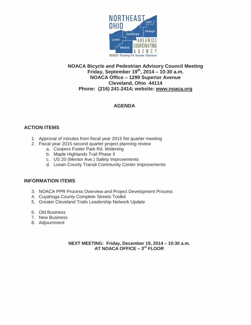
NOACA Bicycle and Pedestrian Advisory Council Meeting Friday, September 19th, 2014 – 10:30 a.m. NOACA Office – 1299 Superior Avenue
Cleveland, Ohio 44114 Phone: (216) 241-2414; website: www.noaca.org
AGENDA
ACTION ITEMS
1. Approval of minutes from fiscal year 2015 fist quarter meeting 2. Fiscal year 2015 second quarter project planning review
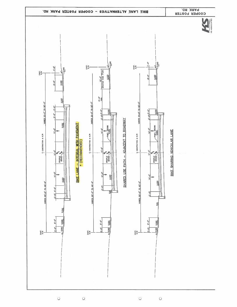
a. Coopers Foster Park Rd. Widening b. Maple Highlands Trail Phase II c. US 20 (Mentor Ave.) Safety Improvements d. Lorain County Transit Community Center Improvements
INFORMATION ITEMS
3. NOACA PPR Process Overview and Project Development Process 4. Cuyahoga County Complete Streets Toolkit 5. Greater Cleveland Trails Leadership Network Update
6. Old Business 7. New Business 8. Adjournment
NEXT MEETING: Friday, December 19, 2014 – 10:30 a.m. AT NOACA OFFICE – 3rd FLOOR

Agenda Item
No. 1
Approval of FY 2015 First Quarter MeetingMinutes

Bicycle and Pedestrian Advisory CouncilJune 20, 2014
NOACA Offices, 1299 Superior Avenue, Cleveland, Ohio 44114
Mr. Marc Von Allmen, NOACA staff, convened the Bicycle and Pedestrian Advisory Council (BPAC) meeting at 10:40 a.m., with a quorum having been established.
Approval of March 21, 2014 Meeting MinutesMr. Allen Pennington made a motion to approve the BPAC minutes of March 21, 2014. Mr. Anthony Ratajczak seconded the motion. The motion passed by voice vote.
Mr. Jacob VanSickle asked if any sponsors responded to the BPAC comments made at the March meeting. Mr. Von Allmen stated the BPAC comments were forwarded to the sponsors, but NOACA has not received any responses. He noted comments are usually received prior to projects being adopted by the Board. Mr. Von Allmen advisedmembers staff will work with sponsors throughout the development of the projects.
Fiscal Year 2015 First Quarter Project Planning Reviews
NOACA Provisional Transportation Asset Management Program Mr. Von Allmen referred members to the list of projects included in their packet. He advised the purpose of the program is to address the needed resurfacing repairs in the NOACA region by bringing the roadways into a state of good repair. Because the scope of the program is limited, Mr. Von Allmen asked members to make suggestions for restriping the roads and/or adding signage. He mentioned several projects on the list are included on NOACA’s Regional Priority Bikeway Network from the 2013 Bike Plan or listed in Cleveland’s Bikeway Implementation Plan. He noted the program has not yet been funded, but staff is currently developing innovative funding strategies.
Ms. Kathy Sarli commented that NOACA will be using a data driven process to prioritize the projects.
The BPAC agreed the following comments should be presented to the project sponsors:
Many roads or segments of roads included in the PTAMP are designated in NOACA’s 2013 Regional Priority Bikeway Network (RPBN) or in the City of Cleveland’s 2014 Bikeway Implementation Plan. At a minimum, share the road and/or bicycle route signage should be included for these roadways.
Many roads included in the PTAMP are currently under consideration as part of TLCI studies. The repaving of these roadways should be coordinated with any TLCI recommendations if timing allows.
All City of Cleveland streets repaved as part of the PTAMP program should reference the 2013 Typologies Plan for guidance on which bicycle and pedestrian facilities to include with the resurfacing.
High-visibility crosswalks should be included at all intersections that experience larger volumes of pedestrians.

Shoulders should be included within the scope of projects when possible, either by striping narrower lanes or increasing pavement width.
Mr. Richard Wong asked what the policy is for repaving roads and would the Cleveland projects automatically be reviewed by the Cleveland Planning Commission. Mr. Cader stated a number of different references will be used, including the typologies and the Bike Plan to determine what can be done on the roadways. Mr. VanSickle suggested that the Complete and Green Streets Task Force be reconvened to review and ensure that the Cleveland projects are in compliance with the ordinance and guiding documents that have been adopted.
Ms. Sarli commented that many of the Cleveland projects on the list will not be funded through the Provisional Asset Management Program, but through some other funding source.
Mr. Wong asked if anyone knew how much more would the project cost increase if a two-foot shoulder was added to a 20-foot roadway. Ms. Fink stated there are a lot of factors that are included in the cost, including utilities, right of way and ditch grading.Ms. Fink noted adding a shoulder to a roadway is very expensive. Mr. Wong then asked if shoulders are constructed the same as roadways. Ms. Fink said yes. Mr. Cader commented that shoulders increase the lifespan of a roadway. Mr. Pennington stated adding a shoulder would increase the cost of a roadway project 15 to 20%.
Ms. Gayle Lewin stated if the sponsors have the opportunity, ability and available funds, they should make an effort to include shoulders.
Erie Street Construction in WilloughbyMr. Von Allmen stated this project involves the reconstruction of Erie Street from US 20 to Stephens Blvd. The project is included in NOACA’s Regional Priority BikewayNetwork. Mr. Von Allmen noted the majority of the segment has two, 12-foot lanes,partial sidewalks and does not have a high volume of traffic. One of the objectives of this project is to link the area to nearby parks.
The BPAC agreed the following comments should be presented to the project sponsor:
The sponsor should increase the width of the pavement to the west to create space for a bike lane and/or a shared use path.
The sponsor should include sidewalks where there are none.
Future Meeting Topics
To make BPAC meetings more meaningful, Mr. Von Allmen asked members for input on topics they would like discussed at future meetings. Mr. Von Allmen suggested the BPAC could invite speakers to talk about best practices with regard to designs for bicyclists and pedestrians or invite speakers from other BPACs to discuss how they have improved their efficiencies over the years. Mr. Von Allmen also suggested theBPAC take field trips to various communities in the region.

BPAC members offered the following suggestions:
Invite speakers from The Midway to discuss a network of protected bike lanes
Invite a speaker from the Cuyahoga Valley National Park to discuss trails and bikeways
Invite a speaker to discuss regional collaboration
Invite a speaker from the Cuyahoga County Planning Commission to discuss the Complete Streets Toolkit
Present bike crash and fatality data to the BPAC and review the trends for the five-county region over the years
Invite representatives from the various municipalities to discuss how they want to improve bike and pedestrian numbers in their communities
Propose projects to communities that have high crash rates
Present accident data for vehicles, bicyclists and pedestrians in the region
Present before and after data for projects that have added amenities, such as sharrows and bike lanes to see if safety has been improved
Mr. Von Allmen stated staff will be working on a bicycle report card next year that will include several metrics. He stated he will present more information to the BPAC at a future meeting. Mr. Von Allmen asked members to forward names of potential speakers or topics they would like discussed at the meetings.
Councilman Martin Keane commented on the importance of the Provisional Asset Program and thanked members for being part of the BPAC.
Old BusinessNo old business was discussed at the meeting.
New BusinessMr. Josh Naramore and Ms. Melissa Thompson introduced themselves as new NOACA employees.
Mr. VanSickle stated a system of checks and balances should be put in place to ensure BPAC comments are being addressed by project sponsors and responses are submittedto the BPAC prior to projects being implemented.
Mr. Von Allmen informed BPAC members that he would review the comment process to them at the next meeting and will accept suggestions on how to improve the system.

Councilman Keane provided background information on the BPAC. He stated that the BPAC has been around for a number of years and was recently part of NOACA’s committee restructuring to give the advisory council a broader geographicalrepresentation.
Ms. Lewin announced there will be a ribbon cutting ceremony for the Scranton Roadtowpath on July 7 at 1:00 p.m.
There being no further business, Mr. Von Allmen adjourned the meeting at 11:40 a.m.

Agenda Item
No. 2
FY 2015 Second Quarter Project Planning Review

NOACA Staff Bicycle and Pedestrian Comments on FY 2015 Second Quarter Projects
1. Maple Highlands Trail Phase II a. This trail segment is included in the 2013 Regional Priority Bikeway Network
(RPBN). NOACA staff supports this project. b. The project sponsor should install advance warning signage along the roadway
and shared use path at both intersections. 2. US 20 (Mentor Ave.) Safety Improvements
a. The roadway segment includes surrounding land uses likely to generate pedestrian traffic, including a park and a school.
b. The proposed project will potentially decrease safety for pedestrians crossing the roadway due to the increased crossing length. The project sponsor should include pedestrian safety countermeasures within the scope of the project to mitigate this impact, especially near the school and park. These may include high visibility crosswalks, leading pedestrian intervals, refuge islands, improved lighting, as well as other considerations.
3. Coopers Foster Park Rd. Widening a. The project sponsor should install pedestrian signals and crosswalks at all
signalized intersections. 4. Lorain County Transit Community Center Improvements
a. NOACA Staff supports this project.


City of Chardon
Mr. Randy Sharpe
City Manager
440.286.2600 440.286.2658
Geauga Shared Use Path Water Street to SR 44
City of Chardon, Maple Highlands Trail - Phase II

The Maple Highlands Trail is a 12.4-mile long lineal park that utilizes sections ofthe abandoned Baltimore & Ohio Railroad corridor. When the Geauga ParkDistrict’s Maple Highlands South section is constructed, the entire route willextend a total of 21 continuous miles, allowing users to travel from Colburn Roadat the Lake/Geauga border to Reeves Road in Parkman Township.The completion of the Maple Highlands Trail was identified as a priority in the2009 Chardon Bikeway & Pedestrian Trail TLCI Plan. Design, right-of-way andconstruction of Phase I was fully funded and awarded NOACA TransportationEnhancements monies in 2010. Phase I is ~0.47 miles in length and is currentlyin the final design phase. Construction is scheduled to be completed by thesummer of 2015.Phase II of the Maple Highlands Trail is ~0.86 miles long and extends from WaterStreet down to SR 44. It will complete the missing section of the Geauga CountyMaple Highlands Trail network through the City of Chardon.
✔
✔
✔

Its main purpose is to provide an alternative transportation and recreationalcorridor to promote multi-modal and non-motorized activity within the City ofChardon and Geauga County, as well as provide connectivity to the entire MapleHighlands Trail network.Phase II of the trail will be very similar to the trail being designed in Phase I. AnADA compliant 10’ paved trail is being proposed and it will meet allODOT/AASHTO standards, as required by the federal funding source.A trailhead is being proposed on city-owned property along the trail alignmentjust north of Park Avenue. A public restroom, drinking fountain and ampleparking is proposed as part of the trailhead conceptual design. Decorative trailcrossings are proposed at Park Avenue and SR 44. The installation of a HAWKsignal is being considered at SR 44.

see attached conceptual alignment study
County/Nearby Region of Lake and Geauga
93,410 (2010 US Census, Geauga County)
✔
✔
✔

✔
134,809.6489,873.10
503,856.251,253,483.731,982,022.72

January 2018
February 2018(submitted w/CE Document)
January 2020
December 2017
December 2018
July 2019
January 2020
July 2019
May 2019September 2019May 2020July 2020August 2020September 2020October 2020

The 20% local match will be paid for with City of Chardon General CapitalFunds.
n/a
✔
✔

ATTACHMENT A
TRANSPORTATION ALTERNATIVES PROGRAM APPLICATION
Maple Highlands Trail Phase IICity of Chardon
✔
✔
✔
✔

✔
✔
✔
✔

✔
✔
✔
✔
✔
✔
✔
✔
✔
✔
✔
✔ ✔

✔
✔
✔ ✔
✔ ✔ ✔
✔
924,8 60
231,2 20
1,156

PRO
JECT
NO
.:
DRA
WN
BY:
CHEC
KED
BY:
DAT
E IS
SUED
:
OF
DES
IGN
ED B
Y:
NO.REVISION DATADATE
E:\CHARDON\12-00036-030\DESIGN\PLAN\PPLAN 12-00036-030 - 8/13/2014 1:41:40 PM
12-0
0036
-030 SDK
SDK MJ
####
####
####
#
OVE
RALL
ALI
GN
MEN
T
14
----
WAT
ER S
TREE
T
PARK
AVE
NU
E
SOUTH STREET
CLAR
IDON
ROA
D
MAPLE HIGHLANDS TRAILPHASE II CONCEPTUAL ALIGNMENT
CITY OF CHARDON

PRO
JECT
NO
.:
DRA
WN
BY:
CHEC
KED
BY:
DAT
E IS
SUED
:
OF
DES
IGN
ED B
Y:
NO.REVISION DATADATE
E:\CHARDON\12-00036-030\DESIGN\PLAN\PPLAN 12-00036-030 - 8/13/2014 1:41:47 PM
12-0
0036
-030 SDK
SDK MJ
####
####
####
#
CON
CEPT
UAL
ALIG
NM
ENT
1
24
----
WAT
ER S
TREE
T
ALA
MEN
DO
LAA
VEN
I
EAG
LES
CSX
CHA
RDO
N
CHA
RDO
N
CHA
RDO
N
GEA
UG
A F
ARM
CO
-OP
HO
NG
WIL
LNER WIL
LNERARK
OPA
SKO
AVE
NI
MAPLE HIGHLANDS TRAILPHASE II CONCEPTUAL ALIGNMENT
CITY OF CHARDON
EAG
LES

PRO
JECT
NO
.:
DRA
WN
BY:
CHEC
KED
BY:
DAT
E IS
SUED
:
OF
DES
IGN
ED B
Y:
NO.REVISION DATADATE
E:\CHARDON\12-00036-030\DESIGN\PLAN\PPLAN 12-00036-030 - 8/13/2014 1:41:52 PM
12-0
0036
-030 SDK
SDK MJ
####
####
####
#
CON
CEPT
UAL
ALIG
NG
MEN
T 2
34
----
PARK
AVE
NU
E
CLEV
ELA
ND
DIE
MA
ND
CHA
RDO
N
GLE
N A
SSO
C
CITY
CHA
RDO
N
CHA
RDO
N
BIRD
LE
CITY
MAPLE HIGHLANDS TRAILPHASE II CONCEPTUAL ALIGNMENT
CITY OF CHARDON

PRO
JECT
NO
.:
DRA
WN
BY:
CHEC
KED
BY:
DAT
E IS
SUED
:
OF
DES
IGN
ED B
Y:
NO.REVISION DATADATE
E:\CHARDON\12-00036-030\DESIGN\PLAN\PPLAN 12-00036-030 - 8/13/2014 1:41:57 PM
12-0
0036
-030 SDK
SDK MJ
####
####
####
#
CON
CEPT
UAL
ALIG
NG
MEN
T 3
44
----
CITY
CHA
RDO
N
SMIT
H
GEA
UG
A
SMIT
H
SMIT
H
BECH
KOW
IAK
BURL
ING
TON
MAPLE HIGHLANDS TRAILPHASE II CONCEPTUAL ALIGNMENT
CITY OF CHARDON
SOUTH STREET

SHOULDER2’ 10’ 2’ 3’+
TRAIL SHOULDER BUFFER3’+
BUFFER
PHOTOSHOP RENDERING
Chardon Maple Highlands Trail Phase II - Typical Section