north carolina department of public instruction social ... · north carolina department of public...
TRANSCRIPT

NCDPI
1
North Carolina Department of Public Instruction Social Studies Section Elementary Division

NCDPI
2
Purpose
Thirty elementary educators participated in a one-week professional development
opportunity during the summer of 2005 which took them from Western North Carolina
to the Outer Banks of our state. During this trek, participants visited sites including the
Cherokee Museum and Reservation, Historic Salem, and The Lost Colony Outdoor
Drama. Teachers attended workshops to help in improving instruction for fourth grade
social studies, which focuses on North Carolina. Participants were required to develop
lessons of their choice. These lessons, which included videos, powerpoint slide shows,
and research, were submitted to the Department of Public Instruction and compiled into
this document, Trekking North Carolina.

NCDPI
3
Acknowledgements
Thanks to Tracey Greggs, Middle Grades English Language Arts/Social Studies Section Chief,
for developing and planning the Trek NC program.
Thank you to the following teachers who participated in the Trek NC experience:
Kathy Fitzgerald
Marlo Gaddis
Angela Howell
Alan Brown
Cherry Crisp
Tami Harsh
Tracy Preslar
Thomasina Montgomery
Nikisha Leak
Judy Ramsey
Matthew Barfield
Phyllis Boisvert
Stacey Beneville
Ann White
Gregory Heath
Carol Chambers
Jessica Rainwater
Antoinette Nicholson
Bethany Rogers
Irma Tillman
Kellie Dimmette
Angela Stanley
Janice Gardner
Marilyn Erb
Camilla Pait
Carol Bingham
Mary Pepe
Melissa Roberts
Bonnie Fulp
Pam McDonald
Susan Blackman
Paula Pruden
Pam Cannon
NCDPI
4
Table of Contents
Battles of North Carolina Research on North Carolina Battles 5
Activities Related to Battles 26 Using African American Related Primary Sources 30 North Carolina People, Geography, and the Environment 58 Additional Lessons and Activities 102

NCDPI
5
Battles of North Carolina
Assignment: Take an in-depth look at one of the major battles fought in
North Carolina. Include a description of the battle, why it was fought
(major issues), explain how this battle impacted the community and the
people, and explain how this battle was resolved. Finally, make a
connection with the issue causing that battle with an issue of today and
predict how we might have solved it in the twenty-first century.
NCDPI
6
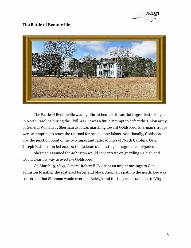
The Battle of Bentonville
The Battle of Bentonville was significant because it was the largest battle fought
in North Carolina during the Civil War. It was a futile attempt to defeat the Union army
of General William T. Sherman as it was marching toward Goldsboro. Sherman‘s troops
were attempting to reach the railroad for needed provisions. Additionally, Goldsboro
was the junction point of the two important railroad lines of North Carolina. Gen.
Joseph E. Johnston led 20,000 Confederates consisting of fragmented brigades.
Sherman assumed the Johnston would concentrate on guarding Raleigh and
would clear his way to overtake Goldsboro.
On March 15, 1865, General Robert E. Lee sent an urgent message to Gen.
Johnston to gather the scattered forces and block Sherman‘s path to the north. Lee was
concerned that Sherman would overtake Raleigh and the important rail lines to Virginia.

NCDPI
7
Ultimately, the Army of Northern Virginia would suffer from the lack of supplies.
Therefore, Johnston immediately left for Smithfield and then to Cole‘s Plantation at
Bentonville, in Johnston County.
On March 19, Johnston‘s troops reached Coles‘ Plantation ahead of Sherman‘s
forces and set a trap, blocking the Goldsboro Road. Although the Confederates
commanded a surprise attack, the Federal forces were much stronger, consisting of
60,000 troops compared to the 20,000 soldiers under Johnston‘s command. The result
of the day was actually a draw.

NCDPI
8
The Confederates drew back as Sherman‘s Right Wing began arriving on the
morning of March 20. Johnston was able to hold onto his only escape route over Mill
Creech and he began to evacuate his wounded soldiers to Smithfield. This was a distance
of about 20 miles. Johnston was grossly outnumbered. His only hope was a frontal
attack since his army was well entrenched.
A combination of Confederate cavalry and infantry pushed back Union troops on
the 21st. Sherman wanted to avoid a major clash so he halted the operation, but not
before Johnston was assured of the use of Mill Creek Bridge. This was his only means of
escape from the battlefield.
On March 22, Federal troops chased the Confederates to Hannah‘s Creek.
Sherman allowed Johnston to escape because it was more important for him to occupy
Goldsboro for rest and provisions. He also wanted to make sure that he lost as few men
as possible.
The Battle of Bentonville actually ended on April 26, 1865 when Gen. Joe
Johnston surrendered to Gen. Sherman at Bennett Place near Durham.
NCDPI
9
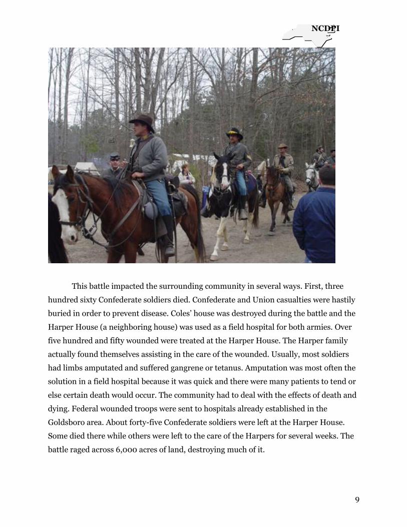
This battle impacted the surrounding community in several ways. First, three
hundred sixty Confederate soldiers died. Confederate and Union casualties were hastily
buried in order to prevent disease. Coles‘ house was destroyed during the battle and the
Harper House (a neighboring house) was used as a field hospital for both armies. Over
five hundred and fifty wounded were treated at the Harper House. The Harper family
actually found themselves assisting in the care of the wounded. Usually, most soldiers
had limbs amputated and suffered gangrene or tetanus. Amputation was most often the
solution in a field hospital because it was quick and there were many patients to tend or
else certain death would occur. The community had to deal with the effects of death and
dying. Federal wounded troops were sent to hospitals already established in the
Goldsboro area. About forty-five Confederate soldiers were left at the Harper House.
Some died there while others were left to the care of the Harpers for several weeks. The
battle raged across 6,000 acres of land, destroying much of it.

NCDPI
10
There were several issues responsible for the American Civil War. One of the
causes involved was the issue of states‘ rights which involved the rights of the states to
make decisions, particularly, the decision of whether to own slaves or not. The purpose
of the Battle of Bentonville was to stop the advance of the Union army in order to
prevent destruction of property, loss of lives, and to protect the capital city of Raleigh.
There are parallels with some of these issues and what is happening, today, in Iraq. As
Americans, we feel that it‘s important for people‘s rights to be protected and for
democracy to be fought for, if necessary. It‘s strange, but sometimes, fighting is still seen
as the only solution.
Hopefully, our country has learned from past mistakes and a civil war would not
be repeated. We have mastered the art of mediation and debates and understand the
importance of a democratic society. Finally, we know from experience that ―United we
stand, Divided we fall!‖

NCDPI
11
The Battle of King’s Mountain
Judy Ramsey
Historians consider the Battle of King‘s Mountain, NC to be the ―turning point‖ of
the Revolutionary War in the south. The victory of the Patriot army over the Loyalist
British led troops destroyed a major wing of British commander Cornwallis‘ army. The
Battle of King‘s Mountain also effectively ended the advance of British troops into North
Carolina. With it, Lord Cornwallis had to retreat from Charlotte into South Carolina to
wait for reinforcements. This allowed the American Patriot General Nathaniel Greene to
reorganize his army in readiness for the next engagement. The Battle of King‘s
Mountain was the first in a string of Patriot victories that led to a final British surrender
within the year at Yorktown, Virginia, and with it, to American independence.
In the fall of 1780, the leader of the Loyalist troops, Major Patrick Ferguson,
traveled through South Carolina into North Carolina gathering support for the British
cause against the rebel American army. After several minor conflicts in August, the
Patriot troops retired to the hills of North Carolina for safety. Ferguson then made a
major error. He sent a message to the Patriot leader, Colonel Isaac Shelby, saying that if
Shelby and his men did not stop opposing the British, Ferguson would march his army
over the mountains, hang the leaders and ―lay the country waste with fire and sword.‖
The Patriots were infuriated and immediately took steps to organize an attack to prevent
this.
Bands of men from western North Carolina, east Tennessee, and northern South
Carolina joined together in the effort. They marched after Ferguson who, warned by his
spies, set up his defense at King‘s Mountain, just north of the North and South Carolina
border. King‘s Mountain is an outlying portion of the Blue Ridge Mountains in what is
today Cleveland County near the town of Shelby.
A heavily rocky and wooded area, the mountain rises 60 feet above the plain
surrounding it. The British campsite was supposed to provide an ideal place to defend
against attack. The top of the mountain was considered too steep to be scaled. However,
the lay of the land actually worked against Ferguson. Patriot soldiers surrounded the
mountain and mounted their assault from all sides. The thick woods provided cover for
Patriot sharpshooters who inflicted heavy losses on Loyalist troops. Finally, the Patriot
men were able to storm the mountain. Major Ferguson was wounded and fell from his
NCDPI
12
horse dead. The British second in command then ordered that a white flag of surrender
be raised. In only one hour and five minutes, the American army had completed
decimated the Loyalist troops, with every last man of them either dead or taken
prisoner, a tremendous victory for the Patriot effort.
The area surrounding Kings Mountain was sparsely populated in 1780, so the
impact on local people and communities was small. However, many of the Patriot
leaders at Kings Mountain did go on to serve in the United States government. Two later
became state governors. Others were Congressmen and judges. Today, many roads and
towns in western North Carolina bear the names of the battle‘s participants. Morganton
and McDowell County, Shelby and Cleveland County are so named.
Students of history would do well to note that one of the major causes for the
Battle of Kings Mountain was the inflammatory remarks made by the British leader,
Patrick Ferguson. As U.S. officials and media personnel of today react and comment
upon the conflict in Iraq, care should be taken to avoid similar remarks or threats which
may, as they did in 1780, incite an uprising of such force that we may be overrun.
Negotiation and overtures to people of differing views would allow peaceful people to
discuss issues and work out their conflicts without bloodshed.
Resources:
Parramore, Thomas C. and Douglas C. Wilms. North Carolina- The History of an
American State. New Jersey: Prentice-Hall, Inc., 1987.
www.co.clevelend.nc.us
www.tengenweb.org

NCDPI
13
The Battle of Moore’s Creek Bridge
Antoinette Nicholson
By mid 1775, there were two opposing groups living in North Carolina. The
Loyalists, a group who wanted to remain under British rule. These were wealthy
merchants and planters to whom Britain promised two hundred acres of land,
cancellation of land fees, and tax exemption for twenty years, if they fought on their
side. The Loyalists were mainly Highlanders who had immigrated to North Carolina in
recent decades. Then there were the Patriots, who wanted independence from Britain
and were willing to fight for it.
The Loyalists had planned to assemble near Cross Creek, in Fayetteville, and
march to the coast. They were to advance along the southwest side of the Cape Fear to
the coast and join in conquering the colony under the leadership of Brigadier General
MacDonald.
In February of 1776, MacDonald moved toward the coast. When he was blocked
by Colonel James Moore, at Rockfish Creek, he moved east, crossed Cape Fear, and
proceeded toward Negro Point Head Road, where battle opposition was expected. The
one place the Loyalists had to cross on the way to the coast was the ―Bridge upon Widow
Moore‘s Creek‖ (http://statelibrary.dcr.state.nc.us/nc/ncsites/moores.htm)
When the Patriots heard what the Loyalists were planning, they gathered their
own forces and prepared to fight in Wilmington. By evening, on February 26, 1776, the
Patriots were on both sides of the bridge. They had removed some planks and greased
some girders ―with soap and animal fat‖ (Horizons, 2003, text book). The defensive
advantage of this particular point was that the creek, which was
thirty-five feet wide and winding through swampy terrain, could only be crossed at the
bridge.
When the Loyalists came upon the Patriots deserted camp, they decided to wait
until daylight to proceed. This didn‘t work as well as expected because they heard
gunfire near the bridge before daylight broke. They rushed the bridge, but thirty paces
away they were met with the firing of muskets and artillery. The entire Loyalist force
soon retreated. The entire battle lasted only a few minutes. The Patriots had won!
The Battle of Moore‘s Creek Bridge was a small battle with large implications.
The strength and wits of the Patriots discouraged Loyalist sentiment in the Carolinas

NCDPI
14
and ―spurred a revolutionary feeling throughout the colonies‖
(http://statelibrary.dcr.state.nc.us/nc/ncsites/moores.htm) The Patriot victory ended
British authority in the colony and ―greatly influenced North Carolina to be the first
colony to vote for independence‖ (http://www.americanrevolution.com/). This led to
the writing of the Halifax Resolves, a paper that recommended independence from
Britain. This ultimately led to all thirteen colonies declaring independence.
Although this battle occurred over two hundred years ago, it brings to mind the
war in Iraq. The citizens there are also divided, just like the Loyalists and Patriots, as to
whether or not they want their independence. It seems that even after all this time, we
still haven‘t figured out how to solve such problems without fighting.
References
Horizons: North Carolina. (2003). Orlando, FL: Harcourt,
Inc. pages 112-116, 161.
http://statelibrary.dcr.stste.nc.uc/nc/ncsites/moores.htm
http://www.americanrevolution.com/

NCDPI
15
The Battle of Guilford Court House
Mary Pepe
One of the bloodiest battles of the American Revolution was known as the Battle
of Guilford Court House in Guilford, North Carolina. The battle, which occurred on
March 15, 1781, was waged between the American colonials, also know as the
Continentals, and the British. Major Nathaniel Greene, Commander in Chief of the
American forces, was fighting to procure liberty and freedom from British domination
and the establish dominance of American rule.
Greene was a brilliant strategist and was an excellent military leader.
Greene‘s opponent, General Charles Cornwallis, military leader of the British
forces, had different motivations in mind as he set out to defeat the American patriots in
this battle. Bitter over his recent defeats at Cowpens and King‘s Mountain, Cornwallis
was anxious to avenge his loss and to extract as many American lives as possible, having
lost so many of his compatriots in the last two skirmishes. Each of these men were
thoroughly convinced of the justness and certainty of their cause; Greene believed in the
rights of the American patriots to establish their own rule in their own land, while
Cornwallis believed that this land should remain a loyal British holding and exist only
for the benefit of his beloved king and country.
In the beginning of the battle, the British dominated the Continental army
because they secured the Guilford court house and were able to drive back the
Americans with the aid of Cornwallis‘ excellent militaristic strategies. Greene‘s army
had the advantage of knowing the terrain, which was dense undergrowth on which many
trees grew. The tide turned, however, when Greene was supported by troops from
Georgia, South Carolina and North Carolina combined. The fact that Greene‘s army
knew the terrain and had additional soldiers at the ready were definite advantages for
the colonials.
Cornwallis, however, was brilliant in his deduction that the Americans would
pursue a frontal engagement, and was ready with his artillery. The fact that the Guilford
Court House provided him a natural stronghold was also in his favor. Cornwallis
expected the Americans to be crushed in a single battle. It was a hard fought battle
lasting many hours.
NCDPI
16
In the end, Cornwallis did manage to defeat the Americans, forcing Greene to
retreat upon the realization that his losses were too heavy to continue. However,
General Cornwallis underestimated the force and power of the Continental army when
he found that over one third of his soldiers had been killed. In addition, Greene had
forced the British army further north, which was against the British intentions to occupy
the Carolinas and Georgia.
Although the battle was recorded as a British victory, it remains a decisive
turning point for the American Revolution. Cornwallis failed to achieve his primary
objective, which was to destroy the entire American army. By pushing Cornwallis
northward, and causing heavy British losses, Greene succeeded in delivering a massive
blow to the British forces from which they would never recover. It was, in essence, the
beginning of the end for the British, as, soon after, Cornwallis would surrender at the
battle of Yorktown, due to severe lack of manpower and supplies.
In the process of reflecting upon this battle and analyzing its effects on American
history, it is apparent that this battle of the American Revolutionary War has much in
common with 21st century conflicts. One in particular would be the American pursuit of
Saddam Hussein in Iran. President George W. Bush, in retaliation for American
hostages being held in Iran during his father‘s administration, and for the attacks on the
world trade center and on the pentagon in September, 2001, doggedly pursued Saddam
and ordered the capture and downfall of the dictator‘s regime. Similarities can be
drawn to Cornwallis‘ need to avenge his cause with Bush‘s need to avenge his father‘s
administration. Bush was angry at the severe loss of American life after the terrorist
attacks of 9-11, as Cornwallis was angry at the severe loss of British lives after the battles
he had lost prior to the Battle of Guilford Court House.
In conclusion, the impact of the Battle of Guilford Court House on the people and
the community of Guilford, North Carolina was varied. On one hand, the influence of
the battle was positive because it instilled a sense of strong unity and patriotism in the
community. On the other hand, the severe loss of life caused much grief and hardship
for the families left behind. It was only realized much later that this battle was a tactical
victory for the Americans, and many townspeople thought they were going to be
permanently under British rule upon the outcome of this battle.
Assessment questions for this selection can be found in the Activities Related to Battles section.

NCDPI
17
The Battle of Shallow Ford
Tracy M. Preslar
In the days of early fall, 1780, the Patriot forces in North Carolina were
demoralized by heavy losses in South Carolina and British General Lord Cornwallis'
advancement to Charlotte. Many fled to Virginia ahead of the British. Patrick Ferguson,
one of Cornwallis' Colonels, had moved into western North Carolina, raising Tory
support for his army.
The Patriot forces prepared to meet Col. Ferguson. Most of the Surry County militia,
along with other North Carolinians, rendezvoused at Quaker Meadows (near
Morganton) on September 30th. They were joined by "over the mountain men" from
Virginia and Tennessee. They expected to find Ferguson near Gilbert Town
(Rutherfordton), but did not catch him until they reached Kings Mountain on October
7th.
In Surry County, in the absence of the local Whig militia, the brothers and Colonels
Gideon and Hezekiah Wright raised a large band of Tories which finally may have
reached a number as high as 900. On October 3rd and 8th, they attacked Whig targets
in the town of Richmond, the County seat, where they killed the Sheriff of the County.
Patriot intelligence believed that the local Tories intended to join Lord Cornwallis' forces
in Charlotte. Patriot General William Lee Davidson, near Charlotte, sent out a company
of 52 under Andrew Carson to meet the Tory forces in Surry County. General Jethro
Sumner, near Salisbury, dispatched two companies of 30 men each under Captain Jacob
Nichols and Captain _____ Miller. Those Whigs who remained in Surry County
gathered and joined the arriving Patriot forces.
Four companies of Patriots, numbering about 160, from Montgomery County, Virginia,
under Maj. Joseph Cloyd and Captains Henry Francis, Isaac Campbell, George Parris,
and Abraham Trigg had followed earlier troops headed to meet Col. Ferguson. When
they reached western North Carolina, they learned of Ferguson's defeat at Kings
Mountain, and were redirected to Surry County. These four companies from Virginia
(about 160 men) joined with the first three companies sent out from Charlotte and

NCDPI
18
Salisbury (about 110 men) and with the local Surry county militiamen who had not
pursued Ferguson (about 80 men). On Saturday morning, October 14th, about 9:30
a.m., these forces of 350 men were on the west side of a small stream, now called the
Battle Branch, near the Shallow Ford crossing of the Yadkin River.
Suddenly they saw the head of the Tory force which had threatened the county for the
past weeks. Numbering between 400 and 900, they had crossed the Yadkin and were
moving westward on Mulberry Fields Road. Both sides hastily formed and fired several
rounds at each other. The Whigs, though outnumbered, quickly gained the advantage.
Captain (James?) Bryan, of the notorious Tory Bryan clan, who led the Tory forces, was
quickly killed, along with 13 others. The Tories retreated pell-mell back across the
Yadkin, shouting "we are whipped, we are whipped." As they were well mounted, they
made good their escape. Captain Henry Francis of the Whigs lost his life, and four
others were wounded. The battle probably lasted about 45 minutes.
When reports of the Tories had worsened, General Sumner (near Salisbury) had
dispatched an additional 300 militiamen under Col. John Peasley. They arrived at the
close of the battle, as did Col. Joseph Williams of Surry County, who had heard the rifle
fire from his nearby home. Captain Francis was buried on the battlefield. The dead
Tories were buried in a separate common grave. The 4 wounded Whigs and 1 wounded
Tory were cared for by a Moravian physician and his assistant, first in the area of the
battle, and then in Bethania, where they were taken to recover from their wounds. Over
the next several days the Patriots went to the Moravian towns (Winston-Salem), cold
and wet from rains that began late on the 14th. General William Smallwood with his
troops, also in search of the Tories, arrived in the Moravian towns and was elated to
learn of the Patriots' victory. Within several days, most of them left for home.
On October 19th, the Field Officers of the Patriots held a Council on nearby land owned
by Abraham Creson. The Council directed that all those who had supported the Tory
cause be offered a pardon, upon meeting specified conditions. Many availed themselves
of this offer.

NCDPI
19
News of the victory at Shallow Ford spread quickly, and greatly encouraged the Patriots.
After the defeat at Kings Mountain, Lord Cornwallis retreated from Charlotte. The
victory at Shallow Ford dispersed the Tory force that had formed in Surry County, and
they never again gathered in such numbers.
The Battle of Shallow Ford has long been overlooked by historians. Recent research
shows that, at the time, it was a significant victory for the Patriot forces. Occurring
exactly a week after Kings Mountain, these two battles turned the tide of the War for
Independence in North Carolina to the Patriots' advantage.
Although this battle wasn‘t necessarily one of North Carolina‘s major battles, I do feel
like it is significant in our history.
This exact type of battle wouldn‘t be fought in this day and time, however if I had to
relate it to a current issue, I would relate it to gangs and violence in our society. Gangs
are widespread in the state of North Carolina. Gang members tend to be territorial and
over-protective of their fellow gang members. They have been known to lash-out at
others, especially their arch enemies when they feel they have been demoralized or
insulted in some way. In the process innocent people lose their lives just like in the
Battle of Shallow Ford. When members of society rise up against one another, I
consider it a battle. Luckily, we have Law Enforcement Officers to protect our civil
rights, and rules and regulations that most citizens adhere to. Without such boundaries,
gang issues would continue to worsen, which in turn would lead to more severe battles
or even war.
NCDPI
20
The Battle of South Mills
The Civil War in Camden County
Tami Harsh
―Boom!‖ as the guns fired on April 19, 1862 at 10am by the Confederate Army
when the Union soldiers were only 5/8 miles away. Previously hiding in the woods
outside of South Mills 8 miles from Elizabeth City, the Confederate soldiers were
awaiting the approach of the Union army. The Confederate soldiers consisted of only 3
companies until later when the lower companies joined forces, approximately 750 men.
Col. Ambrose Wright and the Third Georgia led the attack. Word reached Col. Wright
that the Union soldiers, approximately 3,000 men had landed at Camden Courthouse
and were marching toward South Mills. Due to the size of the opposing force, the odds
were against the Confederate soldiers.
The Mission of the Union led by Gen. Jesse Lee Reno was to destroy the locks on
the Dismal Swamp Canal in South Mills in order to prevent the transportation of
materials needed to build Ironclads in Norfolk by the Confederates.
After 5 hours of intense fighting, the Confederate army fell back to a new position
2 miles outside of South Mills. They withdrew to their defensive positions because they
were low on ammunition. The Union army did not follow due to numerous casualties,
and not being accustomed to the climate and conditions of the south. They returned to
their boats in Elizabeth City. Therefore, the Union soldiers were not successful at
destroying the locks at South Mills.
With today‘s technology, this battle would not have been fought. Jet fighters and
missiles would have replaced the muskets and men used during the Civil War. Battle
would not have taken place. Target would have been destroyed within minutes leaving
no time for defense. However radar and satellites would have alerted the approach of
the enemy.
Much like illegal immigrants approaching our waters and boarders of today, we
strive as a country to protect these ports and boundaries to keep our citizenship sincere
and to protect our country. With the Coast Guard patrolling the waters and GPS
navigators, it is much more difficult for immigrants to enter the United States.
However, with all of the technology available, it is still important to ―keep a watchful
eye.‖

NCDPI
21
Battles In North Carolina
Phyllis Boisvert
Description of the Battle
Date: early morning March 15, 1781
Place: Piedmont region of NC-northern part. Guilford Courthouse in Greensboro.
Armies:
Continental (Colonial) Troops
1. Continental Army led by Nat Greene-trained soldiers
2. Local militia led by Nat Greene-poorly trained farmers and tradesmen
British Troops
1. British Army led by Cornwallis-trained soldiers
2. Tarleton‘s Legion-trained soldiers
3. German Infantry-trained soldiers
Troop Strength:
Colonials about 4,400 men
British and allies about 1,900 men
Prologue: The British general, Cornwallis, has been pursuing Gen. Nathanael Greene‘s
Continental Army through the south toward Virginia. Cornwallis has an army of about
1, 900 men from Britain and Germany. These soldiers have fought long and hard. Men
who are homesick and tired; who have had limited supplies and have forded many rivers
and streams on a long march.
Gen. Greene has 4,400 men. About half are local militia, men who are ill-trained
and frightened. Men who want to return home to protect their families.
You Are There:
Imagine it is early on a late winter morning. The air is misty with early morning
fog. Sounds are distorted. The frosty ground crunches underfoot. People are stirring
about the camp of tents and campfires. Smells of coffee and fatback perfume the air.
Conversation is quiet, thoughtful-gone are the boasts of the past days and nights when
you and your friends bragged about what you will do to Cornwallis‘s men when you
meet. The order is given to douse the fires and gather your equipment. For days Gen.
Greene‘s Continental Army has been marching north pursued by the dreaded British
troops led by Gen. Lord Cornwallis. Yesterday you reached the upper Piedmont of
NCDPI
22
North Carolina. You camped with the Continental Army at Guildford Courthouse. It is
March 15, 1781. Gen. Greene has decided that the time is right. Today you will meet in
the British in battle.
You line up with the North Carolina militia and march to the Great Salisbury
Wagon Road toward the camp of Gen. Cornwallis. You think to yourself, what am I
doing here? I am just a farmer, not a soldier. Is British rule really so bad that we have
to fight? Immediately you stifle such thoughts, they are unbecoming to a colonial. You
may be scared, but you will give the two volleys required of you. Two shots and you are
free to return to your home.
General Greene, an exceptional general in your opinion, has divided his men into
three lines. The first line of defense is arranged along a rail fence. There is little cover,
but a few men are hidden in a forest. Most men are facing cleared farm fields. Gen.
Greene has put the militia, North Carolina farmers and tradesmen who are fighting for a
few days, on the first line. They practice together, but are not well-trained. The second
line, a bit further back, is located in heavy forest. Cornwallis will have a difficult time
breaking through the second line. These men are also militia, but have Continental
officers commanding them. The third line is made up of Continental soldiers, these men
have been trained to fight and fight well. They have committed three years of their lives
to the fight for independence.
You are in the first line of defense. Cornwallis‘s men will have to get through you
to advance. The object is to stop Cornwallis‘s men from marching north to Virginia.
The border isn‘t that far only a few days march. Cornwallis must be stopped or the
revolution will fail.
You take up your position and look across at the British lines across the clearing.
These soldiers wear uniforms of red, green, and a few Germans in blue. Just looking at
them you feel inadequate. While the Continental Army have blue coats, the militia have
only their white homespun garments, or at best leather leggings. You certainly don‘t
look like a soldier.
The order to fire is given and simultaneously 1,500 men fire their muskets. One
half of the British 71st Highland Regiment falls. After firing a second round, you and
your fellow militiamen retreat into the woods.

NCDPI
23
When you join the second line in the forest you realize that many of the men who
were standing beside you on the first line are not there. Many of the men from the first
line have simply disappeared into the forest and gone home abandoning their duty. You
are scared, but you refuse to do such a dishonorable thing. The order comes from Gen.
Greene that any deserters are to be shot by the Continental officers.
Gen. Cornwallis‘s men though fewer in number continue to advance toward the
woods. They are tired and hungry, and getting over the fence without being shot is
difficult. They are moving more slowly. Still these men are hardened, well-trained
soldiers who do not give up a fight. After a bloody hour of fighting when many of them
fell wounded or dying, they broke through the second line. You are one of the few
militiamen to retreat before the British soldiers most have gone home, but you are
unwilling to go home while the battle rages. You fall back to the third line.
The third line of defense is made up of Continental soldiers who have had more
training and experience fighting than the militia. Most will not give up or run easily. A
few however will fight only briefly before giving up. You are with a group of old soldiers
who would rather die than retreat. After intense fighting, Gen. Cornwallis orders his
three artillery guns to fire grape shot into the struggling soldiers. Many of his own men
were killed. You were lucky to escape with your life. When the smoke from the artillery
cleared, the battle was over. Despite heavy casualties, Gen. Cornwallis and the British
had won. Gen. Greene orders the Continental troops to retreat leaving their artillery
behind.
General Cornwallis did not pursue General Greene and his army. Rain began to fall, 550
British soldiers lay dead or wounded, the rest were tired and hungry.
You retreat with Gen. Greene‘s army. Like the rest of the North Carolina militia,
you are free to return to your home. What will you do now? Will you stay or will you
go?
Epilogue:
Gen. Cornwallis and the British won the Battle of Guildford Courthouse, but lost the
war. Cornwallis‘s troops were greatly weakened during this battle sustaining 550
casualties, over a fourth of his force. The colonials sustained only 250 casualties from a

NCDPI
24
much larger force. Cornwallis continued into Virginia with his weakened army where he
was defeated at the Battle of Yorktown in October of 1781.
Why this battle was fought, the major issues.
Maj. Gen. Nathanael Greene of the Colonial Army was trying to stop Gen.
Cornwallis of the British Army from gaining more ground and reconnecting with
the northern arm of the British army. This was a late major battle of the
Revolutionary War and significantly weakened Cornwallis‘s army.
Gen. Cornwallis had already won victories in Georgia and South Carolina and
colonials were feeling defeated and demoralized. They needed a victory to
continue the fight.
The war for independence from Britain was going full steam at this point. War
was fought so that colonials could make their own decisions and trade
agreements, so that they would not be taxed without representation.
How did this battle impact the community and the people.
Cornwallis‘s army was drawn closer to Virginia leaving the people of North
Carolina free from worry about regional fighting and from the worry of
harassment by British troops.
The North Carolina militia was called up to help in the defense of the new
nation. Many of these yeoman farmers and tradesmen did not rise to the
occasion with dignity running away in the heat of battle. Since the mass
desertion is recorded in historical accounts, it would be safe to conjecture
that these men faced some ridicule and dishonor when they returned
home.
Explain how this battle was resolved.
General Cornwallis fired into a melee of Continental and British soldiers killing
many of his own men. This action caused General Greene to retreat
from the battlefield leaving behind two artillery guns since the horses used to haul them
were dead. This was considered a British victory in spite of the heavy losses on the
British side. However, Cornwallis‘s troops were weakened and never recovered their
former formidable strength. Historians consider that this led to his defeat at Yorktown
in Oct, 1791.

NCDPI
25
Connect the issue with an issue of today and predict how we would solve it in the 21st
century.
I see two issues in this battle that could have relevance for today‘s students. This
battle was one of many in the war for independence from a tyrannical government. The
British government passed laws that were unpopular with the majority of the colonials.
The colonials were not represented and felt that they should have input into how they
were treated, how they were taxed, and with whom they could trade. These issues today
would be handled through our Congressional representatives. We can be involved by
writing letters, joining watchdog groups, and participating in the free elections held in
this country.
A second issue that is relevant with the war in Iraq concerns the calling of
reserves to combat. This is an important issue to many students who have parents or
relatives in the reserves today. Patriotism, freedom, and putting individual needs and
wants second to the needs of the country would be timely topics for discussion. This
could be expanded into practical ways to make our reserve soldiers feel more
appreciated as valuable members of our community.
Vocabulary & People
Gen. Nathanael Greene muskets
Continental Army artillery
Gen. Lord Cornwallis deserter
Allies retreat
militia
defense
simultaneous

NCDPI
26
Activities Related to North
Carolina Battles

NCDPI
27
Name: Date:
The Battle of Guilford Courthouse
1) Which of the following was a major cause of the battle? a. The British were anxious to create a new colony in Guilford b. The Continentals wanted to avenge their loss at Cowpens c. Cornwallis was a strong Loyalist who wanted to protect his king‘s honor
2) When comparing Commander Greene and Lord Cornwallis, which of the
following would they have in common? a. Inexperience in battle b. A strong belief in their causes c. Allegiance to England
3) Which of the following was an advantage for the American troops?
a. They had more supplies and artillery
b. They knew the area because it was their homeland
c. They had more military training
4) Based on the facts in this selection, which would be an accurate statement?
a. The British eventually surrendered because of this battle
b. The Americans were filled with shame after the retreat
c. The British were forced to move south into after the battle
5) This selection states that Greene won a ―tactical‖ victory for the Americans. What does ―tactical‖ most likely mean?
a. Definite
b. Strategic
c. Artillery

NCDPI
28
6) Which of the following was the outcome of the battle?
a. The Americans won and the British surrendered
b. The British won and the Americans retreated
c. Neither side won and both sides retreated
7) Why was this battle considered a tactical victory for the Americans?
a. They succeeded in driving the British north
b. They had less loss of life than the British
c. They took over the British fort
8) If this conflict were to occur today, which would be the best way to resolve it?
a. Have a battle using modern weapons
b. Have a summit meeting in which both sides compromise and agree to each
other‘s demands
c. Sign a treaty that would allow one side to rule the other
9) Which of the following was an effect on the people of Guilford after the battle?
a. Their lives were improved because they acquired British supplies and food
b. Their lives were unchanged by the events
c. They endured hardship due to the loss of family and friend
10) Which of the following is, most likely, the opinion of the author of this selection?
a. It was not necessary to fight the battle
b. The battle helped win American independence
c. The battle was a great victory for Cornwallis

NCDPI
29
Think-Tac-Toe
Objective(s):To learn about the Battle of Guilford Courthouse and its importance in the War for Independence and to discover ways that we can use the lessons from this battle to be better citizens in our community.
You are a soldier in the militia from Person County. Write a letter to your mother on the night before the Battle of Guilford Courthouse telling her about your time serving with the militia and how you feel before the battle tomorrow.
Troops often sang songs to help the time marching or in camp pass faster. Write a song that you and your friends could sing. You might write a song about bravery in battle, your true love, your family and home. You might want to choose a familiar tune to help you.
Use a double bubble thinking map or Venn diagram to compare and contrast the Continental Army and the militia. You may use the internet or encyclopedias for further research.
Draw a map showing the battle lines of the troops at the Battle of Guilford Courthouse. Be sure to label your map with important details.
Create a diorama of the Battle of Guilford Courthouse.
Research the uniforms of one of the groups fighting in the battle, then create a uniform similar to the one that your choice wore. You might choose to be a militiaman, a Continental soldier, a British redcoat, one of Tarleton’s Legion, or a German infantryman. You might also choose to dress as a colonial woman.
Write a letter to our Congressional representative or our Senator about an issue that concerns you. You might choose the high cost of gas, taxes, cuts in funding for schools, or something else that you feel needs attention.
Write a letter to a local reservist who is stationed in Iraq or Afghanistan. Thank him or her for the job that they are doing. Tell them how you think they are making a difference.
Collect toiletries and small gifts for a service person overseas. Package and mail the toiletries along with a personal note of thanks.
http://usrevolution.casebook.org/battles/ http://britishbattles.com/battle-guilford.htm www.cr.nps.gov Think-Tac-Toe: Copyright 2000 by Caroline Cunningham Eidson. All rights reserved.

NCDPI
30
Using African American Primary
Sources
Assignment: Using African American related primary sources found on
given sites and/or elsewhere, develop a lesson plan that demonstrates the
personal and real feel of history that reading a diary entry, letter, oral
history transcript, document, and/or period newspaper account can invoke.

NCDPI
31
Using Primary Source Documents - An Interactive Lesson
Matthew Barfield
Focus/Review: The teacher will review different research materials with the students.
(Answers should be: books, audio, Internet, encyclopedias, talk with someone, etc.)
Objective: Students will listen to 5 primary source documents and analyze the impact of
hearing descendants of African American slaves. This will be a two day lesson.
Day One:
Teacher Input: Discuss Primary Source Documents. Students will need to know the
definition of primary source documents. A small discussion can be held with the
students about how primary source documents are valuable to understanding history.
Primary Source Documents: anything from firsthand documents such as poems,
diaries, court records, and interviews that record events as they actually happened
Guided Practice: Students will visit two websites to find examples of different primary
sources. This will be teacher led in the computer lab. The students will research the two
sites looking for at least 5 different types of primary sources. They can make notes on
the attached worksheet or in their journal. The students will discuss the importance of
the accounts and why they impact us so.
http://memory.loc.gov/ammem/aaohtml/aohome.html
http://www.digitalhistory.uh.edu/
Day Two:
Independent Practice: The students will work in 5 groups today. The groups will visit 5
computer stations that have an audio primary source from descendants of African
American slaves. The students will listen to the audio and respond in their journal to
the following prompt.
NCDPI
32
How do you think the person speaking feels about the situation of their
descendants? In your journal or on the worksheet, write your response.
After the students have been at the station for ten minutes, they will rotate until all
stations have been completed.
Closure: The teacher will have the students share a few of their journal responses. The
teacher will discuss with the students why it was important to hear these accounts
instead of reading the account rewritten by someone else.

NCDPI
33
Using Primary Source Documents - An Interactive Lesson
Day One
5 Different Source Documents from Internet Search
1.
2.
3.
4.
5.
Day Two Journal
Audio #1
Audio #2
Audio #3
Audio #4
Audio #5
NCDPI
34
African Americans in North Carolina Using Primary Sources
Janice Gardner
In this lesson students will view and analyze selected Primary Source Photographs
showing life in North Carolina for African Americans in the early 1900‘s. Students will
select one of the photographs for which they will answer teacher developed relevant
questions. Students will write a letter to a friend explaining what they learned about
life in North Carolina for African Americans in the early 1900‘s.
Lesson Goals and Objectives:
1. Students will read about and become familiar with life in North Carolina during
the selected time period.
2. Students will view and analyze selected pictures of life in North Carolina for
African Americans in the selected time period.
3. Students will answer questions related to a selected photograph.
4. Students will write a letter to a friend explaining what they learned about life in
North Carolina for African Americans in the early 1900‘s.
North Carolina Standard Course of Study Grade 4: Social Studies
Goal 2 The learner will examine the importance of the role of ethnic groups and examine
the multiple roles they have played in the development of North Carolina.
2.03 To describe the similarities and differences among people of North Carolina, past
and present.
2.04 To describe how different ethnic groups have influenced culture, customs and
history of North Carolina.
North Carolina Standard Course of Study Grade 4: English Language Arts
Goal 4 The Learner will apply strategies and skills to create oral, written and visual
texts.
4.09 Produce work that follows the conventions of particular genres (e.g., personal and
imaginative narrative, research reports, learning logs, letters of request, and
letters of complaint).

NCDPI
35
This lesson is aligned with the 4th Grade NC Standard Course of Study, but can be
adjusted to meet other grade level objectives.
Time Required: 5 days: 30 minutes – 45 minutes per day
Resources Needed: Internet access, word processing program
Pre-activities:
Students will have prior knowledge of life in North Carolina during the 1900‘s.
Students will have experience writing letters using the correct format.
Students will have prior knowledge and understanding of using the Internet.
Activities:
1. Students will access Internet sites to view (photograph numbers 3, 4, 18, 19,
21) and analyze the selected photographs of North Carolina life in the early
1900‘s.
2. Students will answer questions to analyze a selected photograph.
3. Students will write a letter to a friend explaining what they learned from the
photograph about life in North Carolina for African Americans in the early
1900‘s.
4. Students will publish the letter by reading orally and typing to digital
portfolio.
After viewing all photos, write the title, photographer, and reproduction number
of your selected photo on the top of your paper. Include where and when was the
photograph taken. Answer the questions in complete sentences using correct
grammar.
Teacher Developed Questions:
1. How would you describe this picture?
2. What do you think is the main idea of the photograph?
3. What question(s) comes to mind as you view this photograph?
4. What specific information about African American life in North Carolina
for this time period can you see in the photograph?

NCDPI
36
5. How would you compare this information to today?
Assessment
Check and share the answers to the five questions, including grammar and correct
sentence form.
Student/Teacher Conferencing to work through the correct friendly letter writing form,
identifying the parts of a letter.
Students publish their letters via reading aloud and typing on digital portfolios.
Supplemental resources/information for teachers:
Texts and other books with information about North Carolina life in the early 1900‘s.
Relevant websites:
http://www.loc.gov/rr/print/list/085_disc.html The prints and photographs division of
the Library of congress web page
http://esd.iu5.org/LessonPlans/LetterWriting/letteract2.htm On-line Letter Writing
Unit

NCDPI
37
Primary Sources
Thomasina Montgomery
Empathy
Prompt: Go back into time. The date is April 4, 1968. You hear your parents talking
about Dr. Martin Luther King. You know who he is because you have been studying
about him in school. Your teacher has taught you about the injustice that Negroes are
enduring. You know about segregation because all the children in your classroom
including the teacher look like you. Dr. King wanted all people to be treated fairly and
to have equal rights.
Suddenly an announcement comes over the television that Dr. King has been killed. The
next morning you read the newspapers that gives all the details. Your assignment is to
write a letter to the editor discussing your feelings about the assassination and why the
Negroes should not behave in a violence manner. Express how Dr. King would have
wanted them to act and why.

NCDPI
38
African-Americans in North Carolina
Using Primary Source Documents
Pam Cannon
Have students go to the website below and read the passage by Emeline Moore, ex-slave,
from Wilmington, NC. (It might be easier to have the passage displayed on a large
screen and read it aloud since the dialect makes it difficult to understand for most fourth
graders.)
http://memory.loc.gov/cgi-
bin/ampage?collId=mesn&fileName=112/mesn112.db&recNum=128&itemLink=D?mes
nbib:49:./temp/~ammem_RQR9::
Think Pair Share
After reading the passage, have students think to themselves for a moment what
surprised them most about the passage. Then have students share their ideas with a
partner. Once they have shared with partners, have pairs share their ideas with the class.
Create a class chart with the thoughts shared. This will probably be a varied list; you
could spend some time discussing each.
After discussion of the passage, have students complete the attached assignment.
Students will need to be placed in small groups for question #4 and the ―make a poster‖
section of the assignment.
*A good book to read during a unit of study on slavery and related issues is Roll of
Thunder, Hear My Cry by Mildred D. Taylor.

NCDPI
39
African-Americans in North Carolina After reading the passage by Emeline Moore, answer the following questions.
1. What type of education do you think Ms. Moore had? Why?
2. Were you surprised that she‘s not sure how old she is? Why?
3. What do you think about the last statement made in the passage? What do you think was easier about being a slave than a free person? Why would freedom be difficult?
4. Do you think the government did anything to help the newly released slaves get a start on a better life? What do you think the government could have done to make it easier on people just released from slavery? After thinking on your own, get with your group and discuss ideas and solutions to this problem.
Costs and Benefits: (Work with your group.) Complete the two sheets attached. The first shows how the government actually handled the issue of slaves being freed. The second should show another idea your group discussed. List the benefits and costs of each on separate sides. Be prepared to present your ideas to the class and give your opinion on which is best and why. Real Solution: Release slaves with no further help in starting a new life.

NCDPI
40
Benefits + Costs -
Our Solution:

NCDPI
41
Benefits + Costs -

NCDPI
42
Primary Sources Lesson Plan
Antoinette Nicholson
This lesson will take at least three to four days from beginning to end, depending upon
number of children and computer access.
OBJECTIVES:
The students will use technology to locate slave narratives.
The students will listen to pre-selected recordings of narratives. (Teacher will have
noted in advance.)
The students will write daily entries in their Social Studies journals.
The students will perform a Reader‘s Theater presentation of their selected narrative.
Competency goals:
Social Studies: Goal 2: The learner will examine the importance of the role of
ethnic groups and examine the multiple roles they have played in the development of
North Carolina.
Goal 5: The learner will examine the impact of various cultural groups on North
Carolina.
Language Arts: Goal 2: The learner will develop and apply strategies and skills to
comprehend text that is read, heard, and viewed.
Goal 3: The learner will make connections through the use of oral language,
written language, and media and technology.
Goal 4: The learner will apply strategies and skills to create oral, written, and
visual texts.
Goal 5: The learner will apply grammar and language conventions to
communicate effectively.
MATERIALS:
Computers with speakers, printers, and internet access.
Copies of narratives Journals
Construction paper Glue
Any props children might bring in for performance

NCDPI
43
PROCEDURES:
Throughout entire process, children may ask questions as necessary.
Place children in pairs (groups of 3 if odd number of children).
As pairs (groups), students will use computer to go to www.digitalhistory.uh.edu/
web site to listen to pre-selected narrative recordings.
Pair chooses the one they want to use.
Print a copy of narrative.
Write in journal what made them choose that particular narrative.
Read over copy. Ask any questions.
After all pairs (groups) have their selected narrative, review Reader‘s Theater
procedures and rules.
After review, pairs (groups) decide who will be narrator and who will be person in
narrative.
Write journal entry about decision. Why each person is person performing each role
and how came to that decision.
After journal entry, return to pairs (groups) read over copy and highlight only part
particular child is going to read. (Some parts may be altered if it does not affect
meaning.)
Each child receives a different color construction paper and glue to glue only their
part to paper.
Practice parts as pairs (groups).
Write journal entry about practice. Mention any problems, questions, etc., that may
come up.
Perform Reader‘s Theater for class. (Children may supply props if they choose.)
Write journal entry about performance.
EVALUATION:
Did all work together as a team? (Not only one person did all of the work.)
Were Reader‘s Theater format, rules, and procedures followed?
Did performance follow narrative? (If anything was changed, did it alter the meaning?)
Are all journal entries complete? Do they contain entry date, necessary information,
complete sentences, correct spelling, grammar, and punctuation?

NCDPI
44
Reviewing Slave Narratives
Tami Harsh
North Carolina Social Studies Standards
Competency Goal 2: The learner will examine the importance of the role of
ethnic groups and examine the multiple roles they have played in the
development of North Carolina.
Expected Outcome
Students will:
Identify and apply vocabulary terms such as: indentured servant, Underground
Railroad, slavery, plantation
Review primary source narratives found on the internet of voices from the days of
slavery
Analyze and discuss the thoughts and feelings of these narratives
Pre-Lesson Activities
1. Read to the class the book, Under the Quilt of Night, by Deborah Hopkinson.
2. Discuss vocabulary words: Underground Railroad, slavery, plantation,
indentured servant
3. Using the vocabulary words, have the students write about what they already
know about slavery.
Materials
Under the Quilt of Night, by Deborah Hopkinson
Head-Hand-Heart Chart
Chart Paper
Markers
Computers
Time
1 hour and 30 minutes
2-45 minute sessions
Computer time of 30 minutes could be done as a center during Enrichment
leaving Head-Hand-Heart Chart to be completed during Social Studies time.

NCDPI
45
Vocabulary
Underground railroad, indentured servant, slavery, plantation
First Day Lesson
1. In groups of two to four, allow the students to review the Slave Narratives located
on the website: http://memory .loc gov/amen/aaohtml/aohome.html, slavery,
slave narratives, Voices from the Days of Slavery. Particular Slave Narratives
may be assigned by the teacher to avoid repetition in the project.
Second Day Lesson
1. Have each group work together to discuss the narratives.
2. Using Chart Paper and markers have students copy and complete the Head-
Hand-Heart Chart, one per group.
3. Within the assigned groups, have students complete the chart by listing:
What the character knows (Head)
What the character does (Hand)
What the character feels (Heart)
4. Have each group share the charts with the class
Post Lesson Activities
1. Have students research other books or websites relating to slavery and write
about their findings.
Interdisciplinary Connections
Language Arts
Technology
Writing
Website and Other Resources
http://memory.loc.gov/ammem/aaohtml/aohome.html
Slavery
Slave Narratives
Voices from the Days of Slavery
Under the Quilt of Night, by Deborah Hopkinson

NCDPI
46
Head-Hand-Heart Chart
Head
(What the Character Knows)
Hand
(What the Character does)
Heart
(What the character feels)

NCDPI
47
Using Primary Source Documents to Compare and Contrast the Lives of
Two North Carolina Slaves
Carol Ann Bingham
North Carolina Social Studies Standards
Competency Goal 2: The learner will examine the importance
of the role of ethnic groups and examine the multiple roles they have played in the
development of North Carolina.
Objectives
2.03 Describe the similarities and differences among people
of North Carolina, past and present
Pre-Lesson Activities
1. Review basic facts of the colonial time period in North
Carolina previously taught by using a variety of reading
materials.
Materials
Web-site: http://memory.loc.gov/ammem/aaohtml/aohome.html
Born in Slavery: Slave Narratives from the Federal
Writer‘s Project, 1936-1938
By State – North Carolina
#8 Annie Stephenson
#199 Tempie Herndon Durham. Ex-slave 103 years old
(Interviews should be copied and written in diary form
to make them seem realistic to the students. One
copy per two students)
Question form created by teacher
Venn Diagram form
Assignment
Students will work in groups of two. They will read each diary and answer the questions
for both Annie and Tempie.
Students will use the Venn diagram to compare and contrast the lives of Annie and
Tempie.

NCDPI
48
Questions for Using Primary Source Documents to Compare and Contrast
the Lives of Two NC Slaves
Name Annie Tempie
Age at interview
County lived in
during slavery Master’s name Misses’ name Housing Type of bed Clothes made from Crops grown on plantation Animals raised on plantation Type of work Church or prayer meeting allowed Type of boss Did their families live together all of the time? Number of children Similes used in their description When was a happy time When was a sad time Opinion of slavery

NCDPI
49
Sweet Clara and the Freedom Quilt
Judy Ramsey
Title: Sweet Clara and the Freedom Quilt by Deborah Hopkinson with illustrations by
James Ransome (Alfred A. Knopf, New York, NY, 1993)
Book Summary: This story is based on a true, little-known chapter in African American
history. As a seamstress in the Big House, Clara knows she's better off than the slaves
who work the fields. But slavery has separated Clara from her mother, and she can never
be happy without her. Clara dreams that they will be reunited one day and run away
together - north to freedom. Then Clara hears two slaves talking about how they could
find the Underground Railroad if only they had a map. In a flash of inspiration, she sees
how to use the cloth in her scrap bag to sew a map of the land - a freedom quilt - that no
master will ever suspect is a map to freedom.
Competency Goal 2: The learner will examine the importance of the role of ethnic
groups and examine the multiple roles they have played in the development of North
Carolina.
Lesson Objectives: After reading Sweet Clara and the Freedom Quilt and examining the
map and poster, the student will:
1. locate slave and free states on a United States map.
2. state at least three reasons why slaves would wish to run away and three reasons why
a slave owner would want slaves to remain on the plantation.
3. Work with a partner to create a poem analyzing the perspectives of the slave and
slave owner.
Materials:
Book: Sweet Clara and the Freedom Quilt
Reward Poster
Underground Railroad Routes Map
Large paper and markers
Lesson Development:
1. Explain to the students that this story took place during the last years when
slavery existed in our country. Thousands of slaves tried to escape to freedom in

NCDPI
50
the North and were often helped along a secret route called the Underground
Railroad.
2. Say: Today we will read a story about a young girl named Clara who, with the
help of other slaves, plans an escape route to run away to Canada.
3. Read the story, Sweet Clara and the Freedom Quilt, as students listen. Discuss
with students reasons why Clara wanted to leave the plantation and her method
for accomplishing this.
4. Distribute map showing underground railroad escape routes. Help students
identify slave states and free states. Color slave states red and free states blue.
Locate North Carolina. Ask what type of state it was. Locate the closest escape
route for slaves from NC to use. Trace the route north.
5. Show students the Reward Poster (attached). Explain that this is a copy of an
actual poster used in the 1800‘s. Then ask:
Why were posters such as this used throughout the North and South
during the time of slavery?
What does the poster tell us about Jeff?
Why was Jeff's master willing to pay $250 for his return?
6. Ask: How do you think the plantation owners felt about runaway slaves? Why?
(Slave owners would be very angry because they needed the slaves to do the work on
the plantation, and they had paid money for them. The slave masters would have to
buy other slaves, spending more money to replace the runaway slaves.) How might
the slave feel?
7. Ask the students what they think were the effects of having slaves on the standard
of living of the plantation owners and their families. (The more slaves a plantation
owner had, generally the higher his standard of living because slaves increased his
production of goods and services. He used or sold these goods and services to get
money to purchase other goods and services that the family needed and wanted.)
Conclusion/Closure:
Explain to students that they will use a strategy called ―Poetry for Two Voices‖ in which
they will try to think about how people on both sides of an issue might feel.

NCDPI
51
Pair students together. Give them a large sheet of paper and markers to record their
sentences.
Fold the paper in half, labeling one side ―Slave‖ and one side ―Owner‖.
Students should work together to write sentences about each perspective, how a slave
might feel about his/her situation and, conversely, how the owner would feel. The
objective here is to help children to understand and compare the motivations and
viewpoints of people on both sides of this divisive issue.
Have students share the ―poems‖ with the class.

NCDPI
52

NCDPI
53

NCDPI
54
Proud African Americans
Irma Tillman
North Carolina Social Studies Standards
Goal 2: The learner will examine the importance of the role of ethnic groups and
examine the multiple roles they have played in the development or North
Carolina.
Objectives
Students will
2.04 Describe how different ethnic groups have influenced culture, customs and
history of North Carolina.
Expected Outcomes
Students will
Describe how African Americans have influenced culture, customs and history of
North Carolina.
Demonstrate the personal and real feel of history that reading a diary entry,
letter, oral history transcript, document, and /or period newspaper account can
evoke.
Pre – Lesson Activity
1. Name the different ethnic groups that lived in North Carolina in the past and present.
2. Review how African Americans arrived in North Carolina.
Materials
Books on African Americans in North Carolina
Pre-selected list of famous African Americans from North Carolina
At least one computer with internet access
Research recording sheet with space provided to tell ―who‖ and the time period
they lived in
Time
3 forty five minute class periods spread over one week
Vocabulary
African Americans, characteristics, influence
First Day Lesson

NCDPI
55
1. Review the meaning of the word influence with students.
2. Tell students that they are going to be researching a person from North Carolina
who has influenced others. Pass out the list of names of famous African
Americans from which students can choose. Have students select one they want
to research.
3. Tell students that they will be researching using print and non-print resources to
learn about their person. Their research will be on two main categories: 1-Who
the person is (name, where they lived) 2- How the person influenced others
(What did they do that was important?)
4. Let them know that they will use the information to pretend to be that person. In
a few days they will get to interact and talk to their classmates as if they were
their famous person.
5. Model for students using the listed websites to locate and study the primary
sources found on these sites to learn about their character,
6. Close the lesson by having students write the name of a person that has
influenced them, and two or three sentences describing how that person
influenced them.
Second Day Lesson
1. Take students to the computer lab with a list of the websites for research on
primary sources and a preprinted recording sheet with spaces for writing their
information.
2. Allow 30-40 minutes for researching and writing information.
3. Assist students who need help locating information (Have encyclopedias and
books available for students who cannot find their famous person on the internet.
4. Tell students they have two days to practice reading and reciting information they
have collected.
5. Close the lesson by modeling pretending to be a famous person and telling what
you are famous for.
Third Day Lesson
1. Give students a blank name tag for them to write who they are for the sharing
activity today.

NCDPI
56
2. Students quietly around the classroom meeting and talking with 5 other famous
African Americans.
3. After meeting and talking with other famous African Americans, they must write
down who they met and what each person was famous for.
4. Students may use their recording sheet while they talk if needed. Give students
30 minutes to mingle and meet other famous people.
5. Return students to their seats to write the name and influence of each of the five
―famous people‖ they met today.
6. Close the lesson by asking students to share which famous person they met was
the most interesting and why.
Web Site and Other Resources
African American Odyssey
Hhtp://memory.loc.gov/ammem/aaohtml/aohome.html
Digital History
Hhtp://www.digitalhistory.uh.edu
A History of African Americans in North Carolina by Jeffrey J. Crow, Paul D. Escott,
Flora J, Hatley

NCDPI
57
Segregation Activity
Ann White
Prior to studying segregation, invite all the dark-haired children into the hall. Explain
that you want to demonstrate what segregation was like. During the day, they are to
ignore all of the fair-haired children. This means not to interact, speak, or play with
these children. They are to only communicate with each other. The fair-haired children
feel left out and inferior. Before the end of the day, a class meeting is called to discuss
how this activity caused everyone to feel. All of the students are allowed to express their
feelings which run very strongly. Then, we talk about segregation and how African-
Americans must have felt before integration was established.
This activity was described in a former N.C. Social Studies book.
NCDPI
58
North Carolina People, Geography, and the Environment
Assignment: From the beginning of time, people have formed a
relationship with geography and the environment. Create an interactive
class project in which students will be able to analyze the impact of this
relationship, past and present, using one or more of the five themes. The
five themes of geography include place, location, movement, human and
environmental interaction, and region.

NCDPI
59
North Carolina Regions Project
Matthew Barfield
The following is a list of items that are due at the end of the project. Some are group
oriented and some are individual.
Group Work:
1. 1 map of your region
(labeling oceans, sounds, largest city, mountains, major rivers, 5 cities or more,
capital, fall line, must have a key)
Choose the ones that apply to you.
2. 1 list of agricultural products from your region
3. 1 list of 3 historic places in your region
(choose one to elaborate on)
4. 1 list of at least 3 major tourist attractions in your region
(provide pictures of all three)
5. 1 list of natural resources from your region
6. Describe in words the land and climate of your region.
Individual Work:
7. Each person must select a different city from each region.
Tell me the location (region), population, when the city was
founded, one historical fact about the city, and why you think the city was founded.
8. Complete the following journal entry.
Now that you have analyzed your region, tell me why the region was settled
and why it is still successful today.
Guidelines: *You will have 5 class days to work on the project. One day will be in the Computer lab. *You will get 15 minutes per group on a computer when we are in class *Everything must be typed (Apple Works or Word) except the map! *You will get some computer lab time!
NCDPI
60
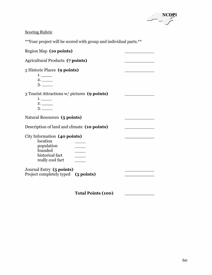
Scoring Rubric **Your project will be scored with group and individual parts.** Region Map (10 points) ___________ Agricultural Products (7 points) ___________ 3 Historic Places (9 points) ___________ 1. ____ 2. ____ 3. ____ 3 Tourist Attractions w/ pictures (9 points) ___________ 1. ____ 2. ____ 3. ____ Natural Resources (5 points) ___________ Description of land and climate (10 points) ___________ City Information (40 points) ___________ location ____ population ____ founded ____ historical fact ____ really cool fact ____ Journal Entry (5 points) ___________ Project completely typed (5 points) ___________ Total Points (100) ___________
NCDPI
61
5 Themes of Geography I Have, Who Has Game Janice Gardner
Materials:
Index cards (enough for each student to have at least one card)
Stick on labels
Each student receives one game card. Teacher or leader begins game by reading aloud
their ‗Who has…‘ question. The student who has the answer reads aloud their ‗I have…‘
side and then turns over card to ask the ‗Who has…‘ question. This continues until the
final question comes back to the teacher or leader who reads their ‗I have…‘ answer.
Questions and answers can be printed on the front and back of index cards or wide
labels and stick on to the cards. Lamination helps keep the cards for many uses.

NCDPI
62
Teacher starter card. (Save ‗I have‘ side as last answer)
I have a migrant worker. I have lines of latitude. Who has the set of lines on a map that runs east and west? Who has the set of lines on a map that runs from the North Pole to the South Pole? I have lines of longitude. Who has the lowest and flattest land form region in NC? I have the Coastal Plain. I have capes. I have the Fall Line. I have the Piedmont. I have the Mountain region. I have Mount Mitchell. Who has points of land that stick out into the ocean? Who has the marking border between the Coastal Plain and the Piedmont? Who has the land form region that is much more hilly than the Coastal Plain? Who has the land form region that is divided from the Piedmont region by the Blue Ridge Mountains? Who has the highest mountain peak in the eastern United States? Who has a body of water that lies between the mainland and an island? I have a sound.

NCDPI
63
I have the Eastern Continental Divide. I have a tributary. I have dams. I have a natural resource. Who has a ridge that separates rivers flowing east from those flowing west? Who has a river or stream that flows into a larger river? Who has walls that are built which can hold back flood waters or help run generators, or machines that make electricity? Who has something that is found in nature that people can use? Who has the state vegetable which NC also leads the nation in producing? I have the sweet potato. I have a quarry. I have red clay soil. I have fertilizer. I have pollution. I have a hurricane. Who has a place where stone is cut or lasted out of the ground? Who has the type of soil in the Piedmont use for making bricks, sewer pipes, and roof tiles? Who has a material that is added to soil to help plants grow? Who has anything that makes a natural resource dirty or unsafe to use? Who has a big storm with heavy rains and high winds that forms over warm ocean water? Who has the science of farming? I have agriculture.

NCDPI
64
I have culture. I have economy. I have tourism. I have an urban area. I have a suburb. I have the Research Triangle Park. Who has beliefs, traditions, and ways of living? Who has the way people use resources to meet their needs? Who has the selling of goods and services to travelers? Who has the city and the surrounding area? Who has a town or small city near a large city? Who has a center for research and technology located in the Piedmont? Who has the cities that make up the Triangle? I have Raleigh, Durham, and Chapel Hill. I have Charlotte. I have Raleigh. I have High Point. I have Durham. I have a population map. I have technology. Who has the largest city in NC? Who has the state capital and the 2nd largest city in NC? Who has the NC city that has the nation’s largest furniture market?

NCDPI
65
Who has the city that is called the ‘City of Medicine’? Who has the kind of map that can show you how many people live in a certain area? Who has the way people use new ideas to make tools and machines? Who has a better way? I have innovation. I have pottery. I have Seagrove. I have textiles. I have Dolly Madison. I have an orchard. I have apples, Christmas trees, and tobacco. Who has pots and dishes made from clay? Who has city that is famous for pottery? Who has an important industry in the Piedmont for many years? Who has the only First Lady from NC? Who has a large group of fruit trees? Who has the three main crops in the Mountain Region? Who has the largest city in the Mountain region? I have Asheville. I have the Biltmore House. I have conservation. I have Kitty Hawk. I have a civil right.

NCDPI
66
I have Charles M. Duke. Who has the largest private home in the US? Who has the protection of natural resources? Who has the location where the Wright Brothers made their 1st flight? Who has a right to all citizens by the Constitution? Who has NC’s first astronaut? Who has a person who moves from farm to farm to harvest crops? I have a migrant worker.
NCDPI
67
Scots Irish Immigration to North Carolina and Their Influence on the
Cultural and Economic Development of North Carolina
Phyllis Boisvert
Learning Standards and Outcomes
Social Studies Goal 1: The learner will apply the five themes of geography to North
Carolina and its people.
Objective 4: Evaluate ways the people of North Carolina used, modified, and adapted to
the physical environment, past and present.
Objective 5: Assess human movement as it relates to the physical environment.
Social Studies Goal 2: The learner will examine the importance of the role of ethnic
groups and examine the multiple roles they have played in the development of North
Carolina.
Objective 2: Trace the growth and development of immigration to North Carolina, over
time from Europe, Asia, and Latin America.
Objective 3: Describe the similarities and differences among people of North Carolina,
past and present.
Objective 4: Describe how different ethnic groups have influenced culture, customs and
history of North Carolina.
Social Studies Goal 3: The learner will trace the history of colonization in North
Carolina and evaluate its significance for diverse people‘s ideas.
Objective 4: Compare and contrast ways in which people, goods, and ideas moved in
the past with their movement today.
Social Studies Goal 5: The learner will examine the impact of various cultural groups on
North Carolina.
Objective 2: Describe traditional art, music, and craft forms in North Carolina.
Historical Background
During the 18th century many people immigrated from County Ulster in what is
today Northern Ireland. These people of Scottish descent came to the Americas looking
for a better way of life than they were able to have in Ireland.
By the year 1717 so many Scotch-Irish had come to the colonies that the movement was
given the name, the Great Migration. There were several reasons for this mass
migration from Ireland including famine, high rents, unpopular British laws that

NCDPI
68
crippled linen production in Ulster, and the positive reports of the wonderful
opportunities in the new land that were sent home by new immigrants.
The Scotch-Irish usually came to the colonies by way of Philadelphia attracted
by the rich farm land of Pennsylvania. But other immigrants to the area also wanted to
settle here, notably immigrants from Germany later called the Pennsylvania Dutch. As
Pennsylvania became more crowded the Scotch-Irish sold their farms and moved south
into Virginia, and later into North and South Carolina. They traveled in Conestoga
wagons along the Great Wagon Road. They moved into the North Carolina mountains
where they adapted their way of life to the challenges of a new land.
The Scotch-Irish brought along their particular religion, Presbyterianism, their
unique way of speaking, their music, and their customs. They had strong family ties and
traditions which they maintained through the years.
Pre-Project Activities
1. Read material in textbook relating to Scotch-Irish migration into North Carolina along
the Great
Wagon Road.
2. Find Ireland and County Ulster on a map.
3. Find Pennsylvania on a map.
4. Trace the route taken by the Scotch-Irish using maps of Ireland and America.
5. In small groups research the Scotch-Irish and their impact on the economy of North
Carolina past and present. Allow one computer session followed by one class period to
complete this task.
6. Introduce Think-Tac-Toe and allow students time to choose their project.
7. Distribute rubric used to evaluate project.
Project
Allow 3 thirty to forty-five minute class periods over a two week period to
research and work on projects.
Projects will be presented to a first grade class during a Scots-Irish Festival
afternoon.
Evaluation

NCDPI
69
Students will demonstrate knowledge of Scotch-Irish influence on North Carolina
by presenting completed project to class.
Students will be able to trace immigration path from County Ulster, Ireland to
North Carolina.
Interdisciplinary Connections
English Language Arts:
Students will be reading primary source materials, drawing conclusions, and
presenting their projects in written form.
Writing Prompt-You are a grandparent who traveled along the Great Wagon
Road to North Carolina. Tell your grandchildren about a day of travel.
Technology:
Students will use internet to research their project.
Students will use Kidspiration or PowerPoint to create graphics to share with the
class.
Web Sites and Acknowledgements
Resources for Scotch-Irish and Great Wagon Road
www.irishgenealogy.com
www.waywelivednc.com
www.dalhousielodge.org
www.usgennet.org
www.scotishsociety-sa.org
http://members.tripod.com/~bonash/
Think-Tac-Toe: Copyright 2000 by Caroline Cunningham Eidson. All rights reserved.
Rubric: Copyright 2004, 2003, 2002, 2001 High Plains Regional Technology in
Education Consortium HRP*TEC

NCDPI
70
Think-Tac-Toe Objective(s): Demonstrate knowledge of Scotch-Irish immigration and settlement of North Carolina’s mountain region and the cultural impact that they brought.
Research the Great Wagon Road. How was it built? Why was it called the Great Wagon Road. Create a diorama showing the Great Wagon Road and settlers traveling on it.
Research the challenges of settling in the North Carolina mountains. How were the mountains different from the land that the Scotch-Irish inhabited in County Ulster? What jobs did the Scotch-Irish do in North Carolina? Present what you have learned in a poster or Power Point presentation.
Research travel past and present. How were goods moved in colonial times, in the 19
th century, in the 20
th
century, and today. Present your research in a Power Point presentation.
Keep a diary (at least 7 entries) of an Irish family’s travel from Pennsylvania to North Carolina. Remember that each entry should describe a moment in time. You may illustrate your diary.
Write a poem about coming to America from Ireland. Your poem should include a verse about each stage of your trip-County Ulster to Pennsylvania, Pennsylvania to Virginia, travel along the Great Wagon Road, arriving in North Carolina, your new home.
Compare and contrast the lives of the Irish in County Ulster and later in the mountains of North Carolina. How were the people’s lives different in each place? What changes did they have to make to live in a new place? Present what you learn using a Thinking Map that is neatly drawn or using Kidspiration.
Research Scotch-Irish music. Bring an example to share with the class. Dance to your music or teach the class to sing an Irish song.
Research Scotch-Irish stories. Present one story in an illustrated book. Tell your tale to the class. You may dress in traditional dress if you wish.
Study Scotch-Irish recipes. Did the Scotch-Irish change their diets when they immigrated to North Carolina. What foods did they bring with them? What foods did they adopt from the Indians? Prepare a Scotch-Irish recipe and bring it to share with the class.
Prepared by: Phyllis Boisvert

NCDPI
71
Scotch-Irish Student Project
Teacher Name: Mrs. Boisvert Student Name: ________________________________________ Parent Signature:_________________________________________
CATEGORY 4 3 2 1 Student Evaluation
Teacher Evaluation
Quality of Work
Provides work of the highest quality.
Provides high quality work.
Provides work that occasionally needs to be checked/redone to ensure quality.
Provides work that usually needs to be checked/redone to ensure quality.
Time-management
Routinely uses time well throughout the project to ensure things get done on time.
Usually uses time well throughout the project, but may have procrastinated on one thing.
Tends to procrastinate, but always gets things done by the deadlines.
Rarely gets things done by the deadlines AND teacher has to adjust deadlines because of this person's inadequate time management.
Attitude Always has a positive attitude about the task(s).
Often has a positive attitude about the task(s).
Usually has a positive attitude about the task(s).
Often has a negative attitude about the task(s).
Pride Work reflects this student's best efforts.
Work reflects a strong effort from this student.
Work reflects some effort from this student.
Work reflects very little effort on the part of this student.
Evaluation Name, student evaluation, student comments and parent signature are complete.
3 of 4 fields completed
2 of 4 fields completed
1 of 4 fields completed
Student Comments:_______________________________________________________________________________ _________________________________________________________________________________________________ Teacher Comments:_______________________________________________________________________________ _________________________________________________________________________________________________
© 2004, 2003, 2002, 2001 High Plains Regional Technology in Education Consortium HPR*TEC

NCDPI
72
Class Project
Region in a Box
Ann White
Students will be divided into three groups to create a region in a box. One-third of the
students will create a replica of the Coastal Plain in a shoe box. One-third of the students
will create a replica of the Piedmont in a shoe box and the last third will create a replica
of the mountain region.
Inside the shoe box, students will form the landforms of their particular region. They
will also include samples demonstrating how people interact with the environment in
this region. This can include ways people make a living and types of recreation. Students
should also include something of an historical nature.
Since writing is always an important piece of the 4th grade curriculum, the students
should explain why they chose these particular artifacts to be included in their region
box.
Region boxes will be grouped by each region and displayed as a museum of N.C. Each
student will explain their box.
Example:
Coastal Plain
Part of the bottom of the box will be covered with sand. The barrier islands will be
formed at the far right of the box .The inner coastal plain and Tidewater areas will also
be displayed. Students could include The Great Dismal Swamp and pocosins.
Farming and fishing industries could demonstrate how people make a living in the
Coastal Plain.
Historical sites might include the Wright Brothers or the lighthouses.
These are just examples students may find interesting. All of these could not be included
in one box.
Note:
This project would be a great culminating activity after a study of the three regions.

NCDPI
73
North Carolina People, Geography, and the Environment Pam Cannon Human and Environmental Interaction
How are people’s lives shaped by the place where they live?
How has a place been shaped by people?
Begin a discussion about early Wilmington and the type of needs the people living there
had. (They needed places to live and ways to earn money; they also needed food and
supplies for living.) What about the area made people choose the lifestyle or job they
had? (Many were farmers because of the abundance of good farm land, others worked
with shipbuilding because of the ports, and still others worked in the naval stores field
because of the abundance of pine trees.)
Discuss the needs that people have living in Wilmington today. (The needs are basically
the same as in early Wilmington.) What about the area make people choose the lifestyle
or job they have? (Today we have more jobs in the tourism and travel industry, jobs
dealing with the ocean or river, the local university and hospital. We still have many jobs
working with the ports.)
Discuss what makes most of the jobs so different now and then. What makes some the
same? How have the people changed the environment of this area? Has the environment
changed the people? If so, how?
Have students search the link below for pictures of Wilmington years ago. How is the
town different in appearance today from the way it looked many years ago? Discuss why
these changes have occurred.
http://www.latimerhouse.org/cgi-bin/search.pl?query=streets&field=all
Divide students into small groups and have them pretend to work for an ad agency that
has been hired by the city of Wilmington to bring new people and industry here either in
the early days or today. Have them write a commercial to present to the class trying to

NCDPI
74
convince people to come here because of our great environment to open their business
or to live here. Record commercials and playback for students to watch.
*This lesson was designed based on Wilmington, but could be adapted to any city. (A
website would need to be located containing historical pictures of the city you choose.)

NCDPI
75
NORTH CAROLINA BOOK OF FACTS-4TH GRADE
Tracy M. Preslar
From the beginning of time, people have formed a relationship with geography and the
environment.
Assignment: Create a North Carolina book of facts. Book will be comprised of
information concerning the three main regions of North Carolina. You are to research
each region and find data that that will support each theme below.
Objective: Students will be able to analyze the impact of the relationships in North
Carolina, past and present, using all five of the following themes.
Place
Location
Movement
Human and environmental interaction
Region
NC Standard Course of Study:
COMPETENCY GOAL 1: The learner will apply the five themes of geography to
North Carolina and its people.
1.01 Locate, in absolute and relative terms, major landforms, bodies of water and
natural resources in North Carolina.
1.02 Describe and compare physical and cultural characteristics of the regions.
1.03 Suggest some influences that location has on life in North Carolina such as
major cities, recreation areas, industry, and farms.
1.04 Evaluate ways the people of North Carolina used, modified, and adapted to
the physical environment, past and present.
1.05 Assess human movement as it relates to the physical environment.
COMPETENCY GOAL 2: The learner will examine the importance of the role of
ethnic groups and examine the multiple roles they have played in the
development of North Carolina.
2.01 Locate and describe American Indians in North Carolina, past and present.

NCDPI
76
2.02 Trace the growth and development of immigration to North Carolina
2.03 Describe the similarities and differences among people of North Carolina,
past and present.
COMPETENCY GOAL 3: The learner will trace the history of colonization in
North Carolina and evaluate its significance for diverse people's ideas.
3.01 Assess changes in ways of living over time and determine whether the
changes are primarily political, economic, or social.
3.02 Identify people, symbols, events, and documents associated with North
Carolina's history.
3.04 Compare and contrast ways in which people, goods, and ideas moved in the
past with their movement today.
COMPETENCY GOAL 4: The learner will analyze social and political institutions
in North Carolina such as government, education, religion, and family and how
they structure society, influence behavior, and response to human needs.
4.01 Assess and evaluate the importance of regional diversity on the development
of economic, social, and political institutions in North Carolina.
COMPETENCY GOAL 5: The learner will examine the impact of various cultural
groups on North Carolina.
5.01 Explain different celebrated holidays, special days, and cultural traditions in
North Carolina communities.
5.03 Describe and compare the cultural characteristics of regions within North
Carolina and evaluate their significance.
COMPETENCY GOAL 6: The learner will evaluate how North Carolinians apply
basic economic principles within the community, state, and nation.
6.01 Explain the relationship between unlimited wants and limited resources.
6.02 Analyze the choices and opportunity cost involved in economic decisions.

NCDPI
77
6.03 Categorize the state's resources as natural, human, or capital.
6.04 Assess how the state's natural resources are being used.
COMPETENCY GOAL 7: The learner will recognize how technology influences
change within North Carolina.
7.01 Cite examples from North Carolina's history of the impact of technology.
7.02 Analyze the effect of technology on North Carolina's citizens, past and
present.
7.03 Explain how technology changed and influenced the movement of people,
goods, and ideas over time.
7.04 Analyze the effect of technology on North Carolina citizens today.
7.05 Identify the advantages and disadvantages of technology in the lives of
North Carolinians.
Projects must have a table of contents and will be graded by amount of information
found (relative to the assignment), neatness and organization, and readability.
Students are encouraged to use a variety of resources for research ( i.e.; internet,
textbook, primary source documents, encyclopedias, and other non-fiction materials)
You will be given time in the computer lab to do research, however you will be required
to spend time on your projects outside of school.
F.Y.I: Very valuable information can be mailed or shared with you if you contact the
right people.
The following information will help to get you started on the right path.
North Carolina Geographic Regions
Bordered by the Atlantic Ocean on the east, Tennessee on the west, Virginia to the north, and

NCDPI
78
South Carolina and Georgia to the south, North Carolina is divided into three distinct
geographic areas: the Mountains, in the west; the Heartland, often called the Piedmont, in the
center; and the Coast, in the east. Each has its own distinct features.
Mountains
The Appalachian mountain chain runs through the western part of the state. The highest peak,
Mount Mitchell, in Yancey County, is 6,684 feet high, making it the tallest along the eastern
coast of the U.S. The Great Smoky Mountains make this area one of the country's top scenic
attractions. Visitors can enjoy grand vistas of magnificent beauty driving through the mountain
ranges on the world-famous, 250-mile Blue Ridge Parkway.
Two-thirds of the mountains are covered with hardwood forests, and in autumn, they create a
brilliant, colorful display. Skiing is a popular winter sport, with some areas getting 30 inches of
snow a year. Summers are cool and refreshing with low humidity.
Piedmont

NCDPI
79
Encompassing the central part of the state, the Heartland is made up of gently rolling foothills.
Although the area enjoys four distinct seasons, temperatures are mild year round -- the average
wintertime temperature is about 42 degrees, and in summer, it's 77 degrees. The area also
enjoys sunshine for about 210 days a year. Located here are shopping meccas, top golf courses,
historic sites and entertainment offerings.
Coast
Warmed by the nearby Gulf Stream, the North Carolina Coast is a sunny place filled with
pristine beaches and the powerful grandeur of the ocean, giant sand dunes (highest along the
East Coast), and wetlands filled with an abundance of wildlife and plants. The defining
characteristic of the area is the Outer Banks, a chain of fragile barrier islands with 130 miles of
unspoiled coastline surrounded by 900 square miles of water.
Web address: http://www.investnc.com/ Good Luck and Have Fun!!

NCDPI
80
Gingo Instructions
T. Montgomery
This game is played similar to Bingo. (Variation to game.) Four corners are covered or
plan until all areas are covered.
Students can make their own game card or teachers can provide one. Write the name of
the theme in each box.
Answers should be written on scripts of paper or asked in random order.
The first student who has Gingo covered is the winner.

NCDPI
81
G I N
G O
LOCATION
REGIONS
PLACE
PLACE
MOVEMENT
REGIONS
LOCATION
PLACE
MOVEMENT
LOCATION
HUMAN ENVIRONMENT
HUMAN ENVIRONMENT
FREE SPACE
HUMAN ENVIRONMENT
HUMAN ENVIRONMENT
REGIONS
MOVEMENT
PLACE
LOCATION
MOVEMENT
MOVEMENT
REGIONS
PLACE
REGIONS
LOCATION

NCDPI
82
Questions for GINGO
T. Montgomery
Where is it? Location Rolling hills Hanging Rock State Park Biltmore House South Four regions of the US What is it like there? Place Cape Plateau Inner Coastal Plains Outer Coastal Plains Highest peak
How does the place affect people? Human Environment Longest growing season Hiddenite found only in North Carolina Produce more sweet potatoes Second largest manufacturing industry Temperature changes with the seasons How do people, goods, and ideas move to and from the place? Movement Trail of Tears Wright Brothers Murphy to Manteo Carries water away from the land
Regions Most populated Milder temperatures Home of Whitewater Rafting Largest city Research Triangle Park Grow more Christmas Trees

NCDPI
83
Have You Seen North Carolina? Irma Tillman
North Carolina Social Studies Standards
Goal 1: The learner will apply the five themes of geography to North Carolina and
its people.
Objectives
Students will
1.03 Suggest some influences that location has on life in North Carolina such as
major cities, recreation areas, industry and farms.
Expected Outcomes
Students will
Identify and locate the three regions of North Carolina on a map.
Identify at least two physical characteristics of each region.
Analyze the impact of location on recreation in the three regions in the past and
the present.
Make a collage showing recreational or historical activities of each region.
Pre-Lesson Activities
1. Review the three regions of our state and have students locate them on a wall map of
North Carolina. (Mountains, Piedmont, Coastal Plains)
2. Have Students share one place they have been in our state. Have them tell which
region they went to and what they visited.
Materials
Pictures, brochures, fliers of historical and for recreational places in NC
Scissors and glue for cutting out and pasting pictures to make a collage
Whole class outlined map of NC on poster board divided into three regions of
NC. (The map should be large enough to cover a wall board)
Pencils and notebook paper for writing a personal narrative.
Time
3-forty-five minute class periods
Vocabulary
Geography, historical, recreational, environment

NCDPI
84
First Day Lesson
1. Begin the lesson with the question. Have you seen North Carolina? ( Have
bulletin board display of a large outline map of NC divided into three regions
with the title question “Have You Seen North Carolina? Also have questions on
sentence strips: Where did you go? What did you see? What did you do? How do
you feel about it?)
2. Have students share one place they have seen in our state. Have them tell which
region they went to and where they visited. (Students may use a wall map of NC
to locate the place and point to the region where it is located)
3. Model for students how to tell a story about the place they visited and how the
geographic location of the place affects the type of recreational activities in that
place. (Tell about a place visited during Trek NC week)
4. Divide students into groups of fours. Have them choose a brochure pamphlet flier
or picture (from a collection on a table) that shows the place where they visited.
In their groups, they will take turns telling others about their trip. (Allow 2-3
minutes for each student to share with his/her group) The listeners may ask
questions to make sure their classmates tell how the geography of the place
affects the recreational activities.
5. Have students write an experience story about their trip to a place they have
visited in NC. They may store their story and picture in a writing folder
Second Day Lesson
1. Have students pull out their pictures and story from yesterday. Have volunteers
share their pictures and story with the whole class. (About 15-20 minutes)
2. Divide students into small groups by the region they have visited. Have students
cut out their pictures. The small groups will take turns arranging their pictures
and gluing them on the poster board to make a collage of recreational places in
each region. (While one group is gluing their pictures in the college, the other
groups will work on revising and editing their stories, making sure they have
answered the four questions from bulletin board and how the geographic
location of the place affects the type of recreation)
3. As a class, have students to choose pictures from the collection to fill any blank
spots on the collage. Also students will observe their class project and make sure

NCDPI
85
all pictures are in the correct region on the collage. Display the NC collage on the
wall bulletin board
Third Day Lesson
1. Divide the students into pairs to do peer editing of their stories while the teacher
conferences with individual students about their writing. (Students make
suggestions for editing, but the owner of the paper is the only one who actually
writes on his paper.
2. Have students publish their stories by rewriting them neatly or typing them.
Students who finish early may do self-select reading from our NC collection of
books.
3. Allow 5-10 minutes at the end of the class period to review and summarize the
impact of geography and the environment on the types of recreation in the three
regions in the past and the present.
Post Lesson Activities
1. Play a jeopardy game to review the location of recreational and historical places
in NC. Students need to know the name of the city and region where the place is
located.
Interdisciplinary Connections
This lesson integrates social studies and writing
Language; have students research the history of a place they have visited
and write a report about it. Have students share what they learned with
the class.

NCDPI
86
North Carolina People, Geography, and the Environment
Objective: Students will complete projects that will teach the impact of the relationship
of geography and the environment and how it affects the people of North Carolina.
Students will examine this relationship in the past and the present.
People Past and Present
Part 1:
Students will first interview an elderly person that was born and has lived in North
Carolina their entire life. In the interview they will be responsible for designing a
schedule of daily weekday activities when they were around the age of a 4th grader.
Students will then make their own daily weekday schedule of their own life.
When both schedules have been completed students will examine the following
questions.
What differences do you see in your schedule as compared to the elderly person you
interviewed?
Why are children‘s schedules today so much different than people of long ago?
How has a changing North Carolina affected the way people live?
Three Regions Scavenger Hunt
Part 2:
Students will go on a scavenger hunt to find natural resources or pictures of natural
resources native to one of North Carolina‘s three regions. Clues about which area the
resources came from will be provided in the search. Once students have found all the
objects they must try to figure out which region it came from and why. After completion
of the scavenger hunt students will examine the following questions.
How were these resources used in the past?
Why are these resources still important to us today? What would we do if some of these
resources were no longer available?
As a follow up activity students must choose one natural resources to complete a
research report describing the natural resource and its importance to North Carolina.
NCDPI
87
Traveling Through North Carolina
Angela Stanley
Subjects: Social Studies, Writing, Technology, Media (Information Skills)
Plan with Media Specialist and Technology Specialist
Grade: 4
Time: 4- 30 min. sessions Media Center
4- 30 min. sessions in classroom (writing)
2- 45 min. sessions in computer lab—wireless lab
Objectives: Social Studies
3:02 Identify people, events, symbols, places and documents within North
Carolina.
English/Language Arts:
3:06 Conduct research for assigned or self-selected projects from a variety of
sources through the use of technological and informal tools.
Example: print, print texts, artifacts, people, libraries, and computer networks
4:03 Make oral and written presentations using visual aids in awareness of
purpose and audience.
5:04 Compose multiple paragraphs
Technology
1:09 Recognize and discuss the importance of citing sources of copyrighted
material and documents.
1:15 Recognize, discuss, and model responsible and safe behavior using online
resources as a class/group/individual.
3:07 Locate, select, organize, and present content information from the Internet
for a specific purpose and audience, citing sources.
Students will research tourist attractions in North Carolina, in the Media Center,
using print resources.
Students will continue research in computer lab using internet in preparation for
a persuasive writing assignment and creating a brochure.
Students will write persuasive papers to convince tourists to visit their chosen
tourist attraction in North Carolina.

NCDPI
88
Students will create travel brochures using wireless mobile lab.
Students will use their brochures, artifacts, and research information during a
Travel Fair to present information to persuade their peers, parents, teachers, and
community to visit places in North Carolina.
Invite staff from Chamber of Commerce to judge During the Travel Fair.

NCDPI
89
LLiigghhtthhoouussee DDaattaabbaassee//BBooookklleett
AAnnggeellaa SSttaannlleeyy
SSuubbjjeeccttss:: SSoocciiaall SSttuuddiieess,, TTeecchhnnoollooggyy
OObbjjeeccttiivvee:: SSttuuddeennttss wwiillll uussee NNCC WWIISSEE OOWWLL ttoo eexxpplloorree tthhee NNoorrtthh CCaarroolliinnaa LLiigghhtthhoouusseess..
UUssiinngg aa cchhaarrtt,, ssttuuddeennttss wwiillll ddooccuummeenntt iinnffoorrmmaattiioonn tthhaatt ccaann llaatteerr bbee uusseedd iinnttoo ccrreeaattiinngg aa
ddaattaabbaassee.. SSttuuddeennttss wwiillll lleeaarrnn aabboouutt NNoorrtthh CCaarroolliinnaa‘‘ss ccooaasstt aanndd tthhee iimmppoorrttaannccee ooff
lliigghhtthhoouusseess ttoo NNoorrtthh CCaarroolliinniiaannss tthhrroouugghh hhiissttoorryy..
SSttuuddeennttss wwiillll uussee NNCC WWIISSEE OOWWLL ttoo ggaatthheerr iinnffoorrmmaattiioonn oonn eeaacchh ooff tthhee
lliigghhtthhoouusseess.. SSeeee pprriinnttaabbllee sshheeeett.. SSttuuddeennttss wwiillll tthheenn uussee AAppppllee WWoorrkkss ttoo ccrreeaattee aa
ddaattaabbaassee..
SSttuuddeennttss wwiillll tthheenn rreeppoorrtt oonn eeaacchh lliigghhtthhoouussee ccrreeaattiinngg ppaaggeess ffoorr aa ssttuuddeenntt mmaaddee
bbooookk.. CCaann hhaavvee ppuubblliisshheedd aanndd iiff ccoosstt ttoooo mmuucchh tthheeyy ccaann bbee ccrreeaatteedd oonn ccoommppuutteerr aanndd
ccooppiieedd.. TTeeaacchheerr mmaayy bbiinndd tthheemm ffoorr aa ccrreeaattiivvee llooookk..
EExxtteennssiioonn:: SSttuuddeennttss ccrreeaattee aa HHyyppeerrssttuuddiioo oorr PPoowweerrPPooiinntt pprreesseennttaattiioonn aabboouutt oonnee
ooff tthhee lliigghhtthhoouusseess.. IInncclluuddee wwhheenn iitt wwaass bbuuiilltt,, iittss hheeiigghhtt,, ccoolloorr,, llooccaattiioonn,, kkiinndd ooff ssiiggnnaall iitt
ssuubbmmiittss,, aanndd wwhhyy iitt wwaass//iiss iimmppoorrttaanntt ttoo NNoorrtthh CCaarroolliinniiaannss..

NCDPI
90
North Carolina Lighthouses
When Built
Height Kinds of
Signals/distance Color Location Interesting Facts
Ocracoke Built
in...
Built
in... Built in...
Built
in... Built in... Built in..
Cape Hatteras Built
in...
Built
in... Built in...
Built
in... Built in... Built in..
Cape Lookout Built
in...
Built
in... Built in...
Built
in... Built in... Built in..
Bodie Island Built
in...
Built
in... Built in...
Built
in... Built in... Built in..
Currituck Beach
Built
in...
Built
in... Built in...
Built
in... Built in... Built in..
Oak Island Built
in...
Built
in... Built in...
Built
in... Built in... Built in..
Bald Head Built
in...
Built
in... Built in...
Built
in... Built in... Built in..

NCDPI
91
Colonial Jobs / Modern Jobs
Carol Ann Bingham
North Carolina Social Studies Standards
Competency Goal 1: The learner will apply the five themes of geography to North
Carolina and its people
Objectives
1.03 Suggest some influences that location has on life in
North Carolina such as major cities, recreation areas,
industry, and farms.
1.04 Evaluate ways the people of North Carolina used,
modified, and adapted to the physical environment,
past and present.
1.05 Assess human movement as it relates to the physical
environment.
Pre-Lesson Activities
1. Review the five colonial jobs featured in the North Carolina
Social Studies Weekly newspaper previously used as guided reading material
during colonial NC learning centers.
(barrowman, tinker, rabbit woman, night-soil carter, town crier)
2. Students choose a colonial job to compare and contrast to a
modern job of the same function.
Materials
NC Social Studies Weekly issue on colonial jobs
Internet access for research
Books on living during colonial times
Advertising section of modern newspapers
Yellow pages of modern telephone book
Adults willing to be interviewed about their work or knowledge of a modern job
Colored pencils
Drawing paper
Computer lab with power point program

NCDPI
92
Power point program with instructions for creating training guide
Example of instruction manual from colonial times
Project 1
Students will draw two illustrations showing their colonial job and modern job.
The illustrations must show the correct clothing, hairstyle, equipment, setting, etc. of
the time period.
Project 2
Students will create a training manual for the colonial job. It should be made of
materials used during colonial times.
Students will create a power point presentation to be used as a training guide for
the modern job. Directions will be given through a power point presentation.
Items to be included in the training manual (5 pages) / training guide (5 slides)
1. Job name / one NC region where the job would be located
2. Job name / job description / drawing or clip art
3. Clothing and accessories needed (5 articles)
4. Equipment needed (3 pieces)
5. List 5 things you need to know in order to do this job
NCDPI
93
Webquest: Let’s plan a trip!
Antoinette Nicholson
INTRODUCTION:
Your mother has accepted a job in another state. This means you and your family will be
moving from Ohio to North Carolina. You will be traveling by car and your parents are
attempting to figure out which route to take. They also want this to be somewhat of an
educational experience for you.
TASK:
Your task is to find the shortest route from Youngstown, Ohio to Rose Hill, North
Carolina using the computer and one of the web sites listed in Resources below. After
you have found the shortest route, you will need to find another route using a fold out
(paper) map of the Eastern United States.
For each trip you will need to answer the following questions in your travel journal:
1) How many miles will you travel?
2) How many miles will be spent on each road?
3) How many hours and minutes are you traveling?
4) Which direction will you be traveling on each road?
5) Do you pass any famous, historical, or important landmarks on the trip? You may
use encyclopedia or library books for help on this question.
6) If so, what are they?
7) Why are these places considered famous, historical, or important?
8) How many states do you go through? Name them.
9) Which route would be the best route to take when you move? Why?
PROCESS:
Using the computer, click on one of the web sites listed in Resources to find the
shortest route from Youngstown, Ohio to Rose Hill, North Carolina.
Print out the directions with the map.
Write in travel journal about the process and which web site was used for directions.
Using the fold out (paper) map, figure out another route.
Write these directions in your travel journal. Be sure to use both cardinal and
intermediate directions.

NCDPI
94
With your ruler, use the map scale and figure out how many miles you will be
traveling on that route.
Write this information in your travel journal.
Pretend you are traveling at 60 miles per hour and figure out traveling time in hours
and minutes.
Write this information in your travel journal. Be sure to show your work.
RESOURCES:
For addresses, type in the following information:
Starting from: 802 Franklin Avenue
Youngstown, OH 44502
Destination (ending at):
226 East South Street
Rose Hill, NC 28458
http://www.yahoo.com/ Click on maps. Click on driving directions. Fill in address
information.
http://www.mapquest.com/ Click on get directions. Fill in address information.
http://map.msn.com/ Fill in information. Click on get directions.
Fold out (paper) maps Encyclopedia Library books
EVALUATION:
1) Are all questions answered in travel journal?
2) Is travel journal complete? (Don‘t forget to date each entry.)
3) Are spelling, grammar, and punctuation rules followed?
4) Is second set of directions written so another person could follow them by reading?
5) Did you use both cardinal and intermediate directions for second route?
6) Is all work shown for figuring out hours and minutes traveled on second route?
7) Is all work shown for figuring out miles traveled on second route?
8) Did you include information about important, famous, or historical sites passed?
10) Are printed directions from computer search included in journal?
CONCLUSION:
You have successfully completed planning a trip for your parents. You have figured out
miles traveled, time spent on the road, and even included some educational experiences.

NCDPI
95
When someone else has to travel a long distance, maybe you can be of assistance.
CONGRATULATIONS!

NCDPI
96
North Carolina Travelers
Bonnie C. Fulp
Purpose: Most people love to travel. But where do you go and what will you see and do
there? Students will develop 6 brochures of North Carolina to help you with these
questions.
Pre-Lesson Activity:
1. Using a map of NC, draw a horizontal line through NC to divide our state
into a top and bottom half. Then draw 2 vertical lines to total 6 parts.
This is necessary to give a fair amount of area to each group. There are
many ways to form groups within a classroom. Each group should be as
even as possible. Each member will have the responsibility of doing
his/her fair share.
2. Before being grouped, students can independently make a rough draft of
the information required on the final group brochure. Using tri-fold white
paper, each student writes the information on the paper. The teacher will
assign one of the six books, maps, internet, magazines, and personal
interviews to find and write each section required on the rubric for the
brochure. The teacher may use one day for two requirements so that the
whole class moves together at the same pace.
Lesson: Give each group time to compare each member‘s research and information.
They will need to pick and choose the research items and eliminate other information.
Three facts are needed for each part of the brochure. Therefore the groups will have to
determine of they have too much information or if they need more. Brochures may be
typed or hand-printed. Pictures or clip art may be scanned, drawn or downloaded. The
final work should be interesting, informative, and correct. Each brochure should make
others want to visit that area!

NCDPI
97
Category 3 2 1 0 Graphics/Pictures 3 Graphics go well
with the text and describe your area.
2 Graphics go well with the text and describe your area.
1 Graphic goes well with the text and describe your area.
0 Graphics go well with the text and describe your area.
Prominent Land Features
3 Land features and their names are accurately listed.
2 Land features and their names are accurately listed.
1 Land feature its name is accurately listed.
0 Land features and their names are listed.
Agriculture Products
3 Agriculture products are listed for your area.
2 Agriculture products are listed for your area.
1 Agriculture product is listed for your area.
0 Agriculture products are listed for your area.
Industrial/Business Products
3 Industrial or business products are listed for your area.
2 Industrial or business products are listed for your area.
1 Industrial or business product is listed for your area.
0 Industrial or business products are listed for your area.
Cultural Groups 3 Cultural groups from the past or present are listed for your area.
2 Cultural groups from the past or present are listed for your area.
1 Cultural group from the past or present is listed for your area.
0 Cultural groups from the past or present are listed for your area.
Traditions, Crafts, Music
3 Different types of traditions, crafts or music from the past that are carried on today are listed for your area.
2 Different types of traditions, crafts or music from the past that are carried on today are listed for your area.
1 Different type of traditions, crafts or music from the past that are carried on todayis listed for your area.
0 Different types of traditions, crafts or music from the past that are carried on today are listed for your area.
Festivals 3 Different festivals are listed from your area.
2 Different festivals are listed from your area.
1 Different festival is listed from your area.
0 Different festivals are listed from your area.
Well Known Person 3 Well known people are listed from your area. They can be past or present.
2 Well known people are listed from your area. They can be past or present.
1 Well known person is listed from your area. They can be past or present.
0 Well known people are listed from your area. They can be past or present.
Historical Sites/Byways
3 Historical sites or scenic byways are listed for your area.
2 Historical sites or scenic byways are listed for your area.
1 Historical site or scenic byway is listed for your area.
0 Historical sites or scenic byways are listed for your area.
Educational Sites 3 Sites that would increase your knowledge of NC are listed from your area.
2 Sites that would increase your knowledge of NC are listed from your area
1 Site that would increase your knowledge of NC is listed from your area
0 Sites that would increase your knowledge of NC are listed from your area
Letter Grade Points earned A 24-30 B 17-23 C 10-16 Inc. 0-9

NCDPI
98
Cruisin’ Carolina Alan Brown Expected Outcomes: Students will…
Locate towns and cities on a NC Travel Map using the coordinate grid system
Create polygons by connecting cities on the map.
Calculate the length of a missing side of a polygon using given information.
Identify major travel routes that connect major cities in the state.
Pre-Lesson Activities:
1. Review the parts of a map with students (title, key, symbols,
compass rose, inset maps, index)
2. As a class, make a list of as many NC cities as possible.
3. From the list, identify whether the cities are in the Coastal Plain,
Piedmont, or Mountains.
4. Review using coordinate grids and ordered pairs; over then up just
an airplane – it goes down the runway and then takes off. (On the
state travel map the ordered pairs use letters and numbers.)
5. Review the formula for finding perimeter.
6. Teach students how to use the map index to help them locate cities
on the map.
Materials Needed for Each Small Group:
Laminated travel map
Ruler or Yard Stick
Calculator
Vis-à-vis marker
Copy of Cruisin‘ Carolina worksheet
Time: 45-50 minutes
Lesson Activity:
1. Divide students into small groups.
2. Give each group the necessary materials.
3. Do the first problem together as a class.

NCDPI
99
4. Have students work together in small groups to complete the
entire worksheet. For students that my finish early, have
them create their own problems using the map index.
Review: Come together as a class and go over the answers. Discuss regions and major
highways that connect major cities while going over the answers.
Post Lesson Activity: Individually have student create a travel itinerary for a road trip
within the state. This must include major cities traveled to, major highways taken, and
the mileage between cities and total trip mileage.
Websites: NC Department of Transportation http://www.ncdot.org/

NCDPI
100
Name: Date: Cruisin’ Carolina
Directions: Locate each of the listed cities on the travel map and connect them using a marker and a ruler. Label the given distances between each of the cities for each problem. Using the total distance measurement, figure out the distance that is missing.
Cities Distance Greensboro to Winston-Salem 29 miles Winston-Salem to High Point _______ miles
High Point to Greensboro 18 miles Total Trip Distance: 67 miles
In what region of the state are all of these cities located?
_________________________
Cities Distance Raleigh to Durham 29 miles
Durham to Chapel Hill 11 miles Chapel Hill to Raleigh _______ miles
Total Trip Distance: 72 miles
These three cities make up an area called ―The Triangle‖.
Cities Distance Wilmington to Jacksonville ________ miles Jacksonville to Goldsboro 70 miles Goldsboro to Wilmington 96 miles
Total Trip Distance: 218 miles
In what region of the state are all of these cities located? __________________________
Cities Distance
Manteo to Edenton 66 miles Edenton to Bath 60 miles
Bath to New Bern ________ miles New Bern to Manteo 158 miles
Total Trip Distance: 335 miles

NCDPI
101
Cities Distance Charlotte to Hickory 57 miles Hickory to Asheville ________ miles Asheville to Murphy 112 miles Murphy to Charlotte 239 miles
Total Trip Distance: 495 miles
In what two regions of the state are these cities located? _________________________________
Cities Distance
Rocky Mount to Lumberton 129 miles Lumberton to Concord 133 miles Concord to Mount Airy 95 miles
Mount Airy to Rocky Mount ________ miles Total Trip Distance: 552 miles
In what two regions of the state are these cities located?
___________________________________
If you finish early, create your own problems for another group to solve.

NCDPI
102
Additional Resources
Some participants requested completing activities or resources not
specifically required for the Trek NC program.
NCDPI
103
Graphing North Carolina Cities
Students will create a bar graph illustrating the population of five cities in North
Carolina. The students must have at least one city from each region. The students must
show how the cities population differs. The students will write information about the
five cities in North Carolina to be included in the class‘s book Oh! The Places We Would
Go!
Exploring Native American Culture
1. Create a recyclable instrument using items around the house. (Science)
2. Native America (group) students will work in groups and research a Native
American tribe that originated in North Carolina. The paper or poster must
include the cultural traditions, music and regions that the tribe comes from.
Presentation must include pictures, music, artifacts and oral presentation.
3. Lumbee 4. Hopi
4. Cherokee 5. Apache
5. Occaneechi 6. Papago

NCDPI
104
North Carolina Trivia Questions Jessica Rainwater These questions and answers can be copied, placed on index cards and laminated. What building materials did Native Americans use over the centuries? Woven mats, strips of bark, and hewn logs What are three ways Native Americans used to get food? Horticulture, hunting, and gathering How did the Native Americans make arrowheads? By flaking – hitting a stone with a harder stone What types of vessel came to Halifax from the Atlantic Ocean in the 1700s? Sloops, schooners, and brigs What is an artifact? Any object made or altered by humans What is an archaeologist? A person who digs up and scientifically studies the remains of past cultures What can personal items sometimes tell us about an archaeological site? The date of the site and social and economic status of the person who owned the items Where can I learn more about archaeology in Halifax? The Montfort House Which was faster in 18th century North Carolina: travel by land or travel by water? Travel by water Why was Halifax settled? It sat where several important toads met and on the Roanoke River

NCDPI
105
Interstate 95 is about eighty two feet wide. How wide were most North Carolina roads in the 1700s? Eight feet or less What does the April 12, 1776 on the North Carolina flag signify? The day when the Fourth Provincial Congress approved the Halifax Resolves How many signed the Halifax Resolves? One – James Green, Jr., the secretary of the provincial congress What do the Declaration of Independence and the Halifax Resolves have in common? Both documents called for independence from Great Britain How many delegates attended the Fourth Provincial Congress? Eighty-three When did the Battle at Guildford Courthouse take place? March 15, 1781 Who was the leader of the British Army during the Revolutionary War? Lieutenant General Earl Cornwallis What was the term used to refer to those loyal to the British government? Loyalists Which region is Guilford Courthouse in? Piedmont region Who was the leader of the southern department of the American forces during the Revolutionary War? Major General Nathaniel Greene About how many men fought in the Battle at Guilford courthouse? About 2,000 men fought for the British, and about 4,500 men fought for the American forces. Where was the turning point of the American Revolution?

NCDPI
106
Battle at Guildford Courthouse What was Nathaniel Greene‘s fighting strategy? To attack and would the British and then retreat to fight another day What was the term used to refer to those loyal to the new colonies? Patriots What was the approximate number of dead or wounded at the Battle at Guilford Courthouse? About 260 died or were wounded for the American forces, and about 500 died or were wounded for the British Army. What was the nickname for the British troops derived from their uniforms? Red-coats

NCDPI
107
Quilting the Underground Railroad
Angela Stanley
Subjects: Social Studies, Math, Art, Reading
Grade: Fourth-Fifth
Time: 3 days (50 min. each day)
Objectives:
Students will be able to work as a class to create a quilt mapping a route on the
Underground Railroad.
Each student will be able to create one quilt block using quilt symbols to contribute to
the quilt.
Materials:
Sweet Clara and the Freedom Quilt by Deborah Hopkinson
Hidden in Plain View by Jacqueline Tobin
Follow the Drinking Gourd by Jeanette Winter
Construction paper Scissors
Glue Markers
Optional-If you have a craft of sewing-- blocks can be made out of material. Note-may
take few days longer. Bring in volunteers to help.
Begin by introducing the book Sweet Clara and the Freedom Quilt. Tell students that
this is a book about one method slaves used to communicate with each other on the
Underground Railroad. Read the story aloud. Let students watch-Follow the Drinking
Gourd. (1994). Reading Rainbow. Lincoln, NE: GPN Distributors. Discuss how Clara
made a quilt showing a route for the slaves to take to escape to freedom. Point out how
the map had to be hidden in the quilt so the slave masters wouldn‘t discover it. Tell the
class that they will be making their own freedom quilt, showing own route to freedom
that slaves might have followed.
Share information from Hidden in Plain View about how the slaves put codes
into their quilts. Show examples of some of the blocks they might have used and what
they meant. Students could also research information at this time about quilt pieces.
Help class plan their own freedom quilt. Use the route from Follow the Drinking
Gourd or another similar story about the Underground Railroad. Have students find

NCDPI
108
important locations and symbols mentioned in the story. Have them share information
with class. Decide as a class what important locations and symbols to include.
Draw map on the board, with the help of the class, showing all important
locations. Make sure everyone agrees on the resulting map. Create a master plan from
this.
Have students work in teams to figure out what size the quilt should be, and the
number of blocks. Encourage them to come up with different answers and why. Let
them share their answers. Then decide on what results to use. (It may be useful to
decide this ahead of time and have them figure dimensions from a sample.)
Have students draw a plan for their block. Have them work with other students
whose blocks are near theirs to line up any rivers or lakes. Then have them decide on
some quilt symbols for other objects on their map such as mountains, trees, cities, safe
houses, etc. If their block doesn‘t have much more than a river, then have them come up
with a symbol to remind runaway slaves of dangers or other ideas to help slaves along.
Give students time to work on their own blocks. When they finish their own
block, have them write which block it is, the name of any rivers and what the symbols
represent.
If made using material it can be sewn into a completed quilt. If made with
construction paper-punch holes in each side of the blocks and tie the quilt together
using string. Use for bulletin board or at my school each class thinks of an item to be
auctioned at our Fall Festival. This would be a wonderful product made by students to
be auctioned to the highest bidder.
Assessment:
Observations of student made quilt blocks.
Students work to create a readable map with matching rivers or other bodies of water.
The use of symbols to represent important locations on the quilt.
Extensions or other ideas of quilt making:
North Carolina Symbol Quilts
North Carolina County Quilting
What Makes Up a Community Quilt
North Carolina Governors Quilt
North Carolina Timeline Quilt