north hertfordshire district council · urban and rural areas throughout the nhdc area are...
TRANSCRIPT
������������������ ������������������������������������������� ����
North Hertfordshire District Council July 2008

QM
Issue/revision Issue 1 Revision 1 Revision 2 Revision 3 Revision 4 Revision 5 Revision 6 Revision 7 Revision 7 Revision 9
Remarks NHDC
Issue
DRAFT DRAFT DRAFT Final Draft Final Final
Revised
Final
Revised
Final
Revised
Final
Revised
Date May 2006 Dec. 2006 Mar. 2007 Jul. 2007 Aug. 2007 Aug. 2007 Dec. 2007 Feb. 2008 May 2008 Jul. 2008
Prepared by D Armitage D Armitage D Armitage M Stinton M Stinton M Stinton M Stinton M Stinton M Stinton M Stinton
Signature
Checked by S Purcell S Purcell S Purcell D Armitage D Armitage D Armitage S Purcell S Purcell S Purcell S Purcell
Signature
Authorised by S Purcell S Purcell S Purcell S Purcell S Purcell S Purcell S Purcell S Purcell S Purcell S Purcell
Signature
Project number 11500574 11500574 11500574 11500574 11500574 11500574 11500574 11500574 11500574 11500574
File reference SFRA
Stage 1
SFRA
Stage 2
SFRA
Stage 2
SFRA
Stage 2
SFRA
Stage 2
SFRA
Stage 2
SFRA
Stage 2
SFRA
Stage 2
SFRA
Stage 2
SFRA
Stage 2
WSP Development and Transportation Unit 9, The Chase John Tate Road Foxholes Business Park Hertford SG13 7NN Tel: +44 (0)1992 526 000 Fax: +44 (0)1992 526 001 http://www.wspgroup.com Reg. No: 2382309
Contents
������� ����!!��"� #�
# ������������ $
#%# ��������������������������� ���� $
#%& '()����*��� $
#%+ ���,������������-� $
#%. /��������� $
#%0 ������1������������� 2
#%3 �����4��,���������� 2
#%$ ���������5��������5����-� 2
#%2 ��������������5���� 6
#%6 7�����5��������5����-� #8
#%#8 ��*���9�����'���������� ���������!������ ����5���� #8
& ���-������ #&
&%# �����,����������-������ #&
&%& ��,����,�-����������-������ #&
&%+ �����,������� �������������� ����� #+
&%. �� ���������*��/��������� #.
+ 9��������,,������:�!��������-� #0
+%# ������������ #0
+%& �,,���������!��������-� #0
+%+ ���� ����������� #3
+%. 5��������������������������� #3
. ��������������������*��; �<������#=� #$
.%# �����>����!�,�� #$
.%& ����������������� #$
.%+ ��,����,������ ���� &&
.%. ?�������������� &&
.%0 �-������������������ &&
.%3 �4������������5����������!�������� &+
.%$ �-�������!����� &+
.%2 ��;�������������������� &.
.%6 9�����-@��-��������-�:���*����� ���� &.
.%#8 �����?�������:��� ������-�5�������� &3
.%## �*���,� ���������� &3
.%#& ���������������� ������ &$
.%#+ ��*��; ��� ���� &2
.%#. ����� � ��������� &2
.%#0 �����������#���� � ��-� &6
0 ��������������������������� ����<������&=� +8
0%# '*��*��; � +8
0%& ��������������� +8
0%+ ����������������� ���� +&
0%. !���������*��������������<��*�����A�:����(�������=� +&
0%0 ���*��������������<��*����*��=� +0
0%3 ���*��������������<��*���!�� ��� �:���*���B�� =� +3
0%$ ���*��������������<5�4�/����=� +$
0%2 ���*��������������<������:�?���������*�����=� +$
0%6 �������7�����C�����9����� +2
0%#8 5���������>���������,������������ +2
0%## '������������������������� +2
0%#& ���������������!����������',,����������� +6
0%#+ ��������(��� ���������-���� ��<�� �=� ��(����-� .8
0%#. �� ��������1���� .+
0%#0 ������������; �������������������� .0
0%#3 �� ,�������������9��; ����,�����;���������� ����?�������,����-���������*����?������������ .3
0%#$ ���������; �������������-� .$
0%#2 ������(����-����4������������������������������� 08
0%#6 �����?�����������*��������� 08
0%&8 �������������!������ ���� 08
3 5����������� �*���,� ����������� 0#
3%# 5���������������'��9�'?��� 0#
3%& ��1������������� 0&
3%+ �4��,���������� 06
3%. ������,������������������ 06
$ ����� � ��������� 38
$%& 7�� ���������'��������-� 3#
2 ������������ 3&
6 B�-� ������������ 3+
�

�,,���4��� ���-������
�,,���4�/� '����������*�-���������!�,,����
�,,���4��� ?������������:��-������������������5�����
�,,���4� � B�-�5�������,���
�,,���4��� ���*��������������������������5�����:�������������*����
��������
�,,���4��� B�-���; ���������������������������������:����������
��;�����������
�,,���4�9� 5���������7 ��9��; ���������:�5����(��� �*���,� ����
>�����
�,,���4��� �� �� ��(����-�5��������� ������� ������
�,,���4��� ������,����������D�������E�
11500574 NHDC SFRA 1
Executive Summary
North Hertfordshire District occupies an area of 375 square kilometres extending from Royston in the North East to Hitchin in the South West. The district is characterised by a number of small to medium sized towns surrounded by smaller settlements in open countryside. The main towns are Hitchin, Letchworth Garden City, Royston and Baldock.
The council is currently preparing a Local Development Framework (LDF) in accordance with the Planning and Compulsory Purchase Act 2004. The North Hertfordshire District Local Plan No 2 with alterations (April 1996) sets out the council’s current proposals for the development and use of land within the district. This will be replaced by the LDF.
There are two principal drainage catchments within the district;
� The River Ivel served by its tributaries the Pix Brook, the Purwell, the Hiz and the Oughton to the north.
� The River Lea catchment served by the Rivers Mimram and Kim in the south east of the Borough.
The North Hertfordshire District Council Strategic Flood Risk Assessment (SFRA) has been carried out to meet the following key objectives:
� Identifying flood risk to potential development sites focusing on areas classified as Flood Zone 2 and 3 by the EA.
� Identifying flood risk in Zone 3 taking into account the presence and standard of existing flood defences.
� Determining, if not already known, the flood defence standards of protection.
� Determining the potential increase in flood risk to existing development due to increased run-off from any proposed development areas.
� Assessing the suitability of areas for the use of sustainable drainage systems.
� Assessing the potential increase in flood risk as a result of climate change.
� Assessing the effect of flood defence failures to establish areas of rapid inundation.
The SFRA has concentrated on the following areas:-
� Whitwell and Kimpton to the south west.
� Hitchin, Letchworth Garden City and Baldock to the north.
� West of Stevenage
The town of Royston has no watercourses within its immediate vicinity, therefore fluvial flood risk has not been assessed at this location.
11500574 NHDC SFRA 2
����?�"��'�?�� �
Urban and rural areas throughout the NHDC area are theoretically at risk of flooding. The risk of flooding to properties can arise from a variety of sources including river flooding, overland runoff, sewer and groundwater flooding.
Flood defences within the district, provide a level of protection to existing properties. However, a residual risk remains, associated both with an event that may exceed the design capacity of the defences, and/or a structural failure.
Planning regulations relating to flood risk should be applied wherever possible, steering vulnerable development away from areas affected by flooding in accordance with the PPS25 Sequential Test.
Where additional planning considerations guide the allocation of sites and the Sequential Test cannot be satisfied, specific recommendations have been provided to assist NHDC and future developers to meet the Exception Test. These should be attached as planning conditions on all future planning permissions.
Council policy is essential to ensure that the recommended planning conditions can be imposed consistently at the planning application stage. This is essential to achieve future sustainability goals within the district in relation to flood risk management. Emergency Planning is also vital in order to mitigate against the wide spread impacts of extensive flooding should it occur.
��7� ��9� '��!����
The North Hertfordshire District SFRA has been delivered in accordance with guidance set out in PPS25. The SFRA has been produced based on existing information in relation to flood risk issues within the district. Flood Zone Maps produced by the Environment Agency are regularly reviewed and updated with improved flood risk mapping information; in turn the understanding of flood risk issues within the district is constantly refined. This knowledge will influence future development control decisions throughout the district.
This SFRA has been produced as a ‘living’ document that should be updated regularly based on current policy directives and an improved understanding of flood risk issues within the district. It is recommended that the SFRA is reviewed on a periodical basis.
11500574 NHDC SFRA 3
97'����"�
AEP
Annual Exceedance Probability e.g. 1% AEP is equivalent to
1% probability of occurring in any one year (or, on average,
once in every 100 years).
Borehole Gauge A device used to measure the fluctuations in depth of
groundwater within a borehole, over a set period of time.
CLG
Communities and Local Government.
Core Strategy
The Development Plan Document within the Council’s Local
Development Framework which sets the long-term vision and
objectives for the area. It contains a set of strategic policies
that are required to deliver the vision including the broad
approach to development.
DEFRA
Department of Environment, Food and Rural Affairs
Development
The carrying out of building, engineering, mining or other
operations, in, on, over or under land, or the making of any
material change in the use of a building or other land.
Development Plan
Document (DPD)
A spatial planning document within the Council’s Local
Development Framework which set out policies for
development and the use of land. Together with the Regional
Spatial Strategy they form the development plan for the area.
They are subject to independent examination.
Drift Geology The unconsolidated sediments at or near the Earth’s surface
(overlying the bedrock formations) of Quaternary age or more
recent.

11500574 NHDC SFRA 4
EA Environment Agency.
EA Main River These are all watercourses shown on the statutory main river
maps held by the EA and DEFRA listed as a ‘Main River’.
This may include any structure or appliance for controlling or
regulating the flow of water into a channel; the EA has
permissive powers to carry out works of maintenance and
improvement on these rivers.
Flood Routing
Direction of overland flow in event of extensive inundation of
an area.
Flood Zone Map
Nationally consistent delineation of ‘high’ and ‘medium’ flood
risk, published on a quarterly basis by the Environment
Agency.
Formal Flood Defence
A structure built and maintained specifically for flood defence
purposes.
Functional Floodplain1
PPS25 Flood Zone, defined as areas at risk of flooding in the
5% AEP (20 year) design event.
Habitable Room
The rooms within a dwelling that are used as living
accommodation. Includes living rooms, bedrooms, dining
rooms, studies. Kitchens larger than 13 square metres are
also included. Bathrooms, toilets and kitchens smaller than
13 square metres are not included. Living rooms greater than
19 square metres are capable of sub-division count as two
habitable rooms.
HEmpSA
Housing and Employment Sites and Major Allocations DPD,
now renamed as the Site Allocations and Policies DPD
(SAaP DPD) (2007).
Hydraulic Model A computer simulation of the stages and flows of water within
a watercourse.
Hydraulic Throttle A narrowing within a river channel that would obstruct the
flow of water.
Hydrogeological
Relating to the branch of geology that deals with the
occurrence, distribution, and effects of groundwater.
11500574 NHDC SFRA 5
Hydrograph A graph that shows the variation with time of the level or
discharge in a watercourse.
Informal Flood Defence
A structure that provides a flood defence function, however
has not been built and/or maintained for this purpose (e.g.
boundary wall).
LIDAR
(Light Detection and Ranging) A method of detecting distant
objects and determining their position, velocity, or other
characteristics by analysis of pulsed laser light reflected from
their surfaces.
Local Development
Framework (LDF)
Will comprise of a portfolio of local development documents
which will provide the framework for delivering the spatial
strategy for the area.
MKSMSRS
Milton Keynes and South Midlands Sub Regional Strategy
NHDC North Hertfordshire District Council
Ordinary Watercourses This is every river, stream, ditch, drain, dyke, sluice, sewer
and passage through which water flows and which does not
form part of a main river.
Planning Policy Guidance
(PPG)
A series of notes issued by the Government, setting out
policy guidance on different aspects of planning. They will be
replaced by Planning Policy Statements.
Planning Policy Statement
(PPS)
A series of statements issues by the Government, setting out
policy guidance on different aspects of planning. They will
replace Planning Policy Guidance Notes.
PPS25 Planning Policy Statement 25: Development and Flood Risk
Department of Communities & Local Government, 2006.
Previously Developed
(Brownfield) Land
Land which is or was occupied by a building (excluding those
used for agriculture and forestry). It also includes land within
the curtilage of the building, for example a house and its
garden would be considered to be previously developed land.
11500574 NHDC SFRA 6
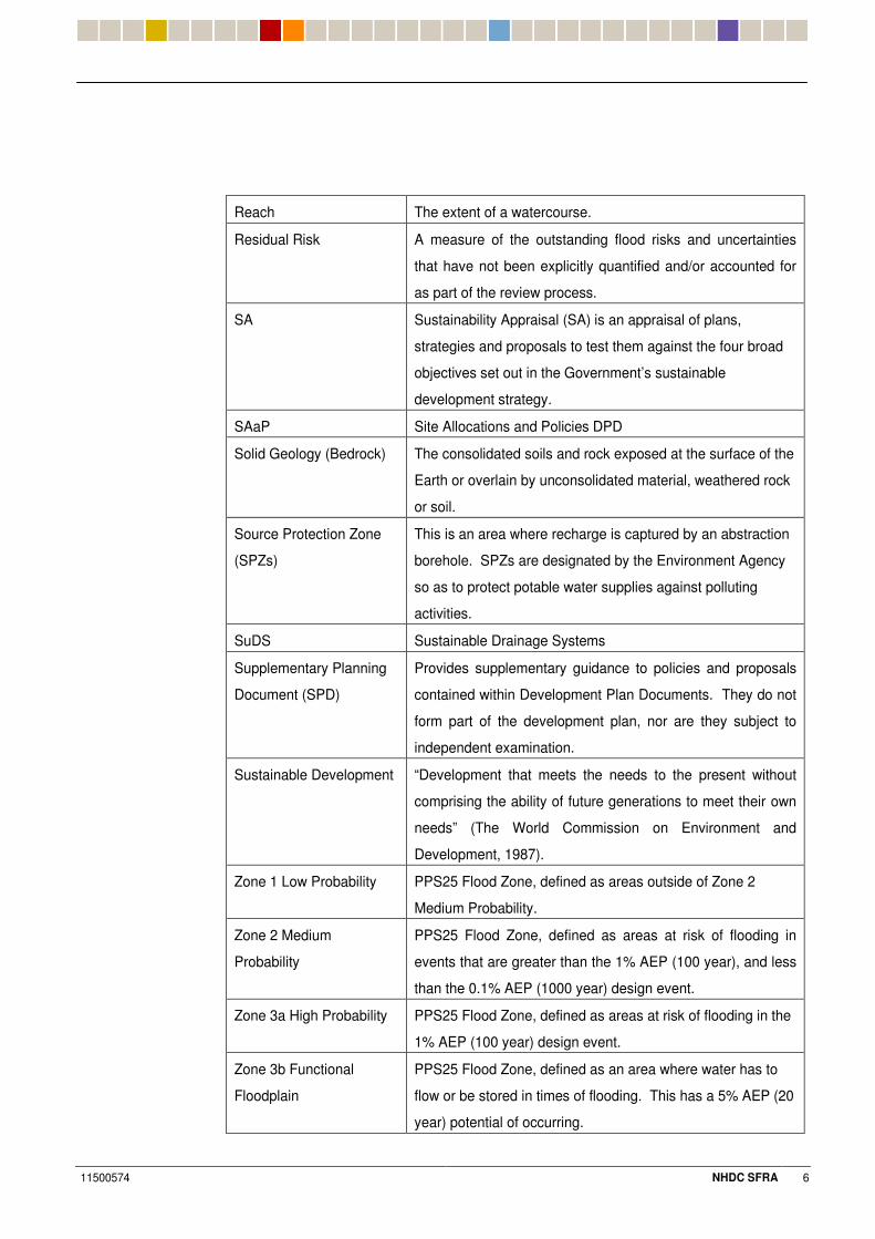
Reach The extent of a watercourse.
Residual Risk
A measure of the outstanding flood risks and uncertainties
that have not been explicitly quantified and/or accounted for
as part of the review process.
SA
Sustainability Appraisal (SA) is an appraisal of plans,
strategies and proposals to test them against the four broad
objectives set out in the Government’s sustainable
development strategy.
SAaP Site Allocations and Policies DPD
Solid Geology (Bedrock) The consolidated soils and rock exposed at the surface of the
Earth or overlain by unconsolidated material, weathered rock
or soil.
Source Protection Zone
(SPZs)
This is an area where recharge is captured by an abstraction
borehole. SPZs are designated by the Environment Agency
so as to protect potable water supplies against polluting
activities.
SuDS Sustainable Drainage Systems
Supplementary Planning
Document (SPD)
Provides supplementary guidance to policies and proposals
contained within Development Plan Documents. They do not
form part of the development plan, nor are they subject to
independent examination.
Sustainable Development
“Development that meets the needs to the present without
comprising the ability of future generations to meet their own
needs” (The World Commission on Environment and
Development, 1987).
Zone 1 Low Probability
PPS25 Flood Zone, defined as areas outside of Zone 2
Medium Probability.
Zone 2 Medium
Probability
PPS25 Flood Zone, defined as areas at risk of flooding in
events that are greater than the 1% AEP (100 year), and less
than the 0.1% AEP (1000 year) design event.
Zone 3a High Probability
PPS25 Flood Zone, defined as areas at risk of flooding in the
1% AEP (100 year) design event.
Zone 3b Functional
Floodplain
PPS25 Flood Zone, defined as an area where water has to
flow or be stored in times of flooding. This has a 5% AEP (20
year) potential of occurring.
11500574 NHDC SFRA 7
1 Introduction
#%# ������9����7'' ����B�������!����
1.1.1 A Strategic Flood Risk Assessment (SFRA) is a planning document that informs a broad variety of groups including the EA, Local Planning Authority and the general public on areas that may be prone to flooding from a broad variety of sources; this takes the potential impacts of climate change into consideration.
1.1.2 WSP Development and Transportation (WSP) have been commissioned by NHDC to undertake a SFRA of the district. The SFRA provides a reference and policy document for NHDC to help steer future development towards areas at low risk of flooding. This will be done through the LDF process. The SFRA will also provide the basis for applying the Sequential Test and Exception Test in the land allocation and development control process (See Sections 1.5 and 1.6 below).
1.1.3 This SFRA has been carried out with the co-operation and support of the Environment Agency (EA), Bedfordshire and River Ivel Internal Drainage Board (IDB), Anglian Water (AW), Thames Water (TW), Hertfordshire County Council (HCC), NHDC, and other local stakeholders. The Bedfordshire and River Ivel IDB is part of the Bedford Group of drainage boards.
#%& '/F���� ���
1.2.1 The objectives of this assessment are to:
� Ensure that NHDC fulfil their obligations under the current PPS25.
� Provide a reference and policy document to support the LDF process.
� Provide a reference and policy document to advise and inform private and commercial developers of their obligations under the PPS25.
#%+ ��'5��'���������� "�
1.3.1 The study has been carried out in two stages:
� Stage 1 which comprised the collection and review of baseline information necessary to carry out the SFRA;
� Stage 2 which focuses upon the identification and assessment of the principal sources of flood risk within the study area in relation to existing, proposed, and potential key development proposals.
1.3.2 The SFRA is essentially a planning tool. It is an assessment of flood risk intended to inform the spatial planning process and, therefore, the level of detail and accuracy should relate to this strategic objective.
#%. /��B9�'�� �
1.4.1 The district of North Hertfordshire lies within a key growth area of the UK and, in line with the Deposit Draft East of England Plan, may be required to accommodate 15,800 dwellings within the Plan period to 2021.
1.4.2 In order to plan for new development in a sustainable manner, NHDC will produce a Local Development Framework (LDF). The LDF contains Development Plan Documents (DPD) and Supplementary Planning Documents (SPD), which take account of the views of key stakeholders, sustainability issues and constraints to development. One such consideration is flood risk.
11500574 NHDC SFRA 8
#%0 ������G������7������
1.5.1 The Sequential Test as set out within Planning Policy Statement 25 aims to steer vulnerable development towards areas of lower flood risk; it is central to PPS25 and should be applied at all levels of the planning process. The Sequential Test should demonstrate whether there are more appropriate sites available in areas with a lower probability of flooding.
#%3 ��������5��'�������
1.6.1 PPS25 expands on the Sequential Test by incorporating an Exception Test, whereby if following the Sequential Test it is not possible or consistent with wider sustainability objects, for the development to be located in zones of lower probability of flooding, the Exception Test can be applied. For the Exception Test to be passed it must be demonstrated that;
1) the development provides wider sustainability benefits to the community that outweigh flood risk, informed by an SFRA where one has been prepared.
2) the development should be on developable, previously developed land or if it is not on previously developed land, that there are no reasonably alternative sites that are on previously developed land; and
3) the Flood Risk Assessment must demonstrate that the development will be safe, without increasing flood risk elsewhere, and where possible, will reduce flood risk overall.
#%$ ����'��7�57�����9�5'7��"�
1.7.1 Since 1988 the Government has been issuing national guidance in the form of Planning Policy Guidance Notes (PPG’s). Planning Policy Guidance Note 25 : ’Development and Flood Risk‘ (PPG 25), published in July 2001 by the Department of Transport, Local Government and the Regions (DTLR) specifically addressed Development and Flood Risk. Paragraph 27 stated:
Local Authorities should adopt a risk based approach to proposals for development in or affecting flood risk areas.
1.7.2 The Department for Communities and Local Government’s (DCLG) Planning Policy Statement 25: Development and Flood Risk (PPS25), replaced PPG25 in December 2006. Paragraph 6 sets out that Local Planning Authorities (LPAs) should prepare and implement planning strategies that help to deliver sustainable development by:
Appraising Risk
� Identifying land at risk and the degree of risk of flooding from river, sea and other sources in their areas;
� Preparing Strategic Flood Risk Assessments as freestanding assessments that contribute to the Sustainability Appraisal (SA) of their plans;
11500574 NHDC SFRA 9
Managing Risk
� Framing policies to the location of development which avoids flood risk to people and property where possible, and manage any residual risk, taking account of the impacts of climate change;
� Only permitting development in areas of flood risk when there are no reasonably available sites in areas of lower flood risk and benefits of the development outweigh the risks from flooding;
Reducing Risk
� Safeguarding land from development that is required for current and future flood management eg conveyance and storage of flood water, and flood defences;
� Reducing flood risk to and from new development through location, layout, and design, incorporating sustainable drainage systems (SUDS);
� Using opportunities offered by new development to reduce the causes and impacts of flooding eg surface water management plans; making the most of the benefits of green infrastructure for flood storage, conveyance, and SUDS; re-creating functional floodplain and setting back defences;
A Partnership Approach
� Working effectively with the Environment Agency, other operating authorities and other stakeholders to ensure that……plans are effective and decisions on planning applications can be delivered expeditiously; and
� Ensuring spatial planning supports flood risk management policies and plans, River Basin Management Plans and emergency planning.
1.7.3 PPS25 aims to reduce the risks to people and the built and natural environment from flooding by discouraging further built development within floodplain areas and by promoting best practice for the control of surface water runoff.
1.7.4 In line with best practice and the requirements of PPS25, NHDC have commissioned this assessment to define areas suitable for development and provide a reference and policy document for developers.
1.7.5 This study has been based upon PPG25, but has been updated to reflect the current guidance, PPS25, which was published in December 2006.
#%2 �����'����97�� �57���
1.8.1 The draft East of England plan sets out a draft spatial strategy that guides planning and development in the East of England over the next 20 years; Hertfordshire is one of the counties incorporated into this plan. North Hertfordshire, may be required to provide an additional 6,800 dwellings, and an additional 9,600 around Stevenage within the plan period up to the year 2021.
1.8.2 Policy SS14 (Development and Flood Risk) within this document promotes the use of SFRA’s to guide development away from floodplains, areas at risk of future flooding, or where development would increase the risk of flooding elsewhere.
11500574 NHDC SFRA 10
#%6 7'��7�57�����9�5'7��"�
North Hertfordshire District Local Plan
1.9.1 The ‘North Hertfordshire District Local Plan: No.2 with Alterations: Written Statement (April 1996) provides a framework for guiding and controlling changes within the area and seeks improvements within the environment.
1.9.2 Policy 50 of the Local Plan states:
The Council will not normally permit development proposals which would be likely to result in a significant risk of flooding. For works necessary to prevent an increase in flooding and possibly some distance away from the development, the impact on nature conservation, landscape and recreation will be considered.
1.9.3 Section 4.3 of the Local Plan goes on to state:
Land adjacent to a watercourse is liable to flood under certain conditions. Development on flood plains can put people and property at risk of flooding, reduce the capacity of the flood plain to store water and impede water flow. Also, development may worsen the risk of flooding downstream because the additional impermeable surfaces (such as roofs, roads and car parks) result in increased and rapid run-off. The Council will liaise and consult with the National Rivers Authority (NRA – Thames and Anglian Regions) and, where appropriate, seek measures to prevent an increase in the risk of damage to the river environment’
1.9.4 The Planning and Compulsory Purchase Act of 2004, brought in the system of Local Development Frameworks to replace Local Plans. Under the new system, policies in adopted local plans only remain valid for three years after the date of the Act, unless local authorities get permission from the Secretary of State to extend that period. North Hertfordshire District Council has not applied to extend that period for policy 50 and are relying on PPG25. The LDF will contain a policy on water resources which deals with flooding.
1.9.5 Assessment criteria for the release of sites taken from Section 6.5.5 of the ‘North Hertfordshire Housing Capacity Study: Final Report (May 2003)’ prepared by Halcrow, states that the provision of new development should:
� consider the capacity of the existing infrastructure to accommodate the development;
� be accompanied by a Flood Risk Assessment.
#%#8 �� ���9�����'���������!�����7'' �!���9�!����57���
1.10.1 The EA are currently preparing a Catchment Flood Management Plan (CFMP) for the River Great Ouse catchment. A large proportion of the NHDC study area falls within this catchment. This high level strategic plan will assess how flood risk might change and be sustainably managed over the next 50 to 100 years.
1.10.2 The plan sets out the EA’s commitment to implement flood risk reductions through working with other authorities, organisations and groups by the following means:
� Catchment wide hydrological studies - Develop a high level hydrological study for the River Great Ouse and its tributaries.
11500574 NHDC SFRA 11
� Liaise with planning authorities to make sure that brownfield sites within the floodplain are not automatically redeveloped.
� Liaise with planning authorities to ensure that update cycles of the Regional Spatial Strategy are used in order to take specific opportunities for flood risk management.
� Encourage rigorous planning control to restrict new development in the floodplain.
� Identify opportunities to reduce runoff from land use by decreasing levels of intensification.
� Continue to improve flood warning and emergency planning processes.
� Encourage environmental stewardship schemes to reduce flood risk to vulnerable areas.
� Undertake a study to investigate problems with surface water and sewer flooding and propose options for work to reduce this.
� Promote the use of sustainable drainage systems where appropriate.
� Increase flood awareness and education at a community level.
� Liaise with Department of Culture, Media and Sport (DCMS) to identify specific opportunities for flood risk management from planned Olympics 2012 developments.
11500574 NHDC SFRA 12
2 Study Area
&%# �����5��'��'����� "������
2.1.1 The District of North Hertfordshire occupies an area of approximately 375 square kilometres and is bounded by Mid Bedfordshire District to the north, South Cambridgeshire District to the north east, Uttlesford District in Essex to the east, East Hertfordshire District to the south east, Stevenage Borough to the south, Welwyn Hatfield District and St Albans District to the south west, and Luton Borough and South Bedfordshire District to the west. Refer to Appendix A for details of the extent of the NHDC boundary.
2.1.2 The study area incorporates Letchworth Garden City, together with the market towns of Hitchin and Baldock, and extensive rural areas throughout the Mimram valley, including the villages of Kimpton, Whitwell and Codicote. Land West of Stevenage, a significant potential urban expansion area, has also been incorporated into the study area. Refer to Appendix A for details of the extent of the study area.
2.1.3 Other parts of the district have been excluded from this study, at the request of NHDC, as there are no significant watercourses within these areas and where urban growth has not been planned.
2.1.4 The northern part of the study area is predominantly urbanised, comprising the three main towns listed within Section 2.1.2, whilst the remainder of the study area is rural, interspersed with a number of villages and hamlets.
&%& �'5'9��5�"�'��������� "������
2.2.1 North Hertfordshire occupies the upland area of the Chilterns scarp and chalk plateau. The general topography of the NHDC area is highly variable but, for the purposes of this study, can be split into distinct areas (see below). Refer to Ordnance Survey (OS) contour mapping provided within Appendix B.
� The western region of the NHDC area forms two distinct steep sided natural valleys which run from the western boundary of the NHDC area towards the southern boundary at Codicote Bottom, which are formed from three distinct ridge lines. The valley floors run from Lilley Bottom (110m AOD) through Whitwell (87m AOD) in a south easterly direction following the course of the River Mimram towards Kimpton Mill (77m AOD) and Codicote Bottom (74m AOD) in the south; and through Kimpton (86m AOD) towards Kimpton Mill. The ridge line to the north of the Mimram Valley runs from Great Offley (160m AOD) in the west to St Paul’s Walden (140m AOD) in the south east. Land either side of the Kimpton valley floor rises towards a ridge line running between Tea Green (158m AOD) in the west and Hoo End (135m AOD) in the south; and also towards higher ground to the west at Peters Green (147m AOD) and to the south at Ayot St Lawrence (126m AOD).
� From the Great Offley (160m AOD) to St Paul’s Walden ridge (140m AOD), land falls steadily in a northerly direction past Hitchin towards Ickleford (50m AOD).
11500574 NHDC SFRA 13
� The eastern half of the NHDC area is effectively bisected by a ridge running between the northern fringe of Great Ashby, Stevenage (146m AOD) in a north easterly direction through Weston Hills (145m AOD), and Clothall (148m AOD) towards Roe Green (150m AOD). Land to the north of the ridge falls steadily in a westerly direction towards Hitchin, in a north westerly direction through Letchworth Garden City towards Lower Wilbury Farm (69m AOD) and in a north westerly direction through Baldock towards Norton Bury (56m AOD). Land to the south of the ridge falls steadily in a southerly direction towards the Beane Valley.
&%+ �����5��'��'�� �����9�������!�����
2.3.1 There are two principal drainage catchments within the study area.
2.3.2 There is an intricate network of rivers and watercourses within the Baldock, Letchworth Garden City and Hitchin areas which drain predominantly in a northerly direction, eventually outfalling into the River Ivel to the north of the study area. The headwaters of the River Ivel are situated immediately to the north of Baldock. Refer to Watercourses Plan in Appendix C.
2.3.3 The watercourses within the River Ivel catchment, and within the study area, include the Pix Brook, the Rivers Purwell (including the tributaries of Ash Brook and Ippollitts Brook), Hiz (headwaters) and Oughton.
2.3.4 The Pix Brook flows in a northerly direction through Letchworth Garden City in a combination of culverted and open channel reaches, before heading in a northerly direction to Stotfold, then turning north west to its confluence with the River Ivel to the north of Church End village.
2.3.5 The River Purwell flows in a north westerly direction through the eastern side of Hitchin to its confluence with the River Hiz next to Grove Road, Hitchin. The River Purwell is fed by the predominantly groundwater fed Ash Brook and Ippollitts Brook, whose headwaters extend several kilometres to the south of Hitchin at Little Almshoe. Due to the nature of the local geology to the south of Hitchin, the River Purwell and its tributaries are also fed by subterranean hydrogeological connectivity emanating from Almshoe Bury swallow hole. This hydrogeological catchment extends several kilometres southwards to the west of Stevenage.
2.3.6 As part of the Environmental Impact Assessment (EIA) work undertaken by the developer of West of Stevenage development, the link between the swallow hole and the River Purwell was assessed. This was especially important as the West of Stevenage development will predominantly be drained by infiltration techniques. The EIA recognised that the hydrogeology in the area is extremely complex. It was concluded that the West of Stevenage development would not significantly impact upon the flows within the downstream River Purwell. However, long term monitoring will be required as part of the developer permission. It is recommended that any noted increase in flows in the River Purwell are acknowledged in site specific Flood Risk Assessments.
11500574 NHDC SFRA 14
2.3.7 The River Hiz flows from its headwaters to the south of Charlton, in a north easterly direction through central Hitchin, via a combination of culverted and open channel reaches, to its confluence with the River Purwell, then flows northwards to its confluence with the River Oughton at Ickleford. The Oughton serves a predominantly rural catchment to the west of Hitchin. The Hiz continues from Ickleford in a northerly direction towards its confluence with the River Ivel to the north east of Henlow.
2.3.8 The watercourse network for the area of Whitwell and Kimpton is dominated by the River Mimram, which flows in a south easterly direction from the headwaters to the north west of Whitwell to its outfall into the River Lea to the west of Hertford having flowed through Old Welwyn and to the north of Welwyn Garden City.
2.3.9 A groundwater-fed tributary of the River Mimram, the River Kim, is routed through Kimpton but is often dormant.
2.3.10 OS mapping indicates that land drainage and groundwater springs are the principal source of flow for the River Oughton, River Hiz (headwaters), Ash Brook, Ippollitts Brook, River Mimram, and River Kim, while urban surface water drainage flows are the principal source of flow for the Pix, Purwell, and the upstream headwaters of the River Ivel.
&%. � !��������� ��/'�� ������
2.4.1 The NHDC area crosses an EA administrative boundary. EA (Thames North East Region) cover the southern portion of the NHDC area from their Hatfield office. EA (Anglian Region, Central Area) cover the remaining majority of the NHDC area from their Brampton office.
2.4.2 The NHDC area also crosses a Water Authority administrative boundary which generally tallies with the landform and ridge lines described in Section 2.2. Thames Water administer the region to the south and west of the ridge. Anglian Water administer the region to the north of the ridge line. Refer to Appendix A for details.
2.4.3 Bedfordshire and River Ivel Internal Drainage Board (IDB) administer several drains and watercourses within the District, most notably Pix Brook. Refer to Watercourses Plan in Appendix C for location of Pix Brook.
11500574 NHDC SFRA 15
3 General Approach & Methodology
+%# �����'������
3.1.1 The data sources used in this assessment are listed below;
� EA publications and archive reports;
� Reports and studies by consultants;
� Hydraulic modelling data;
� Topographical survey data and OS mapping;
� Flood extent data;
� Flood defence and key asset information;
� Sewerage Undertaker asset records;
� Archive and Internet research;
� Local knowledge;
� Local Plan policy documents and urban growth studies.
+%& �55�'������ �!���' '7'9"�
3.2.1 This SFRA has been undertaken in accordance with the EA’s Standing Guidance for Strategic Flood Risk Assessments (March 2005), PPS 25 (Annex E), and Development and Flood Risk: A Practice Guide Companion to PPS 25 ‘Living Draft’ issued by the Department for Communities and Local Government. These documents set out the purpose and deliverables associated with the SFRA and these have been outlined below:
� Evaluation of the flood risk to potential development areas;
� Actual flooding extents within ‘high probability’ Flood Zone 3 to supplement the EA’s Flood Zone Maps;
� Addressing the estimated increase of surface water runoff from sites which have the potential to be developed;
3.2.2 Attention has been given to the future redevelopment of both greenfield and brownfield sites. The SFRA highlights the suitability of future growth directions and development proposals, with recommendations for mitigation, where applicable. The report also sets out general guidance on requirements for specific flood risk assessments for key areas of the district comprising proposed development sites within Letchworth Garden City, Hitchin, Baldock, Royston, West of Stevenage, and the Mimram Valley. In addition, the report also sets out the general criteria for the control and management of development generated surface water runoff.
3.2.3 Flood mapping has been produced to illustrate the extent of the flooding during the critical flood flows for the rivers and watercourses, based upon hydraulic modelling and EA Flood Zone Maps. Due to the nature of the catchment there are very few formal flood defences within the study area.
11500574 NHDC SFRA 16
+%+ �7�!��������9��
3.3.1 An allowance for climate change has been incorporated into the mapping to illustrate the potential increase in flood levels and water level rise within the study catchment to the threshold of 2115. PPS25 Annex B (Table B.2) recommends a peak river flow increase for the critical 1 in 100 year return period (1% annual probability) flood event of 20%, and is a figure widely accepted by the EA.
+%. 5'������7��'������'���7'' ��9�
3.4.1 The principal sources of flooding relevant to the study area include:
� Fluvial (river) flooding resulting from ‘out of bank’ flows from rivers and watercourses;
� Overtopping of flood defence structures including flood storage facilities;
� Breach (failure) of flood defences or flood alleviation schemes;
� Groundwater flooding, including groundwater-fed watercourses;
� Sewer flooding;
� Localised surface water flooding, including from highway drainage;
� Overland flow;
� Surface water runoff from future new development; and
� Drainage infrastructure including sewers, pumping stations, water mains etc.
3.4.2 Fluvial flooding is the dominant source of flood risk within the district and will clearly have the greatest influence upon land-use planning.
11500574 NHDC SFRA 17
4 Data Collection and Review (Stage 1)
.%# �7'' �>'���!�5��
4.1.1 The EA publish Flood Zone Maps (FZMs), showing areas potentially at risk of fluvial (river) flooding. The FZMs have been produced using reliable mapping and modelling data, where available. They are supplemented with data derived from national generalised modelling and appropriate reliable local data which conforms to the EA’s acceptable criterion. The nationally generalised modelling uses a Digital Terrain Model (DTM) which excludes the presence of man-made features such as flood defences, and road and rail embankments. Fluvial flood zone outlines were produced using a 2D raster floodplain model (Jflow) and show the probability of flooding without the presence of defences.
4.1.2 The modelling methodology used to produce FZMs excludes the presence of flood defences. However, in order to ensure that the extent of the Functional Floodplain is delineated, the FZMs also show the areas benefiting from defences that protect against the 1 in 100 year (1%) event. The FZMs show areas deemed to be at risk of flooding for the 1 in 100 year return period event (Flood Zone 3) and 1 in 1000 year return period event (Flood Zone 2) for all watercourses with a catchment area greater than 3km2 in the UK.
4.1.3 FZM data has been provided by the EA (Thames North East Region), in electronic format, for the River Mimram and by the EA (Anglian Region) for the remainder of the catchment. In the absence of detailed modelling information along the River Mimram and other watercourses, the EA have adopted a precautionary principal and therefore all Flood Zone 3 areas are classified as Functional Floodplain (3b). Under these circumstances, the aim of the Precautionary Principal is to look at the viable ‘worst case’ scenario when assessing development and flood risk.
4.1.4 Due to the steep sided nature of the river valleys within the NHDC area, the identified Flood Zones generally follow the routes of the main rivers with no significant off-setting i.e. the natural floodplains do not extend significantly away from the watercourses. There would appear to be no obvious deficiencies in the graphical representation of flood risk areas and the FZMs would appear to be fit for purpose.
4.1.5 FZMs provide the basis for the Sequential Test and assessment of flood risk in this study, except in areas where hydraulic modelling has been undertaken as part of the Stage 2 study.
.%& ����'�����7'' ��9�
Fluvial / Groundwater
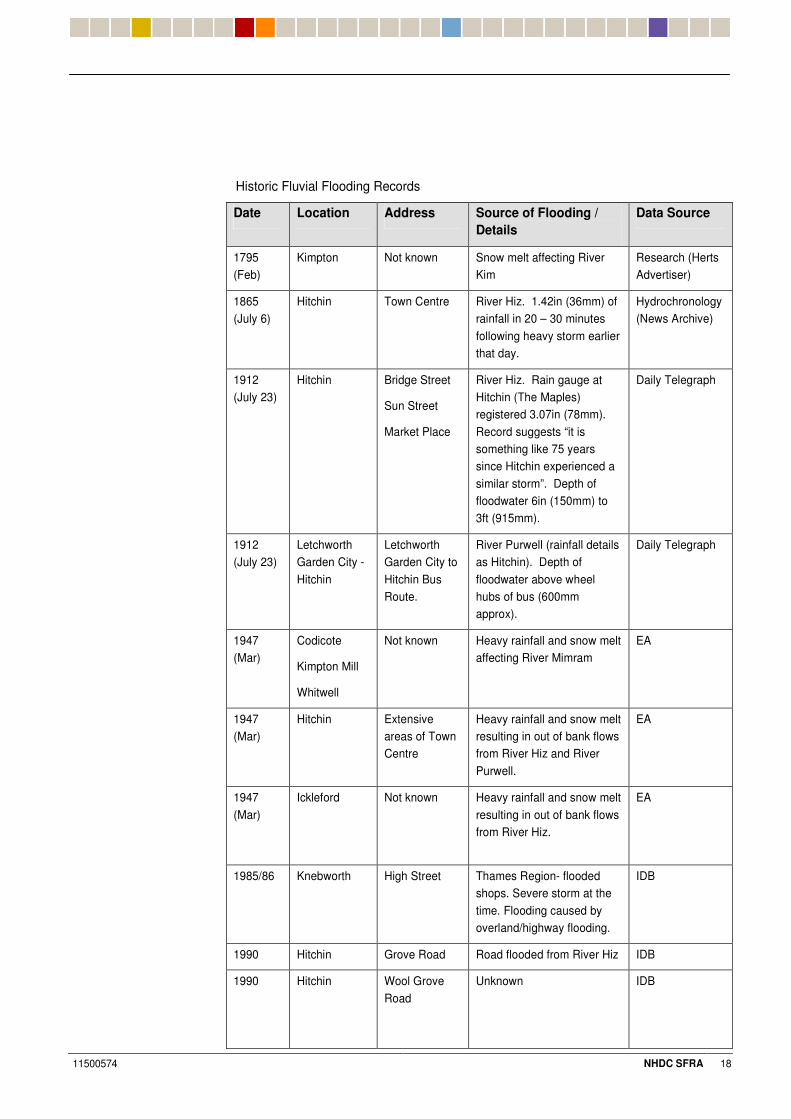
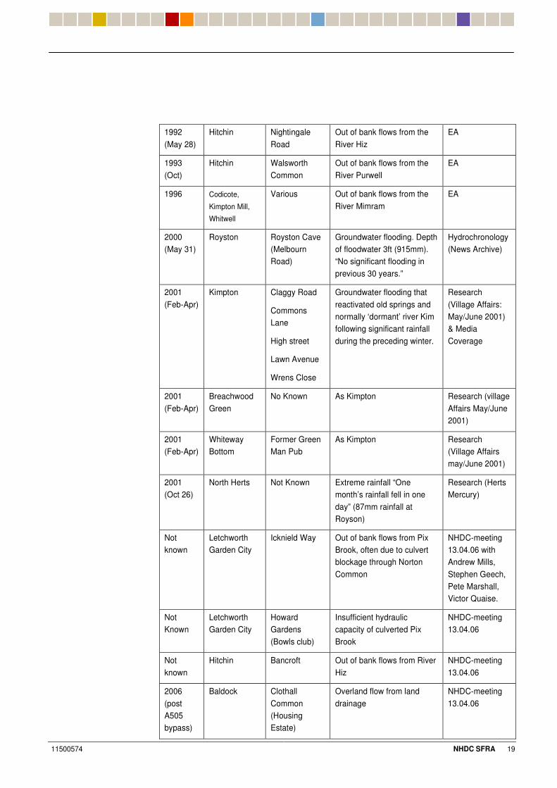
4.2.1 Historic flooding information has principally been obtained from desk studies and archive research. The Bedfordshire and River Ivel IDB has also provided some information. Historic fluvial flooding locations are provided in Appendix E.
4.2.2 Details of historic fluvial flooding records gathered during the Stage 1 study are summarised in the table shown on the next page:
11500574 NHDC SFRA 18
Historic Fluvial Flooding Records
Date Location Address Source of Flooding / Details
Data Source
1795 (Feb)
Kimpton Not known Snow melt affecting River Kim
Research (Herts Advertiser)
1865 (July 6)
Hitchin Town Centre River Hiz. 1.42in (36mm) of rainfall in 20 – 30 minutes following heavy storm earlier that day.
Hydrochronology(News Archive)
1912 (July 23)
Hitchin Bridge Street
Sun Street
Market Place
River Hiz. Rain gauge at Hitchin (The Maples) registered 3.07in (78mm). Record suggests “it is something like 75 years since Hitchin experienced a similar storm”. Depth of floodwater 6in (150mm) to 3ft (915mm).
Daily Telegraph
1912 (July 23)
Letchworth Garden City - Hitchin
Letchworth Garden City to Hitchin Bus Route.
River Purwell (rainfall details as Hitchin). Depth of floodwater above wheel hubs of bus (600mm approx).
Daily Telegraph
1947 (Mar)
Codicote
Kimpton Mill
Whitwell
Not known Heavy rainfall and snow melt affecting River Mimram
EA
1947 (Mar)
Hitchin Extensive areas of Town Centre
Heavy rainfall and snow melt resulting in out of bank flows from River Hiz and River Purwell.
EA
1947 (Mar)
Ickleford
Not known Heavy rainfall and snow melt resulting in out of bank flows from River Hiz.
EA
1985/86 Knebworth High Street Thames Region- flooded shops. Severe storm at the time. Flooding caused by overland/highway flooding.
IDB
1990 Hitchin Grove Road Road flooded from River Hiz IDB
1990 Hitchin Wool Grove Road
Unknown IDB
11500574 NHDC SFRA 19
1992 (May 28)
Hitchin Nightingale Road
Out of bank flows from the River Hiz
EA
1993 (Oct)
Hitchin Walsworth Common
Out of bank flows from the River Purwell
EA
1996 Codicote,
Kimpton Mill,
Whitwell
Various Out of bank flows from the River Mimram
EA
2000 (May 31)
Royston Royston Cave (Melbourn Road)
Groundwater flooding. Depth of floodwater 3ft (915mm). “No significant flooding in previous 30 years.”
Hydrochronology (News Archive)
2001 (Feb-Apr)
Kimpton Claggy Road
Commons Lane
High street
Lawn Avenue
Wrens Close
Groundwater flooding that reactivated old springs and normally ‘dormant’ river Kim following significant rainfall during the preceding winter.
Research (Village Affairs: May/June 2001) & Media Coverage
2001 (Feb-Apr)
Breachwood Green
No Known As Kimpton Research (village Affairs May/June 2001)
2001 (Feb-Apr)
Whiteway Bottom
Former Green Man Pub
As Kimpton Research (Village Affairs may/June 2001)
2001 (Oct 26)
North Herts Not Known Extreme rainfall “One month’s rainfall fell in one day” (87mm rainfall at Royson)
Research (Herts Mercury)
Not known
Letchworth Garden City
Icknield Way Out of bank flows from Pix Brook, often due to culvert blockage through Norton Common
NHDC-meeting 13.04.06 with Andrew Mills, Stephen Geech, Pete Marshall, Victor Quaise.
Not Known
Letchworth Garden City
Howard Gardens (Bowls club)
Insufficient hydraulic capacity of culverted Pix Brook
NHDC-meeting 13.04.06
Not known
Hitchin Bancroft Out of bank flows from River Hiz
NHDC-meeting 13.04.06
2006 (post A505 bypass)
Baldock Clothall Common (Housing Estate)
Overland flow from land drainage
NHDC-meeting 13.04.06
11500574 NHDC SFRA 20
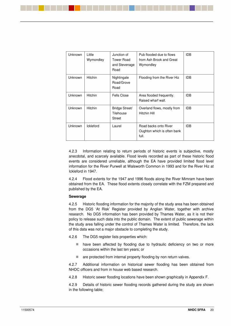
Unknown Little Wymondley
Junction of Tower Road and Stevenage Road
Pub flooded due to flows from Ash Brook and Great Wymondley
IDB
Unknown Hitchin Nightingale Road/Grove Road
Flooding from the River Hiz IDB
Unknown Hitchin Fells Close Area flooded frequently. Raised wharf wall.
IDB
Unknown Hitchin Bridge Street/ Tilehouse Street
Overland flows, mostly from Hitchin Hill
IDB
Unknown Ickleford Laurel Road backs onto River Oughton which is often bank full.
IDB
4.2.3 Information relating to return periods of historic events is subjective, mostly anecdotal, and scarcely available. Flood levels recorded as part of these historic flood events are considered unreliable, although the EA have provided limited flood level information for the River Purwell at Walsworth Common in 1993 and for the River Hiz at Ickleford in 1947.
4.2.4 Flood extents for the 1947 and 1996 floods along the River Mimram have been obtained from the EA. These flood extents closely correlate with the FZM prepared and published by the EA.
Sewerage
4.2.5 Historic flooding information for the majority of the study area has been obtained from the DG5 ‘At Risk’ Register provided by Anglian Water, together with archive research. No DG5 information has been provided by Thames Water, as it is not their policy to release such data into the public domain. The extent of public sewerage within the study area falling under the control of Thames Water is limited. Therefore, the lack of this data was not a major obstacle to completing the study.
4.2.6 The DG5 register lists properties which:
� have been affected by flooding due to hydraulic deficiency on two or more occasions within the last ten years; or
� are protected from internal property flooding by non return valves.
4.2.7 Additional information on historical sewer flooding has been obtained from NHDC officers and from in house web based research.
4.2.8 Historic sewer flooding locations have been shown graphically in Appendix F.
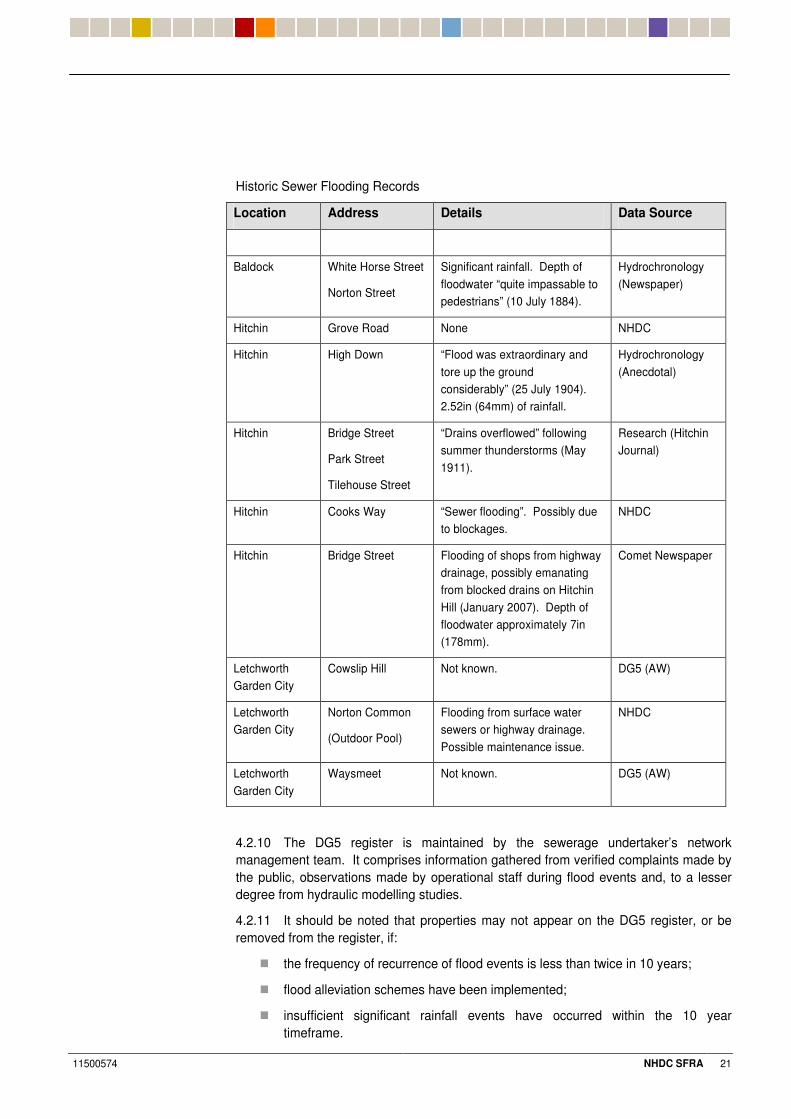
4.2.9 Details of historic sewer flooding records gathered during the study are shown in the following table;
11500574 NHDC SFRA 21
Historic Sewer Flooding Records
Location Address Details Data Source
Baldock White Horse Street
Norton Street
Significant rainfall. Depth of floodwater “quite impassable to pedestrians” (10 July 1884).
Hydrochronology (Newspaper)
Hitchin Grove Road None NHDC
Hitchin High Down “Flood was extraordinary and tore up the ground considerably” (25 July 1904). 2.52in (64mm) of rainfall.
Hydrochronology (Anecdotal)
Hitchin Bridge Street
Park Street
Tilehouse Street
“Drains overflowed” following summer thunderstorms (May 1911).
Research (Hitchin Journal)
Hitchin Cooks Way “Sewer flooding”. Possibly due to blockages.
NHDC
Hitchin Bridge Street Flooding of shops from highway drainage, possibly emanating from blocked drains on Hitchin Hill (January 2007). Depth of floodwater approximately 7in (178mm).
Comet Newspaper
Letchworth Garden City
Cowslip Hill Not known. DG5 (AW)
Letchworth Garden City
Norton Common
(Outdoor Pool)
Flooding from surface water sewers or highway drainage. Possible maintenance issue.
NHDC
Letchworth Garden City
Waysmeet Not known. DG5 (AW)
4.2.10 The DG5 register is maintained by the sewerage undertaker’s network management team. It comprises information gathered from verified complaints made by the public, observations made by operational staff during flood events and, to a lesser degree from hydraulic modelling studies.
4.2.11 It should be noted that properties may not appear on the DG5 register, or be removed from the register, if:
� the frequency of recurrence of flood events is less than twice in 10 years;
� flood alleviation schemes have been implemented;
� insufficient significant rainfall events have occurred within the 10 year timeframe.
11500574 NHDC SFRA 22
.%+ �'5'9��5����7� ����
LiDAR Data
4.3.1 LiDAR (Light Detection and Ranging) and NEXTMap SAR (Surface Model) data was only available from the EA for certain parts of North Hertfordshire. Sufficient data was obtained for Hitchin, Letchworth Garden City, Baldock, and surrounding areas in order to complement the Stage 2 hydraulic modelling and flood mapping.
4.3.2 The vertical tolerance of LiDAR data typically ranges between +/- 0.2m, whilst that of SAR data ranges between +/- 0.5m. This level of accuracy is often unsuitable for detailed hydraulic modelling, but is suitable for the assessment of overland flood routing where the gradient of the terrain is the key requirement.
Topographical Survey Data
4.3.3 Contour mapping data was provided by NHDC in digital format for the entire district.
4.3.4 A topographical survey of selected river channels was carried out as part of the Stage 2 Hydraulic Modelling. Areas covered included the Hiz, the Purwell the Oughton and a short section of the Pix Brook and the River Ivel (headwaters).
.%. ?��������������
4.4.1 The Watercourses & Hydraulic Structures Plans in Appendix C, provides details of the watercourses within the district.
.%0 �" ���7��������������
National Flood and Coastal Defence Database (NFCDD)
4.5.1 Details of hydraulic structures along the Mimram have been provided by the EA and incorporated into the study (see Appendix C).
4.5.2 Structure details from the EA’s NFCDD records for the River Mimram show a range of culverts and structure arrangements dotted along the Mimram Valley.
4.5.3 The NFCDD database is incomplete for Main River reaches, and does not include hydraulic structures along Ordinary Watercourses, land drainage, or under private ownership.
4.5.4 Detailed surveys of key hydraulic structures through Hitchin (River Hiz) and Baldock (River Ivel) that were used in the hydraulic modelling, have been shown in Appendix C.
4.5.5 A site walkthrough along the River Hiz, River Purwell, River Oughton, Ash Brook, St Ippollitts Brook, River Ivel and the Pix Brook was undertaken as part of the Stage 1 study in order to assess key hydraulic structures. Datasheets have been prepared for each hydraulic structure, comprising a photograph and key information relating to the location of the structure. This document is held separately to the SFRA by NHDC.
11500574 NHDC SFRA 23
.%3 �������9��7'' �5�'�����'��!��������
Flood Alleviation Schemes
4.6.1 During the 2001 floods in Kimpton, NHDC put temporary pumping stations in place to pump excess floodwater to the River Mimram. It has subsequently been confirmed that no permanent alleviation measures have been installed.
Flood Defences
4.6.2 Main River defence details have been provided by the EA.
Additional Feasibility Reports
4.6.3 ‘Pre-feasibility Study: Flood Protection: Hitchin (February 2004)’ prepared by Mott MacDonald, incorporates feasibility work investigating the provision of flood mitigation schemes to protect areas of Hitchin.
4.6.4 The report states that a number of properties in Hitchin do not have the indicative standard of protection of 1 in 25 years (in 2003). Various flood mitigation options were proposed. These have been assessed as part of the Stage 2 study so as to review the current standard of protection offered.
.%$ �" ���7���!' �7��
Previous Studies: Hitchin
4.7.1 The EA’s existing hydraulic model of the River Hiz and River Purwell was produced by Mott MacDonald as part of the ‘Pre-feasibility’ study for Hitchin highlighted earlier.
4.7.2 The modelled reach extends along a short length of the River Purwell downstream of the A505 Cambridge Road Bridge to the confluence of the River Hiz, and along the River Hiz to Ickleford Common, a total length of 5.4km.
4.7.3 The aim of the hydrological modelling was to derive flood hydrographs as inflows to the hydraulic model for the design events: 1 in 2, 1 in 5, 1 in 10, 1 in 25, 1 in 50, 1 in 75, 1 in 100 and 1 in 150 year return periods.
4.7.4 The hydrological model was calibrated against the recorded data at Arlesey gauging station (NGR 5190 2379) located at the downstream end of the modelled reach for six historical events.
4.7.5 The hydraulic model was built using the topographic data surveyed in 1993 for the main channel. LiDAR data had been used to define the floodplain and, with modelling information, to define the flood envelopes.
4.7.6 Following an in house review of the ‘Pre-feasibility Study’ model data, it was deemed to provide a fair data source as it is has been validated against gauging station data and historic events, however, it covers a relatively short reach of the River Hiz and a short reach of the River Purwell.
4.7.7 Significant tributaries such as the River Oughton, Ippollitts Brook, Ash Brook, upper reaches of the River Purwell, together with the predominantly culverted reach of the Hiz through the town are represented as inflows were not modelled.
4.7.8 No allowance for climate change impacts had been made within the existing River Hiz model.
11500574 NHDC SFRA 24
4.7.9 Mott MacDonald have recently undertaken a study to ensure that the information provided in the Hitchin ‘Pre-feasibility study’ is in a suitable format to be incorporated into the National Flood and Coastal Defence Database (NFCDD) and that the quality of the information in this study is in line with the latest standards established by the EA for flood mapping and modelling studies. The main aim though, was to investigate the accuracy of the 100 year flood extents.
4.7.10 The Mott McDonald study assessed the accuracy of the 100 year flood extents in Hitchin and determined that the topographical, hydrological and hydraulic model data used in the Hitchin Pre-feasibility study agreed with the latest standards established by the EA for flood mapping and modelling studies. It was also found that the updated flood outline does not vary significantly from the original and that there were no areas benefiting from defences.
Existing Studies: Other
4.7.11 No other hydraulic models were identified within the study area.
4.7.12 As previously stated, all areas that do not have detailed hydraulic modelling and are shown on the EA flood maps as zone 3a, are re-classified as flood zone 3b (Functional Floodplain) based on the precautionary principle. Under these circumstances, the aim of the Precautionary Principal is to look at the viable ‘worst case’ scenario when assessing development and flood risk.
.%2 ��?���9�����������������
Sewer Records
4.8.1 Sewer records and network plans for both the Thames and Anglian Water regions, are held by NHDC Building Control; they were viewed to see the extent and layout of the public sewerage network, and to assess the likely impact of future growth upon the system.
.%6 9�'7'9"@��" �'9�'7'9"�:��� ��'�!����
Geological Maps
4.9.1 British Geological Survey (BGS) maps were reviewed as part of the SUDS viability assessment (refer to section 5.12).
4.9.2 The BGS 1:50,000 Solid and Drift edition, sheet 221 for Hitchin has been consulted to give the geological summary of the site area. The area is underlain by the Upper, Middle and Lower Chalk formations with several areas to the north west of the study area having the Lower and Middle Chalk formations exposed. The Upper Chalk is exposed in the centre of the site just north of Stevenage and locally to the south west. The drift deposits are more varied across the site and are dominantly deposits from the Anglian Glaciation. These comprise predominantly chalky sand and gravels and a chalky sandy, gravelly clay. Tables 5.1 and 5.2 in Section 5.12 give a general description of each of the strata encountered in the study area and of the strata’s drainage potential.
4.9.3 Several channel features run through the area predominantly running north west to south east approximately through Hitchin town centre. These channels are recorded as being up to 100+m deep in certain locations and a maximum of 2km and minimum of 100m across and are comprised of a combination of glaciolacustrine, glaciofluvial and till deposits.
11500574 NHDC SFRA 25
Source Protection Zone Maps
4.9.4 Source Protection Zone (SPZ) boundaries, in electronic GIS compatible format, were provided by the EA for both the Anglian and Thames North East regions.
Hydrometric Data
4.9.5 Historic monthly data records for two borehole gauges within the NHDC study area (Heath Farm and Hyde Hall Farm) were provided by the EA for review during the Stage 2 study as part of the SUDS viability assessment.
Almshoe Bury Swallow Hole
4.9.6 Investigations into the hydrogeological connectivity between Almshoe Bury swallow hole, and the Ash Brook / Ippollitts Brook / River Purwell via an underground flow path were undertaken as part of the West of Stevenage development proposal. This information was considered by the consultants.
4.9.7 Further data is required in relation to the extent of the groundwater-fed drainage catchment to the west of Stevenage and the corresponding impact upon the Ash Brook / Ippollitts Brook / River Purwell and the downstream River Hiz for a variety of development scenarios for West of Stevenage, and from climate change impacts.
4.9.8 As part of the planning consent for the West of Stevenage development an ongoing monitoring system will be implemented to assess any impact of the West of Stevenage development upon flows within the River Purwell. Any resulting increase in flow would need to be taken account of in any future development related FRA.
4.9.9 Recent information provided by HR Wallingford to the EA describe high groundwater levels in the chalk and overlying drift aquifers at the Almshoe Bury Swallow Hole, and the point where the Ippolitis Brook emerges; these reports have been provided as baseline conditions to assess the impact of any proposed development. The highest groundwater levels are found on the interfluve between the Ippolitis and Mimram valleys. Groundwater flow is generally from South to North, but is locally more complicated, due to the presence of buried chambers.
Contaminated Land Issues
4.9.10 Contaminated land issues were discussed with officers of NHDC in preparation for the SUDS viability assessment. It was subsequently agreed with the Contaminated Land Officer that due to the wide scattering of potential ‘hotspots’, the ongoing release of new studies and data, together with the sensitive nature of this type of information, it was prudent to assess SUDS viability independently of this datum source, but make reference to its presence as a consideration of overall SUDS viability. It is recommended that any development site being brought forward through the planning process, assesses the viability of SUDS on a site by site basis taking into account underlying ground conditions.
Ecological Issues
4.9.11 General principles, requirements, and criteria for the provision of ecological and landscaping buffers and SUDS within development proposals were discussed with NHDC.
11500574 NHDC SFRA 26
Archaeological Issues
4.9.12 No specific details were provided in relation to archaeological sites as part of the study.
.%#8 �7'' �?�����9�:��!��9���"�57�����9�
4.10.1 Within the NHDC area, as elsewhere in England, the responsibility for flood warning rests primarily with the EA. The EA provides flood warnings for designated Flood Warning Flood Risk Areas; the areas covered by these warnings can be viewed on the EA’s website.
4.10.2 NHDC complies with the Civil Contingencies Act by the use of a generic public and more detailed staff emergency plan. To support this approach, more detailed plans have been produced for specific risks such as flooding, where a detailed flood plan is used. This plan takes the form of a Hertfordshire Resilience document used across the county by all Hertfordshire Resilience members. In addition, NHDC has recognised the risk of flooding and now has a dedicated Severe Weather Team available to lead the NHDC response on any flooding emergencies.
4.10.3 All NHDC and Hertfordshire Resilience plans are updated on a regular basis and it is the intention of the council to update the public, staff and flood plans during 2008 in light of this Strategic Flood Risk Assessment.
4.10.4 Previously identified flood risks will be revised to ensure all known risks are included with special note of vulnerable locations and groups. Planning arrangements can then be considered by the NHDC Severe Weather Team, reporting any training and planning needs to the NHDC resilience group for action.
.%## � �7'5!����������
Local Plan / Proposals Map
4.11.1 A copy of the ‘North Hertfordshire District Local Plan: No.2 with Alterations : Written Statement (April 1996)’ has been reviewed along with Proposals Maps for the district.
Urban Capacity Study
4.11.2 A copy of the ‘North Hertfordshire Housing Capacity Study: Final Report (May 2003)’ prepared by Halcrow on behalf of NHDC has been reviewed. The document indicates housing numbers across study area centres. The study was updated in November 2006.
Growth Areas
4.11.3 In line with the Secretary of State’s Proposed Modifications to the East of England Plan, NHDC may be required to accommodate 6,200 dwellings, plus a further 9,600 adjoining Stevenage, within the plan period to 2021. The provision of additional housing within North Hertfordshire may be split according to the following shown on the next page:
11500574 NHDC SFRA 27
Growth Area No. of proposed dwellings (approx)
Adjoining Stevenage 8,000
Urban Capacity 6,800
Greenfield 1,000
4.11.4 Within the Milton Keynes and South Midlands Sub Regional Strategy (MKSMSRS) a site has been reserved for 3,000 dwellings at East of Luton (Tea Green). Due to its potential impact upon fluvial flood risk to the River Mimram catchment from surface water runoff or groundwater recharge, the Tea Green site has been considered as part of the Stage 2 study.
4.11.5 Potential LDF growth directions as defined by NHDC have been shown in Appendix G.
4.11.6 Sufficient information on potential development and growth areas was available to assess its impact upon flood risk and capacity of local sewerage infrastructure.
.%#& ���B��'7 ������'�!���'��
North Hertfordshire District Council
4.12.1 The consultants met NHDC officers from: Planning, Engineering, Contaminated Land, Parks and Leisure, Emergency Planning and Land Drainage.
Environment Agency
4.12.2 A meeting was held with the EA to establish contact and to set out a schedule of data requirements. There has been extensive liaison with the EA over matters of relevant data.
4.12.3 Meetings were held with Anglian Water and Thames Water to gather data on sewerage capacity and the likely impacts of future growth upon strategic sewerage infrastructure.
Other Stakeholders
4.12.4 Contact was made with the Clerk of the Parish Councils for Whitwell and Kimpton in order to obtain further historic and anecdotal information relating to the most recent significant floods in 2001.
Records Search
4.12.5 A variety of other data sources were investigated as part of the Stage 1 study. These included:
� Hitchin Historical Society
� Hitchin Forum
� Hitchin Geological Society
� Hitchin Museum
� Hydrochronology Database
� Local Libraries (Hertford and Letchworth Garden City)
11500574 NHDC SFRA 28
� Website Search
� Media (Anglia TV)
.%#+ �� ��?�'�� ����
Limitations of the Stage 1 Study
4.13.1 The Stage 1 report provides a review of baseline information collected to carry out the SFRA. It does not identify and assess the principal sources of flood risk in the study area in relation to existing, proposed, and potential key development proposals.
Hydraulic Models
4.13.2 The EA’s existing hydraulic model of the River Hiz is deemed to be a reliable data source as it has been validated against gauging station data (albeit limited) and historic events. However, it covered a relatively short reach of the River Hiz and a short reach of the River Purwell. Significant tributaries such as the River Oughton, Ippolitts Brook, Ash Brook, upper reaches of the River Purwell, together with the reach of the Hiz through Hitchin were represented as inflows and have not been modelled.
4.13.3 No allowance for climate change had been made within the existing River Hiz model.
4.13.4 No other catchments within the study area had been modelled.
.%#. ���'!!�� ���'���
Hydraulic Modelling
4.14.1 Due to the potential for significant development West of Stevenage, and the potential expansion of Hitchin, understanding the hydraulic performance of the River Hiz and it’s tributaries was considered important for making technical judgements about the location of development.
4.14.2 In order to predict potential overland flood flow routes through Hitchin with greater certainty, it was recommended that the existing ISIS model be supplemented with channel data and topographical data for the currently unmodelled tributaries, and be converted to a TUFLOW model where overland flow routes were deemed likely to occur i.e. the culverted section of the Hiz (Headwaters).
4.14.3 Due to the topography around the Pix Brook north of Letchworth Garden City there appeared to be little need for detailed hydraulic modelling of that watercourse. As no growth was being proposed north of Baldock, no modelling was proposed for the River Ivel. There was deemed a need, however, to establish the impact of climate change upon the Flood Zone Maps at both locations by producing a basic hydraulic model representation at surveyed cross-sections through each river corridor, and applying the respective Flood Estimation Handbook (FEH) 1 in 100 year flood flows (incorporating climate change), to assess the revised flood extents.
4.14.4 Data on groundwater flooding and historical records for the River Mimram and River Kim were adequate. Flow paths were found to be largely defined by the steep topography. No further hydraulic modelling was considered necessary. As with the Pix Brook and River Ivel catchments, the impact of climate change will be quantified by overland flow assessment rather than by detailed hydraulic modelling.
11500574 NHDC SFRA 29
Topographical Data
4.14.5 In order to update and enhance the hydraulic model of the River Hiz and its tributaries, the accuracy of the topographical (LiDAR) data used as part of the previous modelling work for Hitchin was checked against current LiDAR data. The current data was obtained from the EA’s Twerton office; this was supplemented and enhanced where appropriate.
Hydrogeology
4.14.6 Further data was deemed to be required in relation to the extent of the groundwater-fed drainage catchment to the west of Stevenage and the corresponding impact upon the downstream River Hiz and its tributaries for a variety of development scenarios for West of Stevenage.
4.14.7 The connectivity between the drainage catchment serving East of Luton and the River Mimram catchment was also deemed worthy of investigation as part of the Stage 2 study.
.%#0 ��������9��#���!!��"�
4.15.1 Enough information was available, for sufficient areas of the study catchment to proceed to the Stage 2 assessment.
4.15.2 In order to complete the Stage 2 assessment, further areas highlighted for investigation (as set out in Section 4.14) were undertaken.
4.15.3 For details of the hydraulic modelling of the River Hiz and tributaries, River Ivel, and Pix Brook, refer to the following supplementary document:
� North Hertfordshire Strategic Flood Risk Assessment: Hydraulic Modelling Note: prepared by WSP (2008).
4.15.4 The principle outputs for the land-use allocation process were:-
� Definition of functional floodplain (Food Zone 3b)
� Definition of refined 1 in 100 year (Flood Zone 3a) and 1 in 1000 year (Flood Zone 2) flood outlines
� Definition of the 1 in 100 year flood outline incorporating climate change impacts.
4.15.5 Hydraulic modelling has been produced to inform the Council’s land allocations, and will need to be supplemented by further studies and more detailed assessment as part of any future site specific FRA’s.
11500574 NHDC SFRA 30
5 Strategic Flood Risk Assessment (Stage 2)
0%# ' �� ��?�
5.1.1 This Strategic Flood Risk Assessment (SFRA) gives, as its name implies, a strategic overview of flood risk in the District of North Hertfordshire. It should be noted that:
� this SFRA reflects current national planning policies and guidance at the time of writing;
� these policies and guidance may change; and
� flood levels / flood zone classifications may be reviewed over the lifetime of the development.
0%& �����'77����'��
5.2.1 The Stage 1 study identified several areas requiring further investigation and additional data to be collected in order to complete the Stage 2 assessment.
LiDAR Data
5.2.2 Additional LiDAR information (in filtered and unfiltered formats) has been obtained from the EA’s Twerton office to complement the Stage 2 hydraulic modelling study and generate a flood outline.
5.2.3 Limited gauging station data was obtained from the EA (Thames North East) for the River Hiz at Biggin Lane. Suitable data was identified and utilised, where appropriate, for auditing of the River Hiz hydraulic model.
5.2.4 Plans showing the assumed extent of the 1947 historic flood in Hitchin were used for reference, as part of the Stage 2 assessment.
Hydraulic Modelling 5.2.5 In line with recommendations made within the Stage 1 report, detailed hydraulic modelling of the River Hiz and its tributaries was undertaken, to establish the extent of floodplains, overland flow routes and to assess the impact of climate change.
5.2.6 Both InfoWorks RS and ISIS software have been used in this study. Where a greater extent of overbank flooding is expected, InfoWorks RS has been used (e.g. River Hiz and its tributaries). Using a 1D modelling approach is considered adequate for the level of detail required in a Stage 2 SFRA.
5.2.7 Supplementary hydraulic modelling using ISIS river modelling software was undertaken for the headwater reaches of the River Ivel and Pix Brook, due to the small amount of overbank flooding within these two catchments; this was undertaken to establish floodplain extents more accurately, and to assess the impact of climate change.
5.2.8 Modelled flood outlines generated from the study, for a suite of flood return periods, have been provided within Appendix E.
5.2.9 The methodology and outputs of the hydraulic modelling, are contained in a separate report entitled:
� North Hertfordshire District Council- Strategic Flood Risk Assessment, Hydraulic Modelling Report (WSP 2008).
11500574 NHDC SFRA 31
5.2.10 Assessments of the flood risks from each watercourse have been based on the results of the hydraulic modelling, supplemented by historic data and professional experience, where appropriate. Refer to Sections 5.4 – 5.8 of this report for further information.
Flood Alleviation Schemes
5.2.11 Outline details of the Pix Brook Flood Storage Reservoir and Flood Gates, situated on the Pix Brook adjacent to Letchworth Garden City Sewage Treatment Works were provided by the Bedfordshire and River Ivel Internal Drainage Board (IDB).
5.2.12 The EA confirmed that outline flood alleviation scheme options, identified in the Mott MacDonald ‘pre feasibility’ study of the River Hiz and Purwell, have not been implemented.
Hydraulic Structures
5.2.13 Details of monthly grille inspections were obtained from NHDC. This schedule listed several key hydraulic structures within the district that:
� are prone to blockage or siltation; or
� have grille screens that are prone to ‘blinding’ with debris; or
� where the consequences of blockage / ‘blinding’ are significant in terms of flooding of property or key infrastructure.
Sewerage Infrastructure
5.2.14 Discussions with Anglian Water and Thames Water outlined the likely impact of growth in the area and provided an insight into future strategic plans.
5.2.15 Site visits to both Hitchin and Letchworth Garden City Sewage Treatment Works were undertaken to assess the space for future expansions.
5.2.16 Liaison with local Sewage Treatment Works managers also provided an insight into the operational capacity of each facility.
5.2.17 Reference was made to the East of England Sewerage Capacity Study prepared by Halcrow in conjunction with Anglian Water (2006).
Almshoe Bury Swallow Hole
5.2.18 Technical reports prepared by HR Wallingford, as part of the West of Stevenage development proposal, relating to the hydrogeological connectivity in the area were provided by NHDC and reviewed as part of the Stage 2 assessment. These reports provided a technical insight into the complicated hydrogeological characteristics of the swallow hole which is still not fully understood. This information is important for understanding the hydrology and flood risk issues relating to Ippollitts Brook and potential development areas west of Stevenage.
Contaminated Land
5.2.19 Details of potential contaminated land sites held by NHDC were viewed to assist with the assessment of the viability of sustainable drainage systems (SUDS). Generic statements have been made as part of the SUDS viability work on contaminated land issues.
11500574 NHDC SFRA 32
Media
5.2.20 Archive footage of the flooding event at Kimpton in 2001 was obtained from Anglia TV to assist with the assessment of flood risks associated with the River Kim.
5.2.21 A copy of an episode from a television series entitled ‘Secret Rivers’ was obtained in order to assist with the hydraulic modelling and assessment of flood risks associated with the River Ivel.
0%+ �7'' ����B�������!����
5.3.1 A strategic assessment of the principal sources of flood risk within the district has been made, based on the data collected within the Stage 1 and Stage 2 studies. The sections below set out the findings from the Stage 2 assessment for each fluvial (river) catchment, highlighting the likely constraints to future development growth arising from the alternative flood risk sources, management and control of surface water runoff, and in terms of sewerage infrastructure. The flood mapping relating to the new hydraulic modelling is provided in Appendix E.
5.3.2 Strategic flood mitigation opportunities have been identified, along with ways in which residual flood risks may be managed, either strategically or on a site specific basis, as appropriate.
0%. !' �77� ��7� ��7��7'' ����B�<�� �����>�:����/�������=�
��*�����A�
Flood Risk Issues
5.4.1 Predicted flooding along the River Hiz is generally limited to localised areas along its predominantly culverted upstream headwaters. Predicted flooding is generally constrained close to the natural channel towards the north of the town and around Ickleford, mainly due to throttling of flows and impounding of floodwater within upstream tributaries.
5.4.2 Within the upstream headwaters of the River Hiz, floodwater is predicted to be impounded between Charlton and the A602 (Park Way) due to the effects of hydraulic structures. The predicted flood envelope extends to a width of over 50m. Floodwater is also predicted to be impounded upstream of Hitchin Priory towards the headwaters of the Hiz within a ‘leat’, which is an artificial water body.
5.4.3 A further predicted flooding location lies at the junction of Tilehouse Street and Bridge Street (Hitchin). Culvert structures beneath Bridge Street, coupled with intricate weir and sluice arrangements at Hitchin Priory provide hydraulic throttles which result in extensive backwater effects. Existing commercial properties are predicted to be at risk of flooding.
5.4.4 Through Hitchin Town Centre, floodwater is predicted to progress out-of-bank from the watercourse at Bridge Street, Portmill Lane, between Hermitage Road bridge and Hazelwood Close, at Bancroft, and Grove Road bridge, flowing overland from a number of upstream culvert inlets generally in a northerly direction.
5.4.5 The principal predicted flooding location along the River Hiz (headwaters) lies at the junction of Grove Road and Bancroft. Existing properties along Grove Road and Florence Street and their rear gardens are predicted to be at risk of flooding for the 1 in 20 year event or greater. Further downstream, culvert structures beneath the railway
11500574 NHDC SFRA 33
embankment provide hydraulic throttles which result in extensive backwater effects. Low-lying areas of recreational land off Grove Road are predicted to be at risk of flooding for the 1 in 20 year event or greater.
5.4.6 From its confluence with the River Purwell, land adjacent to the railway is predicted to be at risk of flooding upstream of Grove Road due to the effects of a weir arrangement at Grove Road. Further flooding is predicted across low-lying land adjacent to Hitchin Sewage Treatment Works, and across the adjacent allotment gardens off Old Hale Way. Flood extents around Ickleford are less extensive than expected due to the significant throttling and impounding of floodwater within upstream tributaries of the River Hiz.
5.4.7 Predicted flooding locations correlate well with historic flooding associated with the River Hiz.
5.4.8 Predicted flood outlines for the Hiz have been generated based upon culvert structures and grille screens remaining in relatively good order of repair and clear of debris. Partial or full blockage of culvert inlet structures, coinciding with a significant rainfall event, would extend flood outlines beyond those shown in Appendix E thus placing further commercial and residential property, and people, at risk of flooding.
5.4.9 Property damage is likely where there is flooding from hydraulic structure ‘failure’ along the River Hiz (Headwaters).
��*���5��; ����
Flood Risk Issues
5.4.10 Predicted flooding along the River Purwell is extensive but generally constrained to the meadows, common and recreational land running through the eastern side of Hitchin. Predicted flood outlines are heavily influenced by hydraulic structures and channel arrangements associated with the former Mill.
5.4.11 In Hitchin, floodwater is predicted to progress out-of-bank along the majority of the River Purwell, across the functional floodplain downstream of the disused Purwell Mill, across Purwell Meadows and adjacent to Walsworth Common. The predicted flood envelope extends to a width of over 150m between Chaucer Way and Purwell Lane and to over 200m between Walsworth Common and Woolgrove Road.
5.4.12 The principal predicted flooding locations along the River Purwell lie either side of the A505 Cambridge Road. Culvert structures beneath the railway embankment and Cambridge Road provide hydraulic throttles which result in extensive backwater effects. Numerous existing properties off Woolgrove Road and Green Lane are predicted to be at risk of flooding, along with low-lying areas of Walsworth Common and Purwell Meadows.
5.4.13 The current level of protection offered to existing property and land adjacent to Walsworth Common from flooding appears to be marginally in excess of 1 in 20 years.
5.4.14 Predicted flooding locations correlate well with historic flooding associated with the River Purwell.
5.4.15 The same issues relating to blocked culverts and flooding along the River Hiz as set out in section 5.4.8 applies to the River Purwell.
11500574 NHDC SFRA 34
��*���'�������
Flood Risk Issues
5.4.16 Predicted flooding along the River Oughton is significant but generally constrained to the Oughtonhead Common and recreational land to the west of Hitchin. Predicted flood outlines are heavily influenced by hydraulic structures and channel arrangements associated with the former mill.
5.4.17 Floodwater is predicted to progress out-of-bank along the majority of the River Oughton, in particular across the functional floodplain through Oughtonhead Common, and between Westmill Farm and Old Hale Way. At this point the predicted flood envelope extends to a width of approximately 250m.
5.4.18 Weir, sluice and culvert structures adjacent to Westmill Lane and Old Hale Way provide hydraulic throttles which result in extensive backwater effects. Low-lying areas adjacent to the watercourse are predicted to be inundated for the 1 in 20 year event but no existing properties are predicted to be at risk of flooding.
5.4.19 The current level of protection offered to existing property and land adjacent to the River Oughton from flooding appears to be in excess of 1 in 100 years, including an allowance for climate change.
5.4.20 Predicted flooding locations correlate well with historic flooding associated with the River Oughton.
5.4.21 Predicted flood outlines for the River Oughton have been generated based upon weir, sluice and culvert structures remaining in relatively good order of repair and clear of debris. Partial blockage of structures coinciding with a significant rainfall event could extend flood outlines beyond those shown in Appendix E thus placing residential and commercial property, and people, at risk of flooding. The likely consequences of flooding from hydraulic structure ‘failure’ along the Oughton are low in terms of property damage but reliance should still be placed upon maintenance of key hydraulic structures. This should be considered as a residual risk and assessed within any site specific FRA.
�
11500574 NHDC SFRA 35
�,,��������/�����:�����/�����
Flood Risk Issues
5.4.22 Predicted flooding along the Ippollitts Brook and Ash Brook are generally constrained close to their natural channels for the majority of their reaches. Predicted flood outlines are heavily influenced, however, by the hydraulic structure beneath the railway embankment.
5.4.23 Floodwater is predicted to progress out-of-bank along the majority of the Ippollitts Brook as the capacity of the river channel is very limited. The predicted flood envelope extends to a width of over 80m adjacent to Sycamore Close (Hitchin), but is largely constrained from progressing further by the local topography.
5.4.24 The principal predicted flooding location along Ippollitts Brook lies at its confluence with Ash Brook, immediately upstream of the railway embankment. The brick arch culvert beneath the railway provides a significant hydraulic throttle which results in extensive backwater effects. Numerous existing properties along Nine Springs Way and Brook View (Hitchin) are predicted to be at risk of flooding, along with large areas of adjacent open farmland.
5.4.25 The current level of protection offered to existing property adjacent to the Ippollitts Brook and Ash Brook from flooding appears to be in the order of 1 in 50 years.
5.4.26 Predicted flooding locations correlate well with historic flooding associated with Ippolitts Brook and Ash Brook.
5.4.27 Predicted flood outlines for Ippollitts Brook and Ash Brook have been generated based upon culvert structures remaining in relatively good order of repair and clear of debris. Partial or full blockage of culvert inlet structures coinciding with a significant rainfall event could extend flood outlines beyond those shown in Appendix E thus placing further residential property, and people, at risk of flooding. The likely consequences of flooding from hydraulic structure ‘failure’ along the Ippollitts Brook and Ash Brook are medium to high in terms of property damage and places particular reliance upon on maintenance of key hydraulic structures, in particular the railway culvert. This should be considered as a residual flood risk and assessed within any site specific FRAs.
0%0 �7� ��7��7'' ����B�<�� ���� �7=�
Flood Risk Issues
5.5.1 Predicted flooding along the River Ivel (headwaters) is generally constrained within or close to the natural channel due to the relatively steep valley sides. Flood outlines are heavily influenced by hydraulic structures and channel arrangements associated with the former Mill.
5.5.2 Floodwater is predicted to progress out-of-bank across two locations along the River Ivel; namely adjacent to Radwell House, and across open land immediately to the north of Baldock.
11500574 NHDC SFRA 36
5.5.3 Weir, sluice and culvert structures at Radwell Mill and Norton Mill provide hydraulic throttles which result in extensive backwater effects. Low-lying areas adjacent to the watercourse are predicted to be inundated for the 1 in 100 year event but no existing properties are predicted to be at risk of flooding.
5.5.4 The current level of protection offered to existing property and land adjacent to the River Ivel from flooding appears to be in excess of 1 in 100 years, including an allowance for climate change.
5.5.5 Predicted flooding locations correlate well with historic flooding associated with the River Ivel.
5.5.6 As with the previous watercourses, the predicted flood outlines for the River Ivel have been generated based on weir, sluice and culvert structures remaining in relatively good order and clear of debris. Partial or full blockage of structures coinciding with a significant rainfall event could extend flood outlines beyond those shown in Appendix E thus placing residential and commercial property, and people, at risk of flooding. The likely consequences of flooding from hydraulic structure ‘failure’ along the Ivel are low in terms of property damage but reliance should still be placed upon maintenance of key hydraulic structures.
0%3 �7� ��7��7'' ����B�<�� ���!�!��!�:��� ���B�!=�
Flood Risk Issues
5.6.1 Predicted flooding along the River Mimram is generally constrained close to the river channel due to the steep valley sides. Predicted flood outlines are heavily influenced by the steep topography, and locally from hydraulic structures and channel arrangements resulting from former Mill uses.
5.6.2 The River Kim is predominantly groundwater-fed. Based upon evidence gathered from significant flood events in 1947 and 2001, flooding from the Kim is generally observed as overland flows progressing eastwards along Claggy Road and High Street over a prolonged period.
5.6.3 Floodwater is predicted to progress out of bank along a proportion of the River Mimram, in particular near its confluence with the River Kim at Kimpton Mill, upstream of Codicote Road to the south east of Whitwell, and immediately to the north of Whitwell. Further downstream, out of the study area, extensive flooding is known to occur off Kimpton Road and Codicote Road to the west of Welwyn.
5.6.4 Weir, sluice and culvert structures adjacent to Kimpton Mill provide hydraulic throttles which result in extensive backwater effects. Low-lying areas adjacent to the watercourse are predicted to be inundated for between the 1 in 20 year and 1 in 100 year event, but will be exacerbated during periods of high groundwater. No existing properties are predicted to be at risk of flooding.
5.6.5 The current standard of protection offered to existing property and land adjacent to the majority of the River Mimram from channel capacity as opposed to formal flood defences, appears to be in excess of 1 in 100 years, including an allowance for climate change. This reduces to around 1 in 20 years at the northern fringe of Whitwell.
5.6.6 Predicted fluvial flooding locations (refer to Appendix E) correlate well with historic flooding associated with the River Mimram, but do not portray the groundwater-fed flooding at Kimpton.
11500574 NHDC SFRA 37
5.6.7 Predicted flood outlines have been based on the assumption that culvert structures remain in relatively good order. The likely consequences of flooding from hydraulic structure ‘failure’ along the River Mimram and Kim are relatively low in terms of property damage but reliance should still be placed on their maintenance.
5.6.8 As previously stated in section 4.1.3, in the absence of more detailed modelling information along the River Mimram, the EA have adopted a precautionary principal and therefore all Flood Zone 3 areas are classified as functional floodplain. The aim of the Precautionary Principal is to look at the viable ‘worst case’ scenario when assessing development and flood risk.
0%$ �7� ��7��7'' ����B�<5���/�''B=�
Flood Risk Issues
5.7.1 Predicted flooding along the Pix Brook is negligible and largely restricted to a couple of isolated locations, at Norton Common and Rushby Mead (Letchworth Garden City). Predicted flood outlines are heavily influenced by hydraulic structures.
5.7.2 Floodwater is predicted to progress out-of-bank to the west of the Swimming Pool across Norton Common, and upstream of Hillshott off Rushby Mead.
5.7.3 Culvert structures within Norton Common and beneath Hillshott provide hydraulic throttles which result in localised backwater effects. Areas adjacent to the watercourse are predicted to be inundated for between the 1 in 50 year and 1 in 100 year event or greater, with some existing properties off Rushby Mead predicted to be at risk of flooding.
5.7.4 The current level of protection from flooding offered to existing property and land adjacent to the remainder of the Pix Brook appears to be in excess of 1 in 100 years including an allowance for climate change.
5.7.5 Predicted flooding locations correlate well with historic flooding associated with Pix Brook.
5.7.6 Predicted flood outlines have been based on the assumption that culvert structures remain in relatively good order. The likely consequences of flooding from hydraulic structure ‘failure’ along the Pix Brook are high in terms of property damage and disruption to businesses but reliance should still be placed upon the maintenance of key hydraulic structures.
0%2 �7� ��7��7'' ����B�<�'����:�?����'����� ���9�=�
Flood Risk Issues
5.8.1 Predicted flooding to the west of Stevenage is generally constrained to the low-lying wet woodland areas adjacent to Newton Wood, to the south west of Norton Green. Flood outlines are heavily influenced by the local topography and ground conditions and are difficult to establish without detailed topographical survey data.

11500574 NHDC SFRA 38
5.8.2 Appendix E shows details from the EA’s FZM for the area. Flood risk issues are localised and were not deemed to be of strategic importance. Establishment of existing water features and flood outlines within the wet woodland areas would fall to the future developer of the North and West of Stevenage as part of any site-specific assessment.
5.8.3 No Main Rivers are shown to affect land to the north of Stevenage.
0%6 �����'��7��'��C�����9�����
5.9.1 Development to the east of Luton, (near to Tea Green) could potentially exacerbate fluvial flood risk within the Mimram and Kim catchments due to connectivity between local hydrogeological and fluvial catchments. This would need to be assessed within a site specific flood risk assessment for the proposed development.
0%#8 5'������7�>'����'����5� ����� ���'��
5.10.1 Due to the lack of formal flood defences within the study area, there are no significant corresponding zones of rapid inundation of floodwater in the event of flood defence breach (failure).
5.10.2 Only two hydraulically significant impounding structures have been identified, namely:
� Pix Brook Reservoir and Flood Gates
� A temporary impounding lagoon downstream of Kimpton
5.10.3 Although it is unlikely, there is the potential for either impounding structure to fail suddenly, releasing significant volumes of floodwater within a short duration towards downstream areas. The consequences to downstream areas are relatively low as they are predominately rural, but flood flows would be swiftly routed towards urban areas further downstream. In both cases, the primary consequences of failure would impact upon areas outside of the district; in the case of Pix Brook, Stotfold, and in the case of Kimpton, Old Welwyn.
5.10.4 Due to the significant volumes of floodwater held within each facility there is a potential risk of rapid inundation of downstream areas in the event of a structural failure, operational error, or act of vandalism. Whilst highly unlikely, siting of any built development downstream within close proximity (circa 1000 metres) should be avoided, unless it can be demonstrated that flood risks due to rapid inundation may be eliminated or adequately mitigated.
0%## '������'������'���7'' ����B�
5.11.1 Other potential sources of flood risk from overland flow, sewers and water mains would need to be assessed by developers at the planning stage as part of a site specific Flood Risk Assessment. The impact of other sources of flooding was not deemed sufficiently significant to affect district-wide land-use planning.
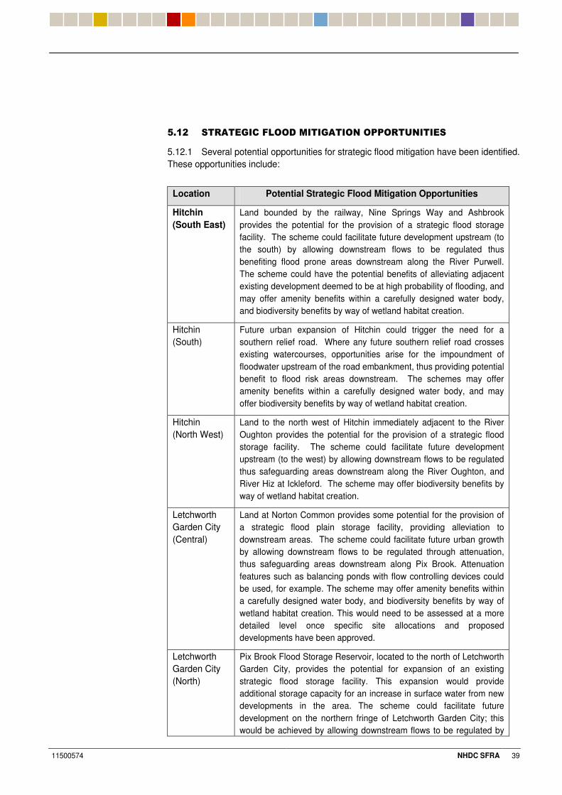
11500574 NHDC SFRA 39
0%#& ������9����7'' �!���9���'��'55'����������
5.12.1 Several potential opportunities for strategic flood mitigation have been identified. These opportunities include:
Location Potential Strategic Flood Mitigation Opportunities
Hitchin (South East)
Land bounded by the railway, Nine Springs Way and Ashbrook provides the potential for the provision of a strategic flood storage facility. The scheme could facilitate future development upstream (to the south) by allowing downstream flows to be regulated thus benefiting flood prone areas downstream along the River Purwell. The scheme could have the potential benefits of alleviating adjacent existing development deemed to be at high probability of flooding, and may offer amenity benefits within a carefully designed water body, and biodiversity benefits by way of wetland habitat creation.
Hitchin (South)
Future urban expansion of Hitchin could trigger the need for a southern relief road. Where any future southern relief road crosses existing watercourses, opportunities arise for the impoundment of floodwater upstream of the road embankment, thus providing potential benefit to flood risk areas downstream. The schemes may offer amenity benefits within a carefully designed water body, and may offer biodiversity benefits by way of wetland habitat creation.
Hitchin (North West)
Land to the north west of Hitchin immediately adjacent to the River Oughton provides the potential for the provision of a strategic flood storage facility. The scheme could facilitate future development upstream (to the west) by allowing downstream flows to be regulated thus safeguarding areas downstream along the River Oughton, and River Hiz at Ickleford. The scheme may offer biodiversity benefits by way of wetland habitat creation.
Letchworth Garden City (Central)
Land at Norton Common provides some potential for the provision of a strategic flood plain storage facility, providing alleviation to downstream areas. The scheme could facilitate future urban growth by allowing downstream flows to be regulated through attenuation, thus safeguarding areas downstream along Pix Brook. Attenuation features such as balancing ponds with flow controlling devices could be used, for example. The scheme may offer amenity benefits within a carefully designed water body, and biodiversity benefits by way of wetland habitat creation. This would need to be assessed at a more detailed level once specific site allocations and proposed developments have been approved.
Letchworth Garden City (North)
Pix Brook Flood Storage Reservoir, located to the north of Letchworth Garden City, provides the potential for expansion of an existing strategic flood storage facility. This expansion would provide additional storage capacity for an increase in surface water from new developments in the area. The scheme could facilitate future development on the northern fringe of Letchworth Garden City; this would be achieved by allowing downstream flows to be regulated by
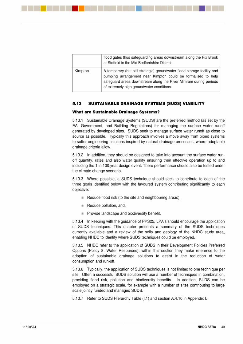
11500574 NHDC SFRA 40
flood gates thus safeguarding areas downstream along the Pix Brook at Stotfold in the Mid Bedfordshire District.
Kimpton A temporary (but still strategic) groundwater flood storage facility and pumping arrangement near Kimpton could be formalised to help safeguard areas downstream along the River Mimram during periods of extremely high groundwater conditions.
�
0%#+ ��������/7�� �����9���"���!��<�� �=� ��/�7��"�
?����������������(��� ���������-���� �H�
5.13.1 Sustainable Drainage Systems (SUDS) are the preferred method (as set by the EA, Government, and Building Regulations) for managing the surface water runoff generated by developed sites. SUDS seek to manage surface water runoff as close to source as possible. Typically this approach involves a move away from piped systems to softer engineering solutions inspired by natural drainage processes, where adoptable drainage criteria allow.
5.13.2 In addition, they should be designed to take into account the surface water run-off quantity, rates and also water quality ensuring their effective operation up to and including the 1 in 100 year design event. There performance should also be tested under the climate change scenario.
5.13.3 Where possible, a SUDS technique should seek to contribute to each of the three goals identified below with the favoured system contributing significantly to each objective:
� Reduce flood risk (to the site and neighbouring areas),
� Reduce pollution, and,
� Provide landscape and biodiversity benefit.
5.13.4 In keeping with the guidance of PPS25, LPA’s should encourage the application of SUDS techniques. This chapter presents a summary of the SUDS techniques currently available and a review of the soils and geology of the NHDC study area, enabling NHDC to identify where SUDS techniques could be employed.
5.13.5 NHDC refer to the application of SUDS in their Development Policies Preferred Options (Policy 8: Water Resources); within this section they make reference to the adoption of sustainable drainage solutions to assist in the reduction of water consumption and run-off.
5.13.6 Typically, the application of SUDS techniques is not limited to one technique per site. Often a successful SUDS solution will use a number of techniques in combination, providing flood risk, pollution and biodiversity benefits. In addition, SUDS can be employed on a strategic scale, for example with a number of sites contributing to large scale jointly funded and managed SUDS.
5.13.7 Refer to SUDS Hierarchy Table (I.1) and section A.4.10 in Appendix I.
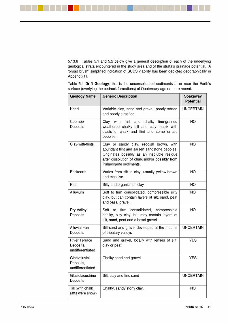
11500574 NHDC SFRA 41
5.13.8 Tables 5.1 and 5.2 below give a general description of each of the underlying geological strata encountered in the study area and of the strata’s drainage potential. A ‘broad brush’ simplified indication of SUDS viability has been depicted geographically in Appendix H.
Table 5.1 Drift Geology; this is the unconsolidated sediments at or near the Earth’s surface (overlying the bedrock formations) of Quaternary age or more recent.
Geology Name Generic Description Soakaway Potential
Head Variable clay, sand and gravel, poorly sorted and poorly stratified
UNCERTAIN
Coombe Deposits
Clay with flint and chalk, fine-grained weathered chalky silt and clay matrix with clasts of chalk and flint and some erratic pebbles.
NO
Clay-with-flints Clay or sandy clay, reddish brown, with abundant flint and sarsen sandstone pebbles. Originates possibly as an insoluble residue after dissolution of chalk and/or possibly from Palaeogene sediments.
NO
Brickearth Varies from silt to clay, usually yellow-brown and massive.
NO
Peat Silty and organic rich clay NO
Alluvium Soft to firm consolidated, compressible silty clay, but can contain layers of silt, sand, peat and basal gravel.
NO
Dry Valley Deposits
Soft to firm consolidated, compressible chalky, silty clay, but may contain layers of silt, sand, peat and a basal gravel.
NO
Alluvial Fan Deposits
Silt sand and gravel developed at the mouths of tributary valleys
UNCERTAIN
River Terrace Deposits, undifferentiated
Sand and gravel, locally with lenses of silt, clay or peat
YES
Glaciofluvial Deposits, undifferentiated
Chalky sand and gravel YES
Glaciolacustrine Deposits
Silt, clay and fine sand UNCERTAIN
Till (with chalk rafts were show)
Chalky, sandy stony clay. NO
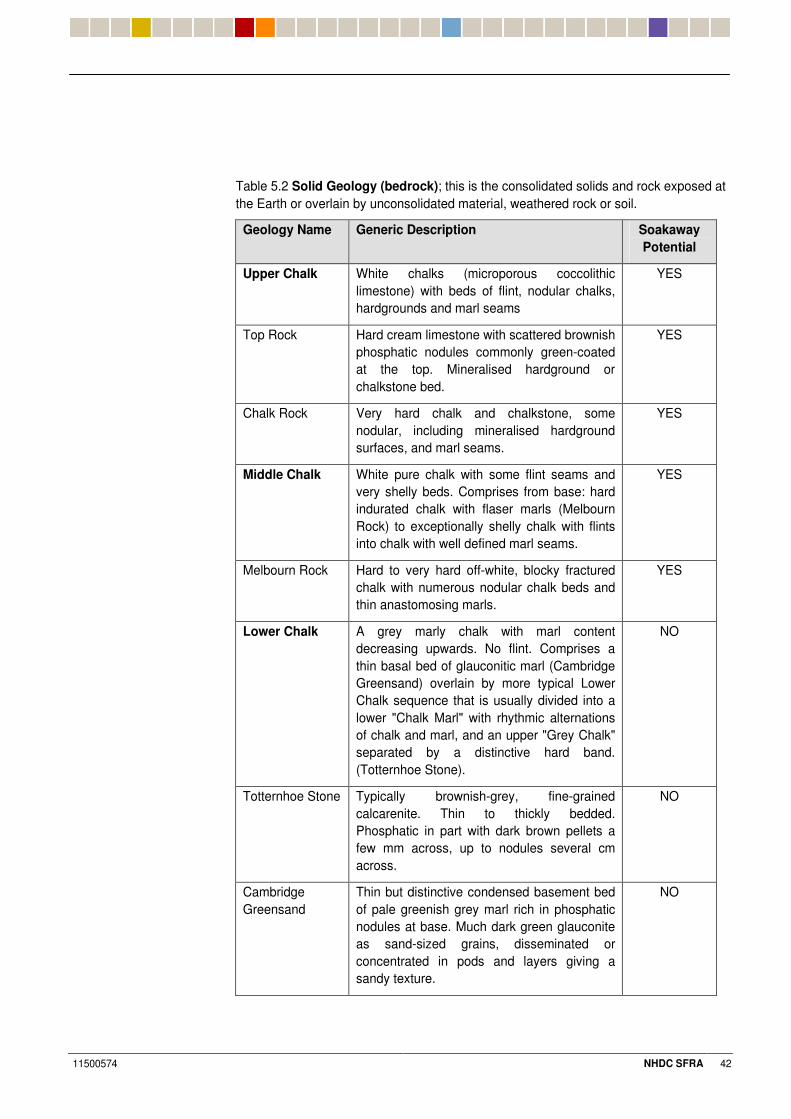
11500574 NHDC SFRA 42
Table 5.2 Solid Geology (bedrock); this is the consolidated solids and rock exposed at the Earth or overlain by unconsolidated material, weathered rock or soil.
Geology Name Generic Description Soakaway Potential
Upper Chalk White chalks (microporous coccolithic limestone) with beds of flint, nodular chalks, hardgrounds and marl seams
YES
Top Rock Hard cream limestone with scattered brownish phosphatic nodules commonly green-coated at the top. Mineralised hardground or chalkstone bed.
YES
Chalk Rock Very hard chalk and chalkstone, some nodular, including mineralised hardground surfaces, and marl seams.
YES
Middle Chalk White pure chalk with some flint seams and very shelly beds. Comprises from base: hard indurated chalk with flaser marls (Melbourn Rock) to exceptionally shelly chalk with flints into chalk with well defined marl seams.
YES
Melbourn Rock Hard to very hard off-white, blocky fractured chalk with numerous nodular chalk beds and thin anastomosing marls.
YES
Lower Chalk A grey marly chalk with marl content decreasing upwards. No flint. Comprises a thin basal bed of glauconitic marl (Cambridge Greensand) overlain by more typical Lower Chalk sequence that is usually divided into a lower "Chalk Marl" with rhythmic alternations of chalk and marl, and an upper "Grey Chalk" separated by a distinctive hard band. (Totternhoe Stone).
NO
Totternhoe Stone Typically brownish-grey, fine-grained calcarenite. Thin to thickly bedded. Phosphatic in part with dark brown pellets a few mm across, up to nodules several cm across.
NO
Cambridge Greensand
Thin but distinctive condensed basement bed of pale greenish grey marl rich in phosphatic nodules at base. Much dark green glauconite as sand-sized grains, disseminated or concentrated in pods and layers giving a sandy texture.
NO
11500574 NHDC SFRA 43
5.13.9 The underlying ground conditions of a development site will determine the type of SUDS approach to be used. This will need to be determined through site specific ground investigations. An initial assessment of a site’s suitability to the use of SUDS can be obtained from the review of the available soils / geological survey of the area presented in Tables 5.1 and 5.2.
5.13.10 The SUDS Viability Plan is provided in Appendix H. It sets out the ground conditions in the district, in terms of their permeability and appropriateness for the use of SUDS infiltration techniques. These definitions are based on a desk study review of available information and our experience and should not supersede site-specific data and ground investigations. For practical reasons this SUDS Plan simplifies the ground conditions encountered within the district and should only be used as an indicator.
5.13.11 The EA (Thames Region) has issued best practice guidance for SUDS (October 2006), available from the EA Development Control teams. This provides a clear hierarchy for SUDS, reflecting the degree of sustainability offered by each technique. The following documents should also be used as technical references for the application of SUDS within the district; these are CIRIA 156- Surface Water Drainage Good Practice and CIRIA 697-The SUDS manual. The Interim Code of Practice for Sustainable Drainage Systems produced by the National SUDS Working Group should also be used. Descriptions of the alternative techniques have been set out below.
0%#. �� ��������G����
5.14.1 SUDS techniques can be used to reduce the rate and volume of surface water discharges from sites to the receiving environment (i.e. natural watercourse or public sewer etc), as well as improve the water quality. Various SUDS techniques are available; however the techniques operate on two main principles:
� Infiltration
� Attenuation
All systems generally fall into one of two categories, or a combination of the two.
5.14.2 The design of SUDS measures should be undertaken as part of the drainage strategy and design for a development site. A ground investigation will be required to access the suitability of using infiltration measures, with this information being used to assess the required volume of on-site storage. Hydrological analysis should be undertaken using industry approved procedures such as the Flood Estimation Handbook to ensure a robust design.
5.14.3 The viability of alternative SUDS techniques would need to be robustly assessed as part of any site specific FRA, and must take full account of a number of criteria, including:
� Underlying Geology and results of on-site Geo-Environmental Investigations;
� Proximity of Groundwater Table;
� Long term maintenance and management of the SUDS asset;
� Sewerage Undertaker’s criteria relating to any public sewer systems that would rely upon the function of the SUDS asset; Environment Agency criteria relating to protection of underlying groundwater and water resources; Contaminated Land issues (refer to NHDC Contaminated Land Officer).
11500574 NHDC SFRA 44
5.14.4 During the design process, liaison should take place with the Local Planning Authority, the EA, Thames Water / Anglian Water in order to establish that the design methodology is satisfactory and to also agree on a permitted rate of discharge from the site. Based on the findings/requirements of the Local Development Framework, NHDC may adopt certain policies that would promote and maintain tailored SUDS practices to proposed developments within the district; these practices for example, would designate maintenance responsibility of the surface water drainage system to a relevant party such as the IDB for example.
5.14.5 Building Regulations advise that a SUDS hierarchy be followed in order to select the appropriate solution for a development site, with preference given to infiltration techniques over attenuation systems, provided that underlying conditions allow. ’Soft’ engineering solutions such as infiltration seek to mimic natural drainage regimes; this hierarchy promotes the use of techniques such as green roofs, basins and ponds; if these measures are not feasible then tanked systems such as geo-cellular boxes or underground tanks can be applied. Infiltration SUDS are reliant on the local ground conditions (i.e. permeability of soils and geology, the groundwater table depth and the importance of underlying aquifers as water resources etc) for their successful operation.
5.14.6 Detailed information relating to infiltration and attenuation SUDS techniques can be found in Appendix I; the following information outlines the applicability of infiltration SUDS methods in relation to the proposed development areas shown in Appendix G based on geology and Source Protection Zones. Information on groundwater levels has not been provided on a site specific basis. NHDC may wish to adopt certain SUDS practices at a policy level that are tailored to the local conditions specific to each area.
7����?'����
All the proposed development areas within Letchworth (L1,L2,L3,L4,L5) do not fall within a Source Protection Zone (SPZ) as shown on the EA’s website. According to the SUDS Viability Plan given in Appendix H infiltration SUDS methods may be viable at the following development locations (L2, L3 and L5). Infiltration methods rely on discharging to ground where suitable ground conditions allow; specific methods such as soakaways, swales, green roofs, ponds and porous paving may be possible depending on the scale and nature of the proposed development. The proposed development areas of (L1 and L4) do not indicate suitable ground conditions for the application of infiltration based SUDS methods. At these locations it may be preferential to apply techniques such as attenuation and source control. Detailed ground investigations on a site specific basis based on the scale and nature of the proposed development should be undertaken to indicate the suitability of using infiltration methods.
/�7 '�B�
All the proposed development areas within Baldock (B1,B3,B4,B5,B6,B7) do not fall within a Source Protection Zone (SPZ) as shown on the EA’s website except for (B2) that is shown to be in an area defined as an ‘Outer Zone’; an Outer Protection Zone covers pollution that takes up to 400 days to travel to a borehole or 25% of the total catchment area. According to the SUDS Viability Plan given in Appendix H infiltration SUDS methods may be viable at the following development locations (B1,B4,B5 and B6). Infiltration methods rely on discharging to ground where suitable ground conditions allow; specific methods such as soakaways, swales, green roofs, ponds and porous paving may be possible depending on the scale and nature of the proposed development. The proposed development area of (B7) does not indicate suitable ground
11500574 NHDC SFRA 45
conditions for the application of infiltration based SUDS methods; development areas (B2 and B3) are shown to be uncertain. At these locations it may be preferential to apply techniques such as attenuation and source control. These assessments do not replace the need to undertake a detailed ground investigation on a site specific basis based on the scale and nature of the proposed development in order to assess the suitability of using infiltration methods.
��������
All the proposed development areas within Hitchin (H1,H2,H3,H4,H5,H6,H7,H8,H9, H10 and H11) do not fall within a Source Protection Zone (SPZ) as shown on the EA’s website; parts of development area (H11) are shown to be within a total catchment area which is the total area needed to support removal of water from a borehole or support any discharge from a borehole. According to the SUDS Viability Plan given in Appendix H, infiltration SUDS methods may be viable at the following development locations (H2,H3,H4,H5,H6,H8,H9,H10 and H11). Infiltration methods rely on discharging to ground where suitable ground conditions allow; specific methods such as soakaways, swales, green roofs, ponds and porous paving may be possible depending on the scale and nature of the proposed development. The proposed development areas of (H1 and H7) do not indicate suitable ground conditions for the application of infiltration based SUDS methods. At these locations it may be preferential to apply techniques such as attenuation and source control. Detailed ground investigations on a site specific basis based on the scale and nature of the proposed development should be undertaken to indicate the suitability of using infiltration methods.
�' ��'����� �B�!5�'��
All the proposed development areas within Codicote and Kimpton (C1, K2 and K1) fall within a Source Protection Zone (SPZ) as shown on the EA’s website; (C1) is shown to be in an Outer Zone and (K2 and K1) are shown to be within a total catchment area. According to the SUDS Viability Plan given in Appendix H infiltration SUDS methods may be viable at the following development locations (K1 and K2). The proposed site of (C1) is shown to be in an area with unsuitable drift geology but suitable ground geology. Infiltration methods rely on discharging to ground where suitable ground conditions permit; specific methods such as soakaways, swales, green roofs, ponds and porous paving may be possible depending on the scale and nature of the proposed development. It is important to note with Kimpton that historical groundwater flooding events have occurred as mentioned within the SFRA; this may indicate high ground water levels within certain areas as the River Kim is predominantly ground water fed. Detailed ground investigations on a site specific basis based on the scale and nature of the proposed development should be undertaken to indicate the suitability of using infiltration methods.
0%#0 ������9�����?���9������������������
5.15.1 Locations of key sewerage infrastructure are shown in Appendix F.
5.15.2 A meeting was held with Thames Water and Anglian Water to find out about capacity issues at local Sewage Treatment Works, and to assess the likely impact of future growth upon the existing infrastructure.
5.15.3 Further data was gathered from the East of England Sewerage Capacity Study (October 2006) prepared by Halcrow in conjunction with Anglian Water and the
11500574 NHDC SFRA 46
Rye Meads Water Cycle Strategy Scoping draft report produced by Halcrow in conjunction with the Environment Agency (May 2007).
5.15.4 The Bedfordshire and River Ivel IDB should also be consulted with regards to any future expansion of Sewage Treatments Works within the district.
0%#3 �!5����'���������9�'?����5'����?�9�������!����
?'�B����5����"��� ������ ��9�?�����'������
5.16.1 As a general principal, where a Sewage Treatment Works within the study area has been identified as running at or near capacity, it can be assumed that further investment would be required to accommodate any growth in excess of a 10% increase in population. This would have to be staged with the works development. Any potential upgrade would also assist with a longer term prevention of sewer flooding in the area.
5.16.2 A brief appraisal has been undertaken of each Sewage Treatment Works
5.16.3 (STW) serving the study area, using up to date information provided by Anglian Water and Thames Water and data taken from the East of England Sewerage Capacity Study and the Rye Meads Water Cycle Strategy Scoping draft report. Population increase data is taken from the East of England Sewerage Capacity Study:
Rye Meads STW (proposed to serve West of Stevenage-Thames Water)
� Estimated population equivalent increase over the East of England Plan period (2006 – 2021) is 86,810 which represents a growth of 26%. The STW currently serves a large domestic population and also treats waste from trade and industry in the catchment.
� Existing primary treatment processes are estimated to provide adequate capacity beyond the Plan period (2021). Secondary treatment processes are currently estimated to be at capacity. Tertiary treatment processes are estimated to provide adequate capacity to 2021.
� The current consent for Rye Meads is a maximum of 330,000 m³ of effluent per day. Once this maximum flow is reached then new consent levels will be required.
� Water quality issues pose significant constraints to future Works improvements.
� Potential for expansion of the Works exists at its current location, but the site is situated in Flood Zone 3 and constraints may be imposed. According to Thames Water, the River Lee and its system of flood relief channels is capable of handling an increase in flows without any further mitigation measures.
� Thames Water have recently stated that they plan to extend the plant by adding an additional 5th process treatment stream; this would allow them to treat most of the growth currently proposed. An additional 6th stream could also be added at a later date.
Ashbrook STW (serves St Ippollitts and surrounding villages- Anglian Water)
� Estimated population equivalent increase over the East of England Plan period (2006 – 2021) of 198 which represents growth of 7%.
� Level of predicted growth unlikely to trigger significant capacity extensions; there are no proposals as yet to apply for an increase in discharge consent at this site.
11500574 NHDC SFRA 47
Hitchin STW (serves Hitchin and Ickleford- Anglian Water)
� Estimated population equivalent increase over the East of England Plan period (2006 – 2021) of 3,776 which represents growth of 11%.
� Potential capacity available to accommodate predicted growth period; there are no proposals at the current time to apply for an increase in discharge consent at this site.
� Physical constraints to upgrading existing overloaded sewers between Grove Road and Hitchin Works that are routed alongside and beneath the railway pose a constraint to accommodating future growth.
� Limited potential for expansion of the Works exists at its current location. Presently undeveloped areas of the site are situated in Flood Zone 3 and constraints may be imposed.
Letchworth STW (serves Letchworth Garden City and Baldock- Anglian Water)
� Estimated population equivalent increase over the East of England Plan period (2006 – 2021) of 4,630 which represents growth of 11%.
� Capacity available to accommodate predicted growth period; there are no proposals at the current time to apply for an increase in discharge consent at this site.
� Potential for expansion of the Works exists at its current location subject to capital works funding.
5.16.4 Any future flood mapping must include an allowance for the future increases in treated effluent baseflow and excess storm flows from each Sewage Treatment Works in order to assess the impact. In order to assess the impact of any future increase in discharge consents into the receiving watercourses, Anglian Water have suggested a Water Cycle Study is undertaken across the entire North Hertfordshire area at a later stage.
0%#$ ���������?���9��������9"�
5.17.1 Following discussions with Anglian Water, there is sufficient capacity within the existing Sewage Treatment Works at Hitchin to accommodate significant urban growth for up to 10,000 dwellings; but there is limited scope for significant expansion of the STW in its present location. The current capacity at Hitchin is a population equivalent of 33,000.
5.17.2 According to Anglian Water, in order for foul flows arising from significant urban expansion to the west, south, or east of Hitchin to be accommodated within the Anglian Water network, it is likely that Anglian Water would need to construct a new Sewage Treatment Works, likely to be situated to the north east of Hitchin upon Anglian Water owned land (a former sludge works). Due to the lack of hydraulic capacity within the existing Hitchin sewer network, a new Terminal Pumping Station may be required to be constructed adjacent to the proposed area of growth to lift pumped flows to the new Sewage Treatment Works without impacting upon the existing system. As part of the rationalisation of the system, Hitchin Sewage Treatment Works would presumably be replaced with a Terminal Pumping Station designed to lift flows to the new Sewage Treatment Works.
11500574 NHDC SFRA 48
5.17.3 If there is significant urban expansion to the west of Hitchin, there is an alternative option, whereby Anglian Water could construct a new Sewage Treatment Works to the west of Hitchin, discharging into the River Oughton. This would have the advantage of obviating the need to replace the existing Hitchin STW, but the viability of the option may be constrained due to water quality considerations from locating two STW’s within close proximity. Anglian Water have stated that at this stage they do not see the expansion of Hitchin Sewage Treatment Works as practical in the long term.
5.17.4 Thames Water have indicated that foul flows from any proposed development to the West of Stevenage development are expected to discharge to the Stevenage public sewer network, ultimately draining to Rye Meads Sewage Treatment Works near Stanstead Abbotts several kilometres to the south east of the NHDC study area. Thames Water have indicated that provision will need to be made within their capital programme for a large underground storage tank beneath Elder Way, Stevenage in order to attenuate flows from the West of Stevenage to a level that may be accommodated within the existing system without the need to reinforce the downstream sewer system. As previously stated outline plans have been produced to extend the sewage treatment process at Rye Meads to accommodate any proposed growth. Thames Water currently plan to extend the plant by adding a 5th process treatment stream; this would allow them to treat most of the growth currently proposed. Once the growth figures are finally confirmed, if there is still not enough capacity then a 6th stream could be added at a later stage.
5.17.5 Although considered a very unlikely scenario, the option of draining foul flows from West of Stevenage to the Anglian Water sewerage network has been considered as part of the Stage 2 SFRA. Based upon discussions with Anglian Water, it is clear that there is sufficient capacity within existing Sewage Treatment Works’ at Hitchin and Letchworth Garden City for growth of this scale; in the case of Hitchin though, there is limited scope for significant expansion of this facility due to it’s location. In order for foul flows to be accommodated within the Anglian Water network, it is likely that Anglian Water would need to construct a new Sewage Treatment Works to the north east of Hitchin upon Anglian Water land (a former sludge works). Due to the distance between West of Stevenage and the new Sewage Treatment Works, and the lack of hydraulic capacity within the existing Hitchin sewer network, a new Terminal Pumping Station (effectively acting as a booster station) may be required to be constructed to the south of Hitchin to lift pumped flows from West of Stevenage to the new Sewage Treatment Works; this could possibly replace the small existing Ashbrook Sewage Treatment Works. As part of the rationalisation of the system, Hitchin Sewage Treatment Works would presumably be replaced with a Terminal Pumping Station designed to lift flows to the new Sewage Treatment Works. According to Anglian Water, the Stevenage Borough Council Water Cycle Study will provide them with more information to assess the potential for upgrading Ashbrook Sewage Treatment Works; Ashbrook is Anglian Waters preferred location to serve West Stevenage if an increase in discharge is permitted by the EA. The current capacity of Ashbrook has a 3,000 population equivalent.
5.17.6 According to Anglian Water, the Letchworth Sewage Treatment Works have the spare capacity to cope with additional development within the Letchworth Garden City and Baldock area for approximately 5,000 dwellings. The current capacity of Letchworth has a 42,000 population equivalent.
5.17.7 Based upon discussions with Thames Water, existing strategic foul sewerage infrastructure within the district is likely to be able to accommodate the relatively minor
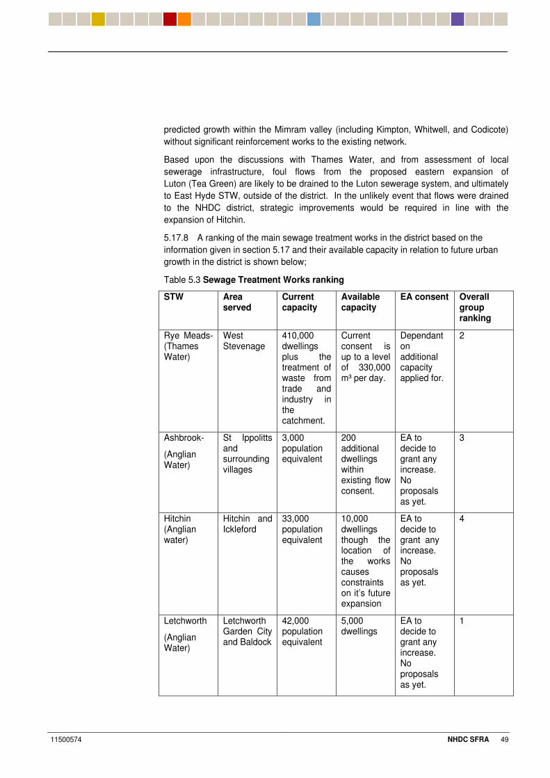
11500574 NHDC SFRA 49
predicted growth within the Mimram valley (including Kimpton, Whitwell, and Codicote) without significant reinforcement works to the existing network.
Based upon the discussions with Thames Water, and from assessment of local sewerage infrastructure, foul flows from the proposed eastern expansion of Luton (Tea Green) are likely to be drained to the Luton sewerage system, and ultimately to East Hyde STW, outside of the district. In the unlikely event that flows were drained to the NHDC district, strategic improvements would be required in line with the expansion of Hitchin.
5.17.8 A ranking of the main sewage treatment works in the district based on the information given in section 5.17 and their available capacity in relation to future urban growth in the district is shown below;
Table 5.3 Sewage Treatment Works ranking
STW Area served
Current capacity
Available capacity
EA consent Overall group ranking
Rye Meads-(Thames Water)
West Stevenage
410,000 dwellings plus the treatment of waste from trade and industry in the catchment.
Current consent is up to a level of 330,000 m³ per day.
Dependant on additional capacity applied for.
2
Ashbrook-
(Anglian Water)
St Ippolitts and surrounding villages
3,000 population equivalent
200 additional dwellings within existing flow consent.
EA to decide to grant any increase. No proposals as yet.
3
Hitchin (Anglian water)
Hitchin and Ickleford
33,000 population equivalent
10,000 dwellings though the location of the works causes constraints on it’s future expansion
EA to decide to grant any increase. No proposals as yet.
4
Letchworth
(Anglian Water)
Letchworth Garden City and Baldock
42,000 population equivalent
5,000 dwellings
EA to decide to grant any increase. No proposals as yet.
1
11500574 NHDC SFRA 50
0%#2 �7����/�7��"�'���������9�������9������������������
5.18.1 Locations of key strategic infrastructure are shown in Appendix F. Facilities highlighted include hospitals, fire stations, police stations and strategic power supply installations.
5.18.2 Key observations from a comparison of flood mapping to strategic infrastructure have been set out below:
� Wymondley Electricity Transferring Station lies adjacent to the floodplain of the Ash Brook. However, informal flood defences in the form of earth embankments appear to protect the facility. Power to a significant population (including Stevenage, Hitchin and Baldock) could be significantly disrupted during significant flood conditions and a breach of the earth defences;
� The sewage treatment works in St Ippollitts adjacent to Ash Brook may be affected by fluvial flooding; potentially this flooding would be constrained close to the natural channel of the brook.
� The A1 near to Stotfold / Astwick could potentially be affected by fluvial flooding. Safe access along a principal highway route may be significantly disrupted during significant flood conditions.
5.18.3 The location of strategic infrastructure and emergency services have been reviewed in relation to the fluvial flood mapping as shown in Appendix E. No strategic facilities appear to be unduly affected by flooding and should, therefore, remain operational during extreme flood conditions.
0%#6 �7'' �?�����9��� �� ������'��
5.19.1 Only the communities of Kimpton, Whitwell and Codicote along the Mimram Valley are covered by the EA Flood Warning System within the NHDC study area.
5.19.2 Due to the hydrological characteristics of the majority of watercourse catchments within the district, the duration of extreme flooding is likely to be relatively short. The exception to this would be the River Kim and River Mimram which are subjected to infrequent but prolonged flooding resulting from groundwater.
5.19.3 The current Hertfordshire Resilience Multi-Agency Response Plan outlines the measures that would need to be taken in order to set up and coordinate evacuations during an emergency such as extensive flooding affecting a number of communities in the county.
0%&8 ���� ��7����B�!���9�!����
5.20.1 Assessment of residual flood risk in terms of hazard and consequences should be considered on a more site specific basis and are generally not appropriate in a strategic assessment, where principal residual risks such as flood defence breach (failure) are not applicable.
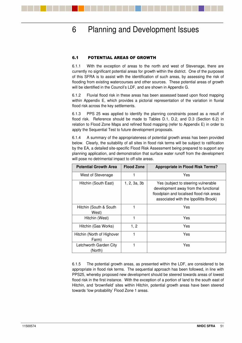
11500574 NHDC SFRA 51
6 Planning and Development Issues
3%# 5'������7�������'��9�'?���
6.1.1 With the exception of areas to the north and west of Stevenage, there are currently no significant potential areas for growth within the district. One of the purposes of this SFRA is to assist with the identification of such areas, by assessing the risk of flooding from existing watercourses and other sources. These potential areas of growth will be identified in the Council’s LDF, and are shown in Appendix G.
6.1.2 Fluvial flood risk in these areas has been assessed based upon flood mapping within Appendix E, which provides a pictorial representation of the variation in fluvial flood risk across the key settlements.
6.1.3 PPS 25 was applied to identify the planning constraints posed as a result of flood risk. Reference should be made to Tables D.1, D.2, and D.3 (Section 6.2) in relation to Flood Zone Maps and refined flood mapping (refer to Appendix E) in order to apply the Sequential Test to future development proposals.
6.1.4 A summary of the appropriateness of potential growth areas has been provided below. Clearly, the suitability of all sites in flood risk terms will be subject to ratification by the EA, a detailed site-specific Flood Risk Assessment being prepared to support any planning application, and demonstration that surface water runoff from the development will pose no detrimental impact to off-site areas.
Potential Growth Area Flood Zone Appropriate in Flood Risk Terms?
West of Stevenage 1 Yes
Hitchin (South East) 1, 2, 3a, 3b Yes (subject to steering vulnerable development away from the functional
floodplain and localised flood risk areas associated with the Ippollitts Brook)
Hitchin (South & South West)
1 Yes
Hitchin (West) 1 Yes
Hitchin (Gas Works) 1, 2 Yes
Hitchin (North of Highover Farm)
1 Yes
Letchworth Garden City (North)
1 Yes
6.1.5 The potential growth areas, as presented within the LDF, are considered to be appropriate in flood risk terms. The sequential approach has been followed, in line with PPS25, whereby proposed new development should be steered towards areas of lowest flood risk in the first instance. With the exception of a portion of land to the south east of Hitchin, and ‘brownfield’ sites within Hitchin, potential growth areas have been steered towards ‘low probability’ Flood Zone 1 areas.
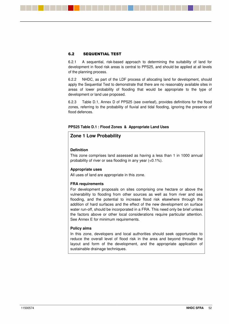
11500574 NHDC SFRA 52
3%& ��G������7������
6.2.1 A sequential, risk-based approach to determining the suitability of land for development in flood risk areas is central to PPS25, and should be applied at all levels of the planning process.
6.2.2 NHDC, as part of the LDF process of allocating land for development, should apply the Sequential Test to demonstrate that there are no reasonably available sites in areas of lower probability of flooding that would be appropriate to the type of development or land use proposed.
6.2.3 Table D.1, Annex D of PPS25 (see overleaf), provides definitions for the flood zones, referring to the probability of fluvial and tidal flooding, ignoring the presence of flood defences.
PPS25 Table D.1 : Flood Zones & Appropriate Land Uses
Zone 1 Low Probability
Definition This zone comprises land assessed as having a less than 1 in 1000 annual probability of river or sea flooding in any year (<0.1%).
Appropriate uses All uses of land are appropriate in this zone.
FRA requirements For development proposals on sites comprising one hectare or above the vulnerability to flooding from other sources as well as from river and sea flooding, and the potential to increase flood risk elsewhere through the addition of hard surfaces and the effect of the new development on surface water run-off, should be incorporated in a FRA. This need only be brief unless the factors above or other local considerations require particular attention. See Annex E for minimum requirements.
Policy aims In this zone, developers and local authorities should seek opportunities to reduce the overall level of flood risk in the area and beyond through the layout and form of the development, and the appropriate application of sustainable drainage techniques.
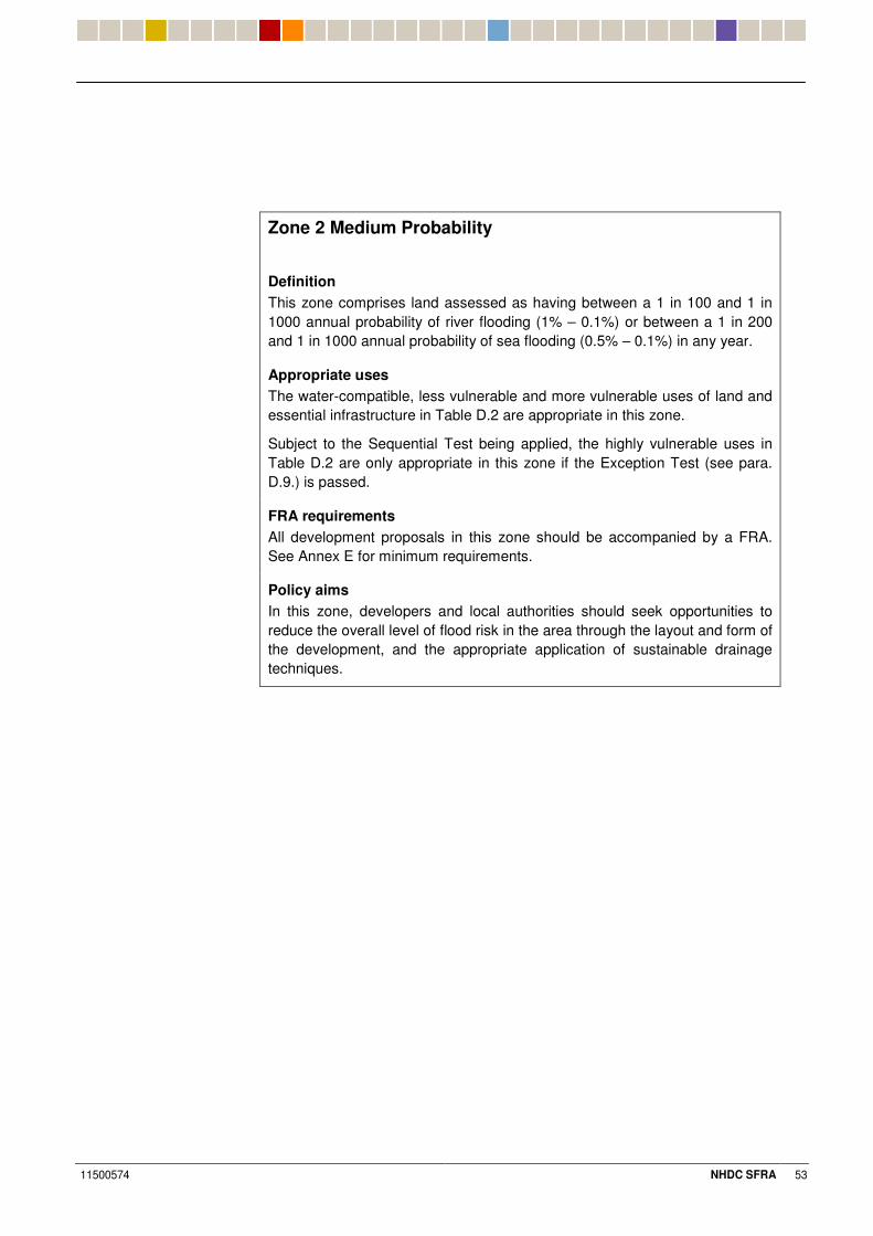
11500574 NHDC SFRA 53
Zone 2 Medium Probability
Definition This zone comprises land assessed as having between a 1 in 100 and 1 in 1000 annual probability of river flooding (1% – 0.1%) or between a 1 in 200 and 1 in 1000 annual probability of sea flooding (0.5% – 0.1%) in any year.
Appropriate uses The water-compatible, less vulnerable and more vulnerable uses of land and essential infrastructure in Table D.2 are appropriate in this zone.
Subject to the Sequential Test being applied, the highly vulnerable uses in Table D.2 are only appropriate in this zone if the Exception Test (see para. D.9.) is passed.
FRA requirements All development proposals in this zone should be accompanied by a FRA. See Annex E for minimum requirements.
Policy aims In this zone, developers and local authorities should seek opportunities to reduce the overall level of flood risk in the area through the layout and form of the development, and the appropriate application of sustainable drainage techniques.
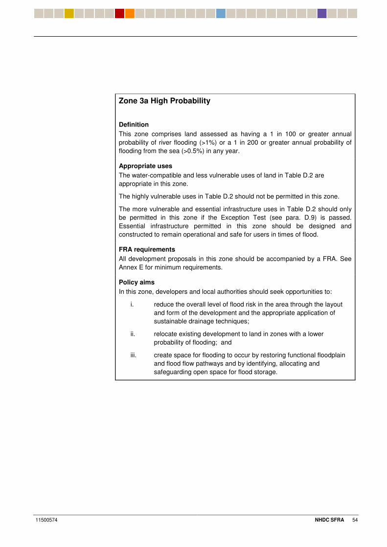
11500574 NHDC SFRA 54
Zone 3a High Probability
Definition This zone comprises land assessed as having a 1 in 100 or greater annual probability of river flooding (>1%) or a 1 in 200 or greater annual probability of flooding from the sea (>0.5%) in any year.
Appropriate uses The water-compatible and less vulnerable uses of land in Table D.2 are appropriate in this zone.
The highly vulnerable uses in Table D.2 should not be permitted in this zone.
The more vulnerable and essential infrastructure uses in Table D.2 should only be permitted in this zone if the Exception Test (see para. D.9) is passed. Essential infrastructure permitted in this zone should be designed and constructed to remain operational and safe for users in times of flood.
FRA requirements All development proposals in this zone should be accompanied by a FRA. See Annex E for minimum requirements.
Policy aims In this zone, developers and local authorities should seek opportunities to:
i. reduce the overall level of flood risk in the area through the layout and form of the development and the appropriate application of sustainable drainage techniques;
ii. relocate existing development to land in zones with a lower probability of flooding; and
iii. create space for flooding to occur by restoring functional floodplain and flood flow pathways and by identifying, allocating and safeguarding open space for flood storage.

11500574 NHDC SFRA 55
Zone 3b The Functional Floodplain Definition This zone comprises land where water has to flow or be stored in times of flood. SFRAs should identify this Flood Zone (land which would flood with an annual probability of 1 in 20 (5%) or greater in any year or is designed to flood in an extreme (0.1%) flood, or at another probability to be agreed between the LPA and the Environment Agency, including water conveyance routes).
Appropriate uses Only the water-compatible uses and the essential infrastructure listed in Table D.2 that has to be there should be permitted in this zone. It should be designed and constructed to:
– remain operational and safe for users in times of flood;
– result in no net loss of floodplain storage;
– not impede water flows; and
– not increase flood risk elsewhere.
Essential infrastructure in this zone should pass the Exception Test.
FRA requirements All development proposals in this zone should be accompanied by a FRA. See Annex E for minimum requirements.
Policy aims In this zone, developers and local authorities should seek opportunities to:
i. reduce the overall level of flood risk in the area through the layout and form of the development and the appropriate application of sustainable drainage techniques; and
ii. relocate existing development to land with a lower probability of flooding.
6.2.4 A sequential approach should be used in areas known to be at risk from all forms of flooding.
6.2.5 The EA’s Flood Zone Maps form the basis for the sequential testing of PPS25 whereby land is categorised as being in one of a range of zones, Flood Zone 1 to Flood Zone 3, according to the probability of flooding to the land. PPS25 advises on the appropriate planning response for different types of development in relation to the flood risk as categorised by the various Flood Zones.
6.2.6 Flood Zone Mapping for the NHDC study area has been refined and enhanced as part of the Stage 2 assessment. These refined Flood Zones (set out in Appendix E) take preference over EA FZMs as the baseline data used to inform the sequential approach.
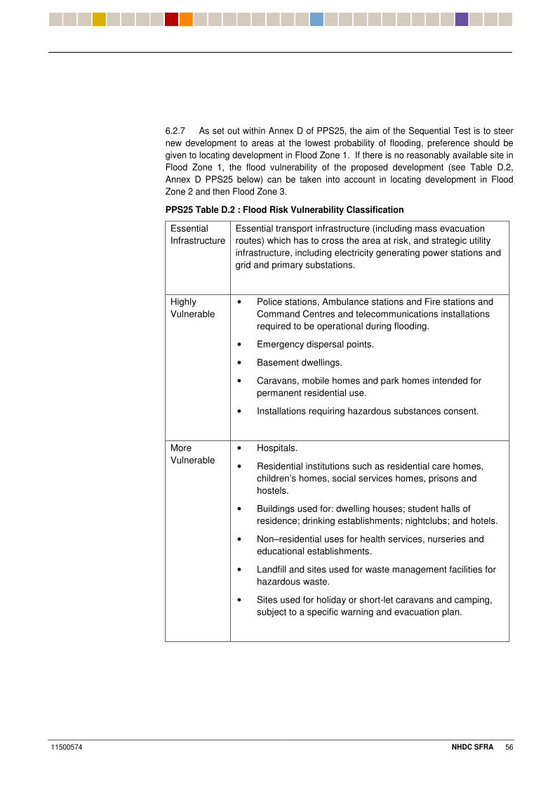
11500574 NHDC SFRA 56
6.2.7 As set out within Annex D of PPS25, the aim of the Sequential Test is to steer new development to areas at the lowest probability of flooding, preference should be given to locating development in Flood Zone 1. If there is no reasonably available site in Flood Zone 1, the flood vulnerability of the proposed development (see Table D.2, Annex D PPS25 below) can be taken into account in locating development in Flood Zone 2 and then Flood Zone 3.
PPS25 Table D.2 : Flood Risk Vulnerability Classification
Essential Infrastructure
Essential transport infrastructure (including mass evacuation routes) which has to cross the area at risk, and strategic utility infrastructure, including electricity generating power stations and grid and primary substations.
Highly Vulnerable
• Police stations, Ambulance stations and Fire stations and Command Centres and telecommunications installations required to be operational during flooding.
• Emergency dispersal points.
• Basement dwellings.
• Caravans, mobile homes and park homes intended for permanent residential use.
• Installations requiring hazardous substances consent.
More Vulnerable
• Hospitals.
• Residential institutions such as residential care homes, children’s homes, social services homes, prisons and hostels.
• Buildings used for: dwelling houses; student halls of residence; drinking establishments; nightclubs; and hotels.
• Non–residential uses for health services, nurseries and educational establishments.
• Landfill and sites used for waste management facilities for hazardous waste.
• Sites used for holiday or short-let caravans and camping, subject to a specific warning and evacuation plan.
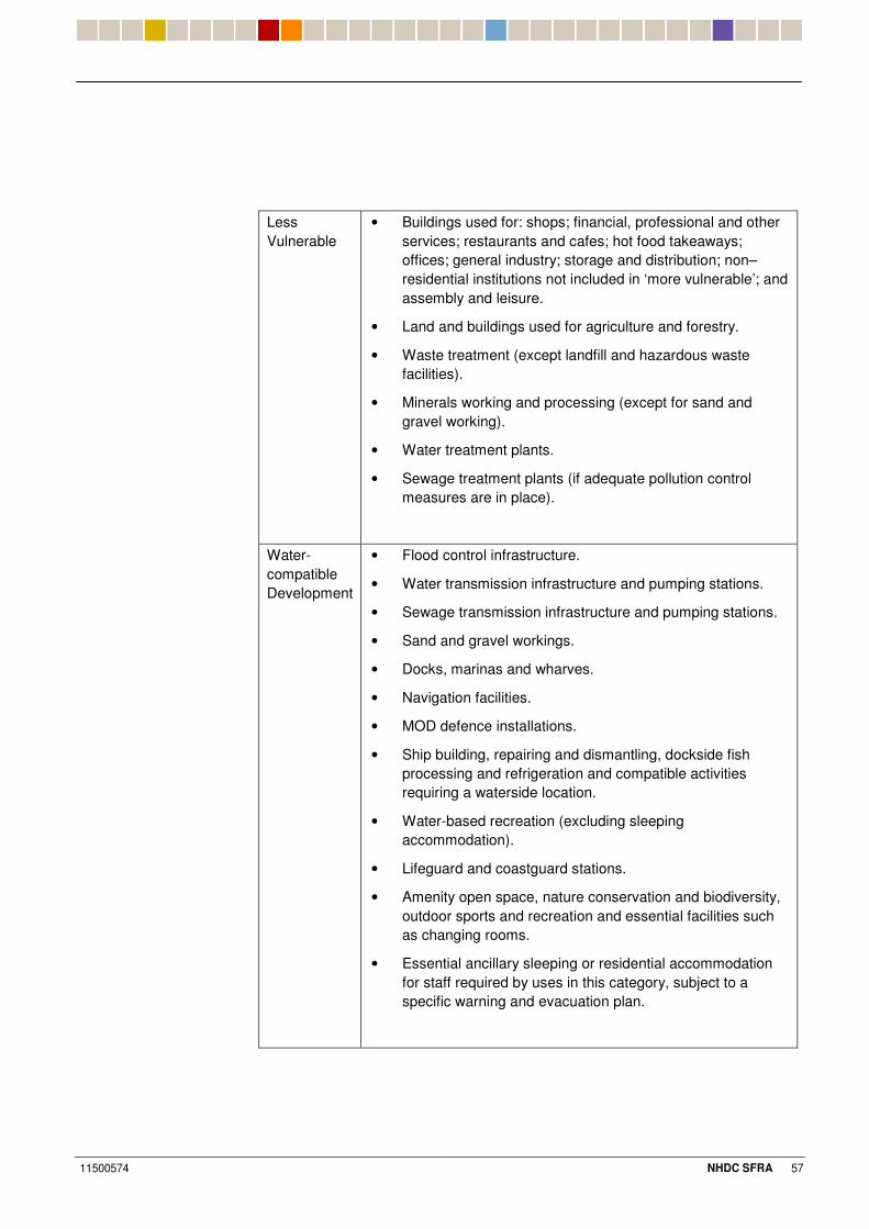
11500574 NHDC SFRA 57
Less Vulnerable
• Buildings used for: shops; financial, professional and other services; restaurants and cafes; hot food takeaways; offices; general industry; storage and distribution; non–residential institutions not included in ‘more vulnerable’; and assembly and leisure.
• Land and buildings used for agriculture and forestry.
• Waste treatment (except landfill and hazardous waste facilities).
• Minerals working and processing (except for sand and gravel working).
• Water treatment plants.
• Sewage treatment plants (if adequate pollution control measures are in place).
Water-compatible Development
• Flood control infrastructure.
• Water transmission infrastructure and pumping stations.
• Sewage transmission infrastructure and pumping stations.
• Sand and gravel workings.
• Docks, marinas and wharves.
• Navigation facilities.
• MOD defence installations.
• Ship building, repairing and dismantling, dockside fish processing and refrigeration and compatible activities requiring a waterside location.
• Water-based recreation (excluding sleeping accommodation).
• Lifeguard and coastguard stations.
• Amenity open space, nature conservation and biodiversity, outdoor sports and recreation and essential facilities such as changing rooms.
• Essential ancillary sleeping or residential accommodation for staff required by uses in this category, subject to a specific warning and evacuation plan.
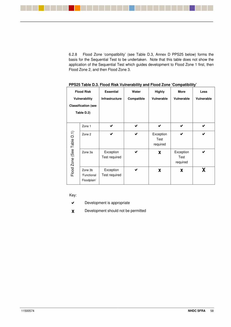
11500574 NHDC SFRA 58
6.2.8 Flood Zone ‘compatibility’ (see Table D.3, Annex D PPS25 below) forms the basis for the Sequential Test to be undertaken. Note that this table does not show the application of the Sequential Test which guides development to Flood Zone 1 first, then Flood Zone 2, and then Flood Zone 3.
PPS25 Table D.3. Flood Risk Vulnerability and Flood Zone ‘Compatibility’
Flood Risk
Vulnerability
Classification (see
Table D.2)
Essential
Infrastructure
Water
Compatible
Highly
Vulnerable
More
Vulnerable
Less
Vulnerable
Zone 1 �� �� � �� ��
Zone 2 � �� Exception Test
required
�� ��
Zone 3a Exception Test required
�� x Exception Test
required
��
Floo
d Zo
ne (S
ee T
able
D.1
)
Zone 3b
‘Functional
Floodplain’
Exception Test required
�� x x X
Key:
� Development is appropriate
x Development should not be permitted
11500574 NHDC SFRA 59
3%+ ����5��'�������
6.3.1 PPS25 expands on the Sequential Test by incorporating an ‘Exception Test’. Following application of the Sequential Test, if it is not possible for the development to be located in zones of lower probability of flooding, the Exception Test can be applied. This must be consistent with other sustainability objectives.
6.3.2 The Exception Test is appropriate for use when there are large areas in Flood Zones 2 and 3, where the Sequential Test alone cannot deliver acceptable sites, but where some continuing development is necessary for wider sustainable development reasons, taking into account the need to avoid social or economic blight and the need for essential civil infrastructure to remain operational during floods. It may also be appropriate to use it where restrictive national designations (e.g. Sites of Special Scientific Interest) prevent the availability of unconstrained sites in lower flood risk areas.
6.3.3 The Exception Test provides a mechanism for managing flood risk while still allowing necessary development to occur. It should not, however, be used to justify ‘highly vulnerable’ development in Flood Zone 3a, or ‘less vulnerable’, ‘more vulnerable, and ’highly vulnerable’ development in Flood Zone 3b.
6.3.4 For development to be allocated or permitted, all three of the Exception Test criteria (set out below) will have to be passed:
a) it must be demonstrated that the development provides wider sustainability benefits to the community that outweigh flood risk, informed by a SFRA where one has been prepared. If the DPD has reached the ‘submission’ stage (see Figure 4 of PPS12: Local Development Frameworks) the benefits of the development should contribute to the Core Strategy’s Sustainability Appraisal;
b) the development should be on developable previously-developed land or, if it is not on previously developed land, that there are no reasonable alternative sites on developable previously-developed land; and
c) a FRA must demonstrate that the development will be safe, without increasing flood risk elsewhere, and, where possible, will reduce flood risk overall.
6.3.5 This SFRA study takes no account of other socio-economic or sustainability factors other than flood risk and drainage infrastructure. These wider issues are to be considered by NHDC as part of their Sequential Test and Exception Test procedure, as required.
3%. ������5������������''7B���
6.4.1 An FRA toolkit relating to each Flood Zone and key proposed development uses has been set out within Appendix I.
6.4.2 Site specific FRA toolkits are offered as guidance only and will be subject to EA approval and current policy at the time of submission of a planning application.
6.4.3 A view has been offered on the likely suitability of the underlying geology and hydrogeology within the ‘town’ or study subcatchment areas for the implementation of sustainable drainage techniques (SUDS). Refer to the SUDS Viability Plan provided in Appendix H for further guidance.
11500574 NHDC SFRA 60
7 Recommendations
7.1.1 NHDC carry out the Sequential Test when allocating land for future development, based on supporting evidence and information set out in Section 6 of this report and the Fluvial Flood Risk Constraints in Appendix E in relation to the test criteria set out.
7.1.2 NHDC support the implementation of SUDS by way of robust planning conditions and / or Section 106 (S106) agreements.
7.1.3 NHDC safeguard the future operation and function of flood defences and flood related infrastructure through the establishment of a maintenance regime. This should be under the control of a sole responsible accountable body, such as the district council or the Bedford Group of Drainage Boards. It could be funded by appropriate developer contribution from new development. The Marston Vale Surface Waters Plan would be a good template to follow whereby the Bedford Group of Drainage Boards control watercourses, implement and maintain and control strategic flood defence infrastructure by way of future developer contribution (applied per m² of impermeable development). This contribution could equally be applied per property by way of a ‘roof tax’ or similar.
7.1.4 NHDC investigate the application of a ‘roof tax ’or similar mechanism to supplement flood defence and strategic flood alleviation schemes. These measures are to safeguard the future of existing settlements that are deemed to be at risk of flooding currently, and in the future taking into account climate change.
7.1.5 NHDC ensure developers and their consultants make reference to this SFRA study prior to the formulation of development proposals and planning applications in order that opportunities are maximised, and the key requirements of PPS25 (supplemented by recommendations within the SFRA) are met.
7.1.6 NHDC ensure developers carry out FRA’s for their proposals in line with the EA’s advice on flood risk and requirements for FRAs.
7.1.7 NHDC seek the implementation of strategic flood mitigation opportunities (some examples were highlighted within Section 5.12) through planning conditions or S106 agreements.
7.1.8 NHDC seek the early identification of a strategy for foul water disposal from any future development West of Stevenage as this may have a significant impact upon the Purwell, Pix Brook, River Hiz and tributaries, and downstream flood risk from increasing final effluent discharges from Sewage Treatment Works’ into the Hiz and downstream watercourses.
7.1.9 NHDC develop a Flood Evacuation Plan for the district that is consistent with the wider context of the borough’s Emergency Plan and the Hertfordshire Resilience Multi-Agency Emergency Response plan.
7.1.10 Future growth directions within the NHDC study area and planning policy may influence the LDF process within the district. The SFRA should be updated periodically to reflect any amendments in future growth proposals.
7.1.11 Potential strategic flood mitigation opportunities exist in Letchworth at Norton Common and Pix Brook Flood Storage Reservoir as set out in section (5.12). These could be assessed at a more detailed level once site specific allocations and proposed developments had been approved.

11500574 NHDC SFRA 61
$%& 7�!�����'���'��������� "�
7.2.1 Hydraulic modelling was not extended to include the complex watercourse network within the area to the West of Stevenage. The combination of wetland habitat and groundwater fed ephemeral streams, do not lend themselves to hydraulic modelling on a macro scale, as part of a strategic study. An indicative flood outline is shown in Appendix E, but detailed investigation of the hydrology and watercourse arrangements should be undertaken by the developer. Based upon the minimal flood risk at the West of Stevenage development, the information currently available was deemed sufficient to allow the site to be sequentially tested.
11500574 NHDC SFRA 62
8 Conclusions
8.1.1 A strategic assessment of flood risk has been carried out to assist NHDC with their land allocations in the LDF. The study area is shown in Appendix A.
8.1.2 Particular reference should be made to the Fluvial Flood Risk Constraints Plans in Appendix E, and to Section 5 of this report, when potential areas of growth are being considered.
8.1.3 Land allocations must be made with reference to the Sequential Test and, where appropriate, the Exception Test, as set out within PPS25.
8.1.4 Recommendations have been set out within Section 7 of this report that seek to allow the implementation of strategic flood mitigation opportunities and enhanced flood protection of existing properties by way of developer contribution.
8.1.5 A site specific FRA ‘toolkit’ has been provided to assist NHDC, the EA, and future developers in identifying the key flood risk issues within the study area and to assist with the formulation of solutions to the management of flood risk and surface water runoff that are of benefit strategically rather than locally.
8.1.6 This SFRA has been based upon government guidance and information available at the time of report issue (May 2008). Flood risk classifications may be subject to change in line with future government guidance. Flood zoning may also change following consideration of detailed topographical information, and investigation of flood risk issues within site specific FRAs accompany planning applications.
�
11500574 NHDC SFRA 63
9 Key Data Sources
Deposit Draft East of England Plan, East of England Regional Assembly, 2004 Development and Flood Risk: A Practice Guide Companion to PPS25 ‘Living Draft,’ Department for Communities and Local Government, 2007 Development West of Stevenage- Interim review of hydrological monitoring, HR Wallingford, 2003 DG5 Property Flooding Register, Anglian Water, 2006 East of England Capacity Delivery Strategy Study: Phase One, Halcrow, 2006 Emergency Plan, North Hertfordshire District Council, 2006 Guidance for Strategic Flood Risk Assessments, Environment Agency, 2005 Hydrological and Hydrogeological Review- Development West of Stevenage, Phase 1, HR Wallingford, 1999 Infiltration Drainage-Manual of Good Practice (C156), Construction Industry Research Information Association (CIRIA), 1996 Interim Code of Practice for Sustainable Drainage Systems, National SUDS Working Group, 2004 Marston Vale Surface Water Strategy, Bedford Group of Internal Drainage Boards, 2002 Milton Keynes and South Midlands Sub Regional Strategy, Government Offices for the South East, East Midlands and East of England (Office of the Deputy Prime Minister), 2005 National Flood and Coastal defence Database (NFCDD), Department Environment Food and Rural Affairs, 2007 North Hertfordshire District Local Plan: No. 2 with Alterations, North Hertfordshire District Council, 1996 North Hertfordshire District Council- Strategic Flood Risk Assessment, Hydraulic Modelling Report, WSP, 2007 North Hertfordshire Housing Capacity Study: Final Report, North Hertfordshire District Council, 2003 Planning Policy Statement 25: Development and Flood Risk (PPS25), Department for Communities and Local Government, 2006 Pre-feasibility Study: Flood Protection: Hitchin, Mott McDonald, 2004 Retrospective Data Gathering: Hitchin Flood Protection Study: Mott McDonald, 2007 Rye Meads Water Cycle Strategy Scoping Draft, Halcrow, 2007 SUDS Manual (C697), Construction Industry Research and Information Association (CIRIA), 2007

Appendices, Figures & Tables

11500574 NHDC SFRA
Appendix A Study Area

11500574 NHDC SFRA
Appendix B Ordnance Survey Contour Mapping

11500574 NHDC SFRA
Appendix C Watercourses & Hydraulic Structures Plans

11500574 NHDC SFRA
Appendix D Key Photographs
11500574 NHDC SFRA
Appendix E Fluvial Flood Risk Constraints Plans & Historic Fluvial Flooding

11500574 NHDC SFRA
Appendix F Key Sewerage and Strategic Infrastructure & Historic Sewer Flooding

11500574 NHDC SFRA
Appendix G Potential LDF Growth Areas & Possible Development Zones

11500574 NHDC SFRA
Appendix H SUDS Viability Plan and SUDS Information

11500574 NHDC SFRA
Appendix I Site Specific FRA ‘Toolkit’

11500574 NHDC SFRA