north pacific research board project final report ... · southeast alaska, defined as the area from...
TRANSCRIPT
NORTH PACIFIC RESEARCH BOARD PROJECT FINAL REPORT
Synthesis of Marine Biology and Oceanography of Southeast Alaska
NPRB Project 406 Final Report
Ginny L. Eckert1, Tom Weingartner2, Lisa Eisner3, Jan Straley4,
Gordon Kruse5, and John Piatt6
1 Biology Program, University of Alaska Southeast, and School of Fisheries and Ocean Sciences,
University of Alaska Fairbanks, 11120 Glacier Hwy., Juneau, AK 99801, (907) 796-6450,
[email protected] 2 Institute of Marine Science, University of Alaska Fairbanks, P.O. Box 757220, Fairbanks, AK
99775-7220, (907) 474-7993, [email protected] 3 Auke Bay Lab, National Oceanic and Atmospheric Administration, 17109 Pt. Lena Loop Rd.,
Juneau, AK 99801, (907) 789-6602, [email protected] 4 University of Alaska Southeast, 1332 Seward Ave., Sitka, AK 99835, (907) 774-7779,
[email protected] 5 School of Fisheries and Ocean Sciences, University of Alaska Fairbanks, 11120 Glacier Hwy.,
Juneau, AK 99801, (907) 796-2052, [email protected] 6 Alaska Science Center, US Geological Survey, Anchorage, AK, 360-774-0516, [email protected]
August 2007
ABSTRACT
This project directly responds to NPRB specific project needs, “Bring Southeast Alaska scientific
background up to the status of other Alaskan waters by completing a synthesis of biological and
oceanographic information”. This project successfully convened a workshop on March 30-31, 2005 at the
University of Alaska Southeast to bring together representatives from different marine science disciplines
and organizations to synthesize information on the marine biology and oceanography of Southeast
Alaska. Thirty-eight individuals participated, including representatives of the University of Alaska and
state and national agencies. A workshop report was submitted to NPRB in August, 2005 that details the
results of this successful workshop. One of the goals of the workshop was to synthesize research on
Southeast Alaska for publication in peer-reviewed journals. Twenty-one titles were proposed in response
to an open call for papers, and seven were submitted to the Journal of Biogeography in Fall 2006. Papers
are currently in revision for publication.
KEYWORDS
Southeast Alaska, marine biology, oceanography, fish, marine mammals, seabirds, intertidal, fisheries
CITATION
Eckert, G.L., T. Weingartner, L. Eisner, J. Straley, G. Kruse, and J. Piatt. 2007. Synthesis of marine
biology and oceanography of Southeast Alaska. North Pacific Research Board Final Report 406, 78 p.
2
TABLE OF CONTENTS
ABSTRACT .................................................................................................................................................................2
TABLE OF CONTENTS ............................................................................................................................................3
STUDY CHRONOLOGY...........................................................................................................................................5
INTRODUCTION .......................................................................................................................................................5
OVERALL OBJECTIVES .........................................................................................................................................5
CHAPTER 1 WORKSHOP REPORT ......................................................................................................................6 EXECUTIVE SUMMARY.......................................................................................................................................8 WORKSHOP SYNOPSIS ......................................................................................................................................10
Introduction........................................................................................................................................................10 Oceanography Overview....................................................................................................................................10 Physical Oceanography – Southeast Alaska ......................................................................................................10 Physical Oceanography – Gulf of Alaska ..........................................................................................................12 Biological Oceanography...................................................................................................................................13 Oceanography General Discussion ...................................................................................................................18 Fisheries Overview ............................................................................................................................................19 Fisheries General Discussion ............................................................................................................................23 Nearshore Ecology Overview ............................................................................................................................25 Nearshore Ecology General Discussion ............................................................................................................27 Seabirds Overview .............................................................................................................................................29 Seabirds General Discussion .............................................................................................................................33 Marine Mammals Overview ...............................................................................................................................35 Marine Mammals General Discussion...............................................................................................................37
WORKSHOP FINDINGS AND RECOMMENDATIONS ..................................................................................39 Appendix 1. Workshop Agenda ............................................................................................................................42 Appendix 2. List of Attendees ...............................................................................................................................44
CHAPTER 2. SOUTHEAST ALASKA: OCEANOGRAPHIC HABITATS AND LINKAGES .......................48 INTRODUCTION........................................................................................................................................................48
Figure 1. Map of Southeast Alaska showing major channels (italicized), land masses (plain text) and cities (red)....................................................................................................................................................................50
GEOLOGICAL SETTING ............................................................................................................................................50 METEOROLOGICAL SETTING ...................................................................................................................................51
Figure 2. Mean monthly alongshore wind velocity over the Southeast Alaska continental shelf in 2003. The means were computed from the National Data Buoy Center (NDBC) meteorological buoy at Fairweather Grounds (58.24N, 134.28W) and the Environment Canada buoy at West Dixon Entrance (54.16N, 134.28W). The principal axis is the projection of the wind vector in the local alongshore direction. .................................52 Figure 3. A barrier jet along the outer shelf of Southeast Alaska, Dec. 30, 2000 (left) and gap winds within and emanating from channels in Southeast Alaska, Jan. 29, 2004 (right). Figures are courtesy of N. Winstead and additional examples are found at: http://fermi.jhuapl.edu/people/winstead/web_wind/index.html). ..........53 Figure 4. A circulation schematic for the Gulf of Alaska including the basin current structure (N. Pacific Current, Alaska Current and Alaskan Stream) and the Alaska Coastal Current on the continental shelf. The vertical bars indicate the annual precipitation rate compiled from historical coastal precipitation measurements. Data for the central Gulf of Alaska are from Baumgartner and Reidel, 1975...........................54 Figure 5. Mean monthly coastal freshwater discharge into the Gulf of Alaska (after Royer, 1982]. ...............54
3
OCEANOGRAPHIC SETTING .....................................................................................................................................55 Figure 6. Mean annual dynamic topography in 2002 (top) and 2005 (bottom) for the Gulf of Alaska inferred from autonomous profiling floats. The transport parallels the contours with clockwise (counterclockwise) flow around centers of low (high) dynamic topography as suggested by the red arrows. (Courtesy Project ARGO and H. Freeland: http://www.pac.dfo-mpo.gc.ca/sci/osap/projects/argo . Additional details are found in Freeland and Cummins, 2005].......................................................................................................................56 Figure 7. Sea Surface Height Anomaly (SSHA) map of the Northeast Gulf of Alaska on Feb. 23, 2003. Positive anomalies are eddies in which the interior flow is clockwise around the eddy center and negative anomalies imply counter-clockwise motion about the eddy center. The figure shows three prominent eddies (one counterclockwise eddy between two clockwise eddies) between 57o and 59oN approximately two months after formation. The sea surface heights are determined by satellite-borne altimeters (courtesy of Colorado Center for Astrophysical Research: Real-time Altimeter Data Group: http://argo.colorado.edu/~realtime/gsfc_global-real-time_ssh/) ........................................................................57 Figure 8. Conceptual circulation scheme for Southeast Alaskan shelf waters in winter (left) and summer (right). “DW” refers to downwelling and “UW” refers to upwelling. The blue transparent arrow indicates the directional flow tendency induced by coastal freshwater discharge. The dashed line on the summer figure implies a transition zone in which the mean along-shelf wind field reverses between downwelling and upwelling favorable conditions. .........................................................................................................................58 Figure 9. Ocean color imagery over the Southeast Alaska continental shelf on Sept. 9, 2004 (left; SeaWIFS image) and May 8, 2005 (MODIS AQUA-LAC). Red corresponds to high chlorophyll concentrations and blue corresponds to low chlorophyll biomass. ...................................................................................................60
LONG-TERM PHYSICAL VARIABILITY IN THE GULF OF ALASKA. ............................................................................63 SUMMARY AND RECOMMENDATIONS ......................................................................................................................68 REFERENCES ......................................................................................................................................................71
CONCLUSIONS........................................................................................................................................................76
PUBLICATIONS.......................................................................................................................................................76
OUTREACH..............................................................................................................................................................77
ACKNOWLEDGEMENTS ......................................................................................................................................77
LITERATURE CITED .............................................................................................................................................77
4
STUDY CHRONOLOGY
July, 2004: Planning for the synthesis workshop began.
March, 2005: Southeast Alaska Marine Biology and Oceanography workshop held at the
University of Alaska Southeast.
August, 2005: Final workshop report submitted to NPRB.
September, 2005: Results of the workshop presented to NPRB by G. Eckert.
September-
November, 2006: Papers submitted to the Journal of Biogeography for review.
April-August, 2007: Revision and resubmission of papers to the Journal of Biogeography
INTRODUCTION
Southeast Alaska, defined as the area from the Canadian border to Yakutat, encompasses a wide range of
habitats from protected, inside waters to high-energy outer coast environments to the eastern Gulf of
Alaska. Temperature and salinity show greater seasonal fluctuations in inside waters than in outer waters
(Picard 1967, Rosenthal et al. 1982), and there are differences in cover, current, food and proximity to
spawning areas (Johnson et al. 2003). The degree of sport and commercial fishing also varies between
inside and outside waters and impacts not only fished species, but also the abundance of competitors,
prey, predators and other species. There is also great variation within inside and outer coast environments
in factors such as substrate, estuary type (e.g. drowned river valleys, glacial fjords), weather, tidal
fluctuations, circulation, and stratification. The complexity of Southeast Alaska presents a challenge to
experts attempting to pull together diverse data sets across a broad geographic area with diverse
oceanographic conditions.
This synthesis project was organized into five major topics, including oceanography, fisheries, marine
mammals, sea birds and nearshore ecology. The synthesis for each topic was directed by an expert in
each field. The final workshop report is presented here as Chapter 1 and a synthesis of oceanography
prepared is presented here as Chapter 2.
OVERALL OBJECTIVES
The overall objective was to organize a workshop to synthesize exising information and generate research
priorities for Southeast Alaska marine biology and oceanography.
5
CHAPTER 1 WORKSHOP REPORT
Southeast Alaska Synthesis of
Marine Biology and Oceanography
Workshop Dates: March 30-31, 2005
University of Alaska Southeast
Juneau, Alaska
Funded by the North Pacific Research Board
Prepared by
Ginny L. Eckert
University of Alaska Southeast
11120 Glacier Hwy.
Juneau, AK 99801
(907) 465-6450
August 26, 2005
Additional materials available on the workshop website
http://uashome.alaska.edu/~jfgle1/SynthesisWorkshop/
6
TABLE OF CONTENTS
TABLE OF CONTENTS ........................................................................................................................... 7
EXECUTIVE SUMMARY ........................................................................................................................ 8
WORKSHOP SYNOPSIS ........................................................................................................................ 10
Introduction ........................................................................................................................................... 10
Oceanography Overview........................................................................................................................ 10
Physical Oceanography – Southeast Alaska ...................................................................................... 10
Physical Oceanography – Gulf of Alaska .......................................................................................... 12
Biological Oceanography................................................................................................................... 13
Oceanography General Discussion....................................................................................................... 18
Fisheries Overview................................................................................................................................. 19
Fisheries General Discussion................................................................................................................ 23
Nearshore Ecology Overview ................................................................................................................ 25
Nearshore Ecology General Discussion ............................................................................................... 27
Seabirds Overview.................................................................................................................................. 29
Seabirds General Discussion................................................................................................................. 33
Marine Mammals Overview .................................................................................................................. 35
Marine Mammals General Discussion ................................................................................................. 37
WORKSHOP FINDINGS AND RECOMMENDATIONS................................................................... 39
7
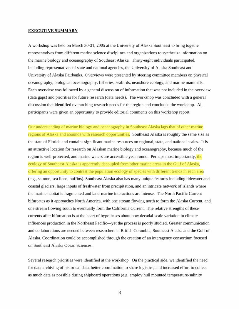
EXECUTIVE SUMMARY
A workshop was held on March 30-31, 2005 at the University of Alaska Southeast to bring together
representatives from different marine science disciplines and organizations to synthesize information on
the marine biology and oceanography of Southeast Alaska. Thirty-eight individuals participated,
including representatives of state and national agencies, the University of Alaska Southeast and
University of Alaska Fairbanks. Overviews were presented by steering committee members on physical
oceanography, biological oceanography, fisheries, seabirds, nearshore ecology, and marine mammals.
Each overview was followed by a general discussion of information that was not included in the overview
(data gaps) and priorities for future research (data needs). The workshop was concluded with a general
discussion that identified overarching research needs for the region and concluded the workshop. All
participants were given an opportunity to provide editorial comments on this workshop report.
Our understanding of marine biology and oceanography in Southeast Alaska lags that of other marine
regions of Alaska and abounds with research opportunities. Southeast Alaska is roughly the same size as
the state of Florida and contains significant marine resources on regional, state, and national scales. It is
an attractive location for research on Alaskan marine biology and oceanography, because much of the
region is well-protected, and marine waters are accessible year-round. Perhaps most importantly, the
ecology of Southeast Alaska is apparently decoupled from other marine areas in the Gulf of Alaska,
offering an opportunity to contrast the population ecology of species with different trends in each area
(e.g., salmon, sea lions, puffins). Southeast Alaska also has many unique features including tidewater and
coastal glaciers, large inputs of freshwater from precipitation, and an intricate network of islands where
the marine habitat is fragmented and land-marine interactions are intense. The North Pacific Current
bifurcates as it approaches North America, with one stream flowing north to form the Alaska Current, and
one stream flowing south to eventually form the California Current. The relative strengths of these
currents after bifurcation is at the heart of hypotheses about how decadal-scale variation in climate
influences production in the Northeast Pacific—yet the process is poorly studied. Greater communication
and collaborations are needed between researchers in British Columbia, Southeast Alaska and the Gulf of
Alaska. Coordination could be accomplished through the creation of an interagency consortium focused
on Southeast Alaska Ocean Sciences.
Several research priorities were identified at the workshop. On the practical side, we identified the need
for data archiving of historical data, better coordination to share logistics, and increased effort to collect
as much data as possible during shipboard operations (e.g. employ hull mounted temperature-salinity
8
sensors, etc.). On the science side, we need to better understand trophic linkages at the ecosystem level,
particularly predator-prey interactions of commercially important fish and shellfish, birds, and marine
mammals. Locations that have been well studied should integrate data across disciplines to examine
linkages among physical processes and higher and lower trophic levels. Early life histories and
recruitment dynamics are needed to better understand critical life stages and population regulation.
Trophic studies need to be conducted during all seasons because some populations may be limited by
winter conditions, whereas others may be limited by factors during another season. Primary and
secondary production need to be studied in this context (e.g. phytoplankton are limited by light in the
winter and can be limited by nutrients in the summer) and to understand oceanographic processes that
occur in productive versus unproductive areas. Past productivity can be extrapolated from sediments in
anoxic basins and from records of growth in bivalves and fishes. Nutrient inputs, uptake, and transport
must be examined to understand primary productivity. Harmful algal blooms are a persistent problem
that warrants further study. A comprehensive inventory of Southeast Alaska marine resources has never
been conducted and would be very valuable to examine biological and physical properties of the marine
ecosystem. Comparisons between northern and southern Southeast Alaska as well as comparisons
between inside waters and offshore regions of Southeast Alaska would be very interesting in light of the
physical differences among these regions. Long-term time series generated by continuous sampling in
discrete locations are valuable for detecting changes over time. Moorings should be established in inside
waters in Southeast Alaska to continuously sample weather and oceanographic parameters. Mapping
efforts should be continued and expanded, including multibeam mapping of subtidal regions and
ShoreZone mapping of intertidal regions.
Future synthesis efforts will include bibliographies and review papers. Bibliographies will be made
available on the Workshop website. Review papers will be prepared by steering committee members on
each focus area and submitted to peer-reviewed journals. Additional information from the workshop,
including PowerPoint presentations from the workshop, is available on the workshop website
http://uashome.alaska.edu/~jfgle1/SynthesisWorkshop/.
9
WORKSHOP SYNOPSIS
Day 1 (March 30) morning
Introduction
Ginny Eckert introduced the goal and structure of the workshop. The goal was to review and synthesize
what is known about marine biology and oceanography of the Southeast Alaska region and then prioritize
future directions for research. The workshop was structured such that steering committee members
(Eckert, Eisner, Kruse, Weingartner, Piatt, and Straley) along with additional experts provided short
overviews of five focus areas (oceanography, nearshore ecology, fisheries, seabirds and marine
mammals). Each overview was followed by a general discussion to address 1) additional existing data
not identified by the speaker that could be included in the synthesis project and 2) priorities for research
within this topic. Workshop participants were selected to represent the broad range of topics covered
during the workshop, although an effort was made to keep the group small enough to facilitate cross-
disciplinary interaction. The North Pacific Research Board provided funding for the workshop and for a
steering committee to conduct the synthesis. Products include this workshop report and synthesis review
papers to be published in peer-reviewed journals. For the purposes of this synthesis, Southeast Alaska
was defined to range from Cape Fairweather to Dixon Entrance.
Oceanography Overview
Physical Oceanography – Southeast Alaska
Overview prepared and presented by Thomas Weingartner, Institute of Marine Science, University of
Alaska Fairbanks.
“Southeast Alaska: Oceanographic Habitats and Bridges”
The oceanography of Southeast Alaska is intimately linked to its complex geological structure and
meteorology in the Northeast Pacific Ocean. Glaciers and tectonic processes carved a complex of
channels and fjords throughout the archipelago and a deep, narrow (10 – 30 km), and corrugated
continental shelf. The region is bounded by steep mountains that, combined with storms associated with
the Aleutian Low, influence wind and precipitation patterns. These storms result in strong winds and
heavy precipitation rates year-round, which significantly affect shelf and archipelago circulation fields.
The region is also forced from offshore by basin-wide circulation that flows northward as a diffuse and
weak eastern boundary current (Alaska Current) along the continental slope of Southeast Alaska. The
Alaska Current, which forms as the westward-flowing North Pacific Current bifurcates offshore of British
Columbia, connects the Gulf of Alaska to the North Pacific Ocean and advects relatively warm water into
10
the region. The location and strength of the Aleutian Low governs the strength of the Alaska Current and
the bifurcation latitude of the North Pacific Current.
Winds and precipitation vary seasonally, resulting in seasonal changes in circulation, mixing, and
stratification. Downwelling favorable winds prevail from fall through early spring; winds are stronger in
northern Southeast Alaska than along the British Columbian shelf. In summer, downwelling weakens
over the northern shelf while upwelling winds develop over the southern Gulf of Alaska. The shelf wind
field is thus divergent year-round with potentially important consequences for the shelf and archipelago.
For example, the divergence will affect cross-shelf circulation patterns, exchange between the shelf and
deep basin, and, through the establishment of alongshore pressure gradients, flows in the channels of the
archipelago. Within the archipelago, orography steers winds, resulting in large spatial gradients in wind
velocity, circulation, and mixing.
Runoff is minimal in winter (when precipitation is stored in the mountain snowpack), increases in
summer with melting, and is maximal in fall when precipitation rates are heaviest. On annual average the
precipitation forces a coastal runoff of ~15,000 m3 s-1 (or 60% of the total coastal discharge into the Gulf
of Alaska). Coastal runoff affects seasonal variations in stratification and promotes fjordal circulations in
coastal embayments. In conjunction with the (mostly) downwelling favorable winds, runoff also forces a
northward mean flow along the coast. This mean flow contributes to the Alaska Coastal Current and thus
directly bridges the British Columbian and northern Alaskan shelves.
Tides interact with complex topography, giving rise to a plethora of small scale circulations that include
tidal bores, internal hydraulic jumps, residual flows, and lee eddies. Many of these processes are likely
modulated over the spring-neap cycle and by changes in wind and runoff. The tides likely affect
exchange of waters between main channels and fjords and bays comprising the archipelago. These
various phenomena are likely to be crucial in advecting and/or retaining plankton and fish larvae and
regulating biological production within the archipelago.
In summary, tides, winds, and runoff interact with a complex bathymetry to transport mass, heat,
freshwater, nutrients, and organisms northward from the southern to the northern Gulf of Alaska. These
interactions also lead to large spatial and temporal gradients in biological production and create an array
of diverse biological habitats. Thus, regional biology and physical oceanography will substantially
modify the waters flowing northward through Southeast Alaska and likely affect production on the
northern Gulf of Alaska shelf. In spite of its apparent importance to both regional oceanographic issues
11
and to the larger Gulf of Alaska ecosystem, there have been few systematic studies in this region. Much
work is needed to understand physical oceanography throughout Southeast Alaska as extrapolations based
on models of dominant processes are generally inaccurate. However these models serve as a useful
framework and a good starting point for future observations and studies.
Physical Oceanography – Gulf of Alaska
“Temperature and Salinity in the Gulf of Alaska”
Overview presented by Bill Crawford, Division of Fisheries and Oceans, British Columbia.
Overview prepared by Ginny Eckert, University of Alaska Southeast.
Bill Crawford and his colleagues studied temperature and salinity anomalies in the Gulf of Alaska
including Southeast Alaska using NODC-archived data and data from Station P off the coast of British
Columbia from 1950 to 2004. The overall patterns are that surface waters (10 to 50 m depth) in summer
were cool in the mid-1960s with a regime shift to warmer waters around 1978. El-Niño years were warm,
typically followed by cool years, and temperatures in 2004 were the warmest in this time series,
potentially as a result of unusual summer weather in the Gulf in spring and summer of 2004. Deeper
waters (100 to 150 m depth) show similar patterns with cool and warm periods but fewer fluctuations
from year to year. Salinity anomalies in surface waters (10 to 50 m depth) at Station P demonstrated fresh
and salty episodes in 2000 and 2003 that were the largest and broadest in space and of opposite sign.
Salinity anomalies in deeper waters (100 to 150 m depth) exceeded the range of anomalies observed at
surface waters and include a large freshwater episode centered in 2002 and ranging from 2000 to 2003.
The analysis of temperature and salinity in the Gulf of Alaska also reveals eddies that persistently form in
two locations: 1) the Haida eddy that is generated at the southwestern tip of the Queen Charlotte Islands
and 2) the Sitka eddy west of Sitka. These eddies are generated nearshore and transport coastal water
with associated higher nutrients and coast-associated species and larvae westward. Sinclair and Crawford
(2005) linked cod recruitment success to sea level in Prince Rupert, presumably as an index to eddy
formation which transports cod larvae offshore in poor recruitment years. Understanding forcing
mechanisms, transport, and frequency of formation of these eddies is a critical research need for the Gulf
of Alaska.
Sinclair, A. F., and W. R. Crawford. 2005. Incorporating an environmental stock-recruitment relationship
in the assessment of Pacific cod (Gadus macrocephalus). Fisheries Oceanography 14:138-150.
12
Biological Oceanography
Overview prepared and presented by Lisa Eisner, NOAA Fisheries, Auke Bay Laboratory.
Southeast Alaska is a diverse and complicated system with fine and meso scale variations in timing,
distribution and intensity of plankton dynamics. Limited research has been conducted in biological
oceanography with long term temporal coverage only in select regions. This review provides an
introduction to some of the relevant processes by focusing on areas or projects with several year of time
series data on plankton and water mass characteristics in Southeast Alaska. Areas include Auke Bay,
Glacier Bay, Icy Strait, the outer coast, and hatcheries near Sitka Sound, Juneau and Ketchikan. This
review also lists biological oceanography data collected over broader spatial areas in Southeast Alaska
(i.e. satellite surface ocean color observations and zooplankton sampling during Canadian salmon
surveys).
Auke Bay is a relatively small (11 km2) shallow (~ 50 m) bay with relatively low freshwater input located
~10 miles north of Juneau. Earlier work in Auke Bay includes sampling by the National Marine Fisheries
Service (NMFS) for salinity, temperature, chlorophyll a, and zooplankton in the 1950s, graduate student
research projects (Oregon State University, University of Alaska Juneau) on phytoplankton and nutrient
cycling in the late 1960s and early 1970s, and studies on currents, water quality, and intertidal habitat
during the marina expansion project in the early 1980s. Most of the peer-reviewed literature on biological
oceanography is from process studies during the APPRISE (Association of Primary Production and
Recruitment in Subarctic Ecosystems) project in Auke Bay in the late 1980s. The main objective of the
APPRISE work was to identify relationships between environmental factors, primary and secondary
production, and the recruitment success of selected larval fish and shellfish. Some of the key biological
oceanography findings of APPRISE for phytoplankton and zooplankton are as follows. The spring bloom
started the first or second week in April (after 5-7 days of sunny weather), lasted approximately one
month and was terminated upon depletion of nutrients in photic zone (Ziemann et al. 1990). Secondary
blooms throughout the spring and summer were triggered by resupply of nutrients by wind driven vertical
mixing (Iverson et al. 1974, Ziemann et al. 1990). Sedimentation of the primary spring bloom peaks in
May, and approximately 40% of the bloom is lost from photic zone (Laws et al. 1988). The dominant
phytoplankton (diatom) genera are Thalassiosira, Skeletonema, and Chaetoceros (Waite et al. 1992). The
spring zooplankton populations peak in mid May and June with abundances dominated by copepods and
biomass dominated by copepods, euphausiids and decapod larvae (Coyle and Paul 1990). Copepods and
euphausiids consumed no more than 30% of the spring bloom production which suggests zooplankton
were not food limited (Coyle and Paul 1990). The dominant copepod genera were Pseudocalanus,
13
Acartia, and Centropages, although the relative importance varied seasonally (Wing, pers. comm.). For
king crab larvae, the length of the larval period was negatively correlated with chlorophyll a
concentration and survival (Shirley and Shirley 1990).
Glacier Bay is a recently deglaciated fjord system (1255 km2) in northern Southeast Alaska, located 60
miles northwest of Juneau with numerous sills and deep (over 400 m) basins, large freshwater inputs from
streams and tide water glaciers and high sedimentation rates (Hooge and Hooge 2002). Glacier Bay
conductivity-temperature-depth (CTD) vertical profiles with sensors for photosynthetic available
radiation (PAR), chlorophyll a fluorescence, optical backscatter (OBS, turbidity) have been collected at
24 stations in the Main Basin and East and West Arms two to four times per year (often March, July,
October, December) from 1993-2005 by the United States Geological Survey (USGS) for the National
Park Service (Hooge and Hooge 2002, Etherington et al. 2004). The spatial variations in surface
chlorophyll a concentrations provide and indication of primary production dynamics. The highest
chlorophyll a levels occurred in the Central Bay, lower reaches of East and West Arms, and Geikie Inlet
and correspond to areas of intermediate stratification, higher light levels (decreased sediment loads), and
zones of potential nutrient regeneration (Etherington et al. 2004). Additional CTD stations were sampled
throughout the bay in summer 1999, 2002 and 2004 (studies by John Piatt and Jim Taggart, USGS) with
water samples collected for nutrients, chlorophyll a (total and size-fractionated), and phytoplankton
species in 2002 and 2004. Initial findings show that there was surface nutrient depletion in summer 2002
(Eisner, unpublished data). Limited studies on secondary production in Glacier Bay indicate that
zooplankton densities were four to five times higher in East and West Arms compared to the Central Bay
and outlying Icy Strait (Robards et al. 2003).
The South East Coastal Monitoring (SECM) group at Auke Bay Laboratory (NMFS) has conducted
juvenile salmon and oceanographic surveys in northern Southeast Alaska including transects in Auke
Bay, Chatham Strait, Icy Strait, Cross Sound, Icy Point, Cape Edwards (Orsi et al. 2000, 2004). Surveys
have been conducted from May-September for 1997 to present, although spatial coverage has varied
between years. Oceanographic parameters collected include CTD vertical casts (temperature, salinity,
density only), surface (2 m) chlorophyll a and nutrients, surface along track thermosalinograph
measurements (temperature and salinity), Secchi disk (water clarity), and zooplankton (243, 333, 505 µm
net tows). One preliminary finding is that daytime biomass of deep 333µm mesh samples declined
seasonally along a habitat gradient, inshore to offshore (Sturdevant pers. comm. 2005). An examination
of the surface nutrient concentrations indicated that dissolved inorganic nitrogen (i.e. nitrate and
ammonium) declined to limiting values (< 1µM) for at least one sampling period between May and
14
August for Auke Bay, Icy Strait and Icy Point stations in 2000-2003, but not in 1999. In general,
nutrients appeared to decline earlier in the season in Auke Bay than at locations closer to the coast (Icy
Strait and Icy Point) possibly due to differences in the timing of the spring bloom. Additional spatial and
seasonal trends should be examined for this physical and biological oceanographic data set.
SeaWIFs ocean color images of chlorophyll a processed by The Sea-Air-Land Modeling and Observing
Network (SALMON) Project at the University of Alaska, http://www.ims.uaf.edu/salmon/index.html)
can indicate the spatial extent of surface chlorophyll a (indicator of phytoplankton biomass) during cloud
free conditions. These images showed mesoscale features (meandering eddy like structures) in coastal
waters (e.g. May 3, 2003). These images also showed that the spring bloom occurred in northern
Southeast Alaska during April (between April 2 and May 3 in 2003), but generally occurred earlier (in
March) off Sitka and in southern Southeast Alaska inside waters. During several days of cloud free
weather in early April 2000, a bloom formed near Sitka Sound was seen to grow substantially and advect
along the coast northward and offshore over the course of a few days to a week. The use of ocean color is
limited since these images cannot show spatial distribution of subsurface blooms (which may occur later
in the growing season) and are hindered by the cloud cover frequently coving much of Southeast Alaska.
Canadian cruises for juvenile salmon were conducted in Southeast Alaska four times per year from 1995
to present (Welch et al. 2003). During these cruises scientists also collected oceanographic parameters:
CTD (fluorometer and transmissometer in recent years), surface nutrients, surface chlorophyll a, and
zooplankton oblique or vertical tows (253 µm) for species enumeration and size fractionation. Data were
collected off the coast and within inside waters depending on the season (more stations are sampled in
Southeast Alaska during fall than in other seasons). These data could provide an indication of ecosystem
and climate change (variations in zooplankton species, water mass properties, etc.) during the past 10
years, particularly in coastal Southeast Alaska where sampling was more frequent.
Nutrients in coastal waters in the Gulf of Alaska, including Southeast Alaska, and extending southward
from British Columbia to Oregon were depleted (< 1 µM nitrate) during summer months (Whitney et al.
in press). Stekoll and Else (1992a, 1992b) collected nearshore nutrient samples near Sitka for a couple of
years. Because data for Southeast Alaska are limited, additional nutrient collection and data analyses for
Southeast Alaska coastal and inside waters would aid in understanding productivity dynamics and allow
comparisons with Northeast Pacific ecosystems.
15
Salmon hatcheries, including DIPAC (Douglas Island Pink and Chum), NSRAA (Northern Southeast
Regional Aquaculture Association), and SSRAA (Southern Southeast Regional Aquaculture Association),
measured weekly surface temperature and salinity, water clarity (Secchi disk depth), and zooplankton
abundance (with limited species ID using a 243 µm net towed horizontally (SSRAA), vertically (DIPAC)
or both (NSRAA)) during spring months. Sampling has been conducted by NSRAA from late March to
late June since 2002 at six sites in Sitka Sound, by DIPAC from mid-April to mid-June since the early
1990s at three sites north and south of Juneau and by SSRAA from Feb to April/May since the early
1980s at four widely spaced sites in southern Southeast Alaska (Anita Bay, Neets Bay, Nakat Inlet,
Kendrick Bay). A comprehensive analysis of these data has not been conducted but could provide an
indication of interannual variation in oceanographic parameters, such as the timing of the spring bloom,
etc.
Harmful algae species in Southeast Alaska include Alexandrium catenella, a dinoflagellate that produces
paralytic shellfish poisoning (PSP) and Pseudonitzschia spp., a diatom that produces domoic acid
poisoning. In Southeast Alaska, PSP occurs in shellfish in inside and coastal waters; whereas domoic
acid poisoning has not been studied but is more likely to occur in coastal waters (Red Tide Newsletter,
1999, Northwest Fisheries Science Center, NOAA). Historically, several deaths in Alaska have been
attributed to PSP poisoning, particularly among indigenous peoples who harvest shellfish for subsistence.
The State of Alaska only monitors commercial shellfish for PSP; however, recreational and subsistence
harvests and phytoplankton that cause PSP are not monitored.
Coyle, K., and A. Paul. 1990. Abundance and biomass of meroplankton during the spring bloom in an
Alaskan Bay. Ophelia 32:199-210.
Etherington, L. L., P. N. Hooge, and E. R. Hooge. 2004. Factors Affecting Seasonal and Regional
Patterns of Surface Water Oceanographic Properties Within a Fjord Estuarine System: Glacier
Bay, AK. Alaska Biological Science Center, USGS. 79 p.
Hooge, P. N., and E. R. Hooge. 2002. Fjord Oceanographic Processes in Glacier Bay, Alaska. Alaska
Biological Science Center, USGS. 148 p.
Iverson, R. L., H. C. Curl, and J. L. Saugen. 1974. Simulation model for wind driven summer
phytoplankton dynamics in Auke Bay, Alaska. Marine Biology 28:169-178.
Laws, E., P. Bienfang, D. Ziemann, and L. Conquest. 1988. Phytoplankton population dynamics and the
fate of production during the spring bloom in Auke Bay, Alaska. Limnology and Oceanography
33:57-65.
16
NOAA Northwest Fisheries Science Center. 1999. Red Tides.
http://www.nwfsc.noaa.gov/hab/Outreach/RedTideNewsletters.htm
Orsi, J. A., E. A. Fergusson, M. V. Sturdevant, B. L. Wing, W. R. Heard, A. C. Wertheimer, and D. G.
Mortensen. 2004. Survey of Juvenile Salmon in the Marine Waters of Southeastern Alaska, May–
August 2003. Alaska Fisheries Science Center, Auke Bay Lab., National Marine Fisheries
Service, NOAA. 59 p.
Orsi, J. A., M. V. Sturdevant, J. M. Murphy, D. G. Mortensen, and B. L. Wing. 2000. Seasonal habitat
use and early marine ecology of juvenile Pacific salmon in southeastern Alaska. Pages 111-122.
in Recent Changes in Ocean Production of Pacific Salmon. North Pacific Anadromous Fish
Comm., Vancouver BC.
Robards, M., G. Drew, J. F. Piatt, J. M. Anson, A. Abookire, J. L. Bodkin, P. Hooge, and S. Speckman.
2003. Ecology of selected marine communities in Glacier Bay: Zooplankton, forage fish,
seabirds, and marine mammals. Final Report for Glacier Bay National Park, National Park
Service. Alaska Science Center, U.S. Geological Survey, Anchorage, Alaska.
Shirley, S., and T. Shirley. 1990. Planktonic survival of red king crab larvae in a subarctic ecosystem,
1985-1989. Pages 263-286 in D. A. Ziemann and K. Fulton-Bennett, editors. APPRISE-
Interannual variability and fisheries recruitment. The Oceanographic Institute, Honolulu HI.
Stekoll, Michael S. and Page V. Else. 1992. The artificial cultivation of Macrocystis integrifolia.
National Coastal Resources Research & Development Institute, Portland, Oregon. 55 pp.
Stekoll, Michael S. and Page V. Else. 1992. The Feasibility of Macrocystis Mariculture in Southeast
Alaska. Japan Overseas Fishery Cooperation Foundation, Tokyo. 171 pp.
Waite, A., P. Bienfang, and P. Harrison. 1992. Spring bloom sedimentation in a subarctic ecosystem. 2.
Succession and sedimentation. Marine Biology 114:131-138.
Welch, D., J. Morris, M. Trudel, M. Thiess, T. Zubkowski, M. Jacobs, P. Winchell, and H. MacLean.
2003. A Summary of Canadian High Seas Salmon Surveys in the Gulf of Alaska 1995 to 2003.
Fisheries and Oceans Canada, Pacific Region 68 p.
Whitney, F. A., W. R. Crawford, and P. J. Harrison. In press. Physical processes that enhance nutrient
transport and primary productivity in the coastal and open ocean of the subarctic NE. pacific.
Ziemann, D. A., L. D. Conquest, K. Fulton-Bennett, and P. K. Bienfang. 1990. Interannual variability in
the Auke Bay phytoplankton. Pages 129-170 in D. A. Ziemann and K. Fulton-Bennett, editors.
APPRISE - Interannual variability and fisheries recruitment. The Oceanographic Institute,
Honolulu HI.
17
Oceanography General Discussion
Summary prepared by Ginny Eckert, University of Alaska Southeast
Overall, the oceanography of Southeast Alaska is poorly studied, and accordingly, there are many data
gaps and research needs. Virtually nothing is known about water flow into, out of, and through Southeast
Alaska; processes that may strongly influence the region as well as circulation in the Gulf of Alaska.
Pressure gauges that have been calibrated could simply and inexpensively monitor water flow in wider
channels such as the entrance of Cross Sound. An inventory of embayments within Southeast Alaska
could be used to generate first-generation models of water flow. A synoptic survey of all of Southeast
Alaska has never been conducted, is needed, and should include CTD & associated sensors to profile the
water column. Spatial and temporal variation in productivity needs to be documented, including
identification of high production areas and spatial and temporal variation in the timing of the spring
phytoplankton bloom. The spatial (vertical as well as horizontal) distribution of nutrients, phytoplankton,
and zooplankton are needed. Existing datasets could be used to identify temporal patterns with limited
spatial resolution, and routine surveys could add sensors (PAR, fluorometer, transmissometer, etc.) to
maximize information gained from ongoing CTD vertical profiles. Future sampling could obtain higher
temporal resolution using moorings that continuously sample with fluorometer, radiometer and nutrient
sensors at key locations. Ships of opportunity (ferries, National Oceanographic Survey ships such as the
R/V Fairweather based in the region) with hull-mounted thermosalinographs or towed CTD-profiling
systems could increase the oceanographic coverage in Southeast Alaska. Establishment of long-term
study sites (perhaps in Glacier Bay, Berners Bay or Sitka Sound) would allow characterization of
oceanographic processes and monitoring of effects of climate and other changes in Southeast Alaska.
Priority research areas
I. Water flow
a. Coupling between shelf and inland waters – How much flow of the Alaska Coastal
Current goes through the inland passage compared to along the shelf?
b. Connections with BC? source waters?
c. Need basic inventory of fjords and embayments – geometry, basin sizes, tides, runoff,
meteorology
d. Seasonal variability
e. Circulation in inside waters, estuaries, fjords, bays – how much shelf edge water moves
to/through inside passage?
18
f. Movement of meroplankton and influences on recruitment – effect of gyres/eddies?
Spatial and temporal variation in recruitment?
II. Production
a. What are the oceanographic characteristics of hotspots for birds, marine mammals and
fish? Work in other areas suggests that productivity not be a predictor of aggregations –
e.g. forage fish spawning areas draw in marine mammals
b. Seasonal and interannual variation in production
c. Benthic-pelagic coupling
d. Head of fjord anomalies
e. Influence of nutrients/iron – sources of these chemicals?
f. Influence of glaciers on production? Relation of sediments to production?
III. Mapping
a. Benthic mapping – some already done; can differentiate hard & soft bottom.
b. Satellite images can reveal information on sediments/productivity/SST
IV. Climate/Weather
a. Precipitation & wind data – need better spatial coverage
b. Glacial inputs? Freshwater, sediments
c. Aggregate long-term data from various locations (Sitka air temperature, Little Port
Walter temperature (weather station since 30s), Ketchikan tide gauge system, Maybe tide
gauge at Skagway, Auke Bay data from 1960-present)
V. Data archives
a. Archive/link to existing datasets
b. Archive/link to existing satellite data (note bias in using data from only clear days)
c. Need to analyze existing data(e.g. plankton data from fish hatcheries)
d. Need to calibrate/ground-truth satellite data.
Fisheries Overview
Overview prepared and presented by Gordon Kruse, Juneau Center School of Fisheries and Ocean
Science, University of Alaska Fairbanks.
Fishery History
For purposes of fisheries considerations, “Southeast Alaska” is taken to be those waters from Dixon Entrance
to Cape Fairweather, corresponding to State of Alaska Statistical Area A.
19

Humans have occupied Southeast Alaska for more than 10,000 years. Middens, including remains of human
use of marine resources, found in caves in Southeast Alaska have been radiocarbon dated to 5,500 years old.
Pre-historical marine harvests by humans included marine mammals, red and black seaweeds, and a variety
of fish and invertebrates. Ancient fishing technologies included fish clubs, salmon spears, fish basket traps,
halibut hooks, eulachon dip nets, and salmon trap fences. Native halibut hooks were remarkably effective.
In Southeast Alaska, “history” began with the first European contact in 1741, when Aleksei Chirikof sailed
the vessels St. Paul to Alexander Archipelago. The earliest commercial groundfish fisheries included Pacific
cod in the 1880s and Pacific halibut and sablefish in the 1890s. Early cod fisheries were dory fisheries, but
trawls were first employed in 1875. The primary product was salted cod. The Pacific halibut fishery was
stemmed by demand associated with the overfishing of Atlantic halibut stocks and the completion of the
transcontinental railroad in 1887. Halibut and sablefish fisheries were prosecuted by longlines in dory
fisheries. The primary products were fresh and iced.
The first commercial herring fishery began in 1878 in Southeast Alaska. Most herring were rendered for oil,
and the Alaska herring reduction fishery was dominated by Southeast Alaska landings through the 1920s.
After harvests plummeted in the 1930s, the herring fishery shifted to Prince William Sound and Kodiak.
Commercial salmon fisheries began in the late 1880s; most salmon were caught in fixed or floating fish traps.
In the early years, most of the product was salted, but canning dominated the 20th Century. After salmon
catches plummeted by 1921, the White Act of 1924 was adopted that required conservation measures,
including closure of the salmon fishery at the midpoint of runs to allow the remaining fish up the river to
spawn. Owing to poor funding and enforcement, many salmon runs are thought to have been overfished in
the 1920s-1950s. The perceived need for state control of fishery management was one of the leading
arguments for statehood, which was enacted in 1959.
Fishery Governance
The federal and state governments have parallel governance for management of fishery resources off the
coast of Alaska. The North Pacific Fishery Management Council is a body that recommends federal fishery
regulations to the U.S. Secretary of Commerce. The National Marine Fisheries Service (NMFS) is
responsible for implementing those regulations, as well as monitoring fish stocks and catches. Within
NMFS, the Restricted Access Management Program is responsible for managing Alaska Region permit
programs, including those that limit access to the federally-managed fisheries of the North Pacific. The
NOAA Fisheries, Office of Law Enforcement, as well as the U.S. Coast Guard, have responsibilities for
20
enforcement of federal fishery regulations. Within the state of Alaska, the Alaska Board of Fisheries
establishes fishery regulations, and the Alaska Department of Fish and Game implements fishery
management plans and regulations. The Commercial Fisheries Entry Commission controls the issuing of
permits for those state-managed fisheries that are limited (non-open access). The Alaska Bureau of Wildlife
Enforcement, within the Alaska Department of Public Safety, has responsibilities for enforcement of state
fishery regulations.
Contemporary Fisheries
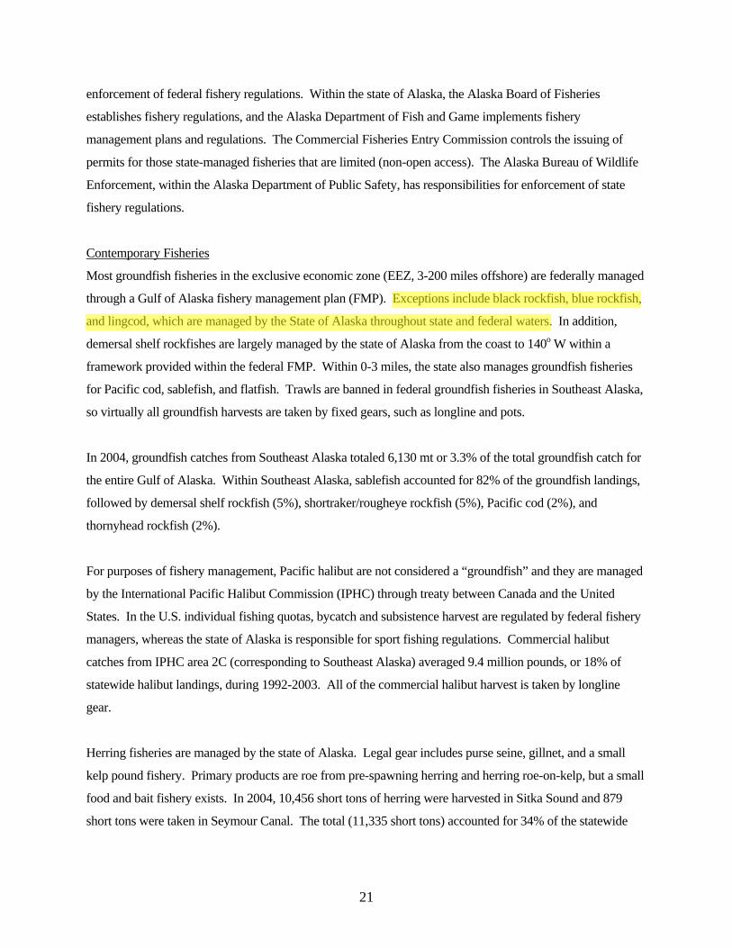
Most groundfish fisheries in the exclusive economic zone (EEZ, 3-200 miles offshore) are federally managed
through a Gulf of Alaska fishery management plan (FMP). Exceptions include black rockfish, blue rockfish,
and lingcod, which are managed by the State of Alaska throughout state and federal waters. In addition,
demersal shelf rockfishes are largely managed by the state of Alaska from the coast to 140o W within a
framework provided within the federal FMP. Within 0-3 miles, the state also manages groundfish fisheries
for Pacific cod, sablefish, and flatfish. Trawls are banned in federal groundfish fisheries in Southeast Alaska,
so virtually all groundfish harvests are taken by fixed gears, such as longline and pots.
In 2004, groundfish catches from Southeast Alaska totaled 6,130 mt or 3.3% of the total groundfish catch for
the entire Gulf of Alaska. Within Southeast Alaska, sablefish accounted for 82% of the groundfish landings,
followed by demersal shelf rockfish (5%), shortraker/rougheye rockfish (5%), Pacific cod (2%), and
thornyhead rockfish (2%).
For purposes of fishery management, Pacific halibut are not considered a “groundfish” and they are managed
by the International Pacific Halibut Commission (IPHC) through treaty between Canada and the United
States. In the U.S. individual fishing quotas, bycatch and subsistence harvest are regulated by federal fishery
managers, whereas the state of Alaska is responsible for sport fishing regulations. Commercial halibut
catches from IPHC area 2C (corresponding to Southeast Alaska) averaged 9.4 million pounds, or 18% of
statewide halibut landings, during 1992-2003. All of the commercial halibut harvest is taken by longline
gear.
Herring fisheries are managed by the state of Alaska. Legal gear includes purse seine, gillnet, and a small
kelp pound fishery. Primary products are roe from pre-spawning herring and herring roe-on-kelp, but a small
food and bait fishery exists. In 2004, 10,456 short tons of herring were harvested in Sitka Sound and 879
short tons were taken in Seymour Canal. The total (11,335 short tons) accounted for 34% of the statewide
21
herring harvests in 2004. Traditional herring fisheries at Kah Shakes/Cat Island, Hobart/Houghton, and West
Behm Canal were closed in 2004 because spawning biomass was estimated to be below threshold.
Salmon fisheries are managed by the state of Alaska under the auspices of the International Pacific Salmon
Commission, formed by treaty between the U.S. and Canada. The Salmon Commission provides regulatory
advice to both countries. A federal salmon FMP for the Gulf of Alaska provides a framework under which
the state of Alaska is the lead authority for salmon fishery management. Primary gear types include purse
seine, drift and set gillnets, and hand and power troll. All five species of Pacific salmon are taken in fisheries
in Southeast Alaska. Purse seine harvests are dominated by pink salmon, followed by chum salmon. The
majority of drift gillnet fisheries harvests are comprised of chum and pink salmon, but coho and sockeye
salmon are significant, as well. Troll fishery catches are dominated by coho and Chinook salmon.
A diverse number of shellfish fisheries are prosecuted in Southeast Alaska. A scallop fishery is managed
largely by the state under the frameworks provided by a federal fishery management plan. The state has full
management authority for the other shellfish fisheries. Crab pot fisheries include red king crab, golden king
crab, blue king crab, Tanner crab and Dungeness crab. A very small trawl fishery for shrimps and dredge
fishery for weathervane scallops exist. The state’s largest dive fisheries harvest geoduck clams, sea
cucumbers and sea urchins. In 2003, 8.4 million pounds of shellfish were harvested from Southeast Alaska,
including 3.34 million pounds of Dungeness crab, 1.64 million pounds of sea cucumbers, 1.06 million
pounds of pot shrimp, and 0.8 million pounds of Tanner crabs.
Fishery Issues and Research Opportunities
A diversity of fishery issues exists in Southeast Alaska. For groundfish, the population structure of sablefish
in inside and offshore waters remains uncertain, and increasing numbers of longline fishery interactions with
whales are problematic. Fisheries for black and blue rockfish and lingcod all suffer from lack of adequate
stock assessments, bycatch monitoring, estimates of discard mortality and concerns for localized depletion.
The primary issues surrounding the halibut fishery involve concerns about localized depletion and allocations
among commercial, sport, and charter boat operators. For herring, primary issues involve depressed prices,
allocations among competing users, and concerns about the role of herring as a forage fish in the ecosystem.
Salmon fisheries also suffer from depressed prices and corresponding industry restructuring, interception
issues, and concerns about introductions of Atlantic salmon escaping from net pens in British Columbia. For
shellfish, stock assessments and life history information are inadequate for many species, and local allocation
issues exist between commercial and recreational users. Paralytic Shellfish Poisoning (PSP) is an important
issue affecting fisheries for Dungeness crabs and bivalves (e.g., clams, mussels), and Bitter Crab Syndrome
22
has depleted Tanner crab stocks in northern Lynn Canal. Data limitations and agency funding retard the
development of other invertebrate fisheries (e.g. clams, mussels) and a developing mariculture industry has
been limited by issues surrounding water quality, zoning, monitoring, as well as PSP.
These issues and the geography of Southeast Alaska provide a wealth of fishery research opportunities. The
ability to work in relatively protected waters year-round and the location of nearby laboratories and seawater
facilities make it much easier to conduct research than, for example, in eastern Bering Sea, which occurs at
the same latitude as Southeast Alaska. The latitude of Southeast Alaska also provides opportunity for
comparative studies of fish and shellfish, including their role as prey for marine mammal populations, to fish
and shellfish assemblages in the western Gulf of Alaska and eastern Bering Sea. Fish and shellfish can be
studied within the contrast of divergent trends in populations of Steller sea lions, harbor seals, and sea otters,
as well as contrasts involving human interactions, such as trawl and no-trawl fishing zones. Stocks of crab,
shrimp, and herring appear to be more stable in Southeast Alaska compared to the rest of the Gulf of Alaska
and Bering Sea, perhaps providing opportunities to study biophysical mechanisms behind fishery stability
and collapses. Institutionally, there are also excellent opportunities to build upon existing fishery programs in
Southeast Alaska involving ADFG, NMFS, IPHC, USGS, and the University of Alaska Southeast and
University of Alaska Fairbanks, among others.
Fisheries General Discussion
Summary prepared by Ginny Eckert, University of Alaska Southeast
For the purposes of this synthesis, we decided to focus on fisheries and not address general fish biology
because of the vast amount of information available on fishes. However many aspects of fishes, including
commercial and non-commercial species, are very important and poorly known in Southeast Alaska.
Topics that should be addressed in another synthesis effort include but not be limited to the following.
• Trophic interactions among fishes, non-piscine predators such as marine mammals, and land-
based predators and scavengers such as eagles and gulls.
• Evolutionary processes, including genetic differentiation of populations and ecotypic variation
(characteristic of many salmon stocks), effects of harvest on evolution in various populations.
• Effects of hatcheries (community-wide ecological effects, effects on salmon genetics, etc.)
23
• Salmon stocks in SEAK that have special/unique features (See Halupka et al. 20001)
• Differences between anadromous and stream-resident populations
• Interactions among and within commercial and non-commercial species.
For many commercially harvested species in Southeast Alaska, basic life history information (e.g. timing
of reproduction, fecundity, early life stages, recruitment, age of reproduction, lifespan) and basic
energetic information (e.g. who eats whom and how much?) are needed. Future studies could relate
oceanographic information to fisheries within Southeast Alaska to examine potential forcing mechanisms
that explain temporal and spatial variability in populations and CPUE (e.g. PDO linkages, transport by
eddies, etc.). An understanding of movement of individuals and stocks is important to determine effects
of protected areas and apparent changes in populations/stocks at one location over time or seasons.
Potential relationships between standing stock and CPUE can be evaluated to determine population sizes
within this region. A comprehensive survey within Southeast Alaska is needed, as is long-term
community monitoring. Studies on forage fish and other prey items and predators of commercially
harvested species are needed to better understand the energetic properties of the ecosystem. Trophic
linkages and energetic requirements may be very important to explaining why some populations decline,
while others do not.
Priority research areas
I. Life history and distribution
a. Basic life history information needed for many commercially important species,
including information on recruitment over time
b. How early life history ties into physical oceanography/transport
i. Movement of meroplankton and influences on recruitment – effect of
gyres/eddies? Spatial and temporal variation in recruitment?
c. Interrelate fishery data with oceanography data to examine recruitment and movement
patterns.
i. Do oceanographic changes correspond to fishery changes and vice-versa,
both large-scale (e.g. PDO) and small-scale? Need long-term data sets for
both oceanographic and fishery information. Encourage interdisciplinary
1 Halupka, Karl C, Mason D. Bryant, Mary F. Willson, and Fred H. Everest. 2000. Biological characteristics and population status of anadromous salmon in Southeast. General Technical Report PNW-GTR-468. U.S. Department of Agriculture, Forest Service, Pacific Northwest Research Station, Portland, OR 255 pp.
24

interaction among oceanographers and fishery biologists/managers. Host
meeting to bring together these two groups.
d. Movement of individuals/stocks
i. a good example is POST – large scale tagging study
ii. how do movements change over time/seasons?
iii. Movements into/out of protected areas
II. Stock assessments
a. Relationship of standing stock to CPUE – what is population size?
b. Stock assessments done for some species and not others.
c. Comprehensive survey needed – what is out there? Trawl survey was conducted about
20 years ago. Could this survey be done again?
d. Analyze existing data to evaluate if populations in inside waters less variable than
population in outer waters.
e. Comparisons of BC stocks with Southeast Alaska stocks?
f. Long-term community monitoring
III. Trophic interactions/ Ecosystem-level studies
a. Bioenergetics – how much/what is consumed and by whom?
b. Need data on higher order predators, which are not commercially fished – e.g. sharks,
rays.
c. Need data on forage and other non-commercial species
i. Who are they? Where are they? When/how are they important? How do
their populations fluctuate over time and space? What are their basic life
history characteristics? Why/where do they aggregate?
d. Seasonality – how do abundances/distributions/energetics, etc. change?
e. Pelagic/benthic linkages
f. Community structure
g. Temporal and spatial variation in species diversity
Day 1 (March 30) afternoon
Nearshore Ecology Overview
Overview prepared and presented by Ginny Eckert, University of Alaska Southeast.
The nearshore includes intertidal and shallow subtidal benthic environments and incorporates many
diverse taxa, including fish, invertebrates, and marine macrophytes (algae and eelgrass), and many
25
different and ecologically important habitats, including, but not limited to, marshes, estuaries, fjords, kelp
beds, beaches and other intertidal areas. This portion of the marine ecosystem is most heavily impacted
by humans, and in Southeast Alaska, relatively little research has been conducted there. Published studies
fall into four categories: 1) fishery-related, 2) ecological studies (predator-prey interactions, etc.), 3)
biogeographic studies, and 4) environmental impact studies including inventories and monitoring.
Fishery-related studies include APPRISE (described in Biological Oceanography section above) and
studies on distributions and ecology of fished species, of which salmon, Dungeness crab and king crab
have been the best studied (see Fisheries section above). Beach seining has been conducted to study
nursery areas for juvenile fish and invertebrates. Areas used for mariculture have been surveyed by the
Alaska Department of Fish and Game (ADFG). A few studies have examined the ecological effects of
fishing, including effects of trawling on habitat-forming species such as corals and sponges, which are
very slow-growing and are severely affected by disturbance. Recently, several studies have examined
movements of commercially harvested species into and out of areas in which fishing was prohibited.
Lingcod showed a high degree of site fidelity and potential for increased egg production in unfished
areas. Effects of subsistence harvest of nearshore fish and invertebrates are poorly known.
Ecological studies include effects of sea otter predation on community structure. In Southeast Alaska,
otters are present in some locations, not in others, and are migrating into new areas at very fast rates.
Because otters are major predators on urchins, clams, and crabs, nearshore community structure is
drastically different when otters are present because their prey items, such as urchins, affect abundance of
kelps that provide habitat and strongly structure the community. A few ecological studies have examined
community structure in meiofauna (small organisms that live in sediments), however meiofauna in
general are greatly understudied and include many undescribed species.
Biogeographic studies in the North Pacific often include Southeast Alaska because it is an interesting
region where relict populations that survived the last ice age intermingle with populations founded by
recent colonizations. High latitude populations of the intertidal copepod Tigropius and other species
living in the high intertidal have less within-populations genetic variation than populations further south,
presumably because of contractions during the last ice age and recent colonizations. However, species
living lower in the intertidal or in the subtidal may have had a refuge and persisted during the last ice age,
and therefore, now have greater within-population genetic variation. The origins of several taxa within
Southeast Alaska have been studied and include sources from the Atlantic that migrate through the Bering
Strait and from the Pacific that migrated northward after deglaciation.
26
Studies of human impact have largely focussed on effects of canneries, logging, mining (Boca de Quadra,
Berners Bay), and other discharges. Few monitoring or inventories are conducted with the exception of
the National Park Service and US Geological Survey, who have largely focussed their efforts in Glacier
Bay, and surveys by US Fish and Wildlife Service that are mostly unpublished. A multi-agency group
(NOAA, ADFG, Alaska Department of Natural Resources, National Park Service, and The Nature
Conservancy) is now funding a series of aerial surveys called ShoreZone, which provide large-scale and
detailed GIS-based maps of visually-identifiable habitats and biota. In 2004, areas in Sitka Sound, Icy
Strait and Lynn Canal were surveyed. Plans for 2005 include the outer coast from Cape Spencer to the
west side of Icy Bay, north Icy Strait and islands, west Lynn Canal, west Chichagof Island, west Baranof
Island , Stevens Passage, and Taku Inlet. As funding permits, mapping would continue to include
contiguous areas, including Mansfield Peninsula on Admiralty Island including Hawk Inlet, east
Chichagof Island and east Baranof Island. Some regions of Southeast Alaska have been mapped using
multibeam sonar, including parts of Glacier Bay and areas near Sitka, and in a few areas, extent of kelp
has been mapped with multispectral digital mapping, including areas near Sitka and Point Baker.
Nearshore Ecology General Discussion
Summary prepared by Ginny Eckert, University of Alaska Southeast
Because the nearshore encompasses many other topic areas of this synthesis, several priority research
areas overlap with previous topics, including studies of life history and distribution of both commercially
and non-commercially important species, examining effects of oceanography on productivity and
transport of organisms, and bioenergetic and ecosystem-level studies. An understanding of coupling of
the nearshore with watersheds, pelagic zones and offshore zones is essential, as the nearshore is where
these different ecosystems intersect.
The ShoreZone project (described above) is an excellent mapping project that will provide valuable data
to many users. ShoreZone needs to be ground-truthed and compared with other inventories in the same
region (e.g. Glacier Bay Coastwalkers). Additional needs for mapping and inventories include multibeam
sonar of subtidal regions, including inventories of organisms that use these habitats, and multispectral
digital mapping of kelps. The function and dynamics of habitats need to be understood to better
understand their importance to commercially important species. The establishment of long-term
monitoring sites as well as a systematic inventory of Southeast Alaska nearshore are needed to establish
baselines within the region, because of expected changes as a result of development and other human
27
impacts such as climate change. It is expected that localized studies of human impact will continue in
areas with logging, canneries, mining or other activities, however a synthesis of previous studies may
provide an intriguing look at responses of nearshore organisms to disturbance.
Food webs and tropic interactions are poorly known in the nearshore, and studies of predators and
linkages to primary and secondary productivity are especially needed. Seasonal changes in community
structure is not well documented, and in the nearshore may help explain distributions and ecology of
commercially important species. The genetic composition and biogeography of Southeast Alaska is
interesting in light of the differences in Southeast Alaska as compared to other regions of the Pacific.
Existing data needs to be archived in a centrally available location, potentially at a site hosted by the
Knowledge Network for Biocomplexity (http://knb.ecoinformatics.org). Additionally, a multi-agency
organization is needed to serve as a hub for all marine-related research in Southeast Alaska.
Priority research areas
I. Life history and distribution
a. Recruitment of larvae – effects of oceanography on dispersal
b. Effects of jellyfish on larval (crab and fish) distributions/recruitment
II. Nearshore linkages to other systems (pelagic, offshore, watersheds, terrestrial, glaciers)
III. Habitat/ Physical processes
a. Habitat functions and dynamics (essential fish habitat: understand particular areas used
by juvenile fish and fish prey)
b. Spatial/temporal variation in habitat
i. Community structure & habitat changes with location in a fjord
ii. Glacier rebound – changes in nearshore as a result?
c. Habitat mapping - continue ShoreZone
d. Groundtruth ShoreZone and compare with other inventories (e.g. Glacier Bay
Coastwalkers)
e. Mulitspectral digital mapping of kelps
f. Habitat mapping – multibeam sonar – link to abundance and distribution of organisms
g. Systematic inventories needed as baseline & a few sites need to be established long-term
to determine temporal variability.
h. Invasive species monitoring
IV. Human Impacts
28
a. Subsistence use of intertidal organisms, kelps, clams, chitons, etc.
b. Effects of pollutants, other discharges
c. Effects of mining – Berners Bay, Coeur
V. Trophic interactions/ecosystem-level studies
a. Effects of predators, including seastars, octopus, bears, mink, eagles, etc.
b. Effects of life histories – recruitment variability
c. Taxonomy of zooplankton, meiofauna and other microscopic, but trophically important
organisms
d. Genetics and biogeography
e. Seasonal changes in species interactions, community structure, migrations
f. Food web interactions – direct and indirect interactions between different trophic levels
(e.g. Macoma, fish, birds) – links to primary and secondary production
VI. Data archives
a. for published and unpublished work
b. need organization to serve as hub
Seabirds Overview
Overview prepared and presented by John Piatt, USGS Alaska Science Center.
Some of the oldest historical observations of marine birds in Alaska were made in Southeast Alaska by
early naturalists, and a wealth of anecdotal information has been collected in recent decades as well.
Species composition and relative abundance of seabirds are described for most areas of Southeast Alaska.
A few systematic avifaunal surveys in Southeast Alaska show that the seabird community is similar to
that found in sheltered waters of Prince William Sound (PWS) to the north, but it is also distinctive from
PWS because it includes species found in abundance only in Southeast Alaska. The southern third of
Southeast Alaska shares greater biogeographic affinity with British Columbia (BC) than with areas to the
north. However, the root causes of biogeographic patterns of abundance are not known in Southeast
Alaska because intensive scientific investigations of seabird ecology, such as those funded in the Gulf of
Alaska and Bering Sea during the 1970s (e.g., OCSEAP), 1980s (e.g., PROBES) and 1990s (e.g.,
EVOSTC), have no equivalent in Southeast Alaska.
Sources of information on seabirds in Southeast Alaska derive from two basic sources: studies of birds at
their colonies and surveys of birds made from vessels at sea. Major colonies of seabirds were visited and
censused by US Fish and Wildlife Service (USFWS) biologists, mostly during the 1970s, as part of a
29
larger program to census seabird colonies throughout the state of Alaska (Sowls et al. 1980). Colonies
were visited and censused from boat- and land-based observation sites, and the most common colonial
species were counted or estimated by sampling of breeding habitat. Leach’s and Fork-tailed storm-petrels
account for about 70% of the 1.6 million seabirds estimated to occur at known colonies in Alaska.
Because storm-petrels are small and nest underground in small burrows on offshore islands, these
estimates are likely minimal. Storm-petrels forage on zooplankton in offshore waters, and are generally
not a conspicuous member of the Southeast Alaska bird community. Members of the alcid family
comprise 29% of all colonial seabirds, i.e., most of the remaining species, and are much more familiar to
visitors of the inside waters of Southeast Alaska. Of this family, the most abundant colonial species
include Rhinoceros Auklets, Ancient Murrelets and Cassin’s Auklets—all nocturnal, burrowing species
found in greatest abundance in southern Southeast Alaska and British Columbia (see more below). Most
large colonies are found along the outer coast, including those of Common Murres and Tufted Puffins.
Smaller colonies of Glaucous-winged Gulls, Pigeon Guillemots and Arctic Terns are scattered widely
among islands within the archipelago. Survey effort in Southeast Alaska is incomplete, and while the
largest colonies have been documented, it is likely that many small colonies have not been surveyed.
Intensive shoreline surveys for ground-nesting species in Glacier Bay revealed that nests of Mew and
Glaucous-winged gulls, Arctic Terns, and Pigeon Guillemots are more common, albeit dispersed, than
ever suspected previously (Arimitsu et al. 2004). This may be true throughout Southeast Alaska.
Relative to other areas of Alaska, little is known about population trends or breeding biology of seabirds
in Southeast Alaska. Most attention has been focused on seabirds breeding on rookeries monitored by the
USFWS at St. Lazaria Island, and to a much lesser extent, Forrester Island. Census data have been
collected for less than 10 years for several species such as Rhinoceros Auklet, Fork-tailed Storm Petrel
and Common Murre. Ancillary data are collected on diets and breeding success as well. Limited
collection of adult and chick meal data suggest that breeding birds rely on a few important forage species,
such as euphausiids, squid, myctophids (by offshore species such as storm-petrels), juvenile pollock,
capelin, sand lance and herring (Sanger 1987, FWS unpubl.).
Considerable data have been collected on the distribution and abundance of seabirds at sea in Southeast
Alaska. Offshore in the Gulf of Alaska, seabirds were surveyed on ships of opportunity during OCSEAP
(1975-1982). Systematic surveys were conducted in Sitka Sound by USFWS in 2000 and included
measures of seabird abundance in relation to water properties and acoustic biomass of prey (Piatt et al.
2000). These surveys revealed marked habitat partitioning in which offshore slope and oceanic water was
occupied by pelagic species such as Black-footed Albatross and Fork-tailed Storm-petrel, shelf waters
30
were used by Common Murres and Rhinoceros Auklets, and more sheltered inside waters were used by
Marbled Murrelets and Pigeon Guillemots. To some degree, this segregation is related to the types of
prey consumed by each species (see above), but this is poorly known for most seabirds in Southeast
Alaska.
There are few data on pelagic ecology of seabirds within the inside waters of Southeast Alaska. Only
Glacier Bay has been studied in detail, with concurrent studies of oceanography, primary production,
zooplankton, forage fish and marine predators, including seabirds (Robards et al. 2003). There is a strong
environmental gradient in Glacier Bay from North to South, ranging from glacial-river fed, stratified,
highly productive waters at the head of the bay to tidally-mixed, more oceanic waters at the mouth of the
bay. Most fish biomass is found within 0.5 km of shore in shallow (<80m) waters, and most (>75%) fish-
eating birds are found nearshore as well. The system is also structured from North to South, with higher
production of zooplankton and forage fish in the upper arms, and a corresponding higher abundance of
fish-eating seabirds. The upper bay is heavily glaciated, and contains a high concentration of pagophilic
species as well, such as Kittlitz’s Murrelet and Black-legged Kittiwake (and also harbor seals, which pup
on the ice and feed locally). The role of glaciers in the enhancement of marine productivity is poorly
understood, and few studies have been conducted to identify the linkages between glaciers and coastal
marine ecosystems.
There have been two extensive avifaunal surveys of Southeast Alaska. During summer, 1994, about 600
coastal and offshore transects were surveyed from small boats at randomly selected sites throughout the
entire Southeast Alaska region (Agler et al. 1995). During a five year period (1997-2001), a low-altitude
aerial survey of the entire shoreline of Southeast Alaska was conducted and all marine birds and
mammals were censused (J. Hodges, unpubl. data). These surveys, while imperfect (boats surveys less
than 0.1% of total area, aerial surveys on coast only, cannot identify all species), offer a snapshot of avian
biogeography not available from any other source and provide a census of all marine birds including non-
colonial species excluded from colony surveys previously described. Indeed, of the 1.9 million birds
estimated to occur at sea (excluding offshore Gulf waters), a large proportion were non-colonial breeders
(35% Marbled Murrelets, 32% seaducks) or did not breed locally (8% shearwaters, fulmars).
Several different patterns of distribution are evident from aerial and boat-based survey datasets.
Estimated to number more than half a million birds, the Marbled Murrelet is the single most abundant
species in Southeast Alaska and is widely distributed throughout. Marbled Murrelets nest in high-volume
old-growth coniferous trees, and their distribution is strongly influenced by the availability of nesting
31
habitat. Thus, while they are widely distributed, numbers are about half in southern Southeast Alaska
than in northern Southeast Alaska, reflecting in part the extensive logging of high-volume old-growth
forest that has taken place in the southern half of Southeast Alaska. Some species are found mostly in the
northern half of Southeast Alaska (Bonaparte’s Gull), some mostly in the southern half (Rhinoceros
Auklets), some are found almost exclusively in inside waters (scoters), and some mostly along the outer
coast (cormorants).
For most cases, we can only speculate on the cause of observed geographic patterns of distribution. Many
are likely to be related to geographic variability in food resources or nesting habitat. We know that both
Marbled and Kittlitz’s Murrelets, for example, feed on small forage fish such as sand lance and herring,
which are widely available in Southeast Alaska; as are Marbled Murrelets. However, Kittlitz’s Murrelets
have a restricted distribution during summer, where they nest on post-glacial till at high altitudes and feed
in coastal marine waters influenced by glacial river outflows. Rhinoceros Auklets and Cassin’s Auklets
are concentrated in southern Southeast Alaska, mostly along outer coasts south of Sitka. In British
Columbia, where both these species are abundant, they tend to feed in shelf and shelf break waters and
may require upwelling processes to bring their preferred prey to the surface. The North Pacific Current
bifurcates during summer near the break point in distribution of auklets (at Sitka), and only the southward
flowing current induces upwelling. Thus, the northward distribution of Rhinoceros and Cassin’s Auklets
may be ultimately constrained by large-scale current patterns offshore.
In summary, much remains to be learned about seabirds of Southeast Alaska and their role in the marine
ecosystem. Compared to other areas of Alaska, where long-term studies of seabirds provide unique
insights into marine ecosystem dynamics and often serve as barometers of ecosystem change, little is
known about seabirds in Southeast Alaska. It appears that at least a few species have declined rapidly
over some or all of their ranges in recent years (e.g., Kittlitz’s Murrelet, Marbled Murrelet, Pelagic
Cormorant, Surf Scoter, Tufted Puffin, etc.). Because Southeast Alaska has a different oceanographic
setting from the rest of the Gulf of Alaska or Bering Sea, it may be useful to compare and contrast the
ecology of seabirds residing in Southeast Alaska with those found elsewhere. This may help us better
understand community changes occurring in different areas in response to natural climate cycles, global
warming and potential anthropogenic impacts from fisheries, pollution and vessel traffic.
Agler, B.A., S.J. Kendall, P.E. Seiser, and J.R. Lindell. 1995. Estimates of marine bird and sea otter
abundance in Southeast Alaska during summer, 1994. U.S. Fish and Wildlife Service, Final
Report, Migratory Bird Management, Anchorage AK.
32
Arimitsu, M.A., M.D. Romano, and J.F. Piatt. 2004. Distribution and abundance of ground-nesting
seabirds in Glacier Bay National Park. Unpubl. Report. U.S. Geological Survey, Alaska Science
Center, Anchorage, AK.
Gould, P.J., D.J. Forsell, and C.J. Lensink. 1982. Pelagic distribution and abundance of seabirds in the
Gulf of Alaska and eastern Bering Sea. U.S. Dept. of the Interior, FWS/OBS 82/48. Washington
D.C. 294 pp.
Piatt, J.F. and D. Dragoo. 2000. Seabird, Marine Mammal and Oceanography Coordinated Investigations
(SMMOCI) in Sitka Sound, Alaska, July 2000. Final Rep. for the U.S. Fish and Wildlife Serv.,
USGS Alaska Biological Science Center, Anchorage. 28 pp.
Robards, M., G. Drew, J.F. Piatt, J. M. Anson, A. Abookire, S. Speckman, and J. Bodkin. 2003. Marine
communities and ecology of Glacier Bay: Zooplankton, forage fish, seabirds and marine
mammals. Final Rep. for Glacier Bay National Park (Gustavus, AK). Alaska Science Center,
USGS, Anchorage, Alaska, 151 pp.
Sanger, G.A. 1987. Trophic levels and trophic relationships of seabirds in the Gulf of Alaska. Pp. 229-
257 in J.P. Croxall (Ed.) Seabirds: feeding biology and role in marine ecosystems, Cambridge
Univ. Press, Cambridge.
Sowls, A.L., S.A. Hatch, and C.J. Lensink. 1978. Catalog of Alaskan seabird colonies. U.S. Dept. of the
Interior, FWS/OBS 8/78. Washington D.C., 185 pp.
Seabirds General Discussion
Summary prepared by Ginny Eckert, University of Alaska Southeast
For the purposes of this synthesis, we decided to focus on seabirds because there was a fair amount of
information available on this taxanomic group of higher marine vertebrates. Other marine and coastal
birds, including waterfowl and shorebirds, deserve study as well but were outside the scope of this effort.
Much is known about birds during breeding and while they are in colonies, but less is known about their
at-sea or non-breeding distributions, behavior and ecology. Productivity and oceanography can have a
strong influence on the foraging success of seabirds, but little is known about the linkages between
physical properties of the water, lower- and mid-trophic level organisims and the marine birds that depend
on them. The effect of the North Pacific Current bifurcation on the biogeography of seabirds in southeast
Alaska needs particular attention. The oceanography of foraging ‘hotspots’ in southeast Alaska and the
processes that influence their productivity also need study. The effect of birds as predators in the
nearshore needs to be studied, both for benthic and pelagic feeding species. For example, sea ducks reach
33
extremely high densities in nearshore areas of Southeast Alaska during winter, and likely have a large
effect on benthic community composition and the abundance of their prey. Human impacts of seabirds
that deserve study include effects of habitat degradation (e.g., from mining effluents), habitat loss (e.g.,
impacts of logging of old-growth on Marbled Murrelets), pollutants (including organochlorines and
petroleum products) on reproductive success, effects of vessel disturbance on birds at sea, effects of
fisheries on either the prey populations used by seabirds or on the bycatch of adult members of the
population, and effects of climate changes (e.g., loss of glaciers and glacially influenced habitat for
Kittlitz’s Murrelet).
Priority research areas
I. Life history and distribution
a. Link abundance and distribution to oceanography
i. Use satellite imagery, concurrent oceanographic studies
ii. Influence of glaciers on local productivity
iii. Effects of N. Pacific Current bifurcation off Sitka
b. Seasonal distributions – particularly in winter
c. Migrating seaducks – where do they stage in Southeast Alaska?
d. Banding, tagging colony returns and adult survival rates
e. Marbled murrelet population trends – most abundant species and indicator for region
(time series); redo complete surveys of SE, continue local surveys
f. Major declines in Kittlitz’s Murrelets – associated with glacial recession?
II. Trophic interactions/ Ecosystem-level studies
a. Bioenergetics – how much/what is consumed and by whom?
b. Energy flow/consumption/productivity
c. Locations and mechanisms of foraging ‘hotspots’
d. Seasonal changes in diets?
e. Monitoring of parasite loads (trematodes)
f. Effects of birds on pelagic/benthos as predators: role of sea ducks in nearshore
communities (lack of mobility of prey and high abundance of sea ducks in winter)
III. Human impacts
a. DDT/organic contaminant monitoring, effects of mining effluent, oil spills
b. Effects of logging on Marbled Murrelet nesting, populations
c. Vessel disturbance/human interactions on Kittlitz’s Murrelets
d. Mortality from fisheries (including longlines and night lights)
34
i. Logbook data of bird observations and bycatch
Day 2 (March 31) morning
Marine Mammals Overview
Overview prepared and presented by Jan Straley, University of Alaska Southeast.
In Southeast Alaska, two living marine mammal groups are represented. These are (1) the carnivores
which include the seals, sea lions and sea otters and (2) the cetaceans which include the whales, dolphins
and porpoises.
Carnivores have blubber and/or fur and can live on land and in the water. Harbor seals, Steller sea lions,
and sea otters are commonly seen carnivores in the waters extending from Cape Fairweather to the north,
Dixon Entrance to the south and out to the edge of the oceanic shelf approximately 12-25 miles offshore.
Cetaceans have blubber and live exclusively in water. They are divided into two suborders; baleen and
toothed whales. The common baleen whales are minke, humpback and gray whales. Historically,
northern right whales and fin whales were present but commercially harvested to depletion. The common
toothed whale is the killer whale. Also present and included in the toothed whale family are Dall’s and
harbor porpoises. Additionally, sperm whales are seen along the shelf edge and Pacific white-sided
dolphins are seen offshore and occasionally in the inside waters of the archipelago. Humpback, minke,
fin, northern right and sperm whales are listed as endangered and Steller sea lions as threatened under the
Endangered Species Act (ESA). Sea otters, harbor seals and Steller sea lions are harvested by Alaska
natives for subsistence use.
Harbor seals are found throughout Southeast Alaska. Their population is estimated to be about 21,000
seals from National Marine Fisheries (NMFS), National Park Service (NPS) and Alaska Department of
Fish and Game (ADFG) aerial survey and trend site data. The population is increasing in all areas except
Glacier Bay which has declined over 70% in the past 12 years. Due to genetic differentiation found in
many areas in Alaska, NMFS and Alaska native groups are currently reassessing stock boundaries for
harbor seals which may result in multiple stocks for Southeast Alaska.
Steller sea lions number about 15,000 and are distributed throughout Southeast Alaska with trends
increasing at all sites. Historically, three rookeries were identified and in recent years two additional
rookeries have been documented. Numerous studies by NMFS, ADFG and the North Pacific Universities
35
Marine Mammal Research Consortium (NPUMMRC) have investigated diet, population dynamics and
biomass of forage species available to Steller sea lions in Southeast Alaska.
Sea otters were extirpated in the 1800s and reintroduced to 7-10 locations along the outer coast of
Southeast Alaska during the 1960s. The United States Geological Survey (USGS) and US Fish Wildlife
Service (USFWS) have surveyed the distribution of sea otters throughout Southeast Alaska and found
their range extends along most of the entire outer coast and they have moved to inside waters in Glacier
Bay, lower Chatham Strait and parts of Clarence and Icy straits. Glacier Bay has had dramatic increases
in sea otters since 1992 when there were none present to a count of 2,000 in 2004. In the rest of Southeast
Alaska, however, there has been about a 6% decline in numbers during their range expansion. However,
because of the increase in Glacier Bay, overall numbers are stable with about 11,000 sea otters currently
in Southeast Alaska.
Of the large baleen whales, only the humpback has been studied to any degree by numerous independent
research groups since the late 1960s. Primary study areas have been in northern Southeast Alaska
(Frederick Sound, Sitka Sound, Chatham Strait, Icy Strait and Glacier Bay). In 2000, a collaborative
effort by J. Straley and NPS estimated about 1000 whales use these areas on an annual basis. Other
studies by NPS, NMFS and the University of Hawaii (UH) investigated distribution, acoustics and forage
species in the early 1980s. When these studies ended, NPS continued to monitor humpback whales in
Glacier Bay and parts of Icy Strait. Today the NPS research program involves studies of vessel-whale
interactions, acoustics and prey species. No information exists on the distribution or numbers of minke or
gray whales in Southeast Alaska, although minke whales are seen in low numbers on a regular basis in
some areas and gray whales migrate seasonally twice a year along the coast and some remain as summer
residents, presumably forgoing their northbound migration to the Bering Sea feeding grounds. There is
some evidence that fin whales may be recovering because they are seen along the shelf edge, off Prince of
Wales Island, and one was seen in Sitka Sound in 2004.
Of the toothed whales, only the killer whale has been studied to any extent in Southeast Alaska. Three
ecotypes have been seen in these waters: residents which eat fish; transients which prey upon marine
mammal and offshores which are infrequently seen and their diet is unknown. Both the resident and
transient groups number in the low hundreds, and offshores, which may range from the Bering Sea to
California, possibly number in the thousands. Sperm whales are found along the shelf edge, however,
little is known about the stock structure or population numbers in the North Pacific. These whales are
eating sablefish and halibut off commercial demersal longline gear. Studies are ongoing investigating this
36
behavior and the levels of depredation occurring in these fisheries (NMFS Auke Bay Lab, University of
Alaska Southeast and Scripps Institute of Oceanography). Harbor porpoise are found in quiet bays and
sounds of Southeast Alaska and NMFS surveys estimate numbers of harbor porpoise to be about 11,000
for this area. No specific estimate exists for either Dall’s porpoise or Pacific white-sided dolphins in
Southeast Alaska because they are considered as one stock in Alaska or the North Pacific and estimated
as such.
There are some seasonal hotspots, for cetaceans in particular. Humpback whales congregate at the
prominent points, pinnacles and areas where water flow is constricted (Pt. Adolphus, Pt. Baker, Frederick
Sound, southern Chatham Strait, possibly the Fairweather Grounds) during the summer months. Gray
whales are seen feeding in the same areas each spring and summer along the outer coast. Harbor porpoise
are often seen in large numbers in Icy Strait and Clarence Strait. During winter, hot spots occur where
herring gather to spend the winter and humpback whales, harbor seals and Steller sea lions are often
found in large feeding concentrations in these areas.
Needs for increasing our knowledge of marine mammals in Southeast Alaska can divided into those based
on 1) a lack of knowledge and 2) the intersection of increasing or recovering marine mammal populations
and increasing human actions such as increased vessel traffic in areas of frequent use by feeding marine
mammals or habitat degradation due to coastal development or resource extraction. A third need would
be to investigate reasons behind declines in populations, such as harbor seals in Glacier Bay, or major
ecosystem changes, such as the reintroduction of sea otters and their range expansion to areas that have
not had sea otters present for over 100 years or more (or ever such as in Glacier Bay).
Marine Mammals General Discussion
Summary prepared by Ginny Eckert, University of Alaska Southeast
General research needs for marine mammals are focused around three issues: 1) forage, 2) populations
and stocks, and 3) human impacts. Information on energetic requirements and available prey for marine
mammals are needed to inform ecosystem-level management and ecosystem models. Parameters specific
to Southeast Alaska are needed because of variation in energy content among and within forage species.
Information is needed on patchiness of prey and oceanographic conditions that might be associated with
prey aggregations and seasonal and ontogenetic changes in diets. Populations and stocks are relatively
well demarcated for some species (e.g. harbor seals) however greater spatial and temporal resolution is
needed for many species to better identify populations and stocks (e.g. harbor porpoise). Phenotypic and
37

genotypic variation in stocks needs to be characterized and explored. Distributions during winter are
greatly needed. Effects of human harvests and vessels (including effects of fishing) are the two primary
focal areas for human impacts.
Priority research areas
I. Forage/trophic interactions
a. Energetic needs – how much food? – parameters for Ecopath (Note - energy content of
same spp and size of krill vary greatly) Variation of energy content among/within spp.
b. What/where feeding? Also - Need info on density of prey patches – this drives a lot of
their pop dynamics.
c. Changes in diet seasonally - winter? Juvenile diets?
d. What oceanographic forces aggregate forage?
e. Need to know a lot more about Euphausiids and forage fishes in SE AK. A lot of taxa
depend on them
II. Populations & stocks
a. Spatial and temporal coverage - need finer resolution
b. Distributions during winter? (most studies during breeding season)
c. Effects of predation
d. Comparisons of stocks – different physical characteristics between stocks, why?
Understand differences (body size)
e. Fitness consequences – repro rates of diff habitats
III. Human impacts
a. Effects of harvest, bottlenecks
b. Vessel interactions
i. Need information on vessel/whale interaction. Speed and size of boat vs
size/age of whale vs density. Need info on noise, air quality, contaminants
ii. Info on entanglement rates, defining what is a serious injury
IV. Specific species
a. Sea otters
i. As sea otters move to inside waters – what are the effects? Otter effects on
communities with pop increase and colonization. Take a focus on South SE
AK because they’ve moved over to S. Prince of Whales shore (W. side
Clarence Strait). Have not moved yet to E. side. This will greatly impact sea
urchin fishery. Impact to fisheries – Dungeness crabs, urchins, abalone,
38
cucumbers, Tanner crabs, king crabs (feed on juvenile king crab in shallow
waters)
b. Harbor seals
i. Comparative studies of seal populations – Sitka, Ketchikan vs. Glacier Bay
ii. Gaps in genetic analysis – harbor seals
iii. Glacier dynamics – ice production/changes and how impacts harbor seals.
WORKSHOP FINDINGS AND RECOMMENDATIONS
Opportunities for expanding our knowledge about the marine biology and oceanography of Southeast
Alaska are great. Southeast Alaska is roughly the same size as the state of Florida and contributes
significantly to Alaskan fisheries, particularly for salmon, halibut, herring, Dungeness crabs, sea
cucumbers, and other shellfish and contains feeding and breeding grounds for many species of marine
mammals and birds. Southeast Alaska is an attractive location for research on Alaskan marine biology
and oceanography, because much of the region is well-protected, and marine waters are accessible year-
round. Many processes or questions that would be difficult to address in other regions of Alaska could be
more easily researched in Southeast Alaska. In fact, Southeast Alaska could serve as a model for Alaska
as a whole. Many processes, such as circulation patterns and their linkages to population dynamics,
might be best addressed there.
Broad research priorities that were agreed upon at the workshop include the following.
• Southeast Alaska bridges the Gulf of Alaska with regions further south through the Alaska
Current which bifurcates in British Columbia and transports relatively warm water into the North
Pacific. Oceanography and marine biology along the British Columbia coast probably most
resemble that in Southeast Alaska, and collaborations with Canadian colleagues should be
explored and expanded.
• Hydrography in Southeast Alaska is poorly known and likely drives circulation in the Gulf of
Alaska. For this reason, the circulation in the Gulf of Alaska will not be understood until more is
known about Southeast Alaska, particularly water flow into and out of the region. Greater
collaborations and partnerships should be formed between researchers in Southeast Alaska and
the Gulf of Alaska. Researchers exploring differences in salmon populations between the lower
48 and Alaska should include information from Southeast Alaska.
• Southeast Alaska has many unique features including its many tidewater and coastal glaciers,
large input of freshwater from precipitation, and an intricate network of islands where the marine
39
habitat is fragmented. The geological and glacial history of the region must be well-recognized.
Interactions between marine, terrestrial and glacial environments and organisms need to be
better studied.
• The marine research community in Southeast Alaska consists of many different agencies and
organizations who partner and collaborate, however greater coordination is needed. An
interagency consortium consisting of agencies and organizations should be developed and
focused on Southeast Alaska. Alternatively, a new organization could be created and serve as a
Southeast Alaska Ocean Science Institute (SEA-OSI).
• Partnerships among existing organizations should be enhanced; one mechanism for doing so
includes sharing logistics for marine shipboard operations and maximizing existing ship time to
collect as much data as possible at stations and while underway. Hull-mounted
thermosalinographs or towed CTD-profiling systems should be routinely employed on all
research vessels operating in the area, and resultant data should be uploaded to NODC
databases to ensure usability by a broad audience. Vessels with home ports in Southeast Alaska
should establish routine transects that they survey on their way into and out of port (e.g. new
NOAA vessel R/V Fairweather).
• Data from past studies from Southeast Alaska should be archived in a central and easily-accessed
location. For example, existing CTD data should be uploaded to NODC databases. Ecological
data can be uploaded to ecological databases such as the KNB. Previous sites should be
resampled to evaluate changes over time with coincident measures of physical processes. Long-
term monitoring should be initiated or continued in several key locations throughout the region.
Specific research priorities for each topic area are included in General Discussion sections above.
Priorities that are broad in nature and recurrent include the following.
• Trophic linkages, particularly predators and forage for fish and shellfish, birds, and marine
mammals, need to be studied and should be studied at the ecosystem level.
• Trophic studies need to be conducted during all seasons because some populations may be limited
by winter conditions, whereas others may be limited by conditions during another season.
• Early life histories and recruitment dynamics are needed to better understand critical life stages
and population regulation.
• Areas that have been well studied (e.g. Glacier Bay) should integrate data across disciplines to
examine linkages among physical processes and higher and lower trophic levels.
• Primary and secondary production need to be studied to understand oceanographic processes that
occur in productive versus unproductive areas. Past productivity can be extrapolated from
40
sediments in anoxic basins and from records of growth in bivalves and fishes. Nutrient inputs,
uptake, and transport must be examined to understand primary productivity.
• Harmful algal blooms are persistent; however their spatial and temporal extent is unknown and
needs to be studied.
• A comprehensive inventory of Southeast Alaska marine resources has never been conducted and
would be very valuable to examine biological and physical properties of the marine ecosystem.
• Comparisons between northern and southern Southeast Alaska as well as comparisons between
inside waters and offshore regions of Southeast Alaska would be very interesting in light of the
physical differences among these regions.
• Long-term time series are very valuable in detecting changes over time, as is continuous sampling
in discrete locations.
• Moorings should be established in inside waters in Southeast Alaska to continuously sample
weather and oceanographic parameters.
• Additional sensors, such as chlorophyll a fluorometers, beam transmissometers, and PAR sensors
should be added to physical oceanographic sampling (CTD profilers) to understand vertical
variations in phytoplankton dynamics.
• Scientists should study vertical and horizontal variation in zooplankton and fisheries abundances
using multi nets and/or acoustics, to determine “hot spots” in both vertical and horizontal spatial
domains.
• Mapping efforts should be continued and expanded, including multibeam mapping of subtidal
regions and ShoreZone mapping of intertidal regions.
41

Appendix 1. Workshop Agenda
Southeast Alaska Synthesis of Marine Biology and Oceanography
March 30-31, 2005
University of Alaska Southeast, Juneau
WORKSHOP AGENDA
March 30 Egan 221-222 Glacier View Room
8:00-8:30 Bagels and Coffee Glacier View Room
8:30 Introduction and Overview Ginny Eckert
8:40 Oceanography Overview Lisa Eisner & Tom Weingartner
9:10 Oceanography Discussion
10:30 Break
10:45 Fisheries Overview Gordon Kruse
11:05 Fisheries Discussion
12:30 Catered Lunch Lake Room – Mourant Building
1:45 Nearshore Ecology Overview Ginny Eckert
2:05 Nearshore Ecology Discussion
3:30 Break
3:45 Seabirds Overview John Piatt
4:05 Seabirds Discussion
5:30 Adjourn
6:30 Dinner Hanger Ballroom (downtown)
42

March 31 Egan Library 105 (basement of the library – to the left of the books)
8:00-8:30 Bagels and Coffee outside library entrance
8:30 Marine Mammals Overview Jan Straley
8:50 Marine Mammals Discussion
10:15 Break
10:30 General Discussion of Priorities for Southeast Alaska
12:30 Adjourn
43
44
Appendix 2. List of Attendees
Lou Barr
PO Box 210361
Auke Bay AK 99821-0361
Claude Belanger
Oil Spill Recovery Institute
300 Breakwater Ave, PO Box 705
Cordova AK 99574
Jim Bodkin
US Geological Survey
Alaska Science Center
1011 E Tudor
Anchorage AK 99503
Susan Boudreau
National Park Service
Glacier Bay National Park and Preserve
PO Box 140
Gustavus AK 99826
Bill Crawford
Division of Fisheries and Oceans, British
Columbia
Institute of Ocean Sciences
9860 West Saanich Road
Sidney BC; V8L 4B2 Canada
Dave Douglas
US Geological Survey
Glacier Bay Field Station
3100 National Park Rd
Juneau AK 99801
Sherri Dressel
Alaska Dept. Fish and Game
PO Box 240020
Douglas AK 99824-0020
Ginny Eckert*
University of Alaska Southeast
11120 Glacier Hwy
Juneau AK 99801
Lisa Eisner*
NOAA Fisheries
Auke Bay Lab
11305 Glacier Hwy
Juneau AK 99801
Hal Geiger
Alaska Dept. Fish and Game
PO Box 240020
Douglas AK 99824-0020
Lew Haldorsen
University of Alaska Fairbanks
Juneau Center School of Fisheries and Ocean
Sciences
11120 Glacier Hwy
Juneau AK 99801
Heidi Herter
University of Alaska Fairbanks
Juneau Center School of Fisheries and Ocean
Sciences
11120 Glacier Hwy
Juneau AK 99801
Nicola Hillgruber
University of Alaska Fairbanks
Juneau Center School of Fisheries and Ocean
Sciences
11120 Glacier Hwy
Juneau AK 99801
Jack Hodges
US Fish and Wildlife Service
Juneau Field Office
3000 Vintage Blvd
Juneau AK 99801
Tom Kline
Prince William Sound Science Center
300 Breakwater Ave, PO Box 705
Cordova AK 99574
Gordon Kruse*
University of Alaska Fairbanks
Juneau Center School of Fisheries and Ocean
Sciences
11120 Glacier Hwy
Juneau AK 99801
Beth Mathews
University of Alaska Southeast
11120 Glacier Hwy
Juneau AK 99801
Molly McCammon
Alaska Ocean Observing System
1007 W 3rd Ave; Ste 100
Anchorage AK 99501
Joe Orsi
NOAA Fisheries
Auke Bay Lab
11305 Glacier Hwy
Juneau AK 99801
Grey Pendleton
Alaska Dept. Fish and Game
PO Box 240020
Douglas AK 99824-0020
45
John Piatt*
US Geological Survey
Alaska Science Center
1011 E Tudor
Anchorage AK 99503
Deborah Rudis
US Fish and Wildlife Service
Juneau Field Office
3000 Vintage Blvd #201
Juneau AK 99801
Carl Schoch
Oil Spill Recovery Institute
300 Breakwater Ave, PO Box 705
Cordova AK 99574
Tom Shirley
University of Alaska Fairbanks
Juneau Center School of Fisheries and Ocean
Sciences
11120 Glacier Hwy
Juneau AK 99801
Jeff Short
NOAA Fisheries
Auke Bay Lab
11305 Glacier Hwy
Juneau AK 99801
Mike Sigler
NOAA Fisheries
Auke Bay Lab
11305 Glacier Hwy
Juneau AK 99801
Leslie Slater
US Fish and Wildlife Service
95 Sterling Hwy #1
Homer AK 99603-7472
Mike Stekoll
University of Alaska Fairbanks
Juneau Center School of Fisheries and Ocean
Sciences
11120 Glacier Hwy
Juneau AK 99801
Jan Straley*
University of Alaska Southeast
1332 Seward St.
Sitka AK 99835
Molly Sturdevant
NOAA Fisheries
Auke Bay Lab
11305 Glacier Hwy
46
47
Juneau AK 99801
Jim Taggart
US Geological Survey
Glacier Bay Field Station
3100 National Park Rd
Juneau AK 99801
Carrie Talus
University of Alaska Southeast
11120 Glacier Hwy
Juneau AK 99801
Tom Weingartner*
University of Alaska Fairbanks
Insitute of Marine Science
P.O. Box 757500
Fairbanks, AK 99775
Alex Wertheimer
NOAA Fisheries
Auke Bay Lab
11305 Glacier Hwy
Juneau AK 99801
Mary Willson
5230 Terrace Pl.
Juneau AK 99801
Bruce Wing
NOAA Fisheries
Auke Bay Lab
11305 Glacier Hwy
Juneau AK 99801
Jamie Womble
NOAA Fisheries
Auke Bay Lab
11305 Glacier Hwy
Juneau AK 99801
Doug Woodby
Alaska Dept. Fish and Game
PO Box 25526
Juneau AK 99802
*Steering Committee member
CHAPTER 2. SOUTHEAST ALASKA: OCEANOGRAPHIC HABITATS AND LINKAGES
Thomas Weingartner
Institute of Marine Science
University of Alaska
Fairbanks, AK 99775
INTRODUCTION
The large scale meteorology and oceanography of the Gulf of Alaska, in conjunction with the complex
geologic setting, creates a potential diverse array of biological habitats throughout Southeast Alaska
archipelago. Because the circulation over the slope and shelf (and presumably within the channels of
Southeast Alaska) is northward on average, the large-scale flow field provides a connection between the
marine ecosystems of British Columbia and the northern Gulf of Alaska. This linkage may be critical in
both maintaining the present-day biological structure of Southeast Alaska and the northern Gulf and in
governing the future evolution of these marine ecosystems. Nevertheless, we remain profoundly ignorant
of the physical oceanography of Southeast Alaska for two reasons. First, marine research efforts in the
region have been very limited. Second, and perhaps closely allied to the first, is that the regional
geological heterogeneity suggests that there are numerous interacting physical processes, covering a
broad spectrum of time and space scales, operating here. However, neither these processes nor their role
in structuring the marine ecosystem of Southeast Alaska are easily resolved in the absence of sustained,
systematic studies. Given the paucity of regional oceanographic information this discussion will be
general, and outline, perhaps speculatively, the physical processes that likely occur in the Southeast
Alaskan marine environment.
The land and waters of Southeast Alaska (Figure 1) encompass a horizontal area of roughly 100,000 km2.
The outer shelf, which forms the offshore boundary, extends nearly 500 km north northwestward from
Dixon Entrance (54o 20’N, 133oW) to Cross Sound (58o 10’N, 136o 40’W) and the mainland, which forms
the inshore boundary, lies nearly 250 km inshore of the continental slope (2000 m isobath). Herein we
refer to inshore or interior waters as waters within the archipelago while offshore waters encompass the
shelf and slope domain seaward of the outermost islands.
48
The major channels permeating Southeast Alaskan waters are Clarence Strait and Chatham Strait. The
former is 240 km long and connects Dixon Entrance with interior waters. Water exchange between
Dixon Entrance and Clarence Strait is likely limited to the near-surface layer because of a relatively
shallow sill at the southern end of Clarence Strait. Chatham Strait opens onto the shelf and extends ~240
km northward between Baranof and Chichagof islands on the west side of the strait and Kuiu and
Admiralty islands on the east. Shelf depths at the entrance to Chatham Strait are ~270 m, but depths
within the strait exceed 500 m. Midway along its length, Chatham Strait connects to Frederick Sound to
the east and, at the north end of Chichagof Island, it branches into Icy Strait and Lynn Canal. The latter
extends another 150 km to the north and, with depths exceeding 600 m, Lynn Canal is the deepest fjord in
North America. Icy Strait continues for 65 km to the northwest of Chatham Strait and connects inshore
waters with the Glacier Bay fjord-complex and ultimately with the Gulf of Alaska shelf via Cross Sound.
For the most part the interior channels are narrow (5 – 20 km) and they typically include both vertical and
lateral constrictions along their length. These constrictions might exert important controls on mixing and
circulation in the interior. The main passages connect to numerous smaller channels, fjords (with and
without tidewater glaciers), and bays. The offshore waters bathe the narrow (~5 – 10 km) continental
shelf with depths less than 300 m and the steep, but equally narrow continental slope. The slenderness of
the shelf and the deep passageways threading through the archipelago suggest that offshore waters,
including those of the Gulf of Alaska basin, might easily communicate with inshore waters.
49
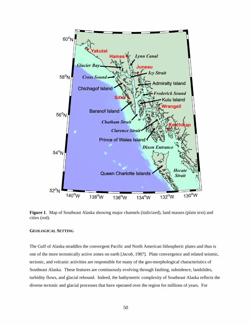
Figure 1. Map of Southeast Alaska showing major channels (italicized), land masses (plain text) and cities (red).
GEOLOGICAL SETTING
The Gulf of Alaska straddles the convergent Pacific and North American lithospheric plates and thus is
one of the more tectonically active zones on earth [Jacob, 1987]. Plate convergence and related seismic,
tectonic, and volcanic activities are responsible for many of the geo-morphological characteristics of
Southeast Alaska. These features are continuously evolving through faulting, subsidence, landslides,
turbidity flows, and glacial rebound. Indeed, the bathymetric complexity of Southeast Alaska reflects the
diverse tectonic and glacial processes that have operated over the region for millions of years. For
50
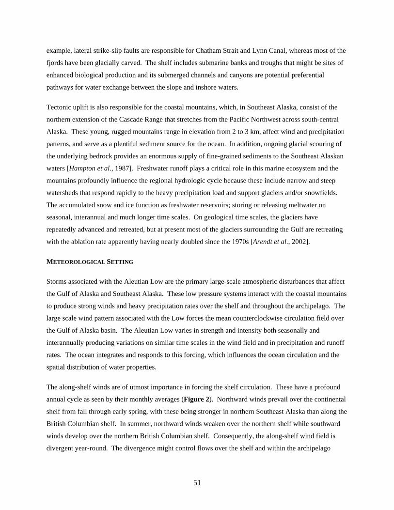
example, lateral strike-slip faults are responsible for Chatham Strait and Lynn Canal, whereas most of the
fjords have been glacially carved. The shelf includes submarine banks and troughs that might be sites of
enhanced biological production and its submerged channels and canyons are potential preferential
pathways for water exchange between the slope and inshore waters.
Tectonic uplift is also responsible for the coastal mountains, which, in Southeast Alaska, consist of the
northern extension of the Cascade Range that stretches from the Pacific Northwest across south-central
Alaska. These young, rugged mountains range in elevation from 2 to 3 km, affect wind and precipitation
patterns, and serve as a plentiful sediment source for the ocean. In addition, ongoing glacial scouring of
the underlying bedrock provides an enormous supply of fine-grained sediments to the Southeast Alaskan
waters [Hampton et al., 1987]. Freshwater runoff plays a critical role in this marine ecosystem and the
mountains profoundly influence the regional hydrologic cycle because these include narrow and steep
watersheds that respond rapidly to the heavy precipitation load and support glaciers and/or snowfields.
The accumulated snow and ice function as freshwater reservoirs; storing or releasing meltwater on
seasonal, interannual and much longer time scales. On geological time scales, the glaciers have
repeatedly advanced and retreated, but at present most of the glaciers surrounding the Gulf are retreating
with the ablation rate apparently having nearly doubled since the 1970s [Arendt et al., 2002].
METEOROLOGICAL SETTING
Storms associated with the Aleutian Low are the primary large-scale atmospheric disturbances that affect
the Gulf of Alaska and Southeast Alaska. These low pressure systems interact with the coastal mountains
to produce strong winds and heavy precipitation rates over the shelf and throughout the archipelago. The
large scale wind pattern associated with the Low forces the mean counterclockwise circulation field over
the Gulf of Alaska basin. The Aleutian Low varies in strength and intensity both seasonally and
interannually producing variations on similar time scales in the wind field and in precipitation and runoff
rates. The ocean integrates and responds to this forcing, which influences the ocean circulation and the
spatial distribution of water properties.
The along-shelf winds are of utmost importance in forcing the shelf circulation. These have a profound
annual cycle as seen by their monthly averages (Figure 2). Northward winds prevail over the continental
shelf from fall through early spring, with these being stronger in northern Southeast Alaska than along the
British Columbian shelf. In summer, northward winds weaken over the northern shelf while southward
winds develop over the northern British Columbian shelf. Consequently, the along-shelf wind field is
divergent year-round. The divergence might control flows over the shelf and within the archipelago
51
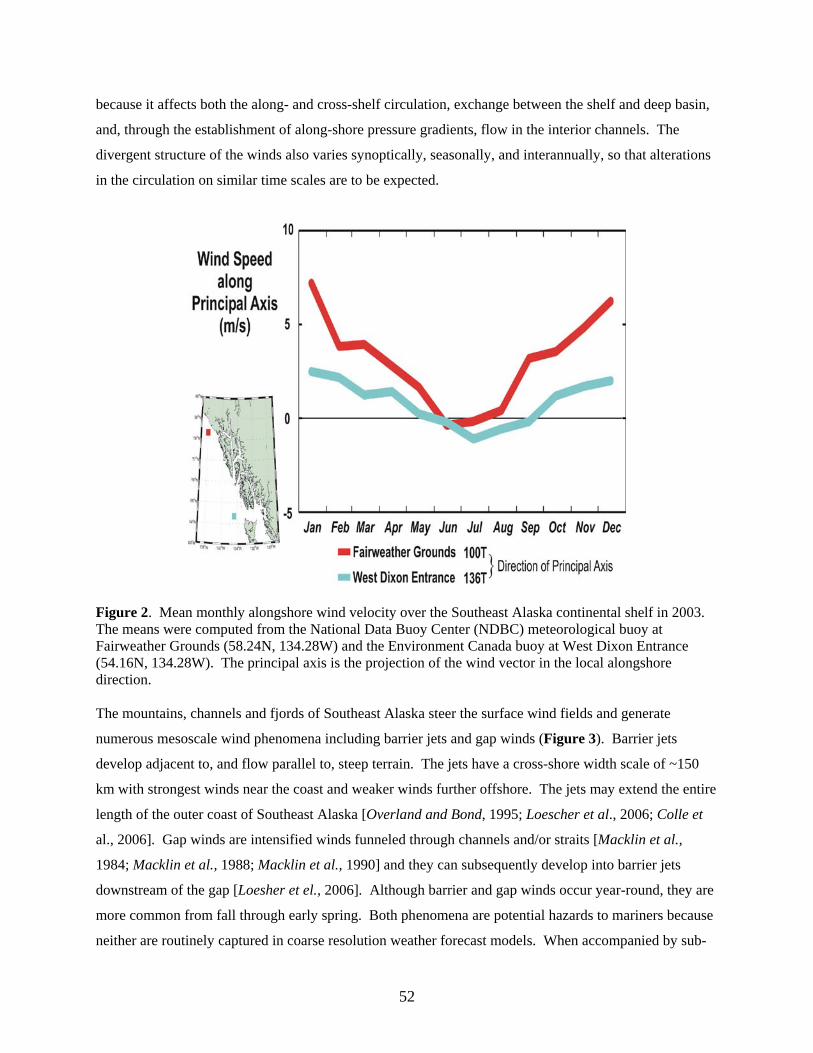
because it affects both the along- and cross-shelf circulation, exchange between the shelf and deep basin,
and, through the establishment of along-shore pressure gradients, flow in the interior channels. The
divergent structure of the winds also varies synoptically, seasonally, and interannually, so that alterations
in the circulation on similar time scales are to be expected.
Figure 2. Mean monthly alongshore wind velocity over the Southeast Alaska continental shelf in 2003. The means were computed from the National Data Buoy Center (NDBC) meteorological buoy at Fairweather Grounds (58.24N, 134.28W) and the Environment Canada buoy at West Dixon Entrance (54.16N, 134.28W). The principal axis is the projection of the wind vector in the local alongshore direction. The mountains, channels and fjords of Southeast Alaska steer the surface wind fields and generate
numerous mesoscale wind phenomena including barrier jets and gap winds (Figure 3). Barrier jets
develop adjacent to, and flow parallel to, steep terrain. The jets have a cross-shore width scale of ~150
km with strongest winds near the coast and weaker winds further offshore. The jets may extend the entire
length of the outer coast of Southeast Alaska [Overland and Bond, 1995; Loescher et al., 2006; Colle et
al., 2006]. Gap winds are intensified winds funneled through channels and/or straits [Macklin et al.,
1984; Macklin et al., 1988; Macklin et al., 1990] and they can subsequently develop into barrier jets
downstream of the gap [Loesher et el., 2006]. Although barrier and gap winds occur year-round, they are
more common from fall through early spring. Both phenomena are potential hazards to mariners because
neither are routinely captured in coarse resolution weather forecast models. When accompanied by sub-
52
freezing air temperature these winds can cause vessel icing. Smaller scale orographic wind effects
associated with the channels and fjords of the archipelago (as evident in Figure 3) are also common and
can result in large spatial gradients in wind velocity. Consequently wind-forced flows and mixing could
vary substantially between neighboring fjords or channels, since the steering effects of the terrain depend
upon the orientation of the water basin and the large-scale structure of a particular synoptic weather event.
Figure 3. A barrier jet along the outer shelf of Southeast Alaska, Dec. 30, 2000 (left) and gap winds
within and emanating from channels in Southeast Alaska, Jan. 29, 2004 (right). Figures are courtesy of
N. Winstead and additional examples are found at:
http://fermi.jhuapl.edu/people/winstead/web_wind/index.html).
Southeast Alaska is subject to heavy coastal precipitation year-round (Figure 4) because the coastal
mountains instigate condensation through adiabatic cooling of moist, marine air masses as these parcels
are uplifted over the mountains. The steep but small watersheds rapidly shed the precipitation to the
ocean, although in winter high-altitude precipitation is stored as snow. Royer [1982] estimated the annual
runoff cycle for the Gulf of Alaska between Ketchikan and Seward (Figure 5) and found that coastal
freshwater discharge is minimal in winter (when precipitation is stored as snow), increases in summer
with melting, and is maximal in fall when precipitation rates are greatest. He estimated the long-term
average runoff to be ~24000 m3 s-1 of which ~15000 m3 s-1 enters from the watersheds of Southeast
Alaska. This estimate is conservative, however, insofar as it is based on precipitation measurements at
sea-level, does not include the freshwater contribution from glacial melt and runoff sources from the
Pacific Northwest, including, at least in some seasons, the Columbia River discharge [Royer, 1998].
53
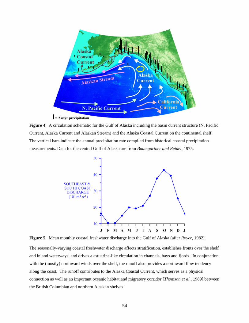
Figure 4. A circulation schematic for the Gulf of Alaska including the basin current structure (N. Pacific
Current, Alaska Current and Alaskan Stream) and the Alaska Coastal Current on the continental shelf.
The vertical bars indicate the annual precipitation rate compiled from historical coastal precipitation
measurements. Data for the central Gulf of Alaska are from Baumgartner and Reidel, 1975.
Figure 5. Mean monthly coastal freshwater discharge into the Gulf of Alaska (after Royer, 1982].
The seasonally-varying coastal freshwater discharge affects stratification, establishes fronts over the shelf
and inland waterways, and drives a estuarine-like circulation in channels, bays and fjords. In conjunction
with the (mostly) northward winds over the shelf, the runoff also provides a northward flow tendency
along the coast. The runoff contributes to the Alaska Coastal Current, which serves as a physical
connection as well as an important oceanic habitat and migratory corridor [Thomson et al., 1989] between
the British Columbian and northern Alaskan shelves.
54
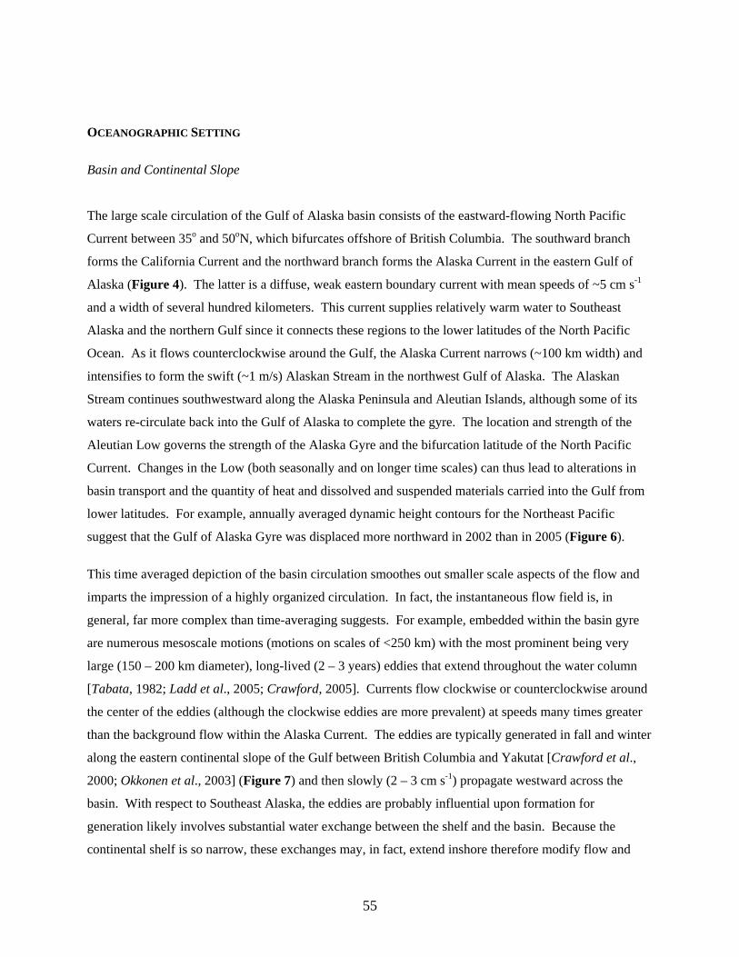
OCEANOGRAPHIC SETTING
Basin and Continental Slope
The large scale circulation of the Gulf of Alaska basin consists of the eastward-flowing North Pacific
Current between 35o and 50oN, which bifurcates offshore of British Columbia. The southward branch
forms the California Current and the northward branch forms the Alaska Current in the eastern Gulf of
Alaska (Figure 4). The latter is a diffuse, weak eastern boundary current with mean speeds of ~5 cm s-1
and a width of several hundred kilometers. This current supplies relatively warm water to Southeast
Alaska and the northern Gulf since it connects these regions to the lower latitudes of the North Pacific
Ocean. As it flows counterclockwise around the Gulf, the Alaska Current narrows (~100 km width) and
intensifies to form the swift (~1 m/s) Alaskan Stream in the northwest Gulf of Alaska. The Alaskan
Stream continues southwestward along the Alaska Peninsula and Aleutian Islands, although some of its
waters re-circulate back into the Gulf of Alaska to complete the gyre. The location and strength of the
Aleutian Low governs the strength of the Alaska Gyre and the bifurcation latitude of the North Pacific
Current. Changes in the Low (both seasonally and on longer time scales) can thus lead to alterations in
basin transport and the quantity of heat and dissolved and suspended materials carried into the Gulf from
lower latitudes. For example, annually averaged dynamic height contours for the Northeast Pacific
suggest that the Gulf of Alaska Gyre was displaced more northward in 2002 than in 2005 (Figure 6).
This time averaged depiction of the basin circulation smoothes out smaller scale aspects of the flow and
imparts the impression of a highly organized circulation. In fact, the instantaneous flow field is, in
general, far more complex than time-averaging suggests. For example, embedded within the basin gyre
are numerous mesoscale motions (motions on scales of <250 km) with the most prominent being very
large (150 – 200 km diameter), long-lived (2 – 3 years) eddies that extend throughout the water column
[Tabata, 1982; Ladd et al., 2005; Crawford, 2005]. Currents flow clockwise or counterclockwise around
the center of the eddies (although the clockwise eddies are more prevalent) at speeds many times greater
than the background flow within the Alaska Current. The eddies are typically generated in fall and winter
along the eastern continental slope of the Gulf between British Columbia and Yakutat [Crawford et al.,
2000; Okkonen et al., 2003] (Figure 7) and then slowly (2 – 3 cm s-1) propagate westward across the
basin. With respect to Southeast Alaska, the eddies are probably influential upon formation for
generation likely involves substantial water exchange between the shelf and the basin. Because the
continental shelf is so narrow, these exchanges may, in fact, extend inshore therefore modify flow and
55
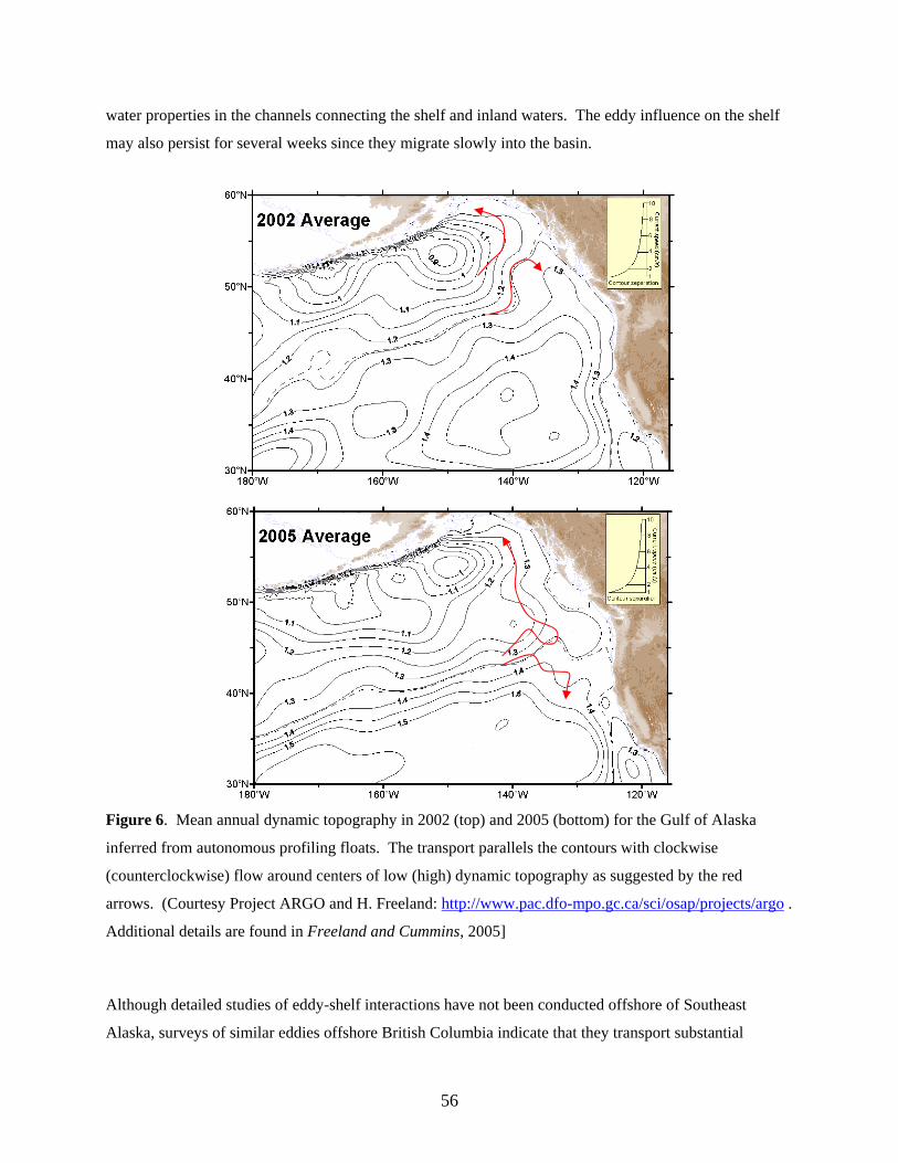
water properties in the channels connecting the shelf and inland waters. The eddy influence on the shelf
may also persist for several weeks since they migrate slowly into the basin.
Figure 6. Mean annual dynamic topography in 2002 (top) and 2005 (bottom) for the Gulf of Alaska
inferred from autonomous profiling floats. The transport parallels the contours with clockwise
(counterclockwise) flow around centers of low (high) dynamic topography as suggested by the red
arrows. (Courtesy Project ARGO and H. Freeland: http://www.pac.dfo-mpo.gc.ca/sci/osap/projects/argo .
Additional details are found in Freeland and Cummins, 2005]
Although detailed studies of eddy-shelf interactions have not been conducted offshore of Southeast
Alaska, surveys of similar eddies offshore British Columbia indicate that they transport substantial
56
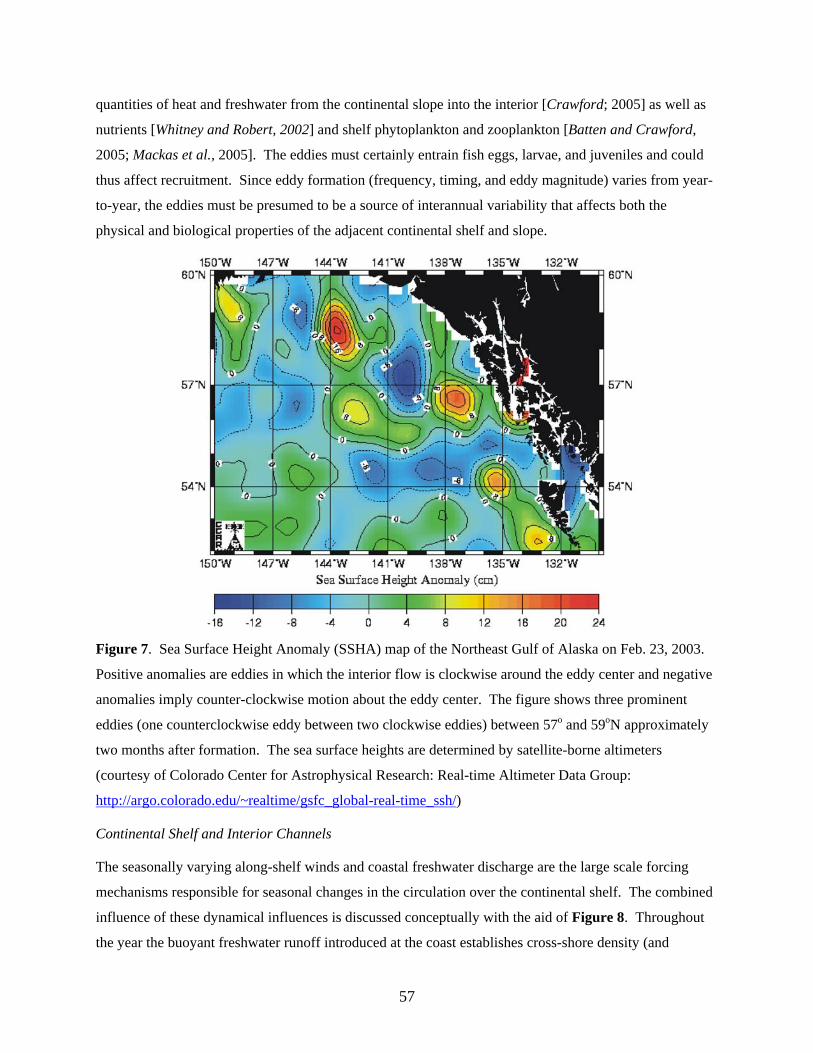
quantities of heat and freshwater from the continental slope into the interior [Crawford; 2005] as well as
nutrients [Whitney and Robert, 2002] and shelf phytoplankton and zooplankton [Batten and Crawford,
2005; Mackas et al., 2005]. The eddies must certainly entrain fish eggs, larvae, and juveniles and could
thus affect recruitment. Since eddy formation (frequency, timing, and eddy magnitude) varies from year-
to-year, the eddies must be presumed to be a source of interannual variability that affects both the
physical and biological properties of the adjacent continental shelf and slope.
Figure 7. Sea Surface Height Anomaly (SSHA) map of the Northeast Gulf of Alaska on Feb. 23, 2003.
Positive anomalies are eddies in which the interior flow is clockwise around the eddy center and negative
anomalies imply counter-clockwise motion about the eddy center. The figure shows three prominent
eddies (one counterclockwise eddy between two clockwise eddies) between 57o and 59oN approximately
two months after formation. The sea surface heights are determined by satellite-borne altimeters
(courtesy of Colorado Center for Astrophysical Research: Real-time Altimeter Data Group:
http://argo.colorado.edu/~realtime/gsfc_global-real-time_ssh/)
Continental Shelf and Interior Channels
The seasonally varying along-shelf winds and coastal freshwater discharge are the large scale forcing
mechanisms responsible for seasonal changes in the circulation over the continental shelf. The combined
influence of these dynamical influences is discussed conceptually with the aid of Figure 8. Throughout
the year the buoyant freshwater runoff introduced at the coast establishes cross-shore density (and
57
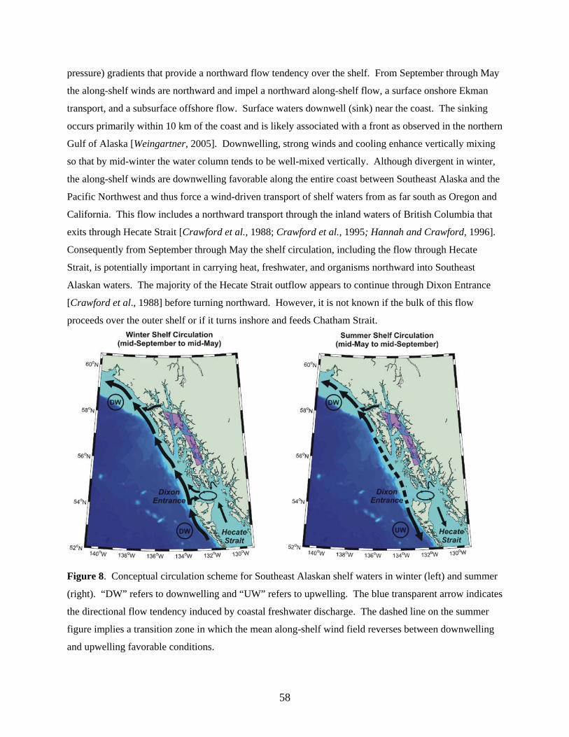
pressure) gradients that provide a northward flow tendency over the shelf. From September through May
the along-shelf winds are northward and impel a northward along-shelf flow, a surface onshore Ekman
transport, and a subsurface offshore flow. Surface waters downwell (sink) near the coast. The sinking
occurs primarily within 10 km of the coast and is likely associated with a front as observed in the northern
Gulf of Alaska [Weingartner, 2005]. Downwelling, strong winds and cooling enhance vertically mixing
so that by mid-winter the water column tends to be well-mixed vertically. Although divergent in winter,
the along-shelf winds are downwelling favorable along the entire coast between Southeast Alaska and the
Pacific Northwest and thus force a wind-driven transport of shelf waters from as far south as Oregon and
California. This flow includes a northward transport through the inland waters of British Columbia that
exits through Hecate Strait [Crawford et al., 1988; Crawford et al., 1995; Hannah and Crawford, 1996].
Consequently from September through May the shelf circulation, including the flow through Hecate
Strait, is potentially important in carrying heat, freshwater, and organisms northward into Southeast
Alaskan waters. The majority of the Hecate Strait outflow appears to continue through Dixon Entrance
[Crawford et al., 1988] before turning northward. However, it is not known if the bulk of this flow
proceeds over the outer shelf or if it turns inshore and feeds Chatham Strait.
Figure 8. Conceptual circulation scheme for Southeast Alaskan shelf waters in winter (left) and summer
(right). “DW” refers to downwelling and “UW” refers to upwelling. The blue transparent arrow indicates
the directional flow tendency induced by coastal freshwater discharge. The dashed line on the summer
figure implies a transition zone in which the mean along-shelf wind field reverses between downwelling
and upwelling favorable conditions.
58
In summer, the winds over the northern southeast Alaskan shelf are downwelling favorable and act with
the runoff to facilitate a northward shelf flow. However, winds over the British Columbian and Pacific
Northwest shelves are southward (including Hecate Strait) and promote southward along-shelf flow, a
surface offshore Ekman transport, and a subsurface onshore flow. This suggests that Southeast Alaskan
waters might contribute to the shelf and inland waters of British Columbia in summer. Subsurface waters
are upwelled (rise to the surface) along the coast, with this upwelling bringing deep, nutrient-rich waters
into the euphotic zone to enhance biological production. The extent and location of the transition zone
between upwelling and downwelling undoubtedly varies synoptically throughout summer and from year-
to-year. Thus, the Southeast Alaska shelf can be entirely engulfed by upwelling (or downwelling) wind
events, with the frequency and intensity of these events likely being critical in establishing the cumulative
biological production over the spring and summer.
We note also that the divergence of the along-shore winds will establish along-shore pressure gradients
over both the shelf and within the main channels of Southeast Alaska. Thus the pressure gradients within
the channels, which will vary synoptically and seasonally, could, in part, be established by the offshore
wind field. Thus flow within the channels and communication between inshore and offshore waters is
likely a combined response to the offshore winds, the along-channel winds, and freshwater runoff. The
relative importance of each of these forces has yet to be established.
The structure of the shelf circulation is unknown but the bathymetry, complicated coastline, and the
density contrast between fresh inshore water and salty slope waters suggest that the mean flow field is
embedded in an energetic “soup” of eddies and other mesoscale motions. The length scale of these
mesoscale motions are typically one to several times the baroclinic Rossby radius of deformation, which
is ~6-10 km based on hydrographic data from the northwest Gulf of Alaska [e.g., Weingartner et al.,
2005]. Thus mesoscale motions of 6 – 25 km are expected along the Southeast Alaskan shelf. Both
upwelling and downwelling winds will establish fronts within ~10 km of the coast, with swift along-shelf
jets embedded within the front. The fronts are often intrinsically unstable and develop meanders that may
detach and form eddies. Alternatively, swift shelf flows, interacting with a rough bottom and/or
convoluted coast, can be diverted cross-shore, perhaps as far as the shelfbreak and/or the basin where the
flow subsequently decays. While measurements of these processes are absent, ocean color satellite
images (Figure 9) indeed suggest that such motions occur on the Southeast Alaskan shelf. Eddies
formed, either through frontal instability or flow-topography interactions, often include vigorous three-
dimensional circulation fields. Enhanced biological production might occur in these mesoscale features
59
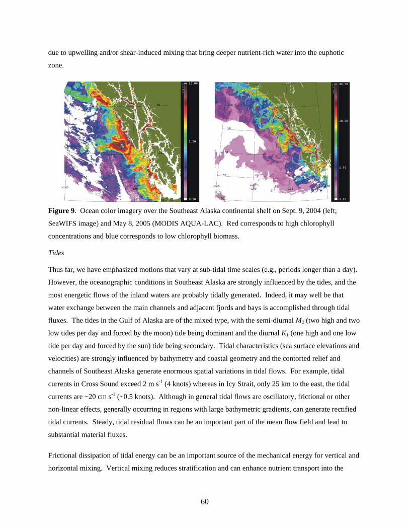
due to upwelling and/or shear-induced mixing that bring deeper nutrient-rich water into the euphotic
zone.
Figure 9. Ocean color imagery over the Southeast Alaska continental shelf on Sept. 9, 2004 (left;
SeaWIFS image) and May 8, 2005 (MODIS AQUA-LAC). Red corresponds to high chlorophyll
concentrations and blue corresponds to low chlorophyll biomass.
Tides
Thus far, we have emphasized motions that vary at sub-tidal time scales (e.g., periods longer than a day).
However, the oceanographic conditions in Southeast Alaska are strongly influenced by the tides, and the
most energetic flows of the inland waters are probably tidally generated. Indeed, it may well be that
water exchange between the main channels and adjacent fjords and bays is accomplished through tidal
fluxes. The tides in the Gulf of Alaska are of the mixed type, with the semi-diurnal M2 (two high and two
low tides per day and forced by the moon) tide being dominant and the diurnal K1 (one high and one low
tide per day and forced by the sun) tide being secondary. Tidal characteristics (sea surface elevations and
velocities) are strongly influenced by bathymetry and coastal geometry and the contorted relief and
channels of Southeast Alaska generate enormous spatial variations in tidal flows. For example, tidal
currents in Cross Sound exceed 2 m s-1 (4 knots) whereas in Icy Strait, only 25 km to the east, the tidal
currents are ~20 cm s-1 (~0.5 knots). Although in general tidal flows are oscillatory, frictional or other
non-linear effects, generally occurring in regions with large bathymetric gradients, can generate rectified
tidal currents. Steady, tidal residual flows can be an important part of the mean flow field and lead to
substantial material fluxes.
Frictional dissipation of tidal energy can be an important source of the mechanical energy for vertical and
horizontal mixing. Vertical mixing reduces stratification and can enhance nutrient transport into the
60
euphotic zone. The interaction of the tides with lateral or vertical constrictions in channels may result in
hydraulically controlled flows. Formally, controlled exchanges occur where the flow through a channel
constriction changes from subcritical to supercritical [Gill, 1977; Armi, 1986; Pratt and Lundborg, 1991].
Controlled flows may be manifested as tidal bores, internal hydraulic jumps, and intense mixing such as
observed in Knight Inlet, British Columbia [Farmer and Smith, 1979; Freeland, 1979; Smith and Farmer,
1979]. Although the horizontal scales over which intense mixing processes occur can be quite small, the
effects of the mixing can influence a much broader area. This occurs because the mixed waters are
subsequently swept downstream of the mixing region by the flow field. In general the strongest mixing
occurs over a horizontal scale associated with the width of a sill or length of a horizontal contraction in
channel width. Hydraulic control may be modulated seasonally and/or over the spring-neap cycle
because it depends not only on the geometric shape of the channel, but also upon the vertical distribution
of current in the stratified fluid. As a consequence tidal mixing processes may vary seasonally in
response to changes in water column structure induced by winds and runoff. Undoubtedly, tidal mixing
phenomena are important in transporting and/or trapping plankton and fish larvae and regulating
biological production within the archipelago and possibly over the shelf as well.
Spatial gradients associated with tidal mixing often result in the formation of tidal fronts. In general such
fronts are aligned with the isobaths and delineate the boundary between well-mixed water and stratified
waters. Tidal fronts can be very narrow (meters to 100s of meters), and vary in strength and position over
the fortnightly tidal cycle or in conjunction with seasonal changes in stratification. These fronts are often
highly productive and important feeding areas for fish.
The interaction of the tidal wave with varying bottom topography can also generate diurnal shelf waves
and residual, or steady, flows that can be locally important by vertically deflecting the pycnocline (the
layer of maximum stratification), thereby altering the depth of the mixed layer, and by transporting
suspended and dissolved materials. While Foreman et al.’s [2000] model results do not indicate the
generation of diurnal shelf waves along the shelf of Southeast Alaska, these waves are a prominent
feature along the British Columbian shelf [Crawford, 1984; Crawford and Thomson, 1984; Flather, 1988;
Foreman and Thomson, 1997; Cummins and Oey, 2000].
Seasonal changes in water-column stratification can also affect the vertical distribution of tidal energy
over the shelf and in channels through the generation of internal waves at the tidal frequency. (Internal
waves, which only exist in stratified waters have a small surface expression but nay induce large vertical
oscillations in the pycnocline.) Significant internal tides are likely generated at the shelfbreak in summer
and fall when stratification is strong and/or in the lee of sills in channels and fjords. Internal tidal waves
61
have small spatial scales (~10 km) in contrast to the large scale (1000s of km) of the generating tidal
wave propagating across the ocean basin. The phases and amplitudes of internal tides vary with depth
and depend upon seasonal changes in stratification. Because internal tides displace the pycnocline, these
waves can have significant biological consequences by pumping nutrients into the euphotic zone,
dispersing plankton and small fishes, and forming transitory and small-scale fronts that affect feeding
behaviors [Mann and Lazier, 1996]. Internal waves can also “break” resulting in vertical mixing.
Fjords
The archetypal fjord geometry consists of a glacially-carved long, narrow U-shaped channel with a deep
basin. The seaward limit of the deep basin is defined by one or more shallower sills that obstruct the deep
inflow of outside waters. In most cases, the sill depth is greater than the depth of the pycnocline, so that
sub-surface inflows are still permissible. River inflow (or glacial meltwater) occurs at the inland end, or
head of the fjord, and flows seaward as a thin, fresh, but strongly stratified layer. The mouth of the fjord
may be harder to define, especially for Southeast Alaska where many of the fjords are tributaries to larger
fjords or channels. In Southeast Alaska, the fjord surface layer is generally quite thin (<15 m) and surface
salinities range from 0 practical salinity units (hereafter dimensionless) at the fjord head to 20 at the fjord
mouth. The salinity of the upper layer increases as it flows seaward along the fjord axis due to
entrainment mixing of more saline, sub-surface waters from below [Long, 1975; 1979]. The vertical
mixing is due to turbulent processes, often associated with tides, and quite possibly involving controls
associated with the fjord geometry, seasonally varying stratification, and sub-tidal motions. Indeed, the
circulation characteristics depend upon fjord geometry (width, depth of the sill(s) and the interior and
exterior basins, sill location(s), runoff, tides, and properties of the exterior waters).
In contrast to the surface layer, deep basin and subsurface salinities within and outside the fjord range
from 30 – 32.5 and may vary slowly. To compensate for the volume of deeper waters entrained into the
surface outflow, sub-surface waters flow inward toward the head of the fjord. This two-layer circulation,
while present on average, is weak and can be easily masked in short-term observations by tidal and/or
wind-driven flows. Although this generic circulation pattern holds for most fjords, there are substantial
variations among fjords owing to differences in geometry and bathymetry, winds, tides, and the salinity
difference between the head and the mouth of the fjord. For example, in some seasons the water at the
mouth of the fjord might be fresher than that at the head (due to seasonal changes in river runoff into the
fjord). In these situations a reverse fjord circulation pattern can develop [Klinck et al., 1981]. The
renewal of deep fjord waters depends on fjord bathymetry and in many cases, the depth of the fjord’s sill.
Deep water renewal depends critically on sill geometry and ambient conditions. For some fjords deep-
62
water renewal may be infrequent and episodic whereas for other fjords complete or partial renewal occurs
periodically either seasonally or more frequently through the interaction of stratified tidal flows with the
sill. In such cases, tidal suction at the sill could draw deep offshore waters over the sill crest to re-supply
the inner basin of the fjord [Thomson and Wolanksi, 1984]. Strong tidal current sill interactions can lead
to a number of complex hydraulic effects that result in strong vertical mixing and exchange [Farmer and
Smith, 1979; Freeland and Farmer, 1980; Freeland, 1979; Smith and Farmer, 1979].
The classical two-dimensional circulation pattern, consisting of outflow in the surface layer and inflow at
depth, with layer coupling obtained through vertical mixing, holds for many fjords. However, the
circulation in a fjord might also be three-dimensional and include substantial horizontal variability due to
the effects of the Earth’s rotation. The Coriolis influence occurs in fjords whose width exceeds the
internal radius of deformation. The latter depends on the stratification so that the circulation dynamics of
a fjord or interior channel may vary seasonally. Under such circumstances the outflow would be confined
to the right-hand side (looking toward the mouth) of the fjord or channel with inflow on the left. For
Southeast Alaska the internal radius of deformation is ~6 – 7 km and thus comparable to the widths of
many of the fjords and channels. Moreover for wide fjords, the along-fjord winds might also establish
upwelling and downwelling flows about the longitudinal axis of the fjord [Cushman-Roisin et al.; 1994]
and this influence may be of some importance in some of the long channels of Southeast Alaska.
LONG-TERM PHYSICAL VARIABILITY IN THE GULF OF ALASKA.
We conclude this review with a brief mention of some of the substantial variability observed over recent
decades in the physical environment of the Gulf of Alaska. This variability has been noted in winds,
atmosphere-ocean heat fluxes and runoff, water temperature and salinity, mixed layer depth, nutrient
supply and circulation properties. Most of the observations are based on data collected over the
northwestern Gulf of Alaska shelf or along “Line P”, which extends westward from the British
Columbian shelf into the central part of the southern Gulf of Alaska basin. Line P has been sampled by
Canadian oceanographers since the mid-1950s and thus spans the bifurcation zone of the North Pacific
Current as it approaches the west coast of North America. Observations in the northwest Gulf of Alaska
include NOAA-supported measurements in the vicinity of Kodiak Island and those supported by a variety
of agencies (including most recently NPRB) over the shelf offshore of Seward, Alaska. The physics of
the bifurcation region and the shelf differ considerably from each another, however, so the spatial extent
over which observed changes along Line P are representative of changes in Southeast Alaska and the
63
northern Gulf are not always apparent. The discussion considers both regions separately, but indicates
that there are a number of shared trends that suggests the changes are spatially broad.
Gulf of Alaska Shelf
Stabeno et al., [2004] analyzed long-term wind fields generated from numerical forecast models (which
are likely biased because of orographic effects) and found that most of the wind variability is at the
interannual time scale (rather than at inter- or intra-decadal scales). They suggested, however, that both
winter wind speeds (important for vertical mixing) and along-shore wind stress (important for coastal
downwelling and along-shore shelf transport) were anomalously weak from the mid-1960s to the mid-
1970s and anomalously strong from the late 1970s through the 1980s. Although these differences
coincided with the mid-1970s regime shift, Royer [2005] found no significant correlation between wind
variations in the northern Gulf and the Pacific Decadal Oscillation index [PDO; Mantua et al., 1997],
except in Southeast Alaska where the correlation was weak, but significant. Stabeno et al., [2004]
stressed that there appeared to be substantial year-to-year variability in the frequency and strength of
summer wind-mixing events and upwelling favorable winds, with these variations being particularly large
over the Southeast Alaskan shelf. Since summer upwelling events are episodic because these vary on the
synoptic storm time scale, year-to-year variations in upwelling event frequency, duration, and strength
could yield large variations in the total summer primary production over the shelf. Their analysis did not
address variability in the along-shelf divergence of the wind field, although it is expected that this is large
also.
Ocean temperatures are controlled by heat exchange with the atmosphere, vertical and horizontal mixing
of waters having different temperatures, and the advection of heat into or out of an oceanic region by
ocean currents. In Southeast Alaska we expect that air-sea heat exchange exerts the primary control over
upper ocean temperatures. Variations in the net seasonal air-sea heat fluxes over the northern Gulf of
Alaska shelf (and by extension Southeast Alaska) from 1950 through 2000 are large at both the
interannual and interdecadal timescales, with the variations in winter heat loss being several time greater
than summer heat gain. In particular, winter cooling decreased by ~20% in the mid-1970s coincident
with the “PDO regime shift” from the cold to the warm phase [Mantua et al., 1997]. Ignoring advection
and mixing, the winter cooling rates prior to the shift would have induced a 5oC decrease over the upper
100 m of the ocean versus a 3.8oC winter temperature decrease since then. These changes are consistent
with a warming of nearly 1.0oC in the upper 100 m of the water column observed since 1970 based on
temperature observations made on the northwest Gulf of Alaska shelf (hydrographic station GAK 1;
Royer, 2005; Royer and Grosch, 2006]. They also found a temperature increase of similar magnitude
64
between 100 – 200 m over this same period. Hence, the warming over the whole water column exceeds
that due to air-sea heat exchange alone and suggests that oceanic transport processes have also
contributed to the warming trend. Very likely this additional warming is due to alongshore transport of
heat from southerly latitudes by the Alaska Coastal Current on the shelf and by the Alaska Current along
the continental slope. This is consistent with the findings of Freeland and Whitney [2000] of a similar
increase in upper ocean temperatures over the British Columbian shelf during the same period. The
warming trend, along with suggestions of increased along-shelf transport due to the winds and changes in
runoff (discussed next) suggest that there has been an increase in along-shelf transport over the Gulf of
Alaska shelf.
Royer’s [2005] analysis also shows that there are substantial El Niño-Southern Oscillation (ENSO)
induced temperature variations on the northern Gulf of Alaska shelf. Here, observed ENSO-induced
temperature changes range between 0.5oC and 1.7oC and occur in winter some 7 – 10 months after the
equatorial onset of ENSO. ENSO-associated temperature perturbations are generally short-lived on the
Gulf of Alaska shelf, however, usually appearing in late fall/early winter and disappearing by late spring.
Although brief in duration, the timing of these perturbations could be of biological significance because
they occur in spring when during the early life history of many invertebrates and fish. Interestingly,
Royer [2005] finds that the ENSO response is statistically significant at depths between 50 and 150 m, but
not at shallower depths. The absence of a significant relationship between the equatorial ENSO signal
and upper ocean temperatures on the Gulf of Alaska shelf likely occurs because random local variability
in air-sea heat fluxes blur the ENSO signal in the upper ocean. Moreover, the presence of the ENSO-
temperature signal at depth does suggest that ocean advection is important and Royer [2005] argues that
ENSO warming in the Gulf of Alaska is primarily associated with oceanic processes that displace the
large-scale coastal temperature gradient northward into the Gulf of Alaska. This interpretation is
consistent with observations made during the 1997-98 ENSO event, which showed anomalously large
increases in the flow along the Alaskan continental slope [Strub and James, 2002], within the Alaska
Coastal Current [Weingartner et al., 2005], and in the northward flux of heat along the British Columbian
continental slope [Freeland, 2002].
Royer [2005] also finds that the PDO (positive or warm phase is associated with above normal
temperatures) is significantly and uniformly correlated with monthly water temperature anomalies over
the entire shelf water column, although the PDO signal accounts for only about 25% of the temperature
variability. The vertically uniform response of the shelf water column to the PDO suggests that both the
atmosphere and the ocean influence shelf temperatures. Since the PDO index reflects winter sea surface
temperature variations over the winter mixed layer, which is typically 150 m throughout the northern
65
North Pacific, these anomalies could be advected onto the shelf by ocean circulation processes. Air-sea
heat exchange is also important however, because winter cooling tends to decrease during the warm phase
of the PDO and increase during the cold-phase.
Coastal freshwater discharge also varies substantially throughout the Gulf of Alaska and this variability
affects salinity, which controls both horizontal and vertical ocean density gradients. Upper ocean salinity
and runoff is well-correlated with transport in the Alaska Coastal Current [Weingartner et al., 2005].
Monthly runoff anomalies can be enormous and be several times the mean monthly value. Although
monthly and interannual variability dominates the long-term record, there is considerable interdecadal
variability as well [Weingartner et al., 2005]. They found that abnormally large runoff occurred from
1920-1945 and from the mid-1980s to the mid-1990s and abnormally low runoff occurred in the early
1900s and from 1960 to 1975. The salinity record from the northern Gulf of Alaska indicates a salinity
decrease of about .07 in the upper 100 m since 1970, which is consistent with the increase in runoff over
this same period [Royer, 2005]. This salinity increase implies an increase in Alaska Coastal Current
transport from fall through spring, which likely resulted in an increase in the along-shelf transport of heat
into the Gulf of Alaska. Although direct measurements of mixed layer depth variations are more difficult
to observe, warming and freshening trends in the upper ocean imply that winter shelf stratification is
strengthening [Royer, 2005]. This tendency appears to be Gulf-wide as similar trends have been reported
by Freeland and Whitney [2000] for the British Columbian shelf and the southern Gulf of Alaska basin.
Although changes in runoff, upper ocean salinities, and transport of the ACC seem consistent with the
“regime shift” change in the PDO from the cold to the warm phase in the mid-1970s, these variables are,
at best, only weakly correlated with the PDO index [Weingartner et al., 2005; Royer, 2005] and the
ENSO index [Royer, 2005]. It is not entirely clear why this is the case, although Dettinger et al. [2001]
find that while precipitation and river discharge increase during the PDO warm-phase and Los Niños over
south central Alaska, these variables tend to decrease over the Pacific Northwest and British Columbia.
Since the salinity and ACC transport in the Gulf are a consequence of runoff along the entire coast, the
spatially out-of-phase patterns in runoff between the northern Gulf of Alaska and the Pacific Northwest
would tend to degrade the correlation between salinity and the PDO and ENSO climate indices.
Nevertheless, there are occasions, however, when ENSO-related salinity affects can be substantial. The
best documented example of this comes from the northern Gulf of Alaska shelf for the El Niño winter of
1997-1998 and the La Niña winter of 1998-1999 [Weingartner et al., 2002; Weingartner et al., 2005].
The El Niño winter witnessed unusually warm ocean temperatures, a substantial reduction in atmosphere-
ocean heat loss, anomalously large freshwater discharges from the Columbia River, British Columbian
66
rivers and the coastal Gulf of Alaska and unusually strong downwelling-favorable wind stress in the
northeastern Gulf of Alaska. Collectively these anomalies resulted in the volume transport in the Alaska
Coastal Current being twice as large during the El Niño winter compared to the La Niña winter. The
runoff differences between these years were also accompanied by an earlier onset of stratification
[Weingartner et al., 2005] and lower nitrate concentrations over the upper ocean [Childers et al., 2005] in
1998 compared to 1999. The large coastal freshwater influx was the primary cause of the early onset of
stratification in 1998, which occurred nearly a month earlier than in 1999. The low surface nutrient
concentrations are consistent with the increased runoff, although larger scale affects might also have been
operant since surface nitrate concentrations were low throughout the southern Gulf of Alaska [Freeland
and Whitney, 2000].
The contrast between these two years also extended to the development of spring stratification, which
affects the timing of the spring phytoplankton bloom. In the northern Gulf, these blooms begin first in
inshore waters (Prince William Sound) and develop on the outer shelf by mid-May. Inshore waters
initially stratify due to runoff, whereas offshore waters stratify through upper-ocean warming associated
with an increases in solar heating and a reduction in wind-mixing. These differences may also hold for
Southeast Alaska. The stratification differences between 1998 and 1999 suggest one way that climate
warming might affect the Southeast Alaska ecosystem. Projections of future climate response to
increased greenhouse gas concentrations [IPCC, 2001] indicate an increase in atmospheric warming and
moisture over the Gulf of Alaska. This will result in higher winter rainfall and runoff and less snow
accumulation in the coastal mountains. Consequently, an earlier onset in spring melt is to be expected. If
wind mixing does not increase proportionately, then stratification and the spring bloom may occur earlier
on the inner shelf than it does presently and advance the start of the spring bloom. Conceivably these
changes could affect phytoplankton community structure and subsequently, the recruitment success of
zooplankton and fish. The IPCC [2001] projections also suggest larger year-to-year variations in
precipitation, so that interannual variability in the timing of the spring bloom in Southeast Alaska might
also increase.
Gulf of Alaska Basin
Interdecadal and ENSO-associated changes have also been observed in the Gulf of Alaska basin. For
example, Lagerloef [1995] and Hunt [1996] concluded that the Alaska gyre underwent a large transition
coincident with the regime shift when the PDO switched from the cold-phase to the warm-phase. They
found that during the cold-phase (prior to the mid-1970s), the center of the Alaska gyre was shifted
northeastward, the gyre circulation was stronger, and cooler sea surface temperatures prevailed over the
central Gulf compared to after the transition. The transition to the warm-phase PDO mode led to a west-
67
southwest displacement of the gyre center and a reduction in upwelling and gyre transport in the central
and eastern gulf. There are also suggestions that on ENSO time scales the Alaska gyre and the California
Current vary out-of-phase [Chelton and Davis, 1982; Tabata, 1991; Kelly et al., 1993], such that more
water from the North Pacific Current enters the Gulf of Alaska when the gyre strengthens, while more is
deflected southward when the gyre weakens.
Polovina et al. [1995] hypothesized that the regime shift was accompanied by changes in mixed layer
depth due to ocean temperature changes and that alterations in mixed layer depth over the basin has
potentially large consequences for biological productivity. Freeland et al. [1997], Freeland and Whitney
[2000], and Whitney and Freeland [1999] examined changes in mixed layer depth and properties along
Line P and found that the winter mixed layer depth has decreased since 1956 at a rate of about 47
m/century. They suggested that there was a step-change to a decrease in winter mixed layer depth
coincident with the regime shift. They also concluded that the shoaling of the winter mixed layer was
related to an increase in upper ocean stratification instigated by both freshening and warming of the
surface layers. Superposed on this long-term trend, are ENSO-related variations that indicate that
shallower winter mixed layers are associated with Los Niños while deeper mixed layers occur during Las
Niñas. A shallow mixed layer decreases the winter re-supply of nitrate and silicate to the euphotic zone
[Whitney et al., 1998; Whitney and Freeland, 1999]. While the decrease in nutrient supply does not
appear to affect the magnitude of the spring bloom at present, it increases the likelihood of nutrient
exhaustion through summer. This decrease was so severe during the 1998 El Niño event that it led to the
first ever report of nitrate depletion in the surface waters if the Gulf of Alaska basin.
SUMMARY AND RECOMMENDATIONS
The dynamically variable marine environment of Southeast Alaska reflects the interaction of tides, storm
systems, and coastal freshwater discharge with the complex bathymetry and orography of the region.
These interactions create numerous marine habitats and establish a large scale flow field that links the
shelf/slope systems of the southern and northern Gulf of Alaska. The oceanographic connection between
these two regions occurs in Southeast Alaska, which suggests that this large region exerts an important
influence on the marine ecosystems of the northern Gulf. This discussion has outlined some of the
physical processes likely to be important and it has emphasized that these processes operate over a broad
range of time and space scales and that these processes and scales vary in importance from one marine
habitat (slope, shelf, channel, bay, etc.,) to another. Heterogeneity in time and space scales has two
important implications for the Southeast Alaska marine ecosystem. First, failure to appreciate these
scales could lead to severe aliasing and cripple our understanding of Southeast Alaskan ecological
68
processes. Second, resolving the dominant physical processes and scales responsible for biological
production may require sustained research efforts. There are, however, a number of regional scale studies
that can be completed with only a moderate level of effort, which would rapidly increase our
oceanographic understanding of this vital ecosystem.
First, the regional wind field, especially over the shelf and adjacent basin must be better understood. This
can be accomplished through a joint analysis of existing meteorological buoy data and the twice daily
QuikSCAT (satellite scatterometer) wind archive (available since July 1999), combined with the long-
term (1950 – present) forecast re-analyzed wind field available from the National Center for
Environmental Prediction (NCEP). The analyses should include constructing the annual cycle of wind
stress and wind-mixing potential, the time and space scales of barrier jets and the divergence properties of
the shelf wind field. Interannual variability in the frequency, intensity and duration of summer upwelling
events should be quantified.
Second, the annual cycles in circulation and water properties over the shelf and within the main channels
of Southeast Alaska has not been described. As a first step, we recommend that oceanographic surveys
be undertaken across the mouth of Chatham Strait (or southern Southeast Alaska) and Cross Sound and
the adjacent shelf. A goal of this survey is to determine the pathways by which Southeast Alaska shelf
and channel waters communicate with British Columbian and northern Gulf of Alaska shelves. Both
British Columbia and Alaska have many mutual interests in this regard and this effort could be done cost-
effectively by a partnership involving both political entities.
Third, it seems highly probable that the transport of water through the main channels of Southeast Alaska
could be monitored with a system of bottom pressure gauges after a suitable calibration period with
moored current meter arrays that span southern Chatham Strait and Cross Sound. The bottom pressure
gauges along with temperature and salinity measurements would then serve as the infrastructure for long-
term monitoring of Southeast Alaska interior waters. The monitoring system could be easily expanded to
include biological measurements, including passive acoustic systems to detect marine mammals and/or
the migratory activities of commercially important fish species. (For example, acoustic receivers being
developed for the POST program could be incorporated into the monitoring moorings.) Monitoring here
is especially important for Southeast Alaska is a transition zone linking the marine ecosystems of British
Columbia and the northern Gulf of Alaska and we have indicated that there are large variations in the
physical attributes of both regions. Hence monitoring efforts in Southeast Alaska are crucial to
understanding how this ecosystem might change and possibly serve as an early detector of ecosystem
69
changes that may eventually propagate into the northern Gulf of Alaska. This information could provide
critical planning information for marine industries and resource managers elsewhere in the Gulf of
Alaska.
Fourth, simple idealized process models should be harnessed to understand the fundamental nature of the
connections between offshore and interior waters. These models have the advantage of being able to
isolate the first-order physical processes responsible for exchange between offshore and inshore waters.
While such models do not replace the value of more complex numerical circulation models, they are
inexpensive to run and diagnose and they provide useful information on the sensitivity of exchange to
various forcing scenarios. The results would be useful in guiding monitoring efforts and isolating
potentially critical processes that affect this marine environment.
Fifth, the characteristics of the fjords, bays and channels of Southeast Alaska should be assembled into a
GIS-type data base. This archive should include the bathymetric characteristics (including substrate type)
of the water body, watershed descriptors (area, elevation profiles, snowpack/glacial characteristics,
runoff, precipitation, and snowpack measurements(, and existing meteorological oceanographic
measurements (winds, air temperatures, tides, hydrography, current meter measurements, etc.). This data
archive could evolve with time as information is obtained and it could be easily expanded to include
additional categories.
70
REFERENCES
Arendt, A.A., K. A. Echelmeyer, W. D. Harrison, C. S. Lingle, and V. B. Valentine. 2002. Rapid
Wastage of Alaska Glaciers and their contribution to rising sea level, Sci., 297, 382 – 386.
Armi, L. 1986. The hydraulics of two flowing layers with different densities, J. Fluid Mech., 163: 27 –
58.
Batten, S. D. and W. R. Crawford. 2005. The inlfuence of coastal origin eddies on oceanic plankton
distributions in the eastern Gulf of Alaska. Deep-Sea Res., Part II, 54 (7-8): 991-1010.
Baumgartner, A and E. Reichel. 1975. The World Water Balance, Elsevier, New York, 179 pp.
Chelton, D. and R. W, Davis. 1982. Monthly mean sea-level variability along the west coast of North
America, J. Phys. Oceanog., 12, 757-779.
Childers, A., T. E. Whitledge, and D. A. Stockwell. Seasonal and interannual variability in the
distribution of nutrients and chlorophyll-a across the Gulf of Alaska shelf, 2005, Deep-Sea Res. II
52: 193-216.
Colle, B. A., K. A. Loescher, G. S. Young, and N. S. Winstead. 2006. Climatology of Barrier Jets along
the Alaskan Coast. Part II: Large-Scale and Sounding Composites. Mon. Weath. Rev., 134: 454 –
477.
Crawford, W. R. 2005. Heat and fresh water transport by eddies into the Gulf of Alaska. Deep-Sea Res.,
Part II, 54(7-8): 893-908.
Crawford, W. R. 1984. Energy flux and generation of diurnal shelf waves along Vancouver Island, J.
Phys. Oceanog., 14, 1600-1607.
Crawford, W. R., J. Y. Cherniawsky, and M.G.G. Foreman. 2000. Multiyear meanders and eddies in the
Alaskan Stream as observed in TOPEX/Poseidon altimeter. Geophys. Res. Lett., 27, 1025 – 1028.
Crawford, W. R., M. J. Woodward, M.G.G. Foreman, and R. E. Thomson. 1995. Oceanographic features
of Queen Charlotte Sound and Hecate Strait in summer. Atmosphere-Ocean, 33(4): 639-681.
Crawford, W. R., W. S. Huggett, and M. J. Woodward. 1988. Water transport through Hecate Strait. B.C.
Atmosphere-Ocean, 26, 301-320.
Crawford, W. R. and R. E. Thomson. 1984. Diurnal period shelf waves along Vancouver Island: a
comparison of observations with theoretical models, J. of Phys. Oceanogr., 14, 1629-1646.
71

Cummins, P.F. and L. –Y. Oey. 2000. Simulation of barotropic and baroclinic tides off northern British
Columbia, J. Phys. Oceanogr., 27, 762-781.
Cushman-Roisin, B., L. Asplin, and H. Svendsen. 1994. Upwelling in broad fjords. Cont. Shelf Res., 14:
1701 – 1721.
Dettinger, M. D., D.S. Battisti, G. J. McCabe, C. M. Bitz, and R. D. Garreaud. 2001. Interhemispheric
effects of interannual and decadal ENSO-like climate variations on the Americas. IN:
Interhemispheric Climate Linkages (V. Markgraf, ed.), p. 1 – 22, Academic Press, New York, 454 p.
Farmer, D. M. and J. D. Smith. 1979. Generation of lee waves over the sill in Knight Inlet, IN: Fjord
Oceanography, p. 259 – 270, H. J. Freeland, D. M. Farmer, and C. D. Levings, editors, NATO
Conference on Fjord Oceanography, Victoria, B. C., 1979, Plenum Press, New York, 715 p.
Flather, R. A. 1988. A numerical investigation of tides and diurnal-period continental shelf waves along
Vancouver Island, J. Phys. Oceanogr., 18, 115-139.
Foreman, M. G. G., W.R. Crawford, J. Y. Cherniawsky, R. F. Henry, and M. R. Tarbotton. 2000. A high-
resolution assimilating tidal model for the northeast Pacific Ocean, J. of Geophys. Res., 105, 28629-
28651.
Foreman, M.G.G. and R. E. Thomson. 1997. Three-dimensional model simulations of tides and buoyancy
currents along the west coast of Vancouver Island, J. Phys. Oceanogr., 27, 1300 – 1325.
Freeland, H., 2002. The Heat Flux across Line P 1996 – 1999. Atmosphere-Ocean 40(1), 81-89.
Freeland, H. J., 1979. The hydrography of Knight Inlet, B.C., in the light of Long’s model of fjord
circulation, IN: Fjord Oceanography, p. 271 – 276, H. J. Freeland, D. M. Farmer, and C. D. Levings,
editors, NATO Conference on Fjord Oceanography, Victoria, B. C., 1979, Plenum Press, New York,
715 p.
Freeland, H. and P. F. Cummins, 2005. Argo: A new tool for environmental monitoring and assessment
of the world’s oceans, an example from the N.E. Pacific. Progr. in Oceanogr., 64: 31-44.
Freeland, H. and F. Whitney. 2000. Climate Changes: Gulf of Alaska, IN: Seas at the Millennium: An
Environmental Evaluation (ed. C. Sheppard) p. 179 – 186, Elsevier Science Ltd.
Freeland, H. J. and D. M. Farmer. 1980. Circulation and energetics of a deep, strongly stratified inlet,
Can. J. Fish. and Aquatic Sci., 37, 1398 – 1410.
Freeland, H. J. and K. L. Denman. 1982. Tographically controlled upwelling center off southern
Vancouver Island, J. Mar. Res., 40, 1069 – 1093.
72
Freeland, H., K. Denman, C. S. Wong, F. Whitney, and R. Jacobs. 1997. Evidence of change in the
winter mixed layer depth in the Northeast Pacific Ocean, Deep-Sea Res., 44, 2117 – 2129.
Gill, A., 1977. The hydraulics of rotating channel flow. J. Fluid Mech., 80, 641 – 671, 1977.
Hannah, C. G. and W. R. Crawford, 1996. Winter transport and sea level fluctuations in Hecate Strait,
British Columbia. J. of Geophys. Res., 101, 28365-28376.
Hampton M. A., P. R. Carlson, H. J. Lee, and R. A. Feely. 1987. Geomorpholgy, sediment, and
sedimentary processes, IN: The Gulf of Alaska, Physical Environment and Biological Resources, p.
93 - 144, D. W. Hood and S. T. Zimmerman, editors, Alaska Office, Ocean Assessments Division,
National Oceanic and Atmospheric Administration, U.S. Dept. Commerce, 655 p.
Hunt, H. D. 1996. Normal Mode Analysis of Dynamic Height in the Gulf of Alaska, 1968 – 1990. M.S.
Thesis, University of Alaska, 66p.
IPCC, 2001: Climate Change 2001: The Scientific Basis, Contribution of Working Group I to the Third
Assessment Report of the Intergovernmental Panel on Climate Change, [J. T. Houghton, Y. Ding, D.
J. Griggs, M. Noguer, P.J. van der Linden, X. Dai, K. Maskell, and C. A. Johnson (eds.)]. Cambridge
University Press, Cambridge, United Kingdon and New York, NY, USA, 881pp.
Jacob, K. H. 1987. Seismicity, tectonics, and geohazards of the Gulf of Alaska regions, The Gulf of
Alaska, Physical Environment and Biological Resources, p. 145 - 186, D. W. Hood and S. T.
Zimmerman, editors, Alaska Office, Ocean Assessments Division, National Oceanic and
Atmospheric Administration, U.S. Dept. Commerce, 655 p.
Kelly, K. A., M. J. Caruso, and J. A. Austin. 1993. Wind-forced variations in sea surface height in the
Northeast Pacific Ocean, J. Phys. Oceanogr., 23, 2392 – 2411.
Klinck, J. M., J. J. O’Brien, and H. Svandsen. 1981. A simple model of fjord and coastal circulation
interaction. J. Phys. Oceanogr., 11, 1612 – 1626.
Ladd, C., N. B. Kachel, C. W. Mordy, and P. J. Stabeno. 2005. Observations from a Yakutat eddy in the
northern Gulf of Alaska, J. Geophys. Res., 110, C03003, doi:10.1029/2004JC002719.
Lagerloef, G. S. E. 1995. Interdecadal variations in the Alaska Gyre, J. Phys. Oceanogr., 25, 2242 –
2258.
Loescher, K. A., G. S. Young, B. A. Colle, and N. S. Winstead. 2006. Climatology of Barrier Jets along
the Alaskan Coast. Part I: Spatial and Temporal Distributions. Mon. Weath. Rev., 134: 437 – 453.
73
Long, R. R. 1979. The fluid mechanical problem of fjord circulations. IN: Fjord Oceanography, p. 67 –
113, H. J. Freeland, D. M. Farmer, and C. D. Levings, editors, NATO Conference on Fjord
Oceanography, Victoria, B. C., 1979, Plenum Press, New York, 715 p.
Long, R. R. 1975. Circulations and density distributions in a deep, strongly stratified, two-layer estuary.
J. Fluid Mech., 7q: 529 – 540.
Mackas, D. L., M. Tsurumi, M. D. Galbraith, and D. R. Yelland. 2005. Zooplankton distirbution and
dynamics in a North Pacific Eddy of coastal origin: II. Mechanims of eddy colonization by and
retention of offshore species. Deep-Sea Researc, Pt. II, 52 (7-8): 1011-1036.
Macklin, S. A., N. A. Bond, and J. P. Walker. 1990. Structure of a low-level jet over Lower Cook Inlet,
Alaska, Mon. Weath. Rev., 118, 2568 – 2578.
Macklin, S. A., G. M. Lackmann, and J. Gray. 1988. Offshore-directed winds in the vicinity of Prince
William Sound, Alaska, Mon. Weath. Rev., 116, 1289 – 1301.
Macklin, S. A., Overland, and J.P. Walker, 1984. Low-level gap winds in Shelikof Strait, Proceedings of
the Third Conference on Meteorology of the Coastal Zone, Miami, Amercian Meteorological
Society, Boston, MA, 97 – 102.Mann, K. H. and J. R. N. Lazier. 1996. Dynamics of Marine
Ecosystems, Biological-Physical Interactions in the Oceans, 2nd edition, Blackwell Science, Inc.,
Cambridge, MA, 394 p.
Mantua, N. J., S. R. Hare, Y. Zhang, J. M. Wallace, and R. C. Francis. 1997. A Pacific decadal climate
oscillation with impacts on salmon production. Bull. Am. Met. Soc., 78, 1069 – 1079.
Okkonen, S. R. T. J. Weingartner, S. L. Danielson, D. L. Musgrave, and G. M. Scmidt. 2003. Satellite
and hydrographic observations of eddy-induced shelf-slope exchange in the northwestern Gulf of
Alaska. J. Geophys. Res., 108, 3033, doi:10.1029/2002JC001342.
Overland, J. E. and N. A. Bond. 1995. Observations and scale analysis of coastal wind jets. Mon. Weath.
Rev., 123, 2934 – 2941.
Polovina, J. J., G. T. Mitchum, and G. T. Evans. 1995. Decadal and basin-scale variations in mixed layer
depth and the impct on biological production in the Central and North Pacific, 1960 – 88. Deep-Sea
Res., 42, 1701 – 1716.
Pratt, L.J. and P.A. Lundberg, Hydraulics of rotating strait and sill flow. Ann. Rev. Fluid Mech., 23, 81 –
106, 1991
74
Royer, T. C., 2005. Hydrographic responses of the coastal Gulf of Alaska to seasonal and interannual
forcing. Deep-Sea Res. II, 52: 267 – 288.
Royer, T.C. 1998. Coastal Processes in the northern North Pacific IN: The Sea. A.R. Robinson and K. H.
Brink (eds.), John Wiley and Sons, NY, 395 – 414.
Royer, T. C. 1982. Coastal freshwater discharge in the Northeast Pacific, J. Geophys. Res., 87, 2017-
2021.
Royer, T. C. and C. E. Grosch. 2006. Ocean warming and freshening in the northern Gulf of Alaska.
Geophys. Res. Lett., 33, L16605, doi:10.1029/2006GL026767.
Smith, J. D. and D. M. Farmer. 1979. Mixing induced by internal hydraulic disturbances in the vicinity of
sills, Generation, IN: Fjord Oceanography, p. 251 – 258, H. J. Freeland, D. M. Farmer, and C. D.
Levings, editors, NATO Conference on Fjord Oceanography, Victoria, B. C., 1979, Plenum Press,
New York, 715 p.
Stabeno, P. J., N. A. Bond, A. J. Hermann, N. B. Kachel, C. W. Mordy, and J. E. Overland. 2004.
Meteorology and Oceanography of the northern Gulf of Alaska. Cont. Shelf Res., 24: 859 -898.
Strub, P. T. and C. James. 2002. Altimeter-derived surface circulation in the large-scale northeast Pacific
gyres, Part I1: Seasonal variability. Progr. Oceanogr., 54 (2-4), 185 -214.
Tabata, S. 1991. Annual and Interannual variability of baroclinic transports across Line P in the northeast
Pacific Ocean, Deep-Sea Res., 38, Suppl., 1, S221-S245, 1991.
Tabata, S. 1982. The anticyclonic, baroclinic eddy of Sitka, Alaska, in the Northeast Pacific Ocean, J.
Phys. Oceanogr., 12, 1260-1282.
Thomson, R. E., Hickey, and LeBlond. 1989. The Vancouver Island Coastal Current: Fisheries barrier
and conduit, p. 265 – 296, IN R. J. Beamish and G. A. McFarlane [ed.] Effects of ocean variability
on recruitment and an evaluation of parameters used in stock assessment models. Canadian Special
Publication in Fisheries and Aquatic Sciences, 108.
Thomson, R. E. and E. Wolanski. 1984. Tidal period upwelling with Raine Island Entrance Great barrier
Reef, J. Marine Res., 42, 787 - 808.
Weingartner. T. J. 2005. Physical and Geological Oceanography: Coastal Boundaries and Coastal and
Ocean Circulation (Chap. 4, p. 35 - 48), IN: The Gulf of Alaska: Biology and Oceanography, edited
by P. Mundy, University of Alaska Sea Grant (Ak-SG-05-01), 214 p.
75
Weingartner, T. J., S. L. Danielson, and T. C. Royer, 2005. Freshwater variabiity and predictability in the
Alaska Coastal Current. Deep-Sea Res., 52:169 – 192.
Weingartner, T.J., K. Coyle, B. Finney, R. Hopcroft, T. Whitledge, R. Brodeur, M. Dagg, E. Farley, D.
Haidvogel, L. Haldorson, A. Hermann, S. Hinckley, J. Napp, P. Stabeno, T. Kline, C. Lee, E.
Lessard, T. Royer, S. Strom. 2002. The Northeast Pacific GLOBEC Program: Coastal Gulf of
Alaska, Oceanography, 15, 48 – 63.
Whitney, F. A., Wong, C. S., and P. W. Boyd. 1998. Interannual variability in nitrate supply to surface
waters of the Northeast Pacific Ocean. Mar. Ecol. Progr. Ser., 170, 15 – 23.
Whitney, F. A. and H. J. Freeland. 1999. Variability in upper-ocean water properties in the Northeast
Pacific. Deep-Sea Res., Part II, 46, 2351 – 2370.
Whitney, F. A. and M. Robert. 2002. Structure of ‘Haida’ eddies and their transport of nutrients from
coastal margins into the Northeast Pacific Ocean. J. Oceanogr. (Issue on Physics and Biology of
Eddies, Meanders and Rings in the PICES Region), 58 (5): 714 – 723.
CONCLUSIONS
Compared to many other regions in Alaska, the oceanography and marine biology of Southeast Alaska are
poorly known. Researchers working in the region should continue to synthesize existing information and
publish in the peer-reviewed literature. Research on the oceanography of the region would greatly
enhance our understanding of ecological processes and the distribution and abundance of commercially
important and charismatic marine species. Research priorities and recommendations resulting from the
workshop should be very useful to funding agencies and entities conducting research in the region.
PUBLICATIONS
Twenty-one titles were submitted in response to the first call for papers and eight were submitted to the
Journal of Biogeography for consideration in a special issue focused on Southeast Alaska. Several other
papers are in preparation.
Dahlheim, M.E., P. A. White, and J. M. Waite. Cetaceans of Southeast Alaska: Distribution and seasonal
occurrence. Submitted to Journal of Biogeography.
Eckert, G.. Marine intertidal biogeography in Southeast Alaska: Influences of dispersal and recent
deglaciation. In prep.
Hastings, K. and C. A. Frissell. Uplift as a mechanism of isolation for salmonid populations in
southeastern Alaska. Submitted to Journal of Biogeography.
76
J.M. Straley, T.J. Quinn II and C.M. Gabriele. Assessment of mark recapture models to estimate the
abundance of a humpback whale feeding aggregation. Submitted to Journal of Biogeography.
Kruse, G.. Review of the marine fisheries of Southeast Alaska. In prep.
Lindstrom, S. The biogeography of seaweeds in Southeast Alaska. Submitted to Journal of
Biogeography.
Neilson, J., J. Straley, C. Gabriele, S. Hills and J. Robbins. Humpback whale entanglement in fishing gear
in northern southeastern Alaska Submitted to Journal of Biogeography.
Romano, M., Piatt, J.F., et al. Biogeography of seabirds in Southeast Alaska. In prep.
Slater, L. and G. V. Byrd. Patterns of change in breeding seabird populations relative to sea temperatures.
Submitted to Journal of Biogeography.
Weingartner, T., S. Daniels, and L. Eisner. Introduction to Southeast Alaska: Oceanographic habitats and
linkages. Submitted to Journal of Biogeography.
Womble, J.N., M. F. Sigler, and M. F. Willson. Linking seasonal distribution patterns with prey
availability in a central-place forager. Submitted to Journal of Biogeography.
OUTREACH
Outreach and education efforts included inviting community members and students to participate in the
workshop and to identifying topical or regional issues that need to be addressed by the research
community. We created a public website containing powerpoint presentations, workshop details and the
workshop report. Publications resulting from this effort will contribute to the knowledge for this region.
ACKNOWLEDGEMENTS
Thanks to the participants of the workshop for contributing to a positive and very productive session.
Carrie Talus, at the University of Alaska Southeast, was instrumental in workshop planning and note
taking. Thanks to NPRB for funding this successful synthesis effort.
LITERATURE CITED
Johnson, S.W., M.L. Murphy and D.J. Csepp. 2003. Distribution, habitat, and behavior of rockfishes,
Sebastes spp., in nearshore waters of southeastern Alaska: observations from a remotely operated
vehicle. Environmental Biology of Fishes, 66: 259-270.
Picard, G.L. 1967. Some oceanographic characteristics of the larger inlets of Southeast Alaska. J. Fish
Res. Board Can. 24: 1475-1506.
77

78
Rosenthal, R.J., L. Haldorson, L.J. Field, V.M. O’Connell, M.G. LaRivere, J. Underwood and M.C.
Murphy. 1982. Inshore and shallow offshore bottomfish resources in the southeastern gulf of
Alaska 1981-82. Alaska Coastal Research, Sitka, Alaska. 166 pp.