north yorkshire, york and the lower tees valley · north yorkshire, york and the lower tees valley....
TRANSCRIPT

Business and Environmental Services
A responsive County Council providing excellent and efficient local services
Historic landscape characterNorth Yorkshire, York and the Lower Tees Valley

THE NORTH YORKSHIRE AND LOWER TEES VALLEY HISTORIC LANDSCAPE CHARACTERISATION
The North Yorkshire & Lower Tees Valley
Historic Landscape Characterisation
Final Report
December 2010
Steve Toase
Historic Environment Team
Countryside Service
Economic and Rural Services
North Yorkshire County Council
County Hall
Northallerton
DL7 8AH
© North Yorkshire County Council & English Heritage 2010
Front Cover: View of Castle Howard Mausoleum (L Bassindale, NYCC)
Historic Environment Team, North Yorkshire County Council i

THE NORTH YORKSHIRE AND LOWER TEES VALLEY HISTORIC LANDSCAPE CHARACTERISATION
Historic Environment Team, North Yorkshire County Council ii
The North Yorkshire & Lower Tees Valley
Historic Landscape Characterisation
Contents
List of Figures ………………………………………………………………………. iv List of Tables ………………………………………………………………………... xiv List of Charts ………………………………………………………………………... xv List of Plates ………………………………………………………………………… xviii Summary …………………………………………………………………………….. 1 Acknowledgements ………………………………………………………………… 3
1. Introduction to the Project 5
1.1 The North Yorkshire and Lower Tees Valley Historic Landscape Characterisation Project …………………………………………………….
5
1.2 Scope of the Project Report ………………………………………………... 7 1.3 General introduction to Historic Landscape Characterisation ………….. 8 1.4 Previous Landscape Character Assessment in the Project area ……… 9 1.5 The National Character Areas …………………………………………….. 10 1.6 Applications of Historic Landscape Characterisation ……………………. 11
2. Overview of the project area 14
2.1 Geology ………………………………………………………………………. 14 2.2 Topography ………………………………………………………………….. 18 2.3 Thematic Overview of the Historic Environment of the Project area ….. 20
3. Methodology 25
3.1 Background ………………………………………………………………….. 25 3.2 Evolution of the Historic Landscape Characterisation Project
Methodology …………………………………………………………………. 25
3.3 Resources Used During the Project ………………………………………. 27 3.4 Characterising Urban Settlement Areas of the Lower Tees Valley
(contribution by Peter Rowe, Tees Archaeology) ………………………………... 31
3.5 Legibility ……………………………………………………………………… 35 3.6 Confidence …………………………………………………………………… 37 4. Overview of Historic Landscape Character types 38
4.1 Enclosed Land ………………………………………………………………. 38 4.2 Unenclosed Land …………………………………………………………… 64 4.3 Woodland ……………………………………………………………………. 66 4.4 Water ………………………………………………………………………… 76 4.5 Military ……………………………………………………………………….. 78 4.6 Coastal ………………………………………………………………………. 80 4.7 Settlement ……………………………………………………………………. 83

THE NORTH YORKSHIRE AND LOWER TEES VALLEY HISTORIC LANDSCAPE CHARACTERISATION
4.8 Designed Landscape ……………………………………………………….. 95 4.9 Industrial ……………………………………………………………………… 102 4.10 Extractive …………………………………………………………………….. 105 4.11 Recreational …………………………………………………………………. 115 4.12 Communications …………………………………………………………….. 118 4.13 Commercial ………………………………………………………………….. 120 4.14 Institutional …………………………………………………………………… 122 5. Overview of the Historic Landscape Characterisation 124
5.1 The Area of North Yorkshire covered by the North Yorkshire County Council Historic Environment Record ……………………………………..
124
5.1.1 Howardian Hills Area of Outstanding Natural Beauty …………………… 133 5.1.2 Nidderdale Area of Outstanding Natural Beauty ………………………… 137 5.2 The Yorkshire Dales National Park …………………………………….…. 142 5.3 The North York Moors National Park ………………………………….….. 150 5.4 The Lower Tees Valley ………………………………………………….…. 158 5.5 The City of York ……………………………………………………………... 171
6. Overview of three National Character Areas 181
6.1 The Vale of Pickering National Character Area …………………………. 181 6.2 The Southern Magnesian Limestone National Character Area ………… 193 6.3 The Humberhead Levels National Character Area ……………………… 205
7. Other examples of HLC Data Analysis & Potential for Further Research
213
7.1 Analysis of Scrayingham Parish …………………………………………… 213 7.2 Analysis of the Birdsall Estate …………………………………………….. 217 7.3 Potential for Further Research …………………………..………………… 220
8. References and Abbreviations ………………………………….………. 222
9. Appendices:
A: Charts ………………………………………………………………………... 229 B: Plates ………………………………………………………………………… 263
Historic Environment Team, North Yorkshire County Council iii

THE NORTH YORKSHIRE AND LOWER TEES VALLEY HISTORIC LANDSCAPE CHARACTERISATION
The North Yorkshire & Lower Tees Valley
Historic Landscape Characterisation
List of Figures
Figure 1 Area covered by the North Yorkshire and Lower Tees Valley HLC project (in grey) in relation to the UK
Figure 2 North Yorkshire and Lower Tees Valley HLC project area showing local authorities, AONBs and main settlements
Figure 3 The unitary authorities of the Lower Tees Valley
Figure 4 National character areas within the HLC project area
Figure 5a Solid geology within the HLC project area (see Figure 5b for key)
Figure 5b Key to solid geology map in Figure 5a
Figure 6 Drift geology within the HLC project area
Figure 7 Topography of the HLC project area (outlined in red)
Figure 8 Roman roads identified within the county
Figure 9 Probable course of the Roman road from Northallerton northwards to the Tees, seen in the field boundaries slightly to the east of the bright green line
Figure 10 The HLC module data entry form in HBSMR software used by the project
Figure 11 The extent of the urban settlement areas characterised by Tees Archaeology in the Lower Tees Valley area
Figure 12 Initial definition of historic areas of urban settlement using hard-copy map prior to digitisation
Figure 13 Digitisation of select areas on the GIS, as initially identified on the hard-copy base map
Figure 14 Legibility of the HLC of the project area
Figure 15 Distribution of enclosed land throughout the project area
Figure 16 Distribution of internal boundaries throughout the project area, by character
Figure 17 Distribution of boundary change and reorganisation
Figure 18 Enclosed land mapped by period of origin
Historic Environment Team, North Yorkshire County Council iv

THE NORTH YORKSHIRE AND LOWER TEES VALLEY HISTORIC LANDSCAPE CHARACTERISATION
Figure 19 Distribution of planned enclosure within the project area
Figure 20 Different types of planned enclosure
Figure 21 Forest of Knaresborough parliamentary award
Figure 22 Distribution of modern improved fields within the project
Figure 23 Distribution of strip fields
Figure 24 Extent of enclosed strip fields at the time of the first edition six-inch County Series Ordnance Survey mapping (1846-63)
Figure 25 Distribution of open fields
Figure 26 Image showing area know as North Field indicating that prior to its current character as enclosed strip fields it was an area of open field agriculture
Figure 27 Distribution of piecemeal enclosure
Figure 28 Distribution of intake
Figure 29 Distribution of assarting within the project
Figure 30 Showing the relationship between assart and ancient woodland
Figure 31 Distribution of cow pastures and stinted pastures
Figure 32 Distribution of cow pastures within the project
Figure 33 Distribution of crofts associated with settlements
Figure 34 Distribution of unenclosed land broad type within the project area
Figure 35 Distribution of woodland in the project area
Figure 36 The distribution of ancient semi-natural woodland
Figure 37 Landmoth wood
Figure 38 Landmoth wood at the time of the first edition six-inch County Series Ordnance Survey mapping (1846-63)
Figure 39 The distribution of ancient semi-natural woodland (restocked)
Figure 40 The density of ancient and semi-natural woodland (restocked) around Helmsley
Figure 41 The distribution of spring wood
Figure 42 Spring wood pre 1600
Figure 43 The distribution of coniferous plantation
Figure 44 Distribution of water broad type within the project area
Figure 45 Distribution of military broad type within the project area
Historic Environment Team, North Yorkshire County Council v

THE NORTH YORKSHIRE AND LOWER TEES VALLEY HISTORIC LANDSCAPE CHARACTERISATION
Figure 46 Distribution of coastal broad type within the project area
Figure 47 Distribution of villages within the project area
Figure 48 The distribution of settlement still believed to have a medieval character in the current landscape
Figure 49 Post-medieval settlement.
Figure 50 Modern settlement pattern
Figure 51 Distribution of historic town cores
Figure 52 Distribution of villages in North Yorkshire
Figure 53 Distribution of hamlets in North Yorkshire
Figure 54 Distribution of planned estates
Figure 55 Distribution of designed landscape broad type within the project
Figure 56 Distribution of municipal designed landscapes within the project area
Figure 57 Distribution of private designed landscapes within the project area
Figure 58 Distribution of private designed landscapes within the project area, by HLC type
Figure 59 Distribution of industrial broad type within the project area
Figure 60 Distribution of extractive broad type within the project area
Figure 61 Distribution of lead mining within the project area
Figure 62 Distribution of quarrying within the project area
Figure 63 Distribution of deep-shaft coal mining within the project area
Figure 64 Distribution of shallow-shaft coal mining within the project area
Figure 65 Distribution of recreational broad type within the project area
Figure 66 Distribution of caravan parks throughout the project area
Figure 67 Distribution of communications broad type within the project area
Figure 68 Distribution of commercial broad type within the project area
Figure 69 Commercial estate to the south-east of the town of Helmsley (centred at SE 617 834)
Figure 70 Previous character of the area shown in Figure 69, as shown on the Second Edition six-inch County Series Ordnance Survey mapping of 1894
Figure 71 Distribution of institutional broad type within the project area
Figure 72 Area covered by the North Yorkshire Historic Environment Record
Historic Environment Team, North Yorkshire County Council vi

THE NORTH YORKSHIRE AND LOWER TEES VALLEY HISTORIC LANDSCAPE CHARACTERISATION
(hatched) in relation to the overall project area
Figure 73 The distribution of modern improved fields (in green) within the area covered by the North Yorkshire Historic Environment Record (hatched) in relation to the overall project area
Figure 74 Strip fields surviving in 1857 in an area to the east of the town of Northallerton (centred at SE 382 933)
Figure 75 Recent vertical aerial photograph of same area as that shown in Figure 74 showing boundary loss since 1857
Figure 76 The distribution of parliamentary enclosure (in green) within the area covered by the North Yorkshire Historic Environment Record (hatched) in relation to the overall project area
Figure 77 The distribution of piecemeal enclosure (in green) within the area covered by the North Yorkshire Historic Environment Record (hatched) in relation to the overall project area
Figure 78 The distribution of areas characterised as the HLC type ‘road junction’, which clearly show the route of the modern A1 road (aligned NW to S)
Figure 79 The distribution of areas characterised as the HLC type ‘airfield’
Figure 80 The historic core of Northallerton (outlined in red)
Figure 81 Expansion of settlement (outlined in red) in Northallerton between c. 1850 and 1900 in relation to the historic core (shown in solid red)
Figure 82 Modern expansion of settlement (outlined in red) in Northallerton in relation to the pre-1900 areas of settlement (shown in solid red)
Figure 83 Extract from the first edition six-inch County Series Ordnance Survey mapping (1846-63) showing the town of Selby
Figure 84 Extract from the second edition six-inch County Series Ordnance Survey mapping (1889-99) showing the town of Selby
Figure 85 Modern extent of settlement in Selby
Figure 86 The Nidderdale (to the west) and Howardian Hills (to the east) Areas of Outstanding Natural Beauty
Figure 87 The historic landscape character of the Howardian Hills Area of Outstanding Natural Beauty (outlined in red) mapped by broad type
Figure 88 Ancient semi-natural woodland in the Howardian Hills AONB
Figure 89 The distribution of plantation woodland (in yellow) in relation to designed landscapes (in brown), indicative of the large estates within the Howardian Hills AONB
Figure 90 The distribution of ancient semi-natural woodland (restocked) in the Howardian Hills Area of Outstanding Natural Beauty
Historic Environment Team, North Yorkshire County Council vii

THE NORTH YORKSHIRE AND LOWER TEES VALLEY HISTORIC LANDSCAPE CHARACTERISATION
Figure 91 The historic landscape character of the Nidderdale Area of Outstanding Natural Beauty (outlined in red) mapped by broad type
Figure 92 Field systems within the Nidderdale AONB which change from piecemeal enclosure to planned in the latter half of the 19th century
Figure 93 Man-made lakes and reservoirs within the Nidderdale AONB
Figure 94 Vertical aerial photograph showing the area of Fewston and Swinsty Reservoirs (centred at SE 184 538)
Figure 95 Vertical aerial photograph showing the relationship between lead mining remains and field boundaries in the Greenhow lead mining complex (centred at SE 110 637)
Figure 96 Area covered by the Yorkshire Dales National Park (hatched) in relation to the overall project area
Figure 97 The historic landscape character of the Yorkshire Dales National Park mapped by broad type
Figure 98 The distribution of parliamentary enclosure in the Yorkshire Dales National Park
Figure 99 Parliamentary enclosure around Worton Pasture (SD 945 888)
Figure 100 The distribution of unknown planned enclosure in the Yorkshire Dales National Park
Figure 101 The distribution of piecemeal enclosure in the Yorkshire Dales National Park
Figure 102 Area of Intake in Swaledale (SD 981 986)
Figure 103 The distribution of intake in the Yorkshire Dales National Park
Figure 104 Area of enclosed strip fields to the north west of Carperby (SE 003 899)
Figure 105 The distribution of strip fields in the Yorkshire Dales National Park
Figure 106 The distribution of stinted pasture and cow pasture in the Yorkshire Dales National Park
Figure 107 Area covered by the North York Moors National Park (hatched) in relation to the overall project area
Figure 108 Extensive area of moorland (SE 471 968, HNY 6763)
Figure 109 Extensive area characterised as shallow-shaft coal mining along Blakey Ridge (SE 682 992), Farndale Head and Rosedale Head.
Figure 110 Jet working areas (in red) within the North York Moors National Park
Figure 111 Ancient woodland around Grosmont, defined by the green hatched areas
Historic Environment Team, North Yorkshire County Council viii

THE NORTH YORKSHIRE AND LOWER TEES VALLEY HISTORIC LANDSCAPE CHARACTERISATION
Figure 112 Extensive area of ancient woodland near Sandsend, defined by the green hatched areas.
Figure 113 Distribution of enclosed strip fields near Castleton
Figure 114 Area covered by the Lower Tees Valley (hatched) in relation to the overall project area
Figure 115 The historic landscape character of the Lower Tees Valley mapped by broad type
Figure 116 The historic landscape character of the Lower Tees Valley mapped by legibility
Figure 117 The historic landscape character of the Lower Tees Valley by historic period. Blank areas indicate areas whose period of origin does not fall exclusively within the periods mapped
Figure 118 The distribution of different types of internal boundaries within the Lower Tees Valley
Figure 119 The distribution of previous character of modern improved fields within the Lower Tees Valley
Figure 120 The distribution of planned enclosure within the Lower Tees Valley
Figure 121 The distribution of planned enclosure by type within the Lower Tees Valley
Figure 122 The distribution of parliamentary enclosure within the Lower Tees Valley, by date.
Figure 123 The distribution of piecemeal enclosure within the Lower Tees Valley
Figure 124 The distribution of piecemeal enclosure within the Lower Tees Valley, showing areas with less that 30% boundary loss since the mid 19th century
Figure 125 The distribution of enclosed strip fields within the Lower Tees Valley
Figure 126 The distribution of historic town cores within the Lower Tees Valley
Figure 127 Middlesbrough in the mid 19th century
Figure 128 Middlesbrough c. 1900
Figure 129 The distribution of settlement prior to the mid 19th century
Figure 130 Settlement 1850 to 1900
Figure 131 Settlement 1900 to 1950
Figure 132 Settlement 1950 to 2000
Figure 133 Settlement character type
Historic Environment Team, North Yorkshire County Council ix

THE NORTH YORKSHIRE AND LOWER TEES VALLEY HISTORIC LANDSCAPE CHARACTERISATION
Figure 134 Position of commercial sites, shown in green, in relation to settlement
Figure 135 Distribution of woodland in the Tees area
Figure 136 Area covered by the City of York (hatched) in relation to the overall project area
Figure 137 The historic landscape character of the City of York mapped by broad
Figure 138 The City of York authority by legibility type
Figure 139 Enclosed land in the City of York authority
Figure 140 Areas with no boundary loss since the First Edition six-inch County Series Ordnance Survey mapping (1846-63)
Figure 141 Areas with less than 30% boundary loss since the First Edition six-inch County Series Ordnance Survey mapping (1846-63)
Figure 142 Enclosed strip fields found within the boundaries of the City of York Authority
Figure 143 Map of City of York Authority showing settlement with a post medieval character
Figure 144 Map showing the expansion of York settlement in the 20th century.
Figure 145 Greens and commons in the York area
Figure 146 Hob Moor in York
Figure 147 Hob Moor at the time of the First Edition six-inch County Series Ordnance Survey mapping (1846-63)
Figure 148 Areas characterised as communication
Figure 149 The area of York railway station at the time of the First Edition six-inch County Series Ordnance Survey mapping (1846-63)
Figure 150 York station at the time of the Second Edition six-inch County Series Ordnance Survey mapping (1889-99)
Figure 151 York station
Figure 152 The area of the Vale of Pickering national character area (hatched) in relation to the overall project area
Figure 153 The historic landscape character of the Vale of Pickering national character area mapped by broad type.
Figure 154 Modern areas within the landscape in the Vale of Pickering
Figure 155 Modern improved fields in the Vale of Pickering
Figure 156 Modern planned enclosure in the Vale of Pickering
Historic Environment Team, North Yorkshire County Council x

THE NORTH YORKSHIRE AND LOWER TEES VALLEY HISTORIC LANDSCAPE CHARACTERISATION
Figure 157 First Edition six-inch County Series Ordnance Survey mapping (1846-63) fields replaced by planned enclosure at SE 702850
Figure 158 Modern planned enclosure at SE 702850
Figure 159 Modern settlement in the Vale of Pickering
Figure 160 Staxton at the time of the First Edition six-inch County Series Ordnance Survey mapping (1846-63)
Figure 161 Modern Staxton village
Figure 162 Irton Manor on the modern mapping
Figure 163 Irton Manor at the time of the First Edition six-inch County Series Ordnance Survey mapping (1846-63)
Figure 164 Post-medieval landscape in the Vale of Pickering
Figure 165 Planned enclosure in the Vale of Pickering
Figure 166 Parliamentary enclosure in the Vale of Pickering
Figure 167 Distribution of planned enclosure, in the Vale of Pickering, which consists of large fields (greater than 10 hectares)
Figure 168 Post-medieval settlements identified within the Vale of Pickering
Figure 169 Settlements with a medieval origin in the Vale of Pickering
Figure 170 Distribution of villages with a medieval origin in relation to the contour mapping
Figure 171 Areas of the landscape which have a medieval character
Figure 172 Distribution of medieval field systems by HLC type compared to the contours of the Vale of Pickering
Figure 173 Previous character of modern improved fields
Figure 174 The area of the Southern Magnesian Limestone national character area (hatched) that lies within the project area
Figure 175 The historic landscape character of the Southern Magnesian Limestone national character area mapped by broad type
Figure 176 Distribution of settlements in the Southern Magnesian Limestone
Figure 177 Distribution of designed landscape in the Southern Magnesian Limestone
Figure 178 Distribution of modern improved fields in relation to the topography of the Southern Magnesian Limestone
Historic Environment Team, North Yorkshire County Council xi

THE NORTH YORKSHIRE AND LOWER TEES VALLEY HISTORIC LANDSCAPE CHARACTERISATION
Figure 179 Distribution of enclosed strip fields in the Southern Magnesian Limestone national character area
Figure 180 Strip fields defined by overgrown hedges to the east of Roecliffe
Figure 181 The extent of the historic core of Knaresborough still evident in the current landscape
Figure 182 Knaresborough at the time of the Second Edition six-inch County Series Ordnance Survey mapping (1889-99)
Figure 183 The modern expansion of Knaresborough
Figure 184 Brearton SE 3213 6095
Figure 185 The concentration of green villages between Knaresborough, Boroughbridge and Ripon.
Figure 186 The extensive area of limestone extraction at SE 4070 6053
Figure 187 The location of limestone quarries on the First Edition six-inch County Series Ordnance Survey mapping (1846-63) at SE 4070 6053
Figure 188 The area of the Humberhead Levels national character area (hatched) that lies within the project area
Figure 189 The historic landscape character of the Humberhead Levels national character area mapped by broad type
Figure 190 The distribution of fields defined by ditches within the Humberhead Levels national character area
Figure 191 The distribution of modern improved fields within the Humberhead Levels national character area
Figure 192 The distribution of modern improved fields within the Humberhead Levels national character area by boundary type
Figure 193 Enclosed strip fields near Eggborough
Figure 194 Location of assarting in the parish of Womersley at the time of the First Edition six-inch County Series Ordnance Survey mapping (1846-63)
Figure 195 Carlton at the time of the First Edition six-inch County Series Ordnance Survey mapping (1846-63)
Figure 196 Modern Carlton village
Figure 197 Distribution of coal mining in the Humberhead Levels
Figure 198 Scrayingham parish, including the two main settlements of Scrayingham and Leppington, with inset showing location in relation to the wider project area
Historic Environment Team, North Yorkshire County Council xii

THE NORTH YORKSHIRE AND LOWER TEES VALLEY HISTORIC LANDSCAPE CHARACTERISATION
Figure 199 Distribution of enclosed strip fields within Scrayingham parish
Figure 200 Distribution of unknown planned enclosure within Scrayingham parish
Figure 201 Distribution of woodland within Scrayingham parish
Figure 202 Leppington Wood, to the north east of Leppington village, also showing areas of enclosed strip fields
Figure 203 Birdsall Estate (hatched), with inset showing location in relation to the wider project area
Figure 204 The historic landscape character of the Birdsall Estate mapped by broad type
Figure 205 The geology of the Birdsall Estate Figure 206 Contours of the land in the Birdsall Estate
Errata
Figure 14, p 36, Figures 15 & 16, p39, Figure 18, p42, Figure 72, p125, Figure 86, p133 and Figure 174, p193.
Spelling should read “Middlesbrough”.
Historic Environment Team, North Yorkshire County Council xiii

THE NORTH YORKSHIRE AND LOWER TEES VALLEY HISTORIC LANDSCAPE CHARACTERISATION
The North Yorkshire & Lower Tees Valley
Historic Landscape Characterisation
List of Tables
Table 1 HLC legibility attribute value descriptions
Table 2 HLC types within the enclosed land broad type Table 3 HLC types within the unenclosed land broad type Table 4 HLC types within the woodland broad type Table 5 HLC types within the water broad type Table 6 HLC types within the military broad type Table 7 HLC types within the coastal broad type Table 8 HLC types within the settlement broad type Table 9 HLC types within the designed landscape broad type Table 10 HLC types within the industrial broad type Table 11 HLC types within the extractive broad type Table 12 HLC types within the recreational broad type Table 13 HLC types within the communication broad type Table 14 HLC types within the commercial broad type Table 15 HLC types within the institutional broad type
Historic Environment Team, North Yorkshire County Council xiv

THE NORTH YORKSHIRE AND LOWER TEES VALLEY HISTORIC LANDSCAPE CHARACTERISATION
The North Yorkshire & Lower Tees Valley Historic Landscape Characterisation
List of Charts
Chart 1 Total percentage of each broad type within the project area, by hectarage
Chart 2 Boundary change and reorganisation within the project area
Chart 3 The number of areas characterised as each type of planned enclosure.
Chart 4 The total hectarage for each type of planned enclosure
Chart 5 Previous character of modern improved fields
Chart 6 Legibility of crofts associated with settlement.
Chart 7 Internal boundary types
Chart 8 Legibility of unenclosed land within the project area
Chart 9 Character of ground cover of unenclosed land within the project area
Chart 10 Modern management regime of unenclosed land within the project area
Chart 11 Dominant dispersed industry of unenclosed land within the project area
Chart 12 Legibility of the woodland in the project area
Chart 13 Proportion of woodland by hectarage
Chart 14 Legibility for coniferous plantation
Chart 15 Legibility of water areas within the project area
Chart 16 Water HLC types, by number within the project area
Chart 17 Types of leisure use of water areas within the project area
Chart 18 Legibility of military areas within the project area
Chart 19 Type of military character area by number within the project area
Chart 20 Type of military character area by hectarage within the project area
Chart 21 Number of areas identified for each type of settlement
Chart 22 Total hectarage for each type of settlement
Chart 23 Patterns of settlement by number of occurrences
Historic Environment Team, North Yorkshire County Council xv

THE NORTH YORKSHIRE AND LOWER TEES VALLEY HISTORIC LANDSCAPE CHARACTERISATION
Chart 24 Legibility of settlements
Chart 25 Type of public space.
Chart 26 Showing density of housing (Low density housing (<25 homes per Ha) Medium density housing (25 - 55 homes per Ha) High density housing (>55 homes per Ha)
Chart 27 Legibility for historic town cores
Chart 28 Housing density for historic town cores
Chart 29 Number of types of village
Chart 30 Legibility of villages
Chart 31 Density of housing in villages (Low density housing (<25 homes per ha) Medium density housing (25 - 55 homes per ha) High density housing (>55 homes per ha))
Chart 32 Legibility of hamlets
Chart 33 Number of each type of hamlet
Chart 34 Legibility of planned estates
Chart 35 Previous character of planned estates
Chart 36 The proportion, by area, of private and municipal designed
Chart 37 The proportion, by number of areas identified, of private and municipal designed landscapes within the project area.
Chart 38 Status of municipal designed landscapes within the project area
Chart 39 Legibility of municipal designed landscapes within the project area, by number of areas
Chart 40 Legibility of municipal designed landscapes within the project area, by hectarage
Chart 41 Number of private designed landscapes within the project area, by HLC type
Chart 42 Status of private designed landscapes within the project area
Chart 43 Legibility of industrial areas within the project area
Chart 44 Number of areas recorded for each HLC type within the broad type industrial
Chart 45 Relative areas of quarrying and mining, by hectarage, within the project area
Chart 46 Relative numbers of areas of quarrying and mining, within the project area
Historic Environment Team, North Yorkshire County Council xvi

THE NORTH YORKSHIRE AND LOWER TEES VALLEY HISTORIC LANDSCAPE CHARACTERISATION
Chart 47 Products of extractive landscapes within the project area
Chart 48 Previous character of extractive landscapes within the project area
Chart 49 Legibility of extractive landscapes within the project area
Chart 50 Legibility of lead mining within the project area
Chart 51 Concentration of lead mining within the project area
Chart 52 Scale of lead mining within the project area
Chart 53 Legibility of quarrying within the project area
Chart 54 Legibility of coal mining within the project area
Chart 55 Relative numbers of different types of coal mining within the project area
Chart 56 Relative areas of different types of coal mining within the project area, by hectarage
Chart 57 Legibility of recreational areas within the project area
Chart 58 Numbers of recreational areas within the project area by HLC Type
Chart 59 Legibility of communications areas within the project area
Chart 60 Communications areas within the project area by Status
Chart 61 Numbers of communications areas within the project area by HLC Type
Chart 62 Legibility of commercial areas within the project area
Chart 63 Numbers of commercial areas within the project area by HLC Type
Chart 64 Legibility of institutional areas within the project area
Chart 65 Numbers of institutional areas within the project area by HLC Type
Chart 66 Status of institutional areas within the project area
Chart 67a Numbers of hectares covered by each historic landscape character broad type for the Yorkshire Dales National Park area
Chart 67b Numbers of records for each historic landscape character broad type for the Yorkshire Dales National Park area
Historic Environment Team, North Yorkshire County Council xvii

THE NORTH YORKSHIRE AND LOWER TEES VALLEY HISTORIC LANDSCAPE CHARACTERISATION
The North Yorkshire & Lower Tees Valley
Historic Landscape Characterisation
List of Plates
Plate 1 Terracing of the first decades of the 20th century at King Edwards Square, Middlesbrough recently renovated as student housing by the University of Teesside
Plate 2 Inter-War semi-detached housing at Gypsy Lane, Marton, Middlesbrough. Note the hipped roofs, bow windows, quoin stones and former recessed porches
Plate 3 Prefabricated houses such as this example at Kathleen Street, Hartlepool (demolished since HLC) were erected immediately after World War II
Plate 4 Planned estates of the 1960s to 1990s dominate large areas of the Tees Valley
Plate 5 Large apartment blocks replaced many institutional buildings such as Middlesbrough General Hospital in the early 2000s
Plate 6 Early 20th century planned estates are now undergoing clearance in many urban areas
Plate 7 Enclosed land at Harkerside Place
Plate 8 Stainburn from Almscliffe, planned fields
Plate 9 Farmland off Nidd Road (SE 2959)
Plate 10 Enclosed strip fields
Plate 11 View from possible assarting into South Wood, an area of ancient woodland
Plate 12 Landmoth Wood
Plate 13 Guisecliff Wood
Plate 14 Hovingham Wood ancient semi-natural woodland (restocked)
Plate 15 Entrance into Brafferton Spring Wood
Plate 16 Wharfedale near Skyreholme
Plate 17 A pond in the marsh of Seaton Snook
Plate 18 Houses on Devonshire Place Harrogate, part of the historic core of High Harrogate
Historic Environment Team, North Yorkshire County Council xviii

THE NORTH YORKSHIRE AND LOWER TEES VALLEY HISTORIC LANDSCAPE CHARACTERISATION
Plate 19 Mallinson Lane and Leadhall Lane, Harrogate
Plate 20 Boulby Alum works
Plate 21 Peak Alum works
Plate 22 Entrance to Irton Manor
Plate 23 Drainage ditches defining a large arable field on the Humberhead Levels
Plate 24 17th-century house in Cawood
Plate 25 Gateforth village green
Plate 26 Gascoigne Wood mine
Plate 27 Drax power station
Plate 28 Gale Common ash disposal site
NB Plates 7 through to 28 are taken from the Geograph website: http://www.geograph.org.uk and licenced for reuse under the Creative Commons Attribution-Share Alike 2.0 Generic License. To view a copy of this license, visit http://creativecommons.org/licenses/by-sa/2.0/ or send a letter to Creative Commons, 171 Second Street, Suite 300, San Francisco, California, 94105, USA.
Historic Environment Team, North Yorkshire County Council xix

THE NORTH YORKSHIRE AND LOWER TEES VALLEY HISTORIC LANDSCAPE CHARACTERISATION
Historic Environment Team, North Yorkshire County Council 1
Summary
Between 2005 and 2010, North Yorkshire County Council, with extensive partnership support from English Heritage, North York Moors National Park Authority, Yorkshire Dales National Park Authority, City of York Council and Tees Archaeology, undertook an Historic Landscape Characterisation Project for North Yorkshire and the Lower Tees Valley. The aim of this project was to use the methodology of Historic Landscape Characterisation to gain a better understanding of the historic dimension of the current landscape within the project area.
The project began by characterising four pilot areas (Filey, South of Selby, Vale of Mowbray, Middlesbrough and Great Ayton) to develop and finalise the methodology that would be employed. The characterisation process involved identifying an area of the landscape where the historic character was shared and defining the extent of that i.e. where it changed to another historic character. For example, with enclosed land an area of fields defined by straight boundaries may be defined as having shared historic character distinct from an area of enclosed strip fields with reverse ‘S’-shaped curved boundaries that is adjacent.
The highest level of classification used is the broad type. This includes such categories as ‘Enclosed Land’, ‘Settlement’ and ‘Industrial’ broad types. The broad yypes allow the North Yorkshire and Lower Tees Valley HLC to be compared to other projects nationally. Below each broad type there are a number of HLC character types, for example ‘Planned Large Scale Parliamentary Enclosure’, ‘Intake’ and ‘Piecemeal Enclosure’ types. These HLC character types are created to refer to the specific historic character of the project area. The decision about which HLC character type to use is based upon the attributes; up to eight attached to each record. These add a further dimension to each record, allowing the database, and the historic character of the landscape, to be interrogated in a variety of ways.
The project utilised the HLC module within HBSMR software developed by Exegesis Spatial Data Management Ltd. This is a bespoke piece of software that uses, in the case of North Yorkshire County Council, Microsoft Access and MapInfo Professional GIS software1 to manage the data of the Historic Environment Record. This allowed the project to use comprehensive text fields enabling the HLC project officers to record more detailed information. The HLC digitises the landscape at a scale of 1:10000 with a lowest digitising area threshold of two hectares.
In the Lower Tees Valley, a slightly different approach was adopted to pick up the detail of the urban areas. This was possible due to the contribution of officer time by Tees Archaeology. In other settlement areas, a broader approach was used, which involved defining the historic town core based on the first edition six-inch County Series Ordnance Survey mapping (1846-63).
In total, the project has created 15461 descriptive records in the database, with associated polygons in the GIS, providing an added dimension to our understanding of the historic landscape within the project area.
North Yorkshire and the Lower Tees Valley is a complex landscape with a variety of environments both in terms of the physical topography and the land management
1 http://www.pbinsight.eu/uk/products/location-intelligence/mapinfo-professional/mapinfo-professional/index.html

THE NORTH YORKSHIRE AND LOWER TEES VALLEY HISTORIC LANDSCAPE CHARACTERISATION
Historic Environment Team, North Yorkshire County Council 2
employed. There are two National Parks, two Areas of Outstanding Natural Beauty and the City of York with an extensive time depth to these landscapes. When taken into account with the urban areas of the Lower Tees Valley, there is a high degree of variation in the historic character, and the legibility of that historic character.
The aim of this report is not to present all the evidence collected within the project, for that is the purpose of the database and GIS records, but to demonstrate the types of analysis which can be carried out with the HLC data. This is illustrated in several ways, firstly by exploring the broad types and highlighting some of the trends in the HLC character types. The report then moves on to look at broad trends that can be seen for each local authority area within the overall project area.
One of the important aspects of HLC is how it can relate detailed information on the historic character of the landscape to the broader national character areas defined by Natural England. This report analyses the HLC for three national character areas: the Vale of Pickering, the Humberhead Levels and the Sothern Magnesian Limestone.
The final section of the project carries out a rapid study of the parish of Scrayingham to show how HLC can enhance our understanding at a local scale.

THE NORTH YORKSHIRE AND LOWER TEES VALLEY HISTORIC LANDSCAPE CHARACTERISATION
Historic Environment Team, North Yorkshire County Council 3
Acknowledgements
The North Yorkshire and Lower Tees Valley Historic Landscape Characterisation (HLC) Project was carried out between April 2005 and March 2010 by staff from the Historic Environment Team, North Yorkshire County Council, with Tees Archaeology undertaking characterisation of urban areas within the Lower Tees Valley. The results form part of the Historic Environment Records/Sites and Monuments Records of the five partner authorities involved. This report has been prepared by Stephen Toase, Historic Landscape Characterisation Project Officer, Historic Environment Team, North Yorkshire County Council.
North Yorkshire County Council would like to acknowledge the financial and management support, comments and advice provided by the project’s management team, which comprised representatives from the six partner organisations involved with the project. Special thanks are due to English Heritage, the main project sponsor, in particular to Graham Fairclough, Head of Characterisation and Dave Hooley, Inspector, English Heritage Characterisation Team. We would also like to acknowledge the support, advice and guidance from project partners: Graham Lee (Senior Archaeological Conservation Officer, North York Moors National Park Authority), Robin Daniels (Archaeology Officer, Tees Archaeology), John Oxley (Archaeologist, City of York Council) and Robert White (Senior Conservation Archaeologist, Yorkshire Dales National Park Authority). The production of the HLC has also benefited from conversations with, and feedback from, Paul Jackson (AONB Manager, Howardian Hills Area of Outstanding Natural Beauty) and Paul Burgess (Nidderdale AONB Officer, Nidderdale Area of Outstanding Natural Beauty).
The project has not been an individual undertaking. Special thanks and appreciation must go to Melanie Partlett, Historic Landscape Characterisation Project Assistant, North Yorkshire County Council, for all her hard work and dedication to the project in its final two years; and to Peter Rowe (Historic Environment Record Officer, Tees Archaeology) for his detailed work on the characterisation of the urban areas of the Lower Tees Valley.
This project would not have been possible without the support of present and former colleagues at North Yorkshire County Council, in particular Gail Falkingham, Historic Environment Team Leader, for providing management and support during the latter half of the project and Nick Boldrini, Historic Environment Record Officer for all his technical and IT assistance throughout. Graham Townsend, GIS Manager, provided valuable support and guidance on GIS and mapping matters. Neil Campling, former Principal Archaeologist at North Yorkshire County Council, prepared the original project design with Robert White of the Yorkshire Dales National Park Authority, and their guidance during the initial stages of the project is much appreciated. Bob Sydes, former Heritage and Environment Manager with North Yorkshire County Council, contributed to project management. Thanks are also extended to Linda Smith, Rural Archaeologist, for her contribution to the geology, topography and thematic overview sections in Chapter 2 and to Liz Forster, former IfA Bursary Holder in Rural Archaeology and Neil Willmets, former Bradford University Archaeology Placement Student, with North Yorkshire County Council, for their contributions to the concordance of the Craven area Lancashire HLC data.
The project has drawn on the methodologies established in previous HLC projects. Particular thanks must go to Dan Ratcliffe, Andy Lines and Jennifer Marchant from
THE NORTH YORKSHIRE AND LOWER TEES VALLEY HISTORIC LANDSCAPE CHARACTERISATION
Historic Environment Team, North Yorkshire County Council 4
the South Yorkshire Historic Environment Characterisation Project, who provided valuable advice on structure and terminology during the set-up phase of the project. Thanks must also go to Miles Johnson, Countryside Archaeological Adviser, Yorkshire Dales National Park Authority, for sharing his knowledge and expertise regarding HLC.
During the set-up phase of the project, various specialists were invited to input into the terminology which would be utilised in the database. Thanks go to Val Hepworth of the Yorkshire Gardens Trust, as well as Martin Roe and Mike Gill of the Northern Mine Research Society. Thanks are also extended to the Lancashire County Council Archaeology Service for provision of HLC data from the Lancashire HLC project, which included the Craven area of North Yorkshire, outside the Yorkshire Dales National Park.

THE NORTH YORKSHIRE AND LOWER TEES VALLEY HISTORIC LANDSCAPE CHARACTERISATION
Historic Environment Team, North Yorkshire County Council 5
1. Introduction to the project
1.1 The North Yorkshire and Lower Tees Valley Historic Landscape Characterisation Project
The North Yorkshire and Lower Tees Valley Historic Landscape Characterisation (HLC) Project was begun in April 2005 and the digitisation completed in January 2010. The project area encompasses the whole of North Yorkshire as well as the Lower Tees Valley, a total area of over 891,100 hectares. This covers a number of local authority areas: the county of North Yorkshire, the Yorkshire Dales National Park Authority2, the North York Moors National Park Authority, the City of York and the unitary authority boroughs of Hartlepool, Middlesbrough, Redcar and Cleveland and Stockton-on-Tees. Also included are the Howardian Hills Area of Outstanding Natural Beauty, Nidderdale Area of Outstanding Natural Beauty and that part of the Forest of Bowland Area of Outstanding Natural Beauty that lies within North Yorkshire (see Figures 1, 2 and 3). This means there is an exceptional variety in the character of the landscape, in terms of the topography as well as the historic and natural environment.
The project steering group comprised representatives of all the above local authorities (with Tees Archaeology representing the unitary authority boroughs of the Lower Tees Valley) and English Heritage, who sponsored the project as part of their national programme of Historic Landscape Characterisation.
The project was carried out by an Historic Landscape Characterisation Project Officer employed by North Yorkshire County Council for the duration of the project, and an Historic Landscape Characterisation Project Assistant for the final twenty months of the project. Additional support was provided by Tees Archaeology, who undertook the characterisation of the urban settlement areas of Hartlepool, Middlesbrough, Stockton and Billingham.
The project has been a five year undertaking to gain a better understanding of the surviving historic character of the modern landscape, recognising that this historic character is the product of landscape changes over many centuries. Such information and understanding has a variety of applications and can be used to inform landscape management, landscape character assessment and strategies, spatial planning, and learning and outreach3.
The main product of the project has been the creation of a body of data identifying, mapping and characterising the distinctive historic dimension of the present urban and rural environment of the North Yorkshire and Lower Tees Valley area. This is a comprehensive product in database and geographic information system (GIS) format, created using a number of sources of information, including digital historic maps and aerial photographs. Having identified aspects of the natural and built environment that have been shaped by human activity in the past, attributes have been grouped together using a classification of broad character types, which in turn have been subdivided into more detailed HLC types of current and previous historic character.
2 Excluding that part of the Yorkshire Dales National Park that lies within Cumbria. This had been covered by Miles Johnson as part of the Cumbria HLC project and data for this area is held within the YDNPA HER and by Cumbria County Council. 3 Clark, Darlington and Fairclough 2004

THE NORTH YORKSHIRE AND LOWER TEES VALLEY HISTORIC LANDSCAPE CHARACTERISATION
0 150 300
kilometres
© Crown Copyright. All rights reserved. North Yorkshire County Council. 100017946 2010
Figure 1 Area covered by the North Yorkshire and Lower Tees Valley HLC project (in grey) in relation to the UK
© Crown Copyright. All rights reserved. North Yorkshire County Council. 100017946 2010
Figure 2 North Yorkshire and Lower Tees Valley HLC project area showing local authorities, AONBs and main settlements
Historic Environment Team, North Yorkshire County Council 6

THE NORTH YORKSHIRE AND LOWER TEES VALLEY HISTORIC LANDSCAPE CHARACTERISATION
© Crown Copyright. All rights reserved. North Yorkshire County Council. 100017946 2010
Figure 3 The unitary authorities of the Lower Tees Valley
Particular patterns or groupings of areas of similar current historic character have been mapped as GIS polygons with linked database descriptions. Additional details about the project methodology and sources of information used can be found in Section 3.
1.2 Scope of the North Yorkshire and Lower Tees Valley Characterisation Project Report
As mentioned above, the main products of the project are the digital data in database and GIS format. The amount of data collected on historic landscape character for the project area, and as a result the physical character of the landscape, is vast. The total number of HLC types recorded within the project itself totals 205, although some occur only once. The total number of records in the database is 15461. Digital data has been disseminated to each of the project partners and is held within the respective local authority Historic Environment Records (formerly known as Sites and Monuments Records).
Whilst the historic characterisation and mapping has covered every part of the project area, this report does not aim to identify and describe every aspect of this information, for this will be found in the database and GIS data. The Historic Landscape Characterisation database can be queried in an almost endless amount of ways. The report does not aim to produce a definitive account of the historic landscape character of North Yorkshire and the Lower Tees Valley landscapes, rather it is to demonstrate the ways in which the data can be interrogated and explore some of the broad trends that emerge.
Section 4 of this report will explore each broad character type, exploring distribution, survival and form. Chart 1 provides a broad overview of the total percentage of each broad type within the project area. Each broad type is discussed with a brief summary of the main HLC character types. In some cases, for example planned
Historic Environment Team, North Yorkshire County Council 7

THE NORTH YORKSHIRE AND LOWER TEES VALLEY HISTORIC LANDSCAPE CHARACTERISATION
Historic Environment Team, North Yorkshire County Council 8
enclosure, the results for a number of HLC character types are presented together, to allow more meaningful analysis to be carried out.
To show how this data can be used at a more focussed level, Section 5 of the report will use the HLC data to examine the historic landscape character of each of the partner areas: the two National Parks, the City of York, Lower Tees Valley and the North Yorkshire HER area, drawing out the broad trends that are visible within these contrasting landscapes. A similar approach has been applied to three of the National Character Areas which fall within the project area, and the two Areas of Outstanding Natural Beauty, Howardian Hills and Nidderdale.
To show the flexibility of use of HLC data at different scales and for different purposes, the report also looks at a specific parish, Scrayingham, to show how HLC can inform our understanding of the historic character of a modern parish landscape. A specific estate, that of Birdsall, is also studied, which formed one of the earliest areas to be characterised within the project in 2005 and was used subsequently to inform the development of a farm environment plan.
1.3 General introduction to Historic Landscape Characterisation
Characterisation is an important tool which allows us to expand our view away from individual monuments and buildings to gain an understanding of the wider historic landscape. As an approach, characterisation has its origins in the 1960s, and the concept of ‘character’ outlined in the 1967 Conservation Area legislation4. Other influences include Landscape Character Assessment5 and the English Heritage Historic Landscape Project carried out between 1992 and 19946. Following the highlighting of characterisation in both Planning Policy Guidance note 7 on ‘The Countryside - Environmental Quality and Economic and Social Development’7 and Planning Policy Guidance note 15 on ‘Planning and the Historic Environment’8, it was used as an approach in the Countryside Character Map, produced jointly by the Countryside Commission, English Heritage and English Nature9.
The methodology for Historic Landscape Characterisation (HLC) was pioneered in Cornwall10, following an invitation from the Government for English Heritage to produce a list of special historic landscapes. It was felt that as the whole landscape is the product of human, historic activity a methodology was needed which encompassed the historic environment in its broadest sense. A number of methodologies were trialled before HLC was decided on as an approach.
Before HLC, no method existed for assessing the historic character for the whole landscape. Many of the studies that existed at the time, carried out on a local basis, were excellent but focussed in on particular areas. HLC differs in that it takes an holistic approach to the landscape, allowing it to be assessed on its own terms, including the typical and commonplace rather than just perceived ‘high value’ areas.
4 HMSO 1967 5 Swanwick and Land Use Consultants 2002 6 Fairclough et al 1999 7 DoE 1997 8 DoE 1994 9 Countryside Commission and English Nature 1996 10 Herring 1998

THE NORTH YORKSHIRE AND LOWER TEES VALLEY HISTORIC LANDSCAPE CHARACTERISATION
Historic Environment Team, North Yorkshire County Council 9
At its heart, HLC has nine guiding principles:11
• Present not past • Landscape not sites • All aspects of the landscape • Human landscape - biodiversity is a cultural phenomenon • Interpretation not record, perception not facts • People’s views • Management of change, not preservation • Transparency • Jargon free, easily accessible • Integration
HLC projects are carried out, in the main, by local authorities in partnership with English Heritage. This has meant that there has been flexibility to the methodology allowing it to be adaptable to local character. At the time of writing, nearly 90% of the historic characterisation of England has either been completed or is underway12.
On the 1st March 2007 the European Landscape Convention came into force, following ratification on the 21st November 200613. HLC is fully compliant with the aims and aspirations of the Convention.
1.4 Previous Landscape Character Assessment in the Project Area
Prior to, and during the life of, the North Yorkshire and Lower Tees Valley HLC project, a number of landscape character assessments have been undertaken for areas which fall within the project area. The earliest of these date to the early 1990s, and the most recent is a landscape character assessment for North Yorkshire undertaken in 2009/1014. Details can be found in the online Landscape Character Network ‘Database of Landscape Character Assessments in England’15.
Within the Lower Tees Valley, there has been landscape character assessment or landscape assessment for Redcar and Cleveland16, the Cleveland Community Forest17 and Hartlepool18. Within the City of York there has been a landscape appraisal19. There has been a landscape character assessment of the Yorkshire Dales National Park20, and North York Moors National Park21, as well as for a North York Moors Upland Land Management Initiative22 and the CAN DO Hambleton and Howardian Hills Landscape Partnership Area23. The Howardian Hills Landscape has
11 Clark, Darlington and Fairclough 2004 12 http://www.english-heritage.org.uk/professional/research/landscapes-and-areas/characterisation/historic- landscape-character/ 13 Council of Europe 2000 14 Chris Blandford Associates forthcoming 15 http://landscapecharacter.org.uk/db/index.html 16 Redcar and Cleveland Borough Council 2006 17 Cleveland Community Forest 1992 18 Hartlepool Borough Council 2000 19 City of York Council 1996 20 Yorkshire Dales National Park Authority 2001 21 White Young Green 2003 22 North York Moors National Park Authority 2000 23 The Hambleton and Howardian Hills CAN DO Partnership in association with the North York Moors National Park Authority 2007

THE NORTH YORKSHIRE AND LOWER TEES VALLEY HISTORIC LANDSCAPE CHARACTERISATION
Historic Environment Team, North Yorkshire County Council 10
also been assessed by the Countryside Commission24, and elsewhere in North Yorkshire, there have been landscape assessments for Northern Ryedale25, Selby District26, Scarborough Borough27, Harrogate Borough28 and Hambleton District29. Part of Craven District was covered by a landscape character assessment for Lancashire commissioned in 199930 and the area of Craven outside the National Park studied in 200231. More recently, landscape character assessment has been carried out for the Forest of Bowland AONB32.
Currently in production is the ‘North Yorkshire Landscape Character Assessment’ which North Yorkshire County Council commissioned Chris Blandford Associates to produce in late 200933. This work has been informed by the full HLC digital dataset.
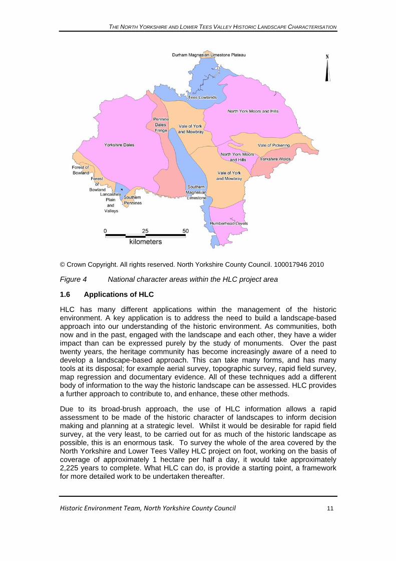
1.5 The National Character Areas34
The HLC project area covers fifteen national character areas, see Figure 4. These give us an insight into the broad character of the landscape, and each national character area has been defined taking the cultural aspects of the landscape into consideration.
The definition of the national character areas used a methodology developed from a pilot in the South West, which was subsequently rolled out nationally. This utilised twelve national datasets, seven of which are explicitly concerned with the historic landscape: farm types, settlement patterns, woodland cover, field density and pattern, visible archaeology, industrial history and designed parkland.
These datasets were combined using a system of statistical analysis to provide an overview of the character. Each square kilometre in the country was assigned an attribute for each dataset. The process then worked on the principle “…that all the kilometre squares in the sample (the whole of England) can be divided up into a number of groups on the basis of the presence or absence of a particular attribute. This subdivision continues until an appropriate number of end groups are reached, each of which will contain kilometre squares with similar attributes. The map which resulted from this then informed the definition of character areas35.”
24 Countryside Commission 1995 25 Gillespies 1999 26 Woolerton Dodwell Associates 1999 27 Scarborough Borough Council 1994 28 Harrogate Borough Council 2004 29 Hambleton District Council 1991 30 Environmental Resources Management 2000 31 Landscape Design Associates 2002 32 Lancashire County Council 2009 33 Chris Blandford Associates forthcoming 34 Countryside Commission 2005 and http://www.naturalengland.org.uk/ourwork/landscape/englands/character/areas/default.aspx 35 Countryside Commission 1998, 8-9
THE NORTH YORKSHIRE AND LOWER TEES VALLEY HISTORIC LANDSCAPE CHARACTERISATION
© Crown Copyright. All rights reserved. North Yorkshire County Council. 100017946 2010
Figure 4 National character areas within the HLC project area
1.6 Applications of HLC
HLC has many different applications within the management of the historic environment. A key application is to address the need to build a landscape-based approach into our understanding of the historic environment. As communities, both now and in the past, engaged with the landscape and each other, they have a wider impact than can be expressed purely by the study of monuments. Over the past twenty years, the heritage community has become increasingly aware of a need to develop a landscape-based approach. This can take many forms, and has many tools at its disposal; for example aerial survey, topographic survey, rapid field survey, map regression and documentary evidence. All of these techniques add a different body of information to the way the historic landscape can be assessed. HLC provides a further approach to contribute to, and enhance, these other methods.
Due to its broad-brush approach, the use of HLC information allows a rapid assessment to be made of the historic character of landscapes to inform decision making and planning at a strategic level. Whilst it would be desirable for rapid field survey, at the very least, to be carried out for as much of the historic landscape as possible, this is an enormous task. To survey the whole of the area covered by the North Yorkshire and Lower Tees Valley HLC project on foot, working on the basis of coverage of approximately 1 hectare per half a day, it would take approximately 2,225 years to complete. What HLC can do, is provide a starting point, a framework for more detailed work to be undertaken thereafter.
Historic Environment Team, North Yorkshire County Council 11

THE NORTH YORKSHIRE AND LOWER TEES VALLEY HISTORIC LANDSCAPE CHARACTERISATION
Historic Environment Team, North Yorkshire County Council 12
HLC takes a comprehensive approach to the landscape, considering all aspects as contributing to the historic character. This means that the information collected is especially well placed to inform positive landscape management36. The compilation and maintenance of HLC data in a GIS system allows a large amount of complex and in depth information to be provided rapidly for a variety of landscape management outputs.
Within local government, the historic environment services provided by the local authorities who are partners in this HLC project regularly provide historic environment data and advice to inform a wide range of schemes, from those requiring planning permission to those concerning land management, and those for which grants are available through national agencies, such as Natural England and Defra.
The availability of HLC data to be included in the information provided to inform agri-environment schemes, for example farm environment plans as part of higher level stewardship37, can enhance the scope, depth and understanding of the historic environment within a particular land holding. In the same way, the holistic approach which HLC embodies means that it has a particular role to play in the management of woodland, and the allocation of English woodland grant schemes38. As will be shown later in the report, the woodlands identified during the project are a product of human activity whether through passive or active management.
Due to the scale at which HLC is carried out, it sits neatly between different levels of landscape assessment. It can inform and enhance landscape character assessment at different scales, from county-wide approaches, such as the North Yorkshire Landscape Character Assessment39, to district-wide approaches to support the evidence base for local development frameworks, such as the special qualities study of Ryedale’s market towns40.
Other applications of HLC include its role in informing spatial planning and strategies, including for example, strategic environment assessments and sustainability appraisals and minerals and waste development frameworks, as well as area management plans, such as those for an Area of Outstanding Natural Beauty41. All this work can be underpinned by the information provided from the HLC project, enabling the historic environment to be considered from a landscape perspective. HLC provides an excellent opportunity to develop partnerships, both internally and with external partners. Because the data collected is inclusive, in terms of geographical extent and time depth, it provides a mechanism to start dialogue with many different groups. Because HLC data records aspects of the natural environment, for example in terms of boundary type, woodland character and unenclosed land ground cover, it provides a mechanism to develop close working between natural environment and historic environment colleagues. HLC can inform the creation of green corridors to ensure that they enhance and respect the historic character of the landscape.
36 Clark, Darlington and Fairclough 2004; 13 37 http://www.naturalengland.org.uk/ourwork/farming/funding/es/hls/default.aspx 38 http://www.forestry.gov.uk/ewgs 39 Chris Blandford Associates forthcoming 40 Ryedale District Council 2010 41 Howardian Hills AONB Joint Advisory Committee 2009

THE NORTH YORKSHIRE AND LOWER TEES VALLEY HISTORIC LANDSCAPE CHARACTERISATION
Historic Environment Team, North Yorkshire County Council 13
In recent years, there has been a rise in interest in local distinctiveness, with organisations such as Common Ground engaging with communities to draw out these themes. HLC can, on a local level, provide a framework through which there can be a dialogue about local character and distinctiveness, complementing or enhancing the understanding of the historic landscape gained from the project.
The historic character of the landscape forms an important aspect of what attracts people to the region, which in turn feeds into the local economy. HLC can enhance our understanding of the historic character in these areas, for example the wider environs of the City of York Authority. It can also draw attention to the historic character of the wider landscape, promoting these as possible destinations.

THE NORTH YORKSHIRE AND LOWER TEES VALLEY HISTORIC LANDSCAPE CHARACTERISATION
Historic Environment Team, North Yorkshire County Council 14
2. Overview of the project area
2.1 Geology
This section provides a brief overview of the solid and drift geology, together with their dominant industries which have had an impact on the landscape. Solid and drift geology maps are reproduced in Figures 5a and 6.
Solid geology42
The extraction of lead, and sometimes copper, from the Carboniferous limestones of the Pennines from the Medieval period onwards heavily modified the landscape. In some areas they are interbedded with sandstones which contain narrow beds of coal which was also extracted. These hard limestones have also been extensively quarried for buildings and the characteristic dry stone walls of the Dales for many centuries whereas the soft Permian-period Magnesian limestone which runs north-south through the county is an important modern quarry product used crushed for construction and other purposes. Calcareous springs in this strip led to the creation of the spa towns at Harrogate and Ripon in the 18th century. The complex lower and middle Jurassic strata of the North York Moors yield a variety of uses, including Whitby jet utilised for jewellery, an iron industry from the late prehistoric period to the 19th century, coal mining (also in the Howardian Hills) and finally alum and cement working on the eastern and northern fringes. It is used as a building stone which gives the houses and farm buildings of the area their soft creamy colour. Wold chalk, although very soft, is easily cut and was used as a domestic and farm building stone usually with brick corners, window and door surrounds. Small farm quarries are very common; there was an industrial chalk quarry and limekilns near Wharram station.
Drift geology
The topography of the study area is best understood in relation to its glacial history, the last glaciation being so severe it wiped out most of the earlier deposits43 except in some caves at the southern edge of what became the Yorkshire Dales. Ice came into the area from upper Teesdale and the Cheviots, sweeping south past the hard rocks of the uplands, one arm moving through the Vales of Mowbray and York, the other down the Tees Valley and skirting east of the North York Moors; thus the central area of lowland and the sharp cliffs of the coast were created, whilst incursions inland created the Vale of Pickering, Esk Valley and Robin Hoods Bay44.
Glacial till or boulder clay was deposited by the ice on much of the lower ground and shows the limits of the ice sheet against the harder rocks of the uplands. It created the undulating topography in parts of the Vale of York seen today and terminal moraines marking the retreat of the ice-blocked valleys creating lake-flats in many of the Pennine dales45. Ice had a scouring effect too, deepening and widening valleys in Littondale, upper Swaledale and elsewhere in the Pennines where it bared the limestone, creating pavements of bare rock and removing any signs of earlier human activity.
42 Taylor 2003, 8-10 43 Atkinson 2003, 10 44 Atkinson 2003, 11 45 Atkinson 2003, 12

THE NORTH YORKSHIRE AND LOWER TEES VALLEY HISTORIC LANDSCAPE CHARACTERISATION
© Crown Copyright. All rights reserved. North Yorkshire County Council. 100017946 2010 Reproduced with the permission of the British Geological Survey © NERC. All rights reserved
Figure 5a Solid geology within the HLC project area (see Figure 5b for key)
Historic Environment Team, North Yorkshire County Council 15

THE NORTH YORKSHIRE AND LOWER TEES VALLEY HISTORIC LANDSCAPE CHARACTERISATION
Figure 5b Key to solid geology map in Figure 5a
Modern exploitation of drift geology has impacted upon the landscape, for example the large-scale sand and gravel extraction in the Vale of Mowbray. The glacial till has been quarried for building stones in the area for hundreds of years, many buildings and walls or wall footings showing large cobbles of mixed material. In contrast, the impact of centuries of peat cutting for domestic and industrial (lead smelting) fuel in the uplands and Vale of Pickering are as yet only poorly mapped and even less understood.
Historic Environment Team, North Yorkshire County Council 16

THE NORTH YORKSHIRE AND LOWER TEES VALLEY HISTORIC LANDSCAPE CHARACTERISATION
© Crown Copyright. All rights reserved. North Yorkshire County Council. 100017946 2010 Reproduced with the permission of the British Geological Survey © NERC. All rights reserved
Figure 6 Drift geology within the HLC project area
Historic Environment Team, North Yorkshire County Council 17

THE NORTH YORKSHIRE AND LOWER TEES VALLEY HISTORIC LANDSCAPE CHARACTERISATION
Historic Environment Team, North Yorkshire County Council 18
2.2 Topography
The width of the project area covers 93 miles (150km) from east to west, stretching almost from coast to coast from Scarborough and Filey on the east coast to just beyond Settle in the west, less than 12 miles (18km) from the west coast at Morecambe Bay. From north to south, the area extends for 76 miles (122km) from north of Hartlepool to below Tadcaster, just below the M62 motorway in the south. Given these dimensions, it is not surprising that the topography of the area is highly varied, being a product of geology and geological processes, creating here a series of well-known rich and varied landscapes, from the rugged coast of the North York Moors on the east to the Selby lowlands in the south, see Figure 7. Two main areas of upland draw the eye, the Pennine chain in the west dominated by the limestone Three Peaks of Whernside (736m), Pen-y-Ghent (694m) and Ingleborough (723m) in the south and Rogan’s Seat (672m) and Angram Common (716m) further north. The North York Moors massif is lower, achieving a maximum height of 454m on Cockayne Ridge and 433m on Westerdale Moor but with notable outliers of the Eston and Upleatham Hills (183m and 179m respectively) between Guisborough and the Tees estuary and the Howardian Hills with 172m on Yearsley Moor. Frequently unnoticed as an upland block are the Yorkshire Wolds which reach 220m at Wharram Percy Farm.
Some areas are sharply defined by scarp slopes, such as the northern edges of the North York Moors and Wolds and the dramatic rise of the Carboniferous limestone on the south side of the Dales but elsewhere the hills fall more gently down to the broad lowlands where the many rivers running off the uplands and down valleys slow down and deposit their load in the shallow north-south lowland created by the ice. Two estuaries, the Tees and the Esk, outfall on the coast. There is no estuary at the eastern end of the Vale of Pickering because it is blocked by a moraine, forcing the river systems to flow inland. South of York, the Humberhead Levels create a broad low-lying area with low topography and often wet soils.

THE NORTH YORKSHIRE AND LOWER TEES VALLEY HISTORIC LANDSCAPE CHARACTERISATION
Hei
ght i
n m
etre
s
965
901
836
772
708
643
579
515
450
386
322
257
193
129 64 0
© Crown Copyright. All rights reserved. North Yorkshire County Council. 100017946 2010
Figure 7 Topography of the HLC project area (outlined in red)
Historic Environment Team, North Yorkshire County Council 19

THE NORTH YORKSHIRE AND LOWER TEES VALLEY HISTORIC LANDSCAPE CHARACTERISATION
Historic Environment Team, North Yorkshire County Council 20
2.3 Thematic overview of the Historic Environment of the Project Area
An area with the size and geographical complexity of North Yorkshire and the Lower Tees Valley does not lend itself easily to a summary overview, which inevitably leaves out more than it could ever include. However, it is felt important to provide some sort of assessment for the user and so a thematic approach has been taken, covering the themes of settlement, religion and ceremony, communication, industry, defence and agriculture, with examples from all periods spread throughout the project area. The emphasis is on elements visible in the current landscape, reflecting human activity for over 5,000 years.
Settlement
Prehistoric activity, generally, is not difficult to find but upstanding settlement is rare and tends to be most obvious on the thin limestone soils of Craven, for example the hut circles on Malham Moor46, although other sites do exist for example the Bronze Age enclosure on Westerdale Moor, Castleton47. One of the most visible prehistoric settlements is the late Iron Age site at Stanwick, north of Scotch Corner, where large earthwork embankments encircled an oppidum or proto-town and have been incorporated into later park and field boundaries48.
Scarborough possibly has the earliest origins of any extant town in the area, developing from a late Bronze Age/early Iron Age promontory fort49 closely followed by a Roman signal station, both making use of the natural promontory. However these do not constitute major settlement whereas Roman York, which was founded around AD 71, developed into an important legionary fortress and civilian settlement50.
The towns of York, Hartlepool and Whitby have important Saxon monastic settlements which possibly included control of markets and/or maritime trade at river mouths or crossings51.
Small market towns tend to be situated in the rural lowlands/upland fringe except where river valleys contained settlements and communication routes as at Hawes in upper Wensleydale, Reeth in Swaledale and Egton in Eskdale52. Whitby and Hartlepool were positioned differently, being on the coast, and they had the multiple benefits of monastic settlement, market and port. Many other market towns began life as Saxon settlements but may have been remodelled in the 12th century with broad main streets to accommodate markets as at Yarm and Stockton and Northallerton whereas Thirsk, Richmond and Skipton were influenced in their plans by the development or insertion of a castle. Harrogate had a late start, developing from a scattered collection of hamlets into a well-established spa town by the end of the 18th century53.
46 White 1997, 27 and fig 15 47 Crosthwaite 1986, 29 48 Wheeler 1954 49 Pearson 2005, 2 50 Butler ed. 1971 51 Petts and Gerrard 2006, 65 52 Daniell 2003, 103 53 Morrison 2003, 203

THE NORTH YORKSHIRE AND LOWER TEES VALLEY HISTORIC LANDSCAPE CHARACTERISATION
Historic Environment Team, North Yorkshire County Council 21
The largest settlements today are in the Tees estuary industrial conurbation from Hartlepool to Redcar, whilst York, Harrogate and Scarborough continue to flourish as modern business and commercial centres.
Religion and ceremony
Throughout the project area are many good stone sources but perhaps curiously there is very little in the megalithic tradition that elsewhere typifies prehistoric ceremonial and funerary sites. Exceptions include the Devil’s Arrows standing stones at Boroughbridge, stone circle(s) at the High Bride Stones on Sleights Moor and the Yockenthwaite stone circle in Littondale. Stone was used for rock art which tends to be found in specific areas where suitable rock types are found, such as the lower Wharfe valley (millstone grit), Fylingdales Moor (Jurassic sandstone)54 and on Feldom Ranges above Richmond. For large ceremonial monuments earthen features banks with stony fills were often used for henges, as at Thornborough east of Masham, Castle Dykes near Aysgarth and Yarnbury55 near Grassington.
Most evident in this theme are the medieval and post-medieval parish churches, especially in rural areas where they are most visible, towering above the village often in an elevated position as at Pateley Bridge or set apart as at Great Ouseburn. Selby and Whitby abbeys, Ripon, St Hilda’s at Hartlepool and York Minster form notable landmarks, some with their origins as Saxon minsters.
Communication
In this area of well-defined topography, with high plateaux cut by rivers and broad lowland valleys in between, communication routes in the pre-modern era were determined by the availability of river crossings, condition of flood plains and density of wood and scrub. Prehistoric routes can be seen in some co-axial field systems in the Dales56 and from the air as cropmarks in many parts of the project area. A number of Roman roads have been recorded in the study area (see Figures 8 and 9). The present A1(M) road through North Yorkshire follows the course of Roman Dere Street for much of its length, an important part of military infrastructure to aid the movement of troops north to Hadrian’s Wall57.
The Great North Road (actually a series of trade routes) has long been a major north-south communication route linking the south of England with Scotland. East-west routes were also important for transporting goods to and from the coastal ports of the Tees, Whitby and Scarborough, the river at York (with connections to the road system) and bringing wool and lead from the Pennines and alum and ironstone from the North York Moors. Drove roads and pack horse routes such as the paved trod or medieval pannier way on Lealholm Rigg, North York Moors are relatively rare survivals in unforgiving territory, sometimes with wayside crosses as markers58.
The great Cistercian monasteries created an extensive network of trackways to connect the abbeys with their granges and lands and to transport goods from the uplands down to the mother house on lower ground. The most extensive series of
54 Brown and Chappell 2005, 32 55 http://www.outofoblivion.org.uk/record.asp?id=51856 http://www.outofoblivion.org.uk/roads.asp57 Wilson 2003, 48 58 Daniell 2003, 101-104

THE NORTH YORKSHIRE AND LOWER TEES VALLEY HISTORIC LANDSCAPE CHARACTERISATION
new roads were created from the mid 18th century onwards in the form of turnpikes which facilitated commerce between both manufacturing and market towns59.
0 30
kilometres60
© Crown Copyright. All rights reserved. North Yorkshire County Council. 100017946 2010
Figure 8 Roman roads identified within the project area
Historic Environment Team, North Yorkshire County Council 22
30 1.5
kilometres
© Crown Copyright. All rights reserved. North Yorkshire County Council. 100017946 2010
Figure 9 Probable course of the Roman road from Northallerton northwards to the Tees, seen in the field boundaries slightly to the east of the bright green line .
Canals followed and, together with rivers, were the best option for moving heavy goods until the creation of the railway network in the 19th century. From its beginnings at Stockton on Tees, the rail network grew to have considerable influence on the landscape ranging from major engineering works and the headquarters of the dominant North Eastern Railway in York to the tunnels and viaducts such as the
59 Sheils 2003, 128-9

THE NORTH YORKSHIRE AND LOWER TEES VALLEY HISTORIC LANDSCAPE CHARACTERISATION
Historic Environment Team, North Yorkshire County Council 23
famous Ribblehead Viaduct on the Settle to Carlisle route60. Hundreds of miles of lines stretched across the countryside connecting rural areas, villages and towns and a whole architectural style was created in the building of stations, hotels, signal boxes and crossing-keepers houses.
Industry
The complex geology in the project area supported extractive industries for obtaining a variety of raw materials including lead, lime and coal from the eastern Pennines and ironstone, coal, alum and lime from the North York Moors and Eston Hills. Salt, lead and coal were probably exploited early, there are Roman lead ingots from near Pateley Bridge, otherwise our knowledge comes from documents from the great monastic houses at Fountains and Rievaulx which describe rentals and agreements for both lead and iron, industries whose importance continued for several hundred years as well as the surviving remains. In the post medieval period alum production dominated the north east part of the Moors and ironstone from there was taken to the Tees estuary foundries for production into finished goods61.
Textiles became industrially important in the 18th and 19th centuries with manufacture impacting on the landscape as flax mills clustered on the western side of the North York Moors and wool, worsteds and cotton mills dominating the wetter south-west from Skipton to Ingleton62.
Defence
Earliest visible defensive structures may be the late Bronze Age/Iron Age palisaded enclosures as at Eston Nab63 in Redcar and Cleveland and Staple Howe in Ryedale, though whether built to defend against animals or people is uncertain. There are many Roman forts such as Elslack, the legionary fortress at York and later Roman signal stations on the coast which signify the strategic importance of the area.
Medieval castles abound due to Norman military consolidation (Knaresborough), Scottish raids (Northallerton), and royal building (Middleham)64. Some made big impacts on the landscape by influencing the development of the town as at Richmond or forcing considerable reorganisation of existing settlement as at Cawood and Helmsley.
The Second World War had a great impact on the area, when the Vale of York became virtually one huge landing strip with airfields every few miles65. The low-lying parts of the east coast are vulnerable to invasion and attack, prompting the creation of signal stations as early as the Roman period and measures such as Heugh Gun Battery at Hartlepool were installed in the 19th century but continued in use until 194466. Catterick Camp has developed, since 1915 when troops first occupied it67, to
60 Sheils 2003, 132 61 Lee and White 2003, 163-190 62 Lawton 2003, 186-188 63 http://www.teesarchaeology.com/new/eston_hills.html64 Matthieu 2003, 82-84 65 Halpenny 1982, 7 66 http://www.teesarchaeology.com/new/heugh_indepth.html67 http://www.richmond.org/guide/history.html
THE NORTH YORKSHIRE AND LOWER TEES VALLEY HISTORIC LANDSCAPE CHARACTERISATION
Historic Environment Team, North Yorkshire County Council 24
become the Army’s base in the northern UK68, with extensive ranges on the edge of Swaledale as well as built development with barracks and other buildings.
Agriculture
In North Yorkshire agriculture has been an important influence for over 5, 000 years and continues to be so today as the county remains predominantly rural. Much visible early farming is confined to the uplands where subsequent activity has not obliterated it, such as the co-axial field systems on Calverside Moor, Swaledale69, Westerdale Moor70 and Lofthouse (Nidderdale). Cropmark evidence reveals large areas of field systems in the lowlands but by it’s nature does not contribute to the visible landscape character today. Best places for upstanding sites of this type in the lowland are the few remaining commons in the Humberhead Levels such as Skipwith Common to the south of York which also has post-medieval line pits for retting flax.
The medieval period is clearer, with fossilised strip fields at Middleton (Pickering), ridge and furrow fields such as at Stainsby71 Middlesbrough, Poppleton Ings York and probably the piecemeal enclosure at Timble72.
There are a large number of planned and model farmsteads in the old North Riding which has more dating from 1750-1790 than any other area73, and consequently is likely to have had an impact on field patterns though research would be needed to establish if this is the case. A good example of this farm building type is at Birdsall Home Farm, with an early 19th century example at Demesne Farm Fylingdales and five planned farmsteads in Kirkleatham parish all built 1760-1770 with eighteenth century enclosures strongly visible around.
68 Archaeological Services Durham University 2007, 2-3 69 White 1997, 20-21 70 Crosthwaite 1986, 29 71 http://www.teesarchaeology.com/new/stainsby_indepth.html72 HLC record HNY1803 73 Wade Martins 2002, 222

THE NORTH YORKSHIRE AND LOWER TEES VALLEY HISTORIC LANDSCAPE CHARACTERISATION
Historic Environment Team, North Yorkshire County Council 25
3. Methodology
3.1 Background
The North Yorkshire and Lower Tees Valley Historic Landscape Characterisation (HLC) has been a five year project which aimed to study, record and analyse the historic character of the current landscape for five adjoining partner authority areas: North Yorkshire, the Yorkshire Dales National Park, the North York Moors National Park, the Lower Tees Valley and the City of York. During the planning stages of the project, a pilot study was carried out by the Yorkshire Dales National Park Authority, which looked at a 1km square area of Swaledale to test the methodology and used MasterMap Ordnance Survey mapping and MapInfo Professional GIS software.
3.2 Evolution of the HLC Project Methodology
The methodology used is based on the nationally-accepted approach, outlined by Aldred and Fairclough74. Following the appointment of the HLC Project Officer in April 2005, based with North Yorkshire County Council, it was decided to use the HLC and MapLink modules within the HBSMR database75, software utilised by the North Yorkshire Historic Environment Record (HER), to carry out the characterisation. This would have several advantages in that the HLC digital data would be fully integrated within the Historic Environment Records for North Yorkshire County Council and the Yorkshire Dales National Park, which also used the same software . Since 2008, the City of York Council has also used HBSMR to manage its historic environment data. The HBSMR software, utilising a Microsoft Access database and associated MapInfo Professional76 GIS capability has allowed for data to be exported for use by the other project partners who are not using the software, for incorporation into their record systems and GIS. In addition, the HLC record form within HBSMR contains text fields which have the potential for a substantial amount of comment and critical analysis to be recorded, if necessary. HBSMR also allows the use of textual descriptions, rather than codes, to record the data.
At the beginning of the project, the HLC Project Officer held discussions with officers of the partner authorities and other HLC projects to discuss methodology, in particular the South Yorkshire Historic Environment Characterisation Project, in progress at that time. Whilst the South Yorkshire methodology differed slightly due to the high concentration of urban areas in that project area, HBSMR software was being used as a framework. This provided examples of how the forms would be set up, the scope of the software and the most efficient way of recording information, which heavily influenced the methodology for the North Yorkshire and Lower Tees Valley HLC project.
To establish the structure and terminology for more specialist Broad Types, such as Extractive and Designed Landscapes, the HLC Project Officer engaged in discussion with the Yorkshire Gardens Trust77, as well as the Northern Mines Research Society78. This enabled a set of useful and appropriate terms to be developed for use
74 Aldred and Fairclough 2003 75 © exeGesIS SDM Ltd 76 © Pitney Bowes Business Insight 77 http://www.yorkshiregardenstrust.org.uk/ 78 http://www.nmrs.org.uk/

THE NORTH YORKSHIRE AND LOWER TEES VALLEY HISTORIC LANDSCAPE CHARACTERISATION
in the project, which would be of relevance to future researchers. Details of these terms can be found in the technical user guide for the project79.
Figure 10 provides a screenshot of the HLC module data entry form in the HBSMR software used by the project, which shows how textual descriptive information can be recorded in the database record for each HLC polygon80.
Figure 10 The HLC module data entry form in HBSMR software81 used by the project
HBSMR utilises a Microsoft Access database which links records to a GIS vector polygon using the Maplink module82.
Initially, during the pilot phase of the project, it was decided that there needed to be a lower cut off point for the size of polygon recording. This was initially set at one hectare with nothing below this size given its own record. Following several months of using this as the lower digitising limit it was decided that this was still not completely practical within the available time and resources. The lower digitising limit was thus set at two hectares. This was in line with the data acquired for the Ancient Woodland Inventory83, and still provided a sufficiently fine grain to pick up the subtleties of historic character, while maintaining a broad-brush approach.
The information collected within the HLC project has a very specific hierarchy, from broad type, through HLC character type to specific attributes. The broadest
79 Toase 2010 80 exeGesIS SDM Ltd 2010, 106-115 81 © exeGesIS SDM Ltd 82 http://www.esdm.co.uk/hbsmr.asp 83 http://www.english-nature.org.uk/pubs/gis/gis_register.asp
Historic Environment Team, North Yorkshire County Council 26

THE NORTH YORKSHIRE AND LOWER TEES VALLEY HISTORIC LANDSCAPE CHARACTERISATION
Historic Environment Team, North Yorkshire County Council 27
classification is broad type; this sits at the top of the hierarchy and is common to, and interchangeable with, other HLC projects in the country. Below this are the HLC character types. For each broad type there will be a number of different HLC types which can be selected (see tables at start of each broad type description in Section 4). For example, under the broad type of ‘enclosed land’ an HLC type of ‘strip fields’, ‘unknown planned enclosure’ or ‘intake’ could be assigned (see Table 2). The attributes record the information which has been used to inform the HLC type84.
The process of characterising an area involved the creation of a record in the database, and then identifying the extent of the polygon that needed to be drawn. This was done by establishing an area of similar character until interrupted by an area of different character. Where this can be identified during the digitising process, past historic character can also be recorded, enabling an understanding of the dynamic character of these areas. The database also allows the recording of a confidence level by the officer. There are over 200 possible HLC types to choose from. A number of these, for example ‘smallholdings’, were only used once during the pilot stages of the project.
The district of Craven, North Yorkshire lies within the project area but had already been characterised as part of the Lancashire HLC project85. It was one of the aims of the North Yorkshire and Lower Tees Valley project to bring this data into the same database and GIS system. Rather than characterising the areas from scratch, and to establish some continuity, the polygons from the Lancashire HLC project were captured, attached to a record in HBMSR and populated by information held in the Lancashire records.
Four pilot areas were initially established. These were selected to cover the wide variety of landscapes and character types within the project area. These were Filey, the Vale of Mowbray, Selby and Great Ayton. As discussed in section 7.3, the Birdsall Estate within Ryedale District of North Yorkshire was characterised as a fifth pilot area during the early stages of the project.
The HLC project has utilised several map resources almost exclusively in digital format. This has allowed them to be fully integrated into the GIS system. These digital resources will be discussed below.
3.3 Resources Used During the Project
3.3.1 Ordnance Survey Vector Mapping (2003-2010)
The main, base vector mapping resource used as part of the project has been Ordnance Survey MasterMap86 data. This is a digital mapping resource provided by the Ordnance Survey which is based around polygons rather than lines. This has two very clear benefits, the first that it allows polygons to be captured and combined together to form the HLC polygons. This has the advantage over the previous use of vector line mapping in that a ‘better fit’ to the landscape can be achieved. The second advantage is that each polygon has metadata attached to it which provides historic information in itself. This has enabled it to be used in combination with the
84 Toase 2010 85 Ede and Darlington 2002 86 http://www.ordnancesurvey.co.uk/oswebsite/products/osmastermap/

THE NORTH YORKSHIRE AND LOWER TEES VALLEY HISTORIC LANDSCAPE CHARACTERISATION
Historic Environment Team, North Yorkshire County Council 28
aerial photographs (see 3.3.2 below) to determine the date of particular landscape features. This has been particularly useful in relation to very modern features such as modern plantations or housing estates, which have been established since the year 2000.
There have been some challenges with using the MasterMap data. Probably the most significant is the capture of map polygons which extend beyond the HLC polygon being defined, due mainly to the capture of roads during the digitisation process. This involved a programme of trimming and editing the polygon to make sure it fitted the appropriate area of historic character.
3.3.2 Vertical Aerial Photography
North Yorkshire County Council holds high quality colour digital vertical aerial photographs for the whole of the County Council area87. These enabled the historic character of the current landscape to be analysed visually, from an office base, particularly to confirm details such as boundary type and ground cover.
This dataset consists of nearly 17,000 individual images, each photograph covering an area of 1km. These digital images were accessed as a seamless map layer within the project GIS. Where aerial photographic coverage of partner areas was not held by the County Council, for example in the Lower Tees Valley area, this imagery was kindly supplied by the partner authorities for the duration of the project.
3.3.3 Historic six-inch County Series Ordnance Survey Mapping
To understand the historic character of the landscape, and establish how dynamic the landscape has been, the use of historic mapping has been essential. Two types of historic map were utilised in particular across the project area. These were the first edition six-inch County Series Ordnance Survey mapping (1846-63), and second edition six-inch County Series Ordnance Survey mapping (1889-99).
In the urban area of the Lower Tees Valley characterised by Tees Archaeology, a number of other editions of historic Ordnance Survey mapping were available, (see section 3.4 below). The third edition six-inch County Series Ordnance Survey mapping (1919-1920) and the fourth edition six-inch County Series Ordnance Survey mapping (1930-1953) were also used for the rural areas of the Lower Tees Valley to create a consistent data set for this part of the project area.
The georeferencing of the maps, which were in imperial measurements, to a metric system meant that in many cases the match with the modern mapping was not exact, however, the similarity of form was clearly visible on visual examination.
In the central urban area of the City of York, the six-inch mapping was not of a scale to enable the detail required for characterisation to be seen. Therefore, the City of York Authority, for the duration of the project, kindly supplied digital 60” to 1 mile mapping of the city, dating to 1852, which enabled accurate assessments to be made of the historic character of the present urban area.
Within the project timescale, it was not feasible to utilise archive cartographic materials, such as tithe and enclosure maps. The digital historic mapping, similar to
87 © UK Perspectives

THE NORTH YORKSHIRE AND LOWER TEES VALLEY HISTORIC LANDSCAPE CHARACTERISATION
Historic Environment Team, North Yorkshire County Council 29
the vertical aerial photographic coverage, was accessed as a seamless map layer in the project GIS.
3.3.4 Ancient Woodland Inventory
One of the main datasets used within the project was the ancient woodland inventory data, maintained by and downloaded from Natural England88. This provided information on the character of the woodlands identified within the project area. By their inclusion or exclusion from the ancient woodland inventory, a decision was reached regarding the probable date. The two hectare cut off point provided the lowest limit for the size of polygon to be digitised, therefore areas of woodland less than two hectares in size were not characterised individually.
During the initial stages of the project, the ancient woodland inventory GIS information was found to be indicative, with the polygon often covering both the woodland and surrounding areas. One of the initial aims when digitising areas of woodland for the HLC project was to ‘tighten’ the boundary to the woodland, using the basemap data.
In addition, using the Ordnance Survey vector mapping and the aerial photography, it was possible to establish if areas of woodland had been cleared since the creation of the ancient woodland inventory, in effect creating an up to date assessment of the character of ancient woodland in the project area.
3.3.5 Published And Unpublished Works
Many published and unpublished works were used during the course of the project. These can be found in Section 8 of this report. Some of these works are general histories of the area, others are specific to a particular industry or location. In relation to enclosed land, the project relied heavily upon the work of Barbara English on Yorkshire Enclosure Awards89. This provides information on all the parliamentary awards within the historic three ridings of Yorkshire, and enabled the project to establish a specific date range for each area of planned enclosure, where an award existed.
3.3.6 Other digital datasets
A number of other datasets were utilised throughout the course of the project. Many of these sit within the Historic Environment Record such as:
Listed building records
Listed building records, downloaded from the English Heritage National Monuments Record ‘Download Spatial Data’ website90, are held in the respective Historic Environment Records, and were used to provide a quick overview of the time depth of settlements. This could then be used to cross reference with images of listed
88 http://www.english-nature.org.uk/pubs/gis/gis_register.asp 89 English:1985 90 http://www.english-heritage.org.uk/professional/archives-and-collections/nmr/spatial-data/

THE NORTH YORKSHIRE AND LOWER TEES VALLEY HISTORIC LANDSCAPE CHARACTERISATION
Historic Environment Team, North Yorkshire County Council 30
buildings, accessible via the Images of England website91 to confirm the character of settlements.
Registered Parks and Gardens records
By referring to the data on registered parks and gardens, similar to the listed building records, available in the respective HERs and derived from English Heritage datasets, it was possible to establish the extent of the designated parkland and ensure this was adequately reflected in the HLC record. In some cases the character within the registered area was different, for example agricultural land. In these cases the character could be described in such a way to reflect this. These helped provide additional information and enhance the assessments made based on the digital mapping.
One other specific resource, worthy of special mention, is the Yorkshire Dales and Cleveland mines data from the Northern Mine Research Society92. This allowed the date and longevity of an area of mining to be determined. Similarly, the on-line data base of the Durham Mining Museum93 was used when characterising the extractive areas of the Lower Tees Valley and the North York Moors.
3.3.7 Online resources
During the course of the project, it was often desirable to confirm the character of a particular area, however, time constraints and the extensive size of the project area made site visits impractical. Therefore, other online resources were used to enable the historic character of the landscape to be verified.
Geograph.org.uk94 is an online resource with the stated aim to have at least one photographic image for each kilometre grid square within the British Isles. By using the Geograph online resource, the character of boundaries, settlements and woodland at ground level could be visually assessed without making a site visit. Some of the photographs used from this resource can be found in Appendix B, subject to the Creative Commons Licence reproduced below the list of plates in the report contents section, and within Appendix B.
During the latter half of the project, Google Streetview95 came online for the British Isles. This allowed sites to be visited virtually, enabling the officer responsible for characterisation to ‘walk’ down streets and confirm the character of settlements. This was only available within the more urban areas within the project, but became invaluable during the characterisation of the City of York.
Access to Archives96 provided some excellent resources for the project. Genuki.org.uk97 also provided a large amount of detail, specifically a dictionary of Yorkshire dialect which was useful in interpreting place and field names on the historic mapping.
91 http://www.imagesofengland.org.uk/ 92 http://www.nmrs.org.uk/main.html 93 http://www.dmm.org.uk/mindex.htm 94 http://www.geograph.org.uk/ 95 http://maps.google.co.uk/intl/en/help/maps/streetview/ 96 http://www.nationalarchives.gov.uk/a2a/ 97 http://www.genuki.org.uk/

THE NORTH YORKSHIRE AND LOWER TEES VALLEY HISTORIC LANDSCAPE CHARACTERISATION
3.4 Characterising Urban Settlement Areas of the Lower Tees Valley (contribution by Peter Rowe, Tees Archaeology)
Early in the project, Tees Archaeology offered to provide additional officer time towards characterising the urban settlement areas of the Lower Tees Valley, including Hartlepool, Middlesbrough, Billingham and Stockton-on-Tees, see Figure 11. This enabled the urban historic character of these areas to be characterised in further detail than for the rest of the project area. A finer level of detail was recorded, almost on a street by street basis.
© Crown Copyright. All rights reserved. North Yorkshire County Council. 100017946 2010
Figure 11 The extent of the urban settlement areas characterised by Tees Archaeology in the Lower Tees Valley area
The principal sources used to plot the development of the townscapes were GIS-based historic Ordnance Survey maps, the Tees HER (including listed buildings data), written histories, aerial photographs (where there were significant gaps in the Ordnance Survey map data) and local knowledge. During the project, a series of current, oblique aerial photographs were made available on line by Windows Live (now Bing.com98). These covered most of the urban areas and enabled digital, remote visual inspection of individual buildings at a very useable scale. The images can be rotated and viewed from each of the four principal points of the compass. This allowed the townscape to be assessed on a building by building basis if necessary.
The available historic Ordnance Survey maps allowed changes to the landscape to be recorded, practically on a decade by decade basis, for much of the 20th century. The maps consulted are set out below: -
Ordnance Survey six-inch to the mile County Series Maps: First edition Durham 1857-1861 First edition Yorkshire 1853-1857
Historic Environment Team, North Yorkshire County Council 31
98 http://www.bing.com/

THE NORTH YORKSHIRE AND LOWER TEES VALLEY HISTORIC LANDSCAPE CHARACTERISATION
Historic Environment Team, North Yorkshire County Council 32
Second edition Durham 1898-1899 Second edition Yorkshire 1895 Third edition Durham 1923-1924 Third edition Yorkshire 1919-1920 Fourth edition Durham 1932-1950 Fourth edition Yorkshire 1930-1953 1:10000 National Grid Series Fifth edition 1952-1958 Sixth edition 1962-1970 Seventh edition 1971-1980 Eighth edition 1981-1990 Ninth composite edition 1974-1995
Using these tools and resources, it was possible to zone individual settlements into broad areas on paper maps, see Figure 12, and to then plot the results en-block on the GIS and database. The average polygon size is significantly smaller than for rural areas as many represent smaller open spaces, such as bowling greens and schools, or small blocks of housing that are often less than two hectares in extent but are significantly different from their environs, see Figure 13.
Results
In general terms, it was noted that the area was still largely agricultural in the mid 19th century with the townscapes really only developing in the second half of the 19th century and early decades of the 20th, and even then in relatively discrete areas such as West Hartlepool, Middlesbrough and Stockton, see sections 4.7 and 5.4. The dominant surviving urban character type from this period is terraced housing of various styles. These could be most easily be distinguished from each other by their external spaces and several new character types were introduced.
The most basic type was the terraced house with direct frontage onto the street with a small yard to the rear. These are normally plain fronted, perhaps with some detailing to windows and porches. These were presumably built to house the majority of the workforce in a gridiron of housing, see Plate 1.
Larger terraced houses were noted to line the main routes into towns and these usually have small forecourt front gardens and perhaps a longer yard or small plot to the rear. They usually benefit from additional features such as bay windows to the main elevation. These are likely to have housed small business owners and the lower professional classes.
Much larger terraced properties were also apparent in the suburbs to the towns. These often have more extensive open spaces to the front and rear and approach villa-like proportions. Bays might be in stone rather than wood and additional features, such as balconies, might appear on the principal elevations. Larger houses of this type might be two-and-a-half storey.
Very large detached villas are also built in this period to house the many entrepreneurs attracted to the area. These are usually individually designed houses, rich in architectural detail, and with extensive grounds, often with ancillary buildings

THE NORTH YORKSHIRE AND LOWER TEES VALLEY HISTORIC LANDSCAPE CHARACTERISATION
Historic Environment Team, North Yorkshire County Council 33
such as stables and groundskeepers quarters. They often line major roads into towns or were developed in discrete areas within the suburbs.
Many institutional buildings are constructed in this period including town halls, schools and hospitals, many of which were large enough to be given their own character type. Gifts of land for public parks in this period, such as Albert Park, Middlesbrough and Ward Jackson Park, Hartlepool help to punctuate the largely urban character with open space as do municipal cemeteries. Many commercial buildings such as banks, and public houses, within current town centres contribute significantly to their character.
Terraced housing continues to dominate the area until the outbreak of the First World War when there is a hiatus in development. Following the end of hostilities, the urban character type changed, with semi-detached properties beginning to appear in once rural areas, particularly along the main approach roads into towns. There is an emphasis on private open space and details such as bow windows and hipped roofs become common, see Plate 2.
The first municipal estates begin to appear in the area in this inter-war period. These often aspire to the Garden Village movement with elements of open space built into the street plan and gardens to each of the properties, such as at Grove Hill, Middlesbrough. It is presumed that features such as indoor toilets and bathrooms begin to be added to most housing stock in this period. Cul-de-sacs begin to appear in favour of the more traditional grids of housing. At the same time there are extensive clearances of older terraced houses in some of the more central areas.
World War II forces a second hiatus in the development of urban housing. In a number of cases small estates and cul-de-sacs are left unfinished for several decades. Following the end of hostilities construction of new housing begins again. There is a marked difference in style with buildings becoming more functional and lacking architectural details such as projecting bow windows, presumably reflecting the scarceness of raw materials. Slate tends to stop being used altogether as a roofing material at this period, a difference that is very evident from aerial photography. Rapidly erected pre-fabricated buildings were noted in a number of locations including both bungalows and two storey dwellings but their survival is rare, see Plate 3.
Despite all of this urbanisation, the area is still relatively compact at the beginning of the 1950s. It is not really until the 1960s and 1970s that large planned estates, both municipal and private, usually of detached or semi-detached houses, begin to radiate from the cores of the original settlements, see Plate 4. This is apparent in towns such as Billingham where a new town centre is constructed with civic facilities such as its own theatre. High rises begin to appear in this period, often on municipal estates or as infill within town centres. Clearances of earlier terraces in the centre of towns continue with housing generally replaced with commercial premises such as shopping centres and industrial estates. Institutional architecture also changes considerably at this time. For example, school complexes become much larger and are built largely in glass with distinctive coloured fascia panels.
The building of housing estates continues into the 1980s with new planned settlements such as Coulby Newham, Middlesbrough and Ingleby Barwick, Stockton-on-Tees spreading onto former agricultural land. These often have their own neighbourhood centres. These estates continue to develop in the 1990s and 2000s

THE NORTH YORKSHIRE AND LOWER TEES VALLEY HISTORIC LANDSCAPE CHARACTERISATION
with new settlements established at Middle Warren, Hartlepool and a large executive housing development at Wynyard, Stockton-on-Tees.
The early 2000s sees the introduction of smaller blocks of apartments within urban areas. These often appear in the former gardens of larger Victorian houses or on cleared institutional sites such as hospitals and schools. As a result the urban areas are becoming more and more residential in character, see Plate 5.
Outcome
The more intensive HLC within the urban areas of Teesside has already been used to build cases to retain key elements of character that fall outside of designated areas, such as conservation areas. This is particularly the case in suburban areas where there is pressure for back-land development and demolitions, see Plate 6. It is hoped that the urban HLC will be used by a broad range of local authority departments to assess the local distinctiveness and importance of different areas.
© Crown Copyright. All rights reserved. North Yorkshire County Council. 100017946 2010
Figure 12 Initial definition of historic areas of urban settlement using hard-copy map prior to digitisation (see Figure 13)
Historic Environment Team, North Yorkshire County Council 34

THE NORTH YORKSHIRE AND LOWER TEES VALLEY HISTORIC LANDSCAPE CHARACTERISATION
Historic Environment Team, North Yorkshire County Council 35
© Crown Copyright. All rights reserved. North Yorkshire County Council. 100017946 2010
Figure 13 Digitisation of select areas on the GIS, as initially identified on the hard-copy base map (see Figure 12)
3.5 Legibility
Legibility is one of the attributes that has been recorded in the project for every polygon characterised, but is probably one of the hardest to define. This attribute is used in relation to all broad types and aims to classify, in a relatively subjective fashion, the degree to which the previous historic character visible on the first edition six-inch County Series Ordnance Survey mapping (1846-63) remains visible in the current landscape.
Table 1 lists the values used to describe legibility and their associated scope notes from the database.
Legibility is a subjective assessment of how dynamic a landscape is, that is how much change has occurred by comparing the modern Ordnance Survey vector mapping (2003-2010) with the first edition six-inch County Series Ordnance Survey mapping (1846-63). In the case of enclosed land, for example, legibility has been assessed by the amount of change in boundaries which has occurred since the first edition six-inch County Series Ordnance Survey mapping (1846-63). This may be indicated by boundary loss, or possibly an increase in boundaries subdividing existing fields. In relation to settlement, the legibility assessment may be based on the increase in dwellings (which in terms of modern estates can have a fairly dramatic impact on the historic character) or the amount of infilling in established settlements.

THE NORTH YORKSHIRE AND LOWER TEES VALLEY HISTORIC LANDSCAPE CHARACTERISATION
HLC Legibility Attribute Value
Description Scope Note
Complete Used where the present landscape character type has historic value
Significant There are many elements of the previous historic character within the landscape forming prominent landscape features
Partial Evidence relating to previous character types is visible within the present environment but is, on the whole, discontinuous
Fragmentary This term is employed where the previous historic character is only slightly visible within the landscape, for example were field boundaries have largely been removed but the external boundaries are preserved, eg in the shape of a housing estate
Invisible This term is used where the previous historic character is not visible at all. For example, where development has completely replaced an earlier field system
Table 1 HLC legibility attribute value descriptions
25 500
kilometres
Pickering
Malton
Settle
Ripon
SkiptonHarrogate
Richmond
Scarborough
Tadcaster
York
Hartlepool
Middlesborough
project area
Invisible
Fragmentary
Partial
Significant
Complete
© Crown Copyright. All rights reserved. North Yorkshire County Council. 100017946 2010
Figure 14 Legibility of the HLC of the project area
Historic Environment Team, North Yorkshire County Council 36

THE NORTH YORKSHIRE AND LOWER TEES VALLEY HISTORIC LANDSCAPE CHARACTERISATION
Historic Environment Team, North Yorkshire County Council 37
Figure 14 shows the legibility as recorded for the whole project area. This highlights areas of the landscape where change in the legibility of the HLC type has been more dynamic in comparison to areas where there is more time depth, for example with little change in boundaries.
This shows that the most accelerated change (as defined by areas of fragmentary and invisible legibility) has occurred in the central part of the HLC project area, away from the National Parks and AONBs, particularly focussed on the Vales of Mowbray and York and the Lower Tees Valley. However, upon closer inspection of the data, it is clear that there are areas within this wider pattern which have seen very little change, for example smaller areas of landscape which have seen no change in their character type since the 1850s.
Legibility has an important strategic role to play in the management of the historic character of the landscape. In the Highways Agency’s guidance on assessing the effect of road schemes on historic landscape character, for example, there is specific reference to legibility. In order to inform the screening or scoping report for a road scheme, questions of how the proposed scheme would affect the HLC and the future legibility of existing time-depth should be considered99.
3.6 Confidence The project was undertaken as a desk-based exercise using only the sources described in section 3.3. Due to the large extent of the project area and the time constraints, it was not possible to verify historic character interpretations on the ground. Over the five year duration of the project, inevitably, information recorded by the mapping and aerial photographic sources used may have become out of date. Where discrepancies were identified between sources, these were noted in the database record and the latest dated source was used to inform the characterisation. The project results, therefore, represent an interpretation of historic character at the point in time at which each record was created. The confidence of decisions made by the project officers about their interpretation of the historic character of an area is recorded in the database using the terms certain, probable or possible. This allows the interpretations to be assessed on their likelihood. Similarly, in the database fields recording the confidence of start and end dates of date ranges (Year from confidence; Year to confidence), uncertainty is recorded with a question mark. The project records, therefore, provide a starting point; a framework for more detailed work to be undertaken thereafter, which may refine or amend the interpretations.
99 Highways Agency 2007

THE NORTH YORKSHIRE AND LOWER TEES VALLEY HISTORIC LANDSCAPE CHARACTERISATION
Historic Environment Team, North Yorkshire County Council 38
4. Overview of Historic Landscape Character Types
4.1 Enclosed Land
Broad Type HLC Type Enclosed land Ridge and furrow - previous type only Lowland intakes Planned large scale parliamentary enclosure Smallholdings Pasture Demesne Large scale private enclosure Unknown planned enclosure Intake Lynchets Lowland meadow Modern improved fields Cow pasture Piecemeal enclosure Open field Assart Early field system Crofts associated with settlement Strip fields
Table 2 HLC types within the enclosed land broad type Description
The overall percentages of each broad type throughout the project area, by hectarage, can be seen in Chart 1. From this, it can be seen that enclosed land accounts for over 70% of the landscape studied, while unenclosed land defines 13%. What this enclosure represents in human terms is an undertaking to divide up and manage the landscape. It is very easy to see the field systems as abstracted, especially in a study so extensive in area as this. However, it is worth bearing in mind that each field represents the intention to change the landscape, and has encapsulated within it many hours of digging ditches, laying hedges or building dry stone walls. Enclosed land does not just represent one single understanding of the landscape, and within this study we have been able to characterise many types of field systems, as can be seen from the HLC types listed in Table 2. Each type of field system, from the creation of strip fields in the medieval period to the creation large modern improved fields, has contributed to the landscapes in which we live and work today. In basic terms, within the HLC project, an area has been characterised as enclosed land where it has a series of fields defined by internal and external boundaries, see Plate 7.
The following section will explore the field systems of North Yorkshire and the Lower Tees Valley, drawing out the broad trends that emerge from the project results within the enclosed land broad type. The different character types which have been recognised and recorded will also be explored in more detail.