northern rail bypass...northern rail bypass, is to re-route the freight rail corridor, to allow the...
TRANSCRIPT

Northern Rail Bypass
Scoping Study
Regional Development Australia Adelaide Hills, Fleurieu and Kangaroo Island
August 2018
This document is, and shall remain, the property of Tonkin Consulting. The document may only be used for the purposes for which it was commissioned and in accordance with the Terms of Engagement for the commission. Unauthorised use of this document in any form whatsoever is prohibited. Tonkin Consulting has derived the information contained in this report from specialist Government agencies and others identified herein. The passage of time, manifestation of latent conditions or impacts of future events may require further investigation of the concept and subsequent data analysis and re-evaluation of the findings, observations and conclusions expressed in this report. All information within the report, provided to Tonkin Consulting by Government officials, local government and industry representative groups and others, has been presumed accurate at the date of report preparation and no formal verification of the accuracy or completeness of the information has been undertaken by Tonkin Consulting at any stage. No warranty of guarantee, whether express or implied, is made with respect to the data reported or to the findings, observations and conclusions expressed in the report. All information supplied in this report is based on information in existence at the time the report was prepared.
Document History and Status
Rev Description Author Reviewed Approved Date
A For Client Comment SLB RCB 26 April 2018
B Final Draft SLB RCB 23 May 2018
C Revised Executive Summary SLB RCB 29 May 2018
D With final Executive Summary SLB RCB 31 May 2018
E Final Draft for Sign Off SLB RCB 10 July 2018
F Final Issue SLB RCB 15 August 2018

Contents
Foreword i
Executive Summary 1
Introduction 10
1.1 Background 10
1.2 Scoping Study Objective and Key Issues 11
1.3 Scoping Study Approach 12
1.4 Scoping Study Participants 13
1.5 Structure of the Scoping Study Report 14
Relevant Existing Literature and Reports 16
Rail Freight Context 18
3.1 The National Rail Freight Network 18
3.2 The Adelaide Hills Section 18
2010 to 2018: The Changing Picture for Rail 21
4.1 General 21
4.2 Other Influencing Changes 24
4.3 Key Stakeholder Input 25
Freight Task Assessment 28
5.1 The Current Freight Task 28
5.2 Likely Future Demand 29
5.3 Summary 30
Refinement of Proposed Route 31
Revised Costing 34
7.1 General 34
7.2 Northern Rail Bypass - Cost Breakdown 34
7.3 Assumptions 36
7.4 Earthworks 36 7.4.1 General 36 7.4.2 Rock Blasting 36 7.4.3 Profile 36 7.4.4 Cut to Fill 37
7.5 Track and Formation 37

7.5.1 Rail Track 37 7.5.2 Ballast 37 7.5.3 Passing Loops 37 7.5.4 Turnouts 37 7.5.5 Level Crossings 37 7.5.6 Tunnels 37 7.5.7 Bridges 38
7.6 Miscellaneous 38 7.6.1 Land Acquisition 38 7.6.2 Services and Signalling 38
7.7 Upgrade of Existing Alignment 38
CBA Review 40
8.1 Introduction 40
8.2 Benefits and Methods 40 8.2.1 General 40 8.2.2 Greater urban consolidation 40 8.2.3 Productivity improvements 41 8.2.4 Savings in the life and capacity of the South East Freeway 42 8.2.5 Amenity improvements to residential areas 43 8.2.6 Other non-quantifiable benefits 43
8.3 Benefit Estimates 43 8.3.1 General 43 8.3.2 Greater urban consolidation 43 8.3.3 Productivity improvements 44 8.3.4 Savings in the life and capacity of the South East Freeway 44 8.3.5 Amenity improvements to residential areas 44 8.3.6 Time Savings at Level Crossings 45 8.3.7 Benefits of Double Stacking 45
8.4 Summary of benefits 46
8.5 Summary 46
The effect of No Rail Freight Bypass 47
Further Investigations – Where to from here? 48
Tables Table 5.1 The current rail task 28 Table 7.1 Northern Rail Bypass – Breakdown of Components 34 Table 7.2 Northern Rail Bypass Costing Summary 35 Table 8.1 Urban Consolidation Benefit 44 Table 8.2 Productivity Gains 44 Table 8.3 Existing Highway Projects in South Australia 44 Table 8.4 Savings in the life and capacity of the South East Freeway 44 Table 8.5 Benefit from Amenity improvements to residential areas 45 Table 8.6 Summary of Benefits 46

Figures Figure 1.1 Key Project Stages 12 Figure 1.2 Northern Rail Bypass Scoping Study Contributors 14 Figure 3.1 Australia's Standard Gauge Network, as used for the national movement of
freight 18 Figure 3.2 Adelaide-Melbourne rail alignment; Adelaide Hills section (source: 2010 RFMS
report) 19 Figure 4.1 Inland Rail route 21 Figure 5.1 Gross tonnages between Dry Creek and Tailem Bend, between 2010 and 2016 29 Figure 6.1 Northern Rail Bypass Alignment 32 Figure 8.1 Map of buffer Zone 42
Appendices Appendix A Scoping Study Methodology Flow Chart Appendix B Relevant Literature and Reports Appendix C Inland Rail Project Sheets Appendix D Key Stakeholder Inputs Appendix E CBA Review – Agglomeration Economies and Effective Job Density

ABN: 898 1669 3886
4 Angas Place, Strathalbyn SA 5255
PO Box 1171
STRATHALBYN SA 5255
Ph: 08 8536 9200
Fax: 08 8536 2411
www.rdahc.com.au
Adelaide Hills Council Mount Barker District Council Alexandrina Council City of Victor Harbor Yankalilla District Council Kangaroo Island Council City of Onkaparinga Council
Foreword The Adelaide Hills and surrounding districts is one of the most dynamic regions in South Australia. It
contains 4 growth communities, with Mount Barker District Council in the region’s centre expecting
to double in size over the next 20 years. This peri-urban area of Adelaide is not only a very beautiful
region, it is rich in agriculture, tourism and general economic activity. It is linked to Adelaide by the
South-Eastern freeway.
The capacity of this Freeway at times struggles with the increased freight volumes and community
travel. The existing Adelaide to Melbourne rail corridor has changed little in the hills since its
introduction in the 1800s. It is clear that if we are to meet the economic and social challenges facing
us, the existing rail corridor and its use must be re-evaluated. One option what is known as the
Northern Rail Bypass, is to re-route the freight rail corridor, to allow the existing corridor to be used
for commuter passenger travel.
The study highlights the economic and social benefits of this potential Northern Rail Bypass
initiative. We know that efficient infrastructure is essential for driving sustainable economic
development. We also know that the continued use of the existing rail line is inefficient and a poor
use of resources.
We are also concerned that the existing route is unattractive to east coast freighters sending freight
to South Australia and beyond. There is already talk of Melbourne freight forwarders utilising the
under construction inland railway, which will allow them to bypass Adelaide altogether via Parkes.
This would have severe economic impacts on the Adelaide region.
Our study aligns with South Australian Government’s GlobeLink proposal, which promotes the
modernisation of the railway transport network for expected growth in national land freight. This new
corridor will have a central role in interstate freight movements by addressing the existing
limitations. It will reduce congestion and open up new opportunities.
James Sexton
Chair, RDA Board
Damien Cooke
CEO, RDA Adelaide Hills Fleurieu & Kangaroo Island
1
Executive Summary Background
The subject of a rail freight bypass of the Adelaide Hills has been debated since the early 2000’s.
Noise, height clearance and grade issues are but a few of the shortcomings of the existing rail
corridor, yet the many investigations to date fail to return a strong business case.
The most recent and significant investigation is the 2010 Adelaide Rail Freight Movement Study
(2010 RFMS), commissioned by the Australian Government. This study forecast a time by which
the existing rail line would reach capacity, and identified and assessed options to meet future rail
demand. A subsequent, separate study was initiated to revisit the findings of the RFMS from an
economic perspective and highlight any areas of concern that may require further investigation.
While extensive the 2010 RFMS left some key questions unanswered, including:
Consideration of the growing population in the Adelaide Hills and at Murray Bridge
Wider social and environmental consequences of the existing system
The potential impact of a new corridor on the eastern states’ freight strategy
The existing and growing constraints from commuter traffic to the east of the city
The potential of establishing freight transport hubs to the north of the city
Increasing project costs over time
The ability or otherwise to achieve double stacking of freight containers
Potential opportunities for the existing rail corridor; perhaps passenger movement?
The impacts/consequences if a new rail line is not considered feasible, and
The potential for a possible future Emissions Trading Scheme applied to the transport
sector and the resultant change in competitiveness of rail over road transport.
Since 2010, there have been many changes to both the national rail freight network as well as
the Adelaide Hills section. Inland Rail is now under construction and due for completion in 2025
and a new freight terminal is planned for the Melbourne end (Dynon). Once operational, double
stacked trains can travel (via Parkes) between Melbourne and Perth. The Adelaide to Melbourne
rail line has been upgraded to cater for 1800m long trains, providing a 20% increase in capacity;
grade separation has also occurred at 2 key locations on the existing line. The Adelaide to
Melbourne rail line however, cannot cater for double stacked trains; unloading and restacking of
trains continues to be common practice at a cost of both labour and time. Significant
infrastructure upgrade is required to enable double stacking to occur, including a new rail bridge
across the River Murray and tunnelling through the Adelaide Hills.
Concurrently, the use of larger road freight vehicles and competition by the Port of Adelaide has
reduced the movement of gross freight tonnages on rail between Adelaide and Melbourne.
Intermodal facilities are being planned at both Monarto and Tailem Bend, while closure of rail
spur lines in the Mallee region has affected bulk grain transport patterns. Global market
conditions for ore and minerals continue to fluctuate and when favourable, may significantly
impact the rail freight task.
In addition, the state’s road network is under increasing pressure to cater for larger and longer
freight carrying vehicles. Residential growth is booming in Mount Barker District Council and
increasing traffic volumes on the South Eastern Freeway, including significant freight activity, will
drive the need for freeway upgrades sooner than currently planned.
The new State Government has a forward thinking transport policy for freight on its agenda,
known as GlobeLink. This is consistent with the concept for the Northern Rail Bypass and is a
strategic policy, recognising that
2
“…A generational upgrade of our freight transport infrastructure is required to provide our
companies with the competitive advantage they need to get our premium quality South
Australian products to markets across the globe…”
It has now been 8 years since the 2010 RFMS was prepared. According to rail freight forecasts
in the RFMS, the rail line should now be 50% closer to capacity. With so many changes and the
passage of time, re-examination of the need or otherwise for the Northern Rail Bypass is timely.
The Project
The South Australian RDA’s whole of state regional collaboration nominated the Realignment of
the Adelaide Hills Rail Corridor as the second highest priority infrastructure for the state’s
economic prosperity. This Scoping Study has enabled the opportunity to review and confirm (or
otherwise) this priority from a more informed perspective.
Focus has been given to the Northern Bypass (south) via Truro only, as indicated in the 2010
RFMS report (Option 3) and rail only has been considered, i.e. no road. It is worth noting that
both the 2010 study and this project are considering a Single Track with passing loops; NOT a
dual track.
This Scoping Study reflects today’s context, current stakeholder wisdom and opinions, costs and
economic considerations. In addition, the study has more fully addressed those items left
unexplored from the previous investigations, through extensive data and literature review,
research, stakeholder liaison, engineering analysis and economic review. These items include:
The economic impact of social benefits of the Northern Rail Bypass
Testing of the Option 3 alignment to ensure up and down grades do not exceed +/ - 1%
Costing of the bypass option to reduce land acquisition issues
Assessment of what is required for double stacking to be achieved
Review of the 2010 RFMS cost estimate, and
More detailed assessment of the economic benefit of the project, and the economic impact
on Adelaide of the Inland Rail project and a possible link between Mildura and Menindee.
This Scoping Study provides a formal, targeted update and extension to the 2010 RFMS. In
addition, this study will inform a second stage subsequent comprehensive Cost Benefit Analysis
(CBA).
Scoping Study Participants
As potentially one of South Australia’s most significant changes to the rail freight network, the
development and assessment of the Scoping Study has included consultation with customers,
rail operators, users, local government and government agencies, and other identified
stakeholders.

3
Approach
Key stages of the Scoping Study have comprised:
Data Review (refer Sections 2, 3 and 4) has canvassed existing literature, reports and current
data sets pertaining to freight movement, ranging from national initiatives and strategic directions
through to detailed rail freight volumes. Further, this considers the characteristics and context of
both the national rail freight network and the Adelaide Hills section.
Testing of the Alignment (refer Section 6) has comprised a detailed review of the proposed
Northern Rail Bypass route, including refinement to ensure minimum horizontal curves and
vertical gradients can be achieved. Preliminary consideration has also been given to the need to
minimise land acquisition and overall cost in terms of bridge structures, tunnelling and the like.
Quantification of the Rail Freight Task (refer Sections 4 and 5) provides key insight into the past,
present and future role of rail freight on the Adelaide Hills line and commentary on the
impacts/opportunities of a new alignment. Significant changes since the 2010 RFMS have been
identified, including to the national rail freight network and in particular the Adelaide Hill s section.
The current freight task and likely future demand for rail on this section of the rail corridor and
beyond have been explored, including identification of key influencing factors.
The refined alignment has been costed for both the Northern Rail Bypass (refer Section 7), as
well as the broad cost of upgrading the existing Adelaide Hills section to accommodate double
stacking. This costing has been based on current rail construction costs, including those used by
ARTC for Inland Rail.
A more detailed set of social and economic considerations for the Northern Rail Bypass has
been prepared, refining and extending the benefits identified in the 2010 RFMS (refer Section 8).
Discussion has also been provided regarding potential implication should no rail bypass be
created (refer Section 9).
The findings have been concluded with advice regarding further work that will be required to
advance the Northern Rail Bypass investigations and to prepare a corresponding Business Case
in accordance with the requirements of Infrastructure Australia.
Stage 1 -Project
Inception
Stage2 - Data Review
Stage 3 -Testing of Alignment
Stage 4 -Quantification
of the Rail Freight Task
Stage 5 -Revised Costing
Stage 6 -Assessment of
Benefits
Stage 7 - Final Report

4

5
Key Findings
Key outcomes and findings of the Scoping Study include:
1. Costs continue to be more competitive for road freight rather than rail when moving goods
between Adelaide and Melbourne.
2. Changes to the Adelaide Hills Rail Alignment since 2010 have enabled a 20% increase in
the carrying capacity of the existing rail line. This indicates that today, the rail line has a
maximum capacity in the order of 12.8M tonnes.
3. In 2015-16, statistical data indicates that 8.11M gross tonnes was carried over this section
of line, indicating the spare capacity of the line is in the order of 37%.
4. Rail freight costs and increased competition by the Port of Adelaide have largely
contributed to a reduction in rail volumes traveling between Adelaide and Melbourne.
5. A windy, steep alignment continues to prevent the Adelaide Hills rail line from catering for
double stacked trains, although double stacking could achieve in the order of 25% savings
for rail customers, and significant time savings for the movement of goods. Double
stacking will require significant infrastructure works to be undertaken to achieve vertical
clearances, including tunnels and a new rail bridge over the River Murray.
6. Population growth through the Adelaide Hills has occurred at a greater rate than expected,
particularly through the Mount Barker District Council region.
7. Accelerated population growth and a greater desire for the road freight task will see the
South Eastern Freeway reach its capacity sooner than expected.
8. Significant changes are both planned and currently under construction for the National Rail
Freight network (i.e. Inland Rail and a new rail freight terminal in Melbourne) which have
the ability to fundamentally change the movement of rail freight through South Australia,
and the role of the Adelaide to Melbourne link in the national rail freight network. These
changes are expected to be complete and in operation by 2025 and will potentially enable
double stacked rail freight to move between Perth and Melbourne without passing through
(or near) Adelaide, with Parkes likely to become the geographic centre of national rail
freight activities. Less freight rail services will potentially stop near or in the vicinity of
Adelaide, reducing the modal choice for freight movement. There is a very real possibility
that South Australia and Adelaide in particular may be ‘forgotten’ in the national rail
picture.
9. The original cost benefit analysis of the rail freight diversion in the 2010 RFMS is now
outdated. Costs have escalated, and the analysis does not address some significant
economic benefits. While only providing an estimation of the broad value of these benefits,
they have been found to potentially be quite large, notwithstanding the application of
conservative assumptions wherever possible. Non-quantifiable benefits are still to be fully
analysed. Further, the base case in the 2010 RFMS assumed a ‘Do Nothing’ scenario; this
is considered unrealistic and a ‘Do Minimum’ scenario should be used for more
appropriate comparison.
10. The estimated cost of the Northern Rail Bypass has been calculated between $3.84 and
$4.96 billion.

6
Northern Rail Bypass – Cost Summary
Component Cost ($m)
Rail Track 214
Earthworks 1309.45 - 1489.27
Tunnels, Level Crossings, Bridges, Viaducts, Murray Bridge Works 1480.77-2232.77
Land Acquisition 76.27
Services/Signalling 120.15
Sub Total 3200.61-4132.43
20% Contingency 640.12 - 826.49
Total 3840.73 - 4958.91
Benefits identified to date total $2.67 billion.
Northern Rail Bypass – Summary of Benefits
Benefit Value ($m)
Urban consolidation 71.4
Productivity improvements 135.7
South East freeway savings 60.4
Amenity improvements 431.0
Time savings at level crossings 518
Double stacking benefit 1460
Improved equity of access to job and service opportunities
Creation of metro public transport options
Unknown connection to burgeoning defence industry
Improved connectivity and function of the national rail freight
network
Total 2676.5++
++ Yet to be fully quantified
While further benefits have now been quantified, more detailed analysis should be conducted
as part of a full updated cost benefit analysis of the Northern Rail Bypass. This analysis
should also address some of the non-quantifiable benefits identified in this report, including
improved equity of access to job and service opportunities, creation of metro public transport
options, and the wider strategic impact of improvements to the national rail freight network.
This will be required to complete a robust business case in accordance with the requirements
of Infrastructure Australia.
Impact of Doing Nothing
Importantly, this scoping study also addresses the effect of no rail bypass. This section of the rail
network and indeed the overall Adelaide to Melbourne rail link could potentially be superseded
by Inland Rail, but at what expense to the state?
At worst, the risk of not creating the Northern Rail Bypass is that Adelaide and wider South
Australia becomes forgotten or is at best seen as an ‘add on’ to the national rail freight network;
superseded by Inland Rail, intermodal facilities at Parkes, and the east-west rail corridor. Most
concerning, it sends a message to current and future investors both locally and globally that
South Australia is seemingly ‘less connected’ than other states and less committed to best
positioning ourselves for positive long-term growth.

7
At this level of investigation, the value of ‘lost opportunity’ is yet to be quantified, but weighs
heavily on the overall economic value of our future rail links.
This too, will require further work as part of a holistic economic assessment.

8
Summary – Where to from Here?
From a ‘big picture’ perspective, the state’s road and rail assets require optimisation to best cater
for the movement of both goods and people. The rail link between Adelaide and Melbourne is a
key infrastructure investment, utilised for freight and passenger transport. Current changes to rail
freight movement at a national level however may adversely influence the use of this asset.
Further, modal choice becomes even less competitive with a road dominated transport network
for freight across the state.
While the cost of the Northern Rail Bypass has increased, benefits have also increased
significantly and still do not reflect the full extent of positive outcomes to be achieved as part of
such an infrastructure investment.
More detailed investigations are required to properly quantify a revised Cost Benefit Analysis for
the project, and to complete a robust Business Case in accordance with the requirements of
Infrastructure Australia.
These investigations should include:
1. More detailed costing for the project, on a more refined alignment based upon engineering
survey
2. More detailed economic assessment of the ‘Do Minimum’, ‘Achieve Double Stacking’ (as
outlined in the 2010 RFMS and which arguably, should be the Base Case) and ‘Northern
Rail Bypass’ options for the rail freight route, including:
Refined assumptions, based upon more project specific data
Consideration given to whether the current rail line should be upgraded to cater for the
freight task alone (i.e. double stacking), or conversely, to investigate the value of dual
rail use of a new corridor
Identification of an appropriate ‘value’ of traditionally non-quantifiable benefits, including
improved access to job and service opportunities, creation of metro transport options,
minimising major delays to commuters and emergency services, and the ‘lost
opportunities’ when compared to the national rail freight network.
3. Further liaison with key stakeholders as required, to assist in refining the alignment. In
particular, consultation will need to be conducted with Councils to the north-east of
Adelaide, in the vicinity of the proposed alignment.
4. Further engagement with the State Government to explore the characteristics and
objectives of the Northern Rail Bypass and its role as part of GlobeLink, and
5. Preparation of a submission to Infrastructure Australia for this project, in accordance with
the relevant requirements and checklists.
The State is considered to be in a key period regarding security of its future economic position
and role in the national rail freight network. Actions must occur quickly, to quantify the real Cost
Benefit Analysis of the overall Northern Rail Bypass.


10
Introduction
1.1 Background
The 1887 linking of the South Australian main rail line to the Victorian rail system created the first
single gauge inter-colonial rail link in Australia. Today, the rail line forms part of the wide-
reaching interstate freight rail corridor connecting Sydney, Melbourne (and to a lesser degree,
Brisbane) with Adelaide, Perth and Darwin.
The terrain through the Adelaide Hills section of the corridor (between Murray Bridge and
Islington) however restricts travels speeds, requires greater locomotive power and incurs
increased maintenance costs to meet the higher levels of wear and tear compared to other rail
freight lines in Australia. Increasing residential development in the vicinity of the rail corridor over
time has also brought the alignment under scrutiny, due to complaints about the noise generated
by train movements. The demand for rail freight movement continues as an important and
complementary alternative to road transport, and there will be a time at which the line will reach
the limit of its capacity. Further, rail offers significant environmental and economy of scale
benefits when compared to the road network.
In 2010 the Adelaide Rail Freight Movement Study (RFMS) was commissioned by the Australian
Government to identify and assess options to meet future rail freight demand in light of the above
issues. These investigations sought to quantify the time at which the rail line would reach
capacity, and future options included realignment of the rail corridor. While extensive, the report
left some key questions unanswered, including (but not limited to):
Consideration of the growing population in the Adelaide Hills and at Murray Bridge
Wider social and environmental consequences of the existing system
The potential impact of a new corridor on the eastern states’ freight strategy
The existing and growing constraints from commuter traffic to the east of the city
The potential of establishing freight transport hubs to the north of the city, and
Increasing project costs over time.
11
Other considerations left unexplored included:
The ability or otherwise to achieve double stacking of freight containers
Potential opportunities for the existing rail corridor; perhaps passenger movement?
The impacts/consequences if a new rail alignment is not considered feasible
The potential for a possible future Emissions Trading Scheme applied to the transport
sector and the resultant change in competitiveness of rail over road transport, and
Population projections for both Melbourne and Adelaide.
An independent review of the RFMS report prepared by SGS Economics in 2010 raised many of
the above comments and related questions.
It has now been 8 years since the RFMS was prepared. According to rail freight forecasts in the
RFMS, the rail line should now be 50% closer to capacity.
The Federal Government has recently committed to $20B in funding for key national rail projects
including Inland Rail, and there is Victorian interest in a potential standard gauge rail link
between Mildura and Menindee. These links however, have the potential to leave South Australia
‘forgotten’ for national rail freight connectivity.
In addition, the Ministerial DPAs for both Mount Barker District Council and Murray Bridge rely on
a significant employment node occurring at Monarto to provide employment for residents in these
growth areas. Mount Barker District Council in particular is growing rapidly as land sales continue
to gain momentum.
Changing production and packaging practices, increasing production volumes and the value o f
the Australian dollar also all affect the demand for rail freight. Given the changes that have
occurred over the past 7 years, a review and update of the 2010 RFMS is timely.
Further, a key policy of the recently elected State Liberal Government is the GlobeLink plan,
designed to “…provide a new road, rail and air freight corridor, bypassing existing road and rail
corridors through the suburbs and around the Adelaide Hills. The corridor will avoid the heavily
populated areas of the existing freight routes, and will take freight directly to Port Adelaide…”
The GlobeLink plan is consistent with the concept for the Northern Rail Bypass and is a strategic
policy, recognising that “…A generational upgrade of our freight export infrastructure is required
to provide our companies with the competitive advantage they need to get our premium quality
South Australian products to markets across the globe…”. In 2017, Regional Development
Australia Adelaide Hills, Fleurieu and Kangaroo Island appointed Tonkin Consulting to undertake
a Scoping Study for this section of rail corridor.
Focus has been given to the Northern Bypass (south) via Truro only, as indicated in the RFMS
report (Option 3) and Rail only has been costed; i.e. no road. It is worth noting that both the 2010
study and this commission are considering a Single Track with passing loops; NOT a dual track.
1.2 Scoping Study Objective and Key Issues
The RFMS concluded that a proposed realignment of the rail corridor to bypass residential areas
(amongst other benefits) was not financially viable. A subsequent, separate study was initiated to
revisit the findings of the RFMS and highlight any areas of concern that may require further
investigation.
The South Australian RDA’s whole of state regional collaboration nominated the Realignment of
the Adelaide Hills Rail Corridor as the second highest priority infrastructure for the state’s
economic prosperity. This Scoping Study will provide an opportunity to review and confirm (or
otherwise) this priority from a more informed perspective.

12
In addition, the Scoping Study will inform a second stage subsequent comprehens ive Cost
Benefit Analysis (CBA). The Scoping Study will form an update to the RFMS Report, but with
targeted focus on key elements as outlined below.
Key issues to be explored and extended in analysis will include the following:
Economic impact of social benefits – these will be explored in more detail in general,
consistent with the Infrastructure Australia methodology. In particularly, the potential for the
existing Hills Corridor to be used for public transport will be assessed.
Testing of Option 3 – Northern Bypass (south) via Truro to ensure up and down grades do
not exceed 1%.
Costing of the bypass option (Option 3) to reduce land acquisition issues. This will assume
a direct route from Murray Bridge to Truro, this possibly following the existing old rail
corridor to Millendella, then Greenfields to Truro and beyond (via 2010 RFMS assessment
route). A triangular connection will be assumed to link Monarto using the existing rail
corridor from Murray Bridge to Monarto and then the old rail corridor from Monarto back to
the proposed new route.
Assessment of what is required for double stacking to be achieved; particularly the
implications of the cutting in Murray Bridge (immediately west of the River Murray rail
bridge) under the Old Princes Highway. It should be noted however that double stacking of
trains will require additional works to be undertaken at the Melbourne end, at considerable
cost.
Review of the previous cost estimate in reference to the double track elements in the 2010
RFMS.
More detailed assessment of the economic benefit of the east-west freight movement
overall, and the economic impact on Adelaide in the event that a Mildura or Eastern In land
Bypass is constructed.
1.3 Scoping Study Approach
Tonkin Consulting’s approach to the Scoping Study investigations has focused on providing
Regional Development Australia with the confidence to determine the real need or otherwise for
a realigned freight corridor. Should the findings be favourable, this report will provide a valuable
base for development of a more detailed investigation and business case.
The key stages of the Scoping Study are as follows:
Figure 1.1 Key Project Stages
Appendix A includes a copy of the Methodology Flow Chart for the Scoping Study; indicating Key
Tasks, Outputs, Consultation Tasks and Timelines for each of the Key Stages.
Stage 1 -Project
Inception
Stage2 - Data Review
Stage 3 -Testing of Alignment
Stage 4 -Quantification
of the Rail Freight Task
Stage 5 -Revised Costing
Stage 6 -Assessment of
Benefits
Stage 7 - Final Report
13
1.4 Scoping Study Participants
As potentially one of South Australia’s most significant changes to the rail freight network, the
development and assessment of such a proposal requires consultation with customers, rail
operators, users and other key stakeholders.
Figure 1.2 illustrates stakeholders and team members involved in the Scoping Study. Further
details of the information gathering and consultation process are described in Section 4.3 of the
report.

14
Figure 1.2 Northern Rail Bypass Scoping Study Contributors
1.5 Structure of the Scoping Study Report
This report has been set out in a series of comprehensive, yet easy to read sections as follows:
Client
RDA AHF&KI
Steering CommitteeRepresentatives from:
RDA Adelaide Hills Fleurieu and Kangaroo IslandSouthern and Hills LGA
RDA Murraylands and RiverlandMurrylands and Riverland LGA
Adelaide Hills CouncilMount Barker District Council
City of MitchamCity of Unley
Rural City of Murray BridgePrimary Producers SA
HDS Australia
Key StakeholdersRepresentatives from:
Primary Producers SA
Monarto Intermodal Terminal
Australian Portable Camps
Genesee and Wyoming
Australian Rail Track Corporation
RDA Murraylands and Riverland
Viterra
South Australian Freight Council
Pacific National
DPTI
Mid Murray Council
Rural City of Murray Bridge
City of Mitcham
Murraylands Food Alliance (general group)
FlindersPorts
Civil Contractors Federation
Consultant
Tonkin Consulting

15
Section 2 comprises a review of existing literature and reports.
Section 3 considers context and current characteristics of both the national rail freight network
and the Adelaide Hills section.
Section 4 identifies the significant changes in the national rail network and in particular, the
Adelaide Hills line since the RFMS was completed. In addition, this section presents key insight
into the past, present and future role and function of rail freight on the Adelaide Hills line and
commentary on the impacts/ opportunities of a new alignment.
Section 5 discusses both the current freight task and likely future demand for rail on this section
and beyond, including key influencing factors.
Section 6 includes review and refinement of the proposed route for the Northern Rail Bypass.
Section 7 provides up-to-date costings for both the (refined) Northern Rail Bypass and upgrade
of the existing Adelaide Hills section to accommodate double stacking.
Section 8 presents a more detailed set of social and economic considerations for the Northern
Rail Bypass, expanding upon the findings of the RFMS to address wider benefits.
Section 9 includes discussion regarding potential implications should no bypass be created.
Sections 10 advises on further work that will be required to advance Northern Rail Bypass
investigations and prepare a business case.

16
Relevant Existing Literature and Reports A number of existing reports, studies and other valuable information relating to movement of
freight both across South Australia and nationally, particularly by rail, have been reviewed as part
of this investigation.
Reports include but are not limited to, the following:
Previous investigations regarding issues with the current rail corridor and options for
realignment
Statistical data regarding rail activity across Australia, including from the Bureau of
Infrastructure, Transport and Regional Development (BITRE) and ARTC’s ‘Trainline’
publication issues 1 to 5 (inclusive).
Checklist and Requirements for Business Cases submissions to Infrastructure Australia
DPTI’s Integrated Transport and Land Use Plan
Other rail related investigations
Recent economic outlook reports for both Australian and South Australia, including
CommSec, AMP, Westpac and the South Australian Centre of Economic Studies (SACES),
including discussions with Professor Dick Blandy, and
Information obtained from relevant websites.
The following reports in particular have been reviewed and summarised:
Who Moves What Where - Freight and Passenger Transport in Australia
National Transport Commission, August 2016
South Australian Rail Freight – A Bypass to Save the Heart of Adelaide
Mitcham Community Rail Freight Task 2007
Adelaide Rail Freight Movements Study Final Report
GHD 2010
Adelaide Interstate Rail Freight – Brief for Strategic Assessment of Corridor Options
SGS Economics, 2010
Northlink, Getting SA on Track, and Northlink Road and Rail Bypass – 2015 update
Northlink Reference Group, 2010 and 2015
Australasian Railway Association Statistical Report- Trainline 5
Department of Industry and Regional Development (DIRD) – Bureau of Infrastructure,
Transport and Regional Development (BITRE), November 2017
Discussion Paper 1 and Checklist for Stages 3 and 4: Business Case Development
and Business Case Assessment
Infrastructure Australia, 2008 and 2017
Murray Basin Region Freight Demand and Infrastructure Study Project Report
Department of Transport, Planning and Local Infrastructure (DTPLI), July 2014
Integrated Transport and Land Use Plan (ITLUP)
Department of Planning, Transport and Infrastructure, 2013

17
Too comprehensive to include here; Appendix B includes a relevant summary of each of
these reports. These reports contain a number of key statistics, discussion and relevant
information in these reports which provide valuable, informative background to this study.
18
Rail Freight Context
3.1 The National Rail Freight Network
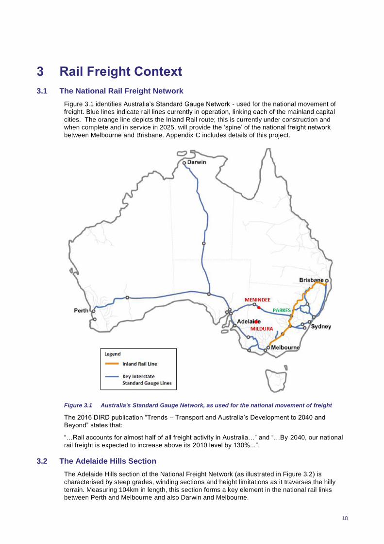
Figure 3.1 identifies Australia’s Standard Gauge Network - used for the national movement of
freight. Blue lines indicate rail lines currently in operation, linking each of the mainland capital
cities. The orange line depicts the Inland Rail route; this is currently under construction and
when complete and in service in 2025, will provide the ‘spine’ of the national freight network
between Melbourne and Brisbane. Appendix C includes details of this project.
Figure 3.1 Australia's Standard Gauge Network, as used for the national movement of freight
The 2016 DIRD publication “Trends – Transport and Australia’s Development to 2040 and
Beyond” states that:
“…Rail accounts for almost half of all freight activity in Australia…” and “…By 2040, our national
rail freight is expected to increase above its 2010 level by 130%...”.
3.2 The Adelaide Hills Section
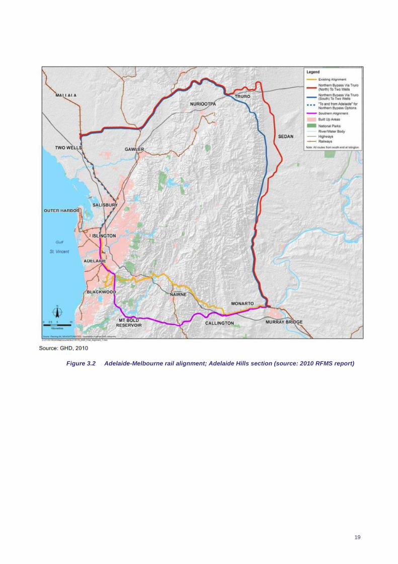
The Adelaide Hills section of the National Freight Network (as illustrated in Figure 3.2) is
characterised by steep grades, winding sections and height limitations as it traverses the hilly
terrain. Measuring 104km in length, this section forms a key element in the national rail links
between Perth and Melbourne and also Darwin and Melbourne.
19
Figure 3.2 Adelaide-Melbourne rail alignment; Adelaide Hills section (source: 2010 RFMS report)
20
While a key element in the overall national freight network, this section is known for its
inefficiencies, which include:
Vertical (clearance height) limitations which cannot accommodate double stacking
Vertical gradients which limit the speed at which trains can travel and extend overall travel
time
Horizontal curves which also limit the speed of the trains
The higher demand for power and therefore fuel to be able to haul laden wagons through
this section.
In addition, there are further negative impacts of the rail infrastructure as it passes through the
urban landscape, including:
Noise
Bushfire risk
Safety risks
Lack of emergency access
Delay to commuters
Pollution, and
Safety at level crossings, where the rail line intersects with road traffic (there are 41 level
crossings between Murray Bridge and Adelaide). In particular, Main Road in Glenalta, Main
Road in Belair and Cross Road in Hawthorn are heavily trafficked and the long delays cause
extended delays across the wider road network, particularly during peak traffic periods.
21
2010 to 2018: The Changing Picture for Rail
4.1 General
While the concept of creating a rail freight bypass of the Adelaide Hills remains unchanged since
the 2010 Adelaide Hills Rail Realignment Study, there have been significant changes to both the
National Freight Rail Network and also the operation of the current Adelaide Hills alignment,
which have clear impacts for this investigation.
These changes include (but are not limited to) the following:
1. Commencement of the Inland Rail Project
Inland Rail is a 1700km long freight railway project, linking Melbourne to Brisbane along a
route located to the west of the mountainous Great Dividing Range.
The rail line is currently under construction, and when complete will complete the ‘spine’ of
the national rail freight network between Melbourne and Brisbane. Appendix C includes
details of this project. 1.8km long, double stacked trains will be accommodated for the full
length of the Inland Rail line.
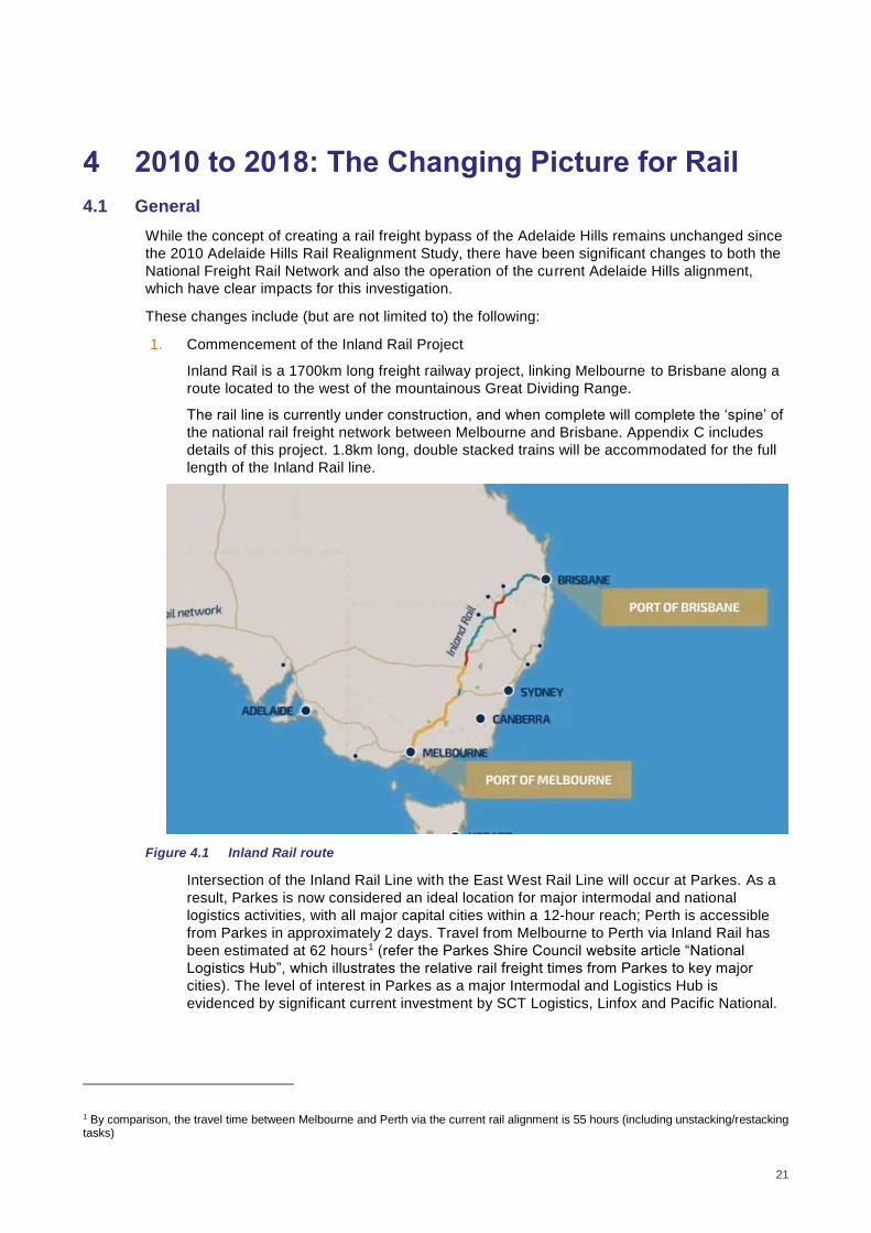
Figure 4.1 Inland Rail route
Intersection of the Inland Rail Line with the East West Rail Line will occur at Parkes. As a
result, Parkes is now considered an ideal location for major intermodal and national
logistics activities, with all major capital cities within a 12-hour reach; Perth is accessible
from Parkes in approximately 2 days. Travel from Melbourne to Perth via Inland Rail has
been estimated at 62 hours1 (refer the Parkes Shire Council website article “National
Logistics Hub”, which illustrates the relative rail freight times from Parkes to key major
cities). The level of interest in Parkes as a major Intermodal and Logistics Hub is
evidenced by significant current investment by SCT Logistics, Linfox and Pacific National.
1 By comparison, the travel time between Melbourne and Perth via the current rail alignment is 55 hours (including unstacking/restacking tasks)

22
The significance of this project to the National Rail Freight network is such that it has the
capacity to change not only the ‘footprint’ of the rail freight network itself, but in addition, its
impacts significantly affect the character and performance of the wider rail freight network.
2. Increased length of trains running between Adelaide and Melbourne
Until recently, the maximum length of trains running between Adelaide and Melbourne was
1500m. Supported by the provision of adequate passing loops, the maximum length of
train has now been increased by 300m to a total of 1800m. This has resulted in a 20%
increase in productivity for rail operators, and therefore extended the capacity of the life of
the line.
3. Grade Separation along the Adelaide – Melbourne Rail line
Two rail grade separation projects have been completed in metropolitan Adelaide, which
significantly improve safety and reduce delays for road traffic. Passenger and freight rail
lines (Noarlunga passenger line and Adelaide to Melbourne line) have been grade
separated at Torrens Junction and at Goodwood.
4. Decline in gross rail tonnages
Overall volumes on this section of track have been in decline since the 2010 study. Gross
rail tonnages on the East-West rail corridor (i.e. between Perth and Melbourne) have been
in decline since 2013-14. “Trainline 5” – a statistical report by Bureau of Infrastructure,
Transport and Regional Economics (BITRE), indicates that there has been an approximate
20% decline in these tonnages in both directions between Dry Creek and Tailem Bend. As
advised by ARTC, the overall decline in intermodal tonnages between Adelaide and
Melbourne has been due to a reduction in export shipping container traffic between
Adelaide and Melbourne. These containers are now either being exported directly from the
Port of Adelaide, or travelling between Adelaide and Melbourne by road.
5. It is worth noting that the length of the rail line between Adelaide and Melbourne is 863km.
Road transport is generally more competitive than rail on routes up to 800 – 1000km in
length (refer DPTI commentary in Appendix D), consequently the Adelaide to Melbourne
rail freight market is relatively low.
6. Increased Port competition
Flinders Ports has been actively increasing its competitiveness in recent years.
Consequently, more containerised goods are being moved directly through the Port of
Adelaide, reducing the volume of land bridged product between Adelaide and Melbourne
(thus supporting point 4, above).
7. Use of larger freight vehicles
Actions arising from the Department of Planning, Transport and Infrastructure (DPTI)
“Moving Freight” study have facilitated the use of larger freight vehicles on the road
network, making the already highly competitive road freight mode even more economically
attractive. By way of example, Sturt Highway is now classified for PBS level 3A vehicles
(i.e. Double Road Trains or B-Triples).
8. Closure of Holden’s Elizabeth plant
Closure of the Holden manufacturing facility at Elizabeth has substantially reduced the
movement of steel on rail between Adelaide and Melbourne.
9. Loss of spur lines for grain haulage
Rail spur lines linking grain storage sites between Loxton and Tailem Bend and Pinnaroo
and Tailem Bend closed in 2015. In consequence, grain is now trucked to Tailem Bend,
and this strategic grain storage facility is further expanding. This has subsequently affected
rail volumes between Tailem Bend and Port Adelaide.

23
10. Intermodal facility development
There is significant interest in the provision of an intermodal facility at Tailem Bend, in the
vicinity of the existing rail line. In addition, Stage 1 approval has recently been granted for
development of an intermodal facility at Monarto; with or without the presence of rail.
In any case the presence of an intermodal facility in the vicinity of rail provides many
potential rail opportunities.
11. Rapid residential growth
Residential growth in Mount Barker District Council is occurring at a relatively rapid rate,
placing increased pressure on the region to consider options for efficient public transport.
This includes consideration of use of the current Hills Rail Corridor for passenger
transport.
Further, this residential growth also increases the demand for supporting provisions,
including employment nodes.
12. Addressing Double Stacking Limitations
Rail freight can only traverse the Adelaide Hills line segment as single stacked trains due
to height limitations at Murray
Bridge and other vertical
restrictions elsewhere (e.g.
Tunnels). To the west of Adelaide,
trains can be double stacked to
continue westbound. Conversely,
double stacked rail from Perth (for
example) must be unstacked prior
to travel through the Adelaide
Hills.
The reloading of freight takes
place at Dry Creek, and adds in
several additional hours of transit
time. Double stacked wagons are
the norm however from Perth and Darwin. In result, almost twice as many trains are
required to cross South Australia in both directions.
ARTC have commented that works are required along the full length of the Adelaide-
Melbourne corridor to facilitate double stacking; not just at the Adelaide end. This includes
other works beyond Murray Bridge and Monarto. ARTC however will not provide details of
these works and it is suspected that these may not be significant. Any double stacking
issues beyond the extent of the Northern Rail Bypass project would also need to be
resolved.
Double stacking at the Dynon Terminal is an issue at the Melbourne end of the line (with
the key constraint being the Bunbury Bridge). Double stacking into this facility is
impractical; it has been concluded that a new facility is needed.
The development of a new terminal in Melbourne will be highly significant and will impact
upon rail operations on the rest of the network. Two options are currently under
consideration – west of Melbourne or north of Melbourne. ARTC is currently working with
the Victorian Government with a view to ensuring a solution is in place by 2025 (Note: this
will therefore also coincide with completion of the Inland Rail Project). It is understood that
the preferred option is referred to as the Western Inland Freight Terminal (WIFT).
Once this is complete, the Adelaide Hills section will remain the only significant component
of the Adelaide – Melbourne corridor that requires investment to accommodate double
stacking.

24
13. The Mildura – Menindee Option (and then linking to Melbourne/ Geelong)
The provision of a rail line between Mildura and Menindee has previously been identified,
to improve freight efficiency, provide national defence benefits and stimulate economic
development within the surrounding region. The project would involve standardising the
existing Geelong – Mildura line and building a new link between Mildura and the new
transcontinental line at Menindee, NSW.
While this option has been discussed over the years, only pre-feasibility analysis has been
undertaken regarding the proposed alignment. As such it is difficult to determine the
potential difference in travel time. Double stacking along this alignment however, would be
a given.
4.2 Other Influencing Changes
Broader changes than rail alone have also occurred since the RFMS which have influence or
require consideration for the future rail network. These include, but are not limited to the
following:
1. Consolidation of Central Australia’s Defence Base to Edinburgh
Consolidation of key elements of Defence Bases for Central Australia to Edinburgh places
key priority on the need for quality, diversified transport routes to and from Adelaide for the
movement of both goods and people. Quality access and egress routes must be available
at all times, particularly in the event an alternate transport mode becomes inaccessible or
unavailable.
2. South Australia’s Economy
The January 2018 State of the States report produced by CommSec sees South Australia
“…ease from fourth to fifth on the (economic) performance rankings in the last quarter…”,
just behind Tasmania.
Further, the final economic report for 2017 by the South Australian Centre for Economic
Studies (SACES) advises that while the State’s real Gross State Product (GSP) rose by
2.2% in the 2016/17 financial year, this is forecast to grow by only 1% in the 2017/18 year.
For the next 3 years, SACES’ predictions for economic growth are notably below those of
Treasury.
Although the 2016/17 rise in GSP was significantly above that of the average of the
preceding 5 years (around 1%), this was largely as a result of the strong winter crop.
Outside of the farming sector, growth remained stagnant at around 1% and well below
Australia’s Gross Domestic Product (GDP), which is around 2.0%. Population growth too,
particularly in the 18 – 25 year old age group, continues to be less than 20 years ago.
SACES advises that while recent economic indicators suggest a strengthened state
economy, the outlook is uncertain, with both positive and negative factors having a
bearing.
One of South Australia’s most highly regarded economists has commented that the recent
change in State Government leadership has seen confidence levels in the Government’s
ability to manage the economy lift significantly. However, there is an enormous task ahead
and this will take time. He has also indicated through discussions that the next 5 years or
so will be crucial to the economic future of South Australia. In particular, there is a very
real need to increase our profit rate and significantly stimulate investment.
Providing quality infrastructure that matches or betters that of other states for the delivery
and movement of goods and services and offers flexibility and choice is a key drawcard for
future investment.
25
3. The GlobeLink plan
As part of their 2036 Plan, the State Government has stated
“A generational upgrade of our freight export infrastructure is required to provide our
companies with the competitive advantage they need to get our premium quality South
Australian products to markets across the globe…The GlobeLink plan will provide a new
road, rail and air freight corridor, bypassing existing road and rail corridors through the
suburbs and around the Adelaide Hills. The corridor will avoid the heavily populated areas
of the existing freight routes, and will take freight directly to Port Adelaide…”
In essence, the GlobeLink plan is consistent with the concept for the Northern Rail Bypass.
4. Diversity and modal choice
Embracing ‘diversity’ is a key buzz word in today’s society, and it is widely recognised that
it provides optimal outcomes in the full range of scenarios.
Diversity in modal choice is not so different, and offers the following benefits:
Competitive pricing
Opportunity to best match product to transport mode
Consumer choice
Alternative transport in the case of emergency scenarios (e.g. rail derailment, highway
shutdowns and the like), and
Flexibility.
4.3 Key Stakeholder Input
The key stakeholder consultation process for the Northern Rail Bypass Scoping Study has been
a key element of the overall investigation, designed to understand:
The current and future rail task for the subject corridor, by volume and commodity
Potential impacts of a realigned corridor on key stakeholder operations
Potential impacts of a realigned rail freight corridor on existing and proposed terminals and
intermodal facilities, including changes to viability of location/s
The number and location of crossings and/ or potential passing loops
Potential impacts (if any) if the Mildura link into the main line is built (and any impacts
emanating from the Inland Rail Link in general).
From both a time and financial perspective, it has been impractical to survey the fu ll extent of
stakeholders involved and/or affected by realignment of the rail corridor. Instead, a number of
key stakeholders have been identified for consultation as part of this project, representing:
Regional Development Boards (RDAMR & RDA AHF&KI)
Government agencies
Peak industry bodies
Affected Councils within the MRLGA and SHLGA
Major companies, and
Transport Providers in the region
Selection of these stakeholders has occurred through discussions with the RDA AHF&KI,
SHLGA and RDA MR.
Results of the stakeholder consultation process were presented to the Steering Committee for
review and discussion. Where gaps were identified in this information, RDA AHF&KI provided

26
assistance with additional information or in encouraging stakeholders to provide more detailed
input. Inputs and opinions were mixed, depending upon stakeholder interests.
Appendix D includes a comprehensive summary of the stakeholder consultation process. More
detailed records of stakeholder inputs to the Scoping Study (as reviewed and confirmed by
stakeholders) can be made available if required.
28
Freight Task Assessment
5.1 The Current Freight Task
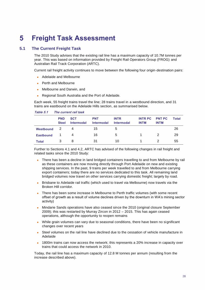
The 2010 Study advises that the existing rail line has a maximum capacity of 10.7M tonnes per
year. This was based on information provided by Freight Rail Operators Group (FROG) and
Australian Rail Track Corporation (ARTC).
Current rail freight activity continues to move between the following four origin-destination pairs:
Adelaide and Melbourne
Perth and Melbourne
Melbourne and Darwin, and
Regional South Australia and the Port of Adelaide.
Each week, 55 freight trains travel the line; 28 trains travel in a westbound direction, and 31
trains are eastbound on the Adelaide Hills section, as summarised below.
Table 5.1 The current rail task
PND
Steel
SCT
Intermodal
PNT
Intermodal
INTR
Intermodal
INTR PC
INTM
PNT PC
INTM
Total
Westbound 2 4 15 5 26
Eastbound 1 4 16 5 1 2 29
Total 3 8 31 10 1 2 55
Further to Sections 4.1 and 4.2, ARTC has advised of the following changes in rail freight and
related tasks since the 2010 Study:
There has been a decline in land bridged containers travelling to and from Melbourne by rail
as these containers are now moving directly through Port Adelaide on new and existing
shipping services. In the past, 9 trains per week travelled to and from Melbourne carrying
export containers; today there are no services dedicated to this task. All remaining land
bridged volumes now travel on other services carrying domestic freight; largely by road.
Brisbane to Adelaide rail traffic (which used to travel via Melbourne) now travels via the
Broken Hill corridor.
There has been some increase in Melbourne to Perth traffic volumes (with some recent
offset of growth as a result of volume declines driven by the downturn in WA’s mining sector
activity)
Mindarie Sands operations have also ceased since the 2010 (original closure September
2009); this was restarted by Murray Zircon in 2012 – 2015. This has again ceased
operations, although the opportunity to reopen remains
While grain volumes can vary due to seasonal conditions, there have been no significant
changes over recent years
Steel volumes on the rail line have declined due to the cessation of vehicle manufacture in
Adelaide
1800m trains can now access the network; this represents a 20% increase in capacity over
trains that could access the network in 2010.
Today, the rail line has a maximum capacity of 12.8 M tonnes per annum (resulting from the
increase described above).
29
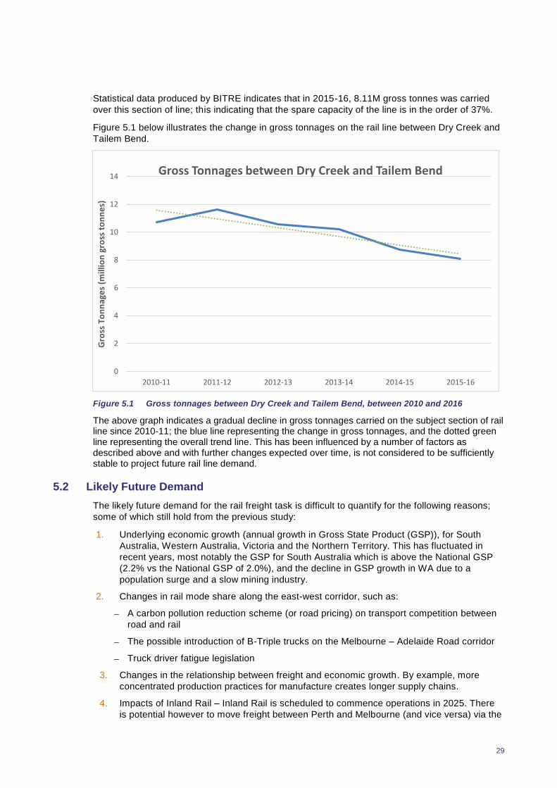
Statistical data produced by BITRE indicates that in 2015-16, 8.11M gross tonnes was carried
over this section of line; this indicating that the spare capacity of the line is in the order of 37%.
Figure 5.1 below illustrates the change in gross tonnages on the rail line between Dry Creek and
Tailem Bend.
Figure 5.1 Gross tonnages between Dry Creek and Tailem Bend, between 2010 and 2016
The above graph indicates a gradual decline in gross tonnages carried on the subject section of rail line since 2010-11; the blue line representing the change in gross tonnages, and the dotted green line representing the overall trend line. This has been influenced by a number of factors as described above and with further changes expected over time, is not considered to be sufficiently stable to project future rail line demand.
5.2 Likely Future Demand
The likely future demand for the rail freight task is difficult to quantify for the following reasons;
some of which still hold from the previous study:
1. Underlying economic growth (annual growth in Gross State Product (GSP)), for South
Australia, Western Australia, Victoria and the Northern Territory. This has fluctuated in
recent years, most notably the GSP for South Australia which is above the National GSP
(2.2% vs the National GSP of 2.0%), and the decline in GSP growth in WA due to a
population surge and a slow mining industry.
2. Changes in rail mode share along the east-west corridor, such as:
A carbon pollution reduction scheme (or road pricing) on transport competition between
road and rail
The possible introduction of B-Triple trucks on the Melbourne – Adelaide Road corridor
Truck driver fatigue legislation
3. Changes in the relationship between freight and economic growth. By example, more
concentrated production practices for manufacture creates longer supply chains.
4. Impacts of Inland Rail – Inland Rail is scheduled to commence operations in 2025. There
is potential however to move freight between Perth and Melbourne (and vice versa) via the
0
2
4
6
8
10
12
14
2010-11 2011-12 2012-13 2013-14 2014-15 2015-16
Gro
ss T
on
nag
es
(mill
ion
gro
ss t
on
ne
s)
Gross Tonnages between Dry Creek and Tailem Bend

30
east-west rail link between Perth and Parkes and then from Parkes to Melbourne. This
practice would therefore bypass Adelaide, dramatically reducing volumes on the corridor.
Similarly, review of terminal locations and freight systems may also impact route choice.
5. The ability or otherwise to double stack rail freight to achieve greater economies of scale.
Scott McKay, CEO – Bowman’s Rail has advised that in the order of 25 cents in every
dollar can be saved (and largely to the direct benefit of the customer) if rail could progress
from its current single stacked limit to achieve double stacking. Transport of dry lentils
between Adelaide and Melbourne for example, have been recently quoted at $25 per
tonne for road travel, versus $40 per tonne for rail. With a 25 percent saving for double
stacked rail, the price differential between road and rail becomes far more competitive (i.e.
$30 per tonne for rail).
6. WA’s mining sector activity – the mining sector places major demands on the rail network,
but this fluctuates significantly depending on consumer demand and the quality and
availability of ore and minerals. In recent years, there has been a downturn in WA’s mining
and resources sector, which has had a marked effect on rail volumes. When this recovers,
and indeed such activity also in South Australia (Mindarie Sands, for example), the
demand for rail for movement of bulk goods will substantially increase.
7. Future changes to road pricing regimes may change the competitive positions of rail and
road (in favour of rail). Rail produces 75% less carbon emissions when compared to road
transport (refer Energy Exchange website – managed by the Australian Government
Department of Environment and Energy). Should road pricing be adjusted to accurately
reflect its carbon footprint, the cost of rail would become significantly cheaper relative to
that for road transport.
8. Moving towards advanced manufacturing – in recent years there has been a significant
economic downturn in South Australia due to closure of major manufacturing facilities in
both the Upper Spencer Gulf and Holden’s Elizabeth plant. Renewed interest in investing
in South Australia however is already occurring, including in both the steel industry and
defence. Further industries predicted for the state include pharmaceuticals, aircraft
manufacturing, professional and scientific equipment manufacturing and computer and
electronic manufacturing. The transport demand and mix for such bulk products remains to
be seen, but positioning ourselves to best attract global investment will be key.
9. Population growth and increased traffic congestion in both the Adela ide Hills and Metro
Docklands sections of the rail network.
5.3 Summary
As discussed in section 5.1, the rail freight task has been in decline for a number of years, for
many reasons. Significant changes have occurred for the rail line from both an economic and
also a capacity perspective, and further change is expected. Economic outlooks for South
Australia indicate that there are many positive opportunities waiting to be embraced across a
number of market sectors. For Western Australia, there is consensus that the recent downturn in
GSP will recover in the next few years as the mining sector reinvigorates and rebalances the
effects of significant population growth.
The size of the future rail task is unclear and is dependent on many factors, not the least of
which is South Australia’s economic investment and growth. The economic performance of the
state over the next 5 years is considered critical for its future.
What is clear, is that:
Without either significant upgrade or realignment, the current rail link cannot compete with the
capacity or efficiency of the national freight network, particularly upon completion of Inland Rail.
In result, the Adelaide Hills section will likely become the nation ’s weakest rail freight link.
Further investigation is required to fully determine the effect this has on the long term economic
competitiveness of South Australia.
31
Refinement of Proposed Route No electronic version of the alignment was provided as an output of the 2010 Study. In order to
refine the proposed route, the GHD proposed alignment (Option 3) from the previous report was
scanned and inserted into Google Earth.
This alignment was then reviewed and modified to suit existing conditions, loosely based on the
following:
The proposed route follows the existing rail corridor from Monarto, along the eastern side of
the ranges
From the hills to the south of Truro, minor modifications have been made to the proposed
route, to follow boundaries where practical
The proposed route follows the rail corridor to Roseworthy / Freeling, and then follows the
road reserve and/or property boundaries, to link with the existing rail corridor at Mallala.
Further refinement of the alignment for the Northern Rail Bypass has been undertaken to
meet specific requirements from ARTC, for example minimum curve radii. The vertical
alignment as identified in the 2010 Study falls within ±1%, hence requiring no further
change.
The review however has enabled the location and indicative length of bridges and tunnels to
be confirmed, together with the location of road/ rail crossing points.
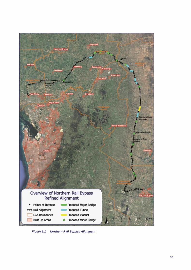
Figures 6.1 overleaf illustrates the refined alignment for the Northern Rail Bypass; indicating
the location of key road and waterway crossings, the need and extent of tunnels and
bridges, as well as identifying key landmarks, townships and roads. It should be noted that
this alignment is still considered preliminary and will be subject to further development
through conceptual and detailed design.
32
Figure 6.1 Northern Rail Bypass Alignment


34
Revised Costing
7.1 General
The Northern Rail Bypass has been costed in 2018 dollars and is summarised in Table 1 below.
Costing has been based on Figure 6.1, and as such is preliminary only, subject to further
development through conceptual and detailed design. Cost estimates have been based on a
combination of:
Previous major rail and road project experiences
Publicly available information from ARTC pertaining to the Inland Rail Project, and
2018 Rawlinsons Australian Construction Handbook.
7.2 Northern Rail Bypass - Cost Breakdown
The following table provides a breakdown of all costed components of the Northern Rail Bypass:
Table 7.1 Northern Rail Bypass – Breakdown of Components
Component Quantity
Rail Track
Line Track Length (km) 2
Passing Loops
Number 3
Length (km) 3
Total Length (km) 9
Total Track Length (km)
Earthworks (track km)
Cut (km) 3
0-5m
5-10m
10-15m
15-20m
20-25m
25-30m
30-35m
35-40m
Total Length (km)
Fill (km)
0-5m
5-10m
10-15m
15-20m
20-25m
25-30m
30-35m
35-40m
154.52
3
3
9
163.52
17.19
18.87
15.46
12.20
5.60
0.45
1.45
0.50
71.72
29.03
16.99
9.85
6.74
1.26
0
0
0
63.87
35
Total Length (km)
Tunnels 0
Number
Total Length (km)
Level Crossings
Number
Road Bridges
Number
Rail Bridges/Viaducts
Number
Total Length
Total Area (m2) 7
7
8.15
7
6
10
10.30
48386.5
The following table of costs was therefore developed, based upon the sources listed in section
7.1.
Table 7.2 Northern Rail Bypass Costing Summary
Component Cost ($m)
Rail Track
Track 163.52
Turnouts 3.00
Base Layer 47.44
Total Rail Track Costs 213.96
Earthworks 1309.45 - 1489.27
Tunnels, Level Crossings, Bridges, Viaducts, Murray Bridge
Works
Tunnels 978.00 - 1630.00
Level Crossings 0.84
Road Bridges 60.00
Rail Bridges/Viaduct 241.93
Murray Bridge Works 200.00-300.00
Total 1480.77-2232.77
Land Acquisition 76.27
Services/Signalling
Service Clashes 73.20
Services for Level Crossings 3.50
Common Service Trench 15.45
Signalling at Turn Points 28.00
Total Services/Signalling 120.15
Sub Total 3200.61-4132.43
20% Contingency 640.12 - 826.49
Total 3840.73 - 4958.91

36
7.3 Assumptions
The following assumptions were made for the cost estimate:
50% of excavated material is assumed to be suitable to be used elsewhere as fill
The cross sections for cut/fill were taken from ‘Adelaide Rail Freight Movements Study’
(2010) by GHD and are based on the depth
Rock blasting is assumed to be required for a percentage of the specified cut. This
percentage is depended on region and depth of cut.
A larger presence of rock is expected from chainage 34000-83000. As such, a high
percentage of rock blasting is expected to be required in this region, however the cut cross
section is assumed to be steeper due to the side support from the rocky material.
Free and unobstructed access will be available to the site at all times
Sufficient area will be available for storage of materials and equipment.
Given the constraints at Murray Bridge, it is assumed that alterations to the existing bridge
and tunnel will be possible. If it is not, a new alignment will need to constructed including a
new river crossing.
Sections 7.4 to 7.6 further describe the approach and more detailed assumptions/
considerations for each component of the costing.
7.4 Earthworks
Alignments and cut/fill depth estimates were taken from ‘Adelaide Rail Freight Movements Study’
(2010) by GHD. These drawings estimated the cut/fill requirements along the track based on
10m contour lines, which provided a basis for an estimated earthworks costing.
For ease of calculation, the cut/fill was categorised into 5m intervals, from 0m to 40m in depth.
The excavation profile differed every 5m due to the battering requirement, thus these intervals
were developed. This allowed for a cost per linear metre to be developed for each interval, which
combined with the chainage, resulted in the cut/fill cost estimation.
7.4.1 General
The cost estimations are based on first principles and includes the cost of plant, labour and
material supply. The estimated costs of fill include compaction of the fill material.
7.4.2 Rock Blasting
Allowance was made for rock blasting as part of the excavation process, with the rock content
based on the depth and location of the excavation. The central mountainous section of the track
(approximately from chainage 34,000 to 83,000) was assumed to have a higher rock content due
to the terrain, thus a greater percentage of excavation was assumed to require blasting.
Excavation costs include the additional costs associated with excavating blasted rock compared
to soil.
Due to uncertainties in the rock content and composition, lower and upper bound costs were
calculated to give a potential range in the excavation costs.
7.4.3 Profile
Excavation and fill profiles were taken from ‘Adelaide Rail Freight Movements Study’ (2010) by
GHD. The cut profiles make allowance for a service track at ground level for excavation up to
7m, and on the first batter for excavation over 7m in depth. All fill profiles have an allowance for a
service track at the height of the rail track.

37
The cut profile was altered for the central mountainous region, where higher rock content is
expected. The rock contained in this area is assumed to provide additional side support, allowing
for steeper batters to be used.
7.4.4 Cut to Fill
It is assumed that some of the excavated material will be suitable to be used as fill in other
sections of the track. This was estimated at 50% of cut to fill, accounting for the quality of the
excavated material (potentially unsuitable material where rock blasting has occurred) and the
location of respective cut and fill areas (long travel distances become unfeasible).
The estimated cost of fill where there is a potential for cut to fill, was reduced due to the
reduction in new fill material required. This reduction still includes the costs associated with
cleaning and preparing the excavated material, to make it suitable to be used as fill.
7.5 Track and Formation
The cost estimates related to track and formation were based on previous rail projects and
information from ARTC.
7.5.1 Rail Track
Estimated costs for the rail track include the rail, sleepers and labour for installation. Based on
information from ARTC, an estimated cost of $1m per linear km of track was used.
7.5.2 Ballast
Costs associated with the base layer and ballast for allowed for in addition to the rail track costs.
A rate of $40/m2 was estimated for both the base layer and the ballast, taking into account the
potential to use larger blasted rock from the excavation process as ballast.
7.5.3 Passing Loops
Allowance was made for 3 passing loops each 3km in length. These were costed by using the
same rate for rail track as mentioned above, with an allowance for additional width of ballast and
base layer. It was assumed that these passing loops would be situated in locations of minimal
cut/fill requirements, and so additional excavation costs have not been allowed for.
7.5.4 Turnouts
Turnouts are required for each of the passing loops, at an assumed cost of $1m per loop.
7.5.5 Level Crossings
All level crossings required were costed as
passive crossings with services required to
upgrade to active crossings calculated below. The
total cost for a single passive crossing is
estimated to be $120,000.
7.5.6 Tunnels
7 tunnels are allowed for along the length of the
track, with the majority of them located in the
central mountainous region. Uncertainties in the
ground composition and accessibility to each
tunnel site, has resulted in a lower and upper cost being adopted. This is due to factors such as
the rock content and soil stability conditions requiring different methods of tunnelling with have
different associated costs. A range of $120-200m per km was estimated for tunnelling. This
38
estimate includes an allowance for the set up costs, which are high resulting from the design
involving a number of small tunnels in succession.
7.5.7 Bridges
Road Bridges
Alterations to existing roads to form road bridges are assumed to cost $10m per bridge, including
all associated costs.
Rail Bridges/Viaducts
The profile for the rail bridges and viaducts were taken from ‘Adelaide Rail Freight Movements
Study’ (2010) by GHD. Assuming these profiles, a cost of $5,000 per m2 of surface area, was
estimated. Given a width of 4.7m, the costs of rail bridges and viaducts is estimated to be
$23,500 per linear metre.
7.6 Miscellaneous
7.6.1 Land Acquisition
An allowance has been made for acquiring land for the rail corridor. Two prices were used for
land acquisition, with the land required for the section of rail up to Truro (approximately chainage
83,000), having a price of half that of the later section of the track. This was supported by br ief
research into the cost of land for sale in each of these areas.
Land acquisition was only based on a corridor, and allowance has not been made for properties
where the rail line will cause major inconvenience. These situations would require addition land
acquisition or payment for damages.
A single price has been allowed for each of the sections mentioned above, and so no allowance
has been made for the price differential between remote areas and areas on the fringe of towns.
Land acquisition would require a property by property analysis and negotiation.
7.6.2 Services and Signalling
An allowance has been made for services/signalling for level crossings, the installation of a
common service trench, signalisation at turn points and the relocation of services due to service
clashes.
It is estimated that the installation of services and signalling at level crossings will cost $500,000
per crossing. This includes the installation of boom gates.
As services will be required along the length of the track, it is assumed that a common service
trench will be required. This trench is assumed to cost $100/m and will continue the entire length
of the track. No allowance has been made for the services in the trench, just the creation of the
trench. Details of the actual services required would be necessary for further costing.
Each turn point (at each end of the track and each passing loop) will require signalisation. This is
estimated to incur a cost of $3.5m per turn point.
It is assumed that the installation of new structures and services will cause clashes with existing
services in the area. The cost of relocating existing services is estimated to be 2% of the total
project cost. The location and depth of existing services will be required to refine the costing.
7.7 Upgrade of Existing Alignment
A key element of upgrade of the existing alignment will lie in addressing double stacking issues,
along the route, particularly through Murray Bridge. Other upgrade requirements are listed in the
RFMS report and some of these have already been implemented.

39
To enable double stacking through this section, alterations will need to be made to both the rail
bridge crossing the river and the tunnel/road bridge where the rail line passes under Bridge
Road. The extent of the works required are uncertain, and further investigation of the load
capacity of the bridge, and the clearance of both the bridge and the tunnel/road bridge will be
required. Given that the bridge is relatively old, the load capacity will need to be investigated to
determine if it has the capacity to support double stacking, or if additional strengthening will be
required. Although the bridge is not heritage listed, it was built in 1925 and is considered an
iconic structure in Murray Bridge.
Due to the constraints imposed by the properties surrounding the Bridge Street tunnel/road
bridge, it will not be possible to significantly raise this road to gain clearance for double stacking.
Therefore, if it is not feasible to lower the rail track by the required amount, a new rail alignment
may need to be considered. This would involve a new river crossing at an alternate location
which will incur additional costs.
At this stage an allowance of $200-300M has been made for alterations to both the bridge and
the tunnel/road bridge, assuming that alterations are possible.
A key benefit achieved by upgrade of the existing alignment lies in grade separation at key road
crossings. The value of time savings for freight is discussed in Section 8.3.
Should time savings for passenger rail be calculated (e.g. as a result of grade separation of the
existing alignment), this would provide a further saving of more than $860M over 20 years, this is
based on an assumed crossing closure time of 45 seconds, for 80 movements each day (both
directions).

40
CBA Review
8.1 Introduction
The original cost benefit analysis of options to reconfigure the interstate rail freight corridor
through Adelaide excluded many potential benefits. This project will examine many of those
benefits and provide a rapid, high level and approximate estimate of their value.
Several options for reconfiguration of the interstate rail freight corridor traversing metropolitan
Adelaide were considered in 2010 by the Commonwealth and State Government. The options
ranged from upgrading existing rail links which run through established residential and m ixed-use
areas, including inner city suburbs, to schemes which would see ‘break of bulk’ points
established to the north and south on metropolitan Adelaide’s periphery, accompanied by a
circumferential rail link which would avoid the need to take freight through central areas. Other
options included bypassing the Adelaide metropolitan area altogether by taking interstate rail
freight through an inland corridor linking Mildura in Victoria to Menindee in NSW.
Some of the options were subjected to cost benefit analysis as part of the Adelaide Rail Freight
Movements Study (RFMS) completed by GHD. The GHD analysis maintained what can be
considered a ‘traditional’ scope; that is, on the benefit side of the equation, it focussed on time
savings and other freight cost efficiencies which might be on offer. Offsetting these benefits were
the increased capital and operating costs associated with the option in question, compared to a
‘base case’ or ‘business as usual’ scenario. This was largely an ‘intra-sectoral’ approach, with
impacts on the freight sector as the prime consideration.
The GHD study was only a preliminary cost benefit analysis because a number of key potential
benefits were not within scope. Externalities such as greater urban consolidation, productivity
improvements, savings in the life and capacity of South East (SE) Freeway, amenity
improvements to residential areas and other non-quantifiable benefits were all excluded from the
study.
At the time of the 2010 FMS, SGS Economics and Planning (SGS) was commissioned to prepare
a paper setting out the theory and available international and national evidence to support the
repositioning of the rail freight options as potential 'city shaping' projects, with collateral impacts
ranging beyond the traditional scope of the preliminary GHD Study.
The rail freight options are again under consideration in 2018 by the South Australian and
Australian State and Federal Governments. In particular, the northern rail bypass option that
bypasses the Adelaide Hills line between Murray Bridge and Two Wells is being examined.
SGS’s brief in this project was to prepare a rapid, high level and approximate analysis of the
externality benefits of the freight diversion options that were not included in the original analysis.
The following sections of this paper describe the benefits and methods of the analysis, provide
estimates of the benefits and make conclusions about the overall value of ‘additional’ benefits.
8.2 Benefits and Methods
8.2.1 General
This section details the benefits in scope, describes the methods and assumptions behind the
estimation for each benefit, and identifies other non-quantifiable benefits.
8.2.2 Greater urban consolidation
There are still a considerable number of freight-dependent manufacturing and warehousing
businesses utilising large areas of land in the inner suburbs. Freight hubs outside the
metropolitan area could enable re-location, and free up this valuable land for housing.

41
Growth through urban consolidation requires lower infrastructure spending than growth
through greenfield development. The typical savings in Australia are in the order of $30,000
to $80,000 per dwelling. Here we will use a conservative estimate of $40,000 per dwelling.
We assume a fixed population, where one new dwelling in the infill corridor removes the
need for one new dwelling in greenfield development.
The current residential density is calculated for a 250m buffer zone either size of the rail
line. This is obtained using the ABS Census of Population and Housing 2016.
The rail line is mapped in red in Figure 8.1 overleaf, however, urban consolidation was only
considered for the portion of the line that is inside the Adelaide Urban Centre and Locality
(UCL).1
We assume that the number of dwellings will rise by a factor of 25 per cent through urban
consolidation and cross-check the new density against existing residential densities in other
inner-city areas of Adelaide and other Australian capital cities.
The number of new dwellings is multiplied by the $40,000 infrastructure saving to estimate
the total infrastructure costs that would be saved through urban consolidation.
8.2.3 Productivity improvements
Building up employment density in Adelaide would boost productivity through agglomeration
economies (an overview of agglomeration economies is at Appendix 1).
The benchmark approach for calculating the marginal productivity benefit is effective job
density (EJD). EJD is a measure of the relative concentration of employment, derived from
the density and accessibility of all jobs across a region.
In line with previous CBA studies conducted by SGS, we assume that 1 extra job will move
to the new area for each added dwelling. These are not net additional jobs but jobs that
move from outer suburban areas.
We use elasticities from SGS modelling to calculate the productivity uplift that would be
generated by an increase in EJD in the area. This is estimated by regressing the
relationship between EJD and labour productivity, and applying that relationship to the
estimated rise in EJD that will come through urban infill.
Annual productivity gains to South Australia’s gross state product are then capitalised with a
discount rate of 7 per cent.

42
Source: SGS, 2018
Figure 8.1 Map of buffer Zone
8.2.4 Savings in the life and capacity of the South East Freeway
The SE Freeway carries large numbers of heavy vehicles (up to 4300 vpd). Due to their
need to "crawl" down, and "climb" up the Freeway, they consume an outside share of
freeway capacity. The freeing up of a significant part of this capacity will reduce travel time,
and potentially delay the need to widen or duplicate the freeway. This will be achieved via a
shift of container freight from road to rail.
We assume that the current overuse of the freeway will reduce its lifespan from a standard
100 years for major road infrastructure to 75 years.
We estimate the replacement value of the highway, based on its length of 76 km and the
price of recent projects in South Australia. Drawing on these examples, we estimate the
highway to be worth $36.3 million per km. We consider this to be a modest estimate
because the input projects are considerably smaller in scale when compared to the SE
Freeway.
The freeway was fully opened in 1979 and has been running for 39 years. The highway is
expected to last until 2054 with its current overuse.
We assume that diverting the freight rail line will mean that the highway will last the full 100
years to 2079, an additional 25 years.
43
We then calculate the saving as the net present value of 25 per cent of the capital cost of
the highway, a saving that would be incurred in 2054 (in 36 years’ time).
8.2.5 Amenity improvements to residential areas
There will be higher amenity for residential areas around the rail line from two sources.
First, reduced noise and lower levels of industrial activity with freight. Second, improved
access to public transport options with the switch to passenger activity on the existing line.
We measure improved amenity through a predicted uplift in residual land value (RLV). We
assume a current residual land value of $150,000 per dwelling, this is in line with current
RLV estimates for similar areas of Adelaide.
In line with findings from other SGS cost benefit analysis studies, we assume a 10 per cent
uplift in RLV. This is calculated for all dwellings along the 250m buffer zone around the rail
line, including the dwellings outside of the Adelaide UCL.
The calculation is also made on the estimated additional dwellings that are introduced
through urban consolidation.
8.2.6 Other non-quantifiable benefits
The following benefits are significant to the project but are not quantifiable given the resource
and time constraints of this project:
Generating improved equity of access to job and service opportunities: creating more jobs in
regional areas and in accessible inner urban locations would boost equity of opportunity
across the state.
Creation of metro public transport options: Taking freight trains out of the Adelaide Hills
creates a possible corridor for public transport investment and integrated housing
development, generating further environmental and social benefits. Services could possibly
be extended to the rapidly expanding Mount Barker District Council, with many associated
benefits such as reduction of pollution and congestion as result of fewer cars travelling to
the city.
Minimising major delays for commuters and emergency services at crucial railway
crossings.
Wider strategic impact of improvements to the national rail freight network.
If the findings of this analysis are to be incorporated into a full cost benefit analysis, many of the
benefits above could be quantified with more time than was available here.
8.3 Benefit Estimates
8.3.1 General
This section details the estimates of the various benefits of the northern diversion of the Adelaide
rail freight link. The analysis reveals that the total benefit could amount to nearly $700 million.
8.3.2 Greater urban consolidation
The net benefit of urban consolidation is detailed in Table 1 below. There are currently 7,140 dwellings around the rail corridor in the Adelaide UCL. We estimate that 1,785 new dwellings will be added to the areas around the rail corridor, which equates to an infrastructure saving of $71.4 million.
44
Table 8.1 Urban Consolidation Benefit
Item Value
(A) Count of dwellings in urban infill area 7,140
(B) Urban consolidation impact 1.25
(C) New dwelling count (C = A x B) 8,925
(D) Added dwellings (D = C – A) 1,785
(E) Infrastructure savings per dwelling ($) $40,000
(F) Total savings ($m) (F = D x E) $71.4
8.3.3 Productivity improvements
The productivity benefits of agglomeration economies from urban consolidation are shown below in Table 8.2. The rise in annual gross state product was estimated.
Table 8.2 Productivity Gains
Item Value
Rise in annual Gross State Product ($m per annum) 9.5
Capitalised value of Gross State Product ($m) 135.7
8.3.4 Savings in the life and capacity of the South East Freeway
Using the costs of three recent or current highway project in South Australia, we estimate the average cost of highway replacement to be $36.3 million per km (see Table 3). The resulting estimate of the benefit of the savings in the life of the SE Freeway are shown in Table 4. Given the additional lifespan of 25 per cent, a length of 76km, the benefit estimate is $689.8 million.
Table 8.3 Existing Highway Projects in South Australia
Previous Projects Cost ($m) Length (km) Cost per km
($m)
Southern Expressway
Duplication
407.5 18.5 22.0
Main South Road Duplication
(Stage 1)
305 10.0 30.5
Northern Connector Project 885 15.5 57.1
Average 1597.5 44.0 36.3
Source: South Australian Department of Planning, Transport and Infrastructure
Table 8.4 Savings in the life and capacity of the South East Freeway
Item Value
(A) Additional lifespan 25%
(B) Length (km) 76
(C) Value per km ($m) $36.3
(D) Benefit = extra lifespan x length x value
($m) (D = A x B x C)
$689.8
(E) Discount rate 7%
(F) Net present value of benefit ($m) $60.4
8.3.5 Amenity improvements to residential areas
The net benefit of amenity improvements to residential areas is estimated via increased RLV, as shown in Table 5 below. The base case includes 9,099 dwellings with an aggregate value of

45
$1,364.8 million. The new land value includes a 10 per cent rise in RLV per dwelling, which brings the RLV up to $165,000, and 1,785 new dwellings in central Adelaide, which brings the total up to 10,884 dwellings. The resulting net benefit in RLV (amenity) is $431.0 million.
Table 8.5 Benefit from Amenity improvements to residential areas
Location Dwellings RLV per
dwelling ($)
Aggregate RLV
($m)
Base case land value
Adelaide UCL 7,140 $150,000 $1,071.0
Adelaide Fringe 1,959 $150,000 $293.8
(A) Total 9,099 $1,364.8
New land value (10% uplift)
Adelaide UCL 8,925 $165,000 $1,472.6
Adelaide Fringe 1,959 $165,000 $323.2
(B) Total 10,884 $1,795.8
(C) Net benefit (C = B - A) $431.0
8.3.6 Time Savings at Level Crossings
Time savings to road users at 8 level crossings between Islington and the Adelaide Hills is
estimated based upon an assumed value of personal time of $15/hour, and an average daily
traffic volume on roads at level crossings of 20 000 vehicles per day.
For an 1800m long train travelling at 60km/h, the average delay time to vehicles at level
crossings is calculated as 2 minutes. Based upon an average of 10 freight trains per day and
1200 vehicles delayed per train, the total delay to road users is 24,000 minutes, or 400 hours per
day. Across 300 days each year for a period of 36 years, this totals $518M.
It should be noted that this is in today’s dollars only, and therefore does not allow for growth on
the road network or any discounting.
8.3.7 Benefits of Double Stacking
It is understood that double stacking freight can achieve a saving in the order of 25% of the cost
of single stacked rail freight. For commercial in confidence reasons, it is difficult to obtain the
annual volume of rail freight travelling in and out of Adelaide, and that Melbourne and Adelaide
and vice versa. Assuming the 2015/16 volumes of rail freight (8.11M tonnes) and a
conservatively assumed transport value of $20 per tonne, this indicates a saving of $40.5M per
year, or $1.46B (undiscounted) over 36 years.

46
8.4 Summary of benefits
Table 8.6 gives a summary of the additional benefits calculated in this project. The total benefit is
$2.68 billion, which indicates that the original cost benefit analysis of the rail freight diversion
excluded some significant benefits and may have undervalued the proposal.
Table 8.6 Summary of Benefits
Benefit Value ($m)
Urban consolidation $71.4
Productivity improvements $135.7
South East freeway savings $60.4
Amenity improvements $431.0
Time savings at level crossings $518
Double stacking benefit $1460
Total $2676.5
8.5 Summary
At a high level, this analysis has found the benefits of the northern rail bypass have been found
to be substantial. Further analysis could examine these benefits in more detail as part of a full,
updated cost benefit analysis.
The RFMS conducted by GHD in 2010 had a focus that excluded many potential benefits. This
Scoping Study gives targeted focus to and considers a number of wider social and economic
benefits that had not been previously explored.
This extended assessment provides a rapid, high level and approximate analysis of the
externality benefits, including greater urban consolidation, productivity improvements, savings in
the life and capacity of South East (SE) Freeway and amenity improvements to residential areas.
While only providing an estimation of the broad value of these benefits, they were found to be
quite large despite using conservative assumptions wherever possible. In total, we estimate that
the net benefit of these factors could amount to in the order of $2.68 billion.
The findings indicate that further, more detailed analysis could be conducted as part of a full
updated cost benefit analysis of the northern rail bypass. This analysis could also address some
of the non-quantifiable benefits identified in this report, including improved equity of access to job
and service opportunities, creation of metro public transport options, minimising major delays for
commuters and emergency services, and the wider strategic impact of improvements to the
national rail freight network.
47
The effect of No Rail Freight Bypass From a single-minded perspective,
less freight travels on the Hills Rail Alignment than 8 years ago
road transport is significantly cheaper than rail (particularly between Adelaide and
Melbourne)
movement of containerised freight by rail is increasingly handled through the Port of
Adelaide
upon completion, Inland Rail could cater for Perth-Adelaide-Melbourne bound double
stacked freight (although arguably not so cost competitively or as quickly), and
a ‘Do Nothing’ or ‘Do Minimum’ approach would be significantly less cost.
The Adelaide Hills Rail Alignment would however become arguably, the ‘weakest link’ in the
national rail network, as:
the only sector unable to carry double stacked freight, and
the sector that still require trains to have an additional engine to make the section’s steep
journey safely.
This section of the rail network (and indeed the overall Adelaide to Melbourne rail link) could
potentially be avoided by using Inland Rail, but at what expense?
The very real risk of not creating the Northern Rail Bypass is that Adelaide and wider South
Australia becomes forgotten or at best is seen as an ‘add on’ to the national rail freight network;
superseded by Inland Rail, intermodal facilities at Parkes, and the east-west rail corridor.
Further, modal choice becomes even less competitive with a road dominated transport network
for freight across the state. Most concerning, it sends a message to current and future investors
both locally and globally that we are seemingly ‘less connected’ than other states and less
committed to best positioning ourselves for positive long-term economic growth.
Section 4.2(2) refers to the uncertainty of the current South Australian economy, and the crucial
time ahead to attract and secure profitable, private investment to grow the economy. The
Northern Rail bypass represents an opportunity to provide greater modal choice through more
competitive access to both the national road and rail network for business and industries now
and in the future.
At this level of investigation, the value of ‘lost opportunity’ is yet to be quantified, but weighs
heavily on the overall economic value of our future rail links.

48
Further Investigations – Where to from here? This Scoping Study has updated and extended the RFMS to reflect today’s costs , circumstances
and consider a much broader set of social and economic circumstances. Further, the study has
also highlighted the state’s critical economic position, and the very real risks of not ensuring our
key infrastructure fosters and supports strong investment and growth. More detailed
investigations are now required to properly quantify a revised Cost Benefit Analysis for the
project, and to complete a robust Business Case in accordance with the requirements of
Infrastructure Australia.
1. More detailed costing for the project, on a more refined alignment based upon engineering
survey
2. More detailed economic assessment of the ‘Do Minimum’, ‘Achieve Double Stacking’ (as
outlined in the 2010 RFMS and which arguably, should be the Base Case) and ‘Northern
Rail Bypass’ options for the rail freight route, including:
Refined assumptions, based upon more project specific data
Recognition that the ‘Do Nothing’ option in the RFMS is not an accurate Base Case. The
aged structures, condition and load bearing capacity of the line will require review and
intervention to maintain operational standards over time. Consideration should also be
given to whether the current rail line should be upgraded to cater for the freight task
alone (i.e. double stacking), or conversely, to investigate the value of dual rail use of a
new corridor?
Identification of an appropriate ‘value’ of traditionally non-quantifiable benefits, including
improved access to job and service opportunities, creation of metro transport options,
minimising major delays to commuters and emergency services, and the ‘lost
opportunities’ when compared to the national rail freight network.
3. Further liaison with key stakeholders as required, to assist in refining the alignment. In
particular, consultation will need to be conducted with Councils to the north-east of
Adelaide, in the vicinity of the proposed alignment.
4. Further engagement with the State Government to explore the characteristics and
objectives of the Northern Rail Bypass and its role as part of GlobeLink, and
5. Preparation of a submission to Infrastructure Australia for this project, in accordance with
the relevant requirements and checklists.
The State is considered to be in a key period regarding security of its future economic
position and role in the national rail freight network. Actions must occur quickly, to
quantify the real Cost Benefit Analysis of the overall Northern Rail Bypass.

Appendix A Scoping Study Methodology Flow Chart


Appendix B Relevant Literature and Reports

Who Moves What Where - Freight and Passenger Transport in Australia
National Transport Commission, August 2016
To be completed as part of the Final Report
South Australian Rail Freight – A Bypass to Save the Heart of Adelaide
Mitcham Community Rail Freight Task 2007
In 2006 the City of Mitcham initiated a Rail Freight Task Force (RFTF). This group, comprised of
elected Council members and community representatives, sought to address concerns
expressed from residents affected by freight train movement on the Adelaide Hills Line.
The report identified that there are various issues associated with its existing alignment through
tunnels, tight curves and steep gradients, including those associated with noise, health, safety
and delays in traffic.
This report identified a number of key issues which assist in contextualising the importance of the
project:
6. Rail freight is more efficient than road transport. Freight trains can carry the equivalent of 35
road trains through the Adelaide Hills
7. Almost all freight traffic bound for the east or west currently travels through the Adelaide Hills
Railway System Corridor
8. The ports of Darwin and Perth (Fremantle) and their proximity to South East Asian markets
compared with east coast cities, makes them increasingly important destinations for imports
and for the export of Australian made goods and bulk commodities transported by rail. The
Adelaide Hills Corridor is an important link for this market.
9. The imposition of the urban growth boundary means that the Adelaide Hills part of the railway
corridor will become more densely populated throughout the hills zone and beyond.
The report aimed to develop appropriate solutions to the issues raised, including the proposal of a freight train bypass north of Adelaide and the suggestion to convert the existing railway into a passenger line. It highlighted the various potential benefits associated with this, including:
Higher track speeds and fewer delays, therefore improved freight transit times
Operator cost savings
Reduced fuel costs
Reduced greenhouse gas emissions
Ability to double stack containers
Longer train lengths
Improved efficiency of the National freight network
The report also suggested potential benefits could be associated with supporting South
Australia’s mining industry.
The report concluded that:
“…The Rail Freight Task Force recommends a new freight train bypass to the north of Adelaide.
The new corridor, running from Murray Bridge in the east to Mallala in the west, would be much
straighter and would travel through relatively unpopulated and much flatter country than the
present route…the bypass offers long-lasting benefits to both residents of the wider community
as well as to those in the rail freight industry. It increases the efficiency and carrying capacity of

the rail freight industry in order to accommodate the inevitable increase in freight volumes in the
coming years.
…At the same time it allows the Adelaide Hills Line to fulfil its full potential in becoming a
dedicated public transport corridor which, could more effectively serve metropolitan Adelaide as
well as the rapidly expanding communities of the Adelaide Hills such as Mt Barker and
beyond…”
Adelaide Rail Freight Movements Study Final Report
Prepared by GHD 2010
A report conducted by GHD was commissioned to investigate existing and future rail movements
to and from Adelaide, where the capacity of the current rail line to meet these demands was
assessed.
Following an assessment of freight demand forecasts the report found that, when accounting for
expected upgrades planned between 2009 and 2011, capacity was not expected to become
restricting until 2025 and 2030.
The Study also found that the rail alignment through the Adelaide Hills between Murray Bridge
and Salisbury freight movement efficiency is constrained due to steep grades and tight curves
resulting in
reduced speeds and decreased efficiency (trains were found to be using 50% more
locomotive power per tonne than other rail corridors),
restriction of trains to a maximum of 3500 tonnes,
increased ‘wear and tear’ and increased maintenance
Due to the proximity of the rail alignment with urban areas, a number of social and
environmental amenity issues were also raised, including
train noise
impact of freight on traffic delays at level crossings
risk to public safety (incl. pollution)
Five options for the realignment of the rail corridor through this section were explored in this
report:
Base Case: Existing alignment between Murray Bridge and Islington remains unchanged.
Includes existing expected improvements (new or extended passing loops)
Option 1: Upgrade the existing alignment (orange in Figure 10.1). Includes grade separation
level crossings, additional passing loops, improvements to enable double stacking.
Option 2: Northern Bypass via Truro (red in Figure 10.1). Flatter alignment by re-directing
to Truro.
Option 3: Northern Bypass via south of Truro (blue in Figure 10.1). Flatter alignment by re-
directing to Truro.
Option 4: Southern Alignment (purple in Figure 10.1). Bypass to the south, including 22km
of tunnelling.
Option 5: Upgrade existing and Northern Bypass via south of Truro. Combination of Option
1 and Option 3.

The options were assessed for appraisal against a number of objectives and comment sough
from the public. A benefit cost analysis was then performed to give an indication of the economic
viability of the various options. This CBA found that
Capital costs are high and outweigh benefits
Operational benefits (such as reduced land transport costs and reduced transit times) are
modest
Social benefits are minimal
The two seemingly ‘top’ options were the upgraded existing alignment (Option 1) and the
northern bypass south of Truro (Option 3 (now known as Northlink). Despite this, based on the
CBA conducted, the Study found that none of the options investigated were economically
feasible.
Unfortunately, the full extent of detailed investigations undertaken to complete this report have
not been available for reference for this Scoping Study.
Adelaide Interstate Rail Freight – Brief for Strategic Assessment of Corridor Options, SGS Economics 2010
The report produced by SGS Economics and Planning, commissioned by a voluntary group of
Councils, reviewed the Adelaide Rail Freight Movement Study (RFMS) conducted by GHD and
assessed the validity of the outcomes produced in the study.
In including a ‘traditional’ scope and undertaking a CBA, the RFMS Study conducted by GHD
focussed on freight movement efficiencies and found that none of the options investigated
produced net positive CBAs. The review conducted by SGS, however, suggested that the scope
of this study was too narrow, where the impacts associated with the various options are broader
and not negligible, and therefore should be accounted for to deliver CBAs that are
representative. It argued that additional focus should be given to ‘cross -sectoral’ issues, such as
impacts on settlement patterns and regional productivity in other industries, which can deliver
broader social benefits not quantified in the CBA previously undertaken for the various options.
In particular, SGS recommended that as a minimum, the current benefit cost analysis for
Strategic Assessment of Corridor Options should paired with a complementary analysis, as
follows:
Specification of alternative metropolitan urban development scenarios under the different
rail freight options, covering the distribution of jobs and housing at a suitable small areas
level (e.g. travel zones)
Specification and analysis of appropriate travel time matrices (houses to jobs) for these
various scenarios, to measure agglomeration effects
Identification of a comprehensive impacts table covering metropolitan and regional ‘city
shaping’ and impacts
Quantification of amenity and urban (metropolitan and regional) consolidation benefits
Quantification of productivity and human capital development benefits.
The presentation which accompanied this report also highlighted the following:
The concept would allow for freight hubs in the Murraylands and the Two Wells dis trict
There is potential to run high quality public transport services from the Hills into Adelaide
using former freight corridor and therefore freeing up road capacity
65 of the 68 Councils support the proposal
All of SA’s RDAs have prioritised this project

A second presentation prepared in 2012 identified a number of more specific issues which were not covered by the GHD Freight Movement Study, as follows:
Creating more jobs in regional areas and in accessible inner urban locations would boost
equity of opportunity across the state. This is a valuable community benefit in its own right.
There are still a considerable number of freight dependent manufacturing and warehousing
businesses utilizing large areas of land in the inner suburbs. Freight hubs outside the
Metropolitan area may be part of a strategy to urge re-location, and free up this valuable
land for housing
Building up employment density in Adelaide would boost productivity
The South eastern Freeway carries large numbers of heavy vehicles. Due to the need for
them to ‘crawl’ down, and ‘climb’ up the Freeway, they use much of the Freeway capacity
The freeing up of a significant part of this capacity will reduce travel time, and potentially
delay for a decade or more the need to widen or duplicate the Freeway
This would also deliver significant safety benefits of the ‘down track‘ of the Freeway and the
Toll Gate intersection
Taking freight trains out of the Adelaide Hills creates a possible corridor for exciting Public
Transport Options, including both passenger rail or a busway option.
Northlink – Getting SA on Track
In July 2010, GHD prepared an Adelaide rail freight movements study for the Department of Infrastructure, Transport, Regional Development and Local Government (DITRDLG). Five options were investigated for the rail freight alignment, including retention and upgrading of the existing Adelaide Hills rail freight line and a ‘northern bypass’. The report concluded that the existing hills rail freight alignment would be serviceable for at least 15-25 years. Despite indications of significant long term benefits for regional and urban communities for a northern rail freight bypass (i.e. Northlink), neither the State or Federal Government has expressed support in this regard. The above investigation dismissed the option to build a ‘northern bypass’ based upon capital cost. In 2010 a Northlink Reference Group was formed, comprising the Mitcham Council, Adelaide Hills Council, Unley Council, District Council of Mallala, Rural City of Murray Bridge and the Regional Development Australia groups of Barossa, Murraylands and Riverland and Metropolitan Adelaide. The group collectively recognise the potential of an Adelaide northern rail freight bypass to deliver job creation, competitive advantage and community building and the opportunity to persuade Governments that a Northlink bypass is a sound long term investment for Australia’s Rail Freight Network that will facilitate both urban and regional growth. The report set out a number of actions to be undertaken and concluded that “…this is a once in lifetime social and economic development opportunity for South Australia that should be enabled by progressive State and Federal Governments…“.
Northlink Road and Rail Bypass - 2015 update
This document provided a short history of the project to date, and summarised the current position as follows:
The concept is in favour with the State Liberal Government but not that of Labor. At a
Federal level, infrastructure spending on rail in the eastern states is considered to be of
greater importance
Rail freight has increased in length, weight and frequency over the past 10 years, which is
positive from an economic perspective, but also increases noise, heath, safety and traffic
delays
The rapid increase in population and industry growth in the Adelaide Hills to Murray Bridge
corridor may also affect the destination to which freight is being directed (potentially away
from Adelaide)

In conclusion, the RDAMR will advocate renewed interest in the bypass to both State and Federal Governments.
DIRD – Bureau of Infrastructure, Transport and Regional Economics (BITRE) – Australasian Railway Association Statistical Report – Trainline 4 (November 2016)
Trainline 4 provides and overview of freight, urban and non-urban passenger rail across Australia. The report analyses traffic levels, the provision of infrastructure and rolling stock, and railway performance. Table 5 of Chapter 2 -Rail Traffic, indicates that over the 3 financial years of 2012–13, 2013–14 and 2014-15, he tonnage of interstate intermodal traffic on the Tailem Bend – Dry Creek line segment has been in decline.
Discussion Paper 1: Australia’s Future Infrastructure Requirement
Infrastructure Australia 2008
Infrastructure Australia is a statutory advisory council, providing advice to governments, investors and owners of infrastructure. As a consequence of discussions with stakeholders and internal research, Infrastructure Australia produced a discussion paper to encourage conversation, raise questions and facilitate the identification of issues and advice regarding infrastructure of national significance from community members, as well as industry and government. Submissions were provided to this discussion paper addressing the following questions:
What are the features and goals of Australian Infrastructure?
Why is it important?
What are the problems?
What are the impacts of these problems?
How did these problems come about?
How might these problems be addressed?
Given the situation, what should be done first?
Submissions were used by Infrastructure Australia to develop a report to the Council of Australian Governments.
Infrastructure Australia – Checklist for Stages 3 and 4: Business Case Development and Business Case Assessment
Infrastructure Australia is an independent statutory body with a mandate to prioritise and progress nationally significant infrastructure. This document provides a checklist for proponents when preparing a submission (or Business Case) for Infrastructure Australia. The complete Infrastructure Australia Assessment Framework (June 2017) can be found at infrastructureaustralia.gov.au. The Assessment Framework Stages are as follows:
Stage 1 – Problem Identification and Prioritisation
Stage 2 – Initiative Identification and Options Development
Stage 3 – Business Case Development
Stage 4 – Business Case Assessment
Stage 5 – Post Completion Review
Previous studies and investigations have considered Stages 1 and 2 in detail; this Scoping Study
will need to address the requirements for Stages 3 and 4, which are outlined in detail in
Infrastructure Australia’s Submission Checklist C6; named “Checklist for Stages 3 and 4:
Business Case Development and Business Case Assessment”.
Some of this work has already been completed as listed in the checklist, but to address these checklists fully, more detailed evaluation of key project elements must be undertaken, including:
Reflection of the proposal for a single (rather than double) rail track
Land use projections
Population and employment projections
Key assumptions
Changes in numbers and distribution of population and employment
Wider economic and social benefits of the project
Related initiatives or projects
A revised Cost Benefit Analysis
Assessment of non-monetised costs and benefits, and
Consideration of Delivery of the project.
These (in particular) and other project elements will need to be clearly articulated and addressed
in developing and completing a Business Case for the Northern Rail Bypass.
‘National Link’ – Connecting Australia’s Rail Freight Network
Broken Hill Council, Ballarat Council and Mildura Council 2008
In response to Infrastructure Australia’s Discussion Paper 1, GHD undertook a report for Broken
Hill, Ballarat and Mildura Councils which highlighted that there currently exists a gap between the
east west transcontinental rail line and the Mildura-Geelong rail line. This means that freight
moved to Melbourne from Perth or Darwin must travel via the Adelaide Hills. Given the
inefficiencies along this section of rail line, freight is often moved by road.
This submission proposed a solution; the National Link Project, consisting of a 220 kilometre rail
connection to close this gap. This would enable freight moving between these destinations to
travel along the east west transcontinental line (north of Adelaide), bypassing Adelaide
altogether.
This report highlights the inefficiencies of the Adelaide Hills section of the rail freight network as
being the excessive gradients of the route and its inability to handle double stacking of
containers.
Murray Basin Region Freight Demand and Infrastructure Study Project Report – July 2014 (DTPLI)
This study comprised investigation of the current and future freight demand in the region
covering the north-west of Victoria, south west of New South Wales and adjoining areas of South
Australia, to provide a basis for future infrastructure planning in the region.
Key outcomes of the assessment included confirmation of a high and increasing level of output
from freight transport activities relating to grain, mineral sands, food and wine products and
general freight (for domestic use and export). Developing transport needs in the mining and
interstate sectors were evident with significant growth predicted over the next 20 years and
beyond.
The report concluded that in order to meet the projected freight demand for the region, a
‘Transcontinental Link’ between Maryborough and Yelta should be constructed.
Integrated Transport and Land Use Plan (‘ITLUP’)
This Plan has been produced since the preparation of the Adelaide Rail Freight Movements
Study Final Report (2010)
1 – Our Vision for South Australia

An alternative freight line in northern Adelaide will reduce travel times for goods to Port Adelaide
and Outer Harbour and reduce the need for freight trains to use the existing line through the
northern suburbs.
In conjunction with the rail grade separation of Goodwood junction, longer-term upgrades to the
freight rail line through the Adelaide Hills will also improve domestic and interstate access to our
industrial centres and Outer Harbour.
Regional South Australia
…Actions in the Plan will better connect regional communities to jobs, services and
opportunities…improved access to community and passenger transport will give regional South
Australians more travel options.
…With massive growth inspected in the volumes of freight moving around the state, interstate
and overseas we must find ways to manage this task efficiently and safety, by using High
Productivity Freight Vehicles, freight rail and ships.
Key Challenges to Achieving our Vision
2 – Providing efficient connections to export/import gateways
In an increasingly globalised world, any transport infrastructure limitations will have major
impacts on trade competitiveness in an export-reliant economy such as South Australia’s – with
flow on-effect on jobs, investment and economic development across the state.
3 -Prioritising transport infrastructure and services to encourage mixed use development
in central and inner Adelaide
Providing adequate transport services to low density, new outer metropolitan growth areas can
be expensive and inefficient. With more people wanting to live in central and inner Adelaide,
providing transport to encourage higher density, mixed use development in the central and inner
city needs to be a priority.
3.2 Greater Adelaide
…The growth of Mount Barker District Council, designed to prevent incremental, ad-hoc and
unplanned development of important agricultural and water protection areas across the Mount
Lofty Ranges, will create a demand for more efficient travel through the middle suburbs to the
city centre.
Transport and land use issues in Outer Adelaide
“…deliver more frequent and reliable connections for people in the outer suburbs accessing
employment and services within inner and middle Adelaide…”
“…enhance the efficiency and safety of freight movement to key ports and support the g rowth of
industry and business…”
6.4 Moving our Goods
We have a different freight mix – relative to other states such as Queensland, Western Australian
and New South Wales, South Australia has a significantly lower volume of bulk products destined
for export markets (such as iron-ore and coal)
Interstate freight comprises the majority of our domestic freight task – Interstate freight accounts
for approximately 70% of the total freight task, with interstate movements accounting for 30%.
We transport the majority of our interstate freight by sea, with coastal shipping comprising 44%
of our total interstate freight task.
A growing and evolving freight task
South Australia’ freight task is substantial and was estimated to be 35.7 billion tonne kilometres
in 2010/11, representing 6% of the total Australian domestic freight task. Our freight task is also
growing. Between 1995/6 and 2007/08 South Australia’s domestic freight task grew by 35% at an
average of 2.4% per annum. While this growth is less than that for the nation (at 3.5% per
annum), South Australia’s contribution to Australia’s total freight task is likely to be
underestimated as the figures do not include ‘through freight’ - freight which does not originate or
terminate in South Australia, such as freight moving between the eastern states and Western
Australia.
It is worth noting that the decline in our vehicle exports over the past decade has been
accompanied by the strong growth in mineral and grain exports, reflecting the rapid expansion of
the mining sector as well as the ongoing importance of agricultural production to the state. The
mining commodity of the freight task is expected to increase rapidly and the efficient
management of this task is a key challenge for South Australia.

Appendix C Inland Rail Project Sheets

SERVICE OFFERING
ABOUT INLAND RAILInland Rail is a once-in-a-generation project connecting regional Australia to domestic and international markets, transforming the way we move freight around the country. It will complete the ‘spine’ of the national freight network between Melbourne and Brisbane via regional Victoria, New South Wales and Queensland.
This new 1,700km line is the largest freight rail infrastructure project in Australia. Early works will start in 2017, and based on the 10-year delivery schedule developed in 2015, the first train is expected to operate in 2024/25.
The dedicated freight network will connect our farms, mines, cities and ports to global markets and will support Australia’s four richest farming regions; provide supply chain benefits and substantial cost savings for producers.
The Australian Government, through the Australian Rail Track Corporation (ARTC), is delivering the multi-billion dollar infrastructure in partnership with the private sector. The Government has committed $8.4bn to deliver Inland Rail, on top of the $900m already funded.
DEVELOPING THE SERVICE OFFERINGInland Rail will provide freight customers on the east coast with competitive pricing, 98% reliability, a transit time from Melbourne to Brisbane of less than 24 hours, flexibility for faster and slower services, and freight that is available when the market wants.
This service offering is central to Inland Rail and reflects the priorities of freight customers for a road competitive service based on reliability, transit time, price and availability.
This service offering was developed in close consultation with customers, rail users and other key stakeholders.
The industry and freight customers have been consistent in expressing their priorities throughout this process and these remain at the core of the service offering.
They highlighted the need for flexibility, interoperability, the importance of terminals and to clearly state the target for reliability.
This feedback is reflected in the service offering, with a clear potential for faster and slower services to meet customer needs (while preserving the core offering of a 24 hour transit time from Melbourne to Brisbane); a clearly specified reliability target of 98%; and clarity around the commitment to interoperability with connections to the NSW country rail network and Queensland narrow gauge network.
While the service offering is specific to the rail network, terminals are a critical element and ARTC will continue to work with terminal operators and proponents as the Inland Rail programme progresses.
inlandrail.com.au 1800 732 761 NOVEMBER 2017
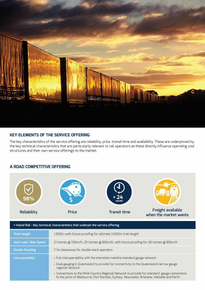
KEY ELEMENTS OF THE SERVICE OFFERING The key characteristics of the service offering are reliability, price, transit time and availability. These are underpinned by the key technical characteristics that are particularly relevant to rail operators as these directly influence operating cost structures and their own service offerings to the market.
A ROAD COMPETITIVE OFFERING
PriceReliability
98%
Transit time
< 24HOURS
Freight availablewhen the market wants
» Inland Rail - Key technical characteristics that underpin the service offering
Train Length 1,800m with future proofing for ultimate 3,600m train length
Axle Load / Max Speed 21 tonnes @ 115km/h, 25 tonnes @ 80km/h, with future proofing for 30 tonnes @ 80km/h
Double Stacking 7.1m clearances for double stack operation
Interoperability Full interoperability with the interstate mainline standard gauge network
Dual-gauging in Queensland to provide for connectivity to the Queensland narrow gauge regional network
Connections to the NSW Country Regional Network to provide for standard gauge connections to the ports of Melbourne, Port Kembla, Sydney, Newcastle, Brisbane, Adelaide and Perth

ATTRIBUTE SPECIFICATION
Reference Train
Intermodal 21 tonne axle load, 115km/h maximum speed, 1,800m length (initial), 2.7hp/tonne power:weight ratio
Coal / bulk 25 tonne axle load (initial), 80km/h maximum speed, length determined by customer requirements within maximum train length
Operational Specification
Freight train transit time
(terminal to terminal)
Target driven by a range of customer preferences and less than 24 hours Melbourne-Brisbane for the intermodal reference train. Flexibility to provide for faster (higher power:weight ratio) and slower (lower power:weight ratio) services to meet market requirements
Gauge Standard (1,435mm) with dual standard / narrow (1,067mm) gauge in appropriate Queensland sections
Maximum freight operating speed 115km/h @ 21 tonne axle load
Maximum axle loads (initial)
21 tonnes @ 115km/h
23 tonnes @ 90km/h
25 tonnes @ 80km/h
Clearance (terminal to terminal) As per ARTC Plate F for double stacking (7.1 m above rail)
Maximum train length (initial) 1,800m
Braking curve G40 for intermodal reference train
Minimum Design Standards
General alignment standards
Design speed 115km/h
Maximum grade1:100 target, 1:80 maximum (compensated)
1:200 maximum at arrival or departure points at loops
Curve radius 1,200m target, 800m minimum
Cant / cant deficiency Set for intermodal reference train
Medium speed alignment standards (mountainous terrain)
Design speed 80km/h minimum
Maximum grade1:100 target, 1:50 maximum (compensated)
1:200 maximum at arrival or departure points at loops
Curve radius 800m target, 400m minimum
Cant Set for coal reference train
Corridor width 40m minimum
Rail Minimum 53kg/m on existing track; 60kg/m on new or upgraded track
Concrete sleepers Rated @ 30 tonne axle load
Sleeper spacing667mm spacing (1,500/km) - existing track
600mm (1,666/km) - new corridors / track or re-sleepering existing track
Turnouts Tangential, rated at track speed on the straight and 80km/h entry / exit on the diverging track
Crossing loops (initial)1,800m (clearance point to clearance point) plus signalling overlap
No level crossing across loops or within road vehicle sighting distance from loops
Future Proofing
Train length To provide for future extension of maximum train length to 3,600m
New structures Capable of 30 tonne axle load @ 80km/h minimum
Formation Formation on new track suitable for 30 tonne axle load @ 80km/h
Crossing loops Loops designed and located to allow future extension for 3,600m trains
Reliability and availability Competitive with road
INLAND RAIL PERFORMANCE SPECIFICATION
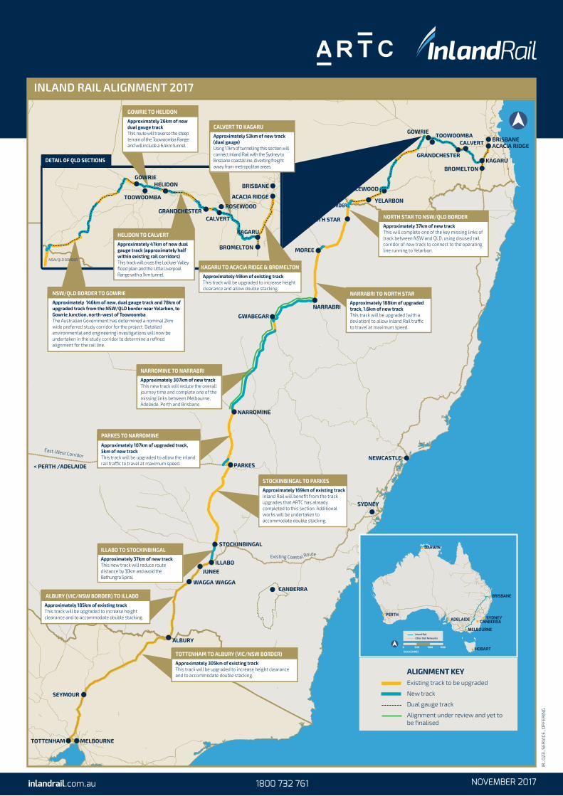
East-West Corridor
Existing Coasta l Route
NORTH STAR
YELARBON
Approximately 37km of new trackThis will complete one of the key missing links of track between NSW and QLD, using disused rail corridor of new track to connect to the operating line running to Yelarbon.
NORTH STAR TO NSW/QLD BORDER
NSW/QLD BORDER
INGLEWOOD
Approximately 188km of upgraded track, 1.6km of new trackThis track will be upgraded (with a deviation) to allow Inland Rail tra�c to travel at maximum speed.
NARRABRI TO NORTH STAR
Approximately 307km of new trackThis new track will reduce the overall journey time and complete one of the missing links between Melbourne, Adelaide, Perth and Brisbane.
NARROMINE TO NARRABRI
Approximately 107km of upgraded track, 5km of new trackThis track will be upgraded to allow the inland rail tra�c to travel at maximum speed.
PARKES TO NARROMINE
Approximately 169km of existing trackInland Rail will benefit from the track upgrades that ARTC has already completed to this section. Additional works will be undertaken to accommodate double stacking.
STOCKINBINGAL TO PARKES
Approximately 37km of new trackThis new track will reduce route distance by 30km and avoid the Bethungra Spiral.
ILLABO TO STOCKINBINGAL
Approximately 305km of existing trackThis track will be upgraded to increase height clearance and to accommodate double stacking.
TOTTENHAM TO ALBURY (VIC/NSW BORDER)
Approximately 185km of existing trackThis track will be upgraded to increase height clearance and to accommodate double stacking.
ALBURY (VIC/NSW BORDER) TO ILLABO
Approximately 146km of new, dual gauge track and 78km of upgraded track from the NSW/QLD border near Yelarbon, to Gowrie Junction, north-west of ToowoombaThe Australian Government has determined a nominal 2km wide preferred study corridor for the project. Detailed environmental and engineering investigations will now be undertaken in the study corridor to determine a refined alignment for the rail line.
NSW/QLD BORDER TO GOWRIE
BRISBANE
ACACIA RIDGE
KAGARU
BROMELTON
TOOWOOMBA
DETAIL OF QLD SECTIONS
Approximately 53km of new track (dual gauge)Using 1.1km of tunnelling this section will connect Inland Rail with the Sydney to Brisbane coastal line, diverting freight away from metropolitan areas.
CALVERT TO KAGARU Approximately 26km of new dual gauge trackThis route will traverse the steep terrain of the Toowoomba Range and will include a 6.4km tunnel.
GOWRIE TO HELIDON
ROSEWOOD
CALVERT
GOWRIEHELIDON
Approximately 47km of new dual gauge track (approximately half within existing rail corridors)This track will cross the Lockyer Valley flood plain and the Little Liverpool Range with a 1km tunnel.
HELIDON TO CALVERT
GRANDCHESTER
Approximately 49km of existing trackThis track will be upgraded to increase height clearance and allow double stacking.
KAGARU TO ACACIA RIDGE & BROMELTON
ALIGNMENT KEYExisting track to be upgraded
New track
Dual gauge track
Alignment under review and yet to be finalised
NSW/QLD BORDER
MOREE
JUNEE
ILLABO
SEYMOUR
TOTTENHAM
GWABEGAR
NARROMINE
MELBOURNE
WAGGA WAGGA
GRANDCHESTERKAGARU
BRISBANEACACIA RIDGECALVERT
GOWRIETOOWOOMBA
NARRABRI
PARKES
STOCKINBINGAL
ALBURY
NEWCASTLE
SYDNEY
CANBERRA
< PERTH /ADELAIDE
BROMELTON
INLAND RAIL ALIGNMENT 2017
BRISBANE
MELBOURNE
HOBART
SYDNEYCANBERRAADELAIDE
PERTH
DARWIN
0 1000500
SCALE (KMS)
1500
Inland Rail Other Rail Networks
IR_023_SERVICE_OFFERING
inlandrail.com.au 1800 732 761 NOVEMBER 2017

Appendix D Key Stakeholder Inputs

Department of Planning, Transport and Infrastructure (DPTI)
DPTI believe that it will be many years before the capacity of the Adelaide – Melbourne line
will be reached, particularly with the increase in train length from 1500m to 1800m
Modal pricing and competition between modes drives the choice between road and train
transport. Road is much more competitive on short haul corridors; rail is best serving long
haul routes
Road is very competitive on haul routes up to 800–1000km in length; consequently, the
Adelaide to Melbourne rail freight market is relatively low. Freight on the corridor is therefore
largely Melbourne to Perth freight, with some niche markets such as grain and SCT train.
Grain volumes on the line have increased since the closure of the Mallee spur lines
Double stacking would increase capacity, but will need to be done well – particularly on a
short haul corridor. The Melbourne end of the corridor will also require significant
investment, and double stacking will also require review of the container types (not all
containers are suitable for double stacking)
Significant consideration will need to be given to future potential of the existing corridor
The bypass may:
Increase costs (for Adel – Melb and Melb – Perth due to the longer distance)
Reduce the likelihood of the establishment of any intermodal facility in the South East
Place pressure upon existing terminals in Adelaide
Encourage operators to review existing terminal locations and freight systems
Require investment in the Adelaide-Mallala corridor to accommodate additional two-way
traffic on this section
Mid-Murray Council
Consider the rail bypass concept to be ideal to have through this region rather than
impacting the Adelaide Hills
Potential outcomes/opportunities for the Council:
This may result in an additional grain silo, if there is potential for much more grain to use
rail
There is an opportunity for the Mid-Murray Council to have maintenance yards around
Sean and Cambrai (with links to the Sturt Highway)
Sedan has plenty of available faming land
A workforce is available (including from the Barossa)
Ingham’s feedlot at Tungali is considered to be very important as a commodity that can
make use of rail
Tepko has good potential for growth, with irrigation, water and gas, and very large farms
Council advised that it would be worth following upon potential mining demand, via both
Hillgrove and SACOME
Rural City of Murray Bridge
Mount Barker District Council is very limited for industrial land, but through development of
Monarto there is an opportunity to provide this in terms of jobs, growth and an economic
zone. This is consistent with the Ministerial DPA for Greater Adelaide (2009?). Water at this
stage however is an issue, but there are opportunities to provide this
Should water become available, there are significant opportunities for horticulture and
agriculture, including orchards, juicing and the like
Should the Mildura – Menindee rail line go ahead, this would free up approximately 60% of
the capacity of the line
The RCMB is keen to see any changes or otherwise to the rail alignment ensure
consistency with the Monarto Master Plan
Note that the ‘2nd’ Adelaide Airport at Monarto is proposed to accommodate both freight and
passenger rail (Note – GLOBELink does not cover both)
Mitcham Council
Considerable costs are incurred as a result of fuel and time costs due to traffic stoppages at
level crossings through the area
Other environmental impacts are noise, dust and bushfire risk
A few summers ago a spark from the train (or thrown brake block) started a bushfire in
Crafers West within the Belair National Park and spread to peri-urban residential areas
Study could give consideration to the WHO standards of noise and vibration due to the
impact these have upon the local communities; the resulting sleep disturbance and
economic impacts associated with reduced productivity.
District Council of Mount Barker District Council
Opportunity for passenger rail
ARTC
Note: ARTC manages the interstate mainline rail track including the existing Murray Bridge to
Mallala section running through the Adelaide Hills
Overall volumes on this section of the track have declined since the 2010 study - historical
stats outlining trends in volumes are attached
There has been a decline in land bridged containers travelling to/ from Melbourne by rail as
these containers are now moving direct through Port Adelaide on new and existing shipping
services
In the past there were 9 trains per week travelling to and from Melbourne carrying these
export containers. There are no services dedicated to this trade today with any remaining
land bridged volumes now travelling on other services carrying domestic freight
In addition, Brisbane to Adelaide traffic (which used to travel via Melbourne) now travels via
the Broken Hill corridor
There has been some increase in Melbourne to Perth traffic volumes (with some recent
offset of growth as a result of volume declines driven by the downturn in WA’s mining
sector/activity)
Mindarie Sands operations have also ceased since the 2010 study (original closure
September 2009); this was restarted by Murray Zircon in 2012 through to March 2015. This
has again ceased operation – although the opportunity to reopen remains
While grain volumes can vary depending upon seasonal conditions, there have been no
significant changes over recent years
Steel volumes on the rail line are expected to decline due to the cessation of vehicle
manufacture in Adelaide
ARTC do not consider capacity to be an issue, rather productivity

Note that 1800m trains that can now access the network represent a 20% capacity increase
over 1500m trains that could access the network in 2010
Genesee and Wyoming Rail (GWR):
Over time, rail freight volumes have declined
Would prefer to see the existing corridor upgraded rather than a realignment
Primary Producers SA:
There is potential to use the existing rail corridor (via Belair etc.) to construct a dedicated
passenger transport system between Adelaide and Mount Barker District Council; this would
prolong the life of the South Eastern Freeway and will defer its expensive replacement and/
or duplication.
The overall cost for the northern rail bypass could be significantly reduced when compared
to the current proposal by provision of a single track only with passing loops.
Monarto Inland Port (MILP):
DPA passed by the City of Murray Bridge in 2015 to facilitate changes and future
development. Master plan for the overall development prepared by Jensen planning in
2015. A Business Plan (confidential) has also been prepared
An intermodal terminal at Monarto is expected to be attractive for containerised food
products produced from the Barossa Valley, Adelaide Hills, Langhorne Creek, the South
East and the Murraylands region. Other opportunities could include Ingham’s feed mill and
Big W’s distribution centre
A container facility for maintenance and repairs etc. as well as rail workshops are also
economic opportunities
An intermodal facility at Monarto can occur independently of the rail realignment, but there
is a desire for the intermodal facility to be linked to the rail network
Would like to see double stacking
Note: Since this discussion, MILP has now received consent for Stage 1 approval.
Viterra
Of the opinion that there are other priorities to spend money on rather than a new rail
corridor alignment
Advise that due to the history of the rail corridor, residents etc. should expect to hear the
noise generated by the train, rather than to simply ‘shift’ this to other communities; perhaps
noise mitigation measures could be implemented?
Viterra currently transports around 600,000 tonnes per annum of grain from Tailem Bend to
Adelaide as funnelled in from other areas)
Some grain growth can be expected from areas such as the Mallee and the Lower South
East
Viterra has heavily invested at Tailem Bend to facilitate the road to rail transfer
Viterra considers the rail bypass to be a less viable option than the current alignment
through the Adelaide Hills as the route distance will be longer and transit times are
expected to be longer
Concern that the rail bypass may also see more Melbourne to Perth trains bypass Adelaide
altogether
It has been suggested that a benefit may exist for Viterra and others if the corridor was
changed and a spur line added such that the existing rail corridor via Freeling, Roseworthy

and down to port Adelaide were re-established as part of the standard gauge network
(approx. 300 000t per annum). It should be noted however that the recent enhanced access
for High Productivity Vehicles to/from Roseworthy may make any shift back to rail less
viable.
Australian Portable Camps
APC is actually a mining based business; this has slowed however and therefore APC has
decided to now push forward with the Monarto Intermodal
Has received formal approval (16/9/17) for Stage 1 of the Monarto Intermodal Facility; this
being the track work (i.e. Section 49 – Crown Development Application approval)
Stage 2 will allow for storage of fresh produce and is currently being prepared for lodgement
for State Development approval.
The facility has a total of 4 stages, and is consistent with the Monarto Master Plan as
prepared by Jensen Planning. Upon completion, the facility could reach a capacity of 50,000
TEU’s per annum (if financially viable)
Note that in 2008, the Big W distribution Centre generated 20,000 TEUs per annum; they
have a contract with SCT for another 3 years
Currently it is not cost effective to use rail for Camp transport. In future, there may be
opportunity to set up a remote commercial facility to utilise the rail infrastructure
Also refer Monarto South Intermodal Land Use Study (2008) – available online. This
includes forecast volumes for freight.
Note: Since this discussion, APC has withdrawn its Section 49 application for the Monarto
Intermodal Facility.
Pacific National
Believes the current corridor is ok, but supports the bypass if longer, heavier and double
stacked trains can operate on the national network between Melbourne and Adelaide and
use less horsepower
Pacific National provides hook and pull services for Great Southern Rail’s (GSR) passenger
services. The Indian Pacific and Ghan will not be impacted, however the (government
subsidised) Overland service between Adelaide and Melbourne will be impacted if the route
is changed
Pacific National would not move its Adelaide terminal (Islington) to Mallala in the near term.
Instead they would bring their train from Mallala into Adelaide
Pacific National currently operates 18 trains per week on the Melbourne – Adelaide corridor
and return
7 x intermodal Superfreighters from Melbourne to Perth
3 x Intermodal Express Trains from Melbourne to Perth
5 x Intermodal Superfreighters from Melbourne to Adelaide
1 x Intermodal Superfreighter from Sydney to Adelaide
2 x SteelLink Trains from Melbourne to Perth
All of these trains would be impacted by this change
Some Melbourne to Perth containers are loaded on the Melbourne to Adelaide trains and
then double stacked on top of containers on the Melbourne to Perth trains in Adelaide. This
increases the train’s payload capacity while remaining within the 1800m confines of the
interstate rail network between Adelaide and Perth
Double stacking on the Adelaide - Melbourne line (as well as the Inland Rail currently being
progressed) will require their Melbourne terminal to relocate from current Dynon site and
free from any overhead bridge restrictions and tunnels that currently exist between
Melbourne and Adelaide
There are significant economies available to Pacific National if they can double stack trains
from Melbourne to Perth
In future, Pacific National may have the option to consign some Melbourne to Perth double
stacked trains via the Inland Railway to Parkes (and then onto Perth via Broken Hill, Port
Augusta and Kalgoorlie)
Currently, an extra loco is required to be added to trains entering and exiting Adelaide from
the east to cope with the steep gradients of the Adelaide Hills (added to and taken off trains
at Tailem Bend). Until the bypass route is decide it is unclear whether this additional
locomotive power will still be required if the Northern Bypass is constructed)
SAFC
Does not support the rail bypass at this time, given the recent investment in upgrades to the
Adelaide- Melbourne Rail Corridor to cater for 1800m long trains
Note that the cost to upgrade the corridor will now be reduced as a result of these recent
works
Concerned that double stacking will continue to be an issue unless issues are also resolved
across the Victorian border
Bowman’s Rail
Significant customers such as Big W (DC at Monarto), Thomas Food International (meat at
Lobethal and Murray Bridge), Lithgow Enterprises (hay at Tailem Bend) and JBS (meat at
Bordertown and Port Wakefield) are understood to have recently signed long term contracts
that commit them to road (Qube)
Most Adelaide origin/ destination imports and exports are now consigned direct through
Adelaide due to land bridge costs to and from Melbourne
Bowman’s currently run 6-8 trains per week between Bowman’s and Port Adelaide, carrying
containerised hay, grain and pulses and lead, and also stop to collect wagons carrying wine
from the SCT Terminal at Penfield
RDA - Murraylands and Riverland
There are significant industry development opportunities that may be consigned to rail,
thereby becoming customers for any proposed rail bypass (e.g. Thomas Foods, Australian
Portable Camps)
Product is also expected to move up the value chain resulting in different products requiring
different freight tasks that may be consigned to rail
Future changes to road pricing regimes may change the competitive positions of rail and
road (in favour of rail)
Industry will make the decisions about how will they will consign freight in the future in a
competitive market

Appendix E CBA Review – Agglomeration Economies and Effective Job Density
SGS Economics and Planning

Agglomeration economies
Agglomeration economies relate to the productivity enhancements that firms gain from locating in
an area of relatively dense economic activity. These benefits stem from a variety of factors
including:
The ability to achieve economies of scale and scope through specialisation given the large
numbers of potential customers that are readily accessible;
The availability of numerous supply sources and potentially specialised infrastructure, and
the competitive environment that stems from this; and
Access to a deep and diverse pool of skilled labour, often complemented by high levels of
technological/ knowledge transfer between firms, which helps bolster innovation.
Literature related to agglomeration can be traced back to the work of Marshall (1920). Marshall’s
work, despite the passage of a century, still provides an excellent description of the conceptual
benefit which firms can gain by locating in a particular location. Since that time agglomeration
has been measured in a number of ways including city population (Aaberg, 1973; Tabuchi,
1986), industry employment (Nakamura, 1985; Henderson, 1986), the number of industrial plants
(Henderson, 2003b) and effective job density (Graham, 2006).
Although all these methods attempt to measure the same basic economic phenomena, there are
two somewhat distinct effects at work. The first is scale of the city, i.e. the larger the city, the
higher the productivity. The second is related to the actual spatial organisation of the city, i.e. the
ease with which firms can interact with each other.
Effective job density
A simple measure such as looking at the employment density of an area does not effectively
demonstrate the phenomena of agglomeration. A firm in a relatively low-employment area but
located on the edge of a Central Business District (CBD) could potentially capture agglomeration
benefits by being close to the CBD. Thus a measure of agglomeration must “ incorporate both
proximity and the scale of the economic activity and …be calculated for very small areas ”
(Graham, 2006).
Accordingly, this study has used the level of employment relative to the time taken to gain
access to that employment and the mode split that is currently experienced by those employees.
The travel time matrix (sourced from the South Australian Government’s Metropolitan Adelaide
Strategic Transport Evaluation Model (MASTEM)) is available for 298 travel zones across
Adelaide. A travel time matrix shows how long it takes to travel from one zone in the city to all
other zones by both car and public transport. In the analysis presented in this section the travel
times have been converted from the travel zone level to a Statistical Local Area level.
This measure of effective job density (EJD) enables a more ‘real life’ representation of the
proximity (in terms of travel time) component of agglomeration that other more basic measures
overlook. That is, 37% of people working in the CBD of Adelaide travel to work on public
transport and thus the proximity to those jobs is somewhat related to public transport travel
times. The other extreme can be seen in locations such as Marion (an outer location in Southern
Adelaide), where 95% of workers travel to work using private vehicles2. Therefore, effective job
density has been estimated as follows:
EJDi = ∑ (PT Mode Sharej ×Empj
PT Travel Timeij+
(1−PT Mode Sharej) ×Empj
PV Travel Timeij)j (1)
Where:
2 This method excludes travel times from other modes (bicycle or walk).

EJDi is the Effective Job Density for zone i; PT Mode Sharej is the percent of work trips which involve public transport for zone j;
Empj is the number of jobs/employment within zone j;
PT Travel Timeij is the time it takes to travel on public transport from zone i to zone j; and
PV Travel Timeij is the time it takes to travel by private vehicle from zone i to zone j.
This method also provides insight into the costs associated with travel in various parts of the city.
A rational commuter would use the mode of transport which would minimise their travel costs
including value of time and any monetary cost. Therefore, the mode split between public
transport and private vehicle at a particular origin-destination pairing should provide insight into
the overall travel cost. The travel zone EJD is then aggregated to an SLA level using a weighted
average based on population for origin and employment for destination.