northwest rail corridor and us 36 brt development · pdf filethis would create a more direct...
TRANSCRIPT
Northwest Rail Corridor and US 36 BRTDevelopment Oriented Transit Analysis
Final 4-24 July 2007
4.4.5 116th Avenue Station (Broomfield)
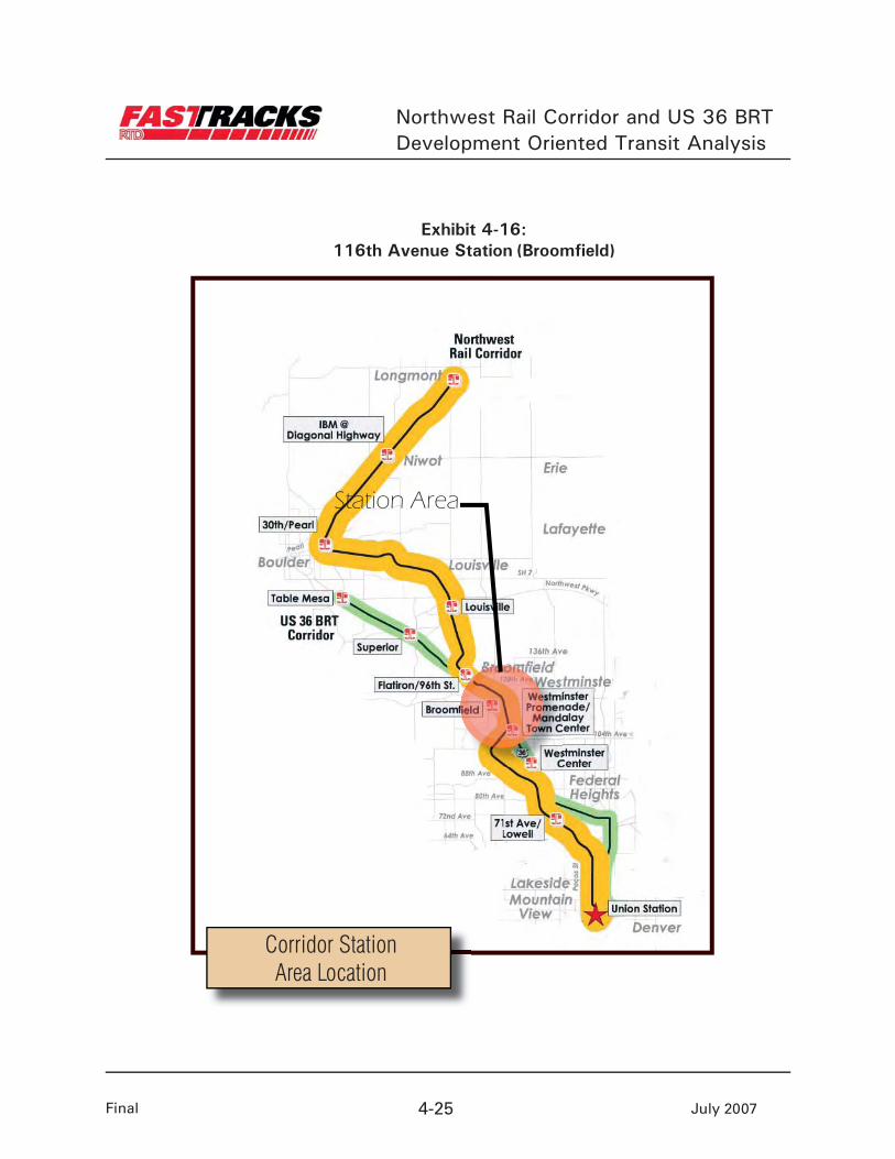
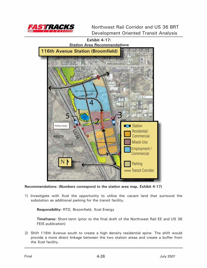
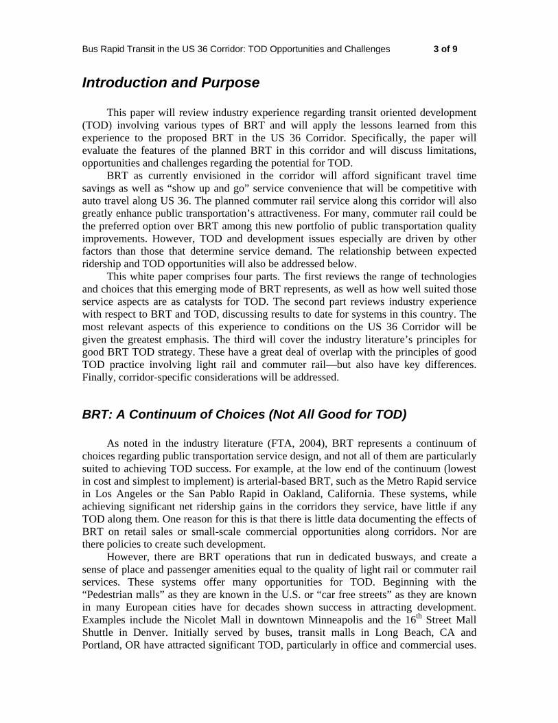
TOD Area Character: The 116th Avenue Station is a shared BRT and CRT station within the City and County of Broomfield’s Original Broomfield area (Exhibit 4-16). The station area offers large tracts of land for development with good visibility from US 36 (Exhibit 4-17). An industrial area east of the railroad tracks provides an employment base for the station area and larger community. Development is occurring west of the station area at the Arista project, with more than 5 million square feet of development planned. A recreational sports complex southeast of the CRT station offers a green space amenity and opportunity for expansion.
The rail station area is constrained by a lack of access. CDOT, RTD and Broomfield are working in partnership to improve transportation connections the site. Improved access will facilitate the mixed-use character needed for TOD.
Challenges:
US 36 and the rail line restrict east-west connections. Mobility is also limited by a disjointed roadway network.
While a pedestrian bridge across US 36 is planned by RTD, the current configuration may not be situated to enhance TOD opportunity east of the BRT platforms since it would not align with 116th Avenue.
The Arista development will be a catalyst for future development east of the highway. Future development in Arista and Original Broomfield should be complementary and the two should not detract from or compete with each other.
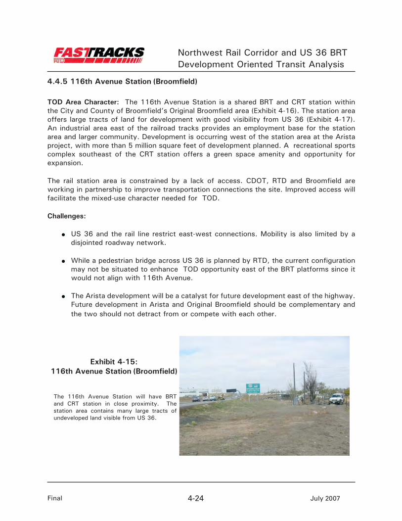
The 116th Avenue Station will have BRT and CRT station in close proximity. The station area contains many large tracts of undeveloped land visible from US 36.
Exhibit 4-15:116th Avenue Station (Broomfield)
Northwest Rail Corridor and US 36 BRTDevelopment Oriented Transit Analysis
Final 4-25 July 2007
Station Area
Corridor Station Area Location
Exhibit 4-16:116th Avenue Station (Broomfield)
Northwest Rail Corridor and US 36 BRTDevelopment Oriented Transit Analysis
Final 4-26 July 2007
TB
W 118th Pl
W 116th Pl
W 116th AVE
REED
WAY
112TH AVE
UPTOWN AVE
BROOMFEILDEVENTS CENTER
BRO
OM
FEIL
D L
N
US36
12
3
4
5Parking Garage
ARISTA
Residential/Commercial
120th Ave Connection
1/2 Mile: BRT/CRT
XCEL
Office / Employment /Commercial
116th Avenue Station (Broomfield)
N
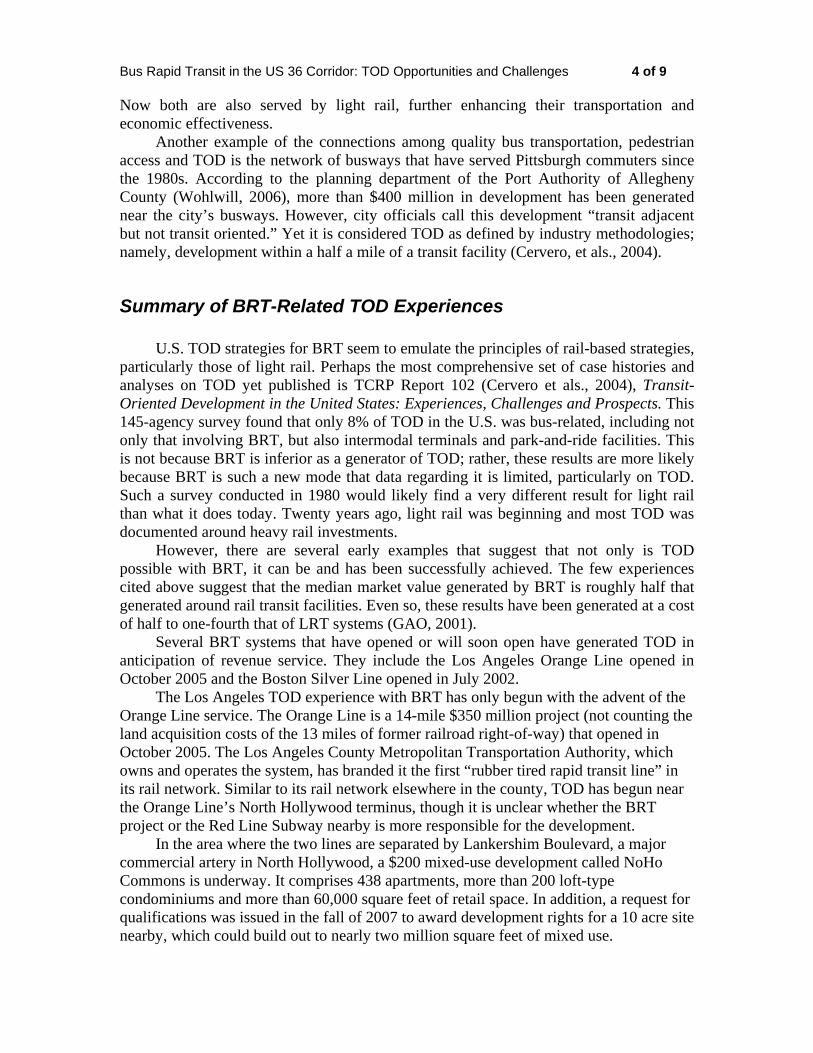
Recommendations: (Numbers correspond to the station area map, Exhibit 4-17)
1) Investigate with Xcel the opportunity to utilize the vacant land that surround the substation as additional parking for the transit facility.
Responsibility: RTD, Broomfield, Xcel Energy
Timeframe: Short-term (prior to the final draft of the Northwest Rail EE and US 36 FEIS publication)
2) Shift 116th Avenue south to create a high density residential spine. The shift would provide a more direct linkage between the two station areas and create a buffer from the Xcel facility.
Exhibit 4-17:Station Area Recommendations
Residental/Commercial
Mixed-Use
Station
Parking
Transit Corridor
Employment / Commercial
T
Northwest Rail Corridor and US 36 BRTDevelopment Oriented Transit Analysis
Final 4-27 July 2007
Responsibility: Broomfield
Timeframe: Long-term (prior to project construction)
3) Move the rail platforms south to connect with the realigned 116th Avenue.
Responsibility: RTD, EIS Team, Broomfield
Timeframe: Short-term (prior to the final draft of the Northwest Rail EE and US 36 FEIS publication)
4) Coordinate with CDOT concerning access into the site from the north. Evaluate access into the site from US 36 and the proposed 120th Avenue Connection.
Responsibility: RTD, Broomfield
Timeframe: Short-term (prior to the final draft of the Northwest Rail EE and US 36 FEIS publication)
5) Explore options to shift the proposed configuration of the pedestrian bridge to the south to align with 116th Avenue. This would create a more direct pedestrian linkage and a connection between the rail and BRT facilities.
Responsibility: RTD, Broomfield
Timeframe: Immediate (within the next three months)
6) Link the Broomfield Industrial Sports Complex to 112th Avenue west of the railroad via pedestrian bridge. This would create a new access from the station to the Complex.
Responsibility: Broomfield
Timeframe: Long-term (prior to project construction)
General Recommendations (not highlighted on station area map)
Complete the Original Broomfield Plan, including identifying a street network, open space connections and land uses to support TOD opportunities.
Responsibility: Broomfield
Timeframe: Short-term (prior to the final draft of the Northwest Rail EE and US 36 FEIS publication)
Northwest Rail Corridor and US 36 BRTDevelopment Oriented Transit Analysis
Final 4-28 July 2007
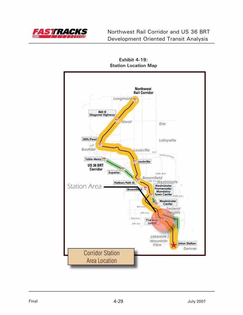
4.4.6 South Westminster
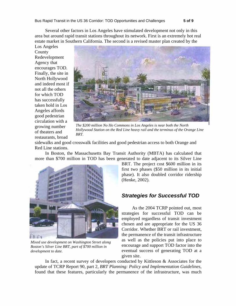
Station Area Character: The South Westminster Station is projected to be one of the busier stations along the corridor (Exhibit 4-19). The station planning area is on 100 acres between Lowell and Federal boulevards in an industrial section of the city (a view of the station area is shown in Exhibit 4-18). The site requires substantial infrastructure improvements in both the short and long term to phase in projected development. The City has a strong TOD plan in place; leadership needs to continue to implement the vision for the station area. Partnership with RTD in the long term will help to refine transit and development design.
Approximately 30-40 acres south of the station are located on a floodplain within open space along Little Dry Creek. A plan has been completed to create a park within the floodplain and to improve the trail connections through the area. An opportunity exists to connect the park with the station to provide a nearby amenity and place of activity. The park could also accommodate the drainage requirements of future development north of the station.
Challenges:
Major infrastructure improvements are required.
The site has over 90 individual owners in the area. Fragmented land ownership makes land assemblage a challenge.
Parking requirements for the park-n-Ride could limit TOD opportunities at this station.
Access into the site poses a challenge for future bus circulation into and out of the station.
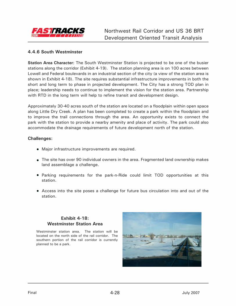
Westminster station area. The station will be located on the north side of the rail corridor. The southern portion of the rail corridor is currently planned to be a park.
Exhibit 4-18:Westminster Station Area
Northwest Rail Corridor and US 36 BRTDevelopment Oriented Transit Analysis
Final 4-29 July 2007
Station Area
Corridor Station Area Location
Exhibit 4-19:Station Location Map
Northwest Rail Corridor and US 36 BRTDevelopment Oriented Transit Analysis
Final 4-30 July 2007
Fede
ral B
lvd.
1
2
3
1
4
6
5B
US 36
US 36
71st Ave.
70 th Ave.
71st Pl.
72nd Ave.Hoo
ker S
t.
Irvin
g S
t.
Julia
n S
t.
Low
ell B
lvd.
Westminster Station Area
NRail Corridor
T
Station
T
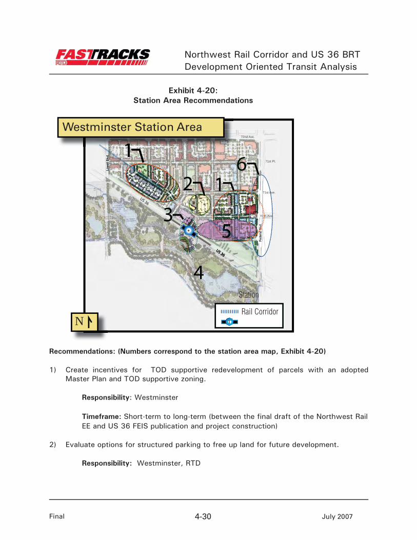
Recommendations: (Numbers correspond to the station area map, Exhibit 4-20)
1) Create incentives for TOD supportive redevelopment of parcels with an adopted Master Plan and TOD supportive zoning.
Responsibility: Westminster
Timeframe: Short-term to long-term (between the final draft of the Northwest Rail EE and US 36 FEIS publication and project construction)
2) Evaluate options for structured parking to free up land for future development.
Responsibility: Westminster, RTD
Exhibit 4-20:Station Area Recommendations
Northwest Rail Corridor and US 36 BRTDevelopment Oriented Transit Analysis
Final 4-31 July 2007
Timeframe: Short-term (prior to the final draft of the Northwest Rail EE and US 36 FEIS publication)
3) Create a focal point or plaza at the station platforms. Connect the TOD with the park to the south through a pedestrian linkage.
Responsibility: Westminster, RTD
Timeframe: Short-term to long-term (between the final draft of the N o r t h w e s t Rail EE and US 36 FEIS publication and project construction)
4) Develop an implementation plan for park improvements south of the alignment. Prioritize capital improvements budget to include funds for park improvements.
Responsibility: Westminster
Timeframe: Short-term to long-term (between the final draft of the N o r t h w e s t Rail EE and US 36 FEIS publication and project construction)
5) Integrate transit parking into the station area without detracting from private development opportunity. Evaluate on-street bus circulation and drop-off areas to maximize TOD potential.
Responsibility: RTD, EE design team, Westminster
Timeframe: Short-term (prior to the final draft of the Northwest Rail EE and US 36 FEIS publication)
6) Consider attractive gateways into the site along Federal Boulevard at cross streets such as 70th, 71st and 72nd avenues. Utilize these entrances as wayfinding to the station at the interior of the site.
Responsibility: Westminster
Timeframe: Long-term (prior to project construction)
Northwest Rail Corridor and US 36 BRTDevelopment Oriented Transit Analysis
Final 4-32 July 2007
General Recommendations (not highlighted on station area map)
Complete a TOD implementation framework that identifies phasing options for TOD and RTD parking that maximizes TOD opportunities, sites for catalyst TOD projects, financing tools to accelerate implementation, and refinements to station area plan.
Responsibility: Westminster, RTD
Timeframe: Short-term (prior to the final draft of the Northwest Rail EE and US 36 FEIS publication)
Finalize scope of work and IGA between RTD and Westminster to develop a TOD Implementation framework.
Responsibility: RTD, Westminster
Timeframe: Immediate to short-term (between now and the final draft of the North- west Rail EE and US 36 FEIS publication)
Appendix A:
Workshop Summaries
i
RTD FasTracks – US 36 BRT and Northwest Rail TOD Stakeholder Forum – Local Government Staff
Location:
National Institute of Trial Attorney’s (NITA) Building 363 Centennial Parkway
Louisville, CO
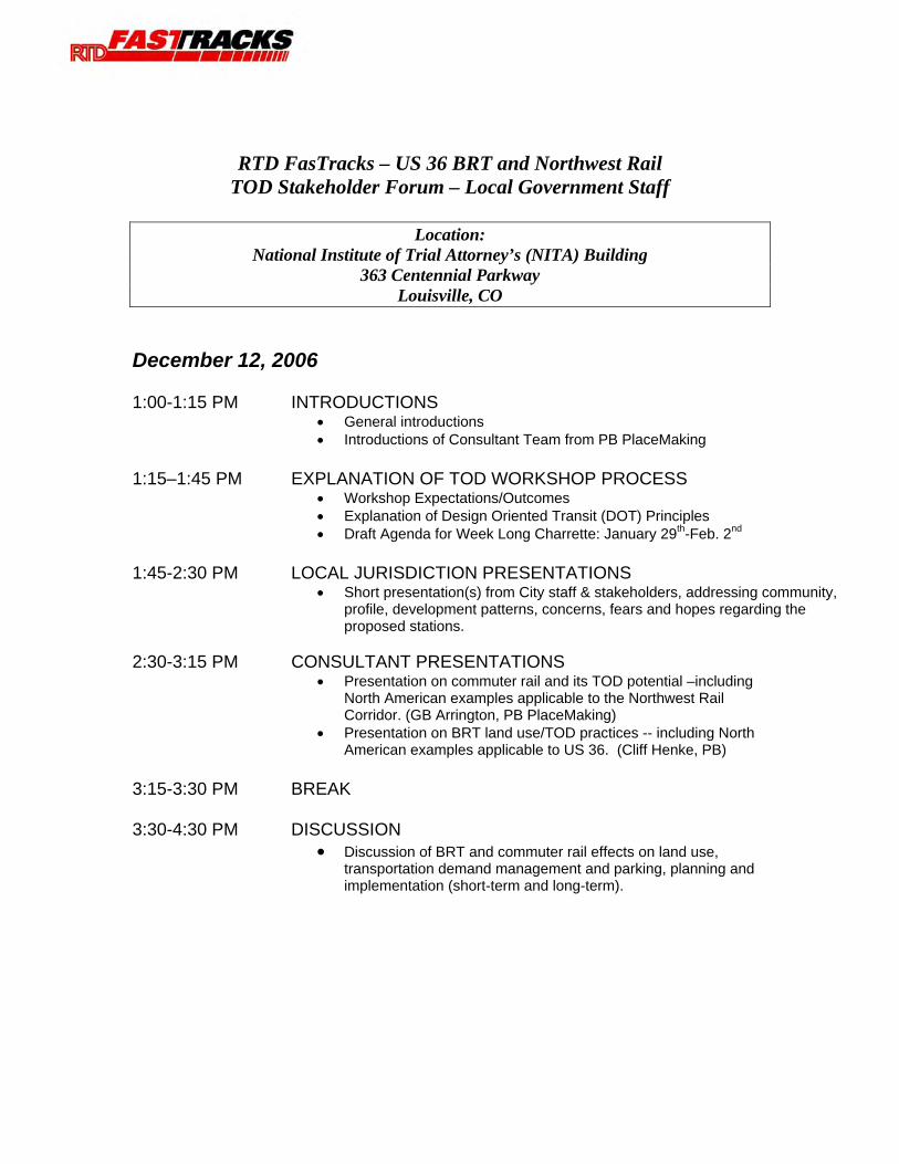
December 12, 2006 1:00-1:15 PM INTRODUCTIONS
• General introductions • Introductions of Consultant Team from PB PlaceMaking
1:15–1:45 PM EXPLANATION OF TOD WORKSHOP PROCESS
• Workshop Expectations/Outcomes • Explanation of Design Oriented Transit (DOT) Principles • Draft Agenda for Week Long Charrette: January 29th-Feb. 2nd
1:45-2:30 PM LOCAL JURISDICTION PRESENTATIONS
• Short presentation(s) from City staff & stakeholders, addressing community, profile, development patterns, concerns, fears and hopes regarding the proposed stations.
2:30-3:15 PM CONSULTANT PRESENTATIONS
• Presentation on commuter rail and its TOD potential –including North American examples applicable to the Northwest Rail Corridor. (GB Arrington, PB PlaceMaking)
• Presentation on BRT land use/TOD practices -- including North American examples applicable to US 36. (Cliff Henke, PB)
3:15-3:30 PM BREAK 3:30-4:30 PM DISCUSSION
• Discussion of BRT and commuter rail effects on land use, transportation demand management and parking, planning and implementation (short-term and long-term).

Meeting Minutes
RTD FasTracks – US 36 Bus Rapid Transit (BRT) and Northwest Rail
TOD Stakeholder Forum – Local Government Staff
DATE: December 12, 2006 LOCATION: National Institute of Trial Advocacy (NITA) Building EXPLANATION OF THE PROCESS
Bill Sirois (TOD Manager, RTD) welcomed the group. RTD is conducting a series of workshops to provide a forum to discuss Transit Oriented Development (TOD) opportunities along the proposed Northwest Rail and US 36 Corridors. A similar workshop will be held for each FasTracks Corridor. RTD held its first workshop, a week-long charrette for the West Corridor, in January 2006. The results of the charrette were documented in a summary report which highlighted actions and responsibilities to move forward with TOD in the West Corridor.
The purpose of this forum is to discuss opportunities and challenges for implementing TOD along the US 36 Corridor, with examples from across the country. GB Arrington of PB PlaceMaking (Portland) will speak on TOD examples of commuter rail. Cliff Henke of PB (Los Angeles) will give examples and recommendations for TOD around Bus Rapid Transit (BRT).
The next step in the process will be a week-long charrette from January 29th to February 2nd. Each jurisdiction should bring a multi-disciplinary group of staff to evaluate and provide input into station area plans. All attendees should review their allotted morning or afternoon time slot to ensure that there are no conflicts with those dates. Broomfield raised an issue about a schedule conflict with Thursday afternoon. Boulder offered to exchange with Broomfield so the Boulder workshop will now be held on Thursday morning and the Broomfield workshop will be held Tuesday afternoon. Local jurisdictions should bring existing land use plans and infrastructure plans developed for the station areas. RTD and the EIS Consultants will present the transit plans and engineering plans for the Corridor. Strategic Economics will provide a market perspective.
An Elected Officials briefing will tentatively be held on Friday, February 2nd, from 7:30 AM – 9:30 AM. Questions were raised about the timing of the briefing and it was concluded that the elected officials should be asked directly about their preference for when they would like to have a briefing.
EXPLANATION OF DESIGN ORIENTED TRANSIT (DOT) PRINCIPLES (GB Arrington)
GB Arrington gave an overview of principles of Transit Oriented Development and the DOT process. He emphasized that linkages are needed between transportation and development at each station. Municipalities should consider their vision and goals for TOD, and the implementation needed to build TOD.
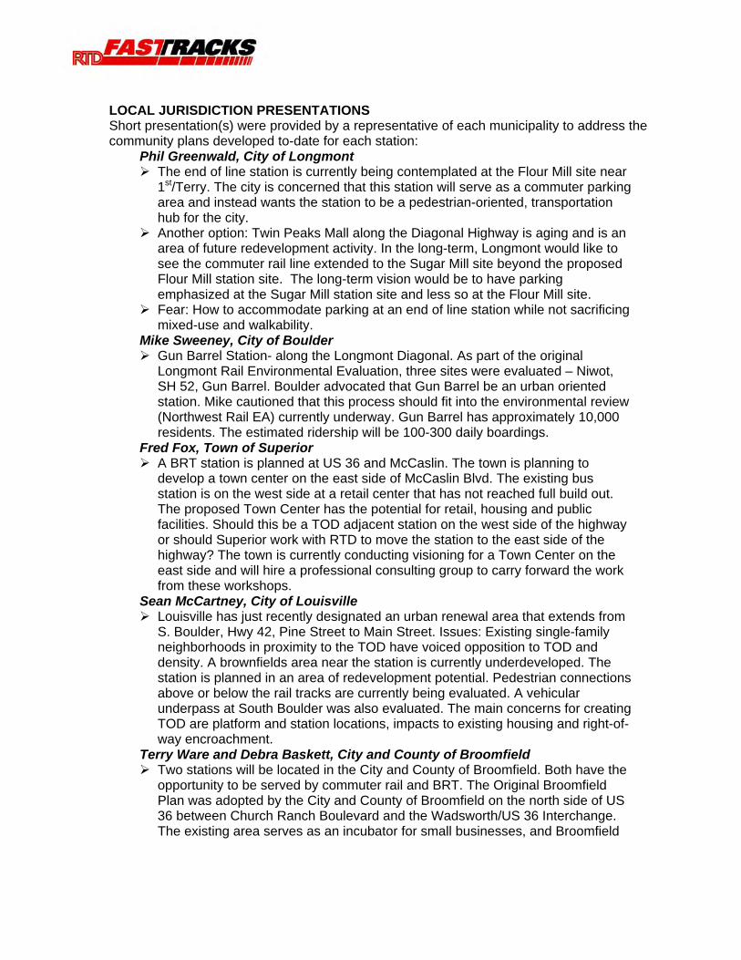
LOCAL JURISDICTION PRESENTATIONS Short presentation(s) were provided by a representative of each municipality to address the community plans developed to-date for each station:
Phil Greenwald, City of Longmont The end of line station is currently being contemplated at the Flour Mill site near 1st/Terry. The city is concerned that this station will serve as a commuter parking area and instead wants the station to be a pedestrian-oriented, transportation hub for the city.
Another option: Twin Peaks Mall along the Diagonal Highway is aging and is an area of future redevelopment activity. In the long-term, Longmont would like to see the commuter rail line extended to the Sugar Mill site beyond the proposed Flour Mill station site. The long-term vision would be to have parking emphasized at the Sugar Mill station site and less so at the Flour Mill site.
Fear: How to accommodate parking at an end of line station while not sacrificing mixed-use and walkability.
Mike Sweeney, City of Boulder Gun Barrel Station- along the Longmont Diagonal. As part of the original Longmont Rail Environmental Evaluation, three sites were evaluated – Niwot, SH 52, Gun Barrel. Boulder advocated that Gun Barrel be an urban oriented station. Mike cautioned that this process should fit into the environmental review (Northwest Rail EA) currently underway. Gun Barrel has approximately 10,000 residents. The estimated ridership will be 100-300 daily boardings.
Fred Fox, Town of Superior A BRT station is planned at US 36 and McCaslin. The town is planning to develop a town center on the east side of McCaslin Blvd. The existing bus station is on the west side at a retail center that has not reached full build out. The proposed Town Center has the potential for retail, housing and public facilities. Should this be a TOD adjacent station on the west side of the highway or should Superior work with RTD to move the station to the east side of the highway? The town is currently conducting visioning for a Town Center on the east side and will hire a professional consulting group to carry forward the work from these workshops.
Sean McCartney, City of Louisville Louisville has just recently designated an urban renewal area that extends from S. Boulder, Hwy 42, Pine Street to Main Street. Issues: Existing single-family neighborhoods in proximity to the TOD have voiced opposition to TOD and density. A brownfields area near the station is currently underdeveloped. The station is planned in an area of redevelopment potential. Pedestrian connections above or below the rail tracks are currently being evaluated. A vehicular underpass at South Boulder was also evaluated. The main concerns for creating TOD are platform and station locations, impacts to existing housing and right-of-way encroachment.
Terry Ware and Debra Baskett, City and County of Broomfield Two stations will be located in the City and County of Broomfield. Both have the opportunity to be served by commuter rail and BRT. The Original Broomfield Plan was adopted by the City and County of Broomfield on the north side of US 36 between Church Ranch Boulevard and the Wadsworth/US 36 Interchange. The existing area serves as an incubator for small businesses, and Broomfield

does not want to lose these businesses. South of US 36, the recently constructed Broomfield Events Center will serve as an anchor for the station area and the proposed Arista Development. The Arista Development is planned on 212 acres of land with 5 million square feet of retail, office, and residential at buildout including a 2-block Main Street mixed-use development. Poor market conditions are currently limiting the housing development planned on the site.
o A recently constructed parking structure was built adjacent to the station. This garage was not located to its best advantage—people do not walk within the proposed development area and instead walk directly from the station facility to their vehicles. A pedestrian bridge across US 36 and a bus transfer facility adjacent to the parking garage are planned by RTD and will be operational by 2009.
96th Street Station: StorageTek is a large employment area near the 96th Street station. A primary challenge of this station is the need to connect to the Flatirons Mall across US 36. The area has experienced a demand to convert from commercial to residential uses. Conservation easements are located north of US 36, and this use will not change in the future. The main challenge with this station is the lack of pedestrian connections.
John Carpenter, City of Westminster: The City of Westminster will have three stations: Westminster Promenade, Westminster Mall, and the South Westminster Station.
o The Westminster Promenade will be a shared station with BRT overlooking Lower Church Lake. o The second station is at the Westminster Mall and has opportunity for commercial activity near the station. o The third station is the South Westminster Station, which will be the focus of the January Workshops. This station is projected to be one of the busier stations along the Corridor. It is located at 70th and Irving within an aging area of the City. The station will be located on 100 acres between Lowell and Federal Boulevard. Approximately 30-40 acres are located on a floodplain along Little Dry Creek. The US 36 Corridor Draft EIS has plans for a regional bikeway to connect to Little Dry Creek. The city is currently estimating 1,600 parking spaces, which presents a challenge for TOD. The area is located on a brownfields site in an Urban Renewal Area with 10 years remaining. The City is researching special financing for the station area to construct infrastructure or structured parking. A plan and design guidelines were recently developed for the full 100 acres. The goal for this process is to critique that plan to determine any modifications.
CONSULTANT PRESENTATIONS GB Arrington, PB PlaceMaking: Review of benefits of TOD.
Changing land use changes transportation behavior. Pedestrian connections can happen now without transit. A TOD should have a five minute walk to everything, close to home, office, shopping and civic spaces.
Focus on walkable districts around stations (scale). Consider corridor as an integrated system-network effects-people will be traveling within the region via the stations.
Questions/Comments:
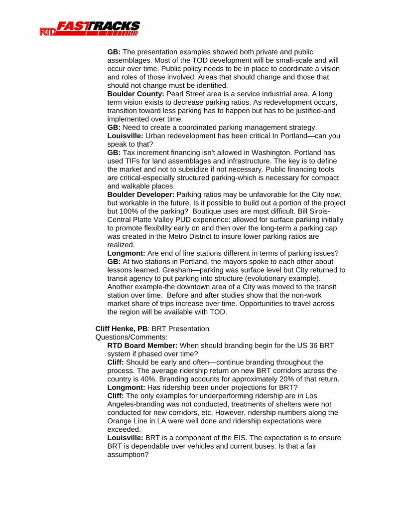
Are at-grade crossings of the tracks allowed? Response: RTD stated that since the tracks are shared with the BNSF Railroad, it is not possible to segregate freight rail from commuter rail. Freight rail will cross through the stations. Grade separation for pedestrians will be necessary. RTD surveyed other agencies to find out whether gates for pedestrians are possible. The survey found that most cities do not like them because of serious maintenance problems. RTD is in negotiations at this time with BNSF concerning operating agreements. All other issues, such as pedestrian crossings, are a lower priority than the operating agreement.
Hold harmless provision for FasTracks-unfair for jurisdictions to make sacrifices for freight if other corridors do not have to do so.
In a few of the examples in the presentation, such as Arlington Heights, the transit agencies can charge for parking. Response: RTD can not charge for parking at this time.
Cliff Henke, PB: BRT Presentation
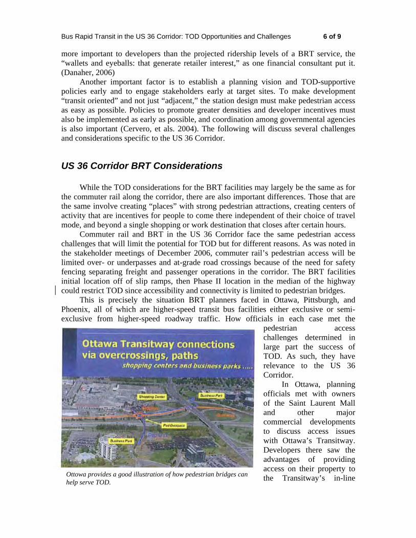
Pittsburgh is the oldest example and a good example of BRT. Consider market and uses and then think about the transportation facility. Idea in Ottawa-provide a feeder service to the BRT mainline on US 36 (access private development).
Pedestrian linkages are key to connect development. Low-risk income strategies: on-board wireless internet, station advertising, carts/kiosks, etc in stations.
Ridership may not help TOD-but community investment and commitment will advance TOD.
Cities should consider pedestrian connections among districts within communities.
Questions/Comments: What makes BRT successful is entering the vehicle and numerous locations-such as more than one door. Financing for the corridor is not yet known. There could be the opportunity to use off-bus boarding.
What do we accommodate with BRT? What will the buses look like? Need to have the conversation about BRT. The TMO is going to work with RTD on branding.
Commuter rail vs. Light rail: due to lower frequency of commuter rail, TOD is not as attractive. A concern of Westminster is that lower frequencies for commuter rail will prevent creation of a successful TOD.
Copies of the presentations given are posted on the US 36 Transportation Mobility Organization website: www.us36tmo.org/
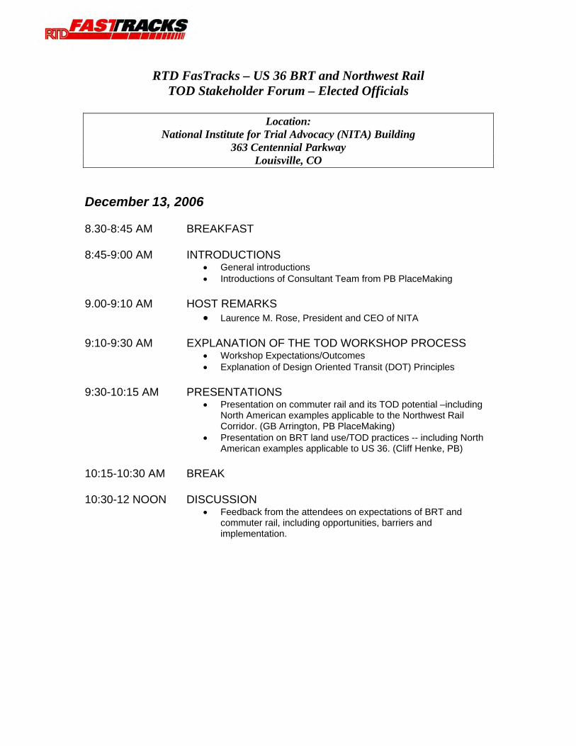
RTD FasTracks – US 36 BRT and Northwest Rail TOD Stakeholder Forum – Elected Officials
Location:
National Institute for Trial Advocacy (NITA) Building 363 Centennial Parkway
Louisville, CO
December 13, 2006 8.30-8:45 AM BREAKFAST 8:45-9:00 AM INTRODUCTIONS
• General introductions • Introductions of Consultant Team from PB PlaceMaking
9.00-9:10 AM HOST REMARKS
• Laurence M. Rose, President and CEO of NITA 9:10-9:30 AM EXPLANATION OF THE TOD WORKSHOP PROCESS
• Workshop Expectations/Outcomes • Explanation of Design Oriented Transit (DOT) Principles
9:30-10:15 AM PRESENTATIONS
• Presentation on commuter rail and its TOD potential –including North American examples applicable to the Northwest Rail Corridor. (GB Arrington, PB PlaceMaking)
• Presentation on BRT land use/TOD practices -- including North American examples applicable to US 36. (Cliff Henke, PB)
10:15-10:30 AM BREAK 10:30-12 NOON DISCUSSION
• Feedback from the attendees on expectations of BRT and commuter rail, including opportunities, barriers and implementation.
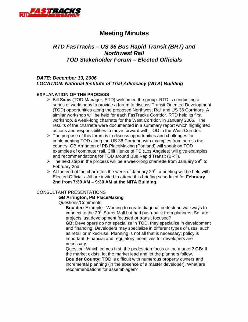
Meeting Minutes
RTD FasTracks – US 36 Bus Rapid Transit (BRT) and Northwest Rail
TOD Stakeholder Forum – Elected Officials
DATE: December 13, 2006 LOCATION: National Institute of Trial Advocacy (NITA) Building EXPLANATION OF THE PROCESS
Bill Sirois (TOD Manager, RTD) welcomed the group. RTD is conducting a series of workshops to provide a forum to discuss Transit Oriented Development (TOD) opportunities along the proposed Northwest Rail and US 36 Corridors. A similar workshop will be held for each FasTracks Corridor. RTD held its first workshop, a week-long charrette for the West Corridor, in January 2006. The results of the charrette were documented in a summary report which highlighted actions and responsibilities to move forward with TOD in the West Corridor.
The purpose of this forum is to discuss opportunities and challenges for implementing TOD along the US 36 Corridor, with examples from across the country. GB Arrington of PB PlaceMaking (Portland) will speak on TOD examples of commuter rail. Cliff Henke of PB (Los Angeles) will give examples and recommendations for TOD around Bus Rapid Transit (BRT).
The next step in the process will be a week-long charrette from January 29th to February 2nd.
At the end of the charrettes the week of January 29th, a briefing will be held with Elected Officials. All are invited to attend this briefing scheduled for February 2nd from 7:30 AM – 9:30 AM at the NITA Building.
CONSULTANT PRESENTATIONS
GB Arrington, PB PlaceMaking Questions/Comments:
Boulder: Example –Working to create diagonal pedestrian walkways to connect to the 29th Street Mall but had push-back from planners. So: are projects just development focused or transit focused? GB: Developers do not specialize in TOD, they specialize in development and financing. Developers may specialize in different types of uses, such as retail or mixed-use. Planning is not all that is necessary; policy is important. Financial and regulatory incentives for developers are necessary. Question: Which comes first, the pedestrian focus or the market? GB: If the market exists, let the market lead and let the planners follow. Boulder County: TOD is difficult with numerous property owners and incremental planning (in the absence of a master developer). What are recommendations for assemblages?
GB: The presentation examples showed both private and public assemblages. Most of the TOD development will be small-scale and will occur over time. Public policy needs to be in place to coordinate a vision and roles of those involved. Areas that should change and those that should not change must be identified. Boulder County: Pearl Street area is a service industrial area. A long term vision exists to decrease parking ratios. As redevelopment occurs, transition toward less parking has to happen but has to be justified-and implemented over time. GB: Need to create a coordinated parking management strategy. Louisville: Urban redevelopment has been critical In Portland—can you speak to that? GB: Tax increment financing isn’t allowed in Washington. Portland has used TIFs for land assemblages and infrastructure. The key is to define the market and not to subsidize if not necessary. Public financing tools are critical-especially structured parking-which is necessary for compact and walkable places. Boulder Developer: Parking ratios may be unfavorable for the City now, but workable in the future. Is it possible to build out a portion of the project but 100% of the parking? Boutique uses are most difficult. Bill Sirois-Central Platte Valley PUD experience: allowed for surface parking initially to promote flexibility early on and then over the long-term a parking cap was created in the Metro District to insure lower parking ratios are realized. Longmont: Are end of line stations different in terms of parking issues? GB: At two stations in Portland, the mayors spoke to each other about lessons learned. Gresham—parking was surface level but City returned to transit agency to put parking into structure (evolutionary example). Another example-the downtown area of a City was moved to the transit station over time. Before and after studies show that the non-work market share of trips increase over time. Opportunities to travel across the region will be available with TOD.
Cliff Henke, PB: BRT Presentation Questions/Comments:
RTD Board Member: When should branding begin for the US 36 BRT system if phased over time? Cliff: Should be early and often—continue branding throughout the process. The average ridership return on new BRT corridors across the country is 40%. Branding accounts for approximately 20% of that return. Longmont: Has ridership been under projections for BRT? Cliff: The only examples for underperforming ridership are in Los Angeles-branding was not conducted, treatments of shelters were not conducted for new corridors, etc. However, ridership numbers along the Orange Line in LA were well done and ridership expectations were exceeded. Louisville: BRT is a component of the EIS. The expectation is to ensure BRT is dependable over vehicles and current buses. Is that a fair assumption?
Cliff: Frequencies for BRT on the Corridor will provide a “’Show Up and Go” service. Broomfield: Are there examples of BRT connections to Malls along a corridor with a connection to commuter rail as well? Cliff: MetroLink stations in LA have BRT and commuter rail near each other-but the two are not walkable. The Toronto BRT ties to the “Go” Train. GB: The bias of the development community is that they do not want to be next to buses. Do not brand new development as TOD-refer to it as pedestrian oriented development or new urban development. Local jurisdictions need to be responsible for creating development and connections, and the ridership will come.
Copies of the presentations given are posted on the US 36 Transportation Mobility Organization website: www.us36tmo.org/
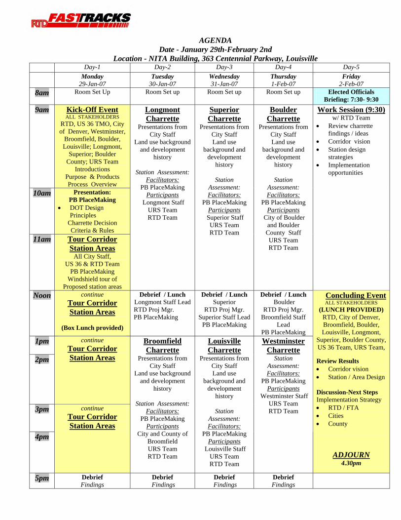
AGENDA Date - January 29th-February 2nd
Location - NITA Building, 363 Centennial Parkway, Louisville Day-1 Day-2 Day-3 Day-4 Day-5 Monday
29-Jan-07 Tuesday
30-Jan-07 Wednesday 31-Jan-07
Thursday 1-Feb-07
Friday 2-Feb-07
8am Room Set Up
Room Set up
Room Set up
Room Set up
Elected Officials Briefing: 7:30- 9:30
9am
Kick-Off Event ALL STAKEHOLDERS
RTD, US 36 TMO, City of Denver, Westminster,
Broomfield, Boulder, Louisville; Longmont,
Superior; Boulder County; URS Team
Introductions Purpose & Products Process Overview
10am
Presentation: PB PlaceMaking
• DOT Design Principles
Charrette Decision Criteria & Rules
11am
Tour Corridor Station Areas
All City Staff, US 36 & RTD Team
PB PlaceMaking Windshield tour of
Proposed station areas
Longmont Charrette
Presentations from City Staff
Land use background and development
history
Station Assessment: Facilitators:
PB PlaceMaking Participants
Longmont Staff URS Team RTD Team
Superior Charrette
Presentations from City Staff Land use
background and development
history
Station Assessment: Facilitators:
PB PlaceMaking Participants
Superior Staff URS Team RTD Team
Boulder Charrette
Presentations from City Staff Land use
background and development
history
Station Assessment: Facilitators:
PB PlaceMaking Participants
City of Boulder and Boulder County Staff URS Team RTD Team
Work Session (9:30) w/ RTD Team
• Review charrette findings / ideas
• Corridor vision • Station design
strategies • Implementation
opportunities
Noon continue Tour Corridor Station Areas
(Box Lunch provided)
Debrief / Lunch Longmont Staff Lead RTD Proj Mgr. PB PlaceMaking
Debrief / Lunch Superior
RTD Proj Mgr. Superior Staff Lead
PB PlaceMaking
Debrief / Lunch Boulder
RTD Proj Mgr. Broomfield Staff
Lead PB PlaceMaking
1pm 2pm
continue Tour Corridor Station Areas
3pm
4pm
continue Tour Corridor Station Areas
Broomfield Charrette
Presentations from City Staff
Land use background and development
history
Station Assessment: Facilitators:
PB PlaceMaking Participants
City and County of Broomfield URS Team RTD Team
Louisville Charrette
Presentations from City Staff Land use
background and development
history
Station Assessment: Facilitators:
PB PlaceMaking Participants
Louisville Staff URS Team RTD Team
Westminster Charrette
Station Assessment: Facilitators:
PB PlaceMaking Participants
Westminster Staff URS Team RTD Team
Concluding EventALL STAKEHOLDERS
(LUNCH PROVIDED) RTD, City of Denver, Broomfield, Boulder, Louisville, Longmont,
Superior, Boulder County, US 36 Team, URS Team,
Review Results • Corridor vision • Station / Area Design
Discussion-Next Steps Implementation Strategy • RTD / FTA • Cities • County
ADJOURN 4.30pm
5pm Debrief Findings
Debrief Findings
Debrief Findings
Debrief Findings
Appendix B:
Bus Rapid Transit In The US 36 Corridor
ii
Bus Rapid Transit in the US 36 Corridor: TOD Opportunities and Challenges 2 of 9
Table of Contents Introduction and Purpose ................................................................................................ 3 BRT: A Continuum of Choices (Not All Good for TOD) .............................................. 3 Summary of BRT-Related TOD Experiences................................................................. 4 Strategies for Successful TOD........................................................................................ 5 US 36 Corridor BRT Considerations.............................................................................. 6 Summary and Conclusions ............................................................................................. 8 References....................................................................................................................... 9
Bus Rapid Transit in the US 36 Corridor: TOD Opportunities and Challenges 3 of 9
Introduction and Purpose
This paper will review industry experience regarding transit oriented development (TOD) involving various types of BRT and will apply the lessons learned from this experience to the proposed BRT in the US 36 Corridor. Specifically, the paper will evaluate the features of the planned BRT in this corridor and will discuss limitations, opportunities and challenges regarding the potential for TOD.
BRT as currently envisioned in the corridor will afford significant travel time savings as well as “show up and go” service convenience that will be competitive with auto travel along US 36. The planned commuter rail service along this corridor will also greatly enhance public transportation’s attractiveness. For many, commuter rail could be the preferred option over BRT among this new portfolio of public transportation quality improvements. However, TOD and development issues especially are driven by other factors than those that determine service demand. The relationship between expected ridership and TOD opportunities will also be addressed below.
This white paper comprises four parts. The first reviews the range of technologies and choices that this emerging mode of BRT represents, as well as how well suited those service aspects are as catalysts for TOD. The second part reviews industry experience with respect to BRT and TOD, discussing results to date for systems in this country. The most relevant aspects of this experience to conditions on the US 36 Corridor will be given the greatest emphasis. The third will cover the industry literature’s principles for good BRT TOD strategy. These have a great deal of overlap with the principles of good TOD practice involving light rail and commuter rail—but also have key differences. Finally, corridor-specific considerations will be addressed.
BRT: A Continuum of Choices (Not All Good for TOD)
As noted in the industry literature (FTA, 2004), BRT represents a continuum of choices regarding public transportation service design, and not all of them are particularly suited to achieving TOD success. For example, at the low end of the continuum (lowest in cost and simplest to implement) is arterial-based BRT, such as the Metro Rapid service in Los Angeles or the San Pablo Rapid in Oakland, California. These systems, while achieving significant net ridership gains in the corridors they service, have little if any TOD along them. One reason for this is that there is little data documenting the effects of BRT on retail sales or small-scale commercial opportunities along corridors. Nor are there policies to create such development.
However, there are BRT operations that run in dedicated busways, and create a sense of place and passenger amenities equal to the quality of light rail or commuter rail services. These systems offer many opportunities for TOD. Beginning with the “Pedestrian malls” as they are known in the U.S. or “car free streets” as they are known in many European cities have for decades shown success in attracting development. Examples include the Nicolet Mall in downtown Minneapolis and the 16th Street Mall Shuttle in Denver. Initially served by buses, transit malls in Long Beach, CA and Portland, OR have attracted significant TOD, particularly in office and commercial uses.
Bus Rapid Transit in the US 36 Corridor: TOD Opportunities and Challenges 4 of 9
Now both are also served by light rail, further enhancing their transportation and economic effectiveness.
Another example of the connections among quality bus transportation, pedestrian access and TOD is the network of busways that have served Pittsburgh commuters since the 1980s. According to the planning department of the Port Authority of Allegheny County (Wohlwill, 2006), more than $400 million in development has been generated near the city’s busways. However, city officials call this development “transit adjacent but not transit oriented.” Yet it is considered TOD as defined by industry methodologies; namely, development within a half a mile of a transit facility (Cervero, et als., 2004).
Summary of BRT-Related TOD Experiences
U.S. TOD strategies for BRT seem to emulate the principles of rail-based strategies, particularly those of light rail. Perhaps the most comprehensive set of case histories and analyses on TOD yet published is TCRP Report 102 (Cervero et als., 2004), Transit-Oriented Development in the United States: Experiences, Challenges and Prospects. This 145-agency survey found that only 8% of TOD in the U.S. was bus-related, including not only that involving BRT, but also intermodal terminals and park-and-ride facilities. This is not because BRT is inferior as a generator of TOD; rather, these results are more likely because BRT is such a new mode that data regarding it is limited, particularly on TOD. Such a survey conducted in 1980 would likely find a very different result for light rail than what it does today. Twenty years ago, light rail was beginning and most TOD was documented around heavy rail investments.
However, there are several early examples that suggest that not only is TOD possible with BRT, it can be and has been successfully achieved. The few experiences cited above suggest that the median market value generated by BRT is roughly half that generated around rail transit facilities. Even so, these results have been generated at a cost of half to one-fourth that of LRT systems (GAO, 2001).
Several BRT systems that have opened or will soon open have generated TOD in anticipation of revenue service. They include the Los Angeles Orange Line opened in October 2005 and the Boston Silver Line opened in July 2002.
The Los Angeles TOD experience with BRT has only begun with the advent of the Orange Line service. The Orange Line is a 14-mile $350 million project (not counting the land acquisition costs of the 13 miles of former railroad right-of-way) that opened in October 2005. The Los Angeles County Metropolitan Transportation Authority, which owns and operates the system, has branded it the first “rubber tired rapid transit line” in its rail network. Similar to its rail network elsewhere in the county, TOD has begun near the Orange Line’s North Hollywood terminus, though it is unclear whether the BRT project or the Red Line Subway nearby is more responsible for the development.
In the area where the two lines are separated by Lankershim Boulevard, a major commercial artery in North Hollywood, a $200 mixed-use development called NoHo Commons is underway. It comprises 438 apartments, more than 200 loft-type condominiums and more than 60,000 square feet of retail space. In addition, a request for qualifications was issued in the fall of 2007 to award development rights for a 10 acre site nearby, which could build out to nearly two million square feet of mixed use.
Bus Rapid Transit in the US 36 Corridor: TOD Opportunities and Challenges 5 of 9
The $200 million No Ho Commons in Los Angeles is near both the North Hollywood Station on the Red Line heavy rail and the terminus of the Orange Line BRT.
Mixed use development on Washington Street along Boston’s Silver Line BRT, part of $700 million in development to date.
Several other factors in Los Angeles have stimulated development not only in this area but around rapid transit stations throughout its network. First is an extremely hot real estate market in Southern California. The second is a revised master plan created by the Los Angeles County Redevelopment Agency that encourages TOD. Finally, the site in North Hollywood and indeed most if not all the others for which TOD has successfully taken hold in Los Angeles affords good pedestrian circulation with a growing number of theaters and restaurants, broad sidewalks and good crosswalk facilities and good pedestrian access to both Orange and Red Line stations.
In Boston, the Massachusetts Bay Transit Authority (MBTA) has calculated that more than $700 million in TOD has been generated to date adjacent to its Silver Line
BRT. The project cost $600 million in its first two phases ($50 million in its initial phase). It also doubled corridor ridership (Henke, 2002).
Strategies for Successful TOD
As the 2004 TCRP pointed out, most strategies for successful TOD can be employed regardless of transit investment chosen and are appropriate for the US 36 Corridor. Whether BRT or rail investment, the permanence of the transit infrastructure as well as the policies put into place to encourage and support TOD factor into the eventual success of generating TOD at a given site.
In fact, a recent survey of developers conducted by Kittleson & Associates for the update of TCRP Report 90, part 2, BRT Planning: Policy and Implementation Guidelines, found that these features, particularly the permanence of the infrastructure, was much
Bus Rapid Transit in the US 36 Corridor: TOD Opportunities and Challenges 6 of 9
Ottowa provides a good illustration of how pedestrian bridges can help serve TOD.
more important to developers than the projected ridership levels of a BRT service, the “wallets and eyeballs: that generate retailer interest,” as one financial consultant put it. (Danaher, 2006)
Another important factor is to establish a planning vision and TOD-supportive policies early and to engage stakeholders early at target sites. To make development “transit oriented” and not just “adjacent,” the station design must make pedestrian access as easy as possible. Policies to promote greater densities and developer incentives must also be implemented as early as possible, and coordination among governmental agencies is also important (Cervero, et als. 2004). The following will discuss several challenges and considerations specific to the US 36 Corridor.
US 36 Corridor BRT Considerations
While the TOD considerations for the BRT facilities may largely be the same as for the commuter rail along the corridor, there are also important differences. Those that are the same involve creating “places” with strong pedestrian attractions, creating centers of activity that are incentives for people to come there independent of their choice of travel mode, and beyond a single shopping or work destination that closes after certain hours.
Commuter rail and BRT in the US 36 Corridor face the same pedestrian access challenges that will limit the potential for TOD but for different reasons. As was noted in the stakeholder meetings of December 2006, commuter rail’s pedestrian access will be limited over- or underpasses and at-grade road crossings because of the need for safety fencing separating freight and passenger operations in the corridor. The BRT facilities initial location off of slip ramps, then Phase II location in the median of the highway could restrict TOD since accessibility and connectivity is limited to pedestrian bridges.
This is precisely the situation BRT planners faced in Ottawa, Pittsburgh, and Phoenix, all of which are higher-speed transit bus facilities either exclusive or semi-exclusive from higher-speed roadway traffic. How officials in each case met the
pedestrian access challenges determined in large part the success of TOD. As such, they have relevance to the US 36 Corridor.
In Ottawa, planning officials met with owners of the Saint Laurent Mall and other major commercial developments to discuss access issues with Ottawa’s Transitway. Developers there saw the advantages of providing access on their property to the Transitway’s in-line
Bus Rapid Transit in the US 36 Corridor: TOD Opportunities and Challenges 7 of 9
stations via pedestrian bridges and extending build-out of their property to walkable distances between their developments and Transitway stations. Today, the mall is the highest grossing in the region, and many officials there attribute at least some of this success to the outreach and coordination between transit planners and the development community. (Bonsall, 2005)
In Pittsburgh, while development near the busways has happened, officials cite pedestrian access and zoning densities in neighborhoods adjacent to select busway stations as important next steps to generating “transit oriented” and not just “transit adjacent” development in these locations. These steps will involve construction of pedestrian bridges as walkways to adjacent neighborhoods, the kinds of measures contemplated in station designs for the US 36 Corridor. (Wohlwill, 2006)Along Pittsburgh’s busways, 54 developments with a market value of more then $500 million were built between 1983 and 1996. The developments comprise both new construction and renovations of existing buildings, with retail, office and residential uses being the most common types. This development has continued, as officials have documented another $200 million in completed projects since 1996, with more planned or underway.
However, Pittsburgh officials believe that the full potential of TOD has yet to be realized, particularly on the East Busway. They would rather have considered TOD strategies earlier in the development of the busways, ideally in the planning phase. As one official put it, the developments realized to date have been “transit adjacent but not transit oriented.” For example, they lack sufficient pedestrian access between many of the transit stations and neighborhoods nearby. (Wohlwill, 2006)
In Phoenix, the outlying suburban stations in the city’s Rapid BRT program consist of park and ride facilities. These face the same challenges found in any express bus park and ride program; namely, that of low-density development around the stations with minimal development other than light commercial and residential uses typical of the Sunbelt in the suburbs. The downtown stations are located on major arterials with minimal architectural treatment. In short, little TOD has been generated because planners there have simply not bothered. Efficiency and speed of vehicle movement has been a higher priority than creating station designs that provide more walkable connections to surrounding neighborhoods.
Where it is appropriate to retain existing mall shuttles and other circulators, they should be adapted to service the new BRT service. Two approaches, while not part of the current BRT plans, could be implemented in the future as additional enhancements. The first is to include real-time passenger information systems on mall shuttles and/or in the malls themselves to help increase ease of BRT service use. In London and other places, such real-time information—which can even include advertising to help pay for the cost of such systems—have been very popular with retail establishments, because by giving patrons exact information on the BRT service they are able to shop longer.
The second is more complicated, which is to interconnect commercial centers off the BRT fixed guideway (in this case US 36) with the BRT service by running on the BRT busway for several stops, then exiting the facility to serve other commercial centers off the guideway. The service could then return to the guideway in either direction. Although not commonly used in this country, this more complicated service plan is used in successful systems in other nations, including Brisbane, Australia, Leeds, England and Bogota, Columbia. (Henke, 2006) This service strategy could be branded as part of the

Bus Rapid Transit in the US 36 Corridor: TOD Opportunities and Challenges 8 of 9
US 36 BRT brand (for example, creation of a “US 36 shoppers loop’ that runs in staggered timetable with the rest of the BRT service).”
Strong branding and outreach are also important to non-users of the BRT system, particularly developers and others interested in TOD. Branding is important to convey the sense of difference between BRT and more conventional bus service. Because BRT is less well known, particularly in cities such as Denver which has had success with both rail and bus-based modes, this difference will become important to the success of any TOD strategy. As with other types of major transit investments, BRT attracts customers because of its ease of use and convenience (Henke, 2006).
Summary and Conclusions
TOD is possible with BRT, though such experience is less prevalent and less well known than development involving rail-based modes. Moreover, the median market value of the TOD generated by a typical BRT investment tends to be one-half of the median value of development generated by rail systems. This may be the result of only having a few examples to pull from. As the implementation of BRT expands in the future, additional research on TOD should be conducted to gather more concrete findings.
The factors that contribute to the success of BRT-based TOD are largely the same as those that account for TOD success with rail-based modes; namely, the more permanent the infrastructure and policy commitment needed to foster TOD, the greater the return on those transit investments. In addition, the underlying health of the economy and the condition of the local real estate market as well as the “sense of place” created by good pedestrian amenities and access are also essential factors in the success of TOD, whether the mode involved is bus or rail-based.
As shown in many places, however, BRT does have one advantage over its rail counterparts: its flexibility can enable cities and towns to extend the catchment areas of the transit investments by creating small changes to the BRT service plan to tie neighborhood-scale developments together, particularly when policies have been put into place to encourage pedestrian friendly development.
Finally, it is important to understand that while TOD contributes to higher corridor transit ridership, such patronage is probably not the most important factor in generating TOD opportunities, except perhaps for foot-traffic-oriented retail. Accordingly, policy makers and planners should consider economic development impacts as a separate issue from ridership effects. In many cases, the best locations for transit patrons may not afford the most ideal “sense of place” that TOD seeks to create. The needs for transit must be balanced with future redevelopment.
Bus Rapid Transit in the US 36 Corridor: TOD Opportunities and Challenges 9 of 9
References Bonsall J. (2005), “BRT Characteristics: An Overview,” presentation at the American Society of Civil Engineers and Institute of Transportation Engineers Workshop on Bus Rapid Transit, Las Vegas, April. Cervero et als. (2004), Transit-Oriented Development in the United States: Experiences, Challenges and Prospects.TCRP Report 102, Washington DC, Transportation Research Board. Danaher A (2006), cited in Federal Transit Administration and WestStart-CALSTART, Proceedings of the BRT Vehicle Working Group and Action Plan for BRT Vehicles, Pasadena, California, WestStart-CALSTART. Federal Transit Administration (2004), Characteristics of Bus Rapid Transit for Decision-Makers, Washington, DC, Federal Transit Administration. Henke C. (2004), “Prospects for Applying Public-Private Partnerships for U.S. Bus Service Delivery,” paper presented at the American Public Transportation Association Bus and Paratransit Conference, Minneapolis, Minnesota, May. Henke C. (2006), Route Structure Strategies in Bus Rapid Transit Service Delivery,” paper presented at the American Public Transportation Association Bus and Paratransit Conference, Anaheim, California, May. Levinson H., et als. (2006), “Bus Rapid Transit Plans in New York’s Capital District,” Journal of Public Transportation, 9, 3, Summer (special BRT edition). Wohlwill, D.E. (2004), “Results of Pittsburgh’s Busways,” presentation at the Transportation Research Board-American Public Transportation Association Conference on Bus Rapid Transit, Denver, Colorado, May.
Appendix C:
US 36 Economic Findings and
Recommendations
iii
US 36 Corridor Study: Economic Conditions and Recommendations
1
US 36 BRT and Northwest Rail Development Oriented Transit Analysis
June 2007
Economic Findings and Recommendations This memorandum describes Strategic Economics’ observations about market conditions and TOD opportunities on the US 36 commuter rail and bus rapid transit corridors. The observations in this memo follow a one-week charrette process hosted by RTD and led by PB PlaceMaking which was held January 28 to February 2, 2007. The analysis is based on a tour of the corridor, conversations with charrette participants, and analysis of economic factors such as employment centers and current market trends.
REGIONAL CONTEXT The long-term demand for TOD in the Denver region is significant. The Center for Transit-Oriented Development (CTOD) estimates that while only 18,000 households lived near Denver’s transit system in 2000, nearly 140,000 households could have a potential demand for housing near transit by 2030. This demand is being generated by the rapid implementation of the FasTracks system, and the consequently improved service and connectivity to a wider variety of places. In November 2006 alone, Denver doubled the size of its transit system by opening the Southeast Corridor. One of the main questions arising from the rapid pace of transit growth and housing demand in Denver is how the housing market will keep pace with the rapidly growing supply of land near the transit system. If cities are not prepared for the demand for new housing near transit stations, growth could occur without planned infrastructure to support it. Conversely, some cities find themselves planning well ahead of development, and wondering where the projects are. The pace of change in Denver’s regional transit system makes it particularly critical for cities to establish station area plans that take advantage of demand for transit-oriented housing types, while preserving the positive characteristics of existing communities. CORRIDOR POSITIONING The extension of transit along the US 36 corridor will influence the market for new development by more fully connecting station areas. The market for land uses at each station will become more integrated through this improved accessibility. Given these new connections, pent-up market demand for housing or commercial development at one station could be accommodated at neighboring stations. This section describes the current market characteristics along the corridor. The focus of this section is to understand how transit, and new relationships between stations, will change the market for transit-oriented development (TOD). Demographic Characteristics The demographic characteristics in each of the US 36 corridor cities will influence the market potential for TOD. Compared with the Denver region, some notable characteristics of the US 36 corridor are: Most cities in the corridor have experienced more rapid growth than the region. While the population in the Denver MSA grew by 30 percent between 1990 and 2000, the US 36 cities grew on an average of 31 percent with highs of 55 percent and 53 percent in Broomfield and Louisville, and a low of 14 percent in Boulder. The population of the City of Denver increased by 19 percent between 1990 and 2000.
US 36 Corridor Study: Economic Conditions and Recommendations
2
The corridor accommodates households with a wide range of income levels. In 2005, Boulder had the lowest median income of the US 36 cities at $46,000, most likely due to the presence of the student population1. Longmont had the second lowest median income, at $51,000, which was lower than the regional median of $55,000. In contrast, Westminster, Broomfield, and Louisville all reported higher median incomes than the region, ranging from $60,000 to $70,000. Though 2005 data is not available for Superior, it enjoyed the highest incomes in the corridor in 2000, leading with a median household income of $82,000. Superior and Boulder have a higher share of renters than the Denver region as a whole. In 2000, only 34 percent of households in the Denver region were renters, compared with 42 percent in Superior, and half of households in Boulder. The tenure mix in Longmont closely resembles the region, while Westminster, Broomfield, and Louisville all have a greater share of owner households. The average household size for most US 36 cities is larger than the regional average. With the exception of Boulder, which again is influenced by its student population, the average household size in US 36 cities exceeded the 2000 regional average of 2.53. Potential for Transit-Oriented Residential Development Although residential growth along much of the US 36 corridor has been historically driven by a demand for lower cost, single-family units, future demand will be for a greater diversity of housing types (rental and ownership), and a range of prices (from workforce to luxury housing). The presence of employment in the corridor will create demand for rental housing, because rental developers generally prefer to build near major job centers. Proximity to major universities including CU-Denver and CU-Boulder will drive the demand from students for rental housing at all stations. Additionally, slow population growth and rising housing prices in Boulder and Denver suggest that these cities have a pent up demand for housing that cannot be accommodated within city limits. In conjunction with the housing demand pressures generated by their own growth control measures, nearby cities will have an opportunity to absorb demand for the more pedestrian-oriented housing types that are currently found in Boulder and Denver. Current Residential Market Condit ions This section evaluates the market for more compact housing types that are compatible with the principles of TOD, with a specific focus on rental units, ownership condominiums, and townhouses. Table 1 shows the median housing sales price per square foot for cities in the US 36 corridor as well as the City of Denver. Presently, Boulder and Louisville command the highest prices for resale housing in the corridor. Prices in Westminster, Broomfield, and Longmont are significantly lower. Table 1: Median Sales Price per Square Foot, All Housing Units Sold Fourth Quarter 2006 Boulder $305 Broomfield $156 Denver $186 Longmont $157 Louisville $206 Westminster $142
Source: DataQuick Real Estate News2 1 Note: A better proxy for non-student income may be the median family (rather than household) income. Boulder’s median family income in 2005 was $76,000, while in Denver it was $67,500. 2 Note: Superior was not included in the available data.
US 36 Corridor Study: Economic Conditions and Recommendations
3
While the median sales price for homes in Denver is lower than Boulder and Louisville, Table 2 shows that the asking price per square foot for new condominiums is equivalent to Boulder. These three communities clearly have the strongest current market potential for condominium units. Though there is limited data on new developments in Louisville, it is clear that the Downtown Louisville station will experience strong immediate pressures for residential TOD given the current competitiveness of the local residential market. Table 2: Profile of New Condominium Units, October 2006 to January 2007
City Number of Projects
Number of Units
Median Unit Size
Median Asking Price per
Square Foot
Boulder 3 768 1,070 $307 Broomfield 3 448 1,366 $172 Denver 31 2,023 1,100 $299 Longmont 2 180 1,261 $128 Louisville 1 66 965 $247 Westminster 7 647 1,292 $147
Source: Hanley Wood, Strategic Economics3 Table 3 shows similar information for new townhouse units in the US 36 corridor. This table shows that Denver, Superior, and Boulder currently command the highest prices per square foot for townhouses, which again reflects the strong market positioning of Denver, Boulder, and the Louisville/Superior area. Broomfield and Westminster have been experiencing rapid development activity over the last 10 years due to the availability of land. In this time these cities have absorbed a large number of housing units including larger format condominiums and townhouses. The lower price per square foot in these areas has been a draw for households that are priced out of Denver but who still wish to purchase a home. Table 3: Profile of New Townhouse Units, October 2006 to January 2007
City Number of Projects Units Median Unit
Size
Median Asking Price per
Square Foot
Broomfield 5 407 1,567 $166 Denver 10 344 1,622 $315 Longmont 2 199 1,325 $146 Superior 1 75 2,177 $245 Boulder 1 N/A 1,200 $208 Westminster 4 380 1,484 $153
Source: Hanley Wood, Strategic Economics4 Investors in apartment buildings tend to look for properties near major employment centers, institutions, and areas that offer urban amenities and entertainment. These criteria make the US 36 corridor ripe for investment in multifamily rental units. With the slowing of the ownership housing market, real estate experts are anticipating that the rental housing market will strengthen and it is
3 Note: Data did not show relevant new projects in Superior. 4 Note: Data did not show relevant new projects in Boulder or Louisville.
US 36 Corridor Study: Economic Conditions and Recommendations
4
likely that the US 36 corridor will be one of the main areas for new multifamily rental housing construction, similar to what is occurring today in the Southeast Corridor. TOD Potential Each station in the corridor has the market potential to attract compact residential development, and the market for residential at each station is strong as a result of the corridor’s unique position connecting two major destinations: Denver and Boulder. Stations with public amenities such as pedestrian-friendly streets, public parks, and retail and services will be able to garner higher prices for residential units and sustain high property values in the long term. Additionally developers will be attracted to these areas because individual projects will require fewer built-in amenities, as a result of providing residents access to shared neighborhood amenities instead. These stations currently include Longmont, 30th & Pearl, and Downtown Louisville, though other stations including 71st & Lowell may be able to achieve a similar critical mass of public amenities. Employment and other nonresidential features of the corridor will drive demand for multifamily rental units at all stations. Stations that will be particularly suited for apartment units, as a result of their close proximity to major job centers and entertainment venues include the Gunbarrel, 30th and Pearl, McCaslin, 116th/US 36, and 71st and Lowell stations.
US 36 Corridor Study: Economic Conditions and Recommendations
5
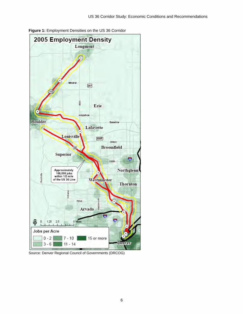
Potential for Transit-Oriented Employment Growth Current Employment Conditions Figure 1 shows the major employment concentrations that currently exist in the US 36 corridor as assessed by DRCOG. The US 36 corridor connects two primary employment and civic nodes: Downtown Denver and Boulder. Additionally the central US 36 Corridor is lined with office parks and other, more dispersed employment centers as a result of growth and development during the dot-com boom. Office, retail, and residential development surged from 1990 to 2000; jobs in the City and County of Broomfield more than tripled from 8,086 to 24,654, and the County’s population increased by more than 50 percent to 38,000. The Interlocken Advanced Technology Environment played a major role in this growth and continues to be a major employment destination today after a much-delayed recovery from the recession of 2001. As a result of this intra-corridor growth, commute patterns in the US 36 Corridor do not reflect a standard “bedroom community” development pattern that is solely, or even primarily, oriented towards the Downtown Denver employment center. Tables 4 and 5 show that many local residents commute within the corridor, rather than commuting to Denver or other employment centers in the region.
US 36 Corridor Study: Economic Conditions and Recommendations
6
Figure 1: Employment Densities on the US 36 Corridor
Source: Denver Regional Council of Governments (DRCOG)
US 36 Corridor Study: Economic Conditions and Recommendations
7
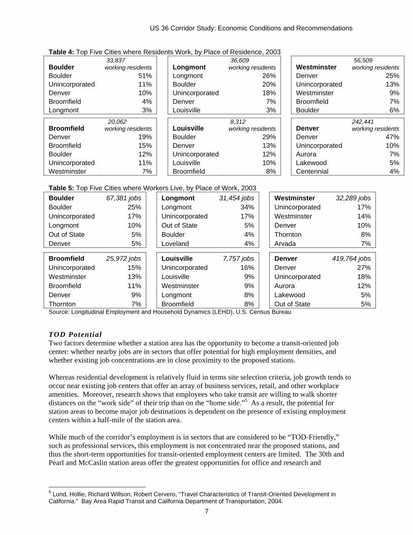
Table 4: Top Five Cities where Residents Work, by Place of Residence, 2003
Boulder 33,837 working residents Longmont
36,609 working residents Westminster
56,509 working residents
Boulder 51% Longmont 26% Denver 25% Unincorporated 11% Boulder 20% Unincorporated 13% Denver 10% Unincorporated 18% Westminster 9% Broomfield 4% Denver 7% Broomfield 7% Longmont 3% Louisville 3% Boulder 6%
Broomfield 20,062 working residents Louisville
8,312 working residents Denver
242,441 working residents
Denver 19% Boulder 29% Denver 47% Broomfield 15% Denver 13% Unincorporated 10% Boulder 12% Unincorporated 12% Aurora 7% Unincorporated 11% Louisville 10% Lakewood 5% Westminster 7% Broomfield 8% Centennial 4% Table 5: Top Five Cities where Workers Live, by Place of Work, 2003 Boulder 67,381 jobs Longmont 31,454 jobs Westminster 32,289 jobs Boulder 25% Longmont 34% Unincorporated 17% Unincorporated 17% Unincorporated 17% Westminster 14% Longmont 10% Out of State 5% Denver 10% Out of State 5% Boulder 4% Thornton 8% Denver 5% Loveland 4% Arvada 7%
Broomfield 25,972 jobs Louisville 7,757 jobs Denver 419,764 jobs Unincorporated 15% Unincorporated 16% Denver 27% Westminster 13% Louisville 9% Unincorporated 18% Broomfield 11% Westminster 9% Aurora 12% Denver 9% Longmont 8% Lakewood 5% Thornton 7% Broomfield 8% Out of State 5% Source: Longitudinal Employment and Household Dynamics (LEHD), U.S. Census Bureau TOD Potential Two factors determine whether a station area has the opportunity to become a transit-oriented job center: whether nearby jobs are in sectors that offer potential for high employment densities, and whether existing job concentrations are in close proximity to the proposed stations. Whereas residential development is relatively fluid in terms site selection criteria, job growth tends to occur near existing job centers that offer an array of business services, retail, and other workplace amenities. Moreover, research shows that employees who take transit are willing to walk shorter distances on the “work side” of their trip than on the “home side.”5 As a result, the potential for station areas to become major job destinations is dependent on the presence of existing employment centers within a half-mile of the station area. While much of the corridor’s employment is in sectors that are considered to be “TOD-Friendly,” such as professional services, this employment is not concentrated near the proposed stations, and thus the short-term opportunities for transit-oriented employment centers are limited. The 30th and Pearl and McCaslin station areas offer the greatest opportunities for office and research and
5 Lund, Hollie, Richard Willson, Robert Cervero, “Travel Characteristics of Transit-Oriented Development in California.” Bay Area Rapid Transit and California Department of Transportation, 2004.
US 36 Corridor Study: Economic Conditions and Recommendations
8
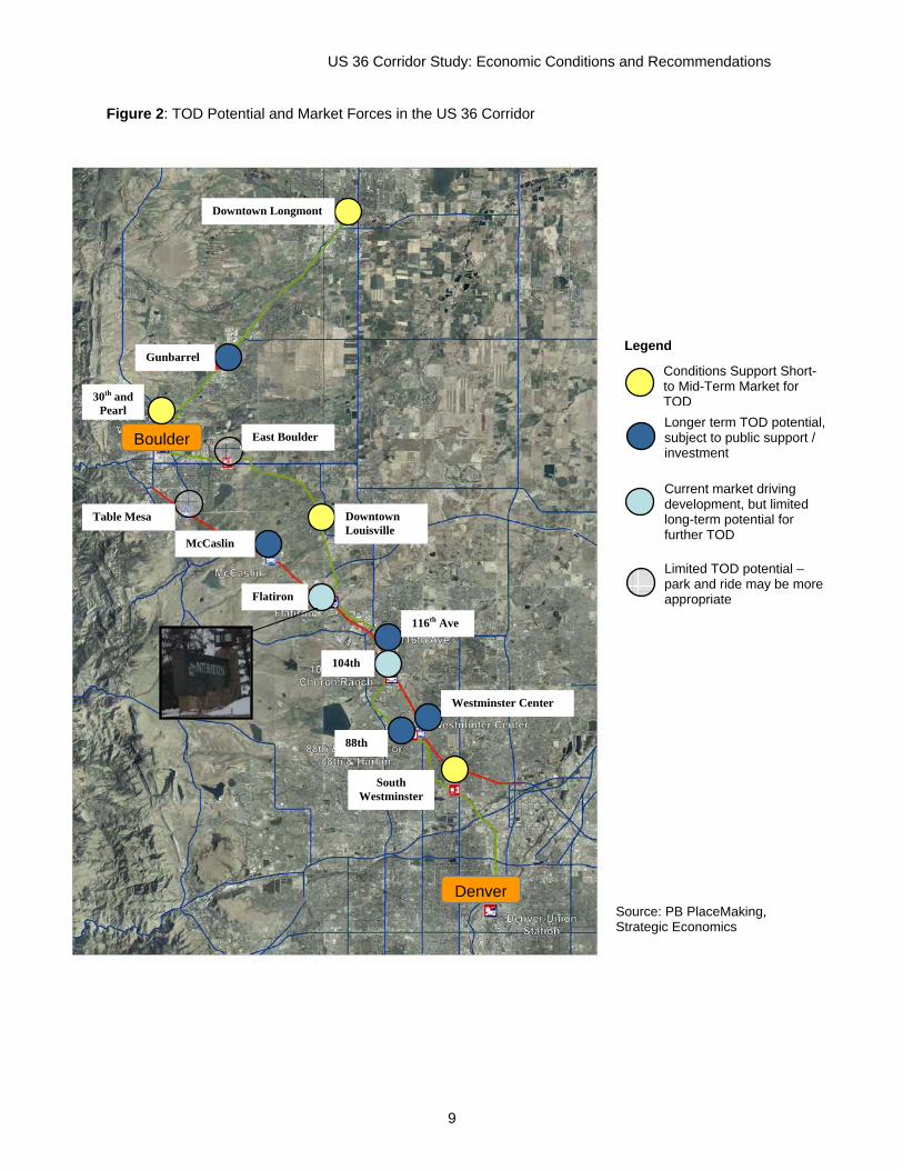
development employment concentrations within walking distance of transit because these areas have some concentrated employment within a quarter mile of the station. Good local bus or shuttle access to the corridor’s other job centers will offer residents and transit users the opportunity to nonetheless reduce their auto commute mode shares. While there are limited studies on the effects of job shuttles on ridership, this additional local transit would provide connections to important regional employment centers such as the Interlocken Advanced Technology Environment. STATION AMENITIES AND TOD POSITIONING Figure 2 shows the general TOD potential for each BRT and rail station on the US 36 corridor. Stations have been classified based on their potential to become fully integrated, transit-oriented districts that extend beyond a single development. Consideration has also been given to the potential phasing of transit-oriented development, based on current market characteristics as described above. The categories of TOD potential are: Conditions support short- to mid-term TOD. Stations include Downtown Longmont, Downtown Louisville, and 71st and Lowell. These stations have the street grid, mix of uses, and/or supportive public policy necessary to create a transit-oriented district. Additionally, residential market pressures in Boulder, Denver, and Louisville are likely to drive compact development at these stations first because they are in close proximity and offer district amenities including a mix of uses, and pedestrian orientation. Longer term TOD potential, subject to public support. Stations include Gunbarrel, McCaslin, 116th Avenue, and Westminster Center/88th. While these stations offer major opportunity sites for new development, they lack the existing pedestrian-friendly street grid and mix of uses necessary to support TOD in the short term. The evolution of these areas as transit-oriented districts is dependent on strong public policy that will encourage future development to fit the design, land use mix, and circulation guidelines necessary to create TOD. Current market driving development, but limited long-term potential for TOD. Stations include Flatiron and 104th/Church Ranch. These areas are experiencing recent development with uses that may be transit-oriented in nature, and may have a significant longer term demand for transit-oriented uses, but they are constrained by the limited opportunity sites remaining for future development. Thus while single development projects may be transit-oriented, the possibility for a full transit-oriented district is unlikely. Limited TOD Potential – park and ride may be more appropriate. Stations include Table Mesa and East Boulder. These stations have limited opportunity sites for future development but can play a key role in the corridor by absorbing more of the parking necessary to support ridership on the BRT and rail lines. As possible parking can be concentrated here, freeing up land at more TOD amenable stations for development rather than parking.
US 36 Corridor Study: Economic Conditions and Recommendations
9
Figure 2: TOD Potential and Market Forces in the US 36 Corridor
Source: PB PlaceMaking, Strategic Economics
Boulder
Denver
Conditions Support Short- to Mid-Term Market for TODLonger term TOD potential, subject to public support / investment
Current market driving development, but limited long-term potential for further TOD
Limited TOD potential – park and ride may be more appropriate
Legend
Downtown Longmont
Gunbarrel
East Boulder
McCaslin
Flatiron
Downtown Louisville
116th Ave
Westminster Center
South Westminster
88th
104th
30th and Pearl
Table Mesa
US 36 Corridor Study: Economic Conditions and Recommendations
10
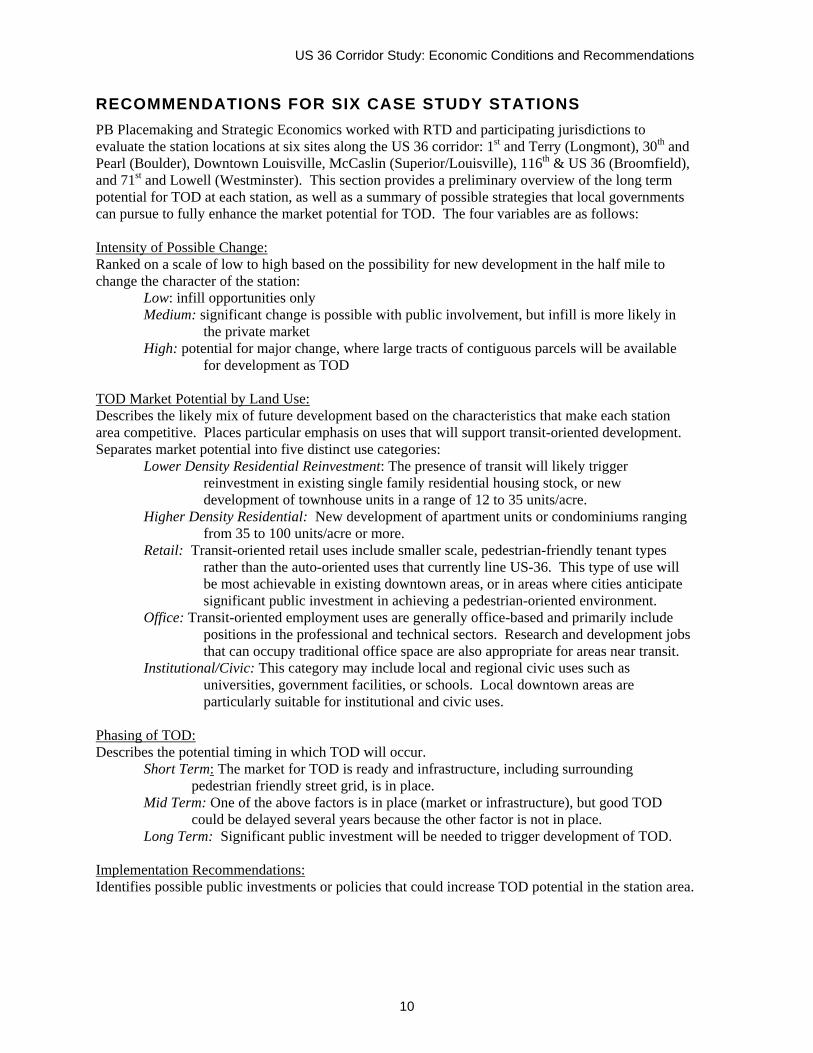
RECOMMENDATIONS FOR SIX CASE STUDY STATIONS PB Placemaking and Strategic Economics worked with RTD and participating jurisdictions to evaluate the station locations at six sites along the US 36 corridor: 1st and Terry (Longmont), 30th and Pearl (Boulder), Downtown Louisville, McCaslin (Superior/Louisville), 116th & US 36 (Broomfield), and 71st and Lowell (Westminster). This section provides a preliminary overview of the long term potential for TOD at each station, as well as a summary of possible strategies that local governments can pursue to fully enhance the market potential for TOD. The four variables are as follows: Intensity of Possible Change: Ranked on a scale of low to high based on the possibility for new development in the half mile to change the character of the station:
Low: infill opportunities only Medium: significant change is possible with public involvement, but infill is more likely in
the private market High: potential for major change, where large tracts of contiguous parcels will be available
for development as TOD TOD Market Potential by Land Use: Describes the likely mix of future development based on the characteristics that make each station area competitive. Places particular emphasis on uses that will support transit-oriented development. Separates market potential into five distinct use categories:
Lower Density Residential Reinvestment: The presence of transit will likely trigger reinvestment in existing single family residential housing stock, or new development of townhouse units in a range of 12 to 35 units/acre.
Higher Density Residential: New development of apartment units or condominiums ranging from 35 to 100 units/acre or more.
Retail: Transit-oriented retail uses include smaller scale, pedestrian-friendly tenant types rather than the auto-oriented uses that currently line US-36. This type of use will be most achievable in existing downtown areas, or in areas where cities anticipate significant public investment in achieving a pedestrian-oriented environment.
Office: Transit-oriented employment uses are generally office-based and primarily include positions in the professional and technical sectors. Research and development jobs that can occupy traditional office space are also appropriate for areas near transit.
Institutional/Civic: This category may include local and regional civic uses such as universities, government facilities, or schools. Local downtown areas are particularly suitable for institutional and civic uses.
Phasing of TOD: Describes the potential timing in which TOD will occur. Short Term: The market for TOD is ready and infrastructure, including surrounding
pedestrian friendly street grid, is in place. Mid Term: One of the above factors is in place (market or infrastructure), but good TOD
could be delayed several years because the other factor is not in place. Long Term: Significant public investment will be needed to trigger development of TOD. Implementation Recommendations: Identifies possible public investments or policies that could increase TOD potential in the station area.
US 36 Corridor Study: Economic Conditions and Recommendations
11
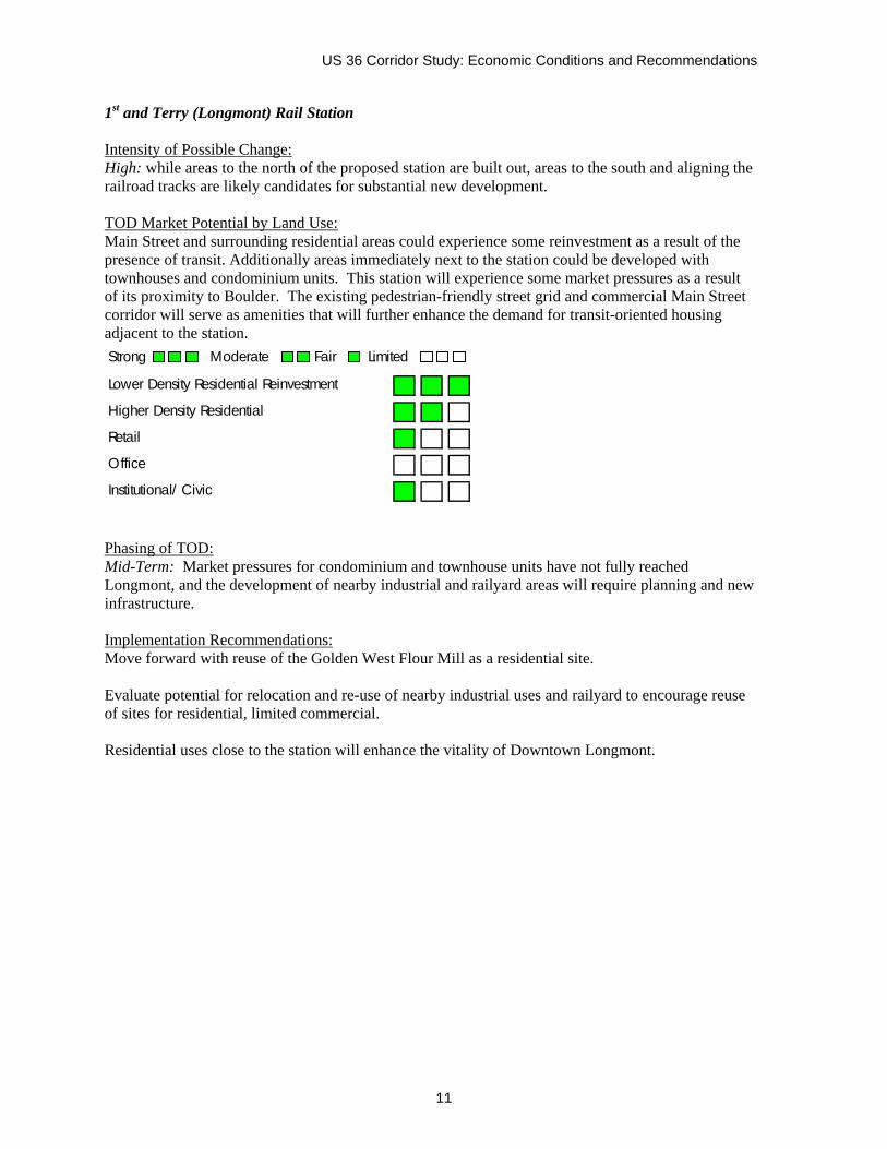
1st and Terry (Longmont) Rail Station Intensity of Possible Change: High: while areas to the north of the proposed station are built out, areas to the south and aligning the railroad tracks are likely candidates for substantial new development. TOD Market Potential by Land Use: Main Street and surrounding residential areas could experience some reinvestment as a result of the presence of transit. Additionally areas immediately next to the station could be developed with townhouses and condominium units. This station will experience some market pressures as a result of its proximity to Boulder. The existing pedestrian-friendly street grid and commercial Main Street corridor will serve as amenities that will further enhance the demand for transit-oriented housing adjacent to the station.
Phasing of TOD: Mid-Term: Market pressures for condominium and townhouse units have not fully reached Longmont, and the development of nearby industrial and railyard areas will require planning and new infrastructure. Implementation Recommendations: Move forward with reuse of the Golden West Flour Mill as a residential site. Evaluate potential for relocation and re-use of nearby industrial uses and railyard to encourage reuse of sites for residential, limited commercial. Residential uses close to the station will enhance the vitality of Downtown Longmont.
Strong Moderate Fair Limited
Lower Density Residential Reinvestment
Higher Density Residential
Retail
Office
Institutional/ Civic
US 36 Corridor Study: Economic Conditions and Recommendations
12
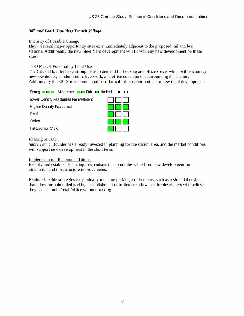
30th and Pearl (Boulder) Transit Village Intensity of Possible Change: High: Several major opportunity sites exist immediately adjacent to the proposed rail and bus stations. Additionally the new Steel Yard development will fit with any new development on these sites. TOD Market Potential by Land Use: The City of Boulder has a strong pent-up demand for housing and office space, which will encourage new townhouse, condominium, live-work, and office development surrounding this station. Additionally the 30th Street commercial corridor will offer opportunities for new retail development.
Phasing of TOD: Short Term: Boulder has already invested in planning for the station area, and the market conditions will support new development in the short term. Implementation Recommendations: Identify and establish financing mechanisms to capture the value from new development for circulation and infrastructure improvements. Explore flexible strategies for gradually reducing parking requirements, such as residential designs that allow for unbundled parking, establishment of in-lieu fee allowance for developers who believe they can sell units/retail/office without parking.
Strong Moderate Fair Limited
Lower Density Residential Reinvestment
Higher Density Residential
Retail
Office
Institutional/ Civic
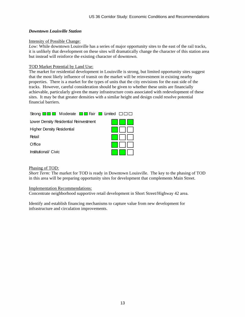
US 36 Corridor Study: Economic Conditions and Recommendations
13
Downtown Louisville Station Intensity of Possible Change: Low: While downtown Louisville has a series of major opportunity sites to the east of the rail tracks, it is unlikely that development on these sites will dramatically change the character of this station area but instead will reinforce the existing character of downtown. TOD Market Potential by Land Use: The market for residential development in Louisville is strong, but limited opportunity sites suggest that the most likely influence of transit on the market will be reinvestment in existing nearby properties. There is a market for the types of units that the city envisions for the east side of the tracks. However, careful consideration should be given to whether these units are financially achievable, particularly given the many infrastructure costs associated with redevelopment of these sites. It may be that greater densities with a similar height and design could resolve potential financial barriers.
Phasing of TOD: Short Term: The market for TOD is ready in Downtown Louisville. The key to the phasing of TOD in this area will be preparing opportunity sites for development that complements Main Street. Implementation Recommendations: Concentrate neighborhood supportive retail development in Short Street/Highway 42 area. Identify and establish financing mechanisms to capture value from new development for infrastructure and circulation improvements.
Strong Moderate Fair Limited
Lower Density Residential Reinvestment
Higher Density Residential
Retail
Office
Institutional/ Civic
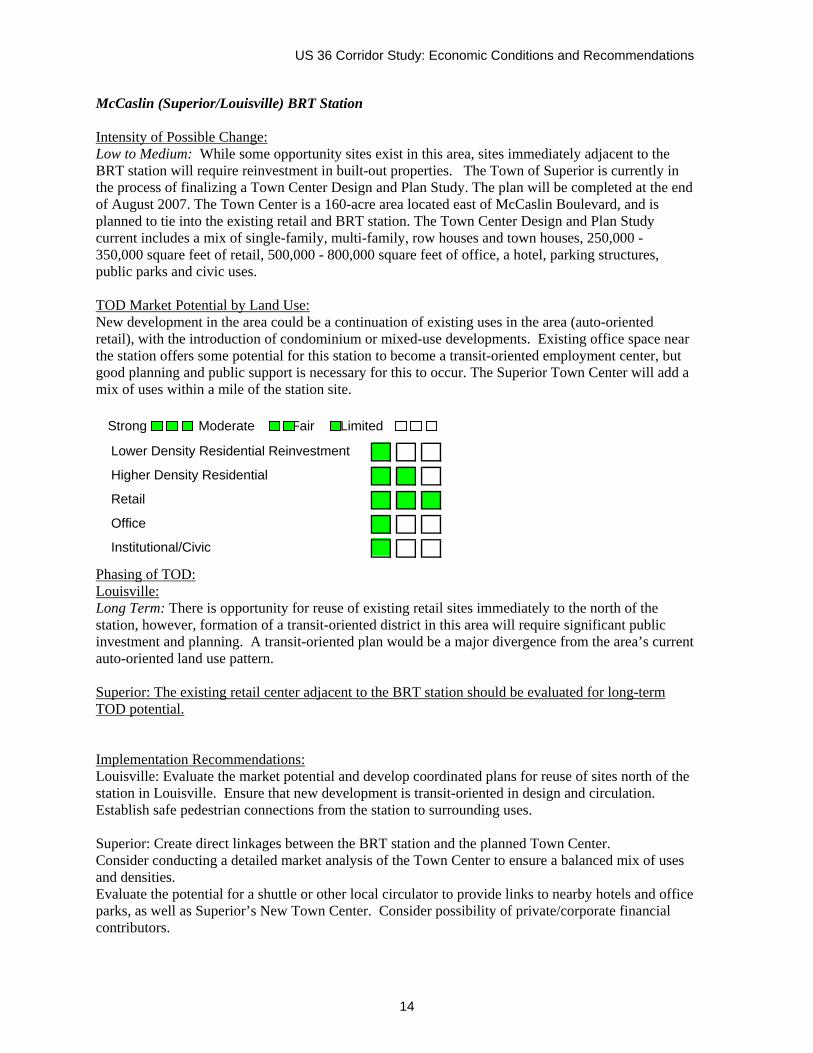
US 36 Corridor Study: Economic Conditions and Recommendations
14
McCaslin (Superior/Louisville) BRT Station Intensity of Possible Change: Low to Medium: While some opportunity sites exist in this area, sites immediately adjacent to the BRT station will require reinvestment in built-out properties. The Town of Superior is currently in the process of finalizing a Town Center Design and Plan Study. The plan will be completed at the end of August 2007. The Town Center is a 160-acre area located east of McCaslin Boulevard, and is planned to tie into the existing retail and BRT station. The Town Center Design and Plan Study current includes a mix of single-family, multi-family, row houses and town houses, 250,000 - 350,000 square feet of retail, 500,000 - 800,000 square feet of office, a hotel, parking structures, public parks and civic uses. TOD Market Potential by Land Use: New development in the area could be a continuation of existing uses in the area (auto-oriented retail), with the introduction of condominium or mixed-use developments. Existing office space near the station offers some potential for this station to become a transit-oriented employment center, but good planning and public support is necessary for this to occur. The Superior Town Center will add a mix of uses within a mile of the station site. Phasing of TOD: Louisville: Long Term: There is opportunity for reuse of existing retail sites immediately to the north of the station, however, formation of a transit-oriented district in this area will require significant public investment and planning. A transit-oriented plan would be a major divergence from the area’s current auto-oriented land use pattern. Superior: The existing retail center adjacent to the BRT station should be evaluated for long-term TOD potential. Implementation Recommendations: Louisville: Evaluate the market potential and develop coordinated plans for reuse of sites north of the station in Louisville. Ensure that new development is transit-oriented in design and circulation. Establish safe pedestrian connections from the station to surrounding uses. Superior: Create direct linkages between the BRT station and the planned Town Center. Consider conducting a detailed market analysis of the Town Center to ensure a balanced mix of uses and densities. Evaluate the potential for a shuttle or other local circulator to provide links to nearby hotels and office parks, as well as Superior’s New Town Center. Consider possibility of private/corporate financial contributors.
Strong Moderate Fair Limited
Lower Density Residential Reinvestment
Higher Density Residential
Retail
Office
Institutional/Civic
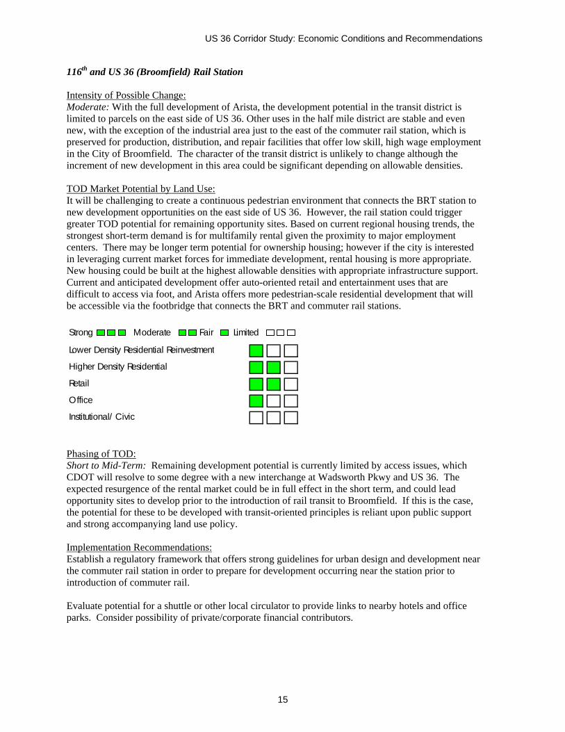
US 36 Corridor Study: Economic Conditions and Recommendations
15
116th and US 36 (Broomfield) Rail Station Intensity of Possible Change: Moderate: With the full development of Arista, the development potential in the transit district is limited to parcels on the east side of US 36. Other uses in the half mile district are stable and even new, with the exception of the industrial area just to the east of the commuter rail station, which is preserved for production, distribution, and repair facilities that offer low skill, high wage employment in the City of Broomfield. The character of the transit district is unlikely to change although the increment of new development in this area could be significant depending on allowable densities. TOD Market Potential by Land Use: It will be challenging to create a continuous pedestrian environment that connects the BRT station to new development opportunities on the east side of US 36. However, the rail station could trigger greater TOD potential for remaining opportunity sites. Based on current regional housing trends, the strongest short-term demand is for multifamily rental given the proximity to major employment centers. There may be longer term potential for ownership housing; however if the city is interested in leveraging current market forces for immediate development, rental housing is more appropriate. New housing could be built at the highest allowable densities with appropriate infrastructure support. Current and anticipated development offer auto-oriented retail and entertainment uses that are difficult to access via foot, and Arista offers more pedestrian-scale residential development that will be accessible via the footbridge that connects the BRT and commuter rail stations. Strong Moderate Fair Limited
Lower Density Residential Reinvestment
Higher Density Residential
Retail
Office
Institutional/ Civic Phasing of TOD: Short to Mid-Term: Remaining development potential is currently limited by access issues, which CDOT will resolve to some degree with a new interchange at Wadsworth Pkwy and US 36. The expected resurgence of the rental market could be in full effect in the short term, and could lead opportunity sites to develop prior to the introduction of rail transit to Broomfield. If this is the case, the potential for these to be developed with transit-oriented principles is reliant upon public support and strong accompanying land use policy. Implementation Recommendations: Establish a regulatory framework that offers strong guidelines for urban design and development near the commuter rail station in order to prepare for development occurring near the station prior to introduction of commuter rail. Evaluate potential for a shuttle or other local circulator to provide links to nearby hotels and office parks. Consider possibility of private/corporate financial contributors.
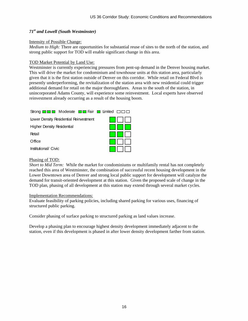
US 36 Corridor Study: Economic Conditions and Recommendations
16
71st and Lowell (South Westminster) Intensity of Possible Change: Medium to High: There are opportunities for substantial reuse of sites to the north of the station, and strong public support for TOD will enable significant change in this area. TOD Market Potential by Land Use: Westminster is currently experiencing pressures from pent-up demand in the Denver housing market. This will drive the market for condominium and townhouse units at this station area, particularly given that it is the first station outside of Denver on this corridor. While retail on Federal Blvd is presently underperforming, the revitalization of the station area with new residential could trigger additional demand for retail on the major thoroughfares. Areas to the south of the station, in unincorporated Adams County, will experience some reinvestment. Local experts have observed reinvestment already occurring as a result of the housing boom.
Phasing of TOD: Short to Mid Term: While the market for condominiums or multifamily rental has not completely reached this area of Westminster, the combination of successful recent housing development in the Lower Downtown area of Denver and strong local public support for development will catalyze the demand for transit-oriented development at this station. Given the proposed scale of change in the TOD plan, phasing of all development at this station may extend through several market cycles. Implementation Recommendations: Evaluate feasibility of parking policies, including shared parking for various uses, financing of structured public parking. Consider phasing of surface parking to structured parking as land values increase. Develop a phasing plan to encourage highest density development immediately adjacent to the station, even if this development is phased in after lower density development farther from station.
Strong Moderate Fair Limited
Lower Density Residential Reinvestment
Higher Density Residential
Retail
Office
Institutional/ Civic