notes on an expedition to the headwaters of the maú...
TRANSCRIPT

MINISTÉRIO DA CIÊNCIA E TECNOLOGIA
INSTITUTO NACIONAL DE PESQUISAS DA AMAZÔNIA CORDENAÇÃO DE PESQUISAS EM ECOLOGIA
NÚCLEO DE PESQUISAS EM RORAIMA
Notes on an Expedition to the Headwaters of the
Maú (Ireng) River, Roraima, Brazil Reinaldo Imbrozio Barbosa (*) Instituto Nacional de Pesquisas da Amazônia Núcleo de Pesquisas de Roraima Caixa Postal 96 69301-970 Boa Vista/Roraima/Brasil Fax/fone : 55-095-623 9433 [email protected] Sebastião Pereira do Nascimento Museu Integrado de Roraima Av. Brigadeiro Eduardo Gomes sno/Parque Anauá 69300-000 Boa Vista/Roraima/Brasil Fone : 55-095-623 1733 [email protected] Ari Alfredo Weiduschat Fundação Nacional de Saúde/RR Distrito Sanitário Yanomami Av. Ene Garcez no 1636 69304-000 Boa Vista/Roraima/Brasil Fone : 55-095-224 4786 Fábio Bonatto Prefeitura Municipal de Boa Vista Empresa Municipal de Urbanismo Rua Coronel Pinto no 485 - Centro 69310-150 Boa Vista/Roraima/Brasil Fone : 55-095-623 1708 (*) corresponding author
2
Abstract
Between the 21st and 28th of January 1996, we undertook a scientific expedition
to the headwaters of the Maú (or Ireng) River, which marks the natural frontier between
Brazil and Guyana in the north of South America. Our aim was to observe physical
geography, human populations, climate, soils, fauna and flora, checking informations
and collecting biological material from this Amazon frontier region which embraces a
overlap between the Monte Roraima National Park and Raposa/Serra do Sol Indian
Land, in the State of Roraima, Brazil. The accumulation of information, can offer a basis
for future scientific activities, in preservation/conservation in this part of the Amazonia.
The Area Under Study
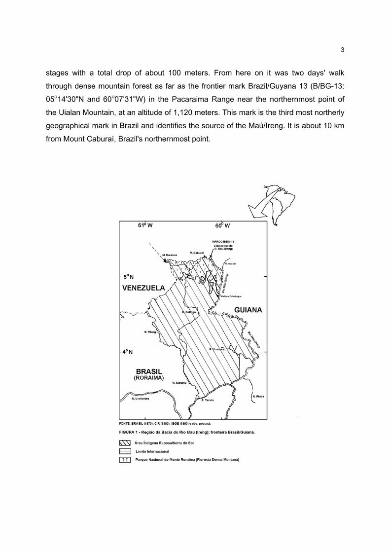
The Maú/Ireng River basin drains a great part of the frontier between Brazil and
Guyana (FIGURE 1). Its main tributaries are the Uialan and Canã rivers on the Brazilian
side and the Cacó, Dacã and Socobi rivers on the Guyanese side. All of these drain into
the upper and middle reaches of the Maú and flow over very ancient terrain formed by
tectonic structures and protozoic sedimentary rocks belonging to the Roraima
Supergroup (Guyana Shield). The waters of the Maú have a dark coloration which
reminds one of the Rio Negro near Manaus, in the State of Amazonas (Brazil). In the
region under observation, the river runs through valleys between mountain ranges
which vary in altitude from 600 to 1,200 meters.
The starting point for our expedition was the Indian Village of Orinduik
(04o45'31"N and 60o01'59"W). Inhabited by Macuxi Indians, it is situated on the banks of
the river within the indigenous area Raposa/Serra do Sol which is at present being
delimitated. This spot is near the Orinduik Falls (altitude 580 m) which we considered as
marking the beginning of the upper course of the Maú. From here on it was necessary
to go upstream by boat for a day and a half passing over 18 rapids. This stage ended at
the frontier mark Brazil-5 (B-5: 05o04'11"N and 59o58'47"W), at the confluence of the
Maú and the Socobi at an altitude of about 650 meters. The B-5 mark is near the
Cachoeira do Grande Caracol or Great Snail Falls (Kurutuwu Mehru), a waterfall in two
3
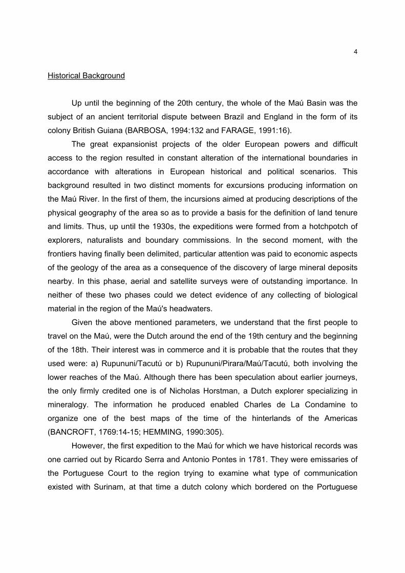
stages with a total drop of about 100 meters. From here on it was two days' walk
through dense mountain forest as far as the frontier mark Brazil/Guyana 13 (B/BG-13:
05o14'30"N and 60o07'31"W) in the Pacaraima Range near the northernmost point of
the Uialan Mountain, at an altitude of 1,120 meters. This mark is the third most northerly
geographical mark in Brazil and identifies the source of the Maú/Ireng. It is about 10 km
from Mount Caburaí, Brazil's northernmost point.
4
Historical Background
Up until the beginning of the 20th century, the whole of the Maú Basin was the
subject of an ancient territorial dispute between Brazil and England in the form of its
colony British Guiana (BARBOSA, 1994:132 and FARAGE, 1991:16).
The great expansionist projects of the older European powers and difficult
access to the region resulted in constant alteration of the international boundaries in
accordance with alterations in European historical and political scenarios. This
background resulted in two distinct moments for excursions producing information on
the Maú River. In the first of them, the incursions aimed at producing descriptions of the
physical geography of the area so as to provide a basis for the definition of land tenure
and limits. Thus, up until the 1930s, the expeditions were formed from a hotchpotch of
explorers, naturalists and boundary commissions. In the second moment, with the
frontiers having finally been delimited, particular attention was paid to economic aspects
of the geology of the area as a consequence of the discovery of large mineral deposits
nearby. In this phase, aerial and satellite surveys were of outstanding importance. In
neither of these two phases could we detect evidence of any collecting of biological
material in the region of the Maú's headwaters.
Given the above mentioned parameters, we understand that the first people to
travel on the Maú, were the Dutch around the end of the 19th century and the beginning
of the 18th. Their interest was in commerce and it is probable that the routes that they
used were: a) Rupununi/Tacutú or b) Rupununi/Pirara/Maú/Tacutú, both involving the
lower reaches of the Maú. Although there has been speculation about earlier journeys,
the only firmly credited one is of Nicholas Horstman, a Dutch explorer specializing in
mineralogy. The information he produced enabled Charles de La Condamine to
organize one of the best maps of the time of the hinterlands of the Americas
(BANCROFT, 1769:14-15; HEMMING, 1990:305).
However, the first expedition to the Maú for which we have historical records was
one carried out by Ricardo Serra and Antonio Pontes in 1781. They were emissaries of
the Portuguese Court to the region trying to examine what type of communication
existed with Surinam, at that time a dutch colony which bordered on the Portuguese
5
Domains (SERRA & PONTES, 1781:86). They went up the Maú as far as Cachoeira do
Papagaio or Parrot Falls (Urue Buru or Urue Mehru), a little above 4oN, near the limit
between the middle and lower courses of the river. In 1786, the Brazilian naturalist
Alexandre Rodrigues Ferreira arrived at the mouth of the river and went up as far as
Pirara Creek (lower Maú). Ferreira's aim was to report on the situation on the frontiers
with colonies of other European powers (England and Holland) and to appraise the
economic potential of the Rio Branco basin (AMOROSO & FARAGE, 1994:75). In 1787,
Colonel Manuel da Gama Lobo D'Almada described the valley of the Rio Branco and
touched briefly on the lower Maú region (D'ALMADA, 1787:629). In 1798, the standard
bearer Francisco Barata, Portuguese emissary to Surinam, commented on the
connection between the Maú and Rupununi basins by way of the Pirara Creek
(BARATA, 1798:27) reaching the same conclusion that Serra & Pontes and D'Almada
had come to some years before. In 1838 and 1839, Robert Schomburgk, a German in
the service of the British Crown, detailed geographical and botanical aspects of the
lower Maú around the mouth of the Pirara Creek and of the Unamara Creek, this last
being near the town of Normandia in the State of Roraima today (SCHOMBURGK,
1840:196). Koch-Grünberg made ethnological studies near the confluence of the Maú
and the Tacutú in 1911 (VGB, 1943). In 1915, an English couple, the Clementis,
interested in getting to Mount Roraima, left Georgetown, reached the Potaro River and
crossed the middle course of the Maú near Maturuca Mountain (CLEMENTI, 1916:462).
They made no relevant observations.
In conclusion, we must acknowledge that the Frontier Inspection Committee led
by General Rondon, in its 1927/28 campaign, was the first to explore on foot the whole
length of the Maú (from the mouth to the source). This was carried out by a team led by
Lieutenant Tales Facó, which reached the headwaters and travelled the whole of the
northern boundary until they met up with Rondon on Mount Roraima (VIVEIROS, 1957).
During this same period, G.H.H. Tate of the American Museum of Natural History, made
his way back from Mount Roraima to British Guiana through the upper valley of the Maú
(TATE, 1930). The Mixed Boundary Commission Brazil/British Guiana which undertook
the setting up of the pillars that mark the frontier (1932/33), travelled the same route as
Facó. Years before, the English explorer Anderson had erroneously identified the

6
source of the Maú to the east of the present marks (AGUIAR, 1940:224).
From that time on, even though some refer specifically to the Maú Basin, most
records are characterized by the global treatment given to geological aspects of the
entire frontier region. A great part of the recorded information is to be found in short
articles, principally in the annals of the Brazilian Congress on Geology, the Inter-
Guianas Geological Conference and the Guiana Geological Conference. As regards this
phase, we would call attention to the following Brazilian papers: a) Projeto
RADAMBRASIL (BRASIL, 1975) which examined several profiles throughout the
Roraima region including the head of the Maú and b) Programa de Levantamentos
Básicos do Brasil (DNPM, 1990). This last promoted a survey entitled "Projeto Caburaí"
whose eventual aim was to form conclusions about economic aspects of the geology of
the whole of the northern region of Roraima to which the Maú also belongs.
People
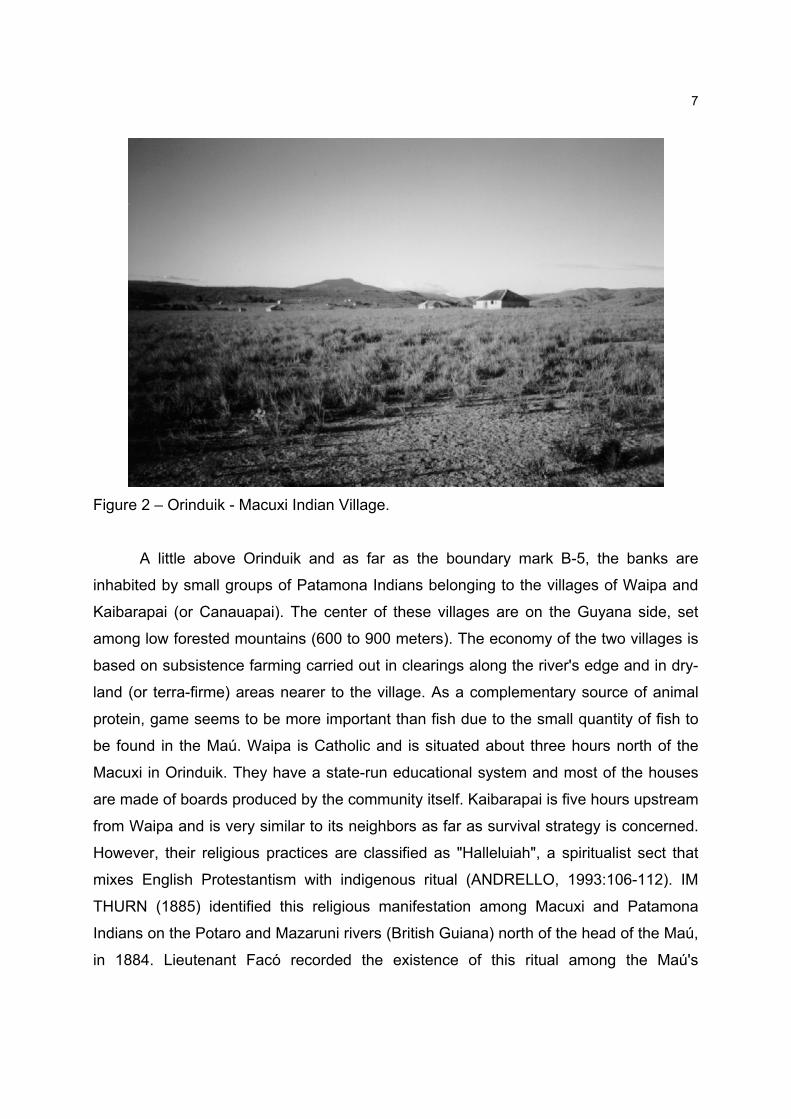
The indigenous ethnic groups that inhabit the upper course of the Maú/Ireng
belong to the Carib linguistic trunk. They are to be found in three villages. The first,
Orinduik, is situated on the Brazilian side and inhabited by Macuxi Indians (FIGURE 2).
We estimate a population of around 30 individuals occupying a little over 20 dwellings in
a highland savanna (550 to 650 meters). Part of the population is itinerant and
participates in the life of other indigenous villages. The houses are made of the trunks of
saplings plastered with a mixture of clay and sand. Most of them are thatched with palm
leaves Mauritia flexuosa L. (Moriche palm). The main activity is subsistence farming
carried out on forested hillsides or in the small patches of gallery forest that accompany
the Maú. The community makes use of game and fish as alternative sources of animal
protein. The religion practiced is strongly influenced by the Catholic Church but still
retains traces of original cultural rites.
7
Figure 2 – Orinduik - Macuxi Indian Village.
A little above Orinduik and as far as the boundary mark B-5, the banks are
inhabited by small groups of Patamona Indians belonging to the villages of Waipa and
Kaibarapai (or Canauapai). The center of these villages are on the Guyana side, set
among low forested mountains (600 to 900 meters). The economy of the two villages is
based on subsistence farming carried out in clearings along the river's edge and in dry-
land (or terra-firme) areas nearer to the village. As a complementary source of animal
protein, game seems to be more important than fish due to the small quantity of fish to
be found in the Maú. Waipa is Catholic and is situated about three hours north of the
Macuxi in Orinduik. They have a state-run educational system and most of the houses
are made of boards produced by the community itself. Kaibarapai is five hours upstream
from Waipa and is very similar to its neighbors as far as survival strategy is concerned.
However, their religious practices are classified as "Halleluiah", a spiritualist sect that
mixes English Protestantism with indigenous ritual (ANDRELLO, 1993:106-112). IM
THURN (1885) identified this religious manifestation among Macuxi and Patamona
Indians on the Potaro and Mazaruni rivers (British Guiana) north of the head of the Maú,
in 1884. Lieutenant Facó recorded the existence of this ritual among the Maú's
8
inhabitants in 1927/28 (ANDRELLO, 1993:107).
In 1988, this region was the subject of study of an interministerial work group set
up by the Brazilian Government. The aim of this group was to define the Raposa/Serra
do Sol Indigenous Area. On this occasion, the Kaibarapai village was recorded as being
established on the brazilian side and composed of about 50 individuals. This number
agrees with that registered by RICARDO (1995:42) as the population of Patamona in
Roraima. According to the same source, there are about 5,500 individuals in Guyana.
The indians told us that the village center was transferred to the Guyanese side in 1989
and that the number of people living on the Brazilian side continues to be about the
same. The Tuchaua (chief) himself, leader of this village, lives on the Brazilian side.
Difficulty of access and transport continues to keep them relatively isolated from other
social groups.
The Environment
In the stretch that was visited, there are several falls. However, the only one that
can really be considered as a true waterfall is the Grande Caracol Falls (Great Snail
Falls). The others are typically strong rapids formed by alterations in the level of the
land. When the water level is low, it is possible to identify a kind of rosy sandstone very
difficult to break manually. This is a notable feature of the Maú as far as a few
kilometers above the Grande Caracol Falls from whence, up as far as the headwaters,
the stony bed of the river is covered by a thick layer of settled sand. According to the
DNPM (1990:32), this subregion of the Roraima Super-group is classified as the Uailan
Formation and the terrain is chiefly rock.
The vegetation in the proximity of Orinduik and going towards the upper Maú, is
a transition between savanna and dense mountain forest. The savanna or lavrado as it
is called locally, is a continuation of the Surumu Volcanic Formation which stretches
along an east-west line separating the Boa Vista Formation (low-lying savanna) from
the Roraima Super-group. It is characterized as occupying very uneven terrain with
several quartz and laterite incrustations and colonized by arboreal species such as the
sandpaper tree (Curatela americana L.) and the mirixi (Byrsonima crassifolia (L.)
9
Kunth.). It is also colonized by creeping species like Bulbostyles spp (Cyperaceae) and
the grasses Andropogon spp and Trachypogon spp. The latter occupy most of the
extent of the savanna. Another notable aspect is the constant presence of fire in the
vegetation. Fire is a cultural tradition of the local Indians who believe that it is a
technique which improves the pasture for the cattle herds and chases off noxious
animals.
The forest becomes continuous about 10 km upstream from Orinduik, a little
before the village of Waipa. From this point, passing through Kaibarapai village and as
far the Grande Caracol Falls, the forest reminds one of those to be found in igapós.
However, the water level marks to be seen on the trees suggest rapid flooding and not
the accumulation of water for months on end. In this stretch, leaving out the area
subject to flooding, the dominant forest type can be described as a sub-type of dense
mountain forest with altitudes of 600-900 meters. Arboreal species of the families
Lecithydaceae (Courupita guianensis Aubl.), Sapotaceae (Pouteria sp) and
Vochysiaceae (Vochysia sp and Qualea sp) are common in this region of the river and
reach heights of 25-30 meters. Legume species are also of frequent occurrence in this
area.
Once beyond the Grande Caracol Falls, the landscape of the river basin is one of
a chain of high profiles covered by continuous forest right up to the headwaters. In this
stretch, the main species observed was Micandra sp (Euphorbiaceae), visibly dominant
in the forest. Other common species were Clusia grandiflora Splitz. (Clusiaceae),
Qualea sp (Vochysiaceae), Pouteria sp (Sapotaceae), and Heterostemon sp
(Caesalpinaceae). In the undergrowth the main species observed were Psychotria
poeppigiana (Rubiaceae) and Syphocampylus sp (Campanulaceae). Another specie of
Psycotria with yellow-colored flowers was also widely distributed. Similarly, Araceae and
Bromeliaceae were much in evidence in the undergrowth.
Above the Grande Caracol Falls, the soil is predominantly formed by a mosaic of
patches of sandstone and podzols (quartz sands). Being extremely porous, it forces the
roots of the plants themselves to be responsible for the rapid recycling of nutrients
within this system. They carry out the mechanical fragmentation and direct absorption of
organic material deposited on the ground. The roots form a great matwork over the soil
10
and for most of their length are serial and tabular. The exception to this pattern is to be
found near the falls in the vicinity of the headwaters, where a mosaic of rocky outcrops
and yellow podzols can be seen.
The dark waters of the Maú hydrographic system show great similarity to those of
the drainage system of the upper Rio Negro. Both spring from very ancient geological
formations and drain soils that are very porous and covered by forest. This
characteristic together with the frequency and intensity of rainfall, causes part of the
organic material not yet totally decomposed (humic and fulvic acids) to run out of the
fluvial micro-systems and into the more voluminous river courses making their waters
take on a dark colour.
We did not make meteorological records but throughout almost the whole period
of the excursion, the rain was incessant especially as we neared the headwaters. The
inhabitants of the forest region told us that the weather is normally humid but that there
is a dry phase between December and March. The period of heaviest rainfall is between
May and July. As far as we could find out, in the savannah region (Orinduik) the months
that mark the peaks of the rainy and dry seasons are similar to those of the forest zone.
The difference lies in the total annual rainfall. The only meteorological records we found
were those of the Mixed Boundary Commission for the year 1932 (AGUIAR,
op.cit.:231). Its notes were as follows : a) Forest Zone - Hot humid climate with
temperatures varying between 17oC and 25oC during the day and between 11oC and
17oC during the night; b) Savannah Region - Hot dry climate during the day with
temperatures varying between 20oC and 28oC and cool at night due to the strong winds
which make the temperature fall to between 14oC and 20oC.
Fauna
The ANNEX shows some of the groups of animals observed and/or collected in
the upper Maú region. As we were not making a systematic survey of any specific group
of regional fauna, the idea was to include the greatest possible number of specimens
within the limits of time and transport we had determined for the trip. Reptiles and
amphibians formed the largest group collected with 23 specimens (8 species). The
11
former proved to be representative as regards species diversity and density. Special
attention was dedicated to the collecting of two species of Dendrobatidae (Atelopus sp).
These anura are of great scientific interest due to the alkaloids they have in their skin.
We were unable to observe any lizards in the forest areas. However, in the open
country near Orinduik, it was possible to collect a specimen of Hemidactylus palaichthus
and to observe Tropidurus hispidus and Cnmidophorus lemniscatus. Snakes were also
found infrequently. Only two specimens of Bothrops sp (jararaca) in the forest region
above the Grande Caracol Falls were found. Among the Chelonia, we found only one
aquatic form (cf. Podocnemis sp) between Orinduik and Socobi. The ichthyofauna is
very poor. There are only five or six species in the whole of the upper Maú. We
managed to identify a type of electric eel (Gymnotus caropo) and observed a Mandí
(Pimelodidae) and also a Jijú or Yarrow (Characidae). All three form part of the local
indigenous diet (personal observation).
The number of birds seen was certainly laughable when compared to the region's
apparent potential. Apart from the constant rain which kept many birds away, the lack of
a bird specialist in the group hindered better identification. We were only able to
describe 18 species with certainty and these chiefly along the course of the river. Others
were considered dubious. As for large mammals, we collected five parts of skulls (3
species) in Indians' homes on the edge of the Maú all of which have been deposited in
the INPA collection. Apart from these examples, we correlated information on other
mammals given by the inhabitants of the region.
The entomofauna of the forest region was represented mainly by: a) ant species
- Camponotus gr. abdominalis (solitary), Odentomachus gr. hastatus (solitary) and
Eciton depanophorum (army ants); b) arboreal termites - Nasutitermes cf corniger and
c) beetles - Nilio sp (Erotylidae) and Agra sp (Carabidae). That of the transition region
(savannah/forest) was represented mainly by: a) flies - Simulium sp (pium or kaboura
fly); b) soil termites - Syntermes sp and Nasutitermes spp and c) ants - Atta spp. The
flea Sarcopsyla penetrans (bicho-de-pé or chigger flea) and diptera of the Lutzomuia
genus (leishmania) were observed in both systems.
Fauna material collected was deposited in the Instituto Nacional de Pesquisas da
Amazônia - INPA (National Institute for Research on the Amazon) in Manaus
12
(herpetofauna, fish, insects and mammals), Museu Integrado de Roraima (Integrated
Museum of Roraima) in Boa Vista (herpetofauna) and Museu de Zoologia of the
University of São Paulo, Sao Paulo (herpetofauna).
Final Consideration
The headwater of the Maú/Ireng River is part of a Amazon region still extremely
unknown because difficulty of access at that area. Description of the indians activities
plus survey of landscape potentialities should permit a better understanding of the
relationships between environment and man. In order, it help to shorten the way of a
quick decision-made on property and land use of that region in Brazilian side, in a effort
of avoid conflicts.
Acknowledgments
The Macuxi Indians from Orinduik village and the Patamona from Waipa and
Kaibarapai received us and permitted our stayed in their land. C. Morato and G. Moreira
(herpetofauna), I. P. Miranda and M. T. Campos (botanic), S. Wilson (birds), A. Harada
(ants), C. Martius (termites), J. Alves-Gomes (gymnotiformes), M. Silva (mammals) and
M. Graça (beetles), all working at INPA/Manaus, helped in the identification of the
material collected.
References
Aguiar,B.D. (1940). Trabalhos da Comissão Brasileira Demarcadora de Limites -
Primeira Divisão - Nas Fronteiras da Venezuela e Guiana Britânica e Neerlandesa, de
1930 a 1940. Anais do IX Congresso Brasileiro de Geografia, Rio de Janeiro. 375p.
Amoroso,M.R. & Farage,N. (1994). Relatos da Fronteira Amazônica no Século XVIII -
Documentos de Henrique João Wilckens e Alexandre Rodrigues Ferreira. NHII/USP &
FAPESP. 134 p.
13
Andrello.G.L. (1993). Os Taurepang: Memória e Profetismo no Século XX. Dissertação
de Mestrado. UNICAMP, Campinas. 177p.
Bancroft,E. (1769). An Essay on the Natural History of Guiana in South America.
Printed for T. Becket & P. A. De Hondt, London.
Barata,F.J.R. (1798). Diário da Viagem a Colônia Holandeza de Surinam, feita pelo
Porta-bandeira da Sétima Companhia do Regimento da Cidade do Pará, pelos Sertões
e rios d'este Estado, em Diligencia do Real Serviço. Rev. Inst. Hist. Geog. do Brasil,
tomo VIII, 1846, Rio de Janeiro.
Barbosa,R.I. (1994). Ocupação em Roraima. I . Do Histórico Colonial ao Início do
Assentamento Dirigido. Bol. Mus. Par. Em. Goeldi (série antropologia) 9 (1): 123-144.
Brasil (1975). Projeto RADAMBRASIL - Levantamento de Recursos Naturais, Volume
8. Ministério das Minas e Energia/Departamento Nacional da Produção Mineral, Rio de
Janeiro. 426 p + maps.
CIR (1993). Raposa/Serra do Sol : Os Índios no Futuro de Roraima. Conselho Indigena
de Roraima, Boa Vista/Roraima. 40p.
Clementi,C. (1916). A Journey to the Summit of Mount Roraima. The Geographical
Journal, vol. XLVIII, July to December 1916, pp. 456-473.
D'Almada,M.G.L. (1787). Descripção Relativa ao Rio Branco e seu Território. Rev. Trim.
Inst. Hist. Geog. Brasil, tomo XXIV, no 4, pp. 617-683, 1861.
DNPM (1990). Programa Levantamentos Geológicos Básicos do Brasil - Geologia da
Região de Caburaí, nordeste de Roraima. Secretaria Nacional de Minas e Metalurgia /
Departamento Nacional da Produção Mineral. 92 p + annexes.
14
Farage,N. (1991). As Muralhas dos Sertões : Os Povos Indígenas no Rio Branco e a
Colonização. Paz & Terra/ANPOCS. Rio de Janeiro. 197p.
Hemming,J. (1990). How Brazil Acquired Roraima. Hispanic American Historical Review
70(2): 295-325.
IBGE (1995). Estado de Roraima (Mapa). Fundação Instituto Brasileiro de Geografia e
Estatística / Governo do Estado de Roraima. Scale 1 : 1,000,000.
Im Thurn,E.F. (1885). The Ascent of Mount Roraima. Proceedings of the Royal
Geographic Society VII: 497-521.
Ricardo,C.A. (1995). "Os Índios" e a Sóciodiversidade Nativa Contemporânea no Brasil.
In: Silva,A.L. & Grupioni,L., A Temática Indigena na Escola. MEC/MARI/UNESCO,
Brasília. pp. 29-60.
Serra,R.F.A. & Pontes,A.P.S. (1781). Documento Official. Revista Brasileira de
Geografia 6(3): 84-90, 1944.
Schomburgk,R.H. (1840). Journey from Fort San Joaquim, on the Rio Branco, and
thence by the rivers Parima and Merewari to Esmeralda, on the Orinoco, in 1838-39.
Journal of Royal Geographical Society, London, Vol. X, pp. 191-247.
Tate,G.H.H. (1930). Notes on Mount Roraima Region. The Geographical Review 20(1):
53-68.
Viveiros,E. (1957). Rondon Conta sua Vida. Cooperativa Cultural, São Paulo. 517p.
VGB (1943). Vultos da Geografia do Brasil : Theodor Koch-Grünberg (1872-1924). Rev.
Bras. Geografia 5(3): 445-448.
15
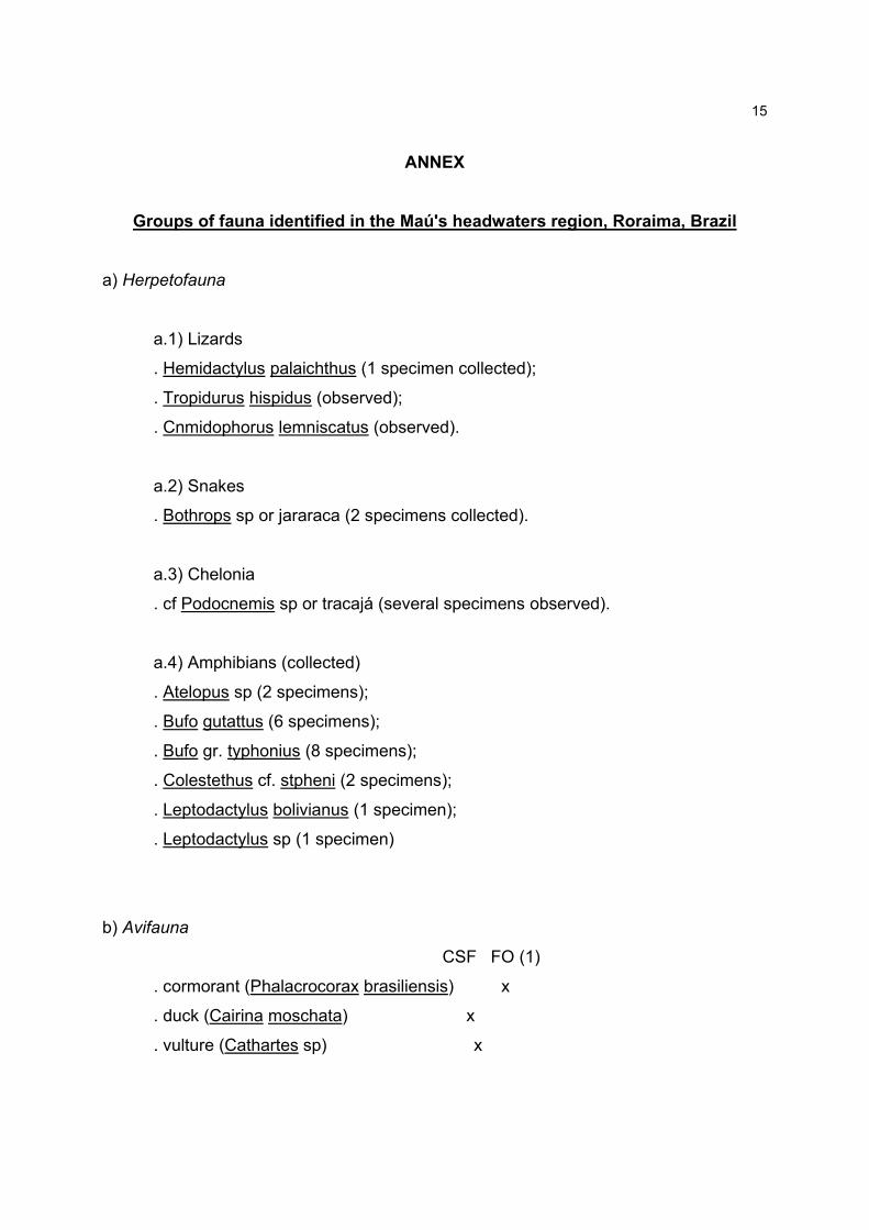
ANNEX
Groups of fauna identified in the Maú's headwaters region, Roraima, Brazil
a) Herpetofauna
a.1) Lizards
. Hemidactylus palaichthus (1 specimen collected);
. Tropidurus hispidus (observed);
. Cnmidophorus lemniscatus (observed).
a.2) Snakes
. Bothrops sp or jararaca (2 specimens collected).
a.3) Chelonia
. cf Podocnemis sp or tracajá (several specimens observed).
a.4) Amphibians (collected)
. Atelopus sp (2 specimens);
. Bufo gutattus (6 specimens);
. Bufo gr. typhonius (8 specimens);
. Colestethus cf. stpheni (2 specimens);
. Leptodactylus bolivianus (1 specimen);
. Leptodactylus sp (1 specimen)
b) Avifauna
CSF FO (1)
. cormorant (Phalacrocorax brasiliensis) x
. duck (Cairina moschata) x
. vulture (Cathartes sp) x
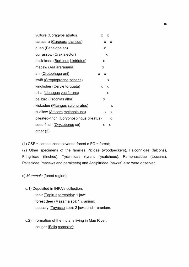
16
. vulture (Coragyps atratus) x x
. caracara (Caracara plancus) x x
. guan (Penelope sp) x
. currassow (Crax alector) x
. thick-knee (Burhinus bistriatus) x
. macaw (Ara ararauana) x
. ani (Crotophaga ani) x x
. swift (Streptoprocne zonaris) x
. kingfisher (Ceryle torquata) x x
. piha (Lipaugus vociferans) x
. bellbird (Procnias alba) x
. kiskadee (Pitangus sulphuratus) x
. suallow (Atticora melanoleuca) x x
. pileated-finch (Coryphospingus pileatus) x
. seed-finch (Oryzoborus sp) x x
. other (2)
(1) CSF = contact zone savanna-forest e FO = forest;
(2) Other specimens of the families Picidae (woodpeckers), Falconnidae (falcons),
Fringilidae (finches), Tyrannidae (tyrant flycatcheus), Ramphastidae (toucans),
Psitacidae (macaws and parakeets) and Accipitridae (hawks) also were observed.
c) Mammals (forest region)
c.1) Deposited in INPA's collection:
. tapir (Tapirus terrestris): 1 jaw;
. forest deer (Mazama sp): 1 cranium;
. peccary (Tayassu spp): 2 jaws and 1 cranium.
c.2) Information of the Indians living in Maú River:
. cougar (Felis concolor);

17
. jaguar (Panthera onca);
. paca (Coelogenys paca);
. agouti (Dasyprocta aguti);
. armadillo (three species of the family Dasipodideae).