notes physiography of india - drishti ias geography.pdf · notes 82°30′ east longitude passes...
TRANSCRIPT

MODULE - 2India: Natural Environ-
ment, Resources and
Development
193
Physiography of India
SOCIAL SCIENCE
Notes
9
PHYSIOGRAPHY OF INDIA
Tutor : Dear learners, you will agree that the place to which we belong has many
influences on our thinking and behaiour. Let us try to know which place
do we belong to?
Natasha : I belong to Hisar town. Farah is from Fatehabad and Rajinder comes
from Bhiwani.
Tutor : Do you know where all these places are located?
Rajinder : Yes, they are in Haryana as well as in India. But, where is India located?
Farah : What is the need to know India’s location?
Tutor : Location of a country is the key to its identity. It determines the important
aspects like climate, vegetation, agriculture, resources etc. This has a deep
impact on the way people of that area live, what they eat and how
powerful is their voice on the world stage. Therefore, to understand the
various aspects of India, we need to look into its location. Let us discuss
more about it in this lesson.
OBJECTIVES
After studying this lesson you will be able to:
l describe the location of India in terms of latitude and longitude;
l describe with the help of map, the significance of the relative location of India
in terms of neighbouring countries;
l illustrate the States and Union Territories with the help of political map of India;
l explain the major physical divisions of India;
l describe the drainage system in India;
l compare and contrast between the Himalayan and the Peninsular drainage
system; and
l explain the importance of people’s participation in keeping river clean.

SOCIAL SCIENCE
MODULE - 2 Physiography of India
India: Natural Environ-
ment, Resources and
Development
194
Notes
9.1 LOCATION
Teacher: Learners, when someone asks where India is, we can answer in two ways,
in terms of absolute and relative location. Let us see what we mean by absolute
location and relative location. Absolute location is given in degrees of latitude and
longitude. Relative location depends upon point of reference, e.g., near, far etc.
Latitude: Latitude is the angular distance, north or south from the equator, of
a point on the earth’s surface.
Longitude: Longitude is an angular distance on the earth’s surface, measured
east or west from the prime meridian at Greenwich.
Angular distance : The angular distance between the points from the centres
is called angular distance.
Teacher: With the help of this map can you find out the latitudinal and the
longitudianal location of Indian mainland.
Natasha: The Indian mainland extends between 8°4′ North and 37°6′ North
latitudes and from 68°7′ East and 97°25′ East longitudes. Thus, the
latitudinal and the North-south extent is 3214 km and East-west extent
is 2933 km. India accounts 2.42% of the total world land area
Teacher: India lies entirely in the northern hemisphere, and eastern hemisphere. The
Tropic of Cancer (23°30′ North) passes through the centre of the country.
It divides the country into almost two equal parts Northward of this
latitude is North India and South of it is known as south India. Similarly
90°N
Longitude(west/East)
Latitude varies from 0°of the equator to 90°
North and Southat the poles
90°SLongitude varies from 0°
at Greenwich to 180°East and West
W EEquator0° 0°
0°
0°
Tropic ofAntarctica
Tropic ofCapricorn
Tropic ofCancer
Tropic ofArctic 66½°N
23½°N
23½°S
66½°S
Prim
e M
eridia
n
Latitude(North/South)

MODULE - 2India: Natural Environ-
ment, Resources and
Development
195
Physiography of India
SOCIAL SCIENCE
Notes
82°30′ East longitude passes almost from the middle of the country. It
is known as Standard Meridian of India.
Teacher: Now determine the relative location of India and then record it in the
space given below: Remember relative location is given in relationship to
other places (north of, south of, northeast of, next to, across from).India
is part of Asian continent. India is surrounded by water from three sides.
Arabian sea in west, Bay of Bengal in the east and Indian ocean in the
south. Towards its north west is Pakistan and Afghanistan. China, Bhutan,
Tibet and Nepal lies to its north. Bangladesh and Myanmar lies to its east.
Srilanka and Maldives are located in the Indian Ocean towards its south.
The southern most point of the country is Indira Point (Nicobar Islands)
which lies on 6°4′ N latitudes and Kannya Kumari is southern most point
of Indian mainland which lies on 8°4′ N latitudes.
Figure 9.1 Latitudinal and Longitudinal extent of mainland of India

SOCIAL SCIENCE
MODULE - 2 Physiography of India
India: Natural Environ-
ment, Resources and
Development
196
Notes
The 82°30′E longitude passes through Mirzapur (in Uttar Pradesh). This is the
Standard Meridian of the country. The 82°30′ East has been selected as
standard Merdian because there is a time lag of almost two hours between
Gujarat and Arunanchal Pradesh. Therefore, a Central Meridian is selected to
determine the time for the whole country.
9.1.1 Locational Significance
Let’s observe the Fig. 9.2.What do you notice? India is the largest country in terms
of area and population in South-Asia. It is surrounded by ocean. India is strategically
located in Indian Ocean. It commands sea routes between Europe and Africa, South-
East Asia, far East Asia and Oceania. It is because of this that India shares good
trade relation between many countries since ancient times. India has a good location
in terms of sea and also well connected by land. Various passes like Nathu-La
(Sikkim), Shipki-La (Himachal Pradesh), Zoji-La and Burji la pass (Jammu &
Kashmir) have their own importance. The main India-Tibet trade route that connects
Kalimpong near Darjeeling with Lhasa in Tibet passes through Jelepa La. Several
passes have provided a passage to many ancient travelers. These routes are not only
important for trade but also to exchange ideas and culture.
Figure 9.2 Location of India with respect to important trade routes
INDIA
NEPAL
CHINA
MYANMAR
PAKISTANSAUDI
ARABIA
IRAN
IRAQ
BANGLADESH
AFGHANISTAN
THAILAND
JAPAN
INDONSIA
ETHOPIA
Syria
Karachi
ARABIANSEA
BAYOF BENGAL
INDIAN OCEAN
PACIFIC OCEAN
RE
D SE
A
ARALSEA
CA
SP
IAN
SE
A
BLACKSEA
TIBET
0 400 800
Kilometres
Delhi
Mumbai
Kolkata
SRI LANKA
Bangkok
Philippines
Tokyo
AUSTRALIA
MALAYSIA
Sea Routes
Air Routes
MALDIVES
40°E 60°E 80°E 100°E 120°E 140°E
40°N
30°N
20°N
10°N
0°

MODULE - 2India: Natural Environ-
ment, Resources and
Development
197
Physiography of India
SOCIAL SCIENCE
Notes
INTEXT QUESTIONS 9.1
1. Look at the map 9.2 and answer the following questions.
(i) Find out the names of two countries lying to the eastern side of India.
(ii) Mention the names of two seas located on the eastern and western side
of India.
(iii) Which country is connected to India by Palk Strait?
(iv) Write the names of two countries having a common border with India.
9.2 STATES AND UNION TERRITORIES OF INDIA
India is the seventh largest country in the world. It has land boundaries of 15,200
km and 6100km long coast line. India’s landmass covers 3.28 million square
kilometer of area. This accounts for nearly 2.42 percent of the total geographical
area of the world.
For good governance, India has been divided into 28 states and 7 union territories.
Let us study the Fig. 9.3 given below.
Figure 9.3 Political Map of India
200 0 200 400
KilometresSRI
LANKA
ARABIANSEA
I N D I A N O C E A N
Andaman & Nicobar Islands(INDIA)
Lakshadweep(INDIA)
C H I N ATIBET
NEPALBHUTAN
BANGLADESH
PAKISTAN
JAMMU & KASHMIR
H. P.
PUNJAB
UTTARAKHAND
HARYANA
DELHI
RAJASTHAN
UTTARPRADESH
BIHAR
JHARKHAND
MADHYA PRADESHGUJARAT
MAHARASHTRA
GOA
KARNATAKAANDHRA PRADESH
TAMIL NADUKE
RA
LA
ODISHACH
ATTISG
ARH
WESTBENGAL
ARUNACHALPRADESH
ASSAMNAGALAND
MANIPUR
MIZORAM
MYANMAR
TRIPURA
MEGHALAYA
SIKKIM
Srinagar
Shimla
DehradunChandigarh
JaipurLucknow
Gandhinagar Bhopal
Mumbai
Raipur Bhubaneshwar
Ranchi
Patna
Kolkata
GangtokItanagar
KohimaDispur
Shilong
Imphal
AizawlAgartala
Hyderabad
Panji
Bangaluru Chennai
Puducherry
Karaikal
Mahe
Thiruvananthapuram
Kavaratti
Port Blair
( Puducherry)
Daman
Silvasa
Diu(D&D)
(D&D)
D&NH
REFERENCESH.P. - HIMACHAL PRADESHD&D - DAMAN & DIUD&NH - DADAR & NAGAR HAVELI
64° 76° 80°72° 84° 88° 92°
72° 84°76° 88° 92°
8°
12°
16°
20°
24°
28°
32°
8°
12°
16°
20°
24°
28°
32°
INDIA
POLITICAL
BAY OF BEGAL

SOCIAL SCIENCE
MODULE - 2 Physiography of India
India: Natural Environ-
ment, Resources and
Development
198
Notes
This map clearly indicates that each state and union territory has its own capital. It
is interesting to note that while New Delhi is the capital of India, Delhi is the capital
of Union Territory Delhi. Can you identify any other capital like this? Yes, it is
Chandigarh which is the capital of two states Haryana and Punjab and also a Union
Territory.
ACTIVITY 9.1
Find out the minimum number of states you need to across, if you want to move
between the following places. (Refer Fig. 9.5)
(a) Kashmir to Mizoram (b) Punjab to Bihar (c) Delhi to Banglore
(d) Mumabi to Kolkata (e) Chennai to Raipur
INTEXT QUESTION 9.2
1. Look at the map 9.3 and answer the following questions.
(i) Write the names of two States of South India.
(ii) Mention the names of two states sharing international boundary.
(iii) Write the names of two countries sharing their boundaries with Sikkim.
(iv) Write the names of two union territories along Arabian Sea.
9.3 PHYSICAL DIVISIONS OF INDIA
Natasha : What is terrain?
Tutor : Terrain is an area of land which usually has a particular type of physical
feature.
Farah : Like, Mumbai beach is sandy and Shillong is a hilly.
Teacher : Right. Do you know India is a vast country with varied land forms and
topography?
Rajinder : What is the meaning of topography?
Teacher : Topography means the features of a place determined by nature. It is
the description of various features and landscape on the surface of the
earth.
India has the topographical diversity. This includes the Great Himalayas, the Northern
Plain, the Thar desert, the coastal plains and the Peninsular Plateau. The reasons for
variation in the topography could be:
l Differences in the rock formations. These landmasses have been formed in
different geological periods.

MODULE - 2India: Natural Environ-
ment, Resources and
Development
199
Physiography of India
SOCIAL SCIENCE
Notes
l Number of processes such as weathering, erosion and deposition has modified
these features to their present forms.
Weathering: Weathering is the process of gradual destruction of rocks at or
near the earth’s surface through physical, chemical and biological processes
caused by wind water, climate change etc.
Erosion: Erosion is the process of gradual transportation of weathered rock
materials through natural agencies like wind, river, streams, glaciers etc.
Weathering is distinguished from Erosion as no transportation of material is
involved in case of weathering.
India is a country of physical diversity. There are high mountain peaks in some areas
while in others, lie the flat plains formed by rivers. On the basis of physical features,
India can be divided into following six divisions:
Figure 9.4 Physiographic Divisions of India
200 0 200 400
Kilometres
Nilgiri Hills2637
Mt. Everest8848
7817
8611KARAKORAMIndus
SHIWALIK RANGE
GARO KHASI
JAINTIANAGA
AR
AV
AL
I R
AN
GE
GREAT
IND
IAN
DESERT
Chota Nagpur Plateau
Malwa Plateau
SATPURA
D E C C A N
EA
ST
ER
N
G
H
A
T
S
WE
ST
ER
NG
HA
TS
Rann of Kachchh
G
R
E
AT
HI
MA
L A Y A
Mahanadi
SRILANKA
ARABIANSEA
BAYOF
BENGAL
LAKSHADWEEPSANDAMAN & NICOBAR
ISLANDS
ALTITUDE SCALEMeters
Above 1200
600 - 1200
300 - 600
Below 300
Indus
Jhelum
Chenab
Ravi
Yamuna Ganga
Chambal
Betwa
GhagharaG
andak
Kosi
Brahmaputra
Godavari
Narmada
TapiGir Hills
Chattisgarh
Mouth of the Ganges
I N D I A N O C E A N
Krishna
Kaveri
64° 76° 80°72° 84° 88° 92°
72° 84°76° 88° 92°
8°
12°
16°
20°
24°
28°
32°
8°
12°
16°
20°
24°
28°
32°
INDIA
PHYSICAL
The Pamir
HINDKUSH
KUNLUN MTS.

SOCIAL SCIENCE
MODULE - 2 Physiography of India
India: Natural Environ-
ment, Resources and
Development
200
Notes
1. The Northern mountains 2. The Northern Plains
3. The Peninsular Plateau 4. The Indian Desert
5. The Coastal Plains 6. The Islands.
1. The Northern Mountain : It is divided into three groups. They are :
(i) The Himalayas
(ii) The Trans Himalayas
(iii) The Puranchal hills
1. The Himalayan Mountains
Himalayas are the young fold mountains.
This is the highest mountain range of
the world. Himalayas act as natural
barrier. The extreme cold, snow and
rugged topography discourage the
neighbors to enter India through
Himalayas. They run from west-east
direction from Indus to Brahmaputra
along the northern boundary of India
1. Pass: It is a natural gap or a route
between a ridge, hill.
2. Range: large landmass consisting of
mountains, ridges and peaks.
3. Peak: highest point or tip of a
mountain range.
4. Valley: a depression or a flat land
between two elevated areas.
5. Dun: Longitudinal valleys existing
beween himachal and shiwaliks.
Figure 9.5 The Himalyan Mountains
200 0 200 400
Kilometres
The Pamir
HINDKUSH
KUNLUN MTS.
G
R
E
A
T
E
R
H
I M A L A
YA
HINDURAJ
SU
LE
MA
NR
AN
GE
Indu
s
Luni
Satluj
Ravi
ChenabJhelum
Shyok
Yamuna
Ganga
Chambal
Betwa
Sind
Ken
Son
Gom
tiGhaghara
Gandak
Kosi
Tista Brahmaputra
Rann of Kutch
KarakoramHills
AghilPass
Khyber Pass
Karakoram Pass
K28611
7397
7788
Rakaposhi
Harmosh
8126Naga Parwat
BaraLacha
LadakhRange
Zaskar Range
Sh
i wa
l i kR
an
ge
LE
SS
AR
HI M
AL
AY
A
Shipkila
KAILA
SH
RANG
E
Mansa rover Lake
Kailash6714
Kamet7750
7817Nanda Devi
8078
Annapurna8848 Mt. Everest
Kanchenjunga8598
Bomdila
Tsangpo
7756
NamchaBarwa
Man
as
S h i w a l i kR a n g e
64° 68° 76° 80°72° 84° 92°

MODULE - 2India: Natural Environ-
ment, Resources and
Development
201
Physiography of India
SOCIAL SCIENCE
Notes
covering a distance of 2500 KM. Their width varies from 400 in the west and 150
KM in the East (Fig. 9.5). The Himalayas may be divided into three parallel ranges:
(a) Greater Himalayas or Himadari
(b) Lesser Himalayas or Himachal
(c) Outer Himalayas or Siwaliks.
(a) The Greater Himalayas or Himadari: The Greater Himalayas comprises of
the northern most ranges and peaks. It has an average height of 6000 metres
and width lies between 120 to 190 Kms .It is the most continuous range. It
is snow bound and many glaciers descend from this range. It has high peaks
like Mt. Everest, Kanchenjunga, Makalu, Dhaulagiri, Nanga Parbat etc. having
a height of more than 8000 metres. Mt. Everest (8848 m) is the highest peak
of the world and Kanchenjunga is the highest peak of Himalaya in India. High
Mountain passes also exist in this range, namely, Bara Lacha-La, Shipki-La,
Nathu-La, Zoji-La, Bomidi-La etc. The Ganga and Yamuna rivers originates
from this Himalayas.
(b) The Lesser Himalayas or Himachal: The altitude of this range lies between
1000 and 4500 metres and the average width is 50 KM. The Prominent ranges
in this are Pir Panjal, Dhaula Dhar and Mahabharata ranges.It compresses of
many famous hill stations like Shimla, Dalhousie Darjeeling, Chakrata, Mussoorie,
Nanital etc. It also comprises of famous valleys like Kashmir, Kullu, Kangra
etc.
(c) The Outer Himalayas or the Siwaliks: It is the outer most range of the
Himalayas. The altitude varies between 900-1100 meters and the width lies
between 10-50 KM. They have low hills like Jammu Hills, etc.The valleys lying
between Siwalik and Lesser Himalayas (Himachal) are called ‘Duns’ like Dehra
Dun, Kotli Dun and Patli Dun.
(ii) The Trans-Himalayan ranges
It extends north of greater Himalaya and parallel to it is called zaskar range. North
of Zaskar range lies Ladakh range. The Indus river flows between Zaskar and Ladakh
range. The Karakoram range lie extreme north of the country. K2 is the second highest
peak of the world.
(iii) The Purvanchal hills
It comprises Mishami, Patkoi, Naga, Mizo hills which are located in eastern side.
The Meghalaya plateau is also part of these hills which includes the hills of Garo,
Khasi and Jaintia.

SOCIAL SCIENCE
MODULE - 2 Physiography of India
India: Natural Environ-
ment, Resources and
Development
202
Notes
INTEXT QUESTIONS 9.3
1. Write the names of the three ranges of the Himalayas.
2. Look at the map (Fig. 9.5) and find out.
(i) In which state Nanga Parbat and Nanda Devi are located?
(ii) Say Yes or No.
(a) Mt. Everest is located in India………………………
(b) Shipki-La pass is located in Siwalik Range……………
(c) Mansarover lake is located in Kailash Range………...
3. Mention the names of the countries in which the Greater Himalayas are situated.
4. Identify two purvanchal hills.
2. The Northern Plains
Let us try to locate and label the states lying in the Northern Plains of India (refer
Fig. 9.5. The Northern Plains are located between south of the Himalayas and north
of the Peninsular plateau. It is formed by the deposition of the sediments brought
by three main river systems namely : the Indus, the Ganga and the Brahmaputra. From
Punjab in the west to Assam in the east, this plain is about 2400 km long. Its width
varies from about 300 km in the west to about 150 km in the east. It mainly includes
the states of Punjab, Haryana, Uttar Pradesh, Bihar, West Bengal and Assam. This
plain is very fertile due to alluvial sediments brought by the rivers from the Himalayas.
This plain is one of the largest and most fertile plains of the world. Major crops such
as wheat, rice, sugarcane, pulses, oil seeds and jute are grown here. Due to proper
irrigation, the plain makes significant contribution in the production of food grains.
The Northern plain is broadly divided into two parts :
(a) The Western plain
(b) The Ganga-Brahmaputra plain
(a) The Western Plain
This plain is formed by the river system of the Indus. It lies to the west of Aravallis.
This plain is formed due to deposits brought by the rivers like the Satluj, the Beas
and the Ravi. This part of the plain has doabs.
(b) The Ganga-Brahmaputra plain
It is also formed by the deposition of the sediments brought by two main river systems,
the Ganga and the Brahmaputra. The early civilizations like Mohenjo-Daro and

MODULE - 2India: Natural Environ-
ment, Resources and
Development
203
Physiography of India
SOCIAL SCIENCE
Notes
Harappa also called river valley civilizations, were spread over plain areas. This is
because of the availability of fertile land and water through the river networks.
Doab: the alluvial land between two converging rivers. Example doab area in
Punjab.
Khadar: The area flooded by rivers almost every year
Banger: The area never flooded by rivers.
3. The Peninsular Plateau
Look at the map (Fig. 9.6) given below, you will find that the Peninsular plateau is
a triangular shaped table land. It is part of ancient land mass called Gondwana level.
It covers an area of nearly 5 lakh sq.km. It is spread over the states of Gujarat,
Maharashtra, Bihar, Karnataka and Andhra Pradesh.
Figure 9.6 The Peninsular plateau of India
72°E 76° 80° 84° 88°
72°E 76° 80° 84°
0 100 200 300 400 500
Kilometres
8°
12°
16°
20°
24°
28°N
8°
12°
16°
20°
24°
28°N
Yamuna
Ganga
Chambal
Bet
wa
Son
Ganga
BAYOF
BENGAL
ARABIANSEA
I N D I A N O C E A N
Luni
Sabarm
ati
Mahi
Narmada
Tapi
Krishna
Tung
bhad
ra
Kaveri
Panneru
Godavari
Mahanadi
CHOTA NAGPURPLATEAU
MAIKALA RANGE
CHATTISGARH
MAHENDRA GIRI
BUNDELKHANDARAVALI H
ILLS
M A L W A P L A T E A U
VINDHYA
SATPURA
SATMALAHILLS
BALAGHAT RANGE
TELENGANA
PLATEAU
ANNAMALAIHILLS
CARDAMOMHILLS
CO
RO
MA
ND
EL
CO
AS
T
MA
LA
BA
RC
OA
ST
WE
ST
ER
N
GH
AT
S
EA
ST
ER
N
GH
AT
S
GIR RANGE
RAJA
STH
AN

SOCIAL SCIENCE
MODULE - 2 Physiography of India
India: Natural Environ-
ment, Resources and
Development
204
Notes
River Narmada divides the peninsular plateau into two parts : The central highlands
and Deccan Plateau
(i) The central Highlands: It extends from Narmada river and the northern plains.
A ravallis is the important mountain which extends from Gujrat through Rajasthan
to Delhi. The highest peak of the Aravallis hills is Gurushikhar (1722m) near
Mt. Abu. The Malwa Plateau and Chhota Nagpur plateau are parts of the central
highlands. River Betwa, chambal and Ken are the important river of Malwa
plateau while Mahadeo, Kaimur and Maikal are the important hills of chhota
Nagpur plateau. The valley of Narmada is lies between the Vindhyas and the
satpura which flows east to west and joins the Arabian sea.
(ii) The Deccan Plateau: The Deccan plateau is separated by a fault (A fracture
in the rock along which rocks have been relatively replaced), from Chota
Nagpur plateau. The black soil area in the Deccan plateau is known as Deccan
trap. It is formed due to volcanic eruptions. This soil is good for cotton &
sugarcane cultivation. The Deccan plateau is broadly divided into:
(a) The Western Ghats
(b) The Eastern Ghats
(a) The Western Ghats: If you look at map (Fig. No. 9.6), we will see the
Western Ghats or Sahyadris lie on the Western edge of the Deccan plateau.
It runs parallel to the western coast for about 1600 km. The average
elevation of the Western Ghats is 1000 metres. The famous peaks in this
area are Doda Betta, Anaimudi amd Makurti. The highest peak in this
region is Anaimudi (2695m.). Western ghats are continuous and can be
crossed through passes like Pal Ghat, Thal Ghot and Bhor Ghat. The rivers
like Godavari, Bhima and Krishna flow eastward while the river Tapti flows
westward. The streams form rapids & water falls before entering the
Arabian Sea. The famous water falls are Jogfalls on Sharavati, Shiva
Samudram falls on Kaveri etc.
(b) The Eastern Ghats: The Eastern Ghats are discontinuous low belt. Their
average elevation is 600 m. They run parallel to the east coast from south
of Mahanadi valley to the Nilgiri hills. The highest peak in this region is
Mahendragiri (1501 m). The famous hills are Mahendragiri hills, Nimaigiri
hills in Orissa, Nallamallai hills in Southern Andhra Pradesh, Kollimalai and
Pachaimalai in Tamilnadu. The area is drained by the Mahanadi, Godawari,
Krishna and Kaveri river systems. The Nilgiri hills join Western & Eastern
Ghats in the south.

MODULE - 2India: Natural Environ-
ment, Resources and
Development
205
Physiography of India
SOCIAL SCIENCE
Notes
ACTIVITY 9.2
Trace five main differences between Western and Eastern Ghats.
1. Continuity
2. Average Elevation
3. Extent
4. Highest Peak
5. Rivers
4. The Indian Desert
The Indian Desert lies towards the western margin of Aravali Hills. It is also called
Thar Desert. It is the ninth largest desert in the world. It spreads over the states of
Gujarat and Rajasthan. This region has semi-arid and arid weather conditions. It
receives less than 150 mm of rainfall per year. The vegetation cover is low with thorny
bushes. Luni is the main river in this area. All other streams appear only at the time
of rainfall otherwise they disappear into the sand.
Figure 9.7 The Indian Desert
I am Thar ‘The Indian Desert’:
1. I remain dry most of the year. The moisture bearing winds goes parallel to
Aravalli so I receive scanty rainfall.
2. I am pierced by cactus and other thorny bushes on my body.
3. If you are thirsty, you will have to walk several kilometers to reach an oasis
and sinduates (small water body).

SOCIAL SCIENCE
MODULE - 2 Physiography of India
India: Natural Environ-
ment, Resources and
Development
206
Notes
4. The sand dunes add to the beauty of my desert.
5. My people follow rich cultures and traditions.
5. The Coastal Plains
The coastal plains in India run parallel to the Arabian Sea & Bay of Bengal along
the Peninsular Plateau.The western coastal plain is a narrow belt along the Arabian
sea of about 10-20km wide. It stretches from Rann of Kachchh to KanyaKumari.
Western coastal plains comprises of three sectors (i) Konkan Coast (Mumbai to
Goa), (ii) Karnataka coast from Goa to Mangalore (iii) Malabar Coast (Mangalore
to Kanya Kumari). The eastern coast runs along Bay of Bengal. It is wider than the
western coastal plain. Its average width is about 120Kms. The northern part of the
coast is called Northern Circar and the southern part is called Coromandal Coast.
Eastern coastal plain is marked by Deltas made by the rivers Mahanadi, Godavari,
Krishna amd Kaveri. The Chilka largest salt water lake in India in Odisha is located
to the south of Mahanadi Delta. The coastal plains are belts for growing spices, rice,
coconut, pepper etc. They are centres of trade & commerce. The coastal areas are
known for fishing activities, therefore large number of fishing villages have developed
along the coasts. Vembanad is famous lagoon which is located at Malabar coast.
6. The Islands
India has two main groups of Islands. There are 204 islands in Bay of Bengal called
as Andaman and Nicobar islands and 43 islands in Arabian Sea called as
Lakshadweep islands The Andaman & Nicobar island extend from north to south
in Bay of Bengal. They are bigger in size. An active volcano is located on the Barren
Island in Andaman & Nicobar group of islands. Lakshadweep islands are located
near Malabar coast of Kerala in the Arabian sea. They cover an area of 32 sq km.
Kavarati is the capital of Lakshdweep. These islands are formed by corals and
endowed with variety of flora and fauna. These islands are important tourist attraction
under water activities like snokling, such diving, deep sea diving and other sports
make these island more popular.
INTEXT QUESTIONS 9.4
1. Answer the following questions briefly (not more than two sentences)
(i) How was Deccan Trap formed?
(ii) State any two economic activities of coastal plains.
(iii) Why does Andman and Nicobar Islands attract more tourists?
(iv) Write the names of the rivers which help to form the western plain.

MODULE - 2India: Natural Environ-
ment, Resources and
Development
207
Physiography of India
SOCIAL SCIENCE
Notes
9.4 DRAINAGE SYSTEMS IN INDIA
The drainage system refers to the system of flow of surface water mainly through
rivers. An area drained by a river and its tributaries is called a drainage basin. The
drainage system is related to a number of factors like slope of land, geological
structure, amount and velocity of water. A river through its drainage system performs
several tasks. These are excess water removal from a particular area, transportation
of sediments from one place to other, providing natural source for irrigation and
maintaining the water table of a region. Traditionally, rivers were useful as a source
of abundant fresh water and navigation. In today’s world rivers importance has risen
to include hydro power generation and setting up water-based industries. These are
also important tourist attraction for activities such as boating, river rafting and cliff
jumping. Because of their utility, rivers are important for life and hence regarded as
lifeline. Many cities are located along the rivers and are densely populated. Delhi
on the banks of Yamuna, Patna along Ganga, Guwahati along Brahmaputra, Nasik
along Godavari and Cuttack along Mahanadi are some examples (Fig. 9.8). On the
basis of the origin the drainage can be divided in to two parts:
(a) The Himalayan drainage system
(b) The Peninsular drainage system
Tributary: A stream or river that flows into a larger river. e.g. Yamuna
Delta: A triangular shaped land at the mouth of a river formed from the deposition
of silt, sand and small rocks that flow downstream in the river. eg. Ganga delta.
Estuary: A partially enclosed coastal body of water where the salty tidal water
mixes with the fresh water of the river. eg. Narmada river makes an estuary.
9.5 MAJOR DRAINAGES SYSTEMS
As mentioned earlier on the basis of origin, the Indian river have been classified into
two major drainage systems. Let us discuss the comparision between the two
drainage systems.
Himalayan River System
1. They are Perennial rivers originating from glaciers.
2. Rivers form valleys by the process of erosion.
3. The rivers are ideal for irrigation purposes as they pass through plain fertile tracts.
4. These rivers have meandering courses which shift over time.
9.5.1 The Himalayan Drainage System
Most of the Himalayan Rivers are perennial. This means they have water throughout
the year. This is because most of these rivers originate from the glaciers and snowy

SOCIAL SCIENCE
MODULE - 2 Physiography of India
India: Natural Environ-
ment, Resources and
Development
208
Notes
peaks. They also receive water from the rainfall. The main river system in this category
are:
1. The Indus River System Jhelum, Ravi, Beas and Satluj
2. The Ganga Rivers System Yamuna, Ramganga, Ghaghara, Gomti,
Gandak and Kosi etc.
3. The Brahmaputra River System Dibang, Lohit, Tista and Meghna etc.
9.5.2 The Peninsular Drainage System
You have already studied about Peninsular Plateau. Most of the Peninsular rivers flow
eastwards and enters into Bay of Bengal. Only Narmada and Tapi rivers which flow
westwards of the Western Ghats. They are good for generating hydropower because
these rivers form rapids & water falls. The major peninsular rivers are Mahanadi,
Godavari, Krishna and Kaveri.
Figure 9.8 Major Rivers of India
Indus R.
Indus R.
Jhel
um R
.
Saba
rmat
i R.
Mah
i R.
Kosi R.
Son
R.
Brahmaputra R.
Hugli
Mahanadi R.
Kaveri R.
Chenab R.
Ravi R.
Satluj R.
Ganga R.
Yamuna R.
Chambal R.
Tapi R.
Godavari R.
Krishna R.BAYOF
BENGAL
ARABIANSEA
I N D I A N O C E A N
Andaman & Nicobar IslandsLakshadweep
SRILANKA
64° 68° 76° 80°72° 84° 88° 92°
72° 84°76° 80° 88° 92°
8°
12°
16°
20°
24°
28°
32°
8°
12°
16°
20°
24°
28°
32°
INDIA
MAJOR RIVERS
Narmada R.

MODULE - 2India: Natural Environ-
ment, Resources and
Development
209
Physiography of India
SOCIAL SCIENCE
Notes
ACTIVITY 9.3
Look at the physical and political maps of India in an atlas. Given below are four
river. Find out the following informaiton and record in the table given below.
Rivers Main Origin States it Drains into
tributaries passes through
Ganga
Brahmputra
Indus
Satluj
Kaveri
Godavari
Krishna
ACTIVITY 9.4
Look at the Atlas and name all the cities situated along the Ganga and locate on
the physical India map.
9.6 KEEPING RIVERS CLEAN
Do you know that over 97% of all the water on Earth is salty and remaining 3%
is fresh water. This tiny amount has to provide the fresh water needed to support
the entire population of the world. Fresh water is a precious resource and the
increasing pollution of our rivers and lakes is a cause for alarm.
You must have seen a river either flowing through your town, village or elsewhere.
India has a large number of rivers that are lifelines for the millions of people living
along their banks. These rivers can be broadly categorized into four groups:
(i) Rivers that flow down from the Himalayas and are supplied by melting snow
and glaciers. This is why these are perennial, that is, they never dry up during
the year.

SOCIAL SCIENCE
MODULE - 2 Physiography of India
India: Natural Environ-
ment, Resources and
Development
210
Notes
(ii) The Deccan Plateau rivers, which depend on rainfall for their water.
(iii) The coastal rivers, especially those on the west coast, which are short and do
not retain water throughout the year.
(iv) The rivers in the inland drainage basin of west Rajasthan, which depend on the
rains. These rivers normally drain towards silt lakes or flow into the sand.
Rivers have been given the pride of place in the way of life. Several cities as
well as holy shrines are on the banks of rivers, and indeed, rivers such as the Ganga
and the Yamuna are sacred to millions. Despite this, they are being polluted with
unaccountable and environmentally threatening practices. Only sewage claims for
about 70 percent pollution loads in Indian rivers. Heavy loads of biological and
chemical pollutants usually enter waterways to be consumed in some manner by the
downstream users. This affects the aquatic life and causes various health hazards.
Along with the pollutants, the insensitivity of people towards rivers is severely adding
to the problem. Urban dwellers identify vaguely with rivers. An example can be the
highly contaminated blackish water of Yamuna river in New Delhi which hardly draws
attention from capital’s citizens.
Since, water issues are assigned to provincial governments in India, each one of them
treats a river as its own, with little or no regard to the downstream effects. Ecologists
and conservationists have long demanded that rivers need to be treated as one entity
and work on a determined, time-specific combination of serious efforts. This could
lead to an improvement of water quality of the rivers. The government has come
up with ambitious river cleaning initiatives such as the Ganga Action Plan (GAP) and
the National River Conservation Plan (NRCP) in the hope of improving water quality.
Water harvesting is gaining popularity across the country, through which monsoon
waters could be retained in the river basins. Several civic organizations and people
movements are also contributing in raising awareness and sensitivity about the critical
condition of polluted rivers.
ACTIVITY 9.5
1. Find out the river or natural water source in your locality. Observe the kind of
activities that are happening there.
2. What kinds of human activities are causing damage to river systems?
3. Write a letter to the local authority suggesting what you and your friends like to
do to stop pollution. Also mention in the letter what help would you like to have
form them.
4. Organise a meeting with your friends to discuss what can be done to prevent
the negative effects of the human activities
There could be many ways of stopping pollution. Suggests the ways to check
the water pollution.

MODULE - 2India: Natural Environ-
ment, Resources and
Development
211
Physiography of India
SOCIAL SCIENCE
Notes
INTEXT QUESTION 9.5
Answer the following question:
1. Mention the name of two tributaries joining Ganga from the north.
2. Which lake is located near Mahanadi?
3. Write the names of the states drained by river Godavari.
4. Which river is tributary of Tunghabhadra?
WHAT YOU HAVE LEARNT
l India is located between 8°4’ North and 37°6’ North lalitudes and 68°7’ East
and 97°25’ longitudes. India has land boundaries of 15,200 km and 6100km
long coast line. India’s landmass covers 3.28 million square kilometer of area.
l India can be divided into mainly six physical divisions: the Northern mountain,
The Northern Plain, the Peninsular Plateau, the Indian desert and the coastal
plains and Islands.
l The Himalayas may be divided into three parallel ranges: Greater Himalayas or
Himadari,Lesser Himalayas or Himachal and Outer Himalayas or Siwaliks.
l The northern plain spreads mainly in the states of Punjab, Haryana, Uttar
Pradesh, Bihar and West Bengal. The soil here is rich in nutrients and hence good
for cultivation of varieties of crops.
l The Peninsular plateau stretches from the Aravali range till the southern tip of
India. It is a table land made of old and metamorphosed rocks.
l The Great Indian Desert spreads over the states of Gujarat and Rajasthan. This
region has semi-arid and arid weather conditions.
l The coastal plains in India run parallel to the Arabian sea & Bay of Bengal. They
are called Western coastal plains and the Eastern coastal plains.
l India has two main groups of Islands. There are 204 islands in Bay of Bengal
called the Andaman and Nicobar Islands and 43 islands in Arabian Sea i.e
Lakshadweep islands.
l Indian River System can be divided into two main categories: The Himalayan
Drainage System and The Peninsular Drainage System. The three main rivers
in Himalayan system are the Indus, Ganga, The Brahmaputra. The main
Peninsular rivers are Narmada, Tapi, Godavari, Krishna , Kaveri and Mahanadi.

SOCIAL SCIENCE
MODULE - 2 Physiography of India
India: Natural Environ-
ment, Resources and
Development
212
Notes
TERMINAL EXERCISES
1. Explain the location and extends of India.
2. Dercribe any three characteristics of the Indian Desert.
3. Explain any two paints each about the three parallel ranges of Himalayas.
4. Differentiate between Himalayan and Peninsular drainge system by giving any four
differences in each.
5. Give reasons:-
(i) Northern plans have fertile alluvial soil.
(ii) Indian desert has very less vegetation cover.
Project:
l Create a guidebook for visitors to your home region
1. It should describe your region’s unique physical and human characteristics.
2. List elements of the physical landscape, such as climate, landforms, plants,
animals, and elements of the human landscape, such as work opportunities,
economic activities, recreational activities, regional language, and foods.
3. The guidebook should include pictures/ drawings and should feature the
things that you feel are special about your locality.
ANSWERS TO INTEXT QUESTIONS
9.1
1. (i) Bangladesh, Myanmmar.
(ii) Bay of Bengal and Arabian Sea.
(iii) Sri Lanka.
(iv) Pakistan, Bhutan.
9.2
1. (i) Kerala, Tamil Nadu.
(ii) Jammu and Kashmir, Arunachal Pradesh.
(iii) Nepal, Bhutan.
(iv) Daman and Diu, Dadar Nagar Haveli.

MODULE - 2India: Natural Environ-
ment, Resources and
Development
213
Physiography of India
SOCIAL SCIENCE
Notes
9.3
1. the Himadari The Himachal, and Siwalik.
2. A. Jammu and Kashmir.
B. (a) No
(b) No
(c) Yes
3. India, Nepal, Bhutan.
4. Patkoi, Mizo hills
9.4
1. (i) Due to volcanic erruption.
(ii) (i) Agriculture (ii) fishing (iii) trade and commerce (any two)
(iii) Because Islands have developed attractive tourist activities of under water
and water sports.
(iv) Satluj, Beas, Ravi
9.5
1. Gandak, Kosi.
2. Chilka.
3. Maharashtra, Andhra Pradesh and Chattisgarh.
4. Krishna.

SOCIAL SCIENCE
MODULE - 2 Climate
India: Natural Environ-ment, Resources and
Development
214
Notes
10
CLIMATE
Mona and Raju were excited about proposed first trip to a hill station, Shimla withtheir parents. While they were packing their clothes, their mother asked them to packsome woolen clothes also. They reside in Chennai, a city and capital of Tamil Nadu,a state in South India. They were really surprised as it was the month of May andit’s very hot in Chennai. Their mother told that although India has monsoon climatebut in Shimla, it being a hill station the weather was cool. They were little confusedwith a few questions in their mind like - what is weather? What is the differencebetween the weather and the climate? Why do we find different climatic conditionsin India? You will find the answers to such questions in the following lesson.
OBJECTIVES
After completing this lesson, you will be able to:
� list the factors that influence the climate of India;
� explain the mechanism of monsoon and its various characteristics;
� recognize the cyclic system of seasons along with their unique features;
� describe the distribution of rainfall in India;
� analyse how our social and cultural life is deeply associated with the cycle ofseasons; and
� describe the global environmental changes and its impact on Indian climate.
10.1 FACTORS AFFECTING THE CLIMATE OF INDIA
When Mona and Raju were in the train along with their parents they asked thequestions to their parents about the difference between the weather and climate. Oneof the fellow passengers was a teacher, Mrs. Rupa and she explained that climate

MODULE - 2India: Natural Environ-ment, Resources and
Development
215
Climate
SOCIAL SCIENCE
Notes
is always for a large area like a country or a big region and generally it does notchange, like India has monsoon climate whereas weather is always for a smallerarea like that of your city or village where it may frequently change like raining inthe morning and sunny in the afternoon. Mrs. Rupa asked them to observe thechanges in the weather conditions along the way to Shimla. They realized the changes:it was hot and humid weather in the southern regions and slowly it became hot anddry in the northern plains; and they felt cool on their way when they were close toShimla. They asked the teacher the reason for it and she explained that there aremany factors which affect the climate or weather.
Climate refers to the sum total of weather conditions and variations over largearea for a long period of time (more than 30 years).Weather is state ofatmosphere over an area at any point of time. Similarly weather conditions whichlast for longer duration are responsible for making a season.
10.1.1 Factors Affecting the Climate of India
1. Location: The places which are closer to equator have high temperature. Asone moves towards the poles temperature decreases. As our country, India islocated in Northern hemisphere closer to equator at 8°4¢ and 23½° Tropic ofCancer passes through the central part of India. So in south of this latitude wefind tropical climate and towards the north we find sub-tropical climate. Forexample, Andhra Pradesh would be hotter than Haryana. Broadly speaking partslying south of the Tropic of Cancer receive more solar heat than those lying northof it.
2. Distance from the sea: The southern half of India is surrounded by sea fromthree sides: the Arabian Sea in the west, the Bay of Bengal in the east and theIndian Ocean in the south. Due to moderating influence of the sea this regionis neither hot in summer nor very cold in winter. For example the area of NorthIndia which is far away from the sea has extreme type of climate and the areaof south India which is nearer to the sea has equable type of climate. We cansee the variations in temperature and rainfall at different stations in the giventable 10.1.
3. Altitude: It means the height above the average sea level. The atmospherebecomes less dense and we feel breathlessness as we go higher from the earthsurface and thus the temperature also decreases with the height. For example,the cities located on the hills are cooler like Shimla whereas the cities lying inthe plains will have hot climate like Ludhiana.
SOCIAL SCIENCE
MODULE - 2 Climate
India: Natural Environ-ment, Resources and
Development
216
Notes
4. Mountain Ranges: Mountain ranges also affect the climate of any region toa great extent. The Himalaya Mountain is located in the northern part of ourcountry with an average height of 6000m. It protects our country from cold windsof Central Asia. On the other hand, they check rain bearing South-West Monsoonwinds and compel them to shed their moisture in India. Similarly, Western Ghatsforce rain bearing winds to cause heavy rain fall on the Western slopes of theWestern Ghats.
5. Direction of surface winds: The wind system also affects the Indian climate.This system consists of monsoon winds, land and sea breeze, and local winds.In winter the winds blow from land to sea so they are cold and dry. On the otherhand, in summer wind blow from sea to land bringing the moisture along withthem from the sea and they cause wide spread rain in most part of the country.
6. Upper air Currents: Besides surface winds, there are strong air currents calledJet streams which also influence the climate of India. These jet streams are anarrow belt of fast blowing winds located generally at 12,000 metre height abovethe sea level. They bring western cyclonic disturbances along with them. Thesecyclonic winds originate near the Mediterranean Sea and move eastwards. Ontheir way, they collect moisture from Persian Gulf and shed it in the North westernpart of India during winter seasons. These Jet streams shift northwards duringsummer season and blow in Central Asia. Thus helps in the onset of monsoons.
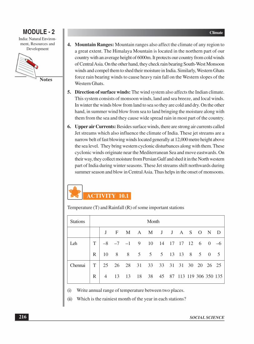
ACTIVITY 10.1
Temperature (T) and Rainfall (R) of some important stations
Stations Month
J F M A M J J A S O N D
Leh T –8 –7 –1 9 10 14 17 17 12 6 0 –6
R 10 8 8 5 5 5 13 13 8 5 0 5
Chennai T 25 26 28 31 33 33 31 31 30 20 26 25
R 4 13 13 18 38 45 87 113 119 306 350 135
(i) Write annual range of temperature between two places.
(ii) Which is the rainiest month of the year in each stations?

MODULE - 2India: Natural Environ-ment, Resources and
Development
217
Climate
SOCIAL SCIENCE
Notes
Figure 10.1
INTEXT QUESTIONS 10.1
Look at the map given above and answer the following questions:
(a) Name the important latitude drawn on the map which has divided India in twoheat zones. Also tell the degree of that latitude.
(b) Name the cities located on map which are influenced by the sea and cities whichare not influenced by the sea.
(c) Which mountain range protects our country from cold breeze of Central Asia?
(d) Observe the wind direction given on the map and tell why do we have dry winterseason?
Mona and Raju returned from Shimla after five days stay. They were very happyand shared their experience with their friends. Few days later they were surprisedto see a news headline that monsoons are coming on time. What is the meaning of
200 0 200 400
Kilometres
Bay of BengalArabianSea
64° 68° 76° 80°72° 84° 88° 92°
72° 84°76° 88° 92°
8°
12°
16°
20°
24°
28°
32°
8°
12°
16°
20°
24°
28°
32°
Winter Monsoon
ii(b)
iv(b)
(a)
(c)
MAP FOR INTEXT QUESTIONS
Lakshadweep
Andaman & Nicobar Islands

SOCIAL SCIENCE
MODULE - 2 Climate
India: Natural Environ-ment, Resources and
Development
218
Notes
monsoon? They wanted to know the answers of their questions with the help of theirteacher. Try to find out answers in the following section.
10.2 MECHANISM OF MONSOON
The word monsoon is derived from the Arabic word ‘Mausim’ which means season.Monsoon refers to the seasonal reversal in the wind direction during a year. Duringsummer, the interior parts of North Indian Plains covering Rajasthan, Punjab,Haryana, and Western Uttar Pradesh are intensely hot. The daily maximumtemperature in some of these parts is as high as 45° to 47° C. Table 10.1 givenbelow indicates the climatic diversity in India. Try to understand the varyingtemperature that different stations in India have.
Table 10.1: Temperature (in ° Celcius) and Rainfall (in cm) of someimportant stations in India
STATIONS MONTHS
J F M A M J J A S O N D
LEH Temp. -8 -7 -1 9 10 14 17 17 12 6 0 -6
Rainfall 10 8 8 5 5 5 13 13 8 5 0 5
SHILLONG Temp. 10 11 16 19 19 21 21 21 20 17 13 10
Rainfall 14 29 56 146 295 476 359 343 302 188 36 10
DELHI Temp 14 17 23 29 34 35 31 30 29 21 20 15
Rainfall 21 24 13 10 10 68 186 170 125 14 2 9
JAISALMER Temp 16 20 25 30 33 34 32 31 30 28 22 17
Rainfall 0.2 0.1 0.3 0.1 0.5 0.7 0.9 86 14 01 0.5 0.2
MUMBAI Temp 24 24 24 28 30 29 27 27 27 28 27 2 5
Rainfall 4 2 2 2 18 465 613 329 286 65 18 2
CHENNAI Temp 25 26 28 31 33 33 31 31 30 28 26 25
Rainfall 4 13 13 18 38 45 87 113 119 306 350 135
Temp 27 27 28 29 29 27 26 26 27 27 27 27
Rainfall 23 21 39 106 208 356 223 146 138 273 206 75
� Air has weight and this weight exerts pressure on us, which is known as airpressure.
� There is an inverse relationship between temperature and air pressure, i.e. ifthe temperature of any area is high then the air pressure will be low and vice-versa.
� Difference in the air pressure is responsible for the attraction of the winds.
THIRUVANANTHAPURAM

MODULE - 2India: Natural Environ-ment, Resources and
Development
219
Climate
SOCIAL SCIENCE
Notes
The average maximum temperature is above 33°C in the month of May at Delhi andJodhpur. Such high temperature heats up the air of that region. Hot air rises, lowpressure area is created under it. This low pressure is also known as monsoonaltrough. It lies between Jaisalmer in the west and Balasore in Odisha in the East.
Figure 10.2 Temperature of May
On the other hand temperature over Indian Ocean is relatively low, as water needsmore time to get heated as compared to land. So a relatively high pressure regionis created over the sea. See the map 10.2 given above and try to understand thegiven phenomenon.
Thus, there is a difference of temperature and resultant pressure over North CentralIndian Plains and Indian Ocean. Due to this difference, air from high pressure regionof the sea starts moving towards the low pressure region of North India. Thus, bymid June the general movement of air is from equatorial region of Indian Ocean tothe Indian subcontinent and the direction of these winds in general is from South-West to North-East. This direction is exactly opposite to that of the trade winds(North – East to South-West) prevailing during winter in India. This complete reversal
64° 68° 76° 80°72° 84° 88° 92°
72° 84°76° 88° 92°
8°
12°
16°
20°
24°
28°
32°
8°
12°
16°
20°
24°
28°
32°
200 0 200 400
Kilometres
TEMPERATURE OF MAY
Low Pressure Trough
46°C
45°C
42°C
38°C
Bay of BengalArabianSea
INDIA
Lakshadweep
Andaman & Nicobar Islands

SOCIAL SCIENCE
MODULE - 2 Climate
India: Natural Environ-ment, Resources and
Development
220
Notes
of wind direction from North-East to South West and vice-versa is known asmonsoons.
Figure 10.3 Temperature of June
These winds originate over warm seas. Therefore, they contain a lot of moisture.When these moisture laden winds move over the Indian sub-continent they causewide spread rain throughout India and from June to September 80% to 90% of thetotal rainfall in India is confined to these four months only.
10.2.1 Characteristics of the Monsoon
1. Monsoons are not steady winds. They are irregular in nature affected by differentatmospheric conditions i.e. due to regional climatic conditions. Sometimesmonsoon early or some times late.
2. Monsoons are not equally distributed. Coastal areas like Kerala West Bengaland Odisha receive heavy rain fall, whereas interior regions like Haryana, MadhyaPradesh, receive less rainfall.
200 0 200 400
Kilometres
64° 68° 76° 80°72° 84° 88° 92°
72° 84°76° 88° 92°
8°
12°
16°
20°
24°
28°
32°
8°
12°
16°
20°
24°
28°
32°
1Ju
ne
5Ju
ne
5Ju
ne
10Ju
ne
10June
38°C
42°C
45°C
46°C
ADVANCING SOUTH-WEST MONSOON
AND TEMPERATURE OF JUNE
Bay of BengalArabianSea
INDIA
Lakshadweep
Andaman & Nicobar Islands

MODULE - 2India: Natural Environ-ment, Resources and
Development
221
Climate
SOCIAL SCIENCE
Notes
3. When monsoon arrives, it gives heavy rainfall which continues for several days.This is known as ‘burst of monsoon’. This occurs mainly at Kerala coast whereit reaches first.
ACTIVITY 10.2
Observe the picture and answer the following questions:
(a) (b) (c)
Figure 10.4
1. Identify the seasons in the given pictures (a), (b) and (c).
2. Arrange them on the basis of their occurrence.
3. Which season you like the most and why? Write answer in about 30 words.
INTEXT QUESTIONS 10.2
Look at maps (Fig. 10.2, Fig. 10.3) of advancing monsoon and answer the followingquestions:
1. Name the states which lie within the low pressure regions.
2. As the monsoon winds are coming from south-west which state they will strikefirst.
3. When the monsoon winds reach the Bay of Bengal, what is their direction?
4. Observe the rainfall data of the following cities and find out the average durationof monsoon in four cities. Name of the cities are:
(a) Mumbai (c) Delhi
(b) Jaisalmer (d) Shillong
A few months later Mona and Raju’s father was transferred to Delhi. They wereexcited to live in the capital of India. They shifted to Delhi. New home, new school,new friends and new environment and everything was new for them. They realized
SOCIAL SCIENCE
MODULE - 2 Climate
India: Natural Environ-ment, Resources and
Development
222
Notes
that now they were going to see the real changes of the seasons which they had readin their book. Try to discover the various seasons and how they happen in thefollowing section.
10.3 CYCLE OF SEASONS
Our country, India, enjoys variety of seasons due to geographical locations. Nowyou will know about the seasons of India and their unique features. We have fourseasons:
(a) Cold weather season (December – February)(b) Hot weather season (March – May)(c) Advancing South – West monsoon season (June – September)(d) Post or retreating monsoon season (October – November).
You will know more about each of them in the following section.
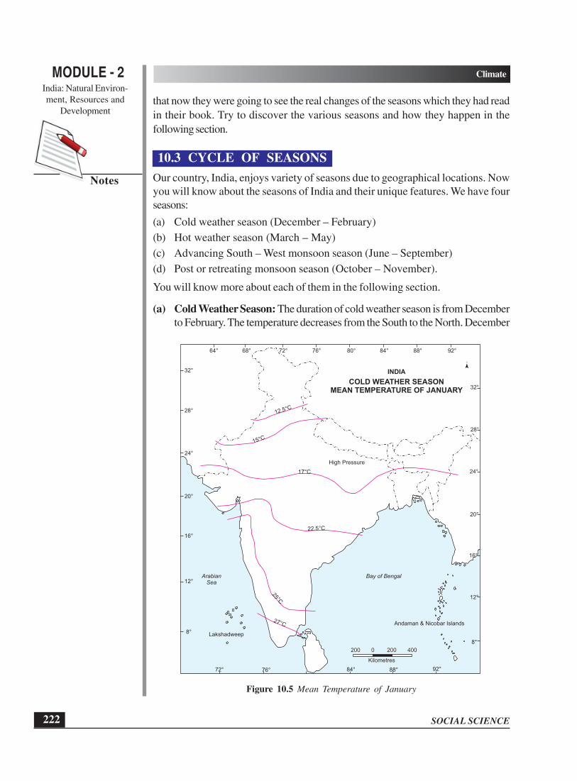
(a) Cold Weather Season: The duration of cold weather season is from Decemberto February. The temperature decreases from the South to the North. December
64° 68° 76° 80°72° 84° 88° 92°
8°
12°
16°
20°
24°
28°
32°
8°
12°
16°
20°
24°
28°
32°COLD WEATHER SEASON
MEAN TEMPERATURE OF JANUARY
12.5°C
15°C
17°C
High Pressure
INDIA
22.5°C
Bay of BengalArabianSea
27°C Andaman & Nicobar Islands
Lakshadweep
200 0 200 400
Kilometres
72° 84°76° 88° 92°
Figure 10.5 Mean Temperature of January

MODULE - 2India: Natural Environ-ment, Resources and
Development
223
Climate
SOCIAL SCIENCE
Notes
and January are the coldest months and the average temperature in North is(12° to 15°C) and in South (25°C). Frost is common in the North and North-West India. There is light rainfall in this region due to Western disturbances.Higher slopes of the Himalayas experience snowfall. During the winter season,North-East trade winds prevail over India. They blow from land to sea. Hence,for most part of the country, it is a dry season. However, the Tamil Nadu coastreceives winter rainfall due to these winds. A part of North-East trade windsblow over Bay of Bengal. They gather moisture which causes rainfall in thecoastal Tamilnadu while the rest of the country remains dry. In the northern partof the country the weather is marked by clear sky, low temperatures and lowhumidity. The winter rainfall is very important for the cultivation of ‘Rabi’ crops.
(b) Hot Weather Season: By the end of February the temperature starts rising.So from March to May it is hot weather season. We find high temperature inplains, western part of India and in the central part of peninsular India. InNorthern plains, thus, an elongated low pressure which is called monsoonaltrough created here, which extends from Jaisalmer in western Rajasthan toJharkhand and parts of Odisha to the East. However, over Indian Ocean south
64° 68° 76° 80°72° 84° 88° 92°
72° 84°76° 88° 92°
8°
12°
16°
20°
24°
28°
32°
8°
12°
16°
20°
24°
28°
32°
200 0 200 400
Kilometres
COLD WEATHER WINDS OF
JANUARY MONTH
Western Cyclonic Disturbance
Bay of BengalArabianSea
INDIA
Lakshadweep
Andaman & Nicobar Islands
Figure 10.6 Direction of winds in January

SOCIAL SCIENCE
MODULE - 2 Climate
India: Natural Environ-ment, Resources and
Development
224
Notes
of the equator high pressure belt begins to develop in this season. In North-West India, afternoon dust storms are common. During summer, very hot anddry winds blow over North Indian plains. They are locally called ‘Loo’.Exposure to theses hot winds may cause heat or sun stroke. This is also theseason for localized thunderstorms, associated with violent winds, torrentialdownpours, often accompanied by hail. In West Bengal, these storms are knownas the ‘Kaal Baisakhi’ (calamity for the month of Baisakh). Towards the closeof the summer season, pre-monsoon showers are common, especially in Keralaand Karnataka. They help in the early ripening of mangoes, and are oftenreferred to as ‘mango showers’.
(c) Advancing South West Monsoon Season: After the scorching heat ofsummer season people eagerly wait for the rains which can give them relief.Farmers wait for the rains so that they can prepare their fields for the nextcropping season Kharif. June to September are the months of advancing South-West monsoon season. By the end of May the monsoon trough further intensifiesover north India due to high temperature in the region. The General directionof the wind during this season is from South-West to north-east. These winds
200 0 200 400
Kilometres
Bay of BengalBranch
Arabian SeaBranch
1Ju
ne
5Ju
ne
5Ju
ne
10Ju
ne
10June
64° 68° 76° 80°72° 84° 88° 92°
72° 84°76° 88° 92°
8°
12°
16°
20°
24°
28°
32°
8°
12°
16°
20°
24°
28°
32°ADVANCING MONSOON
INDIA
Lakshadweep
Andaman & Nicobar Islands
Figure 10.7 Advancing Monsoon of India

MODULE - 2India: Natural Environ-ment, Resources and
Development
225
Climate
SOCIAL SCIENCE
Notes
are strong and blow at an average velocity of 30 km per hour. These moistureladen winds first hit at Andaman and Nicobar Islands in the last week of Mayand Kerala coast in the first week of June with violent thunder and lightning.ThisSouth-West monsoon that flows in to India brings about a major change in itsweather. Two branches of south-west monsoon originate from: (i) Arabian Seaand (ii) Bay of Bengal.
The Arabian Sea Branch obstructed by Western Ghats gives heavy rainfall on theWestern side of Western Ghats. It reaches Mumbai by 10th June (See Fig. 10.7).When this branch crosses the Western Ghats and reaches the Deccan Plateau andparts of Madhya Pradesh, it gives less rainfall as it is a rain shadow region. Further,this branch reaches in Northern Plain by 20th June.
The monsoon winds that move from Bay of Bengal strike Andaman and Nicobarislands North-Eastern states and coastal areas of West Bengal and covers the wholeof India by the 15th of july. They cause heavy rainfall in the region. However, quantityof rainfall decreases as they move towards West over the Northern plains. Forexamples rainfall at Kolkata is 120 cm, Allahabad 91 cm and Delhi 56cm.You musthave seen that rainfall does not continue for several days. The monsoon tends tohave ‘breaks’ in its rainfall which causes wet and dry spells. This means that monsoonrains occur only a few days at a time. Rainless dry spells occur in between. As themonsoon comes after the hot and dry summer season, the rainfall brings down thetemperature. We can see this decline is from 5°C to 8°C between mid June andmid July. This is the time when many parts of India face floods also. This is mainlybecause of heavy rainfall and our inability to manage our water resources moresystematically. On the other hand there are many areas that experience droughtconditions during this season.
ACTIVITY 10.3
Collect the information from the newspapers and other sources and find out whichparts of India are regularly affected by the floods and droughts. Also paste thenewspaper cuttings as a sample. Identify name the reasons and collect the informationabout the most recent.
(d) Retreating or Post Monsoon Season: October and November are themonths of post (or retreating) monsoon season. The temperatures duringSeptember-October start decreasing in north India. Monsoonal trough alsobecomes weak over North-West India. This is gradually replaced by a highpressure system. The South-West monsoon winds weaken and start withdrawinggradually from North Indian Plains by November. In October the weatherremains humid and warm due to continuing high temperature and moist land in

SOCIAL SCIENCE
MODULE - 2 Climate
India: Natural Environ-ment, Resources and
Development
226
Notes
month of October. In Northern plains hot and humid weather becomesoppressive at this time. It is commonly called ‘October Heat’. However,towards the end of October, temperature starts decreasing, making nightspleasant. This is also the time of cyclonic storms which develop in the Bay ofBengal as the low pressure of North India shifts to this area. These storms createhavoc in coastal areas of Odisha, Andhra Pradesh and Tamil Nadu, especiallyin the deltas of Mahanadi, Godavari and Krishna rivers.
Figure 10.8 Retreating Monsoon
INTEXT QUESTIONS 10.3
Choose the correct answer:
(i) The hot and dry wind blowing in the northern plain in the summer are called—
(a) Kaal Baisakhi (c) Trade winds
(b) Loo (d) All of the above
64° 68° 76° 80°72° 84° 88° 92°
72° 84°76° 88° 92°
8°
12°
16°
20°
24°
28°
32°
8°
12°
16°
20°
24°
28°
32°15
Sep
tem
ber
15 October
1Nove
mber
15 Novem
ber
200 0 200 400
Kilometres
RETREATING MONSOON
Bay of BengalArabianSea
INDIA
Lakshadweep
Andaman & Nicobar Islands

MODULE - 2India: Natural Environ-ment, Resources and
Development
227
Climate
SOCIAL SCIENCE
Notes
(ii) Which mountain range acts as a barrier in the path of the Arabian Sea branch?
(a) Aravallis (c) Western Ghats
(b) Eastern Ghats (d) Raj Mahal hills
(iii) The tropical cyclones of the Bay of Bengal usually occurs during
(a) South-west monsoon (c) Retreating monsoon season
(b) Hot weather season (d) Cold weather season
(iv) Which place would be the hottest one in March?
(a) Delhi (c) Deccan Plateau
(b) Shillong (d) Punjab
(v) Monsoons are called ........................
(a) Seasonal winds (c) Permanent winds
(b) Temporary winds (d) Local winds
Seasons, its cycle, causes and effects were now clear to Mona and Raju. Only onequestion remained unanswered. If the monsoons came in a particular area for certainduration so it means the rainfall distribution in India was uneven? Try to find the answerwith the help of Rainfall distribution map.
10.4 DISTRIBUTION OF RAINFALL
Rainfall in India is highly uneven over a period of time in a year. As we movefrom East to West in Northern plains, we observe that in central India rainfalldecreases. In peninsular region, India’s rainfall decreases from coast to interiorparts. In North-East India, the rainfall increases with altitude. India is the uniqueexample of rainfall distribution with marked contrasts. Both, one of the rainiestand driest places of the world are located in India itself. Can you think why?Spatial variations in rainfall in India can be shown under the following headings.Observe the given map and find out the states under the given categories –
(a) Areas of heavy rainfall (more than 200cm): Maximum rainfall in India occursin the western coast, sub Himalayan regions of north-east and Garo, Khasi andJaintia hills of Meghalaya.
(b) Area of Moderate rainfall (100-200cm): Areas receiving 100 to 200cm rainfallin India include some parts of the Western Ghats, West Bengal, Odisha andBihar and many states.
(c) Areas of Low rainfall (60 to 100cm): This is the region of low rainfall, whichincludes parts of Uttar Pradesh, Rajasthan, interier deccan plateau.
(d) Areas of Inadequate rainfall (Less than 60cm): This is region of scanty rainfall.The western part of Rajasthan and Gujarat, Laddakh and south central partreceives a rainfall of less than 20cm.

SOCIAL SCIENCE
MODULE - 2 Climate
India: Natural Environ-ment, Resources and
Development
228
Notes
ACTIVITY 10.4
List out the festivals of India in the table given below. Also find out which seasonis economically significant in your area and why?
List of the Areas where Date and Season Economicallyfestivals celebrated month Significant
Do you see co-relation between seasons of festivals and harvest seasons. Pleaseprovide one reason.
Figure 10.9 Annual Rainfall of India
200 0 200 400
Kilometres
RAINFALL IN (cm)
Above 200
100 - 200
60 - 100
Below 60
Bay of BengalArabianSea
INDIA
ANNUAL RAINFALL
200 0 200 400
Kilometres

MODULE - 2India: Natural Environ-ment, Resources and
Development
229
Climate
SOCIAL SCIENCE
Notes
10.5 SOCIO-CULTURAL LIFE
You are now well aware about the cycle of seasons but a second thought comesto our mind what do the relationship between the seasons and our life? Are theyso important that they affect our life? The answer is ‘yes’. They do affect our socialand cultural life. As India is an agricultural country the main economic activity ofagriculture is totally dependent on the cycle of seasons. The time of Kharif cropis advancing monsoon season and harvesting is post monsoon season. Rabi cropis grown in winter and zaid crop is at the end of winter season. Floods and droughtsare hindrances in the economic growth of the nation as our economy is agro basedeconomy.
All our activities are related with the seasons. As winter season comes the daysbecome shorter and we start purchasing woolen clothes. Groundnuts, almonds andcalorie rich food become very important in our diet. In spite of cold weather peoplecelebrate many festivals like Makar Sankranti in many states, Lohri in Punjabi andPongal in Tamil Nadu in the month of January. Basant Panchami is also celebratedin the month of February in which people pray for good harvest.Summer season isvery dry but it reminds us of juicy fruits, ice creams and variety of drinks. What arethe fruits available in this season? Holi and Baisakhi are the main festivals of theseason.By the end of summer farmers start preparing their fields so that they canwelcome the rains. This is the time when people of Kerala celebrate Onam whichcoincide with their harvest season. Post Monsoon is the harvesting time. It is alsoa festival time of Dushera, Durga Pooja and Diwali which are celebrated all overIndia.
10.6 GLOBAL ENVIRONMENTAL CHANGES AND ITSIMPACT ON INDIAN CLIMATE
After studying this lesson you must have understood that India is fortunate to havefour clear seasons’ summer, winter, spring and monsoon. However, these days onecan notice disturbance in the cycle of seasons. This is due to global warming whichis a burning topic of today’s world. It has a significant political, social and economicimpact that may affect almost every aspect of our lives and lifestyles. The globalwarming has a serious impact on world’s climate and India cannot escape it. Don’tyou think that it is important for everybody to know about it and think how eachone of us can contribute in reducing its extent?
Let us understand what is global warming. During the last decades of urbanization,industrialization and population growth the atmosphere has been polluted. Humanactivities increase the amount of carbon dioxide, Chloro Floro Carbon (CFC) andother dangerous gases. About 51% of the solar energy is absorbed by the earth’ssurface, which increases its temperature. The rest of the heat is reflected back into the atmosphere. This helped in maintaining temperature. But now due to pollutionsome of the reflected heat is trapped by green house gases (GHGs), mainly carbon

SOCIAL SCIENCE
MODULE - 2 Climate
India: Natural Environ-ment, Resources and
Development
230
Notes
dioxide. It has increased the temperature of the Earth’s surface. There is evidenceto show that CO2 levels are still increasing. Many countries have signed a conventionto reduce GHGs under the U.N. framework. However, the current internationalagreements are still not effective enough to prevent the significant changes in climate.
We already know that 70% of Indians are working in agriculture sector. Any changein temperature will have an adverse effect on agriculture. This will have a serioussocial and economic impact on India. After reading the chapter we can clearly seethat climate plays a very important role in Human life. Our food, our festivals, andour economy everything is closely linked with the cycle of seasons. If the seasonsare favourable, human life will be good and comfortable. Since the state of theweather affects agriculture, health, transportation etc it is important that all of us makesome change in our lifestyle to reduce CFC and other harmful gases.
ACTIVITY 10.5
Keep a diary of events about natural calamities such as earthquakes, cyclones andgeographical events. Record them with name of the event, date and their impact.
INTEXT QUESTIONS 10.4
1. Why do we find the rainfall distribution in India highly uneven?
2. Name the three regions of India receiving lowest rainfall.
3. Name the months of Kharif and Rabi season.
4. When do we have the zaid season?
5. Which human activities are responsible for global warming?
WHAT YOU HAVE LEARNT
� Climate of India is affected by many factors like location, distance from the sea,altitude, mountain ranges, direction of surface winds and upper air currents.
� India has a special system of reversal of winds which is known as monsoon andit comes with a system.
� India has a cyclic system of season and it has four main seasons. They are winter,summer, advancing monsoon and retreating monsoon.
� Seasons play an important role in our day to day life and affect our activitiesand eating habits.
� Global warming influences Indian climate also.

MODULE - 2India: Natural Environ-ment, Resources and
Development
231
Climate
SOCIAL SCIENCE
Notes
TERMINAL EXERCISES
1. Describe any five factors which are responsible for affecting the climate? Explainwith the help of examples for each factor.
2. Differentiate between climate and weather.
3. How are winds and their directions responsible for affecting the climate? Explainby giving examples.
4. Define monsoon. Identify the main reason which is responsible for moving tradewinds in opposite direction?
5. Mention any four characteristics of cold weather season.
6. List any four main features of hot weather season?
7. By giving examples explain the effects of the global warming in India. What arethe causes behind it?
ANSWERS TO INTEXT QUESTIONS
10.1
(a) Tropic of cancer, 23½° N
(b)
Incluenced by sea
(i) Mumbai
(ii) Chennai
Not incluenced by sea
(iii) Lucknow
(iv) Delhi
(c) Himalayan Mountain Ranges
(d) Winds are coming from North-East. Since they are coming from land, they aredry and unable to give rain to the country.
10.2
1. Rajasthan, Punjab, Haryana, Uttar Pradesh, Bihar, Jharkhand, West Bengal,Madhya Pradesh and Chhattisgarh and parts of Odisha.
2. Kerala.

SOCIAL SCIENCE
MODULE - 2 Climate
India: Natural Environ-ment, Resources and
Development
232
Notes
3. South to North and North-East and North-West.
4. (a) Mumbai: 4 months (c) Delhi: 4 months
(b) Nagpur: 4 months (d) Shillong: 6 months
10.3
1. (i) (b) Loo
(ii) (c) Western Ghats
(iii) (c) Retreating monsson season
(iv) (c) Deccan Plateau
(v) (a) Seasonal Winds
10.4
1. When monsoon winds enter from the coast, they give the maximum rain there.When they reach the central or northern regions, they become dry, resulting lessrainfall.
2. Regions of low rainfall –
1. Northern leh-ladakh region
2. Western Rajasthan
3. South-Central part
3. Kharif – June and July Rabi – October and November
4. From the end of the winter season i.e. March to May.
5. Urbanization, Industrialization, Deforestation, burning of fossil fuels, etc.

233
Bio-Diversity
SOCIAL SCIENCE
MODULE - 2India: Natural Environ-
ment, Resources and
Development
Notes
11
BIO-DIVERSITY
You must have seen variety of grass, plants, bushes, trees, insects, birds, animals
or beautiful landscape around you. We rely on this diversity of plants and animals
to provide us food, fuel, medicine and other essentials without which we cannot live.
These species are the product of more than four billion years of evolution. This rich
bio diversity is being lost at an alarming rate largely because of human activities.
However, there are many things that each one of us can contribute in preserving these
species, plants, animals and other living organisms. There are lots of things which
you can help in saving these precious diversities. It is very important for us to know
about diversity of plants, animals and micro-organisms. In this lesson, we will learn
about some of these plants, animals, their importance and distribution in India and
need for their conservation.
OBJECTIVES
After studying this lesson you will be able to:
l explain the concept of bio-diversity;
l explain the status of bio-diversity in India;
l establish the significance of biodiversity;
l describe natural vegetation and wildlife in India;
l locate forests, wildlife sanctuaries, national parks, biosphere reserves and
wetlands in an outline map of India; and
l recognise our role in conserving natural vegetation and wildlife in our region.
11.1 BIO-DIVERSITY
Biodiversity is a short form of biological diversity. In simple terms biodiversity is the
total number of genes, species and ecosystems of a region. It includes (i) genetic

SOCIAL SCIENCE
Bio-Diversity
234
MODULE - 2India: Natural Environ-
ment, Resources and
Development
Notes
diversity, (ii) species diversity and (iii) ecosystem diversity. Plants and animals
constitute only a small component of biodiversity. Do you know that the invisible
micro-organisms constitute a large component of bio-diversity.
Figure 11.1 Biodiversity
Genes: The basic biological unit of heredity. Genes of an individual belonging
to the same species are similar and genes control the characteristics of particular
species.
Species: A group of very similar having some common characteristics or qualities
and capable of interbreeding.
Ecosystem – Any segment of the landscape that includes biotic (living) and abiotic
(non-living) components is known as ecosystem.
11.1.1 Status of biodiversity in India
Biodiversity increases as we move from the poles towards the equator. India is
located between 8°4′ North and 37°6′ North latitudes and 68°7′ East and 97°25′
East longitude. Due to this position India has such rich biodiversity. Although India

235
Bio-Diversity
SOCIAL SCIENCE
MODULE - 2India: Natural Environ-
ment, Resources and
Development
Notes
has only 2.42% of the world’s land area but its contribution to the world’s biodiversity
is approximately 8% of the total number of species which is estimated to be 1.75
million (As per Global Biodiversity Assessment of UNEP of 1995). 6% of the world
species are found in India. 45000 plants species comprising about 12 % of world’s
flora are found in Indian forests. Two of the twelve biodiversity hotspots in the world
are in India. They are the North-Eastern region and the Western Ghats.
l A biodiversity hotspot is a region with a high level of endemic species.
Endemic species are those species that are found in a certain limited area.
l Mega biodiversity: A unique combinations of different plants and animal
species which is not available anywhere else.
11.2 SIGNIFICANCE OF BIODIVERSITY
Biodiversity is fundamental to the existence of life on the earth. Its significance cannot
be underestimated. There are varieties of living things that exist in a given physical
environment. These are interdependent and interrelated in the form of an ecosystem.
Do you know that plants occur in distinct groups of communities in areas having
similar climatic conditions? The nature of vegetation in any area determines the animal
life. When the vegetation of a place is altered, animal life also changes and
simultaneously it affects mankind. Loss of any component in the system adversely
affects other components of the system. We are an integral part of the ecosystem.
By cutting trees and killing animals, human beings lead to ecological imbalance. How
does the ecosystem get influenced by human beings? Collect some articles from the
newspaper and magazines which will help you in understanding human impact on
ecosystem. We must understand that all plants and animals in an area are
interdependent and interrelated in their physical environment? Ecosystem is extremely
valuable in different facets of human life which includes the following:
l Providing food, water, fiber, fuel etc.
l Regulating of climate and disease (For example: people are suffering from cold
and cough in winters and stomach infections in monsoon etc.
11.2.1 Causes of Loss of Biodiversity
Increasing population and changing lifestyle leads to extenssive commercial exploitation
of the natural resources. This results in loss of biodiversity. Consequently it is
adversely affecting the ability of the nature to continue delivering the goods and
services for human existence. The loss of biodiversity affects not only the physical
environment but also the social, cultural, religious and spiritual well being of human
life.
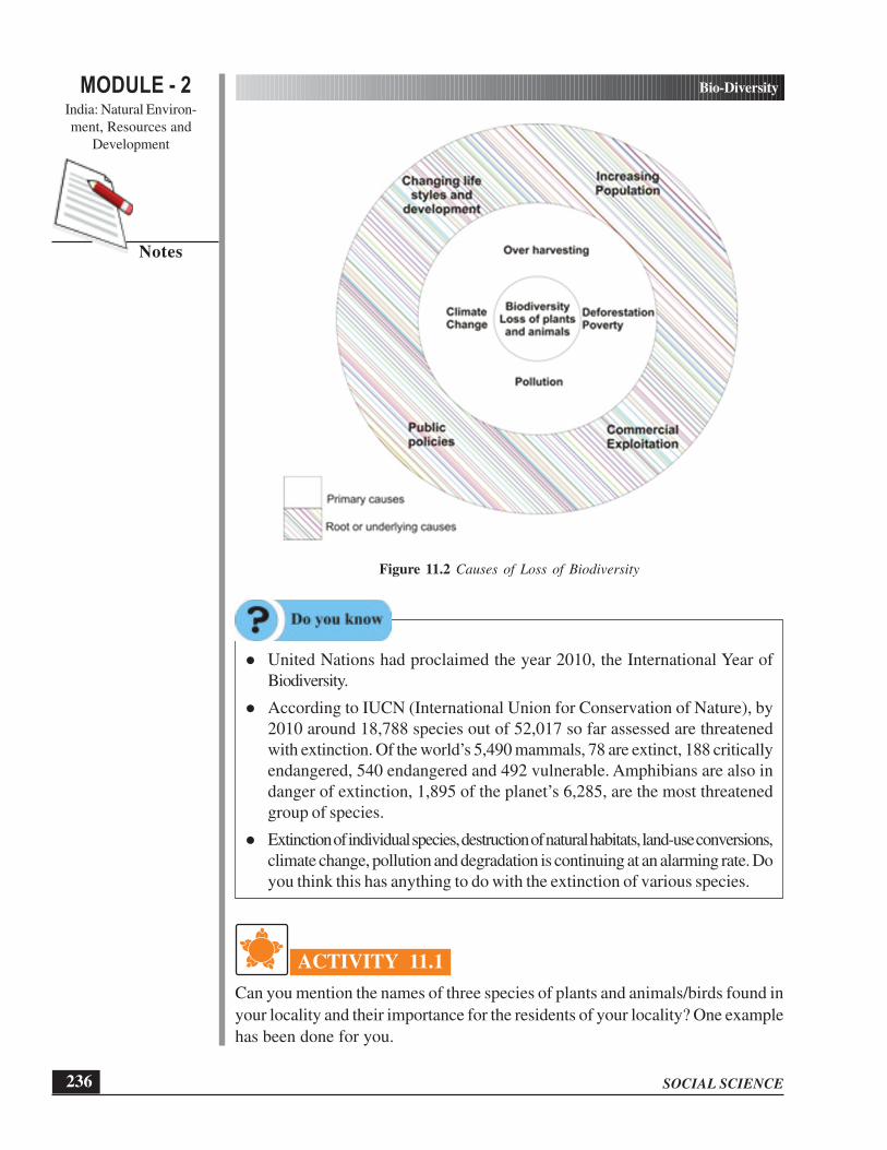
SOCIAL SCIENCE
Bio-Diversity
236
MODULE - 2India: Natural Environ-
ment, Resources and
Development
Notes
Figure 11.2 Causes of Loss of Biodiversity
l United Nations had proclaimed the year 2010, the International Year of
Biodiversity.
l According to IUCN (International Union for Conservation of Nature), by
2010 around 18,788 species out of 52,017 so far assessed are threatened
with extinction. Of the world’s 5,490 mammals, 78 are extinct, 188 critically
endangered, 540 endangered and 492 vulnerable. Amphibians are also in
danger of extinction, 1,895 of the planet’s 6,285, are the most threatened
group of species.
l Extinction of individual species, destruction of natural habitats, land-use conversions,
climate change, pollution and degradation is continuing at an alarming rate. Do
you think this has anything to do with the extinction of various species.
ACTIVITY 11.1
Can you mention the names of three species of plants and animals/birds found in
your locality and their importance for the residents of your locality? One example
has been done for you.

237
Bio-Diversity
SOCIAL SCIENCE
MODULE - 2India: Natural Environ-
ment, Resources and
Development
Notes
Sr. No. Plants Importance Sr. No. Animals/Birds Importance
1. Neem 1. Vulture
2. 2.
3. 3.
4. 4.
INTEXT QUESTIONS 11.1
1. “Bio-diversity is fundamental to the existence of life on the earth” Justify the
statement by giving any two reasons.
2. Explain hotspots in 30 words.
11.3 NATURAL VEGETATION AND WILDLIFE
In our ecosystem, vegetation and wildlife are valuable resources. We all know that
plants provide us with timber, give shelter to man and animals, produce the oxygen
we breathe, prevent soil erosion and natural calamities such as floods, high speed
winds and help in storage of underground water, give us fruits, nuts, latex, turpentine
oil, gum, medicinal plants and also the paper that is so essential for our studies. These
are some of the innumerable uses of plants. Wildlife includes animals, birds, insects,
reptiles as well as the aquatic life forms. They provide us milk, meat, hides and wool.
Insects like bees provide us honey, help in pollination of flowers and have an important
role to play as decomposers in the ecosystem. The birds feed on insects and act
as a decomposers as well. Vulture due to its ability to feed on dead livestock is a
scavenger and considered a vital cleanser of the environment. So life forms, big or
small, all are integral in maintaining a balance in the ecosystem.
11.3.1 Natural Vegetation in India
As in any other part of the world, natural vegetation of India is also determined by
climate, physiographic and soil factors. If we look at the figure 11.3, we find that
based on factors of temperature, rainfall and topographic conditions, India has diverse
vegetation patterns as summarized below. Dense natural vegetation found in North-
Eastern region, Western Ghats and Andaman Nicobar. The Northern plain and
North-Western Region supports very scanty vegetation and is under cultivation. The
Give us medicine,
wood ,oxygen and
shade
Keeps environment
free of carcasses and
waste, restrict
spread of diseases,
help control a
number of pest like
rats

SOCIAL SCIENCE
Bio-Diversity
238
MODULE - 2India: Natural Environ-
ment, Resources and
Development
Notes
Deccan region is full of scrubs and mixed deciduous forests. Natural vegetation of
India can broadly be divided into the following groups:
(i) Tropical Evergreen Forests
(ii) Tropical Deciduous Forests
(iii) Thorn Forests
(iv) Tidal Forests
(v) Himalayan Forests
(i) Tropical Evergreen Forests
Trees in these forests remain green all the year round as the climate of the region
is warm and wet throughout the year. The leaves of these trees do not fall in any
particular season. Hence, they are evergreen. These forests are found in the areas
having more than 200 cm of rainfall with a short dry season. The trees reach a
height up to 60 meters or even more. It has a dense and mixed vegetation of
all kinds including trees, shrubs, climbers, creepers, epiphytes and ferns giving it a
multilayered structure. Hence, their economic exploitation is not viable. The number
of species of trees is very large in a small area. Rosewood, ebony, mahogany,
rubber, jack wood and bamboo are the important species of trees found in
Tropical Evergreen Forests. In India, this type of vegetation is found in the areas
of heavy rainfall in Western Ghats, upper parts of Assam and islands of
Lakshadweep, Andaman and Nicobar. Hardwood from these forests is used for
furniture, handicraft etc. They prevent landslides and soil erosion.
ii) Tropical Deciduous Forests
Trees in these forests shed their leaves once in a year. That is why they are called
tropical deciduous forests. These are most widespread forests of India. These forests
are found in the areas receiving annual rainfall between 75 to 200 cms. As far as
the physical distribution of this type of forests is concerned they are found in the entire
country excluding some parts of Deccan Plateau, North-Eastern Region, Western
Ghats and Eastern coast. These forests have been subject to extensive clearance by
man for the purpose of cultivation. Still some patches of natural vegetation are found
along the foothills of Himalayas, hilly regions of peninsular and central part of the
country. On the basis of the availability of rainfall these forests are further divided
into moist deciduous and dry deciduous.
(a) The moist deciduous forests are found in the areas of rainfall between 100
to 200 cm. These are distributed mainly in the eastern parts of the country,
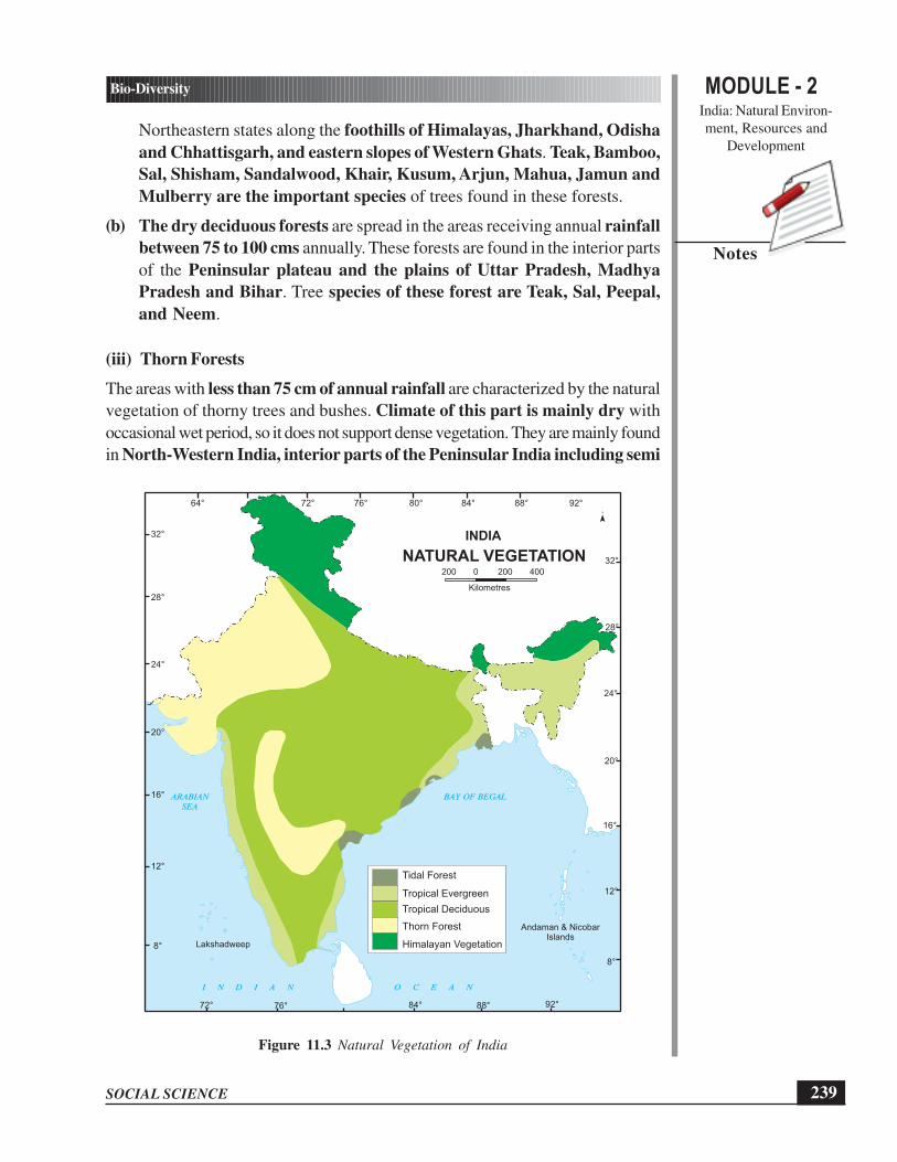
239
Bio-Diversity
SOCIAL SCIENCE
MODULE - 2India: Natural Environ-
ment, Resources and
Development
Notes
Northeastern states along the foothills of Himalayas, Jharkhand, Odisha
and Chhattisgarh, and eastern slopes of Western Ghats. Teak, Bamboo,
Sal, Shisham, Sandalwood, Khair, Kusum, Arjun, Mahua, Jamun and
Mulberry are the important species of trees found in these forests.
(b) The dry deciduous forests are spread in the areas receiving annual rainfall
between 75 to 100 cms annually. These forests are found in the interior parts
of the Peninsular plateau and the plains of Uttar Pradesh, Madhya
Pradesh and Bihar. Tree species of these forest are Teak, Sal, Peepal,
and Neem.
(iii) Thorn Forests
The areas with less than 75 cm of annual rainfall are characterized by the natural
vegetation of thorny trees and bushes. Climate of this part is mainly dry with
occasional wet period, so it does not support dense vegetation. They are mainly found
in North-Western India, interior parts of the Peninsular India including semi
Figure 11.3 Natural Vegetation of India
64° 76° 80°72° 84° 88° 92°
72° 84°76° 88° 92°
8°
12°
16°
20°
24°
28°
32°
8°
12°
16°
20°
24°
28°
32°
200 0 200 400
Kilometres
I N D I A N O C E A N
ARABIAN
SEA
BAY OF BEGAL
Lakshadweep
Andaman & NicobarIslands
Tropical Evergreen
Himalayan Vegetation
Tropical Deciduous
Thorn Forest
Tidal Forest
INDIA
NATURAL VEGETATION

SOCIAL SCIENCE
Bio-Diversity
240
MODULE - 2India: Natural Environ-
ment, Resources and
Development
Notes
arid areas of Gujarat, Rajasthan, Madhya Pradesh, Chhattisgarh, Uttar
Pradesh, Haryana, Karnataka, Andhra Pradesh and Maharashtra. Vegetation
of these forests is widely distributed in the form of small trees and bushes with deep
roots. The stems are succulent to conserve water. Leaves are mostly thick and small
to minimize evaporation. Acacia, euphorbias, babul, cacti, khair, date and palms
are common variety of trees in this type of vegetation.
(iv) Tidal Forests
As suggested by the name, these forests are found in tidal creeks and swamps
influenced by the tides and wetland topography. These areas are characterized by
mud, silt and water accumulated on the surface. Roots and branches of the trees
are submerged under water for specific period of time. They are also called mangrove
forests. Mangroves are practically evergreen with thick leathery leaves. Such types
of forests are found in the deltas of Sundarbans, Mahanadi, the Godavari, Krishna,
Kaveri rivers and in the Andaman and Nicobar Islands. Mangrove or Sundari is the
common tree in sunderbans while palm, coconut, keora, and agar are other important
species of tidal forest. It is interesting to know that this type of forests have remained
away from the large scale commercial exploitation. These forests are located along
the coasts. They provide protection against cyclones.
(v) Himalayan Forest
As is evident by the name that these forests are mainly found in the mountainous
region of the Himalayas. The decreasing in temperature and increasing in altitude lead
to varied types of vegetation depending upon the factors like slope of the mountain
and sunrays receiving side. The ecosystem is highly fragile. Himalayan forests have
been exploited in many ways in recent decades. Areas with relatively low altitude
up to 1000 meters, warm climate and good amount of rainfall are characterized by
dense vegetation cover. These areas look like tropical forest. Sal and Bamboo are
main species in these areas. Between the elevation of 1000 to 2000 meters
evergreen broad leave Oak and Chestnut are the common species found in
these forests. In eastern Himalayas the same elevation is occupied by sub tropical
Pine forests. Chir is common species found in this part. Moist temperate forest in
Himalayas are found between the elevation 1500 to 3500 meters which receives
annual rainfall in the range of 100 to 250 cm. Oak, laurel, chestnut, cedar,
Silver, Fir, spruce rhododendron and deodar are the main species found in this
part of Himalayas. They have been widely exploited for their timber. Alpine forest
found in Himalayas at the height of between 3000 to 3800 mts with large and
extensive highland grassland and sparsely distributed pine, birch, sliver, fir
and rhododendron trees.

241
Bio-Diversity
SOCIAL SCIENCE
MODULE - 2India: Natural Environ-
ment, Resources and
Development
Notes
INTEXT QUESTIONS 11.2
1. Why are the tropical rain forests called evergreen forests? Explain in 30 words.
2. Give reasons
(i) Tidal Forest areas along the eastern coast experienced severe destruction
during cyclones in recent years because
............................................................................................................
............................................................................................................
(ii) Himalayan Forests have been economically more exploited in comparison
to Tropical Evergreen Forests because
............................................................................................................
............................................................................................................
11.3.2 Wildlife in India
You have studied earlier in the lesson that due to its unique geographical position,
India is rich in wildlife. Wildlife of India is a great natural heritage. It is estimated
that about 80 percent of all known plant and animal species on the earth are found
in India. Many plants synthesize substances that are useful to the maintenance of health
in humans and other animals. In recent decades, human encroachment has posed
a threat to India’s wildlife. In response to this, the system of National parks, Wildlife
sanctuaries and protected areas, first established in 1935, has substantially expanded
through wildlife protection Act 1972. Efforts are being made to protect and
preserve biological diversity of our country under various programs. India has
preserved vast tracts of natural habitats, birds and plants in its 551 Wildlife
Sanctuaries, 96 National Parks, 25 Wetlands and 15 Biosphere Reserves
spread almost in all the states of India. Besides this, there are 33 Botanical Gardens,
275 Zoological Parks, Deer Parks, Safari Parks , Aquaria etc. to make people
aware conservation of threatened and endangered wildlife species in their respective
areas. In India, for the purpose of effective conservation of natural habitat of wildlife,
special schemes like Project Tiger 1973 and Project Elephant 1992 have been
launched. These are very important as many species are at the brink of extinction.
However, none of these efforts will be truly successfull unless all Indian recognize
their role in conserving bio-diversity.
(i) Wildlife Sanctuaries: The main objective of the wildlife sanctuaries is to ensure
maintenance of viable population of wildlife and their desired habitat. The wildlife
sanctuaries in India are home to around 2000 different species of birds, 3500
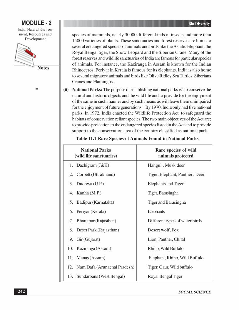
SOCIAL SCIENCE
Bio-Diversity
242
MODULE - 2India: Natural Environ-
ment, Resources and
Development
Notes
species of mammals, nearly 30000 different kinds of insects and more than
15000 varieties of plants. These sanctuaries and forest reserves are home to
several endangered species of animals and birds like the Asiatic Elephant, the
Royal Bengal tiger, the Snow Leopard and the Siberian Crane. Many of the
forest reserves and wildlife sanctuaries of India are famous for particular species
of animals. For instance, the Kaziranga in Assam is known for the Indian
Rhinoceros, Periyar in Kerala is famous for its elephants. India is also home
to several migratory animals and birds like Olive Ridley Sea Turtles, Siberians
Cranes and Flamingos.
(ii) National Parks: The purpose of establishing national parks is “to conserve the
natural and historic objects and the wild life and to provide for the enjoyment
of the same in such manner and by such means as will leave them unimpaired
for the enjoyment of future generations.” By 1970, India only had five national
parks. In 1972, India enacted the Wildlife Protection Act to safeguard the
habitats of conservation reliant species. The two main objectives of the Act are;
to provide protection to the endangered species listed in the Act and to provide
support to the conservation area of the country classified as national park.
Table 11.1 Rare Species of Animals Found in National Parks
National Parks Rare species of wild
(wild life sanctuaries) animals protected
1. Dachigram (J&K) Hangul , Musk deer
2. Corbett (Uttrakhand) Tiger, Elephant, Panther , Deer
3. Dudhwa (U.P.) Elephants and Tiger
4. Kanha (M.P.) Tiger, Barasingha
5. Badipur (Karnataka) Tiger and Barasingha
6. Periyar (Kerala) Elephants
7. Bharatpur (Rajasthan) Different types of water birds
8. Deset Park (Rajasthan) Desert wolf, Fox
9. Gir (Gujarat) Lion, Panther, Chital
10. Kaziranga (Assam) Rhino, Wild Buffalo
11. Manas (Assam) Elephant, Rhino, Wild Buffalo
12. Nam Dafa (Arunachal Pradesh) Tiger, Gaur, Wild buffalo
13. Sundarbans (West Bengal) Royal Bengal Tiger

243
Bio-Diversity
SOCIAL SCIENCE
MODULE - 2India: Natural Environ-
ment, Resources and
Development
Notes
Figure 11.4 National Park, Wildlife Sanctuaries and Bird Sanctuaries in India
(iii) Wetlands: A wetland is an area of land where soil is saturated with moisture
either permanently or seasonally. Such areas may also be covered partially or
completely by shallow pools of water. Wetlands include swamps, marshes, and
bogs, among others. The water found in wetlands can be saltwater, freshwater,
and brackish. Most importantly wetlands also serve as natural wastewater
purification systems. Wetlands are considered as biologically the most diverse
of all ecosystems. Plant life found in wetlands includes mangrove, water lilies,
cattails, sedges, tamarack, black spruce, cypress, gum, and many others. Animal
life includes many different amphibians, reptiles, birds, insects, and mammals.
Wetlands perform two important functions in relation to climate change. They
have mitigation effects through their ability to sink carbon, and adaptation effects
through their ability to store and regulate water. The Convention on Wetlands
of International Importance (Ramsar Convention), is an international treaty
designed to address global concerns regarding wetland loss and degradation.
The primary purpose of the treaty is to list wetlands of international importance
and to promote their wise use with the ultimate goal of preserving the world’s
64° 76° 80°72° 84° 88° 92°
72° 84°76° 88° 92°
8°
12°
16°
20°
24°
28°
32°
INDIA
I N D I A N O C E A N
200 0 200 400
Kilometres
ARABIAN
SEA
BAY OF BEGAL
Dachigam
Rajaji
Corbet
Dudwa
Banbasa
Sariska
Bharatpur
RanthambhorShivpuri
Gir
Sanjay Gandhi
Kanheri
Kawal Pocharam
Tadoba
Kanha Kisli
ChandraPrabha
Mahanad Gorumara
ManasKaziranga
Rajdewra
Simlipal
Chandoka
Eturnagaram
Ranganthittu
Bandipur
Mudumalai
Wild Sanctuary
Bird Sanctuary
National Park
WILD LIFE RESERVES
8°
12°
16°
20°
24°
28°
32°

SOCIAL SCIENCE
Bio-Diversity
244
MODULE - 2India: Natural Environ-
ment, Resources and
Development
Notes
wetlands. Methods include restricting access to the majority portion of wetland
areas, as well as educating the public to combat the misconception that wetlands
are wastelands.
About 25 wetlands or Ramsar sites have been identified of significance in India.
Table 11.2 Wetlands in India
No. Name State Area(km²)
1. Ashtamudi Kerala 614
2. Bhitarkanika Mangroves Odisha 650
3. Chilika Lake Odisha 1165
4. East Calcutta Wetlands West Bengal 125
5. Kolleru Lake Andhra Pradesh 901
6. Loktak Lake Manipur 266
7. Point Calimere Tamil Nadu 385
8. Pong Dam Lake Himachal Pradesh 157
9. Sambhar lake Rajasthan 240
10. Tsomoriri Jammu and Kashmir 120
11. Upper Ganga canal Uttar Pradesh 266
12. Vembanad-Kol Wetland Kerala 1512
13. Wular Lake Jammu and Kashmir 189
14. Harike Lake Punjab 41
15. Bhoj Wetland Madhya Pradesh 32
(iv) Biosphere Reserves
Biosphere Reserves are multipurpose protected areas to preserve the genetic
diversity in representative ecosystems. The Indian government has established 15
Biosphere Reserves, which protect larger areas of natural habitat (than a National
Park or Wildlife Sanctuary), and often include one or more National Parks and/or
preserves along buffer zones that are open to some economic uses. Protection is
granted not only to the flora and fauna of the protected region, but also to the human
communities who inhabit these regions. The main objectives to establish them are:
(i) to conserve diversity and integrity of the life of plants, animals and micro-
organisms, (ii) to promote eco friendly sustainable life in the areas, and (iii) to promote

245
Bio-Diversity
SOCIAL SCIENCE
MODULE - 2India: Natural Environ-
ment, Resources and
Development
Notes
ecological conservation, research, education, awareness and training in the life of such
areas.
Figure 11.5 Biosphere Reserves in India
Table 11.3 Biosphere Reserves
No. Name State
1. Nilgiri Tamil Nadu, Kerala and Karnataka
2. Gulf of Mannar Tamil Nadu
3. Sundarbans West Bengal
4. Nanda Devi Uttarakhand
5. Dihang-Dibang Arunachal Pradesh
6. Pachmarhi Madhya Pradesh
7. Simlipal Odisha
8. Achanakmar Amarkantak Madhya Pradesh and Chhattisgarh
Runn of Kachchh
200 0 200 400
KilometresSRI
LANKA
ARABIAN
SEA
I N D I A N O C E A N
Andaman & Nicobar Islands(INDIA)
Lakshadweep(INDIA)
Port Blair
64° 76° 80°72° 84° 88° 92°
72° 84°76° 88° 92°
8°
12°
16°
20°
24°
28°
32°
8°
12°
16°
20°
24°
32°
INDIA
BAY OF BEGAL
Nanda Devi
Dibang
DibruSaikhowa
Sunderban
Simlipal
Achanakmar
Panchmarhi
Great Nicobar Island
MarineAgastyamalai
Manas
BIOSPHERE RESERVES
Biosphere Reserve

SOCIAL SCIENCE
Bio-Diversity
246
MODULE - 2India: Natural Environ-
ment, Resources and
Development
Notes
9. Manas Assam
10. Kanchenjunga Sikkim
11. Agasthyamala Kerala
12. Great Nicobar Andaman & Nicobar Islands
13. Nokrek Meghalaya
14. Dibru-Saikhowa Assam
15. Rann of Kachchh Gujarat
11.4 NEED OF CONSERVATION OF BIO-DIVERSITY
In section 11.1 we have described bio-diversity as the total number of genes, species
and ecosystems of a region. We have also learnt that biodiversity is fundamental to
our existence on the earth. We look for food, water, shelter and fibre in nature. All
these are interrelated and interdependent. If any one component is disrupted, it would
have multiple impacts on other components of biodiversity. If we want to conserve
our natural vegetation and wildlife we need to relook at the way we exploit these.
It is time to re-look at our lifestyle and bring it in harmony with nature. Vegetation
is an integral part of our life. Let’s see how plant life and vegetation impacts us:
(i) Vegetation is a key component of biodiversity. Without vegetation, the animals
and some micro-organisms would die for lack of habitat, food and oxygen.
(ii) Plant’s root systems hold the soil together, protecting it from being blown away
by the wind or washed away by water.
(iii) Vegetation plays a major role in the water cycle. Plants provide a link between
the ground and the atmosphere by drawing water up from the ground and
releasing it through the leaves into the air as water vapour.
(iv) Vegetation is a natural barrier and slows down the flow of water over the surface
of the ground.
(v) Through photosynthesis, vegetation removes carbon dioxide from the air and
replaces it with oxygen. Other pollutants can also be filtered out of the air by
vegetation.
(vi) Vegetation acts as a stabilising influence in the greenhouse effect. Conversely,
clearing of vegetation releases high amounts of carbon dioxide – the main
greenhouse gas.
(vii) Wildlife plays an important role in maintaining balanced food. This role helps
in maintaining ecological balance resulting in healthy biodiversity.
(viii) The invisible micro-organism play an important role of scavengers, improving
soil fertility and are of immense medicinal value.
You can now feel that conservation of biodiversity is of great significance not only
to the world or national heritage but also for the survival of local people in any part

247
Bio-Diversity
SOCIAL SCIENCE
MODULE - 2India: Natural Environ-
ment, Resources and
Development
Notes
of the globe. We as a responsible citizen of the world need to understand our positive
role in making responsible living choices. This would be our contribution in conserving
biodiversity.
Peoples Participation in Conserving Biodiversity
(A Case Study)
Twenty-five years old Rajender Singh left his job and committed himself to rural
development. With four companions he boarded a bus and travelled to a desolate
village near Alwar. By this time Alwar had been opened to miners and loggers,
who decimated its forests and damaged its watershed. Its streams and rivers dried
up, then its farms. Dangerous floods now accompanied the monsoon rains.
Overwhelmed by these calamities, villagers abandoned their Johads (water
bodies). As men shifted to the cities for work, women spirited frail crops from
dry grounds and walked several kilometers a day to find water. This was Alwar
when Rajendra Singh first arrived in 1985. Before that he worked with nomadic
tribes and tried to understand issues of natural resources management in rural
areas.
Upon advice of a local village elder, he began organizing villagers to learn how
to repair and deepen old johads. He initiated an awareness campaign for Gram
Swawlamban, which is organised every year during the summer months for forty
days in different hundreds of villages. In this campaign discussion on Gram
Swawlamban, soil conservation, improved seeds, collection of herbal medicine
and shramdan were the activities undertaken. Singh coordinated all these activities
to mesh with the villager’s traditional cycle of rituals. He played a catalyzing role
in the building of 8600 johads (water harvesting structures) in 1058 villages spread
over 6500 sq.km. Out of these 3500 were built by TBS and as an after effect
of these the community was motivated to build the remaining 5100 structures.
Through his determination, vision, hard work and dedication, he has transformed
the life of people in 1058 villages of Aravali hills. He has turned the arid land
into cultivable, densely afforested large tracts making a wild life sanctuary by water
management, made the dry rivers flow throughout the year. Aquatic life and bird
sanctuary have flourished. Animal life has become lively, with desert beaming with
life all around.
There is so much we can do to save nature.
Think what we give back to nature in lieu of what we take away. If we cut down
a tree, we should plant two small ones in its place. Buy only those products which
have not been tested on animals. Do not waste paper. Try to use recycled paper.

SOCIAL SCIENCE
Bio-Diversity
248
MODULE - 2India: Natural Environ-
ment, Resources and
Development
Notes
ACTIVITY 11.2
Find out if there is any wetlands in your locality and its distance from your place
of residence.
INTEXT QUESTIONS 11.3
1. Fill in the blanks correctly from the alternatives provided in the bracket:-
(i) At present there are .................... wild life sanctuaries (441/551)
(ii) .................... in Assam is known for the Indian Rhinoceroses.
(Manas/Kaziranga)
(iii) HarikeWetlands is located in .................... (Punjab/ Himachal Pradesh)
(iv) .................... biosphere reserve is in the state of Tamil Nadu.
(Gulf of Mannar/Pachmarhi)
2. Define Wetlands
......................................................................................................................
3. Make a list of any three efforts you can make to safeguard Biodiversity of your
surroundings.
(i) ............................................................................................................
(ii) ............................................................................................................
(iii) ............................................................................................................
WHAT YOU HAVE LEARNT
l We are fortunate to have such a great biodiversity on the planet we live on.
l Being an integral part of nature, it is important for us to save it.
l People all over the world are working to safeguard this irreplaceable natural
wealth and biodiversity.
l Natural vegetation and wildlife are important aspects of biodiversity.
l India is among the twelve mega biodiversity countries of the world having rich
wildlife heritage and great range of natural vegetation.
l It is really important to know about the threats and the need of conservation of
this natural wealth.

249
Bio-Diversity
SOCIAL SCIENCE
MODULE - 2India: Natural Environ-
ment, Resources and
Development
Notes
TERMINAL EXERCISES
1. Define biodiversity. Explain the interrelationship between natural vegetation,
wildlife and micro-organisms.
2. Describe in brief the characteristics and distribution of Tropical Evergreen Forests
in India.
3. Give any two differences between the moist deciduous forests and the dry
deciduous forests in India.
4. State three objectives for establishment of biosphere reserves in India.
5. What are the main causes of loss of biodiversity? State any four.
6. Justify the need for conservation of natural vegetation, wildlife and micro-
organisms with suitable reasons.
7. Study the table given below and answer the following questions.
Natural Parts/Wild life Sanctuary Protected Wild Animals
1. Kaziranga 1. Tiger
2. Manas 2. Elephant
3. Periyar 3. Musk Deer
4. Corbett 4. Lion
5. Dachigram 5. Rhino
6. Wild Buffalo
7. Panther
8. Beer
(a) Match the name of the animal to the national park in which they are
protected?
(b) Encircle the animal which are not protected in any national park?
(c) Write the name of the animal which is protected in more than one National
Park?
8. Refer to Figure No.11.3
(a) Find out the type of vegetation in your state.
(b) Which areas have thorn forests?
(c) Which areas have tidal forests and why are they restricted to those areas?

SOCIAL SCIENCE
Bio-Diversity
250
MODULE - 2India: Natural Environ-
ment, Resources and
Development
Notes
ANSWER TO INTEXT QUESTION
11.1
1. Biodiversity is fundamental to the existence of life on the earth because this is
extremely valuable in different facets of life which includes providing of food,
water, fiber, fuel etc. and regulating of climate and diseases.
2. A biodiversity hotspot is a region with a high level of endemic species. Endemic
species are those species that are found in a limited area.
11.2
1. Trees in these forests remain green all the year round as the climate of the region
is warm and wet throughout the year. The leaves of the trees do not fall in any
particular season. Hence they are evergreen.
2. (i) Tidal forests along the eastern coast provide protection against cyclones.
But in recent years due to massive deforestation, these areas have been
experiencing severe destruction during cyclones in recent years
(ii) Tropical evergreen forest has a dense and mixed vegetation of all kinds
and hence, their economic exploitation is not viable whereas species in
Himalayan vegetation are less dense and found in pure stand.
11.3
1. (a) 551
(b) Kaziranga
(c) Punjab
(d) Gulf of Mannar
2. A wetland is an area of land where soil is saturated with moisture either
permanently or seasonally. Such areas may also be covered partially or
completely by shallow pools of water.
3. Some of the efforts you can make to safeguard Bio diversity of your surroundings
are: (i) stop cutting trees; (ii) plant more trees; (iii) protect all animals; (iv)
establishment of hospitals for injured birds or animals; (v) stop throwing garbage
and polluting environment.

MODULE - 2India: Natural Environ-
ment, Resources and
Development
251
Agriculture in India
SOCIAL SCIENCE
Notes
12
AGRICULTURE IN INDIA
In the previous lessons, we have studied physiography, climate and natural vegetation
in India. Now, we will study about agriculture which is the backbone of Indian
economy. In India around 70% of the population earns its livelihood from agriculture.
It still provides livelihood to the people in our country. It fulfills the basic need of
human beings and animals. It is an important source of raw material for many agro-
based industries. India’s geographical condition is unique for agriculture because it
provides many favourable conditions. There are plain areas, fertile soil, long growing
season and wide variation in climatic condition etc. Apart from unique geographical
conditions, India has been consistently making innovative efforts by using science and
technology to increase production.
In this lesson we will discuss about various types of farming, cropping patterns and
establish their relationship with various geographical factors. We will also discuss
some of the major issues and challenges faced by Indian Agriculture in this lesson.
OBJECTIVES
After studying this lesson you will be able to:
l explain various types of farming in India;
l describe salient features of Indian agriculture;
l list the major crops grown in India along with their utility;
l establish relationship of crops with the types of soil and climatic conditions;
l locate major crop producing areas on the outline map of India, and
l analyse challenges faced by farmers in Indian agriculture.
12.1 TYPES OF FARMING IN INDIA
You know that India has diversified topography. You have already learnt about it in
the lesson on physiography of India. The country has Himalayan mountain ranges

SOCIAL SCIENCE
MODULE - 2 Agriculture in India
India: Natural Environ-
ment, Resources and
Development
252
Notes
extending from Jammu and Kashmir in the west to Arunachal Pradesh in the North-
East. They have hill ranges in the form of Eastern Ghats and Western Ghats. Do
you know India has one of the largest plain areas of the world in the form of Indo-
Ganga plain? Central part of India is dominated by plateau area. Apart from variation
in landform, the country has varieties of climatic conditions, and soil types. These
physical variations along with other factors like availability of irrigation, use of
machinery, modern agricultural inputs like High Yielding Varieties (HYV) of seeds,
insecticides and pesticides have played their respective roles in the evolution of
different farming practices in India. Some of the major types of farming are discussed
below.
1. Subsistence and commercial farming: Majority of farmers in India practises
subsistence farming. This means farming for own consumption. In other words,
the entire production is largely consumed by the farmers and their family and they
do not have any surplus to sell in the market. In this type of farming, landholdings
are small and fragmented. Cultivation techniques are primitive and simple. In other
words there is a total absence of modern equipments like tractors and farm inputs
like chemical fertilizers, insecticides and pesticides. In this farming, farmers mostly
cultivate cereals along with oil seeds, pulses, vegetables and sugarcane.
Commercial farming is just the opposite to subsistence farming. In this case,
most of the produce is sold in the market for earning money. In this system,
farmers use inputs like irrigation, chemical fertilizers, insecticides, pesticides and
High Yielding Varieties of seeds etc. Some of the major commercial crops grown
in different parts of India are cotton, jute, sugarcane, groundnut etc. Rice farming
in Harayana is mainly for commercial purpose as people of this area are pre-
dominantly wheat eaters. Howevr in East and North-Eastern states of India, rice
cultivation would be largely of subsistence type.
2. Intensive and Extensive Farming: The basic difference between these two
types of farming is the amount of production per unit of land. In comparison with
temperate areas of USA, Canada, and former USSR, India does not practise
extensive cultivation. When we use large patch of land for cultivation then we
call it extensive farming. Here, total production may be high due to larger area
but per unit are production is low. Intensive Farming records high production
per unit of land. Best example of intensive cultivation is in Japan where availability
of land for cultivation is very limited. Similar kind of situation can be observed
in the state of Kerala in India.
3. Plantation Farming: It is an estate where a single cash crop is grown for sale.
This type of agriculture involves growing and processing of a single cash crop
purely meant for sale. Tea, coffee, rubber, banana and spices are all examples
of plantation crops. Most of these crops were introduced in India by the Britishers
in the 19th Century.

MODULE - 2India: Natural Environ-
ment, Resources and
Development
253
Agriculture in India
SOCIAL SCIENCE
Notes
4. Mixed Farming: It is a situation in which both raising crops and rearing animals
are carried on simultaneously. Here farmers engaged in mixed farming are
economically better of than others.
All classifications are based on nature and purpose of farming. It may overlap.
For example: Banana is a plantation type of farming. It can also be classified
as commerical farming.
Green Revolution: It stands for a major technological breakthrough in India
based on (i) improved seeds of high yielding varieties, (ii) adequate and assured
supply of water for irrigation, and (iii) increased and appropriate application of
chemical fertilizers for increasing agricultural production.
White Revolution: It stands for remarkable increase in milk production and
establishment of a national milk grid, removing regional and seasonal imbalances.
Among the technological inputs are (i) crossbreeding of indigenous cows with high
milk yielding European breed; (ii) pasteurization of milk for keeping it for a longer
duration; (iii) collection of quality milk from members in rural areas; and (iv)
refrigerated transport system which helps sending milk to far off metropolitan
centres both by road and rail.
Blue Revolution: It refers to big rise in catching of fresh water and marine fish.
Yellow Revolution: It refers to remarkably steady and assured supply of poultry
products.
Pink Revolution: It refers to a considerable rise in the production of quantity
of apples particularly in the states of Himachal Pradesh and J&K.
ACTIVITY 12.1
Conduct a survey within 1 km radius of your residence and find out which types
of crops are grown in that specific area. Record your findings in the table given below
and give reasons for the same.
Name of the crop State Type of farming Reasons
Hint: Apple HP Commercial Suitable climatic
conditions, grown in large
quantities for high demand
in the market

SOCIAL SCIENCE
MODULE - 2 Agriculture in India
India: Natural Environ-
ment, Resources and
Development
254
Notes
12.2 SALIENT FEATURES OF INDIAN AGRICULTURE
(a) Subsistence Agriculture: As mentioned earlier, most parts of India have
subsistence agriculture. This type of agriculture has been practised in India for
several hundreds of years and still prevails in a larger part of India in spite of
the large scale change in agricultural practices after independence.
(b) Pressure of population on Agriculture: Despite increase in urbanization and
industrialization, about 70% of population is still directly or indirectly dependent
on agriculture.
(c) Mechanization of farming: Green Revolution took place in India in the late
sixties and early seventies. After more than forty years of Green Revolution and
revolution in agricultural machinery and equipments, complete mechanization is
still a distant dream
(d) Dependence upon monsoon: Since independence, there has been a rapid
expansion of irrigation infrastructure. Despite the large scale expansion, only
about one third of total cropped area is irrigated today. As a consequence, two
third of cropped areas is still dependent upon monsoon. As you know, monsoon
in India is uncertain and unreliable. This has become even more unreliable due
to change in climate.
(e) Variety of crops: Can you guess why India has a variety of crops? As
mentioned in the beginning of the lesson, India has diversity of topography,
climate and soil. Since India has both tropical and temperate climate, crops of
both the climate are found in India. There are very few countries in the world
that have variety comparable to that of India. You would realize that when we
would discuss the different type of crops in detail. Look at the table No.1 to
get an idea.
(f) Predominance of food crops: Since Indian agriculture has to feed a large
population, production of food crops is the first priority of the farmers almost
everywhere in the country. However, in recent years, there has been a decline
in the share of land used for food crops due to various other commercially most
advantageous uses of these land.
(g) Seasonal patterns: India has three distinct agricultural/cropping seasons. You
might have heard about kharif, rabi and zaid. In India there are specific crops
grown in these three seasons. For example rice is a kharif crop whereas wheat
is a rabi crop.
INTEXT QUESTIONS 12.1
1. Differentiate between intensive and extensive farming by giving two points of
difference each.

MODULE - 2India: Natural Environ-
ment, Resources and
Development
255
Agriculture in India
SOCIAL SCIENCE
Notes
2. Based on the salient features studied above, identify the one applicable in your
area. (example : The farming is largely mechanized in Harayana and well
irrigated. So that there is less dependance on monsoon.)
12.3 MAJOR CROPS OF INDIA
India grows almost each and every crop. Can you think why? If we consider the
varieties of crop grown from Kashmir to Kanyakumari and western coast of Gujarat
to extreme north eastern states of Arunachal Pradesh, there would be hundreds of
crops. We group all these crops into four broad types. Let us discuss the main crops
under each type in detail:
Table 12.1
Sl. No Types of Crops Meaning Major Crops
1. Food grains Crops that are
used for human
consumption
2. Commercial Crops Crops which are grown
for sale either in raw form
or in semi-processed form
3. Plantation Crops Crops which are grown
on Plantations covering
large estates
4. Horticulture Sections of agriculture in
which Fruits and
Vegetables are grown
1. Food grains
(i) Rice: Rice is the most important food crop of India. It is predominantly a Kharif
or summer crop. It covers about one third of total cultivated area of the country
and provides food to more than half of the Indian population. Maximum
population of India is of rice consumers. Do you know what types of
geographical conditions are required for rice cultivation? If you look at rice grown
areas of India, you should find that this is the only crop in India which is grown
in varied conditions as illustrated below..
Some of the geographical conditions are as follows:
(a) Temperature: Rice requires hot and humid conditions. The temperature
should be fairly high i.e. 24°C mean monthly temperature with average
temperature of 22°C to 32°C.
Rice, Wheat, Maize,
Millets, Pulses and
Oil seeds
Cotton, Jute,
Sugarcane, Tobacco
and Oilseeds
Tea, Coffee,
Coconut and
Rubber
Fruits and
Vegetables

SOCIAL SCIENCE
MODULE - 2 Agriculture in India
India: Natural Environ-
ment, Resources and
Development
256
Notes
(b) Rainfall: Rainfall ranging between 150-300 cm is suitable for its growth
in areas of Punjab, Haryana and Western Uttar Pradesh where rainfall is
less than 100 cm, rice is cultivated with the help of irrigation.
(c) Soil: Rice is grown in varied soil conditions but deep clayey and loamy
soil provides the ideal conditions. Rice is primarily grown in plain areas.
It is also grown below sea level at Kuttinad (Kerala), hill terraces of north
eastern part of India and valleys of Kashmir.
Figure 12.1: India: Rice Producing Areas
Major Area
Other Area
Bay of Bengal
LakshadweepAndaman & Nicobar Islands
BHUTAN
BANGLADESH
CHINA
TIBET
NEPALPA
KIS
TA
N
MYANMAR
INDIA
RICE PRODUCTION
64° 68° 76° 80°72° 84° 88° 96°92°
72° 80°76° 88° 96°92°84°
8°
12°
16°
20°
24°
28°
32°
36°
8°
12°
16°
20°
24°
28°
32°
36°
ArabianSea
I n d i a n O c e a nI n d i a n O c e a n
SRILANKA
km. 50 0 50 100 150 200 250 km.

MODULE - 2India: Natural Environ-
ment, Resources and
Development
257
Agriculture in India
SOCIAL SCIENCE
Notes
(d) Labour: Rice cultivation requires easily available cheap labour because
most of the activities associated with it are labour orientated and are not
very well suited for mechanization.
(e) Distribution: Rice is grown in almost all the states of India. The main rice
producing states are Tamilnadu, West Bengal, Andhra Pradesh, Bihar,
Jharkhand, Uttarakhand, Chhatisgarh, Punjab, Odisha, Uttar Pradesh,
Karnataka, Assam and Maharashtra. It is also grown in Haryana, Madhya
Pradesh, Kerala, Gujrat and Kashmir Valley (See figure 12.1).
(ii) Wheat: Wheat is the second most important food crop of India next to rice.
It is a Rabi or winter crop. It is sown in the beginning of winter and harvested
in the beginning of summer. Normally (in north India) the sowing of wheat begins
in the month of October-November and harvesting is done in the month of
March-April. This is the staple food of millions of people particularly in the
northern and north-western regions of India. Unlike rice, wheat is grown mostly
as a rabi or winter crop.
Some of the geographical conditions are as follows:
(a) Temperature: It is primarily a crop of mid-latitude grassland. It requires
cool climate. The ideal temperature is between 10°C to 15°C at the time
of sowing and 21°C to 26°C at the time of ripening and harvesting.
(b) Rainfall: Wheat thrives well in areas receiving annual rainfall of about
75cm. Annual rainfall of about 100cm is the upper limit for wheat
cultivation. As you know areas receiving more than 100cm of rainfall are
suitable for rice cultivation. Like rice, wheat can also be grown by irrigation
method in areas where rainfall is less than 75cm. But on the other hand,
frost at the time of flowering and hailstorm at the time of ripening can cause
heavy damage to the wheat crop.
(c) Soil: Although wheat can be grown in a variety of soils but well drained
fertile loamy and clayey loamy soil is best suited for wheat cultivation. Plain
areas are very well suited for wheat production.
(d) Labour: Wheat is highly mechanized and requires less labour.
(e) Distribution: The main regions of wheat production in India are U.P.,
Punjab, Haryana, Rajasthan, Madhya Pradesh, Gujrat,Maharashtra. U.P.,
Punjab and Haryana together produce more than 66% of the total wheat
of the country (See figure 12.2).
(iii) Millets: Millets are short duration warm weather crops. These are coarse grain
crops and are used for both food and fodder. These are kharif crop. These

SOCIAL SCIENCE
MODULE - 2 Agriculture in India
India: Natural Environ-
ment, Resources and
Development
258
Notes
are sown in May-August and harvested in October-November.Today millets
are mostly consumed by poor people as their staple food. In India, lots of millet
is grown and these are known by various local names. Some of these are Jawar,
Bajra, Ragi, Korra, Kodon, Kutki, Hraka, Bauti, Rajgira. In India, Jawar,
Bajra and Ragi are grown.on large areas But unfortunately area under these
crops has drastically reduced over the years.
Figure 12.2: India: Wheat Producing Areas

MODULE - 2India: Natural Environ-
ment, Resources and
Development
259
Agriculture in India
SOCIAL SCIENCE
Notes
Some of the geographical conditions for growing these crops are as follows:
(a) Temperature: These crops are grown where the temperature is high
which ranges between 27°C to 32°C.
(b) Rainfall: As mentioned earlier that millets are ‘dry land crops’, therefore,
rainfall ranging from 50 to 100cm is ideal for their cultivation.
(c) Soil: Millets are less sensitive to soil deficiencies. They can be grown in
inferior alluvial or loamy soil.
(d) Distribution: Jawar, Bajra, is grown both in north and south India
whereas ragi is generally concentrated in the southern India. Jawar, Bajra,
is grown in Madhya Pradesh, Gujrat, Rajasthan, Maharastra, Karnataka,
Tamil Nadu, Andhra Pradesh, Haryana and Punjab. Ragi is generally
concentrated in the southern India i.e. Tamilnadu, Karnataka and Andhra
Pradesh.
(iv) Pulses: It includes a number of crops which are mostly leguminous and provide
invaluable proteins to the vegetarian population of India. As they have fewer
sources of proteins in comparision to those who consume meat and fish. They
also serve as excellent forage and grain concentrates in the cattle feed. Apart
from that these leguminous crops have the capacity to fix atmospheric nitrogen
in the soil and are normally rotated with other crops to maintain and restore
soil fertility. A large variety of pulses are found in India. These are gram, tur
or arhar (Pigeon Pea or Red Gram), urd (black gram), mung (green gram),
masur (lentil), kulthi (horse gram), matar (peas) etc. But among these above
mentioned varieties only gram and tur or arhar are more important pulses.
Gram: It is the most important of all the pulses. It accounts for about 37% of
the production and about 30% of the total area of pulses in India. It is a rabi
crop which is sown between September and November and is harvested
between February and April. It is either cultivated as a single crop or mixed
with wheat, barley, linseed or mustard.
Some of the geographical conditions are as follows:
(a) Temperature: It is grown in a wide range of climatic condition. Mild cool
and comparatively dry climate with 20°C-25°C temperature.
(b) Rainfall: 40-45 cm rainfall is favourable for gram cultivation.
(c) Soil: It grows well on loamy soils.
(d) Distribution: Although gram is cultivated in several parts of the country,
however, 90% of the total production comes from five states. These states
are Madhya Pradesh, Uttar Pradesh, Rajasthan, Haryana and Maharashtra.

SOCIAL SCIENCE
MODULE - 2 Agriculture in India
India: Natural Environ-
ment, Resources and
Development
260
Notes
1. In India there was a strong tradition of eating various millets as staple food.
But over the years majority of the population uses either rice or wheat as
staple food.
2. As lifestyle related diseases become pandemic in nature, various millets are
now prescribed as an essential food to control these diseases as they contain
a lot of fibers.
ACTIVITY 12.2
1. Find out the areas/states where rice, wheat, and millets are staple foods in India.
Mention the staple foods (rice, wheat, millets) in each of the following states of
India
States Staple food
Rajasthan wheat, Bajara
Karnataka
Your state
2. On an outline map of India show the states (in two different shades) where rice
and wheat are staple foods.
2. Commercial Crops
As mentioned in the beginning of the lesson, commercial crops are those crops which
are grown for sale either in raw form or semi processed form. In this section we
will learn more about selected cash crop i.e. sugarcane, cotton and jute; two
beverages- tea and coffee; three oil seeds i.e. groundnut, mustard and rapeseed.
(i) Sugarcane: Can you think life without sugar in your everyday life? It is almost
impossible to think of life without sugar. Do you know sugarcane belongs to
bamboo family of plants and is indigenous to India? It is a Kharif crop. It is
the main source of sugar, gur and khandsari. It also provides raw material
for the manufacturing of alcohol. Bagasse, the crushed cane residue, has also
multiple uses. It is used for manufacturing of paper. It is also an efficient substitute
for petroleum products and a host of other chemical products. A part of it is
also used as fodder.

MODULE - 2India: Natural Environ-
ment, Resources and
Development
261
Agriculture in India
SOCIAL SCIENCE
Notes
Some of the geographical conditions for the growth of sugarcane are as
follows:
(a) Temperature: It requires hot and humid climate with an average
temperature of 21°C to 27°C.
(b) Rainfall: 75-150 cm rainfall is favourable for sugercane cultivation. Irrigation
is required in those areas where rainfall is less than the prescribed limit.
Figure 12.3: India: Major Sugarcane Producing Areas
Bay of Bengal
LakshadweepAndaman & Nicobar Islands
ArabianSea
I n d i a n O c e a n
BHUTAN
BANGLADESH
CHINA
TIBET
NEPALPA
KIS
TA
N
MYANMAR
INDIA
SUGARCANE PRODUCTION
km. 50 0 50 100 150 200 250 km.
Major PartsSUGARCANE
64° 68° 76° 80°72° 84° 88° 96°92°
72° 80°76° 88° 96°92°84°
8°
12°
16°
20°
24°
28°
32°
36°
8°
12°
16°
20°
24°
28°
32°
36°
SRILANKA
km. 50 0 50 100 150 200 250 km.km. 50 0 50 100 150 200 250 km.

SOCIAL SCIENCE
MODULE - 2 Agriculture in India
India: Natural Environ-
ment, Resources and
Development
262
Notes
(c) Soil: It can grow in a variety of soils. In fact sugarcane can tolerate any
kind of soil that can retain moisture. But deep rich loamy soil is ideal for
its growth. The soil should be rich in nitrogen, calcium and phosphorous
but neither it should be too acidic nor alkaline. Flat, plain and level plateau
is an advantage for sugarcane cultivation because it facilitates irrigation and
transportation of cane to the sugar mills. Sugarcane cultivation requires
heavy manures and fertilizers because it exhausts the fertility of soils quickly
and extensively.
(d) Labour: It is a labour orientated cultivation and requires cheap labour.
Ample human hands are required at every stage i.e. sowing, hoeing,
weeding, irrigation, cutting and carrying sugarcanes to the factories
(e) Distribution: India has the largest area under sugarcane cultivation in the
world and the second largest producer next to Brazil. As far as distribution
of sugarcane cultivation in India is concerned, there are three distinct
geographical regions in the country. These regions are:
(i) The Satluj-Ganga plain from Punjab to Bihar containing 51% of the
total area and 60% of the country’s total production.
(ii) The black soil belt from Maharashtra to Tamil Nadu along the eastern
slopes of the western Gahats.
(iii) Coastal Andhra Pradesh and Krishna river valley.
(ii) Cotton: Cotton is the most important fibre crop not only of India but also of
the entire world. It not only provides a raw material for cotton textile industry
but also its seed is used in Vanaspati oil industry. The cotton seed is also used
as part of fodder for milch cattle for better milk production. Cotton is basically
a kharif crop and grown in tropical and sub-tropical areas.
Some of the geographical conditions are as follows:
(a) Temperature: Cotton is the crop of tropical and sub-tropical areas and
requires uniformly high temperature varying between 21°C and 30°C.
(b) Rainfall: It grows mostly in the areas having at least 210 frost free days
in a year.
It requires modest amount of rainfall of 50 to 100cm. However, cotton
is successfully grown with the help of irrigation in the areas where rainfall
is less than 50 cm.High amount of rainfall in the beginning and sunny and
dry weather at the time of ripening are very useful for a good crop.
(c) Soil: Cotton cultivation is very closely related to Black soils of Deccan
and Malwa plateau. However, it also grows well in alluvial soils of the
Satluj-Ganga plain and red and laterite soils of the peninsular region.
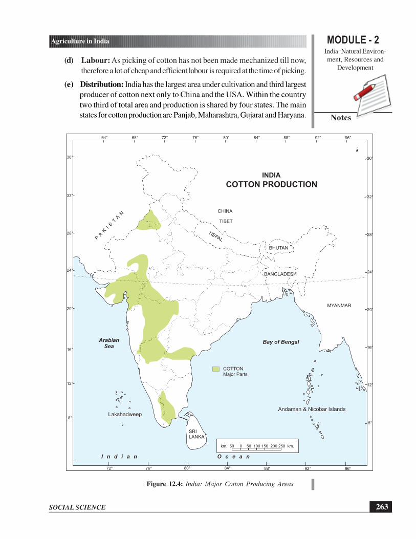
MODULE - 2India: Natural Environ-
ment, Resources and
Development
263
Agriculture in India
SOCIAL SCIENCE
Notes
(d) Labour: As picking of cotton has not been made mechanized till now,
therefore a lot of cheap and efficient labour is required at the time of picking.
(e) Distribution: India has the largest area under cultivation and third largest
producer of cotton next only to China and the USA. Within the country
two third of total area and production is shared by four states. The main
states for cotton production are Panjab, Maharashtra, Gujarat and Haryana.
Figure 12.4: India: Major Cotton Producing Areas
Bay of BengalArabianSea
LakshadweepAndaman & Nicobar Islands
I n d i a n O c e a n
Major PartsCOTTON
INDIA
COTTON PRODUCTION
km. 50 0 50 100 150 200 250 km.
64° 68° 76° 80°72° 84° 88° 96°92°
72° 80°76° 88° 96°92°84°
BHUTAN
BANGLADESH
CHINA
TIBET
NEPALPA
KIS
TA
N
MYANMAR
8°
12°
16°
20°
24°
28°
32°
36°
8°
12°
16°
20°
24°
28°
32°
36°
SRILANKA

SOCIAL SCIENCE
MODULE - 2 Agriculture in India
India: Natural Environ-
ment, Resources and
Development
264
Notes
(iii) Oilseeds: It is one of the important groups of commercial crops in India. In
fact, India has the largest area and production of oilseeds in the world. Oil
extracted from oilseeds not only forms an important item of our diet but also
serves as raw material for the manufacturing of hydrogenated oils, paints,
varnishes, soaps, lubricants etc. Oil-cake (the residue after the oil is extracted
from the oilseeds) forms an important cattle feed and manure.
Groundnut: It is the most important oilseed of India. Groundnut is grown both
as kharif and rabi crop but 90-95% of the total area is devoted to kharif crop.
Some of the geographical conditions are as follows:
(a) Temperature: It thrives best in the tropical climate and requires 20°C
to 30°C temperature.
(b) Rainfall: 50-75 cm rainfall is favourable for groundnut cultivation. It is
highly susceptible to frost, prolonged drought, continuous rain and stagnant
water. Therefore dry winter is needed at the time of ripening.
(c) Soil: Well drained light sandy loams, red, yellow and black soils are well
suited for its cultivation.
(d) Distribution: It is the most important oilseed of India and accounts for
about half of the major oilseeds produced in the country. India is the largest
producer of groundnut in the world and accounts for about one third of
the world’s to the production. Andhra Pradesh, Tamil Nadu and Gujarat
are three main producer of groundnut in India and account for about 60%
of the total production. Another 30% of the total production comes from
Maharashtra, Karnataka and Odisha.
3. Plantation Crops
(i) Tea: India is famous for its tea gardens. You must have heard about tea gardens
of Assam and Darjeeling in West Bengal. It is being said that tea plantation in
India was started by the Britishers in 1923 when wild tea plants were discovered
by them in the hilly and forest areas of Assam. Tea is made from tender sprouts
of tea plants by drying them. At present, India is the leading tea producing
country in the world. China and Sri Lanka are respectively second and third
largest producers of tea.
Some of the geographical conditions for the growth of tea are as follows:
(a) Temperature: It requires hot and wet climate. The ideal temperature for
the growth of tea bushes and leaf varies between 20°C to 30°C. If
temperature either rises above 35°C or goes below 10°C, it would be
harmful for the growth of tea bushes and leaves.

MODULE - 2India: Natural Environ-
ment, Resources and
Development
265
Agriculture in India
SOCIAL SCIENCE
Notes
(b) Rainfall: As mentioned above tea requires a good amount of rainfall
ranging between 150-300 cm and the annual rainfall should be well
distributed throughout the year. Long dry spell is harmful for tea.
(c) Soil: Tea bush grows well in well drained, deep, friable loamy soil.
However, virgin forest soils rich in humus and iron content are considered
to be the best soils for the tea plantation. Tea is a shade loving plant and
grows better when planted along with shady trees.
Figure 12.5: India: Tea Producing Areas
Bay of Bengal
LakshadweepAndaman & Nicobar Islands
ArabianSea
I n d i a n O c e a n
INDIA
TEA PRODUCTION
km. 50 0 50 100 150 200 250 km.
Major Areas
Other Areas
BHUTAN
BANGLADESH
CHINA
TIBET
NEPALPA
KIS
TA
N
MYANMAR
SRILANKA
64° 68° 76° 80°72° 84° 88° 96°92°
72° 80°76° 88° 96°92°84°
8°
12°
16°
20°
24°
28°
32°
36°
8°
12°
16°
20°
24°
28°
32°
36°

SOCIAL SCIENCE
MODULE - 2 Agriculture in India
India: Natural Environ-
ment, Resources and
Development
266
Notes
(d) Labour: Cheap and efficient labour is required for tea production
(e) Distribution: Assam is the leading producer that accounts for more than
50% of tea production of India. Tea producing areas of Assam are the
hill slopes bordering the Brahmaputra and Surma valleys. West Bengal is
the second largest producer of tea where tea is mostly grown in the districts
of Darjeeling, Siliguri, Jalpaiguri and Cooch Bihar districts. Tamil Nadu
is the third largest producer where tea growing areas are mostly restricted
to Nilgiri hills.
(ii) Coffee: Do you know from where coffee was brought to India? It is the
indigenous crop of Ethiopia (Abysinia Plateau). From Ethiopia, it was taken to
Yemen in 11th Century. From Arabia, the seeds were brought by Baba Budan
in 17th Century and were raised in Baba Budan hills of Karnataka. But it was
British planters who took keen interest and large coffee estates were established
in the hills of Western Ghats.
Some of the geographical conditions for the growth of coffee are as follows:
(a) Temperature : It requires hot and humid climate with temperature varying
between 15°C and 28°C. It is generally grown under shady trees.
Therefore, strong sun shine, high temperature above 30°C, frost and
snowfall are harmful for coffee cultivation. Dry weather is necessary at the
time of ripening of berries.
(b) Rainfall: Rainfall between 150 to 250 cm is favourable for coffee
cultivation.
(c) Soil: Well drained, rich friable loamy soil containing good deal of humus
and minerals like iron and calcium are ideal for coffee cultivation. The soil
must be properly manured to retain and replenish fertility and to increase
productivity.
(d) Labour: Like tea, coffee cultivation also requires plenty of cheap and
skilled labour for various purposes like sowing, transplanting, pruning,
plucking, dying, grading and packing of coffee.
(e) Distribution: Karnataka, Kerala and Tamil Nadu are the main states of
coffee production in India.
INTEXT QUESTIONS 12.2
1. Explain any three geographical conditions required for the cultivation of cotton?
2. How will India cloth its billion + population if cotton crop fails for successive
number of years?

MODULE - 2India: Natural Environ-
ment, Resources and
Development
267
Agriculture in India
SOCIAL SCIENCE
Notes
12.4 MAJOR CHALLENGES FACED BY INDIAN
AGRICULTURE
If we look at the challenges faced by Indian agriculture, we can broadly group them
into two categories. One category belongs to the problems that have been long
standing. Second category of problems is new and has been emerging from the
prevailing agricultural practices, system, changing climate and economy. Let us
discuss the major challenges in detail:
1. Stagnation in Production of Major Crops: Production of some of the major
staple food crops like rice and wheat has been stagnating for quite some time.
This is a situation which is worrying our agricultural scientists, planners and policy
makers. If this trend continues, there would be a huge gap between the demand
of ever growing population and the production. Nobody wants India to go back
to a situation that was prevailing in our country prior to Green Revolution. Try
to find out what was the situation during pre-Green Revolution period.
2. High cost of Farm Inputs: Over the years rates of farm inputs have increased
manifold. Farm inputs include fertilizer, insecticide, pesticides, HYV seeds, farm
labour cost etc. Such an increase puts low and medium land holding farmers at
a disadvantage.
3. Soil Exhaustion: On one hand green revolution has played a positive role in
reducing hunger from India. On the other hand it has also led to negative
consequences. One of which is Soil exhaustion. Soil exhaustion means loss of
nutrients in the soil from farming the same crop over and over again. This usually
happens in the rain forest.
4. Depletion of Fresh Ground Water: The second major negative consequence
of green revolution is depletion of fresh ground water. You would remember
that areas where green revolution was successful, it was due to the use of chemical
fertilizers and irrigation. Most of the irrigation in dry areas of Punjab, Haryana
and Western Uttar Pradesh was carried out by excessive use of ground water.
Today fresh ground water situation in these states is alarming. In the coming few
years if this type of farming practice continues, these states are going to face water
famine.
5. Adverse impact of Global Climatic Change: Among various challenges,
global climatic change is the recent one. It has been predicted that its impact
on agriculture would be immense. Since, 70% of Indian population is engaged
in agricultural activities, you can imagine the consequences. It is predicted that
due to climate change, temperature would increase from 2°C to 3°C, there would
be increase in sea level, more intense cyclones, unpredictable rainfall etc These
changes would adversely affect the production of rice and wheat. Specifically,
rise in temperature in winter would affect production of wheat in north India.

SOCIAL SCIENCE
MODULE - 2 Agriculture in India
India: Natural Environ-
ment, Resources and
Development
268
Notes
Production of rice would be affected in coastal areas of India due to ingress of
saline water and increase of frequency of cyclones.
6. Impact of Globalisation You can see the effect of globalisation on the farm
sector in India. All developing countries have been affected by it. The most
evident effect is the squeeze on farmer’s income and the threat to the viability
of cultivation in India. This is due to the rising input costs and falling output prices.
This reflects the combination of reduced subsidy and protection to farmers.
Trade liberalization exposes these farmers to competition from highly subsidized
production in the developed world.
Globalisation refers to the increasingly global relationships of culture, people
and economic activity. Subsidy: A subsidy is money given by government to
help support a business or person. Liberalization: liberty to establish any kind
of economic activity at any time any where in the country without anticipating
any kind of so called private or public restrictions.
7. Providing Food Security: Before the introduction of green revolution in India,
we were not self sufficient in terms of our food grain production. Due to partition
of India in 1947 the network of canal irrigation system, cotton belt and wheat
bowl meant to West Pakistan which is now Pakistan. Similarly the jute belt and
rice bowl was awarded to East Pakistan, which is now Bangladesh. With the
introduction of green revolution, production of food grains increased substantially
and India became self sufficient. However, during the last one decade the total
production has become stagnant. On the other hand we have added another 16
to 18 million population over this period. Although India has become self sufficient
in good it is yet to ensure food security which is dependent upon accessibility,
affordability as well nutritional value of the food available. One of the biggest
challenges facing India is Providing Food Security to its population.
8. Farmers Suicide: Every suicide has a multiple of causes. But when you have
nearly 200,000 of them, it makes sense to seek broad common factors within
that group. The suicides appear concentrated in regions of high commercialization
of agriculture and very high peasant debt. Cash crop farmers seemed far more
vulnerable to suicide than those growing food crops. Yet the basic underlying
causes of the crisis remained untouched. Commercialization of the countryside
along with massive decline in investment in agriculture was the beginning of the
decline. Withdrawal of bank credit at a time of soaring input prices and the crash
in farm incomes compounded the problems. Shifting of millions from food crop
to cash crop cultivation had its own risks. Privatization of many resources has
also compounded the problems.
The devastation lies in the big 5 States of Maharashtra, Andhra Pradesh, Karnataka,
Madhya Pradesh and Chhattisgarh. These states accounted for two-thirds of all farm
suicides during 2003-08.Some of the major factors responsible are indebtedness,

MODULE - 2India: Natural Environ-
ment, Resources and
Development
269
Agriculture in India
SOCIAL SCIENCE
Notes
crop failure and deterioration in economic status. Decline in social position, exorbitant
charges by local money lenders for the vulnerable farmers, chronic illness in the family,
addiction etc. have made life of farmers difficult.
ACTIVITY 12.3
If you are assigned political leadership of the country, what measures would you adopt
to address the challenges that are mentioned above? Which two changes would you
address and how?
............................................................................................................................
............................................................................................................................
............................................................................................................................
............................................................................................................................
............................................................................................................................
INTEXT QUESTIONS 12.3
1. How would climate change would affect agriculture in India? Explain any two
situations.
......................................................................................................................
......................................................................................................................
......................................................................................................................
......................................................................................................................
......................................................................................................................
WHAT YOU HAVE LEARNT
l There are different types of farming practised in India. Some of these practices
are subsistence and commercial farming, intensive and extensive farming,
plantation farming and mixed farming.
l The major salient features of Indian agriculture are subsistence agriculture, highly
dependent on monsoon and animals, variety of crops and predominance of food
crops.
l Major crops in India can be broadly divided into four categories i.e. food crops,
cash crops, plantation crops and fruits.

SOCIAL SCIENCE
MODULE - 2 Agriculture in India
India: Natural Environ-
ment, Resources and
Development
270
Notes
• Some of the major challenges faced by Indian agriculture are Stagnation in
production, high cost of farm inputs, soil exhaustion, depletion of fresh ground
water, climatic change, globalization and liberalization of economy, food security
and farmer’s suicide.
TERMINAL EXERCISES
1. Explain any four salient features of Indian agriculture.
2. Compare the geographical conditions required for the growth of rice and the
growth of wheat cultivation.
3. Identify and write any four similar geographical conditions required for both tea
and coffee.
4. Analyse any four major challenges confronted by Indian Agriculture.
5. Explain the concept of food security. How is it different from self sufficiency in
food.
6. On the outline map of India locate the production areas of:
(i) Two labour intensive crops
(ii) Two crops that are grown in varied terrains
ANSWERS TO INTEXT QUESTIONS
12.1
1. The basic difference between these two types of farming is the amount of
production from per unit of land. USA, Canada, former USSR are the major
countries where extensive farming is practiced whereas Japan is the leading
example of intensive farming.
2. As per the learners experience.
12.2
1. (i) Uniformly high temperature varying between 21°C and 30°C (ii) It grows
mostly in the areas having at least 210 frost free days in a year; (iii) It
requires modest amount of rainfall of 50 to 100cm. However, cotton is
successfully grown by the help of irrigation in the areas where rainfall is
less than 50 cm (iv) high amount of rainfall in the beginning and sunny and
dry weather at the time of ripening are very useful for a good crop; (v)
cotton cultivation is very closely related to Black soils. However, it also

MODULE - 2India: Natural Environ-
ment, Resources and
Development
271
Agriculture in India
SOCIAL SCIENCE
Notes
grows well in alluvial soils of the Satluj-Ganga plain and red and laterite
soils of the peninsular region; (vi) as picking of cotton has not been made
mechanized till now, therefore a lot of cheap and efficient labour is required
at the time of picking (Any three)
2. As per the learners’ experience.
12.3
1. Due to climatic change, temperature would increase by 2 to 3 degree Celsius,
increase in sea level, more intense cyclone, unpredictable rainfall etc These
changes would adversely affect the production of rice and wheat. Specifically
rise in temperature in winter would affect production of wheat in north India.
Production of rice would be affected in coastal areas of India due to ingress of
saline water and increase of frequency of cyclone.

SOCIAL SCIENCE
MODULE - 2 Transport and Communication
India: Natural Environ-ment, Resources and
Development
272
Notes
13
TRANSPORT ANDCOMMUNICATION
Rakesh and his wife lived in a small village. One evening there was heavy rain andthunder storm. His wife had severe stomachache. The village nurse advised him totake her to the nearest hospital. Since there was no communication facility available,it was not possible for Rakesh to contact any doctor, hospital or ambulance. Rakeshrequested his friend to take them to the nearest hospital. Unfortunately their tractorcouldn’t go beyond a few hundred metres as the road was broken and submergedin rain water. What should Rakesh do? What would have been the solution to theproblem?This incident highlights the importance of transport and communication inour life. In this lesson, we plan to bring before you the various modes of transportand communication and their importance for the development of a nation.
OBJECTIVES
After completing this lesson, you will be able to:
� establish that modes of transport and communication help in connecting peopleand facilitate the socio-economic growth of a region;
� classify roads on different parameters and appreciate the role and importanceof road transport in our daily life and national development;
� examine the factors affecting the distribution and density of railway network inIndia and recognise the technical advancement that has taken place in this sphere;
� explain the importance of various means of water transport;
� recognize the growing importance of air transport and its ever growing economicsignificance; and
� realise the role of communication in connecting people and reducing distance

MODULE - 2India: Natural Environ-ment, Resources and
Development
273
Transport and Communication
SOCIAL SCIENCE
Notes
13.1 TRANSPORT AND COMMUNICATION –LIFELINES OF A COUNTRY
Transport and means of communication are integral part of our life today. Can weimagine our life without them? Just imagine if one day you come to know that allthe modern means of transport and communication have been stopped due tounavailability of fuel. Also imagine the problems you are going to face!
ACTIVITY 13.1
List your problems:
� ......................................................................................................................
� ......................................................................................................................
� ......................................................................................................................
� ......................................................................................................................
� ......................................................................................................................
13.1.1 The Role of Transport and Communication
Transport facilitates trade and commerce by carrying goods from the areas ofproduction to that of consumption. Goods from the areas that have surplus are shiftedto those areas which are deficient in those items. Movement of people from one placeto another place in search of job, education and emergency through transport facility.Communication keeps us informed about the world’s events and trends. It bringsin positive changes in the life of the people and thereby enhancing their economicconditions.
13.2 THE MODES OF TRANSPORT
The modes of transport on which the countries depend for connecting people, growthand development are as under:
Modes of Transport
Land Water Air
Roadways Railways Oceanic Inland Domestic International

SOCIAL SCIENCE
MODULE - 2 Transport and Communication
India: Natural Environ-ment, Resources and
Development
274
Notes
13.2.1 Land Transport can be broadly divided into two types:
1. Roadways
2. Railways
1. Roadways
Look at the pictures in Fig. 13.1. Can you imagine the changes in the manner wehave moved from ancient to modern time from these pictures? Suppose, you haveto go to your friend’s house just 500 metres away from your house, or a visitoror a relative living 200 km away from your house. A villager has to catch a bus tocome from a village to a city. Of course, the roads will be used. Now, you must
Figure 13.1 Modes of Transport

MODULE - 2India: Natural Environ-ment, Resources and
Development
275
Transport and Communication
SOCIAL SCIENCE
Notes
have understood that roads are most commonly used means of transport. Roads playan important role in connecting people and also in ensuring socio-economic growthof a country as under:
� Roads provide door to door service by means of a rickshaw, car, bicycle, bus,scooter or a truck.
� The construction, repair and maintenance cost is less than other means oftransport.
� It is the cheapest and the most convenient mode of transportation for a few peopleand relatively smaller amount of goods over shorter distances.
� It is through roads that we reach railway stations, airports and seaports.
� Perishable goods like milk, fruits and vegetables are quickly carried from nearbyvillages to the cities or metropolis or to other destinations.
� Roads connect rural areas to the urban areas and can be constructed in all typesof terrains like hills, deserts, mountain and plateaus.
Classification of Roads
Do you find same kind of roads everywhere? Obviously not, some roads may bekuchcha, and others pakka, then narrow while others broad. Roads are classifiedon the basis of:
(i) Materials used for construction.
(ii) Constructing and maintaining authority.
(i) Material used for construction
Roads can be classified on the basis of materials used for construction as metalledand un-metalled roads. Metalled roads are usually made by bricks, concrete, cementand charcoal. Un-metalled roads are made of sand, mud and straw.
ACTIVITY 13.2
Identify the materials used for the construction of the roads.
Metalled Roads (Pucca Roads) Un-metalled Roads (Kuchha Roads)

SOCIAL SCIENCE
MODULE - 2 Transport and Communication
India: Natural Environ-ment, Resources and
Development
276
Notes
(ii) Constructing and maintaining authority
Have you ever wondered as to who constructed these roads and where did theyget the money from? They are constructed by using public money paid as taxes bypeople. Various government authorities are responsible for balanced development ofroads and better management.
� The development of village roads are undertaken by the scheme known asPradhan Mantri Gram Sadak Yojna launched by the Central government.
Figure 13.2 India: Goldern Quadrilateral
Bay of Bengal
LakshadweepAndaman & Nicobar Islands
km. 50 0 50 100 150 200 250 km.
BHUTAN
BANGLADESH
CHINA
TIBET
NEPALPA
KIS
TA
N
MYANMAR
64° 68° 76° 80°72° 84° 88° 96°92°
72° 80°76° 88° 96°92°84°
8°
12°
16°
20°
24°
28°
32°
36°
8°
12°
16°
20°
24°
28°
32°
36°
Mumbai
Delhi
Chennai
Kolkata
Ahmedabad
ArabianSea
I n d i a n O c e a n
SRILANKA
INDIA
GOLDEN QUADRILATERAL

MODULE - 2India: Natural Environ-ment, Resources and
Development
277
Transport and Communication
SOCIAL SCIENCE
Notes
These provide links from village to village and village to main road in the ruralareas. About 80% of the total road length in India is categorize as rural roads.
� Zila Parisad has been made responsible for constructing roads that connectdistrict headquarters with other cities and towns of the district. These DistrictRoads account for 14% of the total road length in India.
� State Public Works Department (SPWD) constructs and maintains roads thatlink state highways, state capitals with district headquarters. They constitute 4%of the total road length in the country.
Figure 13.3 North-South and East-West corridors
64° 68° 76° 80°72° 84° 88° 96°92°
72° 80°76° 88° 96°92°84°
ArabianSea
I n d i a n O c e a n
BHUTAN
BANGLADESH
CHINA
TIBET
NEPALPA
KIS
TA
N
MYANMAR
8°
12°
16°
20°
24°
28°
32°
36°
8°
12°
16°
20°
24°
28°
32°
36°
Uri Srinagar
Silcher
Porbandar
Bay of Bengal
LakshadweepAndaman & Nicobar Islands
Kanniyakumari
km. 50 0 50 100 150 200 250 km.
SRILANKA
INDIA
NORTH-SOUTH AND EAST WEST
CORRIDORS

SOCIAL SCIENCE
MODULE - 2 Transport and Communication
India: Natural Environ-ment, Resources and
Development
278
Notes
� National Highway Authority of India constructs and maintains the NationalHighways [NH], important roads linking different parts of the country andconnecting state capitals to the main cities of India. They constitute only 2% ofthe total road length but carry 40% of the road traffic. The government haslaunched a major road development project linking north, south, east and westIndia.This will reduce time and fuel. Then it will also help to maintain fast flowof traffic between mega cities of India. It is implemented by National HighwayAuthority of India. The major super highways are:
(a) Golden Quadrilateral connects Delhi, Mumbai, Chennai and Kolkatawhich forms a geometrical figure of Quadrangle.
(b) North-South Corridor links Srinagar to Kanyakumari.
(c) East-West Corridor connecting Silchar in the east to Porbandar in thewest.
� Border Roads are constructed along the bordering areas of the country for easyaccessibility of goods and other requirements of defence personnels during thetime of war and emergency and for the benefit of people living in those areas.They are constructed and maintained by Border Road Organization (BRO).
The oldest and the longest road in India was built across Gangetic plain from thenorth-west to the east on orders of Pashtun emperor, Sher Shah Suri in 16th
century which was renamed as Grand Trunk Road. It is presently divided intoNH-1 (Amritsar to Delhi)and NH-2(Delhi to Kolkata).Today India has about 330lakh kms of road network whereas in 1947 it was only 4 lakh kms.
ACTIVITY 13.3
Look at the maps (Fig. 13.2 and 13.3) and find out which super highway is nearestto your home and which organization maintains it.
2. Railways
“This has become an easy way to place their demands and there is no strictpunishment” said Anu’s father while reading the newspaper. Anu asked, “what hadhappened”. Father replied, “Nothing new, a group of protestors have blocked the

MODULE - 2India: Natural Environ-ment, Resources and
Development
279
Transport and Communication
SOCIAL SCIENCE
Notes
railway tracks. They stopped the trains and have burnt two bogies on Agra Delhiroute”. Anu asked her father “why he was upset’’. Father said, “Don’t you knowthat millions of rupees, efforts of thousands of people and many years are spent inbuilding railway tracks and manufacturing railway coaches. This is for our convenienceand quick movement of passengers and freights. Such an act causes inconvenienceto the passengers, loss of millions of rupees, and affects business.”Anu has realizedthe importance of railways as stated below:
� This is the cheapest transport by which thousands of people can travel togetherfrom one corner of the country to another for the purpose of education, business,siteseeing, pilgrimage or visiting friends or relatives.
� People of all income groups can travel by train as it has different types of coacheslike General, Sleeper and AC chair car.
� One can have comfortable night journey as it has berths and washrooms in sleepercoaches.
� It carries country’s largest amount of bulky goods like coal, cement, food grains,fertilizer, petroleum, automobiles etc. from mines to industries and from industriesto the areas of consumption.
That is why we should all help in maintaining this important resource of country.Railways facilitate the movement of both freight and passengers and contribute tothe growth of our economy.
Indian Railways started in 1853 from Bombay to Thane covering a distance of34 km.
At present, Indian Railway network is the largest in Asia and the fourth largestin the world with the length of more than 64000 kms.
It is the largest government undertaking employing 1.6 million people and aseparate budget is presented for it.
It has been divided into 16 zones for better administration and management ofwork.
When Anu and her father were talking about the importance of railways, one of herfriends Jiya came to her house. She was studying in Delhi University but her nativestate was Sikkim. Jiya understood the logic, but question in her mind was why Sikikim

SOCIAL SCIENCE
MODULE - 2 Transport and Communication
India: Natural Environ-ment, Resources and
Development
280
Notes
never be well connected with the other parts of the country. She stood for a whileand said, “Uncle, why are there few railway lines in my state whereas other stateshave good network of railways?” He explained the factors which are responsiblefor the development of railways:
� The construction of railways is very difficult and costly in mountainous regionwhereas it can be easily done in areas of flat land. Therefore, India has denserailway network in the Gangetic plain where as desert, hills, marshy regions, floodprone areas, dense forest, areas with rapids and rivers have not been developedmuch.
� The states of Uttar Pradesh, Bihar, West Bengal, Punjab and Haryana, are wellconnected by railways because these states are located in the plains. He alsotold that these areas are food bowl of India and most of the crops grown hereare taken to other parts of the country through railways.
� Areas where mining and industries are more developed tend to have betterfacilities of railways for easy transportation of goods. Areas with less industrialdevelopment cannot compensate the cost of construction of railways, thereforehave less railway network.
� Regions which are densely populated and have more movements are definitelywell connected with railways.
� Urban areas or large cities attract more people for jobs, business, education,trade, banking have high density railway network for quick movement of people.
Anu’s father smiled and said “No Jiya, the government is aware of the importanceof connecting different part of the country specially in remote areas. This is beingdone on priority now”. Jiya understood that any one can be connected anywherein the world on the internet.
Technical advancement provided by Indian Railways
There is a direct rail link available from the north to the south of the country (i.e.from Jammu to Kanya Kumari) covering a distance of 3751 km in 71 hours.Facilitiesto travel in 1st A.C., 2nd A.C., 3rd A.C., A.C. Chair Car, 2nd Class sleeper andGeneral class are available to cater to the needs of the people of different economicstrata.Only diesel and electric locomotives are used on broad gauge providingpollution free journey.The passengers can avail the facility of booking electronic-tickets easily from home.The trucks loaded with goods are delivered directly to theconsumers or factories in special rail wagons.

MODULE - 2India: Natural Environ-ment, Resources and
Development
281
Transport and Communication
SOCIAL SCIENCE
Notes
ACTIVITY 13.4
Search the headquarters of the major railway zones in the grid given below.
P O R I T S M
U P N K J O U
K L M T R P M
Q U W A I T B
K O L K A T A
J A I P I N I
Z V D U X Y R
C H E N N A I
T K L J Q R J
I T H Q X Z U
N P I T O J K
INTEXT QUESTIONS 13.1
1. Complete the following statements;
(a) East-West corridor links ...................... and ...................... as ......................
(b) Super Highway connecting four metro-cities is known as ......................as it forms ......................
2. (a) Explain briefly the main factor affecting density of railways. Identify thefollowing two groups of states where there is high and low density ofrailways and give reasons for your answer.
(b) Identify two advantages and two disadvantages in each roadways andrailways transport.
3. “A few states of India lack a good railway network”. Justify the statement in 30words.

SOCIAL SCIENCE
MODULE - 2 Transport and Communication
India: Natural Environ-ment, Resources and
Development
282
Notes
ACTIVITY 13.5
Show the railway reservation form given below to your family. Try to fill it updiscussing the meaning and the importance of the columns given below:
(a) Medical Practitioner
(b) Senior Citizen
(c) Choice of berth
(d) Meals available in some trains

MODULE - 2India: Natural Environ-ment, Resources and
Development
283
Transport and Communication
SOCIAL SCIENCE
Notes
13.2.2 Water Transport
Have you ever wondered why people in ancient times settled down near the rivers?How was trading possible between far off lands? Yes, it was through rivers and seas.From olden days till now waterways had been an important means of transportation.It is because:
Figure 13.4 Mode of Water Transport
� It is the cheapest means as compared to other means of transport because itinvolves no expenditure on construction other than maintenance.
� It is very useful for transporting heavy and bulky goods. A ship can carry lakhsof tonnes of goods at a time.
� It is a better mode of transportation for petroleum and its products as it involvescross-continental transfers. India lacks in petroleum deposit and most of it isimported from Middle East countries.
� It is fuel efficient and environment friendly means of transportation.
Water ways have been classified into two types – Do you know them? Find outwhy are they called Inland waterways and Ocean routes?
1. Inland Waterways: India has inland navigable waterways measuring 14,500 kmwhich include canals, rivers, backwaters and narrow bays etc. But only 3,700km of river length is suitable for mechanized boats in river Ganga andBrahmaputra in the north and Godavari, Krishna and Kaveri in the south. A goodnetwork of inland waterways is able to reduce the traffic on the highways. It alsohelps transportation of goods.
Inland Waterways Authority of India was constituted in 1986 and looks afterthe development, maintenance and management of inland water ways in thecountry. The following three waterways have already been declared as NationalWaterways,
NW 1 – River Ganga from Allahabad, Uttar Pradesh to Haldia, West Bengal(1620 km)
NW 2 – River Brahmaputra from Sadiya to Dhubri in Assam (891 km)
NW 3 – Kollam to Kotapuram stretch of canal in Kerala (205 km)

SOCIAL SCIENCE
MODULE - 2 Transport and Communication
India: Natural Environ-ment, Resources and
Development
284
Notes
2. Oceanic Waterways: If you look at the map of India, you will find that Indiais surrounded on three sides by the Arabian Sea, the Bay of Bengal and the IndianOcean with a coastline of 7516 km India had only 49 ships in 1946 with acapacity of 1,27,083 tonnes. After independence, the Government has takenvarious measures resulting in procurement of 616 ships in 2004 with a grosstonnage of 700,000 tonnes of carrying capacity.
Figure 13.5 Major Ports of India
Bay of Bengal
LakshadweepAndaman & Nicobar Islands
ArabianSea
I n d i a n O c e a n
INDIA
MAJOR PORTS
km. 50 0 50 100 150 200 250 km.
BHUTAN
BANGLADESH
CHINA
TIBET
NEPALPA
KIS
TA
N
MYANMAR
SRILANKA
64° 68° 76° 80°72° 84° 88° 96°92°
72° 80°76° 88° 96°92°84°
8°
12°
16°
20°
24°
28°
32°
36°
8°
12°
16°
20°
24°
28°
32°
36°
MumbaiJawaharlal Nehru
Kandla
Marmagaon
Paradip
Vishakapatnam
Chennai
Kolkata
Haldia
Mangalore
Kochi
Tuticorin
km. 50 0 50 100 150 200 250 km.km. 50 0 50 100 150 200 250 km.

MODULE - 2India: Natural Environ-ment, Resources and
Development
285
Transport and Communication
SOCIAL SCIENCE
Notes
The two categories of Indian Sea Waterways are:
(a) Coastal shipping: Transporting passengers and cargo between the portslocated along the coast of the country is done by coastal waterways. Shipsof about 100 navigation companies are engaged in coastal waterwayshandling about 7 lakh tonnes of cargo through 12 main ports and 189 smalland medium class ports.
(b) International shipping: Most of the shipping capacity of India is usedin international trade. Through the ports of the east coast to Myanmar,Malaysia, Indonesia, Australia, China, Japan and from the west coast portsto the U.S.A., Europe and Asia, are used for export and import.
INTEXT QUESTIONS 13.2
1. (a) Complete the given table with the help of the map given below.
Port State Coast
Mumbai Maharashtra Western
(b) Point out the areas where there are no ports. Give one reason for the same.
13.2.3 Air Transport
Do you wish to fly like a bird? By airways, you can reach at the destination quicklyand without encounter any cring traffic. Our modern day airplane was designed bythe Wright Brothers in 1903. Air transport in India began in 1911. Today it is oneof the important means of transportation like roadways and railways. India hasfacilities of both domestic as well as international airways. Let us discuss itsimportance in the modern age.

SOCIAL SCIENCE
MODULE - 2 Transport and Communication
India: Natural Environ-ment, Resources and
Development
286
Notes
Figure 13.6 Mode of Airways
� Air transport is considering that world is becoming a global village. It is the fastestmeans of transport and one can reach the destination in a few hours coveringthe distance of hundreds of kilometers.
� It is free from surface hindrances such as inaccessible mountains, dense forests,marshy lands or flooded areas.
� It is most important due to its utility in national defence.
� It also connect countries of different continents making earth a global village.
� It is suitable for transporting fruits, vegetables or high value goods like costly drugsand sophisticated machines in desired time frame.
� It is very useful at the time of natural or any other calamities for saving peopleor supplying goods of their basic requirements immediately.
The only drawback is the high cost of travelling or transportation. That is why, itis still out of reach for the common man. In the last few years, the use of air transporthas recorded a rapid increase.
Air transport services in India can be classified into the following categories:
13.2.4 Domestic and International Services
Domestic and International services are provided by government and privateprovider. Pawanhans Helicopter Ltd. (government undertaking) – This Companyprovides air transport to the Oil and Natural gas Corporation, Indian Oil and in theNorth-Eastern part of the country.
INTEXT QUESTIONS 13.3
1. Which states has more than one international airport?
2. Mention two states which do not have international airport?
3. Which is the closest or nearest Domestic and International airport from yourhouse?

MODULE - 2India: Natural Environ-ment, Resources and
Development
287
Transport and Communication
SOCIAL SCIENCE
Notes
13.3 COMMUNICATION AND ITS IMPORTANCE
Your sister’s marriage has been fixed and you want all your relatives and friends tobe present at the wedding. How would you like to inform them? Suddenly, yourgrandfather suffered from a heart attack and your father is in his office. How willyou inform him immediately? How did you come to know about tsunnami in Japanor about the incident where millions of people were protesting against the President
Figure 13.7 Major International Airports of India
Bay of Bengal
LakshadweepAndaman & Nicobar Islands
ArabianSea
I n d i a n O c e a n
INDIA
INTERNATIONAL AIRPORTS
BHUTAN
BANGLADESH
CHINA
TIBET
NEPALPA
KIS
TA
N
MYANMAR
SRILANKA
64° 68° 76° 80°72° 84° 88° 96°92°
72° 80°76° 88° 96°92°84°
8°
12°
16°
20°
24°
28°
32°
36°
8°
12°
16°
20°
24°
28°
32°
36°
Raja Sansi
Amritsar
Delhi
Indira GandhiInternational
Kolkata
Netaji SubhashChandra Bose
Mumbai ChhatrapatiShivaji
Hyderabad
ChennaiMeenam Bakkam
TiruvanantapuramNedimbacherry
Patna
Lok Nayak Jayaprakash
IndoreDevi Ahilya Bai HolkarAhmedabad
Sardar VallabhBhai Patel
NagpurDr. B.R. Ambedkar
Rajiv Gandhi
Bengaluru
km. 50 0 50 100 150 200 250 km.km. 50 0 50 100 150 200 250 km.km. 50 0 50 100 150 200 250 km.

SOCIAL SCIENCE
MODULE - 2 Transport and Communication
India: Natural Environ-ment, Resources and
Development
288
Notes
in Egypt? Your response to the above situations must have classified the importanceof communication in everyday life, its need and various means of carrying it out. Thus,communication is a system of carrying messages to exchange thoughts, ideas andinformation and also to share your sorrows and pleasures with your family membersor friends.
Now you must have understood that the means of communication change suiting thepurpose of communication. There are various means of communication. Peoplecommunicate with each other by writing letters, sending telegrams, radio, T.V.,computer technology, newspapers, magazines and pamphlets; messages can be sentby telegram, facsimile machine (FAX) and E-mail (Electronic mail) for business tradeand other services. E-mail has emerged as the fastest means of communication andis almost free.
It is also important to know that the choice of a particular means of communicationdepends on purposes.
Now, let us classify different means of communication into two groups:
1. Means of Personal Communication
2. Means of Mass Communication
1. Means of Personal Communication: We classify means of personalcommunication into two parts:
(i) Postal Service
(ii) Telephone Service
(i) Postal Service: Postal service is a very old means of communication.Though letter writing is not that popular any longer, it is still important eventoday. Indian Postal Network is the largest in the world. In 2001, Indiahad 1,55,000 post offices providing different services like – letters, moneyorders, parcels, postal saving schemes, etc.
(ii) Telephone Service: It has emerged as one of the most important andwidely used means of communication in today’s world. It is quick andaffordable, serving our need seamlessly.
2. Means of Mass Communication: The means by which information can becommunicated to a very large number of people are called Media or MassCommunication, such as radio, television, newspaper, cinema, books, magazines,traditional folk modes and satellite communication.

MODULE - 2India: Natural Environ-ment, Resources and
Development
289
Transport and Communication
SOCIAL SCIENCE
Notes
(i) Radio: Radio transmission in India started in 1927 from Mumbai andKolkata to entertain, educate and apparise the people of the country withimportant information. Today the program of All India Radio (AIR) areavailable to 90% parts of the country to 98.8% of our people.
(ii) Television: The national television transmission service of India startedin 1959 is one of the biggest ground transmission organizations of theworld. Today, 87% of population can watch it. Television program telecastby National, Regional and local Doordarshan and a large number of privatechannels are available for education, information and recreation.
(iii) Computer (Information Technology): Today, computer has become thebasis of communication and economic development as it is used everywherefrom homes, offices to shops, hospitals, railways, airports, banks, educationalinstitutions, etc.
13.3.1 Newer communication Technology
In recent years, there is revolution of new technology that has helped people in muchbetter way such as:
(a) Internet: It provides access to several kinds of information.It connects all typesof computers across the world to obtain information at the click of a button.
(b) Video Conferencing: People sitting at far off places can talk and express theirviews with the help of telecommunication and computer.
(c) E-Commerce: Facility available for sale and purchase of goods through internetand fax.
(d) Internet Telephony: It is a software programme which makes a computer towork like telephone. This facility has reduced the call rates drastically.
(e) E-Mail: It is a method of sending letters or information through internet toanyone in the world in the blink of an eye.
(f) Tele-Medicine: Using this technology, doctors can advise his patients sittingat a distance of thousands of kilometers from them.
Thus, scientific advancement and technology has revolutionized the system ofcommunication and brought people very close to each other, to be in touch all thetime and making the world a global village.
SOCIAL SCIENCE
MODULE - 2 Transport and Communication
India: Natural Environ-ment, Resources and
Development
290
Notes
ACTIVITY 13.6
Take a pack of old playing cards. Cut pictures of various modes of communicationfrom old newspapers or magazines. Stick one picture on each card. On the backside write one question about it. Now you have your own set of CommunicationCards. Play it with your friends and family.
Hints: Which communication aid can deliver one message at the same timethroughout the country? (Ans. T.V.).
INTEXT QUESTIONS 13.4
1. Categorize the following into personal communication, Mass Communication andothers;
Electronic monitor, utility van, tractor, telegram, metro rail, mobile, postcard,fax, news bulletin, radio, ambulance, facebook, twitter and magazine, bulk SMS.
2. Give one word for each of the following statement:
(a) A system of carrying messages to exchange thoughts, ideas and information.
(b) The service through which letters, parcels and money-orders are sent.
(c) A system of writing letters through internet.
(d) The authority responsible for transmission of programs through radio inIndia.
(e) The most common and popular means of personal communication in Indiaat present.
WHAT YOU HAVE LEARNT
� Need and importance of means of transport and communication
� Types of roads constructed in India

MODULE - 2India: Natural Environ-ment, Resources and
Development
291
Transport and Communication
SOCIAL SCIENCE
Notes
� Role of railways in the development of a country
� Types of waterways and their importance in a country’s trade
� Need of airways and its importance in a country like India
� Modern means of communication and their relevance in our lives
TERMINAL EXERCISES
1. Why are the means of transport and communication regarded as the lifelines ofa country and its economy?
2. State three merits and three demerits of roadways?
3. What is the importance of water ways for India?
4. Study the map of Major Ports and answer the following questions:
(a) Count and tell how many ports are there on the eastern coast.
(b) List the states that have two ports.
(c) Name the state in which Paradeep port is located.
(d) Name the port located in Goa.
(e) Name the southernmost port of India.
5. What are the benefits of airways over other means of transport?
6. State the importance of communication in your day-to-day activities?
7. Differentiate between personal communication and mass communication.
8. List five problems that you faced during your last journey by train. Suggest atleast one remedy for each of the problems you faced.
9. On the outline map of India, identify the states of high, moderate and low raildensity and name them. Why do they have such density?
(Hints: Difficult terrain, climatic conditions, economy, etc)

SOCIAL SCIENCE
MODULE - 2 Transport and Communication
India: Natural Environ-ment, Resources and
Development
292
Notes
India: Railway Zones
Project:
Interview at least five people in your locality who have been staying there for thelast ten years, and ask them what changes have occurred over a period of time dueto construction of new roads/railways.
OR
In your area, find the authority responsible for the construction of roads. You mayneed to go to that office to find the details of it.
ANSWERS TO INTEXT QUESTIONS
13.1
1. (a) Silchar, Porbander, they are located in the eastern and western edge ofthe country
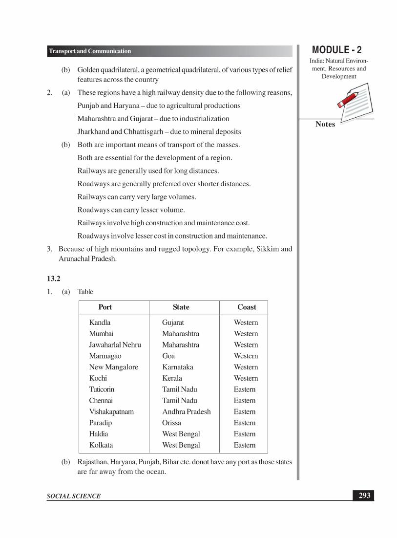
MODULE - 2India: Natural Environ-ment, Resources and
Development
293
Transport and Communication
SOCIAL SCIENCE
Notes
(b) Golden quadrilateral, a geometrical quadrilateral, of various types of relieffeatures across the country
2. (a) These regions have a high railway density due to the following reasons,
Punjab and Haryana – due to agricultural productions
Maharashtra and Gujarat – due to industrialization
Jharkhand and Chhattisgarh – due to mineral deposits
(b) Both are important means of transport of the masses.
Both are essential for the development of a region.
Railways are generally used for long distances.
Roadways are generally preferred over shorter distances.
Railways can carry very large volumes.
Roadways can carry lesser volume.
Railways involve high construction and maintenance cost.
Roadways involve lesser cost in construction and maintenance.
3. Because of high mountains and rugged topology. For example, Sikkim andArunachal Pradesh.
13.2
1. (a) Table
Port State Coast
Kandla Gujarat Western
Mumbai Maharashtra Western
Jawaharlal Nehru Maharashtra Western
Marmagao Goa Western
New Mangalore Karnataka Western
Kochi Kerala Western
Tuticorin Tamil Nadu Eastern
Chennai Tamil Nadu Eastern
Vishakapatnam Andhra Pradesh Eastern
Paradip Orissa Eastern
Haldia West Bengal Eastern
Kolkata West Bengal Eastern
(b) Rajasthan, Haryana, Punjab, Bihar etc. donot have any port as those statesare far away from the ocean.

SOCIAL SCIENCE
MODULE - 2 Transport and Communication
India: Natural Environ-ment, Resources and
Development
294
Notes
13.3
1. Maharashtra
2. Haryana and Rajasthan
3. As per the learners’ experience
13.4
1. Means of transport: Utility van, tractor, metro rail, ambulance, trolley, bicycle.
Means of communication: Telegram, mobile, postcard, fax, facebook, twitter.
2. (a) Communication
(b) Postal service
(c) Email
(d) All India Radio (AIR)
(e) Mobile Phones

MODULE - 2India: Natural Environ-
ment, Resources and
Development
295
Population: Our Greatest Resource
SOCIAL SCIENCE
Notes
14
POPULATION: OUR GREATEST
RESOURCE
All of us hear many people saying that the population of India is a great problem.
You also may be feeling the same. You may be aware that the population of India
is more than a billion and it is still growing. It may overtake the population of China
within the next couple of decades, eventually making India the most populous nation
of the world. It is in this way the population is quite often seen as a liability, a major
hindrance to development and quality of life of the people. But is it true? Let’s think
and understand. Has population not been an asset, a resource for the country? Today,
India is considered as a leading nation in the world in terms of human power. One
of the major contributory factors for this global standing has been the young, educated
and productive people of our country. They are contributing to the development of
not only our country, but many of the foreign countries also. In this context, population
is an asset for the economy, the greatest resource of the country rather than a liability.
In this lesson, you shall know how population of our country can be viewed as the
greatest resource.
OBJECTIVES
After studying this lesson you will be able to:
l analyze population not in terms of simple numbers and a problem, but as the
greatest resource of the country;
l explain factors that make population a human resource;
l identify areas of high, moderate and low density of population and locate the
same on the outline map of India;
l analyze the factors affecting the distribution and density of population;
l examine the implications of the population change and population composition,
rural-urban composition, age composition, sex composition and literacy;

SOCIAL SCIENCE
MODULE - 2 Population: Our Greatest Resource
India: Natural Environ-
ment, Resources and
Development
296
Notes
l appreciate needs of adolescents as a critical population group and the growing
potential human resource;
l recognize the need for empowerment of women in India; and
l evaluate population policies adopted by the Government of India, especially in
the context of human resource development.
14.1 POPULATION AS A RESOURCE
Generally, we understand that population means a collection of people. Let us go
through the meanings of population stated in the box below. This term has been
defined differently in different
contexts. You may find that the
meaning of population stated in a
science or biology textbook is
different from how it has been used
in a social science, geography,
economics or sociology textbooks.
You will learn later on that in statistics
this term has yet another meaning.
Will you like to find out what it is?
You may do it by consulting books on
Statistics. However, in the present
lesson we will be using population to
mean the collection of people living in
a given geographic area or territory.
This is how it is used in the census.
The collection of people is seen and
understood primarily in terms of number. But population is also considered as a
resource, a human resource.
What is resource? It is something that can be used and reused. Let us look around
the room. We find things like furniture, books, notebooks, pen, cups and others. We
consider them as our resources and use and reuse them in our daily life.
Now, let us try to trace their origin. These are made out of the resources which we
get from nature. The furniture is made from timber that we obtain from the forest.
Books and notebooks are made from the wood pulp which comes from the forest.
The pen is made up of plastic which is the by-product of petroleum. The cup is made
of clay found in the soil. These and many more things which are part of our daily
life are extracted, processed or manufactured from the natural resources. It is the
people who with their physical and mental efforts convert the natural resources into
various goods of utility.
What does population mean?
l Total number of people inhabiting a
specified area or territory (e.g.
population of a village, city, state,
country, world).
l Total number of people of a particular
group, race, class or category (e.g.
population of Scheduled Castes,
Scheduled Tribes, or religious groups
like Hindus, Muslims, Christians,
Sikhs)
l In biology, collection of inter-breeding
organisms of a particular species (e.g.
population of tigers, deer, etc.)

MODULE - 2India: Natural Environ-
ment, Resources and
Development
297
Population: Our Greatest Resource
SOCIAL SCIENCE
Notes
The Government of India created a Ministry of Human Resource Development
in 1985, in place of its earlier Ministry of Education and Culture. Some of the
States also have done so. This suggests that the idea of people being a human
resource has gained acceptance.
If resources are things that are used and reused, how can population be considered
a resource? We all know that the grains which are cultivated in the fields, the minerals
that are mined and the goods which are manufactured in factories are all produced
by people. People of the country produce and develop various facilities and services
to make their lives comfortable. The facilities, whether these are means of transport
and communication, schools, colleges, hospitals, electricity producing units,
infrastructure for irrigation and others, play a significant role in the development of
a country.
For producing and developing all such facilities and converting them into useful
resources, human beings play the role of the best resource. Without human beings,
other resources cannot be developed and utilized properly. Therefore, the number
as well as the quality of people, collectively, is the real and ultimate resource of a
country.
In view of the above, the sheer number of people, which is determined by census
conducted at periodic intervals, may be a liability, but the qualitative population
becomes the human capital of a country. For converting the number into capital, the
country has to invest a lot in the form of improving the health and nutritional status
of the people, their education and specialized training and their overall quality of life.
The investments for improving the quality of the people made by the state as well
as the society matter a lot. It is essential that every individual develops to the fullest
capability and is engaged in the development process of the country. It is therefore
important to understand that people as human resource are both an object of
development and also a participant in development. As we discussed earlier the
number of people may not be called resource, but there are certain factors which
convert these numbers into a useful resource.
Human capital: Over the years, the terms used to describe staff and employees
in businesses have changed. We have moved from ‘personnel’ to ‘human
resources’ to ‘human capital’. Human capital represents attributes of a person
that are productive in the economic context. It refers to the stock of productive
skills and technical knowledge embodied in labour.

SOCIAL SCIENCE
MODULE - 2 Population: Our Greatest Resource
India: Natural Environ-
ment, Resources and
Development
298
Notes
Census: The procedure of systematically acquiring and recording information
about the members of a given population. The term is used mostly in connection
with ‘national population and door to door censuses’ to be taken every 10 years.
The Government of India, with the assistance of States, has been conducting
census to collect data about various demographic and socio-economic aspects
of our population.
Factors making population a Human Resource
What are the factors that influence the role of population as the human resource?
You may infer from the above discussion that the education, health and nutritional
status of the people, and their specialized training determine the quality of population
as a human resource. But besides these, there are key socio-demographic factors
that have significant impact on the role of population as a resource. These are: (i)
Distribution of Population; (ii) Growth of Population; and (iii) Population Composition.
We shall try to understand these three factors. Let us begin with Distribution of
Population.
INTEXT QUESTIONS 14.1
1. What is meant by resource?
2. Enumerate qualities that are essential for making human beings a resource.
14.2 DISTRIBUTION OF POPULATION
You may be knowing that resources, whether natural or any other, are not
evenlydistributed. For example, natural resources like forests or iron ore or coal are
not found evenly in the world and also within our own country. The same is the case
with human resources. They are not evenly spread everywhere in the world and their
numbers keep on changing. The spread of population over an area, may be in a state
or the entire country, is known as the distribution of population.
You will find it very interesting when you look at the following map of India (Figure
14.1). It shows how the population of India is spread across various States and Union
Territories (UTs). This has been shown through dots. Each dot represents five lakh
persons. As you see, in some States, the number of dots is less, even if the area
is substantially large. It means that the population in these States is either widely
spread or moderately spread. But in some other States, the dots are very close to
one another, so close that those parts in the map look almost painted. In them, the
spread of population is very dense. Let us prepare a list of sparsely populated,
moderately populated and densely populated States and Union Territories (UTs)
of India.

MODULE - 2India: Natural Environ-
ment, Resources and
Development
299
Population: Our Greatest Resource
SOCIAL SCIENCE
Notes
Figure 14.1: Distribution of Population in India
14.3 DENSITY OF POPULATION
Based on the above figure, a comparison of population distribution in any two States
will be quite interesting. Let us look at the States of Maharashtra and West Bengal
in the map (Figure 14.1). The patterns of the spread of population in them are
different. From the simple look at the map, it appears that West Bengal has more
population than Maharashtra. But it is not true. Maharashtra has more population
than West Bengal, but Maharashtra is thinly populated because its land area is larger
than that of West Bengal. Hence, we can not compare the population situation of
two States in terms of only the number without considering their areas. That is why,
the comparison of population of regions and countries is done through density of
population.

SOCIAL SCIENCE
MODULE - 2 Population: Our Greatest Resource
India: Natural Environ-
ment, Resources and
Development
300
Notes
Density of Population: The density of population is the number of persons living
per unit of an area. It is usually expressed as number of people per square
kilometre (sq km). The formula for its computation is:
Density of population = Number of people in a defined area unit
Total area in square km of that particular area
For determining the density, the number of people living in a specific territory is
divided by the total area of that territory. This provides an average number of persons
living per sq km in the territory. For example, let us assume that the population of
a district is 250,000 and its area is 1000 square km. The density of population of
this district can be calculated as follows:
Density of Population =
250000 persons
1000 sq km area
= 250 persons per sq km.
Figure 14.2: Density of Population in India
INDIA
POPULATON DENSITY
2001
No. of person’s per Sq. km
100 and less
101-250
251-500 National average
501-1000
1001 and above

MODULE - 2India: Natural Environ-
ment, Resources and
Development
301
Population: Our Greatest Resource
SOCIAL SCIENCE
Notes
The map (Fig. 14.2) shows that the density of population in India is uneven. It varies
from one state to another.
ACTIVITY 14.1
Look at the Figure 14.2. Identify and name the States having high
(more than 500 persons per sq km), moderate (100-500 persons
per sq km) and low (less than 100 persons per sq km) density.
States having high density
States having moderate density
States having low density
Can you state the reasons for such a variation in density among
States?
Hints: Unfavorable/harsh climatic conditions, rugged terrain and
poor soil fertility are mainly responsible for the low density. Rich
soil, abundance of rainfall, developed irrigational facilities, moderate
climate and urbanization support high density of population. The
areas of average fertility, modest rainfall, less developed irrigational
facilities and, to some extent, stony/sandy surface sustain moderate
density of population.
It also keeps on changing. As you may find in figure 1.3 the
density of population in India was as low as 77 persons per sq
km in 1901. It has steadily increased from 90 persons per sq
km in 1931 to 325 persons per sq km in 2001. You would be
interested to know, which is the most densely populated State/
UTs of India. For that you may have to see the Census Reports.
According to Census 2001, the NCT of Delhi has the highest
density of population (9340 person per square km) followed by
UT of Chandigarh (7900 persons per sq km). Arunachal Pradesh
has the lowest density, 13 persons per sq km. Among the States,
West Bengal has the highest density of population, i.e., 903
persons per sq km.
Figure 14.3: Density of Population in Decades (1901-2001)

SOCIAL SCIENCE
MODULE - 2 Population: Our Greatest Resource
India: Natural Environ-
ment, Resources and
Development
302
Notes
Factors affecting distribution and density of population
Why is the distribution of population uneven? It is human nature that people like to
live in the areas where resources are easily available. These resources may be fresh
water, fertile soil, food and shelter, opportunities of work and others. The availability
of these resources is influenced by geographical features which cause uneven
distribution. And therefore, density and distribution of population are also uneven.
We can divide the factors which affect distribution and density of population into two
broad categories: Physical and Socio-economic.
A. Physical Factors
Three important physical factors influence the distribution and density of population,
namely relief, climate and soil.
(i) Relief: you may have visited a mountainous area or a valley and also a plain
area and observed that the mountains are less populated than the plains. Relief
which represents the differences in elevation and slope between the higher and
lower parts of the land surface of a given area, directly affects the accessibility
of the area. The areas, which are easily accessible, are most likely to be inhabited
by people. that is why, we find that the plains are densely populated and areas
of rugged relief like mountains and plateaus are not. If you compare the density
and distribution of population in northern plain and those in Himalayan areas,
you can find the effects of relief.
Figure 14.4 : Factors affecting Distribution of Population

MODULE - 2India: Natural Environ-
ment, Resources and
Development
303
Population: Our Greatest Resource
SOCIAL SCIENCE
Notes
Relief : Elevations of land; the variations in height of a land surface and
its being shaped into hills and valleys.
(ii) Climate: Climatic condition is one of the most important factors which affects
density and distribution of population. Favourable climate provides convenient
living conditions for human beings. The higher density of population is found
in the areas where the climate is favorable. But areas with harsh climate, i.e.,
areas that are too hot, too cold, too dry or too wet have lower density of
population. In India, the area having dry climate such as Rajasthan and the areas
with extreme cold climate such as the Valley in Jammu and Kashmir, or Himachal
Pradesh and Uttarakhand have low density of population.
(iii) Soil: Human beings depend upon the quality of soil for agriculture. Areas of
fertile soil can, therefore, support larger population. That is why, the regions
of fertile soil such as the alluvial plains of North India and coastal plains have
higher density of population. On the other hand, the areas with less fertile soils
like parts of Madhya Pradesh, Rajasthan and Chhattisgarh have lower density
of population.
B. Socio-economic Factors
The density and distribution of population also depend on the following socio-
economic conditions of the area:
(i) Industrialization and Urbanization: As you always find, large number of
people reside in the area having industries. They also prefer to live in the urban
areas, towns and cities. The areas which are rich in mineral resources also attract
large population. The mining areas in Jharkhand are very densely populated.
This is so because these areas support several economic activities and offer lots
of employment opportunities. Moreover, the education and health facilities are
better in these areas. We are aware that all large cities of India like Delhi,
Mumbai, Bangalore, Hyderabad, Chennai, Kolkata and many more have high
density of population.
(ii) Transport and Communication: Some parts of the country have better
transport and communication facilities and other public utility services than the
other parts. Areas of northern plain are very well connected, whereas north
eastern areas have comparatively poor connectivity. All such areas where the
public facilities are well developed have a comparatively higher density of
population. Sometimes we find that the places of cultural and religious
significance are also densely populated.
All the above mentioned factors operate in combination. We can take the example
of the high density population in the Ganga plain. It is caused by a combination of
factors: level land, fertile soils, a favorable climate, industrialisation and urbanisation,

SOCIAL SCIENCE
MODULE - 2 Population: Our Greatest Resource
India: Natural Environ-
ment, Resources and
Development
304
Notes
and comparatively well developed means of transport and communication. On the
other hand, factors like rugged hilly terrain, unfavorable climate, poor means of
transport and communication together cause low density of population in areas like
those in Arunachal Pradesh.
ACTIVITY 14.2
Study the maps of physiographic divisions of India, the great northern mountains and
the peninsular plateau of India in lesson 11. The smiling face of our Mother Land.
Read these maps along with the data given in the figure numbers 14.1, 14.2 and
14.4 showing the distribution and density of population, respectively.
Co-relate and analyze the maps and identify the areas where physical conditions are
favourable for people.
INTEXT QUESTIONS 14.2
1. Which one of the following States has the highest density of population according
to 2001?
A. West Bengal B. Kerala
C. Tamil Nadu D. Uttar Pradesh
2. The population of a district is 3, 00,000 and its area is1000 square km. What
would be the density of population?
A. 150 persons/sq. km B. 200 persons/sq. km
C. 250 persons/sq. km D. 300 persons/sq. km
3. Mention four important factors that are responsible for high density of population
in big cities like Delhi, Mumbai, Kolkata and Chennai.
4. Why is density of population of Uttarakhand low? Give two reasons.
14.4 GROWTH OF POPULATION
The quality of population as a human resource in any country is greatly influenced
by the pattern of population change. The change can be in terms of population growth
or population negative growth. Although the population of the world is still growing,
there are countries where it is declining. Both the situations of population change have
their impact on the quality of human resources. If population grows at a faster rate,
it results into an imbalance between population growth and resources of a country.
This situation has an adverse impact on the quality of human resources.

MODULE - 2India: Natural Environ-
ment, Resources and
Development
305
Population: Our Greatest Resource
SOCIAL SCIENCE
Notes
The Indian population has been growing since long. From a population of 238 millions
in the year 1901, it increased to 1028 millions in 2001and is still growing. This
increase in population is more than four times within a span of a century. On the
other hand there are countries in Western Europe where population is declining. Why
it is so? Let us identify those factors which are responsible for population growth.
Factors of Growth of Population
Population of any country increases or decreases because of three main demographic
factors: (a) birth rate, (b) death rate, and (c) migration. A number of socio-economic
factors also influence birth rate and death rate which ultimately affect population
change. However, you may find in figure 14.5 that in our country the main reason
for rapid increase in population is high birth rate and low death rate. The migration
as a factor has rather negligible influence on population growth at the national level.
However, it has influence at local and regional level.
Figure 14.5 : Growth of Population
If you study figure 14.5 carefully, you will find that death rate has been declining since
1921. The birth rate also started declining during the same period. However, the
decline in death rate has been faster than that of the birth rate. That is why, the gap
between birth rate and death rate has been widening, leading to increase in population.

SOCIAL SCIENCE
MODULE - 2 Population: Our Greatest Resource
India: Natural Environ-
ment, Resources and
Development
306
Notes
The population growth is also visible when you look at the decadal growth given
in figure 14.6. The decadal growth rate have declined marginally between 1981 and
1991 and again between 1991-2001. It is a happy sign. But you may be surprised
to know that in spite of decreasing growth rates, the absolute population has been
increasing continuously over the successive years. Based on the outcome of birth
rate and death rate, the entire period since 1901 to 2001 has been divided into four
groups – stagnant, steady, rapid and slowing down stages of population growth.
Birth Rate: The number of births per thousand of population in a given year
under a particular territory is called Crude Birth Rate (popularly known as birth
rate). Thus,
Birth Rate =
No. of live births in a year under an area1000
Mid-year population of that area×
Suppose in a district, the total live births are 800 in a year and its mid-year
population is 25000. So,
Birth Rate =800
100025,000
× = 32 per thousand of population
Death Rate: The number of deaths per thousand of population in a given year
under a particular territory is called Crude Death Rate (popularly known as death
rate). Thus,
Death Rate = No. of deaths in a year under ab area
1000Mid-year population of that area
×
Suppose in a district, the total deaths are 600 in a year and its mid-year population
is 25000. So,
Death Rate =600
100025,000
× = 24 per thousand of population
Natural Growth Rate: Natural growth rate is the difference between birth rate
and death rate. Therefore, natural growth rate = birth rate - death rate.
Suppose the birth rate of a particular year within an area is 32 and death rate
is 24. Therefore, natural growth rate is 32 – 24 = 8 per thousand of population.
on

MODULE - 2India: Natural Environ-
ment, Resources and
Development
307
Population: Our Greatest Resource
SOCIAL SCIENCE
Notes
Figure 14.6 : Decadal Population Growth of India (1901-2001)
As we find right from the beginning of the 20th century, the population of India has
been increasing in absolute numbers except during 1921 when there was a decline
in absolute number. After 1921, there has been a continuous rising trend. That is why,
the census year of 1921 is called the year of “The great divide” in the demographic
history of India.
Let us try to understand the reasons for the fast rate of population growth in India.
The most significant factors are illiteracy and low level of education, unsatisfactory
health and nutritional status and poverty. There are some other crucial socio-cultural
factors like preference for male child, early marriage, religious beliefs and low status
of women.
INTEXT QUESTIONS 14.3
1. If in an area, birth rate is 45 per thousand and death rate is 25 per thousand,
what would be the natural growth rate?
A. 15 per thousand B. 18 per thousand
C. 20 per thousand D. 25 per thousand
2. Which one of the following is the main reason for rapid increase in population
of India?
A. High birth rate and high death rate
B. Low birth rate and low death rate
C. High birth rate and low death rate
D. Low birth rate and high death rate
3. Why is 1921 called the year of “The great demographic divide”?

SOCIAL SCIENCE
MODULE - 2 Population: Our Greatest Resource
India: Natural Environ-
ment, Resources and
Development
308
Notes
14.5 POPULATION COMPOSITION
We have studied the distribution, density and growth of population so far. You would
have been able to understand that the net effect of the difference between birth rate
and death rate determines the pace and trend of population change. This net effect
also demonstrates the composition of population which is an important factor
influencing not only the pace of population growth but also the quality of population
as a human resource. What is population composition? Population composition is
the description of population defined by characteristics such as age, sex, rural-urban
or literacy status. We shall, therefore, try to understand the following aspects of the
population composition in India:
(i) Age composition,
(ii) Sex composition,
(iii) Rural-urban composition, and
(iv) Literacy
(i) Age Composition
The age composition of population has significant implications for the current and
future development of a country. Population has been traditionally divided into three
broad age groups: children (0-14 years), adults (15-60 years) and old (more than
60 years). Figure 14.7 shows age composition of Indian population in the above
mentioned groups. If we compare the data from 1971, it is obvious that the child
Figure 14.7 : Age Composition

MODULE - 2India: Natural Environ-
ment, Resources and
Development
309
Population: Our Greatest Resource
SOCIAL SCIENCE
Notes
population is declining and the population of adults has been increasing. However,
population of the old is also increasing. In this way, the share of dependent population
is increasing. Population of the old and children put together constitutes the dependent
population. When the number of dependent population increases, the dependency
ratio goes up. As a result, the country has to invest more on the growth and
development of children and welfare of the old people; otherwise the same resources
can be used for other productive purposes.
Dependency Ratio
Dependency Ratio = Dependent population (0-14 yrs. plus more than 60 yrs. old)
100Working population (15-59 years)
×
Suppose in a district, dependent population (0-14 years plus more than 60 years)
is 7000 and working population (15-59 years) is 18000. Thus,
Dependency Ratio =7000
10018,000
× = 38.89
That means out of every 100 persons, 39 are dependent and 61 are working
persons.
Think and Ponder
Your grandparents, being in the age-group of 60 years and above, belong to the
dependent population group. Do you think they are a burden? Are they not
contributing towards the welfare of the family and society? If ‘yes’, how are they
contributing? If ‘no’ why are they not contributing?
Adolescents as a Distinct Population Group
The latest approach to understand the age composition emphasises the need to treat
adolescents as a distinct population group. Traditionally, we have been dividing
population in three phases: childhood, adulthood and old age. But as we observe,
there are many individuals who are neither children nor adults. If you yourself are
in that phase of life, you must have experienced your parents or other adults telling
you, “Why are you doing this? You are no longer a child”. On another occasion the
same adults would be telling, “How can you do this? You are not an adult”. In fact,
the phase of life between childhood and adulthood, say between 10 years and 19
or a few more years, is known as adolescence and the persons in this age group
are identified as adolescents. You may go through the text in the Box to understand
meaning of adolescent better.

SOCIAL SCIENCE
MODULE - 2 Population: Our Greatest Resource
India: Natural Environ-
ment, Resources and
Development
310
Notes
What does Adolescent Mean?
United Nations definitions are based on number of years as follows:
l Adolescents: 10-19 years olds
l Youth: 15-24 years olds
l Young People: 10-24 years olds
But adolescents as a population group may not be seen only in association with
the precise number of years, as its periodicity varies from person to person.
Adolescents belong to “a developmental period which extends from the end of
childhood to the beginning of adulthood”.
Adolescence is defined as the period of physical, psychological and social
maturation from childhood to adulthood, the period extending from puberty to
the attainment of full reproductive maturity.
As shown in Table 1.1, adolescents as a distinct population group constitute almost
22.0 per cent of total population of India. This was their share in 2001. Their number
is still growing and currently (in 2009) their percentage share has increased. The
National Population Policy 2000 identifies them as an “under-served population
group”, because their needs have not been specifically addressed so far. The Policy
describes various strategies to address different needs of adolescents. These are:
(i) provide accurate information about physical, physiological, psychological and
social changes and developments that take place during adolescence; (ii) develop
the needed life skills to empower them to avoid risky situations and to attain sound
physical, mental and social health; (iii) provide food supplements and nutritional
Figure 14.8(a) : Trends in Sex Ratio in India

MODULE - 2India: Natural Environ-
ment, Resources and
Development
311
Population: Our Greatest Resource
SOCIAL SCIENCE
Notes
services; and (iv) make available the needed health and counselling services available
to them.
Table1.1 : Adolescents (10-19 Years) by Sex (in thousands) in India, 1991
and 2001
Census Total No.of % of Total Male % of Female % of
Year Adolescents Population Total Total
Male Female
1991 181,419 21.4 95,969 21.9 85,450 21.0
2001 225,061 21.9 119,571 22.4 105,490 21.2
ACTIVITY 14.3
Look into the data given in Table 1.1 and search answers for the following:
1. Why is the number of adolescent girls less than adolescent boys, though
biologically the number of girls should have been more?
2. What is the trend in terms of percentage of male and female adolescents during
1991 and 2001?
3. Why are the adolescents considered as under-served population group?
4. Can you prepare a list of the needs of adolescents that must be addressed by
the society?
(ii) Sex Composition
Sex composition is a very significant indicator of the quality of population of a country
as a human resource. In fact, primarily it is understood on the basis of sex ratio.
Sex ratio is defined as the number of females per 1000 males. It is an important
Figure 14.8 (b) : Trends in Sex Ratio in India

SOCIAL SCIENCE
MODULE - 2 Population: Our Greatest Resource
India: Natural Environ-
ment, Resources and
Development
312
Notes
social indicator to measure the extent of prevailing equity between males and females
at a given point of time. Sex ratio should be favourable. But in our country, sex ratio
has always remained unfavorable to females, and the matter of concern is that it has
been declining. In the year 1901, there were 972 females per 1000 males. In 2001,
it has come down to 933 only. This trend is shown in figure 14.8 (a) and (b).
Sex Ratio is calculated as follows:
Sex Ratio = Total number of females in a particular area
1000Total numbers of the male in same area
×
Suppose in a district, the total number of females is 12000 and total number of
males is 13000. Thus,
Sex Ratio =12,000
100013,000
× = 923 females per thousand male
Let us think why sex ratio is unfavorable in our country? It is primarily because of
the prevailing discrimination against the females in our society. The favourable sex
ratio is available only in one State and one Union Territory. It is 1058 in the State
of Kerala and 1001in the Union Territory of Pondichery, now known as Puducherry.
Child Sex Ratio
The trend of decline in child sex ratio in the country is a matter of great concern.
The sex ratio in 0-6 year population (child population) is continuously decreasing.
Whereas the 1991 and 2001 Census Reports showed some improvement in overall
sex ratio, the sex ratio of 0-6 year population has decreased sharply. Out of 28 States
and 7 Union Territories, only in four States, namely Kerala, Mizoram, Sikkim, Tripura
and Union Territory of Lakshadweep the child sex ratio is in tune with the overall
sex ratio. The worst affected States are Haryana, Himachal Pradesh, Gujarat, Punjab,
and Uttarakhand, and the Union Territory of Chandigarh and National Capital Region
of Delhi. This decline in child sex ratio suggests the prevalence of the practices of
female foeticide and female infanticide in these States. These practices are against
the norms of a civil society.
(iii) Rural-urban Composition
India has been a land of farmers and a country of villages. At the beginning of the
twentieth century nine out of ten persons used to live in villages. More than three-

MODULE - 2India: Natural Environ-
ment, Resources and
Development
313
Population: Our Greatest Resource
SOCIAL SCIENCE
Notes
fourths of our population still lives in rural areas. The urban area in India is defined
as one, in which three-fourth of the population depends directly or indirectly on non-
agricultural pursuits, with a minimum of 5000 population and the density being not
less than 400 persons per sq. km and should have muciplaity town area or Municipal
Corporation.
It seems, (see figure 14.9) we are moving rather fast towards urbanization along with
its consequences such as shortage of housing, water, electricity, and encroachment
on environment.
Figure 14.9: Rural - Urban Change
(iv) Literacy
Literacy is an indicator of
development of any society. As
defined in the Census Report, ‘a
person aged seven and above,
who can both read and write with
understanding in any language is
treated as literate’. Literacy rate
in our country was 18.33 percent
in 1951. It has increased to 65.37
percent in 2001. Among various
States of our country, Kerala has
the highest literacy (90.86
percent) followed by Mizoram
(88.49 percent) and Lakshdweep
(87.52 percent). But the literacy
rate, in general, is lower among
females as compared to males
(figure 14.10) Figure 14.10: Literacy
Rural RuralUrban Urban
(1951-2001)

SOCIAL SCIENCE
MODULE - 2 Population: Our Greatest Resource
India: Natural Environ-
ment, Resources and
Development
314
Notes
ACTIVITY 14.4
Collect the following information from your vicinity for about 10-15 households:
1. Name of the person interviewed .......................
2. Age ....................... Years .......................
3. Academic Qualification .......................
4. Number of persons earning in the family .......................
5. Total no. of members M ....................... F .......................
6. Members of family in the age groups
(a) Up to 14 years .......................
(b) 15 years to 60 years .......................
(c) More than 60 years .......................
7. Based on the data collected above, compute and analyze :
(a) Sex-ratio
(b) Dependency ratio .......................
(i) Below 14 years ....................... and its percentage .......................
(ii) More than 60 years ....................... and its percentage .......................
We have been thus able to understand that the population of any country cannot
become its greatest resource only by virtue of its number. The country has to invest
to improve the quality of demographic characteristics and convert the number into
a resource. For converting the number into human resource, India like many other
countries of the world has been adopting and implementing policies and programmes.
In the next section, therefore, we shall try to understand policies of Government of
India in respect of population and empowerment of women.
INTEXT QUESTIONS 14.4
1. According to 2001 census, the sex ratio of India is:
A. 920 B. 927
C. 933 D. 943
2. The percentage of urban population, according to 2001 census is:
A. 27.8 B. 26.7
C. 25.7 D. 24.0
3. What would be the result if the dependency ratio is more?
4. State any two reasons responsible for unfavourable sex ratio in India.

MODULE - 2India: Natural Environ-
ment, Resources and
Development
315
Population: Our Greatest Resource
SOCIAL SCIENCE
Notes
14.6 POPULATION POLICIES IN INDIA
Do you know that discussions on population growth and the need to adopt a
population policy had begun in India even before Independence? A Sub-Committee
on population was set up by the National Planning Committee appointed in 1938
by the Interim Government. This Committee, in its resolution in 1940 said, “in the
interest of social economy, family happiness and national planning, family planning
and a limitation of children are essential”.
In 1952, India was the first country in the world to launch a national population
programme emphasizing family planning. The aim of the programme was to reduce
birth rates “to stabilize the population at a level consistent with the requirement of
national economy”. Since then India has been reformulating its population policy from
time to time, the details of which you can get from relevant books or when you study
in higher classes. At present we shall try to understand the latest population policy
which was adopted by Government of India in 2000.
National Population Policy (NPP) 2000
The National Population Policy 2000 has made a qualitative departure in its approach
to population issues. It does not directly lay emphasis on population control. It states
that the objective of economic and social development is to improve the quality of
lives that people lead, to enhance their well-being, and to provide the opportunities
and choices to become productive assets (resources) in the society. Stabilizing
population is an essential requirement for promoting sustainable development. The
immediate objective of the NPP 2000 is to address the unmet needs for
contraception, health care infrastructure, and health personnel, and to provide
integrated service delivery for basic reproductive and child health care. The medium-
term objective is to bring the total fertility rate (TFR) to replacement levels by 2010
through vigorous implementation of inter-sectoral operational strategies. The long-
term objective is to achieve a stable population by 2045 with sustainable economic
growth, social development, and environmental protection.
Total Fertility Rate at Replacement Level: It is the total fertility rate at which
newborn girls would have an average of exactly one daughter over their lifetimes.
In more familiar terms, every woman has as many babies as needed to replace
her. It results into zero population growth.
Stable Population: A population where fertility and mortality are constant over
a period of time. This type of population will show an unvarying age distribution
and will grow at a constant rate. Where fertility and mortality are equal, the stable
population is stationary.

SOCIAL SCIENCE
MODULE - 2 Population: Our Greatest Resource
India: Natural Environ-
ment, Resources and
Development
316
Notes
Women Empowerment in India
The empowerment of women is very crucial for improving the quality of population
as a human resource. Women, in India, although making up almost 50% of the total
population, have been looked down upon and subjected to discrimination. By simple
logic, this has deprived the nation of the contribution of half of its population as human
resources. This is quite opposite of what is seen and observed in the developed world.
The role of women in our country has been limited to looking after their families,
also being mute spectators to all kinds of discrimination, ill treatments and crimes
against them.
If you go through the Indian Constitution, you will find that in its Articles14, 15, 16,
19, 39, 42, 51e provisions have been made to ensure justice and equality to all. Many
laws have been passed like Special Marriage Act 1954, Medical Termination of
Pregnancy Act 1971 and Child Marriage Restraint Act (Amendment) 1978. Yet the
status of women continues to be a matter of great concern.
Some steps have been taken and it is hoped that there will be qualitative change
in the status of women. The empowerment of women received a major boost when
the 73rd and 74th Constitutional Amendments providing 33 percent reservation of
seats for Women in Panchayati Raj institutions and Urban Local Bodies were passed
by the Parliament. Another Constitution Amendment Bill has been introduced, which
aims at providing 33 percent reservation for women in the House of the People and
State Legislative Assemblies. A National Commission for Women came into existence
in 1992, through an Act passed in 1990. Wide ranging functions have been assigned
to the Commission to look into and investigate into any ill treatment brought to their
notice against women and to safeguard their interest.
The ultimate objective is to facilitate the advancement, development and empowerment
of women and to eliminate all forms of discrimination. These steps will also ensure
their active participation in all spheres of life and activities. You can read, learn and
understand about the need of women empowerment and its efforts made more in
detail in the lesson ‘Socio –Economic Development and Empowerment of
Disadvantaged Groups’.
INTEXT QUESTIONS 14.5
1. Suppose a particular district has an area of 200 square Km. The same district
records the total number of persons as 17400, 26200, 36200, 47200, 59800,
75200 according to 1951, 1961, 1971, 1981, 1991 and 2001 census,
respectively.
A. Calculate the density of population for all six censuses.
B. Find out the decadal change in density.
C. Can you find any trend from your calculation of population density?

MODULE - 2India: Natural Environ-
ment, Resources and
Development
317
Population: Our Greatest Resource
SOCIAL SCIENCE
Notes
WHAT YOU HAVE LEARNT
l Population is the total number of people living in a country at a given time. The
data regarding various socio-economic and demographic aspects of our population
is collected by the Government of India at the beginning of each decade and
it is called census.
l The total population of India according to the 2001 census is 1028.7 millions
which is more than four times to that of 1901 (238.3 millions). The difference
between the birth rate and death rate is called natural growth rate.
l Density of population is defined as the number of persons per square kilometer.
Its distribution in India is highly uneven. NCT of Delhi has the highest density
of 9294 persons/sq. km. and Arunachal Pradesh has the lowest 14 persons/sq.
km.
l Sex ratio is defined as the number of females per 1000 male in the total
population. Sex ratio is unfavorable in India. It is 933 according to the census
of 2001. The sex ratio can be improved by empowering women.
l Population of India is divided mainly into three age-group; (i) children (0-14
years), (ii) adults (15-60 years) and (iii) old (60+years). Children and old form
the dependent population and their percentage in the total population is about
43.
l For an awakened society, literacy is an important indicator. As per the census
‘a person aged seven and above should be able to read and write with
understanding’. Literacy rate in our country has improved a lot. It was only 18.33
in 1951 which has gone up to 65.37% in 2001. Kerala has the highest literacy
rate 90.86 percent.
l The main objective of the National Population Policy is to improve the quality
of life of the people by reducing birth and death rates, family welfare, stabilizing
population, economic growth, social development and environmental protection.
By making appropriate investment in improving the quality of life, our large
population can be transformed into a productive resource of our country.
TERMINAL EXERCISES
1. Define sex-ratio. Why is the sex-ratio in India unfavorable?
2. Define population growth rate and explain how it is arrived at.
3. What inferences can we draw from the age composition data of India?
4. How can we turn our huge population into a resource?

SOCIAL SCIENCE
MODULE - 2 Population: Our Greatest Resource
India: Natural Environ-
ment, Resources and
Development
318
Notes
5 Define the following terms
(i) Density of population
(ii) Birth rate, Death rate and Growth rate.
(iii) Literacy
6 Explain the National Population Policy?
7 What is meant by women empowerment? How does women empowerment
empower the whole society/community?
ANSWER TO INTEXT QUESTIONS
14.1
1. Something that can be used or reused by us.
2. Education, health and nutrition, specialized training.
14.2
1. A. West Bengal
2. D. 300 persons/square km
3. Industrialization; (ii) Urbanization; (iii) Employment opportunities; (iv) Means of
transport and communication.
4. (i) Rugged topography
(ii) Harsh climatic condition
14.3
1. C. 20 per thousand
2. C. High birth rate and low death rate
3. The year 1921 shows decline in population but after that it has been increasing
continuously.
14.4
1. C. 933
2. A. 27.8
3. Government has to invest more for the welfare of dependent population and
hence less available fund for greater developmental works in country.
4. (i) Discrimination against females.
(ii) Female foeticide and infanticide.

MODULE - 2India: Natural Environ-
ment, Resources and
Development
319
Population: Our Greatest Resource
SOCIAL SCIENCE
Notes
14.5
1. Year A B C
Density Decade change
in density
1951 87 — Continuously
increasing trend in the
density of population
1961 131 44
1971 181 50
1981 236 55
1991 299 63
2001 376 77