notice development assessment panel meeting · development assessment panel meeting (9 december...
TRANSCRIPT

NOTICE
Of
DEVELOPMENT ASSESSMENT PANEL
MEETING
Pursuant to the provisions of Section 56A of the Development Act 1993
TO BE HELD IN
WALKERVILLE COUNCIL LIBRARY MEETING ROOM
42 FULLER STREET, WALKERVILLE
ON
Monday 9 December 2013 at 5.30pm
KATRINA MARTON ACTING CHIEF EXECUTIVE OFFICER Issue Date: Thursday 5 December 2013
MEMBERSHIP
Mr Doug Wallace- PRESIDING MEMBER
Mr Bill Chandler Mr Phil Smith Mr Justin Payne
Mr Gianni Busato Ms C Wigg Mr David Whiting

AGENDA Monday 9 December 2013 at 5.30pm
1. ATTENDANCE RECORD
1.1 Present
1.2 Apologies
1.3 Not Present
2. CONFIRMATION OF MINUTES That the minutes of the Development Assessment Panel meeting held on 11 November 2013 be confirmed as a true and accurate record of the proceedings.
2.1 Letter from Chris Pratt in relation to Development Application DA 200/153/13 (Refer to Attachment)
3. DECLARATIONS OF INTEREST 4. STAFF REPORTS PRESENTED FOR INFORMATION
5. STAFF REPORTS REQUIRING DECISION OF DEVELOPMENT ASSESSMENT
PANEL
5.1 Application: 200/038/13
Applicant: Jonathan Wesley Pheasant
Location: 14 – 16 Church Terrace Walkerville
Proposal: Land division (1 allotment into 2)
Zoning: Residential Character Zone (Church Terrace and Environs Policy Area 10 Historic Conservation Area)
5.2 Application: 200/226/13
Applicant: Calvary Rehabilitation Hospital
Location: 20 North East Road Walkerville
Proposal: Change of use from dwelling to Consulting Rooms
Zoning: Residential Zone (North East Road Corridor Policy Area 8)
6. CONFIDENTIAL ITEMS
7. OTHER BUSINESS
7.1 January 2014 DAP Meeting
8. DEVELOPMENT PLAN POLICY
1. Tennis Court Lights – lack of policy in the development plan that addresses light spill
(Monday 8 July 2013 Meeting)
2
2. Land division - applications creating small sites should include provision for shared
stormwater and solar energy harvesting opportunities (Monday 12 August 2013
Meeting)
3. Clarification of mixed use policies within the Development Plan in the Neighbourhood
Centre Zone including:
- Desired Character Statement that specifies suitable locations for mixed use development
- Design detail - Parking access and relationship to the car parking fund - Private open space
(Monday 14 October 2013)
4. The Interface between floor levels of developments and the street levels/footpaths in
the public realm. (Monday 11 November 2013)
9. CLOSURE
3

4

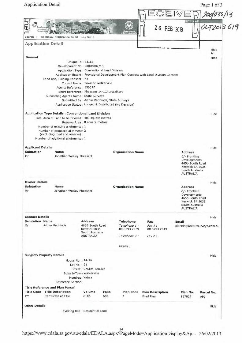
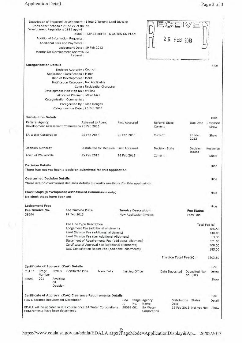
Development Assessment Panel Meeting (9 December 2013) Responsible Manager: Matthew Romaine, Manager Planning and Infrastructure Author: Callum Little, Development Assessment Planner Development Number: 200/038/13 Owner: Jonathan Wesley Pheasant Applicant: Jonathan Wesley Pheasant Location: 14-16 Church Terrace Walkerville Proposal: Land Division 1 into 2 (1 additional allotment) Public Notification Category: Category 3 Zoning: Residential Character Zone (Church Terrace and Environs
Policy Area 10 Historic Conservation Area) Development Plan: Consolidated 22 November 2012 Recommendation: Approval
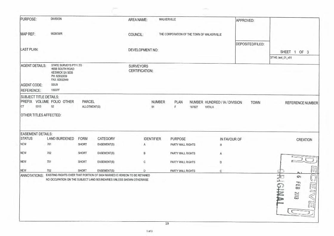
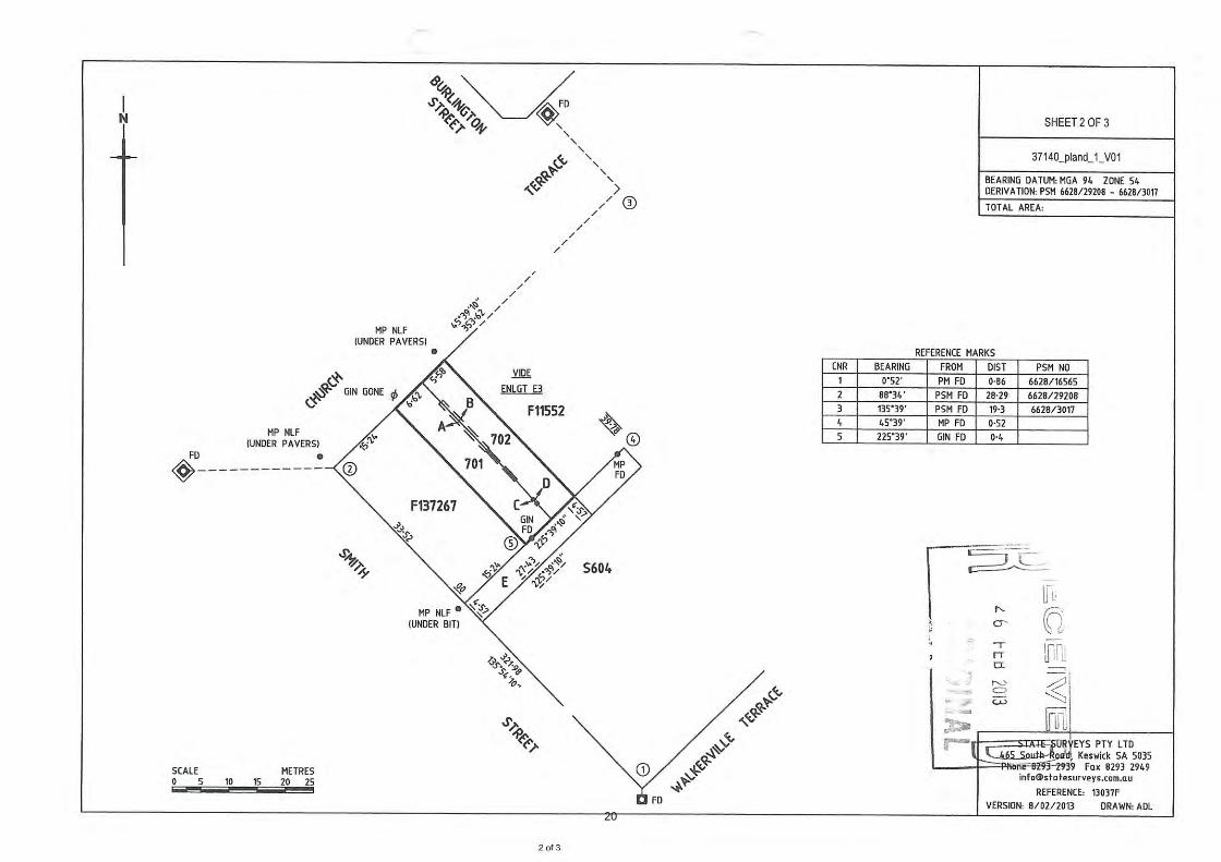
1. SUBJECT LAND The subject land is rectangular with a frontage to Church Terrace. The land has a frontage of 12.2 metres, a depth of 33.53 metres, and a total area of 409 square metres. There is a right of way to the rear over an adjoining property appurtenant to the subject land and providing free and unrestricted access to Smith Street. The land currently accommodates a single storey detached dwelling. The dwelling is of an older style and is listed as a contributory heritage item in Council’s Development Plan. The dwelling has the appearance of one single storey detached dwelling, notwithstanding that is has two front doors. The dwelling has been configured as two dwellings with separate entrances, separate letter boxes and separate street numbers (number 14 and 16 Church Terrace). The land houses a single building in which there is two or more dwellings, accordingly the use of the land is a residential flat building. The dwelling appears to be well maintained. A search of Council records found two previous development applications on the land. A rear laundry, bathroom, carport and verandah were approved in 1982. An application for land division was lodged in 1982, the application included party walls. The land division application was similar to the current application; it proposed to create a new allotment within the existing building. Information submitted in support of the 1982 land division application showed a proposed party wall and a plan of division identical to the current application. The 1982 land division was withdrawn prior to development approval being issued.
5

2. ZONING
Residential Character Zone
Church Terrace and Environs Policy Area
SUBJECT SITE
SUBJECT SITE
SUBJECT SITE
RIGHT OF WAY
6

Historic Conservation Area 3. LOCALITY There is a mix of land uses in the locality with land uses to the north-west, west and south west predominantly community type uses including St Andrews School, St Andrews Church and Walkerville Bowls Club. Adjoining the land on the southern side of Church Terrace on each side of the subject land are two single storey dwellings, each of which has a similar appearance to the dwelling located on the subject land. The dwelling to the north east side of the subject land has been converted to two dwellings and the land has been divided to so as to create two separate allotments. Dwellings to the north east along Church Terrace are generally single storey and detached with relatively large front setbacks and well landscaped yards. Residential development to the south west along Smith Street is characterised by single storey group dwellings. Locality Plan
SUBJECT SITE
SUBJECT SITE
TWO ALLOTMENTS IN ONE DWELLING
ST ANDREWS SCHOOL
WALKERVILLE BOWLS CLUB
7

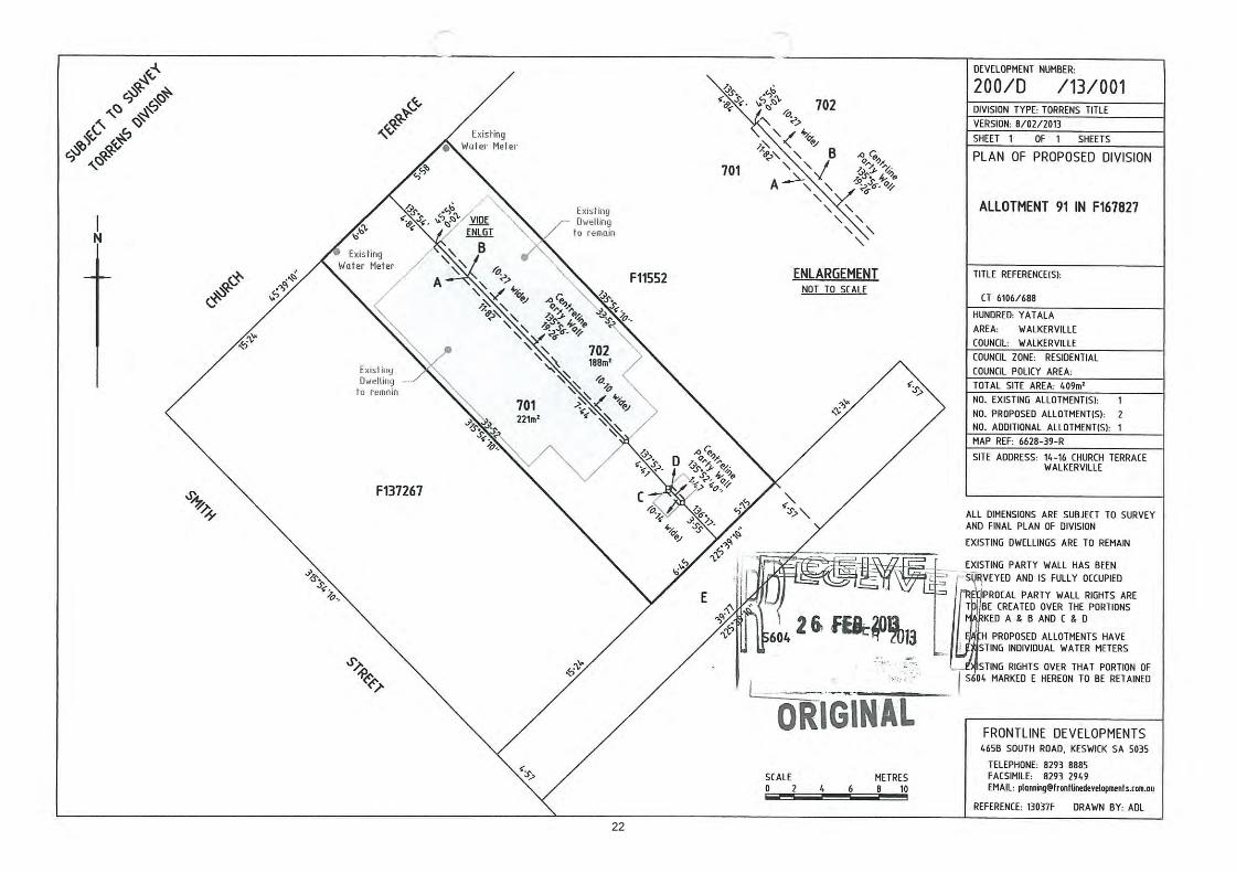
4. THE PROPOSAL The proposal is to divide the existing allotment into two allotments. The proposed allotment on the northern side (Lot 702) will have a frontage of 5.58 metres and depth of 33.52 metres with a total area of 188 square metres. The proposed allotment on the southern side (Lot 701) will have a frontage of 6.62 metres and a depth of 33.52 metres with a total area of 221 square metres. The plan of division includes a party wall where the two occupancies are proposed to be separated and an additional party wall where the outbuildings at the rear of the dwelling are attached to each other. The form of tenure created by the plan of division will be Torrens Title allotments by virtue of the party wall rights being created where existing walls straddle the proposed boundary. The plan of division will change the tenure of the two dwellings on the land. Currently they are dwellings in a residential flat building. They will be changed to semi-detached dwellings as each dwelling will have an exclusive site. 5. PUBLIC NOTIFICATION The application underwent Category 3 public notification. No submissions were received during the notification period. 6. PLANNING ASSESSMENT Key Issues The following issues are considered to be pertinent in reaching a recommendation for the proposal: Land Division The application is to create an additional allotment on land which is currently used as two dwellings. The applicant proposes to retain the existing dwelling on the land. Relevant policies encourage increased dwelling densities in areas close to public open space and centres. The subject land is located a short distance from Walkerville Oval and the Neighbourhood Centre Zone. The proposed allotments will be of a higher density than other residential allotments to the north east and south west along Church Terrace. The smaller allotment sizes will increase housing diversity in the immediate locality. The applicant has indicated that once the new allotments have been created they will provide an affordable entry into home ownership in the area. The creation of residential allotments at higher densities than other allotments in the locality and increased housing choice is supported by the following Principles of Development Control: Land Division Objectives
2 Land division that creates allotments appropriate for the intended use. Residential Development
8
Objectives
2 An increased mix in the range and number of dwelling types available within urban boundaries to cater for changing demographics, particularly smaller household sizes, housing for seniors and supported accommodation. 3 Higher dwelling densities in areas close to centres, public and community transport and public open spaces.
Principles of Development Control
3 Residential allotments should be of varying sizes to encourage housing diversity.
Residential Character Zone Principles of Development Control
3 Vacant or underutilised land should be developed in an efficient and co-ordinated manner to increase housing choice by providing dwellings at densities higher than, but compatible with adjoining residential development in terms of built form.
Impact on the Historic Conservation Area Relevant policies discourage development that will impact on exiting development patterns. Relevant policies make the preservation of Local Heritage Places and Contributory Items a priority. The application proposes to retain the existing contributory item with no alterations to the existing built form. Investigations into when the existing dwelling was separated into two dwellings were unable to identify exactly when this has occurred. Approval of the proposed application will not alter the existing streetscape nor will it increase the possibility that the dwelling on the subject land can be demolished in the future. Any application to demolish the existing dwelling would require development approval and an assessment against the Historic Conservation Area Policies from the Development Plan. Approval of the land division may encourage the retention of the contributory item by splitting maintenance of the building over 2 titles and two owners. The subject application will not have a negative impact on the historic conservation area and is supported by the following Principles of Development Control. Historic Conservation Area Objectives
4 The retention and conservation of places such as land, buildings, structures and landscape elements that contribute positively to the historic character of the area.
Principles of Development Control
1 Places such as land, buildings, structures and landscape elements that contribute to the historic character of the area identified on the Overlay Maps - Heritage and more specifically identified in the respective Table Walk/4 - Contributory Items, should be retained and conserved.
9

2 Development of a contributory item should: (a) not compromise its value to the historic significance of the area (b) retain its present integrity or restore its original design features (c) maintain or enhance the prominence of the original street facade (d) ensure additions are screened by, and/or located to the rear of the building (e) ensure original unpainted plaster, brickwork, stonework, or other masonry is preserved, unpainted.
12 The division of land should occur only where it will maintain the traditional pattern and scale of allotments.
Residential Character Zone Desired Character
Development will conserve the distinctive character of each of these areas and will be limited primarily to the conservation of, or minor alterations and additions to, State and local heritage places identified in Tables Walk/6 - State Heritage Places and Walk/5 - Local Heritage Places and Contributory items identified in Table Walk/4- Contributory Items.
Function of the new allotments There is an existing building on the land and the building has been configured as two dwellings. The function of the land is not proposed to change. Lot A is proposed to have a rear yard with a total area of 74 square metres. Development Plan policies require a minimum of 35 Square Metres of Private Open Space and the provision of 2 off street car parks. The applicant advises that the current tenants park 1 car in the rear yard. The residents of lot A could park two cars in the rear yard and still be left with at least 35 square metres of private open space. Lot B is proposed to have a rear yard with a total area of 65 square metres. The owner could park two cars in the yard and still be left with around 35 square metres of private open space. The proposed private open space area of each dwelling complies with relevant polices including that it be accessible from a living area and that it have a minimum dimension of 4 metres. Approval of the proposed land division will not alter the appearance of the building from the street and will maintain the existing desirable development pattern. The applicant supplied extracts from the Environment Resources and Development Court judgement in the case of Le Cornu v City of Holdfast Bay ERD-02054 [2003] SAERDC 8 (22 January 2003). The Le Cornu case is of some relevance to the current application. In that case the Court chose to approve a land division application where proposed allotment sizes were below the minimum requirements from the Development Plan. The Court reasoned that the application would have no negative impact on the locality as existing buildings were to be retained. For the current application there will be no alteration to the existing built form. The application will formalise an existing situation and will maximise the use of the land despite noncompliance with the minimum allotment sizes required in the Policy Area.
10

The application complies with the following Principles of Development Control: Land Division Objectives
4 Land division that is integrated with site features, including landscape and environmental features, adjacent land uses, the existing transport network and the availability of infrastructure.
Principles of Development Control
2 Land should not be divided if any of the following apply:
(a) the size, shape, location, slope or nature of the land makes any of the allotments unsuitable for the intended use (b) any allotment will not have a frontage to one of the following:
(i) an existing road (ii) a proposed public road (iii) access to a public road via an internal roadway in a plan of community division
(c) the intended use of the land is likely to require excessive cut and/or fill (d) it is likely to lead to undue erosion of the subject land or land within the locality (e) the area is unsewered and cannot accommodate an appropriate waste disposal system within the allotment to suit the intended development (f) the intended use of the land would be contrary to the zone objectives (g) any allotments will straddle more than one zone or policy area.
Residential Development
30 Development should provide off-street vehicle parking and specifically marked disabled car parking places to meet anticipated demand in accordance with Table Walk/2 - Off Street Vehicle Parking Requirements.
Residential Character Zone
11

Objectives
1 A residential zone ensuring the preservation of the existing desirable development patterns and built form.
Principles of Development Control
8 The conversion of an existing dwelling into two or more dwellings should only be undertaken when the building and front yard retain the original external appearance to the public road.
The application does not comply with the following Principles of Development Control:
Residential Character Zone Principles of Development Control
2 Development listed as non-complying is generally inappropriate. 13 Land division should create allotments which accord with the minimum site areas and frontages detailed in the relevant policy area.
Church Terrace and Environs Policy Area 10 Principles of Development Control
7. CONCLUSION The application seeks to formalise the use of land as two dwellings by separating the existing title into two titles. The application proposes to retain an existing contributory heritage item and to maintain existing desirable development patterns. No representations were received during the consultation period. The proposed application will not have an adverse impact on any neighbouring properties or on the locality and warrants development approval. 8. RECOMMENDATION That pursuant to the authority delegated to the Development Assessment Panel by Council, it is recommended that the Development Assessment Panel: DETERMINES that the proposed development is not seriously at variance with the policies in the Town of Walkerville Development Plan, and seeks concurrence from the Development Assessment Commission to GRANT Development Plan Consent to the application by
12
Jonathan Wesley Pheasant to undertake a land division of 1 allotment into 2 allotments at 14 – 16 Church Terrace Walkerville, as detailed in Development Application No. 200/038/13 subject to the following conditions: Conditions
Pursuant to Section 33(1)(a)
1. The development must be undertaken completed and maintained in accordance with the plan(s) and information detailed in Application No. 200/189/13 except where varied by any condition(s) listed below:
Pursuant to Section 33(1)(c)
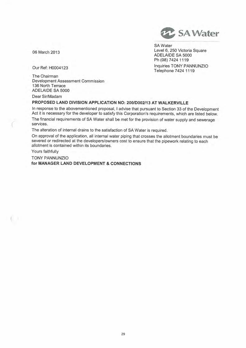
2. The financial requirements of SA Water shall be met for the provision of water supply and sewerage services. The alteration of internal drains to the satisfaction of SA Water is required.
3. On approval of the application, all internal water piping that crosses the allotment boundaries must be severed or redirected at the developers/owners cost to ensure that the pipework relating to each allotment is contained within its boundaries.
4. Payment of $6488 into the Planning and Development Fund (1 allotment(s) @ $6488/allotment). Payment may be made by credit card via the internet at www.edala.sa.gov.au or by phone (8303 0724), by cheque payable to the Development Assessment Commission marked "Not Negotiable" and sent to GPO Box 1815, Adelaide 5001 or in person, at Level 5, 136 North Terrace, Adelaide.
5. A final plan complying with the requirements for plans as set out in the Manual of
Survey Practice Volume 1 (Plan Presentation and Guidelines) issued by the Registrar General to be lodged with the Development Assessment Commission for Land Division Certificate purposes.
CALLUM LITTLE Development Assessment Planner 9. ATTACHMENTS Attachment A: Application Details Attachment B: Certificate of Title Attachment C: Plans of Division Attachment D: Statement of Support Attachment E: SA Water Requirements Attachment F: DAC Requirements Attachment G: Statement of Effect Attachment H: Le Cornu vs. City of Holdfast Bay No ERD - 02-540
13
14
15

16

REGISTER SEARCH OF CERTIFICATE OF TITLE * VOLUME 6106 FOLIO 688 *
COST : $25.00 (GST exempt ) PARENT TITLE : CT 5313/52REGION : EMAIL AUTHORITY : DDA 11890109AGENT : SSU9 BOX NO : 000 DATE OF ISSUE : 14/02/2013SEARCHED ON : 20/02/2013 AT : 10:53:09 EDITION : 1CLIENT REF 13037F
REGISTERED PROPRIETOR IN FEE SIMPLE----------------------------------- JONATHAN WESLEY PHEASANT OF 105 CHURCH TERRACE WALKERVILLE SA 5081
DESCRIPTION OF LAND------------------- ALLOTMENT 91 FILED PLAN 167827 IN THE AREA NAMED WALKERVILLE HUNDRED OF YATALA
EASEMENTS--------- TOGETHER WITH A RIGHT OF WAY OVER THE LAND MARKED B (T 140819)
SCHEDULE OF ENDORSEMENTS------------------------ 11699414 MORTGAGE TO WESTPAC BANKING CORPORATION
NOTATIONS--------- DOCUMENTS AFFECTING THIS TITLE ------------------------------ NIL
REGISTRAR-GENERAL'S NOTES ------------------------- APPROVED FILED PLAN NO UNIQUE IDENTIFIER FX18800 AMENDED TITLE - WITH NEXT DEALING LODGE CT 5313/52
END OF TEXT.
Page 1 of 217

6106 688
20/02/2013 10:53:09
Page 2 of 2
18
19
20

21
22

10 May 2013 Ref: 5969 Statement of Support The Town of Walkerville, PO Box 55 WALKERVILLE SA 5081 Attention: Mr Callum Little Development Assessment Planner Dear Mr Little RE: NON-COMPLYING LAND DIVISION (1 INTO 2) AT 14-16 CHURCH TCE, WALKERVILLE. DA No.: 200/038/13 Access Planning is engaged by Mr. Jonathan Pheasant to provide a Statement of Support in respect to a non-complying Development Application for the abovementioned land division at Walkerville. 1.0 Introduction The subject land is located in the Residential Character Zone, Policy Area 10 - Church Tce and Environs (Refer Figures 1 and 2 below) of the Walkerville Council Development Plan, Consolidated 22 November 2012. Land division of the type proposed is listed under the Procedural Matters section of the Residential Character Zone as non-complying. The following is a brief statement in support of the development application subject to the requirements of Regulation 17(1) of the Development Regulations 2008 as it relates to non-complying development applications. It describes the nature of the proposal and gives brief reasons why the application should, notwithstanding its non-compliance, be the subject of a full assessment report (Statement of Effect).
23

_________________________________________________________________________________
-2-
Figure 1: Subject Site and Zoning Source: Walkerville Council Dev Plan
Figure 2: Subject Site and Policy Area Source: Walkerville Council Dev Plan
2.0 Subject Site and Locality The subject site is a rectangular shaped block of land with a frontage to Church Terrace and a rear right of way of 12.2 metres and a depth of 33.53 metres, all encompassing a land area of 409.06 sq metres. The site is more particularly described as allotment 91 in FP167827, Hundred of Yatala; Certificate of Title Volume 6106 Folio 688. The land is currently improved with a single-storey building configured as two dwellings divided by a party wall. The two dwellings have separate services (water, electricity and sewer) and individual addresses identified as 14 and 16 Church Terrace.
24

_________________________________________________________________________________
-3-
A right of way at the rear of the land provides access to individual car parking areas for each dwelling. The building is listed as a Contributory Heritage Place in Council’s Development Plan and the Department of Planning, Transport and Infrastructure’s, Heritage Places Database. The locality (refer Figure 3) is mixed in nature and characterised by a variety of land uses. To the north east, the site is adjoined by a single-storey building configured as a semi-detached dwelling and separately titled. The allotment areas, street frontage characteristics and built form of these two dwellings are similar in nature to that proposed for the subject site. To the southwest is a single-storey detached dwelling. Both adjoining dwellings take access from the rear right of way. Across Church Terrace to the north, is a Church and recreation area associated with the St Andrews Primary School. To the south across Smith Street, are bowling greens and playing fields associated with the Walkerville Recreation Grounds.
Figure 3: Subject Locality Source: Google Earth
25

_________________________________________________________________________________
-4-
Church Terrace (refer Figure 4) is a local connector road of sufficient width to allow parking on each side and separate traffic lanes in each direction.
Figure 4: Church Terrace in front of the subject site Source: Google Street View
3.0 The Proposed Development The proposal is for the division of the land (refer Figure 5) to create Torrens Titles for the two dwellings on site. The boundaries of the allotments proposed to be created are identified in the survey plan prepared by Frontline Developments. The centerline of the two allotments is also the centerline of the party wall of the existing dwellings’. Proposed allotments 701 and 702 will have the following configuration: • 701 - Church Terrace frontage of 6.62 metres and an area of 221 sq metres; and • 702 - Church Terrace frontage of 5.58 metres and an area of 188 sq metres.
Figure 3: Proposed land division Source: Frontline Developments
26
_________________________________________________________________________________
-5-
4.0 Discussion of the Merits of the Proposed Development The proposal is for the division of the land to create one additional allotment to facilitate the creation of separate titles for two existing dwellings. The subject land is located in the Residential Character Zone, Policy Area 10 - Church Tce and Environs. The proposed land division is not in keeping with the minimum quantitative site area and street frontage standards as set down in Policy Area 10 Principle of Development Control (PDC) 2. The land division will not however: • Change the use of the site; or • Alter the form or density of the existing dwellings; or • Change the access arrangements to the land; or • Require vegetation or trees to be removed. The impact on the locality will remain the same. The neutral arrangement proposed by the land division is in keeping with relevant Objectives, PDC’s and parts of the Desired Character statement for the Residential Character Zone including:
Objectives 1 A residential zone ensuring the preservation of the existing desirable development patterns and built form. 3 Development that contributes to the desired character of the zone. Desired Character Development will conserve the distinctive character of each of these areas and will be limited primarily to the conservation of, or minor alterations and additions to, State and local heritage places identified in Tables Walk/6 - State Heritage Places and Walk/5 - Local Heritage Places and Contributory items identified in Table Walk/4- Contributory Items. Development will not compromise the desirable very low density (allotments above 600 square metres) and low-density (allotments between 300 square metres and 600 square metres) character of the zone. Principles of Development Control Form and Character 6 Development should not be undertaken unless it is consistent with the desired character for the zone. 8 The conversion of an existing dwelling into two or more dwellings should only be undertaken when the building and front yard retain the original external appearance to the public road.
5.0 Summary In summary, the proposed division of land will create one new allotment to facilitate the creation of separate titles for two existing dwellings.
27

_________________________________________________________________________________
-6-
Notwithstanding the non-complying nature of the development, the proposed land division is orderly, logical and consistent with the pattern of land division in the locality. As outlined, the proposed land division is neutral in its impact. Having regard to the matters detailed above, I am of the opinion that a more considered assessment of the development is warranted, at which time relevant Environment, Resources and Development determinations will be cited in support. Should you have any questions in regards to the above please do not hesitate to contact me on telephone 8364 1956 or via email: [email protected] Yours sincerely,
Michael Hutchison ACCESS PLANNING CC: Mr Jonathan Pheasant
28
29

30
01 November 2013 Ref: 5969 Statement of Effect
The Town of Walkerville, PO Box 55 WALKERVILLE SA 5081 Attention: Mr Callum Little - Development Assessment Planner Dear Mr Little
RE: Non-complying land division (1 into 2) at 14-16 Church Terrace, Walkerville. Statement of Effect DA No.: 200/038/13
1.0 Introduction This report has been prepared in relation to a Non Complying application by Jonathan Pheasant to subdivide a site at Walkerville. The subject land at 14-16 Church Terrace, Walkerville is located in the Residential Character Zone, Policy Area 10 - Church Tce and Environs. Land division of the type proposed is listed under the Procedural Matters section of the Residential Character Zone as non-complying. As a non-complying development application and after receipt of a Statement of Support, Council has determined (letter dated 05 September 2013) to proceed with a full assessment of the proposal under Regulation 17(3) of the Development Regulations 2008 (the Regulations) and has requested a Statement of Effect (SOE) be provided. Accordingly, this SOE has been prepared on behalf of the applicant pursuant to the requirements of Regulation 17(5) of the Regulations. The SOE includes: A description of the nature of the development and the nature of its locality; Identifying the provisions of the Development Plan relevant to an assessment of the
proposed development; An assessment of the extent to which the proposed development complies with the
provisions of the Development Plan; and An assessment of the expected social, economic and environmental effects of the
development on its locality. Also included is a summary of an Environment, Resources and Development Court decision with relevance to the application. In preparing this report I can confirm that I have inspected the subject land and its locality, reviewed the proposal plans and assessed the proposal against the Walkerville Council Development Plan, Consolidated 22 November 2012.
31

_________________________________________________________________________________
-2-
2.0 Subject Site and Locality The subject site is a rectangular shaped block of land with a frontage to Church Terrace and a rear right of way of 12.2 metres and a depth of 33.53 metres, all encompassing a land area of 409.06 sq metres. The site is more particularly described as allotment 91 in FP167827, Hundred of Yatala; Certificate of Title Volume 6106 Folio 688. The land is currently improved with a single-storey building configured as two dwellings divided by a party wall. The two dwellings have separate services (water, electricity and sewer) and individual addresses identified as 14 and 16 Church Terrace. Each dwelling is in separate occupancy. A right of way at the rear of the land provides access to individual car parking areas for each dwelling. The building is listed as a Contributory Item in Council’s Development Plan and the Department of Planning, Transport and Infrastructure’s, Heritage Places Database. The locality (Figure 1) is mixed in nature and characterised by a variety of land uses. To the north east, the site is adjoined by a single-storey building configured as a semi-detached dwelling and separately titled. The allotment areas, street frontage characteristics and built form of these two dwellings are similar in nature to that proposed for the subject site. To the southwest is a single-storey detached dwelling. Both adjoining dwellings take access from the rear right of way. The two adjoining buildings and the subject building together form a coherent streetscape with similar setbacks and built form fronting Church Street. Across Church Terrace to the north, is a Church and recreation area associated with the St Andrews Primary School. To the south across Smith Street, are bowling greens and playing fields associated with the Walkerville Recreation Grounds.
Figure 1: Subject Locality Source: Google Earth
32

_________________________________________________________________________________
-3-
Church Terrace (Figure 2) is a local connector road of sufficient width to allow parking on each side and separate traffic lanes in each direction.
Figure 2: Church Terrace in front of the subject site Source: Google Street View
The site is well located with respect to support facilities with a bus service extending along Smith Street nearby to the site, with bus stops in easy walking distance and shops and other support facilities to the south at the corner of Smith Street and Walkerville Terrace. 3.0 The Proposed Development The proposal is for the division of the land (Figure 3) to create Torrens Titles for the two dwellings on site. The boundaries of the allotments proposed to be created are identified in the survey plan prepared by Frontline Developments. The centerline of the two allotments is also the centerline of the party wall of the existing dwellings’. Proposed allotments 701 and 702 will have the following configuration: 701 - Church Terrace frontage of 6.62 metres and an area of 221 sq metres; and 702 - Church Terrace frontage of 5.58 metres and an area of 188 sq metres.
Figure 3: Proposed land division Source: Frontline Developments
33
_________________________________________________________________________________
-4-
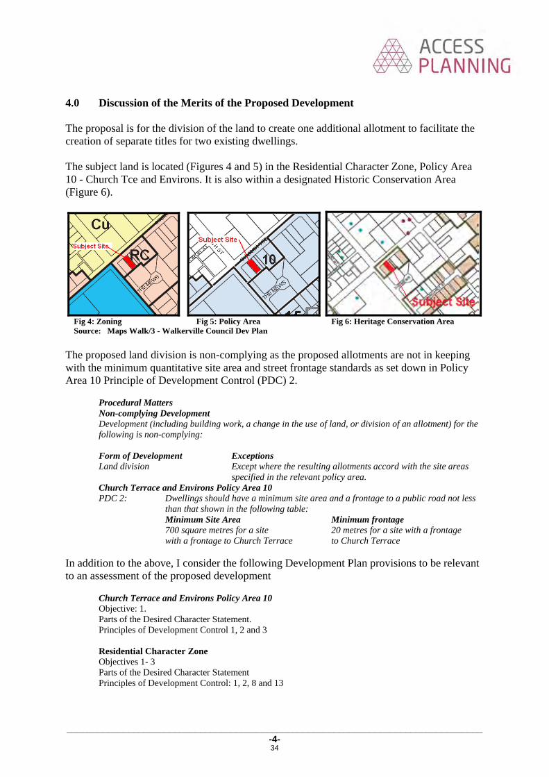
4.0 Discussion of the Merits of the Proposed Development The proposal is for the division of the land to create one additional allotment to facilitate the creation of separate titles for two existing dwellings. The subject land is located (Figures 4 and 5) in the Residential Character Zone, Policy Area 10 - Church Tce and Environs. It is also within a designated Historic Conservation Area (Figure 6).
Fig 4: Zoning Fig 5: Policy Area Fig 6: Heritage Conservation Area Source: Maps Walk/3 - Walkerville Council Dev Plan
The proposed land division is non-complying as the proposed allotments are not in keeping with the minimum quantitative site area and street frontage standards as set down in Policy Area 10 Principle of Development Control (PDC) 2.
Procedural Matters Non-complying Development Development (including building work, a change in the use of land, or division of an allotment) for the following is non-complying: Form of Development Exceptions Land division Except where the resulting allotments accord with the site areas
specified in the relevant policy area. Church Terrace and Environs Policy Area 10 PDC 2: Dwellings should have a minimum site area and a frontage to a public road not less
than that shown in the following table: Minimum Site Area Minimum frontage 700 square metres for a site 20 metres for a site with a frontage with a frontage to Church Terrace to Church Terrace
In addition to the above, I consider the following Development Plan provisions to be relevant to an assessment of the proposed development
Church Terrace and Environs Policy Area 10 Objective: 1. Parts of the Desired Character Statement. Principles of Development Control 1, 2 and 3 Residential Character Zone Objectives 1- 3 Parts of the Desired Character Statement Principles of Development Control: 1, 2, 8 and 13
34
_________________________________________________________________________________
-5-
General Section - Historic Conservation Area Objectives: 1-4 Principles of Development Control: 1, 2 and 12 General Section – Land Division Objectives: 2 and 4 Principles of Development Control: 1 and 2 General Section – Orderly and Sustainable Development Objectives: 1-4 Principles of Development Control: 1 General Section – Residential Development Objectives: 1, 2, 3, and 5 Principles of Development Control: 3, 15, 17, 20, 21, 22, 23, 28, 38 and 43 General Section – Transportation and Access Objectives: 2 Principles of Development Control: 20, 27 30 36 Table Walk/2 Off Street Vehicle Parking Requirements Table Walk/4 Contributory Items
In assessing the merits of the application, the primary planning issues relevant to the Development Plan have been discussed under the following sub-headings: 4.1 Land Use and Zoning As noted above, the proposed land division seeks to create an additional allotment to allow the separate titling of the two long standing existing dwellings on the site. A dwelling/s is an envisaged use in the zone. No changes are required to the two dwellings which are listed in Council’s Development Plan as Contributory Items (Table Walk/4) to facilitate the land division. The building to be divided is also located in a Historic Conservation Area (Figure 6). As no changes are proposed to the built form of the dwellings, or to their external features; such as front and rear fencing, car parks and car park access, pedestrian access paths, front and rear entry doors etc, there will be no change to the design integrity of the building and no consequent impact on the buildings setting in the Conservation Area. The land division will formalise an existing situation with each part of the dwelling already in separate occupation with a separate street number and individual services for power, water and sewer. The building when divided will create two allotments on modest allotments providing, if sold, an affordable entry into home ownership in the area. Equally, if they continue to be rented out, they will provide ongoing affordable rents for the occupants. In each case, access to public transport and local shopping and support facilities provide added support for the division of the land.
35
_________________________________________________________________________________
-6-
In summary, the land division will not: Change the use of the site; or Alter the form or density of the existing dwellings; or Make any changes to the building; or Change the access arrangements to the land; or
Require vegetation or trees to be removed. The impact on the locality will remain the same. The neutral arrangement proposed by the land division is supported by the following Policy Area, Zone and Council Wide provisions:
Residential Character Zone Objectives 1 A residential zone ensuring the preservation of the existing desirable development patterns
and built form. 2 Infill development, including affordable housing, that is designed to reflect the traditional
character elements of the area, particularly as presented to the streetscape. 3 Development that contributes to the desired character of the zone Parts of the Desired Character Statement Areas of concentrated heritage value are identified within Historic Conservation Areas on the Overly Maps- Heritage. Development will conserve the distinctive character of each of these areas….. Principle of Development Control 8 The conversion of an existing dwelling into two or more dwellings should only be undertaken
when the building and front yard retain the original external appearance to the public road. General Section - Historic Conservation Area Objectives 1 The conservation of areas of historical significance. 2 Development that promotes, conserves and enhances the cultural significance and historic
character of identified places and areas. 3 Development that complements the historic significance of the area. 4 The retention and conservation of places such as land, buildings, structures and landscape
elements that contribute positively to the historic character of the area. Principles of Development Control 1 Places such as land, buildings, structures and landscape elements that contribute to the
historic character of the area identified on the Overlay Maps - Heritage and more specifically identified in the respective Table Walk/4 - Contributory Items, should be retained and conserved.
2 Development of a contributory item should: (a) not compromise its value to the historic significance of the area (b) retain its present integrity or restore its original design features (c) maintain or enhance the prominence of the original street facade (d) ensure additions are screened by, and/or located to the rear of the building (e) ensure original unpainted plaster, brickwork, stonework, or other masonry is
preserved, unpainted. 12 The division of land should occur only where it will maintain the traditional pattern and scale
of allotments.
General Section – Land Division Objectives: 2 Land division that creates allotments appropriate for the intended use. 4 Land division that is integrated with site features, including landscape and environmental
features, adjacent land uses, the existing transport network and the availability of infrastructure.
36

_________________________________________________________________________________
-7-
Principles of Development Control: 1 When land is divided:
(a) stormwater should be capable of being drained safely and efficiently from each proposed allotment and disposed of from the land in an environmentally sensitive manner
(b) a sufficient water supply should be made available for each allotment (c) provision should be made for the disposal of wastewater, sewage and other effluent
from each allotment without risk to health 2 Land should not be divided if any of the following apply:
(a) the size, shape, location, slope or nature of the land makes any of the allotments unsuitable for the intended use
(b) any allotment will not have a frontage to one of the following: (i) an existing road (ii) a proposed public road (iii) access to a public road via an internal roadway in a plan of community
division (f) the intended use of the land would be contrary to the zone objectives (g) any allotments will straddle more than one zone or policy area.
General Section – Orderly and Sustainable Development Objectives: 1 Orderly and economical development that creates a safe, convenient and pleasant environment
in which to live. 2 Development occurring in an orderly sequence and in a compact form to enable the efficient
provision of public services and facilities. 3 Development that does not jeopardise the continuance of adjoining authorised land uses. 4 Development that does not prejudice the achievement of the provisions of the Development
Plan. Principle of Development Control: 1 Development should not prejudice the development of a zone for its intended purpose. General Section – Residential Development Objectives: 1 Safe, convenient, pleasant and healthy-living environments that meet the full range of needs
and preferences of the community. 2 An increased mix in the range and number of dwelling types available within urban
boundaries to cater for changing demographics, particularly smaller household sizes, housing for seniors and supported accommodation.
3 Higher dwelling densities in areas close to centres, public and community transport and public open spaces.
5 Affordable housing and housing for seniors provided in appropriate locations. Principle of Development Control: 3 Residential allotments should be of varying sizes to encourage housing diversity.
In the context of the locality, and given the existing building on the site, the proposal to subdivide the land can be considered as appropriate providing for the ongoing orderly use of the land. 4.2 Allotment size and frontage/Boundary Setbacks/Site Coverage/Private Open
Space/Car Parking As noted above, the proposed land division is non-complying because it will create allotments that are below the minimum quantitative site area and street frontage standard for the Policy Area.
37

_________________________________________________________________________________
-8-
In addition, the proposed land division will create dwellings that are not in keeping with a number of other quantitative Development Plan provisions, such as the provision of two off street car parking spaces per dwelling. Having said that, the qualitative provisions of the Development Plan under the general heading of Residential Development, will generally be met. These include:
General Section – Residential Development Principles of Development Control: Street and Boundary Setbacks 15 Dwellings should be set back from allotment or site boundaries to:
(a) contribute to the desired character of the area (b) provide adequate visual privacy by separating habitable rooms from pedestrian and
vehicle movement. 17 Side boundary walls in residential areas should be limited in length and height to:
(a) minimise their visual impact on adjoining properties Site Coverage 20 Site coverage should be limited to ensure sufficient space is provided for:
(a) pedestrian and vehicle access and vehicle parking (b) domestic storage (c) outdoor clothes drying (d) a rainwater tank (e) private open space and landscaping (f) front, side and rear boundary setbacks that contribute to the desired character of the
area (g) convenient storage of household waste and recycling receptacles.
Private Open Space 21 Private open space (land available for exclusive use by residents of each dwelling) should be
provided for each dwelling and should be sited and designed: (a) to be accessed directly from the internal living areas of the dwelling (b) generally at ground level to the side or rear of a dwelling and screened for privacy (c) to take advantage of but not adversely affect natural features of the site (d) to minimise overlooking from adjacent buildings (e) to achieve separation from bedroom windows on adjoining sites (f) to have a northerly aspect to provide for comfortable year-round use (g) to not be significantly shaded during winter by the associated dwelling or adjacent
development (h) to be shaded in summer.
22 Dwellings should have associate Car Parking and Access 37 Driveway crossovers should be single width and appropriately separated, and the number
should be minimised to optimise the provision of on-street visitor parking. 38 On-site parking should be provided having regard to:
(a) the number, nature and size of proposed dwellings (b) proximity to centre facilities, public and community transport within walking distance
of the dwellings (d) availability of on-street car parking
In my view, given the longstanding existing nature of the building its ongoing use as two dwellings and the qualitative aspects of the development; that is, the ongoing preservation of a Contributory Building; the preservation of the built form and streetscape integrity of a Historic Conservation Area, the site’s location close to public transport and local shopping and support facilities and affordability issues, I consider the above non compliance with the minimum site area and street frontage to be largely irrelevant and not fatal to a consideration of the development.
38
_________________________________________________________________________________
-9-
4.3 Relevant Environment, Resources and Development Court Decision There is an Environment, Resources and Development Court decision of relevance to the application. The case is Le Cornu v City of Holdfast Bay No ERD-02-54- [2003] SAERDC 8 (22 January 2003). I have attached a copy of the Courts determination. Briefly: The application under appeal was for the division of land at 84 Broadway, Glenelg South
by way of a primary strata plan under the Community Titles Act 1996. On the land there existed a cream brick two-storey building built some twenty years
earlier and comprising five residential flats together with 6 car parks. The site was located in the Heritage (Conservation) Zone - Residential (New Glenelg)
Zone. The application was refused by Council on grounds of appearance and density. At the hearing the appellants argued that the Community Plan:
o would not alter the form or density of the residential flat building, its use or its impact on the locality,
o it would not preclude the future development of the land in accordance with ‘whatever planning regime might be in force at the relevant time’, and
o the proposal was neutral in planning terms. The Court allowed the appeal and in their determination summarized at paragraphs 11 -14 found as follows:
11. Under the community plan, the land would remain one allotment, which would contain five lots, each of which would be defined by reference to the residential flat building which has existed on the land for about 20 years. The density of development on the land, the site area per dwelling, and the impact of the development on the land on neighbours and passers-by will remain the same, whether the community plan is deposited or not. I do not consider that the Development Plan speaks against the proposal.
12. The Community Titles Act 1996 allows for many different kinds of community plans. Many community plans will have planning impacts, and that is why division under the Community Titles Act 1996 constitutes division and development under the Development Act 1993. The particular community plan the subject of this appeal, however, would not have any direct planning impacts.
13. Ms Vines' and Mr Grainger's apprehensions with respect to the consequences of the fragmentation of ownership that the community plan would make possible, was based, principally, upon the possibility of there being five owners who were also occupiers. However, there is a much broader range of possibilities than that. There may be five owners, some or all of whom lease their lots. There may be fewer owners. The owners may not seek to redevelop the land themselves, but may be bought out by a developer. Ms Vines thought that it was a possibility that a redevelopment of the land may be viable now. She acknowledged, though, that it might be some decades before redevelopment was considered. Neither she nor Mr Grainger had undertaken any investigations or made any calculations in relation to the viability of redevelopment of the land. The evidence in this area consisted mostly of speculation, informed to some extent in Ms Vines' case by her experience. I accept that Ms Vines and Mr Grainger genuinely hold the fears that they express. Those fears, however, are based upon a very narrow view of what may happen in the future. Even accepting that there is a possibility that this proposal may give rise to the feared effect, that possibility is an insufficient basis upon which to refuse the application.
14. The other fear held by Ms Vines and Mr Grainger - that the presence of five owners may give rise to an expectation, which the planning system may at some future time in some way be constrained to fulfil that a redevelopment must also comprise five units - is not supported by fact or law. It is ill founded.
39

_________________________________________________________________________________
-10-
The basis of a division by strata plan is the existing building on the land, and, if the building ceases to exist, then the ownership arrangement must necessarily change also. There is no proper basis, in law or in planning, in these circumstances, for an expectation to arise that the same number of dwelling units will be allowed on the land as existed in the building which has ceased to be. Once that building has ceased to exist, then the owners must look to the Development Plan of the day for guidance as to what form of redevelopment is likely to gain approval.
The circumstances for the Walkerville land division are similar to that outlined in the Le Cornu case, save for the number of dwellings involved (two versus five) and the type of land division (Torrens Title versus Community Title). 4.4 Expected social, economic and environmental effects of the development. Given the argument, as set out above, that the proposed land division will be neutral in planning terms, so too therefore will be its expected social, economic and environmental effects. 5.0 Summary In summary, the proposed division of land will create one new allotment to facilitate the creation of separate titles for two existing dwellings. Notwithstanding the non-complying nature of the development, the proposed land division is orderly, logical and consistent with the pattern of land division in the locality. As outlined, the proposed land division is neutral in its impact. Having regard to the matters detailed above, I am of the opinion that the proposed land division is warranted. Should you have any questions in regards to the above please do not hesitate to contact me on telephone 8364 1956 or via email: [email protected] Yours sincerely,
Michael Hutchison ACCESS PLANNING CC: Mr Jonathan Pheasant
40
You are here: AustLII >> Databases >> Environment Resources and Development Court of South Australia >> 2003>> [2003] SAERDC 8
[Database Search] [Name Search] [Recent Decisions] [Noteup] [Download] [Help]
Le Cornu v City of Holdfast Bay No ERD-02-540 [2003] SAERDC 8 (22 January 2003) Last Updated: 20 April 2003
Court
ENVIRONMENT RESOURCES AND DEVELOPMENT COURT
Judgment of Her Honour Judge Cole
Hearing
20/11/2002 to 21/11/2002, 20/01/2003.
Catchwords and Materials Considered
LOCAL GOVERNMENT --- TOWN PLANNING
Development Act 1993 - a cream brick two-storey building containing five residential flats was built on the land in 1982/93 - development application for provisional development plan consent to divide land by way of primary strata plan under the Community Titles Act 1996 - refused by Council on grounds of appearance and density - in the Heritage (Conservation) Zone - Residential (New Glenelg) - proposal has no direct planning impact - the appeal is allowed.
Development Act 1993 ; Community Titles Act 1996 , referred to.
Representation
Appellant: SHAUN & BARRY LE CORNUCounsel: MR J BOTTEN - Solicitors: JAMIE BOTTEN & ASSOCIATES
Respondent: CITY OF HOLDFAST BAYCounsel: MR M BEAMOND - Solicitors: MELLOR OLSSON
ERD-02-540
Judgment No. [2003] SAERDC 8
[Home] [Databases] [WorldLII] [Search] [Feedback]
Environment Resources and Development Court of South Australia
Page 1 of 4Le Cornu v City of Holdfast Bay No ERD-02-540 [2003] SAERDC 8 (22 January 2003)
21/11/2013mhtml:file://C:\Users\buraly\AppData\Local\Microsoft\Windows\Temporary Internet ...
41
22 January 2003
SHAUN & BARRY LE CORNU
v
CITY OF HOLDFAST BAY
ERDC 549 of 2002
[2003] SAERDC 8
THE COURT DELIVERED THE FOLLOWING JUDGMENT
1. By development application dated 10 April 2002 ("the application"), the appellants applied for provisional development plan consent to divide the land at 84 Broadway, Glenelg South ("the land"), by way of primary strata plan under the Community Titles Act 1996. A primary strata plan is a subspecies of a community plan.
The land
2. The land is comprised in certificate of title Register Book Volume 5477 Folio 678. The appellants are the joint owners of the land. The land is within the area of the City of Holdfast Bay.
3. In about 1982-1983, a cream brick two-storey building containing five residential flats was built on the land, together with 6 carparks. That remains the current built form and use of the land. It seemed to be common ground between the parties that the residential flat building does not make a positive contribution, in terms of its appearance and density, to the Heritage (Conservation) Zone - Residential (New Glenelg) Zone in which the land is situated.
Development Act 1993
4. The division of an allotment by community plan under the Community Titles Act 1996 is encompassed in the definition of "division", which in turn is a kind of "development" under the Development Act 1993. It therefore requires provisional development plan consent.
Community Titles Act 1996
5. The division proposed is a simple strata titling of a residential flat building and its subsidiaries. The boundaries of the lots proposed to be created are identified in the proposal plans by reference to the physical dimensions of the residential flat building. If the proposal proceeds, a future proprietor of one of the community titles will have rights over part of the existing residential flat building, a carport and some common property.
The evidence and the arguments
6. Two witnesses were called in the appellants' case - Mr George Capetanakis, a building surveyor, and Mr Barry O'Callaghan, a licensed surveyor. Mr Capetanakis gave evidence that the residential flat building is structurally sound, and likely to remain substantially so for at least the next 30 years. Mr O'Callaghan gave evidence, among other things, of other properties in the vicinity of the land which have been strata titled.
7. In very broad summary, the argument on behalf of the appellants was that the deposit of a
Page 2 of 4Le Cornu v City of Holdfast Bay No ERD-02-540 [2003] SAERDC 8 (22 January 2003)
21/11/2013mhtml:file://C:\Users\buraly\AppData\Local\Microsoft\Windows\Temporary Internet ...
42

community plan would not alter the form or density of the residential flat building, its use or its impact on the locality. Nor would it preclude the future development of the land in accordance with whatever planning regime might be in force at the relevant time. The implication was that the proposal was neutral in planning terms.
8. The respondent planning authority called two expert witnesses - Ms Elizabeth Vines, a heritage architect, and Mr Nathan Grainger, a town planner. Ms Vines provided some information about the process leading up to the creation by the Development Plan of the Heritage (Conservation) Zone - Residential (New Glenelg). It was her view that the proposed development, if approved, had the potential to compromise the achievement of the objectives for the zone. Mr Grainger shared that view.
9. Again, in very broad summary, the argument on behalf of the respondent planning authority was that the division of the land by community title was likely to lead to the fragmentation of the ownership of the land, so that instead of the present two, related, owners, it was likely that there would be five unrelated owners. The fact of the land having five unrelated owners, it was argued, would render it difficult, if not impossible, for the land to be redeveloped in any form other than for five dwellings which could be held separately by the five owners. It was also argued that the relevant provisions of the Development Plan spoke against the development.
The Development Plan
10. A division by a primary strata plan is not a form of development which is specifically dealt with by any provision of the Development Plan relevant to the land. Mr Grainger, in his statement and in his oral evidence, gave his opinion that the proposal offends many of the provisions of the Development Plan. Most of the provisions he cited have to do with the form of buildings and the density of development. This proposal will have no direct impact upon the form of the buildings on the site, or upon the density of development. Really, I think that what Mr Grainger was attempting to convey, was an apprehension that the fact of the existence of five lots in relation to the land, with the potential for five unrelated owners, would make it more difficult for the land to be redeveloped, at some unknowable future time, in accordance with the objectives of the Development Plan. He illustrated this by reference to an assessment of the residential flat building, which is presently part of the land, with the provisions of the Development Plan in force when the development application the subject of this appeal was lodged.
11. Under the community plan, the land would remain one allotment, which would contain five lots, each of which would be defined by reference to the residential flat building which has existed on the land for about 20 years. The density of development on the land, the site area per dwelling, and the impact of the development on the land on neighbours and passers-by will remain the same, whether the community plan is deposited or not. I do not consider that the Development Plan speaks against the proposal.
12. The Community Titles Act 1996 allows for many different kinds of community plans. Many community plans will have planning impacts, and that is why division under the Community Titles Act 1996 constitutes division and development under the Development Act 1993. The particular community plan the subject of this appeal, however, would not have any direct planning impacts.
13. Ms Vines' and Mr Grainger's apprehensions with respect to the consequences of the fragmentation of ownership that the community plan would make possible, was based, principally, upon the possibility of there being five owners who were also occupiers. However, there is a much broader range of possibilities than that. There may be five owners, some or all of whom lease their lots. There may be fewer owners. The owners may not seek to redevelop
Page 3 of 4Le Cornu v City of Holdfast Bay No ERD-02-540 [2003] SAERDC 8 (22 January 2003)
21/11/2013mhtml:file://C:\Users\buraly\AppData\Local\Microsoft\Windows\Temporary Internet ...
43
the land themselves, but may be bought out by a developer. Ms Vines thought that it was a possibility that a redevelopment of the land may be viable now. She acknowledged, though, that it might be some decades before redevelopment was considered. Neither she nor Mr Grainger had undertaken any investigations or made any calculations in relation to the viabilityof redevelopment of the land. The evidence in this area consisted mostly of speculation, informed to some extent in Ms Vines' case by her experience. I accept that Ms Vines and Mr Grainger genuinely hold the fears that they express. Those fears, however, are based upon a very narrow view of what may happen in the future. Even accepting that there is a possibility that this proposal may give rise to the feared effect, that possibility is an insufficient basis upon which to refuse the application.
14. The other fear held by Ms Vines and Mr Grainger - that the presence of five owners may give rise to an expectation, which the planning system may at some future time in some way be constrained to fulfil that a redevelopment must also comprise five units - is not supported by fact or law. It is ill founded. The basis of a division by strata plan is the existing building on the land, and, if the building ceases to exist, then the ownership arrangement must necessarily change also. There is no proper basis, in law or in planning, in these circumstances, for an expectation to arise that the same number of dwelling units will be allowed on the land as existed in the building which has ceased to be. Once that building has ceased to exist, then the owners must look to the Development Plan of the day for guidance as to what form of redevelopment is likely to gain approval.
15. The appeal will be allowed. An order will be made accordingly.
AustLII: Copyright Policy | Disclaimers | Privacy Policy | FeedbackURL: http://www.austlii.edu.au/au/cases/sa/SAERDC/2003/8.html
Page 4 of 4Le Cornu v City of Holdfast Bay No ERD-02-540 [2003] SAERDC 8 (22 January 2003)
21/11/2013mhtml:file://C:\Users\buraly\AppData\Local\Microsoft\Windows\Temporary Internet ...
44

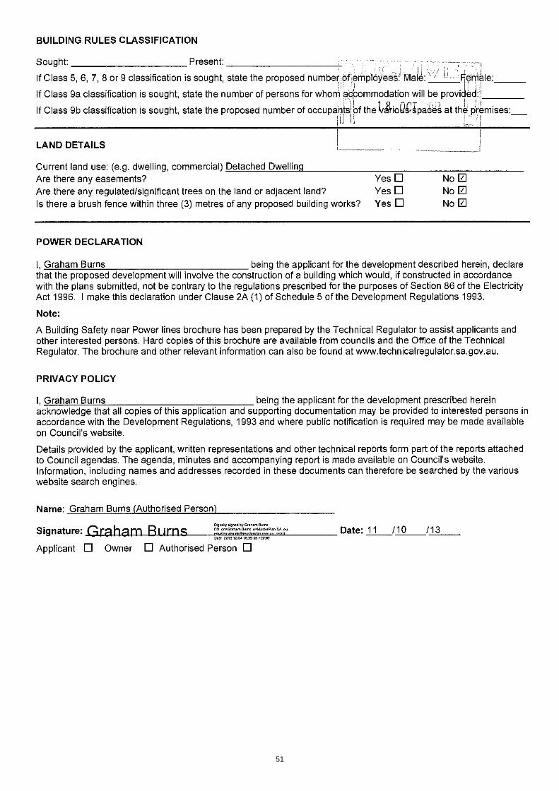
Development Assessment Panel Meeting (9 December 2013) Responsible Manager: Matthew Romaine, Manager Planning and Infrastructure Author: Callum Little, Development Assessment Planner Development Number: 200/226/13 Owner: Calvary Rehabilitation Hospital Applicant: Calvary Rehabilitation Hospital Location: 20 North East Road Walkerville Proposal: Change of use from dwelling to Consulting Rooms Public Notification Category: Category 3 Zoning: Residential Zone (North East Road Corridor Policy Area 8) Development Plan: Consolidated 22 November 2012 Recommendation: To proceed to assess the application
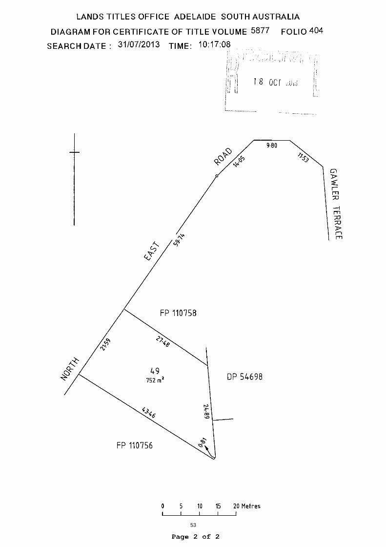
1. SUBJECT LAND The subject land is irregular in shape with a frontage of 21.59 metres to North East Road. The land has a depth of 27.48 metres along the northern (side) boundary and 43.46 metres along the southern (side) boundary. The land has a total area of 752 square metres. The land supports a 1920s style dwelling that appears to be of brick construction. A carport has been constructed along the southern (side) boundary of the land. The dwelling is located 12 metres from North East Road, 1.2 metres from the north (side) boundary and 1 metre from the rear boundary at the closest point.
SUBJECT LAND
45
2. ZONING
Heritage Overlay
Residential Zone
SUBJECT SITE
SUBJECT SITE
46

North East Road Corridor Policy Area 3. LOCALITY The immediate locality is dominated by the primary arterial Road North East Road. North East Road is the primary thoroughfare from Adelaide to the north eastern suburbs and carries substantial traffic volumes. Immediately behind the subject land is a large residential allotment that supports a substantial dwelling. The Calvary Health Centre occupies a substantial part of the locality. The Health Centre has a frontage of over 100 metres to North East Road. The Health Centre is a large complex with both single storey and double storey elements. The majority of the Health Centre buildings are located in the northern section of the land with the car park located in the southern section. Dwellings are the primary land use to the north of the subject land on the southern side of North East Road. A small local scale shopping centre is located to the north of the subject land on the northern side of North East Road. Commercial uses continue along the northern side of North East road until past the intersection with Galway Avenue. Dwellings are the primary land use south of the subject land on the northern side of North East Road. Dwellings facing North East Road are characterised by high front fences and mature landscaping. The amenity of the locality is compromised by the high traffic volumes of North East Road.
SUBJECT SITE
47
Locality Plan
4. THE PROPOSAL The proposal is to change the use of an existing dwelling to consulting rooms. The applicant has advised the following:
The service will be run from two rooms at the rear of the building with practitioners using a fixed screen and camera equipment to communicate with patients off site.
A maximum of two practitioners only will operate from the facility (one practitioner per room).
In time, a third person may be employed offering back-up technical and administrative support for the service.
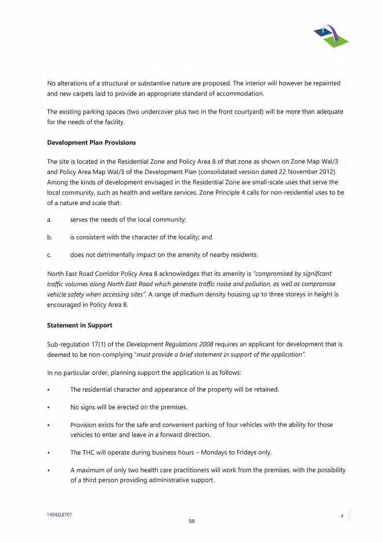
Clients and patients will not attend the premises in person. The service will be offered during business hours only, Mondays to Fridays. No alterations of a structural or substantive nature are proposed The interior will be repainted and new carpets laid to provide an appropriate standard
of accommodation. The existing parking spaces (two undercover plus two in the front courtyard) will be
more than adequate for the needs of the facility. 5. PROCEDURAL CONSIDERATIONS The procedural matters section of the Residential Zone identifies Consulting rooms as a non-complying form of development except where:
a) The total floor area is less than 30 square metres; b) The site does not front an arterial road.
The total area of the dwelling proposed to be converted to consulting rooms is 192 square metres. Section 39 (4)(d) of the Development Act (1993) states that:
Subject Land
Local Shopping Centre
Calvary Hospital
Local Heritage Place
48

A relevant authority may refuse an application that relates to a development of a kind that is described as a non-complying development under the relevant Development Plan without proceeding to make an assessment of the application.
Further, if a person applies for consent in respect of a Development Plan for a non- complying development, the applicant must provide a brief statement in support of the application.
Having received a statement from the applicant, the Development Assessment Panel must now determine whether to proceed to make an assessment of the proposal.
On its face, the application is a substantial departure from the requirements of the Development Plan, with the proposed consulting rooms exceeding the maximum area permitted by the Development Plan by over 160 square metres.
It is recommended to proceed to assess the application despite these departures for the following reasons:
The proposed consulting rooms are an extension of an existing hospital; The proposed consulting rooms will not utlise the entire building; No alterations to the existing dwelling are proposed; Patients are not proposed attend the location.
6. CONCLUSION Should the Panel resolve to proceed with an assessment, certain information will be requested prior to re-presenting the proposal to the Panel for a decision. This information will include a statement of effect in accordance with Regulation 17 of the Development Regulations (2008). Additional information that will be sought will include:
A Statement of Effect from a suitably qualified planning consultant. In considering the relevant arguments together with the reasons outlined in the statement of support provided by the applicant, it is recommended that the Development Assessment Panel resolve that the proposal exhibits sufficient merit to warrant a full assessment. 7. RECOMMENDATION That pursuant to the authority delegated to the Development Assessment Panel by Council, the Development Assessment Panel RESOLVES TO PROCEED WITH A FULL ASSESSMENT of the application by Calvary Rehabilitation Hospital to change the use of No 20 North East Road from a dwelling to consulting rooms, as detailed in Application No. 200/226/13.
CALLUM LITTLE Development Assessment Planner 8. ATTACHMENTS Attachment A: Development Application Form Attachment B: Certificate of Title Attachment C: Planning Report Attachment D: Site Plan
49

50
51

52
53

54

55

56

57

58
59
60

61