notice of meeting - des moines area mpo mentioned the use of polk county’s updated flood mapping...
TRANSCRIPT

MEETING MINUTES
Walnut Creek Watershed Management Authority
***************************
8:00 – 10:00 a.m., Wednesday, March 18, 2015
West Des Moines City Hall – Training Room
***************************
WMA Members Present: John Schultz, Dallas County Soil & Water
Conservation District Jane Clark, Polk County Soil & Water Conservation
District Jennifer Welch, Polk County Soil & Water
Conservation District Bob Rice, Polk County Susan Judkins, City of Clive Doug Ollendike, City of Clive Mitch Holtz, City of Grimes David Wilwerding, City of Johnston Brad Deets, City of Waukee Tom Hadden, City of West Des Moines Ben McAlister, City of West Des Moines Sheena Danzer, City of Windsor Heights
Others Present: Clifford Leonard Adam Bulleman, Snyder and Associates Kolby Jones, Ecosystem Services Exchange Nathan Utt, Ecosystem Services Exchange Dan Pritchard, City of Des Moines Jeff May, City of Des Moines Mike Murphy, Walnut Creek Watershed Coalition Kyle Ament, DNR Ryan Peterson, RDG Greg Pierce, RDG
MPO Staff Present: Teva Dawson, Senior Transportation Planner
1. The meeting was called to order at 8:00.
2. The agenda was approved.
3. The minutes were approved.
4. Treasure’s report: Nothing to report at this time other than the receiving of the grant from the DNR.
For the remaining items, see attached presentation for record of what was presented:
5. Schedule: Consultants could use more ideas to gather feedback from stakeholders in the ag area.
6. TMDL Overview
7. Review of existing studies: Consultants are looking for other similar plans, studies, GIS layers, etc. as what was
presented. Members mentioned the use of Polk County’s updated flood mapping and DNR’s soil slope maps. MPO
will look into any fishing studies that have been conducted in the creek.
8. Review mapping
9. Next steps: Consultants asked WMA members to think about challenges and opportunities within their communities
that should be considered as part of the plan.
10. Next WMA Meeting
a. April 9, 8AM – 10 AM Meeting with Iowa Soybean Association at Heartland Co-Op
b. April 16, 11AM – Executive Committee Meeting
c. April 29, 8AM – 12:00PM: Strategic Session
i. Review Watershed Assessment
ii. Set Goals
iii. Identify Priorities
11. The meeting adjourned at 9:25.

Walnut Creek Watershed Management Authority
Project Kick Off March 18, 2015

Agenda

Schedule & Meeting Purpose

Meeting Purpose

TMDL

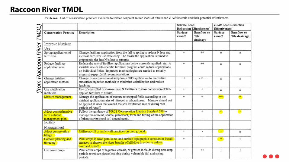
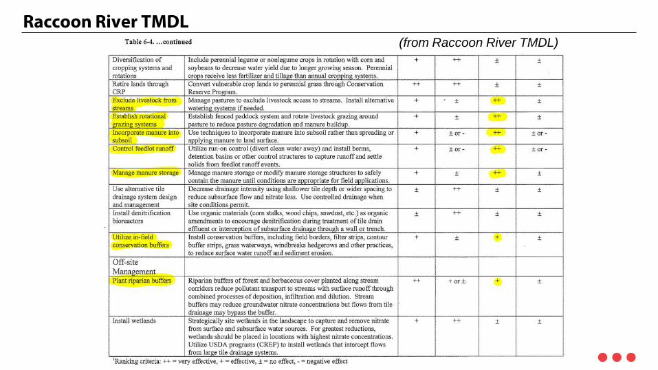
Raccoon River TMDL
• Impaired by Nitrate and E.coli – Includes Walnut Creek from I-80/35 to Raccoon River
• Nitrate – Highest concentrations in APR-MAY-JUN / NOV-DEC – Soil Mineralization & Fertilizer: 48-60% of non-point sources – Non-point sources are 89% of loading when values are higher than allowed – Septic, wildlife make up 0.1% or less – Trend is increasing concentrations over time
• E. coli – Highest concentrations in MAY-JUN-JULY – Highest during higher flows – Non-point sources 92% of total loading – Values in excess of 10,000 CFU/100mL every month except FEB and DEC – Urban areas implement BMPs in lieu of numeric standards
Raccoon River TMDL
(from
Rac
coon
Riv
er T
MD
L)
Raccoon River TMDL (from Raccoon River TMDL)

TMDL - Implementation Strategies
• Reduce ammonia fertilizer application rate
• Remove cattle from streams
• Remove human waste from the watershed
• Convert row crop on C slopes (>5%) or greater to CRP grassland
• Convert row crop on floodplain alluvial soils to CRP grassland
• Strategically locate wetlands near tile outlets for nitrate removal
• Implement Urban stormwater BMPs
• Manure management

TMDL - Monitoring Thoughts
• Need data for model calibration and to compare before/after improvements • Data limited within Walnut Creek watershed subareas • Nitrate may be fixed interval of sampling • E. coli may be fixed interval, but also needs event based sampling • The smaller the watershed, the greater probability of monitoring success • Divide into target, smaller watershed areas where changes can be measured (2 –
10,000 Ac)
Raccoon River Water Balance (from TMDL)

Monitoring Thoughts
• Do not duplicate but add too the following: – DMWW – ISA – USGS
• Monitoring to begin sooner than later.

Existing Studies

Existing Studies - Reviewed
• Polk County, Iowa – Multi-jurisdictional Hazard Mitigation Plan, July 2014 – This report was developed in response to the Disaster Mitigation Act of 2000, to
achieve FEMA eligibility for HazMat Assistance Grant Programs. This document includes initiatives relevant to Walnut Creek Watershed including relevant stormwater management practices and acquisition recommendations to reduce repetitive losses.
Existing Studies - Reviewed
• City of Clive - Walnut Creek Watershed Stream Assessment Report, October 2009; Updated July 2014 – This report includes the assessment of a 12 mile segment of Walnut Creek with a
focus on stream bank stability. The report includes recommendations addressing O&M, site specific projects, and the value of partnerships with neighboring communities and/or the Watershed Management Authority. Goals address upper reaches of the watershed where agriculture dominates and lower reaches that are more urbanized in nature. Ag sector goals relate to debris, tree wash-outs, water quality, seasonal and flash flooding. Urban sector goals call for reductions in negative property and infrastructure impacts, specifics to improve stormwater management, tactics to improve habitat/vegetative health, and increase stream access.

Existing Studies - Reviewed
• City of Grimes – Comprehensive Plan, September 2010 – This document calls for the City to “protect identified wetlands and address
stormwater management issues that can be incorporated into the city’s green network.” A recommendation to establish a stormwater management utility has since been implemented.

Existing Studies - Reviewed
• City of Johnston – Comprehensive Plan Book, December 2010 – This document encourages Johnston to consider the findings in its Watershed
and Stormwater Management Action Plan. Goals of the comp plan speak to promoting conservation, finding the balance between natural resources protection and future urban development, encouraging sustainable practices in areas with environmental resources, preservation of environmentally sensitive areas, and pollution prevention.

Existing Studies - Reviewed
• City of Johnston - Watershed Assessment ; Stormwater Management and Action Plan, December 2009 – The upper Northeast reaches of the North Walnut Creek watershed are in the
extreme Southwest portions of the City of Johnston. This study notes stream paths in this area have been straightened for agriculture and urban development. The report goals include preventing any increase in pollutants and the stormwater runoff volume due to future development.

Existing Studies - Reviewed
• City of Urbandale – Stormwater Report July 2014 – This report reflects the City’s increasing commitment to stormwater management
initiatives and identifies recently completed, new and ongoing projects including channel armoring of North Walnut and Walnut Creeks.

Existing Studies - Reviewed
• City of Urbandale – Comprehensive Plan 2003 – This document references projected growth West of the interstate (within the
Walnut Creek Watershed) and refers often to the City’s parks and open space plan but does not directly address watershed issues; however, the City has a series of stormwater management documents relevant to this effort. (See below).
• City of Urbandale – Stormwater Report July 2014 – This is the most recently available of several Urbandale stormwater reports
published since 1999. This report reflects the City’s increasing commitment to stormwater management initiatives and identifies recently completed, new and ongoing projects including channel armoring of North Walnut and Walnut Creeks.
• Urbandale City Council Lunch & Learn. October 2006 – This power point presentation speaks to a goal of detaining the 100 year storm to
achieve a five-year storm release rate and demonstrates concerns over streambank erosion reaching private properties.

Existing Studies
• Des Moines Water Works – Water Works Park Master Plan, 2014 – The Des Moines Water Works Park Foundation has recently been established to
assist with funding and implementation of this plan that focuses on overall water quality within Central Iowa through education, recreation and restoration. Projects identified in the plan include enhancement of the source water Gallery (horizontal well) through a series of canals (dubbed “The Circuit”) for paddleboarding and education programming; river bank and woodland restoration; improved river access/water trail; paved trail connections and enhancements; and links to Gray’s Lake – creating potentially a significant greenway opportunity for Greater Des Moines with potential for expansion.
Existing Studies
• City of West Des Moines – 2010 Watershed Assessment – West Des Moines Public Works Department conducted a desktop and field analysis
to assist in management of watersheds city-wide to comply with state and federal regulations. Goals include reducing flood, erosion and habitat degradation while increasing water quality.
Existing Studies
• City of West Des Moines – Comprehensive Plan 2010 – Under an over-arching goal to “maintain and protect the physical and environmental
aspects of West Des Moines,” this document outlines ten policy-related elements. These include: maintaining pre-development characteristics of water courses in undeveloped areas, improved infiltration and aquifer protection, reducing development impacts in flood prone areas and reclamation planning for extraction industries and landfills.

Existing Studies
• Greater Des Moines Partnership, Community Foundation of Greater Des Moines, United Way and Metropolitan Planning Organization – Capital Crossroads [2011] and Continuously Updated – This plan’s vision involves ten Capitals, or focus areas, related to quality of life in
Central Iowa. It encompasses a fifty mile radius of the State Capitol, which includes the Walnut Creek Watershed. While Capital Crossroads is a wide-ranging vision, its Natural and Physical Capital teams and the associated subcommittees directly address watershed initiatives. Perhaps among the most relevant and current work is the development of a greenways network throughout Central Iowa for the purposes of water quality protection, habitat improvements, flood mitigation, recreation, and overall resident awareness of cultural and natural heritage and outdoor opportunities.

Existing Studies
• Metropolitan Planning Organization and Partners - The Tomorrow Plan, November 2013 – This Greater Des Moines area plan identifies four key goals and five significant
initiatives to help the metro region maintain its status as a “collaborative, vibrant, and dynamic region of lasting value, equity, and diversity.” Particularly relevant here is Goal 2 (Improve the region’s environmental health and access to the outdoors), its associated strategies (that include the call for the formation of Watershed Management Authorities and regional stormwater efforts) and Initiative 2 – Greenways. TTP calls for building a fully-connected system of natural resource areas by selectively expanding the existing network of parks, conservation areas, open space and trails.

Existing Studies
• Nutrient Reduction Strategy – Targeted load reduction for non point sources is 41% of statewide nitrogen and
29% total phosphorus – Identified a series of BMPS and their capacity to reduce loads.
Existing Studies
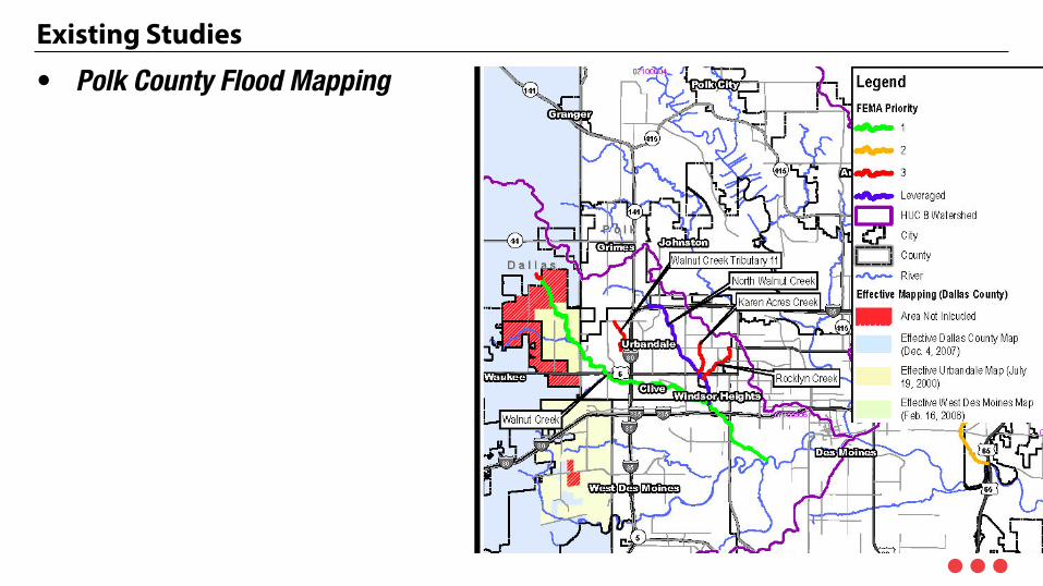
• Polk County Flood Mapping

Existing Mapping

Existing Mapping

Existing Mapping

Existing Mapping
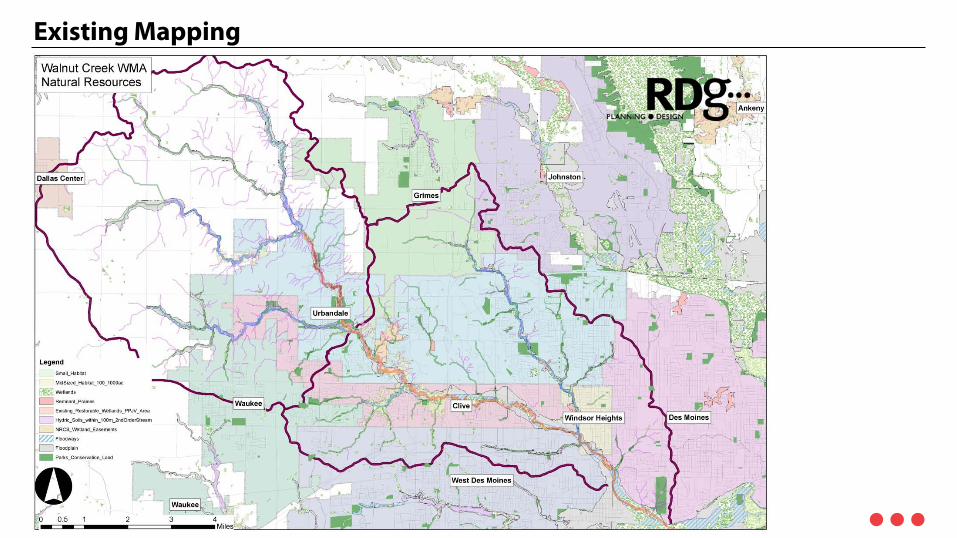
Existing Mapping

Existing Mapping

Existing Mapping

Existing Mapping

Existing Mapping

Discussion
Discussion
1. What other documents / studies remain that could have a significant impact? 2. Missing GIS Data that would be helpful – we’ll follow up. 3. Discussion
1. Challenges & opportunities within the communities, counties or districts that should be considered as a part of this plan. 1. Send to RDG by 4/16

Next Steps

Next Steps
• April 7 - 8, 2015 Field Work / Drone Flights • April 9, 2015 Iowa Soybean / Agricultural Focus Group (April 9 8:00 – 9:30) • April 16, 2015 WMA Executive Committee Meeting #1 • April TBD MPO / RDG / WMA presents to councils and boards – process
overview. • April 29, 2015 WMA Authority Member Meeting #2 - 8 am – 12pm
• Goal Setting & Strategy Meeting • ½ Day Facilitated Discussion Meeting • Review inventory and preliminary assessment recommendations
• May TBD, 2015 Public Meeting #1

Create. Meaning. Together.

Walnut Creek WMA> Overview
• Timeline – we hope not to just meet the timeline, but we want to get far enough along that this WMA would potentially be able to apply for grants in the Fall of 2015 that we anticipate may again be available. – WIRB – SRF Forgivable Loans – IDALS Grants – 319 Funding
Walnut Creek WMA> Overview
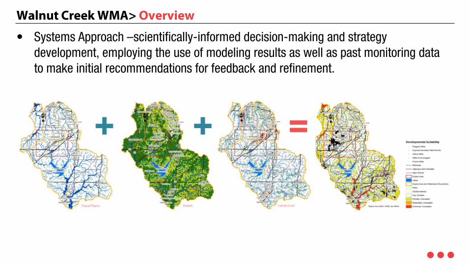
• Systems Approach –scientifically-informed decision-making and strategy development, employing the use of modeling results as well as past monitoring data to make initial recommendations for feedback and refinement.
Walnut Creek WMA> Overview
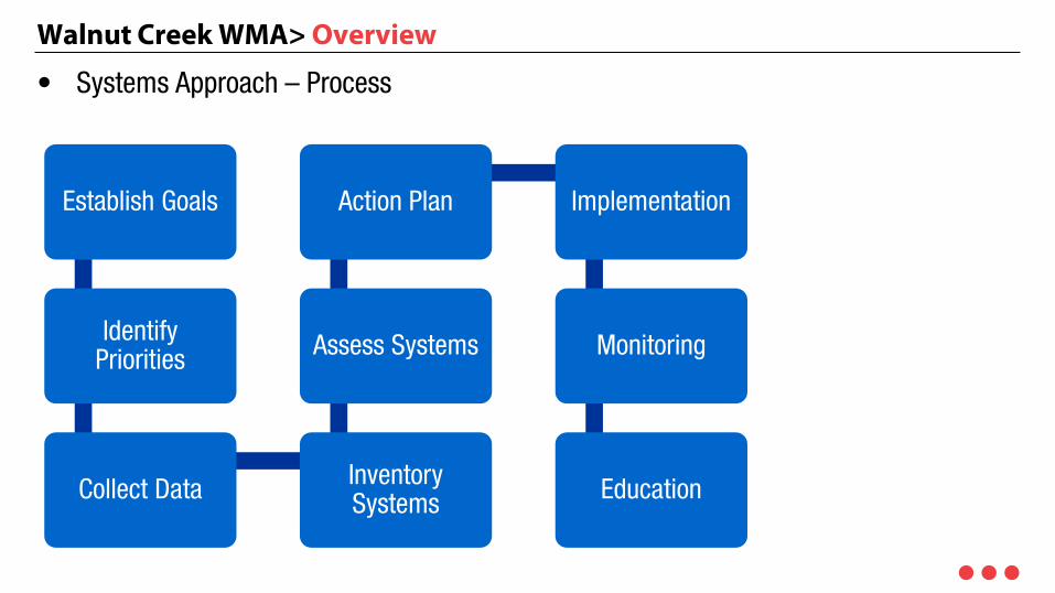
• Systems Approach – Process
Establish Goals
Identify Priorities
Collect Data Inventory Systems
Assess Systems
Action Plan Implementation
Monitoring
Education

Walnut Creek WMA> Overview
• Systems Approach – Process
Walnut Creek WMA> Overview
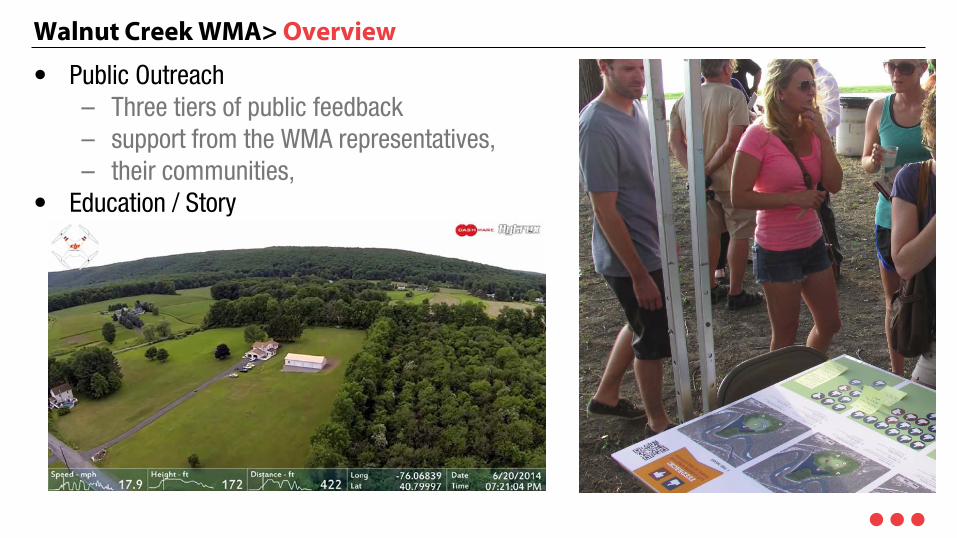
• Public Outreach – Three tiers of public feedback – support from the WMA representatives, – their communities,
• Education / Story – Drone footage

Walnut Creek WMA> Overview
• Provided by the WMA – Initial Decision Maker / Primary Point Person – Public outreach assistance / Face of the project for the WMA – Existing Hydrological and Stream Assessment Studies and – Municipal Utility Data