notices to mariners - chart.gov.cncontents issue no.23(total no.556) notice no.672-706 4 june...
TRANSCRIPT
!!!!!!!!!!!!!!!!!!!!!!!!!!!!!!!!!
!!!!!!!!!!!!!!!!!!!!!!!!!!!!!!!!!
CONTENTS
Issue No.23(Total No.556)
�Notice No.672-706 4 June 2012
NOTICES TO MARINERS
�I IndexNotices to MarinersTemporary NoticesⅢ
II
The Maritime Safety Administration of the People's Republic of China
In order to keep navigation safety and make Chinese coastal port and fairway Charts modify timely and accu-rately, mariners are requested to inform the china MSA immediately of the discovery of new danger, or changes ordefects in aids to navigation and of shortcomings in Chinese coastal port and fairway charts or publications. Copiesof Navigational warning, Sailing information, and Dynamic aids condition should be sent to Tianjin, Shanghai andGuangdong MSA timely. Departments and mariners may contact Shanghai Marine Chart Press Center or Tianjin,Shanghai and Guangdong MSA to get subscribing information. The Notices to Mariners can also be made through thefollowing websites.
In addition to postal methods, the following additional communication facilities are available:Tianjin MSA Survey and Mapping Office: E-mail: [email protected]
Phone: +86(0)22 88112597 Fax: +86(0)22 28110144Shanghai Marine Chart Press Center: E-mail: [email protected]
Phone: +86(0)21 65806386 Fax: +86(0)21 65679011Guangdong MSA Survey and Mapping Office: E-mail: [email protected]
Phone: +86(0)20 34084083 Fax: +86(0)20 34084020China MSA Nautical Charts&Books Publisher: Web: www.chart.gov.cnChina Hydrography Website: Web: www.hydro.gov.cn

Explanatory�Notes
1. The Notices which publish the information about essential changing feature ofChinese coastal sea area and works at sea, is mainly used to correct the Chinesecoastal port and fairway Charts and offer navigation safety information for mariners.
2. The information published in the notice origins from the marine information, thenavigational warning, aids dynamics as well as the hydrographic achievements,which are issued by Maritime Administration. The additional source comes fromshipping, fairway, sea, Harbour affairs, and fishing politics department.
3. The Notices include the Sailing Bulletin, the Notices to Mariners and TemporaryNotices.a) Sailing Bulletin announces rules and regulations of navigation, the printing,
correcting and cancellation of publication, and the marine information which ispromulgate by MSA and has important relationship which navigation safety. Itis not used to correct the Charts.
b) The Notices to Mariners is used for user to correct related Chinese coastal portand fairway Charts. The number in parentheses behind the Chart No. indicatesthat only parts of the Notices related to this chart. The number in squarebracket illustrated the previous update notice information.
c) The Temporary Notices published for the temporary establishment,cancellation, variation as well as works at sea. The Chart No. lists for user'sconvenience when mariners look up for the details.
4. Geographical position refer to the horizontal datum of the current edition of eachaffected chart. The 2000 national geodetic coordinate system which we adoptequals to WGS-84 world geodetic coordinate system in usage. The sounding datumrefers to the level of Lowest Astronomical Tide and the elevation uses 1985national vertical datum. Bearings are true reckoned clockwise from 000° to 359° .Those relating to lights are from seaward. The height of the lighthouse or lightbeacon is referred to Mean High Water Springs.
5. For symbols used in the Notices to Mariners, see GB12319-1998.6. The unit in the Notices complies with the international standard unit of
measurement, with the Chinese characters replaced by symbol and alphabet, suchas degrees(°), minutes(′) and seconds(″), meters(m), kilometers(km) ornautical miles(M).

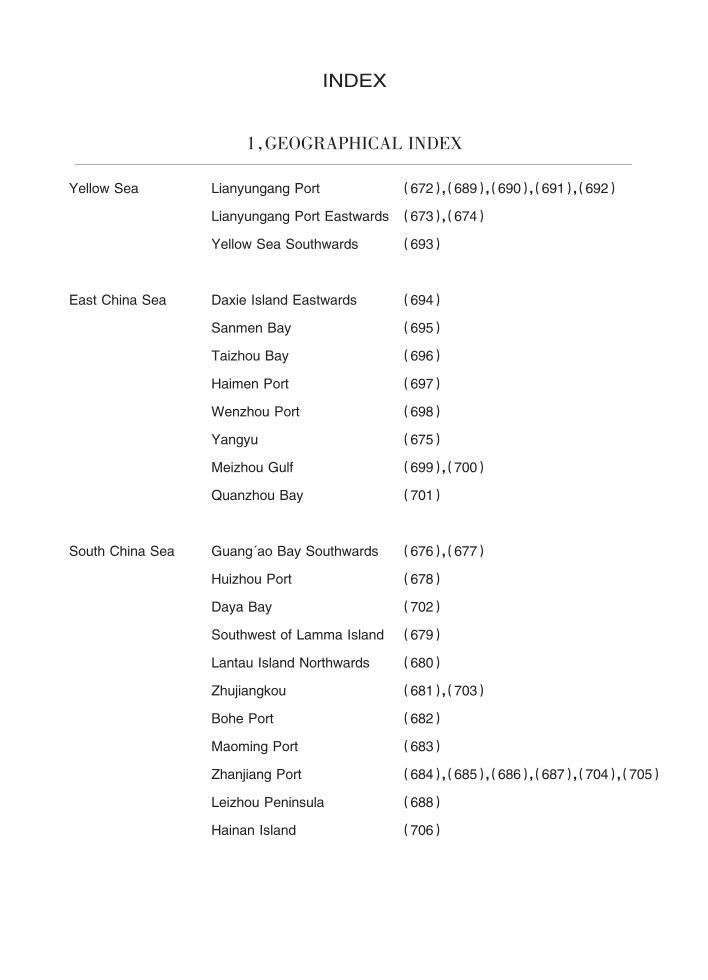
Yellow Sea Lianyungang Port (672),(689),(690),(691),(692)
Lianyungang Port Eastwards (673),(674)
Yellow Sea Southwards (693)
East China Sea Daxie Island Eastwards (694)
Sanmen Bay (695)
Taizhou Bay (696)
Haimen Port (697)
Wenzhou Port (698)
Yangyu (675)
Meizhou Gulf (699),(700)
Quanzhou Bay (701)
South China Sea Guang'ao Bay Southwards (676),(677)
Huizhou Port (678)
Daya Bay (702)
Southwest of Lamma Island (679)
Lantau Island Northwards (680)
Zhujiangkou (681),(703)
Bohe Port (682)
Maoming Port (683)
Zhanjiang Port (684),(685),(686),(687),(704),(705)
Leizhou Peninsula (688)
Hainan Island (706)
INDEX
1,GEOGRAPHICAL INDEX
2,INDEX OF CHARTS AFFECTED
60211
80820
80203
2308
2307
2310
80107
81402
83101
63131
53132
55123
64111
64221
53001
35002
4110141111
50502
5041250501
50411
4300150407
3700137122
83102
83104
13051306
Chart No.
60602
60611
Notice No. Notice No.(T)693
689,690,691,692690693
673,674 693672 691,692672 692
693695695696
696,697697694694
698
675
699
700
699,700
700
701
693
693
675
676,677
678
679
688
678 702
702
678
84001 679,681
84002 679,681
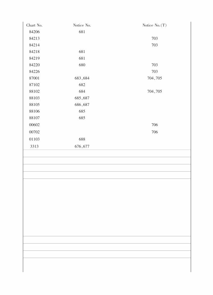
01103
00602
00702
88107
84206
8422084226
88106
8810388105
88102
8700187102
84213842148421884219
Chart No.
3313
Notice No. Notice No.(T)681
703703
681681680 703
703683,684 704,705682684 704,705
685,687686,687685685
706
706
688
676,677
Notices to Mariners
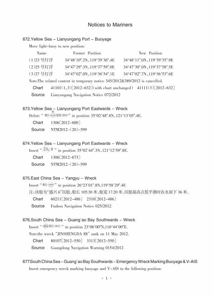
672.Yellow Sea - Lianyungang Port - BuoyageMove light-buoy to new position:
Name Former Position New Position(1)23号灯浮 34°48′10″.2N,119°39′36″.4E 34°48′11″.0N,119°39′35″.9E(2)25号灯浮 34°47′29″.3N,119°37′59″.0E 34°47′30″.0N,119°37′58″.5E(3)27号灯浮 34°47′02″.0N,119°36′54″.1E 34°47′02″.7N,119°36′53″.6ENote:The related content in temporary notice 345/2012&389/2012 is cancelled.Chart 41101(1,3)〔2012-632〕(with chart unchanged) 41111(3)〔2012-632〕Source Lianyungang Navigation Notice 072/2012
673.Yellow Sea - Lianyungang Port Eastwards - WreckDelete“ ” in position 35°02′48″.8N,121°13′05″.4E.Chart 1306〔2012-600〕Source NTM2012-(20)-599
674.Yellow Sea - Lianyungang Port Eastwards - WreckInsert“ ” in position 35°02′44″.3N,121°12′59″.8E.Chart 1306〔2012-673〕Source NTM2012-(20)-599
675.East China Sea - Yangyu - WreckInsert“ ” in position 26°23′01″.8N,119°58′29″.4E注:该船为“盛兴 6”沉船,船长 105.30米,船宽 17.20米,沉船最高点低平潮时在水面下 36米。Chart 60211〔2012-486〕 2310〔2012-486〕Source Fuzhou Navigation Notice 025/2012
676.South China Sea - Guang'ao Bay Southwards - WreckInsert“ ” in position 23°06′00″N,116°44′00″E.Note:the wreck“JINSHENGDA 88” sank on 11 May 2012.Chart 80107〔2012-550〕 3313〔2012-550〕Source Guangdong Navigation Warning 0154/2012
677.SouthChinaSea-Guang'aoBaySouthwards-EmergencyWreckMarkingBuoyage&V-AISInsert emergency wreck marking buoyage and V-AIS in the following position:
据报(2010)概位
239 船
概位
概位(2012)
钢
1· ·
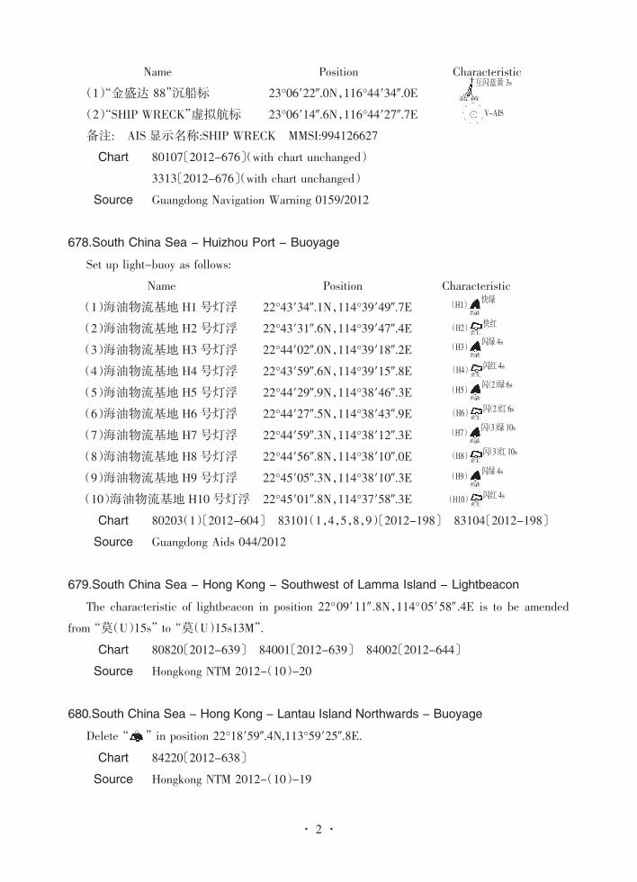
����������� Name Position ��Characteristic
(1)“金盛达 88”沉船标 23°06′22″.0N,116°44′34″.0E
(2)“SHIP WRECK”虚拟航标 23°06′14″.6N,116°44′27″.7E
备注: AIS显示名称:SHIP WRECK MMSI:994126627
Chart 80107〔2012-676〕(with chart unchanged)
3313〔2012-676〕(with chart unchanged)
Source Guangdong Navigation Warning 0159/2012
678.South China Sea - Huizhou Port - Buoyage
Set up light-buoy as follows:
Name �Position Characteristic
(1)海油物流基地 H1号灯浮 22°43′34″.1N,114°39′49″.7E
(2)海油物流基地 H2号灯浮 22°43′31″.6N,114°39′47″.4E
(3)海油物流基地 H3号灯浮 22°44′02″.0N,114°39′18″.2E
(4)海油物流基地 H4号灯浮 22°43′59″.6N,114°39′15″.8E
(5)海油物流基地 H5号灯浮 22°44′29″.9N,114°38′46″.3E
(6)海油物流基地 H6号灯浮 22°44′27″.5N,114°38′43″.9E
(7)海油物流基地 H7号灯浮 22°44′59″.3N,114°38′12″.3E
(8)海油物流基地 H8号灯浮 22°44′56″.8N,114°38′10″.0E
(9)海油物流基地 H9号灯浮 22°45′05″.3N,114°38′10″.3E
(10)海油物流基地 H10号灯浮 22°45′01″.8N,114°37′58″.3E
Chart 80203(1)〔2012-604〕 83101(1,4,5,8,9)〔2012-198〕 83104〔2012-198〕
Source Guangdong Aids 044/2012
679.South China Sea - Hong Kong - Southwest of Lamma Island - Lightbeacon
The characteristic of lightbeacon in position 22°09′11″ .8N,114°05′58″ .4E is to be amended
from“莫(U)15s” to“莫(U)15s13M”.
Chart 80820〔2012-639〕 84001〔2012-639〕 84002〔2012-644〕
Source Hongkong NTM 2012-(10)-20
680.South China Sea - Hong Kong - Lantau Island Northwards - Buoyage
Delete“ ” in position 22°18′59″.4N,113°59′25″.8E.
Chart 84220〔2012-638〕
Source Hongkong NTM 2012-(10)-19
蓝黄
互闪蓝黄 3s
· V-AIS
绿(H1) 快绿
红(H2) 快红
绿(H3) 闪绿 4s
红(H4) 闪红 4s
绿(H5) 闪(2)绿 6s
红(H6) 闪(2)红 6s
绿(H9) 闪绿 4s
红(H10) 闪红 4s
绿(H7) 闪(3)绿 10s
红(H8) 闪(3)红 10s
2· ·
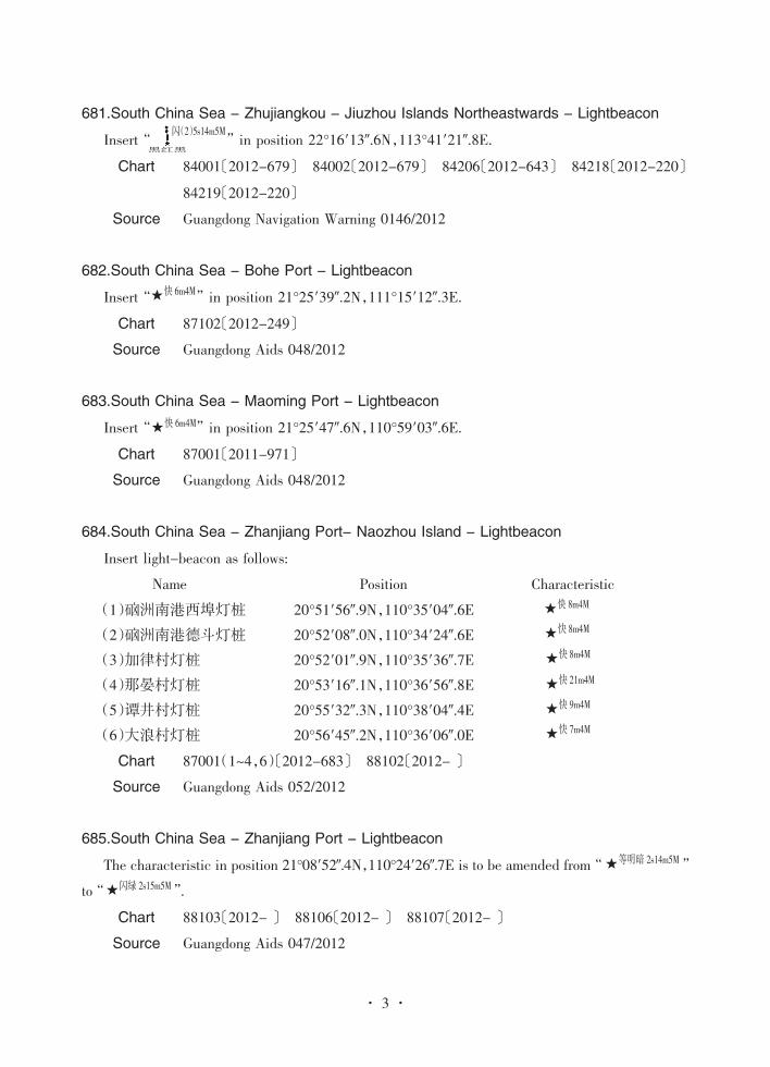
681.South China Sea - Zhujiangkou - Jiuzhou Islands Northeastwards - Lightbeacon
Insert“ ” in position 22°16′13″.6N,113°41′21″.8E.
Chart 84001〔2012-679〕 84002〔2012-679〕 84206〔2012-643〕 84218〔2012-220〕
84219〔2012-220〕
Source Guangdong Navigation Warning 0146/2012
682.South China Sea - Bohe Port - Lightbeacon
Insert“ ” in position 21°25′39″.2N,111°15′12″.3E.
Chart 87102〔2012-249〕
Source Guangdong Aids 048/2012
683.South China Sea - Maoming Port - Lightbeacon
Insert“ ” in position 21°25′47″.6N,110°59′03″.6E.
Chart 87001〔2011-971〕
Source Guangdong Aids 048/2012
684.South China Sea - Zhanjiang Port- Naozhou Island - Lightbeacon
Insert light-beacon as follows:
Name �������Position �����Characteristic
(1)硇洲南港西埠灯桩 20°51′56″.9N,110°35′04″.6E(2)硇洲南港德斗灯桩 20°52′08″.0N,110°34′24″.6E(3)加律村灯桩 20°52′01″.9N,110°35′36″.7E(4)那晏村灯桩 20°53′16″.1N,110°36′56″.8E(5)谭井村灯桩 20°55′32″.3N,110°38′04″.4E(6)大浪村灯桩 20°56′45″.2N,110°36′06″.0E
Chart 87001(1~4,6)〔2012-683〕 88102〔2012-〕
Source Guangdong Aids 052/2012
685.South China Sea - Zhanjiang Port - Lightbeacon
The characteristic in position 21°08′52″.4N,110°24′26″.7E is to be amended from“ ”
to“ ”.
Chart 88103〔2012-〕 88106〔2012-〕 88107〔2012-〕
Source Guangdong Aids 047/2012
黑红黑
闪(2)5s14m5M
★快 6m4M
★快 6m4M
★快 8m4M
★快 8m4M
★快 8m4M
★快 21m4M
★快 9m4M
★快 7m4M
★等明暗 2s14m5M
★闪绿 2s15m5M
3· ·
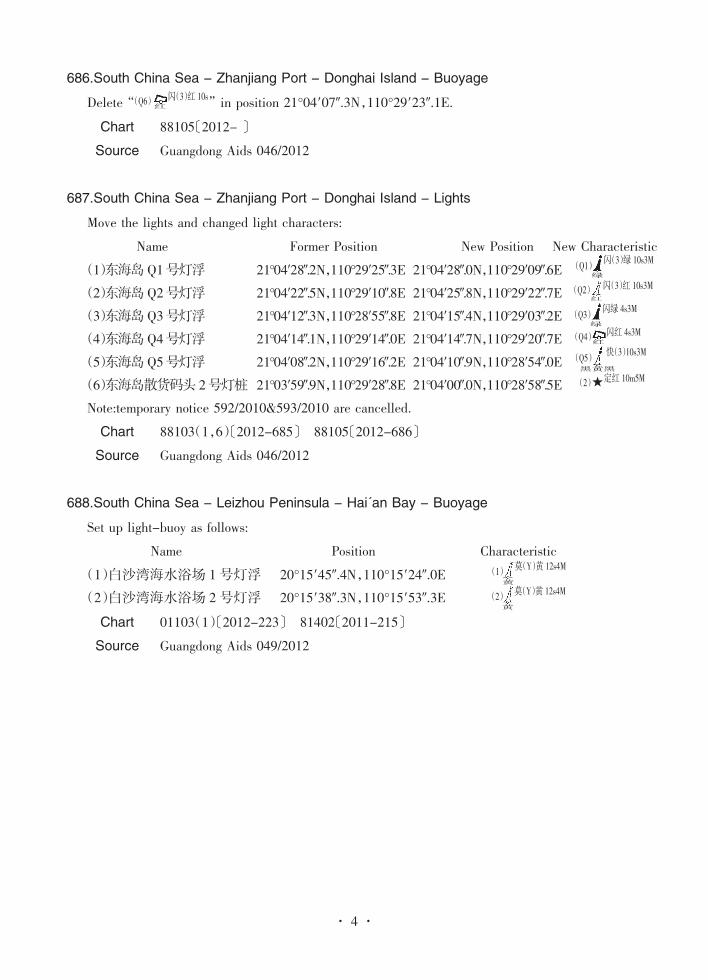
686.South China Sea - Zhanjiang Port - Donghai Island - Buoyage
Delete“ ” in position 21°04′07″.3N,110°29′23″.1E.
Chart 88105〔2012-〕
Source Guangdong Aids 046/2012
687.South China Sea - Zhanjiang Port - Donghai Island - Lights
Move the lights and changed light characters:
���Name ������Former Position New Position New Characteristic
(1)东海岛Q1号灯浮 21°04′28″.2N,110°29′25″.3E 21°04′28″.0N,110°29′09″.6E(2)东海岛Q2号灯浮 21°04′22″.5N,110°29′10″.8E 21°04′25″.8N,110°29′22″.7E(3)东海岛Q3号灯浮 21°04′12″.3N,110°28′55″.8E 21°04′15″.4N,110°29′03″.2E(4)东海岛Q4号灯浮 21°04′14″.1N,110°29′14″.0E 21°04′14″.7N,110°29′20″.7E(5)东海岛Q5号灯浮 21°04′08″.2N,110°29′16″.2E 21°04′10″.9N,110°28′54″.0E(6)东海岛散货码头 2号灯桩 21°03′59″.9N,110°29′28″.8E 21°04′00″.0N,110°28′58″.5ENote:temporary notice 592/2010&593/2010 are cancelled.
Chart 88103(1,6)〔2012-685〕 88105〔2012-686〕
Source Guangdong Aids 046/2012
688.South China Sea - Leizhou Peninsula - Hai'an Bay - Buoyage
Set up light-buoy as follows:
Name ���Position �����Characteristic
(1)白沙湾海水浴场 1号灯浮 20°15′45″.4N,110°15′24″.0E(2)白沙湾海水浴场 2号灯浮 20°15′38″.3N,110°15′53″.3E
Chart 01103(1)〔2012-223〕 81402〔2011-215〕
Source Guangdong Aids 049/2012
红(Q6) 闪(3)红 10s
绿
闪(3)绿 10s3M(Q1)
闪(3)红 10s3M红
(Q2)
绿
闪绿 4s3M(Q3)
红(Q4) 闪红 4s3M
黑黄黑
快(3)10s3M(Q5)
★定红 10m5M(2)
黄
莫(Y)黄 12s4M(1)
黄
莫(Y)黄 12s4M(2)
4· ·

Temporary�Notices
689.Yellow Sea - Lianyungang Port - Pier Construction(T)
From 17 May to 6 November 2012, pier construction is in progress within the area bounded by
the following position:
(1)35°02′15″.5N,119°16′59″.7E
(2)35°01′52″.1N,119°17′10″.3E
(3)35°01′45″.6N,119°17′16″.0E
(4)35°01′49″.3N,119°17′28″.3E
(5)35°01′54″.7N,119°17′26″.8E
(6)35°02′16″.7N,119°17′03″.6E
Operating vessels are showing signals, keeping watch on VHF Ch.16. Mariners are advised to
navigate with caution.
Chart 37001
Source Lianyungang Navigation Notice 074/2012
690.Yellow Sea - Lianyungang Port - Dredging(T)
From 17 May to 6 November 2012, dredging is in progress within the area bounded by the
following position:
(1)35°01′17″.5N,119°17′00″.6E
(2)35°00′39″.1N,119°17′19″.4E
(3)35°00′13″.1N,119°18′48″.0E
(4)35°00′35″.0N,119°18′38″.2E
(5)35°00′53″.2N,119°17′40″.7E
(6)35°01′18″.2N,119°17′23″.0E
Operating vessels are showing signals, keeping watch on VHF Ch.16. Mariners are advised to
navigate with caution.
Chart 37122 37001
Source Lianyungang Navigation Notice 073/2012
691.Yellow Sea - Lianyungang Port - Buoyage
Delete the following temporary light-buoy:
Name Position
(1)23-1号临时灯浮 34°48′13″.1N,119°39′34″.7E
(2)25-1号临时灯浮 34°47′32″.2N,119°37′57″.2E
Note:The related content in temporary notice 346/2012,392/2012 is cancelled.
Chart 37001(2) 41101
Source Lianyungang Navigation Notice 072/2012
692.Yellow Sea - Lianyungang Port - V-AIS
Delete the following AIS virtual navigation mark:
Name Position
(1)23 HAO(23号) 34°48′10″.2N,119°39′36″.4E
(2)25 HAO(25号) 34°47′29″.3N,119°37′59″.0E
(3)31 HAO(31号) 34°46′07″.4N,119°34′44″.3E
(4)33 HAO(33号) 34°45′40″.2N,119°33′39″.4E
Note:temporary notice 388/2012 is cancelled.
Chart 37001 41101 41111(3,4)
Source Lianyungang Navigation Notice 075/2012
693.Yellow Sea - Yellow Sea Southwards - Geological Exploration(T)
From 23 May to 30 August 2012, geological exploration is in progress within the area bounded
by the following position:
(1)34°40′00″N,120°40′00″E
(2)35°20′00″N,120°40′00″E
(3)35°40′00″N,121°10′00″E
(4)36°15′00″N,122°30′00″E
(5)32°00′00″N,122°30′00″E
(6)32°00′00″N,122°20′00″E
(7)34°00′00″N,122°00′00″E
Chart 35002 43001 1305 1306 2307 2308
Source Shanghai Navigation Notice 084/2012
694.East China Sea - Daxie Island Eastwards - Pier Construction(T)
From 19 May to 31 July 2012, pier construction is in progress within the area bounded by the
following position:

(1)29°56′08″N,121°58′57″E
(2)29°55′56″N,121°59′05″E
(3)29°55′53″N,121°59′00″E
(4)29°56′05″N,121°58′52″E
Operating vessels are showing signals, keeping watch on VHF Ch.08. Mariners are advised to
navigate with caution. Vessels are required to pass by slowly keeping a safe distance off the
operating vessel.
Chart 53001 53132
Source Ningbo Navigation Notice 070/2012
695.East China Sea - Sanmen Bay - Geological Exploration(T)
From 22 May to 20 July 2012, geological exploration is in progress in following two areas:
A,Shepan Channel,within a 200m wide area centered on the line joining the following
position:
(1)29°08′07″N,121°34′53″E
(2)29°07′13″N,121°34′54″E
B,Qingshan Channel,within a 200m wide area centered on the line joining the following
position:
(3)29°10′30″N,121°35′49″E
(4)29°09′50″N,121°35′27″E
Operating vessels are showing signals, keeping watch on VHF Ch.16. Mariners are advised to
navigate with caution and pass by slowly.
Chart 50407 50411
Source Taizhou Navigation Notice 026/2012
696.East China Sea - Taizhou Bay - Bridge Construction(T)
From 24 May 2012 to 23 May 2013, bridge construction is in progress within the area bounded
by the following position:
(1)28°44′05″N,121°39′57″E
(2)28°43′22″N,121°44′24″E
(3)28°42′51″N,121°45′50″E
(4)28°41′49″N,121°45′29″E
(5)28°42′18″N,121°44′12″E
(6)28°43′01″N,121°39′45″E
Operating vessels are showing signals, keeping watch on VHF Ch.16. Mariners are advised to
navigate with caution and pass by slowly.
Chart 50412 50501
Source Taizhou Navigation Notice 027/2012
697.East China Sea - Haimen Port - Pier Construction(T)
From 19 May to 18 November 2012, pier construction is in progress within the area bounded
by the following position:
(1)28°41′52″.5N,121°26′27″.0E
(2)28°41′51″.0N,121°26′31″.0E
(3)28°41′48″.0N,121°26′30″.0E
(4)28°41′49″.5N,121°26′26″.0E
Operating vessels are showing signals, keeping watch on VHF Ch.06. Mariners are advised to
navigate with caution and pass by slowly.
Chart 50501 50502
Source Taizhou Navigation Notice 025/2012
698.East China Sea - Wenzhou Port - Construction(T)
From 21 May 2012 to 28 February 2013, construction is in progress daily 06:00-18:00 within
the area bounded by the following position:
(1)27°58′52″.9N,120°53′38″.1E
(2)27°58′52″.9N,120°53′57″.3E
(3)27°58′43″.1N,120°53′57″.3E
(4)27°58′43″.1N,120°53′38″.1E
Operating vessels are showing signals, keeping watch on VHF Ch.16. Mariners are advised to
navigate with caution and pass by slowly.
Chart 55123
Source Wenzhou Navigation Notice 020/2012
699.East China Sea - Meizhou Gulf - Pier Construction(T)
From 23 May 2012 to 30 December 2013, pier construction is in progress within the area
bounded by the following position:
(1)25°07′49″.6N,119°00′13″.0E
(2)25°08′51″.9N,119°00′17″.3E
(3)25°09′51″.2N,119°01′10″.6E
(4)25°09′13″.9N,119°01′56″.4E
(5)25°08′18″.3N,119°01′40″.2E
(6)25°07′37″.1N,119°00′29″.0E
Operating vessels are showing signals, keeping watch on VHF Ch.16. Mariners are advised to
navigate with caution. Vessels are required to pass by slowly keeping a safe distance off the
operating vessel. Irrespective vessels are prohibited from entering the operating area.
Chart 60602 63131
Source Putian Navigation Notice 005/2012
700.East China Sea - Meizhou Gulf - Exploding & Cleaning(T)
From 22 May 2012 to 21 May 2014, exploding & cleaning is in progress within the area
bounded by the following position:
(1)25°04′01″.5N,119°01′07″.0E
(2)25°04′00″.5N,119°01′28″.3E
(3)25°03′43″.8N,119°01′50″.8E
(4)25°03′37″.4N,119°01′31″.8E
(5)25°03′49″.9N,119°01′02″.0E
Operating vessels are showing signals, keeping watch on VHF Ch.16&10. Traffic control action
will be taken during operating. Passing vessel must obey the command of Quanzhou VTS center.
Chart 60611 63131 64111
Source Quanzhou Navigation Notice 012/2012
701.East China Sea - Quanzhou Bay - Exploding & Cleaning(T)
From 24 May to 31 December 2012, exploding & cleaning is in progress within the area
bounded by the following position:
(1)24°49′04″.0N,118°43′44″.1E
(2)24°49′02″.3N,118°43′54″.7E
(3)24°48′55″.5N,118°43′52″.8E
(4)24°48′57″.8N,118°43′44″.3E
Operating vessels are showing signals, keeping watch on VHF Ch.16&10. Irrespective vessels
are prohibited from entering the operating area.
Chart 64221
Source Quanzhou Navigation Notice 013/2012
702.South China Sea - Daya Bay - Mabianzhou Channel - Buoyage(T)
The Mabianzhou Channel No.12-1 light-buoy and AIS in position 22°34′57″.6N,114°41′31″.3E
are lost. Mariners are advised to navigate with caution.
Chart 83101 83102
Source Guangdong Navigation Warning 0153/2012
703.South China Sea - Zhujiangkou - Approaches to Gongsha Channel - Construction(T)
From 17 May to 15 November 2012, construction is in progress within an area bounded by the
following positions:
(1)22°36′09″N,113°48′28″E
(2)22°36′12″N,113°48′24″E
(3)22°36′15″N,113°48′28″E
(4)22°36′09″N,113°48′33″E
Operating vessels are showing signals and keeping watch on VHF Ch.16. Mariners are advised
to navigate with caution. Tel.:13822803010.
Chart 84213 84214 84220 84226
Source Shenzhen Navigation Notice 049/2012
704.South China Sea - Zhanjiang Port - Longteng Fairway - Light-vessel(T)
Delete“ ” in position 21°03′40″.2N,110°35′05″.1E.
Note: AIS Name:ZHAN JIANG GANG MMSI:999413032
Chart 87001 88102
Source Guangdong Navigation Warning 0152/2012
705.South China Sea - Zhanjian Port - Longteng Fairway - Buoyage(T)
Insert“ ” in position 21°03′40″.2N,110°35′05″.1E.
Chart 87001 88102
Source Guangdong Navigation Warning 0152/2012
706.South China Sea - Hainan Island - Approaches to Longmen Port - Construction(T)
From 5 May 2012 to 30 May 2013, construction is taking place within the following two areas:
(1)Operating area:
a.19°52′12″.2N,109°13′00″.5E
红闪(2)10s10m10M雷康(G)AIS
红(30-1) 快红
b.19°53′06″.3N,109°12′03″.3E
c.19°52′39″.0N,109°11′38″.1E
d.19°51′48″.2N,109°11′45″.2E
e.19°51′45″.8N,109°12′24″.2E
(2)Spoil area:
Spoil area is to be setup within an area centered on position 19°45′00″N,108°58′00″E, radius
0.5M.
Operating vessels are showing signals and keeping watch on VHF Ch.08 and Ch.16. Mariners
are advised to navigate with caution. Anchoring and other work are prohibited within the above
area.
Chart 00602 00702
Source Hainan Navigation Notice 015/2012
HYDROGRAPHIC INFORMATION REPORT SHEET
Name(s)of report sender(s)
Mailing address
Subject
Geograghical area
Position or area limit(″PA″indicated if applicable)
…………………………………………………………………………………………………………
Affected chart(s)/publication(s)
Details:
Suggestion(s)/request(s)
Signature :
Date:
……………………………………………………………………………
………………………………………………………………………………………
………………………………………………………………………………………………
…………………………………………………
………………………………………………………………………
…………………………………………………………………………………
…………………………………………………………………………………………………………
………………………………………………………………………………………
HYDROGRAPHIC INFORMATION REPORT SHEETINSTRUCTIONS
1. Extent of Information to be reported:
a)Discovery or the changes in position, range, depth of uncovered reefs, shoals, wrecks or
other obstructions.
b)Discovery or changes of floating objects (e.g buoys, mooring buoys, large scale fishing
stakes, floating shipwrecks), magnetic anomalies, discolored water or breakers.
c)Establishments or changes of navigation facilities.
d)Establishments or changes of mooring or berthing facilities (e.g. piers, submarine cables,
overhead cables, mooring buoys, breakwaters).
e)Changes in the limit of fairway, anchorages or sailing route.
f) Shortcomings in Chinese coastal port and fairway charts and other relative publications.
2. Instructions:
a)Measuring instrument, methods and time should be specified in expressing the location or
scope; and the coordinate system should be indicated(1954 Beijing coordinate system or WGS-84
coordinate system).
b)When position expressed in bearing and distance, the origin should be specified; and when
position expressed in latitude and longitude, the number, edition and publisher of chart referred to
should be specified.
c)Measuring instrument, methods and time of the obstruction or shoal soundings should be
indicated. In addition, the sounding datum and whether it makes corrections for the height of the
tide should also be indicated.
d)Elevation of a navigational mark should be accompanied by the datum it referred to, and
height of a light should indicate whether it refers to that of the top or that of the center.
e)The report should be signed and affix the official seal.
3. Remarks:
a)The information reported will be checked upon our receipt and then used to the best
advantage which may mean inclusion in due weekly edition of Notices to Mariners. Certain
amount of compensation will be given to the report senders.
b)Please send the report to Shanghai MSA Survey and Mapping Office. Address: 82 Lane 7,
Gongqing Road, Yangpu District, Shanghai.