november 2», 1989 ministry of northern development & mines
TRANSCRIPT

November 2», 1989
Ministry of Northern Development & Mines OMEP Office, Mines & Minerals Division 3rd Bloor, 880 Bay Street Toronto, Ontario M5S 1Z8
Dear Sirs:
Here is the brief synopsis you asked for:
Boutder liines The Long Lost Cold Mine
The Boulder Mine was so named by Minnesota prospectors who found high grade gold bearing boulder near the shaft site in 1896.
Photocopies of official reports of the Ontario Inspector of Mines are included in the attached proposal to sample and develop the long lost Boulder Mine. The reports to Government on this mine were made after the Inspector's visits in 1897 and 1898. At that time the access to the area was by boat from Rat Portage, Ontario or by boat from farm roads in Northern Minnesota through the waterways of Lake of the Woods.
Although photographs of the mine and mill buildings exist, numerous attempts by prospectors, mining companies and Ontario geologists to re-locate the mine ahve been unsuccessful.
The writer continued the work done by one of these mining exploration companies in an ardous attempt to find the Boulder Mine. Lands and Titles Office in Kenora had no record of the old survey map; neither did the Mines Branch or Archives in Toronto or Duluth, Minnesota. 52 claims were staked and prospected by our Syndicate during 1988 and 1989 covering an area of 2,000 acres without success.
Finally in September 1989 we discovered the original survey map in Ontario Forestry branch which showed the location of the old Boulder Gold Mine. Now we can do our sampling and assaying when the ground is dear of snow.
To understand the discovery difficulties one must know how the bush country can change in a century. Buildings rot away completely. Cement foundations disintegrate. New bush, now has grown into large trees; beaver dams create ponds and even lakes. Iron rusts away completely. But the shaft and dumps remain, now coverd with soil, trees and water.
When weather permits we will sample the veins along strike and make up our assay plan.
At least, after two years work, we know where the old Boulder gold mine is, and, if assays stand up, we will form a company to drill and develop the mine. Syndicate membes will be issued the vendors' stock in the new Company.
William T. Knox

Bureau of Mines Report Vol VI
The vein hat * strikeof northeast and south west. rroMiog the contact, it U (aid, two or three time*, and U traceable for over halt a mile. At the shaft it outcrops on elevated ground for a distance of a1 out 100 feet, run ning into Iqw ground in each direction and outcropping or becoming exposed again where the ground rises.
About 203 yards from the like and 100 feet above the water level, on location E281, a 41 by 8$ foot shaft has been sunk in the vein to a depth of 90 feet, and is being continued. Sinking was progressing it the rate of 11 feet |ier week with single-hand drillers working in three eight-hour shifts, with three men per shift.
There is 11 feet of quartz at the surface Mid quarts on three sides in the shaft.
The buildings consist of cooking snd sleep ing camps and stable. A uiannger's dwelling ii being built also. All buildings aro roomy, com'ortable and neatly built.
A dock is being constructed in a small, conveniently situated inlet at the lake. The steamer Poarl, with 42 feet keel, belonging to the mine, runs between theie and Rat Portage, a distance of 65 miles.
There is a vety good mill tite at the lake, with excellent- opportunities fur the trans portation of ore by gravity.
On October 22 I met Mr. Giffurd in Rat Portage, and was informed that mining operations hid been suspended for some lime, jwnding the installation of hoisting and air- coinprrssinx plants. These coniiit of the following machinery : An 8 by 12 inch du plex hoister; a six-drill Rand duplex com- preseor, with three No. 3 drills ; a 4 by 12 foot receiver ;' two 46 horse-power boilers ; a 30 hone-power saw mill engine, and a boiler of I ho same capacity and two duplex Snow jmiiipa.
The saw mill, which has a capacity »f 10.000 feet per day, is in running order. The saw mill is an almost essential feature of any mine which is situated at a considerable distance from a railway, as usually a large quantity of lumber is needed, and the expense of transportation is considerable. The loca tions are well wooded with fairly heavy timber, consisting of Norway piiio, spruce, poplar, etc.
The following mining work has been done : No, 1 aliaft, depth BO feet; No, 2 shaft. 1,000 feet east of No. 1 on the asms vein, depth 70 feet.
A new vein with favorable assay values had lieen discovered 30 feet east nf the *"sin vein while cutting out the foundation for the hoisting engine house.
Some additional building* have also been erected.
SU1U MlfM.
Considerable development work has been done at the Stella mine during the year, and
much information obtained regard- dnrtoti- ing the character of the ore bodies.
What wan believed last year to be- one vein liaa proven upon clearing and strip ping to lie the ex)>oiures of severs! parallel vcina crossing the property close together. Work has been done on three or four of theae.
On No. 1 vein the aliaft has been sunk to a depth of 60 feet, and temporarily discon tinued, after being properly fenced. The vein, which is similar to all tho other veins, consists of a cone of quartz and green schist mixed, with rather indefinite walls. Assays range from 4 to $H. A mill test of two tons gave a return of (3.76 free milling. There in a large quantity of concentrates, chielly cup|>er and iron pyrites. , It is the intention to link the aliaft to a depth of 100 feet, and cnwa-cut to the hanging wall, the foot only being exposed.
On No. 2 rein the aliaft has been aunk 65 feet, and discontinued for the prvaant, being pro]>erly secured at the surface to prevent accident. The vein clianged its dip rapidly at a short distance from the aurface ; at a drt>tb of 25 feet the ahaft went into the foot wall. At the bottom a drift waa carried west 1C feet, and from the end a cross-cut driven oath 40 feet, cutting the rein at a diiUnce of 3fi feet. Drifting was done on the vein for a distance of 10 feet west, the vein con- aiating of a zono of quarts and achiat five or six feet wide. The shaft waa full of water, but I got this information from Mr. Nell Csnipbel 1 , the manager. A small ahaft house lins liccn built. Several open cuts have also been mado on this vein, these being five or six feet in depth, and the vein varying from
S&-"S' r-
'Sir''
3&:rt-
:>".:
£.
^•f X. 'oi.
**'.•*<«-


Ontario Geological Survey
Map 2447
KAKAGI LAKEKENORA DISTRICT
Scale 1:31.680 or I Inch to '/; Mile
USJL
PRECAMBfUAM"
MIDDLE TO LATE PRECAMBRlAN <PROTEROZO*C)
UAFIC INTRUSIVE ROCKS
EARLY = = E '-Vr= -'. - = CH£AN)
PELS . '.-=.5 ,E=CC*5
SO Mc*B<yMicf> and AyOntfwta
Sc
«-- EOUAFICANO UL7?'.-U_, - .NTRUSIVE ROCKS
4tf 4*4t
MtMAimC COMttCT
UETAUORPHOSED FELSK MTBUSIVEROCKS
3D Qu»ni-*etasp»rpfxpltyry 3c ~
UETAVOLCAMCS AM) UETASEOtUENTS FELSC TQMTB1MEOIATE MET*-
VOLCAMCS AND MTERCALATED
20
-P/ wc.tas^c i~
2n 2p
UAFC TO HTERUEOMTE UETAVOLCANCS
fa TO 'c
A>«iX>)**t
f*
Ouwtr.

Part I Mines on Lake of the Woods 61
3 •
5:
•*••V 3£;.-S
About » mil* *nd half north of Camp bay, on an extension of the mad running to L>CMiM the Bally Boy mine, is litnaUd a "* property which WM being worked by the Combined Gold Mine* Company of Ontario, Limited, with head office at Niagara Falla, Got. The capitalization w 91,000,000. Prrwdenf, Roliert Humphrey*, Lan** Mill, Psnn.; McreUry. M. P. Hatch. Buflalo, N.Y. The place waa ri*it*d on July 9. Work had been going on since November 1, 1897, with a force of four miner* under the management of 11 r. A. PatUrson. The formation i* ruaa- tivs greenstone (altered diabase), with nnm- «rou* porphyry dikee cutting it, due to th* proximity of"th« granite on th* east. Tli* loeatinn on which moat work has beun dune it S79- , What i* known a* the P*uer*»u r*in it traceable for half a mila with a atrike of nearly north and south. Two toet pit* bar* been tunk'nn;fit 40 feet apart; on* to a depth of 10 fe»t, showing the rein to dip M to 3i decree* cast, ith an exposure of from four to tiro feet of quartz. Both wall* are
distinct, containing a few inchc* of oxtdixetl ecbiitoa* matter.
No. 1 rein it tmceabl* for 600 or COO feet on elevated ground, with a ttrike of a little east of north, and a dip of 66 degree* east. la widthjt'vari** from two to three feet, eontitting of aolid quartz. A *haft liaa been ank on th* Tein to a depth of 63 feet, now full of water. Th* ehaft waa auok on Ui* footwall. sndja crow-cut at th* bottom ahuwed the vein to hare widened. Aaaay* averagedIII. (.- XL. „<,<-•- 6 -fj
No. 7 vein, laid to be traceabl* for orer half a mile, i* apparently a contact between tnp and porphyry, a dik* of which 16 or 20 feet wide U found bar*. A abaft ha* Iwen oak 24 feet on th* rein, but wa* full of water. It it aaid that from two to four feet of qnartx i* *xpo**d in th* latter.
A peculiar deposit, which may projierly be called a rein, wat being Uated at th* tim* of My visit This waa a body of qaarU four or 6>* feet in thickneat lying perfectly flit, covering an area several hundred feet in len|th by from 40 to 100 feet in width, and gradually dipping into the trap on the wort IH!«. It waa apparently a Tein which gradu
ally* flattened near the »urface. with the upper or hanging wall removed, exposing th* naked quartz for a coniidarabl* distance. Two croje-cut* 40 to 60 feet in length were made about 200 feet apart, revealing the abore atate of affair*. Shaft* w*r* rank through th* trap under which the Tein dtp- IHM], showing the dip to get gradually steeper. One thaft waa tunk 26 feet, cutting th* vein, but waa .abandoned owing to th* *ZC**MT* amount of water. A teat pit we*t of th* northerly crow-cut ihowed the Tein to eziat under three feet of country rock, which con- aiated of felaite and trap mixed. A few feet farther weit another teat pit i* being rank which lias not nit tha vein at a depth of 16 f<Mt. Aa aoon M ill., dip of th* Tein can b* atiafartorily established a working abaft for development purposes will bv suuk at a suit able point. Satisfactory *lio*ingi of gold war* obtained from tlie vein.
At another point on the pro|Mrty a vein of ijiuirt* five or six feet wide, mixed with country rock, and forming a ridge, waa teated by a few shots, without satisfactory results and Riven up.
Th* buildings on the property consist of cooking and sleeping camps, and several blacksmith ilioji* situated at different points.
BMildcr MhM.
About two miles south of Camp bay, on th* main ihore. is situated the Boulder mine,
the property consisting of locations SI41, FM46 and E281 and 282, aggregating nearly 400 acres. It i*
owned by the Ontario Boulder Mining Com pany of Ontario Limited, with head office at Minneapolis ; president, E. T. L* Clair. The first work was done in the f\ll of 1897, con. silting of a little test pitting in the northern part of th* property. Operations war* dis continued during tha winUr. and returned in th* spring, under th* management of Mr. J. IL Oifford. At the time of my Ttait, July 9, there waa a fore* of 26 men, including nin* miners, working in three eight-hour shift*.
The formation ia hornblende schist and trap in contact with Laurentian granite ; th* strike being roughly north and south, with an irregular tin* of contact.

•^-. -.•. ..?!»,.•,
'V &•••Bureau of Mines Report Vol VI
The vein has a atrikeof northeast and south, west, rruaaiog the contact, it is said, two or three rimes, and i* traceable for_over hall a mill. At the shaft it outerope on~eTevated ground for a distance of a1 out 100 feet, run. mug into low ground in each direction aud outcropping or becoming exposed again where the ground rice*.
About J200 yards ftoin the lake and 100 fe0t abore the water level, on location E28L, a 4£ by g^footjhaft has jeen sunk in the vein to a depth of 30 feet^and is~being continued. Sulking was progressing st the rate of 11 feet jxer week with *ing]*-li*iid drillers working in three eight-hour shifts, with three men per shift.
There i* 11 feet^of quartz at tlie surface and quart* on three sides m the sliafL
The building* consist of cooking and sleep ing camp* and stable, A manager's dwelling is being built also. All buildings arc roomy, oom'ortabl* and neatly built
A dock U being constructed in a small, conveniently situated inlet at the lake. The steamer Pearl, with 42 tW keel, belonging to the mine, run* between theie and Rat Portage, a distance of 66 miles.
There is a vety good mill rite at the lake, with excellent opportunities fur the trans portation of ore by gravity.
On October 22 I met Mr. Gifford in Hat Portage, and was informed that mining operation* had been suspended for some lime, pending the installation of hoisting aud air- compressing plants. These consist of the following machinery : An 8 by 12 inch du plex boiater; a six-drill Band dujdox com pressor, with three No. 3 drill* ; a 4 by 12 foot receiver ;' two 46 bone-power boilers ; a 30 hone-power saw mill engine, and a boiler of I ho same capacity and two duplex Snow
The following mining work ha* been done : No. 1 shaft, depth BO feet; No. 2 shaft. 1,000 feet east of No, 1 on the same vein, depth 70- feec
r vein with favorable assay values had _I 30 feetMaTritthe mala vein
whilo cutting out the foundation for the hoiating engine house.
Some additional building" nave also been erected.
SUIte Mine.
Eitrntaf
The saw mill, which ha* a capacity »f 10.000 feet per day. is in running order. The saw mill i* an almost essential feature of any mine which is situated at a considerable distance from a railway, a* usually a large quantity of lumber is needed, and the expense of transportation is considerable. The loca tion* are well wooded with fairly heavy timber, consisting of Nor»ay pine, spruce, poplar, etc.
Considerable development work has been done at the Stella mine during the year, and
much information obtained regard ing the character of the ore bodies. Wliat waa believed last year to be
one vein haa proven upon clearing and strip ping to lie the ex|>o*uree of several parallel veins crossing the property close together. Work lisa been done on three or four of these.
On No. 1 vein the sliaft has been sunk to- a depth of 60 feet, snd temporarily discon tinued, after being properly fenced. The- vein, which i* aiuiilar to all the other veins, consists of a fine of quarts and green schist mixed, with rather indefinite walls. Assays range from $4 to 9H. A mill test of two ton* gave a return of $-1.76 free milling. There U a large quantity of concentrates, chiefly copi>er and iron pyrites. , It is the intention to niiik the sliaft to a depth of 100 feet, and erms-cut to the hanging wall, the- foot only being expoaed.
On No. 2 vein the shaft haa been sunk 65 feet, and discontinued for the present, being properly secured at the surface to prevent accident. The vein clianged its dip rapidly at a short distance from the surface; at a depth of 25 feet the shaft went into the foot walL At the bottom a drift waa carried weat 1C feet, and from the end a cross-cut driven south 40 feet, cutting the rein at a distance of 3fi feet. Drifting was don* on the vein for a distance of 10 feet weat. the veiu con- tinting of a zono of <|uariz and schist five or six feet wide. The shaft waa full of water, hut I got this information from Mr. Neil Canipbel', the manager. A small shaft house has liccn built. Several open cuts have also been made on this vein, these being five or six feet in depth, and the vein varying from
CF--
Part I
few incht Twettty tec gold brick, vein gave t Kcewntut fl
On No. 3 feet. The the abaft. « lac*. Open
AtUMMrii
>>ving works11. The) farwpMtt. haa IUnited. Tfafeet in widtlto the tuntHrein ; it waidegree* sout4) feet inachut mixcasnayiruu fithat it willsuitable collof 16 feet.stmcted, am
Twenty feb«eii aunk <up again wit
The buildaccommodatestable, ice h<
There i* awhom are) mi
A wagon rto the mine,road which r
Meeting *1
been sunk on 127 feet, and month. It i be suapended i* installed.
On the saw foimation au<
*i.-« f.irl «•"»••»• .. nnl»small lake m h

1. History of Gold Exploration
1. (a) Gold at and near Kenora.
(b) Stock exchange. Rat Portage. Canp Bay
(c) Migration of prospectors to Cobalt 1904.
(d) Classical professional attitudes hindering successful gold (and
platinum?) ore discoveries in this area.
1. (a) Although a large nuriber of very high grade gold occurrences
have been found throughout the Kenora area and considerable
drilling has been done, no large mines have been developed.
The fact is that the most interesting occurrences are
enigmatic.
From the Cameron Lake Fault at Gogpaw Lake to the Robinson Lake
granite the following characteristics of gold-bearing quartz
veins are cxjiuuu to all occurrences:
- Contacts are undefined.
- Dips are unknown.
- Sigmoidal stretches of barren quartz intervene along strike.
- The veins are always parallel, sub-parallel or within long
(usually thin) bodies of QET». When within the veins wander
haphazardly from side to side (see Frobex sketch).
- Cross-cutting carbonate zones distract the geologist because
these zones carry low values; (from 0.02 to 0.07 oz. Au).
- No structure, especially shearing, is apparent.
- An interesting example of this is the Poirier showing 12
miles south of Sioux narrows where a long carbonate zone of
this sort trends N 45 degrees W whereas the main strike is N
31 degrees E. The highest values are right on highway 171 at
the intersection of the two zones.
- Striking parallel to the Dogpaw-Robinson Lake trend, but
separated by parallel trending ultramafics and ultrabasics,
is a series of gold showings (see Cedartree Geol. map). This
is probably what Kerrich calls 'secondary ponding1 . Although
the writer never saw any eclogites, i.e. garnets.

1. (b) There were so many gold discoveries made near and, mainly,
south of Rat: Portage (now Kenora) that the first exchange in
Canada was formed, "The Rat Portage Stock Exchange" where a
frenzy of trading was made in penny stocks. Sane of the
favourites were based on discoveries at Camp Bay. The Boulder,
Bully Bay, Combined Mines; and further north, Mikado, Regina,
Sultana, and perhaps another fifty with lesser prospects. Seme
production was made by all of the first-named, but the Lake of
the Woods provided a good route to "high-grade" production into
Minnesota and away from taxes, royalties and dividends.
1. (c) As a consequence faulty records were kept. To compound a sense
of failure in the area, the 1904 Cobalt silver rush siphoned
off the capable and experienced prospectors and after 1904
prospecting never recovered its original enthusiasm.
1. (d) The question has always been asked about the numerous gold
showings in the Kenora Mining Division "With all these gold
showings, why have there been no big mines found? With all
this smoke there must be fire!?"
The writer believes that his thesis that a tectonic event
caused by an early archaean overturn of a block of volcanics at
least eight miles cubed caused gold mineralization along the
exposure of the amphibolite-greenschist interface(ponding).
That this exposure extends from South of Robinson Lake to
Dogpaw Lake. That the 'ponding1 is always accompanied by CFP,
chronite, Au, bismuth and possible Pt.
If this event took place that it could account for many of the
gold occurrences in the Kenora area and possibly the gold in
Red Lake.

2. Prospecting by 2nd Bill Krone - BrospprMng Syndicate
(a) Reasons for choosing Cameron Lake Fault.
(b) Sequence of prospecting events.
(c) Errors in judgment; O. Lindsley; dips, strikes and plunges;
insufficient literature ft geological research.
(d) Lear Oil ft Gas; "Little Boy with no Shadow"; regional diabase.
(e) Examination and storage of Frdbex D.D. core. (Conclusions
regarding mineralogy).
(f) Analogy to Camp Bay (using Frobex discovery as a model).
(g) Kalrock. Claims at Camp Bay. Reasons for res taking. (See
(g))-(h) Negative results on sampling QFP's (quartz Feldspar porphyry)
Southern extremity at Camp Bay, Highway 71 - sulphides -
sericite - see photos (page ) Earth's patents. (The resources
of the 2nd Bill Khox Prospecting Syndicate were inadequate to
do an age determination of the amphibolite hanging wall or a
delta 18 oxgen analysis of the quartz contiguous to the
amphibolite).

2. Prospecting by Bill Knox
2. (a) Seven years were spent 'down under* from a base in New Zealand doing Australia. Rji.
Sub-Antarctic, New Zealand and doing work on manganese seabed nodules. Three more
years on the Athabasca formation in Saskatchewan. A year in Guyana on the Rio
Rupununi. Then in 1983 we started work near the Cameron Lake fault, south of Kenora.
2. (b) Fort Knox Gold Resources Inc. was listed on TSE and financed by the (First) Bill Knox
Prospecting Syndicate with Inco's help. Drilling and other work was done at Caviar Lake
and on 200 claims in the Casa Berardi area of N. Quebec. The work was inconclusive.
The Cameron Lake fault area was chosen because it appeared to be a major structural
event. It was early archean. Nuinsco Mine appeared to have some potential and the area
was accessible and hospitable.
As Inco had taken over prospecting and as the author found himself redundant, he
resigned from the board to do his own prospecting.
Although some colours were panned on the old Virginia Mine on the Atikwa River (which
runs into Caviar Lake) too much work was done with too little knowledge of dips and
plunges. In addition the option was expensive and too much money was spent in
geological geophysical and geochemical surveys of a large area of the surrounding
country.
2. (c) The Gcmnissioner of Crown Lands gave an extension for assessment
work to be done on the Whitefish Bay claims. We found the
claims were improperly staked so we re-staked them and had the
- claims inspector come in. This resulted in an extra four months
credit for the Syndicate.

2
Meanwhile we had run a line N 31 ° E from quartz veining on the edge of 1 R • south of
Robinson Lake to join up with our original Camp Bay claims and the Barth option. We
staked a number of claims along this line.
The inspector of mines came in to examine our staking and gave us a dean bill of health.
We surveyed a road and landing site on whitefish Bay for a road into the Boulder Mine.
Illo
89IOO
r /Cedartrea LakeChart AFigures2. 4. Sand?
s
69000
S.
I
i!ji
t686OO
iFig. 2 Plan of drilling of Vain No. 1. Frobishar Prospect (after Frobishar Exploration Co. Ltd.
5i
mar

THIS AQOEMNT made as of the 25th day of April, 1988.
BETWEEN:
of the City of Toronto, Prospector,
(hereinafter referred to as "Khox"),
GF THE FIRST PART;
- and-
up SQBSOQBB to the Prospecting Syndicate herein contemplated,
(hereinafter referred to as the "Subscribers"),
OP THE SBCQM) PART.
that a Syndicate is hereby fanned and constituted
upon the following terms and conditions?
1. The Syndicate shall be known and described as the "Second
Bill Knox Prospecting Syndicate" and the principal office of the
Syndicate for the transaction of general business shall be Suite 601, 10
King Street East, in the City of Toronto, Ontario, M5C 1C3. The
principal office shall at all times be maintained in Ontario and the
members of the Syndicate and the Director under the Securities Act
(Ontario) shall be notified immediately of any change in the location of
the principal office.
2. The objects of the Syndicate shall be the financing of
prospecting expeditions, preliminary mining developments, and/or the
acquisition of mining properties or any combination thereof.

3. Members of the Syndicate shall be the several
firms, individuals and corporations who shall obtain units in the
Syndicate/ either by subscription, purchase, transfer or otherwise.
4. The capital of the Syndicate shall be divided into 250
units, without any nominal or par value, provided, however, that the
aggregate consideration for the issue of the said 250 units, without any
or par value, shall not exceed in amount or value the sum of
$250,000.
5. (a) The units shall be sold initially for $1,000 per unit.
The aggregate consideration for the issue of the said 250 units, without
any nominal or par value, shall not exceed in amount or value the sum of
$250,000.
(b) The initial offering of units shall be 30 units for the
sum of $1,000 each and no further units shall be offered or sold without
the consent of unitholders holding in the aggregate not less than 51% of
the units then issued and outstanding. In the event that the initial
offering of 30 units is not fully subscribed and paid for within 60 days
of the date of the issue of a receipt by the Director of the Ontario
Securities Comnission on the filing of this Agreement with the Ontario
Securities Commission, the proceeds of subscriptions received to the
date thereof shall be returned to the subscribers less the expenses as
outlined in paragraph 7 below.
(c) Not later than the 10th day of the month following any
month during which units of the Syndicate are sold, the Manager shall
file with the Deputy Director, Bifbrcement Branch, of the Ontario
Securities Commission, a list of the purchasers of such units during
such month, together with the details of the cash consideration received therefor.

6. Units shall be tranferable but not divisible, which units
shall be transferable only upon the books of the Syndicate, at its
principal office, by the holder in person, or by attorney duly
appointed, upon surrender of the certificates therefor duly endorsed.
The units of the Syndicate shall be represented and evidenced by
certificates and all certificates shall be signed by the Manager hereinafter appointed, and no certificate shall be issued until the
subscriber has paid the full subscription price.
7. No ccmnission shall be paid to Khox, the Manager, on the
sale of units, but Knox shall be reimbursed for out-of-pocket
and all legal costs incurred in selling or attempting to sell
8. A chartered bank in Canada shall until changed by a majority
of members or by the Manager of the Syndicate be the banker of the
Syndicate and cheques and other directions for payment out thereof shall
be signed by the Manager of the Syndicate.
9. The business of the Syndicate and all its affairs shall be
conducted by the Manager, and the Manager for the time being and until
his successor is appointed as hereinafter provided, shall be William
Thornhill Khox. It is distinctly understood and agreed that the Manager
shall have control of the Syndicate affairs but shall at all times be
subject to the directions of the members, as evidenced in general
meetings called as hgnpjn^f*''**' provided.
10. The Manager and/or any member or members holding in the
aggregate at least 25% of the issued units may convene meetings of the
syndicate to deliberate and decide any of the affairs of the Syndicate.
At every such meeting each unit shall confer one vote; the majority of
votes represented at a meeting shall decide any question and votes may
be personal or given by proxy written and signed by the holder of the
unit. Fourteen days' written notice of all meetings shall be given,
addressed to the members in accordance with the address on file with the Manager.

11. A quorum for any meeting of members shall consist of not
less than two members personally present and holding or representing by proxy not less than 25% of the issued units; provided, however, that
meetings of the Syndicate may be held without notice if all members
agree thereto and waive notice thereof.
12. The Manager may resign on three weeks notice to the members
or may be dismissed without notice by a majority of votes of the members
represented at a meeting called to decide the same, and in case of the
resignation or dismissal of the Manager, he shall make an assignment or
conveyance of all the Trust property to the new Manager to be selected
by the members present at a meeting called for the purpose of selecting
a new Manager, and he shall do all necessary acts and execute all
necessary documents and assignments to vest in the new Manager all the
rights and property then subject to the said Trust and any such new or
substituted Manager shall have all the rights, duties and powers and
authority of the original Manager under this Agreement subject to the
Securities Act. In the event of the death of the Manager, the
provisions hereinbefore in this paragraph contained shall be applicable
as in the event of the resignation or dian^^^! of a Manager.
13. (a) After the sale for cash of any issued units of the
Syndicate no mining properties shall be acquired by the Syndicate other
than by staking unless such acquisition is approved by members of the
Syndicate holding at least two-thirds of the issued units of the
Syndicate that have been sold for cash. In any event the maximun number
of units that may be issued in consideration of the transfer to the
Syndicate. of mining properties shall not exceed 33-1/3% of the total
number of units of the Syndicate.
(b) Ninety per cent of the vendor units of the Syndicate shall be escrowed units and may be released upon the consent of the
Director of the Ontario Securities Ccnmission and any release of such
units shall not be in excess of one vendor unit for each unit of the Syndicate sold for cash.

14. The administrative expenditures of the Syndicate, including, in afrfi*-^ to any other items, salaries, office expenses and advertising paid by the Syndicate with respect to the sale of its units, shall be limited to one-quarter of the total amount received by the treasury of the Syndicate from the sale of its units.
15. The funds of the Syndicate shall be used for the purpose of rting for, optioning, investigating, locating and/or staking or
otherwise acquiring mining claims or interests therein, and/or carrying on preliminary development and geological work on mining claims, all of which shall be carried on in the name of the Syndicate and under the
. vision of the Manager, who for such purpose shall be authorized toemploy such persons and the geologist as he shall deem necessary or advisable and to disburse the funds of the Syndicate for the purpose of the payment of all persons so employed for their services, for the payment of all costs, charges, fees and expenses, in and about the carrying out of the terms and provisions of this Agreement and the organization of the Syndicate (including reasonable office and legal expenses) for the purchase and/or rental of all necessary equipment, supplies, tools and other requirements, and for advertising the sale of the Syndicate units and for operating and office expenses, and generally such expenses as may be necessary and disbursements as must necessarily be made in and about the carrying out of the objects of the Syndicate, and if the Manager, or a general meeting of members, so decides, to defray the costs of the incorporation and organization of a mining corporation or corporations to acquire any or all of the mining ^Tmmg then owned by the Syndicate.
16. A statement of the receipts and disbursements of the Syndicate shall be furnished to the Director under the Securities Act and to each member annually, and in addition, a statement of Receipts and Disbursements shall be filed with the Deputy Director, Enforcement Branch, of the Ontario Securities commission, not later than 15 days after the termination of each calendar quarter, with respect to transactions which took place during such calendar quarter other than the fourth f*^l°ne f>T quarter.

17. Nothing herein contained shall be in any way deemed or
construed as authorizing the Manager or any servant, agent or
representative of the syndicate to incur any debt, obligation or
liability whatsoever, unless there are funds in hands of the Manager to
meet it, which shall be in any way binding upon or affect any subscriber
or member. The liability of the members shall be limited to the amount
of their respective subscriptions.
18. All documents requiring execution by the Syndicate shall be
drawn in the name of the Syndicate and shall be- signed on its behalf by
the Manager.
19. All accounts and records of the Syndicate shall be kept at
the head office of the Syndicate and shall at all Hmps be available for
the inspection of any member of the Syndicate. The Manager shall also
keep a record of the certificates issued, and such records shall be the
sole and conclusive evidence upon which the Manager shall act as to the
ownership of such units and any distribution made by the Manager to the
members shall be made to them as their names appear on such record on
the last day of such preceding month and in proportion to their
respective interest.
20. The »iHaMi number of units of the syndicate which may be
issued in consideration of the transfer to the syndicate of mining
properties shall be 33-1/3% of the total number of units of the
Syndicate.
21. Subject to obtaining any approval required under paragraph
22 hereof, it is expressly understood and agreed that the Manager in his
sole discretion may sell or dispose of the assets and undertaking of the
Syndicate or any part thereof as an entirety or substantially as an
entirety for such consideration as he may think fit, and in particular
for shares, debentures or securities of any conpany incorporated under
the laws of Canada, or of any province therof .

22. No securities, other than those of the Syndicate's own
issue, or no mining properties owned by the Syndicate or held in trust
for the Syndicate shall be disposed of unless such disposal is approved
by members of the Syndicate holding at least two-thirds of the issued
units of the Syndicate other than excroued units. If such approval is
given, then notwithstanding anything herein contained it is understood
and agreed that the Manager must sell or dispose of the assets and
undertakings of the Syndicate or any part thereof as an entirety or
substantially as an entirety for such consideration as the members have
so approved.
23. It is understood that William Thornhill Khox shall be
entitled to an undivided one-third interest in any mining claims or
properties staked by him, recorded and subsequently retained by the
Syndicate. The manner in which, the method by which and the terms upon
which any or all of such mining claims, including the interest of the
said William Thornhill Khox, therein, shall be dealt with or disposed
of, shall be in the absolute and sole discretion of the Syndicate which
may in such discretion allow any or all of such mining claims to lapse,
without incurring any liability whatsoever to the said William Thornhill
Khox or any other person.
24. It is hereby agreed that the said William Thornhill Khox
will hold all mining claims staked or acquired by the Syndicate in trust
for the Syndicate and that transfers in blank of such oiaimg will be
delivered at any time in the future as soon as conveniently possible to
the principal office of the Syndicate.
25. The Manger hereby accepts the said Trust in accordance with
the t HI IIH of this Agreement.
26. This Syndicate is formed under the provisions of Part XIII
of the Securities Act (Ontario), and a copy of'this Agreement is being
filed with the Ontario Securities Coainission.

IN WITNESS WHtWUf the parties hereto have executed this
SIGNED, spar-En AND DELIVERED
in the of:
WILLIAM 1HQKNH1LL KNOT
Apt. 307
110 Inverlochy Boulevard
Thornhill, Ontario L3T 3R6
Witness
Address

The author considers that the only mechanism to expose the ponding was to retain it in
situ and this could only be done if a block of ground would overturn. Such an overturn
would stabilize or relieve the underlying pressure and rf the overturn would be greater
than 180° the now-solidified ponding would be exposed at surface.
The following are the main features of Kerrich's article. 144
Gold Symposium
'Departmert of Geology. VMveraay of WMtwn Ontario * Al the locks in the area have been metamorphosed, the prefix'meta'is not used.
Aidiean Gold-Bearing Chemical Sedimentary Rocks andVeins*A Synthesis of Stable Isotope and Geochemical Relations
ILKemch1
AbstractStoics of kxto gold deposits in 'greenstone' bete reveal a number of common chemical and hydrodynamic lea-•» «MA Tlio sVJIr^«^->n j|jj.lji. hr^ ••» ftuuu* j-»i-ie;j»?«-LJui JH»^K 111 ntures. ine fowMflng aaia nave boon obtained from the Tmnwis. Yeftowknrfe. Red Lake and VaJ d'O-Malartic
. Al gold-bearing chemical sedmntery rocks hWO quartz of 18X* to 24X. implying initial tow-tempera ture equiibrium wih fluids at the seafloor. REE distribu tion in such serJmentery rocks are typical of patterns tor Aichean chemical seolmentary rocks. Locally, auriferous sedraentary rocks (e.g. Timiskaming) exhibit REE distri- butions which paralel abundances in neighbouring sub- volcanic-extrusive fetefc porphyries, basic2 volcanic rocks with background precious metal abundances (<2 ppb Au) have VO whole rock of 7%. to 10V compared to 5.5TU to 6.5%. for fresh basal. The enrichment in "O is attributed to uawator interaction at temperatures of <150rc. Enrichments in "O are also present in some fel- sic igneous rocks.
Hydrothermal veins within given regions have a nar row range of 5*0 quartz (12X. - Yeltowknite: 14%. - Tim- mins) and constant A (quartz-muscovite) implying fluids of metamorphic origin at 40O-50O*C — probably derived by outgassing at the greenschist-ampriiboUe transition.Waft-rocks are in oxygen isotope equilibrium with veins. Vein geometry requires hydrauic pressure > Ethostatic pressure tor fluid discharge along hydraulic fractures. This aliooo condition is consistent with a reservoir of ponded metamorphic fluids. FWng temperature determi nations on primary fluid indijsior» are in trie range 300 to 36trC; significant COfc is present
Wall-rocks of veins have a strong iron reduction ano maly (Fe*+/SFe - 0.92) compared to background (Fe^/SFe - 0.7). requiring the introduction of large vol umes of reductant in the hydrothermal solutions. Hydro- gen is probably the reductant involved, derived by disso ciation of rV> in equiibrium with the QFM system at high temperatures. REE Distribution in veins, plus positive Eu2* anomaies. confirm the reducing environment of ore deposition, and imply fluids at source in equiibrium with rocks of mafic to ultramafc composition. Redox and oxy- gen isotope anomalies correlate: both parameters give estimates for the water/rock ratio along conduits of >3:1.
HkjMemperatum reducing solutions may be critical far aqueous transport of Cr. NL W. Pd. and R which are al present at 10 times to 500 times background abun dances in gold-bearing veins.
In both vein and stratiform deposits. Au. Ag. and Pd average 20. 2. and 0.1 ppm respectively, compared to background abundances of 2.100. and 8 ppb in mafic igneous racks. This represents oonceiflmlimi factors of 10.000 for Au. 20 for Ag. and 10 for Pd reUbva to back ground. The relatively immobile elements Cr. Mi. and W may be significantly enriched in lodes, whereas the abun dant and mobile base metals Cu. Zn. Pb. and Co are con- certrated by only 1 times to 5 times. This separation may be accounted for if fluids are generated under condftJons of tow water/rock such that the absolute abundance of rare elements in solution is not constrained by sotubiity. whereas base-metal solute concentration is. Meta- rnprphic outgassing. where watemock may be -120. satisfies this condrUun. For the Timmins area smple cal- cutations give estimates for hydrothennal fluid volumes of ~90 km*, transport distances of -12 km. and Au solute concentrations of-20 no/ml.
From these data, it is beieved that the distinctive suites of metals in lode gold deposis versus massive base-metal sulphides reflect fundamentaly different properties of the hydrotherrnaJ systems in terms of source, temperature, ratio of hydrauic to lithostatic pres sure, water/rock ratio in source regions, and abundance of COj1-. The predominance of lode gold deposis in Ar- chean 'greenstone* Liultu may be accounted tor if geoth- ermal gradients were hi(her such that outgassing and ponrjng of metamorphic 1 tuids were more efficient, and if Hergraves model of an early gtobo oncompessing hydro sphere is correct, such that metamorphc fluids de bouched onto the seafloor.
IntroductionOne of the salient features of metal distribution in crustal rocks is the predominance of lode gold concentrations in Aichean 'greenstone' bete (Viljoen et al. 1970: Anhaeus- ser 1976; Anhaeusser and Button 1976; Hutchinson 1976: and Pretorius 1976). No completely satisfactory ex planation has been advanced to account for this secular phenomenon.
Lode gold deposits in Arohean 'greenstone' bete are represented by a number of strattgraphicaRy and struc turally distinctive types of auriferous concentrations. These todes may be present singly, but generaJty several

R.Kerrich
i. .s coexist within a mine or cluster of mines which con stitute a gold camp. Two of the most abundant types of concentrations are stratiform layers and hydrothermal veins. Stratiform layers are typically disposed at interflow horizons between mafic-uttramafic flows at the strati- graphic base of 'greenstone* belts. They have been inter preted as chemical sediments precipitated on the seafloorfrom 'volcanic exhalations' (Ridter 1970; Hutchin- son 1976 ; Fripp 1976). Hydrothermal veins transect di verse host rocks and are synchronous with or postdate deformation and metamorphism of 'greenstone' belts. They are considered to be the product of hydrothermal fluids discharging through conduits (Fyfe and Henley 1973): or derived from remobilization of metals from the stratiform layers into fractures during deformation and metamorphism (Anhaeusser 1976; Hutchinson 1976).
However, the properties, volumes, and sources of mineralizing solutions are not precisely understood for the distinctive types of gold lodes.
Whereas the distribution of a large suite of metals has been comprehensively delineated for some exam ples of base-metal deposits (Mercer 1976: Fryer and Hutchinson 1976). and extant metalliferous sedimentary rocks (Robertson 1978). the abundance of transition met als in lode gold deposits is not well documented. Only a limited suite of elements have been reported for a re stricted number of veins (Boyle 1961, 1976) and strati form-type (Fripp 1976) deposits. In addition, the mecha nism by which gold is separated from the abundant base metals is not well understood.
This paper presents a synthesis of determinations for some of the noble metals, transition metals, and other se lected elements (Au. Ag. Pd. Be. B. As. Sb. V. Cr, Co, Ni. Cu. Zn. Mo. Sn. W. Hg. Pb. and Th) on examples of gold- bearing hydrothermal veins and stratiform chemical sedi mentary rocks, together with 'background' mafic volcan- ics. from the Yeltowknife. Abitibi. and Uchi 'greenstone' belts. Canada. Comparisons are drawn with the distribu tion of metals in bas^metal deposits, and the problem of how gold is separated from abundant metals is ad dressed.
An attempt is made to characterize the dominant fea tures of chemical alteration in wall-rocks to both aurifer ous sedimentary rocks and veins by means of mass bal ance calculations. From this basis it is possible to discriminate between hydrothermal and wall-rock contri- butions to some of the transition metals in gold lodes.
The properties, source, volumes, and redox potential of fluids involved in gold mineralization have been evalu ated in each area by means of oxygen isotope analysis, combined with studies of oxidation state and fluid inclu sions. In particular, the oxygen isotope composition of auriferous chert is considered in relation to the thermal and isotope evolution of the oceans. The data are collec tively discussed in the context of the ambient crustal con ditions under which the gold deposits were generated: an hypothesis is presented for the secular variation of gold concentrations.
Geological SettingThe data presented in this paper are synthesized from studies of vein and stratiform lode gold deposits in four major auriferous provinces within Archean 'greenstone* belts of Canada. The provinces investigated include the Yellowknife area. Yeltowknife 'greenstone* belt. Northwest Territories: the Porcupine and Val d'Or-Malartic areas. Abitibi 'greenstone belt1: and Red Lake area. Uchi Sub- province within the Superior Province.
The Yellowknife 'greenstone' belt consists of a 6 km thick sequence of basalt and sedimentary rocks intruded by batholiths of granitic composition (Boyle 1961: Hen- derson and Brown 1966). Major rock units were em- placed over a relatively short duration at 2.8 Ga (Cum- ming and Tsong 1975). Gold-bearing quartz-carbonate veins are situated within major ductile shear zones that transect the volcanic stratigraphy at angles of 20" to 70° in the vertical plane (Kerrich and Allison 1978). Minor au riferous vein systems are located in fractures within the batholiths and sedimentary rocks. Material for this study was collected from major gold concentrations in the Campbell. Con. and Giant shear zone systems, from the Ptarmigan Mine, and from unmineralized areas of mafic volcanic rocks.
The Abitibi 'greenstone' belt is comprised of ultra- mafic flows: mafic to felsic voteanics with coeval intru sions: voteaniclastic sedimentary rocks: chemical sedi mentary rocks including banded iron formation: and several large intrusive batholiths (Goodwin and RkJter 1977). Low- to medium-grade greenschist fades meta morphism predominates.
The Porcupine area is located at the southwestern limits of the Abitibi 'greenstone* belt. The geology of the Porcupine area has most recently been described and evaluated by S.A. Ferguson et al. (1968). D.R. Pyke (1976). and J.F. Davies (1977). At least two stages of lode gold emplacement may be recognized. The first involves gold-bearing ferroan dolomite layers with subordinate chert and mafic or felsic tuff deposited as laterally exten sive chemical sediments at interflow horizons within the strafjgraphically lower part of the mafic volcanic se quence. The second stage is represented by major gold- bearing hydrothermal quartz-carbonate-albite-dravite veins which transected diverse host rocks including the carbonate chemical sediments (Fryer eta/. 1979).
A minimum age for mineralization and regional defor mation is provided by a Rb-Sr whole-rock isochron age of 2.69 Ga on the Matachewan diabase dikes which tran sect Kenoran fold structures and batholiths (Gates and Hurley 1973).
Rocks containing high precious-metal abundances occur in several distinctive settings in the Dome and Au- nor mines where material was collected (Holmes 1968). In this study data are reported for (1) carbonate chemical sedimentary rocks enveloped between mafic volcanic flows. (2) en enc/retonvein arrays in massive dacite-an-
145

Gold Symposium
-5WC--
B
Pf > aw + T
GREENSCHIST
_Xr— ——————— Pf > aw + T_—=^
SOURCE ROCK•MW/mc* • ,
AMPHIBOLITE
Figure f 1-4 Schematic diagram of model for lode gold deposits. m-Direct discharge into hydrosphere. B-Ponding be neath permeability barriers.
Tuff Plus Chemical Sedimentary RocksTuffaceous rocks with variable proportions of admixed chemical sedimentary rocks are a typical feature of strati- graphic sections, in 'greenstone' belts. In contrast to pure chert which is > 90 percent SKD2. the tuffaceous rocks may be characterized by a significant aluminum content, and ratios of aluminum or titanium to the relatively immo bile trace elements (e.g. AI/Y. Ti/Zr) that to a first approxi mation reflect the chemical composition of the feteic. mafic, or ultramafic volcanic provenance. These rocks may be substantially enriched in gold as in the feteic tuf
faceous chert at the East Malartic mine (0.1 - 30 ppm). and the mafic tuffaceous carbonate at the Dome mine; or they may have low gold abundances, as in the example of the Townsite feteic tuffaceous chert at Yeltowknife (0.8 - 6ppb).
In the manner in which the chemical composition of such rocks broadly reflects the extent of dilution of the volcanic component by chemical sedimentary rocks, so the 518O of quartz is intermediate between It-values for the seawater-altered volcanic component and for pure chert. Thus, at the East Malartic mine it is possible to trace laterally in a single stratigraphic unit a progression
160

SBOGN) Bill. KNCK PROSPECTING SYNDICATE
• jacRESS NO. OF ants
Glen F. Telfer 1 $1,000
Toronto, Ontario
Robert Buchan 4 $1,000
Toronto, Ontario
Eugene Bishop 24 $1,000
144 Berner Trail
Scarborough, Ontario
M1B 1B6
Ivan C. Christopher 1 $1,000
G. Ryan 3 $1,000
Patrick J. Sullivan 1 $1,000
105 Treverton Drive
Scarborough, Ontario
M4K 3S5
Rocco Schiralli 1 $1,000
14th Floor
141 Adelaide Street W.
Toronto, Ontario
M5H 3L5
Stanley Havrftins 2 $1,000 36 Shamokin Drive Don Mills, Ontario M3A 3H8

-2-
Claude Isbister 1 $1,000
260 Heath Street W.
Suite 1402
Toronto, Ontario
MSP 3L6
David W. Burn 1 $1,000
W.P. Dickie 1 $1,000
Marston explorers 3 $1,000
(Stan Hawkins)
Suite 1105
347 Bay Street
Toronto, Ontario
M5H 2R7
Gordon Fancy 2 $1,000
390 Bay Street
Suite 1100
Toronto, Ontario
M5H 2Y2
Al Green 2 $1,000
22 Elderwood Dr.
Toronto, Ontario
MSP 1W5
Mamie Bell 1 $1,000
20 Flatt Ave.
Hamilton, Ontario
L8P 4N1

-3-
Orv. Bell 1 $1,000
20 Flatt Ave.
Hamilton, Ontario
L8P 4N1
Bernard Gluckstein 1 $1,000
102 Bloor Street West
Suite 500
Toronto, Ontario
M5S IMS
Gary Neinstein 1 $1,000
102 Bloor Street Nest
Suite 500
Toronto, Ontario
M5S IMS
Les Green 2 $1,000
17 Mapleuood Drive
Whitby, Ontario
L1N 7A6
Irving Zucker 1 $1,000
8 Southbourne Avenue
Downsview, Ontario
M3H 1A1
Goldplex Development Corp. 5 $1,000
3080 Yonge Street
Suite2042
Toronto, Ontario
M4N 3N1

William T. Knew 28 $1,000
110 Inverlochy
Thornhill, Ontario
L3T 3R6
Herbert Gilbert 1 $1,250
32 Moorecroft Cres.
Scarborough, Ontario
M1K 3X1
Paul Mason 5 $1,250
4 Nathanial Court
London, Ontario
M6G 2N3
Pauline Mason 5 $1,250
4 Nathanial court
London, Ontario
M6G 2N3
Joseph White 1 $l,2f»0
32 Moorecroft Cres.
Scarborough, Ontario
M1K 3V1
Audrey White 1 $1,250
32 Moorecroft Cres
Scarborough, Ontario
M1K 3V1

Paul White 1 $1,250
57 Pomander Road
Unionville, Ontario
L3R 1X8
Christine Nard 2 $1,250
Duntroon, Ontario
LON LHO
April O'Neill 1 $1,250
57 Pomander Road
Unionville, Ontario
L3R 1X8
Mrs. Olive Green 2 . $1,250
17 Maplewood Drive
Whitby, Ontario
L1N 7A6
Total Number of units 89
Proceeds from sale of units
September 10, 1988 - 71 units 0 $1,000 $ 71,000
18 units § $1,250 22,500
$ 93,500
November 10, 1988 - 91 units § $1,000 $ 91,000
18 units § $1,250 22,500
$113,500

ers
As you are probably aware, Michael Wilson has recently ^n.iinji-iCtfd mat the current 33 1/3 per cunt Mining Exploration Depletion Allowance IMEDA) will be ^xu-nrled to cite end c T I '/BB for individuals. As a result we have revlsud our r.rcijfcceii returns en money at 1-it.k, as set out below, to reflect this favourable development. In addition. a supplement to our marketing blue sheet Is now being prepared for lmm..-iii,ii.e diiit
QNT.arginal Tjix Rate
19HU and 1%9 46.14%
Money at RiskInvestment $5,000 Leds: Tax Savings
(1988 and beyond) '2,985 Money at Risk $2,015
Befnre CG TaxEstimated Market Value $3,969 Lesb: Money at Risk 2.H15 Profit be-fore CC tax $1,954
Return on Money at Risk 9 7.0%
After "CNIi " CC TaxProfit before CC tax $1,954 "CNIL" CG tax V377 Profit after "CNIL"
CC tax S877
Return on Money at Risk 43.5%
Af t>?r CG TaxProfit before CG tax $1,954 CG Tax ;,??Q Profit after CG tax $ 734
Re-turn on Money at Risk 36.5%

Schedule A
Bill Knox Prospecting Syndicate
Members Income tax deductions -1984
Name:
Share of the Canadian exploration expenses(Schedule B) $
Claim for Canadian development expenses(below) $
Share of business loss (Schedule B) $
Share of mining exploration depletion base (Schedule B) (not to Exceed 25Z of Income before this deduction) $
Total deduction for year,carrying to Line 222 on page 2of Tl General return. $
Cumulative Canadian development expense:
Share of Canadian developmentexpense incurred (Schedule B) $
Claim for 1984 - 30X (carry tosummary above) $
Unclaimed balance, carriedforward to 1985 . $

Schedule b
Bill Knox Prospecting Syndicate
Allocation to Syndicate members at
period ended June 30. 1984
Member Name:
Member aggregate cost of Units: ____(a)
Member share of expenses (a)________ « ___Zx 120,000
Share of:
Canadian exploration expense - ___Z(b) x $2S,5&1- $________
Canadian development expense ___Z(b) x $34,051- $________
Business loss - ___Z(b) x $14,514- $________
Mining exploration depletion- ___Z(b) x $8,527- $________

So I.(. <
bill Knox Prospecting Syndicate
Ad lusted cost base for income tux
purposes of shares of Fore Knox Cold Resourcea luc
received on liquidatton of Syndicate
Member name:
Member aggregate cost of Units: >
Deduct member share of (from Schedule B): $
Canadian exploration expense Canadian development expense Business loss
Adjusted cost base of shares ofFort Knox Gold Resources Inc $
No. of Fort Knox shares received (a)
Average cost per share - (b) »717

The Kalrock property was restaked 1 mediately upon coming open for
OP rni«n.e.nn». staking on ^iril 1, 1987. The OF COflTfflfTS Mining and Lands Ccmnissioner has nmmaT^. given W. Khox an extension until unwary . February 28, 1989, to do the
/ Introduction neCeSSary assesanent •«•*•
Location and Access
Claim Status
Geology
Previous Work
Instrumentation and Survey Methods
VLF Survey
Magnetometer Survey
Survey Results
Discussion of Geophysical Results
Discussion of Geology and Mineralization
InterpretationRecommendations
APPEND^
Figure 1 , Location and Claim Map
Figure 2 , General Geology of Atikaminikie Lake Property
Map 1 , VLF Survey Results
Map 2 • Magnetometer Survey Results

and lands <Eommt00toner n ilje matter of 3H|e MINING
AND IN THE MATTER OFMining Claies K-977601, 977602,
977603, 977604, 977605, 977606, 977607, 977608, 977609. 977610, 977611, 977613, 977614 and 977616, situate in the Township of Phillips, in the Kenora Mining Division, hereinafter referred to as 'the Mining ClaiMs';
AND IN THE MATTER OF an application in respect of
the Mining Claias under section 86 of the Mining
Act by or on behalf of the recorded holder.
UPON THE APPLICATION of or on behalf of the holder
of the Mining Claies for an extension of tiae in which to
coMply with the requirements of the Mining Act and upon
reading the Material filed and hearing the allegations Made;
I ORDER .that upon filing the order herein and
paying the fee therefor, the tiMe for per romance of
deficiency of work on the Mining Claias, and filing due
proof thereof, be and the SSMS is hereby extended until and
including the 28th day of February. 1989, subject, however,
to the right of any adverse interest.
DATED this 17th day of May, 1988.

Ontario
OntarioSecuritiesCommission
Commission des valeurs mobilieres de ('Ontario
416/963-
m mRAO. 1980. OUPint
Suite 1800. Box/C.P. 55 20 Queen Street West Toronto. Ontario M5H3S8
Telex 06217548 Telecopfer(416)593-8240 TDX 76
Receipt for a Prospecting Syndicate Aereeaent dated April 25. 1988.
relating to the securities of tiie above Issuer is hereby issued pursoant to
2 of section 50 of the Act.
DATED at Toronto this 14th day of June. 1988.
Director
To: Second B1U Knox Prospecting Syndicate 10 King Street East Suite 801 Toronto, Ontario H5C 1C3

SBOOND BILL KNGK IfOBPECFOC S9DHOQE
Suite 601, 10 King Street EastToronto, Ontario
M5C 1£3
Telephone: (416) 869 0358 Toronto, Ontario
Telephone: (807) 226 5279 Sioux NarroHG, Ontario
July 4, 1988
Your syndicate has staked 22 claims on the faulting system
which appears to be related to the gold structure where 1,625,000 tons
of gold-bearing ore averaging 0.20 oz. Au per ton are indicated at
Cameron Lake, South of Kenora, Ontario at Nuinsco, a division of Echo
Bay. (See Northern Miner handbook)
A strong magnetic oval anomaly which correlates nicely with
a conductive zone in an area of very sparse outcrop was mapped by the
previous owner, Lear Oil & Gas of U.S.A. Due to the dislocation caused
by the fall in the international price of oil, Lear Oil & Gas did no work to determine the value of the property.
Your 'Syndicate has re-staked these 22 claims. Linecutting
is almost completed and your Syndicate will be trenching as soon as
mapping of the conductive zone is completed. We will be sending you a
progress report sometime in August 1988.
Respectfully submitted,

21 BHTOUT1C LAMU.I-TUFPCMOTIC
2k mwcusTic BMCCUI3m OMMTE IpraMkl* mmHmfn)
C a m e r o n
SVNOKATC PHOPCUTT BOUNDARY
NOTE 9ASE PLAN aid GEOLOGY TAKEN FROM ONTARIO DIVISION of MINES PRELIMINARY MAP PS3I
•ROWAN LAKE AREA*. DISTRICT ofKENORA.
GEOPHYSICS BYLEAR OL and GAS CORP 1985
:CONO BILL KNOX PROSPECTING SVNOICATI
— CAMERON LAKE PROJECT (22 CLAIMS) ——
LINE CUTTING and GEOPHYSICAL CREWS ON SITE WITH FOLLOW-UP TRENCHING (BACK-HOE) PLANNED
I mil*Jam 1988

UPDATE OF:
REPORT ON
GEOPHYSICAL VLF-BM AND MAGNBTOMBTBR SURVEYS
ON
CAMBRON LAKE PROPERTY ROWAN LAKE AREA (M-2580)
KBNORA MINING DIVISION OF ONTARIO
BY
L.C. CHASTKO,P.ENG. INDEPENDENT EXPLORATION SERVICES LTD.
JANUARY, 1985
Updated by: Horst Petak, P. Bng.Winnipeg, Manitoba August 29th, 1988

TABLE OF CONTENTS
Part I - General Information
Introduction 1Location « Access to Property 1Present Property Status 1General Geology £ Structure 2Local Geology t Structure . 10
Part II - Geophysical VLF-EM * Magnetometer Surveys
Line Cutting 12Magnetometer Survey 12
Instrumentation 12Presentation of Results . 12Discussion of Results 13
VLF-EM Survey 13Instrumentation 13Presentation of Results 14Discussion of Results 14
Summary of Surveys . 14Conclusions 16Recommendations 17Bibliography 18
AppendixA - Manufactures Specs. - GEOMICS EM16B - Manufactures Specs. - EDA T.F. MagnetometerC - Assessment Report of Work
Accompanying Maps VLF-EM Profiles VLF-EM Fraser Filtered Data Magnetometer Survey
FIGURES
Figure I- Figure II Figure III Figure IV Figure V Figure VI Figure VII Figure VIII
General Location NapGeneral Location HapGeneral Location MapGeneral Location MapClalM Location MapClaia Geology MapClala Geology Grid LayoutGrid Layout ft VLF-BM Conductors
Map 1 - VLF-EH ProfilesMap 2 - VLF-BM Frazer Filtered DataMap 3 - Magnetometer Survey
PART 1
INTRODUCTION:
On June 19th and 20th, 1988, Independent Exploration Services Ltd. of Winnipeg, Manitoba staked 23 contiguous mineral claims in the Rowan Lake area (Claim Map 6-2639, formerly M-2580) within the Kenora Mining Division of H.V. Ontario. On August 8th, 1988 the ownership of all 23 claims was transferred to V.T. Knox (Prospector's Lie. i H 11620) of Suite 601, 10 King Street B.; Toronto, Ontario; M5C 1C3.
The same property was previously owned by Lear Oil and Gas Corporation of Vancouver who, during December 1984, contracted Independent Exploration Services Ltd. of Winnipeg to conduct a line cutting and ground geophysical program consisting of a magnetometer and VLF electromagnetic survey. Attached report by L.C. Chastko (January, 1985) covers the details of these surveys. Due to a shortage of funds, no further work was performed by Lear Oil and Gas Corporation and the claims came open. The statements, conclusions and recommendations made by L.C. Chastko with regards to this property are therefore as valid now as they were then, and follow-up work is highly suggested.
LOCATION AMD ACCESS TO PROPERTY
The Cameron Lake Property is located in the extreme S.W. portion of the Rowan Lake Area (M-2639) within the Kenora Mining Division and about 20 km. northeast of the town of Nestor Falls.
The property is readily accessible by boat from the end of the Nulnsco road which is an all-weather gravel road from Hwy. 71 to Nuinsco's Cameron Lake gold mine and to Cameron Lake Itself.
PRESENT PROPERTY STATUS;
The "Gameron Lake Property" consists of 23 unpatentedcontiguous mining claims recorded in the name of:W.T. KnoxSuite 601, 10 King Street B.Toronto, Ontario; M5C 1C3Prospector's Licence I H 11620

N. V. ONTARIO
Diagram A—Generalized Distribution of MajorLithologic units and Structures Scale: 1 inch to 100 miles
rt> C.
Cameron Lake Property
FIGURE I

<••••-: - r* . c» •
N.T.S. 52F/SW
ROWAN LAKE
- -'-• '--aGODSON" •--.: ... -. • — o rgygasa™;
ladn la mtfoMmg mmft el the 1 :IOO Hi MiWt
_ V\
Qfev \

II4M
V
N^
.11'
ra-
-R~
i"tr
-n
i>i&
» r
1 ."w
o Is'
""1,"
"" rs
—!•=
- -
-r« —
'«" "
»••
•»»
Sl«
»»
4 I
•!••
»'
\__
.—
—r-
„., _
/ ,
. !
5HJ—
-M
_l__-
_1
i!...«i
5,.», i
:,».. r
^~ ~f
f 7 ~
y,i ,
.,U ,"M
»«»1»«
"
aft
- -^ »•;
iM
I4fl
l
,M,:„;-•
,""",
i""" i"
~"14.%
*XT r
r -;-.
ri",:,.
.^,:1!^
f~ li
Sg*"
!"^1
L _
Jr.. -V
- JI-
-hr-
f.~
-W--
IT-
'"
..
T..
....
l«
u.u
.4
«USI
|4
«»O
TI
.4fc
l*T
4
?i—
—r-
-'T
V
•^L
.J_
_-i-v
—
t^'p!
s10/TT
**%1
L_ j. y
i _*
.I.T
4
|K
i K
KJI
t
__•
° ^^
srpi^
i i»-
-'K
—
|T ~
"iM
U11
14 I
•IIS
OI
•!U
OK
K
J
?-7*-i
MM
M
IMIM
Sf»
4l3
» I
44S3
94
I4M
U7
| II!
hrM
INT
MM
!51
1 1MM
'!' I »
ie/»
.J-
M|
,
-am
t r o
f
in »•
-/•**•*
*!,
TCLU
IZB*
! /'
'. .fc
imll
/
• ~~"
•!• -
.•
/Mn-r
T"^/K
-I
• f
Bfl
, tl
TU
l'
lin
Mf
M
MM
M; <-l.
•VM
tlO
O
i-—r
• I «U
»l
I •<
»«
• I "
'"•
^
|«KM
<
II
I—Y
|T-t
r
^Q
&A
AA
^
II- —
—"
•
I WT»
w*«
I *>
4^7*
.:I*
i^sa'
,L»
****«
Flg.V: Se
cond
Bi
ll Kn
oxProspecting
Syndicate
CAMERON
LAKE
PR
OPER
TY+_....»....«......«
Kenora Mining Di
visi
on
N.W. Ontario
The property encompasses an area of approx. 920 acres (372 hectares) and consists of claim K-1058268 to K- 1058290 incl.) as shown on attached Figure V. The cancelled numbers were the old claims of Lear Oil and Gas Corporation who was the previous owner of the property.
L GEOLOGY;
The consolidated rocks in the area are Early Precambrlan (Archean) in age and comprise a predominantly metavolcanlc-metasedimentary assemblage intruded by minor felsic and mafic bodies and the total assemblage is bounded by granitic rocks. The area has been glaciated. Approximately 5% to 10% of the area is comprised of outcrop of rock vith the remainder of the area being generally lightly overburdened.
The regional geology is eptly described by Mr. L. Kaye in the following excerpts from geological map P.831.
General Geology;The map-area is included in regional geological surveys by Burwash (1933) and Thomson (1935). An interpretation of the geology of part of the northern quarter of the map-area is given by Johnston (1960). A geological survey by Davles (1967) of the adjoining Atikwa Lake area extended south of the northern boundary of the present map-area to the Fourth Base Line, and included the area of Denmark Lake and the northwestern arm of Rowan Lake.
The metavolcanics are the oldest rocks within the map- area. They are products of a aafic-felsic volcanic cycle which was initiated by a vast effusion of pillowed and Missive flows of basalt and andeslte composition. The latter part of the cycle is represented by an assemblage of mafic, and felsic to Intermediate pyroclastics, and subordinate volcanogenic sediments. The volcanics and their associated sediments evidently accumulated in a dominantly aqueous depositional environment.
Pillowed mafic flows are present throughout much of the volcanic pile: on the map, they are seen to be conspicuously abundant north of Sullivan Bay, and in the area of Shingwak Lake. Porphyrltlc mafic flows containing large feldspar phenocrysts ('leopard rock') are useful locally as horizon markers. North of Rowan Lake and Isinglass Lake, large areas are underlain by recrystallized basalt and andeslte lavas that are fine-
to Medina-grained, dense, dark grey to black rocks that coHBonly exhibit relict pillow Tims. These rocks, described as 'blackjack lava* In the field, are particularly susceptible to fracturing and shattering.

Most of the rocks within the report area have been metamorphosed to Middle or upper greenschlst fades rank. Metamorphlc grade nay be higher near granitic intrusive contacts and here, Mafic lavas are commonly recrystallized, weakly foliated amphlbollte rocks.
The «afic to Intermediate tuffs (grain size), less than 2 mm) were Mapped as such on the basis of their dark green colour and high chloritic content. They are coMMonly banded, or layered, and May contain Isolated volcanic boMbs. Tuffs containing pyroclastlc fragments up to 64 MM in size, are described as laplIll-tuffs. Mafic to Intermediate tuffs and lapllll-tuffs occur interbedded with pillowed and Massive basalt and andesite flows, and with felsic pyroclastlc units. Compositional Mixtures of mafic and felsic pyroclastic Material are attributed to reworking of originally water-lain ash material. The tuffaceons sedimentary rocks are an integral part of the pyroclastic sequence and are best described as 'tnffwacke 1 (map unit 2n). Certain chlorite tuff zones contain abundant octahedral crystals of magnetite. A thin, weakly banded Magnetite- quartz iron formation occurs on an island in the northeastern part of Rowan Lake. Three occurrences of chert, noted on the map, are spatially associated with magnetite-bearing mafic tuffs. Mafic pyroclastic breccia consisting of large (size greater than 64 mm) clasts of basalt and scoria in a mafic tuff matrix is exposed about 2,000 feet (610 m) south of Bog Bay, near the western boundary of the map-area, and near the eastern boundary of the map-area in the vicinity of the tourist camp which is located about 3,000 feet (915 m) north-northwest of wampum Lake.
The coarse clasts of the felsic pyroclastic breccia rock units are mostly sub-rounded to sub-angular and composed of dacite to andesite porphyries; the matrix nay consist of various amounts of lapilli and tuff fragments! material with the result that contacts between the coarse and finer pyroclastic phases are gradational.
In the eastern part of Rowan Lake, felsic pyroclastlc breccia contains sub-angular to angular blocks ranging up to 2 feet (61 cm) in size. The distribution of coarse to fine felsic pyroclastics in this area suggests that the centre (vent) for this particular episode of volcanic eruption is probably located within 1 mile west or northwest of Wampum Lake.

Rhyollte and rhyodaclte flows are found Mainly In association with silicic tuff and lapilll-tuff units. The felsic volcanic unit Mapped as 'silicic tuff (quartz porphyry) 1 (Map unit 2b) map in part be intrusive. On the island near the east entrance of Sullivan Bay the quartz porphyry' grade into silicic lapilli-tuff and is evidently extrusive. At the western shore of Sullivan Bay, 'quartz porphyry 1 is shattered or fractured in a way that Implies a diatreme or subvolcanic explosive •ode of emplacement. Feldspar porphyry (Map unit 4b) and quartz-feldspar porphyry (nap unit 4c), Mapped as intrusive rocks. May in part be extrusive or cogenetic with felsic extrusive rocks. The large feldspar porphyry plug exposed at the west-central boundary of the Map-area, May be the remnant of a feeder pipe which supplied felsic Material to higher levels In the volcanic sequence.
The concordant to snbconcordant Mafic sills that intrude the Metavolcanlcs consist Mostly of Medium- to coarse grained MetaMorphosed gabbro and leucogabbro(anorthos1tic gabbro). The sills appear to coalesce with larger Masses of probably consanguinous Mafic and ultraMafic intrusive rocks in the northwestern part of the Map-area. On the northern shore of Isinglass Lake, Metaperidotite and uralitlzed Metapyroxenlte are probably cogenetic ultraMafic differentiates of the larger gabbro body with which they are associated.
A Mafic intrusive-Metavolcanic-granite coMplex occupies Most of the northern part of the Map-area between Rowan Lake and Rainnaker Lake; Mixed, hybrid, and contaminated rocks are characteristic features of the complex and the subdivision of the rocks into appropriate rock units is difficult on the present scale of Mapping. The complex includes large areas that are underlain by fine- to medium-grained hornblende diorite and melanocratic quartz diorite. The nature of the contact between the diorite and gabbro rock units is obscure; in general, the diorites grade into quartz-hornblende gabbro and gabbro rock types.
Melanocratic and gabbro rocks that are penetrated by granite dikes and veins are described as gabbro agmatite (Map unit 3g) or as granite agmatite (Map unit 5g) where the mafic xenolithic component is respectively greater of less than 50 percent. In many places on the Map, the distinction between these units may be arbitrary.
The Molan Lake Stock consists mostly of relatively fresh, coarse-grained porphyrltic quartz monzonite; syenitic and mafic contaminated phases exist mainly within the border zone west and north of Nolan Lake.

Structural Geology;
Interred for the axial
and which Is occupied tor~rne mosr part by the Nolan Lake quartz monzonite stock. A compressed, or other vise deforced, synclinal keel is localized through Sullivan Bay Intervening the two large anticlinal fold structures.
Complex ssall-scale folding is a characteristic feature of the banded or layered volcaniclastlc rocks exposed on islands and shores in the east-central and eastern parts of Rowan Lake. An analysis of these structures implies two phases of deformation. Most earlier-phase snail folds plunge STOW; they may be parasitic on the large regional folds for which a similar attitude of plunge may be Inferred. However, reversals in plunge direction recognized within the map-area map be the result of cross-folding or of drag-folding produced by faulting or shearing.
Kink bands and associated crenulation folds modify earlier small-scale structures and are related to a later phase of deformation. The kink bands trend in two directions, N65V and MSB.
Bast of Newman Lake, steeply plunging llneations suggest that complex fold structures in the vicinity have plunges that are vertical to subvertlcal. South trending, tight isoclinal folds are interpreted to exist in the northwestern part of the map-area, in the vicinity of Scott Bay.
The map shows the disposition of the important faults. A major zone of complex shearing, which strikes generally northwest through Gameron Lake, is probably an extension of a similar feature recognized west of the present map-area. Relative movements connected with the shearing are obscure. Three faults which strike northwest through Gameron Lake and which appear to be associated with the major shear zone, show right-hand strike-slip displacements.
Economic Geology;
Most of the known sulphide occurrences that contain significant copper-nickel Mineralization have been found In the north-central part of the nap-area In mafic flows and mafic to ultramafic Intrusive rocks. The sulphide mineralization occurs typically as disseminated pyrlte- pyrrhotlte with minor or trace amounts of chalcopyrite, pentlandlte, and bornite. The oxide mineral malachite, which is moderately widespread in the area, is a useful Indicator of copper mineralization. Favourable sites for mineralization are (1) in the ultra-mafic phases (peridotite-pyroxenlte) of the mafic Intrusive rocks,(2) in sheared zones developed at or near contacts between mafic Intrusive rocks and mafic volcanlcs, and(3) In fractured, fault-localized zones in recrystallized metavolcanlcs (map unit Id).
Investigation of the copper-nickel occurrences on the northern shore of Isinglass Lake has been mainly concentrated In the vicinity of the original showing which was discovered In the early 1950s and Is located about 2,300 feet north of the largest Island in the lake. According to a recent report by Canadian Nickel Company (Canico company report 1972), on exploration work performed under option on the R.V. Knappett property, the mineralization is irregularly distributed; no mineable deposits were outlined. The sulphide minerals (pyrrhotlte,pyrlte, chalcopyrite, and pentlandlte) occur as blebs in metapyroxenlte and to a lesser extent In metabasalt and metagabbro. Canico further report that the "nickel-copper mineralization is associated with irregular parts of a few conformable, vertically dipping lenses of metapyroxenite. Over a width of 150 feet a series of 1 to 20 feet thick dikes or lenses of metabasalt and metagabbro alternate with a series of 5 to 30 feet thick lenses of metapyroxenlte. The strike of these lenses Is llOo, and the dip 90o. The pyroxenite lenses plunge steeply to the west and east. The maximum strike length of the mineralization Is 300 feet". The average Cu/Ni ratio is reported to be 1:1 and "overall tenor of Cu-Hi grade Is low" Canico further reports that the best mineralized section encountered in one drill hole contained 0.51 percent copper and 0.40 percent nickel over 4 feet true width; in another drill hole the best section of mineralized metapyroxenite graded 0.28 percent copper and 0.32 percent nickel from 11 to 70 feet vertical depth. Including a section from 21 feet to 25.2 feet grading 0.47 percent copper and 0.66 percent nickel. Similar results were obtained from holes drilled in the vicinity in 1955 by Dome Exploration (Canada) Limited (Assessment Piles Research Office, Ontario Division of Mines, Toronto, Report Mo. 12). The best drill intersection

reported by Dome Exploration (Canada) Limited was 0.80 percent nickel over 10 feet, or 0.62 percent copper and 0.79 percent nickel over 15 feet.
Many of the sulphide showings and occurrences of malachite appear to be localized along the system of closely spaced faults that strike H20W in the vicinity of the northern arm of Rowan Lake. These and many other faults in the map-area evidently exert important structural controls for mineralization. Grab samples were taken by members of the present field party from several of the existing trenches on a sulphide showing which occurs in mafic metavolcanlcs in the north-central part of the map-area. The best result was from a grab sample taken from a trench in metabasalt located 4,200 feet south of Mile 32.6 (4th Base Line) and which on analysis by the Mineral Research Branch, Ontario Division of Mines was found to contain 2.47 percent copper and 0.04 ounces gold per ton. Disseminated to massive pyrrhotite/pyrlte, with minor visible chalcopyrlte,exists in metabasalt along the northern shore of the small lake located at the northwestern end of Loss Bay (of Rowan Lake). Three grab samples, taken at random by the author from a north-trending exploratory trench on the northeastern shore of the small lake, were analyzed by the Mineral Research Branch, Ontario Division of Mines. The samples yielded 0.11 percent copper; 0.5 percent copper, 0.06 percent nickel, and 0.04 percent zinc; and 0.35 percent copper, 0.01 ounces gold per ton, and trace silver, respectively.
A grab sample was taken by the author from a trench of disseminated pyrrhotite/pyrlte in mafic metavolcanics located on the eastern shore of the northern arm of Rowan Lake, 4,100 feet south of Mile 31.6 (4th Base Line); on analysis by the Mineral Research Branch, Ontario Division of Mines, the sample yielded 0.46 percent copper.
Several untested sulphide showings and occurrences of malachite staining were found by members of the field party; two grab samples taken from a 3-foot wide malachite-stained showing containing minor amounts of bornite and azurite, in siliclfied, pillowed metabasalt were submitted to the Mineral Research Branch Ontario Division of Mines and on analysis yielded 0.43 (4th Base Line).
Sulphide mineralization associated with drag folds in mafic metavolcanics was encountered by the author on the northeastern shore of a large Island in the northeastern shore of a large island in the north-central part of Rowan Lake; the showing is more precisely located at

9,500 feet south of Mile 29.1 (4th Base Line). The showing contains pyrrhotite, pyrlte, chalcopyrlte, magnetite, and bornlte, and it has previously been tested by two small pits. A grab sample taken by the author from one of the trenches was analyzed by the Mineral Research Branch, Ontario Division of Mines and was found to contain 0.21 percent copper and 0.52 percent zinc. The drag folds may be associated with an assumed fault that strikes M40B through the channel that separates the large island from the mainland. The author suggests that further exploration in the vicinity of the above mentioned sulphide showing would be justified.
A grab sample of malachite-stained talcose sericlte schist locally occurring in the shear zone that strikes southeast through Gameron Lake, was taken by the author and analyzed by the Mineral Research Branch, Ontario Division of Mines. The sample was found to contain 0.16 percent copper and a trace of gold.
At the Wampum deposit, gold is found in association with disseminated pyrite and narrow quartz-carbonate veins in schistose mafic metavolcanics. The small granite intrusion located east of the Wampum shaft also contains disseminated pyrlte. It is reported that there are two zones of mineralization about 1,000 feet apart (Assessment Files Research Office, Ontario Division of Mines, Toronto, File 63.2476; Tower 1942,p.-210). The Wampum shaft is located in the north zone which is situated on the northern limb of a steeply plunging synformal structure near the contact with a metagabbro sill. A grab sample of quartz material taken from the Wampum dump by the author yielded 0.07 ounce gold per ton on analysis by the Mineral Research Branch, Ontario Division of Mines.
Previous drilling in the 1960s by "Noranda Mines Limited on its Cameron Lake property intersected gold 'values' along a strike length of about 400 feet. The gold 'values' were reported (Moranda company files) to .occur in a highly silicified zone within carbonatized gabbro and sericitized tuff and to contain 0.219 ounce per ton gold across an unweighted average true width of 9.2 feet, representing an indicated 37,500 tons to a depth of 125 feet. Further gold 'values' are reported by Zahavy Mines Limited to have been Intersected by holes drilled in 1972 near the Noranda occurrence.
Elsewhere in the map-area, numerous occurrences of gold are associated with quartz and quartz-carbonate veins and sulphide-mineralized schists and shear zones In volcanic flows and pyroclastic rocks.
Of about 30 samples collected by the author during the field season and analyzed for gold content by the Mineral Research Branch, Ontario Division of Nines, the most significant was a chip sample taken across a width of approximately 6 feet (1.8 m) in rusty basalt schist which contains fine ramifying quartz stringers and some pyrlte. This sample contained 0.10 ounce gold per ton. The sample location, which is on patented ground (claim number K4712), is on the northern shore of an island, about 3,000 feet (915 m) southwest of the old shaft that was sunk on the Monte Cristo gold showings. Altered basalt and schistose tuff units display a continuity of strike between the latter gold showing and the above mentioned sample location and they may yet be found to contain economic gold deposits. At the Monte Cristo prospect, J.G. Cross reported (Thomson 1938) that the maximum width of auriferous rock at surface was determined as approximately 290 feet and that higher grade sections averaged 0.17 ounce of gold per ton. The best intersection in drill holes (drilled in 1937) was an interval of 15 feet averaging 0.20 ounce of gold per ton.
Complex fold structures and shear zones that exist within the map-area may act as favourable controls for. gold mineralization. Several of the known gold occurrences in the map-area that are spatially associated with such structures should be re-evaluated with respect to their gold potential.
It Is also recognized that gold and sulphide deposits in the map-area may be restricted to, or preferentially located along, certain volcanic stratigraphic horizons. In this respect, the current concept that many gold and sulphide deposits are formed by volcanlc-exhalatlve processes may provide and Important guideline for future exploration in the map-area. The pyroclastic rocks are favourable hosts for mineralization. Of significance are the gold occurrences associated with felsic pyroclastics on the western shore of Sullivan Bay and the gold occurrences associated with mafic flows and pyroclastics of the Monte Cristo prospect. Consideration of the nature of the volcanic stratigraphy would suggest that occurrences of gold may be discovered on the northern shore or beneath the waters of Sullivan Bay. ( Kaye, L., 1973.)
10

LOCAL GEOLOGY
According to O.D.M. Prelim. Map p.831 the claim group is underlain by felsic to intermediate metavolcanlcs consisting of tu££, lapilli-tuff and pyroclastic breccia. The sequence strikes in a B.S.B. direction and dips are near vertical.
A diorite body Intrudes the sequence and is shown to be approximately 2,000 feet wide. This diorite intrusion is located in the S.W. portion of the property. A S.E. - H.W. striking felsic dike cuts across the metavolcanlc sequence and diorite body In the S.W.portion of the property.
A major complex, intense H.W. - S.B. striking shear zone passes through the area immediately east of the property. This zone is believed to be related to numerous other structural features, including the features controlling the formation of the Muinsco Deposit. Two other major faults striking in a E.N.B. W.S.V. direction cross the property and show a slight displacement. These faults appear to be associated with the major shear zone and have been noted to be altered and mineralized with po py.
Post dating Mr. L. Kaye's map and marginal notes, exploration activities have multiplied considerably with the result of a significant gold mineralization being Intersected by Mulnsco-Lockwood approximately 1 kilometer north of Gameron Lake. (3 km. north of the Lear Oil & Gas Corporation Property). The property was previously drilled by Moranda Mines Ltd. and Zahavy Mines Limited on separate occasions. The property presently is in a development stage.
Subsequent exploration on the Monte Crlsto Property byMuinsco has also dramatically increased the mineralpotential of that zone.
The Lear Oil & Gas Corporation Property has considerable geological and structural similarities to the Muinsco Property located to the north.
1). Both properties are situated in close proximity to the strong H.W. - B.B. shear complex.
2).The Huinsco deposit is located within a shear zone probably related to the major shear. Several similar fault-shear zone traverse the Lear Oil & Gas Property.
3). Shearing and alterations are prevalent on 'both properties.
11

Insert I is informative on the Nuinsco-Lockwood Developments published in the October 20,1983 issue of the Northern Miner.
12

PART II
GEOPHYSICAL SURVEYS
Line Cutting
A 2.7 km. base line was established at a bearing of 90o AzlButh across the property. A total of 39.5 km. of picket lines were established at right angles to a base line at 100 meters Intervals. The picket lines were chained and picketed at 25 meter Intervals.
The extreme M.B. corner of the small lake located in the south central portion of the property was selected as a reference point for starting P.L. 0*00 Base Line was established at right angles to P.L. 0+00, 500 meters North of the shore line from the bay.
MAGNETOMETER SURVEYyn««-ynmentation; (Manufacturer's Specs. Appendix A.)Base Station:EDA PPM 400 Total Field Magnetometer.
Field Unit:EDA PPM 300 Total Field Magnetometer.
Both units are equipped with synchronized quartz crystal clocks and memory banks for data. Correction for diurnal variation is accomplished automatically through a cable hook-up of the field and base station units at the end of survey day.
The Base Station was located for the duration of the survey on approximately 0+50 meters Bast; 5+00 meters South (on lake shore near camp). Base Station sample intervals for PL. 0 + 00 West was at 15 second and changed to a 30 second Intervals for the remainder of the grid due to excessive battery drain in cold weather.
Field readings were taken at 12.5 meter intervals along all picket lines.
Presentation of Results;
The results of the magnetometer survey are presented on the accompanying contoured plan (Magnetometer Survey) at a scale of 1 en. to 25 meters.
13

Discussion off Results;
Approximately 80% of the property (eastern portion) is Magnetically flat with readings generally In the 59,600 to 59,800 gamna range. This area is underlain by the felslc to intermediate metavolcanic tuff and breccias. (P.831; Kaye,L.;1973.)
The vest central portions of the property yields a considerably higher and spiky magnetic signature. The background readings in this area are in the range of 60,000 to 60,300 gamma range with spikes up to 63,762
The south western portion of this magnetically high area has been mapped as being underlain by diorlte intrusive complex. (P.831; Kaye,L.;1973.) The magnetometer survey suggests that- the diorite intrusive is more extensive .than indicated by the geological map P.831. It appears that the area within the 60,000 gamma contour (1000 contour on field map)is probably underlain by the diorite Intrusive.
A series of sharp magnetic dips M.B. trending (8.1 to S.8) and S.B. trending (Al to A2) are believed to be representative of fault and/or shear zones.
Two of the magnetically lines troughs correspond with M.B. faults (84 * 85) indicated by geological map P.831.
The irregular magnetic pattern of the 60,000 gamma contour indicates faulting and displacement complicating the picture.
VLF-EM Survey;
yif«i-m«i»n«-ai-ion8; (Manufacturer's Specs. Appendix B.)
Geonics; BM16 Receiver
Transmission; NAA-Cutier,Maine, Operating frequency. 17.8 £ Hz.
In phase and quadrature readings were taken and recorded at 25 meter Intervals along all picket lines. The readings were all taken facing a Northerly direction.
14

Preaentation of Results
The results of the VLP-Bn survey are presented as:1).Profiled. In Phase and Quadrature readings.2). Praser Filtered Data.
The results are plotted on accompanying plans at a scale of 1 CM. to 25 Meters.
Discussion of Results;
The conductive features within the survey area are More apparent on the plot of the Praser Filtered data. A number of relatively strong electromagnetic trends cross the property In a general B.S.B. direction conformable to the general geological formation. (PI to P6). These features probably represent sulflde rich horizons and possibly some shear zones.
A second set of conductive features trend in a N.B. direction. (31 - 88). These features are generally weaker and one believed to represent N.B. faults and shears. The projection of these features often appear to terminate and/or disrupt the B.S.B. (PI - F6) formational conductors. The strongest such features (N.B. direction) is located in the western portion of the property and straddle the base line. This feature matches a mapped fault. (Kaye/L.; P.831.)
SUMMARY;The proximity of the property to the Nulnsco development to the north coupled with the similarities of geology and structures of the Lear Oil & Corporation property are Incentive for further exploration for gold.
The magnetometer and VLF-BM surveys have not provided a singular target for further exploration but have outlined a series of targets of considerable interest for gold mineralization.
The ragged 60,000 gamma contour (1000 gammas on plan) appears to outline on area underlain by a diorlte intrusive. The raggedness of the 60,000 gamma contour, the magnetically low troughs and the pattern of VLF-BM conductivity suggest a complex pattern of faults and shearing in the area. Several notable coincidental VLF- EM conductors and magnetically low trough areas correspond with mapped fault zones. ( 34 & 35.) The regional pattern of N.B. - S.W. shearing and faulting and N.W. - S.B. shearing and faulting is substantiated and appears prevalent.
15

TARGET AREAS OF INTEREST:
1). Bearing In mind the dlorlte Intrusion the contact with the volcanlcs and the cross-cutting N.E. - S.V. (31 to 35) and M.V. - S.B. (Al 4 A2) faults and shears In the western portion of the property are of considerable Interest for fold Mineralization.
2). Two other N.E. - S.V. (36 ft 87) breaks are Indicatedby the VLP-
B» survey In the central portion and eastern portion ofthe property.
3). The strong length W.N.V. - B.8.B. (PI - P6) fomtlonal trends believed to be sulfIde rich are good target areas bearing In mind that th base •etal potential as well as gold potential of these zones.
16

CONCLUSIONS;
The Magnetometer and VLF-EM surveys have been successful in delineating a number of target areas of potential gold and base Metal Mineralization. PriMe areas of potential gold Mineralization are:
1). The contact area of the diorlte intrusion in the western portion of the property and the nuMerous E.N.E. - W.S.V. (81 to 85) shear structures cutting the Metavolcanic and Intrusions.
2). Other M.E. - S.V. (86 - 88) breaks indicated by the VLF-EM and Magnetometer Survey.
3). The strong "forMational" VLF-EM conductors B.8.E. and V.N.V. (Fl - F6) trending across the property bearing in Mind the base Metal as veil as gold potential.
17

RECOMMENDATIONS:
Phase II
1). The entire property be napped in detail.
2). The area be prospected with emphasis being placed on the dlorlte intrusions metavolcanic contact area and the numerous indicated shears.
3). Rock chip samples be taken systematically along the indicated fault/shear zones. Samples should be analyzed for gold as well as other metals. Most geochemlcal firms provide good package analysis.
4). Soil samples taken in a systematic fashion could be submitted for geochemlcal analysis could prove valuable in delineating features for further exploration.
Phase III
The analysis of the results of this above program should narrow the selection of target areas for possible further testing requiring stripping, trenching and/or diamond drilling.
Respectfully submitted. February l^t 1985
L.C., Cjhastko P.Bng.
^Cv*^——»o0>>
TVLjrjO I3O
18

BACK HOE WORK *"
i^CEfiTiyES OFFICE
The operation was conducted by Fred Moore, proprietor of Roughriders Contractors of Gimley, Manitoba. The back hoe was rented from Mr. Al Penner of Sioux Narrows, Ontario. Mr. Moore brought 3 men from Gimley;
$Fred Moore (Roughriders)
Payment on contract 8,000.00
Al Penner 2,000.00
WORK DONE
In the area where the work was performed there are frost-heaved sulphide-bearing boulders. The work was concentrated on a strong co-related magnetic and electromagnetic anomaly. It was assumed erroneously that bedrock would be within 12 ft. of surface. From 400 W + 150 N approximately eastward for a length of 100 ft. and an average width of 10 ft. and an average depth of 10 ft. was stripped and trenched. Pyritiferous tuff boulders were exposed. These were crushed, roasted and panned but no colours were seen.
An amphibolite boulder containing up to 5% pyrrhotite was unearthed. Dimethyline glyoxime test showed no nickel reaction. The trench was probed along its length to a depth of an extra two feet, so that at least over the coincidentally high mag. and E/M response the sulphides causing this appear to be barren but no actual bedrock was uncovered, that is, to a depth of 12 feet.
UNECUTTING
The area had been gridded, VLF-EM and mag surveys performed by L.C. Chastko of Independent Exploration Services Ltd. in 1984. Mr. Horst Petak, of the same firm was given the job of brushing out the old lines and re-picketing, so that the area could be prospected and mapped. This was done during the autumn of 1987.
During the course of prospecting numerous occurrences of pyrite and pyrrhotite were noted. All of these showed no values of gold or nickel values.

at mmutic UM.LI-IWPMcmc LMUJ-TUFF
an(OTMMIMMMMI
* ECHO BAY*'
Came ran
Lake
NOTE 94SE PLAN aid GEOLOGY TAKEN FROM ONTARIO DIVISION of MINES PRELIMINARY MAP P 831
•ROWAN LAKE AREA*. DISTRICT at ICE NORA.
GEOPHYSICS erLEAR OL and GAS CORK 1983
SECOND BILL KNOX PROSPECTING SVNDICATf
——— CAMERON LAKE PROJECT (22 CLAIMS ) ——
LINE CUTTING and GEOPHYSICAL CREWS ON SITE WITH FOLLOW-UP TRENCHING (BACK-HOE) PLANNED
I mite
Ontario
Ministry of Mineral Development Section Northern Development 3rd Floor, 880 Bay street and Mines Toronto, Ontario
N5S 1Z8
,, ... (416) 965-1062 Devetoppement du Nordetdes Mines
January 08, 1990 r,SiK!BTRY C= KC
Mr. William T. Knox JAN 2 6 1993 Second Bill Knox Prospecting Syndicate22 Front St. West Lower Level ~rc§-.-mir« flF^- Toronto, Ontario .ftCthTiVES UnM5J 1C4
Dear Mr. Knox:
We have received completed Form 2, Application For Grant or Certificate of Entitlement to Tax Credit, for your OHBP Program No. OM88-3-P-97.
I have examined your submission. The following supporting data is required:
- Technical data on the back hoe work.
- What Surveys were done on the the linecutting?
Please submitt above data by January 31, 1990, or the application will be processed as is. In the meantime, should you have any queries concerning this matter, I would be pleased to discuss them with you.
Yours truly.
Ralph Huggins Evaluator Incentives Office

3-
u*1

CERTIFICATE OF QUALIFICATION
I, Horst V. Petak, of Winnipeg, Hanltoba, do hereby certify that:
1). I am a practicing Consulting Geologist with Independent Exploration Services Ltd. based In Winnipeg, Manitoba
2). I a* a graduate of the Carl Franzens University of Graz, Austria, where I received »y Ph.D. In Geology in 1967. I have been practicing my profession as a geologist in Canada continuously since 1968.
3). I asi a aeaber in good standing of the Association of Professional Engineers of the Province of Manitoba.
4). I have no Interest, direct or indirect, in the properties or securities of Second Bill Knox Prospecting Syndicate of Suite 601, 10 King Street Bast, Toronto, Ontario, nor do I expect to receive any such interest whatsoever. .
Winnipeg, Manitoba
August 29th, 1988
Horst W. Petak, Ph.D., P.Bng,
20

I I
;r.ttu>
"••' !»"M
° I"1""
I*"*"
h -!i
v
-v
I '
, >*
f^..
'T-/-
I--r«
"Ir
."V
I- -
11II
4M11
1 i
^A«7T
; I \
I «l_
-T
' —
fc~
~rr
— H
lT •
""%
""""
*«l
.Tir
Tl.,
«
IlIt
T I
SIM
M
u«I. ,
...—
I
' I
' 1-
.-{•-
"*•• —
.•"•
"!=•
-|M
,0«
IViH
l |4
I»0«
l4I
SOTO
|4 ^
^
.« -
T«"
""
?."
".
I?T
" V
lL,.,
T-..
BT
I"'4
W4
!•••
«
Mlt
T4
I tlllU
I H
IM*
»>r
- J
- -
I- -
U ' /
I
• I
• «
*•
•]l
MM
4|
--.-
——
c^
IK nr
Jin
n
IMI0
15
rtt«
WJ
'1 •
kt \
tnn
i i•«
•?•!
!""«
— 7
~ *"
"I
,.?
..»
laM
Ma
^V
M^P
I^
^PW
wr
| 0f«
T*a
I
Mf7
0».....™
i
1.- -t.- - in
I 4M
I8T
SII
N4
HIN
TM
MI7
!«•-f
.--f
tr-
-hur
-'-T
•II1
IIM
04
~^
NT
HI
CLM
IM
WT
•MIW
,
IMO
Ctt
mT
lt--
f rm
••
» —
.IM
4M
44
MTU
I
7-0 m
f r
'MO
M•M
toe
I-——
L---
J
r-T
_^J—
J
I ^^^^*^
—1-
—'iT
—
,i«»«
i»*if»
f**»i'
Tr™
'' i
l*«J
7*
*-i
."aa
n
I I
'-4-
r*i4
•*^i
.1
1^*
L.^
:t,i
d-tr
ir.
Fig.
V: Se
cond
Bill Knox
Prospecting
Syndicate
CAHERON
LAKE
PROPERTY
*mmmmmmmmmmmmmmmmmmmm
Kenora Mining Di
visi
on
N.W. Ontario
4140

BIBLIOGRAPHY
CHASTKO, L.C.1985: Report on Geophysical VLP-BM Magnetometer Surveys
on Cameron Lake Property Rowan Lake Area (M-2560) Kenora Mining Division of Ontario for Lear Oil and Gas Corporation, (January, 1985).
DAVTES, J.C. and MORIN, J.A.1972: Cedartree Lake Area, District of Kenora, Ontario
Department of Mines & Northern Affairs, Prelln.Map P.731, Geol. Ser., scale 1 inch to 1/4 Bile,Geology 1974.
EDWARDS, G.R.1975: Plpestone Lake Area (Northern Half), District of
Kenora; Ontario Dlv. of Mines, Prelln. Map P.1000,Geo. Ser.; scale 1 Inch to 1/4 mile. Geology 1974.
KAYB,L.1974: Crow Lake Area (Eastern Part) District of Kenora;
Ont. Div. Mines, Prelim. Map P.921, Geol. Ser.scale 1 Inch to 1/4 mile. Geology 1973.
1971: Rowan Lake Area, District of Kenora; Ont. Div. Mines, Prelim. Map P.831, Geol. Ser., scale 1 inch to 1/4 mile. Geology 1972.
Northern Mine1983: Oct. 20 Issue.
Nuinsco Resources Limited1984: May 15: Report to Shareholders.
19

CERTIFICATE OF QUALIFICATIOH
I, Horst V. Petak, of Winnipeg, Manitoba, do hereby certify that:
1). I am a practicing Consulting Geologist with Independent Exploration Services Ltd. based in Winnipeg, Manitoba
2). I am a graduate of the Carl Franzens University of Graz, Austria, where I received my Ph.D. in Geology in 1967. I have been practicing my profession as a geologist in Canada continuously since 1968.
3). I am a member in good standing of the Association of Professional Engineers of the Province of Manitoba.
4). I have no interest, direct or indirect, in the properties or securities of Second Bill Knox Prospecting Syndicate of Suite 601, 10 King Street East, Toronto, Ontario, nor do I expect to receive any such interest whatsoever. .
Winnipeg, Manitoba
August 29th, 1988
Horst W. Petak, Ph.D., P.Eng.
20

The PPM-350 is the latest addition to EDA's OMNIMAC*™ series of magnetometers and gradiometers.lt is engineered to provide users with the latest state-of-the-art advances in microprocessor technology, including many features that are unique in the field.
V f»•»•*. Major benefits and features Include:• Significant increase in productivity• Lowered survey costs• Automatic diurnal correction• Programmable grid coordinates• Highly reproduceable data• Ergonomic design• Simplified fieldwork• Computer-compatible

Description Functions Features and BenefitsThe EDA OMNIMAC PPM-350 is a high-technology, proton precession total field magnetometer that measures and records the earth's magnetic field at the simple touch of a key. It identifies and records the location, time of each measurement, computes the statistical error, and records the decay and strength of the signal being measured.The PPM-350 is a microprocessor- based system and employs a memory magnetometer concept pioneered by EDA.Packaged in a compact lightweight rugged housing, the PPM-350 in- cgrnorates ergonomic-design
jres that provide maximum , nfort and ease-of-operation in
the field. It is used in a chest- mounted mode with a shoulder- harness. It has a large Liquid Crystal Display for easy reading, even in direct sunlight and its oversized touch-sensitive keyboard permits cold-weather operation without having to remove gloves.
In a typical field survey operation, the PPM-350 can perform all of the following functions:• A visual readout and storage of
the following information in an absolutely secure memory that prevents data loss or tampering:- total magnetic field
magnitude- time of measurement- grid coordinates for every
reading- statistical error of total field
reading- signal strength and decay
measurement• Users have a choice of three
Input, or data storage, modes:- manual record- spot record- automatic update record
• Users also have a choice of three output modes-.- to a DCU-200 magnetic
cassette recorder- to a DCU-040 or DCU-400
thermal printer- to any RS-232C-compatible
microcomputer• Each reading is automatically
assigned a record number which can also be used to identify loca tions of measurements taken off the grid. This also serves to recall data, as well, simply by key ing in the record number.
• Sub-grid coordinates and posi tion up-date are given, permit ting more detailed study within the main grid, without altering main grid data.
• Many readings can be taken at one point to verify a reading, without updating the position.
than
Productivity up, costs Down Users of the OMNIMAC PPM-350 can enjoy in creases in survey produc tivity by as much as 50% because of the solid-state
.-* features that are designed into it This increase in pro ductivity, with resultant tower survey costs, is made possible because it enables the operator to take measurements faster and with greater accuracy
] techniques permit This, in turn, allows the survey operator to spend more time in the field surveying significantly more area than would be otherwise possible.Automatic Diurnal correction Diurnal variations are corrected automatically and in just a few minutes, instead of the two or three hours required in manual operation. The raw total field data collected and stored in the PPM-350 is corrected by the PPM-400 Base Station Magnetometer through a single cable link. Using the linear interpolation method, corrected data is produced faster and more accurately, because the possibility of human error is reduced.Programmable Grid coordinates Measurements are also made faster and more accurately because the location of each reading is taken automatically on an incremental basis, and recorded along with the time of that measurement. An additional benefit of this feature is that it can provide the basis for computer plotting to obtain survey profiles.Highly Reproduceable Data The PPM-350 provides users with the highest confidence level in the

^7, j;;;;m
industry. Its highly reproduceabte data is a result of four leading- edge design features that eliminate the need for taking multiple readings:- An exclusive Signal Processing
Technique*- Constant Energy Polarization
that maintains equal energy to the sensor even when the main battery supply decreases
- Sensitivity to ±0.02 gamma that ensures repeatability of readings
- Automatic Fine-Tuning that takes the previous reading as the base for the next
Ergonomlc DesignOnor^or comfort and efficiency v. rime considerations in the oesign of the new PPM-350. It is lightweight and is encased in a rugged housing that permits operation in a wide variety of ftekJ conditions. The oversize keyboard enables the operator to take measurements without removing gloves. Large LCD's make reading much easier, even in bright sunlightFieldwork Simplified Since each reading is automatically stored in a non-volatile memory, the need to make handwritten notebook entries on total fieldmagnitude, time of reading, line and station numbers, etc is eliminated. This reduces the need for notebook usage by the operator, thereby improving pro ductivity. Also, it allows field surveys to be made under all weather conditions.C jter Compatible An ^A OMNIMAC systems can in terface with any computer using RS-232C standard. This enables generation of profiles, contour maps, etc
•Patent Pending
Other Features• Data Recall. Daily readings can
be recalled either by record number or in sequence.
• Non-Volatile Memory. A lithium battery with a life-expectancy of 4 years provides total protection of data stored in memory and of the real-time dock in case the primary battery runs down or is removed.
• Environmental Dependability. PPM-350 operates in temperature extremes of -35°C to 55°C At-25°C. a heater automatically activates to ensure LCD perfor mance. Environmental sealing allows operation in very high humidity and in driving rain.
• Higher Gradient Tolerance. More accurate readings are obtained because the PPM-350's optimized sensor geometry and reduced size result in higher tolerances to local gradients.
• Power Supply versatility. Users can choose from a variety of power packages:- rechargeable sealed lead add
battery belt or cartridge - disposable alkaline "C" cell
battery belt or cartridge. Error Analysis. This unique feature is a great time saver because the calculation of the statistical error of each reading lets the operator make an on- the-spot decision whether that reading should be stored or not. Memory Upgrade. The stan dard memory of 1383 readings is optionally expandable up to 2555 readings.Decimal Spacing. Intermediate readings can be stored every 12.5 units, while using the usual 25Hjnit station interval. internal Real-Time Clock. More accurate and reliable measure ments can be made and stored because time is taken to the nearest second. Also, the operator need not wear a wrist- watch, which is a common and often overlooked source of magnetic interference.
P»fl;99 «7»27 £-75e?/«4 15:99133Of •?15199175 3-543.4 .1015:99143 S730S.3 .03!3>99i47 57303.9 .98
I5'99i3l 37341.» .19 13100:36 373*4.: .98 I3IOH99 37307.1 .O~ 15I9M9S 3731!.l .97 13:9H09 5-314.6 .« I5:*:si7
• I 88•2 88•3 88
G 3409 3259 »4C 3404 32594 89C 3499 3399* 88C 3400 33300 83C 3499 3499H 88« 5449 34394 8«G 548* ?:MM 88
:-7o4-j r-7 Ofr 94 1 -»!?-» ;j 3* »2
f.-joo.o!5:OO>3? 3-3J-.J 23*00:-* 3--30*. i 13100:4? 3-31!.-13100:4* 173:0.?!3iOO:37 3-31J. o :5tOO:3« 57323.4 15:01:0? 5-514. i
15i9i:ir S'Sli. s :?tOi:i9 5-3!2.-
0.4-S.27.1-:.i-.37.S
-11.1-i.4 J.5
-C.2
o;7.36.6
11. '.9.3I*. 9 23.S l-t.i 8.4 H.i J2.7
808182838485 8C
—l?700 «7v4i7 • •—. Of 04 :3:00:7*
0.0 057314.15731!. 737310.7
37313.037542.757521.537312.237305.7573:2.7
--= .~ • 10-3.4 , vt
~5 ?• 1 • 10-It.* .0*-10.4 .4"• -!.: .07-il? lol
?4003400*4^0340*34CO34005490
0• i•2• 3
72307-c34-7700-7354-7490H3454-7300-
848888• 488»£95
888888
SpecificationsDynamic RangeSensitivityStatistical Error ResolutionStandard Memory CapacityAbsolute Accuracy
Display Resolution Capture Range
Display
' Gradient Tolerance I Sensor
Sensor Cable
ating Environmental Range
Power Supply
Battery Cartridge Life
Weight and Dimensions Instrument Console only Lead Acid Battery Cartridge Sensor
System Complement
18.000 to 93.000 gammas ±0.02 gamma 0.01 gamma1383 data blocks or readings ± 15 ppm at 23°C. 50 ppm over the operating temperature range 0.1 gamma±25% relative to ambient field strength of last stored value Custom-designed, ruggedized liquid crystal display with an operating temperature range from -35°C to +55°C5.000 gammas per meter Optimized miniature design. Magnetic cleanliness is consistent with the specified absduteaccuracy Remains flexible in temperature range: includes low strain connector -35°Cto +55°C; 0-100% relative humidity; weather-proof Non-magnetic rechargeable sealed lead ackl battery cartridge or belt or. Disposable "C" cell battery car tridge or belt2,000 to 5.000 readings, depending upon ambient temperature and rate of readings
3.4 kg, 238x150x250 mm1.9kg1.2 kg. 56 mm diameter x 200 mmElectronics console; sensorwith 3-meter cable; sensor staff;power supply; harness assembly;operation manual.
EDA is a pioneer in the development of advanced geophysical systems and has created many innovations that increase field productivity and lower survey costs.
EDA's OMNIMAC series consists of the PPM-350 Total Field Magne tometer. PPM-400 Base Station Magnetometer, and the PPM-500 Vertical Cradiometer. Contact us now for details.
EDAtastrumentsinc. lThornd*fe Part Drive Toronto. Ontario Canada M4H1G9 Telex: 06 23222 EDA TOR CaMe: instruments Toronto (416) 425-7800
in USAEDAkKtrumentsmc. 5151 Ward Road Wheat totae. Colorado USA 80033 Tetet 00 450681DVR O031422-9112


^ .«
*'
\ »
*^}
'***
v<
^
vT
11--
v; /n
. -i
v-;1**
^,--^
^^-.
i. V
^ ^/
6^*
;? u'v
•'-
v:'I
k;c'^.
V-.--
V -1
*rs
>»ti
LJ /
/*
* *•
**
••
•'•«
• '
./j,*
x»
x ••
•*
**\
<• /»
^^*
**
**
*«
?.h.
..-Vy«
^ \*
v » s.
^^
-^^
i^^"
^'fc^
'—^"
^*^^
TTB
™
*/'
«3
N
•«s»•
»•\-
Ahtf
'••-
&*
K\"
^IM
at'
<
- "
^m
^l:
;^V
t-
^'
^Ja*
^^^!
^N'6
bV- »
^^
'fe
tfr^
.C^
s.^
-rM
X
• *W
_ ...
>
«r«
. 7;
'
• •
' '"
__
' V
.^
Sri
-W;i
^^e*—
«r F
'i^<
^>,
»i /
H--*
/^
•e*
CE
DART
REE
LAKE
ARE
A x<
P.7
31
L\
T'T
'A
'Vf
c c-/l
? ^
^X.^
v ^-
•!±^
.^/77
-,« -^
w-
*--,
/^, ^
. i/ «
/•;:.*
*:-'
•cv'
.^
r^?:
8' '
^.
lv.
* '"
•' •H
fN
7
' - y
-«.
v\
>c &" i
.. i
!6bd?
«.
' /•-
•
•*j
'•i
^>.
>''3
-*
»'%
•- '
-Ni r
\. \ i
/1
L»»" Rs;
»i:
. • ^
* i'
>rr,
•>^
I 11
.1
•
•'i
,
«s
\
\ ^
•/Jo
:If-
C '
1116
'
'*-.:?
^S
6^
^r#&
£ t*&
t£"'
«;^sju
JSi
s.**-]?k
gr\
'jj
_
U
tdV
'v.=
«»
-•» «
K*
—l«l
.
2k
»c -
* ?
rir'
1«
:»1
ep
~ *n
M>r %
. -••tf
r'
•
i>-
_
CM.»
« M
, '•*•
M*
V ,.
S.L
.
X* N
'-*• »
s
PREL
IMIN
ARY
MAPS
; GE
OL.
SERI
ES
DISTRICT OF
KENO
RA:
ONTA
RIO DI
VISI
ON
OF MIN
ES;
Scal
e:
1 inch t
o i
mile
ONTA
RIO
DIVISION OF
MINES
DISTRICT O
F KE
NORA
PRELIMINARY
MAPS
: GE
OLOG
ICAL
SER
IES
Davi
es,
J.C.
and
Mor
in,
J.A.
1972:
Ceda
rtre
e La
ke A
rea; P
.731
Edw
ards
, G
.R.
1975
: Pi
pest
one
lake
Are
a (n
orth
ern
half
) P.
1000
Kay
e, L.
1974:
Crow Lake Ar
ea (
eastern
part
) P.
921
Kaye,
L.1973:
Rowan Lake A
rea; P
.831
/IK,1
>>
^JV
t»
,,..
,' x
..
...'.^
, \
*». *
«.< i'
^V
.1.
^ •/
_.
»_
• •
»A
•if^
'V'O
ZK
x~
«„
>•». A
<. \T
W
/ f
. V
Ji.
.^.^
. ' '-
h^C
*i.*
_jf*
«y
""»f
l .
/Uh
,s
.s"^
**'
' j'/ " T
* *
"
•t^"
? : A
• • i
"v
" *•»
•
I ,<
• -:
S
£"7
I '-'>
" 2c-3
V
\^
/-\
.O
^i:>
-A^v
^ i
/« »
^42z
Ss3
,2e/
:.;».
V • \ A
'
?AW
TW.M
flt<
"/
2b,C
„' .—
..U
-.JL.
1
1*^.1
9*^J
c%
-JS
or>
J •*?K
*i7£>•
.>3
^7*
^ '*&
l>^
V-.
. «
r.V>J
--C
>•W
ROWA
N LA
KE A
REA
P.83
1M
WVU
HBfi
PIPE
STON
E LA
KE A
REA
P.10
00
m ^^
• ^
'l«
«Ni»
.T.i
JW
-1*
1
rl
&v
t^&
^<i
ftf-
vU'«*\
-j
»• ^
&^>rfa
a<..>
r.-..
^^"J
.1-J.
•»
: «7"
?-.
r^'3$
L•2
.5:••<?*.-

Page 1
EM16 SPECIFICATIONS
MEASURED QUANTITY
SENSITIVITY
RESOLUTION
OUTPUT
rOPERATING FREQUENCY
OPERATOR CONTROLS
POWER SUPPLY
DIMENSIONS
WEIGHT
In-phase and quad-phase components of vertical magnetic field as a percentage of horizontal primary field, (i.e. tangent of the tilt angle and ellipticity).
In-phase Quad-phase
±1%
:±150% :i 40%
Nulling by audio tone. In-phase indication from mechanical inclino meter and quad-phase from a graduated dial.
15-25 kHz VLF Radio Band. Station selection done by means of plug-in units.
• •
On/Off switch, battery test push button, station selector switch, audio volume control, quadrature dial, inclinometer.
6 disposable (AA' cells.
42 x 14 x 9cm
Instrument: 1.6 kg Shipping : 4.5 kg
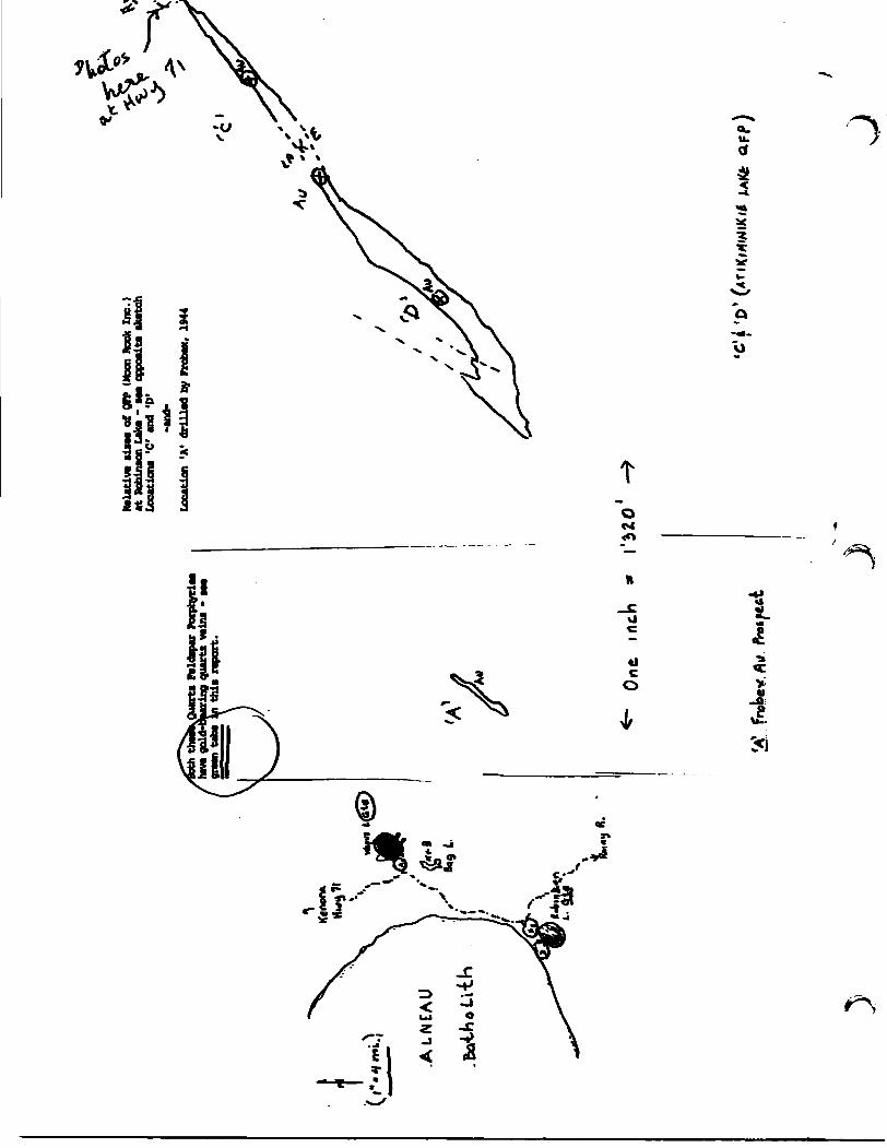
Quart!
FUdapar Fo
tphy
riM
quar
ts v
alni -
CM
,• report.
Ralativ* ai*M
of Off (
Mxn
Rook
Inc.)
at Robinson Lake -
•••
opp
osit
* •k
etch
Location!
-C1 and
'D*
-and
-Lo
eatio
n 'A
' dr
illad
by
FMba
x, 19
44
flu'i'D
' (X
TIK|
H»M
IK<£
JJ

Conductor Ahead

QUADRATURE. CONTROL
INCLINOMETER
FIG. I EM 16EARPHONE, JACK
VOLUME CONTROL
STATION SELECTOR
BATTERY TEST
HANDLE-VERTICAL
& HORIZONTAL COIL


J

163.S2FeSSE0Sea 63.54«7 ROWAN LAKE 900
ON -3
THIS SUBMITTAL CONSISTED OF VARIOUS REPORTS, SOME OF WHICH HAVE BEEN CULLED FROM THIS FILE. THE CULLED MATERIAL HAD BEEN PREVIOUSLY SUBMITTED UNDER THE FOLLOWING RECORD SERIES (THE DOCUMENTS CAN BE VIEWED IN THESE SERIES):
f (/- •€ o /} A \ i < i fa I J ti r u f y
.„/• L.U
/)l(
GloO V f *lt,i»t C*n T f) <Ji i^.tr I •