nps form 10-900 united states department of the …...nps form 10-900 united states department of...
TRANSCRIPT

NPS Form 10-900
United States Department of the Interior National Park Service
National Register of Historic Places Re OCT 1 8 2013
istration For This form is for use in nominating or requesting determinations for individual properti s lin}~ ,qti': :: S, e i. thlb't' ·o.~1, Bulletin, How to Complete the National Register of Historic Places Registrlllion For . J !ll~tern does.J1 e I e roperty
documented, enter "N/A" for "not applicable." For funCiions, architecturn l clnssificatioll, materials, and areas of sigm canoe,
categories and subcategories from the instructions.
1. Name of Property Historic name: Alien-West House Other names/site number: _,_W.!...e=s=t~F_,a""rm-=------------------Name of related multiple property listing: N/A (Enter "N/ A" if property is not part of a multiple property listing
2. Location Street & number: 153 George Street City or town: Banington State: Rhode Island Not For Publication: D Vicinity: D 3. State/Federal Agency Certification
County: ~B~ri~st~o~l ____ _
As the designated authority under the National Historic Preservation Act, as amended,
I hereby certify that this _x__ nomination _request for determination of eligibility meets the documentation standards for registering properties in the National Register of Historic Places and meets the procedural and professional requirements set forth in 36 CFR Part 60.
In my opinion, the property / meets _does not meet the National Register Criteria. I recommend that this property be considered significant at the following level(s) of significance:
_national statewide _.!_local Applicable National Register Criteria:
....!_A _B ....!.._C _D
Signature of certifying official/Title: Date
Rhode Island Historical Preservation and Heritage Commission
State or Federal agency/bureau or Tribal Government
In my opinion, the property ·-meets_ does not meet the National Register criteria.
Signature of commenting official:
Title:
1
Date
State or Federal agency/bureau or Tribal Government

United States Department of the Interior National Park Service I National Register of Historic Places Registration Form NPS Form 10-900 OMB No. 1024-0018
Allen-West House Name of Property
. ational Park Service Certification
reby certify that this property is:
entered in the National Register
_determined eligible for the National Register
_determined not eligible for the National Register
_removed from the National Register
_other (explain:) _ ___ _ ___ _
5. Classification
Ownership of Property
(Check as many boxes as apply.)
Private: 0 Public -Local D Public - State D Public- Federal D
Category of Property
(Check only one box.)
Building(s)
District
Site
Structure
Object
0 D D D D
Sections 1-6 page 2
Bristol County, Rhode Island County and State
L'Z-3· L Date of Action

United States Department of the Interior National Park Service / National Register of Historic Places Registration Form NPS Form 10-900 OMB No. 1024-0018 Allen-West House Bristol County, Rhode Island Name of Property County and State
Sections 1-6 page 3
Number of Resources within Property (Do not include previously listed resources in the count)
Contributing Noncontributing 1 1 buildings sites 1 structures objects 1 2 Total
Number of contributing resources previously listed in the National Register 0 ____________________________________________________________________________
6. Function or Use Historic Functions (Enter categories from instructions.)
DOMESTIC: single dwelling
Current Functions (Enter categories from instructions.)
DOMESTIC: single dwelling

United States Department of the Interior National Park Service / National Register of Historic Places Registration Form NPS Form 10-900 OMB No. 1024-0018 Allen-West House Bristol County, Rhode Island Name of Property County and State
Section 7 page 4
___________________________________________________________________________ 7. Description
Architectural Classification (Enter categories from instructions.) COLONIAL: Georgian MID-19th CENTURY EARLY 20th CENTURY
Materials: (enter categories from instructions.) Principal exterior materials of the property: WOOD: weatherboard; STONE; CONCRETE; BRICK; ASPHALT
Narrative Description (Describe the historic and current physical appearance and condition of the property. Describe contributing and noncontributing resources if applicable. Begin with a summary paragraph that briefly describes the general characteristics of the property, such as its location, type, style, method of construction, setting, size, and significant features. Indicate whether the property has historic integrity.) ______________________________________________________________________________ Summary Paragraph The Allen-West House occupies a 1.4-acre lot on George Street in the northernmost part of Barrington, just south of the Massachusetts state line, in an area known as Nockum Hill (Plat 37, Lot 51). Located east of the Barrington River and including parts of Barrington, Rhode Island and Swansea, Massachusetts, Nockum Hill is a rural area characterized by agricultural fields, pastures and tidal marshes. The Allen-West House is surrounded on the west, south and east by open land, much of which is actively farmed. A dirt lane that has its origins in a 17th century cartway forms the property’s southeasterly boundary. A single family home with a large barn is located immediately to the northeast of the Allen-West House, on the opposite side of George Street. The surrounding properties contribute to the Allen-West House’s rural, agricultural setting. The Allen-West House is set back approximately 50 feet from George Street on a grassy lot with a number of specimen trees. The house, which is oriented toward the northwest, has at its core a timber-frame, one-and-a-half story, square-plan residence built ca.1763 in the Georgian style, which has been expanded with small additions three times. (Photos 1-3, Drawings 1-3) A one

United States Department of the Interior National Park Service / National Register of Historic Places Registration Form NPS Form 10-900 OMB No. 1024-0018 Allen-West House Bristol County, Rhode Island Name of Property County and State
Section 7 page 5
story, side-gable ell was built on the east end around 1848; a one story, hipped-roof, enclosed porch was constructed on the west end around 1920; and a one-story, shed-roof addition was built off the north side of the east ell in the early 1950s. In addition to the house, the property includes a barn complex and a garden shed, both of which date from the 1980s and are considered non-contributing resources. The Allen-West House retains a high level of integrity in terms of location, setting, design, materials, workmanship, feeling and association. Although the ca. 1763 house was expanded three times between the mid-19th and mid-20th centuries, each addition is smaller in scale than the original house and the original floor plan is largely intact. Much of the original interior finishes have survived and they have been supplemented by Colonial Revival trim added in the 1920s and 1950s. The property is unique in Barrington because of the survival of much of the original farmland which, while set off from the house in 1926, remains conserved open space. (Photo 4 and Aerial Photos) In contrast, every one of Barrington’s other eighteenth-century houses – only fifteen of which survive – exist on lots much smaller than their original homesteads, in a suburban rather than a rural setting. ______________________________________________________________________________ Narrative Description The Allen-West House dates to ca. 1763, when the main block of the present house was constructed. Approximately 27 feet wide and 27 feet deep and one-and-one-half-stories tall, it is a square-plan building; on the first floor, there are three differently-sized rooms arranged around an off-center chimney stack, and a small, unheated room behind the staircase to the second floor. The building’s timber frame, which is two structural bays wide and two deep, is unexposed except for the corner posts and intermediate posts. It rests on a stone foundation, has exterior walls of vertical planks covered in wood clapboard, and has a side-gable, asphalt-shingled roof with a simple box cornice. The large brick chimney is parged with stucco. The north-facing façade1 is four bays wide, with an entrance in the second bay. The doorway is capped with original crown molding broken out from the cornice bed molding; the rest of the doorway has Colonial Revival replacement trim. (Photo 5) The original door has also been replaced with a Colonial Revival-style, four-panel door with a four-light inset at the top. The three windows on the façade are placed just below the eave; these are replacement windows which likely date from the late nineteenth century, with molded trim and two-over-two, double-hung, wood sash. The west and east elevations of the ca. 1763 structure are largely obscured by later additions. On the west, there are two windows with plank frames and simple caps at the second story, centered below the gable peak. Eight-over-eight, double-hung, wood sash operate within the original, pegged plank frames. On the east end, there is just one off-center window at the second floor, filled with six-over-six, double-hung, wood replacement sash. The south (rear) elevation of the main block features two windows. In the westernmost bay there is a single window with the
1 The Allen-West House is oriented to the northwest but, for ease of discussion, the façade will be considered to face north.

United States Department of the Interior National Park Service / National Register of Historic Places Registration Form NPS Form 10-900 OMB No. 1024-0018 Allen-West House Bristol County, Rhode Island Name of Property County and State
Section 7 page 6
original plank frame and a molded cornice, filled with six-over-six, double-hung, wood sash. On the east, the original fenestration has been replaced by a large, tripartite Colonial Revival-style window, most likely dating to the 1950s.2 The first floor plan of the ca. 1763 house, measuring 27’ 3” square, is largely intact. (Drawing #1) It has an entry hall in the northeast corner and three primary rooms organized around the off-center triangular chimney stack: a large square parlor (14’ 7¼” by 14’ 4”) in the northwest corner; a somewhat smaller back room (14’ 6¼” by 12’ 5¼”) in the southwest corner; and a long keeping room or kitchen (12’ 3½” by 17’ 9½”) in the southeast corner. These rooms feature fireplace openings of varying widths, scaled to the size of each room. In the keeping room, the fireplace is 4’ wide, with a bake oven on its north side; in the parlor, the opening is 3’ 6” wide; and in the back room, where the fireplace is set at a 45-degree angle, the opening is just 3’ wide. The fireboxes range from 1’ 3” to 1’ 9” in depth. In addition to the entry hall, the northeast quadrant contains a stairway and, in the corner, a small room that historically may have served as an unheated pantry or bedroom. The entry hall, which is a narrow space (7’ by 3’ 3”) with plaster walls, has doorways into the parlor, the kitchen, and the steep dogleg stair on the left leading to the second floor. Only 2’ 7¾” in width, the stair is enclosed by oak plank walls. Cellar framing indicates that a stair to the cellar was once located here, with access through the small passage under the stairs; this passage currently leads to the small corner room that has been refinished on the interior to serve as a modern bathroom. A boxed post remains in the northeast corner of this room. The parlor has plastered walls; original, wide wood floorboards running north/south; and boxed corner posts in all four corners. An original cornice molding survives on three walls, but has been replaced with a smaller profile molding on the north wall, probably when the original windows here were replaced with the existing frames and sash. The doorway onto the hallway contains an original 2’ 3” wide by 6’ 2⅛” high, paneled door; a similar door is in the doorway into the back room. The fireplace located on the south wall features a chimney piece with a pair of raised panels, one large and one narrow, and bolection molding surrounding the firebox. (Photo 6) Immediately to the left of the firebox is a section of full-height paneling, 2’ ½” wide, embellished with six raised panels. This paneling can be removed, exposing the beehive oven and the chimney stack. Notes on the back of this wood panel, written in chalk, record the depth of snowfalls in November, 1771. On the west wall a window was removed to create a 2’ 5” by 6’ 2½” doorway to the ca. 1920 addition and a shallow projecting built-in closet has been added. The back room features plaster walls with wood chair rails on three sides; one section of chair rail to the north of the fireplace appears to be original and the rest appears to date from the 20th century. On the room’s west wall the plaster finish has been removed, exposing the original vertical oak sheathing planks (now painted white). The south wall has boxed corner posts at each end, and a section of original cornice molding. The east wall of the room is built at a 45-degree
2 This window was produced by the Curtis Woodworking Company (in business from 1866 to 1955). It matches the window in the northeast addition from the early 1950s.

United States Department of the Interior National Park Service / National Register of Historic Places Registration Form NPS Form 10-900 OMB No. 1024-0018 Allen-West House Bristol County, Rhode Island Name of Property County and State
Section 7 page 7
angle with a paneled fireplace in the center. (Photo 7) The fireplace has a two-panel chimney piece and bolection molding around the firebox, like the parlor fireplace. To the north of the chimney piece is a large cupboard with a two-panel door; on the other side is a smaller cupboard with a one-panel door. (Photo 8) Original wood floorboards of varying widths are laid parallel to the angled fireplace – unusual in East Bay building. When the western addition was made ca. 1920, a pair of French doors was added in the west wall, presumably at the same time the original cornice and a window were removed, and the plank wall was exposed. (Photo 9) The keeping room features original plank flooring and its walls are finished with wood wainscoting with a chair rail and plaster above, and there are boxed corner posts in the northeast and southeast corners. The secondary entrance to the ca. 1763 house was centered on the east wall of the keeping room, but is now a cased passage to the ca. 1848 kitchen ell. A doorway in the north wall that once led to the possible pantry has been removed and filled in. The fireplace is roughly centered on the west wall and its hearth has original bricks, laid perpendicular to the back of the firebox. The fireplace surround includes a Colonial Revival-style, paneled mantel and bake-oven door which, along with the wainscoting and cabinets on the south wall, are 20th century renovations. (Photo 10) They may have been completed by Walter G. and Mary West, who took out three mortgages for a total of $8,000 from 1919 to 1921, or by the Murphys ca. 1952. The second floor of the ca. 1763 house has two chambers or bedrooms finished with plaster ceilings and knee walls and divided by an original plank wall. (Drawing #2) The stair rises directly into the east chamber, which measures 12’ 5” wide by 13’ 5½” deep. (Photo 11) An original, off-center, brick fireplace, 1’ 2” deep, is located on the west wall of the east chamber. It has a simple replacement mantel and a hearth with 10 rows of bricks laid perpendicular to the back of the fireplace, as in the keeping room directly below. The larger west chamber (10’ 11½” by 16’ 11½”) is entered via a door from the east chamber. (Photo 12) Evidence in the plaster walls indicates that it was once partitioned into two rooms with an interior door. Both chambers have storage areas under the eaves where the original rafters and roof boards are exposed. Whitewash on the roof indicates the garret was originally unfinished. Two closets are located to the north and south of the chimney; the small closet to the north features a door composed of two vertical planks, typical of mid-18th-century carpentry. A third closet, opening to the stair and the west chamber, features a Victorian-period door. A bathroom was installed off the east chamber around 1950. The ca. 1763 square-plan structure contains notable framing elements in the basement, including hand-hewn beams and sawn beams, ranging from 4” by 6” to 7” by 9” in size. (Drawing #3) Of particular interest is the unusual, diagonal beam in the low crawl space under the back room, which helps support the hearth for the angled firebox above. This large, hand-hewn beam, about 9” by 11” in depth, has cut-out pockets, indicating re-use from an earlier house. At least six possibly 17th-century, hand-hewn beams with pockets are re-used in the cellar framing, possibly from the “homestead” of Benjamin Allen (1654-1723), grandfather of Joseph Allen, Jr., who

United States Department of the Interior National Park Service / National Register of Historic Places Registration Form NPS Form 10-900 OMB No. 1024-0018 Allen-West House Bristol County, Rhode Island Name of Property County and State
Section 7 page 8
built the house.3 Over the years, almost all the hand-hewn joists have been sistered with deeper, sawn joists. Two log joists survive near the bulkhead stairs on the south elevation, and a 5½” log joist exists under the hall staircase. Subflooring of wide pine boards and pine flooring appears original in the three main rooms on the first floor above. In the front hall, there is infill framing, using short sawn 2’ by 4’ 5” and 3’ by 4’ joists; these joists, located under 10” to 11” new pine floorboards, were probably installed when the original cellar stair was removed to the ca. 1848 kitchen ell (discussed below). The Allen-West House has been expanded three times since its initial construction ca. 1763. The ca. 1848 ell extends off the southern end of the east elevation of the main block. When the ell was built, a side entrance into the original house was converted into an interior passage between the keeping room and the ell. Measuring 19’ 7½” wide by 13’ 8¾” deep, the ell rests on a stone foundation, has exterior walls sheathed in wood clapboard, and is topped by an asphalt-shingled, side-gable roof. An exterior brick chimney, which currently serves the cellar furnace, is located on the east elevation and is flanked by six-over-six, wood, double-hung windows on the first floor. At the second-floor level, there are two fixed, six-light sash. Secondary framing in the basement, measuring 4¾” by 4’ 3¼”, suggests that there was once a hearth or stove in the east end of the kitchen. The south elevation of the ca. 1848 ell has one six-over-six, wood, double-hung window in each of its easternmost bays, and a modern steel door in its west bay. (Photo 3) Today, the ca. 1848 ell holds a contemporary kitchen, which opens to the roof ridge. (Photo 13) A cellar stair (possibly the original stair, relocated from the hall) and a stair to a small loft are located in the southwest corner of the kitchen, while a small pantry, 2’ 5” by 2’ 9½,” occupies the northwest corner. The ca. 1920 addition, which is 12’ wide by 27’ deep, extends off the west elevation of the main block and houses an enclosed porch. It is one story tall with a concrete-block foundation, is clad in wood clapboards and has an asphalt-shingled, hipped roof. (Photo 2) Double-hung, six-over-nine, wood window sash occupy each of the four bays on the north elevation, the ten bays on the west elevation, and the two westernmost bays of the south elevation. An entrance, consisting of two, modern glass doors (one of which is fixed) is located in the east end of the south elevation. The most recent addition, built in the early 1950s, extends north off the ca. 1848 kitchen ell and abuts the east elevation of the original house. It contains a dining room, bathroom and closet. It is built on a poured concrete foundation, has exterior walls sheathed in wood clapboard, and an asphalt-shingled, shed roof. The dining room measures 10’ 9¾” by 11’ 8½”. A bathroom, measuring 7’ 6” by 8’ 7½” is located to the west of the dining room and is accessed through an interior closet that opens to the kitchen. This addition may originally have been used as a porch; the plastered ceiling in the dining room is 7’ 6” high and there are exposed clapboards on the west wall of the bath, where it meets the exterior wall of the ca. 1763 house. The east elevation of the early 1950s addition has a single window with two-over-two, wood, double-hung sash. The north elevation features a two-over-two, wood, double-hung window in its western bay and
3 The homestead is mentioned in the 1720 deed from Benjamin Allen of land "adjoyning to the said Benjamin Allen’s homelot..." to his son Joseph Allen, Sr. Bristol County, MA, Registry of Deeds, Taunton, Land Evidence Records Records (1683 to 1765), 1720 July 28, vol. 14:154.

United States Department of the Interior National Park Service / National Register of Historic Places Registration Form NPS Form 10-900 OMB No. 1024-0018 Allen-West House Bristol County, Rhode Island Name of Property County and State
Section 7 page 9
a tripartite window manufactured by the Curtis Woodworking Company that matches the south-facing window in the keeping room. Outbuildings (Non-Contributing) The Allen-West House property includes two non-contributing resources: a barn and a garden shed. Located to the southeast of the house, the L-shaped barn includes a one-story, 20’ by 20’ structure with a half-hipped roof and wood-shingle siding and a 32’ by 32’ addition with board-and-batten siding and a hayloft under a gambrel roof, built off the east end of the original structure in 1986. The older section of the barn, which originally housed two horse stalls, once had a narrow door on its south elevation, which opened to a paddock; it has been replaced with a modern garage door. Two 8’-wide doors open off of the north façade of the 1986 section of the barn, providing access to the driveway. Like the older section of the barn, the 1986 section was built for horses. Both sections of the barn are now used for storage. A small, one-story, prefabricated garden shed (ca.1986), measuring 10’ square, is located to the southwest of the house. It has a low gambrel roof with curving ends, and is clad with Texture -111 plywood siding. Setting The larger setting of the Allen-West House, much of which was part of the historic Allen-West farmstead, retains a rural agricultural character. Most of the land to the west, south and southeast is now permanently protected as open space through town zoning; some of it is used as tilled cropland and some as natural conservation land. Other lots in the area are actively farmed; one large parcel nearby is owned by the Audubon Society of Rhode Island. An historic right-of-way (18 feet in width) runs along the easterly side of the nominated property. This dirt lane begins at George Street on the northeast corner of the Allen-West House lot and extends southerly through the Nockum Hill conserved lands to the Barrington River. This right-of-way is identified in late 17th-century deeds as a “cartway,” as a “driftway” in early 19th-century deeds, as a “bridleway” in early 20th-century deeds and as a “Bridle Way” in the deed of February 1, 2013. This right-of-way has been used as the easterly bound of the Allen-West Farm since the early 1700s and appears on multiple Barrington plat maps. A modern gate, which replaced a 19th-century farm gate, is located at the northeast corner of the nominated property, to control access via this right-of-way to the town-owned Doug Rayner Wildlife Sanctuary at Nockum Hill. In addition, a large stone monument commemorating the location of the Baptist church built in the 1660s, was erected in 1905 on George Street at the intersection with this right-of-way (not on the nominated property).

United States Department of the Interior National Park Service / National Register of Historic Places Registration Form NPS Form 10-900 OMB No. 1024-0018 Allen-West House Bristol County, Rhode Island Name of Property County and State
Section 8 page 10
______________________________________________________________________________ 8. Statement of Significance
Applicable National Register Criteria (Mark “x” in one or more boxes for the criteria qualifying the property for National Register listing.)
X A. Property is associated with events that have made a significant contribution to the
broad patterns of our history.
B. Property is associated with the lives of persons significant in our past.
C. Property embodies the distinctive characteristics of a type, period, or method of construction or represents the work of a master, or possesses high artistic values, or represents a significant and distinguishable entity whose components lack individual distinction.
X
D. Property has yielded, or is likely to yield, information important in prehistory or history.
Criteria Considerations (Mark “x” in all the boxes that apply.)
A. Owned by a religious institution or used for religious purposes
B. Removed from its original location
C. A birthplace or grave
D. A cemetery
E. A reconstructed building, object, or structure
F. A commemorative property
G. Less than 50 years old or achieving significance within the past 50 years

United States Department of the Interior National Park Service / National Register of Historic Places Registration Form NPS Form 10-900 OMB No. 1024-0018 Allen-West House Bristol County, Rhode Island Name of Property County and State
Section 8 page 11
Areas of Significance (Enter categories from instructions.) community planning and development agriculture architecture
Period of Significance ca. 1763 – 1945
Significant Dates ca. 1763 – original house built 1848 – east ell built ca.1920 – west addition built
Significant Person (Complete only if Criterion B is marked above.)
Cultural Affiliation
Architect/Builder Joseph Allen, Jr. (ca. 1729 - 1816)
United States Department of the Interior National Park Service / National Register of Historic Places Registration Form NPS Form 10-900 OMB No. 1024-0018 Allen-West House Bristol County, Rhode Island Name of Property County and State
Section 8 page 12
Statement of Significance Summary Paragraph (Provide a summary paragraph that includes level of significance, applicable criteria, justification for the period of significance, and any applicable criteria considerations.) The Allen-West House is significant at the local level under Criterion A, in the areas of community planning and development and agriculture. Built ca. 1763, the house is a rare survivor of the agricultural settlement of Nockum Hill, which had its origins in the early colonial period.4 Characterized by level arable lands bounded by low-lying marshes and tidal flats, the Nockum Hill area was one of the earliest nodes of European settlement in Barrington, then part of the colonial town of Swansea (1667), and, unlike the rest of the town, it remained agricultural in character through the town’s suburbanization in the late 19th and 20th centuries. The Allen-West House is also significant at the local level under Criterion C, in the area of architecture, as a work of colonial architecture in the Georgian style. One of approximately fifteen houses that survive from the 18th century in Barrington, it is notable as an early example of a square-plan house, an important but little-recognized regional house type that grew out of Rhode Island’s 17th-century vernacular tradition. Period of Significance Justification The period of significance begins ca. 1763, when documentary and physical evidence indicates that Joseph Allen, a housewright, constructed the main block of the present-day Allen-West House, and extends to 1945, when the house was sold by the West family and ceased to be the center of an agricultural property. The period of significance encompasses the construction of the ca. 1848 addition off the east end of the main block and the ca. 1920 addition off the west end. ______________________________________________________________________________ Narrative Statement of Significance (Provide at least one paragraph for each area of significance.) Initial Colonial Settlement Nockum Hill is located at the northern apex of present-day Barrington, at its boundary with Massachusetts. The Barrington River is immediately to the west and Hundred Acre Cove is to the southeast, separated from Nockum Hill by a spit of land known as The Tongue. When Europeans arrived, Native Americans had occupied Nockum Hill and its surrounding areas for approximately 8,000 years. Like in other coastal areas of New England, Native Americans likely
4 It is possible that additional homes from the period survive in nearby Massachusetts. For example, the Captain Jonathan Munroe House at 205 Warren Avenue in Seekonk, MA dates to ca. 1730 and is located about 1/2 mile to the northwest of the Allen-West House. The Allen-West House is, however, the only pre-Revolutionary War home at Nockum Hill located in present-day Barrington, Rhode Island. Massachusetts Historical Commission, Inventory Form for 205 Warren Ave., Seekonk, MA.

United States Department of the Interior National Park Service / National Register of Historic Places Registration Form NPS Form 10-900 OMB No. 1024-0018 Allen-West House Bristol County, Rhode Island Name of Property County and State
Section 8 page 13
cleared Nockum Hill to raise corn, dwelling there during the growing season.5 “Nockum” or “Nocum” has been interpreted as “sandy” as well as “visible from afar” in the Algonquin language.6 From the perspective of Hundred Acre Cove, the 27-foot high elevation of Nockum Hill, whose sandy shores reflected the sun’s rays, must have created a striking visual impression. Early 18th-century colonial deeds refer to Nockum Hill and the landing place located along its southern shore.7 Colonial settlement in this area followed upon the 1641 sale of eight square miles of land on the eastern shore of the Providence and Seekonk Rivers by the Wampanoag sachem Osamequin to a company of investors from Plymouth Colony led by John Brown and Edward Winslow. The first settlement of this tract followed in 1643; originally known as Seacunke (Seekonk) and soon renamed Rehoboth, its southern boundary was a short distance north of Nockum Hill. (Map A) With the 1641 purchase, the Rehoboth settlers also acquired the use of “the hundred acres of that marsh lying on the south side of the bounds of Rehoboth now called by the name of the hundred acres to the use of the said town.”8 From this point on, new settlers to Rehoboth were frequently granted two-acre lots of salt marsh in Hundred Acre Cove south of Nockum Hill, along with their home lot on the “Ring of the Green” in present-day East Providence, Rhode Island.9 The salt marshes here would continue to attract the interest of English colonists as a valuable source of fodder for their livestock. In 1653, another large sale by the Wampanoag sachem, the Sowams purchase, brought Nockum Hill, along with most of present-day Barrington, into English ownership.10 Some of the first settlement on these new lands was made on Nockum Hill. In 1667, settlement there received a major boost when the Baptist minister John Myles and a small group of followers moved into Sowams after being expelled from Rehoboth for their Baptist leanings. Shortly thereafter, the Plymouth Colony authorities created the new town of Swansea where Baptists would be tolerated.11 At its founding, Swansea included the present-day towns of Barrington, Warren and part of East Providence, Rhode Island as well as Swansea and Somerset, Massachusetts.12 According to historian Thomas W. Bicknell, Myles and his congregation erected a Baptist meetinghouse – among the first to be built in America – near Nockum Hill. This location would have been roughly equidistant from the already-established homes of the early church members
5 William Cronon, Changes in the Land: Indians, Colonists, and the Ecology of New England (New York: Hill and Wang, 2003):44-52. 6 John C. Huden, Indian Place Names of New England (New York: Museum of the American Indian, Heye Foundation, 1962):148. 7 Bristol County, MA Registry of Deeds, Taunton, Land Evidence Records Records. 1709 27 Dec., vol. 15: 71-2; 1736 10 Feb., vol. 25: 234-5. 8 Jeremy Dupertuis Bangs, Indian Deeds: Land Transactions in Plymouth Colony, 1620-1691 (Boston: New England Historic Genealogical Society, 2008 [Reprint: 1st ed. 2002]): #29, 250; #42, 256; #208, 209. 9 John G. Erhardt, The History of Rehoboth, Seekonk, East Providence, Pawtucket & Barrington, Vol. 1: Seacuncke, 1500s to 1645 (Typescript: Seekonk, MA, 1982):169-173. 10 Virginia H. Adams et al., Historic and Architectural Resources of Barrington, Rhode Island (Providence, RI: Rhode Island Historical Preservation Commission, 1993):6. Bangs, Indian Deeds, #63, 269-270. 11 William G. McLoughlin, Soul Liberty: The Baptists’ Struggle in New England, 1630-1833 (Hanover, NH: University Press of New England, 1991):94-95. 12 Adams, Historic and Architectural Resources of Barrington, 8.

United States Department of the Interior National Park Service / National Register of Historic Places Registration Form NPS Form 10-900 OMB No. 1024-0018 Allen-West House Bristol County, Rhode Island Name of Property County and State
Section 8 page 14
and, with its access to open water, provided a ready place for baptisms.13 On March 9, 1668, the Swansea Town Meeting assigned twelve-acre house lots surrounding the recently built meeting house to leading members of the congregation, though it is not known how many residences were erected.14 In 1672, the town granted a 40-acre meadow to John Myles, whose home was about 1½ miles east of Nockum Hill, in a settlement on the Palmer River that came to be known as Barneyville. The meadow is described as being immediately to the east of “the River called by the Name of New Meadow River” – the present-day Barrington River – indicating that it was located by Nockum Hill.15 Colonial settlement in the region was devastated by King Philip’s War (1675-1676), which began in Swansea, but resumed upon the war’s end. On October 20, 1676, the Plymouth Court lifted any restriction on purchase or settlement due to the presence of Native Americans, and there was a rapid increase in property division in New Meadow Neck (to the southwest of Nockum Hill). 16 In 1678, the Baptists chose to relocate to a new meetinghouse at the southern tip of New Meadow Neck, which soon became a new town center known as the “Place of Trade.”17 With the departure of the Baptist congregation, agriculture, characterized by dispersed single-family farms, became the dominant influence on the development of the Nockum Hill area. Development of the Allen-West Farm Reverend Myles died in 1683, and that same year his widow, Ann, sold Myles’ 40-acre meadow at Nockum Hill to Philip Squire, a wealthy distiller and Baptist from Boston. Nine years later Squire sold the property to his son-in-law, Benjamin Allen (1652-1723).18 Allen acquired 11 adjacent acres “being at a place called Nocum” from his mother-in-law in 1709.19 Various parcels at Nockum Hill were acquired by and passed on to members of the Allen family in the early 18th century; deeds indicate that the family had houses in the area, and that they used a river
13 Thomas Williams Bicknell, A History of Barrington Rhode Island (Providence: Snow & Farnham, Printers, 1898):125. In 1905 Bicknell sponsored the erection of the large stone monument on George Street just northeast of the Allen-West House that commemorates the first Baptist meetinghouse. 14 Swansea, MA, Town of. Proprietors Book of Grants and Meetings, 1668-1769. Family History Library Film 0903396, item 24, f. 2r. 15 According to Thomas Williams Bicknell, 17th-century European settlers referred to the present-day Barrington River as the New Meadow River. Bicknell, A History of Barrington, 12. Swansea, MA, Town of. Proprietors Book of Grants and Meetings, 1668-1769. Family History Library Film 0903396, item 4, f. 6v. 16 Bangs, Indian Deeds, 488-489. New Meadow Neck had been reserved for Indian occupancy by the terms of the Sowams Purchase. 17 Josiah P. Tustin, A Discourse Delivered at the Dedication of the New Church Edifice of the Baptist Church and Society in Warren, RI (Providence, RI: 1845):98. As early as 1678, the Town of Swansea was planning for an “Intended Town of Trade” in this location. See Swansea, MA, Town of. Proprietors Book of Grants and Meetings, 1668-1769. Family History Library Film 0903396, item 3, f. 2v. 18 Bristol County, MA Registry of Deeds, Taunton. Land Evidence Records Records (1683 to 1765) 1692/3 24 Feb., rec. 14 Feb. 1722, vol. 15: 70-71. The original 1683 deed cannot be located, but it is explicitly referred to in the deed of 1692, which describes Ann as the widow of Samuel Miles; we must assume that the name of John Myles’s son has been inserted here in error. 19 Bristol County, MA Registry of Deeds, Taunton. Land Evidence Records Records (1683 to 1765), 1709 27 Dec., vol. 15: 71-72.

United States Department of the Interior National Park Service / National Register of Historic Places Registration Form NPS Form 10-900 OMB No. 1024-0018 Allen-West House Bristol County, Rhode Island Name of Property County and State
Section 8 page 15
landing near Nockum Hill to support their waterborne trade activities.20 By 1763, the subject property was owned by Benjamin’s son, Joseph Allen (1697-ca.1763), a “boatman.” In August of that year, he sold the property, now totaling 60 acres, to his son Joseph Jr. (ca. 1729-1816) of Providence, a “housewright,” in return for a life lease.21 At the time, the present-day town of Barrington was the western part of Warren, Rhode Island; Barrington was incorporated as a separate town, with its current boundaries, in 1770.22 Physical and documentary evidence indicate that Joseph Allen Jr. – a housewright by trade – built the Allen-West House around 1763, when he acquired the property from his father. The house’s architectural details, such as the surviving door and window cornice moldings, the paneled chimney pieces and the bolection molding around the fireplaces, are all characteristic of local Georgian style from the pre-Revolutionary War period. Additional evidence has been found on the back side of the removable paneling in the parlor – graffiti, written in chalk, recording the number of snowfalls in 1771. Finally, “A Topographical Chart of the Bay of Narragansett,” surveyed in 1774 and published in 1777, shows three houses at Nockum Hill and ways to the Barrington River. (Map B) It seems likely that the Allen-West House is one of the three houses depicted; the other two no longer stand. The property remained in the Allen family until the mid-19th century, passing by will to Joseph’s son, Squire Allen (1765-1844) in 1816, who sold it to his son, Ira, in return for a life tenancy in 1843.23 Upon Squire Allen’s death the following year, an inventory was taken of his personal estate. His property included one horse, a pair of oxen, three cows, eleven hens and three turkeys, as well as household furnishings, tools and other belongings.24 Although it is not known what crops were being raised, it is likely that farm products were grown for family consumption as well as for sale. Five years later Joseph G. West (ca. 1821-ca.1880) purchased the house and 60 acres from Ira Allen,25 ushering in a long period of family ownership during which time the property came to be known as the West Farm. Joseph G. West, a local Warren farmer, had married Elizabeth Anne Barney in the Free Baptist Church in Barneyville in 1845, and together they had two children, George Henry (1847-1918) and Jane (b. 1855).26 It is likely that the ell that extends off the east end of the square-plan house, which contains a kitchen, was constructed soon after Joseph West purchased the property.
20 When Benjamin Allen’s estate was divided among his children, Joseph was instructed “to allow a drift way to be kept with gates & barrs at the north side of his homestead” so that his brothers and their heirs could access the river “and to allow a place at the river for his brothers to place their goods on & their heirs where the landing now is.” Bristol County, MA Registry of Deeds, Taunton. Land Evidence Records Records (1683 to 1765), 1720 July 28, vol. 14: 354; 1736/37 10 Feb., vol. 25: 234-5. 21 Town of Warren, Land Records, (1747-1770) 1763 9 August, vol. 1: 16 and 26. 22 Adams, Historic and Architectural Resources of Barrington, 7. 23 Town of Barrington, Land Evidence Records (1770-present) 1843 12 April, vol. 6: 106 and vol. 6: 152-3. 24 Town of Barrington, Probate Records, loose papers, first series, no. 366; and court ledgers 5:448. 25 Town of Barrington, Land Evidence Records (1770-present) 1848 25 April, vol. 6: 423. 26 Nathaniel L. Taylor, “Descendants of Joseph G. West owning the Allen-West Homestead, Barrington.”

United States Department of the Interior National Park Service / National Register of Historic Places Registration Form NPS Form 10-900 OMB No. 1024-0018 Allen-West House Bristol County, Rhode Island Name of Property County and State
Section 8 page 16
From the time of settlement through the mid-19th century, Barrington’s economic base consisted primarily of farming, though the proximity to Narragansett Bay led some residents to go to sea, pursue shipbuilding or, as members of the Allen family had done, engage in coastal trading. As of 1850, Barrington was home to 795 people residing in 122 households, 74 of which were farms. Farmsteads generally consisted of large tracts of land, and were dispersed throughout town.27 A map of Barrington from 1851 shows the town’s population concentrated across the river and on New Meadow Neck, while the sole residence in the Nockum Hill area is labeled “Jos. West.”28 A map from 1870 shows a similar distribution of the population, though there was growing development in the western part of town. At Nockum Hill, there were now two residences: the Allen-West House, labeled “J.G. West,” and a property across the street (no longer extant), labeled “G.H. West” – presumably referring to Joseph’s son, George Henry.29 Federal census records show that Joseph West concentrated on raising market garden produce on his farm, and that his landholdings expanded considerably over the course of the mid-19th century. As of 1850, he had 50 acres of improved land and the cash value of his farm was $1,000. By 1870, he had 100 acres of improved land, 25 acres of unimproved land and the value of his farm had grown to $4,000.30 At the time, his household included his wife, Elizabeth; their daughter Jane; their son George (shown on a map from that year as living across the street); an 18-year-old woman named Hannah (possibly George’s wife); and a 16-year-old farm laborer named Warren Chafee.31 Property records indicate that by this time Joseph West had acquired at least three small lots near the subject property, as shown on a map from 1867. (Map C) He also owned land in nearby Swansea, Seekonk, and Rehoboth, Massachusetts – a reflection of Barrington’s geographic proximity to and historical associations with these communities.32 By the time of the 1880 federal census, Joseph West had 25 acres of tilled cropland, six of which were devoted to potatoes, as well as 80 acres in meadow and 20 acres of woodland. He had sold $2,000 worth of produce in the previous year.33 His son George had been widowed by 1880 and lived with his three young children, as well as a housekeeper, Viola Jorden, who later became his wife.34 Joseph West died sometime after 1880, Elizabeth died in 1895, and the Allen-West House, along with considerable acreage, passed to their son, George. A late-19th-century directory shows that, even before inheriting his parents’ farmland – which included over 100 acres in multiple towns – George had amassed 175 acres of land. Only one other farm in Barrington, that of Leander Peck, was comparable in size. When George died intestate in 1918, his estate included land in four
27 Adams, Historic and Architectural Resources of Barrington, 10-11. 28 Henry F. Walling, Map of Bristol County, Rhode Island, 1851. 29 D.G. Beers and Co., Atlas of the State of Rhode Island and Providence Plantations (Philadelphia, 1870). 30 U.S. Census of 1850, Agriculture Schedule, Town of Barrington, Bristol County, Rhode Island, p. 9, line 19; U.S. Census of 1870, Agriculture Schedule, Town of Barrington, Bristol County, Rhode Island, p. 1, line 11. 31 U.S. Census of 1870, Town of Barrington, Bristol County, Rhode Island, p. 4, family 33. 32 Records from the late 19th century give South Seekonk, Massachusetts – not Barrington, Rhode Island – as the post office address for Joseph West’s farm. 33 U.S. Census of 1880, Agriculture Schedule, Town of Barrington, Bristol County, Rhode Island, farm of Joseph West. 34 U.S. Census of 1880, Town of Barrington, Bristol County, Rhode Island, p.1, families 1 and 2.

United States Department of the Interior National Park Service / National Register of Historic Places Registration Form NPS Form 10-900 OMB No. 1024-0018 Allen-West House Bristol County, Rhode Island Name of Property County and State
Section 8 page 17
towns: Barrington and East Providence, Rhode Island, and Swansea and Seekonk, Massachusetts. He owned 800 head of chicken (500 Leghorn hens; 300 Rhode Island Reds and Plymouth Rocks); four oxen, three yearlings and two horses.35 Upon George’s death, his two oldest children quitclaimed his real estate, including the parcel containing the Allen-West House, to the youngest, Walter G. (1874-1953).36 According to the 1910 federal census, Walter was already engaged in farming, living near his father (possibly in the house across the street from the subject property) and employing a housekeeper as well as two farm laborers. The 1920 census lists Walter West as a truck farmer, but by 1940 he is identified as the owner of a riding school.37 Between 1919 and 1921, shortly after inheriting the Allen-West House, Walter and his wife Mary took out three mortgages for a total of $8,000, probably for house improvements and farm investments. It is during this period that the ca. 1920 enclosed porch that extends off the west end of the square-plan house was constructed. French doors were installed in the back room, to provide access to the porch, and the planks of the west wall of the room were exposed in the process. The porch was reportedly used briefly as a tea room in the 1920s, open to the general public. Other changes during this period may include the Colonial Revival-style fireplace surround in the keeping room, as well as the cabinets on the south wall of the same chamber, though these alterations could date to the mid-20th century. Perhaps the biggest change to the Allen-West House occurred in the early to mid-1920s, when Walter and Mary West began to sell off parcels of farmland. Of these transactions, the most significant was a 1926 sale to Arthur W. Drew of Providence, which conveyed a 60-acre parcel, carving out a 1.4-acre lot that contained the Allen-West House.38 It is at this point that the house lot took on its current boundaries. The subdivision of the West Farm was a reflection of the shift in the property’s use, from productive farmland to riding school, and possibly also indicative of the growing suburbanization of Barrington and nearby towns. Two decades prior, in 1898, historian Thomas Bicknell wrote:
Fifty years ago the chief occupation of the people was farming. At the present time very few cultivate the land except in the raising of vegetables and fruits for family consumption… With the city influences and residents in Barrington, it has become a suburban town, and most of the business people of the town transact their various enterprises in Providence. The industrial change has been a very striking one, and marks the new era on which the town has entered.39
In 1945, Walter and Mary West, who had moved to Seekonk, Massachusetts, sold the house and its 1.4-acre lot to Kenneth and Ruth Ballou of Barrington, ending almost 100 years of
35 Town of Barrington, Probate Records, file no. 0320. 36 Town of Barrington, Land Evidence Records (1770-present) 1918 3 Sept., vol. 26:253. 37 U.S. Census of 1910, Town of Barrington, Bristol County, Rhode Island, p. 3, families 59 and 60; U.S. Census of 1920, Town of Barrington, Bristol County, Rhode Island, p. 1, family 1; U.S. Census of 1940, Town of Barrington, Bristol County, Rhode Island, p. 25, family 503. 38 Town of Barrington, Land Evidence Records (1770-present) 1926 9 Nov., vol. 33:585. 39 Bicknell, A History of Barrington, 558-559.

United States Department of the Interior National Park Service / National Register of Historic Places Registration Form NPS Form 10-900 OMB No. 1024-0018 Allen-West House Bristol County, Rhode Island Name of Property County and State
Section 8 page 18
stewardship by the West family.40 The Ballous sold the property to Stanley P. and Martha W. James of Lynchburg, Virginia in 1952, who sold it to Keeran J. and Elizabeth A. Murphy two years later.41 It is likely that the Murphys constructed the one-story, shed-roof addition off the north side of the east ell – possibly a former porch – which contains a dining room and bathroom, shortly after they purchased the property. The installation of the bathroom on the second floor of the square-plan house also dates from this period. Changes to the property since this period have been minimal. The Architecture of the Allen-West House The Allen-West House is significant as a local interpretation of the Georgian style, the predominant architectural mode in 18th-century Rhode Island (and the rest of the English colonies). Although in 1774 Barrington had 91 households with 601 residents, few pre-Revolutionary War houses survive today. In addition to this house, they can be found on New Meadow Neck (southeast of Nockum Hill) and in Barrington Center (across the river).42 It is also the only know example of the square-plan house type in Barrington. The square-plan house was only recently recognized as a distinct house type in 18th- and early-19th century New England.43 Consisting of three or four rooms organized around an off-center chimney stack, the square-plan house has a framing scheme that is two bays wide and two bays deep with each bay defined by a pair of vertical posts supporting horizontal plates and girts. The chimney is located at the intersection of the two interior girts. This arrangement differs from the three-bay wide frame used in the region’s typical center-chimney house and it has been identified as a direct outgrowth of the framing developed in the 17th-century Rhode Island stone-ender.44 The oldest extant square-plan buildings date from the second quarter of the 18th century and are in the Narragansett Bay area. The house type continued to be constructed into the early 19th century and examples are found in eastern Connecticut, the Connecticut River Valley, central and western Massachusetts, Nantucket and Martha’s Vineyard as well as in Rhode Island. The earliest known example of a square-plan house is the Philip Walker House, erected ca. 1724, in the neighboring town of Rehoboth, Massachusetts (now Rumford, Rhode Island). The Walker House and another early example, the George Thomas House (by 1745) in the North Kingstown village of Wickford, both feature direct entry into one of the house’s principal rooms. This direct entry is characteristic of most early square-plan houses, but variations on the mode of entry began to appear in the mid-18th century. The Allen-West House exemplifies this trend with its
40 Town of Barrington, Land Evidence Records (1770-present) 1945 25 May, vol. 40:312. 41 Town of Barrington, Land Evidence Records (1770-present) 1952 31 July (rec. 11 August), vol. 47:32; 1954 11 June, vol. 50:291. 42 Adams, Historic and Architectural Resources of Barrington, 11, 17. 43 The first published identification of the square-plan type was by Myron O. Stachiw and Nora Pat Small, “Tradition and Transformation: Rural Society and Architectural Change in Nineteenth Century Central Massachusetts,” in Perspectives in Vernacular Architecture III, eds. Thomas Carter and Bernard L. Herman (Columbia, MO: University of Missouri Press, 1989). 44 Myron O. Stachiw, The Early Architecture and Landscapes of the Narragansett Basin, Vol. I: Newport (Vernacular Architecture Forum, 2001):21, 24.

United States Department of the Interior National Park Service / National Register of Historic Places Registration Form NPS Form 10-900 OMB No. 1024-0018 Allen-West House Bristol County, Rhode Island Name of Property County and State
Section 8 page 19
entry opening onto a front lobby or stair hall. Historians of the square-plan house have termed this type of plan the “modified square-plan house.” The Allen-West House is the earliest known example of this modified plan, with the other known examples dating from the late 18th and early 19th centuries. Examples of the modified square-plan, like the Allen-West house plan, survive in some numbers in neighboring East Bay towns and Newport. In Bristol, they include the two nearly identical houses at 28 and 32 Central Street, built in 1808 for Col. Samuel Wardwell, a prosperous distiller.45 In Newport, the Alexander Jack Jr. House at 49 Mill Street, built in 1811 for a free African-American cordwainer, is another example.46 It is significant that surviving examples of the square plan in the East Bay are ordinarily two-and-a-half stories in height and set close to a street line. The Allen-West House, in contrast, is one-and-a half stories in height and exists in a rural, not urban, setting. Conclusion Constructed beginning around 1763, the Allen-West House is one of the few remaining 18th-century houses in Barrington and a vestige of the colonial settlement of the area known as Nockum Hill. In the mid- to late 19th century, during the West family’s period of ownership, the property was an extensive and productive farm, a reflection of the town’s dominant economic activity. The subdivision of the land in the 1920s, leaving 1.4 acres with the house, coincided with the region’s growing suburbanization and presaged an overall decline in agriculture. Through a combination of public and private ownership, however, the Allen-West House is surrounded on three sides by open space, much of it actively farmed, and thereby retains its rural setting.
45 Elizabeth S. Warren et al., Historic and Architectural Resources of Bristol, Rhode Island (Providence: Rhode Island Historical Preservation Commission, 1992):52. 46 Stachiw, Early Architecture and Landscapes of the Narragansett Basin, 83.

United States Department of the Interior National Park Service / National Register of Historic Places Registration Form NPS Form 10-900 OMB No. 1024-0018 Allen-West House Bristol County, Rhode Island Name of Property County and State
Sections 9-end page 20
_____________________________________________________________________________ 9. Major Bibliographical References Bibliography (Cite the books, articles, and other sources used in preparing this form.) Adams, Virginia H. et al. Historic and Architectural Resources of Barrington, Rhode Island. Providence, RI: Rhode Island Historical Preservation Commission, 1993. Anderson, Robert C. “Swansea Massachusetts, Baptist Church Records.” The New England Historical and Genealogical Register, v. 139 (1985):21-49. Bangs, Jeremy Dupertuis. Indian Deeds: Land Transactions in Plymouth Colony, 1620-1691. Boston: New England Historic Genealogical Society, 2008. Barrington Preservation Society Collections: Map File, Plaque File, Tour booklets. Bicknell, Thomas Williams. A History of Barrington, Rhode Island. Providence, RI: Snow & Farnham, Printers, 1898. Bicknell, Thomas Williams. Sowams. New Haven, CT: Associated Publishers of American Records, 1908. Bowen, Richard LeBaron. Early Rehoboth, Vol. I. Rehoboth, MA: Privately printed, 1945. Brackney, William with Charles K. Hartman. Baptists in Early North America, Vol. I, Swansea. Macon, GA: Mercer University Press, 2013. Cronon, William. Changes in the Land: Indians, Colonists, and the Ecology of New England. New York: Hill and Wang, 2003. Dempsey, Claire, Richard E. Greenwood and Wm McKenzie Woodward. The Early Architecture and Landscapes of the Narragansett Basin, Vol. II: Blackstone River Valley and Providence. Prepared for the Annual Meeting and Conference of the Vernacular Architecture Forum, Newport, RI, April 25-29, 2001. Driemeyer, Laura B. and Myron O. Stachiw. The Early Architecture and Landscapes of the Narragansett Basin, Vol. III: Bristol and the East Bay, Wickford and the West Bay. Prepared for the Annual Meeting and Conference of the Vernacular Architecture Forum, Newport, RI, April 25-29, 2001. Erhardt, John G. The History of Rehoboth, Seekonk, East Providence, Pawtucket & Barrington, Vol. I: Seacunke 1500s-1645, Vol. II: Rehoboth, Plymouth Colony 1645-1692. Typescript. 1982-3.

United States Department of the Interior National Park Service / National Register of Historic Places Registration Form NPS Form 10-900 OMB No. 1024-0018 Allen-West House Bristol County, Rhode Island Name of Property County and State
Sections 9-end page 21
Hall, John Raymond. In A Place Called Swansea. Baltimore: Gateway Press, Inc., 1987. Huden, John C. Indian Place Names of New England. New York: Museum of the American Indian, Heye Foundation, 1962. King, Henry Melville. Rev. John Myles and the Founding of the First Baptist Church in Massachusetts, An Historical Address Delivered at the Dedication of a Monument in Barrington, Rhode Island (Formerly Swansea, Mass). Providence, RI: Preston & S. Rounds Co., 1905. Leach, Douglas Edward. Flintlock and Tomahawk: New England in King Philip’s War. Woodstock, VT: The Countryman Press, 2009. Massachusetts Historical Commission. Inventory Form for Barneyville Historic District, Swansea, MA. On file, Massachusetts Historical Commission, Boston.
Massachusetts Historical Commission. Inventory Form for 205 Warren Ave., Seekonk. On file, Massachusetts Historical Commission, Boston. McLoughlin, William G. Soul Liberty: the Baptist’s Struggle in New England, 1630-1833. Hanover, NH: University Press of New England, 1991. Owens, B.G., ed. The Ilston Book Earliest Register of the Welsh Baptists. Aberystwyth, Wales: The National Library of Wales, 1996. Stachiw, Myron O. The Early Architecture and Landscapes of the Narragansett Basin, Vol. I: Newport. Prepared for the Annual Meeting and Conference of the Vernacular Architecture Forum, Newport, RI, April 25-29, 2001. Stachiw, Myron O. and Nora Pat Small. “Tradition and Transformation: Rural Society and Architectural Change in Nineteenth Century Central Massachusetts.” In Perspectives in Vernacular Architecture III, edited by Thomas Carter and Bernard L. Herman. Columbia, MO: University of Missouri Press, 1989. Taylor, Nathaniel L. “Descendants of Joseph G. West owning the Allen-West Homestead, Barrington.” Genealogical chart, unpublished. 12/18/12. Taylor, Nathaniel L. “Kin and Descendants of Benjamin Allen owning land near Nockum Hill, especially the Allen-West Farmstead, Swansey/Barrington.” Genealogical chart, unpublished. 12/17/12, revised 3/12/13. Taylor, Nathaniel L. and Elizabeth S. Warren. “Allen-West Homestead, 153 George Street. Barrington, Rhode Island, Tax Assessor’s Plat 37, Deed Timeline.” Unpublished. 1/29/13.

United States Department of the Interior National Park Service / National Register of Historic Places Registration Form NPS Form 10-900 OMB No. 1024-0018 Allen-West House Bristol County, Rhode Island Name of Property County and State
Sections 9-end page 22
Tustin, Josiah P. A Discourse Delivered at the Dedication of the New Church Edifice of the Baptist Church and Society in Warren, RI. Providence, RI: 1845. Warren, Elizabeth S. et al. Historic and Architectural Resources of Bristol, Rhode Island. Providence, RI: Rhode Island Historical Preservation Commission, 1992. Wright, Otis Olney. History of Swansea, Massachusetts 1667-1917. Swansea, MA: published by the town, 1917. Public Records and Documents Barrington, RI, Town of. Land Evidence Records Records (1770 to 2013). ________________. Mortgage Records (1919 to 1921). ________________. Probate Records (1816 to 1954). Bristol County, MA, Registry of Deeds. Land Evidence Records Records (1683 to 1765). Swansea, MA, Town of. Proprietors Book of Grants and Meetings, 1668-1769. Church of Latter Day Saints, Family History Library Film 0903306, item 4. ________________. Proprietors Records, 1667-1730. Church of Latter Day Saints, Family History Library Film 0903396, item 1. ________________. Proprietors Records, 1670-1713. Church of Latter Day Saints, Family History Library Film 0903306, item 5. U.S. Census of 1790, 1800, 1870, 1880, 1910, 1920 and 1940. Population Schedule. Town of Barrington, Bristol County, Rhode Island. U.S. Census of 1850, 1860, 1870 and 1880. Agriculture Schedule. Town of Barrington, Bristol County, Rhode Island. Warren, RI, Town of. Land Evidence Records Records (1746/7 to 1770). Historic Maps and Atlases 1777 Blaskowitz, Charles. A Topographical Chart of the Bay of Narragansett. Based on a
survey by Thomas Wheeler in 1774. 1851 Walling, Henry F. Map of Bristol County, Rhode Island. 1862 Walling, Henry F. Map of the State of Rhode Island and Providence Plantations.

United States Department of the Interior National Park Service / National Register of Historic Places Registration Form NPS Form 10-900 OMB No. 1024-0018 Allen-West House Bristol County, Rhode Island Name of Property County and State
Sections 9-end page 23
1867 Mason, James S. Map of Real Estate in the Town of Barrington. On file, Barrington
Town Hall Vault. Plat Book 1, Map 92, Section 3. 1870 Beers, D.G. Atlas of the State of Rhode Island and Providence Plantations.
Philadelphia: D.G. Beers and Co. 1871 Beers, F.W. Atlas of Bristol County, Massachusetts. Philadelphia: F.W. Beers & Co. 1895 Everts and Richards. New Topographical Atlas of Surveys – Southern Rhode Island,
Comprising the Counties of Newport, Bristol, Kent and Washington. Philadelphia: Everts and Richards.
1908 Ross, E.W., Civil Engineer. “Map of Indian Localities about Narragansett and Mount
Hope Bays.” In Sowams by Thomas W. Bicknell, 125. New Haven, CT: Associated Publishers of American Records.
Plat Maps, on file at Tax Assessor’s Office, Barrington Town Hall Barrington, Town of. Plat 37, Detail of George Street, 1938, 1948, 1954. ___________________________________________________________________________ Previous documentation on file (NPS): ____ preliminary determination of individual listing (36 CFR 67) has been requested ____ previously listed in the National Register ____ previously determined eligible by the National Register ____ designated a National Historic Landmark ____ recorded by Historic American Buildings Survey #____________ ____ recorded by Historic American Engineering Record # __________ ____ recorded by Historic American Landscape Survey # ___________ Primary location of additional data: x Historic Preservation Office ____ Other State agency ____ Federal agency x Local government ____ University x Other Name of repository: Barrington Preservation Society Museum in Town Library. Historic Resources Survey Number (if assigned): _______________
______________________________________________________________________________

United States Department of the Interior National Park Service / National Register of Historic Places Registration Form NPS Form 10-900 OMB No. 1024-0018 Allen-West House Bristol County, Rhode Island Name of Property County and State
Sections 9-end page 24
10. Geographical Data
Acreage of Property 1.4 acres Use either the UTM system or latitude/longitude coordinates Latitude/Longitude Coordinates Datum if other than WGS84:__________ (enter coordinates to 6 decimal places) 1. Latitude: 41.771844 Longitude: -71.312189
2. Latitude: Longitude:
3. Latitude: Longitude:
4. Latitude: Longitude: Or UTM References Datum (indicated on USGS map):
NAD 1927 or NAD 1983
1. Zone: Easting: Northing:
2. Zone: Easting: Northing:
3. Zone: Easting: Northing:
4. Zone: Easting : Northing:

United States Department of the Interior National Park Service / National Register of Historic Places Registration Form NPS Form 10-900 OMB No. 1024-0018 Allen-West House Bristol County, Rhode Island Name of Property County and State
Sections 9-end page 25
Verbal Boundary Description (Describe the boundaries of the property.)
The boundaries of the Allen-West House are shown on the attached sketch map. The property encompasses 1.4 acres and is comprised of Barrington Tax Assessor’s Plat 37, Lot 51. Boundary Justification (Explain why the boundaries were selected.) The boundaries of the nominated property encompass the Allen-West House and the 1.4 acres on which it sits, set off from surrounding farmland in 1926.
______________________________________________________________________________
11. Form Prepared By name/title: Burton Van Name Edwards, Ph.D., Past President and Treasurer and Elizabeth Sargent Warren, Past President (see below) organization: Barrington Preservation Society street & number: Box 178 city or town: Barrington state: R.I. zip code: 02806 e-mail: [email protected] telephone: 401-245-9719 date: September 11, 2013 Research assistance from: Rev. Dr. Charles K. Hartman, Past Pastor - First Baptist Church in Swansea, MA and Nathaniel Lane Taylor, Ph.D., Genealogist and Vice-President, Barrington Preservation Society. ___________________________________________________________________________ Additional Documentation Submit the following items with the completed form:
• Maps: A USGS map or equivalent (7.5 or 15 minute series) indicating the property’s
location.
• Sketch map for historic districts and properties having large acreage or numerous resources. Key all photographs to this map.
• Additional items: (Check with the SHPO, TPO, or FPO for any additional items.)

United States Department of the Interior National Park Service / National Register of Historic Places Registration Form NPS Form 10-900 OMB No. 1024-0018 Allen-West House Bristol County, Rhode Island Name of Property County and State
Sections 9-end page 26

United States Department of the Interior National Park Service / National Register of Historic Places Registration Form NPS Form 10-900 OMB No. 1024-0018 Allen-West House Bristol County, Rhode Island Name of Property County and State
Sections 9-end page 27
Photographs Submit clear and descriptive photographs. The size of each image must be 1600x1200 pixels (minimum), 3000x2000 preferred, at 300 ppi (Pixels per inch) or larger. Key all photographs to the sketch map. Each photograph must be numbered and that number must correspond to the photograph number on the photo log. For simplicity, the name of the photographer, photo date, etc. may be listed once on the photograph log and doesn’t need to be labeled on every photograph. Photo Log Name of Property: Allen-West House at Nockum Hill City or Vicinity: Barrington County: Bristol State: Rhode Island Photographer: Dana Gee (Photos 1-5, 7, 9-11, 13), Nathaniel L. Taylor (Photos 8, 12) and Joanna M. Doherty (Photo 6) Date Photographed: January to August, 2013 Description of Photograph(s) and number, include description of view indicating direction of camera: 1 of 13 View of Allen-West House, showing north and east elevations. 2 of 13 View of Allen-West House, showing north and west elevations. 3 of 13 View of Allen-West House, showing south elevation. 4 of 13 View of Allen-West House, looking northeast, showing barn (non-contributing)
and fields. 5 of 13 Detail of original crown molding at main entry, on north elevation. 6 of 13 View of parlor, showing south wall with fireplace, paneled chimney piece,
removable panel (to left of fireplace) and paneled door. 7 of 13 View of back room, showing angled fireplace, paneled chimney piece and
cupboards on east wall.
8 of 13 Detail of cupboard to south of chimney piece in back room. 9 of 13 View of back room, showing west wall with exposed planks.

United States Department of the Interior National Park Service / National Register of Historic Places Registration Form NPS Form 10-900 OMB No. 1024-0018 Allen-West House Bristol County, Rhode Island Name of Property County and State
Sections 9-end page 28
10 of 13 View of keeping room, showing fireplace, Colonial Revival-style mantel and
bake-oven door on west wall. 11 of 13 View of staircase to second floor, with plank wall. 12 of 13 View of second floor, from west chamber looking east into east chamber. 13 of 13 View of modern kitchen in ca. 1848 ell, looking northeast.
Aerials: Google Maps Date: May, 2013 1 of 2 View of Allen-West House property, looking north. 2 of 2 View of Nockum Hill, with Allen-West House at bend of George Street, showing
surrounding farmland, conservation land, R.O.W./Rayner Road to Barrington River, marshes and crescent-shaped beach on southeast shoreline.
Architectural Drawings: Architect: Lombard John Pozzi, A.I.A. Date: December 2012 - February 2013 1 of 3 Allen-West House, First Floor Plan. December, 2012. 2 of 3 Allen-West House, Second Floor Plan. February, 2013. 3 of 3 Allen-West House, Basement Floor Plan. February, 2013. Additional Information: Map A Ross, E.W., Civil Engineer. “Map of Indian Localities about Narragansett and
Mount Hope Bays.” In Sowams by Thomas W. Bicknell, 125. New Haven, CT: Associated Publishers of American Records, 1908.
Map B Blaskowitz, Charles. “A Topographical Chart of the Bay of Narragansett,”
surveyed by Thomas Wheeler, 1774. Detail of Nockum Hill, Barrington, published 1777. Courtesy of the Barrington Preservation Society.
Map C Mason, James S. “Map of Real Estate in the Town of Barrington,” Detail of
Nockum Hill, 1867. Barrington: Town Hall vault, Plat Book 1, Sheet 92, Section 3.

United States Department of the Interior National Park Service / National Register of Historic Places Registration Form NPS Form 10-900 OMB No. 1024-0018 Allen-West House Bristol County, Rhode Island Name of Property County and State
Sections 9-end page 29
Barrington assessor’s map 37, showing boundaries of Allen-West House property

United States Department of the Interior National Park Service / National Register of Historic Places Registration Form NPS Form 10-900 OMB No. 1024-0018 Allen-West House Bristol County, Rhode Island Name of Property County and State
Sections 9-end page 30
Allen-West House Site Plan

United States Department of the Interior National Park Service / National Register of Historic Places Registration Form NPS Form 10-900 OMB No. 1024-0018 Allen-West House Bristol County, Rhode Island Name of Property County and State
Sections 9-end page 31
Drawing 1 of 3 Allen-West House, First Floor Plan

United States Department of the Interior National Park Service / National Register of Historic Places Registration Form NPS Form 10-900 OMB No. 1024-0018 Allen-West House Bristol County, Rhode Island Name of Property County and State
Sections 9-end page 32
Drawing 2 of 3 Allen-West House, Second Floor Plan

United States Department of the Interior National Park Service / National Register of Historic Places Registration Form NPS Form 10-900 OMB No. 1024-0018 Allen-West House Bristol County, Rhode Island Name of Property County and State
Sections 9-end page 33
Drawing 3 of 3 Allen-West House, Basement Floor Plan

United States Department of the Interior National Park Service / National Register of Historic Places Registration Form NPS Form 10-900 OMB No. 1024-0018 Allen-West House Bristol County, Rhode Island Name of Property County and State
Sections 9-end page 34
Paperwork Reduction Act Statement: This information is being collected for applications to the National Register of Historic Places to nominate properties for listing or determine eligibility for listing, to list properties, and to amend existing listings. Response to this request is required to obtain a benefit in accordance with the National Historic Preservation Act, as amended (16 U.S.C.460 et seq.). Estimated Burden Statement: Public reporting burden for this form is estimated to average 100 hours per response including time for reviewing instructions, gathering and maintaining data, and completing and reviewing the form. Direct comments regarding this burden estimate or any aspect of this form to the Office of Planning and Performance Management. U.S. Dept. of the Interior, 1849 C. Street, NW, Washington, DC.

Additional Information Map A Ross, E.W., Civil Engineer. “Map of Indian Localities about Narragansett and Mount Hope Bays.” In Sowams by Thomas W. Bicknell, 125. New Haven, CT: Associated Publishers of American Records, 1908.

Map B Blaskowitz, Charles. “A Topographical Chart of the Bay of Narragansett,” surveyed by Thomas Wheeler, 1774. Detail of Nockum Hill, Barrington, published 1777. Courtesy of the Barrington Preservation Society.
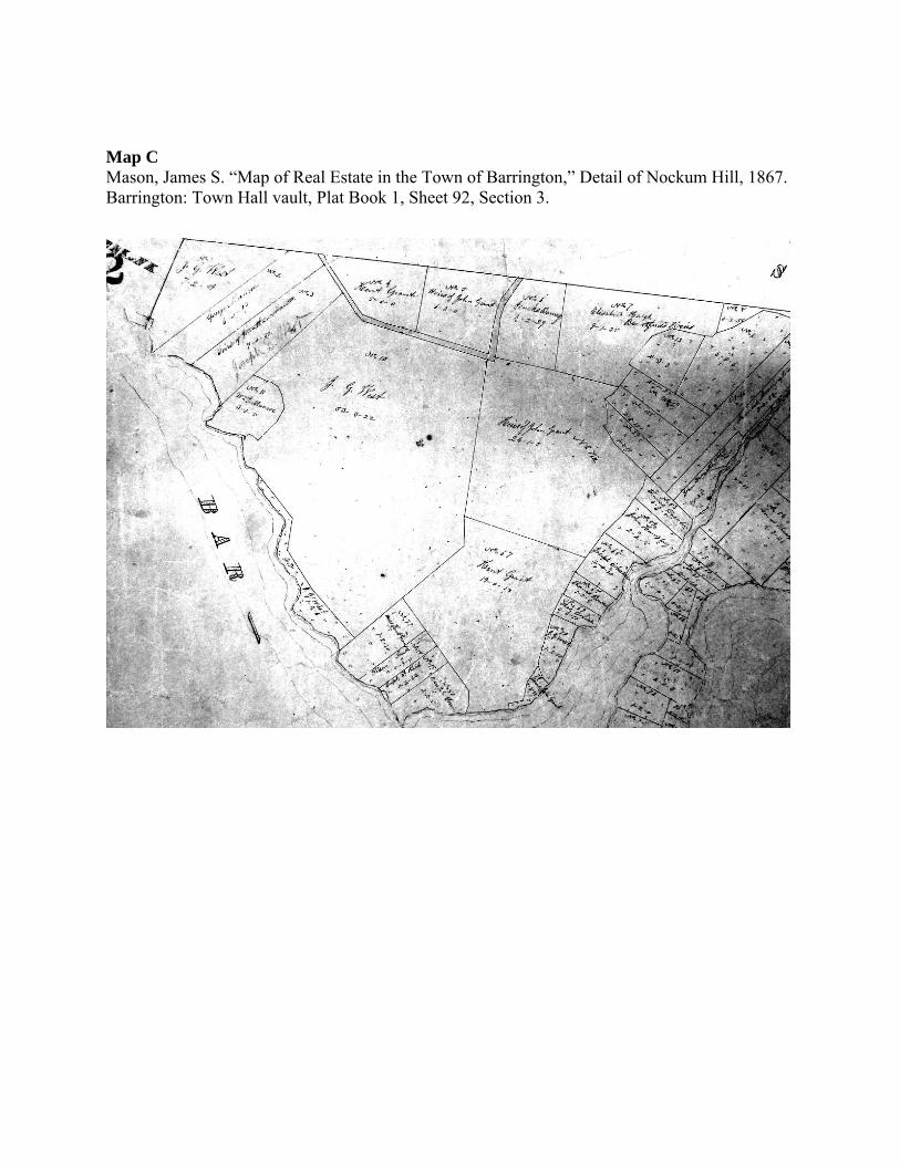
Map C Mason, James S. “Map of Real Estate in the Town of Barrington,” Detail of Nockum Hill, 1867. Barrington: Town Hall vault, Plat Book 1, Sheet 92, Section 3.


