nrl09/21/2004_davis.1 cioss/coast goes-r risk reduction activities for hes-cw cioss: cooperative...
Post on 22-Dec-2015
215 views
TRANSCRIPT
NRL09/21/2004_Davis.1
CIOSS/COAST GOES-R Risk Reduction Activities for HES-CW
CIOSS/COAST GOES-R Risk Reduction Activities for HES-CW
CIOSS: Cooperative Institute for Oceanographic Satellite Studies, College of Oceanic and
Atmospheric Sciences, Oregon State University, Corvallis, Oregon
COAST: Coastal Ocean Applications and Science Team, Mark Abbott Team Leader, Curtiss Davis
Executive Director
NRL09/21/2004_Davis.2
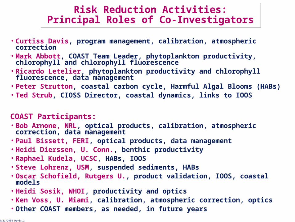
Risk Reduction Activities:Principal Roles of Co-Investigators
Risk Reduction Activities:Principal Roles of Co-Investigators
• Curtiss Davis, program management, calibration, atmospheric correction• Mark Abbott, COAST Team Leader, phytoplankton productivity, chlorophyll
and chlorophyll fluorescence • Ricardo Letelier, phytoplankton productivity and chlorophyll fluorescence,
data management • Peter Strutton, coastal carbon cycle, Harmful Algal Blooms (HABs)• Ted Strub, CIOSS Director, coastal dynamics, links to IOOS
COAST Participants:• Bob Arnone, NRL, optical products, calibration, atmospheric correction,
data management• Paul Bissett, FERI, optical products, data management• Heidi Dierssen, U. Conn., benthic productivity• Raphael Kudela, UCSC, HABs, IOOS• Steve Lohrenz, USM, suspended sediments, HABs• Oscar Schofield, Rutgers U., product validation, IOOS, coastal models• Heidi Sosik, WHOI, productivity and optics• Ken Voss, U. Miami, calibration, atmospheric correction, optics• Other COAST members, as needed, in future years

NRL09/21/2004_Davis.3
COAST and Risk Reduction ActivitiesCOAST and Risk Reduction Activities
• The Coastal Ocean Applications and Science Team (COAST) was created in August 2004 to support NOAA to develop coastal ocean applications for HES-CW:– Mark Abbott, Dean of the College of Oceanic and Atmospheric Sciences
(COAS) at Oregon State University is the COAST team leader,– COAST activities are managed through the Cooperative Institute for
Oceanographic Satellite Studies (CIOSS) a part of COAS, Ted Strub, Director
– Curtiss Davis, Senior Research Professor at COAS, is the Executive Director of COAST.
• Paul Menzel Presented GOES-R Risk Reduction Program at the first COAST meeting in September 2004 and invited COAST to participate.– Curt Davis and Mark Abbott presented proposed activities in Feb. 2005. – CIOSS/COAST invited to become part of GOES-R Risk Reduction Activity
beginning in FY 2006.– Proposal Submitted to NOAA Sept 6, 2005.– Here we present an overview of our planned Risk Reduction Activities.
NRL09/21/2004_Davis.4
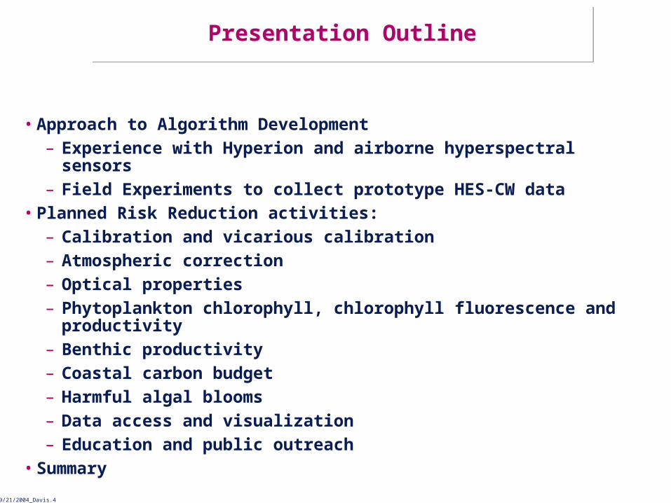
Presentation OutlinePresentation Outline
• Approach to Algorithm Development– Experience with Hyperion and airborne hyperspectral sensors– Field Experiments to collect prototype HES-CW data
• Planned Risk Reduction activities:– Calibration and vicarious calibration– Atmospheric correction– Optical properties– Phytoplankton chlorophyll, chlorophyll fluorescence and productivity– Benthic productivity– Coastal carbon budget– Harmful algal blooms– Data access and visualization– Education and public outreach
• Summary

NRL09/21/2004_Davis.5
HES-CW MeasurementsHES-CW Measurements
• Calibrated at sensor radiances for all channels– For the threshold 14 channels and possibly the
additional goal channels• Measurements are geo-located to approximately 1 Ground
Sample Distance (GSD)• Methods for on-orbit calibration and validation of products
are not clearly defined at this time.• Methods for atmospheric correction are not clearly
defined at this time.

NRL09/21/2004_Davis.6
HES-CW ProductsHES-CW Products
• Water-leaving radiance (the product of atmospheric correction, all other products are calculated from this one)
• Optical properties– Turbidity (water clarity)– Particulate absorption (phytoplankton, detritus, sediments)– Dissolved absorption (CDOM)– Particulate backscatter (phytoplankton, detritus, sediments)– Diffuse attenuation (light availability for seagrasses, corals)
• Chlorophyll (phytoplankton biomass)• Chlorophyll fluorescence (phytoplankton health and productivity)• Total Suspended Matter (TSM, material transport)• Colored Dissolved Organic Matter (CDOM, organic matter transport,
track river plumes)• These products tie directly into NOS requirements for coastal ocean
remote sensing.

NRL09/21/2004_Davis.7
NOAA HES-CW ApplicationsNOAA HES-CW Applications
• Water quality monitoring (e.g. Harmful Algal Blooms, suspended sediments, CDOM)
• Coastal hazard assessment
• Navigation safety
• Human and ecosystem health awareness (HABs)
• Natural resource management in coastal and estuarine areas
• Climate variability prediction (sea level rise, carbon cycle)
• Landscape changes
• Coral reef detection and health appraisal
NRL09/21/2004_Davis.8
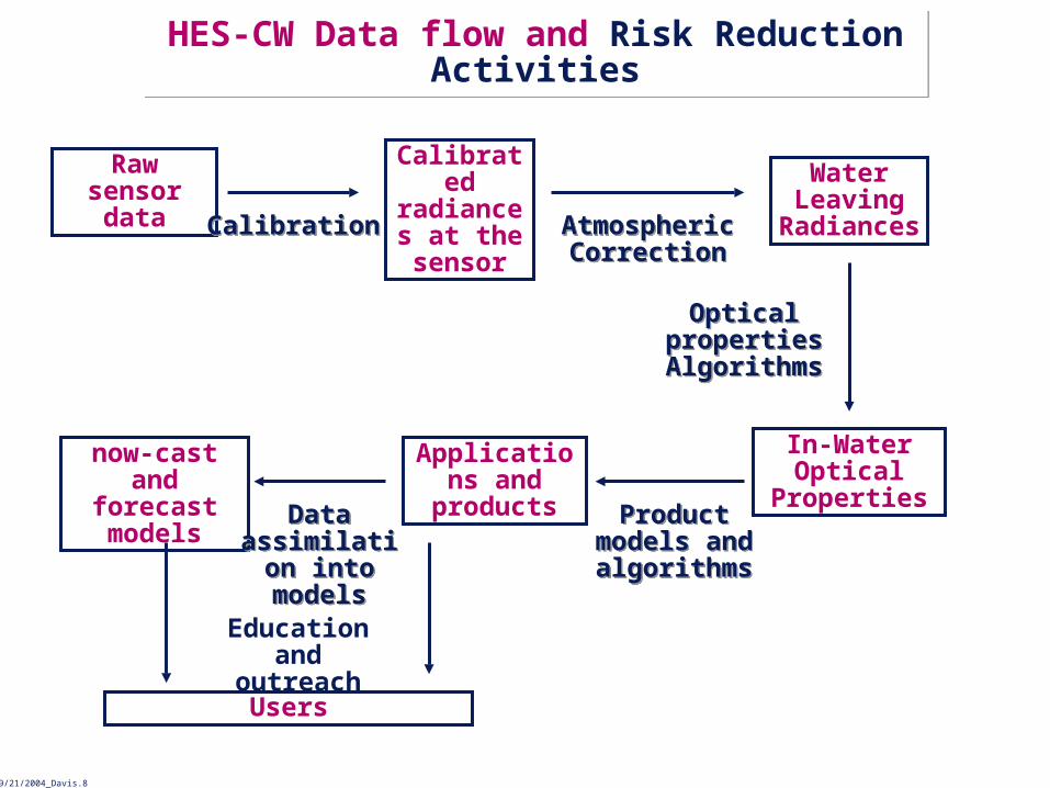
HES-CW Data flow and Risk Reduction Activities
HES-CW Data flow and Risk Reduction Activities
Raw sensor data
Calibrated radiances
at the sensor
Water Leaving
Radiances
In-Water Optical
Properties
Applications and products
Users
CalibrationCalibration Atmospheric Correction
Atmospheric Correction
Optical properties Algorithms
Optical properties Algorithms
Product models and algorithms
Product models and algorithms
now-cast and forecast models Data
assimilation into models
Data assimilation into models
Education and outreach

NRL09/21/2004_Davis.9
Approach to Algorithm DevelopmentApproach to Algorithm Development
• Directly involve the ocean color community which has extensive algorithm development experience with SeaWiFS and MODIS– NASA funded science teams developed, tested and validated calibration,
atmospheric correction and product algorithms– Additional product development and testing funded by U. S. Navy– SeaWiFS procedures and algorithms documented in series of NASA
Tech memos and numerous publications– MODIS algorithms documented in Algorithm Theoretical Basis
Documents (ATBDs)– Algorithms are continuously evaluated and updated; SeaWiFS and
MODIS data routinely reprocessed to provide Climate Data Records with latest algorithms
• Design program to assure compatibility of HES-CW products with VIIRS– VIIRS algorithms based on MODIS ATBDs– Similar calibration and atmospheric correction approaches– Use the same ocean calibration sites for vicarious calibration
• Initial plans and algorithms based on SeaWiFS and MODIS experience modified to fit HES-CW in geostationary orbit.
• Advanced algorithms tested and implemented when available.• Early tests planned using airborne hyperspectral data.
NRL09/21/2004_Davis.10
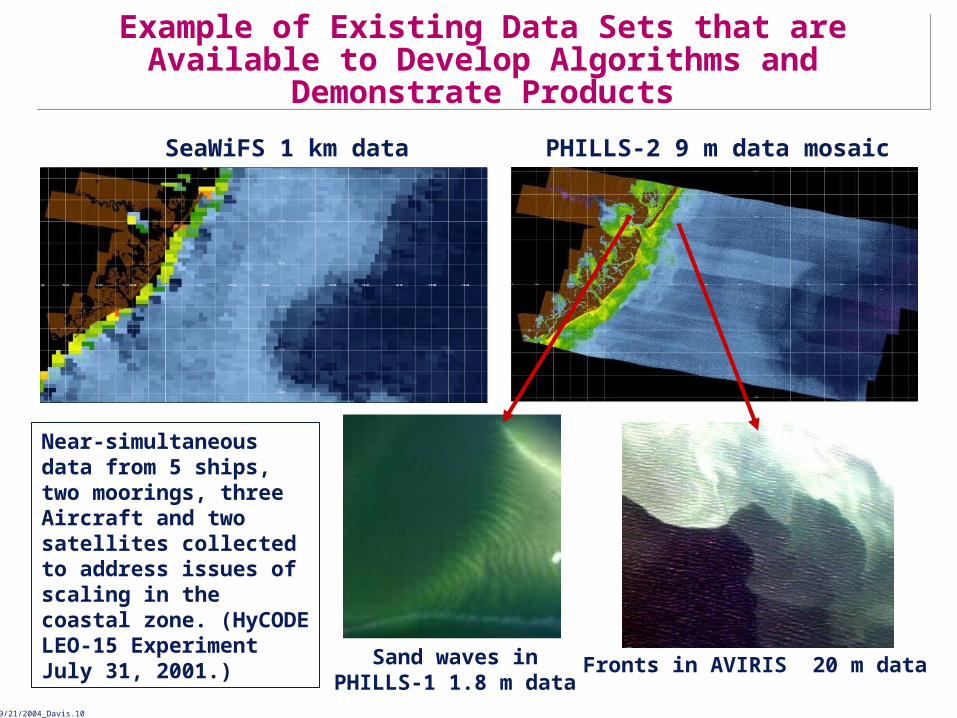
SeaWiFS 1 km data PHILLS-2 9 m data mosaic
Sand waves inPHILLS-1 1.8 m data
Fronts in AVIRIS 20 m data
Near-simultaneous data from 5 ships, two moorings, three Aircraft and two satellites collected to address issues of scaling in the coastal zone. (HyCODE LEO-15 Experiment July 31, 2001.)
Example of Existing Data Sets that are Available to Develop Algorithms and Demonstrate Products
Example of Existing Data Sets that are Available to Develop Algorithms and Demonstrate Products

NRL09/21/2004_Davis.11
Extensive In-situ data for product validation at LEO-15 site
Extensive In-situ data for product validation at LEO-15 site
Comparison at the X. (C. O. Davis, et al., (2002), Optics Express 10:4, 210--221.)
X
0
50
100
150
200
250
300
0.4 0.5 0.6 0.7 0.8 0.9Wavelength (microns)
Ref
lect
ance
X 1
04 PHILLS-1
Ground Truth ASD
Profiling Optics and Water Return (POWR) Package
Profiling Optics and Water Return (POWR) Package
PHILLS SensorPHILLS Sensor
NRL09/21/2004_Davis.12
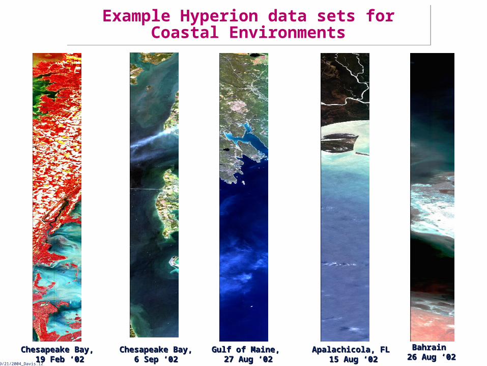
Chesapeake Bay,Chesapeake Bay, 19 Feb ‘0219 Feb ‘02
Gulf of Maine, Gulf of Maine, 27 Aug ‘0227 Aug ‘02
Apalachicola, FLApalachicola, FL 15 Aug ‘0215 Aug ‘02
Chesapeake Bay,Chesapeake Bay,6 Sep ‘026 Sep ‘02
Bahrain Bahrain 26 Aug ‘0226 Aug ‘02
Example Hyperion data sets for Coastal Environments
Example Hyperion data sets for Coastal Environments

NRL09/21/2004_Davis.13
Proposed Experiments to Collect Simulated HES-CW data (1 of 2)
Proposed Experiments to Collect Simulated HES-CW data (1 of 2)
• There are no existing data sets that include all the key attributes of HES-CW data:– Spectral coverage (.4 – 2.4 m)– High signal-to-noise ratio (>300:1 prefer 900:1, for ocean radiances)– High spatial resolution (<150 m, bin to 300 m) – Hourly or better revisit
• Propose field experiments in FY2006-2008 to develop the required data sets for HES-CW algorithm and model development.
• Airborne system:– Hyperspectral imager that can be binned to the HES-CW bands– Flown at high altitude for minimum of 10 km swath– Endurance to collect repeat flight lines every half hour for up to 6 hours– Baseline AVIRIS on ER-2 which can meet all of these requirements.
• Propose three experimental sites:– 2006 Monterey Bay (coastal upwelling, HABs)– 2007 New York/Mid Atlantic Bight (river input, urban aerosols)– 2008 Mississippi River Plume (Sediment input, HABs)

NRL09/21/2004_Davis.14
Proposed Experiments to collect simulated HES-CW data (2 of 2)
Proposed Experiments to collect simulated HES-CW data (2 of 2)
• Experimental Design– Choose sites with IOOS or other long term monitoring and modeling
activities– Intensive effort for 2 weeks to assure that all essential parameters are
measured:- Supplement standard measurements at the site with shipboard or
mooring measurements of water-leaving radiance, optical properties and products expected from HES-CW algorithms,
- Additional atmospheric measurements as needed to validate atmospheric correction parameters,
- As needed, enhance modeling efforts to include bio-optical models that will utilize HES-CW data.
– Aircraft overflights for at least three clear days and one partially cloudy day (to evaluate cloud clearing) during the two week period. - High altitude to include 90% or more of the atmosphere- 30 min repeat flight lines for up to 6 hours to provide a time series for
models and to evaluate changes with time of day (illumination, phytoplankton physiology, etc.)
• All data to be processed and then distributed over the Web for all users to test and evaluate algorithms and models.
NRL09/21/2004_Davis.15
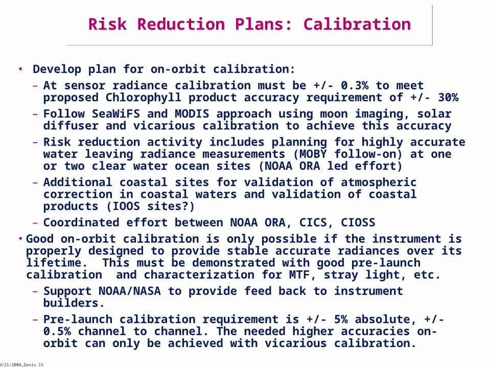
Risk Reduction Plans: CalibrationRisk Reduction Plans: Calibration
• Develop plan for on-orbit calibration:– At sensor radiance calibration must be +/- 0.3% to meet proposed
Chlorophyll product accuracy requirement of +/- 30%– Follow SeaWiFS and MODIS approach using moon imaging, solar
diffuser and vicarious calibration to achieve this accuracy– Risk reduction activity includes planning for highly accurate water
leaving radiance measurements (MOBY follow-on) at one or two clear water ocean sites (NOAA ORA led effort)
– Additional coastal sites for validation of atmospheric correction in coastal waters and validation of coastal products (IOOS sites?)
– Coordinated effort between NOAA ORA, CICS, CIOSS • Good on-orbit calibration is only possible if the instrument is properly
designed to provide stable accurate radiances over its lifetime. This must be demonstrated with good pre-launch calibration and characterization for MTF, stray light, etc.– Support NOAA/NASA to provide feed back to instrument builders. – Pre-launch calibration requirement is +/- 5% absolute, +/- 0.5% channel to
channel. The needed higher accuracies on-orbit can only be achieved with vicarious calibration.

NRL09/21/2004_Davis.16
Atmospheric Correction ChallengesAtmospheric Correction Challenges
We anticipate three major challenges in developing the atmospheric correction algorithms for HES-CW.
1. Adaptation of the current algorithms for SeaWiFS and MODIS to the geostationary viewing geometry, including addressing BRDF issues.
2. Dealing with Absorbing Aerosols which are common downwind from urban and industrial areas.
3. In coastal waters with high levels of suspended sediments, or large phytoplankton blooms the contributions at the NIR bands are not negligible. This can lead to significant underestimation of the satellite-derived water-leaving radiance spectrum (SeaWiFS, MODIS).

NRL09/21/2004_Davis.17
Current Atmospheric Correction AlgorithmsCurrent Atmospheric Correction Algorithms
w is the desired quantity in ocean color remote sensing.
Tg is the sun glint contribution—avoided/masked and residual
contamination is corrected.
twc is the whitecap reflectance—computed from wind speed.
r is the scattering from molecules—computed using the Rayleigh
lookup tables.
A = a + ra is the aerosol and Rayleigh-aerosol contributions —
estimated using aerosol models.For Case-1 waters in the open ocean, w is usually negligible at
765 & 865 nm. A can be estimated using these two NIR bands.
w is the desired quantity in ocean color remote sensing.
Tg is the sun glint contribution—avoided/masked and residual
contamination is corrected.
twc is the whitecap reflectance—computed from wind speed.
r is the scattering from molecules—computed using the Rayleigh
lookup tables.
A = a + ra is the aerosol and Rayleigh-aerosol contributions —
estimated using aerosol models.For Case-1 waters in the open ocean, w is usually negligible at
765 & 865 nm. A can be estimated using these two NIR bands.Menghua Wang, NOAA/NESDIS/ORAMenghua Wang, NOAA/NESDIS/ORA
SeaWiFS and MODIS algorithm (Gordon and Wang 1994)SeaWiFS and MODIS algorithm (Gordon and Wang 1994)
t r A twc Tg tw, L 0 F0
NRL09/21/2004_Davis.18
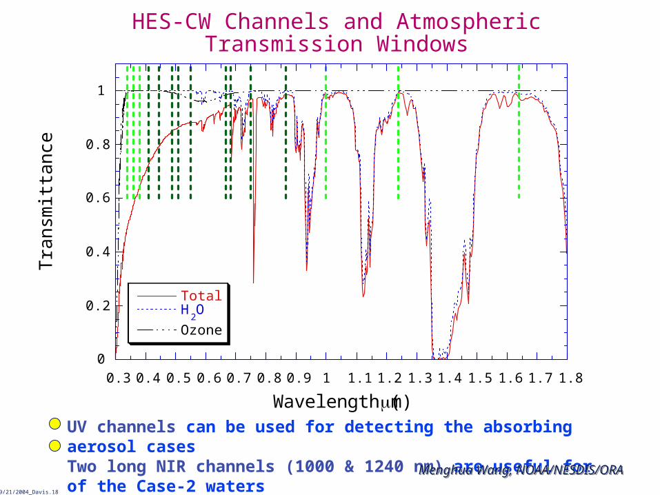
HES-CW Channels and Atmospheric Transmission Windows
0
0.2
0.4
0.6
0.8
1
0.3 0.4 0.5 0.6 0.7 0.8 0.9 1 1.1 1.2 1.3 1.4 1.5 1.6 1.7 1.8
TotalH
2O
Ozone
Tra
nsm
ittan
ce
Wavelength (m)UV channels can be used for detecting the absorbing aerosol casesTwo long NIR channels (1000 & 1240 nm) are useful for of the Case-2 waters
Menghua Wang, NOAA/NESDIS/ORAMenghua Wang, NOAA/NESDIS/ORA

NRL09/21/2004_Davis.19
Risk Reduction Plans: Atmospheric correctionRisk Reduction Plans: Atmospheric correction
• Atmospheric correction needed to produce water-leaving radiance.• Approach:
– Evolution of algorithms from the current SeaWiFS, MODIS algorithms.– Adjustments for Geostationary orbit geometry– Adaptation to different spectral channels– Development of coastal atmospheric correction algorithm:
- Address absorbing aerosols,- Address high reflectance in coastal waters where NIR channels cannot
be used for aerosol calculations. – Current effort between NOAA ORA, CICS, CIOSS
- Providing feedback to NOAA/NASA and instrument and spacecraft vendors to assure spectral channel characteristics, etc.
– Would like to expand effort to include collaborative efforts with CIMSS, CIRA, others?
– Explore advantages of using HES sounder and ABI data to improve atmospheric correction.

NRL09/21/2004_Davis.20
Risk Reduction Plans: In-water Optical Properties 1Risk Reduction Plans: In-water Optical Properties 1
Remote-sensing reflectance (Rrs, water-leaving radiance normalized by
the downwelling irradiance) is a function of properties of the water column and the bottom,
Rrs() = f[a(), bb(), (), H], (1)
where a() is the absorption coefficient, bb() is the backscattering
coefficient, () is the bottom albedo, H is the bottom depth. In optically deep waters (when the bottom is not imaged),
Rrs() = f[bb()/a() + bb()] (2)
Where f is a proportionality constant that varies slightly as a function of the shape of the volume scattering function and the angular distribution of the light field. The backscattering coefficient bb() is the sum of the
backscattering from the phytoplankton, detritus, suspended sediments and the water itself. The absorption coefficient a() is the sum of the absorption by CDOM, phytoplankton, detritus, suspended sediments and the water itself.
NRL09/21/2004_Davis.21
Risk Reduction Plans: In-water Optical Properties 2Risk Reduction Plans: In-water Optical Properties 2
• Algorithms for SeaWiFS and MODIS use spectral channel ratios to calculate specific products, such as suspended sediments, chlorophyll and CDOM.
– This approach does not work if the bottom is imaged (e.g. West Florida Shelf), or in the presence of high levels of suspended sediments (e.g. Mississippi River Plume)
• Excellent Radiative Transfer Models (e.g. HYDROLIGHT) are available to model the light field – the challenge for remote sensing is to invert those models to go from remote sensing reflectance to estimates of the in-water constituents.
• Two approaches are demonstrated that solve the full problem and produce values for water column optical properties, bathymetry and bottom type.
– A predictor-corrector approach is used to invert a semi-analytical model
– A look-up table approach has been used to invert HYDROLIGHT.

NRL09/21/2004_Davis.22
Bathymetry, Bottom Type and Optical Properties Example Approach: Semi-Analytical Models
Bathymetry, Bottom Type and Optical Properties Example Approach: Semi-Analytical Models
a) Bottom type and b) bathymetry derived from an AVIRIS image of Tampa Bay, FL using automated processing of the hyperspectral data. Accurate values were retrieved in spite of the fact that water clarity varies greatly over the scene.
(Lee, et al., J. Geophys. Research, 106(C6), 11,639-11,651, 2001.)
Seagrass beds
Sand barsNavigation channel
• Semi-analytical model developed to resolve the complex optical signature from shallow waters.
• Simultaneously produces bathymetry, bottom type, water optical properties.

NRL09/21/2004_Davis.23
Bathymetry, Bottom Type and Optical Properties Example Approach: Look-up Tables
Bathymetry, Bottom Type and Optical Properties Example Approach: Look-up Tables
Interpretation of hyperspectral remote-sensing imagery via spectrum matching and look-up tables. Mobley, C. D., et al., Applied Optics, 2005.Interpretation of hyperspectral remote-sensing imagery via spectrum matching and look-up tables. Mobley, C. D., et al., Applied Optics, 2005.

NRL09/21/2004_Davis.24
Risk Reduction Plans: In-water Optical Properties 3Risk Reduction Plans: In-water Optical Properties 3
Planned Risk Reduction Activities:
• NASA and the Navy have a set of band ratio type algorithms to produce in-water optical properties from SeaWiFS and MODIS data.
• Initial approach will be to adapt those algorithms for use with HES-CW. • Main Risk Reduction effort will be to develop comprehensive methods along
the lines of the Lee et al. and Mobley, et al. approaches that have been demonstrate for airborne hyperspectral data.– Will work in all conditions even when the bottom is imaged
• Algorithm work can be initiated immediately with existing data sets but the HES-CW demonstration data set will be essential for the full demonstration of the algorithms.
• Initiate effort in 2006 to use existing data sets and to participate in the planning of the HES-CW demonstration experiment to assure that all of the essential data is collected.
• Expanded effort in 2009 utilizing the demonstration data set and Web based data system.

NRL09/21/2004_Davis.25
Risk Reduction Plans: Phytoplankton chlorophyll, chlorophyll fluorescence and productivity
Risk Reduction Plans: Phytoplankton chlorophyll, chlorophyll fluorescence and productivity
• Chlorophyll and Chlorophyll fluorescence – Fluorescence unambiguously associated with chlorophyll– Signal is small, but use of baseline approach greatly reduces impact of
atmosphere on retrievals– Amount of fluorescence per unit chlorophyll varies as function of light,
phytoplankton physiology, and species composition• Validation relies on long time series of high quality measurements to ensure
consistency– IOOS, MOBY sites– Analysis of MODIS Aqua and Terra data sets– AVIRIS or other overflights
• Estimates of chlorophyll and productivity– Continued field and satellite data analysis– Modeling of quantum yield of fluorescence based on laboratory
analyses, comparison with field measurements– Incorporate quantum yield into productivity models– Compare with recent chlorophyll/backscatter models using SeaWiFS
NRL09/21/2004_Davis.26
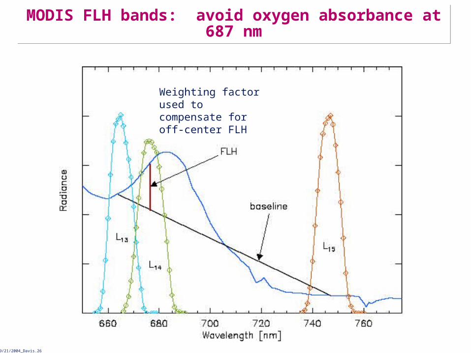
Weighting factor used to compensate for off-center FLH
MODIS FLH bands: avoid oxygen absorbance at 687 nmMODIS FLH bands: avoid oxygen absorbance at 687 nm

NRL09/21/2004_Davis.27
0
0.02
0.04
0.06
0.08
0.1
0.12
0.14
0.16
0.18
0 0.05 0.1 0.15 0.2 0.25
Oregon Drifters FLH, W m-2 m-1 sr-1
MO
DIS
Terr
a F
LH,
W m
-2
m-1 s
r-1
MODIS Terra FLH vs Oregon optical drifters derived FLH
MODIS Terra FLH vs Oregon optical drifters derived FLH
NRL09/21/2004_Davis.28
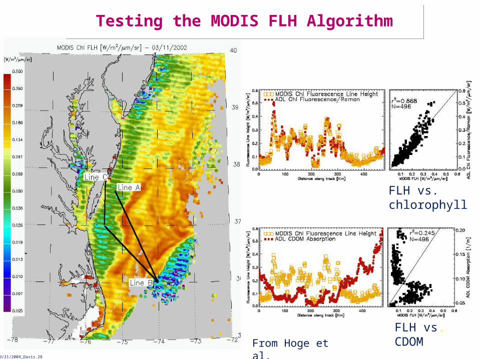
From Hoge et al.
FLH vs. chlorophyll
FLH vs. CDOM
Testing the MODIS FLH AlgorithmTesting the MODIS FLH Algorithm

NRL09/21/2004_Davis.29
Frequent measurements in morning can elucidate quantum yield of fluorescenceFrequent measurements in morning can elucidate quantum yield of fluorescence
I nitial slope proportional to FI nitial slope proportional to F
NRL09/21/2004_Davis.30
Risk Reduction Plans: Phytoplankton chlorophyll, chlorophyll fluorescence and productivity
Risk Reduction Plans: Phytoplankton chlorophyll, chlorophyll fluorescence and productivity
• Proposed activities:
- Development of chlorophyll and fluorescence algorithms based on SeaWiFS and MODIS legacy and modified to fit HES-CW in geostationary orbit.
- Characterization of chlorophyll and chlorophyll fluorescence algorithm sensitivity based on HES-CW (waveband position and SNR) characteristics (i.e. Letelier and Abbott 1996)
- Generation of HES-CW synthetic chlorophyll and fluorescence products in coastal (case II) waters using Hyperion and PHILLS data, and data from field experiments in 2007-2008.
- These field experiments will serve to:
1) Validate a chlorophyll algorithm for case II waters based on chlorophyll fluorescence.
2) Assess diurnal changes in algal physiology affecting carbon:chlorophyll ratio and the chlorophyll fluorescence efficiency.
3) Evaluate how water column stability and CDOM concentrations affect the apparent relationship between chlorophyll concentration and the chlorophyll fluorescence in algorithms inherited from SeaWiFS and MODIS.
4) Develop improved productivity models incorporating laboratory estimates of quantum yield.

NRL09/21/2004_Davis.31
Risk Reduction Plans: Benthic ProductivityRisk Reduction Plans: Benthic Productivity
Benthic habitats are degrading and seagrass beds are decreasing at an alarming rate. To better understand and monitor that process we propose to develop procedures and algorithms for using GOES-R HES-CW data to quantify benthic productivity.
• Develop algorithms for estimating benthic productivity from seagrass and sediment across the large optically shallow carbonate sediment basins (Florida Bay, Bahamas, etc.).
• Conduct sensitivity analysis identifying U.S. coastal regions (e.g., Chesapeake Bay, Monterey Bay) with optically shallow water ecosystems that can be resolved by the GOES-R HES-CW. Potential benthic constituents for analysis include seagrasses, kelp, and benthic algal mats.
• Use seagrass canopy model (Zimmerman 2003), bathymetry and remotely derived estimates of diel and seasonal water column optical properties to develop predictive maps of the optically shallow regions that could support seagrass habitats based on light availability.
• Use the field data collected during the process studies to extrapolate benthic productivity algorithms from the carbonate systems to other coastal ecosystems identified in the sensitivity analysis.

NRL09/21/2004_Davis.32
Risk Reduction Plans: Harmful Algal Blooms Background
Risk Reduction Plans: Harmful Algal Blooms Background
• In the Gulf of Mexico, blooms of the toxic algae Karenia brevis result in shellfish bed closures and lost tourism that cost the state of Florida millions of dollars each year.
• Similar problems in other parts of the country with other toxic species.
• Ship based monitoring very expensive and time consuming
• Inadequate data frequently leads to unnecessary closings.
• HABSOS system being developed to provide early warnings using SeaWiFS data and models
• HES-CW will greatly improve warning systems like HABSOS
– More frequent data for cloud clearing
– Higher spatial resolution to assess conditions closer to the shell fish beds and beaches

NRL09/21/2004_Davis.33
Some properties have a diel cycle associated with it.
Documenting the diel dynamics can thus potentiallyassist in documenting and identifying material in the ocean
-81º-83º-85º-87º
-82.5º-83º-83.5º-84º
27º
27.5º
28º
26.5ºOctober 2001 EcoHAB StationOctober 2001 EcoHAB Diel Station
29º
27º
25º
31ºCase example:
Detection of K. brevis
Frequent sampling can assist in detection and classification of HABs
Frequent sampling can assist in detection and classification of HABs

NRL09/21/2004_Davis.34
Cel
ls L
-1
(x10
5 )
0.0
0.4
0.8
1.2
1.6
0.20
0.25
0.30
dissolved a(440) (m-1)
A) Karenia brevis cell abundance
08:00 14:00 20:00 02:00Time of Day
10a
total 676 nm
5
0
Dep
th (
m)
A)
B)
0.20
0.10
When K. brevisBlooms, conditions
tendto be calm. Under
these Conditions the cells exhibit a dramatic
dielmigration. The net
resultis a 10X increase in
cells at the air-sea
interface over a several
hour period. This unique feature will be readily detected
in HES-CW data.

NRL09/21/2004_Davis.35
HABSOS can immediately utilize improved spatial resolution and frequency of coverage from HES-CWHABSOS can immediately utilize improved spatial
resolution and frequency of coverage from HES-CW
NRL09/21/2004_Davis.36
Risk Reduction Plans: Harmful Algal BloomsRisk Reduction Plans: Harmful Algal Blooms
Proposed Risk Reduction Activities:• Improve methods for early detection of HABs from optical remote sensing
data– Not all HABs have a unique optical signature – use additional
information, e.g. vertical migration to identify blooms.– Specific methods needed for each region of the country to identify local
species, etc.• Continue development of models of HAB dynamics
– Higher frequency of HES-CW data critical for cloud clearing and to include vertical migration in the models
• Prepare to use HES-CW data in warning systems, such as, HABSOS– Increased frequency of sampling for cloud clearing will provide faster
updates allowing more precise system for warnings - Avoid unnecessary costly beach and shellfish bed closures
• Strong education component to educate the state and local managers and the public as to the benefits of HES-CW data and improved models and forecasts.

NRL09/21/2004_Davis.37
Coastal Carbon CycleCoastal Carbon Cycle
• Detailed studies of the Oregon coastal upwelling system to determine its role as a CO2 source or sink.
• pCO2 in coastal (and other) environments is associated with
characteristic chlorophyll and SST signatures.
• Using multiple satellite products and techniques, such as multiple linear regression, we have developed an approach to determine sea surface pCO2 from space.
• Combine this with winds from either scatterometer(s) or coastal/buoy meteorological stations to facilitate flux calculations.
(Hales et al., 2004. Atmospheric CO2 uptake by a coastal upwelling system. Global Biogeochemical Cycles, 19, GB1009, 10.1029/2004GB002295.)

NRL09/21/2004_Davis.38
Cascade Head: Repeat
sections
Cape Perpetua: Extended sections
Coastal Oregon Study SiteCoastal Oregon Study Site

NRL09/21/2004_Davis.39
Undersaturation of CO2 in coastal watersUndersaturation of CO2 in coastal waters
Freshly upwelled water near the Oregon coast is a CO2 source to the atmosphere. As the water moves offshore the phytoplankton bloom making the same waters a CO2 sink.
Freshly upwelled water near the Oregon coast is a CO2 source to the atmosphere. As the water moves offshore the phytoplankton bloom making the same waters a CO2 sink.
Cascade Head time series
Cascade Head time series

NRL09/21/2004_Davis.40
Coastal CO2: Relationship to physics and biologyCoastal CO2: Relationship to physics and biology
Productivity & CO2 uptake
N limitation offshore

NRL09/21/2004_Davis.41
Risk Reduction Plans: Coastal CO2 FluxesRisk Reduction Plans: Coastal CO2 Fluxes
• The coastal ocean plays a large and poorly measured role in the global carbon cycle.
– Addresses NOAA’s climate change goals • HES-WC will provide valuable data to study this process;
– Temporal sampling of 3 hours will enable basic budgets to be calculated and the tracking of processes such as productivity and subduction.
– This is a dynamic environment – any ability to ‘clear’ or alias clouds will enhance badly-needed coverage.
• Coupling with NASA’s Orbiting Carbon Observatory (2008) will add significant coupling to atmospheric data.
• Proposed risk reduction activities:– Continue to develop and refine current models and algorithms using
SeaWiFS, MODIS and shipboard data.– Update algorithms to take advantage of HES-CW data.– Adapt approach to take advantage of IOOS and associated modeling
efforts.
NRL09/21/2004_Davis.42
Risk Reduction Plans: Now-cast and forecast models
Risk Reduction Plans: Now-cast and forecast models
• Now-cast and forecast models are currently under development for the coastal ocean;– Model development will be closely coupled with IOOS,– Current emphasis is on getting the physics right and on assimilating
surface currents, wind data and other physical parameters,– Some bio-optical models that could make excellent use of HES-CW data
have been demonstrated,– Work in this area will require the HES-CW demonstration data set to be
collected in 2007-2008,– Plan to initiate modeling efforts in 2009.
• A second class of prognostic models for HABs are being developed for several coastal regions– Begin limited effort in 2006 to support those models specifically
emphasizing the utility of HES-CW data to improve skill of those models– Utilize the HES-CW demonstration data set beginning in 2009.

NRL09/21/2004_Davis.43
EcoSim 2 Model Output for July 31, 2001 HyCODE experiment at (LEO-15)
EcoSim 2 Model Output for July 31, 2001 HyCODE experiment at (LEO-15)
July 31 SeaWiFS Chlor-a (mg/m3)
.5
2
3
4
5
39:30N
39:00N
Node A
UCSB
Small diatoms
Large diatoms
Satellite Measured
Bissett, et al., Submitted J. Geophys. Res.

NRL09/21/2004_Davis.44
Risk Reduction Plans: Data ManagementRisk Reduction Plans: Data Management
• Data processing, distribution and archiving issues.– Need more processing capacity for atmospheric correction and product
algorithms (3-5 X the calibration processing)– Need for reprocessing with updated calibrations and new algorithms to
make Climate Data Records and the need to archive CDRs- Planned data system not sized for reprocessing.
• Next generation product generation and delivery services will build on the notion of “web services,” which are industry standard tools for building complex services from building block components and multiple data streams. Web services can provide new capabilities that are not anticipated in the original systems design. By designing these services as linked components rather than monolithic systems, GOES-R can provide a much greater degree of flexibility and evolution within a cost-constrained environment.
• We propose monitoring and providing advice on current plans for the HES-CW data system, with specific risk reduction activities beginning in 2008. – Web based server with the the Simulated HES-CW data from the
proposed experiments. Include all ancillary data and access to models for testing.

NRL09/21/2004_Davis.45
Example: CI-CORE Data on GIS Web Server. Airborne hyperspectral data for the Big Sur Coast
Example: CI-CORE Data on GIS Web Server. Airborne hyperspectral data for the Big Sur Coast
NRL09/21/2004_Davis.46
Risk Reduction Plans: Education and Public Outreach
Risk Reduction Plans: Education and Public Outreach
For education and outreach CIOSS will support three activities:• Demonstrating and training users on the algorithms and
products developed during the risk reduction activities.• Informing the general public as to the value and utility of HES-
CW data.• Educating state and local users to the value and utility of HES-
CW products. • For the general public and state and local users we will work
through the Coastal Services Center.– Currently developing a brochure on HES-CW with CSC.
• Initially a very low level effort for the first three years. • Increase activity according to need and requests from NOAA.

NRL09/21/2004_Davis.47
SummarySummary
• HES-CW will provide an excellent new tool for the characterization and management of the coastal ocean.
• We will build on extensive experience in calibration, atmospheric correction, algorithm development from SeaWiFS and MODIS and continuing with VIIRS to provide the necessary algorithms for HES-CW.
• Planned Activities focus on calibration and algorithm development;– Initially utilize existing data sets including SeaWiFS and MODIS,– 2007-2008 field experiments to develop example HES-CW data for
- algorithm development and testing,- Coordination with IOOS for in-situ data and coastal ocean models,- Demonstrate terabyte web-based data system.
– Initially provide SeaWiFS and MODIS heritage calibration and algorithms;- Calibration approach includes vicarious calibration,- Heritage band-ratio algorithms.
– Major focus on developing advanced algorithms that take advantage of HES-CW unique characteristics.
• Efforts coordinated with NOAA ORA, NMFS and NOS with a focus on meeting their operational needs.