nsw oeh - eis and technical reports » gold coast quarry - air quality report... · operational...
TRANSCRIPT
Katestone Environmental Pty Ltd D1205128-3 Cardno HRP - Gold Coast Quarry Air Quality Assessment
April 2013 Page 74
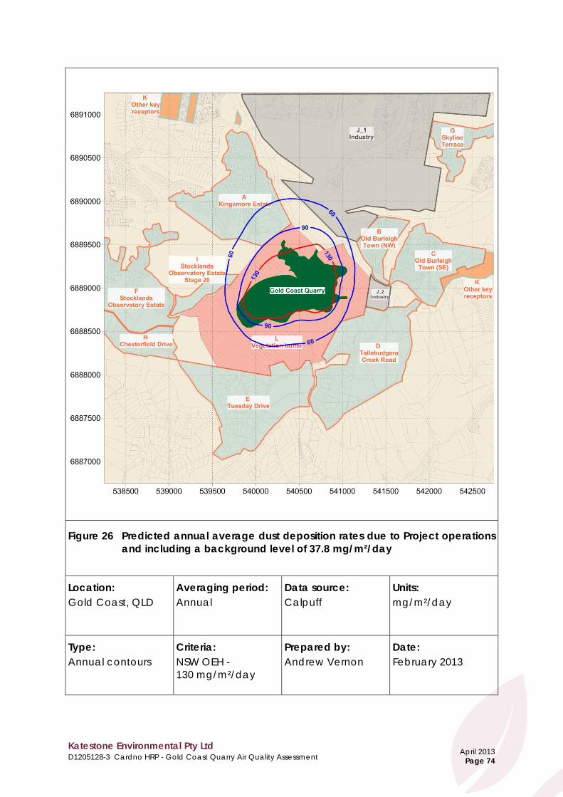
Figure 26 Predicted annual average dust deposition rates due to Project operations and including a background level of 37.8 mg/m²/day
Location: Gold Coast, QLD
Averaging period: Annual
Data source: Calpuff
Units: mg/m²/day
Type: Annual contours
Criteria: NSW OEH - 130 mg/m²/day
Prepared by: Andrew Vernon
Date: February 2013

Katestone Environmental Pty Ltd D1205128-3 Cardno HRP - Gold Coast Quarry Air Quality Assessment
April 2013 Page 75
Figure 27 Predicted annual average concentration of respirable crystalline silica due to Project operations in isolation
Location: Gold Coast, QLD
Averaging period: Annual
Data source: Calpuff
Units: µg/m³
Type: Annual contours
Criteria: Vic EPA - 3 µg/m³
Prepared by: Andrew Vernon
Date: February 2013

Appendix A Methodology and Activity Data for Dust Emissions Inventory

Katestone Environmental Pty Ltd D1205128-3 – Cardno HRP – Boral Gold Coast Quarry - Air Quality Assessment - Appendix A
April 2013 Page i
Contents
A1 Gold Coast Quarry Dust Emissions Inventory .................................................... 1 A2 Methodology and activity data for Operation Q5 dust emissions
inventory ................................................................................................................ 2 A2.1 Quarry hours of operation ....................................................................... 2 A2.2 Drilling ......................................................................................................... 2 A2.3 Blasting ....................................................................................................... 3 A2.4 Bulldozing ................................................................................................... 3 A2.5 Material transfers ...................................................................................... 4 A2.6 Screening ................................................................................................... 6 A2.7 Crushing ..................................................................................................... 6 A2.8 Conveyor emissions .................................................................................. 7 A2.9 Haulage on Unpaved Roads .................................................................. 8 A2.10 Haulage on Paved Roads ....................................................................... 9 A2.11 Grading of Unsealed Haul Roads........................................................... 9 A2.12 Wind Erosion ............................................................................................ 10
A2.12.1 Wind Erosion of Active Stockpiles ........................................ 10 A2.12.2 Wind Erosion of Exposed Areas ............................................ 11
A3 References .......................................................................................................... 12

Katestone Environmental Pty Ltd D1205128-3 – Cardno HRP – Boral Gold Coast Quarry - Air Quality Assessment - Appendix A
April 2013 Page 1
A1 Gold Coast Quarry Dust Emissions Inventory
Dust emissions for activities related to each stage of the quarry were based on emission factors and methods published by the US EPA (US EPA, 1998; US EPA 2006a; US EPA 2006b; US EPA 2004; US EPA 2003; US EPA 2011). Operational information, site layouts, quarrying methods and vehicle information were provided by Boral and Cardno HRP. Typical quarry product and overburden characteristics were taken from the US EPA AP-42 documents where information was not available. The complete dust emissions inventory is detailed in Section 7, Table 13 of the Gold Coast Quarry Air Quality Assessment Report and reproduced below.
Stage Emission Rate (g/s)
TSP PM10 PM2.5 Establishment 1 (E1) 0.52 0.10 0.01
Establishment 2 (E2) 4.15 1.23 0.13
Establishment 3 (E3) 6.26 1.82 0.19
Development 1 and 2 (D1/D2) 8.44 2.83 0.38
Development 3 and 4 (D3/D4) 11.72 3.82 0.50
Operation (Q1 -Q5)1 24.01 9.13 1.18 Table note: 1 Operation expected to last for 40 years at extraction rate of 2 Mtpa. These emissions are based on Operational Stage Q5, which is 2Mtpa extraction with full development of the pit A summary of the activities from each stage of the quarry is provided in the table below. Incremental tonnage per Stage/Phase Material Phase E1 Phase E2 Phase E3 Phase D1 Phase D2 Phase D3 Phase D4 Topsoil 4000 15912 8964 26100 0 18900 0 Cut 21900 422240 453180 888942 1441133 1365735 1405650 Fill 1850 95760 115900 0 0 24890 0 Overburden 20050 326480 337280 776652 844625 744338 827775 Product 0 0 0 112290 596507 596507 577875 The following sections describe in detail the methodologies and activity data that was used to calculate the dust emissions inventory for the operational stage (phase Q5) of the Gold Coast Quarry, and used in the air quality assessment.
Katestone Environmental Pty Ltd D1205128-3 – Cardno HRP – Boral Gold Coast Quarry - Air Quality Assessment - Appendix A
April 2013 Page 2
A2 Methodology and activity data for Operation Q5 dust emissions inventory
The following sections detail how dust emissions from each activity were calculated and list the activity data used for the calculation. Where possible, discussion of the parameters that have the greatest influence on the dust emissions has been included. A2.1 Quarry hours of operation
Boral provided the following information regarding the operating hours of the proposed quarry. Each section includes detail of how the operating hours for each activity have been incorporated into the dispersion modelling to provide a more accurate prediction of potential impacts. Parameter Units Value Comments Number of operating days per week for quarry
Days/ week 6 Quarry operates Monday to Saturday
Quarry operating hours hours 12 6am - 6pm Number of days per week for blasting Days/week 5 Monday to Friday
Blasting hours per day hours 8 9am - 5pm A2.2 Drilling
The emission factors for drilling were calculated from the AP42 documents, chapter 11.9 "Western Surface Coal Mining" (October 1998). Material Units TSP PM10 PM2.5 Overburden/raw quarry material kg/hole 0.59 TSP x 0.52 TSP x 0.03
To estimate peak emissions and therefore the maximum ground-level concentrations of dust over a 24-hour period, one blast per day was assumed, and therefore the drilling of 150 holes per day was also assumed. Calpuff was set up to model the dispersion of dust emissions due to drilling 150 holes released at a constant rate between 6am to 6pm, each day. Parameter Units Value Source Number of holes drilled per blast holes/blast 150 Boral

Katestone Environmental Pty Ltd D1205128-3 – Cardno HRP – Boral Gold Coast Quarry - Air Quality Assessment - Appendix A
April 2013 Page 3
A2.3 Blasting
The emission factor for blasting was calculated from the AP42 documents, chapter 11.9 "Western Surface Coal Mining" (October 1998). Material Units TSP PM10 PM2.5 Overburden/raw quarry material kg/blast 0.00022 x A1.5 TSP x 0.52 TSP x 0.03
Where A is the area per blast (m2). One blast per day was assumed in order to estimate the maximum ground-level concentrations of dust due to quarry operations over a 24-hour period. Actual frequency of blasting is proposed to be once a week. Parameter Units Value Source
Blasts per day blasts/day 1 For dispersion modeling purposes,
actual frequency of blasting is proposed to be once a week.
Area per blast (A) m2 1300 Blastechnology Calpuff was set up to model the dispersion of dust emissions due to one blast released at a constant rate between 6am to 6pm, each day, which is consistent .with the objectives for PM10 and PM2.5. A2.4 Bulldozing
The emission factors for bulldozing were calculated from the AP42 documents, chapter 11.9 “Western Surface Coal Mining” (October 1998). Material Units TSP PM10 PM2.5
Overburden/raw quarry material kg/hr 3.1
2.1
)()(6.2
Ms
4.1
5.1
)()(45.074.0
Ms
× TSP x 0.105
Where s = material silt content (%) M = material moisture content (%) Emissions of dust due to dozer movements in the active pit area were calculated using the following activity data. Parameter Units Value Source Number of bulldozers number 1 Boral
Operations hours/day for each bulldozer hr 12
Assumed to operate continuously while other quarry operations occur (i.e. from
6am to 6pm) Silt content of active pit material % 6.9 US EPA AP42 documents, Chapter 13.3
"Unpaved roads" (US EPA, 2006a). Average value for bulldozing
overburden Moisture content of active pit material % 7.9
Calpuff was set to model the continuous use of the bulldozer between 6am to 6pm, each day. While the emissions due to dozer activity are dependent on material characteristics, they are directly proportional to the hours of operation. The estimate of emissions is conservative as it has assumed a 100% utilisation rate for the bulldozer.

Katestone Environmental Pty Ltd D1205128-3 – Cardno HRP – Boral Gold Coast Quarry - Air Quality Assessment - Appendix A
April 2013 Page 4
A2.5 Material transfers
Material is transferred at various locations and by several types of equipment during quarry operations. The emission rates for transfer points were calculated using the following equation from the AP42 documents, chapter 13.2 "Aggregate Handling and Storage Piles" (November 2006b):
tkgMUkE /22.2
0016.04.13.1 −
=
k = 0.74 for particles less than 30 μm k = 0.35 for particles less than 10 μm k = 0.053 for particles less than 10 μm U = mean wind speed in m/s M = material moisture content The following activity data were used to calculate emissions due to material transfers. Parameter Units Value Source Comments
Mean wind speed between 6am and 6pm
m/s 3.3 CALMET
All material transfers will occur during quarry
operating hours, during which the average wind
speed is slightly higher than over a 24-hour period
Overburden moisture content % 7.9
US EPA AP42 documents, Chapter 13.3
"Unpaved roads" (US EPA, 2006a). Average
value for bulldozing overburden
Used for: • front end loaders
moving overburden in active pit area
• truck dumping overburden
Raw material moisture content
% 2.1
US EPA AP42 documents, chapter
13.2.4, average values for stone quarrying and processing "various limestone products"
Used for: • front end loaders
moving raw quarry material
Product moisture content % 2.1
US EPA AP42 documents, chapter
13.2.4, average values for stone quarrying and processing "crushed
limestone"
Used for: • front end loaders • truck dumping • trip feeders • conveyor transfers • surge bins • stacking • reclaiming

Katestone Environmental Pty Ltd D1205128-3 – Cardno HRP – Boral Gold Coast Quarry - Air Quality Assessment - Appendix A
April 2013 Page 5
Throughputs Parameter Units Value Source Front end loader overburden extraction/dumping rate
tph 100 Assumed to match extraction rate
Front end loader raw material extraction rate
tph 900
Process flow diagrams provided by Boral
Truck dumping to primary crusher tph 895
Total transfer capacity through primary crusher stage
tph 3,080
Stacking and reclaiming rate at scalps/roadbase stockpile
tph 142
Stacking and reclaiming rate at primary stockpile
tph 752
Total trip feeder rate near primary stockpile tph 752
Stacking and reclaiming rate at scalps/roadbase stockpile
tph 142 Process flow diagrams provided by Boral
Stacking and reclaiming rate at secondary scalps stockpile
tph 292 Assumed equivalent to blending stockpile.
Total transfer capacity through secondary crusher stage
tph 4,343
Process flow diagrams provided by Boral Total transfer capacity through tertiary crusher stage
tph 5,892
Stacking and reclaiming rate at ballast stockpile
tph 292 Assumed equivalent to blending stockpile.
Total transfer capacity through final screening stage
tph 1,498 Process flow diagrams provided by Boral
Total transfer capacity in loadout tph 2,685
Stacking and reclaiming rate at blending stockpile
tph 292 Assumed reclaiming rate. Stacking rate provided on process flow diagrams from Boral
Calpuff was set up to model dispersion of dust emissions due to material transfers released between 6am and 6pm.

Katestone Environmental Pty Ltd D1205128-3 – Cardno HRP – Boral Gold Coast Quarry - Air Quality Assessment - Appendix A
April 2013 Page 6
A2.6 Screening
Emission factors for screening at the processing plant were calculated using the AP42 documents, chapter 11.19.2 "Crushed Stone Processing and Pulverized Mineral Processing." Material Units TSP PM10 PM2.5
Raw quarry material and product
kg/Mg 0.0125 0.0043
PM10 x 0.000025 / 0.00037 (using the ratio of controlled screening PM2.5 and PM10 emission factors for as a
scaling factor) The following throughputs, provided by Boral, were used to calculate the peak emissions due to screening over a day of quarry operations. Calpuff was set up to model dispersion of these emissions released at a constant rate between 6am and 6pm each day.
Screen number Units Maximum throughput Comments
1 tph 242 Screens within primary crushing stage 2 tph 242
3 tph 237 4 tph 752 Screens within secondary crushing
stage 5 tph 442 6 tph 442 7 tph 379
Screens within tertiary crushing stage 8 tph 379 9 tph 749
10 tph 375
Screens within final screening stage 11 tph 375 12 tph 291 13 tph 121
A2.7 Crushing
Emission factors for primary, secondary and tertiary crushing of quarry products at the processing plant were calculated using the AP42 documents, chapter 11.19.2 "Crushed Stone Processing and Pulverized Mineral processing” (August 2004). Emission factors for all crushing operations have been determined from the emission factor for tertiary crushing. Material Units TSP PM10 PM2.5
Raw and product material
kg/Mg 0.0027 0.0012
TSP x 0.00005 / 0.0027 (using the ratio
of controlled tertiary crushing PM2.5 and
TSP emission factors for as a scaling factor)
The following throughputs, provided by Boral, were used to calculate the peak emissions due to crushing over a day of quarry operations. Calpuff was set up to model dispersion of these emissions released at a constant rate between 6am and 6pm each day.

Katestone Environmental Pty Ltd D1205128-3 – Cardno HRP – Boral Gold Coast Quarry - Air Quality Assessment - Appendix A
April 2013 Page 7
Crusher number Units Maximum throughput Comments
1 tph 653 Primary crusher 2a tph 351 Secondary crushers 2b tph 351 3 tph 253
Tertiary crushers 4 tph 253 5 tph 253 6 tph 600
A2.8 Conveyor emissions
TSP emissions from conveyors at the quarry processing plant for each hour modelled were estimated using the following equation:
𝐸𝐹𝑇𝑆𝑃 = 0.031 × 0.2 × 0.00006(𝑈 + 𝑈𝑐𝑜𝑛𝑣)2 − 0.0002(𝑈 + 𝑈𝑐𝑜𝑛𝑣)2 + 0.0001
0.00006(10 + 𝑈𝑐𝑜𝑛𝑣)2 − 0.0002(10 + 𝑈𝑐𝑜𝑛𝑣)2 + 0.0001
where: EFTSP emission factor for TSP (g/m/s) U wind speed (m/s) UCONV conveyor speed (m/s) TSP emissions for each hour modelled were based on the combined speed of prevailing winds and the conveyor, referenced in the study by GHD and Oceanics Australia (GHD-Oceanics, 1975), using the reference emission rate of 0.031 g/s/m at a base wind velocity of 10 m/s. The factor 0.2 is used to account for the difference in particle size distribution between particulate matter sampled in the GHD Oceanics study and the normal TSP size fraction of PM30-50. Of TSP emissions, 47% are estimated to be PM10 and 7% of TSP emissions are estimated to be PM2.5. The particulate matter distribution is based on size ratios of dust emitted from transfers. The following activity data were used to estimate emissions due to conveyors within the processing plant. Calpuff was set up to model emissions from conveyors operating between 6am and 6pm. Parameter Units Value Source Wind speed m/s 3.3 CALMET Conveyor speed m/s 6 Assumed Total length of conveyors (as viewed on site layouts)
m 1562 Site layouts provided by Boral
Slant angle of conveyors % 6 Boral
Total length of conveyors m 1570 Calculated from information and layouts
provided by Boral

Katestone Environmental Pty Ltd D1205128-3 – Cardno HRP – Boral Gold Coast Quarry - Air Quality Assessment - Appendix A
April 2013 Page 8
A2.9 Haulage on Unpaved Roads
The emission factors for wheel generated dust due to haulage along unpaved roads were calculated from the AP42 documents in chapter 13.2.2 titled “unpaved roads” dated December 2003. The equation included in the assessment is as follows:
( ) ( )ba WskE 3/12/= Where s = surface material silt content (%) W = mean vehicle weight (tons) and the following constants were assumed.
Constant TSP (assumed from PM30)
PM10 PM2.5
k (lb/VMT) 4.9 1.5 0.15 a 0.7 0.9 0.9 b 0.45 0.45 0.45
The following activity data were used to estimate emissions from haulage activity on unpaved roads onsite. Calpuff was set up to model the dispersion of haulage emissions generated during the quarry operational hours of 6am and 6pm. Parameter Units Value Source Comments Material characteristics
Surface material silt content % 8
US EPA AP-42 documents, Chapter 13.3 " Unpaved roads"
(US EPA, 2006a). Average value for stone quarrying and
processing
Used for: • haulage of raw
material from active pit to processing area
Surface material silt content % 10
US EPA AP-42 documents, Chapter 13.3 " Unpaved roads" (US EPA, 2006a). Plant road
average value for stone quarrying and processing
Used for: • haulage of product
to main road along unsealed route
Vehicle weights Cat 740 ADT payload tonnes 39.5
Specifications data provided by Boral
Used for: • haulage of raw
material and overburden onsite
Cat 740 ADT average weight tonnes 53
Product haul truck payload tonnes 43 Used for:
• haulage of product material from processing area offsite
Product haul truck average weight
tonnes 36
Haul road lengths - one way Active pit to processing area km 1.73
Site layouts provided by Boral
Haulage of raw quarry material
Processing area to product stockpiles
km 0.06
Haulage of product material that is not
leaving site immediately
Product stockpile area to paved access road
km 0.16 Haulage of product leaving site

Katestone Environmental Pty Ltd D1205128-3 – Cardno HRP – Boral Gold Coast Quarry - Air Quality Assessment - Appendix A
April 2013 Page 9
A2.10 Haulage on Paved Roads
The emission factors for wheel generated dust due to haulage along the paved section of road up to the site boundary were calculated from the AP42 documents in chapter 13.2.1 titled “Paved Roads” dated December 2003. The equation included in the assessment is as follows:
( ) ( ) 02.191.0 WsLkE ×= Where sL = road surface silt loading (g/m2) W = mean vehicle weight (tons) and the following constants were assumed. Constant TSP (assumed from
PM30) PM10 PM2.5
k (g/VKT) 3.23 0.62 0.15 The following activity data were used to calculate emissions due to haulage of product material on the section of paved road. Calpuff was set up to model the dispersion of haulage emissions generated between 6am and 6pm. Parameter Units Value Source Length of haul road km 0.85 Site layout provided by Boral
Silt loading g/m2 8 US EPA AP-42 documents, Chapter
13.3.1 "Paved roads" (US EPA, 2006a). Plant road average value for quarrying
Product haul truck payload tonnes 43
Specifications data provided by Boral Product haul truck average weight tonnes 36
A2.11 Grading of Unsealed Haul Roads
The emission factors for grading were calculated from the AP42 documents, chapter 11.9 “Western Surface Coal Mining” (October 1998). Material Units TSP PM10 PM2.5 Unsealed road kg/VKT 0.0034 (S)2.5 0.6 x 0.051 (S)2.0
TSP x 0.031
Where S = mean vehicle speed (km/hr), based on specifications data for a 140M grader that would be used by the earthworks crew. For the modelling assessment a mean vehicle speed of 12.4 km/hr has been adopted. One grader has been assumed to operate 50% of the time during quarry operating hours. Grading emissions have been apportioned to each section of unsealed haul road according to the length of each section. Calpuff was set up to model the dispersion of haulage emissions generated between 6am and 6pm.

Katestone Environmental Pty Ltd D1205128-3 – Cardno HRP – Boral Gold Coast Quarry - Air Quality Assessment - Appendix A
April 2013 Page 10
A2.12 Wind Erosion
Wind erosion will occur 24 hours per day, regardless of quarry operations. The amount of dust lift-off into the air is dependent on the wind speed. Typically, wind speeds during the daytime are higher than overnight. While this means that there may be more dust lift-off during the day than overnight, conditions for dispersion are typically poorer overnight due to a much lower mixing height and more stable air and there is not a straightforward relationship between the amount of dust lift-off and potential impacts in the area. To accurately represent the variation in dust lift-off and dispersion of these emissions throughout a 24-hour period, Calpuff has been set up with hourly varying emissions for wind erosion. A2.12.1 Wind Erosion of Active Stockpiles
The emission factors for active stockpiles and the active pit area were calculated from the AP42 documents, chapter 11.9 “Western Surface Coal Mining” (October 1998). Scaling factors for the PM10 and PM2.5 emission factors were taken from the AP42 documents, chapter 13.2 "Industrial Wind Erosion" (November 2006). Material Units TSP PM10 PM2.5
Active stockpiles kg/(hectare)(hour) 1.8 × 𝑢 × 365−𝑝
365,
TSP x 0.5 (assumed from the NPI mining version 2.3 where a 50 %
ratio of TSP to PM10 was found.
PM10 x 0.075 (assumed from the NPI mining version 2.3 where a 15 %
ratio of TSP to PM10 was found.
Where u = wind speed and p is the number of days per year with rainfall greater than 0.25mm. To calculate wind erosion emissions from active stockpiles, a time series of hourly wind speeds over the entire year was extracted from the dataset generated by CALMET at the project site. The equations and activity data in the following sections were then applied to calculate a wind erosion emission rate for each hour of the year. The following stockpile surface areas were calculated and used to estimate wind erosion emissions. Stockpile Units Surface area Source Active pit area m2 38,746
Stockpile shapes and footprints provided by Boral, total surface areas
calculated by Katestone
ROM pad stockpile m2 3,608 Primary crusher stockpile
m2 3,608
Post primary scalps m2 885 Secondary scalps m2 885 Radial stacker stockpiles (blending, ballast and scalps/roadbase)
m2 1528
Product stockpiles m2 13,145

Katestone Environmental Pty Ltd D1205128-3 – Cardno HRP – Boral Gold Coast Quarry - Air Quality Assessment - Appendix A
April 2013 Page 11
A2.12.2 Wind Erosion of Exposed Areas
The emission factors from wind erosion for the exposed, inactive areas of the pit were calculated from the AP42 documents, chapter 11.9 “Western Surface Coal Mining” (October 1998) and adapted to include the effect of rainfall on wind erosion.
Material Units TSP PM10 PM2.5
Inactive pit areas Mg/(hectare)(year) 0.85* Rain
Factor
TSP x 0.5 (assumed from the NPI mining
version 2.3 where a 50 % ratio of TSP to PM10
was found.
PM10 x 0.075 (assumed from the AP42, chapter 13.2
"Industrial Wind Erosion").
Where the rain factor is given by 365−𝑝
365, where p is the number of days per year with rainfall
greater than 0.25 mm. The following activity data has been used to estimate wind erosion from the exposed, inactive pit area. To estimate wind erosion emissions for each hour of the year, the total dust emissions for a year were calculated, and these were split between each hour of the year according to the wind speed. Parameter Units Value Source Number of days with rainfall > 0.25 mm number 179 Bureau of Meteorology Coolangatta
Aero monitoring station, 2011 year Exposed, inactive pit area ha 27.2 Site layouts provided by Boral

Katestone Environmental Pty Ltd D1205128-3 – Cardno HRP – Boral Gold Coast Quarry - Air Quality Assessment - Appendix A
April 2013 Page 12
A3 References
US EPA (October 1998), AP-42 document, Chapter 11.9 "Western Surface Coal Mining". US EPA (November 2006a), AP-42 document, Chapter 13.2.2 "Unpaved Roads".
US EPA (November 2006b), AP-42 document, Chapter 13.2.4 "Aggregate Handling and Storage Piles".
US EPA (August 2004), AP-42 document, Chapter 11.19.2 "Crushed Stone Processing and Pulverized Mineral Processing".
US EPA (December 2003), AP-42 document, Chapter 13.2.2 "Unpaved Roads".
US EPA (January 2011), AP-42 document, Chapter 13.2.1 "Paved Roads".

Appendix B Air Dispersion Modelling Methodology and Evaluation

Katestone Environmental Pty Ltd D1205128-3 - Cardno HRP - Boral Gold Coast Quarry - Air Quality Assessment - Appendix B
April 2013 Page i
Contents B1 Air dispersion modelling ................................................................................................... 1
B1.1 TAPM ....................................................................................................................... 1 B1.2 Calmet ................................................................................................................... 2 B1.3 Calpuff ................................................................................................................... 2
B2 Air dispersion model evaluation ..................................................................................... 4 B2.1 Statistical measures .............................................................................................. 4 B2.2 Meteorological evaluation ................................................................................. 6
Tables Table B2.1 Evaluation of TAPM model performance ............................................................ 6
Figures
Figure B2.1 Frequency distribution of wind speeds measured at Coolangatta BOM site (blue line) and predicted by TAPM (red line) ............................................... 7
Figure B2.2 Frequency distribution of wind direction measured at Coolangatta BOM site (blue line) and predicted by TAPM (red line) ............................................... 8
Figure B2.3 Frequency distribution of wind speeds measured at Coolangatta BOM site (blue line) and predicted by TAPM (red line) with data assimilation ........ 9
Figure B2.4 Frequency distribution of wind direction measured at Coolangatta BOM site (blue line) and predicted by TAPM (red line) with data assimilation ...... 10
Katestone Environmental Pty Ltd D1205128-3 - Cardno HRP - Boral Gold Coast Quarry - Air Quality Assessment - Appendix B
April 2013 Page 1
B1 Air dispersion modelling
The meteorological data for this study was generated by coupling TAPM, a prognostic mesoscale model to CALMET, a diagnostic meteorological model. The coupled TAPM/CALMET modelling system was developed by Katestone to enable high resolution modelling for regulatory and environmental assessments. The modelling system incorporates synoptic, mesoscale and local atmospheric conditions, detailed topography and land use categorisation schemes to simulate synoptic and regional scale meteorology for input into pollutant dispersion models, such as CALPUFF. Details of the model configuration and evaluation are supplied in the following sections. B1.1 TAPM
The meteorological model, TAPM (The Air Pollution Model) Version 4.0.5, was developed by the CSIRO and has been validated by the CSIRO, Katestone and others for many locations in Australia, in southeast Asia and in North America (see www.cmar.csiro.au/research/tapm for more details on the model and validation results from the CSIRO). Katestone has used TAPM throughout Australia as well as in parts of New Caledonia, Bangladesh, America and Vietnam. This model has performed well for simulating regional meteorological conditions. TAPM has proven to be a useful model for simulating meteorology in locations where monitoring data is unavailable. TAPM is a prognostic meteorological model that predicts the flows important to regional and local scale meteorology, such as sea breezes and terrain-induced flows from the larger-scale meteorology provided by the synoptic analyses. TAPM solves the fundamental fluid dynamics equations to predict meteorology at a mesoscale (20 km to 200 km) and at a local scale (down to a few hundred metres). TAPM includes parameterisations for cloud/rain micro-physical processes, urban/vegetation canopy and soil, and radiative fluxes. TAPM requires synoptic meteorological information for the study region. This information is generated by a global model similar to the large-scale models used to forecast the weather. The data are supplied on a grid resolution of approximately 75 kilometres, and at elevations of 100 metres to 5 kilometres above the ground. TAPM uses this synoptic information, along with specific details of the location such as surrounding terrain, land-use, soil moisture content and soil type to simulate the meteorology of a region as well as at a specific location. TAPM was configured as follows:
• 35 x 35 grid point domain with an outer grid of 30 kilometres and nested grids of 10 kilometres, 3 kilometres and 800 metres
• Grid centred near the project site (latitude –28°7’, longitude 153°25) • Landuse and coastline refined for TAPM using Geosciences Australia classifications • Geosciences Australia 9-second DEM terrain data • Synoptic data used in the simulation for the period of January 2011 to December
2011 • 25 vertical grid levels • Hourly varying wind speed and wind direction data from the Bureau of Meteorology
(BoM) Coolangatta monitoring station was assimilated into TAPM to nudge the predicted solution towards the observation
• Data assimilation was given a 11 kilometre radius of influence • Data was assimilated over the lowest 4 vertical levels • Data was given a reliability of 0.9 • All other options set to default

Katestone Environmental Pty Ltd D1205128-3 - Cardno HRP - Boral Gold Coast Quarry - Air Quality Assessment - Appendix B
April 2013 Page 2
B1.2 Calmet
CALMET is an advanced non-steady-state diagnostic three-dimensional meteorological model with micro-meteorological modules for overwater and overland boundary layers. The model is the meteorological pre-processor for the CALPUFF modelling system. CALMET is capable of reading hourly meteorological data from multiple sites within the modelling domain; it can also be initialised with the gridded three-dimensional prognostic output from other meteorological models such as TAPM. This can improve dispersion model output, particularly over complex terrain as the near surface meteorological conditions are calculated for each grid point. CALMET (version 6.327) was used to simulate meteorological conditions in the study region. The CALMET simulation was initialised with the gridded TAPM three dimensional wind field data from the 800-metre (innermost) grid. CALMET treats the prognostic model output as the initial guess field for the CALMET diagnostic model wind fields. CALMET then adjusts the initial guess field for the kinematic effects of terrain, slope flows, blocking effects and 3-dimensional divergence minimisation. The geophysical data was supplied by Geosciences Australia. Key features of CALMET used to generate the wind fields are as follows: • Domain area of 100 by 100 grid points at 100 metre spacing • Twelve vertical levels set at 20, 60, 100, 150, 200, 250, 350, 500, 800, 1600, 2600 and
4600 metres at each grid point. • 365 days (1 January 2011 to 31 December 2011) • Prognostic wind fields generated by TAPM for the 800 metre grid (innermost) used as
MM5/3D.dat at surface and upper air for "initial guess" field • All other options have been set to default. B1.3 Calpuff
The CALPUFF dispersion model utilises the three-dimensional wind fields from CALMET to simulate the dispersion of air pollutants to predict ground-level concentrations across a gridded domain. CALPUFF is a non-steady-state Lagrangian Gaussian puff model containing parameterisations for complex terrain effects, overwater transport, coastal interaction effects, building downwash, wet and dry removal, and simple chemical transformation. CALPUFF employs the three-dimensional meteorological fields generated from the CALMET model by simulating the effects of time- and space-varying meteorological conditions on pollutant transport, transformation and removal. CALPUFF contains algorithms that can resolve near-source effects such as building downwash, transitional plume rise, partial plume penetration, sub-grid scale terrain interactions, as well as the long range effects of removal, transformation, vertical wind shear, overwater transport and coastal interactions. Emission sources can be characterised as arbitrarily-varying point, area, volume and lines or any combination of those sources within the modelling domain. CALPUFF (version 6.267) was used to simulate the dispersion characteristics and emissions generated by the proposed activities. Hourly varying meteorological conditions were obtained from CALMET at 100 metre resolution.

Katestone Environmental Pty Ltd D1205128-3 - Cardno HRP - Boral Gold Coast Quarry - Air Quality Assessment - Appendix B
April 2013 Page 3
Key features of CALPUFF used to simulate dispersion:
• Domain area of 50 by 50 grid points at 50 metre spacing • 365 days (1 January 2011 to 31 December 2011) • Partial plume path adjustment for terrain modelled • Dispersion coefficients calculated internally from sigma v and sigma w using
micrometeorological variables • Minimum turbulence velocity of sigma-v over land set to 0.2 m/s • Minimum wind speed allowed for non-calm conditions 0.2 m/s • For dust modelling size fractions for TSP, PM10 and PM2.5 were based on size
fractions from the emission factor handbooks. The geometric mass mean diameters assumed in the modelling were 30 µm (TSP), 10µm (PM10) and 2.5 µm (PM2.5). All pollutants were modelled with 0 µm geometric standard deviation as required when using the grouping function in CALPUFF.
• Wind erosion sources modelled with hourly varying emission rates dependant on the wind speed
• All other sources modelled with emissions occurring during hours of operation only (diurnal emission rates)
All other options set to default.

Katestone Environmental Pty Ltd D1205128-3 - Cardno HRP - Boral Gold Coast Quarry - Air Quality Assessment - Appendix B
April 2013 Page 4
B2 Air dispersion model evaluation
The TAPM meteorological simulations were compared against meteorological monitoring in the region by using statistical measures described here. B2.1 Statistical measures
Root Mean Square Error (RMSE)
2
1)(1RMSE ∑
=
−=N
iii OP
N The RSME can be described as the standard deviation of the difference for hourly predicted and observed pairings at a specific point. The RMSE is a quadratic scoring rule which measures the average magnitude of the error. The difference between predicted and corresponding observed values are each squared and then averaged over the sample. Finally, the square root of the average is taken. Since the errors are squared before they are averaged, the RMSE gives a relatively high weight to large errors. This means the RMSE is most useful when large errors are particularly undesirable. Overall, the RSME is a good overall measure of model performance, but since large errors are weighted heavily (due to squaring), its value can be distorted. RMSE is equal to the unit of the values being analysed i.e. an RMSE of 1.2 for wind speed = 1.2 m/s-1. Systematic Root Mean Square Error (RMSEs)
2
1S )ˆ(1RMSE ∑
=
−=N
iii OP
N The RMSEs is calculated as the square root of the mean square difference of hourly predictions from the regression formula and observation pairings, at a specific point. The regressed predictions are taken from the least squares formula. The RMSEs estimates the model’s linear (or systematic) error. The systematic error is a measure of the bias in the model due to user input or model deficiency, i.e. data input errors, assimilation variables and choice of model options. Unsystematic Root Mean Square Error (RMSEu)
2
1U )ˆ(1RMSE ∑
=
−=N
iii PP
N The RMSEu is calculated as the square root of the mean square difference of hourly predictions from the regression formula and model prediction value pairings, at a specific point. The RMSEu is a measure of how much of the difference between predictions and observations resulting from random processes or influences outside the legitimate range of the model. This error may require model refinement, such as new algorithms or higher resolution grids, or that the phenomena being simulated cannot be fully resolved by the model.

Katestone Environmental Pty Ltd D1205128-3 - Cardno HRP - Boral Gold Coast Quarry - Air Quality Assessment - Appendix B
April 2013 Page 5
Ultimately for ‘good’ model performance, the RMSE should be a low value, with most of the variation explained in the observations. Here, the systematic error RMSEs should approach zero and the unsystematic error, RMSEu, should approach the RMSE since:
2u
2S
2 RMSERMSERMSE += Mean Error (ME) and Mean Absolute Error (MAE) The ME is simply the average of the hourly modelled values minus the hourly observed values. It contains both systematic and unsystematic errors and is heavily influence by high and low errors. The MAE measures the average magnitude of the errors in a set of predictions, without considering their direction. It measures accuracy for continuous variables. Expressed in words, the MAE is the average over the verification sample of the absolute values of the differences between predictions and the corresponding observation. The MAE is a linear score which means that all the individual differences are weighted equally in the average. The MAE and the RMSE can be used together to diagnose the variation in the errors in a set of predictions. The RMSE will always be larger or equal to the MAE; the greater difference between them, the greater the variance in the individual errors in the sample. If the RMSE=MAE, then all the errors are of the same magnitude Both the MAE and RMSE can range from 0 to ∞. They are negatively-oriented scores - lower values indicate better accuracy. Index of agreement
2
1
2
1
|)||(|
)(1IOA
meani
N
imeani
N
iii
OOOP
OP
−+−
−−=
∑
∑
=
=
The IOA is calculated using a method described in Wilmott (1982). The IOA can take a value between 0 and 1, with 1 indicating perfect agreement. The IOA is the ratio of the total RMSE to the sum of two differences: the difference between each prediction and the observed mean, and the difference between each observation and observed mean. From another perspective, the IOA is a measure of the match between the departure of each prediction from the observed mean and the departure of each observation from the observed mean. (Note: N is the number of observations, Pi are the hourly model predictions, Oi are the hourly
observations, Omean is the observed observation mean, and ii bOaP +=ˆ is the linear
regression fitted with intercepts a and slope b.) A models skill can be measured by the difference in the standard deviation of the modelled and observed values. Skill measure statistics are given in terms of a score, rather than in absolute terms. SE is indicative of the of how much of the standard deviation in the observations is predicted to be due to random/natural processes (unsystematic) in the atmospheric boundary layer (i.e. turbulence). SV shows how closely the modelled standard deviation matches the observed standard deviation

Katestone Environmental Pty Ltd D1205128-3 - Cardno HRP - Boral Gold Coast Quarry - Air Quality Assessment - Appendix B
April 2013 Page 6
SR takes into account systematic and unsystematic errors in relation to the observed standard deviation. Skill is determined by the following benchmarks:
• SKILL_E (SE) = (RMSE_U/StdvOBS) < 1 shows skill • SKILL_V (SV) = (Stdv_MOD/Stdv_OBS) close to 1 shows skill • SKILL_R (SR) = (RMSE/Stdv_OBS) < 1 shows skill
B2.2 Meteorological evaluation
The closest monitoring station to the site for use in the TAPM model evaluation is the Coolangatta Airport monitoring station operated by BoM. TAPM was initialised without data assimilation to determine the model’s ability to simulate the range of meteorological conditions. Wind speed, wind direction, surface temperature and relative humidity were extracted from TAPM at the location of Coolangatta Airport. As wind direction has a cross-point at north between 0° and 360°, it has been decomposed into its U component (east-west) and V component (north-south) for statistical analysis. Concurrent data for the period 1 January 2011 to 31 December 2011 from the Coolangatta observations and those extracted from TAPM for the monitoring site location have been analysed to assess the performance of the model. The TAPM model evaluation (Table B2.1) shows that there is an acceptable index of agreement (IOA) for temperature (0.93), relative humidity (0.78) and the U (0.70) and V (0.81) components. The wind speed (IOA) is unacceptable (0.57) suggesting that the model is not predicting the wind speed sufficiently. The wind speed root mean square error (RMSE) is 2.46 and the mean absolute error (MAE) is 2.01. Analysis of the frequency distribution (Figure B2.1) shows that the model predicts a higher frequency of light to moderate (1 – 3 m/s) wind speeds with little or no winds predicted above 6 m/s, whilst the observations suggest that moderate to strong winds are common place (3- 8 m/s). Figure B2.2 illustrates the frequency distribution of the modelled and observed wind direction. The plot indicates the model was predicting a lower frequency of winds from the south-southwest compared to the Coolangatta observations.
Table B2.1 Evaluation of TAPM model performance Statistical measure
Wind speed (m/s)
Temperature (°C)
Relative humidity (%)
U vector (m/s)
V vector (m/s)
intercept 1.20 7.06 29.08 0.02 0.24 slope 0.25 0.67 0.65 0.33 0.43 RMSE 2.46 2.34 13.68 1.86 2.34
RMSE_s 2.36 1.80 6.20 1.56 2.13 RMSE_u 0.68 1.50 12.19 1.02 0.98
IOA 0.57 0.93 0.78 0.70 0.81 SE 0.33 0.29 0.82 0.43 0.27 SV 0.41 0.73 1.05 0.55 0.50 SR 1.18 0.46 0.92 0.80 0.64
MAE 2.01 1.78 10.88 1.44 1.90 These results indicated that data assimilation was required to nudge the TAPM modelled wind fields towards the observations. Wind speed and direction data recorded at Coolangatta Airport were assimilated into TAPM (as described in section B1.1). The frequency distributions of wind speed and wind direction are presented in Figure B2.3 and

Katestone Environmental Pty Ltd D1205128-3 - Cardno HRP - Boral Gold Coast Quarry - Air Quality Assessment - Appendix B
April 2013 Page 7
Figure B2.4 respectively. These figures demonstrate that the inclusion of the monitoring data in the TAPM model has changed the windfields generated.
Figure B2.1 Frequency distribution of wind speeds measured at Coolangatta BOM site (blue line) and predicted by TAPM (red line)
Location: Coolangatta
Period: January 2011 to December 2011
Data source: Bureau of Meteorology meteorological station and TAPM
Units: m/s
Type: Probability Density Function (pdf) of the frequency distribution
Averaging Period: 1-hour
Prepared by: Andrew Vernon
Date: November 2012

Katestone Environmental Pty Ltd D1205128-3 - Cardno HRP - Boral Gold Coast Quarry - Air Quality Assessment - Appendix B
April 2013 Page 8
Figure B2.2 Frequency distribution of wind direction measured at Coolangatta BOM site (blue line) and predicted by TAPM (red line)
Location: Coolangatta
Period: January 2011 to December 2011
Data source: Bureau of Meteorology meteorological station and TAPM
Units: o
Type: Probability Density Function (pdf) of the frequency distribution
Averaging Period: 1-hour
Prepared by: Andrew Vernon
Date: November 2012

Katestone Environmental Pty Ltd D1205128-3 - Cardno HRP - Boral Gold Coast Quarry - Air Quality Assessment - Appendix B
April 2013 Page 9
Figure B2.3 Frequency distribution of wind speeds measured at Coolangatta BOM site (blue line) and predicted by TAPM (red line) with data assimilation
Location: Coolangatta
Period: January 2011 to December 2011
Data source: Bureau of Meteorology meteorological station and TAPM
Units: m/s
Type: Probability Density Function (pdf) of the frequency distribution
Averaging Period: 1-hour
Prepared by: Andrew Vernon
Date: November 2012

Katestone Environmental Pty Ltd D1205128-3 - Cardno HRP - Boral Gold Coast Quarry - Air Quality Assessment - Appendix B
April 2013 Page 10
Figure B2.4 Frequency distribution of wind direction measured at Coolangatta BOM site (blue line) and predicted by TAPM (red line) with data assimilation
Location: Coolangatta
Period: January 2011 to December 2011
Data source: Bureau of Meteorology meteorological station and TAPM
Units: o
Type: Probability Density Function (pdf) of the frequency distribution
Averaging Period: 1-hour
Prepared by: Andrew Vernon
Date: November 2012