nthmp five year review: fema’s role in tsunami mitigation mike mahoney, fema hq, mitigation...
TRANSCRIPT
NTHMP Five Year Review:FEMA’s Role in Tsunami Mitigation
Mike Mahoney, FEMA HQ, Mitigation Directorate
Chris Jonientz-Trisler, FEMA Region X
2Presenter’s Name June 17, 2003
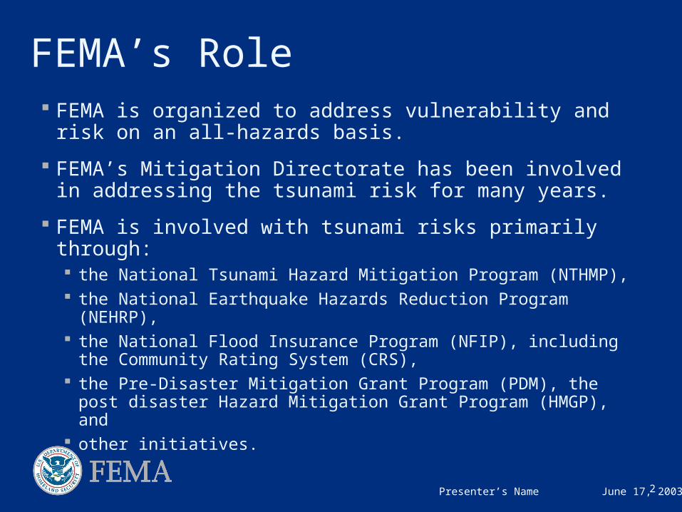
FEMA’s Role FEMA is organized to address vulnerability and risk on an
all-hazards basis.
FEMA’s Mitigation Directorate has been involved in addressing the tsunami risk for many years.
FEMA is involved with tsunami risks primarily through: the National Tsunami Hazard Mitigation Program (NTHMP), the National Earthquake Hazards Reduction Program (NEHRP), the National Flood Insurance Program (NFIP), including the
Community Rating System (CRS), the Pre-Disaster Mitigation Grant Program (PDM), the post
disaster Hazard Mitigation Grant Program (HMGP), and other initiatives.
3Presenter’s Name June 17, 2003
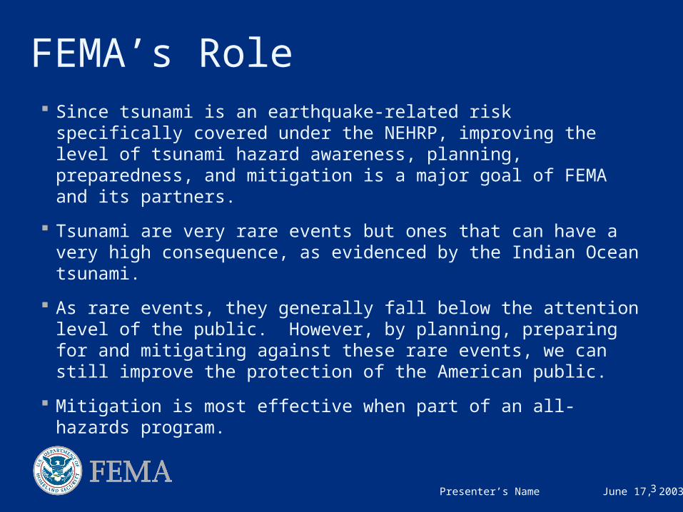
FEMA’s Role Since tsunami is an earthquake-related risk specifically
covered under the NEHRP, improving the level of tsunami hazard awareness, planning, preparedness, and mitigation is a major goal of FEMA and its partners.
Tsunami are very rare events but ones that can have a very high consequence, as evidenced by the Indian Ocean tsunami.
As rare events, they generally fall below the attention level of the public. However, by planning, preparing for and mitigating against these rare events, we can still improve the protection of the American public.
Mitigation is most effective when part of an all-hazards program.
4Presenter’s Name June 17, 2003
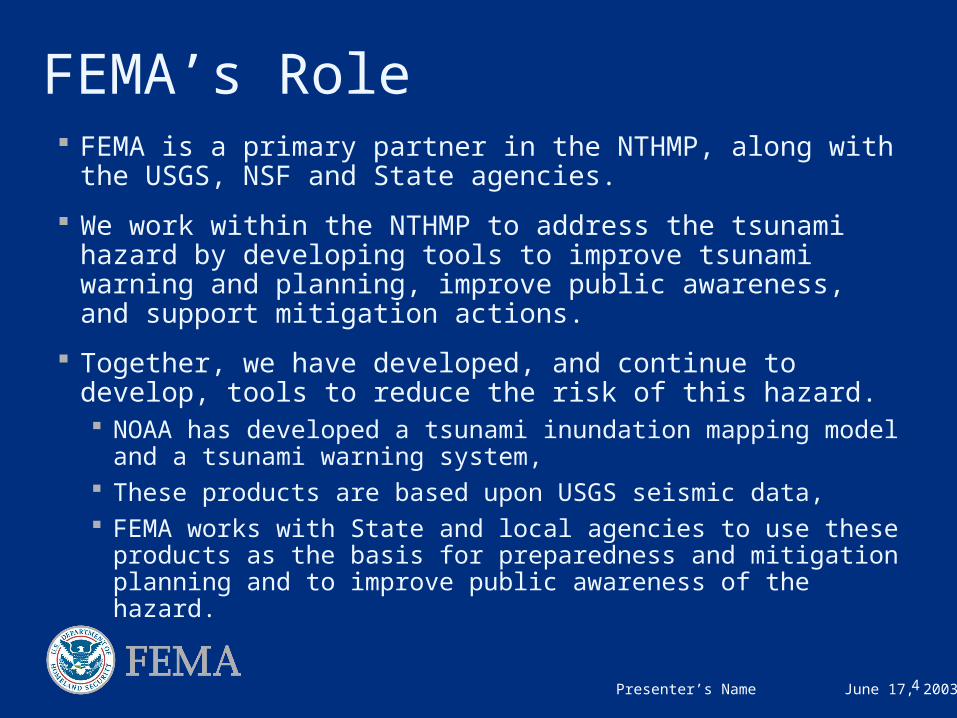
FEMA’s Role FEMA is a primary partner in the NTHMP, along with the
USGS, NSF and State agencies.
We work within the NTHMP to address the tsunami hazard by developing tools to improve tsunami warning and planning, improve public awareness, and support mitigation actions.
Together, we have developed, and continue to develop, tools to reduce the risk of this hazard. NOAA has developed a tsunami inundation mapping model and a
tsunami warning system, These products are based upon USGS seismic data, FEMA works with State and local agencies to use these products
as the basis for preparedness and mitigation planning and to improve public awareness of the hazard.
5Presenter’s Name June 17, 2003
FEMA’s Role
The identification of relative risk to tsunami is based on the NTHMP maps and products, and is used by communities to develop and balance their all-hazards plans and projects funded by FEMA.
These planning and mitigation projects are funded under FEMA’s Pre-Disaster Mitigation Competitive Grant Program (PDM) and the post-disaster Hazard Mitigation Grant Program (HMGP).
Both programs recognize and allow for the funding of plans and actions to reduce the risk from tsunami events.

6Presenter’s Name June 17, 2003
FEMA’s Role All Pacific coastal states have developed State Mitigation
Plans that include addressing the tsunami hazard.
Several communities within these States have also developed Pre-Disaster Mitigation plans under PDM that address the tsunami hazard, allowing them to be eligible for funding under PDM grant program.
Many States and communities have recognized their vulnerability to the tsunami hazard and they are addressing this risk along with their other more frequent hazards: Several coastal counties have FEMA approved multi-hazard
mitigation plans that include tsunami chapters. Some Plans include tsunami mitigation actions to protect public
and critical facilities. At least two communities, Seaside and Cannon Beach, OR have
completed mitigation activities using local funding.
7Presenter’s Name June 17, 2003
FEMA’s Role FEMA’s focus has been in the Pacific Northwest, Alaska and
Hawaii since this is where the largest number of tsunami and associated fatalities have occurred.
FEMA supported development of a Tsunami Hazard Mitigation Program and projects in Puerto Rico under the HMGP funds following Hurricane Georges.
The greatest risk to the U.S. would be a tsunami generated by an earthquake along the Cascadia subduction zone. Such an event would only give 10-20 minutes of warning time.
Because large numbers of people that would be affected, we will continue to work to improve preparedness and reduce the risk of tsunami and other disasters.
8Presenter’s Name June 17, 2003
FEMA’s Building Science Role FEMA addressed coastal seismic and tsunami loads when we
developed the FEMA Coastal Construction Manual (CCM)(FEMA-55). This manual was developed to provide design and construction guidance for residential structures built in coastal areas throughout the United States.
The CCM addresses seismic loads for coastal structures and provides information on the tsunami hazard and associated loads. The conclusion of the CCM is that tsunami loads are too great for conventional residential construction.
It should be noted that the study did not address the possibility of special design and construction details that would be possible for critical facilities.
9Presenter’s Name June 17, 2003
Vertical Evacuation Project A project was initiated by FEMA in 2004 to develop tsunami
design and construction criteria for refuge that would allow for vertical evacuation of the local population where high ground is not accessible in time.
This 3-year $500,000 effort is funded equally divided between FEMA (under NEHRP), and NOAA (under the NTHMP).
The project is being done with input from the engineering and design communities and the States to produce construction design guidance for a tsunami shelter structure.
Such a structure must be capable of withstanding both the severe ground shaking from a design earthquake and specific forces from tsunami waves that would impact structures.
10Presenter’s Name June 17, 2003
Vertical Evacuation Project This project is a significant challenge since current design
codes and practice take into account earthquake or coastal storm surge but does not address stronger forces that a near source tsunami would generate. These forces include the combination of: The loads from the triggering earthquake, The tsunami wave loads (hydrostatic, hydrodynamic, buoyancy) The associated debris impact and debris damming loads, and The shelter performance requirements.
The Project Review Committee met last week to review the 90% draft of the design guide.
The project is scheduled to be completed later this year, and will be printed as FEMA 446.
11Presenter’s Name June 17, 2003
Vertical Evacuation Project
An additional project phase has been contracted to develop a guide for States and communities on how this tsunami design guidance can be utilized.
This will work will include representatives from affected States and local communities, as well as the NTHMP and NEHRP agencies.
This information will especially be critical for low-lying communities that lack evacuation access to high ground following a local earthquake and that may have to rely on vertical evacuation in existing buildings.
12Presenter’s Name June 17, 2003
FEMA’s Role under NEHRP
FEMA funds the public/private consortium Cascadia Region Earthquake Workgroup (CREW) to develop products to assist the business community in developing contingency plans.
For example, they developed a subduction zone earthquake scenario for planning for Pacific Northwest corporations, lifeline, and government entities.
FEMA is working with the at-risk States to increase public awareness for residents and visitors through other FEMA programs such as NEHRP. Even the best warning system is not enough if the public does not know how to respond.
FEMA is working on translating tsunami products into non-English languages and to provide more exposure for tsunami preparedness and mitigation products on FEMA’s website.
13Presenter’s Name June 17, 2003
National Flood Insurance Program
As the Federal agency responsible for administering the National Flood Insurance Program (NFIP), FEMA identifies flood-prone areas, develops flood risk information, and develops and distributes Flood Insurance Studies (FISs) and Flood Insurance Rate Maps (FIRMs) to the over 20,000 communities participating in the NFIP
Since 2003, FEMA has been working on modernizing the flood hazard map inventory through implementation of its Flood Map Modernization Program. This effort was necessary because the majority of the map inventory was out of date.
14Presenter’s Name June 17, 2003
Flood Map Modernization
Flood Map Modernization is a 5-year, $1 billion effort to modernize FIRM’s and provide them in a digital format.
FEMA has four main goals for Map Mod: Network the Nation
Leverage the use of Federal, State, and local resources
Reduce processing time and costs for flood map updates
Communicate widely, effectively, consistently, and continuously
Clear data standards are being used to ensure that the modernized flood hazard maps reflect the best available data that suit the risk level for the given area.
15Presenter’s Name June 17, 2003
NFIP Tsunami Flood Mapping The NFIP has considered tsunami wave heights in the
development of Flood Maps since the late 1970’s in areas of the West Coast, Hawaii and other Pacific Island areas where tsunami was considered a significantly probable flood threat. Some of these areas are:
Crescent City, CA (Region IX) USACE tsunami study provided the 100- and 500-year elevations Storm-tide elevations and tsunami elevations were compared and the higher value was used on the FIRM.
Seaside, OR (Region X) $540,000 pilot project co-funded by FEMA, through the NFIP, NOAA, and the USGS The goal of the project is to develop techniques that can be used to determine the probability and magnitude of tsunami
in other communities along the west coast of the United States.
Hawaiian Islands (Region IX) All 5 counties in Hawaii have tsunami elevations mapped on the FIRM. Tsunami runup dominates on the islands’ north shores, while hurricanes/typhoons dominate on the south shores.
Other Pacific Islands (Region IX) New flood maps for American Samoa include tsunami flood risks. For Guam and the Commonwealth of the Northern Mariana Islands, the typhoon is the dominant risk shown on the
current FIRM.
16Presenter’s Name June 17, 2003
NFIP Tsunami Flood Mapping In 2003, FEMA did a study to evaluate procedures for
delineating coastal flood hazard areas. For the Pacific Coast, the study identified recommendations for mapping tsunami risk.
The study identified the following issues that need to be addressed before FEMA provide updated 1% annual chance tsunami flood information on FIRMs: Limitations in the models used to estimate tsunami frequency. No clear method to identify the 1% annual chance flood risk from
multiple tsunami sources or to perform probability assessments. No procedure for estimating tsunami-based erosion.
The study recommended that a methodology suitable for the NFIP be developed to identify and map tsunami hazards on FIRMs, and that a pilot study be conducted in the Pacific Northwest. This led to the Seaside, Oregon pilot study.
17Presenter’s Name June 17, 2003
NFIP Tsunami Flood Mapping The focus of the NFIP flood mapping efforts is to provide a
1% annual chance of flood risk information for flood insurance rating purposes.
A tsunami hazard generated for NFIP flood mapping, normalized to a 1% annual chance event, may not show the true potential threat of a tsunami for a community.
Tsunami mapping on FIRMs should only be used for insurance purposes.
Local communities should be cautioned against using these maps for activities related to public safety since maximum tsunami inundation could be much greater than the 1% annual chance elevation shown on the FIRM.
18Presenter’s Name June 17, 2003
Flood Loss Reduction Activities The NFIP Community Rating System (CRS) creates an
incentive for communities to help minimize tsunami risk.
Through CRS, the cost of flood insurance can be reduced in those communities that exceed the NFIP minimum flood loss reduction requirements.
The CRS provides credit when local governments: Map tsunami run-up areas Acquire tsunami hazard areas for open space uses. Zone tsunami hazard areas for open space uses. Adopt land use planning measures that control development and uses. Require new structures to be built at or above the tsunami flood elevation. Prohibit new critical facilities in tsunami hazard areas and adopt tsunami
construction requirements. Develop local public information and education programs. Receive the NOAA TsunamiReady designation.
19Presenter’s Name June 17, 2003
Conclusion FEMA’s work will enable communities to improve their
emergency management by planning and preparing for innovative ways of evacuating to safety and improving public awareness of the hazard.
Anytime we can look at a potential threat comprehensively, we are better able to deal with its risks.
FEMA is proud to be able to help provide the tools that States and local communities will need to be able to address their risk from this rare but potentially catastrophic hazard and we look forward to future work with our partners in the NTHMP.
