nuggetty gully reservoir. - central goldfields … · stream bed length & length of overland...
TRANSCRIPT
CENTRAL GOLDFIELDS SHIRE COUNCIL.
INVESTIGATION & ADVICE FOR THE REHABILITATION OF FLOOD DAMAGED
RESERVOIRS.
NUGGETTY GULLY RESERVOIR.
PART B – FINAL DRAFT REPORT:
ABOVE-GROUND INSPECTION.
SUB-SURFACE INVESTIGATIONS.
TENDER NO: G742-11.
DATE: FEBRUARY 2012.

Central Goldfields Shire Council. Tender: G742-11
Investigation & Advice for Flood Damaged Reservoirs. Part B. Nuggetty Gully Reservoir. Timor State Forest.
ii

Central Goldfields Shire Council. Tender: G742-11
Investigation & Advice for Flood Damaged Reservoirs. Part B. Nuggetty Gully Reservoir. Timor State Forest.
iii
CENTRAL GOLDFIELDS SHIRE COUNCIL.
INVESTIGATION & ADVICE FOR THE REHABILITATION OF FLOOD DAMAGED
RESERVOIRS.
NUGGETTY GULLY RESERVOIR.
PART B – FINAL DRAFT REPORT:
ABOVE-GROUND INSPECTION.
SUB-SURFACE INVESTIGATIONS.
TENDER NO: G742-11.
DATE: February 9, 2012.
Prepared by Christian Bannan & Roger Wrigley.
DISCLAIMER: The information contained in this document is confidential between Bannan Pastoral Co and the Central Goldfields Shire Council. This report is a draft for comment and intended to serve as a guide only. Bannan Pastoral Co. their staff & contractors hereby disclaim any liability for commercial loss or damage to any person, property or thing in respect to the information and recommendations contained in this document. Every effort has been made to ensure that field information, laboratory results, recommendations and any other information presented is as correct as possible at the date of printing of this document.
Central Goldfields Shire Council. Tender: G742-11
Investigation & Advice for Flood Damaged Reservoirs. Part B. Nuggetty Gully Reservoir. Timor State Forest.
iv
TABLE OF CONTENTS EXECUTIVE SUMMARY ................................................................................................................................ vii 1. INTRODUCTION........................................................................................................................................ 1 2. BACKGROUND INFORMATION. .......................................................................................................... 3
2.1. Reservoir Location. .............................................................................................................................. 3 2.2. History of the Area. ............................................................................................................................. 4 2.3. Construction Date & Method. ............................................................................................................. 5 2.4. Current Use & Catchment. .................................................................................................................. 5 2.5. The January 14, 2011 Flood Event. .................................................................................................... 6 2.6. Previous Drought. .............................................................................................................................. 12
3. CATCHMENT HYDROLOGICAL INVESTIGATION. ....................................................................... 14
3.1. Catchment Area.................................................................................................................................. 14 3.2. Catchment Vegetation. ...................................................................................................................... 15 3.3. Geology. ............................................................................................................................................. 17 3.4. Soils. ................................................................................................................................................... 17 3.5. Rainfall. .............................................................................................................................................. 22
3.5.1. Annual Rainfall. ........................................................................................................................ 22 3.5.2. Average Monthly Rainfall & Evaporation .............................................................................. 23 3.5.3. Historic Monthly Rainfall Totals – 1878-2011....................................................................... 24 3.5.4. Highest Daily Rainfall Figures per Month – 1878-2011........................................................ 24 3.5.5. January 2011 Daily Rainfall. ................................................................................................... 25
3.6. Stream Bed Length & Length of Overland Flow............................................................................. 26 3.7. Elevation & Slope. ............................................................................................................................. 26
3.7.1. Elevation.................................................................................................................................... 26 3.7.2. Slope. ......................................................................................................................................... 27
3.8. Time of Concentration. ...................................................................................................................... 27 3.9. Rainfall Design Intensity. .................................................................................................................. 28 3.10. Runoff Co-Efficient. ..................................................................................................................... 29 3.11. Flood Discharge. ........................................................................................................................... 29 3.12. Spillway Size Requirements. ........................................................................................................ 30 3.13. Catchment Yield. ........................................................................................................................... 30 3.14. Reservoir Volume. ........................................................................................................................ 31
4. SURVEY RESULTS. ................................................................................................................................ 32
4.1. Catchment Area.................................................................................................................................. 32 4.2. Levels. ................................................................................................................................................. 32
4.2.1. Embankment. ............................................................................................................................ 32 4.2.2. Spillway. .................................................................................................................................... 32 4.2.3. Freeboard. .................................................................................................................................. 32
4.3. Embankment Dimensions.................................................................................................................. 33 4.3.1. Height. ....................................................................................................................................... 33 4.3.2. Length. ....................................................................................................................................... 33 4.3.3. Crest Width. .............................................................................................................................. 33 4.3.4. External Batter. ......................................................................................................................... 33
4.4. Spillway Dimension & Capacity. ..................................................................................................... 33 4.4.1. Floor Width. .............................................................................................................................. 33 4.4.2. Capacity. .................................................................................................................................... 33
Central Goldfields Shire Council. Tender: G742-11
Investigation & Advice for Flood Damaged Reservoirs. Part B. Nuggetty Gully Reservoir. Timor State Forest.
v
5. FINDINGS OF SUB-SURFACE INVESTIGATIONS .......................................................................... 34 5.1. Power Auger Investigation. ............................................................................................................... 35
5.1.1. Site 1. 50 metres. ..................................................................................................................... 35 5.1.2. Site 2. 100 metres. ................................................................................................................... 35 5.1.3. Site 3. 108 - 130 metres. .......................................................................................................... 35 5.1.4. Site 4. 150 metres. ................................................................................................................... 35 5.1.5. Site 5. 200 metres. ................................................................................................................... 36 5.1.6. Site 6. 241 metres. ................................................................................................................... 36
5.2. Backhoe Investigation. ...................................................................................................................... 37 5.2.1. Investigation Details. ................................................................................................................ 37 5.2.2. Pit 1. Northern Abutment. ....................................................................................................... 38 5.2.3. Pit 2. Gully below the embankment. ...................................................................................... 39 5.2.4. Pit 3. Crest at the overtopped section. .................................................................................... 40 5.2.5. Pit 4. Southern abutment. ........................................................................................................ 41 5.2.6. Pit 5. Batter of the embankment in a badly rilled area. ......................................................... 42 5.2.7. Pit 6. Batter of the embankment beside a badly rilled area................................................... 43
6. RECOMMENDATIONS. .......................................................................................................................... 44
6.1. Action that must be undertaken to ensure dam safety. .................................................................... 44 6.1.1. Repair the damaged section of embankment. ......................................................................... 44 6.1.2. Upgrade the current spillway to handle flood discharge. ....................................................... 44 6.1.3. Increase the height of freeboard............................................................................................... 45 6.1.4. Fill in rilled areas. ..................................................................................................................... 45 6.1.5. Fencing the embankment. ........................................................................................................ 45 6.1.6. Installation of a gauge board. ................................................................................................... 45 6.1.7. Development of a dam safety monitoring plan & warning system. ...................................... 45 6.1.8. Signage. ..................................................................................................................................... 46
6.2. Options that could be undertaken but will not impact on the safety of the dam. ........................... 46 6.2.1. Maintain the water drain. ......................................................................................................... 46 6.2.2. Re-instate the emergency spillway. ......................................................................................... 46 6.2.3. Decommission the reservoir..................................................................................................... 47
6.3. Options that have been removed after discussion with Central Goldfields Shire Council Staff. . 47 7. DAM SAFETY MONITORING & EMERGENCY PLANS. ................................................................ 48
7.1. Suggested Monitoring Interval.......................................................................................................... 48 7.2. Inspection Checklists. ........................................................................................................................ 48
7.2.1. Regular checks by the Central Goldfields Shire Council. ...................................................... 48 7.2.2. Comprehensive examination by a qualified dams engineer................................................... 49
7.3. Notification System. .......................................................................................................................... 50 7.4. Emergency Management Plan........................................................................................................... 50
8. CONCLUSIONS. ....................................................................................................................................... 51 REFERENCES ..................................................................................................................................................... 53
LIST OF FIGURES. Figure 1. Location of the Nuggetty Gully Reservoir……………………………………………………...…3 Figure 2. Valve below the Nuggetty Gully Reservoir…………………………………………………….....4 Figure 3. The section of embankment that overtopped and developed a pipe…………………..…………..7 Figure 4. Dead tree in the overtopped section……………………………………………………………….8 Figure 5. Rill erosion in the overtopped section…………..……………………………..…………………..9 Figure 6. The heightened section of embankment……………………………………………………….…10 Figure 7. The emergency spillway……………………………………………………….………….……...11 Figure 8. The spillway channel………………………………….……………………………….….……...12

Central Goldfields Shire Council. Tender: G742-11
Investigation & Advice for Flood Damaged Reservoirs. Part B. Nuggetty Gully Reservoir. Timor State Forest.
vi
Figure 9. The Nuggetty Gully Reservoir during the drought…………………………………….…..…….13 Figure 10. The water drain……………………………………………………………………………...….14 Figure 11. Firewood collection area………………………………………………………………………..16 Figure 12. Trees which have coppiced…………….…………………….…………………………….…...16 Figure 13. Site 1 dispersion tests……………………………………………………………………..…….18 Figure 14. Site 2 dispersion tests…………………………………………………………………...………19 Figure 15. Turbid water in the borrow pit below the embankment………………………………….....…..19 Figure 16. Clear water in the reservoir………………………………………………………………….….20 Figure 17. Disturbance to the embankment and catchment from traffic………………..….…………....…20 Figure 18. Soil erosion along a vehicle track in a gully……………………………………………………21 Figure 19. Pit 1………………………………………………………………………..……………………39 Figure 20. Pit 2………………………………………………………………………………..……………40 Figure 21. Pit 3…………………………………………………………………………………..…………41 Figure 22. Pit 4…………………………………………………………………………………..…………42 Figure 23. Pit 5…………………………………………………………………………………..…………43 Figure 24. Pit 6……………………………………………………………………………………..………44
LIST OF TABLES. Table 1. Soil profile logs and dispersion test results ......………………………………………………….18 Table 2. Rainfall design intensity for each catchment……………………………………….………..…....28 Table 3. Flood discharge volume for each catchment………………………………..……………...……..29 Table 4. Required spillway floor width for flood discharge…………………………………….…......…...30 Table 5. Catchment and reservoir yield ……..………………...…………………….……………….…….31 Table 6. Spillway capacity.....………………………………………………………………………………33 Table 7. Pit 1 profile log……………………………………….…………………………………………...39 Table 8. Pit 2 profile log……………………………………….…………………………………………...40 Table 9. Pit 3 profile log……………………………………….…………………………………………...41 Table 10. Pit 4 profile log……………………………………….………………………………..………...42 Table 11. Pit 5 profile log……………………………………….………………………………..………...43 Table 12. Pit 6 profile log……………………………………….………………………………..………...44
LIST OF GRAPHS. Graph 1. Maryborough Annual Rainfall – 1978 to 2010……………..…………………………………….22 Graph 2. Maryborough Average Monthly Rainfall & Evaporation – 1978 to 2011……….………………23 Graph 3. Daily rainfall for Maryborough in January, 2011 ………………………………………………..25
LIST OF APPENDICES Appendix A. Emergency Management Plan for the Nuggetty Gully Reservoir. Appendix B. Initial inspection of the Nuggetty Gully Reservoir. Appendix C. Catchment of the Nuggetty Gully Reservoir Appendix D. Geology map. Appendix E. Rainfall data for Maryborough – 1878 to 2011. Appendix F. Flood discharge computation sheets. Appendix G. Australian Rainfall & Runoff flood computation. Appendix H. Time of Concentration graph. Appendix I. Plan view of the embankment. Appendix J. Side elevation of the embankment. Appendix K. Embankment length measurement. Appendix L. Embankment cross-sections. Appendix M. Power auger field notes.
Central Goldfields Shire Council. Tender: G742-11
Investigation & Advice for Flood Damaged Reservoirs. Part B. Nuggetty Gully Reservoir. Timor State Forest.
vii
EXECUTIVE SUMMARY The Nuggetty Gully Reservoir is a recreational and aesthetical asset owned by the Central Goldfields Shire Council. The reservoir is located in the Timor State Forest, 5 kilometres north of Maryborough in central Victoria. The reservoir was built for domestic water supply to the town of Timor during the Gold Rush. The reservoir is approximately 145 years old, has heritage and biodiversity values and holds a reserve of water that can be drawn upon for fire-fighting. The reservoir impounds approximately 75 ML of water at the full supply level and is classed as a ‘notifiable’ dam under Victorian law. Regular and comprehensive monitoring plans must be developed by the owner of a notifiable dams and an emergency management plan must be in place. The embankment sustained damage during the record rain event on January 14, 2011. Water flow overtopped the dam’s embankment as a result of high inflows and inadequate spillway capacity. Emergency works allowed the water level in the dam to fall below the point of overtopping. Embankment damage included rill erosion and there is evidence of an outlet in the earthen embankment which shows that piping has occurred. This is not seen to be continuous to the reservoir but is likely to have been associated with the passage of water flow during the overtopping event or the elevated water level lapping at the bank. The earthen pipe ceased flow once fill material was placed on the crest and the water level in the reservoir was lowered. The earthen pipe may possibly be linked with dead tree roots and conveyed very little water during the event. Prior to the event there have been no emergency management plans or routine maintenance checks. A proposed monitoring plan is suggested in section 7.0 and an emergency management plan in Appendix A. Prior to the completion of Part B of this project, the Central Goldfields Shire Council must work through and agree on these plan. Remediation work is required to ensure the safety of the dam. This involves:
1. Increasing the depth of freeboard from 0.5 to 0.9 metres. The water level at full capacity will be 212.10 metres AHD. Increasing the depth of freeboard will lower the current full supply level by 0.4 metres.
2. Re-construction of the existing spillway. The minimum required floor width is 12.0 metres.
3. Installation of a longitudinal curtain wall along the crest across the overtopped
section. This wall will must be lime at 1.0%, constructed with suitable clay, at least 2.0 metres in depth, 600mm in width and 50 metres in length. The curtain wall is intended to block the earthen pipe and strengthen the embankment.

Central Goldfields Shire Council. Tender: G742-11
Investigation & Advice for Flood Damaged Reservoirs. Part B. Nuggetty Gully Reservoir. Timor State Forest.
viii
4. Placement of soil and rock on the external batter of the damaged section to flatten
the slope and bolster the repaired section. The material excavated from the spillway should be used.
5. Fill in any other rills that are not covered during the flattening of the embankment.
6. Fencing the embankment to keep motorbikes away and stop aggressive disturbance to the crest and outer batter. Groundcover on the embankment is critical for maintaining stability and strength after rainfall.
7. Implementation of a maintenance and monitoring program to ensure that: The spillway is not blocked. The internal face of the dam is not damaged from lapping of waves. The council are aware of dam levels and necessary downstream
landowners are notified.
8. Implementation of an emergency management plan.
9. Signage to inform users of the owner, the need to report damage and the requirement for trail bikes to stay off the embankment.
It is recommended to carry out these works as soon as possible. These works constitute the minimum requirements for structural remediation of the dam. It is optional but preferred if the water drain throughout the Timor State Forest is maintained. This structure supplies the reservoir with 60% of the total catchment area. Maintenance of the race ensures that the reservoir will have a reliable supply of water to support vegetation on the embankment, protect the embankment from exposure and enhance recreational and biodiversity value. The drain is blocked in a number of locations and has other damage from traffic. Removal of this structure and diversions of water could cause problems with nearby landholders.
Central Goldfields Shire Council. Tender: G742-11
Investigation & Advice for Flood Damaged Reservoirs. Part B. Nuggetty Gully Reservoir. Timor State Forest.
1
1. INTRODUCTION. The Nuggetty Gully reservoir is a ‘notifiable’ dam (Lewis, 1992) located in the Timor State Forest, approximately 5 kilometres north of Maryborough in central Victoria. The reservoir is owned by the Central Goldfields Shire Council and the surrounding land is managed by DSE. The reservoir is approximately 140 years old and has significant recreational and heritage values (Anon, 1992; Anon, 2008; Ipsen pers. comm, 2012). There is no consumptive use for the water impounded apart from fire-fighting and road construction. A ‘notifiable’ dam is one in which can impound more than 50 ML of water or has an embankment height of greater than 5.0 metres (Lewis, 1992). Both of these specifications apply to this reservoir. The Department of Sustainability and Environment (DSE) must be informed of the presence of a notifiable dam and regular monitoring is required to ensure dam remains safe (Anon, 2011). Regular monitoring and reporting by a qualified dams engineer is required. Reports are to be submitted to local council, the DSE and Goulburn-Murray Water (GMW). The DSE Dam Safety Emergency System should be used. A monitoring program for this reservoir is recommended in section 7. An emergency management plan is provided in Appendix A. The reservoir sustained embankment damage from overtopping during the morning of January 14, 2011 (Doran pers. comm, 2011; Ipsen pers comm, 2012). Overtopping caused rill erosion to the outer batter in some of the deepest sections of embankment. A local earthmoving contractor undertook the emergency works which included:
Heightening the embankment in the overtopped section by 100-200mm Cutting an emergency spillway through the embankment at the southern-most point. Scraping the existing spillway to increase the depth of surcharge through the spillway.
Emergency works were successful and the water levels in the reservoir fell rapidly to a safe level (Doran pers. comm, 2011). It was unknown at the time of the event that there was a small earthen pipe through the embankment. Emergency works ceased the flow of the pipe, which was connected to a rilled section of embankment. The condition of the reservoir embankment was unknown prior to this event. It is suspected, based on aerial imagery, rainfall records and drought conditions that the reservoir impounded very little water between 1998 and 2009. The Central Goldfields Shire Council has highlighted their concerns about the safety of the dam following the event. This project has been commissioned to highlight:
The extent of damages sustained from the event. Minimum requirements and recommendations for structural remediation. Implementation of a monitoring and emergency management plan. Any other safety issues that require attention.
Investigations into flooding in Victoria and Queensland throughout 2010 and 2011 have brought flood intensity and hydrology under review. For the case of this reservoir we have commenced modelling using historic 1 in 100 year data. Based on discussion with the North Central

Central Goldfields Shire Council. Tender: G742-11
Investigation & Advice for Flood Damaged Reservoirs. Part B. Nuggetty Gully Reservoir. Timor State Forest.
2
Catchment Management Authority (NCCMA) it is possible that the flooding events in the catchment of the Loddon River during January 2011 may be in the magnitude of 1 in 150 years (Hall, pers. comm 2011). This is yet to be confirmed. Given the extensive history of drought and bushfire in Victoria over the past 15 years, the reservoir provides a valuable water reserve for fire-fighting. The reservoir is set in bushland and the water in reserve is of high value in the event of an emergency. The project duration is from November 2011 to March 2012. This report combines the findings of Part A (above-ground inspections) and Part B (sub-surface investigations). After submission of this report, council are required to confirm the development of plans for remediation. Cost estimates will be provided with the plans. Bannan Pastoral Co. will supervise the structural remediation of the dam and ensure that works are carried out to specification. This investigation is one of two which Bannan Pastoral Co. is currently undertaking in response to the flood events in January 2011, the other being the Goldfields Reservoir on the south end of the Maryborough township.

Central Goldfields Shire Council. Tender: G742-11
Investigation & Advice for Flood Damaged Reservoirs. Part B. Nuggetty Gully Reservoir. Timor State Forest.
3
2. BACKGROUND INFORMATION.
2.1. Reservoir Location. The Nuggetty Gully Reservoir is located in the Timor State Forest, approximately 5 kilometres north of Maryborough and 2 kilometres south-east of Timor in Central Victoria. The reservoir is positioned on an upper section of the Billy Goat creek, a tributary stream of the Bet-Bet creek (Vicmap, 1995). The reservoir covers an area of approximately 5 hectares. Figure 1 highlights the location of the reservoir with respect to Timor and Bowenvale.
Figure 1. Location of the Nuggetty Gully Reservoir with respect to Timor and Bowenvale (Vicmap, 1995).

Central Goldfields Shire Council. Tender: G742-11
Investigation & Advice for Flood Damaged Reservoirs. Part B. Nuggetty Gully Reservoir. Timor State Forest.
4
According to the Central Goldfields Shire Council, the land forming the reservoir and hinterland is crown land and no Title Plan can be provided. The reservoir is owned by the Central Goldfields Shire Council.
2.2. History of the Area. In 1854 gold was discovered at Chinaman’s Flat, in the area between Timor and Maryborough. Within six months the population had grown to 18,000, peaking at approximately 27,000 miners in March 1857 (Anon, u.d.). During 1856 the Nuggetty Gold Rush occurred. Old records indicate that the site of the Nuggetty Rush occurred above the Old Leads Reservoir, which is likely to be this site (Anon, u.d.). There were significant findings of gold in the Nuggetty Gully, Timor and Chinaman’s Flat area between 1855 and 1865 (Anon, 2008, Osborn & DuBourg, 2011). Old records indicate that the reservoir was used to supply the township of Timor-Bowenvale for 80-90 years prior to water being piped to the area from Maryborough in 1962. Figure 2 is an image of a control valve found below the embankment.
Figure 2. Control valve found below the embankment. The water supply was valuable and fourteen properties in the Chinaman’s Flat and Timor area were rated for their water use late in the 18th century (Anon, 2008). Between 1881 and 1895
Central Goldfields Shire Council. Tender: G742-11
Investigation & Advice for Flood Damaged Reservoirs. Part B. Nuggetty Gully Reservoir. Timor State Forest.
5
there was a reservoir keeper based at the site enforcing policy that people were not allowed to remove water, swim or fish at the site (Anon, u.d.). Old records indicate that the water supplies were poor given the size of the community reliant on this source. Groundwater drilling was conducted in the early 19th century in the Timor area in search of suitable water for the town. Groundwater tested up as unsuitable and water from the reservoir remained the primary domestic source until 1962. At this time water was pumped from ‘the creek’ (assuming the Bet-Bet creek) to a tank to supply the area (Anon, 2008). In 1968 the Bowenvale Water Trust purchased permanent water from the Maryborough Water Trust and water was supplied by pipe.
2.3. Construction Date & Method. No records could be obtained listing the reservoir construction date. Records highlight that the reservoir was originally leased to the government for 10 years after the date of construction, prior to 1881 (Anon, 2008). It is likely that the reservoir was constructed during the Nuggetty Rush between 1865 and the late 1870’s. The Timor Book (Anon, 2008; p.17) states; ‘The reservoir had a capacity of 2,500,000 gallons with a drainage area of 850 acres. The bank, made from stiff red clay and fine quality gravel was 920 feet long and 6 feet wide at the top. A 1.5 mile water drain increased the catchment and the area was well fenced’. Calculations in section 3.14 show that the reservoir is much larger than originally noted. It is assumed that the embankment was constructed by hand with the aid of horse scoops. Trees, rock and clay may have been loosened from within the storage floor by blasting. It is assumed that the borrow area for embankment is in the deepest section of the gully where unconsolidated sediment (clay) may be of greatest depth. Investigation shows that the material used in the embankment was sourced from within the storage. Given the depth of unconsolidated soil above bedrock in the gully above and below the reservoir ranges from 0.5-1.0 m in depth, it is likely that a maximum of 1.0 m of material has been borrowed from within the storage to build the embankment.
2.4. Current Use & Catchment. The Nuggetty Gully reservoir is reserved for fire-fighting purposes. During the field visits, water tankers have been observed pumping water from the reservoir for road construction purposes. The catchment comprises of Box-Ironbark Forest which appears to contain a diversity of flora and fauna. This is deemed to be of high conservation value. There are very few weeds present. Trail bike riding is common in the catchment. The crest and outer batter of the embankment have been used as tracks.
Central Goldfields Shire Council. Tender: G742-11
Investigation & Advice for Flood Damaged Reservoirs. Part B. Nuggetty Gully Reservoir. Timor State Forest.
6
The area shows signs of excavation for gold below the embankment and throughout the catchment. Prospectors have been sited during field inspections. There is a section of the upper catchment on the eastern boundary which has been thinned for firewood collection. The catchment is used for orienteering and bushwalking.
2.5. The January 14, 2011 Flood Event. The Nuggetty Gully Reservoir sustained damage from overtopping during the rain events on January 14th, 2011. During the five days prior, a total of 137.6 mm of rain was recorded in Maryborough. It is suspected that the reservoir was at full supply level prior to January 14. On the morning of January 14, 2011, local farmers witnessed the embankment overtopping (Ipsen, pers. comm 2012). Water overtopped the embankment due to insufficient spillway capacity. A call was made to a local excavator contractor to carry out emergency works. This involved:
Heightening the embankment in the overtopped section by approximately 100 mm (Figures 3 & 6).
Installing an emergency spillway at the southern end of the embankment (Figure 7). Scraping of the spillway to increase the depth of surcharge (Figure 8).
Soil was placed across a 50 metre section of the embankment to initially control the overtopping. After installing the emergency spillway, the water level fell rapidly (Doran pers comm. 2011, Ipsen pers comm. 2012). Repairs were made using soil from a borrow pit below the breached section. Figure 3 highlights the repaired section of embankment and the borrow pit.

Central Goldfields Shire Council. Tender: G742-11
Investigation & Advice for Flood Damaged Reservoirs. Part B. Nuggetty Gully Reservoir. Timor State Forest.
7
Figure 3. The section of embankment that overtopped during the flood event.

Central Goldfields Shire Council. Tender: G742-11
Investigation & Advice for Flood Damaged Reservoirs. Part B. Nuggetty Gully Reservoir. Timor State Forest.
8
It is possible that sections of the embankment near the damaged section contain roots from dead trees. Figure 4 highlights the dead tree in the embankment which is likely to have created a void through the bank which may be associated with the earthen pipe.
Figure 4. The dead Red-Gum on the embankment, close to the damaged section.

Central Goldfields Shire Council. Tender: G742-11
Investigation & Advice for Flood Damaged Reservoirs. Part B. Nuggetty Gully Reservoir. Timor State Forest.
9
Rill erosion has occurred in a number of locations on the outer batter. One point of rilling is directly above the old water control valve (Figure 2). This area was checked for other evidence of piping.
Figure 5. Rill erosion near the damaged section above the old water release valve.
Central Goldfields Shire Council. Tender: G742-11
Investigation & Advice for Flood Damaged Reservoirs. Part B. Nuggetty Gully Reservoir. Timor State Forest.
10
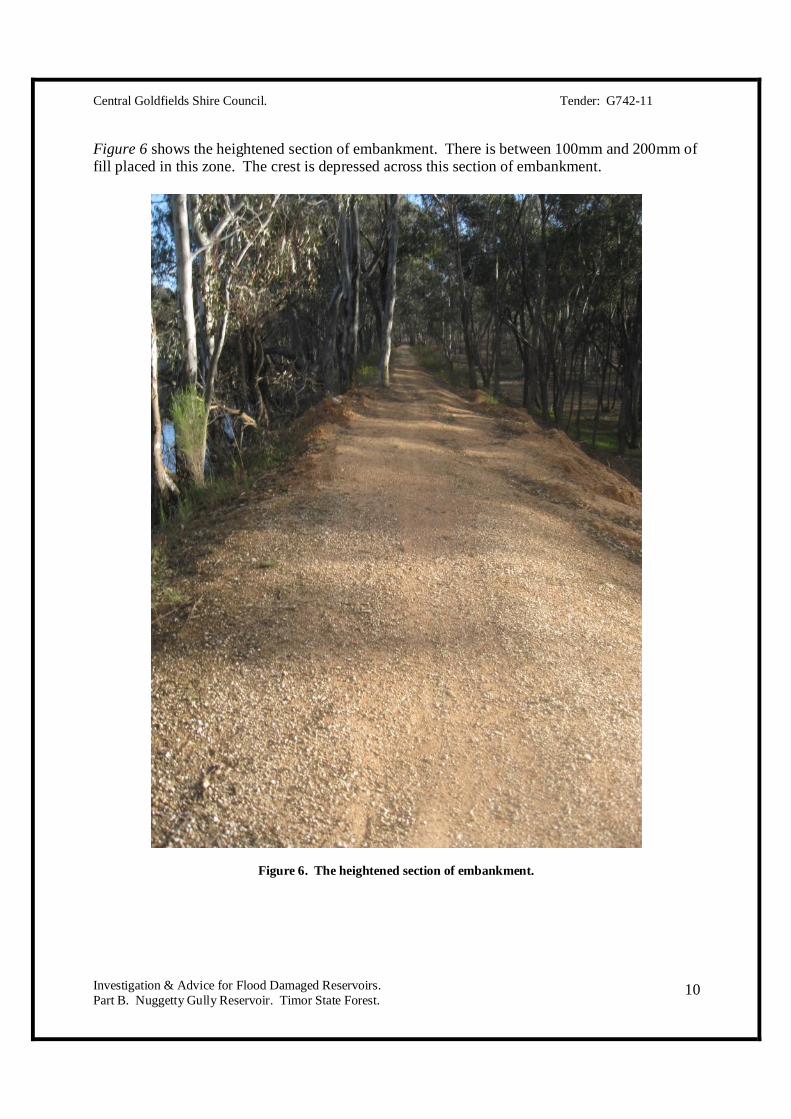
Figure 6 shows the heightened section of embankment. There is between 100mm and 200mm of fill placed in this zone. The crest is depressed across this section of embankment.
Figure 6. The heightened section of embankment.

Central Goldfields Shire Council. Tender: G742-11
Investigation & Advice for Flood Damaged Reservoirs. Part B. Nuggetty Gully Reservoir. Timor State Forest.
11
Figure 7 is an image of the emergency spillway cut into the embankment at the southern-most point. This location is very close to the point where the water drain enters the reservoir.
Figure 7. The emergency spillway.

Central Goldfields Shire Council. Tender: G742-11
Investigation & Advice for Flood Damaged Reservoirs. Part B. Nuggetty Gully Reservoir. Timor State Forest.
12
Figure 8 is an image of the existing spillway. This structure was scraped during the event.
Figure 8. The spillway was scraped during the flood event.
2.6. Previous Drought. The drought from 2001-2010 is likely to have had impact on the integrity of the embankment. Based on aerial photos, water levels in the reservoir were very low for extended periods. The sub-surface investigation has revealed very dry conditions throughout all accessible areas of the embankment. The erosion damage caused by overtopping is likely to have been exacerbated by dry soils conditions. Low water levels and dry conditions have put pressure on the vegetation on the embankment. The embankment is home to a number of large trees, mostly River Red Gum (Eucalyptus camaldulensis) and Grey Box (Eucalyptus microcarpa). There are two dead trees on the embankment which may have created voids from decaying root material. It is possible that some structural weakness of the crest has occurred. This section will be reinforced by installing a curtain wall.
Central Goldfields Shire Council. Tender: G742-11
Investigation & Advice for Flood Damaged Reservoirs. Part B. Nuggetty Gully Reservoir. Timor State Forest.
13
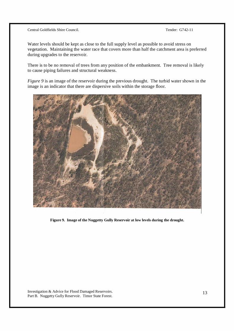
Water levels should be kept as close to the full supply level as possible to avoid stress on vegetation. Maintaining the water race that covers more than half the catchment area is preferred during upgrades to the reservoir. There is to be no removal of trees from any position of the embankment. Tree removal is likely to cause piping failures and structural weakness. Figure 9 is an image of the reservoir during the previous drought. The turbid water shown in the image is an indicator that there are dispersive soils within the storage floor.
Figure 9. Image of the Nuggetty Gully Reservoir at low levels during the drought.
Central Goldfields Shire Council. Tender: G742-11
Investigation & Advice for Flood Damaged Reservoirs. Part B. Nuggetty Gully Reservoir. Timor State Forest.
14
3. CATCHMENT HYDROLOGICAL INVESTIGATION. The following investigation has been compiled to model catchment yield, peak rates of runoff, water yield, flood discharge and spillway sizing. Notes made from the initial inspection of the reservoir are included as Appendix B. These notes have been supplied to the Central Goldfields Shire Council.
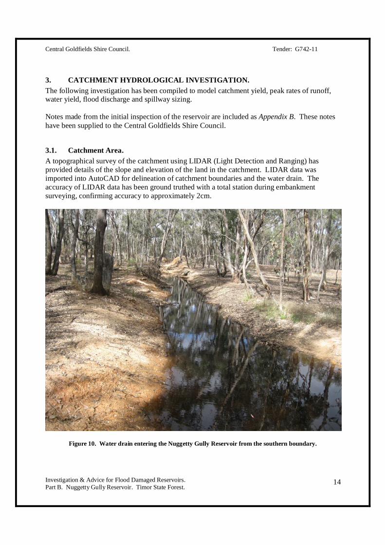
3.1. Catchment Area. A topographical survey of the catchment using LIDAR (Light Detection and Ranging) has provided details of the slope and elevation of the land in the catchment. LIDAR data was imported into AutoCAD for delineation of catchment boundaries and the water drain. The accuracy of LIDAR data has been ground truthed with a total station during embankment surveying, confirming accuracy to approximately 2cm.
Figure 10. Water drain entering the Nuggetty Gully Reservoir from the southern boundary.
Central Goldfields Shire Council. Tender: G742-11
Investigation & Advice for Flood Damaged Reservoirs. Part B. Nuggetty Gully Reservoir. Timor State Forest.
15
A sketch of the catchment of the Nuggetty Gully Reservoir is presented as Appendix C. The catchment is split into two sections:
1. The natural catchment. Area is approximately 93 hectares. 2. The water drain catchment. Area is approximately 148 hectares.
The total catchment area is 242 hectares. These figures are approximate and will be used for the purpose of all calculations. An image of the water drain entering the reservoir from the south end is presented in Figure 10.
3.2. Catchment Vegetation. The natural catchment area is Box-Ironbark Forest with a good mixture of understory plant species. Vegetation appear to be healthy and there are very few weeds present. Vegetation within the catchment has been assessed by visual observation and use of plant identification books (Cunningham et al, 1992). The main tree species in the catchment include:
Grey Box (Eucalyptus microcarpa). The most common tree species throughout the catchment.
Red Ironbark (Eucalyptus sideroxylon). Common at higher elevations in the catchment. River Red-Gum (Eucalyptus camaldulensis). Found in the area of the embankment,
immediate reservoir hinterland, localised depressions and other isolated areas.
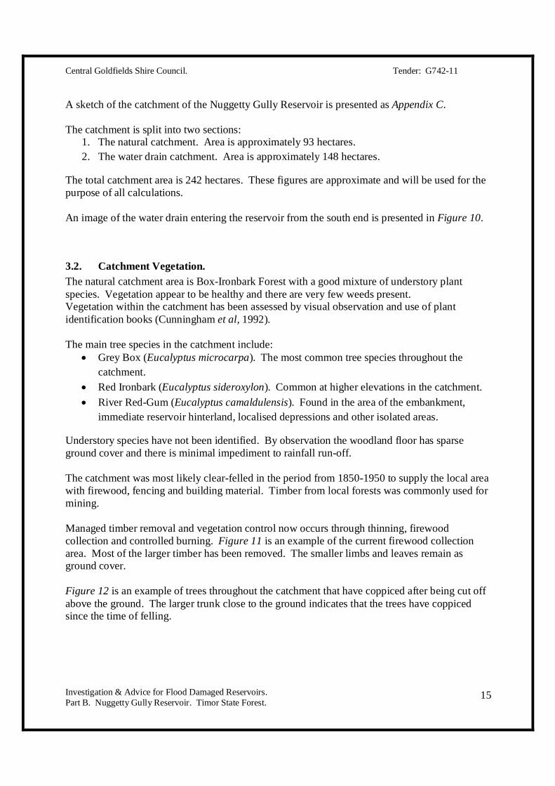
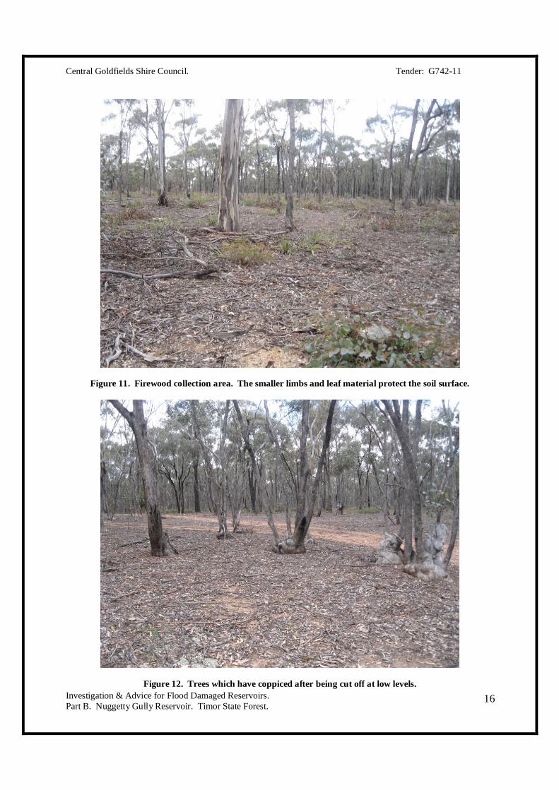
Understory species have not been identified. By observation the woodland floor has sparse ground cover and there is minimal impediment to rainfall run-off. The catchment was most likely clear-felled in the period from 1850-1950 to supply the local area with firewood, fencing and building material. Timber from local forests was commonly used for mining. Managed timber removal and vegetation control now occurs through thinning, firewood collection and controlled burning. Figure 11 is an example of the current firewood collection area. Most of the larger timber has been removed. The smaller limbs and leaves remain as ground cover. Figure 12 is an example of trees throughout the catchment that have coppiced after being cut off above the ground. The larger trunk close to the ground indicates that the trees have coppiced since the time of felling.
Central Goldfields Shire Council. Tender: G742-11
Investigation & Advice for Flood Damaged Reservoirs. Part B. Nuggetty Gully Reservoir. Timor State Forest.
16
Figure 11. Firewood collection area. The smaller limbs and leaf material protect the soil surface.
Figure 12. Trees which have coppiced after being cut off at low levels.

Central Goldfields Shire Council. Tender: G742-11
Investigation & Advice for Flood Damaged Reservoirs. Part B. Nuggetty Gully Reservoir. Timor State Forest.
17
3.3. Geology. The geology consists of marine deposits formed in the Early Ordovician period, approximately 445-485 million years of age (Schoknecht, 1988; Geovic, 2011). Underlying rock includes sandstone, shale, slate and quartz. The landscape is gently undulating to hilly and in some areas rock is exposed at ground level. The geology of the Nuggetty Gully catchment is classified into two units (Geovic, 2011):
Ocl - Ordovician, Castlemaine Group, Lancefieldian. This unit is shaded in blue. Qa1 – Quaternary, Alluvial, Unnamed Group. This unit is shaded in pale white.
The alluvial group of sediments overlies the older Ordovician group in isolated depressions and other lower slopes. Alluvial and colluvial material was found throughout the embankment during sub-surface investigation providing an indication of the material derived from the floor of the dam. The northern and southern abutments of the reservoir lie in weathered rock with a thin covering of soil (300mm). Appendix D is a geology map of the area (Geovic, 2011). Soil descriptions are included in section 6.0.
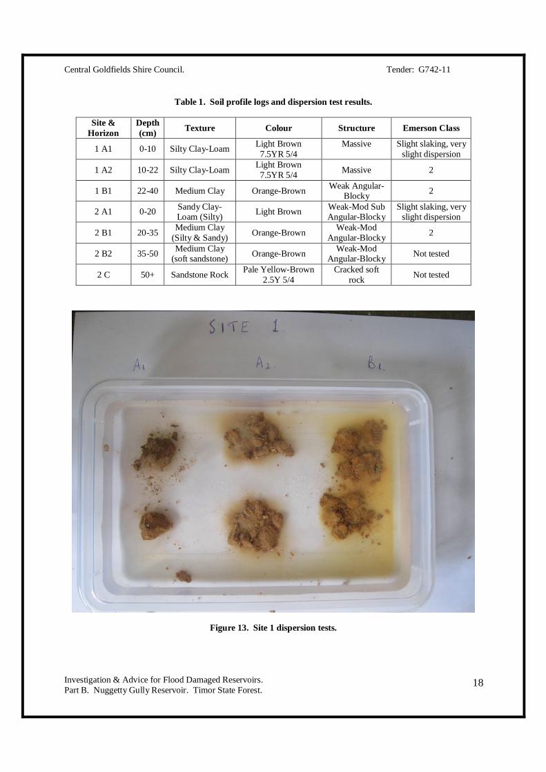
3.4. Soils. The soils comprise of clay, sand and silt formed from colluvium (hill wash), alluvium (material shifted from water) and weathered rock. Soil profiles are described as gravelly and sandy loams, clay-loams and clays overlying rock. Soil depth ranges from 0.5 and 1.0m, often shallower in areas. Soil profiles are often deeper in depressions, particularly on the lower slopes (Schoknecht 1982). Within the forested catchment area most soil surfaces have a lining of organic material, including leaves, timber, twigs and bark. This material protects the soil surface from erosion. In areas where there has been timber removal or traffic disturbance, groundcover and species diversity is poor. Soil samples were collected from two sites in the catchment area. Site 1 was located immediately east of the northern rim of the Goldfields reservoir. Site 2 was collected from a railway cutting to the south-east of the reservoir near the top of the ridge. The samples from both sites were tested for their dispersive characteristics by immersing an unbroken aggregate in rainwater for 24 hours. Figures 13 & 14 are images of soils tested for dispersive properties. Table 1 summarises soil characteristics.
Central Goldfields Shire Council. Tender: G742-11
Investigation & Advice for Flood Damaged Reservoirs. Part B. Nuggetty Gully Reservoir. Timor State Forest.
18
Table 1. Soil profile logs and dispersion test results.
Site & Horizon
Depth (cm) Texture Colour Structure Emerson Class
1 A1 0-10 Silty Clay-Loam Light Brown 7.5YR 5/4
Massive
Slight slaking, very slight dispersion
1 A2 10-22 Silty Clay-Loam Light Brown 7.5YR 5/4 Massive 2
1 B1 22-40 Medium Clay Orange-Brown Weak Angular-Blocky 2
2 A1 0-20 Sandy Clay-Loam (Silty) Light Brown Weak-Mod Sub
Angular-Blocky Slight slaking, very
slight dispersion
2 B1 20-35 Medium Clay (Silty & Sandy) Orange-Brown Weak-Mod
Angular-Blocky 2
2 B2 35-50 Medium Clay (soft sandstone) Orange-Brown Weak-Mod
Angular-Blocky Not tested
2 C 50+ Sandstone Rock Pale Yellow-Brown 2.5Y 5/4
Cracked soft rock Not tested
Figure 13. Site 1 dispersion tests.

Central Goldfields Shire Council. Tender: G742-11
Investigation & Advice for Flood Damaged Reservoirs. Part B. Nuggetty Gully Reservoir. Timor State Forest.
19
Figure 14. Site 2 dispersion tests.
Highly turbid water observed in the borrow pit confirms that the soils are dispersive. Given that the water in the reservoir reasonably clear it is likely that the lining of organic material on the floor is keeping the impounded water free of turbidity.
Figure 15. Turbid water in the borrow pit below the embankment.

Central Goldfields Shire Council. Tender: G742-11
Investigation & Advice for Flood Damaged Reservoirs. Part B. Nuggetty Gully Reservoir. Timor State Forest.
20
Figure 16. Clear water in the reservoir.
Figure 17. Disturbance to the embankment and catchment from traffic.
Central Goldfields Shire Council. Tender: G742-11
Investigation & Advice for Flood Damaged Reservoirs. Part B. Nuggetty Gully Reservoir. Timor State Forest.
21
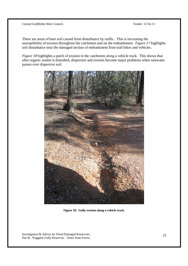
There are areas of bare soil caused from disturbance by traffic. This is increasing the susceptibility of erosion throughout the catchment and on the embankment. Figure 17 highlights soil disturbance near the damaged section of embankment from trail bikes and vehicles. Figure 18 highlights a patch of erosion in the catchment along a vehicle track. This shows that after organic matter is disturbed, dispersion and erosion become major problems when rainwater passes over dispersive soil.
Figure 18. Gully erosion along a vehicle track.

Central Goldfields Shire Council. Tender: G742-11
Investigation & Advice for Flood Damaged Reservoirs. Part B. Nuggetty Gully Reservoir. Timor State Forest.
22
3.5. Rainfall.
3.5.1. Annual Rainfall. Average annual rainfall has been calculated from the Bureau of Meteorology rainfall data for weather station number 88043 at Maryborough (BOM, 2011). Data for the period from 1878-2011 has been accessed and is included as Appendix E. The data indicates that the average annual rainfall for Maryborough is 528.5mm. Annual rainfall figures have been graphed to observe the years of highest rainfall. Graph 1 indicates that the three years of highest recorded annual rainfall were:
1. 1973. 1022.2mm. 2. 2010. 952.1mm. 3. 1903. 764.4mm.
All other above average rainfall values lie within 528.5 and 764.4mm. Of 132 year period measured, 70 years recorded above average rainfall, totalling 56%. The driest year was 1967, recording 246.7mm. The second driest year was 1982, recording 254.8mm. Data is incomplete for the year of 1899.
Graph 1. Maryborough Annual Rainfall – 1978 to 2010 (BOM, 2011).
Central Goldfields Shire Council. Tender: G742-11
Investigation & Advice for Flood Damaged Reservoirs. Part B. Nuggetty Gully Reservoir. Timor State Forest.
23
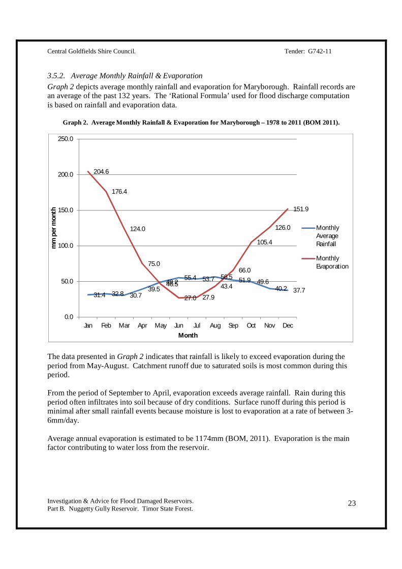
3.5.2. Average Monthly Rainfall & Evaporation Graph 2 depicts average monthly rainfall and evaporation for Maryborough. Rainfall records are an average of the past 132 years. The ‘Rational Formula’ used for flood discharge computation is based on rainfall and evaporation data.
Graph 2. Average Monthly Rainfall & Evaporation for Maryborough – 1978 to 2011 (BOM 2011).
The data presented in Graph 2 indicates that rainfall is likely to exceed evaporation during the period from May-August. Catchment runoff due to saturated soils is most common during this period. From the period of September to April, evaporation exceeds average rainfall. Rain during this period often infiltrates into soil because of dry conditions. Surface runoff during this period is minimal after small rainfall events because moisture is lost to evaporation at a rate of between 3-6mm/day. Average annual evaporation is estimated to be 1174mm (BOM, 2011). Evaporation is the main factor contributing to water loss from the reservoir.
31.4 32.8 30.739.5
49.255.4 53.7 56.5 51.9 49.6
40.2 37.7
204.6
176.4
124.0
75.0
46.5
27.0 27.9
43.4
66.0
105.4
126.0
151.9
0.0
50.0
100.0
150.0
200.0
250.0
Jan Feb Mar Apr May Jun Jul Aug Sep Oct Nov Dec
mm
per
mon
th
Month
MonthlyAverageRainfall
MonthlyEvaporation

Central Goldfields Shire Council. Tender: G742-11
Investigation & Advice for Flood Damaged Reservoirs. Part B. Nuggetty Gully Reservoir. Timor State Forest.
24
3.5.3. Historic Monthly Rainfall Totals – 1878-2011. Appendix E provides a list of monthly rainfall values from 1878 to 2011. The data highlights years where monthly rainfall recordings were above 100mm. Rainfall figures have been highlighted in the following colour code:
Green 100-150 mm. Orange 150-200 mm. Red Greater than 200mm.
The data shows that there were are 7 years on record where average monthly rainfall was above 100mm for two months in succession. These years included 1917, 1923, 1932, 1964, 1975, 1981 and 2010. It is likely during these periods that the reservoir may have been in receipt of significant inflows due to prolonged catchment wetting. The stand-out features of the data include:
In 2010, there were four months in succession (August to November) where monthly rainfall figures were greater than 100 mm. In the month of November the rainfall recording was greater than 150mm (155.3mm). This is the year of second highest annual rainfall on record. This was backed up two months later (January 2011) by 240 mm of rain, the highest monthly rainfall recording on record. This has led to the events that occurred on January 14, 2011.
In 1981, there were three months in succession (June to August) where monthly rainfall figures were between 100 and 150mm. Annual rainfall this year was above average at 641.6mm.
In 1903, there were three individual months of the year (April, July and September) which all recorded between 100 and 150 mm of rainfall. Annual rainfall this year was third highest on record.
3.5.4. Highest Daily Rainfall Figures per Month – 1878-2011. The highest daily rainfall figure for each month from 1878-2011 are included in Appendix E. Records indicate that there have been other occasions where the rainfall within a 24 hour period has exceeded the recorded level of 90.4mm on January 14, 2011. These include:
27th of December, 1999. A total of 99.2mm was recorded. 32.4mm was recorded the previous day.
30th of November, 1933. A total of 99.3mm was recorded. 6.4mm was recorded the previous day.
On four occasions daily rainfall has been recorded at between 80-90 mm. It is possible on the January 14, 2011 that:
Rapid filling of the dam caused by high inflows throughout 2010 have left little room in storage for further catchment runoff.

Central Goldfields Shire Council. Tender: G742-11
Investigation & Advice for Flood Damaged Reservoirs. Part B. Nuggetty Gully Reservoir. Timor State Forest.
25
Rainfall in the days leading up to the event may have influenced the failure of the dam. The rainfall intensity per hour was more significant than other events in the past. The reservoir may have been in receipt of some of the highest inflows on record.
3.5.5. January 2011 Daily Rainfall. Rainfall data from January 2011 has been sourced from the Bureau of Meteorology. The rainfall data is presented in Graph 3. The data highlights that there were significant rainfall events prior to January 14, 2011, with the day of January 14 recorded at 90.4mm. Based on landscape observation during this period, most soils were subject to saturation. It is possible that parts of the embankment that have cracked from drying could have become saturated during this period. Given that the embankment was dry at the time of the sub-surface investigation, saturation is unlikely to have occurred. Recent communication with the North Central Catchment Management Authority has highlighted that the rainfall events experienced in the Loddon River catchment at the time of the event may be representative of 1 in 150 year interval (Hall, pers. comm. 2011). All flood scenarios are being revised by the Bureau of Meteorology, Department of Sustainability and Environment and the North-Central Catchment Management Authority.
Graph 3. Daily Rainfall (mm) for January, 2011 (BOM 2011).
Graph 3. Daily rainfall during January, 2011.
0 0 0 0 0 0 0 0 0
12.3
49.6
59.7
16
90.4
1.3 0 0 0 0 0 0 0 0 0.40.2
10.8
0 0 0 0 00
10
20
30
40
50
60
70
80
90
100
1 2 3 4 5 6 7 8 9 10 11 12 13 14 15 16 17 18 19 20 21 22 23 24 25 26 27 28 29 30 31Day of January, 2011.

Central Goldfields Shire Council. Tender: G742-11
Investigation & Advice for Flood Damaged Reservoirs. Part B. Nuggetty Gully Reservoir. Timor State Forest.
26
3.6. Stream Bed Length & Length of Overland Flow. Stream length and overland flow are critical factors because they determine the time it takes for water to travel from the highest point in the catchment to the lowest point (spillway). The time of travel helps dictate the time of concentration and the rainfall design intensity. The Nuggetty Gully Reservoir has five major drains collecting runoff from the natural catchment and one man-made drain entering from the south-west. There are many other smaller tributary streams in valleys supplying water to the major drains. The ‘Rational Formula’ (Adams & McMahon, 1985; Adams 1987) is the adopted method for calculating stream bed length and length of overland flow used for this investigation. The method was developed by the former SCA (Soil Conservation Authority) for the design of spillways and small dams. The Rational Formula is included in section 3.11 - ‘Flood Discharge’ and computations for this catchment are provided in Appendix F. An alternate model is the ARR model (Australian Rainfall & Runoff) included in Appendix G. Calculations have been cross-checked against this model for consistency. Note that all figures provided for modelling are approximate. THE NATURAL CATCHMENT:
Longest length of stream: 1100 metres. Longest length of overland flow: 100 metres. Shortest length of overland flow: 0 metres.
A tortuosity factor of 1.2 (VCAH 1982, p.26) has been multiplied to the stream length to provide an adjusted stream length (taking into account meandering). Refer to Appendix F for calculations. THE TOTAL CATCHMENT (INCLUDING THE CATCHMENT OF THE WATER DRAIN):
The longest length of stream: 2000 metres. Longest length of overland flow: 100 metres. Shortest length of overland flow: 0 metres.
A tortuosity factor of 1.2 has been applied as per above.
3.7. Elevation & Slope.
3.7.1. Elevation. Four data sources have been considered for finding elevation. These include:
1. LIDAR.

Central Goldfields Shire Council. Tender: G742-11
Investigation & Advice for Flood Damaged Reservoirs. Part B. Nuggetty Gully Reservoir. Timor State Forest.
27
2. Surveying results. 3. Hand-held GPS readings. 4. 1:25,000 topographical map heights.
From these measurements the catchment heights are measured and assumed as follows: Lowest point – spillway. 212.50 m. Highest point (natural catchment - E-W transect). 240.80 m. Highest point (total catchment - N-S transect). 250.00 m.
3.7.2. Slope. Based on the elevation levels in section 3.7.1, the average slope of the land is: Slope % = Rise / Run = 37.5 / 2000 = 0.00875 = 1.87 %. For the purpose of flood discharge, a ‘weighted slope’ value is calculated (VCAH, 1982; p.29). The formula for undulating land is: Weighted slope % = 0.75 x (h/L) x 100 Where: h = height of catchment from highest to lowest point (fall) L = length of the catchment after a tortuosity factor has been applied Weighted slope %:
Natural catchment: 1.67 %. Water drain catchment: 1.17 %. Total catchment: 1.17 %.
There is a close match between the approximate slope (not taking into account a multiplication factor of 0.75% for hilly areas) and the weighted slope values.
3.8. Time of Concentration. Time of Concentration for each catchment and has been derived from the following calculation: Time of Concentration = Time for stream flow Plus Time for overland flow. Time for stream flow (t) is calculated using the following formula:
t = d / v, where:

Central Goldfields Shire Council. Tender: G742-11
Investigation & Advice for Flood Damaged Reservoirs. Part B. Nuggetty Gully Reservoir. Timor State Forest.
28
t = Time in concentration (seconds) d = Distance (m) v = Velocity (m/s).
v (velocity) is derived from VCAH (1982, p. 25). Time of Concentration for each catchment for a 1 in 100 year event is calculated at:
Natural catchment: 75.00 minutes. Water drain catchment: 117.51 minutes. Total catchment: 132.90 minutes.
Refer to Appendix F, ‘Flood Discharge Computation Sheets’, for the calculations that apply each catchment. The time in concentration figures are the same for various flood scenarios within the same catchment.
3.9. Rainfall Design Intensity. Rainfall design intensity figures have been derived from Time of Concentration graphs cited in ‘Vic Roads - Road Design Manual’ (1982, Appendix 6-38). This graph is provided as Appendix H. Rainfall Design Intensity computations are provided for 1 in 20, 1 in 50 and 1 in 100 year events. The data is presented in Table 2.
Table 2. Rainfall design intensity (mm/hour) for each catchment using three flood scenarios.
Flood Scenario Natural Catchment (96.76 Ha)
Water Drain Catchment (148 Ha)
Total Catchment (241.76 Ha)
1 in 20 year 28 21.5 19.0 1 in 50 year 33 24.5 22.0
1 in 100 year 37 27.0 24.5 The rainfall design intensities are higher for the water drain because water is likely to be moving faster through this structure. Flood computation sheets are included in Appendix F and are listed as:
Appendix F.1. Natural catchment, 1 in 20 year event. Appendix F.2. Natural catchment, 1 in 50 year event. Appendix F.3. Natural catchment, 1 in 100 year event. Appendix F.4. Water drain catchment, 1 in 20 year event. Appendix F.5. Water drain catchment, 1 in 50 year event. Appendix F.6. Water drain catchment, 1 in 100 year event. Appendix F.7. Total catchment, 1 in 20 year event. Appendix F.8. Total catchment, 1 in 50 year event. Appendix F.9. Total catchment, 1 in 100 year event.
Central Goldfields Shire Council. Tender: G742-11
Investigation & Advice for Flood Damaged Reservoirs. Part B. Nuggetty Gully Reservoir. Timor State Forest.
29
3.10. Runoff Co-Efficient. Runoff co-efficient inputs have been obtained from VCAH (1982, p.30), which provides runoff factors for calculation. These are:
The design rainfall intensity: o 25-50 mm/hour: 0.15 o Less than 25 mm/hour: 0.05
The level of ground cover (uniform for whole catchment): 0.05 Infiltration rate (uniform for whole catchment): 0.20 Surface retention (uniform for whole catchment): 0.05 Degree of relief(uniform for whole catchment): 0.05
The runoff co-efficient equals the sum of all runoff factors. This factor is used in the flood discharge calculations.
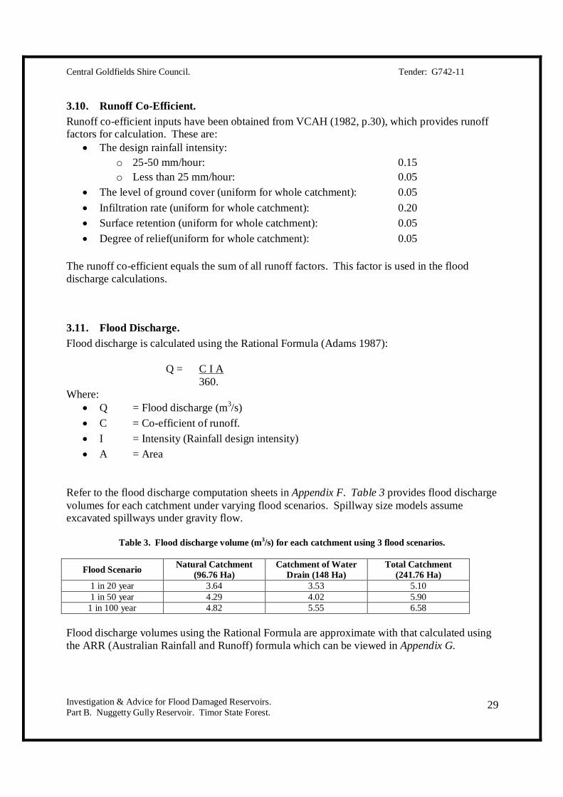
3.11. Flood Discharge. Flood discharge is calculated using the Rational Formula (Adams 1987):
Q = C I A 360. Where:
Q = Flood discharge (m3/s) C = Co-efficient of runoff. I = Intensity (Rainfall design intensity) A = Area
Refer to the flood discharge computation sheets in Appendix F. Table 3 provides flood discharge volumes for each catchment under varying flood scenarios. Spillway size models assume excavated spillways under gravity flow.
Table 3. Flood discharge volume (m3/s) for each catchment using 3 flood scenarios.
Flood Scenario Natural Catchment (96.76 Ha)
Catchment of Water Drain (148 Ha)
Total Catchment (241.76 Ha)
1 in 20 year 3.64 3.53 5.10 1 in 50 year 4.29 4.02 5.90
1 in 100 year 4.82 5.55 6.58 Flood discharge volumes using the Rational Formula are approximate with that calculated using the ARR (Australian Rainfall and Runoff) formula which can be viewed in Appendix G.
Central Goldfields Shire Council. Tender: G742-11
Investigation & Advice for Flood Damaged Reservoirs. Part B. Nuggetty Gully Reservoir. Timor State Forest.
30
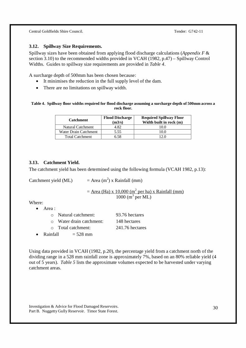
3.12. Spillway Size Requirements. Spillway sizes have been obtained from applying flood discharge calculations (Appendix F & section 3.10) to the recommended widths provided in VCAH (1982, p.47) – Spillway Control Widths. Guides to spillway size requirements are provided in Table 4. A surcharge depth of 500mm has been chosen because:
It minimises the reduction in the full supply level of the dam. There are no limitations on spillway width.
Table 4. Spillway floor widths required for flood discharge assuming a surcharge depth of 500mm across a
rock floor.
Catchment Flood Discharge (m3/s)
Required Spillway Floor Width built in rock (m)
Natural Catchment 4.82 10.0 Water Drain Catchment 5.55 10.0
Total Catchment 6.58 12.0
3.13. Catchment Yield. The catchment yield has been determined using the following formula (VCAH 1982, p.13): Catchment yield (ML) = Area (m2) x Rainfall (mm) = Area (Ha) x 10,000 (m2 per ha) x Rainfall (mm) 1000 (m3 per ML) Where:
Area : o Natural catchment: 93.76 hectares o Water drain catchment: 148 hectares o Total catchment: 241.76 hectares
Rainfall = 528 mm
Using data provided in VCAH (1982, p.20), the percentage yield from a catchment north of the dividing range in a 528 mm rainfall zone is approximately 7%, based on an 80% reliable yield (4 out of 5 years). Table 5 lists the approximate volumes expected to be harvested under varying catchment areas.
Central Goldfields Shire Council. Tender: G742-11
Investigation & Advice for Flood Damaged Reservoirs. Part B. Nuggetty Gully Reservoir. Timor State Forest.
31
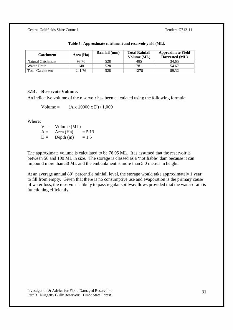
Table 5. Approximate catchment and reservoir yield (ML).
Catchment Area (Ha) Rainfall (mm) Total Rainfall Volume (ML)
Approximate Yield Harvested (ML)
Natural Catchment 93.76 528 495 34.65 Water Drain 148 528 781 54.67 Total Catchment 241.76 528 1276 89.32
3.14. Reservoir Volume. An indicative volume of the reservoir has been calculated using the following formula:
Volume = (A x 10000 x D) / 1,000
Where: V = Volume (ML) A = Area (Ha) = 5.13 D = Depth (m) = 1.5
The approximate volume is calculated to be 76.95 ML. It is assumed that the reservoir is between 50 and 100 ML in size. The storage is classed as a ‘notifiable’ dam because it can impound more than 50 ML and the embankment is more than 5.0 metres in height. At an average annual 80th percentile rainfall level, the storage would take approximately 1 year to fill from empty. Given that there is no consumptive use and evaporation is the primary cause of water loss, the reservoir is likely to pass regular spillway flows provided that the water drain is functioning efficiently.

Central Goldfields Shire Council. Tender: G742-11
Investigation & Advice for Flood Damaged Reservoirs. Part B. Nuggetty Gully Reservoir. Timor State Forest.
32
4. SURVEY RESULTS. There are no original plans of the Nuggetty Gully Reservoir. Comparisons between current measurements and original sizing cannot be made.
4.1. Catchment Area. Catchment area is approximately 242 hectares. Catchment boundaries were sketched by importing LIDAR data into AutoCAD. The catchment is divided into two sections:
Natural catchment: 93.76 hectares Catchment including water drain 148.0 hectares.
Appendix C is a sketch of the catchment of the Nuggetty Gully Reservoir.
4.2. Levels.
4.2.1. Embankment. Appendix I provides a plan view of the embankment. Levels range from:
o 213.51 m (northern tip). o 213.02 m (centre section) o 213.54 m (south end near the cut section).
The embankment is not horizontal. The crest has ‘dished out’ or ‘slumped’. It is possible that the embankment was built with a depression in the bank but this is unlikely.
4.2.2. Spillway. The existing spillway level is approximately 212.51 metres AHD (Appendix I). After repairs the new spillway level will be 212.10 metres AHD. The level of the emergency spillway is 212.56 metres AHD (Appendix I). Although it is possible to leave this open as an emergency spillway, it is recommended to reinstate the cut embankment and have one spillway only. One spillway is easier to manage. Beaching would be required below this section if it were to be left open. It will be easier to install fencing if this section is reinstated.
4.2.3. Freeboard. Refer to Appendix J for a side elevation of the embankment and spillway. Current height of freeboard is:
Lowest embankment level: 213.02 m. Minus: Highest spillway level (existing spillway): 212.51 m.
Freeboard height: 0.51 m.

Central Goldfields Shire Council. Tender: G742-11
Investigation & Advice for Flood Damaged Reservoirs. Part B. Nuggetty Gully Reservoir. Timor State Forest.
33
4.3. Embankment Dimensions.
4.3.1. Height. The height of the embankment is approximately 5.3 metres. The deepest section is where the gully below meets the embankment. This is close to the outlet of the old valve. Height is measured using levels in Appendix I.
4.3.2. Length. The embankment length is approximately 257 metres. The length is provided in Appendix K.
4.3.3. Crest Width. Crest width varies from 1.5-2.0m depending on position. These measurements were taken using a measuring tape.
4.3.4. External Batter. Cross sections of the external batter have been drawn at 10 individual intervals. The external batter slope ranges from 2.25:1 through to 2.5:1 across most of the deeper section. Refer to Appendix L for cross-sections of the embankment.
4.4. Spillway Dimension & Capacity.
4.4.1. Floor Width. The floor width is 4.0 metres.
4.4.2. Capacity. The spillway capacity with varying surcharge depths is included in Table 6 (VCAH, 1982):
Table 6. Spillway capacity with varying surcharge depths.
Surcharge Depth (mm)
Spillway Capacity (m3/s)
100 0.20 150 0.40 200 0.60 250 0.80 300 1.00 350 1.30 400 1.60 450 1.90
500 (embankment overtopping)
2.20

Central Goldfields Shire Council. Tender: G742-11
Investigation & Advice for Flood Damaged Reservoirs. Part B. Nuggetty Gully Reservoir. Timor State Forest.
34
5. FINDINGS OF SUB-SURFACE INVESTIGATIONS Sub-surface investigations were carried out over two visits to the site. The visits were at the following times:
1. December 30, 2011. Investigations using a power auger were undertaken at specific points along the embankment. These findings of this investigation are presented in section 5.1. Notes are presented in Appendix M.
2. January 11, 2012. Investigations involved use of a backhoe. The findings of this investigation are presented in section 5.2.
On both visits the embankment material and soil in the area below the embankment were inspected. The intention of the work was to clarify:
The material used and placement of materials on the embankment. If the construction is consistent with original plans drawn in the early 1860’s. The moisture conditions of the embankment. Location and direction of the phreatic surface. Presence of tree roots on the embankment. Possible piping failure.
Initial indications by the Central Goldfields Shire Council highlighted that the reservoir sustained damage from overtopping and a piping failure. The earthmoving contractor that undertook repair works at the time of the event noted that he was not aware of a piping failure. The sub-surface investigation revealed a small earthen pipe through the embankment along with rilling erosion. Damages require remediation.

Central Goldfields Shire Council. Tender: G742-11
Investigation & Advice for Flood Damaged Reservoirs. Part B. Nuggetty Gully Reservoir. Timor State Forest.
35
5.1. Power Auger Investigation. Notes from this investigation are included as Appendix M.
5.1.1. Site 1. 50 metres. This site exhibited very dry conditions in all auger holes apart from on the water’s edge. At this point the soil is saturated to the full depth of the auger (1.0m). Soils consist of gravelly and silty clays of low plasticity. The soils are very dry indicating that there is no seepage through the embankment. Water is permeating into the embankment from rainfall. The slope of the phreatic surface is downwards and depth to moist material is unknown. Layers of low and high density have been identified by the ease in which they can be augered.
5.1.2. Site 2. 100 metres. This site is very similar to the first site exhibiting gravelly and silty clay soil. The soils vary in density with depth and have been placed in layers during construction. The main feature of this site is the higher clay content on the water’s edge in comparison to the other augered holes across the embankment. Clay on the water edge is yellow-grey in colour and higher in plasticity. The phreatic surface is downwards noted by the presence of dry material in all holes except that on the edge of the water. Non-yielding material is found between 600-800mm of depth. There was a high amount of rock placed throughout the embankment during construction.
5.1.3. Site 3. 108 - 130 metres. Site 3 was located at the lowest level of the embankment. It is hard to gauge the extent of damage from overtopping because there has been a large volume of soil placed across this section during emergency works. The soils in this section are similar to those observed across other sections of the embankment. A series layers with varying densities have been placed to form the embankment. There is a dead tree in this section which may affect the cause embankment weakness. A curtain wall must be installed to seal the embankment in the event that water may travel along voids caused by tree roots.
5.1.4. Site 4. 150 metres. Site 4 is highly similar to other inspected sites. There is a low density layer made up of silty and gravelly clay overlying a similar layer of higher density. A high level of rock is contained within the high density layer.

Central Goldfields Shire Council. Tender: G742-11
Investigation & Advice for Flood Damaged Reservoirs. Part B. Nuggetty Gully Reservoir. Timor State Forest.
36
The material is also dry indicates that seepage is not likely. Movement of moisture is predominately downwards. The embankment appears to be very stable and safe in the current condition.
5.1.5. Site 5. 200 metres. This point exhibits low density material to 500mm. The material is gravelly and sandy clay. The dispersive properties of this material are causing the embankment to seal-up after initial wetting. Very little water is moving into the bank.
5.1.6. Site 6. 241 metres. This point exhibited greyish clay in the saturated zone. Immediately outside of the wetted zone the material is gravelly and sandy clay of low plasticity. This material is dry. A layer of high density is found at 500mm.

Central Goldfields Shire Council. Tender: G742-11
Investigation & Advice for Flood Damaged Reservoirs. Part B. Nuggetty Gully Reservoir. Timor State Forest.
37
5.2. Backhoe Investigation.
5.2.1. Investigation Details. Six soil pits were constructed in the following locations:
1. The northern abutment below the embankment. 2. The base of the gully below the deepest point of the embankment. 3. The top of the embankment in the area that overtopped. 4. The southern abutment below the embankment. 5. Mid-section of the embankment where there is deep rilling. 6. Beside another rilled section of embankment.
The soil profiles highlight:
Sandy and silty layers containing colluvium to a depth of 150mm, noted as the ‘A horizons’.
Clay-dominant subsoil layers between 150-500mm, noted as the ‘B horizons’. A mixture of weathered rock and clay at 500-800mm. Solid rock at between 500mm1000mm of depth.
GPS co-ordinates for soil pits are:
Pit 1. Zone 55. Easting: 0742708 Northing: 5902052
Pit 2. Zone 55. Easting: 0742685 Northing: 5901958
Pit 3. Zone 55. Easting: 0742714 Northing: 5901972
Pit 4. Zone 55. Easting: 0742655 Northing: 5901827
Pit 5. Zone 55. Easting: 0742709 Northing: 5901964
Pit 6. Zone 55. Easting: 0742704 Northing: 5901939
Central Goldfields Shire Council. Tender: G742-11
Investigation & Advice for Flood Damaged Reservoirs. Part B. Nuggetty Gully Reservoir. Timor State Forest.
38
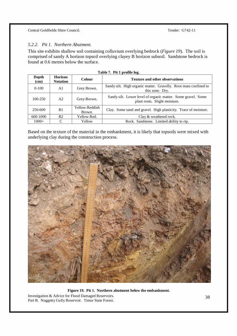
5.2.2. Pit 1. Northern Abutment. This site exhibits shallow soil containing colluvium overlying bedrock (Figure 19). The soil is comprised of sandy A horizon topsoil overlying clayey B horizon subsoil. Sandstone bedrock is found at 0.6 metres below the surface.
Table 7. Pit 1 profile log. Depth (cm)
Horizon Notation Colour Texture and other observations
0-100 A1 Grey Brown. Sandy silt. High organic matter. Gravelly. Root mass confined to this zone. Dry.
100-250 A2 Grey-Brown. Sandy silt. Lower level of organic matter. Some gravel. Some plant roots. Slight moisture.
250-600 B1 Yellow-Reddish Brown. Clay. Some sand and gravel. High plasticity. Trace of moisture.
600-1000 B2 Yellow-Red. Clay & weathered rock. 1000+ C Yellow Rock. Sandstone. Limited ability to rip.
Based on the texture of the material in the embankment, it is likely that topsoils were mixed with underlying clay during the construction process.
Figure 19. Pit 1. Northern abutment below the embankment.

Central Goldfields Shire Council. Tender: G742-11
Investigation & Advice for Flood Damaged Reservoirs. Part B. Nuggetty Gully Reservoir. Timor State Forest.
39
5.2.3. Pit 2. Gully below the embankment. This pit was located at the base of the gully below the deepest section of embankment. The material is a mixture of alluvium and colluvium containing sand, silt, clay and gravel. The underlying weathered rock is found at 900mm. An overlying organic layer is dominant and can be observed in Figure 20. This indicates that the borrow area removed for the dam is likely to be shallow and wide. It also indicates that the material used for the dam is a combination of topsoil and clay, which once mixed exhibits gravelly and sandy clay of low plasticity. The borrow pit exhibits a layer of quartz sand throughout the undisturbed profile indicating that floods of high magnitude have washed large material down the gully. The presence of this dam reduces the erosion process downstream.
Table 8. Pit 2 profile log Depth (cm)
Horizon Notation Colour Texture and other observations
0-30 O Dark grey-brown Organic horizon. Leaves, twigs, bark and insects.
30-100 A1 Pale Red-Brown.
Sandy silt & silty sand. High organic matter. Gravelly. Root mass confined to this zone. Dry. Pale.
100-300 A2 Light-Brown. Sandy silt. Low density. Lower level of organic matter. Some gravel. Some plant rots. Slight moisture.
300-900 B1 Yellow-Reddish Brown.
Clay. Some sand and gravel. High plasticity. Trace of moisture.
900-1000 B2 Yellow-Red. Clay & weathered rock.
Figure 20. Pit 2. Deepest section of the gully below the embankment.

Central Goldfields Shire Council. Tender: G742-11
Investigation & Advice for Flood Damaged Reservoirs. Part B. Nuggetty Gully Reservoir. Timor State Forest.
40
5.2.4. Pit 3. Crest at the overtopped section. This pit was constructed to inspect the embankment material in the overtopped section. Clay content and presence of moisture was also of interest. The material is gravelly and sandy clay and has been deposited in layers of varying thickness. The embankment material is uniformly dry to 1.8 metres. The depth of this pit is well below the water line and indicates that there is no horizontal movement of water through the bank. Figure 21 depicts the level of dryness. The shallowness of tree roots is an indication that trees require surface moisture from rainfall to survive. Tree roots are keeping the embankment dry.
Table 9. Pit 3 profile log Depth (cm)
Horizon Notation Colour Texture and other observations
0-200 Fill. Red-Brown. Sandy & silty clay. Placed on top of the bank during the overtopping event.
0-100 Fill. Pale Red-Brown.
Original surface layer of the embankment. Sandy silt & silty sand. Some tree roots. Very dry. Gravelly.
100-600 Fill. Brown. Gravelly & sandy clay. Some weathered rock. Some large tree roots. Very dry.
600-1400 Fill. Brown. Gravelly & sandy clay. Some weathered rock. Higher % sand and gravel than the above layer. Very dry.
1400-1800 Fill. Yellow-Red. Weathered rock/clayey weathered rock.
Figure 21. Pit 3. Crest of the embankment.
Central Goldfields Shire Council. Tender: G742-11
Investigation & Advice for Flood Damaged Reservoirs. Part B. Nuggetty Gully Reservoir. Timor State Forest.
41
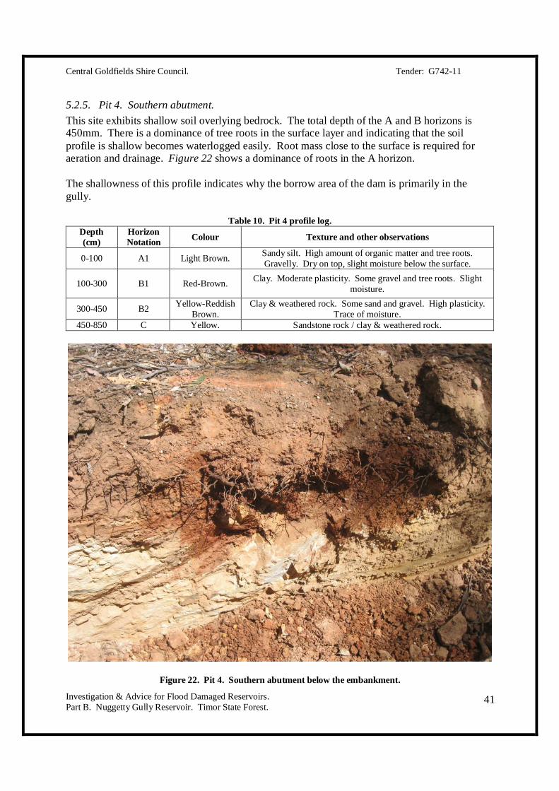
5.2.5. Pit 4. Southern abutment. This site exhibits shallow soil overlying bedrock. The total depth of the A and B horizons is 450mm. There is a dominance of tree roots in the surface layer and indicating that the soil profile is shallow becomes waterlogged easily. Root mass close to the surface is required for aeration and drainage. Figure 22 shows a dominance of roots in the A horizon. The shallowness of this profile indicates why the borrow area of the dam is primarily in the gully.
Table 10. Pit 4 profile log. Depth (cm)
Horizon Notation Colour Texture and other observations
0-100 A1 Light Brown. Sandy silt. High amount of organic matter and tree roots. Gravelly. Dry on top, slight moisture below the surface.
100-300 B1 Red-Brown. Clay. Moderate plasticity. Some gravel and tree roots. Slight moisture.
300-450 B2 Yellow-Reddish Brown.
Clay & weathered rock. Some sand and gravel. High plasticity. Trace of moisture.
450-850 C Yellow. Sandstone rock / clay & weathered rock.
Figure 22. Pit 4. Southern abutment below the embankment.
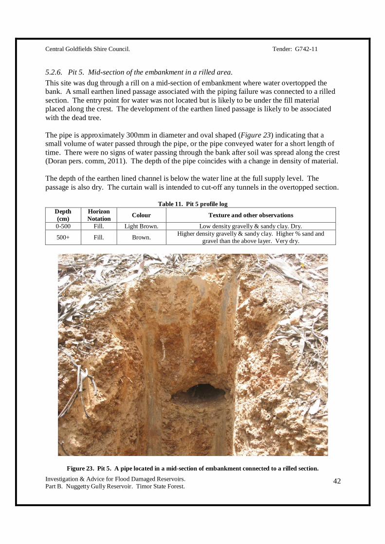
Central Goldfields Shire Council. Tender: G742-11
Investigation & Advice for Flood Damaged Reservoirs. Part B. Nuggetty Gully Reservoir. Timor State Forest.
42
5.2.6. Pit 5. Mid-section of the embankment in a rilled area. This site was dug through a rill on a mid-section of embankment where water overtopped the bank. A small earthen lined passage associated with the piping failure was connected to a rilled section. The entry point for water was not located but is likely to be under the fill material placed along the crest. The development of the earthen lined passage is likely to be associated with the dead tree. The pipe is approximately 300mm in diameter and oval shaped (Figure 23) indicating that a small volume of water passed through the pipe, or the pipe conveyed water for a short length of time. There were no signs of water passing through the bank after soil was spread along the crest (Doran pers. comm, 2011). The depth of the pipe coincides with a change in density of material. The depth of the earthen lined channel is below the water line at the full supply level. The passage is also dry. The curtain wall is intended to cut-off any tunnels in the overtopped section.
Table 11. Pit 5 profile log Depth (cm)
Horizon Notation Colour Texture and other observations
0-500 Fill. Light Brown. Low density gravelly & sandy clay. Dry.
500+ Fill. Brown. Higher density gravelly & sandy clay. Higher % sand and gravel than the above layer. Very dry.
Figure 23. Pit 5. A pipe located in a mid-section of embankment connected to a rilled section.

Central Goldfields Shire Council. Tender: G742-11
Investigation & Advice for Flood Damaged Reservoirs. Part B. Nuggetty Gully Reservoir. Timor State Forest.
43
5.2.7. Pit 6. Batter of the embankment beside a rilled area. This pit was dug beside a rilled section of embankment. Directly above the rill there is evidence that water overtopped the bank washing lighter coloured soil and disturbing the layer of organic matter. There has been a layer of soil spread along the crest directly above the rill. There is no evidence of a piping failure at this location. The layer from 100-500mm is low-density gravelly and sandy clay. This material is dispersive and easily erodible.
Table 12. Pit 6 profile log Depth (cm)
Horizon Notation Colour Texture and other observations
0-100 Fill. Light Brown. Topsoil layer with a high level of organic matter. Material is low-density gravelly & sandy clay. Dry.
100-500 Fill. Brown. Gravelly & sandy clay. Low density. Very dry. Rock and gravel dispersed through this layer.
Figure 24. Pit 6. Near a bad rill.

Central Goldfields Shire Council. Tender: G742-11
Investigation & Advice for Flood Damaged Reservoirs. Part B. Nuggetty Gully Reservoir. Timor State Forest.
44
6. RECOMMENDATIONS. The recommendations in this section provide detail of the actions that must be undertaken for minimum structural remediation of the Nuggetty Gully Reservoir. There are also recommendations that can be undertaken but do not affect the structural integrity of the embankment. These recommendations have been further developed in consultation with the Central Goldfields Shire Council upon completion of Part A of this project. It is assumed that the Central Goldfields Shire Council will consult the necessary landholders and groups if required prior to confirming the proposed option. Those concerned are listed in the Part A report submitted for this project.
6.1. Action that must be undertaken to ensure dam safety.
6.1.1. Repair the damaged section of embankment. This will require:
1. Installation of a compacted clay curtain wall in the crest of the embankment across the overtopped section. The minimum requirements for this wall are:
Width of 300mm. Depth of 2.0 metres. Length of 50 metres. Constructed with suitable clay (to be reviewed during construction. It is assumed
that the material excavated from the embankment will be suitable across the full length of the curtain wall).
Mixed with hydrated lime at 1.0% of volume.
2. Reduce the grade on the external face of the embankment.
Spillway spoil should be placed behind the overtopped section of embankment. The grade should be reduced to a minimum of 3:1.
A basic plan for the installation of a curtain wall will be provided after the Central Goldfields Shire Council provide instruction to proceed.
6.1.2. Upgrade the current spillway to handle flood discharge. This will require:
Widening to a minimum of 12.0 metres. Lowering the spillway level by 400 mm. The new spillway level should be 212.10
metres AHD. The spillway will set the full supply level. Rock beaching along the water course below the spillway.

Central Goldfields Shire Council. Tender: G742-11
Investigation & Advice for Flood Damaged Reservoirs. Part B. Nuggetty Gully Reservoir. Timor State Forest.
45
Spillway plans and costing will be provided after the Central Goldfields Shire Council provides instruction to proceed.
6.1.3. Increase the height of freeboard. The minimum required freeboard height is 0.9 metres. Lowering the spillway by an additional 400mm will provide the required height of freeboard. The current freeboard height of 0.5 metres is not satisfactory for this reservoir given the:
Absence of a curtain wall. Fetch distance. Nature of inflows from the drain. Type of catchment. Age of the structure.
Spillway sizing has been calculated based on a maximum flood discharge height of 500mm. This ensures that there is an additional 400mm of embankment above the maximum flood level during a flood event. Because of the additional height in the spillway at peak flood discharge, the spillway capacity is expected to handle flood discharge volumes of greater magnitude than 1 in 100 years.
6.1.4. Fill in rilled areas. If any rilled areas of embankment are not covered when the embankment is flattened, these areas should be filled in to stop burrowing animals.
6.1.5. Fencing the embankment. It is important to ensure that the embankment is protected from the loss of groundcover. Trail bikes are the main cause of a loss of groundcover. The embankment must be fenced in a way that stops riders from using the embankment. The crest can be used by walkers if the shire chose to build a fencing system that provides access.
6.1.6. Installation of a gauge board. A gauge board must be installed at a point where it is easily readable by Central Goldfields Shire Council staff, reservoir users and contractors carrying out reservoir checks. The gauge board should indicate the full supply level. It is recommended to place the gauge board approximately 3.0-5.0 metres off the embankment.
6.1.7. Development of a dam safety monitoring plan & warning system. This requirement is discussed in further detail in section 7. This requirement ensures that the reservoir is inspected on the following intervals:
Monthly by the owner. Checks are listed in section 7.2.1.

Central Goldfields Shire Council. Tender: G742-11
Investigation & Advice for Flood Damaged Reservoirs. Part B. Nuggetty Gully Reservoir. Timor State Forest.
46
Annually by a qualified dams engineer. Checks are listed in 7.2.2.
If issues are reported while carrying out regular monthly inspections, a qualified dams engineer should be contacted for advice.
A warning system is recommended in section 7.3.
6.1.8. Signage. It is a requirement to install signage indicating reservoir users of the following:
The reservoir is property of the Central Goldfields Shire Council. If at any stage damage to the embankment or surrounds are observed they should be
reported to the owner. Riding on the embankment or spillway is not permitted.
6.2. Options that could be undertaken but will not impact on the safety of the dam.
6.2.1. Maintain the water drain. Undertaking this option will assist with maintaining as much water in the reservoir as possible. This ensures that:
Further drought stress on the embankment and vegetation is minimised. There are sufficient levels in reserve for fire-fighting. The water source is used to maintain biodiversity in the forest.
Undertaking repairs to the water would involve the removal of some minor obstructions. The water drain is a very old structure and has significant heritage value.
6.2.2. Re-instate the emergency spillway. This option is recommended to:
Send regular spillway flows and flood discharge along one properly formed spillway channel.
Stop people from driving or riding into the reservoir. Make fencing the embankment easier.
In the event that this section is not reinstated, rock beaching must be placed below the spillway to avoid erosion. It is also recommended that a channel lined with rock is installed to avoid water from discharging and ponding below the base of the embankment.
Central Goldfields Shire Council. Tender: G742-11
Investigation & Advice for Flood Damaged Reservoirs. Part B. Nuggetty Gully Reservoir. Timor State Forest.
47
6.2.3. Decommission the reservoir. The option of decommissioning the storage has been raised by staff of the Central Goldfields Shire Council. If this option is to be considered community consultation will be required. The groups that require consultation are outlined in the Part A report. It is unlikely that the community would favour this option because:
The reservoir provides a valuable water resource in the event of fire in the forest or local area.
The reservoir has heritage values that date back to the Gold Rush. The reservoir is used by locals for recreational purposes. The maintenance costs are low. The costs associated with filling in the reservoir would be better spent upgrading the
spillway. If the reservoir were to be filled in, the water race would also need to be cut to allow
water to pass along its natural path. Downstream landowners will need to be consulted. Most of their assets have been constructed after the construction of the water race and volumes of water not normally observed would pass along watercourses.
6.3. Options that have been removed after discussion with Central Goldfields Shire Council Staff.
Full construction of a second spillway. Diversion on the water race. Cutting the water drain. Building diversion channels around the reservoir. Increasing the height of the embankment in the depressed area. Reconstruction of the embankment. Make no change to the reservoir.

Central Goldfields Shire Council. Tender: G742-11
Investigation & Advice for Flood Damaged Reservoirs. Part B. Nuggetty Gully Reservoir. Timor State Forest.
48
7. DAM SAFETY MONITORING & EMERGENCY PLANS.
7.1. Suggested Monitoring Interval. A dam safety monitoring plan is required to assist the Central Goldfields Shire Council with the management and safety of the Nuggetty Gully Reservoir. A plan must be developed because the storage fits the classification of a notifiable as it impounds more than 50 ML of water at the full supply level (Lewis, 1992). A notifiable storage poses as a significant hazard to life or property in the event of failure. Lewis (1992) classes the frequency of monitoring by the level of hazard in which the dam presents in the event of failure. The information provided states that notifiable dams of low risk should be monitored on the following interval:
Quick visual inspection weekly by the owner. Comprehensive examination every 3 months.
These guidelines are viewed as more than sufficient given that their risk of failure after structural remediation will be very low. A monitoring interval recommended for this dam is:
A regular inspection on a monthly basis, as per the guidelines in section 7.2.1. A comprehensive examination undertaken annually, as per the guidelines in section 7.2.2.
A regular routine check on a specific time interval will enable the dam owner to become aware of faults before partial or total failure occurs. Upon the development of a monitoring plan, the owner of the dam is required to provide copies of the plan to the DSE and GMW. Comprehensive examination reports are to be provided to DSE and GMW annually.
7.2. Inspection Checklists.
7.2.1. Regular checks by the Central Goldfields Shire Council. This check should be carried out by staff of the Central Goldfields Shire Council. Checks should be documented and filed for reference. The following checks should be made:
Spillway. Water level. Obvious cracks in the embankment. Unusual green areas on or close to the embankment. Any other issues that are brought to attention, including dead trees.
The owner is required to make notes of any problems or damages. In the event that any issues of concern are noted, the DSE Dam Safety Emergency Plan should be referred to and appropriate action taken. A qualified dams engineer should be consulted immediately. The routine check will take approximately 1 hour per month.
Central Goldfields Shire Council. Tender: G742-11
Investigation & Advice for Flood Damaged Reservoirs. Part B. Nuggetty Gully Reservoir. Timor State Forest.
49
7.2.2. Comprehensive examination by a qualified dams engineer. A comprehensive examination on an annual basis should include the following checks: 1. Internal batter.
Scouring, sloughing or erosion from dispersive soil. Rilling. Animal damage. Presence of dead or dying trees. Longitudinal or horizontal cracking.
2. External batter. Rilling. Animal damage. Disturbance to topsoil, vegetation or groundcover. Presence of dead or dying trees. Longitudinal or horizontal cracking.
3. Crest. Rilling. Animal damage. Disturbance to topsoil, vegetation or groundcover. Presence of dead or dying trees. Longitudinal or horizontal cracking. Depressions holding water.
4. Spillway. Blockages from vegetation or dead animals. Conditions of beaching material below the spillway.
5. Water level. The water level at the time of inspection should be recorded.
6. Evaluation of council monthly inspection records. This is required to highlight the following things that may have occurred since the previous comprehensive examination:
Any damage sustained. Details of repair work. Fluctuations in water level over the period.
A report containing details of the abovementioned must be provided to the Central Goldfields Shire Council and passed onto the DSE and GMW. The DSE Dam Safety Emergency Plan should be used if any issues of concern are raised.
Central Goldfields Shire Council. Tender: G742-11
Investigation & Advice for Flood Damaged Reservoirs. Part B. Nuggetty Gully Reservoir. Timor State Forest.
50
7.3. Notification System. When the water level exceeds 80% of the full supply level, downstream landowners should be notified using a warning system. Landowners should indicate their preferred method of notification. Options include those that can be delivered to a person instantly which include:
Telephone calls. SMS. E-mail. In person.
Downstream landowners should be notified when: When the dam reaches 80% of the full supply level. When the level falls below 80%. Prior to a forecasted major rainstorm. When significant rainfalls are predicted over a short period of time.
7.4. Emergency Management Plan. An emergency management plan is required in the event that an emergency situation occurs. The plan is provided in Appendix A. The plan will be completed in consultation with the Central Goldfields Shire Council prior to the completion of Part B of the project.
Central Goldfields Shire Council. Tender: G742-11
Investigation & Advice for Flood Damaged Reservoirs. Part B. Nuggetty Gully Reservoir. Timor State Forest.
51
8. CONCLUSIONS. This report summarises the findings of Parts A and B of the project ‘Investigation and Advice for the Rehabilitation of Flood Damaged Reservoirs – Nuggetty Gully Reservoir’. The report provides recommendations that constitute the minimum requirements for structural remediation and safe operation of the reservoir. Upon instruction from the Central Goldfields Shire Council plans will be generated and supplied. During the course of this process works will be costed along with the finalisation of a monitoring plan and emergency management plan. Plans are to be supplied to the DSE and GMW. The failure of the dam on January 14, 2011 was due to overtopping. Overtopping was caused by high inflows and an inadequately sized spillway. Inflows are likely to have been of a magnitude of 1 in 100-150 years. Water overtopped at the lowest point of the embankment which has possibly subsided since the time of construction. Overtopping was controlled by lowering the water level after constructing an emergency spillway. A small earthen channel was found through the embankment. The passage of water passing through this channel was not enough to create the development of a large pipe and cause a piping failure. The earthen channel ceased flow after emergency works were undertaken. The overtopping event was controlled by cutting an emergency spillway into the embankment at the southern-most point. The earthmoving contractor, unaware of the presence of the earthen channel, appears to have plugged the entry point while spreading soil on the crest of the embankment. Alternatively the pipe has stopped flowing when water levels have fallen in the dam. The embankment sustained rill erosion from overtopping and the earthen channel. The embankment has been built in layers from materials borrowed from within the storage. The embankment contains sandy and gravelly clays of varying densities. The pipe appears to be running along the top of a high density layer. This will be intercepted after the installation of a cut-off wall, constructed from the top of the crest to a depth of 2.0 metres across the overtopped section. After submission of Part A of this project the Central Goldfields Shire Council indicated that their preferred options were to upgrade the current spillway and repair the damaged embankment. The spillway must be widened and deepened to the specifications listed in this report. The floor width and height are oversized to cater for flood discharge of greater volume than 1 in 100 years. A curtain wall must also be installed along the crest across the overtopped section and the embankment must be bolstered and outer batter flattened by placing spoil from the spillway behind the overtopped section. The spillway will set the depth of freeboard at 0.9 metres. The entrance to the spillway must be monitored to ensure that there are no blockages from vegetation, debris or dead animals. Rock beaching below the spillway must be installed. This will dissipate energy and minimise scouring of the water course.

Central Goldfields Shire Council. Tender: G742-11
Investigation & Advice for Flood Damaged Reservoirs. Part B. Nuggetty Gully Reservoir. Timor State Forest.
52
There should be absolute minimal disturbance to the vegetation on the embankment. Any dead trees must be identified during monitoring inspections and the details forwarded to a qualified engineer for assessment. The embankment must be secured to ensure that trail bikes are kept off. Signage should also be installed for trail bike riders to alert them that riding on the embankment is not permitted. The crest of the embankment can be used for walking. A monitoring plan has been suggested in section 7.0. An emergency management plan is provided in Appendix A.
Central Goldfields Shire Council. Tender: G742-11
Investigation & Advice for Flood Damaged Reservoirs. Part B. Nuggetty Gully Reservoir. Timor State Forest.
53
REFERENCES Adams, C.A. 1987, Design flood estimation for ungauged rural catchments in Victoria Road
Construction Authority, Victoria, Draft Technical Bulletin. Adams, C.A. & McMahon, T.A. 1985, Estimation of flood discharge for ungauged rural catchments
in Victoria, Proceedings 1985 Hydrology and Water Resources Symposium, IEAust Natl Conf. Publ. No. 85/2, pp 86-90.
Anon undated. Dunolly General History, cited at:
http://www.dpcd.vic.gov.au/_/data/assets/pdf_file/0020/44633/Dunolly.pdf Anon 2008, Timor book, Central Goldfields Visitor Information Centre. Anon 2011. Victorian Resources Online – Maintaining your dam, Suggested Dam Inspection Frequencies, Cited at:
http://vro.dpi.vic.gov.au/dpi/vro/vrosite.nsf/pages/access-dams-maintain Cunningham, G.M., Mulham, W.E., Milthorpe, P.L. & Leigh, J.H. 1992, Plants of Western New South Wales,
CSIRO Publishing, Melbourne. Doran, C. Earthmoving contractor, Maryborough, Victoria, personal communication, December 30 2011. Geovic 2011. Nuggetty Gully Geology, Department of Primary Industries, Victoria. Cited at:
http://mapshare2.dse.vic.gov.au/MapShare2EXT/Imf.jsp?site=geovic
Hall, G. Personal communication. North Central Catchment Management Authority, December 8, 2011. Ipsen, G. Local Farmer, Timor, personal communication, January 4, 2012. Lewis, B. 1992. ‘Your Dam – An Asset or Liability’, Rural Water Corporation & Department of Conservation &
Environment, Victoria. Nathan, R.J. & Weinmann, E. 1999, Estimation of Large to Extreme Floods, Book VI in Australian Rainfall and
Runoff - A Guide to Flood Estimation , The Institution of Engineers, Australia, Barton, ACT. Osborn, B. & DuBourg, T. 2011, ‘Maryborough – A Social History’ Central Goldfields Shire Council,
Maryborough, Victoria. Schoknecht, N.R. 1988, ‘Land Inventory of the Loddon River Catchment’, Land Protection Division, Department of
Conservation & Lands, Victoria. Vic-Roads Road Design Manual 1985, Vic Roads, Victoria. Vicmap 1995. Dunolly South 7624-3-S, Topographical Map 1:25,000, Department of Property & Services, Division
of Survey and Mapping, Melbourne.

Central Goldfields Shire Council. Tender: G742-11
Investigation & Advice for Flood Damaged Reservoirs. Part B. Nuggetty Gully Reservoir. Timor State Forest.
54

Central Goldfields Shire Council. Tender: G742-11
Investigation & Advice for Flood Damaged Reservoirs. Part B. Nuggetty Gully Reservoir. Timor State Forest.
55
APPENDIX A.

Central Goldfields Shire Council. Tender: G742-11
Investigation & Advice for Flood Damaged Reservoirs. Part B. Nuggetty Gully Reservoir. Timor State Forest.
56
NUGGETTY GULLY RESERVOIR EMERGENCY MANAGEMENT PLAN.
1) Maintain records of landholder phone numbers of downstream properties who would be affected in the event of embankment failure. Update records annually.
2) Mark their properties on a map that can be referred to in the event of an emergency.
3) Maintain a record and contact details of agencies in the region responsible for emergency management as per the DSE Dam Safety Emergency Plan. These include Central Highlands Water, Goulburn Murray Water and the Department of Sustainability and Environment.
4) The Central Goldfields Shire Council should alert downstream landholders when an
event of high intensity is forecasted.
5) When the reservoir reaches 80% of the full supply level at any season, downstream landowners should be notified.
6) An inspection of the spillway should be carried out by the Central Goldfields Shire Council at times when flood discharge is passing through the spillway. At any time that concern is raised about the safety of the dam the DSE Dam Safety Emergency Plan should be carried out and a qualified dams engineer contacted immediately.
7) In the event of an earthquake or landslip in the catchment, the dam should be inspected
immediately and the DSE Dam Safety Emergency Plan activated. A qualified dams engineer should be contacted and downstream landowners notified immediately.
8) In the event of a breech or overtopping, the DSE Dam Safety Emergency Plan should be
activated and a qualified dams engineer should be contacted. Downstream landowners should be notified immediately. An inspection of the dam should be carried out as soon as possible if safe to do so. Short term remediation works and long term repairs should be considered.
Central Goldfields Shire Council. Tender: G742-11
Investigation & Advice for Flood Damaged Reservoirs. Part B. Nuggetty Gully Reservoir. Timor State Forest.
57
APPENDIX B.
Central Goldfields Shire Council. Tender: G742-11
Investigation & Advice for Flood Damaged Reservoirs. Part B. Nuggetty Gully Reservoir. Timor State Forest.
58
Initial Inspection & Observations from the Nuggetty Gully Reservoir. Date of Inspection: Tuesday, 15th of November, 2011. Carried out by: Christian Bannan & Roger Wrigley.
The Nuggetty Gully reservoir and catchment were inspected to determine possible causes of failure during January 2011. The inspection included a walk and drive throughout the catchment to the east to gain an understanding of the soils, vegetation and slope of the land. Catchment: The main catchment area (to the east) is Grey Box forest, with a good mixture of understory plants. The plant species appear healthy and there were very few weeds present. The geology consists of gently undulating Ordovician sandstone, shale and slate (Schoknecht 1988). A typical soil profile exhibits shallow topsoil and a total soil depth of 0.5-1.0m overlying bedrock. Soils are deeper in depressions. Subsoils are dispersive as indicated by the dispersed water in the small hole excavated below the breached section. Soil used for plugging the breach was obtained from this pit. There is evidence of old mining activity and recent prospecting. There are some areas where erosion is evident, indicating that the speed of water flow into the dam is greater than 1.0 m/s. The slope of the land is contributing to the speed of water movement. The water in the reservoir is reasonably clear indicating that the there is little contact between the water and dispersive subsoil. The reservoir is likely to have a lining of organic matter and silt which will improve water clarity. There is minimal erosion in the catchment and therefore minimal impact on water turbidity. Reservoir & Spillway Observations and Damage:
1. A piping failure was the cause of breaching during January 2011. This is confirmed by inspecting the ‘patched up’ section where the pipe occurred and also confirming what occurred with the earthmoving contractor who repaired the dam (Craig Doran). We will understand more on the cause after further investigation.
2. Damage is confined to a 35-50m section of the embankment covering the breached area.
This is likely to be adjacent to the deepest point of the dam. This zone will be under the greatest amount of pressure.
3. The embankment has most likely subsided over its 100-150 year history. The embankment has now ‘dished out’ across the breached section. The height of the dished out section is approximately 1.0m lower than the north and south ends of the

Central Goldfields Shire Council. Tender: G742-11
Investigation & Advice for Flood Damaged Reservoirs. Part B. Nuggetty Gully Reservoir. Timor State Forest.
59
embankment. The lower embankment height significantly reduces the amount of freeboard.
4. A dead tree in the dished out section near the breach may have contributed to the piping failure. It is possible that dead decaying roots may have may be creating a weakness in the embankment by allowing water to pass into and through the embankment. This will be confirmed upon further investigation.
5. The spillway height is likely to be providing insufficient freeboard to protect the dished out section of the embankment from overtopping. This will be confirmed upon completion of surveying. The additional spillway constructed by the earthmoving contractor appears to have lowered the water height in the dam to take pressure away from the repaired breach.
6. The outflow of the spillway will also require sufficient rock stabilisation to minimise the amount of erosion that is currently occurring below.
Recommendations for the Central Goldfields Shire Council at this point:
1. No urgent earthworks are required. Emergency earthworks carried out in January 2011 are substantial enough maintain the integrity of the embankment if significant inflows were to occur in the catchment of the reservoir, until such time that the repairs are carried out to the embankment and spillway (expected timeframe 2-4 months).
2. Motorbikes must be banned immediately from using the embankment and outer face for riding. Motorbikes are destroying the vegetation and groundcover which protects the outer face from erosion and deterioration. Most of the impact from trail bikes is concentrated near the breached section.
3. The water height does not need to be lowered at this stage. Maintain water in the dam for fire-fighting purposes.
4. Do not remove any trees from the embankment. This may create other passages for water to pass through the embankment.
5. Investigation is required in the area of the breached section to determine the extent of the damage and methods for repair. A backhoe or small excavator will be required for the non-intrusive investigation. Power augers will also be used to check other areas of the embankment for consistency in construction materials.

Central Goldfields Shire Council. Tender: G742-11
Investigation & Advice for Flood Damaged Reservoirs. Part B. Nuggetty Gully Reservoir. Timor State Forest.
60
6. Surveying of the reservoir, spillway and surrounding catchment will need to be undertaken as soon as possible.
7. Depth measurements will be required using a boat to determine the capacity of the dam. This will be undertaken as soon as possible.
8. Further hydrological and soil investigation will be undertaken in the catchment to properly determine catchment inflows and peak inflow.
Other options for maintaining the integrity of the existing structure which need to be discussed with the Central Goldfields Shire Council:
1. Creating diversion channels around the dam with gates which allow water to shift into the dam at slow speed or otherwise pass around the dam. This includes the inflow channel to the south from private property.
2. Reducing the height of the spillway and possible upgrades in size to handle peak inflows.
3. The possibility of constructing a second spillway in the location where the emergency
spillway has been constructed.
These options will be discussed upon completion of Part A of the project. Other issues to be discussed with the Central Goldfields Shire Council:
1. The area to the south of the dam which draws water from private property was not inspected. We need to obtain permission from the landowner via the CGSC to inspect this area and include this in the area to be surveyed.
2. The emphasis of this investigation will shift to the catchment investigation, spillway
design and diversion measures rather than significant reconstruction of the embankment.
3. Embankment repairs are likely to be confined to the damaged 35-50m section of embankment.
4. If trees are removed from the embankment their roots will also have to be removed (to
stop root decay in the embankment). This would include a full reconstruction of the embankment. This is very expensive (in excess of $250,000.00). It is likely that the tree roots are assisting with holding the embankment together.

Central Goldfields Shire Council. Tender: G742-11
Investigation & Advice for Flood Damaged Reservoirs. Part B. Nuggetty Gully Reservoir. Timor State Forest.
61
APPENDIX C.

Central Goldfields Shire Council. Tender: G742-11
Investigation & Advice for Flood Damaged Reservoirs. Part B. Nuggetty Gully Reservoir. Timor State Forest.
62

Central Goldfields Shire Council. Tender: G742-11
Investigation & Advice for Flood Damaged Reservoirs. Part B. Nuggetty Gully Reservoir. Timor State Forest.
63

Central Goldfields Shire Council. Tender: G742-11
Investigation & Advice for Flood Damaged Reservoirs. Part B. Nuggetty Gully Reservoir. Timor State Forest.
64

Central Goldfields Shire Council. Tender: G742-11
Investigation & Advice for Flood Damaged Reservoirs. Part B. Nuggetty Gully Reservoir. Timor State Forest.
65
APPENDIX D.

Central Goldfields Shire Council. Tender: G742-11
Investigation & Advice for Flood Damaged Reservoirs. Part B. Nuggetty Gully Reservoir. Timor State Forest.
66

Central Goldfields Shire Council. Tender: G742-11
Investigation & Advice for Flood Damaged Reservoirs. Part B. Nuggetty Gully Reservoir. Timor State Forest.
67

Central Goldfields Shire Council. Tender: G742-11
Investigation & Advice for Flood Damaged Reservoirs. Part B. Nuggetty Gully Reservoir. Timor State Forest.
68

Central Goldfields Shire Council. Tender: G742-11
Investigation & Advice for Flood Damaged Reservoirs. Part B. Nuggetty Gully Reservoir. Timor State Forest.
69
APPENDIX E.

Central Goldfields Shire Council. Tender: G742-11
Investigation & Advice for Flood Damaged Reservoirs. Part B. Nuggetty Gully Reservoir. Timor State Forest.
70
Maryborough Monthly & Annual Rainfall - 1878 - 2011.
Year Jan Feb Mar Apr May Jun Jul Aug Sep Oct Nov Dec Annual
1878 0.0 22.4 113.8 77.2 11.4 67.0 33.5 43.5 36.8 30.8 23.3 0.0 459.7 1879 9.9 10.7 18.5 71.3 31.6 22.1 23.8 35.1 41.5 49.7 37.8 24.4 376.4 1880 5.1 106.4 61.3 133.5 24.6 70.4 5.8 30.0 58.5 37.3 1.3 13.4 547.6 1881 6.6 0.0 65.1 22.4 69.2 56.3 19.7 49.5 18.0 27.5 38.1 44.2 416.6 1882 0.0 0.0 5.8 56.4 81.3 23.3 60.7 40.1 20.6 59.1 50.8 34.5 432.6 1883 6.9 45.2 40.6 14.4 89.2 73.1 59.1 63.3 43.2 39.6 41.0 39.1 554.7 1884 60.9 16.8 53.6 29.2 73.2 45.4 7.6 41.8 44.4 40.7 30.8 47.9 492.3 1885 13.0 33.9 38.4 44.0 36.7 56.6 65.1 32.0 85.1 18.1 34.6 73.7 531.2 1886 112.6 20.5 21.3 6.4 30.8 11.7 61.8 100.3 46.5 67.3 46.3 60.2 585.7 1887 17.8 26.8 6.1 54.9 23.1 65.6 65.8 63.3 46.2 48.0 100.2 89.6 607.4 1888 31.4 6.6 11.5 16.8 51.3 54.3 47.8 36.2 21.6 27.6 9.4 54.6 369.1 1889 82.0 34.0 3.5 106.8 49.8 145.7 17.5 84.4 53.4 51.5 70.4 1.3 700.3 1890 30.7 1.5 58.7 55.2 48.8 88.4 78.2 62.9 43.6 52.6 83.8 19.8 624.2 1891 14.0 0.0 38.4 25.4 39.2 46.8 43.6 30.2 31.5 78.3 34.2 29.6 411.2 1892 1.3 4.6 36.8 75.8 82.7 58.7 44.5 49.3 55.9 53.2 70.9 42.7 576.4 1893 6.4 2.3 29.2 66.9 174.6 88.3 42.6 52.7 57.5 87.3 86.9 12.7 707.4 1894 11.5 0.0 48.3 47.9 40.6 61.7 58.8 62.1 71.6 161.5 6.9 91.9 662.8 1895 51.3 1.0 19.3 69.9 9.2 34.1 45.9 48.2 58.0 36.6 0.0 63.0 436.5 1896 27.0 52.8 40.9 63.1 19.7 24.1 34.1 27.9 28.7 2.6 33.0 13.4 367.3 1897 83.6 3.9 14.5 13.8 15.8 52.8 40.6 101.0 49.8 36.6 25.6 15.2 453.2 1898 0.5 38.4 2.6 31.8 24.9 119.1 44.8 46.5 60.3 36.7 12.8 37.6 456.0 1899 6.6 27.5 17.3 36.0 21.9 9.7 1900 23.1 2.5 57.6 56.7 62.0 78.7 2.8 87.1 54.2 16.3 0.0 15.5 456.5 1901 31.5 10.3 25.9 44.4 7.8 71.7 42.2 32.3 86.4 58.4 31.1 13.0 455.0 1902 19.0 8.3 35.5 1.8 7.6 45.8 15.8 13.4 27.7 21.5 10.0 55.2 261.6 1903 21.6 20.1 23.3 106.7 35.0 62.0 109.4 50.0 115.5 84.4 87.8 48.6 764.4 1904 81.2 37.1 10.9 16.8 53.7 74.7 85.5 39.4 20.9 53.6 26.4 1.3 501.5 1905 35.6 15.3 6.4 84.2 53.2 50.3 84.0 23.5 45.0 76.2 19.0 9.2 501.9 1906 0.0 35.6 47.1 7.2 82.5 105.0 56.9 50.6 71.2 69.4 83.1 13.4 622.0
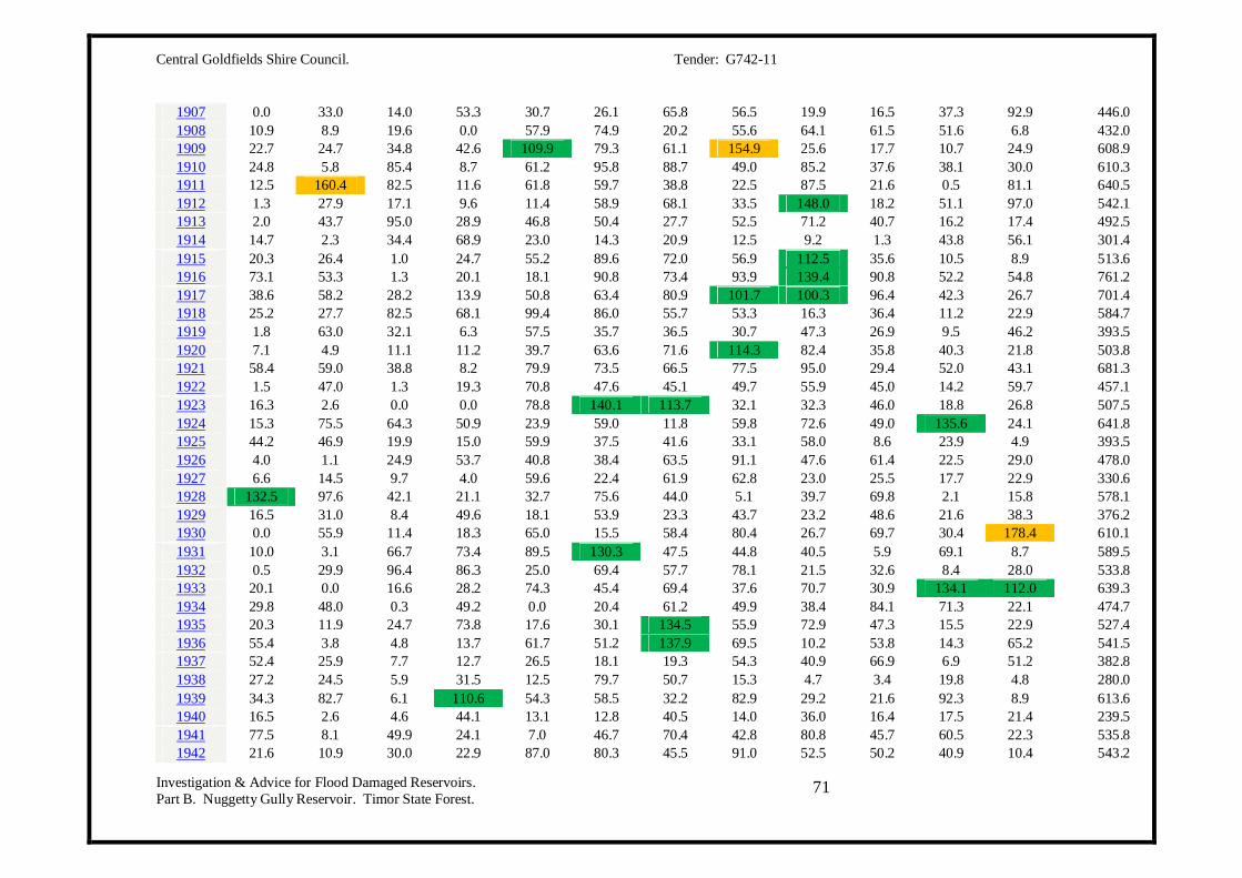
Central Goldfields Shire Council. Tender: G742-11
Investigation & Advice for Flood Damaged Reservoirs. Part B. Nuggetty Gully Reservoir. Timor State Forest.
71
1907 0.0 33.0 14.0 53.3 30.7 26.1 65.8 56.5 19.9 16.5 37.3 92.9 446.0 1908 10.9 8.9 19.6 0.0 57.9 74.9 20.2 55.6 64.1 61.5 51.6 6.8 432.0 1909 22.7 24.7 34.8 42.6 109.9 79.3 61.1 154.9 25.6 17.7 10.7 24.9 608.9 1910 24.8 5.8 85.4 8.7 61.2 95.8 88.7 49.0 85.2 37.6 38.1 30.0 610.3 1911 12.5 160.4 82.5 11.6 61.8 59.7 38.8 22.5 87.5 21.6 0.5 81.1 640.5 1912 1.3 27.9 17.1 9.6 11.4 58.9 68.1 33.5 148.0 18.2 51.1 97.0 542.1 1913 2.0 43.7 95.0 28.9 46.8 50.4 27.7 52.5 71.2 40.7 16.2 17.4 492.5 1914 14.7 2.3 34.4 68.9 23.0 14.3 20.9 12.5 9.2 1.3 43.8 56.1 301.4 1915 20.3 26.4 1.0 24.7 55.2 89.6 72.0 56.9 112.5 35.6 10.5 8.9 513.6 1916 73.1 53.3 1.3 20.1 18.1 90.8 73.4 93.9 139.4 90.8 52.2 54.8 761.2 1917 38.6 58.2 28.2 13.9 50.8 63.4 80.9 101.7 100.3 96.4 42.3 26.7 701.4 1918 25.2 27.7 82.5 68.1 99.4 86.0 55.7 53.3 16.3 36.4 11.2 22.9 584.7 1919 1.8 63.0 32.1 6.3 57.5 35.7 36.5 30.7 47.3 26.9 9.5 46.2 393.5 1920 7.1 4.9 11.1 11.2 39.7 63.6 71.6 114.3 82.4 35.8 40.3 21.8 503.8 1921 58.4 59.0 38.8 8.2 79.9 73.5 66.5 77.5 95.0 29.4 52.0 43.1 681.3 1922 1.5 47.0 1.3 19.3 70.8 47.6 45.1 49.7 55.9 45.0 14.2 59.7 457.1 1923 16.3 2.6 0.0 0.0 78.8 140.1 113.7 32.1 32.3 46.0 18.8 26.8 507.5 1924 15.3 75.5 64.3 50.9 23.9 59.0 11.8 59.8 72.6 49.0 135.6 24.1 641.8 1925 44.2 46.9 19.9 15.0 59.9 37.5 41.6 33.1 58.0 8.6 23.9 4.9 393.5 1926 4.0 1.1 24.9 53.7 40.8 38.4 63.5 91.1 47.6 61.4 22.5 29.0 478.0 1927 6.6 14.5 9.7 4.0 59.6 22.4 61.9 62.8 23.0 25.5 17.7 22.9 330.6 1928 132.5 97.6 42.1 21.1 32.7 75.6 44.0 5.1 39.7 69.8 2.1 15.8 578.1 1929 16.5 31.0 8.4 49.6 18.1 53.9 23.3 43.7 23.2 48.6 21.6 38.3 376.2 1930 0.0 55.9 11.4 18.3 65.0 15.5 58.4 80.4 26.7 69.7 30.4 178.4 610.1 1931 10.0 3.1 66.7 73.4 89.5 130.3 47.5 44.8 40.5 5.9 69.1 8.7 589.5 1932 0.5 29.9 96.4 86.3 25.0 69.4 57.7 78.1 21.5 32.6 8.4 28.0 533.8 1933 20.1 0.0 16.6 28.2 74.3 45.4 69.4 37.6 70.7 30.9 134.1 112.0 639.3 1934 29.8 48.0 0.3 49.2 0.0 20.4 61.2 49.9 38.4 84.1 71.3 22.1 474.7 1935 20.3 11.9 24.7 73.8 17.6 30.1 134.5 55.9 72.9 47.3 15.5 22.9 527.4 1936 55.4 3.8 4.8 13.7 61.7 51.2 137.9 69.5 10.2 53.8 14.3 65.2 541.5 1937 52.4 25.9 7.7 12.7 26.5 18.1 19.3 54.3 40.9 66.9 6.9 51.2 382.8 1938 27.2 24.5 5.9 31.5 12.5 79.7 50.7 15.3 4.7 3.4 19.8 4.8 280.0 1939 34.3 82.7 6.1 110.6 54.3 58.5 32.2 82.9 29.2 21.6 92.3 8.9 613.6 1940 16.5 2.6 4.6 44.1 13.1 12.8 40.5 14.0 36.0 16.4 17.5 21.4 239.5 1941 77.5 8.1 49.9 24.1 7.0 46.7 70.4 42.8 80.8 45.7 60.5 22.3 535.8 1942 21.6 10.9 30.0 22.9 87.0 80.3 45.5 91.0 52.5 50.2 40.9 10.4 543.2

Central Goldfields Shire Council. Tender: G742-11
Investigation & Advice for Flood Damaged Reservoirs. Part B. Nuggetty Gully Reservoir. Timor State Forest.
72
1943 21.6 23.6 4.1 33.0 28.0 39.5 54.5 44.3 42.6 20.5 17.3 8.4 337.4 1944 6.8 13.7 33.8 44.9 53.2 10.0 37.5 3.4 14.3 29.2 15.8 39.2 301.8 1945 15.2 26.3 3.0 5.4 23.9 81.7 51.2 72.2 28.2 36.6 31.8 5.1 380.6 1946 84.0 110.6 55.9 35.0 24.4 37.5 59.5 32.3 14.6 31.9 45.8 39.1 570.6 1947 0.8 47.2 97.9 22.1 11.4 49.2 70.2 42.9 40.8 103.4 32.6 77.3 595.8 1948 19.5 65.6 1.5 35.0 27.8 53.8 43.9 22.3 30.8 71.4 16.7 110.8 499.1 1949 15.7 114.8 79.2 1.5 29.2 14.5 46.8 15.0 57.0 98.0 89.0 4.2 564.9 1950 1.8 94.8 106.1 53.9 69.4 17.7 65.9 74.5 74.3 48.9 37.8 34.0 679.1 1951 20.5 106.1 0.8 49.9 68.0 85.6 81.4 60.3 9.7 64.8 10.5 32.5 590.1 1952 24.7 24.6 9.1 58.8 101.4 79.4 34.1 56.7 42.0 89.1 91.3 29.7 640.9 1953 12.7 12.7 3.3 31.0 22.9 71.1 48.5 56.5 84.7 44.0 39.7 25.4 452.5 1954 49.3 14.3 7.6 58.9 19.5 32.5 30.4 48.5 28.4 54.9 64.2 84.8 493.3 1955 22.8 76.3 11.5 10.5 63.7 78.1 45.7 109.8 63.9 52.2 32.3 22.8 589.6 1956 33.9 1.3 52.7 88.5 158.6 57.5 97.0 54.3 55.4 61.7 29.9 11.9 702.7 1957 3.8 88.2 19.3 26.7 12.6 73.0 24.3 35.5 26.3 56.1 29.4 27.3 422.5 1958 29.9 23.0 6.9 10.2 89.3 9.8 78.9 120.2 46.8 72.6 46.1 8.4 542.1 1959 21.6 62.5 50.2 17.8 10.2 59.1 20.6 53.1 56.2 60.3 13.4 45.5 470.5 1960 33.9 40.8 15.0 79.4 109.2 52.3 81.7 68.7 94.2 21.7 88.4 15.0 700.3 1961 91.2 18.0 43.2 96.1 13.9 40.7 48.3 28.8 16.3 68.0 35.3 77.7 577.5 1962 52.9 17.6 47.7 7.6 73.7 66.1 46.7 70.1 58.5 53.3 18.5 22.9 535.6 1963 73.8 7.8 23.3 12.3 100.8 51.7 54.5 50.7 52.9 52.0 9.6 11.9 501.3 1964 4.8 25.9 8.1 79.0 40.6 60.2 98.1 52.6 111.1 106.1 34.0 44.5 665.0 1965 3.8 0.0 7.9 28.2 66.7 29.1 69.8 95.9 26.4 16.9 66.3 62.2 473.2 1966 13.3 42.2 43.5 11.9 35.1 26.5 55.5 47.1 70.9 69.4 19.8 71.0 506.2 1967 4.1 2.3 5.3 9.1 20.1 40.5 35.3 54.4 27.7 8.4 11.0 28.5 246.7 1968 51.6 2.6 49.1 68.7 92.3 79.6 74.6 86.2 21.9 51.7 40.2 51.1 669.6 1969 11.0 76.1 84.1 19.0 67.2 12.4 84.8 64.2 51.2 7.1 55.2 26.9 559.2 1970 77.6 4.4 71.1 74.1 40.1 37.4 26.0 53.7 47.5 26.7 84.7 26.1 569.4 1971 34.1 103.7 21.6 70.7 43.1 48.9 34.2 40.4 64.0 69.3 71.4 58.5 659.9 1972 48.5 161.2 26.7 50.9 24.0 46.7 54.4 55.5 30.7 37.2 52.6 0.8 589.2 1973 94.1 186.7 24.6 68.1 67.1 98.4 52.6 97.2 91.0 132.1 49.8 60.5 1022.2 1974 88.6 53.8 22.6 107.4 89.6 10.6 72.0 84.4 62.8 88.6 6.4 18.0 704.8 1975 32.4 1.6 77.0 8.0 46.0 16.2 71.0 59.8 121.4 195.0 40.2 63.0 731.6 1976 11.6 77.6 22.4 8.5 13.8 33.0 26.0 39.6 47.0 38.4 52.2 46.0 416.1 1977 25.4 31.0 32.6 36.6 56.0 71.4 25.8 27.2 23.8 26.4 28.8 9.0 394.0 1978 7.8 8.0 40.0 60.4 98.8 57.8 79.6 80.2 71.8 64.8 82.0 37.8 689.0
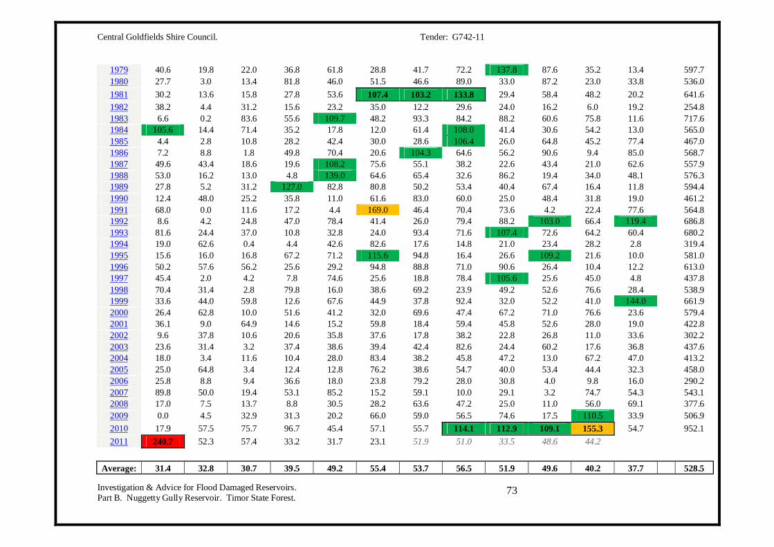
Central Goldfields Shire Council. Tender: G742-11
Investigation & Advice for Flood Damaged Reservoirs. Part B. Nuggetty Gully Reservoir. Timor State Forest.
73
1979 40.6 19.8 22.0 36.8 61.8 28.8 41.7 72.2 137.8 87.6 35.2 13.4 597.7 1980 27.7 3.0 13.4 81.8 46.0 51.5 46.6 89.0 33.0 87.2 23.0 33.8 536.0 1981 30.2 13.6 15.8 27.8 53.6 107.4 103.2 133.8 29.4 58.4 48.2 20.2 641.6 1982 38.2 4.4 31.2 15.6 23.2 35.0 12.2 29.6 24.0 16.2 6.0 19.2 254.8 1983 6.6 0.2 83.6 55.6 109.7 48.2 93.3 84.2 88.2 60.6 75.8 11.6 717.6 1984 105.6 14.4 71.4 35.2 17.8 12.0 61.4 108.0 41.4 30.6 54.2 13.0 565.0 1985 4.4 2.8 10.8 28.2 42.4 30.0 28.6 106.4 26.0 64.8 45.2 77.4 467.0 1986 7.2 8.8 1.8 49.8 70.4 20.6 104.3 64.6 56.2 90.6 9.4 85.0 568.7 1987 49.6 43.4 18.6 19.6 108.2 75.6 55.1 38.2 22.6 43.4 21.0 62.6 557.9 1988 53.0 16.2 13.0 4.8 139.0 64.6 65.4 32.6 86.2 19.4 34.0 48.1 576.3 1989 27.8 5.2 31.2 127.0 82.8 80.8 50.2 53.4 40.4 67.4 16.4 11.8 594.4 1990 12.4 48.0 25.2 35.8 11.0 61.6 83.0 60.0 25.0 48.4 31.8 19.0 461.2 1991 68.0 0.0 11.6 17.2 4.4 169.0 46.4 70.4 73.6 4.2 22.4 77.6 564.8 1992 8.6 4.2 24.8 47.0 78.4 41.4 26.0 79.4 88.2 103.0 66.4 119.4 686.8 1993 81.6 24.4 37.0 10.8 32.8 24.0 93.4 71.6 107.4 72.6 64.2 60.4 680.2 1994 19.0 62.6 0.4 4.4 42.6 82.6 17.6 14.8 21.0 23.4 28.2 2.8 319.4 1995 15.6 16.0 16.8 67.2 71.2 115.6 94.8 16.4 26.6 109.2 21.6 10.0 581.0 1996 50.2 57.6 56.2 25.6 29.2 94.8 88.8 71.0 90.6 26.4 10.4 12.2 613.0 1997 45.4 2.0 4.2 7.8 74.6 25.6 18.8 78.4 105.6 25.6 45.0 4.8 437.8 1998 70.4 31.4 2.8 79.8 16.0 38.6 69.2 23.9 49.2 52.6 76.6 28.4 538.9 1999 33.6 44.0 59.8 12.6 67.6 44.9 37.8 92.4 32.0 52.2 41.0 144.0 661.9 2000 26.4 62.8 10.0 51.6 41.2 32.0 69.6 47.4 67.2 71.0 76.6 23.6 579.4 2001 36.1 9.0 64.9 14.6 15.2 59.8 18.4 59.4 45.8 52.6 28.0 19.0 422.8 2002 9.6 37.8 10.6 20.6 35.8 37.6 17.8 38.2 22.8 26.8 11.0 33.6 302.2 2003 23.6 31.4 3.2 37.4 38.6 39.4 42.4 82.6 24.4 60.2 17.6 36.8 437.6 2004 18.0 3.4 11.6 10.4 28.0 83.4 38.2 45.8 47.2 13.0 67.2 47.0 413.2 2005 25.0 64.8 3.4 12.4 12.8 76.2 38.6 54.7 40.0 53.4 44.4 32.3 458.0 2006 25.8 8.8 9.4 36.6 18.0 23.8 79.2 28.0 30.8 4.0 9.8 16.0 290.2 2007 89.8 50.0 19.4 53.1 85.2 15.2 59.1 10.0 29.1 3.2 74.7 54.3 543.1 2008 17.0 7.5 13.7 8.8 30.5 28.2 63.6 47.2 25.0 11.0 56.0 69.1 377.6 2009 0.0 4.5 32.9 31.3 20.2 66.0 59.0 56.5 74.6 17.5 110.5 33.9 506.9 2010 17.9 57.5 75.7 96.7 45.4 57.1 55.7 114.1 112.9 109.1 155.3 54.7 952.1 2011 240.7 52.3 57.4 33.2 31.7 23.1 51.9 51.0 33.5 48.6 44.2
Average: 31.4 32.8 30.7 39.5 49.2 55.4 53.7 56.5 51.9 49.6 40.2 37.7 528.5
Central Goldfields Shire Council. Tender: G742-11
Investigation & Advice for Flood Damaged Reservoirs. Part B. Nuggetty Gully Reservoir. Timor State Forest.
74
Between 100 and 150mm for the month
Between 150 and 200mm for the month
More than 200mm for the month.
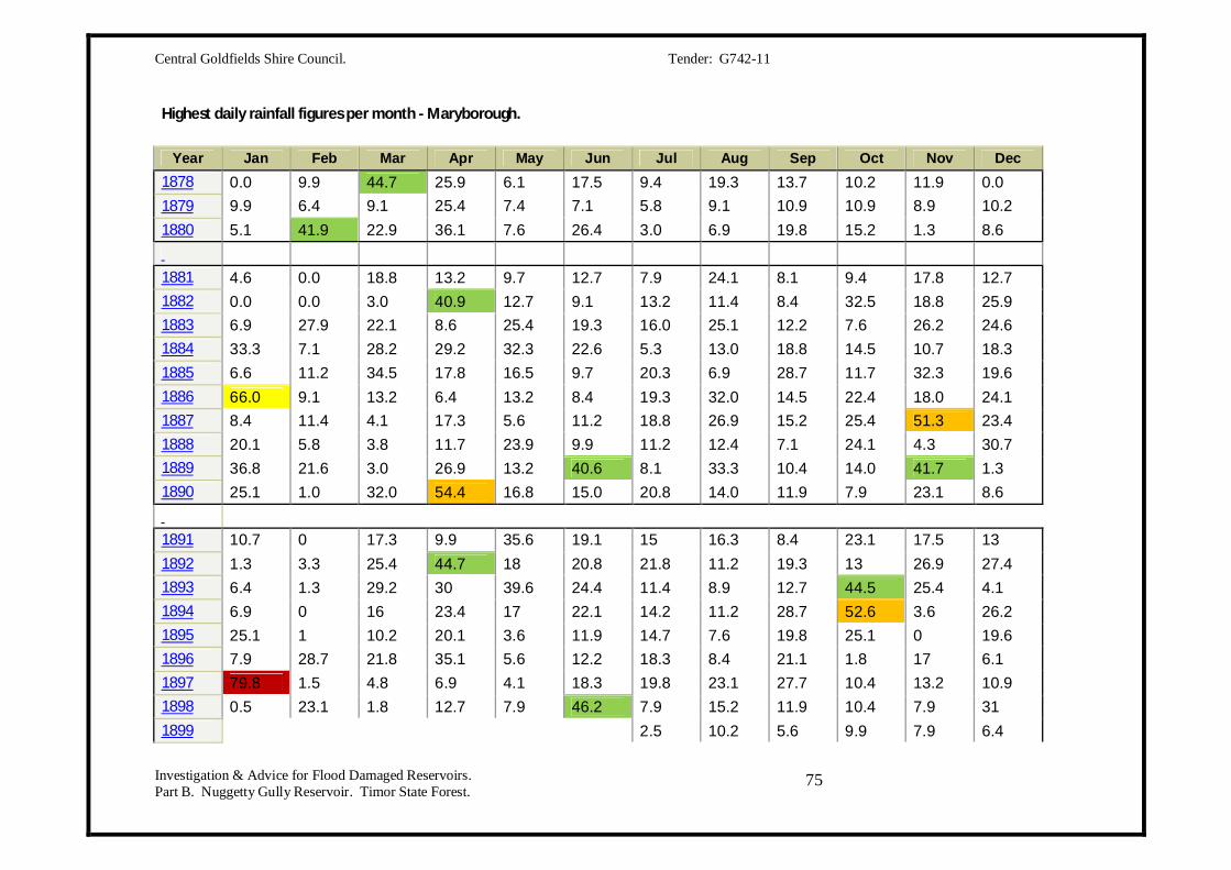
Central Goldfields Shire Council. Tender: G742-11
Investigation & Advice for Flood Damaged Reservoirs. Part B. Nuggetty Gully Reservoir. Timor State Forest.
75
Highest daily rainfall figures per month - Maryborough.
Year Jan Feb Mar Apr May Jun Jul Aug Sep Oct Nov Dec 1878 0.0 9.9 44.7 25.9 6.1 17.5 9.4 19.3 13.7 10.2 11.9 0.0 1879 9.9 6.4 9.1 25.4 7.4 7.1 5.8 9.1 10.9 10.9 8.9 10.2 1880 5.1 41.9 22.9 36.1 7.6 26.4 3.0 6.9 19.8 15.2 1.3 8.6 1881 4.6 0.0 18.8 13.2 9.7 12.7 7.9 24.1 8.1 9.4 17.8 12.7 1882 0.0 0.0 3.0 40.9 12.7 9.1 13.2 11.4 8.4 32.5 18.8 25.9 1883 6.9 27.9 22.1 8.6 25.4 19.3 16.0 25.1 12.2 7.6 26.2 24.6 1884 33.3 7.1 28.2 29.2 32.3 22.6 5.3 13.0 18.8 14.5 10.7 18.3 1885 6.6 11.2 34.5 17.8 16.5 9.7 20.3 6.9 28.7 11.7 32.3 19.6 1886 66.0 9.1 13.2 6.4 13.2 8.4 19.3 32.0 14.5 22.4 18.0 24.1 1887 8.4 11.4 4.1 17.3 5.6 11.2 18.8 26.9 15.2 25.4 51.3 23.4 1888 20.1 5.8 3.8 11.7 23.9 9.9 11.2 12.4 7.1 24.1 4.3 30.7 1889 36.8 21.6 3.0 26.9 13.2 40.6 8.1 33.3 10.4 14.0 41.7 1.3 1890 25.1 1.0 32.0 54.4 16.8 15.0 20.8 14.0 11.9 7.9 23.1 8.6 1891 10.7 0 17.3 9.9 35.6 19.1 15 16.3 8.4 23.1 17.5 13 1892 1.3 3.3 25.4 44.7 18 20.8 21.8 11.2 19.3 13 26.9 27.4 1893 6.4 1.3 29.2 30 39.6 24.4 11.4 8.9 12.7 44.5 25.4 4.1 1894 6.9 0 16 23.4 17 22.1 14.2 11.2 28.7 52.6 3.6 26.2 1895 25.1 1 10.2 20.1 3.6 11.9 14.7 7.6 19.8 25.1 0 19.6 1896 7.9 28.7 21.8 35.1 5.6 12.2 18.3 8.4 21.1 1.8 17 6.1 1897 79.8 1.5 4.8 6.9 4.1 18.3 19.8 23.1 27.7 10.4 13.2 10.9 1898 0.5 23.1 1.8 12.7 7.9 46.2 7.9 15.2 11.9 10.4 7.9 31 1899
2.5 10.2 5.6 9.9 7.9 6.4
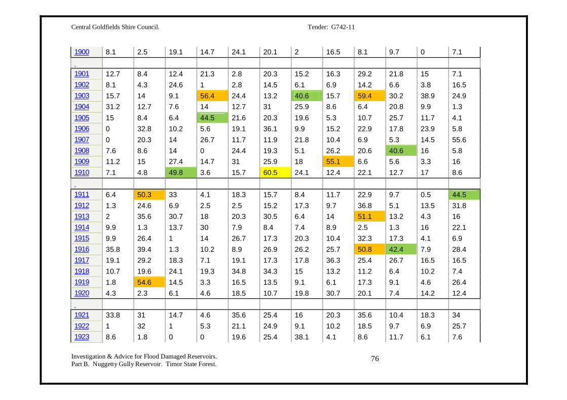
Central Goldfields Shire Council. Tender: G742-11
Investigation & Advice for Flood Damaged Reservoirs. Part B. Nuggetty Gully Reservoir. Timor State Forest.
76
1900 8.1 2.5 19.1 14.7 24.1 20.1 2 16.5 8.1 9.7 0 7.1 1901 12.7 8.4 12.4 21.3 2.8 20.3 15.2 16.3 29.2 21.8 15 7.1 1902 8.1 4.3 24.6 1 2.8 14.5 6.1 6.9 14.2 6.6 3.8 16.5 1903 15.7 14 9.1 56.4 24.4 13.2 40.6 15.7 59.4 30.2 38.9 24.9 1904 31.2 12.7 7.6 14 12.7 31 25.9 8.6 6.4 20.8 9.9 1.3 1905 15 8.4 6.4 44.5 21.6 20.3 19.6 5.3 10.7 25.7 11.7 4.1 1906 0 32.8 10.2 5.6 19.1 36.1 9.9 15.2 22.9 17.8 23.9 5.8 1907 0 20.3 14 26.7 11.7 11.9 21.8 10.4 6.9 5.3 14.5 55.6 1908 7.6 8.6 14 0 24.4 19.3 5.1 26.2 20.6 40.6 16 5.8 1909 11.2 15 27.4 14.7 31 25.9 18 55.1 6.6 5.6 3.3 16 1910 7.1 4.8 49.8 3.6 15.7 60.5 24.1 12.4 22.1 12.7 17 8.6 1911 6.4 50.3 33 4.1 18.3 15.7 8.4 11.7 22.9 9.7 0.5 44.5 1912 1.3 24.6 6.9 2.5 2.5 15.2 17.3 9.7 36.8 5.1 13.5 31.8 1913 2 35.6 30.7 18 20.3 30.5 6.4 14 51.1 13.2 4.3 16 1914 9.9 1.3 13.7 30 7.9 8.4 7.4 8.9 2.5 1.3 16 22.1 1915 9.9 26.4 1 14 26.7 17.3 20.3 10.4 32.3 17.3 4.1 6.9 1916 35.8 39.4 1.3 10.2 8.9 26.9 26.2 25.7 50.8 42.4 7.9 28.4 1917 19.1 29.2 18.3 7.1 19.1 17.3 17.8 36.3 25.4 26.7 16.5 16.5 1918 10.7 19.6 24.1 19.3 34.8 34.3 15 13.2 11.2 6.4 10.2 7.4 1919 1.8 54.6 14.5 3.3 16.5 13.5 9.1 6.1 17.3 9.1 4.6 26.4 1920 4.3 2.3 6.1 4.6 18.5 10.7 19.8 30.7 20.1 7.4 14.2 12.4 1921 33.8 31 14.7 4.6 35.6 25.4 16 20.3 35.6 10.4 18.3 34 1922 1 32 1 5.3 21.1 24.9 9.1 10.2 18.5 9.7 6.9 25.7 1923 8.6 1.8 0 0 19.6 25.4 38.1 4.1 8.6 11.7 6.1 7.6

Central Goldfields Shire Council. Tender: G742-11
Investigation & Advice for Flood Damaged Reservoirs. Part B. Nuggetty Gully Reservoir. Timor State Forest.
77
1924 4.6 20.1 29.5 18.3 11.4 12.7 3 17.3 20.8 8.9 39.4 8.9 1925 18.8 34 14 7.9 25.1 12.7 9.4 6.6 10.7 3.3 12.7 4.1 1926 2 0.8 21.6 13 10.7 9.9 17 28.4 15.5 15.7 7.4 19.1 1927 6.6 7.6 4.3 2.5 23.4 6.4 18.3 9.9 14.7 8.1 7.6 12.7 1928 44.5 36.3 11.7 12.2 9.9 22.9 15.7 3.3 17.8 13 1.3 8.9 1929 7.6 25.9 2.8 25.4 3.8 15.2 5.8 16.8 6.9 19.6 9.9 24.1 1930 0 43.2 9.4 5.6 20.3 7.9 18.5 19.8 4.6 26.7 13.2 85.3 1931 4.6 1.8 29 41.4 21.3 36.8 10.4 11.2 13.2 3.6 38.9 8.4 1932 0.5 7.4 57.4 18.5 16.8 11.7 17.3 31.5 6.4 12.2 3.3 9.4 1933 9.4 0 10.2 18.3 27.7 22.6 45.7 11.4 25.4 22.4 99.3 46.7 1934 13.5 12.2 0.3 16 0 9.1 15.2 17.8 8.9 18.8 26.9 9.9 1935 13.2 3.8 15 29 5.6 7.1 37.3 20.3 20.8 17.3 5.1 19.8 1936 29.2 3.3 2.5 7.9 45.7 10.9 50 19.3 3.8 16.8 3.8 15.2 1937 16.5 15.2 5.1 6.1 5.6 8.4 5.1 18.8 13.2 21.1 4.6 29.2 1938 19.1 14.2 5.1 18.8 7.9 18.3 17.3 3.8 1.3 1.8 14.5 2.8 1939 25.9 55.6 3.3 55.4 20.3 18.8 11.2 13.2 8.4 5.6 40.1 7.1 1940 14 1.3 2 9.7 8.1 3.6 11.7 4.8 10.4 14 6.1 17.5 1941 48.3 8.1 16.3 10.7 4.1 19.8 17 19.1 19.1 25.1 47 7.4 1942 21.6 6.9 26.4 10.2 16.5 17.5 9.4 29 9.4 24.4 9.1 7.6 1943 14.2 11.7 3.3 6.9 14.5 10.4 14 10.9 9.1 11.4 9.4 5.3 1944 5.3 6.1 16.5 13.7 10.4 4.1 14.7 1.8 4.3 15.7 7.6 13.7 1945 6.4 16.3 3 2.8 7.4 30.7 10.7 31.8 6.6 15.7 9.9 5.1 1946 23.6 45 23.4 12.2 17.8 15.7 11.2 5.8 3 14 21.1 32.3 1947 0.8 18.5 41.9 14.5 5.6 19.1 12.7 12.7 13.5 19.3 21.1 29.2 1948 8.9 38.1 1 21.8 5.8 31.8 9.7 4.1 12.2 29.7 3 61.5
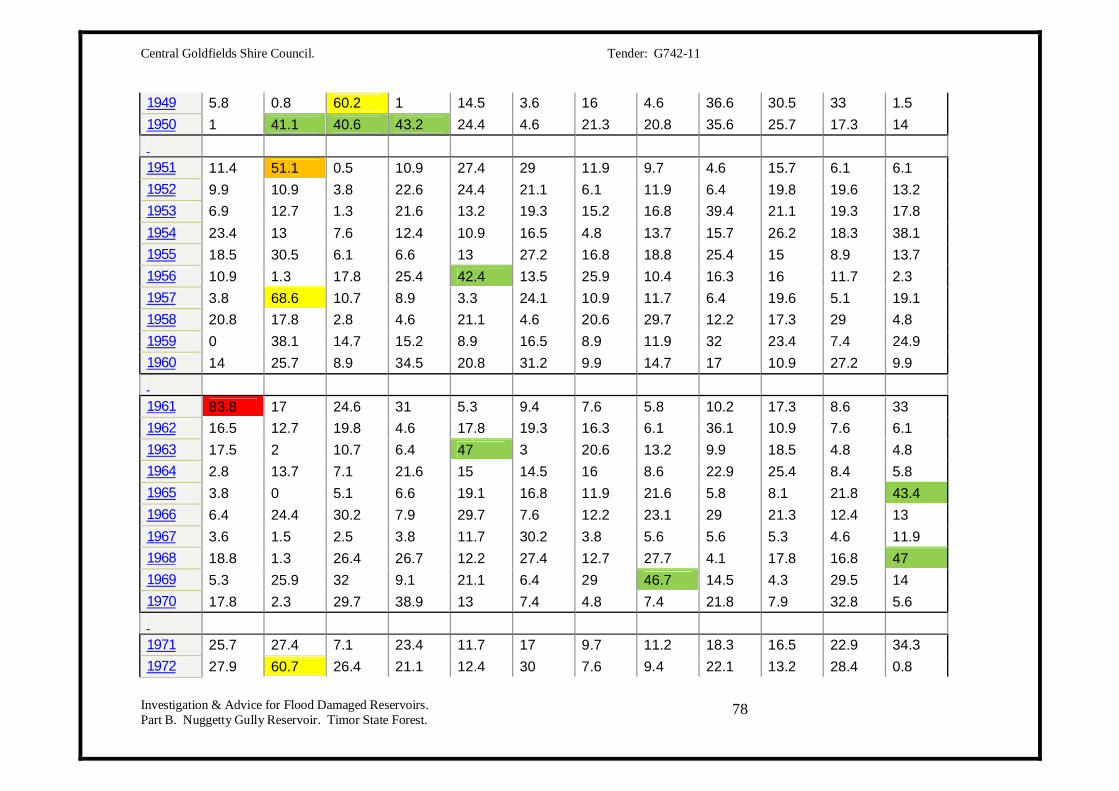
Central Goldfields Shire Council. Tender: G742-11
Investigation & Advice for Flood Damaged Reservoirs. Part B. Nuggetty Gully Reservoir. Timor State Forest.
78
1949 5.8 0.8 60.2 1 14.5 3.6 16 4.6 36.6 30.5 33 1.5 1950 1 41.1 40.6 43.2 24.4 4.6 21.3 20.8 35.6 25.7 17.3 14 1951 11.4 51.1 0.5 10.9 27.4 29 11.9 9.7 4.6 15.7 6.1 6.1 1952 9.9 10.9 3.8 22.6 24.4 21.1 6.1 11.9 6.4 19.8 19.6 13.2 1953 6.9 12.7 1.3 21.6 13.2 19.3 15.2 16.8 39.4 21.1 19.3 17.8 1954 23.4 13 7.6 12.4 10.9 16.5 4.8 13.7 15.7 26.2 18.3 38.1 1955 18.5 30.5 6.1 6.6 13 27.2 16.8 18.8 25.4 15 8.9 13.7 1956 10.9 1.3 17.8 25.4 42.4 13.5 25.9 10.4 16.3 16 11.7 2.3 1957 3.8 68.6 10.7 8.9 3.3 24.1 10.9 11.7 6.4 19.6 5.1 19.1 1958 20.8 17.8 2.8 4.6 21.1 4.6 20.6 29.7 12.2 17.3 29 4.8 1959 0 38.1 14.7 15.2 8.9 16.5 8.9 11.9 32 23.4 7.4 24.9 1960 14 25.7 8.9 34.5 20.8 31.2 9.9 14.7 17 10.9 27.2 9.9 1961 83.8 17 24.6 31 5.3 9.4 7.6 5.8 10.2 17.3 8.6 33 1962 16.5 12.7 19.8 4.6 17.8 19.3 16.3 6.1 36.1 10.9 7.6 6.1 1963 17.5 2 10.7 6.4 47 3 20.6 13.2 9.9 18.5 4.8 4.8 1964 2.8 13.7 7.1 21.6 15 14.5 16 8.6 22.9 25.4 8.4 5.8 1965 3.8 0 5.1 6.6 19.1 16.8 11.9 21.6 5.8 8.1 21.8 43.4 1966 6.4 24.4 30.2 7.9 29.7 7.6 12.2 23.1 29 21.3 12.4 13 1967 3.6 1.5 2.5 3.8 11.7 30.2 3.8 5.6 5.6 5.3 4.6 11.9 1968 18.8 1.3 26.4 26.7 12.2 27.4 12.7 27.7 4.1 17.8 16.8 47 1969 5.3 25.9 32 9.1 21.1 6.4 29 46.7 14.5 4.3 29.5 14 1970 17.8 2.3 29.7 38.9 13 7.4 4.8 7.4 21.8 7.9 32.8 5.6 1971 25.7 27.4 7.1 23.4 11.7 17 9.7 11.2 18.3 16.5 22.9 34.3 1972 27.9 60.7 26.4 21.1 12.4 30 7.6 9.4 22.1 13.2 28.4 0.8

Central Goldfields Shire Council. Tender: G742-11
Investigation & Advice for Flood Damaged Reservoirs. Part B. Nuggetty Gully Reservoir. Timor State Forest.
79
1973 38.6 82 13 24.1 12.4 30.5 14.7 23.6 20.6 36.1 29.2 38.4 1974 51 44.4 11 13 46.8 5.8 12 10 9.8 17.8 2.2 8.4 1975 8.2 1 50 3.8 9.4 2.8 16.4 11.8 33 44.8 19.6 30.2 1976 4.6 44.6 14.8 3.4 4 10.2 10.4 9 13.8 10.6 16.4 15.6 1977 9.6 10.4 11 35 8.8 22.8 7.6 9 8.2 14 8.4 3.6 1978 3 3 20.4 34 49 8 16.2 42 14.4 30.4 32.4 7.6 1979 16.2 10 17 8.6 25 10.4 10.7 19.8 53.8 39.4 12 5 1980 18.4 1.6 8 52.4 16.4 20.2 11.6 43.8 11.8 20.6 7.2 18.8 1981 24 9.2 6.8 25.6 9.4 16.6 19.4 40.4 17 31.4 20 8.8 1982 18.4 4 6.4 4.8 9 12.6 4.2 20.6 6.4 7.8 5.2 9.6 1983 2 0.2 23.2 20.5 40.8 8.4 18.7 23 28.2 34.6 25.2 5 1984 48.8 10 33.8 7.6 6.6 6 17.4 17.4 16.4 21.6 22 4.2 1985 2 1.6 10.4 9.6 26.6 10.4 6 21.2 6.6 37.8 12.6 21.2 1986 6 5 0.6 21.6 21 7 29.1 19.8 28.6 18.6 5 36.6 1987 16.4 29.8 8.2 7.2 30 23.4 9.8 9.2 8.2 11.2 8.6 39.6 1988 39.8 16.2 5.8 2.4 46 12.2 14 9.6 40.2 5.2 13.4 21.1 1989 17 3.8 16 51 44.8 27.2 13.2 10.4 12.4 14.8 11.2 5.2 1990 6.6 16 20 17.8 8.2 15 38.2 11.2 8 13 22 14 1991 37 0 8 14 2 40 10.4 10 16.4 2 11.4 24 1992 5.2 3.8 8 20.4 30 12.2 5.2 34.4 15.8 30.4 16.6 24.4 1993 24.2 11.6 14.8 4.8 8.4 8 27.2 22.4 27 15 44 27.4 1994 5 37.6 0.2 1 16.6 34.6 7 3.8 11 5.4 9.8 2.8 1995 9 6 11.6 14.8 31.4 26.6 11.2 4 10 64.2 12 6 1996 17.2 29 36.4 10 15.8 24.8 18 16 19 9.2 3.4 4.6 1997 24.4 1.2 1.8 2.8 18.8 7 5 18.4 26.6 20.4 18 4.6

Central Goldfields Shire Council. Tender: G742-11
Investigation & Advice for Flood Damaged Reservoirs. Part B. Nuggetty Gully Reservoir. Timor State Forest.
80
1998 23.8 22.8 1.6 44 4 12.4 15.2 7.4 26 24.4 40.2 7.2 1999 16.8 22.6 21.4 11.4 31.2 12 6.8 33.4 13 19.6 13.6 99.2 2000 19.8 40.4 7.6 22 10.8 7.8 22.6 10.6 16.6 32.2 46.4 19.4 2001 27.4 3.4 23.5 11.4 5.6 12.4 7.6 10.6 15.8 14.2 10.2 6 2002 4 20.2 5 14 13.2 11.6 4.2 13.2 4.8 6.2 3.8 24.2 2003 19.8 23 1.4 15.2 12.4 7 25.2 30 6.8 17.6 11.6 14.6 2004 4 1.4 10.4 6.8 10.2 24.8 15 11 12.4 3.6 19 21 2005 15.4 29.6 1.6 5.8 11.4 22.2 9 18.4 12.4 12.6 25.8 16 2006 9.2 5.6 9.2 10.2 10.6 11.8 27.8 16.4 9.8 1.6 2.8 9.8 2007 25.8 29.8 6 30.8 15.5 4.8 11.2 6 8.6 1.4 28 43.7 2008 9.6 5.2 6.4 3.6 12 11.6 16.4 13.2 6.6 4 23.4 50.4 2009 0 4.4 10 10.6 14 14.2 20.4 14.9 14.8 5.3 37.7 13.4 2010 16.7 22.1 27.6 80.4 12.3 11 11.6 19.3 79.6 39.1 40.8 12 2011 90.4 17.6 19.8 12.9 10.7 7.4 11.2 14.9 23.1 21.3 15.5
Central Goldfields Shire Council. Tender: G742-11
Investigation & Advice for Flood Damaged Reservoirs. Part B. Nuggetty Gully Reservoir. Timor State Forest.
81
APPENDIX F.

Central Goldfields Shire Council. Tender: G742-11
Investigation & Advice for Flood Damaged Reservoirs. Part B. Nuggetty Gully Reservoir. Timor State Forest.
82

Central Goldfields Shire Council. Tender: G742-11
Investigation & Advice for Flood Damaged Reservoirs. Part B. Nuggetty Gully Reservoir. Timor State Forest.
83

Central Goldfields Shire Council. Tender: G742-11
Investigation & Advice for Flood Damaged Reservoirs. Part B. Nuggetty Gully Reservoir. Timor State Forest.
84
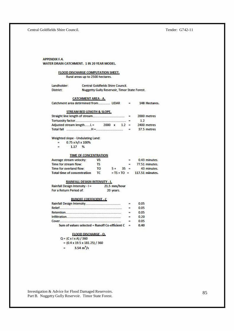
Central Goldfields Shire Council. Tender: G742-11
Investigation & Advice for Flood Damaged Reservoirs. Part B. Nuggetty Gully Reservoir. Timor State Forest.
85

Central Goldfields Shire Council. Tender: G742-11
Investigation & Advice for Flood Damaged Reservoirs. Part B. Nuggetty Gully Reservoir. Timor State Forest.
86

Central Goldfields Shire Council. Tender: G742-11
Investigation & Advice for Flood Damaged Reservoirs. Part B. Nuggetty Gully Reservoir. Timor State Forest.
87

Central Goldfields Shire Council. Tender: G742-11
Investigation & Advice for Flood Damaged Reservoirs. Part B. Nuggetty Gully Reservoir. Timor State Forest.
88
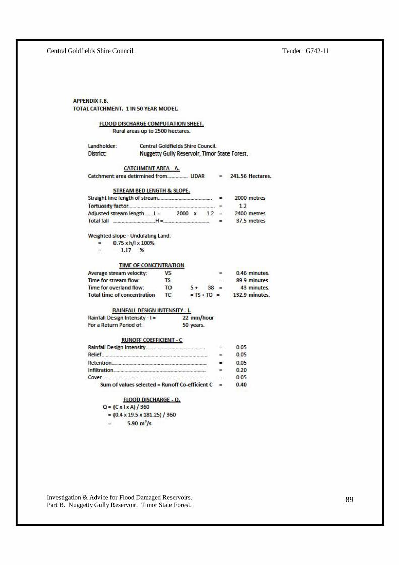
Central Goldfields Shire Council. Tender: G742-11
Investigation & Advice for Flood Damaged Reservoirs. Part B. Nuggetty Gully Reservoir. Timor State Forest.
89
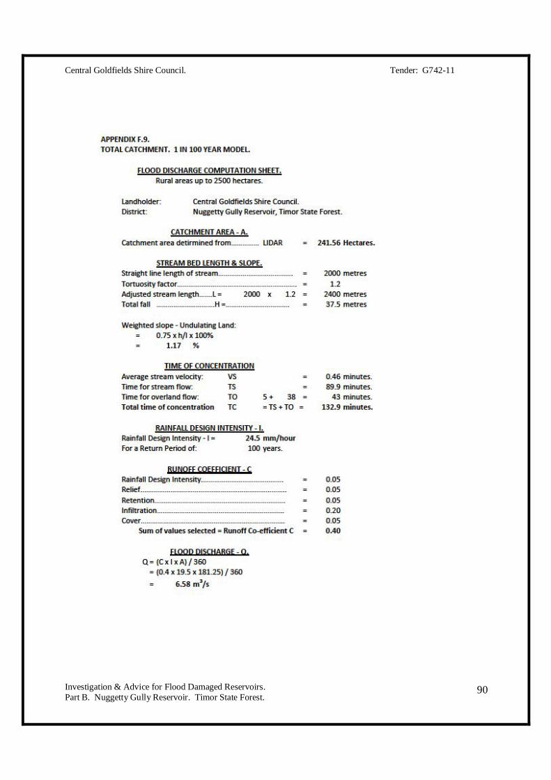
Central Goldfields Shire Council. Tender: G742-11
Investigation & Advice for Flood Damaged Reservoirs. Part B. Nuggetty Gully Reservoir. Timor State Forest.
90
Central Goldfields Shire Council. Tender: G742-11
Investigation & Advice for Flood Damaged Reservoirs. Part B. Nuggetty Gully Reservoir. Timor State Forest.
91
APPENDIX G.
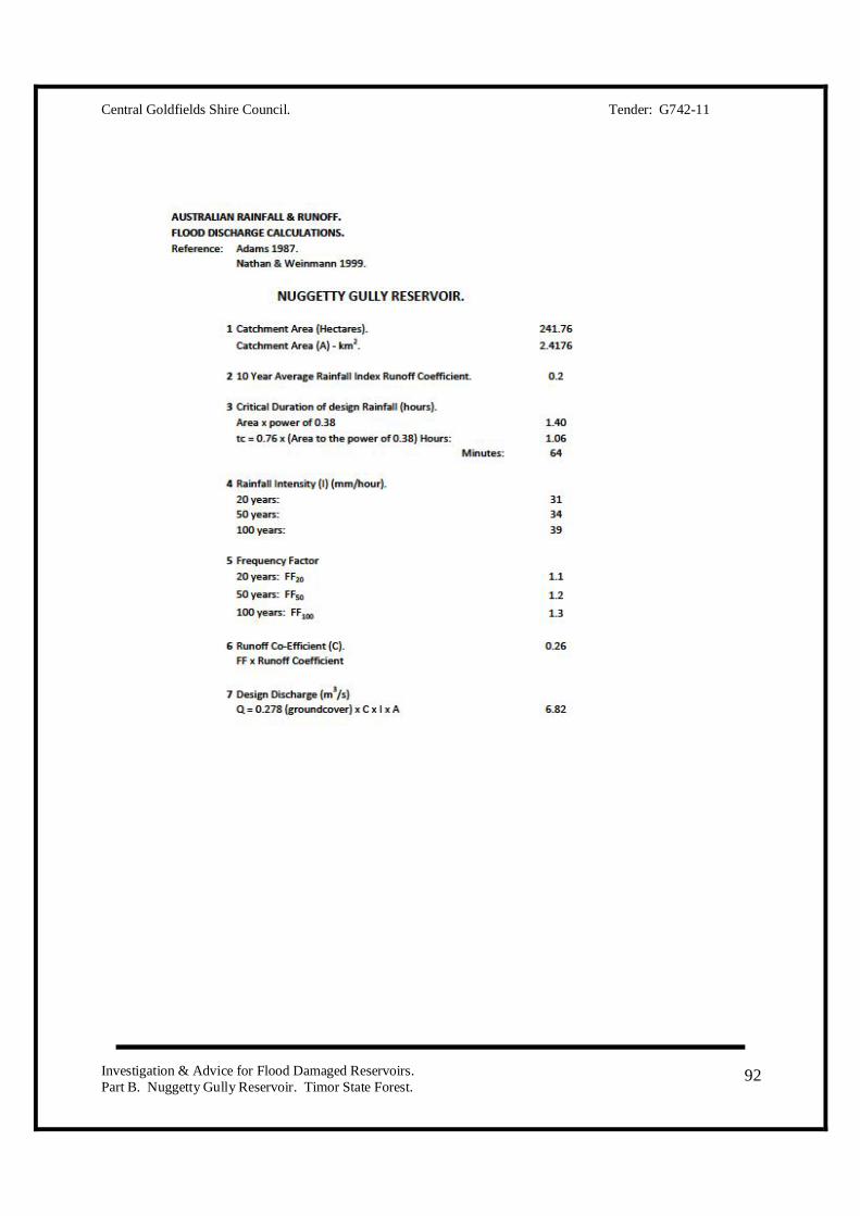
Central Goldfields Shire Council. Tender: G742-11
Investigation & Advice for Flood Damaged Reservoirs. Part B. Nuggetty Gully Reservoir. Timor State Forest.
92

Central Goldfields Shire Council. Tender: G742-11
Investigation & Advice for Flood Damaged Reservoirs. Part B. Nuggetty Gully Reservoir. Timor State Forest.
93
APPENDIX H.

Central Goldfields Shire Council. Tender: G742-11
Investigation & Advice for Flood Damaged Reservoirs. Part B. Nuggetty Gully Reservoir. Timor State Forest.
94

Central Goldfields Shire Council. Tender: G742-11
Investigation & Advice for Flood Damaged Reservoirs. Part B. Nuggetty Gully Reservoir. Timor State Forest.
95

Central Goldfields Shire Council. Tender: G742-11
Investigation & Advice for Flood Damaged Reservoirs. Part B. Nuggetty Gully Reservoir. Timor State Forest.
96

Central Goldfields Shire Council. Tender: G742-11
Investigation & Advice for Flood Damaged Reservoirs. Part B. Nuggetty Gully Reservoir. Timor State Forest.
97
APPENDIX I.

Central Goldfields Shire Council. Tender: G742-11
Investigation & Advice for Flood Damaged Reservoirs. Part B. Nuggetty Gully Reservoir. Timor State Forest.
98

Central Goldfields Shire Council. Tender: G742-11
Investigation & Advice for Flood Damaged Reservoirs. Part B. Nuggetty Gully Reservoir. Timor State Forest.
99

Central Goldfields Shire Council. Tender: G742-11
Investigation & Advice for Flood Damaged Reservoirs. Part B. Nuggetty Gully Reservoir. Timor State Forest.
100

Central Goldfields Shire Council. Tender: G742-11
Investigation & Advice for Flood Damaged Reservoirs. Part B. Nuggetty Gully Reservoir. Timor State Forest.
101
APPENDIX J.

Central Goldfields Shire Council. Tender: G742-11
Investigation & Advice for Flood Damaged Reservoirs. Part B. Nuggetty Gully Reservoir. Timor State Forest.
102

Central Goldfields Shire Council. Tender: G742-11
Investigation & Advice for Flood Damaged Reservoirs. Part B. Nuggetty Gully Reservoir. Timor State Forest.
103

Central Goldfields Shire Council. Tender: G742-11
Investigation & Advice for Flood Damaged Reservoirs. Part B. Nuggetty Gully Reservoir. Timor State Forest.
104
Central Goldfields Shire Council. Tender: G742-11
Investigation & Advice for Flood Damaged Reservoirs. Part B. Nuggetty Gully Reservoir. Timor State Forest.
105
APPENDIX K.

Central Goldfields Shire Council. Tender: G742-11
Investigation & Advice for Flood Damaged Reservoirs. Part B. Nuggetty Gully Reservoir. Timor State Forest.
106

Central Goldfields Shire Council. Tender: G742-11
Investigation & Advice for Flood Damaged Reservoirs. Part B. Nuggetty Gully Reservoir. Timor State Forest.
107

Central Goldfields Shire Council. Tender: G742-11
Investigation & Advice for Flood Damaged Reservoirs. Part B. Nuggetty Gully Reservoir. Timor State Forest.
108
Central Goldfields Shire Council. Tender: G742-11
Investigation & Advice for Flood Damaged Reservoirs. Part B. Nuggetty Gully Reservoir. Timor State Forest.
109
APPENDIX L.

Central Goldfields Shire Council. Tender: G742-11
Investigation & Advice for Flood Damaged Reservoirs. Part B. Nuggetty Gully Reservoir. Timor State Forest.
110

Central Goldfields Shire Council. Tender: G742-11
Investigation & Advice for Flood Damaged Reservoirs. Part B. Nuggetty Gully Reservoir. Timor State Forest.
111

Central Goldfields Shire Council. Tender: G742-11
Investigation & Advice for Flood Damaged Reservoirs. Part B. Nuggetty Gully Reservoir. Timor State Forest.
112

Central Goldfields Shire Council. Tender: G742-11
Investigation & Advice for Flood Damaged Reservoirs. Part B. Nuggetty Gully Reservoir. Timor State Forest.
113

Central Goldfields Shire Council. Tender: G742-11
Investigation & Advice for Flood Damaged Reservoirs. Part B. Nuggetty Gully Reservoir. Timor State Forest.
114

Central Goldfields Shire Council. Tender: G742-11
Investigation & Advice for Flood Damaged Reservoirs. Part B. Nuggetty Gully Reservoir. Timor State Forest.
115

Central Goldfields Shire Council. Tender: G742-11
Investigation & Advice for Flood Damaged Reservoirs. Part B. Nuggetty Gully Reservoir. Timor State Forest.
116
Central Goldfields Shire Council. Tender: G742-11
Investigation & Advice for Flood Damaged Reservoirs. Part B. Nuggetty Gully Reservoir. Timor State Forest.
117
APPENDIX M.

Central Goldfields Shire Council. Tender: G742-11
Investigation & Advice for Flood Damaged Reservoirs. Part B. Nuggetty Gully Reservoir. Timor State Forest.
118
POWER AUGER FIELD NOTES. Site 1. 50 metres.
1. Water edge. Gravelly and silty clay. Moisture content is higher than saturation. There is a phreatic surface into the embankment.
2. Inner batter – just below the crest. Gravelly and silty clay. Low plasticity. Very dry. Moisture angling downwards rather than horizontal.
3. Crest. Gravelly and silty clay. Low density. Higher density layer at 750 mm. Less gravel. More silt. More hydrophobic (taking in less water). Clay dominant.
4. Outer batter – upper section. Gravelly and silty clay. Very dry. Some weathered rock between 800-1000mm.
5. Outer batter – mid section. Gravelly and silty clay. Very dry.
6. Outer batter – lower section. Gravelly and silty clay. Rock at 600mm.
7. Outer batter – toe of embankment. Gravelly and silty clay. Rock at 500mm.
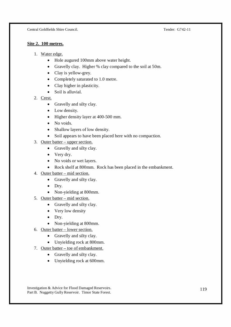
Central Goldfields Shire Council. Tender: G742-11
Investigation & Advice for Flood Damaged Reservoirs. Part B. Nuggetty Gully Reservoir. Timor State Forest.
119
Site 2. 100 metres.
1. Water edge. Hole augured 100mm above water height. Gravelly clay. Higher % clay compared to the soil at 50m. Clay is yellow-grey. Completely saturated to 1.0 metre. Clay higher in plasticity. Soil is alluvial.
2. Crest. Gravelly and silty clay. Low density. Higher density layer at 400-500 mm. No voids. Shallow layers of low density. Soil appears to have been placed here with no compaction.
3. Outer batter – upper section. Gravelly and silty clay. Very dry. No voids or wet layers. Rock shelf at 800mm. Rock has been placed in the embankment.
4. Outer batter – mid section. Gravelly and silty clay. Dry. Non-yielding at 800mm.
5. Outer batter – mid section. Gravelly and silty clay. Very low density Dry. Non-yielding at 800mm.
6. Outer batter – lower section. Gravelly and silty clay. Unyielding rock at 800mm.
7. Outer batter – toe of embankment. Gravelly and silty clay. Unyielding rock at 600mm.
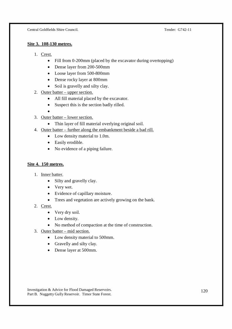
Central Goldfields Shire Council. Tender: G742-11
Investigation & Advice for Flood Damaged Reservoirs. Part B. Nuggetty Gully Reservoir. Timor State Forest.
120
Site 3. 108-130 metres.
1. Crest. Fill from 0-200mm (placed by the excavator during overtopping) Dense layer from 200-500mm Loose layer from 500-800mm Dense rocky layer at 800mm Soil is gravelly and silty clay.
2. Outer batter – upper section. All fill material placed by the excavator. Suspect this is the section badly rilled.
3. Outer batter – lower section. Thin layer of fill material overlying original soil.
4. Outer batter – further along the embankment beside a bad rill. Low density material to 1.0m. Easily erodible. No evidence of a piping failure.
Site 4. 150 metres.
1. Inner batter. Silty and gravelly clay. Very wet. Evidence of capillary moisture. Trees and vegetation are actively growing on the bank.
2. Crest. Very dry soil. Low density. No method of compaction at the time of construction.
3. Outer batter – mid section. Low density material to 500mm. Gravelly and silty clay. Dense layer at 500mm.

Central Goldfields Shire Council. Tender: G742-11
Investigation & Advice for Flood Damaged Reservoirs. Part B. Nuggetty Gully Reservoir. Timor State Forest.
121
Site 5. 200 metres.
1. Inner batter – 0.5m from water edge. Saturated to 1.0m.
2. Inner batter – between water edge and crest. Completely dry.
3. Crest. Completely dry. Combination of layers with varying density.
4. Outer batter – mid section. Low density material to 500mm. High density layer beyond 500mm. Gravelly and silty clay.
5. Toe of embankment. Dense layer at 500mm. Gravelly and silty clay.
Site 6. 241.5 metres.
1. Inner batter – close to water edge. Saturated to 1.0m. Grey-yellow clay.
2. Inner batter – between water edge and crest. Completely dry.
3. Crest. Completely dry. Low density layer to 500mm. High density layer beyond 500mm.
4. Outer batter – mid section. Low density material to 500mm. Gravelly and silty clay.