nws central region service assessment · nws central region service assessment joplin, missouri,...
TRANSCRIPT

NWS Central Region Service Assessment
Joplin, Missouri, Tornado – May 22, 2011
U.S. DEPARTMENT OF COMMERCE
National Oceanic and Atmospheric Administration
National Weather Service, Central Region Headquarters
Kansas City, MO
July 2011

Cover Photographs
Left: NOAA Radar image of Joplin Tornado. Right: Aftermath of Joplin, MO, tornado courtesy
of Jennifer Spinney, Research Associate, University of Oklahoma, Social Science Woven into
Meteorology.

ii
Preface
On May 22, 2011, one of the deadliest tornadoes in United States history struck Joplin,
Missouri, directly killing 158 people and injuring over 1,000. The tornado, rated EF-5 on the
Enhanced Fujita Scale, with maximum winds over 200 mph, affected a significant part of a city
with a population of more than 50,000 and a population density near 1,500 people per square
mile. As a result, the Joplin tornado was the first single tornado in the United States to result in
over 100 fatalities since the Flint, Michigan, tornado of June 8, 1953.
Because of the rarity and historical significance of this event, a regional Service Assessment
team was formed to examine warning and forecast services provided by the National Weather
Service. Furthermore, because of the large number of fatalities that resulted from a warned
tornado event, this Service Assessment will provide additional focus on dissemination,
preparedness, and warning response within the community as they relate to NWS services.
Service Assessments provide a valuable contribution to ongoing efforts by the National Weather
Service to improve the quality, timeliness, and value of our products and services. Findings and
recommendations from this assessment will improve techniques, products, services, and
information provided to our partners and the American public.
Lynn P. Maximuk
Director, Central Region
National Weather Service
July 2011

iii
Executive Summary
On May 22, 2011, one of the most devastating tornadoes in the nation’s history directly killed
158 people and injured over 1,000 in Joplin, Missouri. From a National Weather Service (NWS)
perspective, this was essentially a “warned” event in that advance notice of the tornado was
given, critical information was communicated and received, and most people sought the best
shelter available to them. The timely actions of the ”weather enterprise” (NWS, media,
emergency management), and the eventual response of local businesses, churches, schools, and
the general public undoubtedly saved many lives.
The NWS Springfield Weather Forecast Office was well prepared and performed in an
exemplary manner in both its provision of services and its application of scientific expertise.
The professionalism and dedication of the staff members is clearly a credit to the communities
they serve.
Still, to learn what more can be done to help reduce fatalities from strong and violent tornadoes,
the assessment team examined relevant issues ranging from internal NWS warning operations to
dissemination strategies to public warning response. To help accomplish this, nearly 100
interviews were conducted in Joplin with tornado survivors, local businesses, media, emergency
management, NWS staff, city officials, and others.
Many of the key findings within this report involved societal aspects of warning response and
risk perception. Responding to warnings is not a simple act of stimulus-response, rather it is a
non-linear, multi-step, complex process. Relationships between false alarms, public
complacency, and warning credibility are highly complex as well.
The majority of Joplin residents did not immediately take protective action upon receiving a first
indication of risk (usually via the local siren system), regardless of the source of the warning.
Most first chose to further assess their risk by waiting for, actively seeking, and filtering
additional information before taking protective actions.
The reasons for doing so were quite varied, but largely depended on an individual’s “worldview”
formed mostly by previous experience with severe weather. Most importantly, the perceived
frequency of siren activation in Joplin led the majority of survey participants to become
desensitized or complacent to this method of warning. This suggests that initial siren activations
in Joplin (and severe weather warnings in general) have lost a degree of credibility for most
residents – one of the most valued characteristics for successful risk communication.
Instead, the majority of Joplin residents did not take protective action until processing additional
credible confirmation of the threat and its magnitude from a non-routine, extraordinary risk
trigger. This was generally achieved in different ways, including physical observation of the

iv
tornado, seeing or hearing confirmation, and urgency of the threat on radio or television, and/or
hearing a second, non-routine siren alert.
This report suggests that in order to improve warning response and mitigate user complacency,
the NWS should explore evolving the warning system to better support effective decision
making. This evolution should utilize a simple, impact-based, tiered information structure that
promotes warning credibility and empowers individuals to quickly make appropriate decisions in
the face of adverse conditions. Such a system should:
a. provide a non-routine warning mechanism that prompts people to take immediate life-saving
action in extreme events like strong and violent tornadoes
b. be impact-based more than phenomenon-based for clarity on risk assessment
c. be compatible with NWS technological, scientific, and operational capabilities
d. be compatible with external local warning systems and emerging mobile communications
technology
e. be easily understood and calibrated by the public to facilitate decision making
f. maintain existing “probability of detection” for severe weather events
g. diminish the perception of false alarms and their impacts on credibility
While the weather enterprise was generally successful in communicating the Joplin tornado
threat in a timely manner, current communication and delivery mechanisms are not seamless and
are somewhat antiquated. Specifically, many warning dissemination systems are not fully
compatible with specific warning information provided by storm-based warning polygons—
occasionally resulting in untimely gaps and confusion during dissemination. To improve the
warning dissemination system and provide a more coordinated warning message, the NWS
should continue to advance the development and cultivate the use of GPS-based mobile
communications technologies and Emergency Alert System/NOAA Weather Radio upgrades.
Last, an important impediment to heightening the urgency of the severe weather message from
the Weather Forecast Office was the WSR-88D Volume Coverage Pattern strategies available to
forecasters. Low level rotational intensification and tornado genesis occurred very rapidly as the
storm approached Joplin. Limited scans (every 5 minutes) at the lowest elevations slices likely
impacted the WFO ability to quickly ascertain the magnitude of the event. To enhance the
ability to monitor rapid tornado genesis, the NWS should develop and implement additional
Volume Coverage Pattern strategies that allow for more continuous sampling near the surface
(e.g., 1-minute lowest elevation sampling).

v
Table of Contents
Introduction and Background ......................................................................................................1
Societal Aspects of Risk Perception and Warning Response .....................................................3
Methodology ................................................................................................................................4
Risk Signals: Receiving and Understanding the Warning ..........................................................4
Perception, Processing and Personalizing the Threat ...................................................................6
Triggers for Decisions to Act .......................................................................................................7
Taking Protective Actions ............................................................................................................9
Conclusions ................................................................................................................................10
Warning Communications, Dissemination, and Community Preparedness ..........................11
Storm-Based Warnings and Local Warning Dissemination Systems ........................................11
NWSChat as a Coordination Tool ..............................................................................................14
Community Preparedness ...........................................................................................................14
WFO Springfield Products and Services ...................................................................................15
Storm Prediction Center (SPC) Products and Services ...........................................................18
WFO Springfield Warning Operations .....................................................................................20
Appendices
Appendix A: Radar Imagery .....................................................................................................24
Appendix B: Upper Air Observations .......................................................................................27
Appendix C: Operational Enhanced Fujita (EF) Scale .............................................................28
Appendix D: Findings, Recommendations, and Best Practices ................................................29
Appendix E: Acronyms .............................................................................................................33
Appendix F: Assessment Team Members .................................................................................34
Appendix G: Errata ...................................................................................................................35
1. Introduction and Background
On May 22, 2011, one of the most devastating tornadoes in the nation’s history directly killed
1581 people and injured over 1,000 in Joplin, Missouri. The Joplin tornado was the first single
tornado to result in over 100 fatalities since the June 8, 1953, Flint, Michigan tornado.
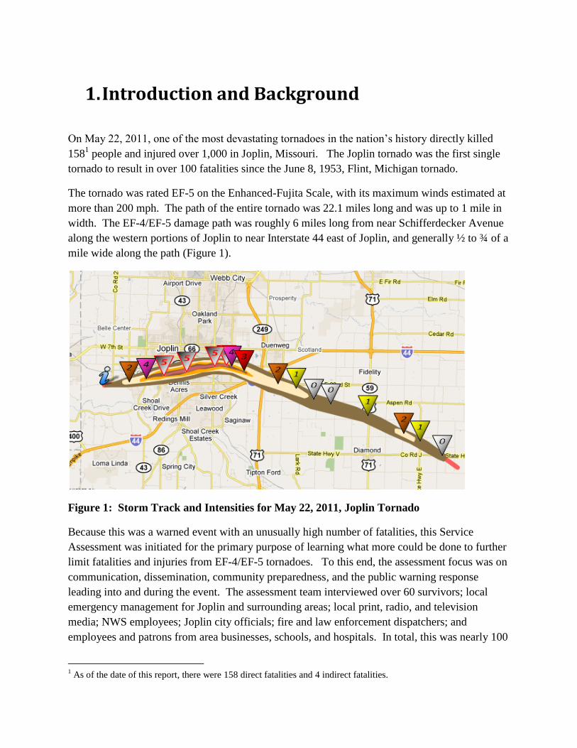
The tornado was rated EF-5 on the Enhanced-Fujita Scale, with its maximum winds estimated at
more than 200 mph. The path of the entire tornado was 22.1 miles long and was up to 1 mile in
width. The EF-4/EF-5 damage path was roughly 6 miles long from near Schifferdecker Avenue
along the western portions of Joplin to near Interstate 44 east of Joplin, and generally ½ to ¾ of a
mile wide along the path (Figure 1).
Figure 1: Storm Track and Intensities for May 22, 2011, Joplin Tornado
Because this was a warned event with an unusually high number of fatalities, this Service
Assessment was initiated for the primary purpose of learning what more could be done to further
limit fatalities and injuries from EF-4/EF-5 tornadoes. To this end, the assessment focus was on
communication, dissemination, community preparedness, and the public warning response
leading into and during the event. The assessment team interviewed over 60 survivors; local
emergency management for Joplin and surrounding areas; local print, radio, and television
media; NWS employees; Joplin city officials; fire and law enforcement dispatchers; and
employees and patrons from area businesses, schools, and hospitals. In total, this was nearly 100
1 As of the date of this report, there were 158 direct fatalities and 4 indirect fatalities.
2
interviews. This report attempts to synthesize the most common responses, and occasionally
highlight other responses that offer important insights.
Not surprisingly, there was a full spectrum of responses on most key interview points, especially
on issues concerning how people perceived and responded to warnings. For example, some
people took shelter in appropriate locations, but did not survive. Others mistakenly drove their
vehicles into the tornado path, but somehow lived to tell of it.
Also, while these interviews and the assessment efforts sought insights on how to reduce violent
tornado fatalities, it is worth noting that the actions of the “weather enterprise”2, local businesses,
churches, schools, and the general public undoubtedly saved many lives on May 22, 2011.
Generally speaking, advance warning of the tornado was given, information was communicated
and received, and most people sought the best shelter available to them. It is difficult to quantify
these impacts and place them in historical context with other comparable tornadoes.
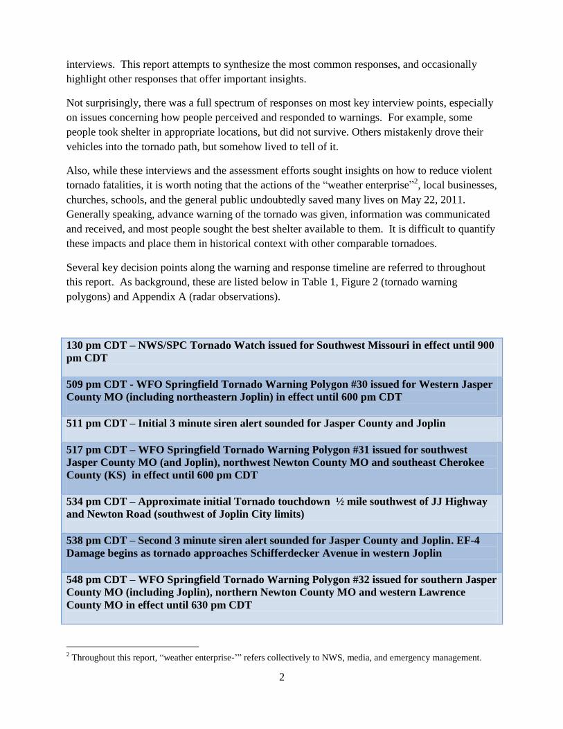
Several key decision points along the warning and response timeline are referred to throughout
this report. As background, these are listed below in Table 1, Figure 2 (tornado warning
polygons) and Appendix A (radar observations).
130 pm CDT – NWS/SPC Tornado Watch issued for Southwest Missouri in effect until 900
pm CDT
509 pm CDT - WFO Springfield Tornado Warning Polygon #30 issued for Western Jasper
County MO (including northeastern Joplin) in effect until 600 pm CDT
511 pm CDT – Initial 3 minute siren alert sounded for Jasper County and Joplin
517 pm CDT – WFO Springfield Tornado Warning Polygon #31 issued for southwest
Jasper County MO (and Joplin), northwest Newton County MO and southeast Cherokee
County (KS) in effect until 600 pm CDT
534 pm CDT – Approximate initial Tornado touchdown ½ mile southwest of JJ Highway
and Newton Road (southwest of Joplin City limits)
538 pm CDT – Second 3 minute siren alert sounded for Jasper County and Joplin. EF-4
Damage begins as tornado approaches Schifferdecker Avenue in western Joplin
548 pm CDT – WFO Springfield Tornado Warning Polygon #32 issued for southern Jasper
County MO (including Joplin), northern Newton County MO and western Lawrence
County MO in effect until 630 pm CDT
2 Throughout this report, “weather enterprise-’” refers collectively to NWS, media, and emergency management.

3
Table 1: Key Timeline of Events for Joplin Tornado Event
Figure 2: Tornado Warning polygons prior to and during the Joplin tornado and the
tornado damage path
2. Societal Aspects of Risk Perception and
Warning Response
A major portion of the Joplin Tornado Service Assessment was dedicated to understanding the
societal response to NWS warnings and external local warning systems. The Service
Assessment team went to Joplin, Missouri, between June 7-9, 2011, to interview residents about
how they received, processed, and responded to the warnings leading up to the May 22 tornado.
Finding #1: Recent NWS Assessments have addressed societal impacts of warnings, most
notably the “Super Tuesday Tornado Outbreak of Feb. 5-6, 2008” and the “Mother’s Day
Weekend Tornado Outbreak of 2008.” Many of the societal impacts uncovered in previous
Service Assessments were also evident in Joplin, suggesting the NWS should take a more
aggressive stance in addressing warning response.
Recommendation #1: For future Service Assessments, NWS should plan a more structured
approach to collecting information on societal aspects of warning response. This should include
developing sub-teams well-versed in social science and NWS warning operations that can be
4
quickly deployed to the field following any given severe weather disaster.
a. METHODOLOGY
In order to meet the Assessment objectives, the team utilized ethnographic methods or
techniques commonly used by social scientists to scientifically describe cultures and the people
within these cultures3. In particular, the team strove to understand residents’ points of views
regarding the process of warning reception to warning response, and how decisions were made.
The team carried out a series4 of semi-structured interviews with residents and local businesses:
in-person, over the phone, or in group settings. Semi-structured interviewing is a method of
inquiry based on the use of an interview guide to provide consistency between interviewers,
providing a menu of questions or topics that need to be covered in a particular order. This
method is useful in situations where interviewers have only one opportunity to conduct an
interview. Questions for this Assessment were formulated in such a way as to minimize the
influence of the interviewer and, perhaps most importantly, to allow each person to define the
content of the discussion they felt was important.
The findings in this Service Assessment represent a local case study, meaning that the societal
responses to warnings that are described in this Assessment are meant to reflect the trends
present in this particular sample. Because of limited sample size and distribution, interview
responses are largely characterized in general terms, and occasionally in specific terms to
highlight useful insights.
b. RISK SIGNALS: RECEIVING AND UNDERSTANDING THE WARNING
Response to severe weather warnings is a complex, non-linear process depending on perception
of risk. Perception of risk is influenced first and foremost by the method in which the risk is
communicated. The warnings, or risk signals5, that aroused Joplin residents’ attention, prompted
their belief in the threat of the tornado and informed their decisions to act included, in no
particular order: Broadcasts made on television and radio; NWS watches and warnings obtained
via commercial and government web pages; the activation and deactivation of the 1st siren; the
activation of the 2nd
siren; text messages; posts to social media networking sites; information
transmitted over NOAA Weather Radio (NWR); observations of the physical environment;
3 Spradley, James P. (1979) The ethnographic interview. New York: Holt, Rinehart and Winston (17)
4 The results shared in this section of the report are based on the perspectives of 54 residents of Joplin. Nine of the
63 interviews were not included because they were either second-hand accounts, wind interfered with the audio
recording, or the interview did not contain relevant data.
5 Kasperson, Jeanne X., Roger E. Kasperson, Nick Pidgeon, and Paul Slovic (2003). The social amplification of risk:
assessing fifteen years of research and theory. In The Social Amplification of Risk. N. Pidgeon, R. E. Kasperson and
P. Slovic. (eds). Cambridge, UK: Cambridge University Press. Pp. 13-46.

5
messages from family, friends, neighbors, and coworkers. Each of these signals, independently
or in combination, were processed in varying ways over differing amounts of time, heightening
or diminishing perceptions of threat.
Finding #2a: For the majority of surveyed Joplin residents, the first risk signal for an imminent
severe weather threat came via the local community siren system. As a result, there was a
significant degree of ambiguity associated with the first alert regarding the magnitude of the
risk, the seriousness of the warning, and its potential impact.
This did not necessarily mean that residents exclusively relied on these systems for their weather
information, only that the sirens were their first indication of a risk.
In Joplin, it is community policy to sound sirens when either a tornado is reported to be moving
toward Joplin or severe thunderstorm winds are expected to exceed 75 mph. These triggers may
or may not be associated with an NWS warning, and the Jasper County/Joplin Emergency
Manager has discretion and uses professional judgment on when to activate sirens. These types
of local warning system policies are by no means unique to Joplin.
Once the decision is made to activate sirens, they are sounded in one 3-minute burst and then
shut off. For those that used the sirens as the initial alert tool, there was no way to immediately
discern the magnitude and nature of the threat nor its potential impact. This lack of information
makes it difficult for warning recipients to calibrate the severity of the situation, thus delaying
their response. Also, several of those interviewed expressed confusion associated with the
single 3-minute siren alert, thinking the threat was over once the sirens had ceased.
Conceptually, warnings could be defined broadly as the number and combination of risk signals
each person received and processed prior to their decision to take protective action.
The interviews indicated that individuals received anywhere between two and nine risk signals
from the time they were aware of the possibility of severe weather to the time they engaged in
protective action. This drastic difference is explained by a) the differing lengths of time that
passed from first indication of threat to taking protective action, b) the differing ways individuals
received risk signals and interpreted the situation as threatening, and c) the effect of conflicting
risk signals.
The number of signals between first indication of severe weather and protective action markedly
increased as information became conflicted or unclear. In the most extreme example, one
resident’s interview indicated nine risk signals identified before taking protective action:
1. Aware that thunderstorms were probably going to happen
2. Noticed the weather changing outside
3. Heard the 1st siren while driving to restaurant (approximately 30-minute lead time)
4. Restaurant shut doors and disallowed entry
5. Drove to a 2nd restaurant where business was carrying on as usual

6
6. Noticed the weather changing
7. Reports came from TV and radio
8. Patron indicated tornado in Joplin
9. Management instructed protective action
In this example, signals 4 and 5 are significant in that they heightened and diminished this
resident’s perception of risk, respectively. Once the restaurant shut its doors and refused entry,
this resident perceived the threat of severe weather as real and commented during the interview
that he did not want to be in his car. Upon arriving at another restaurant close by, however, his
perception of threat was diminished because business at this second establishment was carrying
on as normal. He was escorted to a table and ordered a meal.
c. PERCEPTION, PROCESSING AND PERSONALIZING THE THREAT
Finding #2b: The majority of surveyed Joplin residents did not immediately go to shelter upon
hearing the initial warning, whether from local warning sirens, television, NWR, or other
sources. Instead, most chose to further clarify and assess their risk by waiting for, actively
seeking, and filtering additional information.
In order to gain a sense for how social models of understanding influenced perceptions of risk
and warning response, particular attention was paid to the “worldviews” held by residents.
Worldview6 is defined as an overall perspective of how people interpret their environment or the
world around them – and is generally informed by things like one’s experience, education, and
cultural values.
Interviews showed aspects of worldview that influenced risk perception and warning response
included: Previous experiences with tornadoes; apathy; familiarity with seasonal weather
patterns in southwest Missouri; optimism bias; perceived frequency of siren activation in Joplin;
social networks as mechanisms for warning dissemination; avid fear of tornadoes, and the
number of deadly tornadoes earlier in the year.
Previous experiences with tornadoes were shown to have an influence in the way residents
perceived their risk and responded to the warnings. As one resident indicated, the tornado he
experienced prepared him mentally for appropriate response action during this event. Another
resident commented that time spent in Oklahoma City made him complacent to the possibility of
a tornado in Joplin.
Similarly, familiarity with seasonal weather in southwest Missouri played a major role in risk
6 Roncoli, Carla, Keith Ingram, Christine Jost and Paul Kirshen (2003) “Meteorological Meanings: Farmer’s
interpretation of seasonal rainfall forecasts in Burkina, Faso.” In Weather, climate, culture. S. Strauss and B. Orlove
(eds). Oxford; New York: Berghahn Books. Pp. 181-200.

7
perception and warning response. Most individuals commented that severe weather in southwest
Missouri during spring is common; however, tornadoes never affect Joplin or themselves
personally. It was common in the interviews to hear residents refer to “storms always blowing
over and missing Joplin,” or that there seemed like there was a “protective bubble” around
Joplin, or “there is rotation all the time, but never in Joplin”. One city employee stated, “…
don’t think it can’t happen in your community, because that’s what I thought”. This sense in
which people believe their personal risk from a hazard is less than the risk faced by others is
referred to as optimism bias and can lead to diminished perceptions of threat and influence
response.
Although not as common, social networks as mechanisms for warning dissemination were found
to generally amplify perceptions of risk and lead to warning response. For example, one woman
reported eating dinner with family, receiving a text message about the tornado, and then
receiving a phone call shortly after informing her of a storm travelling through Joplin. This
heightened the woman’s belief that a threat existed and prompted her and her family members to
take shelter at the restaurant.
Similar to seasonal weather patterns, the perceived frequency of siren activation (false alarms)
led a large number of participants to become desensitized or complacent to this method of
warning. Many noted that they “hear sirens all the time and [sirens] go off for dark clouds,” they
are “bombarded with [sirens] so often that we don’t pay attention”, “the sirens have gone off so
many times before,” “sirens are sounded even for thunderstorms,” and “all sirens mean is there is
a little more water in the gutter”.
The diminished severity or absence of a threat (complacency) held by Joplin residents can be
understood as resulting from their normalization of the threat. Normalized responses toward
severe impacts are likely to occur in groups frequently exposed to hazardous weather7. The same
could be said for residents in Joplin who, based on their perceived frequent exposure to local
warning systems (and NWS warnings) during spring, normalized their reactions to the activation
of the first siren and characterized it as just another aspect of springtime in Joplin.
Finding #2c: Familiarity with severe weather and the perceived frequency of siren activation
not only reflect normalization of threat and/or desensitization to sirens and warnings, but they
also establish that initial siren activation has lost a degree of credibility for many residents.
Credibility is considered to be one of the most valued characteristics for effective risk
communication8.
7 Bankoff, Greg (2007) ‘Living with risk; coping with disasters: hazard as frequent life experience in the
Philippines’. Education about Asia. 12(2): 26-29
8 Trumbo, Craig W., and Katherine A. McComas (2003) “The functionality of credibility in information processing
for risk perception.” Risk Analysis 23(2): 343-353.

8
It should be noted that stakeholders in the warning process, such as media or Emergency
Managers, were less likely to think over-warning or desensitization to NWS warnings was an
issue. During interviews, Emergency Managers in particular felt the frequency of warnings was
appropriate, while media staff were split with some saying “most warnings were ‘cry wolf,’”,
while others emphasized the importance of advance warning for all tornadoes regardless of false
alarms. In general, these groups have a sense of obligation for the safety of their constituents
which influences their worldview of the warning process and risk perception.
TRIGGERS FOR DECISIONS TO ACT
Though risk signals tended to elevate awareness, there were certain signals that stood out, added
important credibility to the warning, and acted as triggers in prompting a belief in the threat and
taking protective action.
Finding #2d: The majority of surveyed Joplin residents did not take protective action until
receiving and processing additional, credible confirmation of the threat and its magnitude from
a non-routine trigger.
While searching for additional information concerning the severe weather threat constitutes
“taking an action,” the actions many residents described taking were not the immediate life-
saving measures desired with the issuance of a tornado warning. In most cases, these life-saving
actions, or the decision to find shelter, were associated with additional extraordinary risk signals.
This was generally achieved in different ways, including:
a. Physical observation of the environment (seeing the tornado approach).
While significant numbers of people actually did this, the approach was complicated by
having a “rain-wrapped” tornado that made the tornado more difficult to recognize until it
was very close. There were numerous accounts of people running to shelter in their
homes just as the tornado struck, despite significant advance warning of the risk.
b. Seeing or hearing confirmation of the threat on radio or television, seeing the large
tornado on the air, or hearing on-air instructions to “take cover now.”
When the tornado began moving into Joplin most local electronic media switched to
“wall-to-wall” coverage of the event, including live video from tower-cams. As coverage
quickly evolved, and the magnitude of the event became clear, on-air commentators
implored those in the path to take cover immediately. This kind of media coverage
helped convey the seriousness and urgency of the situation, and prompted many listeners

9
and viewers to find shelter.
c. Hearing a second, non-routine, siren alert at approximately 538 pm CDT.
It is the Joplin emergency management policy to sound the sirens one time for a severe
weather alert. Because of the length of time that had elapsed since the initial siren alert,
and as reports came into central dispatch of a tornado moving into Joplin, the Emergency
Manager made the decision to activate the local warning sirens a second time. This
second siren activation came about 20 minutes after WFO Springfield issued the Tornado
Warning (TO.31) for southwestern Jasper County, including Joplin (issued at 517 pm
CDT). A large number of those interviewed noted that this non-routine second siren alert
raised their level of awareness, confirmed the alert, indicated the seriousness of the
warning, and prompted them to get to the best available shelter.
It is unclear how many of those killed in the tornado failed to take shelter, or if a change in
response time and behavior would have impacted survival rates. In the case of the Joplin
tornado, it was somewhat fortunate that the tornado was moving at a relatively slow forward
speed (~20 mph), and the initial siren alert occurred more than 20 minutes before the tornado
struck the city.
Lastly, several of the people interviewed indicated a desire for different levels of warning
(applied to local siren policies) as a means to clarify the seriousness/magnitude of the threat.
Specifically, these comments spoke to some desired differentiation in warnings and siren tones
between life-threatening emergencies and threats to property. These persons noted, “maybe there
should be two levels of warning… a regular warning and a panic button warning for when it will
be really bad”; “I wonder if there shouldn’t be different types of sirens for different types of
warnings”; and another noted that there is a difference between a warned big event and a warned
small tornado or funnel cloud.
TAKING PROTECTIVE ACTIONS
After processing a variable number of risk signals and reaching a decision to act, the majority of
surveyed Joplin residents took shelter in the most appropriate location available to them. This
included basements, interior rooms or hallways, or crawl spaces. This suggests campaigns to
promote severe weather safety practices are effective.
Even if this action was taken in the last available seconds, in many cases it was a life-saving
measure. Unfortunately, due to a number of factors, below ground shelters (basements) are not
common in the Joplin area, and some people likely still found themselves in situations that were
not survivable. It is unclear to what degree this contributed to the tornado mortality in Joplin.
Preliminary analysis done by the Joplin Globe newspaper revealed that most fatalities occurred
in residences (54%), followed by non-residential buildings (32%), and in vehicles or outdoors

10
(14%). This type of analysis is beyond the scope of the Service Assessment and is being
addressed in separate studies by both the National Institutes of Standards and Technology and
Federal Emergency Management Agency.
The majority of businesses interviewed had a plan for receiving warnings and sheltering patrons.
While lives were lost in these non-residential buildings, the toll certainly would have been much
higher if not for the action plans and employees in these businesses.
In addition, a significant number of fatalities in Joplin occurred in vulnerable populations such as
the elderly, infirm, or disabled. These populations typically require additional time and/or
assistance to get to the best available shelter.
Best Practice #1: NWS outreach and severe weather safety education programs should
continue to emphasize and assist area businesses with severe weather safety action plans via the
StormReady program or other similar mechanisms. This kind of outreach and planning
assistance should also be extended to vulnerable populations in nursing homes, group homes,
hospitals, etc.
d. CONCLUSIONS
Responding to warnings is not a simple act of stimulus-response, rather it is a non-linear, multi-
step, complex process. Relationships between false alarms, public complacency, and warning
credibility are highly complex as well. While residents of Joplin addressed these in terms of
local warning siren systems, they also relate directly to the content and skill of NWS warnings
and the weather enterprise as a whole. As a rudimentary evaluation of NWS warning skill,
severe weather verification statistics were compiled for the period from 10/1/2007 to 4/1/2011.
These are listed in Table 2.
Probability of
Detection
False Alarm Rate Initial Lead Time
All Tornado 70% 76% 12.5 minutes
All Severe 83% 46% 18.6 minutes
EF0-1 Tornado 68% NA 11.9 minutes
EF2-5 Tornado 84% NA 16.3 minutes
EF3-5 Tornado 94% NA 17.8 minutes
Table 2: NWS Severe Weather Warning verification statistics from 10/1/2007–4/1/2011
Finding #2e: Nationally, 76% of all NWS Tornado Warnings, in their totality, are false alarms.
This means 24% of all tornado warnings are eventually associated with an observed tornado –
indicating limited skill in differentiating between tornadic and non-tornadic events; however,
68% of EF0-1 tornadoes receive advance warning of near 12 minutes, while 94% of EF3-5
tornadoes receive advance warning of near 18 minutes, indicating an ability to better detect

11
strong/violent tornadoes.9 Just over half (54%) of all severe weather warnings coincide with a
severe weather event, indicating moderate skill in distinguishing between severe and non-severe
thunderstorms.
While there are no guarantees that simply decreasing false alarms will significantly impact
warning response behavior, the results of the Joplin resident interviews appear to indicate a
relationship between perceived false alarms, degree of warning credibility, and complacency in
warning response. Nonetheless, as indicated by the report findings, there are a number of ways
NWS can explore to improve effective decision making within the warning response process.
Recommendation #2: To improve severe weather warning response and mitigate user
complacency, the NWS should explore evolving the warning system to better support effective
decision making. This evolution should utilize a simple, impact-based, tiered information
structure that promotes warning credibility and empowers individuals to quickly make
appropriate decisions in the face of adverse conditions. This structure should:
a) lessen the number of risk signals processed before protective action is taken (finding 2b)
b) provide a non-routine warning mechanism that prompts people to take immediate life-saving
action in extreme events like strong and violent tornadoes (finding 2d).
c) be impact-based more than phenomenon-based for clarity on risk assessment (finding 2a)
d) be compatible with NWS technological, scientific, and operational capabilities (finding 2e)
e) be compatible with external local warning systems and emerging mobile communications
technology (finding 2a)
f) be easily understood and calibrated by the public to facilitate decision making (finding 2a)
g) maintain existing “probability of detection” for severe weather events (finding 2e)
h) diminish the perception of false alarms and their impacts on warning credibility and
response (finding 2c)
3. Warning Communications, Dissemination, and
Community Preparedness
The communication and dissemination of warning information during the Joplin tornado event
was complex and involved the cooperation of several partners, as well as a variety of different
systems. For this portion of the assessment, numerous interviews were conducted with local
media, emergency management, local fire and law enforcement dispatch, and WFO Springfield
staff. Also, as part of the evaluation, a well-attended media round-table meeting was held at the
9 Because NWS warnings do not differentiate between weak and strong/violent tornado warnings, a calculation of
false alarm rate for strong/violent tornadoes is not possible.

12
local Joplin television stations. These entities constitute much of the local weather dissemination
enterprise, or weather enterprise.
STORM-BASED WARNINGS AND LOCAL WARNING DISSEMINATION SYSTEMS
While the weather enterprise was generally successful in communicating the threat in a timely
manner for the Joplin tornado, current communication and dissemination mechanisms are not
seamless and are somewhat antiquated. This can lead to untimely gaps and confusion during
dissemination.
Storm-based warnings are an important feature of the warning process, and are designed to limit
the “false alarm area” associated with severe weather warnings. All of the partners interviewed
preferred storm-based warnings (also referred to as warning polygons), because of the more
specific information they provide; however, while more specific, communicating storm-based
warning information comes with challenges within the current dissemination infrastructure.
Finding # 3: Many current warning dissemination systems are not fully compatible with specific
warning information provided by storm-based, warning polygons.
Recommendation # 3: The NWS should continue to collaborate with partners who disseminate
weather information to advance GPS-based warning dissemination systems that are compatible
with more specific storm-based warning information. This change should include cultivating use
of mobile communications technologies (text messaging, smart phone apps, Commercial Mobile
Alert System, etc.) and technological upgrades of the Emergency Alert System (EAS) and NWR.
One local media outlet in Joplin reported success using text messaging and social media (e.g.,
Facebook) as a method of disseminating warning information and receiving storm reports from
residents. In addition, most television stations reported using their Facebook accounts to deliver
and receive weather information, including warnings and storm reports. However, among
residents interviewed in the field, only a small number stated that this was how they primarily
received the warnings.
Many current dissemination systems are based on geo-political boundaries and jurisdictions (e.g.,
counties), including EAS and NWR. This can inadvertently project a sense of over-warning or
confusion for the general public when warning polygons overlap or multiple warning polygons
are issued for a county. For better or worse, NWR and EAS alerted Jasper County (and Joplin)
residents twice within a 10-minute period for tornado warning polygon #30 (TO.30) at 509 pm
and polygon #31 (TO.31) at 517 pm CDT (Figure 2).
These same considerations can impact other dissemination modes as well. Some NWS partners
in the Joplin area have adapted their local warning systems in an attempt to be more specific,

13
avoid confusion, and avoid possible warning fatigue created by multiple polygons over the same
geographic area. Emergency Managers in Jasper and surrounding counties have local warning
instructions that are based on reports and local discretion, and are not necessarily tied to NWS
warnings.
For Joplin specifically, sirens were activated twice, based on reports rather than NWS warnings.
According to the Emergency Manager, the first 3-minute siren activation, at 511 pm CDT,
resulted primarily from funnel cloud reports to the west of Joplin in southeastern Kansas. This
activation roughly coincided with the 509 pm CDT issuance of tornado warning polygon #30
(TO.30) for a different thunderstorm cell affecting western Jasper County (and northeastern
Joplin). According to some interviews, confusion was created because of this overlap.
Residents heard the initial siren activation and then the warning details for polygon #30 (TO.30),
and assumed the activation was for the area to the north.
In one example, a man was clearly confused by the string of warning information he received
and processed from various sources.
1. Heard first sirens at 511 pm CDT (estimated 30-35 minutes before tornado hit).
2. Went to the TV and heard NWR warning from TV override that indicated tornado near
airport drive 7 miles north (polygon #30) of his location.
3. Went on porch with family and had a cigar. Looked like a regular thunderstorm.
4. Heard second sirens (estimated 27 minutes later).
5. Thought something wasn’t right so went inside and turned local TV stations on.
6. Saw on TV several colored counties for tornado warnings, but regular programming was
still on and thought the threat was still to the north.
7. Heard his wife yell “basement,” grabbed the cat and told son to put his shoes on.
8. Tornado hit as they reached the top of the basement stairs, destroying their home.
NWS tornado warning polygon #31 (TO.31) was not issued for southwest Jasper County,
including all of Joplin proper, until 517 pm CDT. Yet, because the sirens already had been
sounded once, there was hesitation to do so again. Once reports were received of a tornado on
the ground, the sirens were reactivated in Joplin at 538 pm CDT. While this prompted many
people to action, by that time, the tornado was moving into western portions of the city and had
started to produce EF-4 damage.
Additionally, television meteorologists combined polygon warnings on air in an attempt to
simplify the warning situation. Since tornado warning polygons #30 (TO.30) and #31 (TO.31)
overlapped, covered portions of Jasper County, and both expired at 600 pm EDT, local television
meteorologists combined the multiple tornado warnings into a broadcast summary. While the
television meteorologists also prefer the specific information associated with warning polygons,
they sometimes find it difficult to communicate the threats when multiple polygons overlap
(Figure 2).

14
Finding # 4: Partners adapt weather and warning information in their local warning systems in
an attempt to communicate risk simply and unobtrusively. The result is sometimes a poorly
coordinated warning message across the weather enterprise that can lead to confusing or mixed
messages.
Recommendation # 4: The NWS should collaborate with partners throughout the weather
enterprise to provide a better coordinated warning message. Guidance should be developed to
assist partners in the development of local warning system and siren strategies that work in
conjunction with NWS warnings rather than independent of them.
Because of compatibility issues between NWS warning strategies and antiquated dissemination
systems, NWS forecasters also need to remain cognizant of the service issues that occasionally
may arise from their warning polygons.
NWSCHAT AS A COORDINATION TOOL
Many NWS partners, particularly Emergency Managers and television media, emphasized the
interaction with WFO Springfield during the storm using NWSChat. They almost unanimously
commented on how the interaction with WFO Springfield and surrounding WFOs was enhanced
by the chat room and provided valuable information during the event. This communication link
enabled them to make timely, accurate decisions at the local level.
Best Practice #2: NWSChat should continue to be supported and encouraged as a valuable
communication tool amongst the weather enterprise team members.
Finding #5: Because the Joplin/southwest Missouri area lies near the intersection of multiple
NWS County Warning Areas , there was some difficulty noted by NWS partners in following
chats from many different offices.
Recommendation #5 : The NWS should continue to improve collaboration tools for our
partners. Partners requested improvements to the current NWSChat display to include a
“dashboard” interface to allow them to more easily monitor multiple offices at the same time.
COMMUNITY PREPAREDNESS
By most all accounts, WFO Springfield has a solid working relationship with various partners in
and around the Joplin area. This relationship has been enhanced from the roughly two dozen
outreach and spotter training events in the last year that were conducted in Joplin and
surrounding areas.

15
The city of Joplin is also a StormReady community. The Emergency Manager and city officials
were interviewed about the StormReady process and the application was reviewed with them. In
general, the StormReady program was a positive experience for the city and aided them in
preparation for this storm event. The process highlighted the need for community leaders to help
develop severe weather plans for businesses, schools, hospitals, and other entities. Several large
businesses and public venues were struck during this tornado, with each facility having a varied
degree of preparedness. The StormReady program could be a useful vehicle for facilitating
increased interaction with local businesses and public venues to develop severe weather plans
within communities.
Finding #6: The StormReady renewal application for the city of Joplin had some discrepancies
and incomplete information. WFO Springfield does not have a StormReady Advisory Board that
consists of any individuals outside the local office.
Recommendation #6: NWS needs to maintain a credible structure to the StormReady program,
including local advisory boards, and adhere to established criteria for StormReady
certifications.
4. WFO Springfield Products and Services
WFO Springfield issued a well-integrated product and service suite before, during, and after the
tornado. These products and services allowed for advance planning by the general public and
emergency management community, provided for effective and accurate warnings well in
advance of the tornado, and undoubtedly saved numerous lives.
Hazardous Weather Outlooks (HWO) were issued frequently on Friday, May 20, and Saturday,
May 21, and were consistent in notifying NWS users of potential severe thunderstorms for
Sunday, May 22, for the Joplin area. A consistent message was also delivered on Friday and
Saturday mornings via multimedia web briefings (MMWB) and website graphics. At that point,
WFO Springfield was focused on large hail and damaging straight-line winds as the main severe
weather threats, although isolated tornadoes were mentioned in all of the products.
The Area Forecast Discussion (AFD) issued at 235 am CDT on Sunday, May 22, included an
excellent section addressing the expected severe thunderstorm development and evolution for the
afternoon and evening hours. In this AFD, forecasters continued to focus on very large hail as
the primary threat for later in the day, but continued to maintain a small tornado probability. The
main objection to widespread tornado development was unfavorable lower level wind speed and
direction forecast guidance. Once again, similar forecast and reasoning information were
presented via HWO, MMWB and web graphic products created early Sunday morning.

16
By 8 am CDT Sunday morning WFO forecasters recognized an increased threat for a more
substantial severe weather outbreak later in the day and reflected that thinking with HWO and
MMWB updates through the remainder of the morning hours. During this time, an important
decision was made not to conduct a conference call with county and city Emergency Managers
and media. WFO policy states that conference calls should be conducted when moderate or high
confidence exists for a high impact event, such as widespread wind damage from derechos, or
the possibility of damaging or otherwise long-track tornadoes. While confidence was high that
very large hail would occur with some severe thunderstorms, forecaster confidence that
significant tornadoes would occur was too low to justify a conference call. The Emergency
Managers and members of the media interviewed following the tornado all agreed that
conference calls held by WFO Springfield prompt them to increase their awareness and
preparation for anticipated severe weather events and result in a greater dissemination of
information throughout the community. All groups stressed that conference calls raise
awareness more than MMWBs and suggested that WFO Springfield initiate calls for moderate or
higher risks of severe weather. Although the content is essentially the same in the MMWB, the
personal contact provided by the conference calls conveys a greater sense of urgency to weather
situations.
Finding #7: Conference calls provided by WFO Springfield play a critical role in heightening
the preparedness levels of NWS partners and are requested by partners for scenarios with SPC
Moderate Risk or greater.
Recommendation #7: The NWS should ensure that tools and procedures are in place for WFO
operational staff to easily conduct conference calls with NWS partners. These calls should be
provided in a consistent manner and associated with SPC Moderate Risk or greater.
A series of complex meteorological events and interactions took place during the afternoon hours
of May 22 that eventually resulted in the devastating EF-5 tornado. Forecasters at WFO
Springfield discussed the ongoing and expected mesoscale evolution with an AFD issued at
107 pm CDT with a headline of “Mesoscale Convective Discussion.” Shortly thereafter,
Tornado Watch #325 was issued at 130 pm CDT for all of southwest Missouri. A routine AFD
was issued at 237 pm as well as another “Mesoscale Convective Discussion AFD” issued at
347 pm, which also discussed the results of a special 19Z radiosonde observation (RAOB).
These afternoon discussions were timely, well-written and did a good job of keeping all users up
to date with the latest meteorological reasoning on imminent storm development and convective
mode. Forecaster focus remained on very large hail as the main severe weather threat, but
isolated tornadoes were also deemed a possibility due to the very unstable air mass in place and
sufficient low level wind structure. Updated HWOs were also issued at 114 pm CDT and
347 pm CDT that included an upgrade in tornado probabilities.
17
Best Practice #3: WFOs should issue non-routine AFDs to discuss ongoing and expected
mesoscale feature evolution when severe thunderstorms are anticipated.
The first thunderstorms of the day developed between 200 pm and 300 pm CDT over southeast
Kansas and quickly became severe, prompting Severe Thunderstorm Warnings from WFO
Springfield. As severe storms moved east, forecasters became increasingly concerned about
their tornado potential and issued the first Tornado Warnings of the day at 425 pm and 451 pm
CDT for portions of Cherokee and Crawford Counties in southeast Kansas, west of Joplin. At
433 pm CDT, forecasters briefed the Jasper County (which encompasses Joplin) Emergency
Manager on the severe storms to the west. Additional thunderstorms then developed to the east
near the Kansas and Missouri border and also rapidly became severe. These were identified by
forecasters as having high tornado potential. Tornado Warning #30 (TO.30) was issued for one
of these storms at 509 pm CDT for western Jasper County, including the northeast part of the
city of Joplin but was for a different storm/circulation than the one that eventually hit the city.
This alert was followed by Tornado Warning #31 (TO.31) at 517 pm CDT for the next storm to
the south for southwestern Jasper County and portions of neighboring counties which included
all of Joplin. Another coordination call was made to the Jasper County Emergency Manager at
525 pm CDT to update him on the Tornado Warning and latest information concerning the
storm. At this point, the severe thunderstorm west of Joplin had become the dominant
thunderstorm in the region and was poised to produce a violent tornado.
Based on storm surveys and radar imagery, it was estimated that initial tornado touchdown
occurred just west of Joplin at 534 pm CDT, moved into western suburbs of Joplin around 536
pm CDT and crossed Schifferdecker Avenue around 538 pm CDT. Thus, WFO Springfield
issued Tornado Warning #31 (TO.31) with 17 minutes of lead time for touchdown and 19
minutes lead time before entering Joplin. The entire path of the tornado was encompassed by
Tornado Warning polygons #31 (TO.31) and #32 (TO.32).
Tornado Warning #31 (TO.31) for Joplin was first updated with a Severe Weather Statement at
530 pm CDT that indicated the storm had a history of funnel clouds. The first indication of a
confirmed tornado was issued via another Severe Weather Statement at 539 pm CDT that stated,
“At 534 pm CDT…trained weather spotters reported a tornado near Galena” and that “This
storm is moving into the city of Joplin.” At 542 pm CDT, WFO Springfield issued another
Severe Weather Statement (follow-up to TO.30) that stated, “At 538 pm CDT…trained weather
spotters reported a tornado near Joplin.” This statement was followed by another Tornado
Warning (TO.32) for southern Jasper County at 548 pm CDT in effect until 630 pm. This
warning stated, “At 543 pm CDT…trained weather spotters reported a tornado near eastern
Joplin” and “damaging and multiple vortex tornado was reported with this storm.” This
warning was followed with one Severe Weather Statement as the tornado moved southeast of
Joplin and eventually dissipated around 612 pm CDT. Additionally, numerous Local Storm
Reports were issued as the tornado moved through the city.
18
Despite being focused mainly on very large hail as the primary severe weather threat prior to
thunderstorm development, warning forecasters did an outstanding job of recognizing the
tornado potential of the storm that moved through Joplin and issued an accurate Tornado
Warning with sufficient lead time for people to take life-saving action. Unfortunately, the
tornado developed rapidly on the southwestern outskirts of a densely populated area and had
moved through much of the city before the size and violence of the tornado was apparent to
warning forecasters. Thus, they did not issue a Severe Weather Statement with a “Tornado
Emergency”10
headline for Joplin proper; however, radar imagery by 539 pm CDT certainly
indicated a well-defined hook echo over Joplin accompanied by a very large and distinctive
debris ball. Warning forecasters on duty at that time noted that this was their first indication of
the size and strength of the tornado. It follows that Severe Weather Statements issued from 539
pm to 548 pm CDT and the Tornado Warning issued at 548 pm CDT should have been more
strongly worded and portrayed a greater sense of urgency. Instead the statements and warning
were worded very much like previous warnings and statements issued that day. A quote from
the Service Assessment for the Super Tuesday Tornado Outbreak applies here: “During tornadic
episodes where the forecasters have a high level of confidence an immediate and widespread
response is critical, statements such as ‘this is an extremely dangerous and life threatening
situation’ would increase the level of significance of these products.”
Finding #8: After the significance of this event was apparent, Tornado Warnings and Severe
Weather Statements lacked enhanced wording to accurately portray that immediate action was
necessary to save lives with this tornado.
Recommendation #8: WFO warning forecasters should use wording that conveys a sense of
urgency in warnings and statements when extremely dangerous and life threatening weather
situations are in progress.
5. SPC Products and Services
SPC forecasters correctly anticipated a threat of severe weather for Joplin more than 48 hours in
advance, and anticipated a significant severe weather threat more than 24 hours in advance. As
time progressed, SPC forecasters increasingly focused on the possibility of supercells with very
large hail and tornadoes and issued a Tornado Watch about 4 hours prior to the Joplin tornado.
A progression of pertinent SPC graphical forecasts is depicted in Figure 3.
A slight risk of severe thunderstorms was mentioned by SPC for a broad area of the eastern
United States, stretching from northeast Texas to the eastern Great Lakes, beginning with the
10
NWS Directive NWSI 10-511, Section 4.3.4, allows this product for rare situations when reliable sources confirm,
or there is clear radar evidence, of a damaging tornado.

19
Day 3 Convective Outlook issued during the early morning hours of Friday, May 20. This
outlook also mentioned a 30% chance of severe weather for southwest Missouri, including the
city of Joplin. The outlook text stated, “...isolated supercells…a couple which may be capable of
producing tornadoes…” would be possible on Sunday, May 22.
This reasoning continued with the Day 2 Convective Outlooks issued on Saturday, May 21. A
slight risk of severe thunderstorms (30% probability) was maintained for southwest Missouri in
both outlooks issued that day. Additionally, the afternoon update mentioned significant severe
weather for Sunday, May 22, in a narrow swath from south Texas to southwest and central
Missouri. At this time, very large hail was expected to be the primary threat; however the
outlook text also stated, “low level winds are expected to back later in the day…in response to
southwestern U.S. trough…with a tornado or two possible.”
Figure 3: (A) SPC Day 3 Categorical Outlook issued 20/0730z valid 22/12z – 23/12z
(B) SPC Day 2 Combined Probability Outlook issued 21/1724z valid 22/12z – 23/12z

20
(C) SPC Day 1 Tornado Probability Outlook issued 22/1255z valid 22/13z-23/12z
(D) Tornado Watch #325 valid 22/1830z-23/0200z
SPC upgraded a portion of the severe thunderstorm slight risk area to a Moderate Risk with its
Day 1 Convective Outlook issued at 755 am CDT on Sunday, May 22. Joplin was included in
the Moderate Risk area and was also in an area that was forecasted to have a
10% chance of a EF2-EF5 tornado. The severe weather mode and locations of highest severe
weather probabilities continued to be fine-tuned by SPC through the morning and early afternoon
hours. An update to the Day 1 Convective Outlook, issued at 1117 am CDT, stated, “Currently
the highest probability for diurnal thunderstorm development appears to be from northeastern
Oklahoma into Missouri where area will be influenced by left exit region of upper jet streak
stretching from the southern Rockies into southern plains.” A Mesoscale Discussion was issued
at 106 pm CDT for southwest Missouri (and surrounding areas) which stated, “…and although
low level shear is a bit marginal…it will be more than sufficient for tornadoes given extreme
instability.”
Tornado Watch #325 was issued by SPC (after coordination with WFO Springfield and other
affected offices) at 130 pm CDT which included Joplin. The text of the watch indicated
“explosive thunderstorm development” with a “strong tornado or two possible.” This watch
provided about 4 hours of lead time prior to the tornado moving through Joplin. Another
Mesoscale Discussion issued by SPC at 348 pm CDT specifically mentioned the possibility of
cyclic tornadoes.
Interviews with partners and stakeholders, including WFO forecasters, media, and Emergency
Managers, found SPC products and services very useful. In this particular case, the progression
to a moderate risk on the morning of the 22nd
was especially noted. All local television
meteorologists stated they directly monitor and use SPC products frequently. Local Emergency
Managers were more likely to get their convective outlooks and watch information through WFO
products like the HWO.
Amongst the general public, the majority of residents had little idea there was a threat of severe
weather prior to Sunday, May 22. About half of those interviewed, reported learning of the
possibility of severe weather in the hours leading up to the tornado. Just less than half reported
their first indication of a severe weather threat was in the moments just prior to the tornado.
6. WFO Springfield Warning Operations
WFO Springfield operations are well-established for severe weather and, from all accounts, those
on duty performed in an exemplary manner, both in the provision of services and the application
of scientific expertise. The station duty manual (SDM) contains several detailed plans for varied

21
severe weather scenarios. The WFO has modeled its severe weather operations using the
Incident Command System which creates a flexible structure that can be expanded depending
upon the significance of the event.
For the Joplin tornado event, the WFO was staffed initially with six employees, and added an
additional employee midway through the event. The Meteorologist in Charge and Warning
Coordination Meteorologist were called in shortly after the Joplin impacts were known. The
staffing profile was modeled after a moderate event detailed in the planning section of the Severe
Weather Station Duty Manual. WFO Springfield utilized two radar operators for this event as
well as a coordinator, meso-analyst and a verification/communication specialist. The office
configuration was excellent and fostered good communications between the severe weather
team. The severe weather team was placed in a cluster within a corner of the operations area and
was self-contained. Warning forecasters and radar operators were situated next to each other
with the severe weather coordinator behind them.
The office maintains a situational awareness display that is in clear view of the warning
operations team. The display is composed of two ceiling mounted projectors and screens. It is
flexible and can display information from any of the Advanced Weather Interactive Processing
Systems units as well as personal computers in the operations area. The WFO also recently
added to its situational awareness display a large screen television with access to various news
outlets. This addition proved valuable during the Joplin tornado event because staff was able to
follow, in real-time, local and national news accounts of the storm aftermath.
The verification specialist was at a workstation across from the radar operators. The dedicated
position of verification/communication specialist is designed to encompass use of all of the
avenues of social media including NWSChat, Facebook, and Twitter as well as collecting and
disseminating real-time ground truth reports. This position was praised by the user community
as an invaluable resource for rapid communication during severe weather. Local media in
particular commented on the importance of rapid dissemination of real-time reports via chat and
Local Storm Report products. At the time of the event, WFO Springfield had just recently
activated its Facebook page, and this portion of verification/ communications position was not
fully developed.
Best Practice #4: WFO Springfield employed a dedicated Verification/Communication
Specialist position to communicate using chat and social media during the event.
The primary radar operator at WFO Springfield made excellent use of “Bunkers Storm Motion
Vectors”11
and other mesoscale tools early in the event. These techniques, in combination with
observed storm behavior, suggested the storm motions were more deviant than originally
11
Bunkers, et. al. (2000), “Predicting Supercell Motion Using a New Hodograph Technique, Bunkers,” Weather
and Forecasting.

22
anticipated. This fact signaled that localized low-level helicity was beyond values suggested by
the available analyses, indicating an increased risk for tornadoes. This degree of situational
awareness was critical for anticipating the evolution of the tornado threat. This awareness, along
with recognition of a cell merger over southeast Kansas, led directly to the early warning of the
Joplin tornado.
Once the primary radar operator recognized a significant storm was developing, WFO
Springfield staff sectored radar responsibility. The primary radar operator maintained
surveillance of the storms associated with the Joplin tornado and passed the remaining storms off
to the secondary radar operator. While WFO Springfield did an excellent job of sectoring radar
operations, one common WFO severe weather practice they did not employ is working in
radar/warning teams of two. This requires more personnel to implement, but it allows one
forecaster to concentrate on radar interrogation and the other to concentrate on the warning
message and product composition at the text workstation, typically resulting in an improvement
to both. Employing such a strategy may have led to enhanced product wording as suggested in
Recommendation #8.
The initial Tornado Warning decision for the Joplin tornado was made based on a combination
of radar data from the WFO Tulsa (KINX), WFO Pleasant Hill (KEAX) and WFO Springfield
radar (KSGF). See Appendix A (Figure 4).
Finding #9: Radar data acquisition was compromised across key geographic locations, mainly,
owing from Volume Coverage Pattern (VCP) selection at both KSGF and KINX. In this case,
velocity data was obscured on KSGF upstream of Joplin near a critical warning decision point–
and KINX velocity data was obscured over Joplin during the height of the tornado event.
The VCP 211 scanning strategy was employed at KSGF for the duration of the event. There are
three notable impacts from this selection. First, the scanning strategy takes approximately 5
minutes to complete versus 4.2 minutes for VCP (2)12. Over the course of the 90 minutes
leading up to and including the tornado, there were roughly 4 fewer volume scans available for
use. The reduced data frequency leads to a greater lag in sampling the rapid increase in the
tornado circulation intensity. Second, the VCP (2)11 scanning strategy is less effective at
capturing data in the lower portions of thunderstorms, especially at ranges comparable to Joplin
from KSGF. Finally, velocity data was unnecessarily compromised from both KSGF and KINX
during key times. In reference to the VCP selections at both sites (KSGF 211, KINX 212), the
2XX series of VCPs presents substantial degradation in low-level velocity data at fixed ranges
from the radar site, a direct result of employing a fixed Pulse Repetition Frequency (PRF) on the
lowest elevation scans.
Recommendation #9: WFO warning operations should make use of the more
effective/adaptable VCP 12 and manually select appropriate PRF to remove range obscured

23
velocity data and mitigate compromised radar datasets.
Also, concerning sampling frequency, it is very apparent that near surface processes responsible
for both tornadogenesis and intensity escalation occur on time scales much shorter than the radar
observes. Re-emphasizing, the average tornado exists on time scales shorter than one complete
WSR-88D volume scan. Use of Federal Aviation Administration Terminal Doppler Weather
Radar (TDWR) has exposed NWS field offices to a more effective means of gathering radar data
at the lowest elevation level where time criticality is the greatest. The TDWR scanning strategy
samples at the lowest elevation every minute while completing a volume scan, thus attempting to
capture rapid changes near the surface.
Finding #10: Low-level rotational intensification and tornadogenesis occurred very rapidly
with the Joplin tornado from 529 pm CDT to tornado touchdown around 534 pm CDT and the
beginning of EF-4 damage around 538 pm CDT. Limited scans at lowest elevation slices during
this time impacted the WFO’s ability to quickly ascertain the magnitude of the tornado.
Recommendation #10: To enhance the ability to monitor rapid tornadogenesis and tornado
intensification, NWS should develop and implement additional hybrid WSR-88D VCP strategies
that allow for more continuous sampling near the surface (e.g., 1-minute lowest elevation
sampling).
Lastly, WFO Springfield continued to issue warnings and statements in a timely and effective
manner even with the increased workload following the Joplin disaster. The office implemented
a Public Information Officer position to handle the increased media calls and developed talking
points for incoming staff. Storm survey teams were developed next day after the event to survey
the tornado tracks. In response to the increased workload within the office, staffing was
increased in the short term to meet the demand. Due to the magnitude of the event, the increased
workload and demands on the staff became increasingly more difficult to manage. During this
phase, the Central Region Headquarters Regional Operations Center deployed two additional
staff members and an onsite Incident Meteorologist to assist with WFO operations and provide
support for the local Emergency Operations Center.
Best Practice #5: NWS offices should have a post-disaster plan and work closely with Regional
Operations Centers on strategies for staffing and resource allocation after high profile weather
events.

24
Appendix A – Radar Imagery

25
26
Figure 4:
(A) KINX 0.5o Base Reflectivity valid 2011 May 22, 2209Z
(B) KINX 0.5o Storm Relative Velocity valid 2011 May 22, 2209Z
(C) KINX 0.5o Base Reflectivity valid 2011 May 22, 2216Z
(D) KINX 0.5o Storm Relative Velocity valid 2011 May 22, 2216Z
(E) KSGF 0.5o Base Reflectivity valid 2011 May 22, 2229Z
(F) KSGF 0.5o Storm Relative Velocity valid 2011 May 22, 2229Z
(G) KSGF 0.5o Base Reflectivity valid 2011 May 22, 2234Z
(H) KSGF 0.5o Storm Relative Velocity valid 2011 May 22, 2234Z
(I) KSGF 0.5o Base Reflectivity valid 2011 May 22, 2243Z
(J) KSGF 0.5o Storm Relative Velocity valid 2011 May 22, 2243Z
(K) KSGF 0.5o Base Reflectivity valid 2011 May 22, 2253Z
(L) KSGF 0.5o Storm Relative Velocity valid 2011 May 22, 2253Z

27
Appendix B - Upper Air Observations
Figure 5: Skew-T/log-P from Springfield, Missouri, at 1200z and 1900z
28
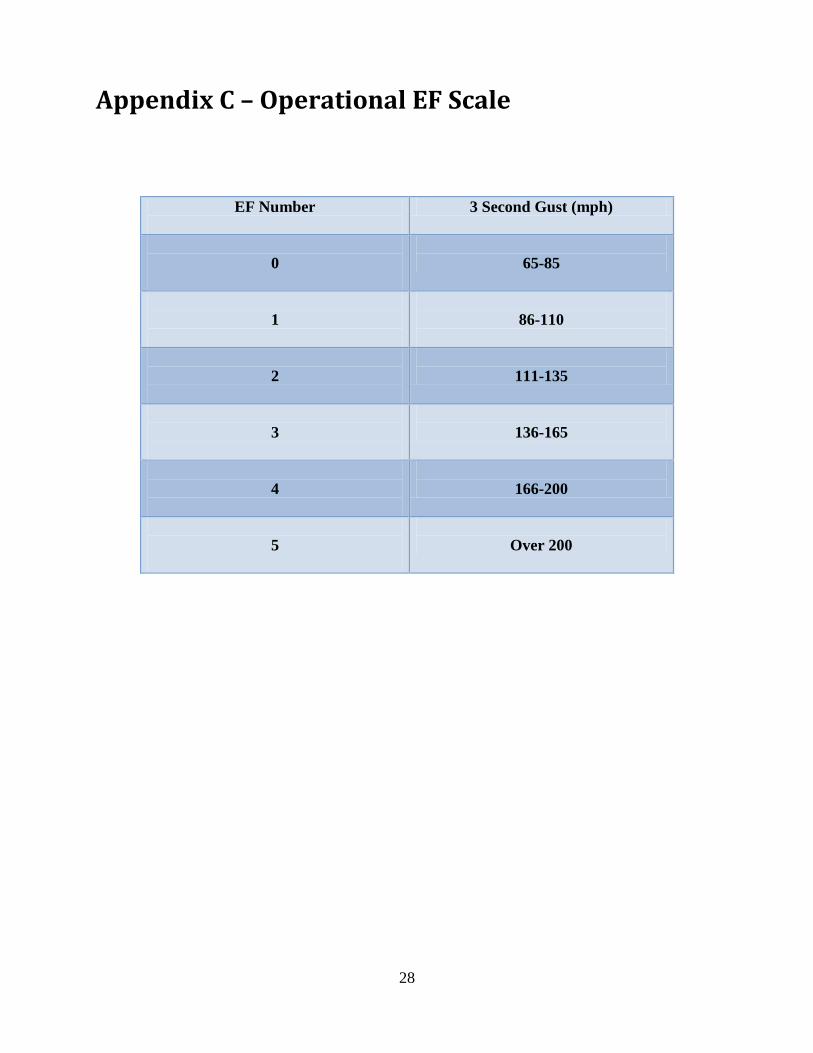
Appendix C – Operational EF Scale
EF Number
3 Second Gust (mph)
0
65-85
1
86-110
2
111-135
3
136-165
4
166-200
5
Over 200

29
Appendix D - Findings, Recommendations, and
Best Practices
Findings and Recommendations
Finding #1: Recent NWS Assessments have addressed societal impacts of warnings, most
notably the “Super Tuesday Tornado Outbreak of Feb. 5-6, 2008” and the “Mother’s Day
Weekend Tornado Outbreak of 2008.”. Many of the societal impacts uncovered in previous
Service Assessments were also evident in Joplin, suggesting the NWS should take a more
aggressive stance in addressing warning response.
Recommendation #1: For future Service Assessments, NWS should plan a more structured
approach to collecting information on societal aspects of warning response. This should include
developing sub-teams well-versed in social science and NWS warning operations that can be
quickly deployed to the field following any given severe weather disaster.
Finding #2a: For the majority of surveyed Joplin residents, the first risk signal for an imminent
severe weather threat came via the local community siren system. As a result, there was a
significant degree of ambiguity associated with the first alert regarding the magnitude of the
risk, the seriousness of the warning, and its potential impact.
Finding #2b: The majority of surveyed Joplin residents did not immediately go to shelter upon
hearing the initial warning, whether from local warning sirens, television, NWR, or other
sources. Instead, most chose to further clarify and assess their risk by waiting for, actively
seeking, and filtering additional information.
Finding #2c: Familiarity with severe weather and the perceived frequency of siren activation
not only reflect normalization of threat and/or desensitization to sirens and warnings, but they
also establish that initial siren activation has lost a degree of credibility for many residents.
Credibility is considered to be one of the most valued characteristics for effective risk
communication.
Finding #2d: The majority of surveyed Joplin residents did not take protective action until
receiving and processing credible confirmation of the threat- and its magnitude- from a non-
routine trigger.
Finding #2e: Nationally, 76% of all NWS Tornado Warnings, in their totality, are false alarms.
This means 24% of all tornado warnings are eventually associated with an observed tornado –

30
indicating limited skill in differentiating between tornadic and non-tornadic events; however,
68% of EF0-1 tornadoes receive advance warning of near 12 minutes, while 94% of EF3-5
tornadoes receive advance warning of near 18 minutes, indicating an ability to better detect
strong/violent tornadoes. Just over half (54%) of all severe weather warnings coincide with a
severe weather event, indicating moderate skill in distinguishing between severe and non-severe
thunderstorms.
Recommendation #2: To improve severe weather warning response and mitigate user
complacency, the NWS should explore evolving the warning system to better support effective
decision making. This evolution should utilize a simple, impact-based, tiered information
structure that promotes warning credibility and empowers individuals to quickly make
appropriate decisions in the face of adverse conditions. This structure should:
a) lessen the number of risk signals processed before protective action is taken (finding 2b)
b) provide a non-routine warning mechanism that prompts people to take immediate life-saving
action in extreme events like strong to violent tornadoes (finding 2d).
c) be impact-based more than phenomenon-based for clarity on risk assessment (finding 2a)
d) be compatible with NWS technological, scientific, and operational capabilities (finding 2e)
e) be compatible with external local warning systems and emerging mobile communications
technology (finding 2a)
f) be easily understood and calibrated by the public to facilitate decision making (finding 2a)
g) maintain existing “probability of detection” for severe weather events (finding 2e)
h) diminish the perception of false alarms and their impacts on warning credibility and
response (finding 2c)
Finding # 3: Many current warning dissemination systems are not fully compatible with specific
warning information provided by storm-based, warning polygons.
Recommendation # 3: The NWS should continue to collaborate with partners who disseminate
weather information to advance GPS-based warning dissemination systems that are compatible
with more specific storm-based warning information. This change should include cultivating use
of mobile communications technologies (text messaging, smart phone apps, Commercial Mobile
Alert System, etc.) and technological upgrades of the Emergency Alert System (EAS) and NWR.
Finding # 4: Partners adapt weather and warning information in their local warning systems in
an attempt to communicate risk simply and unobtrusively. The result is sometimes a poorly
coordinated warning message across the weather enterprise that can lead to confusing or mixed
messages.
Recommendation # 4: The NWS should collaborate with partners throughout the weather
enterprise to provide a better coordinated warning message. Guidance should be developed to
assist partners in the development of local warning system and siren strategies that work in
conjunction with NWS warnings rather than independent of them.

31
Finding #5: Because the Joplin/southwest Missouri area lies near the intersection of multiple
NWS County Warning Areas (CWA), there was some difficulty noted by NWS partners in
following chats from many different offices.
Recommendation #5: The NWS should continue to improve collaboration tools for our
partners. Partners requested improvements to the current NWSChat display to include a
“dashboard” interface to allow them to more easily monitor multiple offices at the same time.
Finding #6: The Storm-Ready renewal application for the city of Joplin had some discrepancies
and incomplete information. WFO Springfield does not have a StormReady Advisory Board that
consists of any individuals outside the local office.
Recommendation #6: The NWS needs to maintain a credible structure to the Storm-Ready
program, including local advisory boards, and adhere to established criteria for Storm-Ready
certifications.
Finding #7: Conference calls provided by WFO Springfield play a critical role in heightening
the preparedness levels of NWS partners, and are requested by partners for scenarios with SPC
Moderate Risk or greater.
Recommendation #7: The NWS should ensure that tools and procedures are in place for WFO
operational staff to easily conduct conference calls with NWS partners. These calls should be
provided in a consistent manner and associated with SPC Moderate Risk or greater.
Finding #8: After the significance of this event was apparent, Tornado Warnings and Severe
Weather Statements lacked enhanced wording to accurately portray that immediate action was
necessary to save lives with this tornado.
Recommendation #8: WFO warning forecasters should use wording that conveys a sense of
urgency in warnings and statements when extremely dangerous and life threatening weather
situations are in progress.
Finding #9: Radar data acquisition was compromised across key geographic locations, mainly
owing from Volume Coverage Pattern (VCP) selection at both KSGF and KINX. In this case,
velocity data was obscured on KSGF upstream of Joplin near a critical warning decision point –
and KINX velocity data was obscured over Joplin during the height of the tornado event.
Recommendation #9: WFO warning operations should make use of the more
effective/adaptable VCP 12 and manually select appropriate Pulse Repetition Frequencies
(PRF) to remove range obscured velocity data and mitigate compromised radar datasets.

32
Finding #10: Low level rotational intensification and tornadogenesis occurred very rapidly
with the Joplin tornado from 529 pm CDT to tornado touchdown around 534 pm CDT and the
beginning of EF-4 damage around 538 pm CDT. Limited scans at lowest elevation slices during
this time impacted the WFO’s ability to quickly ascertain the magnitude of the tornado.
Recommendation #10: To enhance the ability to monitor rapid tornadogenesis and tornado
intensification, NWS should develop and implement additional hybrid WSR-88D VCP strategies
that allow for more continuous sampling near the surface (e.g., 1-minute lowest elevation
sampling).
Best Practices
Best Practice #1: NWS outreach and severe weather safety education programs should
continue to emphasize and assist area businesses with severe weather safety action plans via the
Storm Ready program or other, similar mechanisms. This kind of outreach and planning
assistance should also be extended to vulnerable populations in nursing homes, group homes,
hospitals, etc.
Best Practice #2: NWSChat should continue to be supported and encouraged as a valuable
communication tool amongst the “weather enterprise” team members.
Best Practice #3: WFOs should issue non-routine AFDs to discuss ongoing and expected
mesoscale feature evolution when severe thunderstorms are anticipated.
Best Practice #4: WFO Springfield employed a dedicated Verification/Communication
Specialist position to communicate using chat and social media during the severe weather event.
Best Practice #5: NWS offices should have a post-disaster plan and work closely with Regional
Operations Centers on strategies for staffing and resource allocation for high profile weather
events.

33
Appendix E - Acronyms
AFD Area Forecast Discussion
CDT Central Daylight Time
EAS Emergency Alert System
EF Enhanced Fujita Tornado Scale
HWO Hazardous Weather Outlook
KINX Tulsa, Oklahoma Radar
KSGF Springfield, Missouri Radar
KS Kansas
LSR Local Storm Report
MMWB Multi Media Web Brief
MO Missouri
mph miles per hour
NOAA National Oceanic and Atmospheric Administration
NWS National Weather Service
PRF Pulse Repetition Frequency
RAOB Rawindsonde Observation
SDM Station Duty Manual
SGF Springfield, MO
SPC Storm Prediction Center
TDWR Terminal Doppler Weather Radar
VCP Volume Coverage Pattern
WFO Weather Forecast Office

34
Appendix F - Team Members
Richard Wagenmaker
Meteorologist in Charge NOAA/NWS Detroit, MI
Justin Weaver
Meteorologist in Charge
NOAA/NWS Lubbock, TX
Gary Garnet
Warning Coordination
Meteorologist
NOAA/NWS Cleveland, OH
Bethany Perry
NOAA Central Region
Collaboration Team
Coordinator
NOAA Kansas City, MO
Jennifer Spinney
Research Associate
University of Oklahoma,
Social Science Woven into
Meteorology
Other Contributors
Bill Davis
Meteorologist in Charge
NOAA/NWS Springfield,
MO
Steve Runnels
Warning Coordination
Meteorologist
NOAA/NWS Springfield,
MO
Dr. Greg Mann
Science and Operations
Officer
NOAA/NWS Detroit, MI

35
Appendix G: Errata
Page 1: amended; first paragraph, first sentence changing fatalities to 158 (official total).
Page 17: corrected; third paragraph, first sentence changing #30 to #31 (TO.31).
Page 17: clarification; third paragraph, third sentence adding (follow-up to TO.30).
Page 17: clarification; third paragraph, fourth sentence adding (TO.32).
Page 18: clarification; first paragraph, second sentence changing time of radar image from 540
pm to 539 pm CDT and add 539 pm to 548 pm CDT Severe Weather Statements.
Page 22: corrected; second paragraph to add WFO Pleasant Hill, Missouri (KEAX) radar.
Page 34: amended; changing Bethany Hale to Bethany Perry