nws readiness for goes-r and snpp/jpss dr. louis w. uccellini noaa assistant administrator for...
TRANSCRIPT
NWS Readiness for GOES-R and SNPP/JPSS
Dr. Louis W. UccelliniNOAA Assistant Administrator for Weather Services and
Director, National Weather Service
NOAA Satellite ConferenceCollege Park, MD
April 8, 2013
1
2
Building community resilience in the face of increasing vulnerability to extreme weather
• Mission:
– Provide weather, water, and climate data, forecasts and warnings for the protection of life and property and enhancement of the national economy
• Vision…a Weather Ready Nation: – Society is prepared for and responds to weather dependent events
• Success:– depends on ability to forecast and warn extreme events with
enough lead time for people to plan, react, and take steps to mitigate
Building a Weather Ready Nation

Our Vulnerability to High-Impact Weather Has Increased
Why a Weather Ready Nation?...
3
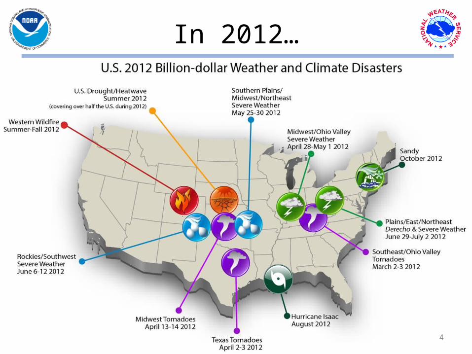
In 2012…
Pre-Decisional**Making the extraordinary ordinary 4
14 Billion-Dollar Disasters
4

• Global Observing System• Computers (supercomputers,
work stations)• Data Assimilation &
Modeling/Science• Trained workforce
Key components of a successful forecast
Today: Everything you read, see or hear about weather, climate and ocean forecasts
begins with numerical prediction models
Global Observing System• ~2 Billion / day• 99.9 % remotely sensed, mostly from
satellites• 35 different satellites now used
5Satellite contribution dominated by LEO

Key components of a successful Warning
• situational awareness• rapid data access• increasingly remotely
sensed observations• decision support services
/training
Services/products
6Satellite contribution dominated by GEO
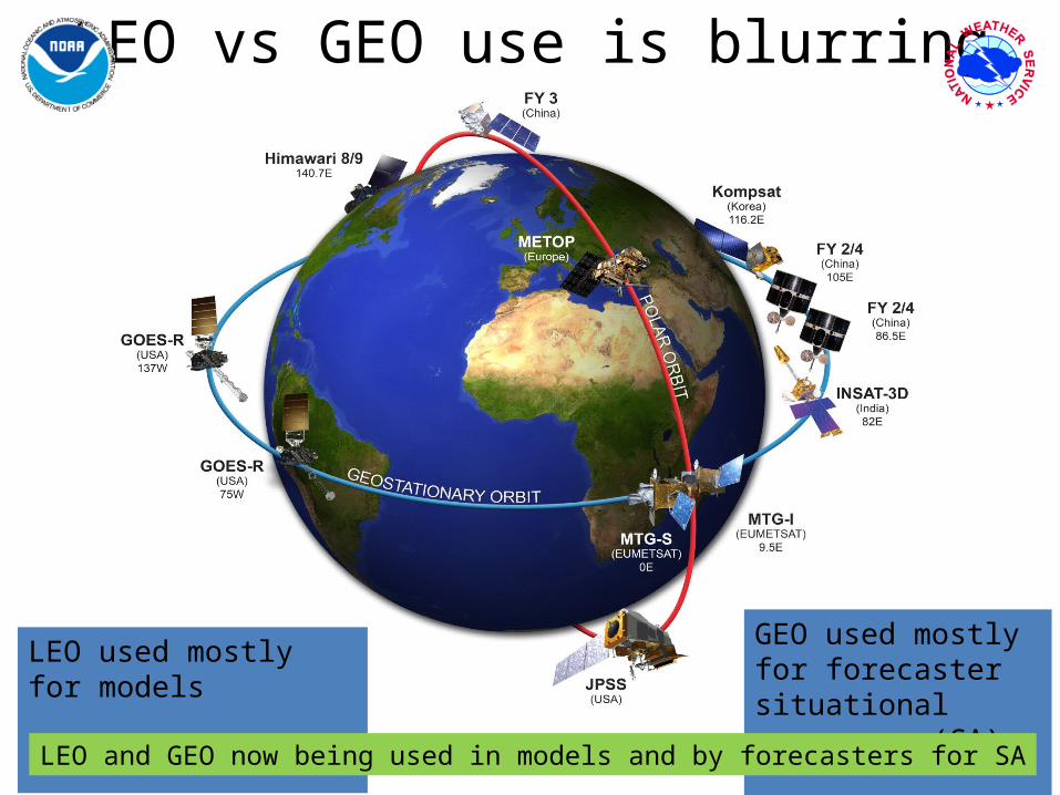
LEO vs GEO use is blurring
Pre-Decisional** 7
LEO used mostly for models
GEO used mostly for forecaster situational awareness (SA)
LEO and GEO now being used in models and by forecasters for SA

Observation Impact to NWP
Pre-Decisional**Making the extraordinary ordinary
O3: Ozone from satellites METEOSAT IR Rad (T,H)
MTSATIMG: Japanese geostationary sat vis and IR imagery GOES IR rad (T,H)
MODIS: Moderate Resolution Imaging Spectroradiometer (winds) GMS: Japanese geostationary satellite winds
SSMI: Special Sensor MW Imager (H and sfc winds) AMSRE: MW imager radiances (clouds and precip)
MHS: MW humidity sounder on NOAA POES and METOP (H) MSG: METEOSAT 2nd Generation IR rad (T,H)
HIRS: High-Resol IR Sounder on NOAA POES (T,H) PILOT: Pilot balloons and wind profilers (winds)
Ocean buoys (Sfc P, H and winds) METEOSAT winds
GOES winds AMSU-B: Adv MW Sounder B on NOAA POES
SYNOP: Sfc P over land and oceans,H, and winds over oceans QuikSCAT: sfc winds over oceans
TEMP: Radiosonde T, H, and winds GPSRO: RO bending angles from COSMIC, METOP
AIREP: Aircraft T, H, and winds AIRS: Atmos IR Sounder on Aqua (T,H)
IASI: IR Atmos Interferometer on METOP (T,H) AMSU-A: Adv MW Sounder A on Aqua and NOAA POES (T)
0 2 4 6 8 10 12 14 16 18
Note:1) Sounders on Polar Satellites reduce forecast error most2) Results are relevant for other NWP Centers, including NWS/NCEP
Courtesy: Carla Cardinaliand Sean Healy, ECMWF
8

9
Proving Grounds – Testbeds – JCSDAR2O-O2R
Mass loading
Effective particle radius
False color for reference
Ash height
9

10
• Full Integration of LEO & GEO– Operational & Research– Traditional (e.g. IR-MW) & Emerging (e.g. GPSRO)– Remotely Sensed & In-Situ
• Latency– 2.5 hour data assimilation (DA) window, data loses
value quickly when used in later DA cycles– Minutes latency relevant to severe weather warnings
Key Challenges

NOAA Enterprise Shared Services ModelDissemination
*
11

12
• Satellite data remains critically important to the forecast and warning mission of NWS
• Data access / latency needs are driving integrated dissemination plans
• Testbeds / Proving Grounds focused on use of GEO and LEO will have to come to grips with blurring categories of satellite data
In Summary

Questions?
13

Backups
14

Observation Impact to NWP
Pre-Decisional**Making the extraordinary ordinary
Courtesy: Ron GelaroNASA / GMAO
15