oantienans - bsee data center lull in 911 omp? attention. ni. salty cmd too iiiisuite jsw hcmetan,...
TRANSCRIPT

hall l u l l in 911 O m p ? Attention. Ni. Salty CMD
TOO I i i i S u i t e JSW Hcmetan, T u u T7002
oantienans
Reference la auric to your supplemental DeTelopaont Operation* Coordination DBieunt (DOCD) and ami leannaj I n* information received January 24, 1969. for iflgf- ft^-g Tjyr, nil uni r l l , Maim Paaa Araa. Thla DOCD includes taa ae Haitian propoeed for wall aVg aod Platfora B and Wall No* 2.
In accordance with 30 Cfl 290.34, thla DOCD la haraby deanad aubalttad end I J ioa feeing ooaaldered far approval.
Tour "VT^tT and ahould ba rafaranead In your oiaiaainl-oat lon and oorr^apocdeaaa ocnoamlnc thla DOCD.
Slnoarol' /cure,
(Orig. SpH A. Doea 1 Girok J7<* D. J. Bourgeola
Regional Supervisor Field Operationa
bcc: .Leaae OCS-0 5727 (OPS-3-2) (FILE I0CH) /OPS-3-4 a/Public info. Copy of the DOCD I and anexatp. info. (PUBLIC RECORDS)
MJTolbart«ock 101/31/39: doedooea
Office of Program Services

HALL-HOUSTON OIL COMPANY Republicftank Center
700 Louisiana, Suite 2390 Houston, Texas 77002
(713) 228-0711 Fax (713) 228-9908
January 23, 1989
Mr. Daniel J . Bourgeois Regional Supervisor, F ie ld Operations U.S. Department of the Interior Minerals Management Service 1_01 Elmwood Park Boulevard New Orleans, Louisiana 70123-2394
Attention: FO-2-1
RE: Supplemental Develop: ent Operations Coordination Document OCS-G 572 7, Block 244 Main Pass Area Offshore Alabama
Gentlemen:
Enclosed please find ten (10) copies of the Supplemental Development Operations Coordination Document (DOCD) with associated Environmental Report and Air Quality Review for Lease OCS-G 5727, Main Pass Block 244. Five (5) copies of the subject report are for "Proprietary" information purposes and five (5) copies contain "Public Information"; a l l copies being marked accordingly.
Excluded from the Public Information copies are certain geologic discussions, depth of wells and structure map.
Hall-Houston Oil Company anticipates commencing development operations on March 15, 1989 by spudding Well No. 2. Should further information be required, please contact the undersigned.
Sincerely,
Kathy Camp Manager, Regulatory Affairs
KC enclosures
ii
Public Information ff

SUPPLEMENTAL DEVELOPMENT OPERATIONS COORDINATION DOCUMENT
MAIN PASS AREA, BLOCK 244
OCS-G 5727
Hall-Houston Oil Company (Hall-Hous ton) as Operator of the subject block, submits this proposed Supplemental Development Operations Coordination Document (DOCD) in accordance with the regulations contained within Ti t l e 30 CFR 250.34, as follows:
1. Brief History to Date
Under an I n i t i a l DOCD, Hall-Hcston Oil Company completed and is presently producing Well No. J. at the A platform in Main Pass Block 244. Lease OCS-G 5727 i s held by production.
2. Description and Schedule of Operations
A total of two (2) wells w i l l be involved in the additional development and production a c t i v i t i e s for Main Pass Area Block 244.
Under this DOCD, Ha 11-Houston Oil Company i s proposing to d r i l l Well No. 2 and i n s t a l l a tripod well protector platform "B" with test f a c i l i t y (see Attachment I , Platform Elevation Drawing) over Well No. 2 at a proposed location 4150' FEL and 5850' FSL of Main Pass Block 244. Hall-Houston w i l l also d r i l l Well No. A-2 from the existing A platform.
Production from Well No. A-2 w i l l be transported via pipeline to proposed Platform B; be commingled with production from Weli No. 2, and further transported f t . processing at existing f a c i l i t i e s located on Hall-Houston's platform A in Main Pass Area Block 265.
The following schedule details the chronological order of the proposed events leading to f u l l production:
A c t i v i t y Approximate Date
1. D r i l l Wells No. 2 and A-2 March 15, 1989
2. Commence installation of Platform B July 15, 1989
3. Ins ta l l pipeline July 30, 1989
4. Commence production August 31, 1989

HALL-HOUSTON OIL COMPANY Supplemental DOCD Main Pass 244
Page 2
3. Drilling/Completion Equipment
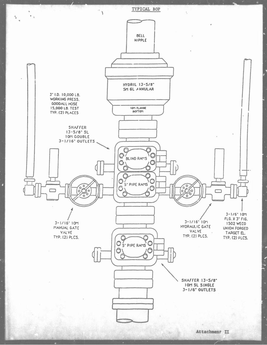
The proposed wells will be drilled/completed with a jackup drilling rig. When a rig i s selected, the rig specs will be made a part of the Application for Permit to Dr i l l each well. Typical diverter and BOP schematics are enclosed herewith as Attachment I I . Any rig utilized by Hall-Houston Oil Company will be designed, operated and maintained in accordance with 30 CFR 250.40 (b)(4).
Pollution prevention features will include a d r i l l floor containment system with collection tank in hull.
Safety features will include well control and blowout prevention equipment as described in 30 CFR 250, Subpart D. Hall-Houston Oil Company wil l perform a l l operations in a safe and workmanlike manner and will maintain a l l equipment in a safe condition, thereby ensuring the protection of lease and associated f a c i l i t i e s , the health and safety of a l l persons, and the preservation and conservation of property and the environment. The appropriate l i f e rafts, l i f e jackets, ring buoys, etc., as prescribed by the U.S. Coast Guard, will be maintained on the facility at a l l times.
4. Platform and Production Equipment
Platform "B" shall be designed, fabricated, installed, inspected, and maintained in accordance with a l l the requirements of 30 CFR 250.130 (b), under the provisions of the "Requirements for Verifying the Structural Integrity of OCS Platforms".
Pollution prevention features will include the installation of curbs, gutters, drip pans, and drains in deck areas in a manner necessary to collect a l l contaminants not authorized for discharge. Oil drainage will be piped to a properly designed, operated, and maintained sump system which will automatically maintain the o i l at a level sufficient to prevent discharge of o i l into offshore waters. All gravity drains shall be equipped with a water trap or other means to prevent gas in the sump system from escaping through the drains. Sump piles shall not be used as processing devices to treat or skim liquids but may be used to collect treated-produced water, treated-produced sand, or liquids from drip

HALL - HOUSTON OIL COMPANY Supplemental DOCD Main Pass 244
Page 3
pans and deck drains and as a final trap for hydrocarbon liquids in the event of equipment upsets. Improperly designed, operated or maintained sump piles which do not prevent the discharge of oi l into offshore waters shall be replaced or repaired.
5. Location of Wells
The approximate locations of the two (2) well(s) proposed in this Plan, as well as the proposed depths, are described as follows:
No. 2 Surface: 4150' FEL/5850' FSL PBHL:
No. A-2 Surface: 3491' FWL/72001 FSL PBHL:
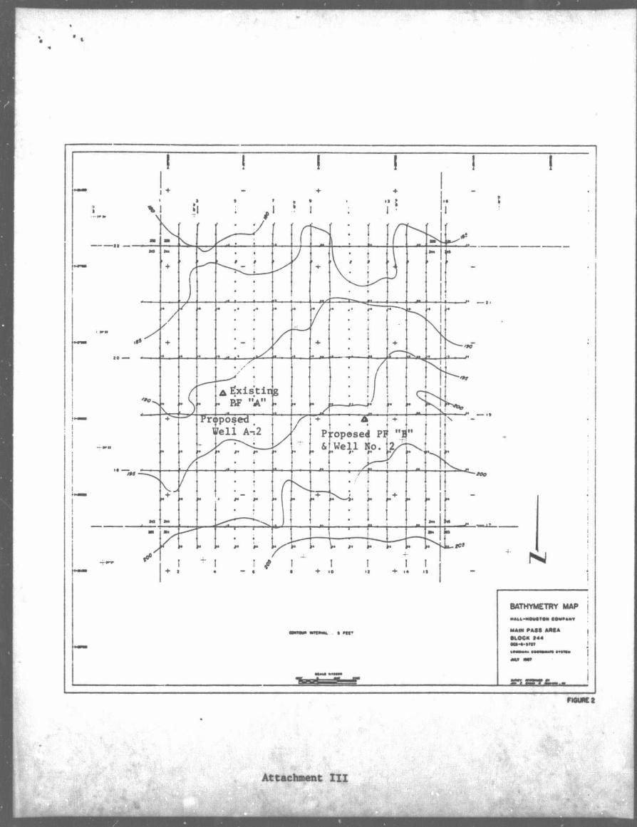
Main Pass Block 244 i s located approximately 55 miles east from Venice, Louisiana, and 75 miles south of the Jackson County lines* The water depth in Block 244 i s 200 feet. See Attachment I I I , Bathymetry Map, for the location of the existing and proposed wells and structure.
6. Onshore Facilities and Transportation
The service base for this area will be located in Venice, Louisiana. This wi l l be an established facility that will require no modifications. Transportation from the existing onshore fa c i l i t i e s to the block will involve the use of one supply boat making seven (7) trips per week, one crew boat making ten (10) trips per week and one helicopter making one (1) trip per week during drilling and/or completion operations. I t i s estimated one service boat will be making seven trips per week during production operations with one helicopter making one trip per week.
Enclosed herewith as Attachment IV, i s a map showing the lease relative to the shoreline depicting the proposed transportation route(s). The boats will normally move to Block 244 via the most direct route from Venice, Louisiana. The helicopter will normally take the most direct route of travel between the two points when air traffic and weather conditions permit.
"Public Information"
HALL-HOUSTON OIL COMPANY Supplemental DOCD Main Pass 244
Page 4
7. Geological/Geophysical Information
information on geological hazards relative to anomalies was included in the I n i t i a l Plan of Exploration for Block 244.
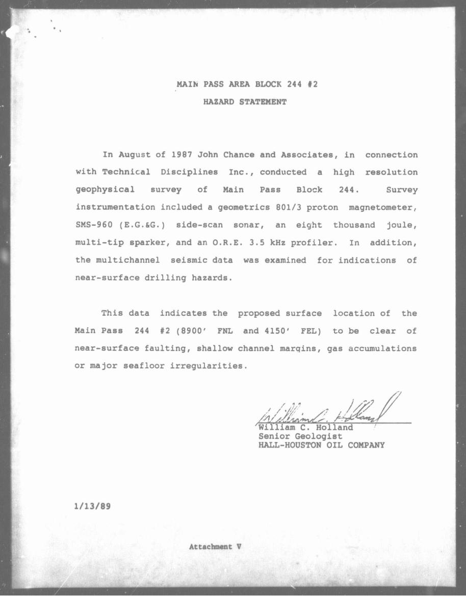
A shallow drilling hazards report covering the surface location of Well No. 2 and Platform B is enclosed herewith as Attachment V.
A structure map which illustrates Hall-Houston's current interpretation of Main Pass Area. Block 244 i s enclosed herewith as Attachment VI.
8. Pollution Prevention Information
Pollution prevention control measures will be in accordance with 30 CFR 250.40. Hall-Houston has on f i l e with the MMS an approved Oil Spill Contingency Plan for the Gulf of Mexico. In the event of a s p i l l , this Plan will be actuated. Hall-Houston i s a member of Clean Gulf Associates which provides spill containment equipment and clean-up equipment at six Halliburton Service Bases on the Gulf Coast: Galveston and Rockport in Texas; Grand Is l e , Venice, Cameron and Intracoastal City in Louisiana. I f a sp i l l should occur from the proposed locations, the equipment located at Venice, Louisiana, would be utilized f i r s t , with additional equipment moved in from other bases, i f necessary. Fast boat response with o i l boom, skimmers, pump and storage tanks would require approximately 4-6 hours, including preparation time. A heavy equipment system would require approximately 20-28 hours, including six hours preparation time. See Attachment VII for the Oil Spill Trajectory Analysis for Main Pass Block 244.
9. New or Unusual Technology
Hall-Houston Oil Company does not intend to utilize any new or unusual techniques or technology while developing Main Pass Block 244.
"Public Information'

HALL-HOUSTON OTL COMPANY Supplemental DOCD Main Pass 244
Page 5
10. Lease Stipulation(s)
The following measures have been or will be taken to satisfy the requirements of the operational stipulations appended to Lease OCS-G r 727, Main Pass Block 244:
Stipulation No. 1 - Protection of Cultural Resources
John Chance and Associates conducted a high resolution geophysical survey during July 1987. A report was prepared by Technical Disciplines Inc. and subsequently reviewed and accepted by MMS. Although this report does not indicate the possibility of any significant cultural resources, Hall-Houston Oil Company agrees that i f any site, structure, or object of historical or archaeological significance should be discovered during any operation, the findings will be immediately reported to the Regional Director and every reasonable effort will be made to preserve and protect the cultural resource from damage until the Regional Director has given direction as to its preservation.
11. Effluent Discharges
It is not expected that any liquid or solid wastes, or pollutants will be generated by offshore, onshore or transportation-related operations with the following exceptions. The discharge of wastewater resulting from offshore activities includes deck drainage, solid wastes (i.e. sanitary and domestic wastes), cooling water and desalinization unit discharges. Deck drainage will consist of a l l waste resulting from rainfall, rig/platform washing, deck washings, tank cleaning operations, and runoff from curbs and gutters, including drip pans ard work areas with an estimated volume range of 0 to 200 bbls/day. Sanitary and domestic wastes wi]l be processed on the rig and the resulting effluent during drilling and completion operations will be discharged into the Gulf with an estimated maximum of 2900 gallons/day flow, depending on the number of inhabitants. The platform will be an unmanned facility, therefore, once production operations commence there should be no sanitary and domestic waste discharges. Cooling water i s defined by the U.S. Environmental Protection Agency as "noncontact" water used for cooling machinery, and desalinization discharges are those wastes resulting from the creation of freshwater from seawater. These discharges are regulated by the U.S. Environmental Protection Agency through the National Pollutant Discharge Elimination System (NPDES) Permit.

HALL-HOUSTON OIL COMPANY Supplemental DOCD Main Pass 244
Page 6
Drill cuttings and excess drilling fluids will be disposed of in accordance with applicable environmental regulations. Drilling fluids used by Hall-Houston Oil Company are composed of bulk constituents and special purpose additives. The principal bulk constituents are water, barite (barium sulfate), clay minerals, chrome lignosulfonate, lignite, and sodium hydroxide. All these constituents are nontoxic to marine organisms at the dilutions reached shortly after discharge.
Hall-Houston Oil Company will utilize a water-based mud system during the continuous phase of the drilling mud. In special circumstances, especially in freeing stuck pipe, an oil "slug" or " p i l l " may be added to a water-based mud. Hall-Houston will not discharge oil-based mud or mud to which diesel has been added. Any o i l contaminated muds or cuttings will be transported to shore for proper disposal. Where o i l other than diesel i s added to the mud system, i t may be discharged as long as there is no visible sheen on the receiving waters and the mud meets the toxicity limitations imposed by the U.S. Environmental Protection Agency in the NPDES Permit. See Attachment VIII for Anticipated Quantity of Discharged Mud and Cuttings.
12. Hydrogen Sulfide
Based on available geological and geophysical data from wells drilled in the surrounding Main Pass Area, Hall-Houston Oil Company considers Block 244 to be in an area where the absence of hydrogen sulfide has been confirmed.
Enclosed are copies of the following information:
ATTACHMENT NO.
I I I
I I I IV V
VI VII
Platform Elevation Drawing Rig Information Bathymetry Map Vicinitv Map Shallow Drilling Hazard Statement Structure Map Oil Spill Trajectory Analysis Anticipated Quantity of Discharge VIII
Also enclosed i s the Air Quality Review and Environmental Report.

TYPICAL TRIPOD STRUCTURE
ATTACHMENT I

*
TYPICAL DIVERTER
UEiflAUQH CLOSf MYORII - PORT QYfRrtfMQQ^Aryr
Y vfrAwnfopfnoiiD. " f fg*"HTl Y PORT YrM YlXAtlBE. QPEhf Q BY Rf rmvi^ P m f m m
IHAT Tif S Af#ti AP m m f T o pnnT, VAX Vf HAffll/.
• i n
2000 OOP
•• «O0OAU MOM
(MONSCACNIK) • U P S ? smcNsrx - aoo PSI
VCTKINO pofsstnc • TOO osi rvp.mpiACts
•* ANSI ooo nc. vr r * . *o«mq
TYP. (2) r \ A a s
ocncocxcooociAss MYo.cpfBAnr - n
. VAlVt 7I60P3I W P . ' rVP.Q»P\ACIS
PITS ft* 7000 PSl cun IT AMS« •OOriANOt R-O RiNO CASKII
(JIPiACIS
C9HJJLDU
J * w ClOSC
KJQT OPfN
STMOPtN
•'toaox
t .—
Altachment I I
TYPICAL BOP
MLL NIPPLE
3' I.O. 10.000 LB. WORKING PPCSS. GOOO ALL HOSE 15.000 LB. TCST TYP. (2) PLACES
SHAFFER 13-5/8" SL IOM DOUBLE
3-1 /16- OUTLETS
HYDRIL 13-5/8* SM 6L A HNULAR
3-1/16* IOM MANUAL GATE
VALVE TYP. (2) PLCS.
ion HA*«C ponoi
n
BLIND RAMS ^ Ov yp
ON—
T ; 5' PIPE RAMS T '
(1P w 5* PIPE RAMS ^
0
3-1/16' lOn HYDRAULIC GATE
VALVE TYP. (2) PLCS.
3-1/6* IOM FLG. X 3" FlG. 1502 WECO
UNION FORGED TARGCT EL
TYP. (2) PLCS.
SHAFFER 13-5/8* IOM SL SINGLE
3 - 1 / 6 ' OUTLETS
Attachment I I
Attachment I I I

Hall Houston 011 Co.
VICINITY MAn
MAIN PASS AREA BLOCK 244 #2
HAZARD STATEMENT
In August of 1987 John Chance and Associates, in connection
with Technical Disciplines Inc., conducted a high resolution
geophysical survey of Main Pass Block 244. Survey
instrumentation included a geometries 801/3 proton magnetometer,
SMS-960 (E.G.&G.) side-scan sonar, an eight thousand joule,
multi-tip sparker, and an O.R.E. 3.5 kHz profiler. In addition,
the multichannel seismic data was examined for indications of
near-surface dri l l i n g hazards.
This data indicates the proposed surface location of the
Main Pass 244 #2 (8900' FNL and 4150' FEL) to be clear of
near-surface faulting, shallow channel marqins, gas accumulations
or major seafloor irregularities.
Senior Geologist HALL-HOUSTON OIL COMPANY
1/13/89
Attachment V

OIL SPILL TRAJECTORY ANALYSIS FOR
HALL-HOUSTON OIL COMPANY MAIN PASS AREA, BLOCK 244, OCS-G 5727
In the event a s p i l l occurs from Main Pass Area, Block 244, Hall-Houston Oil Company has a projected trajectory of a s p i l l u t i l i z i n g information in the Environmental Impact Statement (EIS) for OCS Lease Sales 118 and 122.
The EIS contains o i l s p i l l trajectory simulations using seasonal surface currents coupled with wind data, adjusted every 3 hours for 30 days or until a target i s contacted.
Hypothetical s p i l l trajectories were simulated for each of the potential launch sites across the entire Gulf. These simulations presume 500 s p i l l s occurring in each of the four seasons of the year. The results in the EIS were presented as probabilities that an o i l s p i l l beginning from a particular launch site would contact a certain land segment within 3, 10, or 30 days. U t i l i zing the summary of the trajectory analysis (for 10 days) as presented on pages IV-40 through IV-45, the probable projected land f a l l of an o i l s p i l l from Main Pass 244 i s as follows. Also listed i s the CGA Map Number corresponding to the land segment which w i l l be utilized to determine environmentally sensitive areas that may be affected by a s p i l l .
AREA LAND SEGMENT CONTACT CGA MAP NO.
Main Pass 244 Plaquemines Parish, LA Louisiana Maps 7 & 8 St. Bernard Parish, LA Hancock County, MS MAFLA Maps 9 & 10 Harrison County, MS Jackson County, MS Mobile County, AL
Section V, Volume I I of the CGA Manual containing maps as listed above, also includes equipment containment/cleanup protection response modes for the sensitive areas. Pollution response equipment available from CGA and i t s stockpile base i s listed in the CGA Manual Volume I , Section I I I .
Section VI, Volume I I of the CGA Operations Manual depicts the protection response modes that are applicable for o i l s p i l l clean-up operations. Each response mode i s schematically represented to show optimum deployment and operation of the equipment in areas of environmental concern. Implementation of the suggested procedures assures the most effective use of the equipment and w i l l result in reduced adverse impact of o i l s p i l l s on the environment. Supervisory personnel have the option to modify the deployment and operation of equipment to more effectively respond to site-specific circumstances.
Attachment VII

ANTICIPATED QUANTITY OF DISCHARGED MUD, CUTTINGS & FLUIDS
WELL
i t -) l l
HOLE SIZE
26" 20" 13-1 >" 9-7/8"
DEPTH INTERVAL
0 144 800 2500
144' 800' 2500' 7000'
CUTTINGS (BBLS)
132 204 421 597
FLUIDS (BBLS)
50 150 378 462
TOTAL 1354 1040
"A-2" 26" 0 - 125• 115 50 13-1/2" 125 - 1835' 424 356 9-7/8" 1835 - 6491' 617 463
TOTAL 1156 869
I t i s estimated that d r i l l i n g f l u i d s w i l l be discharged at the rate of 63 barrels per day. The estimated d r i l l i n g f l u i d s discharge f o r the t o t a l project (two wells) i s 1909 barrels. I n addition t o the estimated discharges while d r i l l i n g , an end-of-well f i n a l mud discharge of approximately 1000 barrels i s planned after the second well has been d r i l l e d . The projected rate of discharge of cuttings i s estimated t o be 83 barrels per day with an estimated t o t a l of 2510 barrels f o r the t o t a l project.
Attachment V I I I

ENVIRONMENTAL REPORT
FEDERAL LEASE OCS-G 5727
HAIN PASS AREA BLOCK 244
OFFSHORE, LOUISIANA AND ALABAMA
THE FOLLOWING ENVIRONMENTAL REPORT WAS PREPARED BY J. CONNOR CONSULTING FOR HALL-HOUSTON OIL COMPANY. FOR COASTAL ZONE CONSISTENCY DETERMINATION BY THE STATE OF LOUISIANA AND ALABAMA ON OPERATIONS PROPOSED TO BE CONDUCTED IN THE DEVELOPMENT OPERATIONS COORDINATION DOCUMENT FOR LEASE OCS-G 5727. FOR INQUIRIES REGARDING THIS REPORT PLEASE CONTACT:
HALL-HOUSTON OIL COMPANY
700 LOUISIANA, SUITE 2390
HOUSTON, TEXAS 77002
ATTENTION: MS. KATHY CAMP
JANUARY, 1989

«
TABLE OF CONTENTS
TITLE PAGE 1
TABLE OF CONTENTS 11
I. DESCRIPTION OF PROPOSED ACTION 1
A. DESCRIPTION OF PROPOSED TRAVEL MuDES, ROUTES AND 1 FREQUENCY
B. ONSHORE SUPPORT SYSTEMS 1 C. NEW OR UNUSUAL TECHNOLOGY 1 D. VICINITY MAP 1 E. PROPOSED MEANS TO TRANSPORT OIL AND GAS TO SHORE 2
ROUTES, QUANTITIES
II. DESCRIPTION OF AFFECTED ENVIRONMENT 2
A. COMMERCIAL FISHING 2 B. SHIP, ING 3 C. PLEASURE BOATING, SPORT FISHING AND RECREATION 3 D. POTENTIAL OR KNOWN CULTURAL RESOURCES 4 E. ECOLOGICALLY SENSITIVE FEATURES 5 F. PIPELINES AND CABLES 6 G. OTHER MINERAL USES 6 H. OCEAN DUMPING 6 I. ENDANGERED OR THREATENED SPECIES AND CRITICAL 6
HABITAT
III. UNAVOIDABLE ADVERSE ENVIRONMENTAL EFFECTS 7
A. WATER QUALITY 7 B. EFFECTS ON MARINE ORGANISMS 7 C. WETLANDS AND BEACH 7 D. AIR QUALITY 7 E. COMMERCIAL FISHING 8 F. SHIP NAVIGATION 8 G. CULTURAL RESOURCES 8
H. RECREATION AND AESTHETIC VALUES 8
IV. SUMMARY 9
REFERENCES 10
-11-

I. DESCRIPTION OF PROPOSED ACTION
Hall-Houston Oil Company (Hal1-Houston), plans to conduct development activities on Main Pass Area, Block 244, OCS-G 5727.
As proposed, the Development Operations Coordination Document for Main Pass Area Block 244 will include the Installation of a production platform (Platform "B") and drill two additional wells.
At this time, the planned commencement date for proposed activities 1s on or about March 15, 1989.
A. DESCRIPTION OF PROPOSED TRAVEL MODES, ROUTES AND FREQUENCY
Boats and helicopters will be dispatched from a support base located in Venice, Louisiana. The boat will normally move to the block via the most direct route from Venice, Louisiana, however, boats operating in the field may travel from other facilities nearby. Following is an estimate of trips to the proposed operation.
Drilling Operations Production Operations
Crew Boat 10 trips per week 0 trips per week Supply Boat 7 trips per week 7 trips per week Helicopter 1 trip per week 1 trip per week
B. ONSHORE SUPPORT BASE
The proposed activities will utilize a support base located at Venice, Louisiana. This base provides 24-hour service, a radio tower with phone patch, dock space, office space, parking lot, eguipment and supply storage space, drinking and drill water, etc. The proposed development activities will help to maintain this base at its present level of activity. No expansion of the physical facilities or the creation of new jobs is expected to result from the work planned in conjunction with this block.
C. NEW OR UNUSUAL TECHNOLOGY
No new technigues or unusual technology will be reguired for this operation.
D. VICINITY MAP
Main Pass Area Block 244 is located approximately 50 miles east of the Louisiana coastline and 70 miles south of the Alabama coastline. See Exhibit A.
-1-

E. PROPOSEO MEANS TO TRANSPORT OIL ANO GAS TO SHORE, ROUTES, QUANTITIES
Producible hydrocarbons will be transported via existing pipelines in or near Main Pass 244,
II. DESCRIPTION OF AFFECTED ENVIRONMENT
A. COMMERCIAL FISHING
The Gulf of Mexico is the single most important area for fisheries production in the United States. In 1985, the total landings of all fisheries in the Gulf was about 2.4 billion pounds, valued at $596 million dockside, and represented about 38% of the total United States landings by pounds and 26% by value. In 1985, the top four U.S. ports in quantity of commercial fishery landings were Cameron, Louisiana; Pascagoula-Moss Point, Mississippi; and Dulac-Chauvin and Empire-Venice, Louisiana.
The Gulf shrimp fishery represents the single most valuable fishery in the United States with landings (heads removed) averaging approximately 230 million Ibs/vr. The major shrimp species include brown, white, and pink shrimp. In 1981 production reached almost 270 million pounds worth over $401 million dockside. In addition to shrimp, the blue crab sianificantly contributes to the Gulf's crustacean landings. In 1985, about 56 million poui. s of blue crabs, worth about $16 million, were taken in the Gulf's near-shore estuaries and sounds. Oysters are the main mollusk harvested in the Gulf's nearshore estuaries and sounds, and oyster landings in 1985 were approximately 26.5 million pounds valued at about $41 million.
In the Gulf the following commercial fishes were the most economically important in 1985 and are arranged 1n order of decreasing priority: qulf menhaden, groupers and scamp, red snapper, black mullet, red drum, yellowfin tuna, catfish and bullheads, swordfish, black drum, spotted seatrout, yellowtail snapper, pompano, vermilion snapper, and king mackerel and cero.
The menhaden purse seine fishery is the most important fishery in terms of pounds landed. In 1985, 1.9 billion pounds valued at $67 million were landed in the Gulf. Menhaden are used in the manufacture of fish meal and solubles for additives to livestock feeds, and production of fish oil. Also, small amounts are used for bait and canned pet food.
The industrial bottomfish trawl fishery produces stock for the pet food industry, bait, animal food, and fishmeal. This fishery reached peak production in the earlv 1970's at about 115 millions pounds, worth about $2.8 million; however, it has declined in recent years.
Shrimp 1s by far the most valuable component of the Alabama landings. In 1985, the total commercial landings for Alabama were about 29 million pounds, worth about $ 41 million (USDC, NMFS, 1986a). Commercial catch for Mobile Bay in 1985 accounted for $5 million in seafood harvest (USDI, MMS, 1987a). In 1977, there were approximately 1,806 commercial fishermen on the Alabama coast, where processed fishery products amounted to $90.4 million. The main
?rocessed fishery products were shrimp, crabs, and oysters (USDC, NMFS, 984).
Shrimp is by far the most valuable component of the Louisiana landings. The menhaden fishery is the largest in terms of pounds landed. In 1985. the total commercial landings for Louisiana were abrut 1.7 billion pounds, worth $229 million. Louisiana ranked first in the Urited States in pounds landed and second in value.
B. SHIPPING
Fairways play an important role in the avoidance of collisions on the OCS, particularly in the case of the large oceangoing vessels, but not all vessels stay within the fairways. Many others, sucn as fishing boats and OCS support vessels, travel through areas with high concentrations of fixed structures. In such cases the most important mitigation factor Is the requirement for adequate marking and lighting of structures. After a structure has been in place for a while, it often Becomes a landmark and an aid to navigation for vessels that operate in the area on a regular basis.
Main Pass Diock 244 is clear of all shipping fairways and anchorage areas. The platform and each of the marine vessels servicing this operation will be equipped with all U. S. Coast Guard required navigational safety aids.
C PLEASURE BOATING, SPORT FISHING AND RECREATION
The northern Gulf of Mexico coastal zone is one of the major recreational regions of the United States, particularly in connection with marine fishing and beach-related activities. The shorefronts along the Gulf coasts of Alabama, Mississippi, Louisiana, and Texas offer a diversity of natural and developed landscapes and seascapes. The coastal beaches, barrier islands, estuarine bays and sounds, river deltas, and tidal marshes are extensively and intensively utilized for recreational activity by residents of the Gulf South and tourists from throughout the Nation, as well as from foreign countries. Publicly-owned and administered areas such as National seashores, parks, beaches, and wildlife lands, as well as specially designated preservation areas such as historic and natural sites and landmarks, wilderness areas, wildlife sanctuaries, and scenic rivers attract residents and visitors throughout the year. Commercial and private recreational facilities and establishments, such as resorts, marinas, amusement parks, and ornamental gardens, also serve as primary interest areas and support services for people who seek enjoyment from the recreational resources associated with the Gulf.
The two major recreational areas most directly associated with offshore leasing and potentially affected by it are the offshore marine environment and the coastal shorefront of the adjoining states. The only major recreational activity occurring on the OCS 1s offshore marine recreational fishing and diving. Studies, reports, and conference proceedings published by MMS and others have documented a substantial recreational fishery, including scuba diving, directly associated with oil and gas production platforms. The recreational fishing associated with oil and gas structures stems from their function as high profile artificial fishing reefs. A report on the 1984 Marine Recreational Fishery Statistics Surveys presented by NMFS at the Sixth Annual Gulf of Mexico Information Transfer Meeting Indicates a majority of the offshore recreational fishing 1n the Central Gulf of Mexico

1s directly associated with oil and gas structures. There are currently about 4,000 offshore oil and gas structures in the Central and Western Gulf of Mexico. Many other studies have demonstrated that when oil and gas structures are accessible to marine recreational fishermen and scuba divers th?y are a major attraction for marine recreational activities and are a positive Influence on tourism and coastal economics.
With the exception of Grand Isle and vicinity and a stretch cf beach area in Cameron Parish, (Peveto/Constance/Ocean View Beaches, Holly Beach, Hackberry Beach) Louisiana has very limited beach area suitable for recreation. Most of it is very narrow, of poor recreational quality and generally inaccessible by automobile, some of the highest quality beach areas in coastal Louisiana are found along the barrier islands chain off Terrebonne Parish. Several additional significant recreational resources are found along the Gulf Coast. Louisiana has ornamental gardens, scenic roads, rivers, and trails.
D. POTENTIAL OR KNOWN CULTURAL RESOURCES
Archaeological resources are any objects or features which are man-made or modified By human activity. Significant archaeological resources are either historic or prehistoric and, as defined by 36 CFR 60.6, generally include properties greater than 50 years old which are associated with events that have made a significant contribution to the Lroad patterns of our history; are associated with the lives of persons significant in the past; embody the distinctive characteristics of a type, period, or method of construction; represent the work of a master; possess high artistic values; represent a significant and distinguishable entity whose components may lack individual distinction; or have yielded, or may be likely to yield, information important in prehistory or history.
Although most historic archaeological resources on the OCS are shipwrecks, other types of historic sites, such as the Ship Shoal Lighthouse, may occur in Federal waters.
Figures indicate that less than 2% of pre-20th century ships reported in the Gulf and less than 10% of all ships reported lost between 1500 and 1945 have known locations. Considering the problems with inaccurate wreck reporting, drift and breakup of wrecks, and ships which have been lost but never reported, it becomes apparent that very little is really known about the locations of historic shipwrecks in the Gulf of Mexico.
In order to deal with the management problems of this largely unlocated resource base, a high probability zone for the occurrence of shipwrecks (Zone 1) was proposed by the baseline study (CEI, 1977). This zone was delineated by using geographic factors, such as approaches to seaports, straits, shoals, reefs, and historic shipping routes, as indicators of high shipwreck potential.
Required remote sensing surveys on the OCS have recorded evidence of approximately 57 potential wrecks. Ten of these are definite wrecks while

/
the regaining 47 would require further investigation for positive identification. Eighty percent of these possible wrecks were recorded within Zone 1 which, according to the baseline study, is where the highest incidence of shipwrecks should occur.
E. ECOLOGICALLY SENSITIVE FEATURES
Barrier beaches are a common landform along the Gulf Coast and stretch in an irregular chain from Florida to Texas. These elongated, narrow landforms are composed of sand ano other loose sediments transported by waves, currents, storm surges, and wind. In geological terms, barrier islands are a young phenomenon, being formed only in the last 5000 to 6000 years. The term "barrier" identifies the structure as one that protects other features, such as bays, estuaries, and marshes, from direct wave attack of the open ocean. The waters in these bays and estuaries are a blend of the terrestrial-freshwater systems of the mainland and the saltwater system of the ocean, and among the richest ecosystems known. Many of the species that inhabit the bays, estuaries, and adjacent marshes use these areas as spawning, nursery, and feed grounds.
Another benefit of both the islands and their adjacent marshes and bays is that of providing habitats for a large number of birds and other animals. The islands also provide habitat for several threatened or endangered species, for example, the loggerhead turtle, the southern bald eagle, alligators, and brown pelicans.
The shelf and shelf edge of the Central and Western Gulf are characterized by topographic features which are inhabited by benthic cinmunities. The benthic organisms on these features appear to be deptn related; however, the actual limiting factors are temperature and light penetration (turbidity and sedimentation).
The Central Gulf of Mexico lists 16 topographic features.
Shelf Edge Banks Midshelf Banks
Bright Bank Sonnier Bank McGrail Bank 29 Fathom Bank Rankin Bank Fishnet Bank Alderdice Bank Rezak Bank Sidner Bank Ewing Bank Jakkula Bank Bouma Bank Parker Bank Sackett Bank Diaphus Bank Sweet Bank
-5-

F. PIPELINES AND CABLES
Hall-Houston as a prudent operator will avoid all pipelines and cables In this block during development activities.
G. OTHER MINERAL USES
The activities proposed for Main Pass 244 will have no direct or indirect impact on other mineral uses.
H. OCEAN DUMPING
Ocean dumping is prohibited in this area.
I. ENDANGERED OR THREATENED SPECIES AND CRITICAL HABITAT
Five federally listed endangered whale species occur within the Central Gulf. These include fin, humpback, right, sei, and sperm whales. Generally, these large cetaceans inhabit the continental slope and deep oceanic waters, occasionally they are sighted nearshore (Schmidly, 19fcl). Sperm whales have been sighted near the Louisiana p-lta and offshore Brownsville (Fritts et al., 1983).
Four federally listed endangered turtle species (Kemp's ridley, green, hawksbill, and leatherback turtles) and one threatened species (Kggerhead turtle) occur in the Gulf of Mexico.
The American alligator occurs generally throughout the Central Gulf coastal areas. The alligator is listed as endangered throughout its range except in the coastal areas of Florida and Texas where it is listed as threatened and in Louisiana where it is listed as "threatened by similarity of appearance".
The red-cockaded woodpecker occurs primarily in mature open pine forest throughout the Eastern and Central Gulf area and into eastern Texas.
Arctic peregrine falcons migrate along the eastern coast of Florida, the Florida Keys, and the Gulf coast of Texas. Some peregrine falcons overwinter along the Gulf coastal areas.
The northward migration corridor of the endangered eskimo curlew crosses the Louisiana and Texas coastal areas.
The endangered Alabama beach mouse, Perdido Key beach mouse and Chotawatchee beach mouse occur r ong the eastern Alabama and northwestern Florida Gulf beaches.
Brown pelicans occur along the coast of Cameron Parish, Louisiana. Bald eagles inhabit several Guif coastal counties.
These spedes may be affected by the development of coastal lands and/or the occurrence of oil spills which may affect the species directly or through

their food sources. Since the proposed activities include no plans for the deveiopment of the coastal lands, the impact on endangered or threatened species is primarily based on the occurrence of oil spills.
Hall-Houston as a prudent operator, will take the necessary measures to reduce the probability of oil spills. Hall-Houston's proposed development operations on Block 244 should not pose a threat to any endangered or threatened species.
III. UNAVOIDABLE ADVERSE ENVIRONMENTAL EFFECTS
A. WATER QUALITY
Production activities will temporarily reduce water quality adjacent to the location. This will Increase turbidity in a plume down-current from the work site. Peleased waters and a minor oil spill could also contribute to water quality degradation.
B. EFFECTS ON MARINE ORGANISMS
Some organisms will be killed and some will be temporarily functionally impaired as a result of development operations. The most affected groups will be plankton and benthos immediately around the platform. Damage will be both mechanical and toxicological. These impacts are considered to be localized, short term and reversible at the population level.
An oil spill could affect a broad spectrum ot marine organisms. However, most effects would be localized and short term. Any effects on mammals and turtles would be significant.
C. WETLANDS AND o.. .CH
In the unlikely event of a spill occurring and reaching shore, organisms in wetland and beach habitats could be killed or functionally impaired. Human community disruption could also occur. Although all such effects would be localized, any effects on endangered species and/or critical habitats would be significant.
D. AIR QUALITY
The air quality at the lease site will be degraded temporarily during operations, but should return to normal once operations are measurably completed. Offshore activities probably will not affect onshore air quality. Air quality at the onshore base will be only insignificantly reduced by onshore activities. Any such effect will be temporary.

E. COMMERCIAL FISHING
Of thc various types t f fishing gear In use In the OCS areas, trawls have the qreatest chance for operational conflicts with oil and gas activities. Losses may, however, bt compensated under tht Fishermen's Contingency Fund or other legal routts. Trawl nets can bt snagged on underwater stubs causing damage or loss of tht ntts. ln addition, i t is conceivable that snags could damage underwater production equipment or pipelines causing a spill of oil or gas. Because saftty equipment is installed, which shuts in production when a loss of pressure occurs, tht likelihood o* a major spill resulting thereby is considered very small. Less frequently, large objects which were lost overboard from petroleum Industry boats, pipeline lay barges, and platforms are caught by fishing gear resulting in damage to the gear and/or its catch of fish; however, occurrence of this type of incident is low. Also, commercial fishermen would probably not harvest fish 1n the area of an oil spill, as spilled oil could coat or contaminate commercial fish species rendering them unmarketable. Other unavoidable adverse impacts include loss of fish space caused by installation of unburied pipelines, rigs, platforms, or by other OCS-related structures. There may be some localized competition for shore facilities. These effects and any effect that the development operations will have on stocks of important species are considered minor.
F. SHIP NAVIGATION
Very l i t t l e interference can be expected between the platform and marine vessels utilized during production operations and ships that use established fairways. However, at night and during rough weather, fog, and heavy seas, ships not using established fairways could collide with the platform. Approved aids to navigation will be installed on the proposed platform In accordance with USCG regulations.
G. CULTURAL RESOURCES
There is only a small probability that an unknown cultural resource exists in the lease area.
H. RECREATION AND AESTHETIC VALUES
The platfonn and marine vessels may represent an obstacle to some sport fisherman, but such an effect is expectef to be negligible and not permanent.
Even though existing regulations and orders prohibit indiscriminate Uttering of the marine environment with trash, offshore oil and gas operations involving men, machines, equipment, and supplies is bound to result in some littering of the ocean. Human nature and accidents associated with offshore operations will contribute some floatable debris to the ocean environment which will eventually come ashore on major recreational beaches.
The effects that normal operations or a minor oil spill would have on any fish stocks Important to sport fishermen are also considered to be negligible.

A minor oil spill and/or non-petroleum floating debris could foul beaches inshore of the lease area. The fouling of the beaches would be an aesthetic detriment that could adversely affect recreation. Any effects on beach recreation could adversely affect tourism ano, consequently, the local economy.
IV. SUMMARY
The proposed activity will be carried out and completed with the guarantee of the following items.
A. The best available and safest technologies will be utilized throughout the project. This includes meeting all applicable requirements for equipment tynes, general project layout, safety systems, and equipment and monitor. ,g systems.
B. All operations are covered by a Minerals Management Service approved Oil Spill Contingency Plan.
C All applicable Federal. State and Local requirements regarding air emission and water quality and discharge for the proposed activities, as well as any other permit conditions, will be complied with.
D. The proposed activities described in detail in the Development Plan will comply with Louisiana's and Alabama's Coastal Zone Management Program and will be conducted in a manner consistent with such Program.

REFERENCES
1. Final Environmental Impact Statement, Proposed Oil and Gas Lease Sales 94, 98 and 102, Gulf of Mexko OCS Region, OCS EIS, MMS 84-0057.
2. Final Environmental Impact Statement, Proposed Oil and Gas Lease Sales 94, 98 and 10Z, Gulf of Mexico OCS Region, OCS EIS, MMS 84-0057, vUuals
3. Fisheries of the United States, 1985, April, 1986.
4. The Ecology of Petroleum Platforms In the Northwestern Gulf of Mexico: A Community Profile, Bureau of Land Manaqement Open File Report 82-03. July, 198Z.
5. Environmental Report West Cameron Area Blocks 516 and 524, March, 1987.
6. BLM Draft Environmental Impact Statement, OCS 011 and Gas Lease Sales A-t2 jnd 62.
7. BLM Final Environmental Impact Statement, OCS Oil and Gas Lease Sales A-62 and 62.
8. BLM Final Environmental Impact Statement, OCS Oil and Gas Lease Sale 47.
9. Minerals Management Service, 1983. Final Regional Environmental Impact Statement, Gulf Of Mexico. U.S. Department of the Interior.
10. Final Environmental Impact Statement, Proposed Oil and Gas Lease Sales 110 and 112, Gulf of Mexico OCS Region, OCS EIS, MMS 86-0087.
11. Final Environmental Impact Statement, Prcposed Oil and Gas Lease Sales 110 and 112, Gult of Mexico OCS uegion, OCS EIS, MMS 86-0087, visuals.
12. Final Environmental Impact Statement, Proposed Oil and Gas Lease Sales 113, 115 and 116, Gult of Mexico OCS Region, OCS EIS, MMS-87-0077.
-10-

TEXAS/
Hain Pass
N P
Hall Houston Oil Co,
VICINITY MAP
0

COASTAL ZONE MANAGEMENT
CONSISTENCY CERTIFICATION
SUPPLEMENTAL DEVELOPMENT OPERATIONS COORDINATION DOCUMENT
MAIN PASS AREA, BLOCK 244
OCS-G 5727
The proposed activities described in detail in this Plan comply with Louisiana's approved Coastal Zone Management Program and will be conducted in a manner consistent with such Program.
Hall-Houston Oil Company
±/J*jef Certifying O f f i c i a l
January 23, 1989 Date

COASTAL ZONE MANAGEMENT
CONSISTENCY CERTIFICATION
SUPPLEMENTAL DEVELOPMENT OPERATIONS COORDINATION DOCUMENT
MAIN PASS AREA, BLOCK 244
OCS-G 5727
The proposed activities described in detail in this Plan comply with Alabama's approved Coastal Zone Management Program and will be conducted in a manner consistent with such Program.
Hall-Houston Oil Company_
January 23, 1989
Date

P.O. Box 218753 Houston. Texas 77218 713-558-0607
January 16, 1989
PROJECTED AIR EMISSION SCHEDULE FOR DEVELOPMENT/PRODUCTION PROJECT
GENERAL INFORMATION
Location of Facility:
Distance Offshore: Name of Platform: Operator:
Contact Person: Well Footaae Drilled 1989: Date Drillinq Will Begin: Date Production Will Begin
Main Pass Area 244 OCS-G 5727 55 miles Platform "A" Hall-Houston Oil Company 700 Louisiana, Suite 2390 Houston, Texas 77002 Ms. Kathy Camp 13491' March 15, 1989 August, 1989
MAJOR SOURCE (OFFSHORE)
Power used aboard drilling vessel; approximate footage to be drilled 13491'*
Emitted Substance
CO SO 2
NOX VOC TSP
Projected Emissions **Tons/Year
i w (267) (43)
(627
(45
5.34 .85
12.55 1.01 .89
* Based on 60 hphr/ft. from Table 4-3, "Atmospheric Emissions from Offshore Oil and Gas Development and Production", EPA No. 450/3-77-026, June, 1977
** Emission factors from Table 3.3.3-1. "Compilation of Air Pollutant Emission Factors", Third Edition, EPA Report AP-42, August, 1977
Projected Air Enissions Hall-Houston 011 Company Main Pass Area 244 Page 2
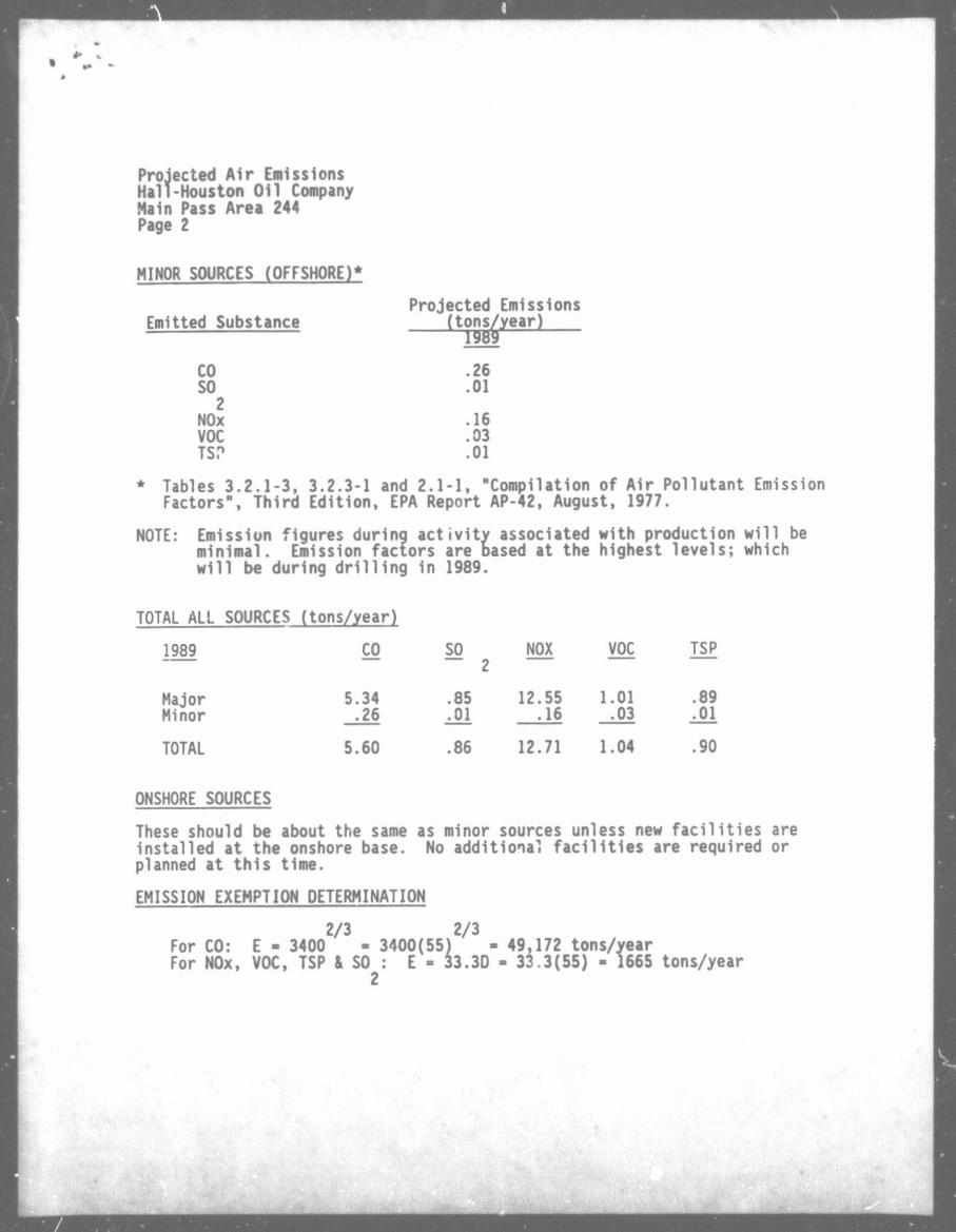
MINOR SOURCES (OFFSHORE)*
Emitted Substance "(tons/year) Projected Emissions
ons/
CO .26 SO .01 2
NOx .16 VOC .03 TS? .01
* Tables 3.2.1-3, 3.2.3-1 and 2.1-1, "Compilation of Air Pollutant Emission Factors", Third Edition, EPA Report AP-42, August, 1977.
NOTE: Emission figures during activity associated with production will be minimal. Emission factors are based at the highest levels; which will be during drilling in 1989.
TOTAL ALL SOURCES (tons/year)
1989 CO SO "~ 2
NOX VOC TSP
Major Minor
5.34 .26
.85
.01 12.55 .16
1.01 .03
.89
.01
TOTAL 5.60 .86 12.71 1.04 .90
ONSHORE SOURCES
These should be about the same as minor sources unless new facilities are installed at the onshore base. No additional facilities are required or planned at this time.
EMISSION EXEMPTION DETERMINATION
2/3 2/3 For CO: E - 3400 - 3400(55) - 49,172 tons/year For NOx, VOC, TSP & SO : E - 33.3D - 33.3(55) - 1665 tons/year
2
Projected Air Emissions Hall-Houston Oil Company Main Pass 244 Page 3
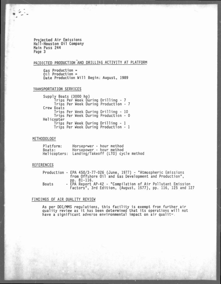
PREDICTED PRODUCTION AND DRILLING ACTIVITY AT PLATFORM
Gas Production -Oil Production -Date Production Will Begin: August, 1989
TRANSPORTATION SERVICES
Supply Boats (3000 hp) Trips Per Week During Drilling - 7 Trips Per Week During Production - 7
Crew Boats Trips Per Week During Drilling - 10 Trips Per Week During Production - 0
Helicopter Trips Per Week During Drilling - 1 Trips Per Week During Production - 1
METHODOLOGY
Platform: Horsepower - hour method Boats: Horsepower - hour method Helicopters: Landing/Takeoff (LTO) cycle method
REFERENCES
Production - EPA 450/3-77-026 (June, 1977) - "Atmospheric Emissions from Offshore Oil and Gas Development and Production", pp. 81-116.
Boats - tPA Report AP-42 - "Compilation of Air Pollutant Emission Factors", 3rd Edition, (August, 1S77), pp. 116, 125 and 127
FINDINGS OF AIR QUALITY REVIEW
As per DOI/MMS regulations, this facility is exempt from further air guality review as it has been determined that its operations will not have a significant adverse environmental impact on air qualit".
