occhhoo orriioss mmaarriinnee ppaarrkk...
TRANSCRIPT

1
DDRRAAFFTT
OOCCHHOO RRIIOOSS MMAARRIINNEE PPAARRKK
PPRROOTTEECCTTEEDD AARREEAA ZZOONNIINNGG PPLLAANN
22001155--22002200
Prepared by
National Environment and Planning Agency
January 2015

1
© Published by the National Environment and Planning Agency (NEPA)
10 Caledonia Avenue
Kingston 5
Jamaica W.I.
Telephone: 1-876-7547540
Fax: 1-876-7547596
E-mail: [email protected]
Website: www.nepa.gov.jm
Compiled by the staff of the Protected Areas Branch with input from Ecosystems Management Branch of NEPA.
This publication may be reproduced in whole or part for education or non-profit purposes without the special permission
from the copyright holder. Acknowledgement of the source must be made and NEPA would appreciate receiving a copy of
any such publication.
© 2015 by NEPA

i
Table of Contents List of Tables ........................................................................................................................... iii
List of Plates ............................................................................................................................. iv
List of Figures ............................................................................................................................ v
List of Boxes ............................................................................................................................. vi
Acknowledgements .................................................................................................................. vii
List of Acronyms ................................................................................................................... viii
Executive Summary .................................................................................................................. ix
Introduction ............................................................................................................................... ix
The Purpose of Zoning Marine Protected Areas ................................................................... ix
Legislative Basis for Zoning the ORMPPA ........................................................................... x
Objectives of the ORMPPA Zoning Plan .............................................................................. x
Methodology for Developing Zoning Plan ................................................................................ x
The 2015-2020 Zoning Regime for ORMPPA ......................................................................... xi
1. Conservation Zone ........................................................................................................ xii
2. No Wake Zone ............................................................................................................ xiii
3. Dive and Snorkel Sites ................................................................................................. xiv
4. Multiple-use Zone ......................................................................................................... xv
1.0 Introduction ..................................................................................................................... 1
2.0 The Purpose of Zoning Marine Protected Areas............................................................. 3
2.1 Legislation for Zoning ...................................................................................................... 3
2.2 Objectives of the ORMPPA Zoning Plan ........................................................................ 3
3.0 Methodology for Developing Zoning Plan ..................................................................... 4
3.1 Primary Methods and Resources ...................................................................................... 4
3.2 Literature Review ............................................................................................................. 5
3.3 Consultations .................................................................................................................... 8
4.0 Overview of ORMPPA ................................................................................................... 8
4.1 Geography ................................................................................................................... 8
4.1.1 Boundary Description ................................................................................................ 9
4.2 Marine Resources ............................................................................................................. 9
4.2.1 Coral Reef .................................................................................................................. 9
4.2.2 Fish Population ........................................................................................................ 10
4.2.3 Benthic Cover .......................................................................................................... 11

ii
4.3 Characteristics of User Groups ...................................................................................... 12
4.3.1 Fisher Folks ............................................................................................................. 13
4.3.2 Water sports Operators ............................................................................................ 13
5.0 The 2015-2020 Zoning Regime for ORMPPA ............................................................. 13
5.1 Conservation Zone ......................................................................................................... 15
5.1.1 Objective of Conservation Zones: ........................................................................... 15
5.1.2 Boundary Description for Conservation Zone A ..................................................... 16
5.1.3 Boundary Description for Conservation Zone B ..................................................... 17
5.1.4 Boundary Description for Conservation Zone C ..................................................... 18
5.1.5 Justification for Conservation Zones ....................................................................... 19
5.1.6 Activities Guide ....................................................................................................... 20
5.2 No Wake Zone ............................................................................................................... 21
5.2.1 Objective of No Wake Zone .................................................................................... 22
5.2.2 Boundary Description .............................................................................................. 22
5.2.3 Justification for No Wake Zone B ........................................................................... 23
5.2.4 Activities Guide ....................................................................................................... 23
5.3 Dive and Snorkel Sites ................................................................................................... 24
5.3.1 Objective:................................................................................................................. 24
5.3.2 Justification for Dive and Snorkel Sites .................................................................. 25
5.3.3 Activities Guide ....................................................................................................... 25
5.4 Multiple-use Zone .......................................................................................................... 26
5.4.1 Objective:................................................................................................................. 26
5.4.2 Boundary Description .............................................................................................. 27
5.4.3 Justification for Multiple-use Zone ......................................................................... 27
5.4.4 Activities Guide ....................................................................................................... 27
Bibliography ............................................................................................................................ 28
APPENDIX 1 Legislation for Ocho Rios Marine Park Protected Area .................................. 30
APPENDIX 2 Commercial and Shipping Channel ................................................................. 33
APPENDIX 3 Jet Ski Launch Site ........................................................................................... 34
APPENDIX 4 Dive and Snorkel Sites ..................................................................................... 35

iii
List of Tables
Table 1: Proposed Zones for ORMPPA by Friends of the Sea.................................................. 5
Table 2: Coastal and Benthic Resources in ORMPPA .............................................................. 9

iv
List of Plates
Plate 1: Jet Ski Launch Site in Ocho Rios Bay ........................................................................ 15

v
List of Figures
Figure ES-1: Draft Zoning Plan for the ORMPPA (2015-2020)……………………………..xi
Figure 1: Ocho Rios Protected Area ......................................................................................... 1
Figure 2: Ocho Rios Marine Park Protected Area ..................................................................... 2
Figure 3: Zones for ORMPPA Proposed by Friends of the Sea ................................................ 7
Figure 4: Graph Showing Association between Coral Reef Rugosity and Species Richness..10
Figure 5: Graph Showing Size of Fish Species within ORMPPA .......................................... 11
Figure 6: Graph Showing Fish Biomass and Density in ORMPPA ........................................ 11
Figure 7: Draft Zoning Plan for ORMPPA (2015 – 2020) ...................................................... 14
Figure 8: Boundary for Conservation Zone A ........................................................................ 16
Figure 9: Boundary for Conservation Zone B ......................................................................... 17
Figure 10: Boundary for Consercation Zone C........................................................................ 19
Figure 11: Boundary for No Wake Zone ................................................................................ 23
Figure 12: Dive and Snorkel Sites within the ORMPPA ......................................................... 25
Figure 13: Map Showing Multiple-use Zone in ORMPPA ..................................................... 27
Figure 14: Boundary for Port and Shipping Chanel ............................................................... 33
Figure 15: Image Showing Designated Jet Ski Launch Site .................................................... 34
Figure 16: Dive Sites in the Western Section of ORMPPA .................................................... 35
Figure 17: Dive Sites in Conservation Zone A ....................................................................... 35
Figure 18: Dive Sites Surveyed in Conservation Zone A by NEPA ....................................... 36
vi
List of Boxes
Box ES-1: User Activities for the Conservation Zones…………............................……… xii
Box ES-2: User Activities for the No Wake Zone…...........................…………….……… xiii
Box ES-3: User Activities for the Dive and Snorkel Sites………………………………… xiv
Box ES-4: User Activities for the Multiple-use Zone …...............……………………….. xv
Box 1: User Activities for the Conservation Zones…………............................……… 21
Box 2: User Activities for the No Wake Zone…...........................…………….……. 24
Box 3: User Activities for the Dive and Snorkel Sites…………………………………… 26
Box 4: User Activities for the Multiple-use Zone …...............………………………….. 28

vii
Acknowledgements
The Natural Resources Conservation Authority (NRCA) and the National Environment and
Planning Agency (NEPA) would like to recognize and thank the many people, communities
and organizations whose assistance has made the completion of the Zoning Plan for the Ocho
Rios Marine Park Protected Area a reality.
The Community
Fishing interests and representatives from the following areas:
Mammee Bay
Sailor Hole
Ocho Rios
White River
Watersports Operators within Ocho Rios and its environs
Members of the Jamaica Hotel and Tourist Association
Government of Jamaica
Fisheries Division
Jamaica Constabulary Force, Marine Division
Port Authority of Jamaica
St. Ann Parish Council
Tourism Product Development Company Limited
Urban Development Corporation

viii
List of Acronyms
BCA Beach Control Act
EMB Ecosystems Management Branch
MPA Marine Protected Area
NEPA National Environment and Planning Agency
NGO Non-government Organization
ORMPPA Ocho Rios Marine Park Protected Area

ix
Executive Summary
Introduction The Ocho Rios Marine Park Protected Area (ORMPPA) includes the area of approximately
2km2 which was declared a protected area in 1966 under the Beach Control Act and
designated a protected area under section 5(b)(1) of the Natural Resources Conservation
Authority (NRCA) Act (16 August 1999). The ORMPPA covers approximately 133km2
(13,385ha), and 13.5km of coastline between Mammee Bay in St. Ann and Frankfurt Point in
St. Mary.
The marine resources within the ORMPPA support a range of commercial and recreational
activities and competing resource users. Although ORMPPA was designated a protected area
on 16 August 1999 under section 5(b) (1), a zoning plan (whilst developed) was never
promulgated. This zoning plan will therefore seek to address the existing and potential user
conflicts, as well as, facilitate the protection of sensitive habitats and species to support the
management strategy for the ORMPPA.
The zoning plan was developed based on the results of scientific research has undergone a
series of consultations and targeted activities with both governmental and non-governmental
stakeholders as well as individual members of the user community. The zoning plan provides
the framework for the management of uses within the ORMPPA over a five-year period
(2015-2020), after which it will be revised based on recommendations arising from research,
monitoring and evaluation activities.
The Purpose of Zoning Marine Protected Areas
Zoning is a system in which specific geographic areas within a protected area are classified
according to its preservation requirements, and its ability to sustain certain human activities,
by providing guidance as to what can and cannot occur within sections of the protected area
with respect to its natural resources management, cultural resource management, human use
and benefit, visitor use and experience, access, facilities and protected area development,
maintenance and operations (NEPA, 2010).
Marine Protected Areas (MPAs) are “common property”, as the resources belong to the state.
However, if these activities are not managed sustainably this “free access” of users can
exceed the carrying capacity of the resources in the area. Zoning is one method used by
managers to protect the natural resources within a MPA, as well as, reduce the user conflicts
to ensure that the various users groups are able to benefit from the resources in a sustainable
way.

x
Legislative Basis for Zoning the ORMPPA
Section 4(2) c of the NRCA Act, 1991 is the main piece of legislation which provides the
basis for the zoning of the ORMPPA by the NRCA. It makes reference to the provision for
the zoning of a protected area for specified purposes and for the licensing of persons carrying
on any trade or business therein.
Objectives of the ORMPPA Zoning Plan
The objectives for zoning for MPAs are dependent on the characteristics and uses of the area.
Within the ORMPPA the two main objectives of zoning are to 1) ensure the sustainable use
of its natural resources, and 2) reduce the user conflicts while allowing all users to enjoy the
benefits of the area while complying with the applicable environmental laws and regulations.
These objectives will be achieved by incorporating the following activities outlined in the
EMB 2011 report, “Ocho Rios Marine Park: Draft Zoning Recommendations”
1. Regulate fishing, recreational and tourism related activities to ensure adequate space
for users, safety of users, and the sustainable use of the resources.
2. Preserve important spawning and nursery areas for fish and establish no fishing zones.
3. Protect critical ecological habitats and restrict human use/access as necessary.
4. Provide a refuge for threatened species such as sea turtles.
5. Maintain industrial transportation/shipping corridors.
6. Regulate multiple uses within the ORMPPA.
Methodology for Developing Zoning Plan
The following are the methods used in determining the zones presented in this plan.
Primary Methods and Resources
Resource Assessments
o Marine Assessments
Fisheries
Water column
Coral reefs
Seagrasses
o GIS and Remote sensing
Stakeholder consultations and User Assessments
Secondary Methods and Resources
A literature review was done of existing documents and legislations pertaining to the area
within the ORMPPA, and included:

xi
The Town and Country Planning (Kingston and Saint Andrew) Provisional
Development Order, 2008 (Draft) unpublished.
Draft Overwater Policy
The Draft Ocho Rios Marine Park Management Plan by Friends of the Sea
(undated).
Report on the Socio-economic Assessment of the Ocho Rios Protected Area by
PAB (2013)
Socio-economic Valuation Study of the Ocho Rios Marine Park by Environmental
Management Unit, University of the West Indies (2001).
The 2015-2020 Zoning Regime for ORMPPA
Arising from the ecological assessments, literature review and consultations, the proposed
zones four (4) zones for the ORMPPA are:
1. Conservation Zone
2. No Wake Zone
3. Dive and Snorkel Sites
4. Multiple Use Zone
In addition to the zones to comply with present uses two channels were demarcated which are
1) Port and Commercial Shipping Channel (designated by the Port Authority of Jamaica) and
2) Jet Ski Launch Site designates by the Tourism Product Development Company.
FIGURE ES-1: DRAFT ZONING PLAN FOR ORMPPA (2015- 2020)
(Source: Protected Areas Branch, NEPA 2015)

xii
1. Conservation Zone
Three Conservation Zones were proposed. Conservation Zone A is protected area that was
declared under the Beach Control Act in 1966, Conservation Zone B is on the western side
of the park and Conservation C on the eastern side, adjacent to Conservation Zone A.
Objective:
1. To provide for the protection, preservation and/or restoration of ecologically
significant or sensitive habitats, species.
2. 2. To improve economic opportunities for fishers through the operation of these zones
as managed fisheries to improve the viability of the fishery.
3. 3. To increase the resilience of coastal and marine ecosystems to the effects of climate
change.
4. To provide pristine/undisturbed environments for research and other educational
activities
Box ES-1: User Activities for the Conservation Zone
Allowed
Activities with environmental footprint that will not adversely impact the functionality of the area’s ecosystems and that of adjacent zones.
Swimming/snorkeling
Non-motorized watersports
Motorized vessels/activities (only for management activities and for the purposes of ingress and egress using designated channel)
Ecological restoration/conservation activities.
Research/educational activities.
All activities associated with the NRCA’s management of the area.
Not Allowed Activities with environmental footprint that will adversely impact the functionality of the area’s ecosystems
and that of adjacent zones.
Anchoring and mooring.
Motorized vessels/activities.
Fishing/bait collection.
Feeding of fish. Anchoring.
Removal or disturbance of physical or biological features/specimens or habitats e.g. dune, sand, rock, reef, artifacts, flora and fauna.
Coastal modifications, construction or maintenance of any encroachment which falls under the beach licensing regime.
Any activity which contravenes local environmental laws and/or may have a deleterious effect on human safety or the environment.

xiii
Allowed
Activities with an environmental footprint that will not adversely impact the functionality of the area’s ecosystems and that of adjacent zones.
Motorized vessels/activities (for ingress and egress only, at a speed not exceeding 6 knots).
Ecological restoration/conservation activities.
Research/educational activities.
All activities associated with the NRCA’s management of the area. Not Allowed Swimming/snorkeling.
Non-motorized vessels/activities (with the exception of sail boats/catamarans specifically involved in the transportation of passengers from the Dunn’s River dock to other sites).
Speeds over 6 knots.
Jet skis.
Anchoring and mooring
Fishing/bait collection.
Feeding of fish. Anchoring.
Removal or disturbance of physical or biological features/specimens or habitats e.g. dune, sand, rock, reef, artifacts, flora and fauna.
Coastal modifications, construction or maintenance of any encroachment which falls under beach licensing regime.
Activities with environmental footprint that will adversely impact the functionality of the area’s ecosystems and that of adjacent zones.
Any activity which contravenes local environmental laws and/or may have a deleterious effect on human safety or the environment.
2. No Wake Zone
The No Wake Zone is found between Rico Chico and Dunn’s River Falls. This zone was
created to accommodate the current boating activities within the area. It is 20m away from
the current swim zone delineated by the operators of Dunn’s River, and it is 50m in width,
just wide enough for motorized vessels to traverse the area while picking up and dropping off
visitors to Dunn’s River Falls.
Objective:
To reduce wave action within the Conservation Zone B as the zone is only 20m from the
swim zone, as well as to ensure safety of other users operating non-motorized vessels in the
Conservation Zone.
Box ES-2: User Activities for the No Wake Zone

xiv
Allowed
Non-motorized watersports (however not within 50m of a dive flag)
Motorized vessels (however not at those sites located within the Conservation Zones and not within 50m of a dive flag)
Diving & Snorkeling
Swimming
Activities with environmental footprint that will not adversely impact the functionality of the area’s ecosystems and that of adjacent zones.
Ecological restoration/conservation activities.
Research/educational activities.
All activities associated with the NRCA’s management of the area.
Not Allowed Motorized boats (within 50 m of a dive flag and at Dive sites located within the Conservation Zones)
Swimming/Snorkeling
Non-motorized vessels (within 50m of a dive flag)
Jet Skis
Anchoring and Mooring
Feeding of fish
Fishing/bait collection Removal or disturbance of physical or biological features/specimens or habitats, e.g. dune, sand, rock,
reef, artifacts, flora, fauna.
Coastal modifications, construction or maintenance of any encroachment which falls under beach licensing regime
Activities with environmental footprint that will adversely impact the functionality of the area’s ecosystems and that of adjacent zones.
Any activity which contravenes local environmental laws and/or may have a deleterious effect on human safety or the environment.
3. Dive and Snorkel Sites
These sites are found within the Conservation Zones or on the perimeter of the zones. They
will be marked by a buoy and no motorized vessel should be within 30m of the site if a dive
flag is visible.
Objective:
To separate motorized activities from non-motorized activities such as snorkeling and
SCUBA diving, as well as, to ensure the safety of these users of the ORMPPA. Also, to give
these users the opportunity to enjoy views the marine environment in a fairly undisturbed
state.
Box ES-3: User Activities for the Dive and Snorkel Sites

xv
4. Multiple-use Zone
The Multiple-use Zone will allow for a range of uses such as fishing as well as recreational
boating and all activities with an environmental footprint that will not adversely impact
archaeological/heritage resources and the functionality of the area’s ecosystems and that of
adjacent zones.
Objective:
To allow motorized activities and other activities such as fishing and the operation of jet skis
which are not allowed in the Conservation Zones within the ORMPPA.
Box ES-4: User Activities for the Multiple-use Zone
Allowed
Fishing (except within the Ship Channel) Motorized and Non-Motorized vessels and activities
Activities with environmental footprint that will not adversely impact the functionality of the area’s ecosystems and that of adjacent zones.
Ecological restoration/conservation activities.
Installation of facilities/structures associated with the management of the area and permitted activities (e.g. anchor pins, mooring buoys, marker buoys, appropriate temporary sanitary and solid waste disposal facilities).
Research/educational activities.
Mooring
Anchoring (except at reef sites) All activities associated with the NRCA’s management of the area.
Not Allowed
Jet skis (within Ship Channel and other restricted areas in the Ocho Rios Bay area).
Fishing within the Ship Channel
Activities with environmental footprint that will adversely the functionality of the area’s ecosystems and that of adjacent zones.
Removal or disturbance of physical or biological features/specimens or habitats, e.g. dune, sand, reef, rock, artifacts, flora, fauna.
Anchoring on reefs. Coastal modifications, construction or maintenance of any encroachment which falls under beach licensing regime
Any activity which contravenes local environmental laws and/or is deemed to be a potential threat to human safety or which may have a deleterious effect on the environment e.g. open burning, dumping.

1
1.0 Introduction
The Ocho Rios Marine Park Protected Area (ORMPPA) was designated a protected area
under section 5(b) (1) of the Natural Resources Conservation Authority (NRCA) Act on 16
August 1999. The ORMPPA includes the area of approximately 2km2 which was declared a
protected area in 1966 under the Beach Control Act (Figure 1). ORMPPA covers
approximately 133km2
(13,385ha), and 13.5km of coastline between Mammee Bay in St. Ann
and Frankfurt Point in St. Mary (Figure 2).
FIGURE 1: OCHO RIOS PROTECTED AREA (SOURCE PROTECTED AREAS BRANCH, 2014)
The coastline of the ORMPPA is characterized by natural and man-made beaches, limestone
cliffs, and numerous costal developments such as the commercial town of Ocho Rios, hotels
and villas. Other coastal developments include a cruise ship pier, and the Reynolds Bauxite
Pier from which sugar and limestone is exported. The coast rises into limestone hills
inhabited by small communities and farm lands, and is the source of the rivers which flow
into the ORMPPA including Dunn’s River, Turtle River, White River and Roaring River.
The ORMPPA is characterized by fringing reefs, reef flats, and sea grass beds interspersed
with mudflats. The marine resources within the ORMPPA support commercial activities such
as fishing, shipping, and recreational activities such as water sports, SCUBA diving, and
swimming. The key stakeholders within ORMPPA are fishers, watersports operators and
hotel/villa owners who cater mainly to the visitors/tourists offering a variety of services
which may cause user conflicts. Therefore, the zoning plan will address the existing and

2
potential user conflicts, as well as, protect sensitive habitats and species to support the
management strategy for the ORMPPA.
FIGURE 2: OCHO RIOS MARINE PARK PROTECTED AREA (SOURCE PROTECTED AREAS BRANCH, 2013)
The zoning plan for the ORMPPA is being developed to protect sensitive and threatened
resources, species and habitats, as well as the fishery stock. Although ORMPPA was
designated a protected area on 16 August 1999 under section 5(b)(1), a zoning plan was never
implemented, although a draft copy was developed by the non-government organization
(NGO), Friends of the Sea and included in their Draft Ocho Rios Marine Park Management
Plan submitted in undated. Also, NEPA’s Ecosystems Management Branch (EMB) in 2011
made recommendations for the zoning of ORMPPA based on empirical data collected on the
park’s marine resources.
This zoning plan has been developed based on the recommendations of these proposals, as
well as, those made through consultations with the main current user groups, that is, the
hotel/villa owners, fishers and water sports operators. The zoning plan provides the
framework for the management of uses within the ORMPPA over a five-year period (2015-
2020), after which it will be revised based on recommendations arising from research,
monitoring and evaluation activities. The effective implementation of the zoning plan will
require the requisite legislation, an effective enforcement framework, the engagement of

3
stakeholders, and a sound public education strategy to encourage compliance among the
respective resource user groups.
2.0 The Purpose of Zoning Marine Protected Areas
Marine Protected Areas (MPAs) are “common property”, as the resources belong to the state.
However, if these activities are not managed sustainably this “free access” of users can
exceed the carrying capacity of the resources in the area. Zoning is one method used by
managers to protect the natural resources within a MPA, as well as, reduce the user conflicts
to ensure that the various users groups are able to benefit from the resources in a sustainable
way.
Zoning is a system in which specific geographic areas within a protected area are classified
according to its preservation requirements, and its ability to sustain certain human activities,
by providing guidance as to what can and cannot occur within sections of the protected area
with respect to its natural resources management, cultural resource management, human use
and benefit, visitor use and experience, access, facilities and protected area development,
maintenance and operations (NEPA, 2010). The zoning plan needs to be revised periodically,
that is, every 5-years. Also, the zoning plan has to be revised as the marine environment is
dynamic. The socio-economics of areas change over time and so will the demand on the
resources and the user conflicts. Additionally research, monitoring and evaluation may
provide new information for alternative measures to effectively manage the area.
2.1 Legislation for Zoning
Section 4(2) c of the NRCA Act, 1991 is the main piece of legislation which provides the
basis for the zoning of the ORMPPA by the NRCA. It makes reference to the provision for
the zoning of a protected area for specified purposes and for the licensing of persons carrying
on any trade or business therein.
2.2 Objectives of the ORMPPA Zoning Plan
The objectives for zoning for MPAs are dependent on the characteristics and uses of the area.
Within the ORMPPA the two main objectives of zoning are to 1) ensure the sustainable use
of its natural resources, and 2) reduce the user conflicts while allowing all users to enjoy the
benefits of the area while complying with the applicable environmental laws and regulations.
These objectives will be achieved by incorporating the following activities outlined in the
EMB 2011 report, “Ocho Rios Marine Park: Draft Zoning Recommendations”
7. Regulate fishing, recreational and tourism related activities to ensure adequate space
for users, safety of users, and the sustainable use of the resources.

4
8. Preserve important spawning and nursery areas for fish and establish no fishing zones.
9. Protect critical ecological habitats and restrict human use/access as necessary.
10. Provide a refuge for threatened species such as sea turtles.
11. Maintain industrial transportation/shipping corridors.
12. Regulate multiple uses within the ORMPPA.
3.0 Methodology for Developing Zoning Plan
Information for development of the ORMPPA zoning plan was compiled from a literature
review, baseline research/assessments and consultations with key stakeholders within
ORMPPA. The following are the methods used in determining the zones presented in this
plan.
3.1 Primary Methods and Resources
In order to guide the development of the zoning plan, baseline research was conducted
between 21 June and 24 June 2011 by the EMB and the findings presented in a report. The
data collected included, but was not limited to, an assessment of fisheries and benthic marine
environments such as seagrass beds and coral reefs. The assessments provided a broad basis
for determining the dynamic factors which should be considered in developing the
recommendations for this proposed zoning plan, as well as, identified the gaps and areas for
further research and management.
The recommendations proposed in the 2011 EMB report are:
1. Reduce the administrative region of the ORMPPA by reducing the northern boundary to
approximately 1 km north of any existing reef system. This will reduce the size of the
protected area from 13.3ha and likely reduce the corresponding water depth from 1000m
to 100m.
2. Designating a network of small and no-take areas that are no greater than 1km2 where
fish will be allowed to grow and take refuge. These no take zones should base on the
locations known areas with a high fish biomass and density such as was reported at
Carib Trenches, Jewels and Ocho Rios Reef.
3. With the use of expert opinion which includes consultations with local stakeholders the
proposed zones within the ORMPPA should be simplified into less ambiguous zones that
are easy to manage and police. The consultation process should consider clear boundary
designations for the following areas:
Fishing
Fish Sanctuaries
Swimming
Anchoring of conveyances or vessels and mooring

5
Port and Commercial Shipping
Use of motorized craft
Use of non-motorized craft
Use of personalized watercrafts (Jet Skis)
Environmental Restoration/Preservation or no use zones
4. Create a steering committee to guide the development and finalization of the ORMPPA
zoning plan. The terms of reference of this committee would include but not be limited
to:
a. The preparation of government briefing on the progress of the zoning plan for the
endorsement by the Cabinet;
b. Identifying data gaps;
c. Formulating policy directives for the management of the ORMPPA and
d. Conducting community outreach and education on the zoning plan.
3.2 Literature Review
A literature review was done of existing documents and legislation pertaining to the
ORMPPA, and included:
The Town and Country Planning (Kingston and Saint Andrew) Provisional
Development Order, 2008 (Draft) unpublished;
Draft Overwater Policy;
The Draft Ocho Rios Marine Park Management Plan by Friends of the Sea
(undated);
Report on the Socio-economic Assessment of the Ocho Rios Protected Area by
PAB (2013); and
Socio-economic Valuation Study of the Ocho Rios Marine Park by Environmental
Management Unit, University of the West Indies (2001).
The draft zoning plan developed by Friends of the Sea and published in the The Draft Ocho
Rios Marine Park Management Plan proposed eight (8) zones (Table 1, Figure 3).
TABLE 1: PROPOSED ZONES FOR ORMPPA BY FRIENDS OF THE SEA
Diving, Snorkeling, Restoration, and
Research
Only diving, snorkeling, and research are
permitted within this zone.
Multiple Recreational Use/No Fishing
Motorized and non-motorized recreational
activities may take place within this zone. No
fishing is permitted within this zone.
Multiple Recreational Use/No Jet Skis
Zone
Motorized and non-motorized recreational
activities may take place within this zone. No

6
jet skiing is permitted within this zone.
Research Only
This is a no take zone, where only permitted
research may take place.
No Wake Zone
Watercrafts within this area are not permitted
to create a wake.
Shipping Channel Zone
This zone allows access for vessels to the
piers located within the Ocho Rios Bay.
Transportation Channel Zone
No stopping is permitted within this zone.
Limited Recreational Use and Research
Zone
Limited recreational use includes non-
motorized activities. No fishing is permitted
in this zone.

7
FIGURE 3: ZONES FOR ORMPPA PROPOSED BY FRIENDS OF THE SEA
B
Frankfort Point
A
reef
C
D
E
F
G H
I
Western boundary
Map of Proposed Ocho Rios Marine Park Zones
A A shipping channel is already established,
conveying vessels into the Ocho Rios Bay.
B A no wake zone and a fuelling depot will be
situated within the Ocho Rios Bay.
C A transportation channel will extend west
from the shipping channel to mid-way be-
tween Dunn’s River and Roaring River. No
stopping is permitted within the transporta-
tion channel. Dolphin Cove, which is a desig-
nated research area, is situated within the
transportation channel.
G East of F, a research only zone extends to
Sombra Apartments.
H East of G, a multiple recreation use/no
fishing zone extends to the Grand Lido Sans
Souci Beach.
I East of H to the eastern ORMP boundary a
diving, snorkelling, restoration, and
research zone is located.
D West of the transportation channel, extend-
ing to the centre of Mammee Bay Beach, a
limited recreational use and research area is
located within the fore reef.
E From the centre of Mammee Bay Beach to
the western boundary of the ORMP a no go,
research zone is located.
F East of the Shipping Channel, extending to
Mahogany Beach, a multiple use zone with
no jet skis is located within the fore reef.

8
3.3 Consultations
Consultations with stakeholder groups are integral to developing a zoning plan as for the plan
to be effective it will need the support for all the stakeholders, and so it important that they be
involved in the planning process. The objective of the consultations as outline in the 2011
report by EMB, “Ocho Rios Marine Park: Draft Zoning Recommendations” are as follows:
1. A collective vision for the management of the park.
2. Conservation targets.
3. The socio-economic implications of the proposed zoning plan.
4. The management objectives for each proposed zones and identify the challenges
associated with each objectives and recommend strategies to overcome these
challenges.
5. Existing legislative gaps and recommending solutions.
6. Defining enforcement roles and responsibilities and creating a synergy between
enforcers to achieve the enforcement objectives of the park.
Consultations were held with key stakeholders in the ORMPPA which are hotel/villa owners,
fishers and watersports operators. The Port Authority of Jamaica was also consulted because
of their responsibility for the transport and shipping channel within the Ocho Rios Bay. Three
consultations were held in July 2014, one with each key stakeholder group, then a stakeholder
meeting was convened on 3 October 2014 where a the group developed a draft zoning plan,
and on 11 November 2014 representatives from each stakeholder group participated in a
reconnaissance activity to further define the boundaries for the different zones.
4.0 Overview of ORMPPA
4.1 Geography
The ORMPPA is bordered by the Caribbean Sea to the north, and extends seawards to the
1000m depth contour, an average distance of 9.68km, and the southern boundary extends to
the high water mark of the coastline for approximately 13.5km between Mammee Bay in St.
Ann and Frankfurt Point in St. Mary. The coastline is characterized by natural and man-made
beaches, limestone cliffs, and numerous costal developments such as the commercial town of
Ocho Rios hotels and villas and a pier for cruise ship passengers and exportation of sugar and
limestone. The coast rises into limestone hills which are the source of the rivers which flow
into the ORMPPA including Dunn’s River, Turtle River, White River and Roaring River.
The ORMPPA is characterized by fringing reefs, reef flats, and sea grass beds interspersed
with mudflats. The fringing reefs can easily been seen from shore, and south of the reef flat
crest is a shallow protected lagoon with significant sea grass beds. North of the reef crest, is a
narrow band coral reef where the sea floor slopes into deeper water and extends to the

9
Cayman Trench. The marine resources support a multiple of activities including a mixture of
recreational and commercial activities such as fishing, shipping, and activities such as
snorkeling, boating, diving, and swimming. The park is heavily used to support the main
economic activities within Ocho Rios which is “sun, sand and sea” tourism.
4.1.1 Boundary Description
Commencing at a point “A” along the high water mark of the North Coast in the parish of St.
Ann, where the northern shoreline boundaries of the properties of Drax Hall and Mammee
Bay meet and which have approximate coordinates of 180 26’ 15” N and 77
0 10’ 19” W;
thence in a meandering line generally south-east and north-west along the high water mark of
the coastline for approximately 13.5 km to a point “B” along the high water mark at
Frankfort Point, having approximate geographical coordinates of 180 25’ 18” N and 77
0 02’
51”W; thence north to a point “C” in the sea that intersects with the 1000 m depth contour
line; thence generally west and south-west along the 1000 m depth contour line to a point “D”
where it intersects with the line running north from the point of the beginning; thence to the
point of beginning “A”. 1
(Figure 2)
4.2 Marine Resources
An assessment completed by NEPA’s EMB in 2011 using remote sensing and rapid
ecological assessment which revealed that the marine resources within the ORMPPA
comprise mainly coral reefs and the shore is mostly sandy (Table 2).
TABLE 2: COASTAL AND BENTHIC RESOURCES IN ORMPPA
Coastal Habitat Area / Length (ha)
Seagrass Beds 271.61
Reef 897.96
Mangrove 0
Rocky Shore 2593.17
Sandy Shore 6432.89
4.2.1 Coral Reef
Reef assessments were conducted at six (6) sites, Dunn’s River, Carib Trenches, Jewel,
Jamaica Inn and Couples, San Souci by EMB in 2011. The data collected were collated with
data from previous assessments conducted in 2009 and 2010 and used to analyze the reef
structure of ORMPPA. The previously surveyed sites included Grande Reef, and Double
Reef which were assessed in 2010 and Carib Trenches, Dickies Reef, Ocho Rios Reef,
Maffessante Reef and Sandals Reef which were assessed in 2009. The sites surveyed were
exposed to varying levels of environmental and anthropogenic impacts and human
disturbance such as exposure to sediment and nutrient loading and high density tourism
1 Natural Resources Conservation (Ocho Rios Marine Park Protected Area) Order 1999

10
activities. All assessments were conducted at depths ranging from 3.05m (10ft) to 11.7m
(38.4ft), and the data analyzed to detect trends in overall reef ecosystem health and
biodiversity within the ORMPPA (NEPA, 2011).
The higher the reef rugosity then more habitats is provided to shelter reef fish and other
organisms. At the sites assessed the reefs were relatively low to medium relief. San Souci
recorded the lowest index of 0.10 affording little shelter for foraging while all other sites
assessed recorded values indicative of medium relief or reef complexity. However, no distinct
relationship between species richness and rugosity at the sites were observed (Figure 4).
Rugosity vs Species Diversity
0
5
10
15
20
25
30
35
40
45
50
0.00
0.05
0.10
0.15
0.20
0.25
0.30
0.35
0.40
Species Richness Rugosity Index
Species Richness 42 39 41 44 42 36 22 25
Rugosity Index 0.21 0.31 0.27 0.33 0.10 0.26 0.34 0.23
DUNN'S
RIVER
CARIB
TRENCHESJEWELS
JAMAICA
INNSAN SOUCI
CARIB
TRENCHES
DOUBLE
REEF
GRANDE
REEF
FIGURE 4: GRAPH SHOWING ASSOCIATION BETWEEN CORAL REEF RUGOSITY AND SPECIES RICHNESS
4.2.2 Fish Population
The analysis of commercial fish density, size and biomass indicates the status of the fish
stocks and by extension fishing pressure in the area. The diversity of fish species on the reef
indicates the community dynamics on the reef. The relative abundance of one trophic group
to another will dictate species interactions; and the types of predators on the reef are
determined by the relative availability of prey food items. Similarly, the amount of fleshy
algae on a reef is determined to a significant extent on the abundance of herbivorous fish on
the reef (NEPA, 2011)
The size of the commercially important fish species grunt, snapper, parrotfish, grouper and
surgeonfish in ORMPPA were assessed by EMB in 2011. Results showed that the average
size of the fish assessed was below the expected adult size range, and most of the fish
measured were 6 – 10 cm, but a significant number of individuals also fell in the 11 – 20 cm
size range, but none measured greater than 21 cm. Commercially important species such as
the parrotfish, grunts and groupers had a high number of individuals in the 11-20 cm size
class. This indicates that most of the fish within the ORMPPA are juveniles to sub-adults
(Figure 5). Overall, there was also a low density of commercially important species.

11
0-5
6-10
11-20
21-30
31-40
>40
Angelfish
Butterflyfish
Grunt
Parrotfish
Grouper
Snapper
Surgeonfish
Leatherjacket
Other
0
50
100
150
200
250
No. of
Individuals
Size (cm)
Trophic groups
Distribution and frequency of the main fish groups
FIGURE 5: GRAPH SHOWING SIZE OF FISH SPECIES WITHIN ORMPPA
The fish biomass, which is length to weight ratio, was also assessed for commercially
important species (Figure 6). The parrotfish had the highest density (8.15 parrotfish/100m2),
but this is still low compared to other Caribbean reefs. The Snappers and Grunts recorded the
lowest densities of 0.18 snapper/100m2 and 1.09 grunts/100m
2 (NEPA, 2011).
FIGURE 6: GRAPH SHOWING FISH BIOMASS AND DENSITY IN ORMPPA
FIGURE 6: GRAPH SHOWING FISH BIOMASS AND DENSITY IN ORMPPA
4.2.3 Benthic Cover
The benthic cover of the reef includes corals, sponges, algae and other sessile invertebrates,
and gives a good indication of the dynamics of competition on the reef. Benthic cover
provides a good indicator of the process of reef competition among reef organism. The
competition between live coral cover and fleshy algal cover is of concern too because the loss
12
of live coral cover will result in a shift from coral dominated reefs to algal dominated reefs.
The loss of live coral cover will ultimately lead to a loss of the coral reef. Coral cover is an
excellent indicator of reef health and is normally a proxy for net coral growth.
According to the EMB 2011 report, the percentage live coral cover ranged from a low of
5.77% at Jamaica Inn to a high of 18.11% at Dunn’s River. However, in 2010 live coral cover
data from the sites assessed (Carib Trenches, Double Reef and Grande Reef) ranged between
2.8 % and 11.26%, and in 2009 the range was from a low of 3.21% at Maffessante Reef to a
high of 11.70 % at Ocho Rios Reef. Analysis of the data collected in 2011 showed that
macroalgae was dominant benthic cover within the ORMPPA. However, at Dunn’s River,
Jewels and Ocho Rios Reef this was the opposite where live coral cover ranged from 11.70%
- 18.11%, and macrolagae cover was the least abundant, thus illustrating the inverse
relationship between macroalgae and coral cover. This supported the higher fish species
richness found at these sites compared to the other sites within the ORMPPA. Analysis of the
data indicated that the reefs within the ORMPPA are dominated by macroalgae which
displays a mean percentage cover of 55% of the substrate, that is, a range of 33.77% to
68.83%, in contrast to live coral cover with ranges between 3.21% and 18.11%, an overall
average of 8% live coral. The dominant coral species type recorded is Porites astreoides and
in lower numbers species such as Acropora palmata, Madracis miribilis, Porites furcata,
Agaricia agaricia, Siderastrea siderea, Montastrea faveolata and Montastrea franksi (NEPA.
2011)
At sites such as Dunn’s River, Jewels and Ocho Rios reef the data represented the highest
live coral cover of all sites assessed ranging from 11.70 – 18.11%. These sites also displayed
the lowest abundance of macroalgae. This demonstrates an inverse relationship between coral
and macroalgae cover which provides an indication of fish abundance. This finding is also
corroborated by the higher fish species richness at these sites when compared to other sites
with higher macroalgae coverage (NEPA, 2011). The sites recommended in the EMB report
as “no take” zones are Carib Trenches, Jewels and Ocho Rios Reef based on the high fish
biomass and density as the maintenance of the ecological characteristics of these areas can
enhance the ecological function of the ORMPPA.
4.3 Characteristics of User Groups
Most of the activities within the ORMPPA are centered on tourism, therefore the main user of
the protected area’s resources include watersports operators and operators of villas and
hotels. The protected area also support fisher folks and includes four fishing beaches which
are Mammee Bay, Sailor Hole, Ocho Rios Bay and White River. In January 2014 members of
NEPA’s Protected Areas Branch (PAB) conducted a socio-economic survey of the users of
the ORMPPA. The survey groups were divided according to profession and were fisher folks,
watersports operators and organizations which included hoteliers, commercial enterprises and
government agencies. The characteristics of the user groups used in this survey are based on
the survey conducted by NEPA in 2014. Representatives from the hotel/villa comprised

13
mainly tertiary institution graduates, and were mostly in the age bracket 26 to 55 years
(NEPA, 2014).
4.3.1 Fisher Folks
The four (4) fishing beaches within ORMPPA are Mammee Bay, Sailor Hole, Ocho Rios and
White River. Most of the 25 fishermen interviewed in NEPA survey conducted in 2014 have
been fishing within the ORMPPA for 21 to 25 years, and most stated fishing is their main
source of income. The dominant fishing method used is both hook and line and pot (72%),
followed by spear fishing (36%), net fishing (32%) and other e.g. trolling (20%). Near shore
fishing and deep-sea fishing are practiced relatively equally (72%) with most fisher folks
fishing in both locations depending on the method chosen. The vessels used are mostly
motorized (92%). Fifty-six percent of the fisher folks interviewed achieved primary
educations, 40% secondary and 4% tertiary.
4.3.2 Water sports Operators
Most of the 13 watersports operators interviewed in the NEPA 2014 survey have been
operating for five (5) years or less, and all had a valid licence from the Jamaica Tourist Board
(JTB). Watersports operators participated in snorkeling (84.64%), sailing and glass bottom
boat rides (54%), kayaking, jet skiing and SCUBA diving (46%), wind surfing (39%),
catamaran cruises (31%), pedal boarding (23%) and fishing (15%). Most watersports
activities were done in the vicinity of Mammee Bay and Sandals. The common locations for
these activities include Ocho Rios Wall, Caribe Trenches, Mammee Bay, Dolphin Reef,
Barracuda Reef, Double Reef, Dunn’s River and Coral Gardens.
5.0 The 2015-2020 Zoning Regime for ORMPPA
Arising from the ecological assessments, literature review and consultations, the proposed
zones four (4) zones for the ORMPPA are:
Conservation Zone
No Wake Zone
Dive and Snorkel Sites
Multiple-use Zone

14
FIGURE 7: DRAFT ZONING PLAN FOR ORMPPA 2015-2020 (SOURCE PROTECTED AREAS BRANCH 2015)
In addition to the zones, in order to comply with present uses two channels were demarcated
which are 1) Port and Commercial Shipping Channel and 2) Jet Ski Launch Site (Plate1). The
shipping channel is designated by the Port Authority of Jamaica and allows for cruise ships,
commercial ships and boats transporting cruise ship passengers access the pier in Ocho Rios
Bay (Appendix 2). No recreational activities and fishing is allowed within this channel for
safety reason.
The Jet Ski Launch Site is delineated within the Ocho Rios Bay by red buoys 200m from
shore which indicates the closest distance the jet skis can get to the shore (Appendix X).
Within the 200m mark the jet ski operators have to use the ingress and egress channels to
launch from shore. This is the only site from which they are currently allowed to launch
within the ORMPPA. After launching they can operate anywhere within the Multiple-use
Zone.

15
PLATE 1: JET SKI LAUNCH SITE IN OCHO RIOS BAY
5.1 Conservation Zone
Three Conservation Zones were proposed. Conservation Zone A is the protected area that
was declared under the Beach Control Act (BCA) in 1966, Conservation Zone B is on the
western side of the protected area and Conservation C is on the eastern side, adjacent to
Conservation Zone A.
5.1.1 Objective of Conservation Zones:
5. To provide for the protection, preservation and/or restoration of ecologically
significant or sensitive habitats and species.
6. To improve economic opportunities for fishers through the operation of these zones
as managed fisheries to improve the viability of the fishery.
7. To increase the resilience of coastal and marine ecosystems to the effects of climate
change.
8. To provide pristine/undisturbed environments for research and other educational
activities

16
5.1.2 Boundary Description for Conservation Zone A
The boundary description of Conservation Zone A (Figure 8) is as follows:
1. The boundary description begins at point A; a land-based mark at coordinates
18°24'43.56"N; 77° 6'29.03"W
2. From point A the boundary runs in a straight line to point B a water-based mark at coordinates
18°24'49.94"N; 77° 6'34.06"W
3. From point B, the boundary continues to point C, a water-based mark , at coordinates
18°24'49.91"N; 77° 6'43.72"W
4. From C, the boundary runs to point D, a water-based mark, at coordinates
18°25'5.91"N; 77° 6'43.83"W
5. From D, the boundary runs straight to E, a land-based point at coordinates
18°25'6.31"N; 77° 4'20.33"W
6. From E, the boundary follows the coastline back to point A.
FIGURE 8: BOUNDARY FOR CONSERVATION ZONE A (SOURCE: PROTECTED AREAS BRANCH, 2015)

17
5.1.3 Boundary Description for Conservation Zone B
The boundary description of Conservation Zone B (Figure 9) is as follows:
1. The boundary description begins at point A, a land-based mark at coordinates
18°26'24.37"N; 77°10'15.27"W
2. From point A the boundary runs in a straight line to point B a water-based mark at coordinates
18°26'26.17"N; 77°10'15.21"W
3. From point B, the boundary continues to point C, a water-based mark , at coordinates
18°25'57.48"N; 77° 9'31.65"W
4. From C, the boundary runs to Point D, a water-based mark, at coordinates
18°25'36.90"N; 77° 8'48.94"W
5. From D, the boundary runs straight to E, a water-based point at coordinates
18°25'16.33"N; 77° 8'13.00"W
6. From E, the boundary runs to point F, a water-based point at coordinates
18°25'8.68"N; 77° 7'48.16"W
7. From F the boundary runs in a straight line to point G a water-based mark at
coordinates
18°25'1.10"N; 77° 7'33.34"W
8. From point G, the boundary continues to point H, a land-based mark at coordinates
18°24'56.22"N; 77° 7'35.95"W
9. From H, the boundary follows the coastline back to point A.
FIGURE 9: BOUNDARY FOR CONSERVATION ZONE B (SOURCE: PROTECTED AREAS BRANCH, 2015)

18
5.1.4 Boundary Description for Conservation Zone C
The boundary description of Conservation Zone C (Figure 10) is as follows:
1. The boundary description begins at point A; a land-based mark at coordinates
18°25'4.48"N; 77° 4'20.86"W.
2. From point A the boundary runs in a straight line to point B a water-based mark at
coordinates
18°25'10.80"N; 77° 4'26.94"W.
3. From point B, the boundary continues to point C, a water-based mark at coordinates
18°25'13.49"N; 77° 4'24.47"W.
4. From C, the boundary runs to point D, a water-based mark, at coordinates
18°25'16.30"N; 77° 4'19.13"W.
5. From D, the boundary runs straight to E, a water-based point at coordinates
18°25'15.16"N; 77° 4'0.65"W.
6. From E, the boundary runs to point F, a water-based point at
coordinates18°25'16.95"N; 77° 3'46.72"W.
7. From F the boundary runs in a straight line to point G a water-based mark at
coordinates 18°25'21.61"N; 77° 3'36.62"W.
8. From point G, the boundary continues to point H, a water-based mark at coordinates
18°25'20.38"N; 77° 3'25.95"W.
9. From H, the boundary runs to point I, a water-based mark, at coordinates
18°25'21.29"N; 77° 3'19.80"W.
10. From I, the boundary runs straight to J, a water-based point at coordinates
18°25'30.71"N; 77° 3'3.57"W.
11. From J, the boundary runs to point K, a water-based point at
coordinates18°25'35.84"N; 77° 2'47.27"W.
12. From point K, the boundary continues to point L, a land-based mark, at coordinates
18°25'27.22"N; 77° 2'47.09"W.
13. From L, the boundary follows the coastline back to point A.

19
FIGURE 10: BOUNDARY FOR CONSERVATION ZONE C (SOURCE: PROTECTED AREAS BRANCH, 2015)
5.1.5 Justification for Conservation Zones
The Conservation Zones are concentrated along the ORMPPA coastline on the coral reefs.
These areas were chosen as the groups from the consultation meetings suggested that there be
no fishing on the reefs, that the conservation areas should encompass the reef ecosystem, and
that a nursery be established between White River and Couples San Souci. They also
recommended that recreational activities be kept closer to hotels and the shoreline, and
activities such as snorkeling can be near the reef where marine fauna are in abundance.
Therefore, these areas will restrict fishing activities, but allow recreational activities such as
snorkeling and non-motorized sports. Although diving and snorkeling will be accommodated
in the conservation zones the primary focus is still to maintain the habitat in as much a
pristine state as possible, therefore no anchoring and feeding of the fish will be allowed. The
designation of these areas as conservation zones was also done based on the findings of the
EMB survey in 2011 which indicated that the fish population within the ORMPPA is mostly
juvenile to sub-adult and that the coral reef cover for most sites is relatively low. Therefore,
these areas will act as fish sanctuaries allowing the fish population to recover as well as take
the pressure of the coral reefs.
Conservation Zone A encompasses the entire protected area which was declared a under the
BCA in 1966. It is currently used mostly for dive and snorkel activities by most watersports

20
operators who say that some days there could be up to 300 guests swimming in the area.
Under the BCA the activities which are not allowed in the area include:
fishing with nets, traps or spears.
boats except those propelled by wind or oars.
water skiing, except in areas designated by the Authority.
the dredging or disturbance in any way of the floor of the sea.
Not allowing any motorized boats and no anchoring in this area is consistent with the
condition under the BCA.
The Conservation Zone A has two (2) of the three (3) “no take” zones proposed by EMB in
their report based on assessment done in 2011 which are Carib Trenches and Ocho Rios Reef,
and Conservation Zone B, has one, Jewel. The “no take” zones were recommended due to
high fish biomass and density to allow the fish population to recuperate, as most of the sites
surveyed in 2011 by EMB were populated by juvenile fish and the dominate substrate was
macroalgae.
5.1.6 Activities Guide
The areas comprising the Conservation Zone within this plan are reserved for the purposes of
ecological conservation and restoration. The zones will allow for those compatible activities
with an environmental footprint that will not adversely impact the area’s values. All activities
are subject to the granting of relevant approvals. The activities that will be allowed and those
to be prohibited are outlined in Box 1 below.
21
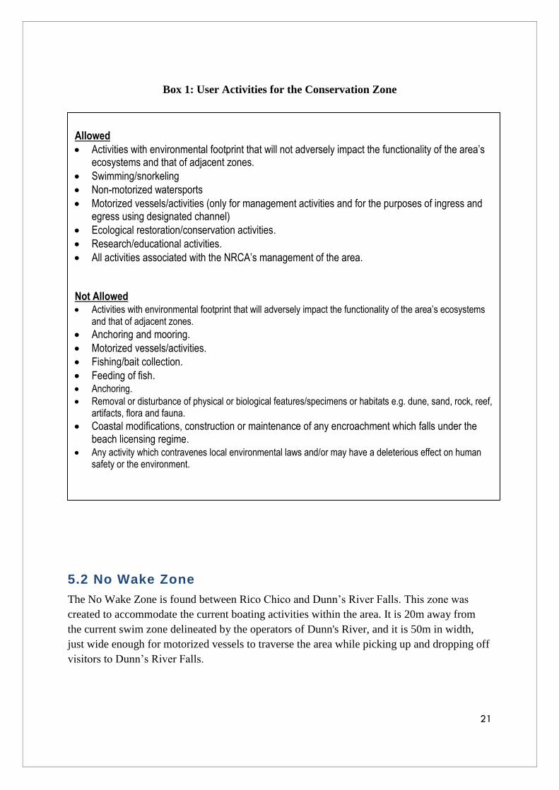
Box 1: User Activities for the Conservation Zone
5.2 No Wake Zone
The No Wake Zone is found between Rico Chico and Dunn’s River Falls. This zone was
created to accommodate the current boating activities within the area. It is 20m away from
the current swim zone delineated by the operators of Dunn's River, and it is 50m in width,
just wide enough for motorized vessels to traverse the area while picking up and dropping off
visitors to Dunn’s River Falls.
Allowed
Activities with environmental footprint that will not adversely impact the functionality of the area’s ecosystems and that of adjacent zones.
Swimming/snorkeling
Non-motorized watersports
Motorized vessels/activities (only for management activities and for the purposes of ingress and egress using designated channel)
Ecological restoration/conservation activities.
Research/educational activities.
All activities associated with the NRCA’s management of the area.
Not Allowed Activities with environmental footprint that will adversely impact the functionality of the area’s ecosystems
and that of adjacent zones.
Anchoring and mooring.
Motorized vessels/activities.
Fishing/bait collection.
Feeding of fish. Anchoring.
Removal or disturbance of physical or biological features/specimens or habitats e.g. dune, sand, rock, reef, artifacts, flora and fauna.
Coastal modifications, construction or maintenance of any encroachment which falls under the beach licensing regime.
Any activity which contravenes local environmental laws and/or may have a deleterious effect on human safety or the environment.

22
5.2.1 Objective of No Wake Zone
To reduce wave action within the Conservation Zone B as the zone is only 20m from the
swim zone, as well as to ensure safety of other users operating non-motorized vessels in the
Conservation Zone.
5.2.2 Boundary Description
The boundary description of the No-Wake Zone (Figure 11) is as follows:
1. The boundary description begins at point A; a water-based mark at coordinates
18°25'11.42"N; 77° 8'27.54"W.
2. From point A the boundary runs in a straight line to point B a water-based mark at
coordinates 18°25'12.83"N; 77° 8'26.73"W. 3.
3. From point B, the boundary continues to point C, a water-based mark at coordinates
18°25'11.38"N; 77° 8'25.47"W.4.
4. From C, the boundary runs to point D, a water-based mark, at coordinates
18°25'11.33"N; 77° 8'22.17"W.5.
5. From D, the boundary runs straight to E, a water-based point at coordinates
18°25'9.65"N; 77° 8'18.17"W.6.
6. From E, the boundary runs to point F, a water-based point at coordinates
18°25'7.35"N; 77° 8'15.23"W.
7. From F the boundary runs in a straight line to point G a water-based mark at
coordinates 18°25'6.53"N; 77° 8'13.55"W. 8.
8. From point G, the boundary continues to point H, a water-based mark at coordinates
18°25'10.57"N; 77° 8'10.63"W.
9. From H, the boundary runs to point I, a water-based mark, at coordinates
18°25'10.50"N; 77° 8'5.37"W.10.
10. From I, the boundary runs straight to J, a water-based point at coordinates
18°25'9.92"N; 77° 8'3.83"W.
11. From J, the boundary runs to point K, a water-based point at coordinates
18°25'8.22"N; 77° 8'4.17"W.
12. From point K, the boundary continues to point L, a water-based mark, at coordinates
18°25'9.01"N; 77° 8'7.10"W.
13. From L, the boundary runs to point M, a water-based mark, at coordinates
18°25'8.96"N; 77° 8'9.95"W.
14. From M, the boundary runs to point N, a water-based mark, at coordinates
18°25'5.50"N; 77° 8'12.06"W.
15. From N, the boundary runs straight to O, a water-based point at coordinates
18°25'4.86"N; 77° 8'12.87"W.
16. From O, the boundary runs to point P, a water-based point at
coordinates18°25'4.94"N; 77° 8'14.36"W.
17. From P the boundary runs in a straight line to point Q a water-based mark at
coordinates 18°25'6.22"N; 77° 8'16.54"W.
18. From point Q, the boundary continues to point R, a water-based mark at coordinates
18°25'8.23"N; 77° 8'19.04"W.

23
19. From R, the boundary runs to point S, a water-based mark, at coordinates
18°25'9.82"N; 77° 8'22.80"W.
20. From S, the boundary runs straight to T, a water-based point at coordinates
18°25'9.84"N; 77° 8'26.50"W.
21. From T, the boundary runs back to point A.
FIGURE 11: BOUNDARY OF NO WAKE ZONE (SOURCE: PROTECTED AREAS BRANCH, 2015)
5.2.3 Justification for No Wake Zone B
This area is currently used to pick up and drop off visitors at Dunn’s River Falls who would
like to proceed to other watersports or sightseeing activities within the ORMPPA after
visiting the Falls. Therefore the designation of the zone is accommodating a present use
within the area.
5.2.4 Activities Guide
With the primary objective of safeguarding the activities of swimmers in adjacent areas, the
No-Wake Zone regulates the type and mode of operation of vessels in the Dunn’s River
Beach area. As such, the zone only allows for the ingress and egress (at reduced speed) of
motorized craft involved in the transportation of cruise ship and other visitors from the dock
at Dunn’s River Falls to other recreational and watersports sites. The regulated activities are
outlined in Box 2.

24
Allowed
Activities with an environmental footprint that will not adversely impact the functionality of the area’s ecosystems and that of adjacent zones.
Motorized vessels/activities (for ingress and egress only, at a speed not exceeding 6 knots).
Ecological restoration/conservation activities.
Research/educational activities.
All activities associated with the NRCA’s management of the area. Not Allowed Swimming/snorkeling.
Non-motorized vessels/activities (with the exception of sail boats/catamarans specifically involved in the transportation of passengers from the Dunn’s River dock to other sites).
Speeds over 6 knots.
Jet skis.
Anchoring and mooring
Fishing/bait collection.
Feeding of fish. Anchoring.
Removal or disturbance of physical or biological features/specimens or habitats e.g. dune, sand, rock, reef, artifacts, flora and fauna.
Coastal modifications, construction or maintenance of any encroachment which falls under beach licensing regime.
Activities with environmental footprint that will adversely impact the functionality of the area’s ecosystems and that of adjacent zones.
Any activity which contravenes local environmental laws and/or may have a deleterious effect on human safety or the environment.
Box 2: User Activities for the No-Wake Zone
5.3 Dive and Snorkel Sites
These sites are found within the Conservation Zones or on the perimeter of the zones. They
will be marked by a buoy and no motorized vessel should be within 30m of the site if a dive
flag is visible.
5.3.1 Objective:
To separate motorized activities from non-motorized activities, such as snorkeling and
SCUBA diving to ensure the safety of these users of the ORMPPA. Also, to give these users
the opportunity to enjoy views the marine environment in a fairly undisturbed state.

25
FIGURE 12: DIVE AND SNORKEL SITES WITHIN THE ORMPPA (SOURCE: PROTECTED AREAS BRANCH, 2015)
5.3.2 Justification for Dive and Snorkel Sites
The designation of these sites was based on the current areas used for these activities. These
sites are mainly within or on the perimeter of the Conservation Zones on the coral reef.
5.3.3 Activities Guide
The Activities Guide stipulates the mode of operation allowed at all dive and snorkel sites
located throughout the protected area. The designated sites (Appendix 4) will allow for
recreation associated with dive and snorkel activities. All non-motorized and motorized craft
(inclusive of jet skis) are required to steer clear of these areas when in use. Box 3 details the
activities allowed and prohibited at the sites.

26
Allowed
Non-motorized watersports (however not within 50m of a dive flag)
Motorized vessels (however not at those sites located within the Conservation Zones and not within 50m of a dive flag)
Diving & Snorkeling
Swimming
Activities with environmental footprint that will not adversely impact the functionality of the area’s ecosystems and that of adjacent zones.
Ecological restoration/conservation activities.
Research/educational activities.
All activities associated with the NRCA’s management of the area.
Not Allowed Motorized boats (within 50 m of a dive flag and at Dive sites located within the Conservation Zones)
Swimming/Snorkeling
Non-motorized vessels (within 50m of a dive flag)
Jet Skis
Anchoring and Mooring
Feeding of fish
Fishing/bait collection Removal or disturbance of physical or biological features/specimens or habitats, e.g. dune, sand, rock,
reef, artifacts, flora, fauna.
Coastal modifications, construction or maintenance of any encroachment which falls under beach licensing regime
Activities with environmental footprint that will adversely impact the functionality of the area’s ecosystems and that of adjacent zones.
Any activity which contravenes local environmental laws and/or may have a deleterious effect on human safety or the environment.
Box 3: User Activities for the Dive and Snorkel Sites
5.4 Multiple-use Zone
The Multiple-use Zone will allow for a range of uses such as fishing as well as recreational
boating and all activities with an environmental footprint that will not adversely impact
archaeological/heritage resources and the functionality of the area’s ecosystems and that of
adjacent zones.
5.4.1 Objective:
To allow motorized activities and other activities such as fishing and the operation of jet skis
which are not allowed in the Conservation Zones within ORMPPA?
27
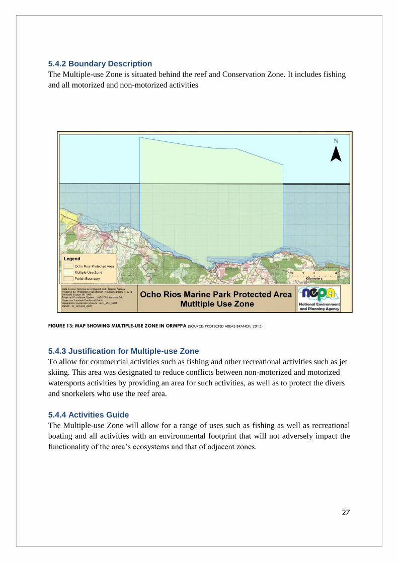
5.4.2 Boundary Description
The Multiple-use Zone is situated behind the reef and Conservation Zone. It includes fishing
and all motorized and non-motorized activities
FIGURE 13: MAP SHOWING MULTIPLE-USE ZONE IN ORMPPA (SOURCE: PROTECTED AREAS BRANCH, 2015)
5.4.3 Justification for Multiple-use Zone
To allow for commercial activities such as fishing and other recreational activities such as jet
skiing. This area was designated to reduce conflicts between non-motorized and motorized
watersports activities by providing an area for such activities, as well as to protect the divers
and snorkelers who use the reef area.
5.4.4 Activities Guide
The Multiple-use Zone will allow for a range of uses such as fishing as well as recreational
boating and all activities with an environmental footprint that will not adversely impact the
functionality of the area’s ecosystems and that of adjacent zones.
28
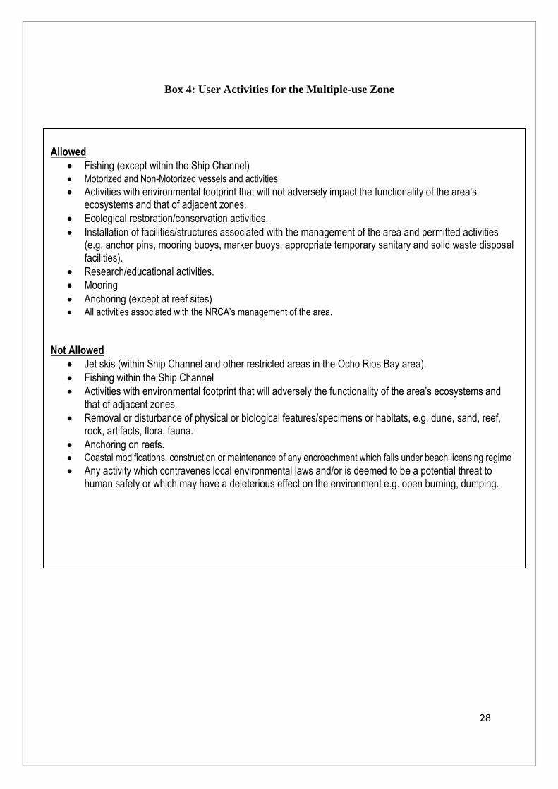
Box 4: User Activities for the Multiple-use Zone
Allowed
Fishing (except within the Ship Channel) Motorized and Non-Motorized vessels and activities
Activities with environmental footprint that will not adversely impact the functionality of the area’s ecosystems and that of adjacent zones.
Ecological restoration/conservation activities.
Installation of facilities/structures associated with the management of the area and permitted activities (e.g. anchor pins, mooring buoys, marker buoys, appropriate temporary sanitary and solid waste disposal facilities).
Research/educational activities.
Mooring
Anchoring (except at reef sites) All activities associated with the NRCA’s management of the area.
Not Allowed
Jet skis (within Ship Channel and other restricted areas in the Ocho Rios Bay area).
Fishing within the Ship Channel
Activities with environmental footprint that will adversely the functionality of the area’s ecosystems and that of adjacent zones.
Removal or disturbance of physical or biological features/specimens or habitats, e.g. dune, sand, reef, rock, artifacts, flora, fauna.
Anchoring on reefs. Coastal modifications, construction or maintenance of any encroachment which falls under beach licensing regime
Any activity which contravenes local environmental laws and/or is deemed to be a potential threat to human safety or which may have a deleterious effect on the environment e.g. open burning, dumping.

29
Bibliography
Friends of the Sea. undated Ocho Rios Marine Park: Management Plan. Ocho Rios, St. Ann:
Friends of the Sea
NEPA. 2014. Socio-economic Assessment of the Ocho Rios Protected Area: Towards the
Zoning of the Ocho Rios Protected Area Plan. Kingston, Jamaica: NEPA
NEPA. 2012. Protected Area Zoning Planning Process. Kingston, Jamaica: NEPA
NEPA. 2011. Ocho Rios Marine Park: Draft Zoning Recommendation. Kingston, Jamaica:
NEPA
NEPA. 2008. The Town and Country Planning (Kingston and Saint Andrew) Provisional
Development Order, 2008 (Draft). Unpublished.
University of the West Indies. 2001. Socio-economic Valuation Study of the Ocho Rios
Marine Park by Environmental Management Unit. Kingston, Jamaica: University of the West
Indies (2001).

30
APPENDIX 1 Legislation for Ocho Rios Marine Park
Protected Area

31

32

33
APPENDIX 2 Commercial and Shipping Channel
Coordinates:
A - 18°24'53.73"N B - 18°24'32.74"N C - 18°24'38.64"N D - 18°24'43.53"N
77° 7'8.64"W 77° 6'43.89"W 77° 6'31.58"W 77° 6'33.44"W
E - 18°24'44.39"N F - 18°24'47.76"N G - 18°25'3.21"N
77° 6'32.94"W 77° 6'32.46"W 77° 6'56.62"W
FIGURE 14: BOUNDARY FOR PORT AND SHIPPING CHANNEL (SOURCE: PROTECTED AREAS BRANCH, 2015)

34
APPENDIX 3 Jet Ski Launch Site
FIGURE 15: IMAGE SHOWING DESIGNATED JET SKI LAUNCH SITE (SOURCE: PROTECTED AREAS BRANCH, 2015)

35
APPENDIX 4 Dive and Snorkel Sites
FIGURE 16: DIVE SITES IN THE WESTERN SECTION OF ORMPPA (SOURCE: PROTECTED AREAS BRANCH, 2015)
FIGURE 17: DIVE SITES IN CONSERVATION ZONE A (SOURCE: PROTECTED AREAS BRANCH, 2015)

36
FIGURE 18: DIVE SITES SURVEYED BY NEPA IN CONSERVATION ZONE A (SOURCE: ECOSYSTEMS MANAGEMENT BRANCH, 2011)