ocean circulation - people.ucsc.edu€¦ · 1) ocean layers • ocean is strongly stratified •...
TRANSCRIPT

OCEAN CIRCULATION

I. Ocean Layers and circulation types
1) Ocean Layers
• Ocean is strongly Stratified • Consists of distinct LAYERS –controlled by density
•takes huge amounts of energy to mix up the stable layers!

Temperature slice in the central Atlantic NorthSouth
Thermocline – a sharp transition in temperature and hence DENSITY (marked by many contour intervals)
The “main” thermocline divides WARM SURFACE from COLD DEEP water.

Ocean Layers
SURFACE OCEANTHERMOCLINE
DEEP OCEAN
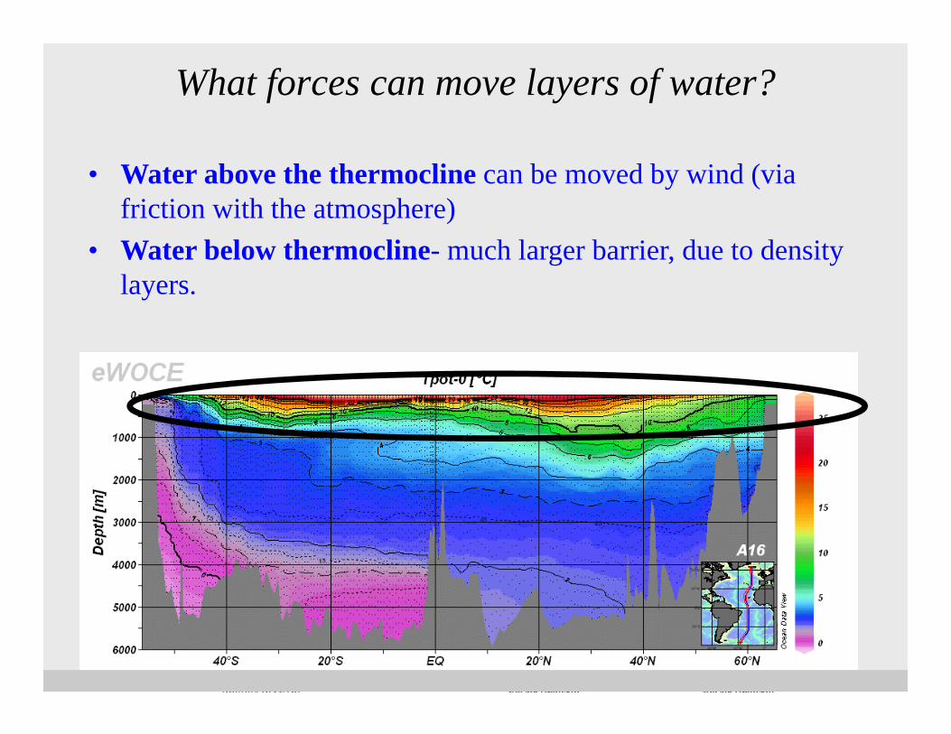
• Water above the thermocline can be moved by wind (via friction with the atmosphere)
• Water below thermocline- much larger barrier, due to density layers.
What forces can move layers of water?

1) Circulation “types”
two very separate types of ocean circulation –
•1) surface -driven by wind •2) deep driven by density

II. Wind Fields and Main Ocean “Gyres”

Rev: Main-wind beltsRecall: Main WINDBELTS – these drive Surface circulation!
Prevailing Westerlies
Trade Easterlies
Recall again..

If wind drives the circulation….
What major ocean currents would you predict these wind
bands would create?

Prevailing Westerlies
Prevailing Westerlies
Easterly Trade
Easterly Trade
Subtropical gyres and their Main Current Types
Equatorial/tropical current
W E
Eastern Boundary current
L
0°
30°S
30°N
60°N
60°S
L
H
H
L
High latitudecurrent
High latitudecurrent

5 Major subtropical gyres
Notice smaller Sub-polar Gyres as well !
30°N
30°S
H
H

More realistic Global Surface Currents
Kaufman Fig. 4.12

Franklin map
Had Just started:
The strange story of Nansen’s icebergs…
How do we know they exist?Ben Franklin’s map of the Atlantic deduced the Atl. Gyre from the way
ships would drift along their route to and from the New World

• Large ~ circular current flows
• Set in motion by main wind patterns
• Bounded by continents on E and W
• “subtropical” gyres most pronounced
Summary: Ocean Gyres
But What is wrong with this picture
(so far..) ?

II. ECKMAN TRANSPORT(CORIOLIS strikes again)

Nansen contemplating ice

Nansen’s funky icebergsNansen noticed icebergs moving
20˚ - 40˚ to right of wind direction

Ekman SpiralModel of surface response to wind forcing
- When wind blows over the ocean, surface water moves 45o to the right of the wind in the northernhemisphere
- Current rotates and weakens deeper in water column

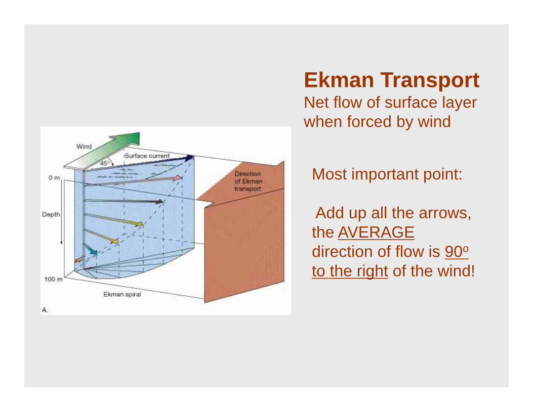
Ekman TransportNet flow of surface layer when forced by wind
Most important point:
Add up all the arrows, the AVERAGE direction of flow is 90o to the right of the wind!
90o
Ekman TransportNet flow of surface layer when forced by wind
Most important point:
Add up all the arrows, the AVERAGE direction of flow is 90o
to the right of the wind!

Ekman Transport Causes Convergence of Water in
Middle of Gyres
Prevailing Westerlies
Northeasterly Trades
HCONVERGENCE
30°N

HPara ver esta película, debedisponer de QuickTime™ y de
un descompresor .
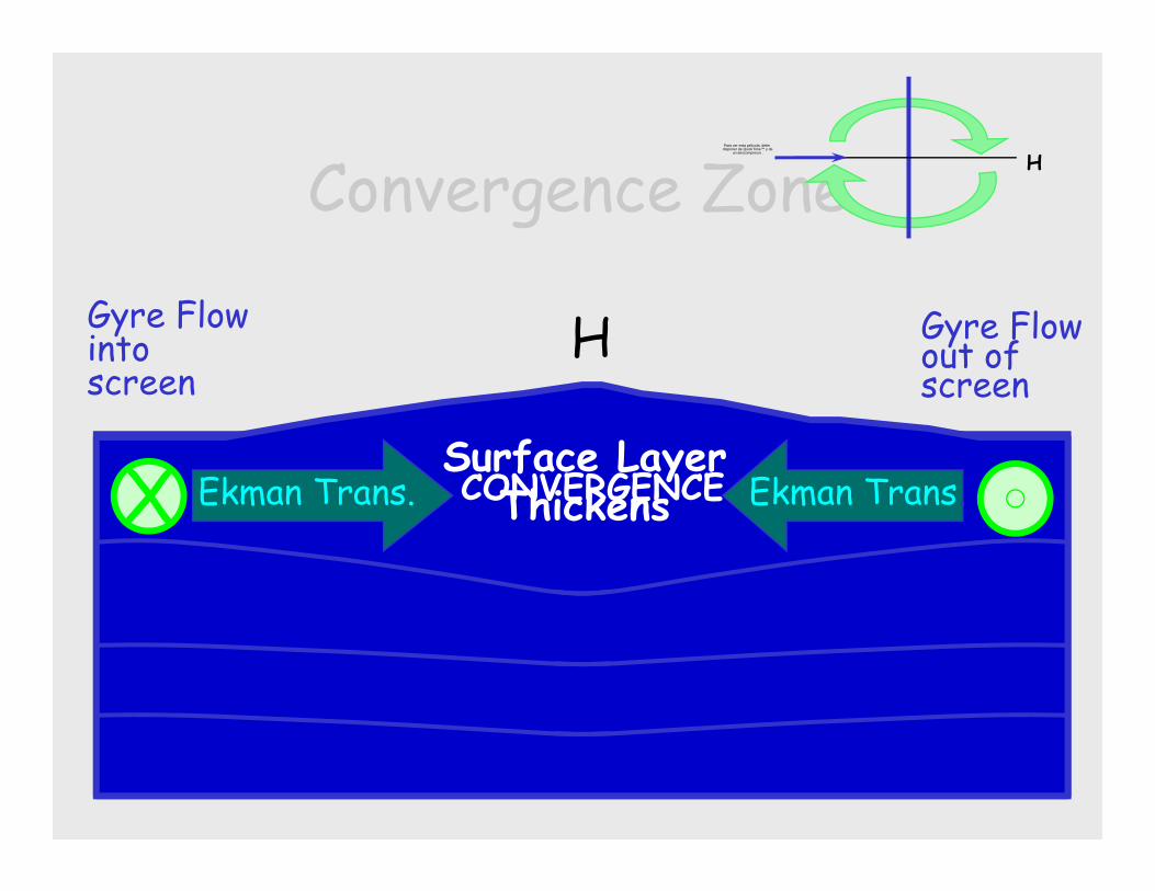
Convergence Zone
Surface LayerThickens
Gyre Flow out of screen
Gyre Flow into screen
H
Ekman Trans. Ekman Trans.CONVERGENCE
HPara ver esta película, debedisponer de QuickTime™ y de
un descompresor .
X

Geostrophic FlowPRESSUREGRADIENTFORCE
CORIOLIS
•PGF = High to Low Pressure Flow•Plus Coriolis•Results in Flow Clockwise around Gyre (NH)•Strength of Flow related to PG
PRESSUREGRADIENTFORCE
CORIOLISX
HPara ver esta película, debedisponer de QuickTime™ y de
un descompresor .
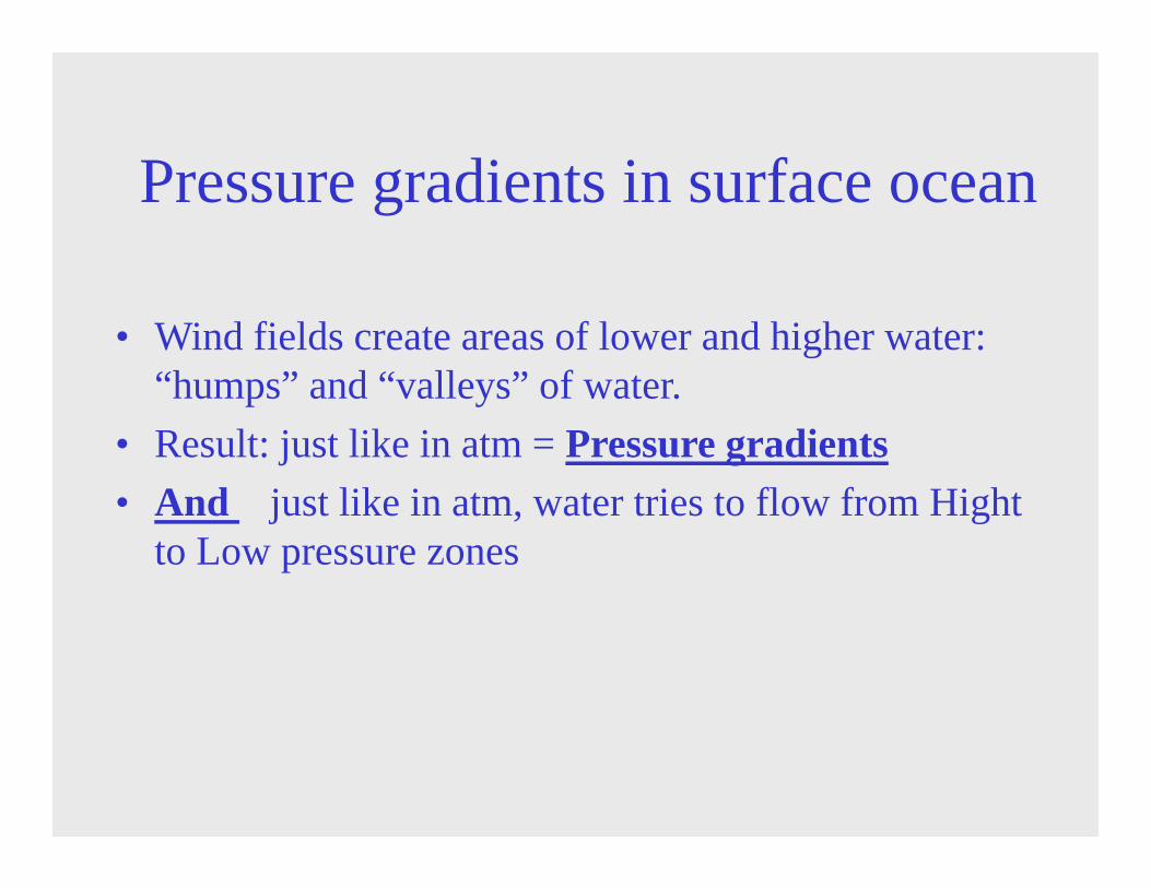
• Wind fields create areas of lower and higher water: “humps” and “valleys” of water.
• Result: just like in atm = Pressure gradients• And just like in atm, water tries to flow from Hight
to Low pressure zones
Pressure gradients in surface ocean

• Can be used to calculate current strengths.
From Regional Oceanography © 2001 - 2003 M. Tomczak and J. S. Godfrey
“Dynamic Height Maps” Maps of relative height of surface ocean
from the measurements of the ocean density

• 1) Direct Effect of Wind– Confined to upper 50-100 m– Frictional surface layer flow is ~90˚ to right of wind
direction in NH, to left in SH -> Ekman Transport
• 2) Indirect Effects of Coriolis– Eckman Transport sets up Pressure gradients drive
focused currents (jets)– Can be 1 - 2 km below surface
SUMMARY:WHAT DRIVES SURFACE CURRENTS?

• Wind stress drives surface convergences
• Sea surface rises
• Balance between coriolis effect and PG at the gyres: Geostrophic currentmoving in a circular path around the gyre hill
Summary of Main Gyre Circulation.

One more thing:Notice anything funny about this gyre ?
“WESTERN INTENSIFICATION”
&W. Boundary Currents
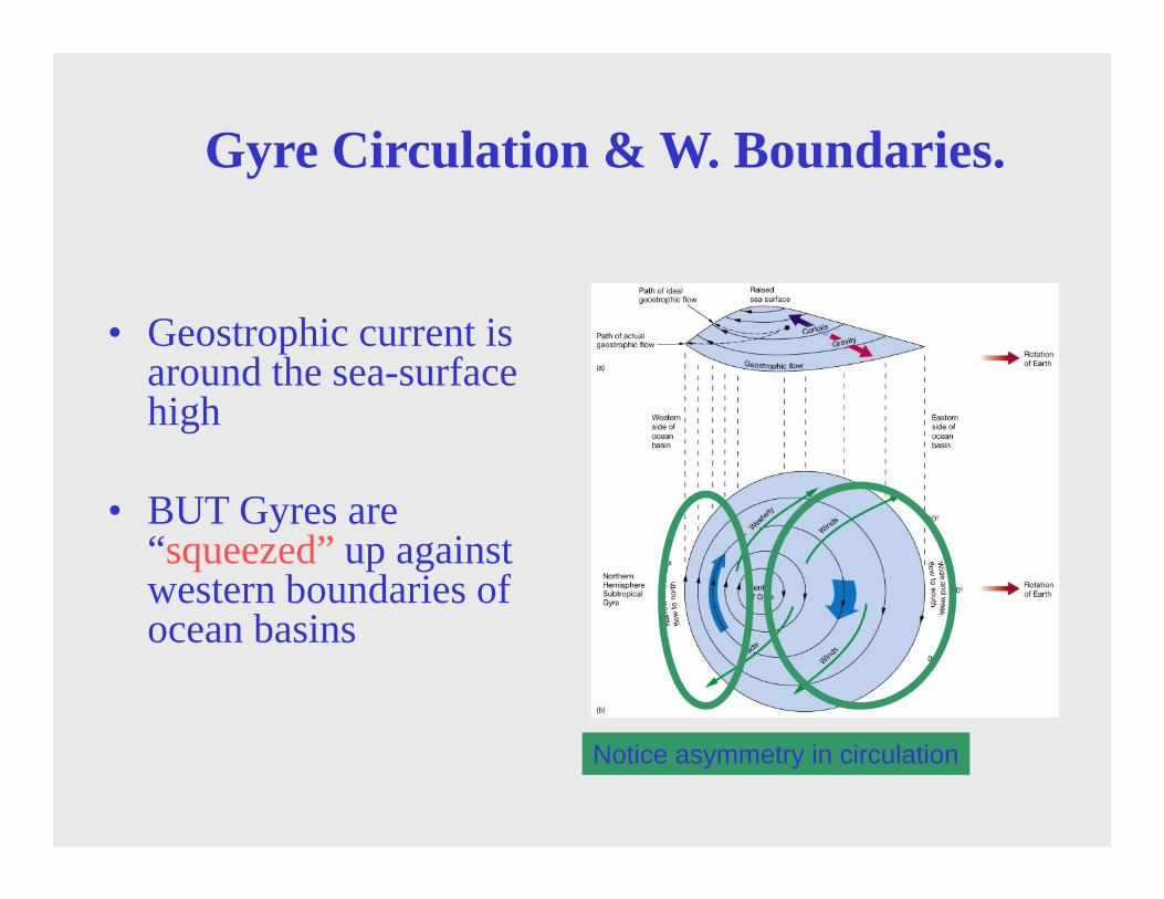
• Geostrophic current is around the sea-surface high
• BUT Gyres are “squeezed” up against western boundaries of ocean basins
Gyre Circulation & W. Boundaries.
Notice asymmetry in circulation

Reasons for western intensification (asymmetric gyres)
Notice asymmetry in circulation
• 1) Earth’s rotation-coriolis effectasymmetries with latitude: Westerlies more effect than Easterlies
• => higher speed along the western margin of the hill compared to the eastern side.

Western boundary currents• Found in all the ocean basins: NH and SH• Fast (~1 m/s) and narrow (~100 km)
Figure 7-4
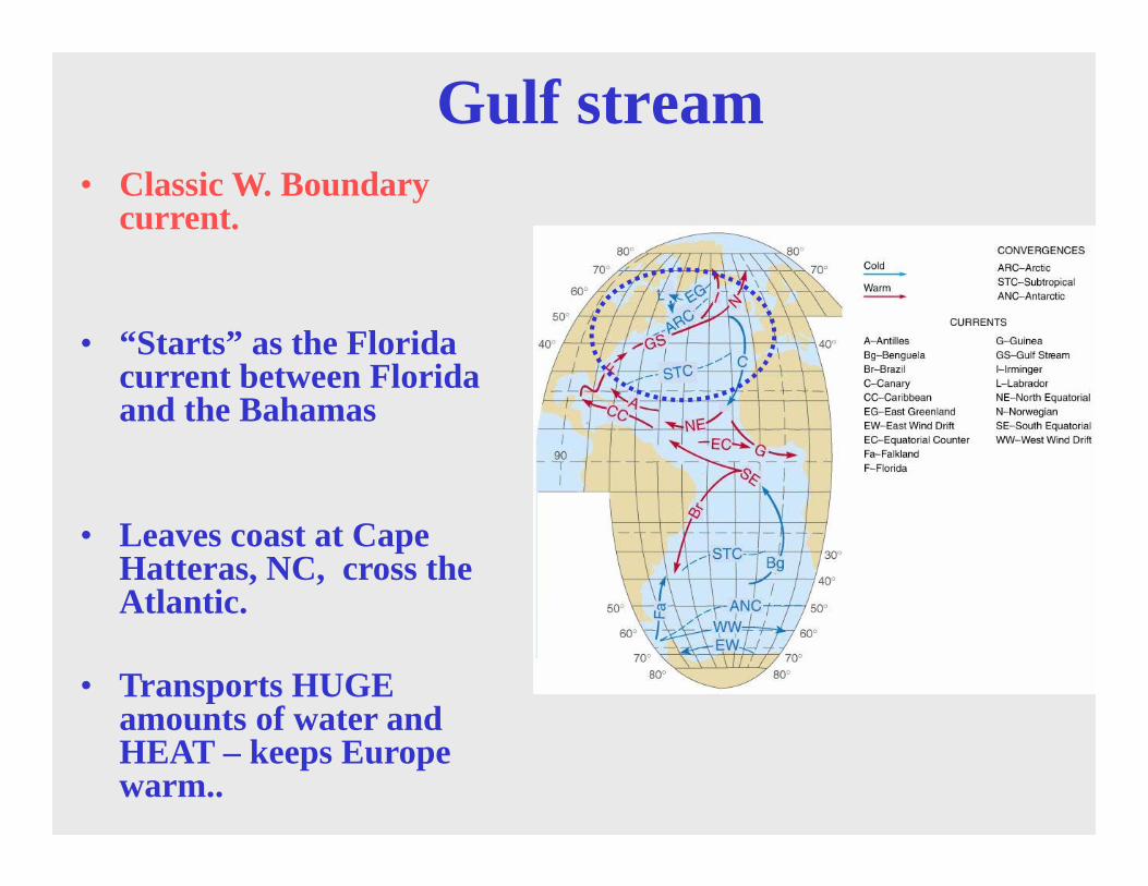
Gulf stream• Classic W. Boundary
current.
• “Starts” as the Florida current between Florida and the Bahamas
• Leaves coast at Cape Hatteras, NC, cross the Atlantic.
• Transports HUGE amounts of water and HEAT – keeps Europe warm..

Water transport Water flow rates, units are in Sverdrups (= 1 million cubic meters/second)
100
~ 6

Moves so fast, that creates:
Gulf Stream “rings”Temperature June 11, 1997
cold water surrounded by warm rings:unique physical characteristics and biological habitats

Warm core rings

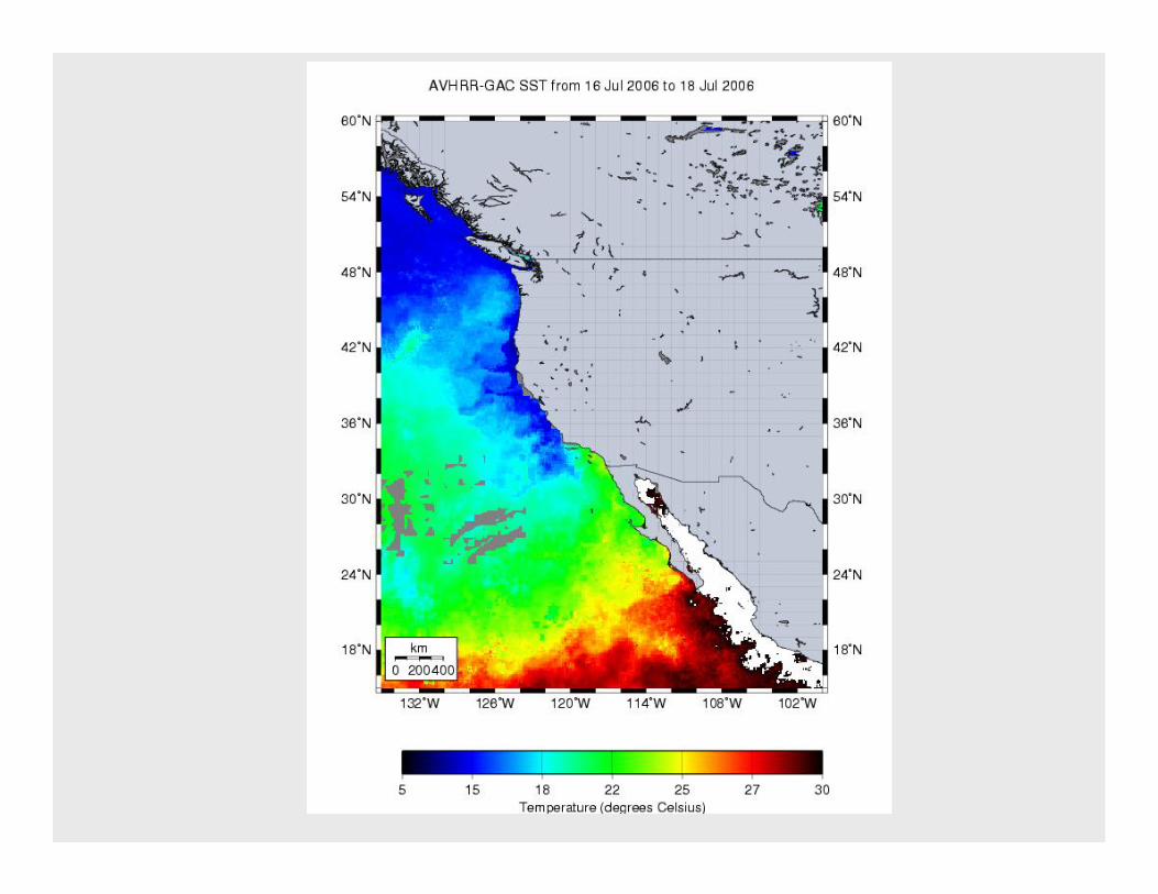
Currents shape climate! • Warm current - warms air (L) = high water vapor= humid coast
East Coast USA, also E. Coast Asia (Japan in Aug..)• Cool current cools air (H) = low water vapor dry coast
W. Coast USA (Santa Cruz)

Finally:Back to the coasts- How would Eckman transport affect coastal
surface circulation?

UPWELLING(revisited)

Coastal UpwellingExample from Northern Hemisphere
W Emiddle of gyre
Typical Northerly wind
Ekman TransportSea level
1000 m

wind

Coastal UpwellingExample from Southern Hemisphere
W Emiddle of gyre X
southerly wind
Ekman Transport
XSea level
1000 m

Peru and CA-Amazingly productiveUpwelling-drivenEnvironments! -due to the upwelling of nutrients to the surface

Global chl map
Chlorophyl a: productive upwelling areas vs oceanic desserts

Equatorial Divergent Upwellingmap view
2˚N
2˚S
EQ Trade Winds
West East
UPWELLING
Ekman Transport{to right in NH}
Ekman Transport{to left in SH}
DIVERGENCE

summary cartoon

Equatorial Divergent Upwellingcross-section
2˚N2˚S
West East
DIVERGENCE
X XXTrade Winds
UPW
ELLING
Ekman Trans.
{to left in SH}
Ekman Trans.
{to right in NH}
Surface LayerThins

What about in the deep?
Does it circulate? How?
Next time: DEEP OCEAN
CIRCULATION