ocean sciences -...
TRANSCRIPT
O C E A N S C I E N C E S
A T T H E N E W M I L L E N N I U M

Sponsored by the National Science Foundation through an award to the
University Corporation for Atmospheric Research Joint Office for Science Support
Editing and design by Geosciences Professional Services, Inc.
March 2001
O C E A N S C I E N C E S
A T T H E N E W M I L L E N N I U M
M E M B E R S H I P
Robert Beardsley ............... Woods Hole Oceanographic Institution
Rainer Bleck ........................ Los Alamos National Laboratory
Peter Brewer* .................... Monterey Bay Aquarium Research Institute
Kenneth Bruland ................ University of California, Santa Cruz
Russ Davis ........................... University of California, San Diego
Jody Deming ........................ University of Washington
Robert Detrick .................. Woods Hole Oceanographic Institution
Stanley Hart ........................ Woods Hole Oceanographic Institution
Mark Hay ............................. Georgia Institute of Technology
Peter Jumars ....................... University of Maine
Ellen Kappel** ..................... Geosciences Professional Services, Inc.
David Karl ........................... University of Hawaii
Cindy Lee ............................ State University of New York, Stony Brook
Susan Lozier ........................ Duke University
Donal Manahan .................. University of Southern California
Larry Mayer ......................... University of Maine
Marcia McNutt ................... Monterey Bay Aquarium Research Institute
Frank Millero ...................... University of Miami
Ted Moore* ......................... University of Michigan
Mark Ohman ...................... University of California, San Diego
Peter Rhines ........................ University of Washington
Eli Silver ............................... University of California, Santa Cruz
Sharon Smith ....................... University of Miami
Karl Turekian ....................... Yale University
Francisco Werner .............. University of North Carolina
* Decadal Committee Co-Chairs
** Ex Officio Member
O C E A N S C I E N C E S
D E C A D A L C O M M I T T E E
Preface.................................................................................................................................................................................... 1
Executive Summary ............................................................................................................................................................. 3
Futures Reports ................................................................................................................................................................... 7
Ocean Ecology: Understanding and Vision for Research (OEUVRE) ............................................................... 7
Future of Marine Geology and Geophysics (FUMAGES) ................................................................................. 10
Advances and Primary Research Opportunities in Physical Oceanography (APROPOS) ........................ 13
The Future of Ocean Chemistry in the US (FOCUS) ...................................................................................... 16
The Ocean’s Role in Global Climate ............................................................................................................................. 19
Box: The Pacific Decadal Oscillation ................................................................................................................... 22
Box: How Rapidly Can Climate Change? ............................................................................................................ 27
Box: Global Warming 55 Million Years Ago......................................................................................................... 28
Box: The Iron Fertilization Experiment ............................................................................................................... 31
Long-Term Ocean Observations and Prediction ....................................................................................................... 37
Box: Predicting the El Niño Southern Oscillation ............................................................................................. 40
Box: A Coupled Physical-Biogeochemical Model .............................................................................................. 46
Box: A Sea of Change: Hawaii Ocean Time-Series ............................................................................................ 50
Box: Tools for Observation .................................................................................................................................... 52
Ocean Turbulence .............................................................................................................................................................. 55
Box: Brazil Basin Tracer Release Experiment ..................................................................................................... 57
Box: Coastal Mixing and Optics Experiment ..................................................................................................... 60
Box: Hydromechanical Signals and Turbulent Noise ......................................................................................... 62
Box: Effects of Surface Waves on Oceanic Turbulence .................................................................................... 66
Box: Turbulence Dynamics in Wave-Driven Currents ..................................................................................... 68
C O N T E N T S
Non-Equilibrium Ecosystem Dynamics ........................................................................................................................ 71
Box: Decadal Scale Changes in the Antarctic Marine Ecosystem .................................................................. 74
Box: Biodiversity and Ecosystem Stability: Finding Strength in Weakness ................................................... 78
Box: Catastrophic Decline of the Jamaican Coral Reef ................................................................................... 80
The Complex Coastal Ocean ......................................................................................................................................... 87
Box: Wave- and Density-Driven Sediment Transport ...................................................................................... 91
Box: Sea Level Rise ................................................................................................................................................... 93
Box: Wind-Driven Larval Transport .................................................................................................................. 101
Box: Biological Data Assimilation ....................................................................................................................... 106
The Ocean Below the Seafloor: Fluid Flow and Effects on Geology, Chemistry and Life in the Crust ...... 109
Box: Ridge-Flank Hydrothermal Circulation ................................................................................................... 111
Box: The Hot, Deep Subseafloor Biosphere ................................................................................................... 119
Box: Burning Ice: Gas Hydrates from the Ocean Floor ................................................................................ 121
Box: CORK Subseafloor Hydrogeological Experiments .............................................................................. 123
Dynamics of Oceanic Lithosphere and Margins ...................................................................................................... 125
Box: Subduction Recycling................................................................................................................................... 128
Box: Imaging Mantle Flow and Melt Generation ............................................................................................ 134
Box: Megamullions in the Oceanic Crust ........................................................................................................ 139
Conclusions ..................................................................................................................................................................... 145
Findings ..................................................................................................................................................................... 146
Recommendations ................................................................................................................................................. 150
1
P R E F A C E
During the summer of 1998, the Director of the National Science Foundation’s Division of Ocean Sciences
appointed a Decadal Committee to review “the most important and promising opportunities for discovery
and new understanding in the ocean sciences over the next decade.” The committee’s charge proved to be
challenging, for the scope, scale and complexity of the ocean sciences have increased enormously over the
last few decades. Forcing of climate change by greenhouse gases has emerged from the realm of scientific
study into a serious socioeconomic issue, placing stringent demands on understanding key ocean processes
involved in the transport of vast quantities of heat and carbon dioxide. Huge new demands imposed by
human development pressures and extraordinary impacts on marine ecosystems in coastal regions are now
seen as marked changes in the marine environment. The end of the Cold War has forced a reassessment of
national marine science priorities.
In addressing the charge, the Decadal Committee sought to draw on the widest possible input from the
ocean science community. The committee initially relied heavily on four disciplinary reports covering ocean
physics, chemistry, biology, and geology and geophysics, which had been prepared within the previous five
years. Because formal participation in the disciplinary workshops was limited, the Decadal Committee solic-
ited by e-mail, and advertisement through the membership of the American Geophysical Union, the views of
over 2,000 ocean scientists. Approximately 400 replies were received, many of them quite detailed. These
comments factored into the committee’s deliberations and, ultimately, this report. The Committee also
incorporated community input from a web-posted draft of the report, which was accessed over 3,000 times.
“I seem to have been only like a boy playing on the seashore, and diverting
myself in now and then finding a smoother pebble or a prettier shell than
ordinary, whilst the great ocean of truth lay all undiscovered before me.”
Isaac Newton
2
The Decadal Committee established seven working groups based upon public responses and the principal
crosscutting themes identified from the disciplinary reports, with the intent of examining the importance of
these new areas to ocean science. These working groups were:
• The Ocean’s Role in Global Climate
• Long-Term Ocean Observations and Prediction
• Ocean Turbulence
• Non-Equilibrium Ecosystem Dynamics
• The Complex Coastal Ocean
• The Ocean Below the Seafloor: Fluid Flow and Effects on Geology, Chemistry and Life in the Crust
• Dynamics of Oceanic Lithosphere and Margins
This report, “Ocean Sciences at the New Millennium,” presents the results of the working groups, and
highlights areas where cooperation across traditional disciplinary boundaries is likely to lead to important
new insights. These themes are not intended to represent all aspects of the disciplinary science reflected in
the individual workshop reports. This report concludes with key findings from each of the working group
themes and broad recommendations for future research. The report does not address implementation or
cost issues— the committee was specifically asked not to do so—as these are dealt with by science propos-
als, by NSF program development and by policy decisions within NSF.
This NSF-commissioned report addresses fundamental science issues. It was not possible to address all
topics, however, including several that are in common with mission agencies such as NOAA, NASA, DOE and
the US Navy, where NSF support often plays a crucial role. In particular, the report does not cover: (1) the
technical details of new ocean-observing satellite systems, (2) the design and development of primarily op-
erational systems for very large-scale ocean observations, such as a Global Ocean Observing System, (3)
the study of oceans on other planets, (4) marine acoustics studies derived from Navy SOSUS arrays, and (5)
direct applications to operational fisheries management.
The object of this activity is to develop a clear and compel-
ling description of the most important and promising op-
portunities for discovery and new understanding in the ocean
sciences over the next decade. The product will be a suc-
cinct (100-150 pp) report written for community and agency
readership.
The most challenging task is integration—we need an origi-
nal vision of the future of the ocean sciences over the next
decade presented (as far as possible) as an integrated whole.
The foundation of the report will be the four disciplinary
science reports plus, as appropriate, other recent planning
documents from special focus programs. But the assump-
tion will not be made that these documents are in fact com-
prehensive. Efforts will be made to identify gaps and omis-
sions.
Boundaries with other disciplines will be explored,
multidisciplinary efforts will be identified and fully developed.
C O M M I T T E E C H A R G E
3
E X E C U T I V ES U M M A R Y
The oceans play a pivotal role in climate, contain the largest and most unexplored habitat for life on Earth and
provide routes for commerce and sites for recreation. The oceans also contain important food and energy
resources in great demand by society. Movement of the great oceanic plates builds spectacular mountain
ranges, but is also the cause of earthquakes and volcanoes that wrench the margins of the ocean basins.
In the decade ahead, ocean scientists are poised to make major breakthroughs in the understanding of ocean
biology, chemistry, geology and physics. Such potential has been created by an extraordinary period of inven-
tion and discovery from which new capabilities have emerged in the areas of computation, molecular biology,
deep drilling and rapid ocean-observing technologies. These new capabilities are providing unparalleled views
of the ocean basins, their changing interaction with the atmosphere, the great biological shifts in near-surface
waters, and the emerging view of the long-hidden deep ocean basins. The promise of progress in the next
decade is predicated on these new tools and the new “look” at the ocean that these tools have made
possible.
It has been more than thirty years since a comprehensive survey of the entire field of oceanography has been
undertaken. Because the field has changed dramatically in the intervening years, and because of the unmistak-
able importance of the oceans to our nation, the National Science Foundation’s Division of Ocean Sciences
formed a “Decadal Committee” to examine the future of oceanographic research over the next decade. The
committee was asked to identify the most important and promising opportunities for discovery and new
understanding. To carry out their charge, the Decadal Committee initially relied heavily on four disciplinary
reports covering ocean physics, chemistry, biology, and geology and geophysics, which had been prepared
within the previous five years with extensive community participation.
4
The Decadal Committee assimilated the material from the disciplinary reports, as well as other community
input, and selected seven topics for special emphasis. These broad topics cut across disciplinary boundaries
and identify areas where significant progress can be made in understanding ocean processes and their impact
on Earth and on society. These topics are:
The Ocean’s Role in Global Climate. Scientists have voiced concerns over global warming for over 40
years. Today these concerns have reached a sufficient level of public awareness that they are beginning to be
addressed by international policy makers. Plans are now being made for very large-scale changes in our
energy industry, yet we have limited knowledge of the complex oceanic lag times and linkages between
radiative input and climatic response. Moreover, recent evidence reveals that climate change has occurred
within only a few decades in the geologic past in the complete absence of human intervention. Innovative
tools now exist for observing, modeling and comparing the climate changes of today with those of the
geologic past, and for carrying out novel experiments that test active intervention in the greenhouse gas-
climate system.
Long-Term Ocean Observations and Prediction. A program of sustained observations is a require-
ment for understanding oceanographic processes. The very few existing time-series stations paint a compel-
ling picture of important oceanic changes in physics, chemistry and biology. Yet these stations capture the
time domain at only a single point. New strategies for observing the appropriate spatial correlation are
required. Deployment of a large number of new stations and efficient tools, such as instrumented floats and
vehicles, will greatly enhance our ability to observe and predict important planetary changes. These efforts to
extend into the future the detailed records of oscillations in the oceans and in the climate system should go
hand-in-hand with efforts to extend them into the past.
Ocean Turbulence. Turbulent mixing in the ocean is a difficult property to observe. Turbulence affects
small-scale processes such as scent tracking by microscopic organisms, and large-scale processes such as the
formation of dense, cold and deep water in high latitudes and its return flow to the surface through thermo-
haline circulation. Large-scale tracer injections into the ocean make it clear that the interaction of ocean tides
with the seafloor topography induces major increases in mixing rates over those taking place in the ocean’s
interior. Small-scale studies have permitted insightful numerical models to be constructed that describe
animal behavior in a turbulent world. Mesoscale eddies in the upper ocean contain much of the energy, and
transport most of the signals, required for ocean understanding, yet their number is too great, and their size
too small, for true representation in present-day numerical models. The significant extension of innovative
tracer studies, expanding capabilities for numerical simulation, and new sensors, skills and methods for turbu-
lent flux observation all promise important breakthroughs in the next few years.
Non-Equilibrium Ecosystem Dynamics. The realization that marine ecosystems are commonly in dis-
equilibrium represents a major change in the direction of ocean ecological studies. Oceanic populations may
naturally show directional changes over time, or oscillate between different states. Many oceanic processes
are inherently nonlinear, so that small perturbations at one frequency can cause large-scale changes at an-
other. Today we also have human influences of enormous scale on fisheries and on climate, and these add to
an initially complex system. The introduction of exotic species, the proliferation of harmful algal blooms and
5
the effectiveness of marine reserves, are all examples where sophisticated ecosystem knowledge is required.
Great progress has been made in observing ecosystem trends, and increasingly in coupled biological-physical
observation and modeling. Controlled experiments, for example, adding or removing species from an eco-
system, can now be carried out to test important hypotheses and enhance conservation goals.
The Complex Coastal Ocean. The ocean margin occupies only about 10% of the global ocean area, and
a much smaller area of its volume, but it dominates the economic importance of the sea. Almost 50% of the
269 million people in the US live in coastal counties. Material fluxes to the coastal zone are largely unidirec-
tional—from the land to the sea—and these fluxes of sediments, biologically active materials and sometimes
toxic compounds are rapidly increasing. If we are to comprehend the impact of these fluxes, we must con-
quer the complexity of coastal transport processes. The physical forcing of wind provides coastal upwelling,
enriching marine ecosystems and creating rich fisheries. Climate shifts can change these dynamics with enor-
mous consequences. The time and space scales of these changes can be small. The need for a synoptic view
of this environment to understand the processes that produce these changes presents major challenges for
the coastal oceanographer. New eyes from satellites and coastal radar can provide needed observations, and
new couplings of biology and physics can illuminate the field.
The Ocean Below the Seafloor. Fluid flow through the oceanic crust, and through the seafloor along the
margins of the ocean basins, is the fundamental process by which mass and energy are transferred from
Earth’s interior to the ocean and atmosphere. With the discovery of hydrothermal vents in the 1970s, it was
soon realized that a volume equivalent to the entire ocean is circulated through the seafloor about once
every six million years. This “ocean below the seafloor” flows about one thousand times more slowly than
the ocean’s thermohaline circulation, but it emerges from the seafloor carrying potent fluids with large
chemical signals. How this cycle is driven in space and time, and how deep bacterial populations thrive in this
flow and change its chemical nature, are important questions. The strange world of hydrothermal fluids is
matched by the formation of “frozen” methane gas as a solid hydrate at the ocean margins. Evidence suggests
that liberation of enormous quantities of methane from these deposits, by unknown mechanisms, has oc-
curred in the geologic past.
Dynamics of Oceanic Lithosphere and Margins. During the past four decades the ocean basins have
been mapped and sampled with an increasingly sophisticated array of tools, enabling scientists to develop and
refine the plate tectonic paradigm, as well as discover seafloor hydrothermal vents with their unique biologi-
cal communities. While we have recently made great strides in spatially characterizing the seafloor, and
determining its evolution on geologic time scales, the details of the processes that create and modify the
seafloor landscape, and crust and mantle below, still require further investigation. In addition, increasing
evidence suggests that mantle dynamics and lithosphere recycling play a role in environmental change and
natural resource accumulation. In the distant past, episodic large-scale magmatism appears to have pro-
6
foundly affected Earth’s environment, but the magnitude, history and cause of variations in mass flux from
Earth’s interior are not well understood. Advanced drilling, sampling and monitoring technologies will enable
us to address these fundamental questions.
In assimilating the information in these topics a number of key findings emerged. These indicators of novel
science cut across the traditional fields and provide challenges for the decade ahead.
Climate knowledge. An increased knowledge of the oceanic fluxes of heat, water and biogeochemical
properties that drive climate, together with a better understanding of the interplay of the internal oscillations
of the deep and shallow ocean, are essential for evaluating climate change and for planning how to respond to,
or ameliorate, rapid changes.
Physical complexity. The complexity of ocean circulation may now be studied in sufficient detail to permit
additional insight on the transport of material, and the fluctuations of ecosystems, important to mankind.
One key aspect of this complexity is turbulence, where advances in knowledge will result in new understand-
ing of problems ranging from water mass conversion to predator-prey interactions. Advances in ocean
numerical modeling made possible by increased understanding will greatly enhance understanding and pre-
diction on time and space scales important to society.
Climate and shifting ecosystems. A more quantitative understanding of climate-biology coupled fluctua-
tions is required. Interaction of ocean circulation with behaviorally controlled movements of organisms
maintains the spatial connections and persistence of marine populations. Rather than hovering about a long-
term equilibrium point, marine ecosystems are now thought to be easily shifted to new states by a range of
environmental factors. Unless this behavior is well understood, its fundamentally nonlinear character poses
significant risks for both intentional and unintentional efforts by humans to manipulate the oceans.
New monitoring systems. Despite increased understanding and technical capabilities, our knowledge of
ocean biological, chemical and physical fields does not yet provide an adequate baseline for observing and
predicting known changes. It is now possible to create important, new, science-based observing programs
that can meet this challenge. Such observing systems could also serve in observing and understanding criti-
cally important, abrupt Earth episodes as diverse as earthquakes, eruptions beneath the sea or harmful algal
blooms on the surface ocean.
Human impact. The oceans play a key role in the emerging study of the links between climate and human
health. An opportunity exists to greatly increase our knowledge of pathogens and parasites in the ocean and
in identifying, predicting and ameliorating their impact on human health and the health of marine ecosystems.
There is clear evidence of the human impact on water, chemical and sediment fluxes to the oceans that now
equals or exceeds the fluxes of nature. Increased knowledge of the links at ocean margins is essential for
guiding human development in coastal regions.
The subseafloor and life at extremes. Advances in geophysical imaging, geochemical tracing and
geodynamical modeling, coupled with the renaissance of deep ocean drilling technologies, will lead to major
breakthroughs in understanding Earth’s dynamic evolution. Fluids flowing through the seafloor influence a
wide range of microbial and geological processes. Evidence for the existence of bacterial communities deep
below the seafloor is an exciting indication of the extremes of life. The nature and extent of biological activity
within oceanic crust, the role of these fluids and contained biota in geochemical cycling between the solid
Earth, hydrosphere and atmosphere, will be an important new avenue of research in the coming decade.
7
F U T U R E S R E P O R T S
O C E A N E C O L O G Y : U N D E R S TA N D I N GA N D V I S I O N F O R R E S E A R C H ( O E U V R E )
The OEUVRE report (1998) reflects 30 years of impressive progress in biological oceanography and marine
ecology and anticipates further progress through four broad themes. The OEUVRE report also notes a
blurring of distinctions between biological oceanography and marine ecology and adopts “ocean ecology” as
the umbrella term covering marine ecological research. Among other potent forces leading to unification are
broad adoption of molecular and genetic methods to identify the biological units being studied and their
genetically programmed activities, and the universal appreciation by oceanographers and ecologists of the
importance of fluid dynamics to biological processes at all scales and levels. Methods and experimental
designs have migrated rapidly in both directions between ecology and oceanography, with manipulative chemical
experiments now carried out on a grand scale and flow dynamics measured and simulated on many scales in
many ways by oceanographers and ecologists alike. Ocean ecology is so broad, however, that the OEUVRE
report intentionally does not try to review or predict it all. One potentially serious compromise made in
selecting participants and discussing the future, in order to cover as much of the subject area as feasible, was
to emphasize questions and de-emphasize technologies. From this perspective, the four major themes did
not cover everything, and progress will certainly follow other courses as well. These themes, however, were
clearly good choices to represent the depth and diversity of the field as is perhaps best demonstrated by
remarkable progress on all four in the short years since the OEUVRE report was written.
Functional significance of biological diversity in biogeochemical dynamics. A primary scientific
problem in building quantitative “box” models is finding a suitable level of aggregation. The extreme approach
of treating each species as its own “box” in the system is not yet feasible. Notably, many microbes now
identified using molecular genetic methods have never been cultured, and the geochemical transformations
that they accelerate are unknown. On a macroscopic scale, no one knows how the hundred or more species
of sediment-feeding animals in some deep-sea and tropical benthic communities differ functionally. Tradi-
tional compromises of aggregating into boxes defined by trophic levels and body sizes are being challenged
and improved in at least two ways. The more obvious way is via molecular genetic methods that can identify
organisms by their genetic structure, map genetic structure on molecular function (e.g., presence of a nitro-
genase gene), and analyze for current level of activity (e.g., through rate of transcription into RNA and
production of proteins). The less obvious means is through empirical experiments, often in microcosms, with
systems that systematically vary in species diversity. The latter approach continues to reveal rich feedbacks
that make predictive understanding so challenging.
8
Adding to the challenge of defining boxes and flows in models is that the problem is not purely biological.
How will changes in the physical, geological and chemical environment, for example, resulting from climate
change, alter activities of organisms that are present or modify the species list? In addition to the problems
posed by the interdisciplinary nature of such questions are important sampling issues such as how best to
resolve the biological diversity within and below the seafloor and to plumb its physiological responses to
environmental variables.
Functional ecology (of individuals, with ramifications for populations, communities, and eco-
systems). Behavior and performance of individuals as a function of environmental parameters and neigh-
bors are the purview of “functional ecology.” It is not unusual for an individual marine organism to span four
orders of magnitude in length during external development from egg to adult, and development entails a
transit from Reynolds numbers far below one to Reynolds numbers far above one. Furthermore, biome-
chanical, biochemical and other approaches quickly reveal that larvae and juveniles are not simply scaled-
down versions of adults. Completion of a life cycle in the sea often entails at least three distinct foods: a larval
food, a young juvenile food and an adult food. Not only are the food cues different, but the hunting strategies
often are vastly different because of the transition from laminar to turbulent flows.
A major advance of the last 30 years is the revelation that a little turbulence is a good thing for many
suspension feeders, as it renews the local concentration of food and brings new items into the sensory arena
of the suspension feeder. Too much turbulence, however, interferes with particle detection, capture or both.
Turbulence poses sensory issues for organisms as small as bacteria, as successful search strategies for solute
concentrations must take the behavior of local solute concentration in this intermittent, three-dimensional
flow regime into account. The study of chemosensing in particular is poised for major advance. New capabili-
ties to predict chemical behavior from molecular structure cut through the combinations and permutations
of molecular structure that otherwise would need to be tested. Analytic capability for trace quantities also
has exploded.
A challenge of the next decade is to discover what sensory information organisms combine, and in what ways
they combine it to determine their interactions with other organisms and with the nonliving portions of their
environments. How does biomechanical resistance to damage change with growth in size of a kelp? What is
the smallest bivalve pump that is effective in suspension feeding on phytoplankton? Over what time scales
does previous feeding history influence present feeding behavior as organism size changes? To what extent do
functional responses happen at particular times, stages of development or achieved body sizes?
Structuring dynamics of biological assemblages. It is clear that many marine species exist in
metapopulations; local populations experience export and import of offspring to and from other populations.
Because flows in the sea are so strongly time varying, however, it is not clear for most local populations to
what extent they are maintained by local reproduction or by reproduction “upstream.” And the answer
typically varies from one year to the next. This information is critical in rational design of marine preserves,
so initial preserves must play a role as manipulative experiments to help determine the answers. Molecular
9
genetics continue to surprise. Organisms with obvious dispersal stages nevertheless can show strong local
relatedness; they can, but do not, disperse. Conversely, genetic structure of some planktonic foraminiferans at
both poles is identical, implying recent exchange. So few systems have been well worked out that empirical
generalizations cannot yet be expected, but both scientific curiosity and the need for conservation practice
grounded in understanding of ecological mechanisms can be expected to fuel advances over the next de-
cades.
Determining that some “keystone” species are inordinately important in affecting community structure is
one of the great ecological successes of the last three decades, but predicting which species would have
strong interactions has been an elusive goal. Recent successes in prediction have taken the opposite perspec-
tive, that interactions become strong when multiple, weak interactors are missing, and point to the impor-
tance of inconspicuous food-web interactions that may not have received enough attention previously (e.g.,
omnivory).
Human impacts and habitat linkages. The most sobering aspect of the OEUVRE workshop was the
realization that little if any of the ocean is unaffected by the present or past activities of humans (e.g., whaling
and release of salmon from hatcheries as well as more obvious pollution). In other words, mankind is doing
many manipulations without understanding their consequences. A corollary is that a greater effort needs to
be devoted to taking advantage of those manipulations to uncover consequences and mechanisms. Experi-
ence with science shows that a good method is to predict those consequences and then learn from the
errors in the predictions as the perturbation proceeds. These approaches need to be iterative, interactive
and bold to give any hope of learning faster than the rate of anthropogenic change. For example, attempts
should begin immediately to alter the course of harmful algal blooms rather than simply study them without
intervention. Even without anthropogenic influence, community structure has changed continually in the sea
and elsewhere, but the rate of change clearly has been accelerated by human activities. Both ice caps appear
to be shrinking, and a northwest passage of open water may have dramatic biogeographic consequences.
Teasing apart the causes of community change has arguably been most successful from time series, and the
need to have marine time series extended into a domain less influenced by mankind argues for greater use of
fossil evidence. Molecular tools are already helping here, for example, to reveal that the dextrally and sinis-
trally coiled forms of Globigerina used as paleotemperature indicators are genetically distinct. Even when
morphological differences are less obvious, genetic evidence of distinct populations can often help to estab-
lish morphological characters of use in the fossil record. Further, studies of functional ecology should help to
reveal the functions of spines and other characters recognizable in fossils, giving more direct indication of
environmental features during life. Because fossils are preserved in nearshore environments for only limited
periods, rapid progress is essential.

1 0
F U T U R E O F M A R I N E G E O L O G Y A N DG E O P H Y S I C S ( F U M AG E S )
The vastness of the world’s oceans, and their considerable average depth of 4 km, pose great challenges for
those who probe oceanic lithosphere. Using tools such as high-resolution sonar systems, drillships, mass
spectrometers, microprobes and multichannel seismic systems, marine geoscientists have put together a
remarkable array of discoveries. As a first step in the discussion of the Future of Marine Geology and
Geophysics (FUMAGES), attendees of the 1996 Ashland, OR workshop examined some of the most exciting
scientific advances in their field in the last 20-25 years.
Detailed mapping and sampling at mid-ocean ridges, and more recently some longer-term experiments, illus-
trate the complex relationship among biology, chemistry and physics in the ocean. Seawater flushing through
the mid-ocean ridge system pumps a variety of elements, vital to vent communities and the ocean’s overall
chemical budget, into the oceans as well as large amounts of heat. Microbial communities, discovered both in
the shallow crust at mid-ocean ridges and at depths of up to 800 m in seafloor sediments, may have implica-
tions for the origin of life on Earth and the potential for life on other planets.
Over the past 20 years, paleoceanographers, by measuring isotopes of elements such as oxygen that are
bound into the shells of microscopic organisms, have linked orbital forcing to Pleistocene climate change.
Paleoceanographers are finding evidence for millennial, even centennial, variability in the ocean-climate sys-
tem. With the data in hand, they are beginning to make model/data comparisons which have shown, for
example, that sea-surface temperatures were cooler during the last glacial maximum.
Marine geophysicists have made great strides in studying the kinematics and geodynamic implications of plate
tectonics. They have determined the kinematic history of all major ocean basins, and have developed a robust
model for the variation of seafloor depth with age. New insights have been gained into the mechanics of
continental rifting and rift-related magmatism. Large-scale seismic experiments and detailed mapping of dis-
crete mid-ocean ridge segments have greatly enhanced our knowledge of ocean crustal generation pro-
cesses. Processes that cannot be explained by plate tectonics have also been identified.
Major advances have been made in the study of processes controlling sea-level change. By systematic studies
of both academic and industry seismic profiles, sea-level changes on regional and global scales have been
correlated. This “sequence stratigraphy” provides a unifying framework in which all the components of a
sedimentary facies can be compared, correlated, and perhaps reevaluated. A conclusion from these studies is
that few crustal margins are truly stable, and that local sea-level behavior is a function of many factors.
1 1
Promis ing New Areas o f Research
Following presentations on scientific highlights, workshop participants were divided into four thematic groups:
Solid Earth, Paleoceanography, Sediments, and Fluids, where future research directions were discussed. Some
common themes came out of these discussions, and below are excerpted from the FUMAGES report.
• Exploration of the fourth dimension (time) through in situ measurements of active processes
on various timescales from seconds to decades. The geologic record contains evidence of many
catastrophic events, for example, earthquakes, landslides, and volcanic eruptions. Most of our models, however,
smooth these events over time to create steady-state representations for what are really discontinuous
processes such as erosion of headlands, glacial meltwater pulses, creation of oceanic crust, and filling of
flexural moats. Such steady-state models distort the true impact of these events on human timescales and
are useless for hazard mitigation. Given the current lack of understanding of the temporal and spatial
pattern of most geologic events, we require the technology to install undersea observatories and event-
detection systems to catch geologic events in action.
• Characterizing and modeling geosystems with complicated, nonlinear responses (e.g., climate,
seismogenesis, sediment dynamics). Many of the research topics central to marine geology and
geophysics address the issues such as climate change, coastal pollution and erosion, and earthquake hazards.
In some cases, there has been pressure to implement solutions to these problems without a complete
understanding of these complicated systems. Some of these systems are now known to be highly nonlinear,
such that the input at one frequency can produce a response at very different frequencies. Human forcing
may in fact lead to very unpredictable and undesirable consequences. An important area of future research
will be in characterizing and modeling systems in which the input forcing is known or can be measured, and
the system response can be inferred from the geologic record (geologic time scales) or from direct
observation (human time scales).
• Determining the central role of fluids (water and magma) as agents for geochemical cycling
between the solid earth, hydrosphere and atmosphere. Geologic modification of Earth is controlled
by fluids, whether it be in fault zones, magma erupting on a mid-ocean ridge or island arc, plumes rising
from the deep Earth, hydrothermal circulation in ocean crust and sediments, or methane deposits on
continental margins. These fluids determine the locus of geological activity and are the agents for geochemical
cycling between the solid Earth and the hydrosphere and atmosphere. Quantitative understanding of the
physical and chemical processes that lead to concentrations and focusing of these fluids through the
lithosphere, igneous crust, and sediments until their eventual expulsion into the water column or atmosphere,
however, is in its infancy. We need to better understand the physical properties of the medium through
which the fluids flow, the stresses acting on these systems, and their chemical, mechanical, and thermal
interaction with their host rock.
1 2
• Exploring the role of biological activity on geological processes. Just as ocean chemistry cannot
be understood without taking into account biological cycling of materials, the solid Earth is modified by
biologic activity from the scale of bacteria to humans. Submarine ecosystems harbor some of the most
unusual and extreme examples of life on Earth, and the implications of understanding how these systems
have adapted to and how they modify their environments have implications for the origin of life itself. Links
between biologists and geoscientists must be strengthened, and hybrid scientists trained, to make progress
in this exciting new area of exploration.
• Investigating the long-term variability of geological processes. A glance at the recent past shows
a climate system principally forced by the eccentricity of Earth’s orbit. Present-day nearshore sedimentary
sequences reflect flooding of the world’s shelves following the melting of large continental ice sheets, and
today’s seafloor volcanic activity is completely dominated by steady-state formation of new crust at the
mid-ocean ridge. However, with the benefit of the geologic record, we see that just one million years ago
variations in Earth’s tilt were more important than eccentricity in modulating climate. During glacial maxima,
sediment bypassed many continental margins through a series of canyons. In the Cretaceous, plume-type
volcanism was far more important than today in the mass and energy transfer between the deep Earth and
the surface. While in some cases the causes of the changed in the geologic record are easily identified (e.g.,
rising sea level), in other cases they are not. More emphasis in the future will be directed toward the
documenting the various different stable states of Earth’s systems, discovering what events trigger evolution
from one stable state to another, and identifying the linkages between the states of very different systems
(e.g., climate and tectonics).
To make significant progress in these research areas, workshop participants listed several different tools and
technologies that need to be made available to the community. These include: (1) ocean observatory systems
(buoys, cables, AUV) and sensors for real-time monitoring of ocean processes; (2) ocean drilling platforms,
including one with well control, for sampling Earth’s lithosphere and conducting experiments; (3) submersibles,
ROVs, and AUVs; for sampling and ground-truth; (4) geophysical imaging tools (3-D MCS, BBOBS, etc.) for
deep geophysical imaging of the lithosphere; and (5) Altimetric Geoid. We also need to address the needs of
those working near the shoreline in shallow-water, high-energy environments where technology for imaging,
sampling, and monitoring is currently lacking.

1 3
A DVA N C E S A N D P R I M A RY R E S E A R C HO P P O RT U N I T I E S I N P H Y S I C A LO C E A N O G R A P H Y ( A P RO P O S )
Forty-six scientists attended the 1997 meeting on the Future of Physical Oceanography in Monterey, Califor-
nia. Attendees were asked to consider the most significant advances over the last twenty years and the most
promising opportunities for the future. Key advances identified by the group include: the revolutionary under-
standing of the tropical ocean-atmosphere coupling that has lead to the predictive El Niño models, a theo-
retical understanding of the subtropical thermocline, the estimation of the global distribution of mesoscale
variability, the theory and observation of coastal-trapped waves, completion of the World Ocean Circulation
Experiment (WOCE) and its accompanying knowledge of the pathways and time scales of ocean circulation,
substantial advances in our understanding of bottom boundary layer physics, quantitative measurements of
the strength of small-scale ocean mixing and the dependence of this mixing on the strength of the internal
wave field. Additionally, technological advances have allowed us to observe the ocean on a broad range of
space and time scales. Long-term mooring technology, satellite remote sensing, microstructure probes, acoustic
Doppler current meters, acoustic tomography, freely drifting floats and many other innovative instruments
and techniques have given us new views of the ocean. For example, the successful TOPEX/POSEIDON mis-
sion has mapped sea surface height to 3 cm accuracy at 7 km spacing for 5 years. This advance permits direct
measurement of the water movements that characterize the El Niño-Southern Oscillation, as well as permit-
ting global estimates of sea level rise.
While the last twenty years have seen great advance in our physical understanding of the ocean, the field is
just beginning to assemble the elements necessary to achieve a comprehensive understanding of the physics
of the ocean. In assessing the key areas in which a compelling case can be made for progress, the APROPOS
group selected eight themes.
Climate. The problem of climate prediction is perhaps the most difficult issue facing ocean physicists today.
The issues surrounding atmospheric greenhouse gas forcing are now well known in general, but in detail
there remain huge challenges. Unlike the linkage between equatorial ocean processes and El Niño, where
well-identified theory and linear wave guide dynamics provide cohesion, the global climate problem requires
an understanding of high-latitude convection and water-mass formation, coupling of the wind driven and
thermohaline circulation, the extratropical climatic oscillations, and the physics of air-sea exchange. The
decadal time scale of extratropical dynamics means that scientists see only a few realizations of the system
within their lifetimes. Thus, to aid our understanding of the ocean’s role in our global climate we must expand
our database and frame hypotheses about past climate change and ocean circulation using paleooceanographic
studies.

1 4
The hydrologic cycle. The ocean’s role in the global hydrologic cycle is a critical area for study because it
impacts the climate system. Our knowledge of the oceanic fresh water source-sink distribution is far poorer
than our knowledge of the source-sink distribution of heat. Yet, salinity and temperature contend in their
joint effect on the density of seawater and in their influence on the ocean circulation and the climate system.
Knowledge of the freshwater input from continents, precipitation and sea ice is poor. Observational tech-
niques addressing these issues (e.g., the use of oxygen isotopes and tritium/helium to diagnose fresh water
sources) herald progress. In addition to the development observational techniques, advances on such issues
as temperature-salinity relationships, thermocline maintenance and interhemispheric water-mass exchanges
are critical to deciphering the ocean’s role in the hydrologic cycle.
Observing the ocean. Because the problem of sampling the ocean adequately is enormous, the ocean has
traditionally been undersampled, and remains so. However, great strides have been made in the past few
decades. Satellites can now observe the ocean’s surface, and buoys and floats can drift over vast distances
with the ocean currents. Because drifters and floats can now be deployed in large numbers at reasonable
cost, they promise to revolutionize data acquisition for physical oceanographers. While future developments
in satellite oceanography hold great promise for increasing accuracy, in situ observations will remain critical
to our studies. A national effort to support sustained high-quality global observation over decades is needed.
Measurements of air-sea fluxes of heat, fresh water and gases, surface and subsurface temperature, salinity
and velocity, are all necessary to meet new scientific challenges. Given the rapid increase in Lagrangian mea-
surements by drifting and profiling floats, and a parallel increase in geochemical tracer data, an intense ap-
proach to Lagrangian analyses of advection and diffusion is needed. Time-series stations are still very few in
number, but where these data are available they show clear evidence of important change, and with modern
technology far more observations can be made economically. The TOGA-TAO array of equatorial Pacific
buoys is one example of an effective measurement network, and this concept can be greatly expanded.
Global and regional connections. The mechanism connecting the physics of large-scale and small-scale
processes in the ocean is not well understood. Transitions from a coastal source to a basin scale signal, from
regional signals to global, from wetlands and estuaries to rising sea levels, and from a tropical El Niño to mid-
latitude precipitation, are all examples of connections crossing scales. If we can comprehend and capture the
physics underlying these transfers we can make important contributions.
Cross-shelf transports. The strongest ocean currents along coasts are those parallel to the shore, which
can move material great distances. Yet the strongest gradients in properties are often those across the
continental shelf. These cross-shelf transports are often inhibited by topography, and by river outflow. This
exchange needs to be understood if we are to address issues such as the control of biological productivity in
the coastal ocean, or the removal of contaminants from the nearshore zone. How the ocean couples to its
surroundings on both the landward and seaward sides is a critical issue in coastal oceanography. Estuarine
processes are important for determining the quantity and quality of terrestrial material that reaches the
open shelves. The oceanic setting, including eddies, filaments and boundary currents, in turn determines how
effectively coastal influences can spread offshore. Thus, the future study of the continental shelf demands
consideration of both offshore and nearshore (estuarine and surf-zone) dynamics.
1 5
Inland waters and environmental fluid dynamics. Inland waters such as lakes, rivers and estuaries are
of critical importance to mankind, and often yield to the same discipline of observational and computational
technologies that promise progress for the open ocean. Here there are exciting opportunities for interdisci-
plinary work, and lakes often provide model systems for studies of turbulence and topographic forcing.
Turbulent mixing and unexplored scales. Ocean turbulence measurements, essential to understanding
the mixing processes by which energy is transferred at different scales through the water column, and by
which chemical signals are distributed, are poised for a breakthrough. Ocean physicists have grasped many of
the processes important on longer time and space scales, yet they are largely ignorant of the processes on
scales of about 100 m to 50 km — a critical scale for many biological processes. Innovations in both theory
and measurement are rapidly emerging. These same scales, which characterize the complex ocean physics at
coastal boundaries where topography generates instabilities and cross shelf transport, are of key importance.
Modern towed and autonomous vehicles offer the chance to explore horizontal scales far shorter than that
traditionally sampled by the stopping and starting of a ship. It is these scales, typically ranging from the
mesoscale (50 km) to the microscale (less than 10 m), that are important for biological processes and for
providing critical physical linkages in mixing.
Numerical modeling as an integrative tool. Large-scale computing is an essential tool for modeling the
ocean-atmosphere system. Models represent ways to capture data, and to give expression to theory. The
ocean contains important circulation features — the mesoscale eddies — that are 100 times smaller than the
equivalent atmospheric features, and thus explicit resolution of these dominant elements is a huge problem
and is only currently only marginally possible. Adding to this difficulty is the need to characterize such
features as deep convection at high latitudes, topography, and boundary currents. Enormous progress has
been made, but as computing capacity and model skill grows we may expect tremendous progress in both
understanding and prediction.

1 6
T H E F U T U R E O F O C E A N C H E M I S T R Y I NT H E U S ( F O C U S )
Ocean chemistry provides insights into oceanic processes at molecular scales, but has an impact well beyond
this. There is a consistent history of development of chemical understanding of the oceans followed by
application and transfer of techniques into other fields. Ocean physics has come to depend on a variety of
chemical tools, beginning with accurate salinity determination and equations of state, and progressing on to
the measurement of extraordinarily low concentrations of water-mass tracers. Understanding ocean biologi-
cal productivity patterns has depended on the evolution of chemical measurements; early macronutrient
measurements at 10-6 moles per liter explained many first-order phenomena, and more recent assays of
ultra-trace nutrients at 10-10 moles per liter are beginning to elucidate longstanding and perplexing problems
in plankton distributions. Measurements of even lower levels of various elements and isotopes have enabled
development of tools critical to the understanding of the ocean’s geological evolution.
The FOCUS report reviewed these impacts over the past three decades and previewed new ones to come.
The report evolved from a meeting in 1998, attended by more than 50 scientists and program managers, with
input from the entire ocean science community. The progress review covered Biogeochemical Cycles, Ocean
Sources and Sinks, Gases, Ocean Paleochemistry, Physical Chemistry of Seawater, Sedimentary Processes,
Organic Geochemistry, Anthropogenic Impacts, Ocean Ventilation and Circulation, and Analytical Techniques.
This review made clear the enormous strides achieved in ocean chemistry over the past three decades.
Biogeochemical studies have sought to unravel the enormous complex of chemical transformations that
occur while organisms fix chemical substances into biomass, move them about in the ocean as a result of
biological and physical imperatives, and either return to the ocean water as dissolved substances or become
buried into the sedimentary pile below. A plethora of biogeochemical processes provide both controls on
the abundance of life and revelations about it. New techniques in chemical characterization, often on materi-
als at concentrations lower than have been measured before, have revolutionized our ability to interpret
chemical distributions. Molecular forms, such as linkage of metals to organic compounds, dictate element
reactivity and govern their ability to modulate processes such as biological production.
Similar characterization skills have facilitated interpretation of environmental change in long records of ocean
history recorded in sediments, using an emerging array of tracers that exploit elemental, isotopic, and
biomolecular tags. The historical records thus unearthed have provided ancient “experiments” in climate
change, such as the “hothouse” and “snowball” Earth. These records have led to important insights into the
implications of the present “experiment” in greenhouse-gas buildup.

1 7
The ocean’s boundaries connect it to land, the atmosphere and the lithosphere. Each of these adjoining
environments exchanges chemicals with the ocean, providing vital links in global chemical cycles. These
exchanges modulate processes within the sea and, reciprocally, allow the sea to affect processes in its neigh-
bors. Assessing the magnitudes and pathways of these exchanges has occupied much attention and will
continue to do so. Particularly exciting discoveries have arisen in these studies at interfaces. For example,
discoveries at hydrothermal zones resolved longstanding problems of input-output budgets in the oceans and
provided a basis for understanding the spectacular new ecosystems and mineral deposits found there. Studies
of atmospheric fluxes yielded an ability to measure extraordinarily low concentrations of chemical tags, such
as natural helium isotopes or anthropogenic freons, that reveal the ventilation of the oceans. Combined
studies of biological and chemical processes in sediments revealed the intense processing occurring in very
small volumes, with major influences on the water column above. Chemical measurements of human-derived
materials have demonstrated patterns and impacts of human activity on the oceans, such as the nutrient
effluxes that lead to low-oxygen zones in coastal areas; the budgetary approach of chemical oceanographers
has been crucial in assessing limits on these dynamics.
The FOCUS process sought to unfetter deliberations from classical, chemical subdisciplines by assessing
oceanic processes that occur at various timescales. The ensuing report envisions rapid progress in several
areas, driving from combinations of recent discoveries, new paradigms, new technology and new integrations
with other fields.
• The role of plant nutrients in supporting life. Subtleties in nutrient dynamics and chemical forms,
such as small amounts of silica or appropriate forms of trace metals, have profound ability to influence the
community structure of plants and the ensuing food web. The ocean’s ability to support life and the role of
life in maintaining the chemical constitution of the ocean are strongly affected by these nutrient cycles.
Emerging analytical technologies and field-deployable sensors will show how these dynamics affect end
states of great importance, such as fisheries and harmful algal blooms.
• Land-sea exchange at the ocean margins. Margins influence oceanic biogeochemical cycles much
more than their small proportion of oceanic area - ca. 10% - might imply. Their proximity to land makes
them especially susceptible to anthropogenic influences, resulting in increasing instances of altered nutrient
cycling or even redox conditions. Processes that occur disproportionately in margin environments, such as
organic matter burial, mineral formation, and denitrification, affect the oceanic balances of many elements.
Unraveling the highly variable complex of chemical, physical, geological and biological linkages in margins
will provide needed context for the continuing human colonization of the coastline.
• Organic matter assemblies at molecular and larger scales. Organic matter affects many oceanic
processes more strongly than its low concentrations might imply. The “micro-architecture” of the organic
assemblies — the manner in which well-known biochemical compounds are held together — is poorly
understood. However, these architectures appear to control organic matter reactivity, with important
implications for biological productivity, photochemical processes, mineral formation and trace-metal dynamics.

1 8
• Advective chemical transport through the ocean ridges and flanks, ocean margin sediments,
and coastal aquifers. Fluid flow through these environments appears to have greater importance than
previously believed, and may strongly influence many oceanic chemical cycles. For example, groundwater
input to the ocean is not a large fluid flux relative to river input, but its composition differs so greatly from
that of surface waters that it may have very important impacts upon entry into seawater. Greater
understanding of the magnitude and variability of these advective flows will improve budgeting of chemicals
in the oceans and elucidate many regional processes affected by the flow, such as nutrient inputs.
• Air-sea exchange. Gases that directly influence global ecosystems, such as CO2 and other greenhouse
gases, halocarbons that affect stratospheric ozone, and gases that create sulfate aerosol all have important
source/sink terms in the oceans. New technologies, such as deliberate tracer releases in the ocean, are
rapidly bringing us closer to understanding the limiting factors in gas exchange. More accurate determination
of air-sea fluxes of these gases, of both natural and anthropogenic origin, are critical for assessing processes
affected by these gases.
• Material export from the upper water column. Relationships among mixing, photosynthesis and
internal recycling affect this export. Long-term, time-series observations are already radically changing our
views of export that were derived from previous expeditionary approaches to measurement. Our
understanding of processes such as CO2 and N2 sequestration from the atmosphere and pelagic-benthic
coupling are thus critically dependent on improving our understanding of euphotic zone recycling.
• Controls on the chemical and isotopic compositions of sedimentary phases. Further development
of paleoenvironmental indicators, or “proxies,” will lead to a better understanding of past climatic and
carbon-cycle variations. New analytical technologies, enabling measurements of very small masses in materials
that have been already separated according to criteria such as molecular structure, will continue to provide
new proxy measurements of former oceanic environments. Earth historical records provide an invaluable
guide to natural variability of the chemistry/climate system at various time scales, including natural
“experiments” in which the whole system has responded to a perturbation.
Comparison of these areas for future progress with the headings of the past progress reports shows nicely
the maturation of this field and its merging with other fields in ocean science. The FOCUS report also
explores recommendations for changes in research infrastructure and education that will enable this antici-
pated progress to develop.

1 9
T H E O C E A N ’ S R O L E I N
One of the most pressing environmental challenges that the Earth, ocean and atmospheric science commu-
nities face today is to understand how our global climate evolves on decadal and centennial time scales.
While many subfields within Earth, ocean and atmospheric science have matured over the past fifty years, the
study of our climate and its evolution is still in a period of relative infancy. A main reason for this lag is the
relative absence of long time-series measurements and, because climate studies are inherently interdiscipli-
nary, the few time series that exist contain incomplete or inadequate data to answer the complex questions
now being posed. An understanding of how Earth and its fluid envelope store and transport heat, carbon and
other climatic tracers involves an understanding of biological, chemical, physical and geological processes.
The intersection of these fields presents the biggest challenge to climate scientists, but also the biggest
potential payoff. The economic and societal benefits that will accrue from an improved understanding of our
climate and its change cannot be overstated.
Ocean scientists have a huge role to play in deciphering our evolving climate because of the ocean’s impor-
tance in establishing that climate. The ocean contains more than 50 times the amount of carbon dioxide than
the atmosphere, and the heat capacity of the ocean is more than 1000 times greater than that of the atmo-
sphere. Thus, the ocean acts as the great flywheel, or modifier, of climate. In addition to its importance as a
reservoir of carbon dioxide and heat, oceanic circulation, either through large-scale currents, mesoscale
motions or diffusive processes, is responsible for the distribution of heat, freshwater and carbon dioxide that
are gained from atmospheric exchange. This distribution plays a critical role in establishing global climate. For
example, the ocean’s poleward transport of heat makes it an approximately equal partner with the atmo-
sphere in regulating the global temperature. Such distribution also makes possible the sequestering of heat
and carbon in the deep ocean and in sediments.
G L O B A L C L I M A T E
Day 1580.2

2 0
As a major heat and carbon reservoir, the ocean acts to modulate the atmospheric response to the anthro-
pogenic input of CO2. The ocean’s heat capacity has reduced the current impact of global warming by
creating a lag time of about 30 years between the perturbation of a greenhouse gas concentration in the
atmosphere and the full effect of its warming. Figure 1 shows that each ocean basin has warmed significantly
over the past 50 years. While this warming extends to nearly 1000 m globally, in the North Atlantic the
warming extends to 3000 m, illustrating the importance of the thermohaline circulation in carrying climate
signals to the ocean depths. Additionally, because the ocean is such an enormous heat sink, the rate at which
the ocean warms in response to increased radiative input has a direct and significant impact on the warming
of our atmosphere.
Figure 1. Time series of five-year running
composites of heat content (1022 J) in the
upper 3000 m for each major ocean basin.
Vertical lines represent the ± 1 SE of the
five-year mean estimate of heat content.
The linear trend is estimated for each time
series for the period 1955 to 1996, which
corresponds to the period of best data
coverage. The trend is plotted as a red line.
The percent variance accounted for by this
trend is given in the upper left corner of
each panel. Reprinted with permission from
S. Levitus, I. Antonov, T.P. Boyer and C.
Stevens, Warming of the world ocean, Sci-
ence, 287, 2228, 2000. Copyright 2000
American Association for the Advancement
of Science.
2 1
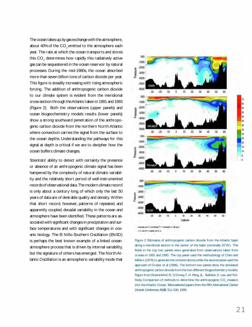
The ocean takes up, by gas exchange with the atmosphere,
about 40% of the CO2 emitted to the atmosphere each
year. The rate at which the ocean transports and stores
this CO2 determines how rapidly this radiatively active
gas can be sequestered in the ocean reservoir by natural
processes. During the mid-1980s, the ocean absorbed
more than seven billion tons of carbon dioxide per year.
This figure is steadily increasing with rising atmospheric
forcing. The addition of anthropogenic carbon dioxide
to our climate system is evident from the meridional
cross-section through the Atlantic taken in 1991 and 1993
(Figure 2). Both the observations (upper panels) and
ocean biogeochemistry models results (lower panels)
show a strong southward penetration of the anthropo-
genic carbon dioxide from the northern North Atlantic
where convection carries the signal from the surface to
the ocean depths. Understanding the pathways for this
signal at depth is critical if we are to decipher how the
ocean buffers climate changes.
Scientists’ ability to detect with certainty the presence
or absence of an anthropogenic climate signal has been
hampered by the complexity of natural climatic variabil-
ity and the relatively short period of well-instrumented
records of observational data. The modern climate record
is only about a century long, of which only the last 50
years of data are of desirable quality and density. Within
that short record, however, patterns of repeated, and
apparently coupled, decadal variability in the ocean and
atmosphere have been identified. These patterns are as-
sociated with significant changes in precipitation and sur-
face temperatures and with significant changes in oce-
anic biology. The El Niño-Southern Oscillation (ENSO)
is perhaps the best known example of a linked ocean-
atmosphere process that is driven by internal variability,
but the signature of others has emerged. The North At-
lantic Oscillation is an atmospheric variability mode that
Figure 2. Estimates of anthropogenic carbon dioxide from the Atlantic basin
along a meridional section in the center of the basin (nominally 20˚W). The
fields in the top two panels were generated from observations taken from
cruises in 1991 and 1993. The top panel used the methodology of Chen and
Millero (1979) to generate the concentrations, while the second panel used the
approach of Gruber et al (1996). The bottom two panels show the simulated
anthropogenic carbon dioxide from the two different biogeochemistry models.
Figure from: Wanninkhof, R., S. Doney, T.-H. Peng, J.L. Bullister, K. Lee, and R.A.
Feely, Comparison of methods to determine the anthropogenic CO2 invasion
into the Atlantic Ocean, Tellus-selected papers from the Fifth International Carbon
Dioxide Conference, 51B, 511-530, 1999.

2 2
T h e P a c i f i c D e c a d a l O s c i l l a t i o nContributed by Nathan Mantua, University of Washington, Seattle
The Pacific Decadal Oscillation is a long-lived El Niño-like pattern of Pacific
climate variability. The two oscillations have similar spatial climate
fingerprints, but very different temporal behavior. Fisheries scientist Steven
Hare coined the term PDO in 1996 while researching connections between
Alaska salmon production cycles and Pacific climate.
During warm phases of PDO, ocean surface temperatures tend to be
anomalously cool in the central North Pacific coincident with unusually
warm temperatures along the west coast of the Americas. PDO sea level
pressure anomalies vary in a wavelike pattern, with warm phases favoring
unusually low pressures over the North Pacific and high pressures over
western North America and the subtropical Pacific. These pressure patterns
cause enhanced counterclockwise wind stress over the North Pacific and
into northwestern North America. By construction, cool PDO climate
anomalies are simply mirror images of warm phase anomalies.
The North American climate anomalies associated with PDO are broadly
similar to those connected with El Niño and La Niña, though generally not
as extreme. Warm phases of PDO are correlated with El Niño-like North
American temperature and precipitation anomalies, while cool phases of
PDO are correlated with La Niña-like climate patterns. PDO variability is
strongly expressed in regional snow pack and stream flow anomalies,
especially in western North America, and may also influence regional patterns
of summer rainfall and drought in the US.
The most striking feature of the PDO is its preferred time scale of variability.
While El Niño-Southern Oscillation (ENSO) events typically persist for 6
to 18 months, 20th century PDO eras have persisted for 20 to 30 years at
a time. Several independent studies find evidence for just two full PDO
cycles in the past century: “cool” PDO regimes prevailed from 1890 to
1924 and again from 1947-1976, while “warm” PDO regimes dominated
from 1925 to 1946 and from 1977 through (at least) the mid-1990’s (bottom
figure). There is evidence that 20th century PDO fluctuations were most
energetic in two broad spectral bands, one in periods from 15 to 25 years,
and the other in periods from 50 to 70 years.
Important changes in Northeast Pacific marine ecosystems have been
correlated with the PDO. For example, warm (cool) PDO phases have
favored high (low) salmon production in Alaska and low (high) salmon
production off the west coast of California, Oregon, and Washington states.
These salmon production cycles are thought to arise from changes in the
coastal ocean environment that alter the dynamics of the entire food web,
including rates of phytoplankton and zooplankton production, species
assemblages, and predator distributions.
Top: A contour map showing gridded October-March averaged
sea surface temperatures regressed on the normalized October-
March PDO index. Solid (dashed) contours depict positive (nega-
tive) SST anomalies in °C.
Bottom: Time series of the normalized October-March PDO in-
dex (filled bars) and annual landings of central and western Alaska
sockeye salmon, plus central and southeast Alaska pink salmon.
These four Alaska salmon subgroups make up about 75% of Alaska's
total annual salmon harvest.
1940 1960 1980 20000
50
100
150
200
mill
ions
cau
ght
PDO index values
0
2
2 Alaska salmon catch
Much controversy now exists over how PDO works, and how
it might best be monitored, modeled and predicted. From a
societal impacts perspective, recognition of PDO is important
because it shows that “normal” climate conditions can change
over time periods comparable to the length of a human’s
lifetime. The stakes in PDO science are high, as an improved
PDO understanding offers even sharper views of the future
than those now provided by ENSO science alone.
References
Mantua, N.J., S.R. Hare, Y. Zhang, J.M. Wallace, and R.C. Francis, A
Pacific decadal climate oscillation with impacts on salmon pro-
duction., Bull. Amer. Meteor. Soc., 78, 1069-1079, 1997.
Zhang, Y., J.M. Wallace, D.S. Battisti, ENSO-like interdecadal vari-
ability: 1900-93, Jour. of Climate, 10, 1004-1020, 1997.

2 3
is associated with significant changes in the ocean, including the rate of deep and intermediate water forma-
tion. A different pattern, the Pacific Decadal Oscillation, is observed in and over the Pacific (see PDO box on
opposite page). Among other large-scale effects, this mode of variability is implicated in the rapid transition
in seasonal climate statistics over much of the northern hemisphere during 1976-77. There is also an indica-
tion that there are interdecadal variations in the amount of sea-ice cover around Antarctica.
The internal oscillations discussed above create climate variability significant enough to complicate and/or
mask climatic variability produced by greenhouse gas emissions. A major challenge to climate scientists today
is to assess the degree to which these forcing mechanisms are controlling our modern climate and the
degree to which man has affected the climate system. To meet this goal, we must study the variability of the
natural (unperturbed by man) global climate, which can be gained by using proxy data from geological records.
Marine sediments extend our very limited historical and instrumental records into the realm of large-scale,
natural climatic variability and reveal scenarios of extreme climate change that are comparable to those
predicted for our immediate future. Marine sediments and their contained biologic remnants are multitrack
recorders of climate and oceanographic change. Geochemical and biotic proxies have been developed to
quantitatively estimate sea-surface temperature change, the fluctuating magnitude of global ice volume, changes
in deep- and surface-water circulation patterns and heat transport, changes in continental aridity, changes in
the intensity and circulation patterns of the atmosphere, and changes in the CO2 content of the atmosphere.
We can make use of the global extent of the marine sedimentary record to develop comprehensive pictures
of past oceanographic conditions and to identify times when both the average state of the climate system and
the boundary conditions of this system were substantially different. Oceanographic and climatic data ob-
tained from the global array of marine sedimentary sections, when combined with the high time-resolution
record of atmospheric composition found in cores from the Greenland and Antarctic ice caps, have begun to
give us insight into the phasing of changes within the climate system.

2 4
W H AT A R E T H E B I G P RO B L E M S ?In light of the urgent need to distinguish between natural climate variability and anthropogenic interference
with the climate system, it is imperative that we understand the interrelationships among carbon, heat and
climate. The ocean is of central importance as scientists seek to determine what balance can be achieved
between mankind’s sources of carbon and nature’s sinks. We need to understand the nature and extent of
the ocean-induced delay in atmospheric warming created by rising CO2 levels. And, we need to understand
the sensitivities of the inherently turbulent, coupled atmosphere-ocean system to anthropogenic interference.
Specific challenges facing ocean scientists are:
What are the l inkages and de lay t imes between carbon and c l imate?
The goal set for the industrialized nations at the 1998 Kyoto meeting of the United Nations Framework
Convention on Climate Change was to achieve a reduction in greenhouse gas emissions to about 5% less
than 1990 levels by 2010. Because our economy, and thus our energy use, has been growing apace in the last
decade, the United States will likely fall short of this target, perhaps by 20% or more. Yet this “Kyoto” goal,
hard though it may be, is only a small start on the road to stabilization. Reasonable calculations of economic
growth show that if it is desired to hold atmospheric CO2 levels at double the pre-industrial concentration
of about 560 ppm, then a deviation from our projected course by about 3.67 billion tons of CO2 per year will
be required by about 2025, and about 15 billion tons per year by about 2050. These are truly enormous
quantities, and achieving this goal could mean costly and radical changes for society. If we can determine with
more certainty the linkages and delay times between carbon and climate, we may be able to adopt a less
radical course. The large-scale variability of surface ocean CO2 distribution has been coarsely mapped. With
the availability of new low-power and low-cost sensors, and the clear definition of surface wind fields, it is
now possible to make rapid progress in constraining the surface fluxes of CO2 with much more rigor.
A better understanding of anthropogenic, centennial and longer changes in climate requires understanding
the processes governing transport by the slow, voluminous, deep-ocean currents that carry climate signals
from the sites of strong air-sea interaction into the ocean’s interior. While the movement of these deep
currents is principally dictated by thermohaline circulation, it is at the sea surface that the ocean interacts
with other elements of the climate system. Because surface ocean properties, which regulate ocean-atmo-
sphere heat, freshwater and carbon dioxide fluxes, are imprinted by the fluctuating short-term climate anomalies,
understanding long-term climate will require improved understanding of how the wind-driven circulation
transports and mixes these properties.
In the ancient oceans it appears that atmospheric CO2 may have played a pivotal role in the warm extremes
of climates when concentrations reached three to four times present-day levels. We currently do not under-
stand exactly how such high levels of CO2 interacted with the oceans and the hydrologic cycle to produce a
tropical climate not greatly different from today’s, and a near-polar climate some 12°C warmer than today’s.
How these conditions developed, how they were maintained and how Earth’s climate eventually returned to
conditions closer to those of present day is one the most perplexing problems of paleoceanography and
paleoclimatology. To address those problems we need a much clearer picture of what these ancient oceans
2 5
were really like. What was their surface circulation like under conditions of weak pole-to-equator thermal
gradients, and what was the vertical structure and mixing in ocean basins with a vertical temperature gradient
that was half that of today’s? To what degree did thermohaline circulation supply the heat needed at higher
latitudes to keep the Arctic and Antarctic largely ice-free, or was an ice-free Arctic a prerequisite for a
warmer climate? The Arctic sea ice in the modern world appears to be gradually thinning and decreasing in
extent and may disappear in summertime altogether in 50 years with large consequences for the radiation
balance at high northern latitudes. These puzzles from the past have immediate modern significance.
What i s requ ired to ach ieve the s tab i l i za t ion o f greenhouse gasconcentrat ions?
Each year the two-way exchange of CO2 gas between air and sea is about 330 billion tons per year; the net
flux of about 7-10 billion tons into the ocean from mankind’s industrial activities is a small fraction of this.
And, each year photosynthesis in the ocean fixes some 180 billion tons of CO2, most of which is very quickly
recycled. It is clear that small changes in these large numbers could have a powerful effect on our planet, and
the basic scientific knowledge of what keeps these fluxes in check is an essential goal if we are to understand
what is required to achieve stabilization of greenhouse gas concentrations. Ocean science can provide much
of this critical knowledge by better constraining the surface fluxes of CO2 (as noted above).
The linkage of biogeochemical cycles and the biological carbon pump with the overturning of water masses
to form deep water is a classic problem that is critical to a better understanding of carbon cycling within the
ocean. We are entering an era of new understanding of the statistics of this process. We now recognize early
warning signs of processes that lead to the deep convection events which ventilate the oceanic depths.
A technological aid to achieving the stabilization of greenhouse gas concentrations may be required in addi-
tion to conservation efforts and the development of alternate energy sources. Because the oceans are the
largest active reservoir of carbon in stored and dissolved form, they are often considered the appropriate
repository for the excess that humans produce. Pilot experiments that either enhance the biological carbon
pump or directly inject anthropogenic CO2 into the deep ocean have already been successfully carried out.
We should more fully explore these options and be open to the development of other such techniques of
carbon sequestration.
What cou ld create abrupt c l imate change?
Within the paleoceanographic records there is clear evidence of rapid regime shifts that can take place within
a few decades and then persist for centuries. The origin of these shifts is uncertain but both changes of the
thermohaline overturning circulation and of the tropical circulation have been suggested as mechanisms.
Climate records from deep-sea cores show that the current deep-water formation pattern in the North
Atlantic can change within an average human life span, and has done so in concert with great episodes of
climate change in the past. Such past rapid shifts in climate are seen not only in the North Atlantic and in the
proxy data for temperatures over Greenland, but also in the indicators of the degree of oxygenation of
2 6
shallow intermediate waters in the North Pacific. Thus, these rapid climate shifts are at least hemispheric, and
probably global, in extent (see Rapid Climate Change box on opposite page). Sophisticated climate models
project that a rapid collapse of thermohaline circulation is possible as a result of the changed hydrologic
regime from global warming, with fresh water stabilization of the upper layers. We need to determine the
likelihood of such an event as a function of anthropogenic forcing.
In the more distant past, during a warm episode of climate, a very large and abrupt shift in climate has been
well-documented. In this case the abrupt shift to an even warmer climate is believed to have resulted from a
near-catastrophic destabilization of gas hydrates and release of large volumes of biogenic greenhouse gases
that had accumulated in marine sediments (see Global Warming box on page 28). There are some indications
that other such rapid releases of greenhouse gases may have induced abrupt climate changes at other times
in the geologic past. Thus, there may be at least two (and possibly more) mechanisms by which abrupt climate
change can occur–one driven by the hydrologic regime and one driven by atmospheric composition. Both
seem to be linked to the oceanic part of the climate system and its passage through some critical threshold.
The nature of these shifts in terms of their impact and the sequence of events leading up to them must be
documented in the multi-proxy paleoceanographic records. With this independent evidence in hand we can
more confidently evaluate climatic models that attempt to recreate such rapid climate shifts.
How can we pred ic t c l imate var i ab i l i t y ?
Looking to the future, there are a number of ocean processes that must be better studied if we are to
understand and predict climate variability and change. These include: (1) ENSO and other coupled ocean-
atmosphere phenomena in the tropics that have an impact on global climate on interannual time scales, (2)
patterns of slower decadal variability, of which the North Atlantic Oscillation and the Pacific Decadal Oscil-
lation are the best known examples, (3) slower changes of the thermohaline circulation, (4) abrupt climate
change and the interplay among atmospheric, surface ocean and deep ocean circulation involved in such
changes, (5) the role of sea-ice cover and fresh water influx into the Arctic region on the climate-ocean
circulation connection and (6) processes in the ocean, such as CO2 sequestration, that affect possible anthro-
pogenic climate change.
A prediction of our climatic evolution hinges on our understanding of the coupled ocean-atmosphere dy-
namical modes that are active in decade-to-century climate variability. El Niño-Southern Oscillation theory,
observation and computer modeling provide a dramatic and important success story in ocean-atmosphere
science (see ENSO box on page 40). The atmospheric tropical wind field responds to ocean surface tem-
perature, and it also alters the ocean temperature through its control over mixing by wind, air-sea heat flux
and upwelling. Yet the oceanic thermocline has its own dynamics involving long-wave propagations and trans-
port by equatorial ocean currents. The two interact to produce an oscillation that is so clearly discernible in
theory and models that it proves useful in climate predictions.
Outside of the tropics, climate variability is also strong and important in its impact on human activity. The
nature of ocean-atmosphere coupling is more complex there, however. Over short time scales the atmo-
sphere takes the initiative, for example, driving deep convection downwind of the continents where cold
winds blow over warm ocean. The ocean has its own natural oscillations, particularly at very low frequency.
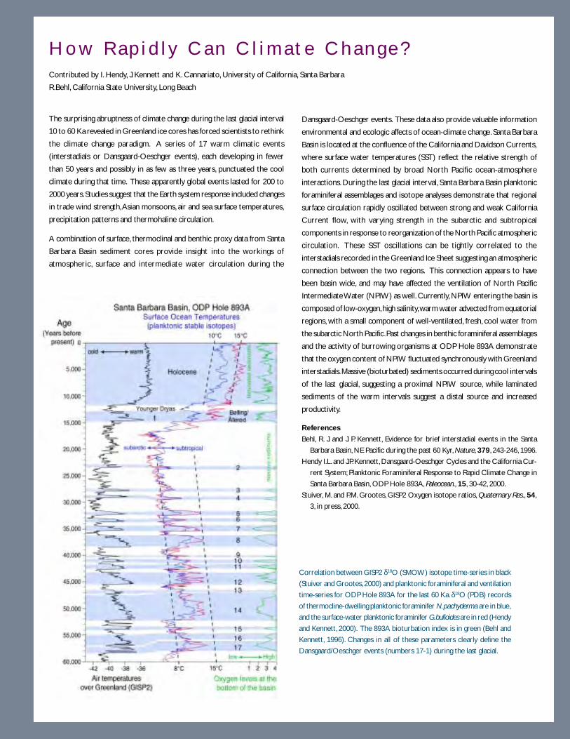
2 7
H o w R a p i d l y C a n C l i m a t e C h a n g e ?Contributed by I. Hendy, J. Kennett and K. Cannariato, University of California, Santa Barbara
R.Behl, California State University, Long Beach
The surprising abruptness of climate change during the last glacial interval
10 to 60 Ka revealed in Greenland ice cores has forced scientists to rethink
the climate change paradigm. A series of 17 warm climatic events
(interstadials or Dansgaard-Oeschger events), each developing in fewer
than 50 years and possibly in as few as three years, punctuated the cool
climate during that time. These apparently global events lasted for 200 to
2000 years. Studies suggest that the Earth system response included changes
in trade wind strength, Asian monsoons, air and sea surface temperatures,
precipitation patterns and thermohaline circulation.
A combination of surface, thermoclinal and benthic proxy data from Santa
Barbara Basin sediment cores provide insight into the workings of
atmospheric, surface and intermediate water circulation during the
Dansgaard-Oeschger events. These data also provide valuable information
environmental and ecologic affects of ocean-climate change. Santa Barbara
Basin is located at the confluence of the California and Davidson Currents,
where surface water temperatures (SST) reflect the relative strength of
both currents determined by broad North Pacific ocean-atmosphere
interactions. During the last glacial interval, Santa Barbara Basin planktonic
foraminiferal assemblages and isotope analyses demonstrate that regional
surface circulation rapidly oscillated between strong and weak California
Current flow, with varying strength in the subarctic and subtropical
components in response to reorganization of the North Pacific atmospheric
circulation. These SST oscillations can be tightly correlated to the
interstadials recorded in the Greenland Ice Sheet suggesting an atmospheric
connection between the two regions. This connection appears to have
been basin wide, and may have affected the ventilation of North Pacific
Intermediate Water (NPIW) as well. Currently, NPIW entering the basin is
composed of low-oxygen, high salinity, warm water advected from equatorial
regions, with a small component of well-ventilated, fresh, cool water from
the subarctic North Pacific. Past changes in benthic foraminiferal assemblages
and the activity of burrowing organisms at ODP Hole 893A demonstrate
that the oxygen content of NPIW fluctuated synchronously with Greenland
interstadials. Massive (bioturbated) sediments occurred during cool intervals
of the last glacial, suggesting a proximal NPIW source, while laminated
sediments of the warm intervals suggest a distal source and increased
productivity.
References
Behl, R. J. and J. P. Kennett, Evidence for brief interstadial events in the Santa
Barbara Basin, NE Pacific during the past 60 Kyr, Nature, 379, 243-246, 1996.
Hendy I.L. and J.P. Kennett, Dansgaard-Oeschger Cycles and the California Cur-
rent System; Planktonic Foraminiferal Response to Rapid Climate Change in
Santa Barbara Basin, ODP Hole 893A, Paleocean., 15, 30-42, 2000.
Stuiver, M. and P.M. Grootes, GISP2 Oxygen isotope ratios, Quaternary Res., 54,
3, in press, 2000.
Correlation between GISP2 δ18O (SMOW) isotope time-series in black
(Stuiver and Grootes, 2000) and planktonic foraminiferal and ventilation
time-series for ODP Hole 893A for the last 60 Ka. δ18O (PDB) records
of thermocline-dwelling planktonic foraminifer N. pachyderma are in blue,
and the surface-water planktonic foraminifer G. bulloides are in red (Hendy
and Kennett, 2000). The 893A bioturbation index is in green (Behl and
Kennett, 1996). Changes in all of these parameters clearly define the
Dansgaard/Oeschger events (numbers 17-1) during the last glacial.
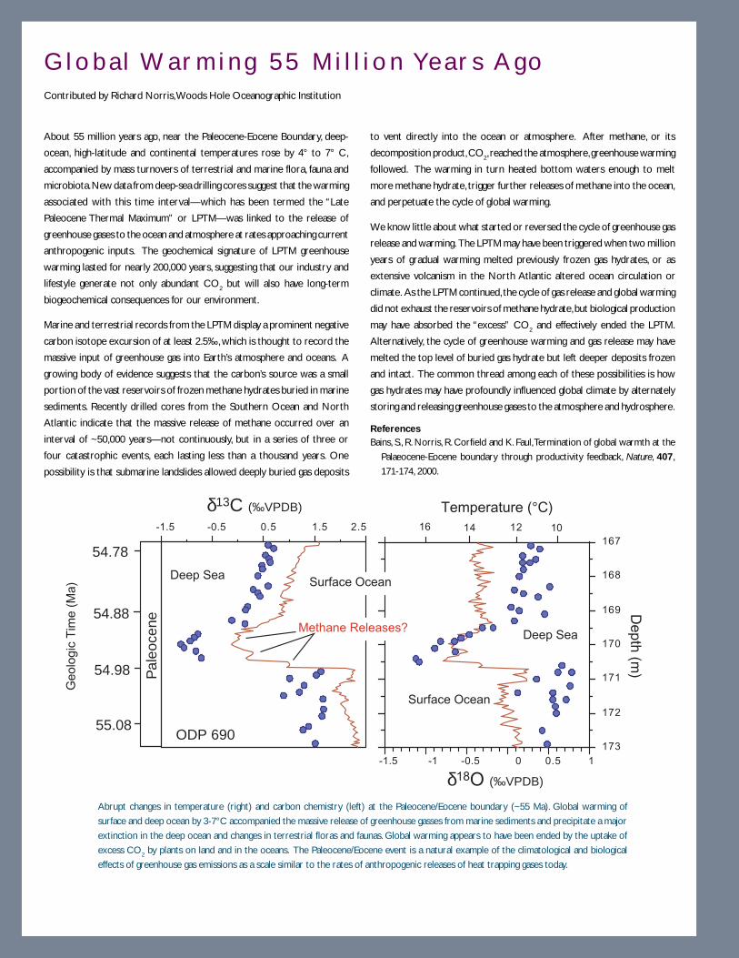
2 8
G l o b a l Wa r m i n g 5 5 M i l l i o n Ye a r s A g oContributed by Richard Norris, Woods Hole Oceanographic Institution
About 55 million years ago, near the Paleocene-Eocene Boundary, deep-
ocean, high-latitude and continental temperatures rose by 4° to 7° C,
accompanied by mass turnovers of terrestrial and marine flora, fauna and
microbiota. New data from deep-sea drilling cores suggest that the warming
associated with this time interval—which has been termed the “Late
Paleocene Thermal Maximum” or LPTM—was linked to the release of
greenhouse gases to the ocean and atmosphere at rates approaching current
anthropogenic inputs. The geochemical signature of LPTM greenhouse
warming lasted for nearly 200,000 years, suggesting that our industry and
lifestyle generate not only abundant CO2 but will also have long-term
biogeochemical consequences for our environment.
Marine and terrestrial records from the LPTM display a prominent negative
carbon isotope excursion of at least 2.5‰, which is thought to record the
massive input of greenhouse gas into Earth’s atmosphere and oceans. A
growing body of evidence suggests that the carbon’s source was a small
portion of the vast reservoirs of frozen methane hydrates buried in marine
sediments. Recently drilled cores from the Southern Ocean and North
Atlantic indicate that the massive release of methane occurred over an
interval of ~50,000 years—not continuously, but in a series of three or
four catastrophic events, each lasting less than a thousand years. One
possibility is that submarine landslides allowed deeply buried gas deposits
to vent directly into the ocean or atmosphere. After methane, or its
decomposition product, CO2, reached the atmosphere, greenhouse warming
followed. The warming in turn heated bottom waters enough to melt
more methane hydrate, trigger further releases of methane into the ocean,
and perpetuate the cycle of global warming.
We know little about what started or reversed the cycle of greenhouse gas
release and warming. The LPTM may have been triggered when two million
years of gradual warming melted previously frozen gas hydrates, or as
extensive volcanism in the North Atlantic altered ocean circulation or
climate. As the LPTM continued, the cycle of gas release and global warming
did not exhaust the reservoirs of methane hydrate, but biological production
may have absorbed the “excess” CO2 and effectively ended the LPTM.
Alternatively, the cycle of greenhouse warming and gas release may have
melted the top level of buried gas hydrate but left deeper deposits frozen
and intact. The common thread among each of these possibilities is how
gas hydrates may have profoundly influenced global climate by alternately
storing and releasing greenhouse gases to the atmosphere and hydrosphere.
ReferencesBains, S., R. Norris, R. Corfield and K. Faul, Termination of global warmth at the
Palaeocene-Eocene boundary through productivity feedback, Nature, 407,
171-174, 2000.
-1.5 -1 -0.5 0 0.5 1
16 12 10-1.5 -0.5 0.5 1.5 2.5167
168
169
170
171
172
173
Pal
eoce
ne
δ13C (‰VPDB)
δ18O (‰VPDB)
14
Temperature (°C)
Depth
(m)
Methane Releases?Deep Sea
Surface Ocean
Deep SeaSurface Ocean
Ge
olo
gic
Tim
e (
Ma
)
54.98
54.88
54.78
55.08ODP 690
Abrupt changes in temperature (right) and carbon chemistry (left) at the Paleocene/Eocene boundary (~55 Ma). Global warming of
surface and deep ocean by 3-7°C accompanied the massive release of greenhouse gasses from marine sediments and precipitate a major
extinction in the deep ocean and changes in terrestrial floras and faunas. Global warming appears to have been ended by the uptake of
excess CO2 by plants on land and in the oceans. The Paleocene/Eocene event is a natural example of the climatological and biological
effects of greenhouse gas emissions as a scale similar to the rates of anthropogenic releases of heat trapping gases today.

2 9
Feedback of sea-surface temperature fluctuations on the atmosphere is weaker and more subtle than the
tropics. Computer models and simplified box models suggest that oscillations of the ocean can happen with
a variety of periods, from a few decades to thousands of years. Such oscillating ocean circulations can be
excited by the random excitation of the atmosphere, or they can develop two-way feedbacks that make them
truly coupled modes. The Antarctic circumpolar wave is such a mode, with a period of about ten years. It
apparently develops when changes in winds cause changes in north-south movement of the upper ocean
thermal structure, which in turn feeds back, shifting the pattern of westerly winds.
The North Atlantic Oscillation (NAO) involves the tracks of storms in the northern Atlantic, and their
intensity. It has a great impact on temperature and rainfall in the eastern US and Europe, and fisheries in the
northern Atlantic (see Figure 5, page 41). In the 25 years after 1971, the strongly positive NAO has driven
deep, cold convection in the northern Atlantic, which has affected the pattern of oceanic meridional over-
turning. The NAO operates over a vast range of time scales, from a few days to a century or longer. Its impact
is significant in surprising places, for example, river flow and drought cycles in the Tigris-Euphrates river
system in the Middle East, and the occurrence of cold-air outbreaks in the central US. The Pacific Decadal
Oscillation (PDO) describes cycles with a period of 20 to 60 years (the duration of a cold or warm phase
being one-half the period) and has a direct impact on salmon migration and US weather (see PDO box on
page 22).
Despite the presence of modes of oscillation such as NAO and PDO in computer models, it is not yet known
how much feedback is involved. Within the atmosphere, the tendency of Rossby waves to be deflected by
NAO-related wind fields argues for an atmosphere-only oscillator, and passive response of the ocean. Yet, the
broad range of periods observed in the NAO argues that the ocean may be active at the decade-to-century
time scale. Interaction between the Arctic and Atlantic oceans is particularly apparent at decadal time scales.
Whether or not coupled ocean/atmosphere dynamics is important to these climate modes, and whether or
not they are forced by greenhouse gases, their strength and pattern structure provide new paradigms for
global change. The strong oceanic activity within this domain argues for intense examination of their dynamics.
Efforts to extend into the future the detailed records of oscillations in the oceans and in Earth’s climate
system should go hand-in-hand with efforts to extend them into the past. In the past two decades the
development of proxy records of past climate change with seasonal to annual resolution has shown that
oscillations such as those associated with ENSO can be traced back hundreds and even thousands of years.
This effort is still growing. It is not an easy task to tie the spectrum of climate variability in one place to that
of another because there are marked regional differences in the response of the climate system to these
oscillations. An important opportunity awaits us in the next decade to increase our fundamental understand-
ing of the physical character of these oscillations, to obtain and develop proxy records of these oscillations,
and to evaluate their long-term spectral character and stability. An increased fundamental understanding of
these oscillations and their influence on global climate will be derived from defining their character through
time and determining the spectral interplay between these oscillations under differing boundary conditions.
3 0
What are the pathways for c l imate s i gna l s in the ocean?
While the current sites of deep convection are largely known, a quantitative understanding of the pathways
and rates of the warm-to-cold conversion of water is needed to assess the ocean’s sensitivity to climate
events. Thermohaline circulation’s rate, volume and properties are all affected by the processes that control
convection. Although in models it is salinity that causes the greatest changes in the thermohaline circulation,
previous focus in understanding the thermohaline circulation has been on thermal forcing, rather than on
freshwater, presumably because the source-sink distribution of heat is much better known. Although essen-
tial to understanding modulation of convection, knowledge of freshwater inputs from continents, precipita-
tion and melting sea-ice is particularly lacking. Tracers, such as oxygen isotopes, can be invaluable in gaining
this knowledge. Also necessary to understanding the hydrologic cycle is knowledge of how river runoff in the
Arctic influences the surface waters of the Atlantic and Pacific, and ultimately the thermohaline circulation. To
improve our understanding of the role of the hydrologic cycle in the climate, an improved knowledge of the
rates, pathways, storage and redistribution of water in all its phases will be necessary.
This assessment will require better observations of the air-sea exchanges of heat and freshwater and it will
require that all available ocean and meteorology data be integrated into global models. It will also require us
to obtain and decipher paleoceanographic records from the highest latitudes of the northern and southern
hemisphere such as the Arctic Ocean and the southern Weddell and Ross Seas.
The rates and pathways by which surface waters move from areas of air-sea interaction into the deep ocean
and then back to the surface are also essential to understanding the ocean’s role in climate. These processes
involve most elements of the general circulation including meridional overturning, subduction, convection,
western boundary currents (and their interaction with the interior through recirculation), and the diapycnal
mixing that returns deep waters to the surface. These same processes control the geochemical recycling of
nutrients that have a direct impact on the biologic productivity of the oceans and the very structure of the
oceanic food web from its primary producers to the high-level predators. Traditional analyses based on
temperature and salinity will continue to be important in diagnosing these processes, but geochemical trac-
ers are particularly useful in providing estimates of water-mass age (see Tracer Release box on page 57) and
in quantifying diapycnal mixing, while direct velocity observations are needed both in concentrated boundary
currents and the ocean interior.
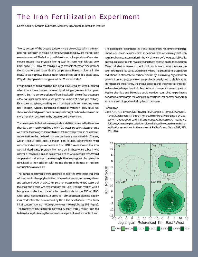
3 1
Day 158
0.51.0
1.5 2.02.5
3.0
Day 151
0.3
0.2-15
-10
-5
0
5
10
15Day 153
-15 -10 -5 0 5 10 15 -10 -5 0 5 10 15-15
-10
-5
0
5
10
0.5-1.0< 0.5 1.0-1.5 1.5-2.0 2.0-2.5 2.5-3.0 >3.0
Day 155
0.51.0
2.0
2.5
1.5
Lagrangian Referenced Km. East / West
0.20.3 0.4
0.5
1.0
Km
. N
orth
/ Sou
th
T h e I r o n F e r t i l i z a t i o n E x p e r i m e n tContributed by Kenneth S. Johnson, Monterey Bay Aquarium Research Institute
Twenty percent of the ocean’s surface waters are replete with the major
plant nutrients such as nitrate, but few phytoplankton grow and the nutrients
are not consumed. The lack of growth has important implications. Computer
models suggest that phytoplankton growth in these High Nitrate, Low
Chlorophyll (HNLC) areas could pull large amounts of carbon dioxide from
the atmosphere and lower Earth’s temperature. Plankton blooms in the
HNLC areas may have been a major force driving Earth into glacial ages.
Why do phytoplankton not grow in HNLC waters today?
It was suggested as early as the 1920s that HNLC waters were produced
when iron, a trace nutrient required by all living organisms, limited plant
growth. But, the concentrations of iron dissolved in the surface ocean are
a few parts per quadrillion (a few parts per million of a part per million).
Early oceanographers, working from iron ships with iron sampling wires
and iron gear, invariably contaminated samples with iron. They could not
show iron-limited growth because samples brought on board contained far
more iron than occurred in the unperturbed environment.
The development of ultra-trace analytical capabilities pioneered by the ocean
chemistry community clarified the HNLC water paradox. Measurements
with these technologies demonstrated that iron was present in much lower
concentrations than believed. Iron was particularly low in the HNLC areas,
which receive little dust, a major iron source. Experiments with
uncontaminated samples of seawater from HNLC areas showed that iron
would, indeed, cause phytoplankton to grow in these waters, but it was
unclear if these results could be extrapolated to whole ecosystems. Would
zooplankton that avoided the sampling bottles simply graze phytoplankton
stimulated by iron addition with no net change in biomass or nutrient
consumption as a result?
The IronEx experiments were designed to test the hypothesis that iron
addition would allow phytoplankton biomass to increase, consuming nitrate
and carbon dioxide. A 10x10 km patch of ocean in the HNLC waters of
the equatorial Pacific was fertilized with 400 kg of iron and marked with a
few grams of the inert tracer sulfur hexafluoride on day 150 of 1995.
Chlorophyll concentrations, a proxy for phytoplankton biomass, rapidly
increased within the area marked by the sulfur hexafluoride tracer from
initial concentrations of <0.2 mg/L to values >3.0 mg/L by day 158 (Figure).
The biomass of phytoplankton increased by more than 2 million kg in the
fertilized area, illustrating the tremendous impact of small amounts of iron.
The ecosystem response to the IronEx experiment has several important
impacts on ocean sciences. First, it demonstrates conclusively that iron
regulates biomass accumulation in the HNLC waters of the equatorial Pacific.
Subsequent experiments have extended these conclusions to the Southern
Ocean. Modest increases in the flux of dust borne iron to the ocean, as
seen in Antarctic ice cores, would clearly have the potential to create large
reductions in atmospheric carbon dioxide by stimulating phytoplankton
growth. Iron and phytoplankton are probably closely tied to glacial cycles.
Perhaps more importantly, the IronEx experiments show the potential for
well-controlled experiments to be conducted on open-ocean ecosystems.
Marine chemists and biologists could conduct controlled experiments
designed to disentangle the complex interactions that control ecosystem
structure and biogeochemical cycles in the ocean.
References
Coale, K. H., K. S. Johnson, S. E. Fitzwater, R. M. Gordon, S. Tanner, F. P. Chavez, L.
Ferioli, C. Sakamoto, P. Rogers, F. Millero, P. Steinberg, P. Nightingale, D. Coo-
per, W. P. Cochlan, M. R. Landry, J. Constantinou, G. Rollwagen, A. Trasvina and
R. Kudela, A massive phytoplankton bloom induced by ecosystem-scale iron
fertilization experiment in the equatorial Pacific Ocean, Nature, 383, 495-
501, 1996.
3 2
W H AT M A K E S P RO G R E S S P O S S I B L E N OW ?There have been major advances in the past few decades in our ability to observe the ocean and to delineate
the processes that both control circulation and have an impact on global climate. We have been able to
recover and decipher records of past climate states and to begin to evaluate the natural variability of the
climate system. Our improved understanding of the present and past climate systems and enhanced com-
puter technology have placed us on the threshold of new discovery. Some of the steps that have brought us
to this threshold include:
• A succession of successful field programs. Measurements made primarily through the World Ocean
Circulation Experiment (WOCE) have resulted in the recent compilation of global data sets of temperature,
salinity, velocity and various tracers. Collectively, these data sets have given oceanographers an unprecedented
view of the contemporary ocean circulation. The success of the Joint Global Ocean Flux Study (JGOFS)
and WOCE programs in the 1990s has created the first two decadal time series of CO2 in the oceans. The
global survey of CO2 in the oceans, carried out with unprecedented accuracy by scientists of many nations,
has been completed and allows us to place calculations of the oceanic transport of heat and CO2 on the
same observational and theoretical basis.
• Satellite observations. Within the last decade polar orbiting satellites observing the ocean have become
a reality, providing global coverage of critical properties every few days. The Topex-Poseidon radar altimetric
mission provides sea surface height, from which changing ocean dynamics can be observed. The SeaWIFS
sensor provides ocean color at several wavelengths. The successful launch of the NASA Terra satellite adds
to this observing power. It is now possible to study in near real time the fluctuations of the great physical
and biogeochemical controls on carbon dioxide around the globe. The use of these data is in its infancy, and
we may expect rapid progress by linking satellite, ship and moored observations in truly innovative ways.
• New observational and measurement technologies. New measurement techniques have made
possible direct observations of diapycnal mixing and basin-scale patterns of absolute velocity, monitoring of
the tropical wind fields that drive the oceanic equatorial waves of ENSO, and significantly improved
measurements and parameterizations of air-sea fluxes. These have already been used to improve theoretical
understanding and numerical models of the ocean’s role in climate.
The rapid development of moored sensors for CO2 and ocean biogeochemical properties has led to the
possibility of time series observations at high latitudes, where climate change effects will be critical. Similarly,
the development of sensors carried on autonomous vehicles allow exploration under the ice, and the
survey of deep water convection events in progress. The increasing sophistication of drifters and floats
have allowed for a novel view of ocean circulation by providing Lagrangian pathways.
3 3
The measurement of 14C, the essential radiochemical clock for deep-sea circulation studies, has been
revolutionized by accelerator-mass spectrometry. Measurements that earlier required 200 liters of seawater
can be made with just 1 liter, in shorter time and at lower cost. Combined with increasingly sophisticated
chemical separation methods, 14C ages are being derived from small amounts of specific organic compounds,
increasing the confidence in this dating method.
Paleoceanographers have devised multiple, independent ways of estimating past temperatures in the oceans,
circulation pathways of deep ocean waters, and paleo-productivity. They can trace the weathering of the
terrestrial parts of the planet and the delivery of sediments to the oceans via both rivers and winds. They
are even approaching the very difficult problems of estimating paleo-salinity, pH of ocean waters, and CO2
content of the atmosphere in the distant past.
• Successful pilot experiments. A whole new set of bold, innovative and important pilot experiments,
which have now been successfully completed, pave the way for rapid advances. Among these are studies of
the deep Brazil basin (see Tracer Release box on page 57) and the Greenland Sea where the injection of
sulfur hexafluoride (SF6) is used to trace circulation and mixing. Pilot experiments seeding the ocean with
iron resulted in the rapid development of a phytoplankton bloom, strongly drawing down CO2 levels (see
Iron Fertilization box on page 31). By adding SF6 tracer along with iron, the movements of the fertilized
patch could be traced, and the effects of mixing accounted for. Sequestration of CO2 in the deep ocean
could potentially reduce or eliminate the atmospheric residence time, and the climate forcing that
accompanies it. The first small scale pilot studies to explore this process have now been carried out.
• Enhanced predictive capabilities. The Tropical Oceans and Global Atmosphere (TOGA) program has
established both the basic dynamics of ENSO, involving wavelike motions in the oceanic equatorial waveguide
and air-sea latent heat transfer that drive atmospheric convection, and has led to seasonal predictions with
useful skill.
• Innovations in modeling and data assimilation. Until quite recently the problems of useful simulations
of ocean physics and climate were so hard that applications to the carbon cycle were set to one side. It is
now common to carry a full set of CO2 system variables in climate models, and to incorporate not just the
“tracer” fossil fuel CO2 signal, but the full range of ocean biogeochemical cycles. This has lead to useful
predictions of change, which will be tested by innovative experiments.

3 4
W H AT I S R E Q U I R E D F O R P RO G R E S S ?To provide the essential information that society needs to make wise choices for its future, we need to create
a coherent ocean climate program. Such a program should advance our understanding of physical oceanogra-
phy, paleoceanography and the ocean carbon cycle.
• Continued observation and understanding of the ocean. The knowledge of climate that we have
today is based upon a background of continuing ocean observations, satellite data streams, assimilation
schemes and numerical models. It is essential that these continue. Without this network, prospects for
more detailed understanding can not be assured.
• Extend the time-series stations. As part of an effort to unravel our evolving climate, we should create
the next generation of observing programs. Because we cannot observe all the ocean at all times, critical
choices must be made. The only two existing time series stations at Bermuda and Hawaii (see HOTS box
on page 50) provide essential data, and must be maintained. But the extension of time series capability to
a significant number of climate critical locations, such as the far North Atlantic, is needed in order to
capture the early signals of climate change. This will require the innovative extension of mooring and
sensor technology.
• Support satellite and ship-based observations. The full impact of near real-time satellite observations
on experimental planning has yet to be felt, yet the intelligent folding of these two observational modes has
the potential to revolutionize carbon and climate studies. In particular, the ability to capture deep-water
formation events as they unfold is critical. The development of modern autonomous underwater vehicles,
which can adapt to events, has provided an important new dimension to the efficient solution of these
problems.
• Enhance ocean modeling, data assimilation and theory. Large-scale numerical models of the ocean
are the essential tools for casting the results of theory and observations into rigorous form. A period of
fertile interaction of experiment, theory, data and modeling is needed in order to make significant progress
in our understanding of the climate system. For example, the real ocean contains energetic, small-scale
eddy features that can not be explicitly resolved in models, however, these features often dominate the
scale of observations made from ships. Ocean experiments can rarely obtain volume closure, and questions
on the boundary conditions continue to plague numerical simulations.
3 5
• Obtain high-resolution records of past climates. Certain areas of high sediment-accumulation rate
contain detailed records of climate that can provide information on oceanographic conditions such as
temperature, salinity and biologic productivity in a wide array of geographic locations. Similarly, coral growth
bands and growth bands of long-lived mollusks provide oceanographic records with seasonal to annual
resolution. These records can extend our understanding of natural oscillations in the ocean system back
thousands of years. Although they may not provide as detailed a view of the world ocean as a global ocean
observing system might give us in the future, the records of the past already exist and await our efforts to
gather and interpret them. To obtain long, high-resolution sediment records there is a basic need for a long
piston-coring capability. In some areas where sections are very thick and thus have very high time resolution,
access to dynamically positioned, deep-water drillships and mission-specific drilling platforms will be required.
• Obtain records of extreme climates of the past. Our knowledge of Earth’s climate system during
extreme warm times is inadequate; the availability of samples is sufficient only to tell us that such conditions
existed. Samples indicate an ice-free Arctic and Antarctic, and thermal gradients in the ocean which were
generally half that of modern times. The exact nature of tropical climates during such warm times, however,
is a matter of debate. The impact of such a diminished gradient on wind-driven circulation has yet to be
documented, and the nature of thermohaline circulation has not been firmly established. Thus, we are
uncertain as to the mechanisms that maintain heat transport from low to high latitudes in such warm times
or that diminish radiative losses in high latitudes. We know little of the vertical stability of the ocean in such
warm times or the effect that the potential changes in the stability structure of the upper ocean might have
on ecosystems. The need for drilling platforms is particularly acute for sampling older parts of the geologic
records when these extreme warm climates existed.
• Develop new paleoceanographic proxies. Over the past few decades we have learned that a multiple-
proxy approach to describing paleoceanographic and paleoclimatic conditions is essential to extracting a
reliable record of past climates. We also need geochemical and biotic proxies for as many climatic and
oceanographic variables as possible. The more completely we can describe past conditions the more
certain we are of our interpretations. For example, recently developed approaches to evaluating past CO2
concentrations of the atmosphere show great promise in linking atmospheric and oceanic environments of
the past. We must continue to develop innovative approaches to the quantitative estimation of past
climatic and oceanographic conditions. These proxies are often expressed as variations in elemental,
isotopic or molecular composition in various organic and inorganic phases. Hence, progress may well be
dependent on a better understanding of the basic physiological and chemical processes that create and
preserve these phases.
3 6
• Develop and employ “whole system” climate models that are capable of predicting long-
term (centennial scale) climate change. Anthropogenic effects are, in present-day models at least,
capable of producing changes comparable in magnitude and rapidity to those seen in paleoceanographic
records. Study of response to anthropogenic forcing and of the dynamics of natural climate changes on
centennial time scales is needed for scientific and national security reasons. These studies will differ from
work on shorter time-scale variability in two substantial ways. First, the phenomena involve the full water
column, whereas interannual and decadal variability are largely upper ocean phenomena. Second, we cannot
rely on future observations to verify our methods of prediction because we cannot afford to wait that long.
Thus in order to be useful, understanding in this area must be incorporated into models and those models
must be tested thoroughly. There are two distinct approaches to such testing: (1) apply the models to the
prediction of similar, but more rapidly evolving, phenomena, and (2) apply the models to oceanographic
conditions of the past. Such hindcasting makes use of the paleoceanographic records that exist in the deep
sea and can be recovered by ocean drilling and coring.
• Extend the perturbation experiments. The successful execution of tracer, iron-enrichment and CO2-
injection experiments has been a great stimulus to the ocean sciences. Important new results on the rate
of ocean mixing, on fundamental controls on biogeochemical cycles, and on the realities of plans for carbon
sequestration have rapidly emerged from these efforts. The adoption of these techniques, and the
development of new classes of perturbation experiments has the potential to radically change our science.
• Assess the sequestration option. The topic of carbon sequestration, either through iron fertilization
or direct disposal, is perhaps the most controversial in all of the challenges facing ocean scientists and
society. To put it bluntly, we know far too little to make any useful scientific judgement at this time, yet
answers may be required quite soon. Apart from cost and engineering concerns, the basic chemistry,
physics and biology associated with large-scale iron fertilization or releases of CO2 in the deep sea are not
well-known. While we can make sophisticated calculations of the fate of plant cells, of the dissolution of
deep-sea calcium carbonate, of the circulation paths of a tracer, of the physical chemistry of hydrate formation
or the effects of impurities in the injected material, and even the effects of low pH-high pCO2 on marine
animals, putting all of the effects into the context of carbon sequestration is a huge challenge.

3 7
L O N G - T E R M O C E A N
O B S E R V A T I O N S A N D P R E D I C T I O N
The 1.2 billion cubic kilometers of ocean on Earth encompass resources, ecosystems and a massive piece of
the dynamical climate system. To understand and predict the changing ocean, there is great need to capture
in detail its baseline physical, biological, chemical and geological properties. The strict oceanic analog of
weather forecasting would be to predict the amplification and decay of oceanic mesoscale eddies, tides and
wind-waves. While these events are relevant because of their impact on marine resource management and
ship movement, ocean prediction spans a much wider range, from climate changes involving the global ocean
circulation to the adjustment of a marine ecosystem following the introduction of an exotic species.
Looking from the fantail of a research ship across a vast expanse of sea surface, we sense how small are our
efforts to observe and understand the volume of ocean that lies below. Until the 1970s just a handful of
oceanographers were traversing this domain. From underpowered, slow ships they lowered thermometers,
plankton nets and water sampling bottles. While oceanographers now number in the thousands, and modern
observational tools greatly extend our grasp, oceanography remains a “young” science because of the ocean’s
vastness.
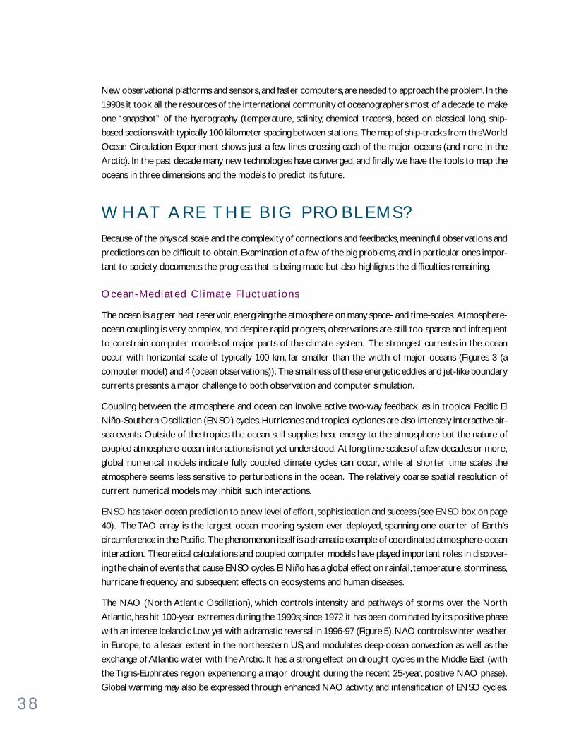
3 8
New observational platforms and sensors, and faster computers, are needed to approach the problem. In the
1990s it took all the resources of the international community of oceanographers most of a decade to make
one “snapshot” of the hydrography (temperature, salinity, chemical tracers), based on classical long, ship-
based sections with typically 100 kilometer spacing between stations. The map of ship-tracks from this World
Ocean Circulation Experiment shows just a few lines crossing each of the major oceans (and none in the
Arctic). In the past decade many new technologies have converged, and finally we have the tools to map the
oceans in three dimensions and the models to predict its future.
W H AT A R E T H E B I G P RO B L E M S ?Because of the physical scale and the complexity of connections and feedbacks, meaningful observations and
predictions can be difficult to obtain. Examination of a few of the big problems, and in particular ones impor-
tant to society, documents the progress that is being made but also highlights the difficulties remaining.
Ocean-Media ted Cl imate F luctuat ions
The ocean is a great heat reservoir, energizing the atmosphere on many space- and time-scales. Atmosphere-
ocean coupling is very complex, and despite rapid progress, observations are still too sparse and infrequent
to constrain computer models of major parts of the climate system. The strongest currents in the ocean
occur with horizontal scale of typically 100 km, far smaller than the width of major oceans (Figures 3 (a
computer model) and 4 (ocean observations)). The smallness of these energetic eddies and jet-like boundary
currents presents a major challenge to both observation and computer simulation.
Coupling between the atmosphere and ocean can involve active two-way feedback, as in tropical Pacific El
Niño-Southern Oscillation (ENSO) cycles. Hurricanes and tropical cyclones are also intensely interactive air-
sea events. Outside of the tropics the ocean still supplies heat energy to the atmosphere but the nature of
coupled atmosphere-ocean interactions is not yet understood. At long time scales of a few decades or more,
global numerical models indicate fully coupled climate cycles can occur, while at shorter time scales the
atmosphere seems less sensitive to perturbations in the ocean. The relatively coarse spatial resolution of
current numerical models may inhibit such interactions.
ENSO has taken ocean prediction to a new level of effort, sophistication and success (see ENSO box on page
40). The TAO array is the largest ocean mooring system ever deployed, spanning one quarter of Earth’s
circumference in the Pacific. The phenomenon itself is a dramatic example of coordinated atmosphere-ocean
interaction. Theoretical calculations and coupled computer models have played important roles in discover-
ing the chain of events that cause ENSO cycles. El Niño has a global effect on rainfall, temperature, storminess,
hurricane frequency and subsequent effects on ecosystems and human diseases.
The NAO (North Atlantic Oscillation), which controls intensity and pathways of storms over the North
Atlantic, has hit 100-year extremes during the 1990s; since 1972 it has been dominated by its positive phase
with an intense Icelandic Low, yet with a dramatic reversal in 1996-97 (Figure 5). NAO controls winter weather
in Europe, to a lesser extent in the northeastern US, and modulates deep-ocean convection as well as the
exchange of Atlantic water with the Arctic. It has a strong effect on drought cycles in the Middle East (with
the Tigris-Euphrates region experiencing a major drought during the recent 25-year, positive NAO phase).
Global warming may also be expressed through enhanced NAO activity, and intensification of ENSO cycles.

3 9
Figure 3. Temperature at the sea surface as mod-
eled by a high-resolution (1/120 grid), layered
model of the Atlantic circulation. Eddies with
diameters of about 100 km dominate the kinetic
energy, along with the warm (red) Gulf Stream
and the cold (blue) jet-like circulations of the
subpolar ocean. It is this rich texture of dynam-
ics that makes ocean prediction challenging. Fig-
ure courtesy of R. Bleck, MICOM project.
http://panoramix.rsmas.miami.edu/micom/
Figure 4. Tracks of drifting buoys
(‘drifters’) on the sea surface,
launched during 1996-1999 by Dr. P.P.
Niiler. These give another view of
the complex ‘fabric’ of the oceans.
Tracks are colored corresponding to
the ‘box’ (dashed lines) they were
launched in. The tracks show intense
eddy activity, superimposed on the
general circulation. Typical duration
of a track is 200 days; the gradual
bleeding of colors from one box to
the next is the way we visualize the
ocean circulation.
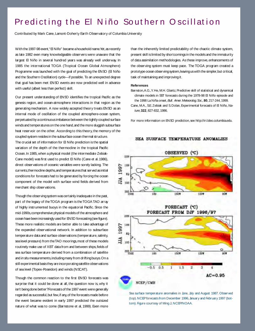
4 0
P r e d i c t i n g t h e E l N i ñ o S o u t h e r n O s c i l l a t i o nContributed by Mark Cane, Lamont-Doherty Earth Observatory of Columbia University
With the 1997-98 event, “El Niño” became a household name. Yet, as recently
as late 1982 even many knowledgeable observers were unaware that the
largest El Niño in several hundred years was already well underway. In
1985 the international TOGA (Tropical Ocean Global Atmosphere)
Programme was launched with the goal of predicting the ENSO (El Niño
and the Southern Oscillation) cycle—if possible. To an unexpected degree
that goal has been met: ENSO events are now predicted well in advance
with useful (albeit less than perfect) skill.
Our present understanding of ENSO identifies the tropical Pacific as the
genesis region, and ocean-atmosphere interactions in that region as the
generating mechanism. A now widely accepted theory treats ENSO as an
internal mode of oscillation of the coupled atmosphere-ocean system,
perpetuated by a continuous imbalance between the tightly coupled surface
winds and temperatures on the one hand, and the more sluggish subsurface
heat reservoir on the other. According to this theory, the memory of the
coupled system resides in the subsurface ocean thermal structure.
The crucial set of information for El Niño prediction is the spatial
variation of the depth of the thermocline in the tropical Pacific
Ocean. In 1985, when a physical model (the intermediate Zebiak-
Cane model) was first used to predict El Niño (Cane et al. 1986),
direct observations of oceanic variables were sorely lacking. The
currents, thermocline depths, and temperatures that served as initial
conditions for forecasts had to be generated by forcing the ocean
component of the model with surface wind fields derived from
merchant ship observations.
Though the observing system was certainly inadequate in the past,
part of the legacy of the TOGA program is the TOGA TAO array
of highly instrumented buoys in the equatorial Pacific. Since the
mid-1990s, comprehensive physical models of the atmosphere and
ocean have been increasingly used for ENSO forecasting (see figure).
These more realistic models are better able to take advantage of
the expanded observational network. In addition to subsurface
temperature data and surface observations (temperature, salinity,
sea level pressure) from the TAO moorings, most of these models
routinely make use of XBT data from and between ships, fields of
sea surface temperature derived from a combination of satellite
and in situ measurements, including many from drifting buoys. On a
still experimental basis they are incorporating satellite observations
of sea level (Topex-Poseidon) and winds (NSCAT).
Though the common reaction to the first ENSO forecasts was
surprise that it could be done at all, the question now is, why it
isn’t being done better? Forecasts of the 1997 event were generally
regarded as successful, but few, if any, of the forecasts made before
the event became evident in early 1997 predicted the outsized
nature of what was to come (Barnstone et al, 1999). Even more
than the inherently limited predictability of the chaotic climate system,
present skill is limited by shortcomings in the models and the immaturity
of data assimilation methodologies. As these improve, enhancements of
the observing system must keep pace. The TOGA program created a
prototype ocean observing system, leaving us with the simpler, but critical,
task of maintaining and improving it.
References
Barnston, A.G., Y. He, M.H. Glantz, Predictive skill of statistical and dynamical
climate models in SST forecasts during the 1978-98 El Niño episode and
the 1998 La Niña onset, Bull. Amer. Meteorolog. Soc., 80, 217-244, 1999.
Cane, M.A., S.E. Zebiak and S. Dolan, Experimental forecasts of El Niño, Na-
ture, 322, 827-832, 1986.
For more information on ENSO prediction, see http://iri.ldeo.columbia.edu.
Sea surface temperature anomalies in June, July and August 1987. Observed
(top). NCEP forecasts from December 1996, January and February 1997 (bot-
tom). Figure courtesy of Ming Ji, NCEP/NOAA.
4 1
Figure 5. The North Atlantic Oscillation (NAO, and its close relative, the
Arctic Oscillation or AO) affect winds, rainfall and temperatures over
much of the northern hemisphere, but particularly the regions bounding
the Atlantic Ocean. In this figure, the Arctic, European and US regions are
shown at extremes of the AO (upper panels are positive extremes, and
lower panels negative extremes). The wintertime (January-March) sea-
level pressure (solid curves), surface air temperature (colors) and pre-
cipitation (numbers, cm/month) show the effect strong, high-latitude
storms and jetstream during the positive phase (above). This phase had a
long period of dominance between 1972 and 1995, bringing with it warmth
and rain to western Europe, cold to eastern Canada and the Labrador
Sea, and increased oceanic flow connecting Arctic and Atlantic. During
the negative phase winter storms track farther south, off the US coast
while northern Europe is colder and drier. Atmosphere-ocean interac-
tion in the NAO is subtle and incompletely understood. Figure courtesy
of David Thompson, Colorado State University.
LH
L
H
11
16
6
10
4
3
3
4
4
2 1
16
9
8 7
4
H
L
L
L
L
H
H
H
19
8
15
12
5
8
H
L
L

4 2
The NAO (as measured by the Iceland-Lisbon sea-level pressure difference) has a broad frequency spectrum
with extreme behavior in the last quarter century. Its predictability purely through time series analysis is not
great, but increasing understanding of its dynamics should increase predictive skill. Among the important
linkages are the remarkably “tall” atmospheric structure of the NAO, which reaches the stratosphere as a
nearly polar-symmetric vortex, and signs of significant response of the atmosphere to the high-latitude SST
perturbations. Paleoclimate time series (tree rings and potentially Greenland ice cores) may provide a much
longer record of the NAO against which to measure predictive variance.
Studies with coupled ocean-atmosphere models suggest that components of the deep ocean circulation have
predictability ranging beyond a decade. Indeed, some branches of the system are well-anchored, and predic-
tion of, say, the spreading of Labrador Sea Water down the deep western boundary current of the Atlantic,
following an intense year of deep convection, is becoming rather straightforward.
Var iab i l i t y o f the Mer id iona l Over turn ing Circu la t ion
The ocean is organized in stable density layers that resist upward or downward flow. This stratification is
perhaps the oceanic property of most importance to life on Earth, for it limits the upwelling of nutrient-rich
deep waters to the sunlit upper layers. There are several key aspects of density-driven circulation that are
inadequately understood and difficult to model: (1) Where are the main areas of deep-water return and what
controls the rate of return? (2) How do we appropriately model a system that may have highly variable
seasonal pulses of supply and yet may take hundreds of years to complete a circuit of circulation and (3) How
are the present apparent changes in climate affecting this crucial system?
The ocean circulates in nearly horizontal gyres and jets, partially driven by winds, and in “up-down and north-
south” concentrated arteries juxtaposed with much broader drifts of global scale. Sinking regions are few, yet
where does the water rise? There is a tendency for fluids heated and cooled from above to rise broadly while
-2.0 -1.5 -1.0 -0.5Group Mean Change
-2.1
-0.9-0.3-0.3-1.0
-1.3
-0.6-0.7
-1.1-0.6 -0.5
-0.2
-2.3 -1.6 -2.0-1.2
-1.4
-1.6
-1.7-1.5
-1.1-2.3-2.2
-1.5-2.1-1.5 -0.4
-1.0
-2.6
70 N 80 N
0 E
Chukchi
Beaufort Canada
PoleNansen
Eastern
Figure 6. Changes in mean sea-ice thickness
between 1958-1976 and 1993-1997 (meters).
The mean thinning of the Arctic ice is about
40%. While not unequivocally a result of
greenhouse-gas induced global warming, it is
a striking change in Arctic climate. Figure is
from Rothrock, D.A., Y. Yu and G.A. Maykut,
Thinning of Arctic sea-ice cover, Geophys. Res.
Lett., 26, 3469-3472, 1999.
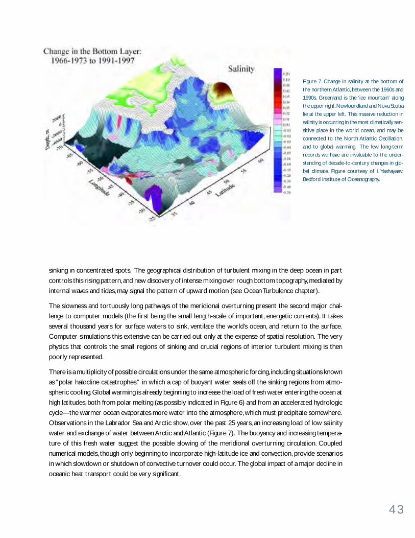
4 3
sinking in concentrated spots. The geographical distribution of turbulent mixing in the deep ocean in part
controls this rising pattern, and new discovery of intense mixing over rough bottom topography, mediated by
internal waves and tides, may signal the pattern of upward motion (see Ocean Turbulence chapter).
The slowness and tortuously long pathways of the meridional overturning present the second major chal-
lenge to computer models (the first being the small length-scale of important, energetic currents). It takes
several thousand years for surface waters to sink, ventilate the world’s ocean, and return to the surface.
Computer simulations this extensive can be carried out only at the expense of spatial resolution. The very
physics that controls the small regions of sinking and crucial regions of interior turbulent mixing is then
poorly represented.
There is a multiplicity of possible circulations under the same atmospheric forcing, including situations known
as “polar halocline catastrophes,” in which a cap of buoyant water seals off the sinking regions from atmo-
spheric cooling. Global warming is already beginning to increase the load of fresh water entering the ocean at
high latitudes, both from polar melting (as possibly indicated in Figure 6) and from an accelerated hydrologic
cycle—the warmer ocean evaporates more water into the atmosphere, which must precipitate somewhere.
Observations in the Labrador Sea and Arctic show, over the past 25 years, an increasing load of low salinity
water and exchange of water between Arctic and Atlantic (Figure 7). The buoyancy and increasing tempera-
ture of this fresh water suggest the possible slowing of the meridional overturning circulation. Coupled
numerical models, though only beginning to incorporate high-latitude ice and convection, provide scenarios
in which slowdown or shutdown of convective turnover could occur. The global impact of a major decline in
oceanic heat transport could be very significant.
Figure 7. Change in salinity at the bottom of
the northern Atlantic, between the 1960s and
1990s. Greenland is the ‘ice mountain’ along
the upper right. Newfoundland and Nova Scotia
lie at the upper left. This massive reduction in
salinity is occurring in the most climatically sen-
sitive place in the world ocean, and may be
connected to the North Atlantic Oscillation,
and to global warming. The few long-term
records we have are invaluable to the under-
standing of decade-to-century changes in glo-
bal climate. Figure courtesy of I. Yashayaev,
Bedford Institute of Oceanography.
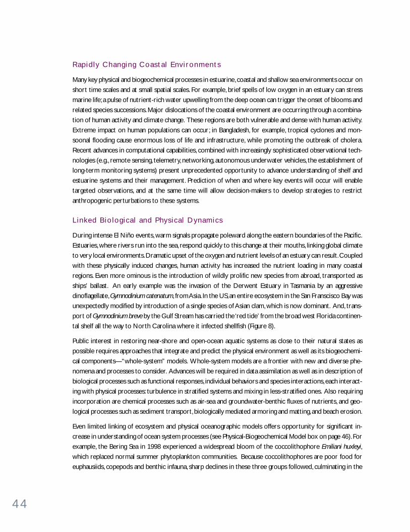
4 4
Rapid ly Chang ing Coasta l Env i ronments
Many key physical and biogeochemical processes in estuarine, coastal and shallow sea environments occur on
short time scales and at small spatial scales. For example, brief spells of low oxygen in an estuary can stress
marine life; a pulse of nutrient-rich water upwelling from the deep ocean can trigger the onset of blooms and
related species successions. Major dislocations of the coastal environment are occurring through a combina-
tion of human activity and climate change. These regions are both vulnerable and dense with human activity.
Extreme impact on human populations can occur; in Bangladesh, for example, tropical cyclones and mon-
soonal flooding cause enormous loss of life and infrastructure, while promoting the outbreak of cholera.
Recent advances in computational capabilities, combined with increasingly sophisticated observational tech-
nologies (e.g., remote sensing, telemetry, networking, autonomous underwater vehicles, the establishment of
long-term monitoring systems) present unprecedented opportunity to advance understanding of shelf and
estuarine systems and their management. Prediction of when and where key events will occur will enable
targeted observations, and at the same time will allow decision-makers to develop strategies to restrict
anthropogenic perturbations to these systems.
L inked B io log ica l and Phys ica l Dynamics
During intense El Niño events, warm signals propagate poleward along the eastern boundaries of the Pacific.
Estuaries, where rivers run into the sea, respond quickly to this change at their mouths, linking global climate
to very local environments. Dramatic upset of the oxygen and nutrient levels of an estuary can result. Coupled
with these physically induced changes, human activity has increased the nutrient loading in many coastal
regions. Even more ominous is the introduction of wildly prolific new species from abroad, transported as
ships’ ballast. An early example was the invasion of the Derwent Estuary in Tasmania by an aggressive
dinoflagellate, Gymnodinium catenatum, from Asia. In the US, an entire ecosystem in the San Franscisco Bay was
unexpectedly modified by introduction of a single species of Asian clam, which is now dominant. And, trans-
port of Gymnodinium breve by the Gulf Stream has carried the ‘red tide’ from the broad west Florida continen-
tal shelf all the way to North Carolina where it infected shellfish (Figure 8).
Public interest in restoring near-shore and open-ocean aquatic systems as close to their natural states as
possible requires approaches that integrate and predict the physical environment as well as its biogeochemi-
cal components—“whole-system” models. Whole-system models are a frontier with new and diverse phe-
nomena and processes to consider. Advances will be required in data assimilation as well as in description of
biological processes such as functional responses, individual behaviors and species interactions, each interact-
ing with physical processes: turbulence in stratified systems and mixing in less-stratified ones. Also requiring
incorporation are chemical processes such as air-sea and groundwater-benthic fluxes of nutrients, and geo-
logical processes such as sediment transport, biologically mediated armoring and matting, and beach erosion.
Even limited linking of ecosystem and physical oceanographic models offers opportunity for significant in-
crease in understanding of ocean system processes (see Physical-Biogeochemical Model box on page 46). For
example, the Bering Sea in 1998 experienced a widespread bloom of the coccolithophore Emiliani huxleyi,
which replaced normal summer phytoplankton communities. Because coccolithophores are poor food for
euphausiids, copepods and benthic infauna, sharp declines in these three groups followed, culminating in the
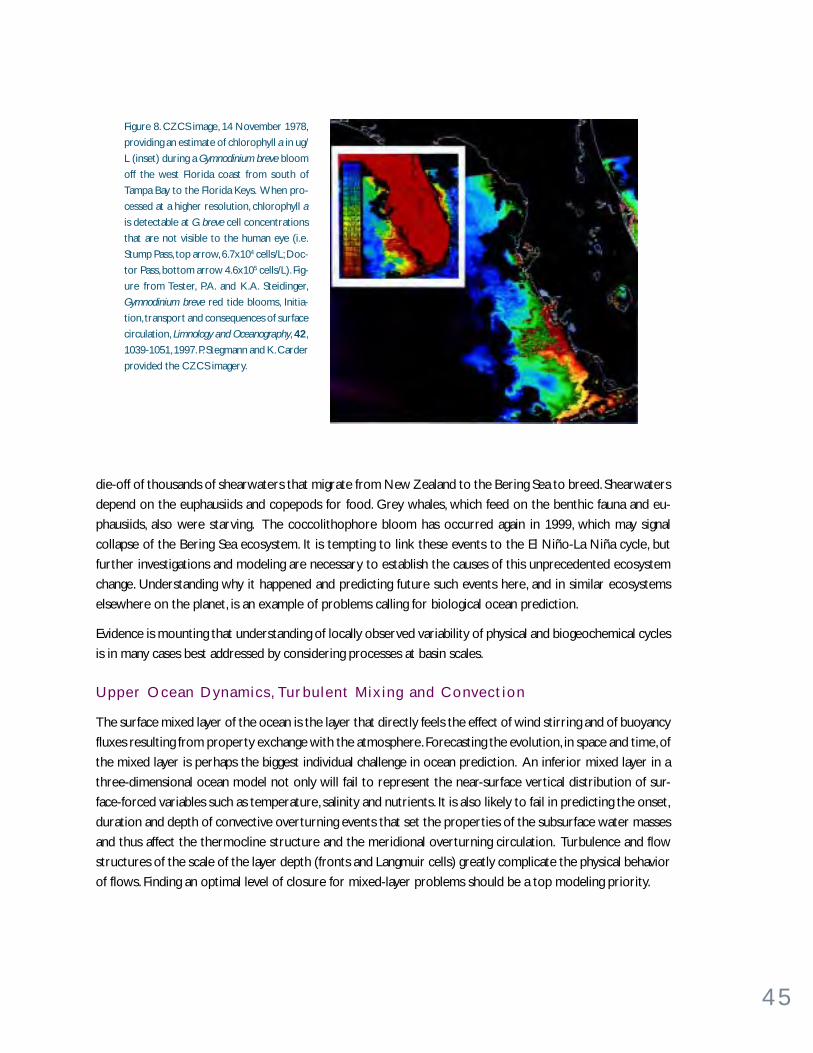
4 5
Figure 8. CZCS image, 14 November 1978,
providing an estimate of chlorophyll a in ug/
L (inset) during a Gymnodinium breve bloom
off the west Florida coast from south of
Tampa Bay to the Florida Keys. When pro-
cessed at a higher resolution, chlorophyll a
is detectable at G. breve cell concentrations
that are not visible to the human eye (i.e.
Stump Pass, top arrow, 6.7x10⁴ cells/L; Doc-
tor Pass, bottom arrow 4.6x10⁵ cells/L). Fig-
ure from Tester, P.A. and K.A. Steidinger,
Gymnodinium breve red tide blooms, Initia-
tion, transport and consequences of surface
circulation, Limnology and Oceanography, 42,
1039-1051, 1997. P. Stegmann and K. Carder
provided the CZCS imagery.
die-off of thousands of shearwaters that migrate from New Zealand to the Bering Sea to breed. Shearwaters
depend on the euphausiids and copepods for food. Grey whales, which feed on the benthic fauna and eu-
phausiids, also were starving. The coccolithophore bloom has occurred again in 1999, which may signal
collapse of the Bering Sea ecosystem. It is tempting to link these events to the El Niño-La Niña cycle, but
further investigations and modeling are necessary to establish the causes of this unprecedented ecosystem
change. Understanding why it happened and predicting future such events here, and in similar ecosystems
elsewhere on the planet, is an example of problems calling for biological ocean prediction.
Evidence is mounting that understanding of locally observed variability of physical and biogeochemical cycles
is in many cases best addressed by considering processes at basin scales.
Upper Ocean Dynamics , Turbu lent Mix ing and Convect ion
The surface mixed layer of the ocean is the layer that directly feels the effect of wind stirring and of buoyancy
fluxes resulting from property exchange with the atmosphere. Forecasting the evolution, in space and time, of
the mixed layer is perhaps the biggest individual challenge in ocean prediction. An inferior mixed layer in a
three-dimensional ocean model not only will fail to represent the near-surface vertical distribution of sur-
face-forced variables such as temperature, salinity and nutrients. It is also likely to fail in predicting the onset,
duration and depth of convective overturning events that set the properties of the subsurface water masses
and thus affect the thermocline structure and the meridional overturning circulation. Turbulence and flow
structures of the scale of the layer depth (fronts and Langmuir cells) greatly complicate the physical behavior
of flows. Finding an optimal level of closure for mixed-layer problems should be a top modeling priority.
4 6
A C o u p l e d P hy s i c a l - B i o g e o c h e m i c a l M o d e lContributed by Karline Soetaert, Peter Herman, Jack Middelburg, and Carlo Heip, Netherlands Institute of Ecology, Yerseke
Biological processes affecting carbon and nutrient cycling are highly
dependent on the physical structure (mixing, stratification) of the water
column. Heating from the top warms the upper water layers, reduces vertical
mixing and eventually leads to stratification, whereas cooling and wind shear
at the surface destabilize the water column and lead to enhanced mixing.
Deep, nutrient-rich water is mixed into the euphotic zone, where nutrients
rapidly are used for primary production. A part of the fixed nutrients
settles out of the euphotic zone in particulate form and is remineralized in
deep, aphotic waters or in the sediment. The remainder is
locally recycled through grazing and mineralization and is
reused for primary production. Nitrogen fixed by organisms
is partly buried upon reaching the sediments, partly removed
by denitrification and partly returned to the water column.
We have represented the coupled physical-biological
processes in a one-dimensional (vertical), dynamic model.
The physical part of the model generates vertical profiles
of temperature and eddy diffusive mixing and is forced by
wind shear and heat transfer at the surface and by bottom
shear in the benthic boundary layer. The biological model
considers primary production, grazing by zooplankton,
zooplankton development, detritus formation, sinking and
mineralization and nutrient transformation. In the sediment
we modeled the reactions of early diagenesis involving
organic carbon, oxygen, nitrogen and reduced substances
such as iron, manganese and sulfide. The model was validated
using data from the European Union Ocean Margin
Exchange project (OMEX).
Model results show a drastic change in time scale from the
meteorological forcing (hourly resolution) via the daily scale
response in pelagic variables (chlorophyll a, primary
production, ammonium, f-ratio) to the monthly to yearly
scale sediment response. High resolution in meteorological
forcing is needed because vertical mixing is much more
affected by short bursts of high winds than by continuous
low winds. Pelagic variables respond rapidly to these intense
mixing events. The slowly responding sediments must be
incorporated to include the delayed regeneration and loss
of nutrients. Reconciling these different time scales in an
efficient and consistent numerical code poses major
challenges.
Data-model comparison shows that this type of model can
be used to link easily measurable variables (e.g., chorophyll
a and temperature, which can be obtained from remote
sensing) to variables that are of high interest (e.g., the f-
ratio of new to regenerated production) for which
shipboard measurements are usually insufficient to estimate a seasonally
integrated value.
Progress in this type of coupled modeling will profit from advances in
computing technology, allowing implementation of sufficiently detailed
models in three dimensions, and from progress in remote data acquisition,
in particular of meteorological forcing of biologically relevant variables
such as chlorophyll a.
Upper panel (Forcing of system): Time series plot of wind speed. Vertical lines delineate the period
shown in detail on the right.
Middle panel (Water-column response). Left: Comparison of model predictions with shipboard
measurements (primary production and f-ratio) and remote observations (f-ratio). Right: Mod-
eled temporal evolution of chlorophyll and ammonium in the water column
Lower panel (Sedimentary response): Left: Comparison of model predictions with benthic lander-
based oxygen uptake rates and observed pore-water profiles. Right: Modeled temporal evolution
of dissolved oxygen and ammonium in the sediment.
4 7
Mixing along and across the layers of the ocean interior allows fluid to rise and sink, and stirs tracers and
ecosystems horizontally (see Turbulence chapter). Climate models cannot generally represent this level of
detail: it must often be parameterized. To make matters worse, convective plumes penetrate as much as two
kilometers downward from the surface, at a relatively few sites where the oceanic stable stratification is
weakened and winds are strong and cold. Representation of convection in computer models must be improved.
Globa l Fresh-Water Circu la t ion and Sea Ice
Understanding the movement of the water and water vapor through the atmosphere-land-ocean system is a
key to the thermodynamics and physical dynamics of weather and climate. Both observations and models are
particularly weak in this area (it is very difficult, for example, to measure rainfall over the sea, either on a ship
or from a satellite). Impacts of freshwater transport on human populations and ecosystems are numerous.
Monsoonal flooding, continental drought and milder climatic variation of rainfall all are related to the ocean.
The oceanic overturning circulation, described above, is centrally dependent on freshwater loading at high
latitudes.
The physical density of ocean water is controlled both by its temperature and salinity. Variations in salinity
follow from phase changes: evaporation, precipitation, freezing and thawing near the sea surface, and runoff
and iceberg calving from land. Freshwater layers at the surface are very buoyant, and can control both upper-
ocean dynamics and the larger scale overturning circulations. Observation and computer modeling of salinity
fields must deal with this complex interaction with atmosphere and land surfaces.
Observational data for freshwater input, either directly through snow and rain or indirectly via rivers and
terrestrial glacier runoff, can in principle be provided by atmospheric circulation model simulations. However,
model biases in handling the terrestrial and the atmospheric components of the hydrological cycle and in
particular lags in groundwater inputs make this practice inadvisable.
Sea ice, because of its insulating capacity, its radiative properties and its creation of saline brine during freez-
ing, exerts profound effects on air-sea heat exchange. It is a major factor in high-latitude climate, one that is
currently suffering major change in the Arctic (Figure 7). Representation of sea-ice in numerical models is rich
with microphysical challenges.
Complex Sea f loor Topography and Down-S lope F lows
The geography of the seafloor is rich with seamounts, ridges, transform faults, continental rises and shelves, as
well as the occasional flat abyssal plain. Ocean circulation is surprisingly sensitive to this detail, owing to
Earth’s rotation. The flow is channeled and broken into eddies by the topography, yet once again computer
simulations of moderate resolution have difficulty in representing these effects. Seafloor mountains, ridges
and continental rises exert horizontal pressure forces which are crucial elements of the circulation.
Water sinks as part of the meridional overturning circulation in narrow streams at high latitude. These are
boundary currents hugging the continental rises, a few tens of kilometers wide and often just a few hundred
meters thick. As they descend, waters from intermediate-depth layers are entrained into them. Their trans-
port increases, and they drive recirculating flows in the surrounding ocean. Accurate representation of these
concentrated overflows has been very difficult to achieve. Their assimilation into the global pattern of circu-
lation is an important goal for modeling.

4 8
W H AT M A K E S P RO G R E S S P O S S I B L E N OW ?• Instrument and platform development. Observations of the ocean are the ultimate source of progress.
Remarkable developments in instrumentation during the last few years have put us in a strong position to
“know” the complexity of the oceans (see Tools for Observation box on page 52). For in situ measurement,
compact, electronic and optical sensors can now record temperature, salinity, dissolved oxygen, fluorescence
and suspended-particle density. Video imaging provides detailed biological sections and profiles. Sensors for
nitrate (an “autoanalyzer on a chip”) and carbon dioxide are being developed. Drifting, moored and gliding
platforms are available to reduce our dependence on expensive ship time. Nevertheless, some of the most
subtle chemical, biological and physical observations continue to require ships as platforms. Remote sensing
using satellites and acoustics provides extensive spatial coverage.
• Rapidly improving computer modeling. Numerical modeling acts in tandem with observations, theory
and laboratory experimentation. Aided by the speed of modern workstations, many research and dissertation
projects in physical and biogeochemical oceanography today have a numerical modeling component. With
the observational database rapidly growing and sufficient computational resources to support
experimentation with a wide variety of models, we are on track to make rapid progress. The time when
only major institutions had the resources to engage in ocean modeling, and even then were forced to invest
them into the development of a single “super model,” has passed. Today’s enriched model “gene pool”
removes uncertainties associated with dependence on too few models.
As more and more oceanographers make use of modeling, its diversity is increasing, just as occurred two
to three decades ago in meteorology. In modeling the physical circulation, a choice exists today between
“level” models which represent approximately the equations of a continuous fluid with values only on a
fixed three-dimensional lattice of points, and “layer” models which represent the three-dimensional fluid
continuum by a simplified stack of “shallow-water” layers. Likewise, modelers today have a choice of different
horizontal grid layouts allowing them to concentrate computing resources in specific geographic regions
that may be difficult to resolve spatially, such as undulating coastlines or gaps in underwater mountain
ranges.
• Continuing development of theory. Numerical models will not in our lifetimes attain sufficient resolution
and completeness to describe all of the missing physics of the small scales of motion. The relatively high
resolution seen in Figure 3, with 10 km grid spacing, restricts the duration of the model runs, yet it is still a
factor 107 too coarse to represent the finest (millimeter-scale) motions in fluid turbulence. Even if we
could resolve all scales, a “perfect” numerical simulation would be of little value without understanding of
basic principles upon which all this detail rides. Theory defines the principles that can simplify the “rules of
play” for ocean circulations, waves and mixing.
While the physical ocean can be described by its velocity, temperature, salinity and sea-surface elevation,
other combinations of these quantities have been discovered. The potential density is a combination that
describes the organization of the oceans into stable layers. The potential vorticity is another function of
these variables that describes quantitatively the tendency of small elements of fluid to spin. Potential
4 9
vorticity describes much about the flow and the disturbed, undulating layers of potential density. The
remarkable fact is that both of these two quantities remain constant, if one follows the moving fluid (until
friction or diffusion acts): they are “tracers” of the motion. Maps of potential vorticity and potential density
of the oceans show a large-scale geographical variation connected with Earth’s shape, and smooth variations
related to the circulation of the ocean, with concentrated variations in jet-like currents and eddies. Rossby
waves, instabilities and their interaction with the general circulation are all described compactly with potential-
vorticity “thinking.” Water masses, traveling around the global ocean, are marked by their potential vorticity
and their trace chemical “signatures.”
Theory also defines simple analogs of the complex ocean system. Henry Stommel created a model of the
ocean involving just two boxes of uniform fluid, connected by horizontal pipes. After imposing temperature
and freshwater fluxes at the ocean surface, a family of possible circulations occurs. As surprising as it may
seem, this box model contains the essence of the chaotic variability of the great meridional overturning
circulation of the world’s oceans. It has become a paradigm showing the possible slowing of the circulation
under global warming, and the multiple forms that ocean circulation can assume.
W H AT I S R E Q U I R E D F O R P RO G R E S S ?To predict and test the states of the ocean, one needs an ocean model, an observing system, a data assimila-
tion technique and adequate computer facilities.
• New approaches in physical modeling. Models are idealizations of reality. Such idealizations are helpful
if they remove complexities that stand in the way of understanding the response modes of a dynamical
system. Development within complex numerical models is particularly needed in the areas of turbulent
mixing and convection; complex seafloor topography and down-slope flows; global freshwater circulation
and sea ice; “open” lateral boundaries; and upper ocean dynamics. In addition, simple idealizations of the
complex ocean-atmosphere system must be pursued.
• Improved whole-system models. Models of biological and chemical processes are essential for prediction
and for understanding. Coupled with physical models, they allow exploration of ranges of response that can
be realized, the conditions under which particular responses are possible, and thresholds where undesirable
responses (e.g., extinction) might occur. At present, biological models generally either track bulk properties
(nutrients, phytoplankton, zooplankton, detritus) or individuals (growth, reproduction, death, feeding) in
the physical environment specified by the coupled physical model. The approach of developing large
ecosystems models should be “middle-out” and not “bottom-up.” They should focus first on the taxa of
primary interest and elaborate up to predators and down to prey. This structure relies on providing
necessary detail of the model for the target species and requires diminishing detail of the neighboring ±1
and ±2 trophic levels. The effort in constructing these models lies in identifying the target species
and in achieving proper parameterizations of the processes and interactions with neighboring levels.

5 0
A S e a o f C h a n g e : H aw a i i O c e a n T i m e - S e r i e sContributed by David M. Karl, University of Hawaii
Oceanic productivity, fishery yields and the net marine sequestration of
atmospheric greenhouse gases are all controlled by the structure and
function of planktonic communities. Detailed paleoceanographic studies
have documented abrupt changes in these processes over time scales ranging
from centuries to millennia. Most of these major shifts in oceanic productivity
and biodiversity are attributable to changes in Earth’s climate, manifested
through large scale ocean-atmosphere interactions. The establishment of a
global network of ocean time-series stations for repeated physical and
biogeochemical measurements represents one mechanism for the
ecosystem surveillance that is necessary to record and eventually understand
these complex oceanic processes.
The open ocean has traditionally been viewed as a nitrogen (N) limited
habitat, and this has guided the development of conceptual models of
numerous biogeochemical processes. However, under conditions of extreme
N-limitation when the more accessible pools of nitrate and ammonium
have been exhausted, certain groups of prokaryotic microorganisms can
turn to the nearly inexhaustible pool of dissolved N2 in the sea as an alternate
N source.
Observations made during the Hawaii Ocean Time-Series (HOT) program
at Station ALOHA (22°45’N, 158°W) during the past decade suggest that
N2 fixation is a dominant source of new N for this ecosystem. Based on
measurements of the distribution and abundance of key N2-fixing bacteria,
N2 fixation was estimated to account for approximately 30 to 50% of the
total N export, a value equivalent to 50 mmoles of N m-2 yr-1. However, this
appears to be a perturbed ecosystem state, rather than business as usual.
One hypothesis is that this enhancement of N2 fixation is a direct result of
climate-induced changes to the North Pacific habitat. Selection for N2-
fixing bacteria (including Trichodesmium, selected species of Synechococcus
and perhaps other free-living and symbiotic Bacteria) resulted from increased
stratification and oligotrophication. This is likely a direct consequence of
the increased frequency and duration of El Niño Southern Oscillation
(ENSO)-favorable climate conditions during the past two decades in concert
with changes in the longer-term Pacific Decadal Oscillation (PDO).
N2 fixation in the world’s oceans could be controlled by the atmospheric
deposition of Fe, which itself is a variable, climate-sensitive parameter. Total
atmospheric dust transport is also affected by humankind, including
population demographics, global economies and land use patterns. These
complex natural and anthropogenic interactions provide a mechanism for
biogeochemical variability in otherwise “stable and homogeneous” biomes.
In this regard, the seascape might be a slave to the landscape, and there is
no question that the latter has changed significantly over the past 250 years.
HOT program data synthesis and modeling efforts are already underway in
numerous laboratories around the world. A major advantage in working
with these extensive, publicly available data sets (http://hahana.soest.
hawaii.edu) is the rich spectrum of variability that is observed in an
ecosystem that was expected, a priori, to be homogeneous and time
invariant. These “surprises of the sea” should keep us busy for at least
another decade.
Reference
Karl, D. M., A sea of change: Biogeochemical variability in the North Pacific
subtropical gyre, Ecosystems, 2,181-214, 1999.
Top left: Surface ocean bloom of Trichodesmium as seen from the US Space
Shuttle about 300 km above the sea (scale: 1:850,000). Top right: Microscopic
view of Trichodesmium showing the characteristic spherical (also called puff)
and fusiform (also called tuft) morphologies. Center: Troup Southern Oscilla-
tion Index (SOI) showing the 10-year running mean (heavy line). The continu-
ous positive SOI (El Niño favorable) condition which for the subtropical North
Pacific means fewer storms and less mixing. There may also be gyre circula-
tion effects. These physical features give rise to an extreme oligotrophication
(nutrient stressed conditions) and selection for organisms like Trichodesmium
which can fix their own N from the nearly inexhaustible supply of dissolved
gaseous N2. Bottom: The result is a steady increase in the N:P ratio of mate-
rials exported from the euphotic zone. Along with this is a higher than aver-
age C:P ratio (P is selectively retained while N and C are exported) causing a
temporary change in the balance between export C and imported C (which is
imported at the 106C:1P “Redfield” ratio, from below). The net effect is a
decadal scale, climate driven temporary sequestration of C which will have
major impacts on the flux of carbon dioxide across the air-sea interface.
5 1
• Improved observational sensors and platforms. The full three-dimensional complexity of the ocean
has to be confronted. Improved measurements of many types (e.g., measuring temperature, salinity, currents,
phytoplankton, zooplankton, nutrients, oxygen, pigments, transmissivity, carbon dioxide) involving arrays
deployed for extended periods are necessary to resolve mean and variance on a seasonal time scale at
least, if not on the event scale. Compact electronic sensors for biology and chemistry will give a quantum
leap in understanding the ocean. For example, predicting the onset of blooms and areal extent of blooms
has practical implications for fisheries and inherent value for integrated ecosystem studies. Increasing
sophisticated techniques of molecular biology and multidisciplinary sampling need to be developed to
track the genetic evolution of ecosystems. There is a feeling of urgency, particularly regarding the coastal
ocean. There we are observing systems that are already embarked on rapid and diverse changes, and are
under external stress.
Satellites give us virtually global observations of sea-surface temperature, sea-surface elevation (hence an
approximate global map of the surface currents), surface winds, tropical rainfall, large- and fine-scale surface
waves, sea-ice cover and ocean color, relating to biological productivity. Advances in satellite sensor technology
promise more (for example, an approximate surface salinity field and global radiometric SST observations
through cloud), yet continuing support must be exerted to keep the even current sensors operating into
the future. Acoustic transmission, over both long and short range, produces a variety of two- and three-
dimensional information.
The prospect of small, low-power, accurate electronic or optical in situ sensors for many chemical and
biological variables is exciting. New drifting and propelled Autonomous Undersea Vehicles (AUVs) are
under development, which can survey many thousands of kilometers of ocean on a single mission; these at
long last will help us to understand the fully four-dimensional covariance in biological and physical processes.
Given the remarkable suite of new sensors and platforms, resources are needed to deploy them in adequate
numbers.
• Extended time-series observations. The increasing evidence of long-term change of Earth’s climate,
and its ubiquitous effects on the oceans, has come from very sparse observations. Only a handful of sites in
the world’s ocean have been revisited regularly over many years. At the coasts and on islands, some tide
gauges have been in operation since the earliest extended measurements in Britain in the early 1800s. A
network of weather ships occupied fixed locations in the high latitude Atlantic and Pacific in the 1950s to
1970s, yet only a few fixed sites are still being monitored (see HOTS box on opposite page).
It would trivialize the sampling problem to suggest merely collecting data at a single point. In a system in
constant motion in three dimensions, it is difficult to interpret trends without knowledge of spatial correlation
scales. We view the requirement for extended time-series observations to include capturing essential
spatial signals as well, posing a significant challenge to experimentalists.
Quasi-random hydrographic stations have been combined in a heroic work of data “archeology,” to construct
a 50-year history of the net heat storage of the world’s ocean (see Figure 1 in Global Climate chapter). We
are, however, generally lacking time histories, and must rely on proxy indicators of climate such as tree
rings, sediment cores and ice cores. Manageable surveying of the three-dimensional, time-dependent world
would be difficult even without resource limitations. As it is we must identify a small set of locations and
sections that merit constant “exploration in time.” Fortunately, new tools are rapidly increasing the efficiency
of long-duration measurements (see Tools for Observation box on page 52).
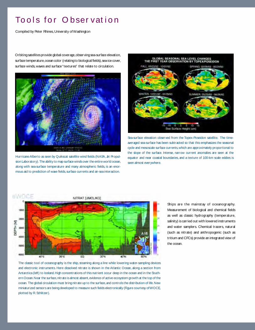
5 2
To o l s f o r O b s e r v a t i o nCompiled by Peter Rhines, University of Washington
Orbiting satellites provide global coverage, observing sea-surface elevation,
surface temperature, ocean color (relating to biological fields), sea-ice cover,
surface winds, waves and surface “textures” that relate to circulation.
Sea-surface elevation observed from the Topex-Poseidon satellite. The time-
averaged sea-surface has been subtracted so that this emphasizes the seasonal
cycle and mesoscale surface currents, which are approximately proportional to
the slope of the surface. Intense, narrow current anomalies are seen at the
equator and near coastal boundaries, and a texture of 100-km scale eddies is
seen almost everywhere.
Hurricane Alberto as seen by Quikscat satellite wind fields (NASA, Jet Propul-
sion Laboratory). The ability to map surface winds over the entire world ocean,
along with sea-surface temperature and many atmospheric fields, is an enor-
mous aid to prediction of wave fields, surface currents and air-sea interaction.
The classic tool of oceanography is the ship, steaming along a line while lowering water-sampling devices
and electronic instruments. Here dissolved nitrate is shown in the Atlantic Ocean, along a section from
Antarctica (left) to Iceland. High concentrations of this nutrient occur deep in the ocean and in the South-
ern Ocean. Near the surface, nitrate is almost absent, evidence of active ecosystem growth at the top of the
ocean. The global circulation must bring nitrate up to the surface, and controls the distribution of life. New
miniaturized sensors are being developed to measure such fields electronically (Figure courtesy of WOCE,
plotted by R. Schlitzer).
Ships are the mainstay of oceanography.
Measurement of biological and chemical fields
as well as classic hydrography (temperature,
salinity) is carried out with lowered instruments
and water samplers. Chemical tracers, natural
(such as nitrate) and anthropogenic (such as
tritium and CFCs) provide an integrated view of
the ocean.

5 3
g y
Acoustic profiling and towed temperature-salinity sensors provide
“CAT scans” of the upper ocean. Here the Canadian ship, Vector,
explores the remarkable undular bores that occur where a tidal
flow crosses a topographic ridge. The wave crests are seen as
slicks on the surface (top) and as a train of “solitons” radiating
from the concentrated down-slope flow in a surface-to-bottom
section of temperature (bottom). Figure reprinted with permis-
sion from, D. Farmer and L. Armi, The generation and trapping of
internal solitary waves over topography, Science, 283, 188-190, copy-
right 1999 American Association for the Advancement of Science.
The Seaglider is one of several autonomous undersea vehicles
that will enable oceanographers to measure hydrographic, chemi-
cal and biological fields on long sections across the oceans. This
particular instrument can measure about 1000 profiles from the
surface to a depth of 2 km over a track of about 6000 km. Each
time it surfaces it transmits its data via satellite, at which time its
course can be reset. Photo courtesy of C. Eriksen, University of
Washington.
Ship-borne, free-fall instruments provide detailed profiles of
ocean mixing and turbulence. Acoustic backscatter instruments
provide images of microstructure and profiles of currents.
Freely drifting and “gliding” vehicles profile the ocean while communicating to
home base via satellite. In sufficient numbers, PALACE floats and gliders can
map out the oceanic temperature and salinity, and they will soon incorporate
electronic sensors for oxygen, nitrate and other chemical and biological fields.
The ARGO float program involves the deployment of several thou-
sand freely drifting PALACE floats, which profile the oceanic tem-
perature and salinity while moving with the circulation, deep be-
neath the surface. In large numbers they are yielding a global picture
of the evolving density structure of the ocean. Photo courtesy of
S. Riser, University of Washington.
Tracks of many ARGO floats as of November, 2000. Along with
this path information, profiles of temperature and salinity are
recorded. Figure from the Coriolis Data Center, http://
www.ifremer.fr/coriolis/palace/geomap.asp.
Deep-sea moorings in the equatorial Pacific, maintained by NOAA, have
provided a remarkable portrait of El Niño-La Niña cycles. This huge
time-series array is augmented with tide gauges at islands, satellite imag-
ery and altimetry, drifting buoys (arrows) and temperature-current mea-
surements from ships (blue lines). Figure courtesy of NOAA/PMEL/TAO
Project Office, Dr. Michael J. McPhaden, Director.
Moored instruments provide observations extended in time, and
anchored to one site. These are particularly valuable in establishing
the climatology of regions with intense, narrow currents and
temperature/salinity structures.
5 4
• Merging observational data with models: Data assimilation. Given an adequate ocean observing
system and given continued advances in our modeling efforts, the next step is to use these observations to
drive and update models from an “initial value” input in a predictive mode. Plentiful physical data now exists
from satellites, and increasingly from drifting-profiling vehicles. Assimilation models for short-term prediction
(e.g., in the case of an oil-spill trajectory) and long-term climate (e.g., with the possible slowing of the deep
circulation by high-latitude warming and freshwater loading) will one day be the centerpieces of our science.
Near-optimal data assimilation techniques require extensive raw computing power.
• Computers. Ocean prediction would be impossible without computers. The ocean sciences have reached
a point where its progress is severely hampered by the lack of computer resources. Computer and data
storage technologies undoubtedly will continue to advance, perhaps even more so in the future than in the
past, because of the economic incentive and heightened competitiveness that result from catering to a
huge consumer market. Academia, and ocean science in particular, will benefit from this development. We
are developing an increasingly complex picture of the ocean as a biological, physical and chemical system.
Oceanographers have become steadily more dependent on computers and numerical models as investigative
tools to unravel this complexity. The need for computers in oceanography is particularly acute because of
the extremely nonlinear nature of many ocean phenomena and the difficulty of making observations. If we
are to use observational capabilities wisely and turn observations into a comprehensive understanding of
the ocean, then we cannot avoid the use of large, sophisticated numerical models.
• People. Progress in observing, understanding and predicting the oceans depends upon a continuing supply
of talented and curious young researchers. The field of ocean science is changing rapidly in sophistication
and importance, and new skills will be required to meet the challenges of the coming decades. It is important
to recruit, train and imbue with enthusiasm for the field of ocean science entry-level graduate students,
engineers and technical workers.
Having the new technologies and carefully considered scientific plans to observe and model the three-
dimensional ocean is not the same as actually doing it. The accelerating change of the natural world begs
us to pursue these goals with utmost speed.

5 5
Ocean turbulence plays a critical role in the transfer of mass, momentum, salt, heat and other water proper-
ties from the larger scales of generation or input to the smallest scales of dissipation by molecular processes.
Turbulence also has an impact on processes as diverse as zooplankton detection of prey and avoidance of
predators, transfer of CO2 across the air-sea interface, and mixing of heat and nutrients throughout the
ocean. A better understanding of ocean turbulence and its role in ocean mixing, and how ocean mixing can
be accurately parameterized, is essential for developing new ocean circulation models for studies ranging
from local ecosystem dynamics to coupled atmosphere-ocean climate.
Two characteristics of turbulent flow make it extremely difficult to study. First, turbulent flows and tracer
fields span a wide range of scales and spatial patterns. The span is so wide that a complete description of the
state of a turbulent field would require more degrees of freedom than can possibly be encompassed in
analytic theories or, at present, in numerical models. Second, the dynamics of turbulent fields are nonlinear so
that each spatial scale interacts with many more and no pattern evolves independently from others. These
two characteristics conspire to ensure that the “turbulence problem” cannot be fully solved by the usual
analysis technique of simplifying a problem until it can be understood in terms of Newtonian ideas of causal-
ity and response. Indeed the combination of complexity and nonlinearity means that the entire web of
interacting components must be treated as a whole.
O C E A NT U R B U L E N C E

5 6
A clear example of the complexity and nonlinearity of the turbulence problem can be found in the overturn-
ing circulation of the world’s oceans, which is responsible for perhaps half the ocean’s ability to transport heat
from the tropics toward the poles. Water made dense by vigorous cooling at high latitudes sinks in a few
locations and spreads throughout the ocean, forming deep and intermediate water masses. Mass conserva-
tion dictates that this water somehow returns to the shallow ocean through the ubiquitous stable stratifica-
tion. This return requires that the stratifying heat and fresh water be transported downward through this
upwelling, presumably by fine- and micro-scale eddies that are small enough not to be suppressed by the
stable stratification. By the simple argument that Walter Munk made in his landmark paper “Abyssal Recipes,”
this balance requires an eddy transport characterized by a diapycnal (across density surfaces) diffusivity of
about 1 cm2 s-1. Indeed, general circulation models show that the rate of overturning, and hence poleward
heat transport that affects global climate, is largely determined by the diapycnal diffusivity used.
The relationship between overturning circulation and micro-scale eddy diffusion exemplifies three important
facts about the broader study of ocean turbulence. First, it shows how all scales are directly connected. The
same point is made by considering the upper ocean’s carbon pump, whereby the export of particulate carbon
scales roughly with the rate at which nutrients are supplied to the euphotic zone to support primary produc-
tion. Over much of the world’s oceans this rate of supply is governed by upward turbulent transport of
nutrients through the stably stratified ocean below the winter mixed layer. Second, there is a desperate need
for direct observations. The web of nonlinear interactions is so complex that it is simply not possible to
reliably estimate the rate of diapycnal eddy diffusion, or of any other important turbulent process, in the
absence of direct observations of the turbulence itself. It took decades of observations of eddy motion on
the micro-scale and remarkable direct measurements of the vertical spread of tracers (see Brazil Basin box
on opposite page) to learn that the ocean’s eddy activity is in most places an order of magnitude weaker than
is required to produce Munk’s 1 cm2 s-1 diffusivity. Third, there is much that needs to be learned. Either the
current picture of the overturning circulation is very wrong or mixing is more vigorous at times or places not
yet examined than in the places that have been measured. It is fascinating that much the same conclusion is
reached about the mixing required to support the observed rates of primary production in the vast olig-
otrophic oceans (Figure 9), but this paradox is made less striking by uncertainty about the rates and mecha-
nisms of nutrient recycling.
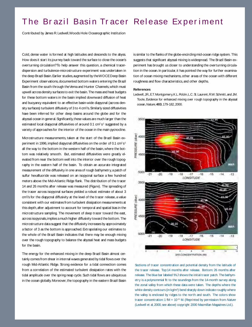
5 7
T h e B r a z i l B a s i n Tr a c e r R e l e a s e E x p e r i m e n tContributed by James R. Ledwell, Woods Hole Oceanographic Institution
Cold, dense water is formed at high latitudes and descends to the abyss.
How does it start its journey back toward the surface to close the ocean’s
overturning circulation? To help answer this question, a chemical tracer-
dispersion and turbulence-microstructure experiment was undertaken in
the deep Brazil Basin. Earlier studies, augmented by the WOCE Deep Basin
Experiment observations, documented bottom waters entering the Brazil
Basin from the south through the Vema and Hunter Channels, which must
upwell across density surfaces to exit the basin. The mass and heat budgets
for these bottom waters in the basin implied downward diffusion of heat
and buoyancy equivalent to an effective basin-wide diapycnal (across den-
sity surfaces) turbulent diffusivity of 3 to 4 cm2/s. Similarly sized diffusivities
have been inferred for other deep basins around the globe and for the
abyssal ocean in general. Significantly, these values are much larger than the
estimated local diapycnal diffusivities of around 0.1 cm2 s-1 suggested by a
variety of approaches for the interior of the ocean in the main pycnocline.
Microstructure measurements, taken at the start of the Brazil Basin ex-
periment in 1996, implied diapycnal diffusivities on the order of 0.1 cm2 s-1
all the way to the bottom in the western half of the basin, where the bot-
tom was relatively smooth. But, estimated diffusivities were greatly el-
evated from near the bottom well into the interior over the rough topog-
raphy in the eastern half of the basin. To obtain an accurate integrated
measurement of the diffusivity in one area of rough bathymetry, a patch of
sulfur hexafluoride was released on an isopycnal surface a few hundred
meters above the Mid-Atlantic Ridge flank. The distribution of the tracer
14 and 26 months after release was measured (Figure). The spreading of
the tracer across isopycnal surfaces yielded a robust estimate of about 3
cm2/s for the diapycnal diffusivity at the level of the tracer release, a value
consistent with our estimates from turbulent dissipation measurements at
this depth, after adjustment to account for temporal and spatial bias in the
microstructure sampling. The movement of deep tracer toward the east,
across isopycnals, implies a much higher diffusivity toward the bottom. The
microstructure data suggest that the diffusivity increases by approximately
a factor of 3 as the bottom is approached. Extrapolating our estimates to
the whole of the Brazil Basin indicates that there may be enough mixing
over the rough topography to balance the abyssal heat and mass budgets
for the basin.
The energy for the enhanced mixing in the deep Brazil Basin almost cer-
tainly comes from shear in internal waves generated by tidal flows over the
rough Mid-Atlantic Ridge. Strong evidence for a tidal connection comes
from a correlation of the estimated turbulent dissipation rates with the
tidal amplitude over the spring neap cycle. Such tidal flows are ubiquitous
in the ocean globally. Moreover, the topography in the eastern Brazil Basin
is similar to the flanks of the globe-encircling mid-ocean ridge system. This
suggests that significant abyssal mixing is widespread. The Brazil Basin ex-
periment has brought us closer to understanding the overturning circula-
tion in the ocean. In particular, it has pointed the way for further examina-
tion of ocean mixing mechanisms, other areas of the ocean with different
roughness and flow characteristics, and other depths.
References
Ledwell, J.R., E.T. Montgomery, K.L. Polzin, L.C. St. Laurent, R.W. Schmitt, and J.M.
Toole, Evidence for enhanced mixing over rough topography in the abyssal
ocean, Nature, 403, 179-182, 2000.
Sections of tracer concentration and potential density from the latitude of
the tracer release. Top:14 months after release. Bottom: 26 months after
release. The blue bar labeled ‘INJ’ shows the initial tracer patch. The bathym-
etry is a polynommial fit to the soundings from the 14-month survey along
the zonal valley from which these data were taken. The depths where the
white density contours (in kg/m3) bend sharply down indicate roughly where
the valley is enclosed by ridges to the north and south. The colors show
tracer concentration: 1 fM = 10-15 M. (Reprinted by permission from Nature
(Ledwell et al, 2000, see above) copyright 2000 Macmillan Magazines Ltd.).
5 8
Figure 9. An example of annual variations over the past decade in (a) nutrient concentrations; and (b) pigment
concentrations and primary productivity at the U.S. JGOFS Bermuda Atlantic Time-Series Study (BATS) station. Nu-
trients are mixed upwards into surface waters through eddy diffusion throughout the year; convective overturn
deepens the mixed layer during Fall/winter leading to further mixing. Figure modified from Steinberg, D.K., C.A.
Carlson, N.R. Bates, R.J. Johnson, A.F. Michaels, and A.F. Knap, Overview of the U.S. JGOFS Bermuda Atlantic Time-
series Study (BATS): A decade-scale look at ocean biology and biogeochemistry, Deep Sea Res. II, in press.
5 9
W H AT A R E T H E B I G P RO B L E M S ?Because turbulence is involved with so many of the processes going on inside the ocean, a comprehensive list
of problems to be solved about turbulence would be very long. It is more efficient at the present level of
understanding to identify important broad areas of research and explain how they have an impact on under-
standing in other areas of oceanography.
Diapycna l f luxes
An accurate representation of diapycnal eddy fluxes is needed to reliably model or diagnose large-scale
processes such as the ocean’s role in climate or the oceanic carbon cycle, as well as better understand
overturning ocean circulation, nutrient supply to the euphotic zone, and intentional deep-water disposal of
carbon or radioactive wastes. Recently, encouraging progress has been made in relating diapycnal fluxes to
the gross stratification, internal wave activity and to roughness on the neighboring ocean bottom (see Coastal
Mixing box on page 60). Nevertheless, an understanding of the relative importance of different phenomena
(e.g., tides, beams of internal waves intersecting topography, double diffusion, intrusions, internal wave over-
turning vs. shear, fronts) in establishing diapycnal diffusion is still a remote goal.
Diapycnal mixing is difficult to study because the turbulence required to transport nutrients from below the
thermocline, for example, is extremely intermittent in time and space. This intermittency not only makes it
difficult to characterize the transport processes going on in one region on a single day, but it causes the
transport on another day or in a neighboring region to be different by an order of magnitude. Furthermore,
the observations needed to measure turbulent fluxes are extremely demanding technically. Consequently, a
geography of ocean mixing is grossly incomplete and there are still vast ocean regions, seasons and depth
ranges in which there is little idea of mixing rates.
To better understand diapycnal eddy fluxes requires an increased deployment of autonomous instruments
that can provide the long records needed to explore rare events. These same instruments provide a capabil-
ity for adaptive search and resampling strategies upon encountering unusual values of nutrients or pigments.
They will afford the opportunity to confirm the existence of, and measure the temporal and spatial scales of,
important vertical transport events. Key in this development will be the successful miniaturization of optical
and chemical sensors of nutrients, pigments and particle sizes and types.
Progress can be expected from continued observational exploration of turbulence levels in different regions
over the full seasonal cycle with enough observations taken to characterize rare events, and new observa-
tional efforts to measure more directly turbulent fluxes of momentum and water properties such as heat, salt
and biota. Continued model studies of the effect on the circulation and its biota of different rates of mixing
will both explain the consequences of diapycnal mixing and guide observational studies to important regions.

6 0
Dye and Microstructure Stud ies in the
C o a s t a l M i x i n g a n d O p t i c s E x p e r i m e n tContributed by Neil S. Oakey, Bedford Institute of Oceanography, Canada, and James R. Ledwell, Woods Hole Oceanographic Institution
The rate at which quantities such as heat, salt or nutrients are mixed across
density surfaces and through the water column is parameterized by the
vertical (or diapycnal) diffusivity. For the first time, on the same length and
time-scales, diapycnal mixing has been studied simultaneously using two
very different techniques, dye and microstructure measurements. A total
of four dye and microstructure comparisons were made in the New York
Bight area in two field programs in September 1996 and August 1997.
Ledwell determined diapycnal mixing rates using a tracer dye injected at a
target isopycnal surface. Diffusivity was estimated by repeatedly sampling
the patch of tracer to determine how the concentration of dye evolves in
space and time. The evolution of dye injected in September 1996 is shown
in the figure. Red indicates the highest concentration of the vertically inte-
grated dye and dark blue the most dilute. The vertical distribution of tracer
was obtained by averaging over the horizontal dimensions of the patch
with reference to the target isopycnal surface. The vertical dispersion of
the dye over the experiment is shown in the upper right inset for the three
surveys. Assuming that at each sampling one is able to account for total
amount of tracer injected, the time rate of change of the second moment
of the thickness of the tracer patch gives the diapycnal diffusivity.
Although the dye gives the answer, it tells us little about the processes that
cause the mixing. To address this, Oakey concurrently measured vertical
mixing rates using a microstructure profiler, EPSONDE. Over 500 micro-
structure profiles were acquired in 56 hours of sampling at the three sites
shown in the figure as broad white bars (centered at day 257.5, 259.5 and
261.3), closely correlated in space and time with the dye measurements.
Vertical diffusivities of heat, KT, and mass, Kr, were estimated from the tem-
perature gradient microstructure and the turbulent dissipation, respectively.
Different techniques of obtaining an ensemble average from the microstruc-
ture results were used to compare microstructure estimates to those from
the dye. As an example, KT is shown in the figure inset. The yellow profile
with light gray error bars was obtained by averaging the vertical diffusivities
for every 1.6-m vertical segment of data. The blue curve with its dark gray
error bars was obtained by averaging the temperature variance and mean
gradient separately for each 15 to 20 profiles acquired in one transit of a
site line (a station) and then dividing to obtain vertical diffusivity.
The vertical diffusivity calculated from the diapycnal dispersion of the dye
is shown as a green bar (indicating the confidence interval) in the lower left
inset overlaid on the estimates of KT from microstructure measurements.
Microstructure profiles interpreted with simplified turbulence models have
traditionally been used to estimate mixing rates. Showing that dye and
microstructure techniques yield similar estimates of vertical diffusivity gives
us more confidence in using the more widely available results from micro-
structure studies. In general, the dye and microstructure results from all
four experiments agreed in that they provided the same mixing rates within
the errors of the measurements. The caveat is that the error bars are large
- typically at least a factor two for each type of measurement.
This work was funded by the Office of Naval Research as part of the Coastal
Mixing and Optics Experiment.

6 1
Turbu lence , par t i c le contact ra tes and b io log ica l behav iors
Turbulence moves suspended particles as well as fluids, strongly influencing the interaction rates of organisms
in life processes such as fertilization of egg by sperm, ingestion of prey by predator or infection of host by
pathogen. Success of all such encounters is highly, and often nonlinearly, dependent on the number of organ-
isms in close proximity, and so is strongly influenced by the stirring and mixing effects of turbulence at
virtually all scales (see Hydromechanical Signals box on page 62). Abalone populations have been observed
to fail in fertilization despite high individual growth rates, for example, when populations fall below critical
threshold densities for sperm-egg encounter.
The last decade has seen a rapid increase in understanding of how the kinetics of encounter are influenced by
small-scale turbulence in the same manner as is the collision and coagulation of non-living particles. Higher
turbulence intensity at a given concentration increases encounter rate, but the shear developed at the high-
est dissipation rates may be strong enough to prevent consummation of the interaction, just as it may be
strong enough to cause disaggregation of inanimate particles. When the concentration of organisms is held
constant in laboratory flow devices, fertilization, suspension feeding and larval settlement all are most suc-
cessful at intermediate shears. In the field, however, turbulence is also dispersive and so acts to eliminate
patches of high abundance.
At present, there is a basic understanding of the mechanism by which turbulence effects biological encounter
and the rough shape of the unimodal curve describing the rate of successful encounter as a function of
turbulence intensity. The next decade promises success in predicting the magnitude as well. The critical
questions here include:
1) What are the appropriate length and time scales for interactions among organisms of different sizes,
with different swimming behaviors, and with a variety of sensory modalities?
2) How does organism age, size and swimming speed modulate the effect that turbulence has on
predator-prey interactions, suspension feeding and aggregation?
3) The biological processes of foraging in any organism can be split into functional components of
predation such as search, encounter, pursuit, capture and ingestion. How and at what scales does
turbulence affect each of the processes?
4) Patchiness in the plankton can be caused by purely physical means, but plankton aggregations occur
through interaction between behavior and physics. At what turbulence intensities does behavior have
the opportunity to control the position of plankton in the water column and how often and when
does this opportunity occur in nature?
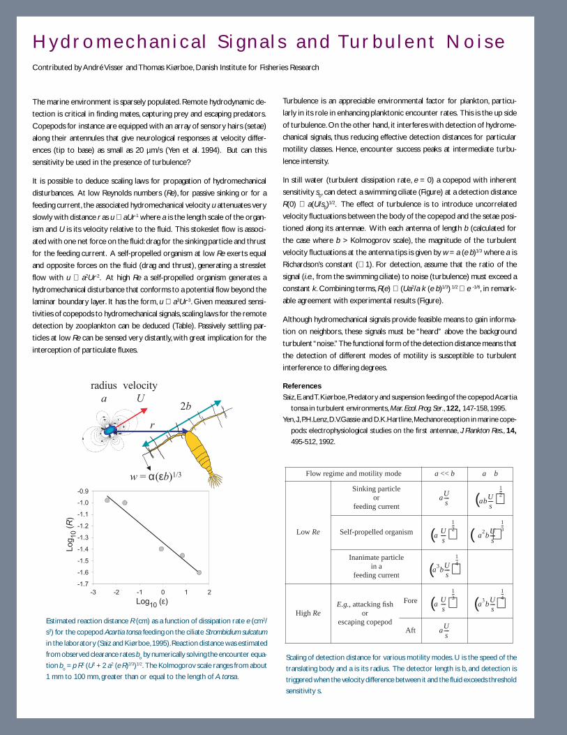
6 2
Flow regime and motility mode a << b a b
Low Re
Sinking particleor
feeding current
Self-propelled organism
Inanimate particlein a
feeding current
High ReE.g., attacking fish
orescaping copepod
Fore
Aft
aUs---- ab
Us----
12---
aUs----
12---
a2b
Us----
13---
a3b
Us----
14---
aUs----
13---
a3b
Us----
14---
aUs----
( )
( ) ( )
( )
( )( )
H y d r o m e c h a n i c a l S i g n a l s a n d Tu r b u l e n t N o i s eContributed by André Visser and Thomas Kiørboe, Danish Institute for Fisheries Research
The marine environment is sparsely populated. Remote hydrodynamic de-
tection is critical in finding mates, capturing prey and escaping predators.
Copepods for instance are equipped with an array of sensory hairs (setae)
along their antennules that give neurological responses at velocity differ-
ences (tip to base) as small as 20 µm/s (Yen et al. 1994). But can this
sensitivity be used in the presence of turbulence?
It is possible to deduce scaling laws for propagation of hydromechanical
disturbances. At low Reynolds numbers (Re), for passive sinking or for a
feeding current, the associated hydromechanical velocity u attenuates very
slowly with distance r as u ∝ aUr-1 where a is the length scale of the organ-
ism and U is its velocity relative to the fluid. This stokeslet flow is associ-
ated with one net force on the fluid: drag for the sinking particle and thrust
for the feeding current. A self-propelled organism at low Re exerts equal
and opposite forces on the fluid (drag and thrust), generating a stresslet
flow with u ∝ a2Ur-2. At high Re a self-propelled organism generates a
hydromechanical disturbance that conforms to a potential flow beyond the
laminar boundary layer. It has the form, u ∝ a3Ur-3. Given measured sensi-
tivities of copepods to hydromechanical signals, scaling laws for the remote
detection by zooplankton can be deduced (Table). Passively settling par-
ticles at low Re can be sensed very distantly, with great implication for the
interception of particulate fluxes.
Turbulence is an appreciable environmental factor for plankton, particu-
larly in its role in enhancing planktonic encounter rates. This is the up side
of turbulence. On the other hand, it interferes with detection of hydrome-
chanical signals, thus reducing effective detection distances for particular
motility classes. Hence, encounter success peaks at intermediate turbu-
lence intensity.
In still water (turbulent dissipation rate, e = 0) a copepod with inherent
sensitivity s0, can detect a swimming ciliate (Figure) at a detection distance
R(0) ∝ a(U/s0)1/2. The effect of turbulence is to introduce uncorrelated
velocity fluctuations between the body of the copepod and the setae posi-
tioned along its antennae. With each antenna of length b (calculated for
the case where b > Kolmogorov scale), the magnitude of the turbulent
velocity fluctuations at the antenna tips is given by w = a (e b)1/3 where a is
Richardson’s constant (≅ 1). For detection, assume that the ratio of the
signal (i.e., from the swimming ciliate) to noise (turbulence) must exceed a
constant k. Combining terms, R(e) ∝ (Ua2/a k (e b)1/3) 1/2 ∝ e -1/6, in remark-
able agreement with experimental results (Figure).
Although hydromechanical signals provide feasible means to gain informa-
tion on neighbors, these signals must be “heard” above the background
turbulent “noise.” The functional form of the detection distance means that
the detection of different modes of motility is susceptible to turbulent
interference to differing degrees.
References
Saiz, E. and T. Kiørboe, Predatory and suspension feeding of the copepod Acartia
tonsa in turbulent environments, Mar. Ecol. Prog. Ser., 122, 147-158, 1995.
Yen, J., P.H.Lenz, D.V.Gassie and D.K.Hartline, Mechanoreception in marine cope-
pods: electrophysiological studies on the first antennae, J. Plankton Res., 14,
495-512, 1992.
Scaling of detection distance for various motility modes. U is the speed of the
translating body and a is its radius. The detector length is b, and detection is
triggered when the velocity difference between it and the fluid exceeds threshold
sensitivity s.
-3 -2 -1 0 1 2
-1.7
-1.6
-1.5
-1.4
-1.3
-1.2
-1.1
-1.0
-0.9
r
velocity
U
radius
a2b
w = α(εb)1/3
Log10
(ε)
Log10(R
)
Estimated reaction distance R (cm) as a function of dissipation rate e (cm2/
s3) for the copepod Acartia tonsa feeding on the ciliate Strombidium sulcatum
in the laboratory (Saiz and Kiørboe, 1995). Reaction distance was estimated
from observed clearance rates bo by numerically solving the encounter equa-
tion bo = p R2 (U2 + 2 a2 (e R)2/3)1/2. The Kolmogorov scale ranges from about
1 mm to 100 mm, greater than or equal to the length of A. tonsa.
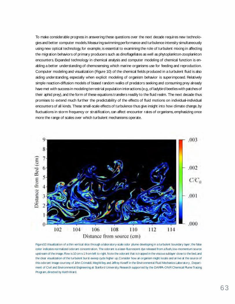
6 3
To make considerable progress in answering these questions over the next decade requires new technolo-
gies and better computer models. Measuring swimming performance and turbulence intensity simultaneously
using new optical technology, for example, is essential to examining the role of turbulent mixing in affecting
the migration behaviors of primary producers such as dinoflagellates as well as phytoplankton-zooplankton
encounters. Expanded technology in chemical analysis and computer modeling of chemical function is en-
abling a better understanding of chemosensing, which marine organisms use for feeding and reproduction.
Computer modeling and visualization (Figure 10) of the chemical fields produced in a turbulent fluid is also
aiding understanding, especially when explicit modeling of organism behavior is superimposed. Relatively
simple reaction-diffusion models of biased random walks of predators seeking and consuming prey already
have met with success in modeling terrestrial population interactions (e.g., of ladybird beetles with patches of
their aphid prey), and the form of these equations transfers readily to the fluid realm. The next decade thus
promises to extend much further the predictability of the effects of fluid motions on individual-individual
encounters of all kinds. These small-scale effects of turbulence thus give insight into how climate change, by
fluctuations in storm frequency or stratification, can affect encounter rates of organisms, emphasizing once
more the range of scales over which turbulent mechanisms operate.
Figure10. Visualization of a thin vertical slice through a laboratory-scale odor plume developing in a turbulent boundary layer; the false
color indicates normalized odorant concentration. The odorant is a laser-fluorescent dye released from a flush, low-momentum source
upstream of the image. Flow is 10 cm s-1 from left to right. Note the odorant that is trapped in the viscous sublayer close to the bed, and
the clear visualization of the turbulent burst-sweep cycle higher up. Consider how an organism might locate and arrive at the source of
this odorant Image courtesy of John Crimaldi, Meg Wiley, and Jeffrey Koseff in the Environmental Fluid Mechanics Laboratory , Depart-
ment of Civil and Environmental Engineering at Stanford University. Research supported by the DARPA-ONR Chemical Plume Tracing
Program, directed by Keith Ward.

6 4
Mesosca le eddy transpor t
Mesoscale eddies are energetic, rotating flow features having dimensions from kilometers to hundreds of
kilometers. Although intermittent in time and space, mesoscale eddies can exist for months to years and
move hundreds to thousands of kilometers in their lifetime. Due to their relatively large volumes and longevities,
these eddies can transport large amounts of salt and heat and the planktonic communities over large dis-
tances from one oceanic environment to another. Large rings of warm water, spun off from the Gulf Stream,
are one common eddy feature of the North Atlantic Ocean, and they often contain biological assemblages
transported far from their home, with gradually altering ecosystem-rate processes as ecological succession
proceeds.
Mesoscale eddies are strongly affected by Earth’s rotation and ocean stratification, and are both generated by
larger currents, such as the Gulf Stream and Kuroshio, and are capable of influencing those currents as they
shed energy into eddies and as the eddies steer the parent flow. These eddies create shear as they move
through the ocean, and this shear produces important fine-scale structures both directly and through inter-
action with internal waves.
For over 30 years there has been lively debate among physical oceanographers as to how mesoscale eddies
affect the larger-scale, more slowly evolving general circulation of the ocean. Henry Stommel first drew
attention to this problem, and subsequent observational work has been successful in identifying many of the
more energetic classes of surface and subsurface mesoscale eddy motions. The large number of eddies, and
the contrast in their energies and properties with the surrounding fluid, make it clear that these eddies can
contribute significantly to larger-scale property transport. It is also clear that the correlations of velocity and
tracer concentrations (such as temperature and carbon dioxide) are too low in general to be reliably mea-
sured at a point with present techniques, thus preventing direct calculations of eddy fluxes. Nevertheless,
recent efforts to parameterize these effects have shown that even small correlations between velocities and
concentrations can lead to net transports that have a profound effect on circulation and large-scale distribu-
tion of properties in the ocean.
In cases where there is a clear separation of spatial scales between eddies and the mean field in which they
circulate, recent theoretical work has shown that the eddy flux of a tracer can be modeled as the product of
a tensor diffusivity and the tracer’s mean gradient. This result has allowed improved parameterizations for
eddy fluxes in medium-resolution numerical ocean circulation models (which do not permit resolution of the
mesoscale eddies themselves). Clearly, more work using numerical circulation models that either resolve the
eddy field directly or incorporate more accurate parameterizations of eddy fluxes are needed to investigate
the effects of the mesoscale eddy field on the larger-scale ocean circulation and property distributions. Also
required for significant progress are new field measurements of sufficient duration and spatial coverage to
establish the magnitude of eddy fluxes and to test the relation of these fluxes with the larger-scale circulation
and property distributions. Such measurements can be made within the context of the long time series
needed to support climate studies.
6 5
Sur face- l ayer processes
The oceanic mixed layer, where turbulent mixing overcomes stable density stratification, is the most promi-
nent consequence of the vigor of air-sea interaction (see Effects of Surface Waves box on page 66). The main
energy source for upper-ocean turbulence is atmospheric forcing both by wind stress and buoyancy loss
through evaporation and cooling. In turn, this turbulence regulates both the rate at which the ocean responds
to atmospheric forcing and how it feeds back on the atmosphere. Because the ocean’s immediate impact on
the atmosphere is determined by the sea-surface temperature, which modulates the transfer of sensible and
latent heat, the cycle of heat storage in the mixed layer and its subsequent release are crucial. It is the slower
interaction of the mixed layer and the seasonal thermocline below, however, that governs how the atmo-
sphere affects the stratified ocean. The rate of gas transfer through the air-sea interface is so strongly
hindered by that interface’s suppression of turbulence that it is plausible that the air-sea transfer of oxygen
and CO2 are mainly determined by the breaking of capillary ripples and plunging waves.
The basic annual variation of the mixed layer’s depth and temperature can be understood in terms of air-sea
fluxes of heat and mechanical energy and turbulence where the mixed layer meets the seasonal pycnocline.
Because of the importance of this seasonal cycle to both the ocean’s effect on the atmosphere and establish-
ment of upper-ocean stratification, this process has been widely studied, and several models of mixed-layer
behavior are included in ocean circulation models. Remarkably, despite 30 years of measurement and model-
ing, there is no consensus on (a) what processes are responsible for wind mixing of the mixed layer (how
much is wind mixing similar to mixing next to a solid surface, how much is it influenced by breaking waves
over scales ranging from micro-breakers to plungers, and how much is wind mixing the result of Langmuir
circulations driven by surface waves), (b) what processes, in addition to the obvious buoyancy input by
surface warming, cause the deep winter mixed layer to restratify, and (c) what is the relative importance of
wind-driven turbulence, large eddies in the mixed layer, and turbulence generated by the strong shear found
in the upper thermocline to entrainment of stratified waters into the mixed layer? Much of the seasonal air-
sea transfer of heat, for example, is often the result of a small number of storms. It is important even to
climate dynamics that these questions are resolved because the ocean’s response to such storms differs
significantly between models based on these different processes.
Computer modeling using Large Eddy Simulation (LES) techniques can help explain observations and point
the way to parameterizations that allow upper-layer physics to be represented in circulation models. How-
ever, LES runs into many of the same problems experienced in numerical models when many of the processes
responsible for the mixing fall below the grid scale, especially near the surface. Nevertheless, significant
progress will depend on sophisticated and comprehensive field studies that not only describe the bulk changes
associated with air-sea interaction but also allow detailed diagnosis of the small-scale processes that bring
about these changes. Because of the close connection between primary productivity, turbulent nutrient
supply and sinking fluxes of particulate carbon, co-locating studies of the physical and biological processes
occurring in the upper layer will be a particularly productive path to progress.
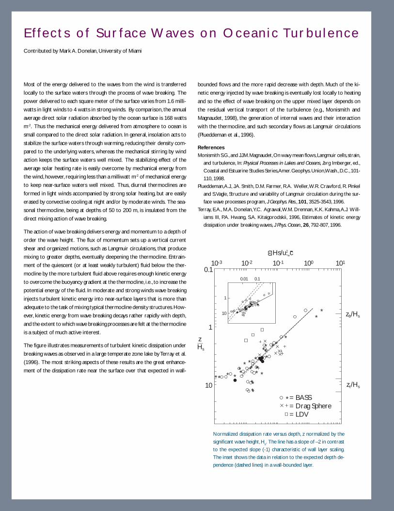
6 6
E f f e c t s o f S u r f a c e Wave s o n O c e a n i c Tu r b u l e n c eContributed by Mark A. Donelan, University of Miami
Most of the energy delivered to the waves from the wind is transferred
locally to the surface waters through the process of wave breaking. The
power delivered to each square meter of the surface varies from 1.6 milli-
watts in light winds to 4 watts in strong winds. By comparison, the annual
average direct solar radiation absorbed by the ocean surface is 168 watts
m-2. Thus the mechanical energy delivered from atmosphere to ocean is
small compared to the direct solar radiation. In general, insolation acts to
stabilize the surface waters through warming, reducing their density com-
pared to the underlying waters, whereas the mechanical stirring by wind
action keeps the surface waters well mixed. The stabilizing effect of the
average solar heating rate is easily overcome by mechanical energy from
the wind, however, requiring less than a milliwatt m-2 of mechanical energy
to keep near-surface waters well mixed. Thus, diurnal thermoclines are
formed in light winds accompanied by strong solar heating, but are easily
erased by convective cooling at night and/or by moderate winds. The sea-
sonal thermocline, being at depths of 50 to 200 m, is insulated from the
direct mixing action of wave breaking.
The action of wave breaking delivers energy and momentum to a depth of
order the wave height. The flux of momentum sets up a vertical current
shear and organized motions, such as Langmuir circulations, that produce
mixing to greater depths, eventually deepening the thermocline. Entrain-
ment of the quiescent (or at least weakly turbulent) fluid below the ther-
mocline by the more turbulent fluid above requires enough kinetic energy
to overcome the buoyancy gradient at the thermocline, i.e., to increase the
potential energy of the fluid. In moderate and strong winds wave breaking
injects turbulent kinetic energy into near-surface layers that is more than
adequate to the task of mixing typical thermocline density structures. How-
ever, kinetic energy from wave breaking decays rather rapidly with depth,
and the extent to which wave breaking processes are felt at the thermocline
is a subject of much active interest.
The figure illustrates measurements of turbulent kinetic dissipation under
breaking waves as observed in a large temperate zone lake by Terray et al.
(1996). The most striking aspects of these results are the great enhance-
ment of the dissipation rate near the surface over that expected in wall-
bounded flows and the more rapid decrease with depth. Much of the ki-
netic energy injected by wave breaking is eventually lost locally to heating
and so the effect of wave breaking on the upper mixed layer depends on
the residual vertical transport of the turbulence (e.g., Monismith and
Magnaudet, 1998), the generation of internal waves and their interaction
with the thermocline, and such secondary flows as Langmuir circulations
(Plueddeman et al., 1996).
References
Monismith S.G., and J.J.M. Magnaudet, On wavy mean flows, Langmuir cells, strain,
and turbulence, In: Physical Processes in Lakes and Oceans, Jorg Imberger, ed.,
Coastal and Estuarine Studies Series, Amer. Geophys. Union, Wash., D.C., 101-
110, 1998.
Plueddeman,A.J., J.A. Smith, D.M. Farmer, R.A. Weller, W.R. Crawford, R. Pinkel
and S. Vagle, Structure and variability of Langmuir circulation during the sur-
face wave processes program, J. Geophys. Res., 101, 3525-3543, 1996.
Terray, E.A., M.A. Donelan, Y.C. Agrawal, W.M. Drennan, K.K. Kahma, A.J. Will-
iams III, P.A. Hwang, S.A. Kitaigorodskii, 1996, Estimates of kinetic energy
dissipation under breaking waves, J. Phys. Ocean., 26, 792-807, 1996.
10-3
1
zsH
0.1
10
= BASS= Drag Sphere= LDV
10-2
0.01 0.1
10
1
10-1 100 101
Hs/u2 c*w
ω
zb/Hs
zt/Hs
*
** * *****
****
*** *
***
*** **
*
**
*
Normalized dissipation rate versus depth, z normalized by the
significant wave height, Hs. The line has a slope of –2 in contrast
to the expected slope (-1) characteristic of wall layer scaling.
The inset shows the data in relation to the expected depth de-
pendence (dashed lines) in a wall-bounded layer.

6 7
W H AT M A K E S P RO G R E S S P O S S I B L E N OW ?There are no direct solutions in sight to the problems of oceanic turbulence. It is unlikely that a single
solution will suddenly solve the turbulence problem that has vexed the brightest minds for two centuries.
There are, however, some new tools that promise significant progress. Some of them are:
• Deliberate tracer releases. The North Atlantic Tracer Release Experiment was a significant breakthrough
in determining very directly the rate of diapycnal mixing in the main thermocline. Because of ingenious
methods for releasing the tracer SF6 very close to an isopycnal and for detecting it in very small amounts
over large areas, it is now possible to watch diapycnal mixing redistribute a passive tracer for over one year
in the interior of an ocean circulation gyre where mixing is quite weak. Deliberate tracer releases have now
been successfully made in much more energetic mixing regimes (e.g., a coastal tidal mixing front) to investigate
diapycnal mixing on shorter time scales (e.g., several days).
• Expanding capability for numerical simulation. The present generation of computers allows limited
simulation of turbulent processes and thus provides new opportunities to develop theories and
parameterizations of turbulent processes and to better understand what the necessarily incomplete
measurements mean. For example, Large Eddy Simulation of the mixed layer is being used to address the
questions surrounding mixing within the mixed layer and entrainment of pycnocline water. Likewise, Direct
Numerical Simulation is being used to investigate mixing on the smallest scales (down to dissipation scales)
and explore the assumptions of isotropy so often used in interpreting instrumental (especially fine- and
microstructure) records.
• Improving sensors and methods for physical observations of turbulence. The sensor technology
that has made present understanding of ocean turbulence possible was, to a large degree, supported for its
ability to detect submarines. Despite reduced funding for technical development, this technology has improved
steadily so that it is now possible to sample quickly many turbulence variables simultaneously over much of
the water column. The ability to sample both velocity and tracer microstructure is essential to providing
confidence in the conclusions about transport rates and mechanisms.
• Improving sensors and methods for turbulent flux measurements. Accurate direct covariance
measurements of turbulent fluxes of momentum and heat are now possible using new acoustic current
meters and anemometers. Originally developed for ocean sediment transport and atmospheric planetary
boundary layer studies, these new sensors and techniques are beginning to provide a detailed look at the
true turbulent fluxes without a priori assumptions about isotropy or approximations in the turbulent
kinetic energy equation (see Turbulence Dynamics box on page 68). These new flux measurements will
provide critical tests of existing and new turbulent flux parameterizations.
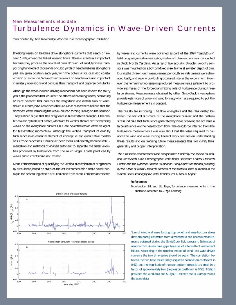
6 8
New Measurements E luc idate
Tu r b u l e n c e D y n a m i c s i n Wav e - D r i v e n C u r r e n t sContributed by John Trowbridge, Woods Hole Oceanographic Institution
Breaking waves on beaches drive alongshore currents that reach or ex-
ceed 1 m/s, among the fastest oceanic flows. These currents are important
because they produce the so-called coastal “river” of sand, typically trans-
porting hundreds of thousands of cubic yards of beach material alongshore
past any given position each year, with the potential for dramatic coastal
erosion or accretion. Wave-driven currents on beaches are also important
in military operations and because they transport and disperse pollutants.
Although the wave-induced driving mechanism has been known for thirty
years, the processes that counter the effects of breaking waves, permitting
a “force balance” that controls the magnitude and distribution of wave-
driven currents, have remained obscure. Most researchers believe that the
dominant effect balancing the wave-induced forcing is drag on the seafloor.
They further argue that this drag force is transmitted throughout the wa-
ter column by turbulent eddies, which are far weaker than either the breaking
waves or the alongshore currents, but are nevertheless an effective agent
for transmitting momentum. Although the vertical transport of drag by
turbulence is an essential element of conceptual and quantitative models
of surfzone processes, it has never been measured directly, because instru-
mentation and methods of analysis sufficient to separate the small veloci-
ties produced by turbulence from the much larger signals produced by
waves and currents have not existed.
Measurements aimed at quantifying the vertical transmission of drag forces
by turbulence, based on state-of-the-art instrumentation and a novel tech-
nique for separating effects of turbulence from measurements dominated
by waves and currents, were obtained as part of the 1997 “SandyDuck”
field program, a multi-investigator, multi-institution experiment conducted
in Duck, North Carolina. An array of five acoustic Doppler velocity sen-
sors was mounted on a bottom-fixed steel frame at a water depth of 5 m.
During the three-month measurement period, three instruments were dam-
aged badly, and severe bio-fouling occurred late in the experiment. How-
ever, the remaining two sensors produced measurements sufficient to pro-
vide estimates of the force-transmitting role of turbulence during three
large storms. Measurements obtained by other SandyDuck investigators
provide estimates of wave and wind forcing, which are required to put the
turbulence measurements in context.
The results are intriguing. The flow energetics and the relationship be-
tween the vertical structure of the alongshore current and the bottom
stress indicate that turbulence generated by wave breaking did not have a
large influence on the near-bottom flow. The drag force inferred from the
turbulence measurements was only about half the value required to bal-
ance the wind and wave forcing. Present work focuses on understanding
these results and on planning future measurements that will clarify their
generality and proper interpretation.
The turbulence measurements and analysis were funded by the Mellon Founda-
tion, the Woods Hole Oceanographic Institution’s Rhinehart Coastal Research
Center and the National Science Foundation. SandyDuck was funded primarily
by the Office of Naval Research. Portions of this material were published in the
Woods Hole Oceanographic Institution Year 2000 Annual Report.
230 240 250 260 270 280 290 3000.5
0
0.5
1
1.5
2
2.5
τ wy d
/dx(
Sxy
) (P
a)
Sum of wind and wave forcing
a
230 240 250 260 270 280 290 3000.5
0
0.5
1
1.5
2
2.5
-ρ
<v′ w
′ > (
Pa)
Nearbottom turbulent Reynolds shear stress
Year day 1997
b
Sum of wind and wave forcing (top panel) and near-bottom stress
(bottom panel) estimated from atmospheric and oceanic measure-
ments obtained during the SandyDuck field program. Estimates of
near-bottom stress have gaps because of intermittent instrument
failure. According to the simplest model of wind- and wave-driven
currents, the two time series should be equal. The correlation be-
tween the two time series is high (squared correlation coefficient is
0.63), but the magnitude of the near-bottom stress is too small by a
factor of approximately two (regression coefficient is 0.53). J. Edson
provided the wind data, and S. Elgar, T. Herbers and R. Guza provided
the wave data.
References
Trowbridge, J.H. and S.L. Elgar, Turbulence measurements in the
surfzone, accepted to J. Phys. Oceanog.

6 9
• Improved large-scale observations and models. Because turbulence is crucial to so many large-
scale processes, it is possible to use large-scale observations and models to better understand turbulence.
For example, the high-quality observations from the World Ocean Circulation Experiment (WOCE) will
much better define the general circulation, including thermohaline overturning, and thereby perhaps resolve
the “Abyssal Recipes” paradox. Similarly, coupled with ecological and general-circulation models, satellite
observations of ocean color and long-term, in situ observations of physical and bio-optical parameters may
be expected to shed new light not only on ocean ecology but on the turbulent processes involved.
• New ways to observe small-scale biological fields. New optical, acoustic and chemical sensors are
being developed and existing sensors are being improved and miniaturized. The combination of data from
sophisticated, high-capability sensors operating from ships and remotely operated vehicles, themselves
embedded in a network of data from autonomous instruments carrying robust, miniaturized sensors,
opens the possibility of newly comprehensive investigations of turbulent interactions with biological systems.
W H AT I S R E Q U I R E D F O R P RO G R E S S ?Open avenues toward progress in understanding ocean turbulence appear to be more evolutionary than
revolutionary in all respects save one. The importance of turbulence to both the behavior of individual
animals and to supporting aquatic plants dictates new collaborations between biologists and ocean physicists.
This collaboration is likely to be profitable not only in the development of more comprehensive methods for
field observations but also in development of ecological models and perhaps in sharing of conceptual frame-
works. Equally, the broad importance of turbulence means that process-oriented students of the microscale
and those investigating the large-scale consequences of turbulence need to be aware of, and keep testing,
each others’ perceptions. Points of disagreement, such as the “Abyssal Recipes” paradox, should be sought as
quick avenues from conventional wisdom to experimental test. Debate among large-scale specialists, physical
turbulence experts and biological oceanographers who manage to overcome their semantic differences will
continue to be the surest way to raise these points.
Exploitation of existing instruments and development of new and improved observational methods will likely
continue to be the foundation for progress. Special mechanisms to support the frequently lengthy process of
such developments will require special wisdom in the environment of peer-reviewed proposals. Hopefully it
will be possible to weigh the value of sustained investment to yield new methods against the promise of
immediate results using today’s methods. Even with wisdom, development of new observational methods will
be expensive, but past progress demonstrates the worth of this approach.
Turbulence research does not cry out for massive “organization.” Progress to date has been steady and the
result of numerous small breakthroughs in theory, numerical simulation and, most of all, in instrumentation
and observational technique. The most productive studies have been mid-sized collaborations focused on
particular regions and sets of phenomena. These collaborations have lasted only a few years and have not
expended many man-years on organization or extensive programmatics. If this approach can be extended to
foster collaboration among biologically and physically oriented workers, this efficient approach should serve
the future well.

7 0
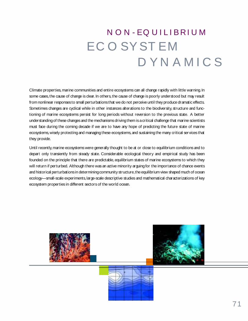
7 1
Climate properties, marine communities and entire ecosystems can all change rapidly with little warning. In
some cases, the cause of change is clear. In others, the cause of change is poorly understood but may result
from nonlinear responses to small perturbations that we do not perceive until they produce dramatic effects.
Sometimes changes are cyclical while in other instances alterations to the biodiversity, structure and func-
tioning of marine ecosystems persist for long periods without reversion to the previous state. A better
understanding of these changes and the mechanisms driving them is a critical challenge that marine scientists
must face during the coming decade if we are to have any hope of predicting the future state of marine
ecosystems, wisely protecting and managing these ecosystems, and sustaining the many critical services that
they provide.
Until recently, marine ecosystems were generally thought to be at or close to equilibrium conditions and to
depart only transiently from steady state. Considerable ecological theory and empirical study has been
founded on the principle that there are predictable, equilibrium states of marine ecosystems to which they
will return if perturbed. Although there was an active minority arguing for the importance of chance events
and historical perturbations in determining community structure, the equilibrium view shaped much of ocean
ecology—small-scale experiments, large-scale descriptive studies and mathematical characterizations of key
ecosystem properties in different sectors of the world ocean.
E C O S Y S T E M D Y N A M I C S
N O N - E Q U I L I B R I U M

7 2
Recent studies suggest that neither physical, chemical nor biological components of marine ecosystems need
to be at equilibrium. It is now recognized that many properties of marine ecosystems show directional
changes over time, oscillate between different states or exhibit complex behavior as a consequence of non-
linear interactions. A related lesson from the fossil record is that long periods of little change can be punc-
tuated by short periods of rapid change in species composition. These departures from “equilibrium” condi-
tions are not necessarily transients from which ecosystems will quickly rebound, but may represent the more
typical states experienced by most organisms in the sea. The equilibrium-based theoretical and observational
tools that were commonly used in previous decades have poorly equipped the discipline to address the
realities of a dynamic and changing ocean environment. Major new research efforts are needed to expand our
ability to understand, model and predict the responses of marine populations and communities to these non-
equilibrium conditions.
W H AT A R E T H E B I G P RO B L E M S ?The realization that marine ecosystems are commonly in disequilibrium presents exciting opportunities for
ocean scientists from various traditional disciplines to collaborate on a spectrum of ecosystem studies.
Characterization of external climate forcing which causes ecosystem variability is vital. Differentiating an-
thropogenic influences on marine ecosystems from naturally occurring changes is a pressing and complex
challenge. Large-scale manipulative experiments are urgently needed that test hypothesized responses of
communities and food webs to perturbations. Experimental investigations of the functional relationships
between organisms and their four-dimensional environment are needed. New classes of models that incor-
porate nonlinear interactions, explicit spatial structure and non-equilibrium climate conditions need to be
developed. And, an evolutionary perspective needs to be fostered that illuminates the ways in which popula-
tions and communities of organisms are adapted to the extremes, rather than the mean state of marine
ecosystems.
Understanding of processes causing shifts in marine communities is inadequate, although some important
factors are beginning to be identified. Some of these processes are discussed in the next section and the most
promising new research directions pointed out.
Externa l ly Forced Changes in Mar ine Ecosystems
Ocean ecologists are becoming increasingly aware of the linkages between external physical forcing and the
responses of marine communities. Some of these physical changes are directional and progressive, with
unknown consequences for the marine biota. Others appear to be cyclical, occurring across a spectrum of
temporal frequencies. Still others are episodic, with no predictable recurrence interval but having the poten-
tial to greatly influence the structure and function of marine communities. Whether directional, cyclical or
episodic, understanding the consequences of such changes in the external environment for marine commu-
nities is an exciting and open field ripe for new forms of scientific collaboration and innovative investigation.

7 3
Secular changes. Other than the direct effects of human interference, such as overfishing and habitat
modification, the most conspicuous directional changes in the atmosphere and upper ocean in the twentieth
century are the progressive increases in CO2 , CH4 and other radiatively active gases. The capacity of the
ocean to assimilate these gases, the consequences for the ocean’s chemistry and the role of the biological
pump in modifying atmospheric gas content and heat flux to Earth’s surface are subjects of active investiga-
tion. The consequences of these secular changes for the ocean’s biota and the role of the ocean’s biota in
influencing the atmosphere are major problems that have only begun to be addressed.
While some studies have documented significant warming of the upper ocean in the last 40 to 50 years, it is
not yet clear whether these changes should be considered secular trends or part of a long-term, cyclical
oscillation of unknown periodicity. In any case, warming of the upper ocean has, in some regions, led to
increased vertical stratification that can have significant consequences for the vertical diffusion of nutrients
and for primary and secondary production. In tropical oceans, an increase in the duration of annual extreme
high temperatures have been associated with widespread coral bleaching and death. In the Antarctic, reduced
winter sea ice coverage appears to be changing the types of grazers in pelagic food webs, which in turn alters
the biological pump exporting carbon to the seafloor (see Antarctic Marine Ecosystem box on page 74).
Documenting such trends, and discerning the mechanisms through which they influence oceanic communi-
ties, is a important direction for the future.
The long-term, 70% decline in the total biomass of zooplankton of the California Current system between
the 1950s and the 1990s is another example of a change that has been interpreted as part of a cyclical
phenomenon (see “Interdecadal scale changes” below), but the instrumental record is too short to differen-
tiate clearly between long-term, periodic behavior and a secular trend. The flux of organic matter to the
deep-sea benthos has also declined in the last decade, concomitantly with the decrease in zooplankton in
overlying surface waters. Hence, perturbations in the atmosphere may influence upper ocean plankton com-
munities and propagate through a 4000 m water column to the deep seafloor. Rising ocean temperatures
have also been associated with geographic alterations of species’ distributions. Along the US coastline,
southern fishes and intertidal organisms have both expanded northward. Detecting and understanding these
perturbations and community alterations represent exciting new opportunities.
Other secular trends, such as the increase in the intensity of the ozone hole and consequent changes in uv-
b flux, have already been found to influence photosynthetic activity of marine phytoplankton and develop-
mental processes in larval marine invertebrates. The longer term consequences of such changes at the
population and community level are unknown.
A long-term trend toward increased nutrient influx into the coastal Gulf of Mexico may be increasing the
frequency of hypoxic events on the continental shelf. However, the increased flux of nutrients into these
oligotrophic waters an have two markedly different fates. The new nutrients may stimulate primary and
secondary production in the water column, which can ultimately enhance fish production. Alternatively, the
enhanced primary production may flocculate as unutilized organic matter on the continental shelf where its
oxidation results in severe oxygen depletion in the water column that can kill fishes. It is not well understood
how these markedly different pathways are controlled.

7 4
D e c a d a l S c a l e C h a n g e s i n t h e A n t a r c t i cM a r i n e E c o s y s t e mContributed by Valerie Loeb, Moss Landing Marine Laboratories
William Fraser, Montana State University
Roger Hewitt, Southwest Fisheries Science Center
Antarctic krill, Euphausia superba, is the major food source for higher-level
predators including penguins, fish, seals and whales and is considered the
keystone species of the Antarctic marine ecosystem. Another pelagic ani-
mal, the gelatinous tunicate Salpa thompsoni, can also be abundant in the
Antarctic Peninsula area during spring and summer months. Salps constantly
filter seawater, ingest phytoplankton and small zooplankton and produce
dense fecal pellets as they swim through the upper water column. During
episodic and massive spring-summer blooms, salps can have a major impact
on other zooplankton through competition for planktonic food particles
and predation upon small organisms such as krill eggs and larvae. Unlike
krill, salps have relatively few predators and most of the newly fixed carbon
ingested by salps in the upper water column is lost to deep waters via
downward transport of fecal pellets. Hence, whether krill or salps pre-
dominate in the upper water column has significant implications for the
functioning of the Antarctic ecosystem.
Between-year variations in krill and salp abundance have been related to
winter sea ice development (Loeb et al., 1997). Two successive winters of
strong sea ice development appear to favor low salp abundance, good krill
reproductive success and substantial krill population growth, while rela-
tively low winter sea ice extent is associated with poor krill recruitment
success and massive summertime salp blooms. The positive relationship
between krill recruitment and winter sea ice development is believed to be
due to the ability of krill to feed on abundant ice algae and other food
growing under sea ice, as well as the refuge from predators provided by
cracks and crevices within the sea ice. Low salp competition and predation
pressure during these periods are hypothesized to enhance krill recruit-
ment success. In contrast, rapid salp population increases are thought to
occur in open water during years when phytoplankton growth in early
spring is not limited by sea ice cover.
Long-term, interdecadal shifts in abundance of krill (Figure), krill predators
and salps have been related to the decreased frequency of winters with
extensive sea ice development, which are in turn associated with a warm-
ing trend observed in the Antarctic Peninsula area since the 1940’s (Fraser
et al., 1992; Loeb et al., 1997). The frequency of cold winters with extensive
sea ice cover has decreased from every four out of five years during the
middle of the last century to only one or two out of five years since the
1970’s.
References
Fraser, W.R., W.Z. Trivelpiece, D.G. Ainley and S.G. Trivelpiece, Increases in
Antarctic penguin populations: reduced competition with whales or a loss of
sea ice due to environmental warming?, Polar Biology, 11, 525-531, 1992.
Loeb, V., V. Siegel, O. Holm-Hansen, R. Hewitt, W. Fraser, W. Trivelpiece and S.
Trivelpiece, Effects of sea-ice extent and krill or salp dominance on the Ant-
arctic food web, Nature, 387, 897-900, 1997.

7 5
Cyclical changes in climate. In the 1990s our awareness increased of the presence of interannual and
longer-period variations in the atmosphere and ocean in virtually all ocean basins. In a limited number of
instances there is already clear evidence that marine populations respond in dramatic ways to these varia-
tions (e.g., “regime shifts” in the North Pacific and plankton responses to the North Atlantic Oscillation). In
other instances there is suggestive evidence that some of the long-period variability in marine communities
may be directly influenced by cyclical climate variations. There are now significant opportunities to under-
stand the mechanisms linking climate with fluctuations in marine populations and communities.
Interdecadal scale changes. Recent observations from the North Atlantic and North Pacific suggest that there
are remarkable decadal-scale climate oscillations linked to the variability of marine populations (see Pacifical
Decadal Oscillation box on page 22). It seems likely that such linkages will also appear in other ocean basins
(see Global Climate chapter). While the precise mechanisms involved and the timing of the transitions
between ecosystem states are not yet clear, there is evidence that some populations in major marine ecosys-
tems oscillate between different states in phase with large-scale forcing from the atmosphere and upper
ocean. In some cases there are relatively rapid changes from one dominant mode to another. These results
have broad implications for the way we study and manage marine ecosystems. The possibility that the
ecosystem is currently not at equilibrium and may change relatively quickly to a new state means that scien-
tists and resource managers must pay close attention to the state of the climate cycle as well as to present-
day conditions. Ill-timed exploitation of a marine population during a period of natural decline can severely
depress a marine resource for decades. There could be similar consequences if pathogens, hurricanes or
other perturbations negatively impact populations during these critical periods. This underscores the need
to understand the longer-period climate properties and the ways in which climate cycles interact with other
important processes affecting marine populations.
Interannual changes. The El Niño-Southern Oscillation (ENSO) is the largest known short-term climate signal
in the world ocean (see ENSO box on page 40). Large El Niños in the twentieth century have resulted in
major declines in fishery harvests (finfish, sea urchins, squid), severely altered kelp forests, depressed biomass
of zooplankton, temporarily displaced lower latitude organisms into high latitudes, exacerbated coral bleach-
ing and reef loss, and increased rates of parasitic infection of some marine organisms. The new ability to
project the occurrence of El Niños has benefited the design of experimental and observational programs
(and permitted human agencies to prepare for the environmental and social consequences of the event).
Despite this new ability to forecast, there is still uncertainty as to how the tropical perturbations are propa-
gated into high latitudes: to what extent does the signal propagate through the ocean and to what extent
through the atmosphere? In the future, improved understanding of physical propagation mechanisms and
biological responses should permit the forecasting of El Niño effects on ocean populations in a way that can
be used for the adaptive management of marine resources.
Other interannual perturbations, such as variations in the ocean’s thermohaline circulation, may result in
changes in stability of the Southern Ocean as a consequence of increased freshwater input. The conse-
quences of such changes for ecosystems and for world climate have not been adequately explored.

7 6
Episodic changes. A variety of episodic changes occur in marine ecosystems and
may perturb communities and ecosystems away from equilibria, or may introduce
new conditions which can transiently favor entirely new communities. Some ex-
amples include the relatively sudden birth and death of hydrothermal vents (Figure
11). The emergence of vent fluids is followed by rapid colonization and proliferation
of vent-adapted organisms, then their local demise when the hydrothermal fluids
exit elsewhere in Earth’s crust. Hurricanes have been found to result in a wholesale
decimation of coral reef communities, although some corals show remarkable resil-
ience to such changes. Some anthropogenic influences such as oil spills can be ex-
treme perturbations to ecological systems, whose recovery potential is poorly un-
derstood.
In terna l l y Dr iven Changes in Mar ine Sys tems
In addition to perturbations to marine communities caused by external physical
factors and by humans, numerous processes internal to populations and communi-
ties can cause relatively abrupt shifts in the composition and function of the ocean’s
biota. Understanding these processes, which often develop from nonlinearities in
the interactions between individuals within a population, or between species, is an
important challenge in the ocean sciences.
Trophic Cascades. In addition to strong direct effects on prey, consumers can
have pervasive, indirect impacts on community organization when the prey are them-
selves strong interactors with other species in the community. These indirect ef-
fects can extend well beyond the particular prey taxa consumed. Such indirect inter-
Figure 11. Temporal sequence of faunal community development near a primary eruptive fissure at 9°50’N along the East Pacific Rise following a volcanic eruption in 1991 (see Figure 18 on page 115 in the
Ocean Below the Seafloor chapter for vent chemistry and temperature sequence in same vent area). The
photos were taken from Alvin, and all are of the same view. (a) April 1991: no vent megafaunal organisms
present when vigorous hydrothermal circulation was initiated, but profuse microbial material was being
expelled. (b) By March 1992, the fissure was colonized by an extensive population of Tevnia jerichonana,
with Riftia pachyptila noticeably absent. (c) By December 1993, numerous R. pachyptila had settled and
rapidly grown to form a dense thicket, engulfing the existing T. jerichonana. (d) Between December 1993
and October 1994, continued rapid colonization and growth by large numbers of R. pachyptila dramati-
cally increased the density, lateral extent and vertical growth within this colony. (e) By November 1995,
the density and lateral extent of the colony continued to increase. The colony was now occupied by over
~2000 R. pachyptila. About half of the T. jerichonana assemblage documented in 1992 was alive in 1995 at
the base of the R. pachyptila tubes. The staining of worm tubes with a rust-colored ferrous-oxide precipi-
tate was coincident with increased concentrations of iron in the diffuse vent fluids (maximum recorded
was 33°C), and a decrease in H2S, supporting this colony. (f) By November 1997, although the tempera-
ture of the fluids remained high (27.2°C), almost no H2S remained in the fluids, and the R. pachyptila
community had noticeably declined. Reprinted from Deep Sea Res. II, 45, Shank, T.M., D.J. Fornari, K.L. Von
Damm, M.D. Lilley, R.M. Haymon and R.A. Lutz, Temporal and spatial patterns of biological community
development at nascent deep-sea hydrothermal vents along the East Pacific Rise, 465-515, copyright
1998, with permission from Elsevier Science. The figure, which has been modified from the original to
include Frame (f) (unpublished data), was supplied by Tim Shank, Woods Hole Oceanographic Institution;
Richard Lutz, Rutgers University; and Karen Von Damm, University of New Hampshire.

7 7
action chains can produce trophic cascades, in which the impact of an apex predator cascades through the
intervening trophic levels to influence the abundance of primary producers and the organization and compo-
sition of the community in general.
The trophic cascade concept is best exemplified by long-term studies of the interactions of piscivorous fish,
planktivorous fish, zooplankton and phytoplankton in North American lakes. In these systems, both observa-
tional and experimental studies indicated that all lower trophic levels could be altered dramatically by chang-
ing the density of top consumers. Similar cascades occur in the marine realm. Interactions among sea otters,
herbivorous sea urchins, and kelps provide a dramatic example. In areas occupied by sea otters, herbivorous
sea urchins are rare, kelps are common, and the large numbers of fishes and other species that recruit to kelp
beds produce a system that is highly productive, rich in biodiversity, and important for exporting energy to
surrounding communities. When sea otters are absent, urchins overgraze the kelps, the biogenic structure
that defines the system is lost, and the system consists of high densities of urchins, a few encrusting seaweeds
that are resistant to grazing, and little else. Thus, in the absence of sea otters, species-rich kelp beds can
change to species poor urchin-barrens. Such shifts have occurred after fur traders drove the otters to near
extinction and after killer whales along the coast of Alaska switched from their normal prey to feeding on sea
otters. Once urchin barrens have been established, they can persist for long periods in the absence of sea
otters, but if otters are reintroduced to the area, they rapidly consume the urchins and promote reestablish-
ment of kelp bed communities.
In pelagic marine systems there are several patterns suggesting that trophic cascades allow perturbations of
upper trophic levels to cascade down and influence phytoplankton dynamics in the open ocean. In the subarc-
tic Pacific between 1990 and 1994, surface chlorophyll and salmon abundance alternated synchronously
between high values in odd years and low values in even years, while zooplankton biomass varied with an
opposite sign, i.e., low in odd and high in even years. A likely explanation for this interannual oscillation
involves the releases of hatchery-reared salmon and their predatory impact on herbivorous zooplankton; by
depressing zooplankton, salmon appear to release phytoplankton from grazing pressure. The potentially
complex nature of these interactions illustrates the need for cooperative, multifaceted research programs.
Other Nonlinearities. Existing classical, linear models of food webs have long predicted that complex
communities are inherently unstable. Such models predict that the presence of large numbers of interacting
species will tend to cause large fluctuations in abundances of other organisms and thus to destabilize food
webs. However, a recent model that allows communities to display nonlinear trophic interactions and to
display nonequilibrium dynamics arrives at the opposite conclusion: large numbers of weak interactions
between species tend to dampen oscillations and thus to stabilize communities (see Biodiversity and Ecosys-
tem Stability box on page 78). This new result agrees with abundant evidence for large numbers of interacting
species found in nature.
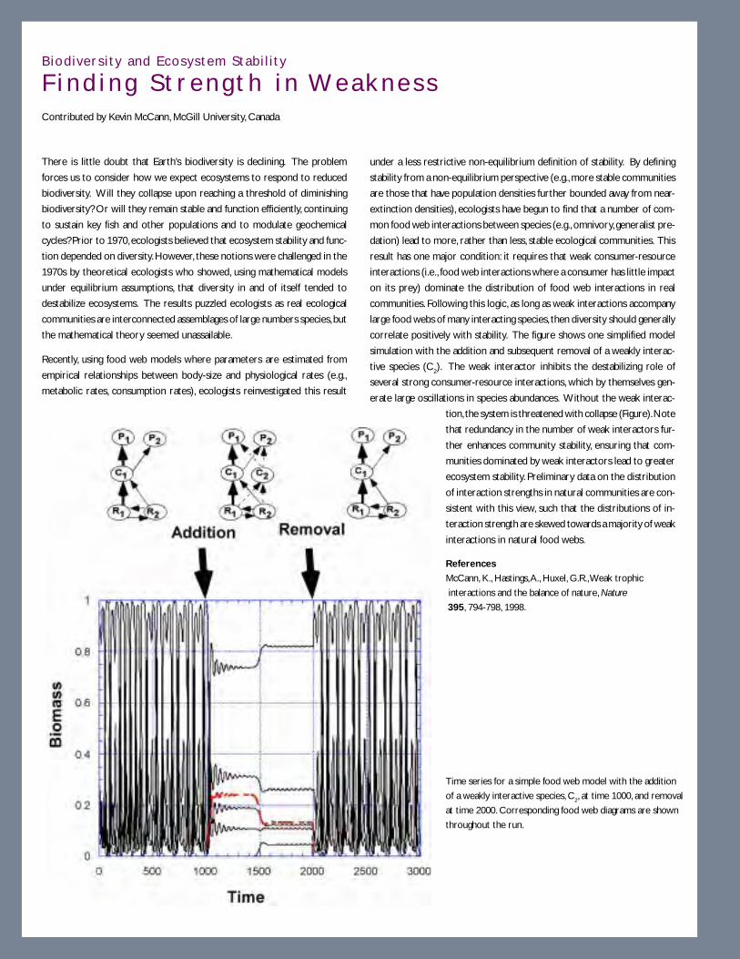
7 8
Biod ivers i ty and Ecosystem Stab i l i t y
F i n d i n g S t r e n g t h i n We a k n e s sContributed by Kevin McCann, McGill University, Canada
There is little doubt that Earth’s biodiversity is declining. The problem
forces us to consider how we expect ecosystems to respond to reduced
biodiversity. Will they collapse upon reaching a threshold of diminishing
biodiversity? Or will they remain stable and function efficiently, continuing
to sustain key fish and other populations and to modulate geochemical
cycles? Prior to 1970, ecologists believed that ecosystem stability and func-
tion depended on diversity. However, these notions were challenged in the
1970s by theoretical ecologists who showed, using mathematical models
under equilibrium assumptions, that diversity in and of itself tended to
destabilize ecosystems. The results puzzled ecologists as real ecological
communities are interconnected assemblages of large numbers species, but
the mathematical theory seemed unassailable.
Recently, using food web models where parameters are estimated from
empirical relationships between body-size and physiological rates (e.g.,
metabolic rates, consumption rates), ecologists reinvestigated this result
under a less restrictive non-equilibrium definition of stability. By defining
stability from a non-equilibrium perspective (e.g., more stable communities
are those that have population densities further bounded away from near-
extinction densities), ecologists have begun to find that a number of com-
mon food web interactions between species (e.g., omnivory, generalist pre-
dation) lead to more, rather than less, stable ecological communities. This
result has one major condition: it requires that weak consumer-resource
interactions (i.e., food web interactions where a consumer has little impact
on its prey) dominate the distribution of food web interactions in real
communities. Following this logic, as long as weak interactions accompany
large food webs of many interacting species, then diversity should generally
correlate positively with stability. The figure shows one simplified model
simulation with the addition and subsequent removal of a weakly interac-
tive species (C2). The weak interactor inhibits the destabilizing role of
several strong consumer-resource interactions, which by themselves gen-
erate large oscillations in species abundances. Without the weak interac-
tion, the system is threatened with collapse (Figure). Note
that redundancy in the number of weak interactors fur-
ther enhances community stability, ensuring that com-
munities dominated by weak interactors lead to greater
ecosystem stability. Preliminary data on the distribution
of interaction strengths in natural communities are con-
sistent with this view, such that the distributions of in-
teraction strength are skewed towards a majority of weak
interactions in natural food webs.
References
McCann, K., Hastings, A., Huxel, G.R., Weak trophic
interactions and the balance of nature, Nature
395, 794-798, 1998.
Time series for a simple food web model with the addition
of a weakly interactive species, C2, at time 1000, and removal
at time 2000. Corresponding food web diagrams are shown
throughout the run.

7 9
Other recent studies have highlighted some additional nonlinearities in the interactions between organisms
that cause pronounced changes in community patterns and the state of marine ecosystems. These include
disease, mating failures or interactions of these factors. For organisms that fertilize their eggs externally, such
as abalone or sea urchins, reproductive success is facilitated where adults are present in high densities so that
sperm and eggs released into the water column have high probabilities of contact soon after release. When
adult densities are lower, field measurements have shown that few eggs are successfully fertilized. It thus
appears that localized, high-density patches of animals may be a critical aspect of successful reproduction for
these species. Unfortunately, the high densities that facilitate fertilization also may promote increased suscep-
tibility to disease transmission. Both the Caribbean sea urchin Diadema antillarum and the black abalone in
the Northeast Pacific have experienced dramatic mortality due to diseases that spread rapidly throughout
the entire population and apparently reduced population densities below a threshold needed for successful
reproduction. Closer analysis of such nonlinear interactions will lead to much greater predictive ability in
the future.
Harmful Algal Blooms. Of approximately 5,000 species of marine phytoplankton, some 300 species form
blooms that can discolor the sea surface (so-called “red tides”), with about 40 of these species also producing
potent toxins that affect community structure, ecosystem function, fisheries and even human health. Al-
though blooms are natural phenomena that have occurred throughout recorded history, there is accumulat-
ing evidence that harmful algal blooms have increased in intensity, frequency and geographic extent since the
1970s. Factors promoting increased blooms are debated, but include ballast water introduction of exotic
species into new areas, coastal eutrophication and climate change. The paralytic shellfish toxins acquired by
shellfish through ingestion of dinoflagellates also could have large-scale, cascading effects on community
structure through their indirect effects on keystone species such as sea otters or other predators.
Regardless of the causes of blooms, the chemically mediated and ecosystem-wide effects of toxic phytoplank-
ton blooms can be dramatic, including large scale die-offs of scallops, fishes, birds, marine mammals and other
organisms, and the resulting loss of hundreds of millions of dollars in fisheries and tourism revenues. Along
the US Gulf Coast, outbreaks of the toxic dinoflagellate Ptychodiscus brevis have been estimated to kill up to 100
tons of fish per day, and similar effects of dinoflagellate blooms have occurred in many parts of the coastal ocean.
Determining the mechanisms leading to such blooms, the causes for changes in their frequency of occur-
rence, and developing potential control mechanisms is a significant problem for the coming decade.
Invas ions
The study of the dramatic and unexpected effects of the introduction of exotic species into local marine
waters represents a newer field of marine ecology—the science of invasions. There are now numerous
examples of how these invasive organisms have altered local aquatic communities, from the change in whole
estuarine areas (e.g., San Francisco Bay), to alterations of water quality in the Great Lakes by the introduction
of the zebra mussel, to problems with specific taxa in the coastal ocean (e.g., the introduction of a worm
endemic to South Africa into California waters, which hinders shell growth in abalone).

8 0
Ca t a s t roph i c Dec l i n e o f t h e J ama i c a n Cor a l Ree fContributed by Terry Hughes, James Cook University, Australia
Caribbean coral reefs provide an example of nonlinear and large-scale com-
munity shifts that appear to result from multiple interacting stresses that
are largely anthropogenic and that have fundamentally changed these di-
verse ecosystems over the last two decades. The speed and extent of
change, and the urgency of the need for understanding and addressing these
changes, is best documented for reefs in Jamaica, where live coral cover
declined from more than 50% in the late 1970s to less than 5% by the early
1990s.
Jamaica is the third largest island in the Caribbean and is the center of
coral diversity in the Atlantic Ocean. Jamaica’s human population has un-
dergone exponential growth and by the 1960s, fishing pressure was esti-
mated to be two to three times above sustainable levels. Although fishing
pressure had been high for an extended period, and herbivorous fishes that
remove seaweeds (preventing them from overgrowing and killing coral)
had been severely reduced, the reefs had not shown signs of change due to
overfishing. In part, this resulted from an ecological replacement of fish
grazing by a dense buildup of the herbivorous sea urchin Diadema antillarum.
High densities of this sea urchin are correlated with fishing pressure, which
removes fishes that both prey on and compete with the urchin. In the early
1980s, Diadema near the Caribbean opening to the Panama Canal began to
die due to a species-specific pathogen. Within a year, this disease spread
throughout the entire Caribbean and caused 95-99% mortality in Diadema
densities Caribbean-wide. With Diadema removed by the pathogen, and
herbivorous fishes continuing to be removed by fishing, reefs around this
entire island nation underwent a spectacular change in community struc-
ture that has persisted from the early 1980s until today. Between 1977 and
1994, coral cover declined from 52% to 3% and seaweed cover increased
from 4% to 92% along the more than 300 km of coastline that was moni-
tored (Figure left). This pattern was also apparent at all depths surveyed
(Figure right). Species-rich and topographically-rich coral reefs have been
replaced by topographically simple algal beds that do not attract or sup-
port large numbers of other species.
The high seaweed cover preempted space and virtually stopped coral re-
cruitment (a process that is necessary for coral recovery). The few re-
maining sea urchins now had an overabundance of algal food; they grew
rapidly and put more energy into reproduction, but there has been minimal
recruitment of Diadema onto the reef. As external fertilizers, their spawn-
ing success is strongly density dependent (i.e., if they are not crowded to
the point of it stunting their growth, then there is much lower probability
of sperm contacting eggs when they are released into the water column).
Densities may be too low for successful spawning.
Although coral reefs have flourished through major fluctuations in sea level
occurring over scales of 103 to 105 years, reefs around Jamaica changed
dramatically, and with no warning, in about 10 years. There have been no
significant signs of recovery since that time. Given the life span and size of
corals that comprise the significant frame builders on these reefs, recovery
may take decades to hundreds of years, if it occurs at all.
Large-scale changes in community structure at fore-reef sites along >300 km of
the Jamaican coastline, surveyed in the late 1970s (1977, hatched bars) and the
early 1990s (1993, solid bars). Figures (left and right) reprinted with permission
from Hughes, T.P., Catastrophes, phase shifts, and large-scale degradation of a
Caribbean coral reef, Science, 265,1547-1551, 1994. Copyright 1994 American
Association for the Advancement of Science.
Degradation of Jamaican coral reefs over the past two decades.
Small-scale changes in (A) coral cover and in (B) macroalgal
cover over time at four depths near Discover Bay.

8 1
The characteristics that make particular species efficient invaders, and the properties of assemblages that
make them less or more susceptible to invasion, require greatly expanded study in the future. As with many
other topical issues, our future ability to address these problems will depend greatly on reinvigorating the
field of systematics. Taxonomic expertise is vital to correctly identify and distinguish exotic and native
species, and to understand their modern day ecology and biogeography.
Pathogens and Paras i tes
Just as predators can affect the structure of marine communities, pathogens and parasites can cause dramatic
and long-term changes in marine ecosystems. This topic is mentioned separately because not only is it poorly
understood, but it is potentially of great significance to ecosystem dynamics. Marine scientists have recently
drawn attention to the role of both climate variability and human activity in increasing the incidence of
outbreaks of waterborne diseases. Some pathogens are known to adversely affect marine shellfish, echino-
derms, corals and mammals. Others, such as the cholera-inducing marine Vibrio bacteria may attach to the
chitinous exoskeleton of zooplankton such as copepods, which act as vectors for the dispersal of this human
pathogen.
In addition to this indirect effect of a pathogen on marine community structure, pathogens also appear to be
having considerable direct effects via diseases of corals, sponges, gorgonians, seagrasses and other organisms
that produce the basic biogenic structure of marine ecosystems. In the 1930s, eelgrass along the American
Atlantic coast was devastated by disease, as were tropical sponges in numerous areas of the Caribbean.
Caribbean corals have declined throughout the entire region. In some areas, the coral decline resulted from
the indirect effects of a pathogen that killed sea urchins which in turn were preventing corals from being
overgrown by seaweeds (see Jamaican Coral Reef box on page 80), but for other areas the causes for decline
were less clear. Given that these corals provide the biogenic structure and habitat complexity upon which
many other reef organisms depend, the indirect effects of coral loss on biodiversity and community structure
are considerable. Even our very inadequate knowledge of diseases in the marine biota is largely limited to
those cases where the impact is close to catastrophic. An opportunity exists to greatly increase our knowl-
edge of pathogens in the ocean, their effects on populations, communities and ecosystems, and on how the
biota naturally defend against them.
Metapopu la t ion Dynamics
Marine populations are frequently structured into semi-isolated subunits. These geographically distributed
subpopulations are linked to one another through advection and diffusion, as well as through active behav-
ioral migration. Exchanges can involve individuals of any age, but often involve transport of early stages in the
life history (i.e., larval, spore and early juvenile stages). Ignorance of movement during these stages is a major
impediment to understanding the population dynamics of marine organisms. These linkages between sub-
populations play a defining role in local and metapopulation dynamics, community interactions, evolutionary
dynamics and the management of marine populations and reserves. Scales and intensities of subpopulation
linkages depend on life-history characteristics (e.g., reproductive mode and larval stage duration), physical
8 2
forcing (advection and diffusion) and organismal behavior (e.g., diel vertical migration and responses to chemical
cues). Over the last two decades, it has become clear that some of these processes affect the rates and scales
of dispersal, but there is no comprehensive understanding of population linkages for any marine system.
Traditionally it is assumed that dispersal magnitude and gene flow are proportional to the length of time a
propagule spends in the plankton, but this simple approach is inadequate. Observations of meroplanktonic
stages that can spend weeks to months in the water column provide conflicting evidence about scales of
dispersal. Some observations, such as the rate of spread of invasive species and the presence of larvae at great
distances from their parental ranges suggest that the scale of dispersal can be hundreds to thousands of
kilometers. Other observations suggest that the actual scale of dispersal is substantially lower (< 10 km). For
example, there can be considerable genetic heterogeneity over short distances in continuously distributed
species, and there is temporal variation in the genetic composition of recruits. Equally disconcerting is the
realization that species without a planktonic dispersal phase can fail to show genetic differentiation across
large spatial scales. One cannot hope to understand biogeochemical processes, the effects of changing climate
on marine ecosystems, or to predict the effects of anthropogenic stresses without improved evolutionary
understanding of marine population linkages.
Resolving the problem of unknown population linkages will require quantifying the temporal and spatial
variability of dispersal paths, and the consequences of dispersal for population and evolutionary dynamics.
These studies initially should focus on larval or spore transport. Rapid progress depends on identifying
tractable field systems. Ecosystems with spatially discrete populations, such as island chains, estuaries, hydro-
thermal vents or systems with sharp boundaries between distinct circulation regimes (e.g., at prominent
biogeographic boundaries such as Cape Hatteras or Point Conception) represent especially productive re-
search opportunities.
W H AT M A K E S P RO G R E S S P O S S I B L E N OW ?• Coupled physical-biological observational programs. New opportunities exist for physical scien-
tists and ecologists to collaborate in studies of the responses of marine ecosystems to variations in atmo-
spheric and oceanic forcing. . Recent advances in continuously measuring observational platforms deployed
in environments from the intertidal to the deep sea have set the stage for cooperative research programs.
Platforms range from space- and aircraft-based remote sensors, moored arrays and seafloor observatories,
to remotely operated vehicles and free-drifting autonomous vehicles and surface-based vessels. The devel-
opment of new sensors now permits remote assessment of fine-scale turbulence, as well as the optical and
acoustic measurement of different varieties of plankton and marine snow. Developments in molecular
genetics holds the promise for much more rapid, automated identification and enumeration of marine
organisms. Such observational programs need to be synchronized so that the sampling scales for the
atmospheric, oceanic, and biotic properties of marine ecosystems are compatible. The realization that
secular and cyclical changes in the physical and chemical environment impose a non-steady state driver on
biological systems opens new doors to research programs in which the ocean sciences are better linked.
8 3
• Convergence of ecological and paleoceanographic measurement scales. Ecologists have begun
to resolve biological changes on time scales longer than those traditionally studied, while geologists and
paleoceanographers are concurrently developing the ability to resolve changes on shorter time scales.
Such convergence of time scales presents opportunities to extend contemporary ecological understanding
into the geological past. For example, the ability to resolve annual variations in population size of pelagic
fishes from varved sediments, to infer the population size of Pacific salmon from the stable nitrogen iso-
tope signature that they deposit in lake sediments after spawning, or to resolve annual variations in marine
climate from coral records, means that ocean scientists have new opportunities to directly link the extant
processes observable today with those affecting marine communities in the geological past. In some in-
stances, sufficiently long time series of organismal abundances or proxy variables overlap the time period
of the instrumented measurements within the twentieth century, thus permitting the sedimentary record
to be validated and more reliably extended into the past.
Many of the proxy measurements upon which paleoclimate reconstructions are based are founded on
inadequate knowledge of the ecology of the organisms involved and rest on assumptions that have been
poorly validated. The habitats occupied by organisms, processes regulating the mineralization of skeletal
hard parts, and physiological changes that induce different vital effects across the life history of organisms
require careful attention in order to more accurately characterize ecosystem change. Partnerships among
biologists, chemists and geochemists would be highly beneficial in this area.
• Modeling. New ocean-atmosphere circulation models are now being coupled with ecological process
models. Diagnostic numerical models can be used to test understanding of marine ecosystem responses to
perturbations. Fully developed four-dimensional circulation models can be coupled with simulations of
marine organism population dynamics. The appropriate scales for such models is a recurrent issue because
larger-scale processes invariably influence (and sometimes dominate) the local scales. Models on nested
scales are often required. In another class of ecosystem model, we are on the cusp of entering a new phase
in ecological studies—ecosystem forecasting. In a few selected marine ecosystems where there are appro-
priate, long-standing observational programs, we are beginning to test knowledge of the system through
the development of forecast models. Such models will be prognostic and forward-projecting and will be
regularly updated by observational programs. Short-term predictions will be regularly adjusted through
assimilation of data. By analogy with the development of forecasting methods in meteorology, this process
is expected to evolve rapidly in the coming years and decades.
• Large-scale ecosystem manipulations. Marine ecosystem studies entered a new era with the suc-
cessful IronEx experiments (see IronEx box on page 31). Although pelagic systems have been manipulated
in enclosed water columns for decades and localized manipulations of benthic communities have been a
research tool for scientific generations, IronEx heralded a new ability to manipulate an unencumbered
water column in the open ocean and to measure both biological and geochemical consequences. Such bold
manipulative experiments provide critical tests of ecosystem function. This approach could profitably be
extended into many areas of ecosystem research. Do pink salmon releases truly induce trophic cascades in
pelagic ecosystems? Controlled releases of these predators from selected hatcheries could test the validity

8 4
of the hypothesis. Is local persistence of estuarine populations of bivalves critically dependent upon ex-
change of organisms (and genetic diversity) with other subpopulations? Temporary isolation of estuarine
populations could help answer the question. Can the invasiveness of different taxa be predicted (and
controlled)? Judicious manipulations of hypothesized biological control agents in semi-isolated environ-
ments could test the viability of the hypothesis.
W H AT I S R E Q U I R E D F O R P RO G R E S S ?• Integrated, long-term measurement programs. Measurement programs that extend over larger
space and longer time scales than have typically been pursued are urgently needed. For climate-related
studies, biotic variables need to be measured on sufficiently large scales to integrate the larger-amplitude
environmental signals and be compatible with the measurement scale of the physical properties. Concurrent
process-oriented research programs and manipulative experiments are needed to test the mechanisms
thought to link the larger-scale forcing to population and community variations.
For studies oriented more toward episodic or event-scale processes, measurement techniques are needed
that permit the occasional rare event to be captured and fully resolved because of the sensitivity of many
nonlinear interactions to these extremes. Averaging measurement techniques are often criticized because
such measurements can underestimate rate processes in biological “hot spots”—for example,
microassemblages of heterotrophic bacteria on particles or around organic aggregates, or the accumulation
of planktonic organisms in vertical thin layers in the water column. The degree to which biological and
chemical rate process are regulated by such high-density assemblages needs to be resolved, as does the
biological composition of such hot spots and their temporal duration. New measurement technologies
that permit unattended assessment of organismal abundances, growth rates, behavior and spatial patterns,
concurrently with characterization of the physical environment, are greatly needed. Autonomous instruments,
remotely operated instruments and space-based remote sensing technologies should be expanded and
more fully utilized. The biotechnology revolution should be more fully exploited in the development of
new measurement techniques and approaches.
• New model development. There are opportunities for development of several classes of ecological
models. Spatially explicit models are needed to predict dispersal pathways, connectivity of subpopulations,
variations in abundance and the persistence time of marine populations. Knowledge of the interactions of
animal behavior with flow fields will be required to build realistic simulations of metapopulation dynamics.
Because model projections tend to quickly outstrip the data available, coordinated development of research
teams of modelers, observationalists and experimentalists will ensure that there is rapid communication
about the most important measurements and processes. New experimental and observational studies can
then be focused on the processes to which ecosystem states are found to be most sensitive.

8 5
Expanded efforts in the training of graduate students and retraining of more advanced scientists are urgently
needed to help develop these new integrative models. Many require new partnerships of ecologists with
physical scientists, modelers or applied mathematicians. Thus, there is a need to accelerate the development
of scientists with the skills and knowledge to work across traditional boundaries. This will produce an
ever-increasing need for deeper quantitative training of biologists, but also a parallel need for graduate
students and researchers in physical oceanography, chemistry, and other disciplines to become better
acquainted with the important problems and processes in ocean ecology.
• Taxonomic underpinnings. The fundamental biological unit in marine ecosystems is species. Most of
the future of ecosystem research rests upon knowledge of the component species, their diverse identities,
life history characteristics and roles in geochemical transformations and other ecosystem functions. Yet,
paradoxically, at a time when this information is most needed, it is least available. In many different scientific
forums, the dearth of taxonomists and restricted pipeline of young talent in the field of systematics have
been discussed. A National Academy of Sciences workshop on Marine Biodiversity pointed to a critical
need for the support of taxonomists, their incorporation directly into field and experimental research
programs and the training of a new generation equipped with appropriate new analytical and numerical
techniques. Apart from the nascent Census of Marine Life, no significant action has been taken to improve
the situation in marine systematics, and meanwhile the problem has only intensified. Major scientific issues
ranging from paleoclimate reconstructions using marine microfossils, to understanding the agents responsible
for harmful algal blooms, to understanding global patterns of the ocean’s biodiversity cannot be resolved
unless the taxonomic underpinnings of marine research are supported and reinvigorated.
• Longer duration of research grants. New appreciation of the dynamic nature of marine ecosystems,
and the different characteristic modes that ecosystems may exhibit, requires a longer-term research
perspective than has been customary in NSF ocean sciences-funded studies. The traditional three-year
grant is not sufficient to characterize or understand the important processes controlling ecosystem dynamics.
Studies of longer duration are much more likely to achieve a deeper understanding of the variable states of
natural ecosystems and the mechanisms leading to transitions between states. Although we actively encourage
NSF to continue funding new ideas that might be profitably tested on a shorter time frame, there is a
compelling need to fund innovative ecosystem science on a sufficiently long time frame to understand the
mechanisms causing transitions between different states of marine ecosystems and to make significant
scientific advances in their prediction.

8 6
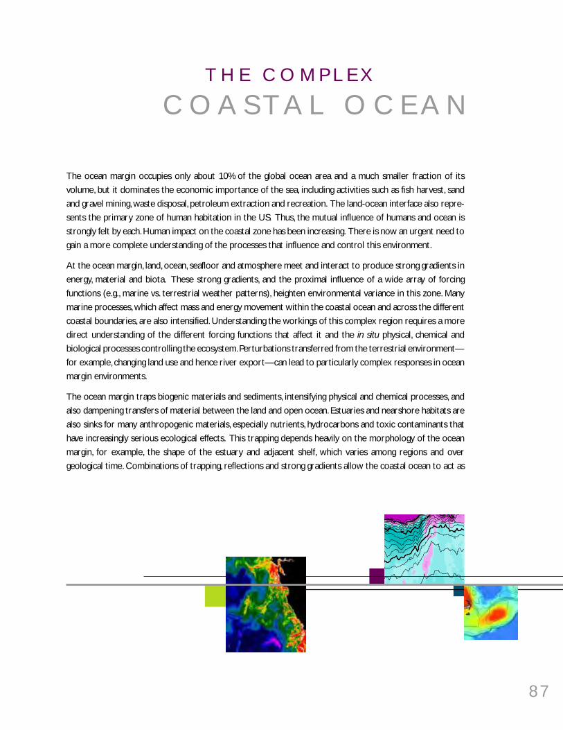
8 7
6
2
25
25
24
T H E C O M P L E X
C O A S T A L O C E A N
The ocean margin occupies only about 10% of the global ocean area and a much smaller fraction of its
volume, but it dominates the economic importance of the sea, including activities such as fish harvest, sand
and gravel mining, waste disposal, petroleum extraction and recreation. The land-ocean interface also repre-
sents the primary zone of human habitation in the US. Thus, the mutual influence of humans and ocean is
strongly felt by each. Human impact on the coastal zone has been increasing. There is now an urgent need to
gain a more complete understanding of the processes that influence and control this environment.
At the ocean margin, land, ocean, seafloor and atmosphere meet and interact to produce strong gradients in
energy, material and biota. These strong gradients, and the proximal influence of a wide array of forcing
functions (e.g., marine vs. terrestrial weather patterns), heighten environmental variance in this zone. Many
marine processes, which affect mass and energy movement within the coastal ocean and across the different
coastal boundaries, are also intensified. Understanding the workings of this complex region requires a more
direct understanding of the different forcing functions that affect it and the in situ physical, chemical and
biological processes controlling the ecosystem. Perturbations transferred from the terrestrial environment—
for example, changing land use and hence river export—can lead to particularly complex responses in ocean
margin environments.
The ocean margin traps biogenic materials and sediments, intensifying physical and chemical processes, and
also dampening transfers of material between the land and open ocean. Estuaries and nearshore habitats are
also sinks for many anthropogenic materials, especially nutrients, hydrocarbons and toxic contaminants that
have increasingly serious ecological effects. This trapping depends heavily on the morphology of the ocean
margin, for example, the shape of the estuary and adjacent shelf, which varies among regions and over
geological time. Combinations of trapping, reflections and strong gradients allow the coastal ocean to act as

8 8
both a low-pass filter and an amplifier of terrestrial and oceanic processes. The filtering capacity of coastal
ocean margins is influenced by its biological communities. The result is an environment that varies strongly in
space and time, with especially important consequences for the human populations that reside near the
coast, and for ecosystem processes that can propagate into the open ocean.
W H AT A R E T H E B I G P RO B L E M S ?This section focuses on three areas in which we see imminent rapid scientific progress. The first is fluxes of
material from land to the sea, an area which has seen much progress but in which issues of variance, and basic
science, sorely need advance. The second is the manner in which the physics of coastal environments drives
other types of oceanic processes. The third focuses on the enormous potential influence of the open ocean
on its thin edge and, conversely, the impact that this region of high fluxes and steep gradients can have on the
open ocean.
Land-Ocean F luxes
Material inputs to the coastal zone are largely unidirectional—from land to sea—and include organic and
inorganic sediment, dissolved elements, airborne dust, and anthropogenic pollutants and nutrients. These
inputs are influenced by the local watershed and meteorological characteristics and biogenic habitat quantity
and quality. Human activities can also have a strong impact on the coastal ocean, both locally and remotely.
Cumulatively, these material inputs have a major influence on the chemistry of the global ocean and need
further study as fluxes of materials, especially nutrients and toxic contaminants, have greatly influenced eco-
system processes, including food web dynamics, biological production and community structure.
Inputs of biologically important materials. While we know patterns of water flow and major element
composition of larger rivers reasonably well, there is less understanding of the chemical form of minor
elements and organic matter that are transported from terrestrial watersheds into the coastal environment.
Riverine organic matter is a vital term in the global carbon balance and minor elements are often critical to
coastal and oceanic ecosystems. Lack of dissolved iron in some coastal upwelled waters can also be biolimiting
unless iron inputs from land sources are available, and extensive blooms of large diatoms do not develop in
these waters as they do in other upwelled waters containing sufficient iron. In some cases, estuaries act as
important biogeochemical filters by removing excess nutrients and other minor elements during river/ocean
mixing, but the relative roles of biological versus inorganic processes need better definition (e.g., for phos-
phate).
The total volume of groundwater discharge to the global ocean is relatively small, but locally groundwater can
significantly influence the freshwater contributions. More importantly, however, groundwater often has far
higher concentrations of dissolved species than do river water, affecting regional delivery of some dissolved
ions (e.g., nitrate). Work on identifying important regions of groundwater influence, its role in material flux,
and consequent ecosystem response is now accelerating. This area is ripe for significant advances, especially
in composition and speciation of incoming groundwater, hydrological and geological controls on inflows, and
patterns of dispersal in the oceans.
8 9
Sediment fluxes and episodic events. Globally, rivers deliver approximately 15 to 20 billion tons of
suspended solids to the sea every year, often in short, episodic pulses. Once carried to the marine setting,
sediments and associated materials can be trapped or dispersed along the coast, funneled into the deep-
ocean basins , or where supply is high and the energy for dispersion is relatively low, left concentrated in large
deltas. The processes by which sediments move from the riverine, through the estuarine, and out into the
coastal ocean environments give rise to a wide variety of research opportunities. The high energies of tidal,
wave and current movements at the ocean-land boundary tend to separate the sediment delivered by rivers
by properties such as particle size. Understanding the processes by which these various components move
across the coastal boundary region, or are trapped within it, is a great scientific challenge.
Sediments delivered by rivers are not chemically inert and may serve as source or sink for many materials
(e.g., nutrients, pollutants) in the coastal ocean. This source or sink role may change as the particles change
their depositional regime during subsequent resuspension or transport events. In short, many chemical ele-
ments, including pollutants such as heavy metals, share their immediate transport dynamics with the particles
to which they are attached especially with fine-grained sediments.
An important area of research continues to focus on the time scales of sediment exchange between the
water column and the bottom. While some aspects of sediment resuspension and transport are understood
and supported by field measurements, the ability to predict and model sediment transport in many coastal
settings is crude at best. This means that coastal sediment budgets cannot be constructed with any confi-
dence, and the evolution of the shoreface and bottom topography cannot be predicted for different condi-
tions, including highly episodic events such as storms and hurricanes. Some key questions include:
• How are riverine sediments trapped in the coastal zone? Terrestrial events that occur over a range of time and
spatial scales can have a great impact on the margin ecosystem. The periodicity and impact of fluvial events
depend on the hydrology and size of the watershed. Individual storm events tend to have a greater impact
on arid watersheds and small rivers than on wet watersheds or large rivers. Small mountainous rivers
discharge greater loads relative to the size of their drainage basins than do larger rivers. Most large rivers
enter the ocean with very gentle gradients; thus, large reaches of the rivers (100s km) can be influenced by
tides and/or estuarine processes. Even in these large systems, episodic events such as large coastal storms
can cause large excursions from “average” riverine input values. In addition, episodic events can overwhelm
the modulating influence of marsh, mangrove and estuarine processing of nutrients, with resulting large
inputs of nutrients and pollutants to the outer margin. Currently, there is little quantitative knowledge
available about the amount of sediment reaching the ocean, and little understanding of the processes
related to sediment entrapment, in any of these fluvial regimes. For example, despite over 30 years of study,
we still do not understand the role of the shoreface in barrier island evolution.
• What is the impact of sediment fluxes on coastal ecosystems? While sediment fluxes alter the quantity, quality
and distribution of biogenic habitat and communities that have major influence on chemical and energy
fluxes within coastal regions, the quantitative impact of episodic events on material fluxes is largely unknown.
In estuaries, sea grass, salt marsh and once large populations of suspension-feeders (e.g., oysters) provide a
biological filter that can offset loading of human-derived nutrients and other wastes. Influx of sediments

9 0
and associated changes in the geomorphology of estuaries can reduce, smother and degrade biogenic
habitats, thereby reducing their ability to function as filters and provide essential nursery and foraging
habitats for myriad economically and ecologically valuable species. In nearshore environments, sediment
loading also has important negative effects on kelp forests and coral reefs that also function to provide
habitat for highly diverse and productive biological communities. Episodic events need particular attention,
as they can overwhelm the modulating influence of marsh, mangrove and estuarine processing, with resulting
large inputs of nutrients and pollutants to the outer margin.
• What are the important modes of fluid mud transport? Until recently, fluid muds (suspended-sediment
concentrations greater than 10 g/l) were considered to be restricted to estuarine settings and largely
unimportant in the large-scale transport of fine-grained sediments. Hyperpycnal flows (underflows rich in
sediment) have been observed to reach the ocean during large river floods, but density-driven gravity flows
have not generally been considered to be important on continental shelves (see Sediment Transport box
on opposite page). Such flows could move large masses of sediment, along with their adsorbed chemical
species, across the gently sloping continental shelves, carrying pollutants to seafloor regions previously
thought to be pristine. The non-Newtonian character of these fluid muds make them poorly understood
agents for transport.
• How are sedimentary terraces on continental margins constructed through time? Over geologic time, the detailed
structure of sedimentary terraces, which ring nearly all continental margins, records the interplay of the
changes in accommodation space for sediment storage, in sediment supply, in sea level, and in sediment
transport and deposition (Figure 12). It remains uncertain whether individual elements of this terrace are
constructed by the integration of transport and deposition processes that take place over months and
years or are dominated by the very large, episodic storm events that may occur only once in a century or
Figure 12. Over the past century, rivers have discharged
annually about 35,000 km3 of water and 20 x 109 tons
of sediment to the ocean. Fluxes have changed over
the past 20,000 years, and continue to do so. The
abundant sediment eroded by glaciers during the last
glacial maximum was transported fluvially as climate
warmed, thus giving a time lag between erosion and
sediment delivery to the ocean. Erosion, and thus ulti-
mately sediment delivery, decreased throughout much
of the Holocene, but increased (locally by an order of
magnitude) with the advent of organized agriculture.
Erosion has accelerated in the past century because
of changing land-use, particularly in Africa and Asia.
Global sediment delivery, however, is decreasing, the
result of increased river management, particularly dam
construction. Figure courtesy of J.D. Milliman, and is
from J.D. Milliman and K.L. Farnsworth, River Discharge
to the Ocean: A Global Analysis, Oxford University
Press, in press.
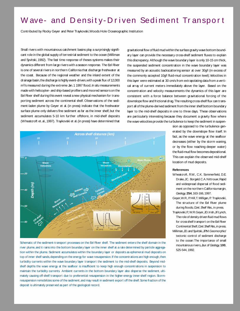
9 1
Wav e - a n d D e n s i t y - D r i v e n S e d i m e n t Tr a n s p o r tContributed by Rocky Geyer and Peter Traykovski, Woods Hole Oceanographic Institution
Small rivers with mountainous catchment basins play a surprisingly signifi-
cant role in the global supply of terrestrial sediment to the ocean (Milliman
and Syvitski, 1992). The fast time response of theses systems makes their
dynamics different from large rivers with a season response. The Eel River
is one of several rivers in northern California that discharge freshwater at
the coast. Because of the regional weather and the inland extent of the
drainage basin, the discharge is highly event-driven, with a peak flux of 12,000
m3/s measured during the extreme Jan. 1 1997 flood. In situ measurements
made with helicopter- and ship-based profilers and moored sensors on the
Eel River shelf during this event reveal a new physical mechanism for trans-
porting sediment across the continental shelf. Observations of the sedi-
ment-laden plume by Geyer et al. (in press) indicate that the freshwater
surface plume only delivers fine sediment as far as the inner shelf, but the
sediment accumulates 5-10 km further offshore, in mid-shelf deposits
(Wheatcroft et. al., 1997). Traykovski et al. (in press) have determined that
gravitational flow of fluid mud within the surface gravity wave bottom bound-
ary layer can provide the necessary cross-shelf sediment fluxes to explain
this discrepancy. Although the wave boundary layer is only 10-15 cm thick,
the suspended sediment concentration in the wave boundary layer was
measured by an acoustic backscattering sensor at over 30g/l (in excess of
the commonly accepted 10g/l fluid-mud concentration level). Velocities in
this layer were estimated at 30 cm/s from extrapolating data from a verti-
cal array of current meters immediately above the layer. Based on the
concentration and velocity measurements the dynamics of this layer are
consistent with a force balance between gravitational forcing of the
downslope flow and frictional drag. The resulting cross-shelf flux can trans-
port all of the plume-derived sediment from the inner shelf bottom boundary
layer to the mid-shelf deposits in one to three days. These observations
are particularly interesting because they document a gravity flow where
the wave velocities provide the turbulence to keep the sediment in suspen-
WaveVelocities
WaveVelocities
0
20 15 10
Across shelf distance (km)
Dep
th (
m)
5 0
20
40
60
80
10
5
030000
Conc. (mg/l)
m a
bove
bot
tom
0
10
20
30
40
50
2000Conc. (g/l)
WBLcm a
bove
bot
tom
Vel. (cm/s)
Vel. (cm/s)030
020
Turbidity Current Boundary Layer
Ambient Current Boundary Layer
River Plume
Flocculation
Boundary Layer
Turbidity
Current
Flood Deposits
Preserved Strata
Storm
Resuspension
Ambient
Shelf Currents
Off-sh
elf
Transp
ort
Ephemeral Mud D
eposits
Schematic of the sediment-transport processes on the Eel River shelf. The sediment enters the shelf domain in the
river plume, and it rains into the bottom boundary layer on the inner shelf at a rate determined by particle aggrega-
tion within the plume. Sediment accumulates within the boundary layer or deposits as ephemeral mud deposits on
top of inner shelf sands, depending on the energy for wave resuspension. If the concentrations are high enough, then
turbidity currents within the wave boundary layer transport the sediment to the mid-shelf deposits. Beyond mid-
shelf depths the wave energy at the seafloor is insufficient to keep high enough concentrations in suspension to
maintain the turbidity currents. Ambient currents in the bottom boundary layer also disperse the sediment, ulti-
mately causing off-shelf transport due to preferential resuspension in the higher-energy inner-shelf region. Storm-
resuspension remobilizes some of the sediment, and may result in sediment export off the shelf. Some fraction of the
deposit is ultimately preserved as part of the geological record.
sion as opposed to the turbulence gen-
erated by the downslope flow itself. In
fact, as the wave energy at the seafloor
decreases (either by the storm waning,
or by the flow reaching deeper water)
the fluid-mud flow becomes depositional.
This can explain the observed mid-shelf
location of mud deposits.
References
Wheatcroft, R.W., C.K. Sommerfield, D.E.
Drake, J.C. Borgeld. C.A. Nittrouer, Rapid
and widespread dispersal of flood sedi-
ment on the northern California margin,
Geology, 254, 163-166, 1997.
Geyer, W.R., P. Hill, T. Milligan, P. Traykovski,
The structure of the Eel River plume
during floods, Cont. Shelf Res., in press.
Traykovski, P., W.R. Geyer, J.D. Irish, J.F. Lynch,
The role of density driven fluid mud flows
for cross shelf transport on the Eel River
Continental Shelf, Cont. Shelf Res., in press.
Milliman, J.D. and Syvitski, J.P.M. Geomorphic/
tectonic control of sediment discharge
to the ocean: The importance of small
mountainous rivers, Jour. of Geology, 100,
525-544, 1992.

9 2
millennium. We are only beginning to acquire a quantitative understanding of the processes that control
the distribution of sediment accumulation among estuaries, shelves and slopes, especially as a function of
varying sea level. Coastal processes and morphology during periods of low sea level are particularly unclear.
We are only beginning to quantify the magnitude of sea-level change in the past (see Sea Level Rise box on
opposite page), and we have serious doubts about the more simple models of tectonic subsidence along
continental margins. Understanding the developmental history of Earth’s primary depocenters is fundamental
not only to the exploration for resources, but also to the understanding of Earth’s tectonic pulses that
build these thick sedimentary sections and then recycle them back into mountains ranges.
Carbon fluxes. Carbon fluxes in margin sediments are higher because of direct river input of terrigenous
carbon, shallow depth that leads to efficient deposition, and higher overall ocean margin productivity espe-
cially in terms of new production. Despite sedimentary remineralization, these higher fluxes can result in
relatively high efficiencies of organic carbon preservation in margin sediments (Figure 13). This preservation
on geological time scales can influence the CO2/O2 balance of the atmosphere. The controls on this seques-
tration, at various time scales, are not well understood, but there should be a clear link to sediment dynamics.
Organic carbon buried in sediments may serve as a substrate for microbial activity within the sediments, and
gives rise to gas hydrates in ocean margin settings. The reservoir size of this microbially produced gas is well
over two orders of magnitude larger than that of proven global gas reserves. These hydrates may be signifi-
cant in sediment movement as well as the carbon cycle and paleoclimate (see Global Warming box on page
28 and Gas Hydrates box on page 121). Their modern distribution is poorly known, as are their generation
rate, migration pathways through the sediments, and rate of return to the ocean environment.
Figure 13. Carbon burial in oceanic sedi-
ments is dominantly on the ocean margins.
Percentages of total burial on figure show
that most occurs on shelves, divided be-
tween low-latitude deltaic depocenters and
more normal shelf environments. Redrawn
from J. Hedges, and R. Keil, Sedimentary
organic matter preservation: An assessment
and speculative synthesis, Mar. Chem. 49, 81-
115, 1995.

9 3
S e a L e v e l R i s eContributed by W. Sturges, Florida State University
There may be disputes about global warming, but people do not argue
about sea level rise when beach-front buildings tumble into the ocean. Sea
level is rising along all mid-latitude coasts; Charleston, South Carolina and
Boston, Massachusetts are examples of the average trend (see figure). At
high latitudes, however, the continents are still recovering from melting of
glaciers. The land is emerging (so-called glacial rebound), and local sea level,
in response, is going down, as shown along the Alaska coast. From the coasts
of Alaska to Scandinavia, sea level is sinking at up to 6 mm/year. Although
the continents can be either sinking or emerging depending on distance
from the regions of ice loading, over most of the globe, sea level is unmis-
takably rising. Estimates of global sea level rise hover at just under 2 mm/
year (Douglas, 2000). The best estimate of the present rate of rise is 2-3
mm/year on the East Coast of the US, and barely less than 2 mm/year on
the West Coast. Where large reserves of natural gas or oil are being pumped
out (or replaced), or where sediment loading is unusually great, the local
rate of coastal sinking or rising can be affected more by human activity
than by the large-scale effects of the ocean.
The largest single factor in sea-level change at most locations is the delayed
response from glacial unloading, on time scales of thousands of years. Sea
level was roughly 100 m lower during the last glacial maximum (ca. 20,000
years ago), and it has been rising at mid-latitudes ever since. On time scales
of decades, forcing by winds over the open ocean causes variability of roughly
±10 cm. The melting of mid-latitude glaciers and the potential melting of
high-latitude ice are obvious contributors to the mass of water in the oceans
and are subjects of intense research. The expansion of sea water as it
warms adds a small additional component to the rate of rise.
As the figure shows, sea level fluctuates chaotically over periods of a few
years. Our inability to predict winds over the open ocean limits our ability
to predict the variability of ocean forcing of sea level on decadal time scales.
The effect of global warming on the addition of water from glacial melting
is a topic of intense ongoing research. Melting of the Greenland and Ant-
arctic ice cover would have enormous implications, and although the data-
base is now developing, it is still new. Most geophysical quantities vary so
much on decadal time scales that it can be highly misleading to draw con-
clusions based only on short records.
References
Douglas, B C., Sea level change in the era of the recording tide gauge, Ch. 3, in,
Sea Level Rise, B.C. Douglas, M. S. Kearney, and S P Leatherman, eds.
Academic Press, New York, N.Y., 232 pp, 2000.
Sturges, W. and B.G. Hong, Decadal variability of sea level. Ch. 7, in, Sea Level
Rise, B.C. Douglas, M. S. Kearney, and S P Leatherman, eds. Academic Press,
New York, N.Y., 232, pp., 2000.
Sea level at Boston, Charleston, and Yakutat. Note
both long-term trends and wind-driven interannual
fluctuations (Sturges and Hong, 2000).
9 4
Anthropogenic influences. There is no question that human activities have affected and will continue to
affect the coastal environment. Apart from some Arctic rivers and very large rivers (such as the Amazon,
whose enormity has thus far defied human impact), human activity has had a moderate to very heavy impact
on most rivers through deforestation, agriculture, flow modification and urbanization. Very few watersheds
discharging into the ocean are in a natural state, and most are undergoing continual changes in land use. For
example, farming activity is decreasing in some areas and is sometimes accompanied by reforestation, while in
other areas, deforestation is increasing. Dams continue to be built in some areas, while in other areas dams
may be removed. The coastal implications of dams are only now being documented, and predicting their
consequences is almost impossible with our current understanding of coastal sedimentation, nutrient re-
gimes and other issues. If we are to make rational and informed choices in meeting societal needs we must
more fully understand the consequences of these activities.
Global river discharges of nitrogen and phosphorus, and total organic carbon may have doubled over the past
two centuries, with much larger relative increases in some river and groundwater systems. Nitrogen to silica
ratios in rivers have changed and probably caused shifts in coastal phytoplankton populations. Along with
fishery exploitation, nutrient loading in estuaries and nearshore environments has had the largest impact on
biological processes in coastal ecosystems. Nutrient loading through river discharge, ground water seepage
and atmospheric deposition has been linked to major changes in the structure of biological communities in
estuaries and coastal regions, as well as changes in the rates and processes that control community and
population dynamics. Increasing eutrophication can further reduce water quality, increase the frequency and
spatial extent of hypoxia/anoxia events, and generate harmful algal blooms (e.g., red tides, Pfisteria) that affect
a spectrum of commercial industries and can harm human health. Though we have been able to monitor the
consequences of irregular nutrient input, we have little knowledge of the complex chemical, biological and
physical interactions that trigger harmful algal blooms so that we can ultimately predict, or take steps to
avoid, their occurrence.
Human activity has not only affected rivers; it has also affected the atmosphere in terms of particulates,
aerosols and chemicals. Although the general pattern of dust supply to the ocean is fairly well known, much
less is known about the total flux and its variability, and how this flux affects biological systems through
delivery of both contaminants and limiting micronutrients such as iron. Likewise, the potentially important
role of wet deposition events in nutrient delivery to coastal waters is gaining appreciation. Eolian deposition
of nutrients appears to be a major source of nutrient loading in coastal margins that may lead to eutrophica-
tion and associated ecological changes. Atmospheric inputs of particulates and nutrients can lead to both
local and distant changes in the levels of primary and secondary production. Some of the atmospheric input
of anthropogenic contaminants into the Northeast Pacific watersheds and coastal waters can now be traced
back to massive dust storms in Asia. Whether this will become a significant contaminant source for the
Northeast Pacific is unknown.

9 5
Trace element cycles may prove especially significant. Alterations of trace element concentrations in coastal
environments can influence biological communities via both toxicity and biolimitation. Predictions from cul-
ture work indicate significant potential impacts on community structure at the base of marine food chains by
the elevated levels of copper and zinc observed in some coastal areas. The balance between supply of
macronutrients (e.g., N, P, Si) and trace nutrients (e.g., Fe) may regulate species composition and ecosystem
structure. Such shifts in ecosystem structure can produce harmful algal blooms.
Land-derived inputs of toxic contaminants can influence biological processes from the cellular to ecosystem
level. Changes associated with contaminant uptake in coastal fishes, invertebrates and mammals apparently
reduce the reproduction, growth, condition and survival of individuals leading to changes in ecological inter-
actions and subsequent ecosystem structure and function. The Exxon Valdez oil spill in Alaska and chronic
PCB contamination in Puget Sound provide two clear examples of how land-derived contaminants released
through human activities alter a wide spectrum of biological processes and ecological dynamics that impact
inshore, offshore and terrestrial ecosystems. Defining the pathways of contaminants into the marine environ-
ment and their impact on the biota is critical to making informed decisions on control and remediation.
Greater research will be needed to determine the ecological effects of human and natural alterations in the
quantity, quality and spatially explicit processes associated with coastal habitats. The distribution of coastal
habitats (salt-marsh and oyster reefs, seagrass beds, kelp forests, coral reefs and mangroves) controls chemi-
cal and energy budgets and the production of economically valuable species. These habitats are being de-
stroyed and degraded at an increasing rate as a result of human activity along the coast (see Coral Reef box
on page 80). It is necessary to understand how coastal biogenic habitats function to provide essential re-
sources to associated species, control rates of energy and material transfer and regulate geological processes.
Efforts are also needed to identify and predict how global warming and sea level rise will affect the distribu-
tion, abundance and landscape connectivity of various habitat types and their influence on associated pro-
cesses and species. Greater understanding of spatially explicit habitat processes is likely to improve our
ability to manage and conserve exploited species. For example, fishery managers worldwide now recognize
that effective management of declining coastal fisheries will be impossible without a better understanding of
species-habitat associations, species interactions and the development of marine reserve systems. An inte-
grated research program is required that involves multifaceted quantitative modeling, synthesis of existing
biological and physical data from geographically diverse systems, and large-scale experiments to test spatially
explicit interactions among energy and material transfers, species-species and species-habitat interactions.
The development of marine reserve systems has increasingly been used as a management tool, but funda-
mental knowledge of the essential requirements of such systems is lacking.

9 6
Phys ica l ly forced marg in processes
A number of physical processes strongly influence the character of the coastal ocean environment. Episodic,
large, wind-driven surface waves and storm surges can cause massive sediment movement, beach erosion and
physical, chemical and biological modification to coastal estuaries, marshes and lagoons. In contrast, tides and
tidal currents (including tidally generated internal wave currents) create a constant background of sediment
movement, coastal water-level change and bottom-generated turbulent mixing. Freshwater flow from both
point and distributed sources (including groundwater) into saline shelf water drives an estuarine circulation
with a brackish transition zone where a number of key biochemical and sedimentary processes occur. Mid-
latitude and tropical storms can create large wave- and wind-driven currents and surface mixing that can
rework bedforms, reduce vertical stratification, restructure the coastline and significantly displace water,
particles and biota. Continental climate regimes can accelerate surface cooling and heating of shelf waters.
Deep-ocean features (e.g., boundary currents, eddies and rings) can also lap onto the shelf and directly affect
coastal ocean environments. Factors such as surface buoyancy loss, increased turbidity and wave-induced re-
suspension can cause rapid water mass sinking, transporting shelf material to slope depths on short time scales.
Understanding basic physical processes. Recent work gives a first-order understanding of many of the
more basic physical processes at work in the coastal ocean. Some areas where important advances are being
made and where we anticipate significant progress include:
• Role of turbulent mixing in estuarine physics. Vertical mixing has long been thought to control the “estuarine
circulation” and salt budget in most estuaries, but only recently have direct turbulence measurements been
made in a number of different estuaries (e.g., Hudson, San Francisco Bay, Columbia, Puget Sound). These
measurements are providing a more comprehensive and quantitative understanding of vertical mixing
processes, which play a fundamental role in most coastal physical and biological processes. For example, in
the lower Hudson, the combination of the estuarine circulation and strong oscillatory tidal currents result
in a distinct asymmetry in the vertical current and density structure over a tidal period, with the most
intense Reynolds stresses occurring during flooding. Despite this variability over the tidal cycle, the mean
along-estuary momentum remains a simple balance between bottom stress and the pressure gradient. The
role of secondary circulation in horizontal mixing can now be investigated using new high-resolution
hydrographic survey tools. These and similar advances presage a new era of quantitative estuarine research.
• Behavior and dynamics of freshwater plumes. The detailed behavior and dynamics of surface freshwater
plumes flowing from coastal sources onto the shelf have been investigated both observationally and
theoretically now for a number of large rivers (Amazon, Columbia), estuaries (Delaware, Chesapeake) and
small rivers (Hudson, Connecticut, Eel). In all cases, the tendency for a buoyant plume to flow along the
coast to the right of the source in the northern hemisphere can be augmented or countered by the
direction and strength of the ambient along-shelf flow and direct wind forcing (i.e., up- or down-welling-
favorable). Future research will evaluate the influence of a wide variety of other factors that all influence
the plume’s movement and evolution over space and time: the magnitude of the freshwater flux, its time
dependence, the density contrast between plume and ambient water, the nature and strength of wind-
driven vertical mixing near the surface and bottom interfaces of the plume, the ambient shelf circulation,
and bottom topography. These studies will have wide interdisciplinary application, because river plumes
are one of the primary sources of freshwater, nutrients, pollutants and sediment to the coastal ocean. River
plumes can also spread harmful algal blooms along the coast, so predicting the behavior of plumes has direct
societal benefits.

9 7
• Dynamics of the surf zone and inner shelf. Interest in the complex wave-driven currents and sediment movement
in the surf-zone has been reinvigorated by new methods to deploy high-frequency, three-dimensional
current sensors and other instrumentation in this highly turbulent area. For example, measurements off
Duck, NC show how storm-driven waves shoaling over a bumpy sloping bottom generate a bottom stress
pattern that reshapes the beach morphology with dynamic feedback to the waves and bottom stress field
(see Turbulence Dynamics box on page 68). The inner shelf—where surface and bottom boundary layers
merge—is also a dynamic feature. It is in this zone where the onshore (offshore) transport in the upper
layer decreases from the mid-shelf Ekman flux to zero at the coast during wind-driven downwelling
(upwelling), thus forming the “coastal wall” traditionally used as the shallow boundary condition in analytic
and numerical shelf circulation models. Recent theory suggests that the inner shelf responds quite differently
to upwelling versus downwelling winds, due to the interplay of cross-shelf density advection and vertical
turbulent mixing. Field studies of the inner shelf are just beginning to examine this prediction, which has
important implications for along- and cross-shelf transport of water and material during wind events.
• Dynamics of wind-driven currents. A major accomplishment of the last two decades has been the development
of coastal-trapped wave (CTW) theory and its verification through field studies around the world. In
particular, the ability of continental margins to act as one-way waveguides for low-frequency waves (with
time scales of 1 to 20 days typically) energetic over the shelf and upper slope is now well understood, and
the application of this theory to the generation of along-shelf currents by local and remote wind forcing
has been demonstrated in a number of regions with relatively simple topography. A prime example is the
southward along-shelf currents driven along the US West Coast by large-scale upwelling-favorable winds
during summer (as evidenced by the cold upwelled water seen in Figure 14). Along-shelf differences in
topography and wind forcing contribute predictably to variations in along-shelf flow.
Figure 14. Satellite-derived images of sea sur-
face temperature (right) and pigment (left)
obtained during a summer period of active
wind-driven upwelling. The coldest waters
(dark blue) along the coast show regions of
enhanced upwelling. Note the high pigment
concentrations in the upwelled water found
far from the coast, as well as the greater spa-
tial complexity close to shore. Figure courtesy
of Mark Abbott, Oregon State University.
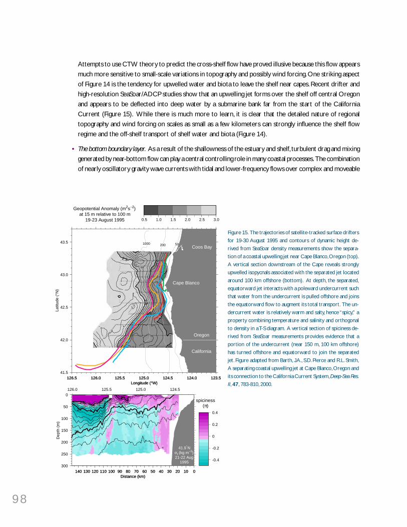
9 8
Attempts to use CTW theory to predict the cross-shelf flow have proved illusive because this flow appears
much more sensitive to small-scale variations in topography and possibly wind forcing. One striking aspect
of Figure 14 is the tendency for upwelled water and biota to leave the shelf near capes. Recent drifter and
high-resolution SeaSoar/ADCP studies show that an upwelling jet forms over the shelf off central Oregon
and appears to be deflected into deep water by a submarine bank far from the start of the California
Current (Figure 15). While there is much more to learn, it is clear that the detailed nature of regional
topography and wind forcing on scales as small as a few kilometers can strongly influence the shelf flow
regime and the off-shelf transport of shelf water and biota (Figure 14).
• The bottom boundary layer. As a result of the shallowness of the estuary and shelf, turbulent drag and mixing
generated by near-bottom flow can play a central controlling role in many coastal processes. The combination
of nearly oscillatory gravity wave currents with tidal and lower-frequency flows over complex and moveable
Figure 15. The trajectories of satellite-tracked surface drifters
for 19-30 August 1995 and contours of dynamic height de-
rived from SeaSoar density measurements show the separa-
tion of a coastal upwelling jet near Cape Blanco, Oregon (top).
A vertical section downstream of the Cape reveals strongly
upwelled isopycnals associated with the separated jet located
around 100 km offshore (bottom). At depth, the separated,
equatorward jet interacts with a poleward undercurrent such
that water from the undercurrent is pulled offshore and joins
the equatorward flow to augment its total transport. The un-
dercurrent water is relatively warm and salty, hence “spicy,” a
property combining temperature and salinity and orthogonal
to density in a T-S diagram. A vertical section of spiciness de-
rived from SeaSoar measurements provides evidence that a
portion of the undercurrent (near 150 m, 100 km offshore)
has turned offshore and equatorward to join the separated
jet. Figure adapted from Barth, J.A., S.D. Pierce and R.L. Smith,
A separating coastal upwelling jet at Cape Blanco, Oregon and
its connection to the California Current System, Deep-Sea Res.
II, 47, 783-810, 2000.126.5 126.0 125.5 125.0 124.5 124.0 123.5
Longitude (°W)
41.5
42.0
42.5
43.0
43.5
Latit
ude
(°N
)
126.5 126.0 125.5 125.0 124.5 124.0 123.5Longitude (°W)
2.52.5
2.0
2.0
1.5
1.5
50
50
200
200
1000
1000
0.5 1.0 1.5 2.0 2.5 3.0
Geopotential Anomaly (m2s–2)at 15 m relative to 100 m
19-23 August 1995
Coos Bay
Cape Blanco
Oregon
California
140 130 120 110 100 90 80 70 60 50 40 30 20 10 0Distance (km)
300
250
200
150
100
50
0
Dep
th (
m)
140 130 120 110 100 90 80 70 60 50 40 30 20 10 0Distance (km)
-0.4
-0.2
0
0.2
0.4
spiciness(π)
26
26
25
25
24
41.9°Nσt (kg m–3)21-22 Aug
1995
126.0 125.5 125.0 124.5

9 9
bed-forms greatly hinder detailed flow measurements within a few centimeters of the bottom. However,
above a few centimeters, new acoustic current sensing approaches allow accurate measurement of the
three-dimensional turbulent flow near the bottom, and recent studies are starting to provide direct tests
of some of our basic ideas about bottom boundary layers. For example, on the relatively smooth flat New
England shelf, the shear production and dissipation terms in the turbulent kinetic energy equation were
determined independently. Within a few meters above bottom, these terms balance within experimental
error, providing the first in situ confirmation of the production-dissipation energy balance that is commonly
assumed to hold in boundary layer studies (see Turbulence Dynamics box on page 68). In contrast, the
Prandtl-Karman “law of the wall,” a semi-empirical relationship between turbulent shear stress and vertical
derivative of horizontal velocity, has proven to be quantitatively inaccurate in some shelf, estuarine and
surfzone bottom boundary layers. Presumably, observed departures from the law of the wall are due to
stable stratification, but they are too large to be explained by local application of the atmospheric Monin-
Obukhov similarity theory, and their proper interpretation is a subject of current research.
Recent theory and limited observation show a pronounced asymmetry in bottom layer structure depending
on the direction of the overlying flow. When deeper (denser) water is carried up the shelf in the bottom
layer, the density difference at the top of the layer increases, reducing vertical mixing and resulting in a
thinner bottom layer. When shallow (lighter) water is carried down the shelf, the vertical density difference
decreases, increasing vertical mixing and resulting in a thicker layer. In this region further above the bottom,
the dynamics become more complex, as stratification (due to temperature, salinity or suspended sediment),
bottom slope, and the direction and strength of the overlying flow all influence the character and height of
the boundary layer. Future field studies designed to investigate this predicted asymmetry will describe this
basic phenomenon as it occurs in the coastal ocean and provide a critical test of new models of vertical
turbulent mixing. It is essential to note that vertical mixing plays such a fundamental role of coastal dynamics
that it needs to be better understood and parameterized in order for numerical physical and coupled
physical/biological models to provide realistic simulations.
• Shelf-break Fronts. The combination of rapid survey tools (such as SeaSoar and the shipboard ADCP) with
precision navigation is providing new high-resolution descriptions of the fronts between shelf and ocean
waters found near the shelf break along many continental margins. The shelf-break front along the Northeast
US provides a clear example of this emerging picture. The cross-front scale is only 10 to 20 km, resulting
in strong horizontal density gradients and large vertical and horizontal current shears, with peak currents
in the near-surface core of the jet of up to 40 to 80 cm/s (Figure 16). In addition, a vigorous secondary
circulation has been observed using dye releases. The shelf-break jet transports a significant fraction of the
along-shelf flux of shelf water, and supplies the shelf water carried off shelf as streamers around warm-core
rings. Strong shelf-break jets have now been found in the Labrador Sea, Black Sea, West Florida Shelf and
South China Sea. The existence of these fronts may have been identified in historical hydrographic data, but
their detailed thermohaline and velocity structure can now be quantified. While the importance of shelf
break jets is only starting to emerge, it is clear that they can maintain their identity over long distances and
thus transport shelf water far along the continental margin. The impact of this process on material transport,
the spread of marine organisms and formation of geobiological domains, is not currently understood.

100
Figure 16. A high resolution density and velocity section across the shelfbreak south of New England in the Middle Atlantic Bight. The
density section (panel a) shows strong cross-shelf density gradients which stretch from the bottom to the surface, with particularly
strong gradients in the upper 20 m of the water column. The contour interval is 0.1 kg/m3. The alongshelf velocity (panel b) shows a
strong jet with a maximum velocity of 0.5 m/s which is relatively narrow (10 km). The contour interval is 0.05 m/s, with dashed contours
representing westward flow and solid contours eastward flow. Figure courtesy of Glen Gawarkiewicz, Woods Hole Oceanographic
Institution, modified from G. Gawarkiewicz, F. Bahr, R. Beardsley, K Brink, Interaction of a slope eddy with the shelfbreak front in the
Middle Atlantic Bight, J. Phys. Oceanogr., accepted, 2000.
Important advances are being made in other areas of the physics of the coastal zone. These include coastal
meteorology, the effects of surface wave breaking in air-sea interaction (see Effects of Surface Waves box
on page 66), the use of high-resolution numerical weather prediction models to describe the surface
forcing on the coastal oceans, and the development and increased use of numerical circulation models for
estuarine and shelf studies.
Physical Forcing and Variability of Biological Processes in the Coastal Zone. While some effects of
physical forcing have been established, there is great uncertainty in the mechanisms by which they influence
variability in biological phenomena. Some pelagic ecosystems are strongly dependent on large scale and
mesoscale physical forcing. A prime example is the Northeast Pacific coastal upwelling zone stretching from
California to Alaska. The water properties and currents in this zone are strongly influenced by large-scale,
coupled ocean-atmospheric processes (e.g., El Niño, the North Pacific Decadal Oscillation), coastal runoff
and mesoscale processes (e.g., supercritical surface winds near points, upwelling jets and eddies generated
both on and off the shelf). Recent work on salmon, an important regional fishery, suggests that large fluctua-
tions in stock occurred before intensive fishing, indicating that trying to sort out the ecological influences of
the different physical processes in this region will be very difficult. Such sorting out will need to be done if we
want to predict the impact of climate change on this fishery.
The effects of physical processes on coastal biological communities can be quite dramatic (see Larval Trans-
port box on the opposite page) and can help explain the tremendous variance in coastal biological data sets.
On the West Coast, dramatic fluctuations of crab, salmon and other fish populations occur on five to seven
year (ENSO) cycles, as well as decadal cycles and longer (30-year time scales are known, but the relative roles
a) b)
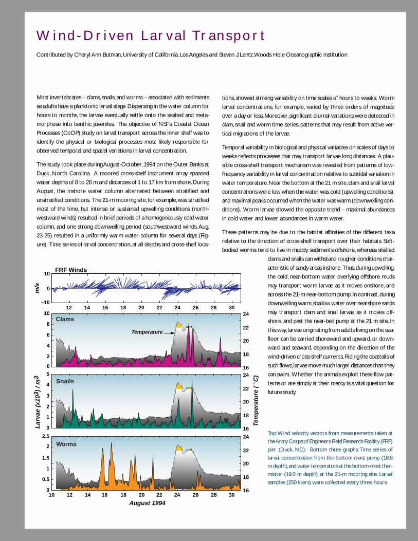
101
W i n d - D r i v e n L a r v a l Tr a n s p o r tContributed by Cheryl Ann Butman, University of California, Los Angeles and Steven J. Lentz, Woods Hole Oceanographic Institution
Most invertebrates – clams, snails, and worms – associated with sediments
as adults have a planktonic larval stage. Dispersing in the water column for
hours to months, the larvae eventually settle onto the seabed and meta-
morphose into benthic juveniles. The objective of NSF’s Coastal Ocean
Processes (CoOP) study on larval transport across the inner shelf was to
identify the physical or biological processes most likely responsible for
observed temporal and spatial variations in larval concentration.
The study took place during August-October, 1994 on the Outer Banks at
Duck, North Carolina. A moored cross-shelf instrument array spanned
water depths of 8 to 26 m and distances of 1 to 17 km from shore. During
August, the inshore water column alternated between stratified and
unstratified conditions. The 21-m mooring site, for example, was stratified
most of the time, but intense or sustained upwelling conditions (north-
westward winds) resulted in brief periods of a homogeneously cold water
column, and one strong downwelling period (southwestward winds, Aug.
23-25) resulted in a uniformly warm water column for several days (Fig-
ure). Time series of larval concentration, at all depths and cross-shelf loca-
tions, showed striking variability on time scales of hours to weeks. Worm
larval concentrations, for example, varied by three orders of magnitude
over a day or less. Moreover, significant diurnal variations were detected in
clam, snail and worm time-series, patterns that may result from active ver-
tical migrations of the larvae.
Temporal variability in biological and physical variables on scales of days to
weeks reflects processes that may transport larvae long distances. A plau-
sible cross-shelf transport mechanism was revealed from patterns of low-
frequency variability in larval concentration relative to subtidal variation in
water temperature. Near the bottom at the 21 m site, clam and snail larval
concentrations were low when the water was cold (upwelling conditions),
and maximal peaks occurred when the water was warm (downwelling con-
ditions). Worm larvae showed the opposite trend – maximal abundances
in cold water and lower abundances in warm water.
These patterns may be due to the habitat affinities of the different taxa
relative to the direction of cross-shelf transport over their habitats. Soft-
bodied worms tend to live in muddy sediments offshore, whereas shelled
clams and snails can withstand rougher conditions char-
acteristic of sandy areas inshore. Thus, during upwelling,
the cold, near-bottom water overlying offshore muds
may transport worm larvae as it moves onshore, and
across the 21-m near-bottom pump. In contrast, during
downwelling, warm, shallow water over nearshore sands
may transport clam and snail larvae as it moves off-
shore, and past the near-bed pump at the 21 m site. In
this way, larvae originating from adults living on the sea-
floor can be carried shoreward and upward, or down-
ward and seaward, depending on the direction of the
wind-driven cross-shelf currents. Riding the coattails of
such flows, larvae move much larger distances than they
can swim. Whether the animals exploit these flow pat-
terns or are simply at their mercy is a vital question for
future study.
Top: Wind velocity vectors from measurements taken at
the Army Corps of Engineers Field Research Facility (FRF)
pier (Duck, NC). Bottom three graphs: Time series of
larval concentration from the bottom-most pump (18.8
m depth), and water temperature at the bottom-most ther-
mistor (19.0 m depth) at the 21-m mooring site. Larval
samples (250 liters) were collected every three hours.
10 24
22
20
18
16
8
Lar
vae
(x10
3 ) /
m3 24
22
20
18
16
Tem
per
atu
re (
°C
)
24
22
20
18
16
6
4
2
0
5
4
3
2
August 1994
2.5
1.5
0.5
2
1
0
1
0
Clams
Snails
Worms
10 12 14 16 18 20 22 24 26 28 30
Temperature
m/s
–10
0
10FRF Winds
12 14 16 18 20 22 24 26 28 30
102
of changes in wind-driven primary productivity, larval transport and range shifts of predators are not under-
stood). While at various locations these coastal communities have much in common, there are frequently
major differences in both species composition and abundance over short distances. These differences partly
result from differences in physical habitat (e.g., rocky vs. mud bottom, temperature gradients, intensity of
bottom turbulence), but partly result from physical barriers and preferential pathways in alongshore trans-
port. Much still needs to be learned about what physical and biological processes control the distribution of
coastal benthic animals. This information is critical to any attempt to make marine reserves successful,
especially since each species may have quite different environmental conditions for successful reproduction
and recruitment.
Relatively little is known about how subtidal flows affect transport and dispersal of organisms, particularly
larvae, throughout potential coastal habitats. Most marine species have a dispersing larval stage, which is a
critical component of recruitment, yet the transport paths of these larvae are largely unknown. The effects
of buoyancy- and wind-forced circulation, nonlinear tidal flow and topographic features on retention and
redistribution of larvae have been observed, but our increasing understanding of coastal circulation has not
been extended to this critical biological effect. Recent developments in elemental fingerprinting and popula-
tion genetics are promising tools, but the eventual resolution of this issue will depend on well-focused
interdisciplinary field studies coupled with improved biological/physical models. Physical models representing
features on horizontal scales of one kilometer (or less) over dispersal distances of hundreds of kilometers
are needed in many cases. Further study of vertical migratory behavior of larvae and secondary settlement,
i.e., active or passive behavior that results in redistribution of settled juveniles by subsequent flow and sedi-
ment-transport events, is needed. Smaller-scale physical mixing also affects biological processes such as
chemosensing, gamete dispersal, fertilization success and settling, which play critical roles in reproduction,
prey avoidance, and food location and identification. Physical barriers are often broken down by anthropo-
genic means (e.g., transfer of alien species from foreign ports) with largely unpredictable, but often negative,
effects on coastal ecosystems. Empirical rates of spread of these invading organisms have been determined,
but the understanding of underlying biological/physical control mechanisms is needed to make vital predic-
tions of these rates are lacking.
Turbulent processes influence many features in the coastal ocean (e.g., boundary layers, water mass forma-
tion, animal behavior, sediment movement). Recent field studies using high-frequency ADCP, microstructure
sensors and purposeful tracer releases to investigate physical advection and turbulent mixing in the coastal
ocean have revealed the complexity of the interactions that occur (see Tracer Release and Coastal Mixing
boxes on pages 57 and 60). As noted in the Ocean Turbulence chapter, a window of opportunity is now open
to examine biological responses to these interactions. One zone in which progress in our quantitative under-
standing of turbulence will yield much fruit is the benthic boundary layer. This zone has received attention as
the site where sediment exchanges with the water column in the vertical, but it is also emerging as an
important zone for horizontal movement (e.g., for off-shelf transport). Resuspension of sediments introduce
particles, biota and chemicals to the water column; however, these fluxes have been studied mostly in lower
energy situations. “Storm-chasing” has proven difficult from ship platforms, but new in situ sampling technolo-
gies will elucidate the importance of resuspension in higher energy events.

103
Exchange wi th the Open Ocean
Morphology strongly affects how ocean margins exchange with the open ocean. Coastal regimes may or may
not include extensive estuarine regimes, and have shelves that vary in width, relief and depth. The degree to
which these coastal systems trap material exiting the continents or import materials from the open ocean
varies dramatically. Thus, processes controlling margins’ ability to export to the open ocean and import and
process material originating from the open ocean, become two areas of great significance for further study.
Materials export to the open ocean. Localized export of material to the open ocean can have global
importance. As an example, mountainous New Guinea, with its tectonically young and easily weatherable
rocks, hot weather and high rainfall, exports as much sediment as that discharged by all North American
rivers. Sediment discharged from the north side of New Guinea area largely bypasses a very narrow shelf and
escapes seaward, injecting dissolved and particulate matter into an undercurrent that contributes to the
Pacific Equatorial Undercurrent. This process may be the major source of Fe to the equatorial Pacific, and
cycles of productivity observed ten thousand kilometers away, in the eastern equatorial Pacific, may reflect
these localized tectonic and weathering processes in New Guinea. In contrast, most Fe in the organic-rich
rivers of the southeast US is flocculated in estuaries, inhibiting its flux to the open ocean.
Classic thought has been that during high stands of sea level, similar to present-day conditions, sediment was
trapped in estuaries or on continental shelves. Very little sediment was thought to be lost to the deep sea (i.e.,
beyond the shelf break). However, several recent studies suggest that a large portion of fluvial sediment
(>80%) is lost seaward from at least some estuaries, and that much is deposited as turbidite-like layers >5 cm
thick. This is especially true for rivers emptying onto narrow, steep shelves. And these are the same systems
that receive the dominant (>50) amount of global sediment flux from land. This has a significant impact on
thought about mass transfer and evolution of continental-margin architecture, and also impacts the fate of
components that are carried by the particles (e.g., carbon). The export and deep burial of carbon would
greatly influence its fate (e.g., remineralization) and its role in greenhouse gases.
Coastal regimes have high primary production, much of it available for export. A large portion of the particle
flux from the ocean margin to the open ocean may occur as density-driven, particle-rich fluids—denser ones
along the bottom, more dilute fine-grained suspensions that flow along isopycnal surfaces, and surface flows
of upwelled water with high concentrations of phytoplankton (Figure 14). Particles in these flows carry a
variety of associated chemicals into the open marine environment. Because sedimentary organic matter and
its affiliated elements are more efficiently remineralized in deep-ocean sediments, materials otherwise headed
for burial will be returned to the water column. The magnitude of this transport and the extent to which the
transfer of materials and chemical species is dominated by event-driven episodes are not well known.
Along much of the modern continental margins, fine-grained sediments and associated organics from the
shelves are trapped in slope regions where they strongly influence the benthic community. In other regions,
isopycnal flows of suspended solids and adsorbed chemicals extend hundreds of kilometers offshore and
only gradually settle out as a hemipelagic drape of land-derived clays. The controls on the effectiveness of
104
trapping on the slope are unclear. However, there are numerous opportunities for sedimentary particles to
be temporarily stored between estuaries and the deep ocean, and particle exchange with the open ocean
draws heavily on the two previously identified “problem” areas, namely, physically forced margin processes
and land-ocean fluxes.
Trace and minor element concentrations in coastal water columns are often much different from those of
the open ocean. Water movement offshore can result in significant perturbation in their concentrations in
the open ocean environment. As coastal water with high oxygen demand is advected offshore and
remineralization proceeds, large-scale oxygen minima appear. Biogeochemically active elements such as Fe,
Mn and C all exhibit deep-water maxima due to offshore transport. The impact of these exports on global
budgets needs a better quantitative definition.
Processing of imported material. The intensity of processes on the margins makes them potent modi-
fiers of ocean water that is forced to flow up onto the slope and shelf. As an example, the global nitrogen
cycle is strongly dependent on denitrification that occurs on the ocean margins. Denitrification is enhanced
primarily as a result of a combination of shallow depth and lower oxygen concentrations at the sediment-
water interface, causing nitrate derived from the open ocean to be converted to nitrogen gas and eventually
returned to the atmosphere. Water residence time is a critical parameter in this loss term. Habitat alteration
from processes such as altered sediment delivery may influence this denitrification process. These processes
are clearly significant at the global level. Quantifying these exchanges will require physical oceanographers to
determine the magnitude and time-dependent nature of shelf-open ocean or sediment-water fluxes in inter-
disciplinary efforts with marine geologists, biologists and biogeochemists.

105
W H AT M A K E S P RO G R E S S P O S S I B L E N OW ?While many factors will play a role in advancing the oceanography of ocean margins, two are particularly
noteworthy. First, the problems on the margins are made especially difficult by the complexity of these areas,
and second, many problems have lacked the appropriate sensing capability.
• Conquering complexity. The complexity and variability, both spatial and temporal, of the coastal oceans
have always presented daunting challenges to marine scientists trying to develop a broader understanding
of the processes that influence and control this dynamic environment. The devil has been often in the
details, with the details often intractable in spite of satisfactory understanding of the relevant principles.
For example, topography is critically important to many coastal processes, but varies considerably among
coastal regions; this combination has inhibited generic coastal research by tending to restrict research
conclusions to the sites in which they were investigated. The role of high variance has been difficult to
assess in the past because of meager data-gathering capabilities for many important variables. The high
temporal variability and great heterogeneity of water and material transport within and along the conti-
nental margins have made any study of material reactivity a difficult task. Assessing the role of the coastal
ocean in the carbon cycle faces difficulties similar to its assessment in the equally variable terrestrial
ecosystem.
Fortunately, the advent of new sampling and monitoring technologies promises tremendous advance in the
near future, especially in elucidating the very important role of episodic, high-energy events that may play
a major role in some aspects of the coastal environment. Recent advances in remote sensing, continuous
chemical sensing, and the application of tracers presage significant progress in understanding coastal pro-
cesses occurring on short and long time scales. New tools include HF radar, acoustic and optical imaging
systems deployed on towed bodies, Remotely operated vehicles, and moorings, towed microstructure, bio-
optical and chemical sensors, isopycnal floats and GPS drifters, and better moored instruments, samplers
and mooring technology.
• New eyes. As in any science, the advent of new sensing capabilities often leads to breakthroughs and the
science of ocean margins is no exception. As an example, recent advances in several areas have set the
stage for rapid progress in understanding micronutrient-biota interactions, including: (1) methods to deter-
mine speciation of bioactive trace metals, (2) understanding the biochemical role these metals play and
their uptake mechanisms at the molecular level, (3) molecular tools to study these processes in the field
with great sensitivity and selectivity, and (4) protocols to trace small water “patches” in the upper ocean,
enabling manipulative experiments. Another example is the ability to see for the first time km scale
circulation features in surface currents using HF radar. These circulation features affect transport of larvae
and other biologically important material, over areas of thousands of square kilometers. Developing meth-
ods for assimilation of these and other subsurface data into physical models will not only allow a better
tracking of the transport of anthropogenic materials and larval stages of marine organisms, it will aid in a
better understanding of primary and secondary biological productivity and subsequent transport of this
production.

106
B i o l o g i c a l D a t a A s s i m i l a t i o nContributed by Dennis McGillicuddy, Woods Hole Oceanographic Institution
Coupled physical-biological models offer a framework for dissection of the
diverse assemblage of processes which influence the structure of plank-
tonic populations. However, their utility is predicated on an ability to con-
struct a simulation which is representative of the natural system. One tech-
nique for doing so (the “forward” problem) is to initialize a coupled model
with a set of observations, integrate forward in time and then compare
with the next set of observations. A successful outcome results in minor
discrepancies between observations and predictions, and the model solu-
tions thus can be used as a basis for diagnosis of the processes controlling
the observed behavior. Unfortunately, satisfactory completion of the for-
ward problem is not always achievable due to limitations in the models, the
observations, or both. Adjoint data assimilation methods provide an alter-
native approach which is particularly useful in such cases. These techniques
can be used to determine the model inputs (e.g., parameters, forcing func-
tions) that minimize the misfit between observations and predictions, thereby
producing an optimal solution from which the underlying dynamics can be
gleaned.
An example of this approach is shown below, in which the adjoint method
was used to diagnose physical and biological controls on Pseudocalanus spp.
in the Gulf of Maine-Georges Bank region. The forward model is posed as
an advection-diffusion-reaction equation for the concentration of this cope-
pod. The inversion procedure is used to determine the biological sources
and sinks (i.e., the “reaction” term) implied by the changes in abundance
over time and the circulation during the intervening period. This analysis
reveals geographically specific patterns in sources (red shading) and sinks
(blue shading). These spatial patterns vary seasonally according to the ani-
mal distributions, the circulation, and their orientation with respect to each
other. In cases when the flow is either weak or aligned with gradients in
organism abundance, changes in concentration over time are dominated
local population dynamics. Such is the case during this time period in the
western Gulf of Maine, where the moderate increase in Pseudocalanus abun-
dance is largely a result of the localized area of growth extending from just
north of Cape Ann down into Cape Cod Bay. In contrast, where strong
currents cut cross the gradients of abundance, a complex three-way bal-
ance arises between the local tendency, advective transport, and the popu-
lation dynamics. Note that the area of net growth is centered slightly up-
stream of where the highest concentration of Pseudocalanus occurs.
References
McGillicuddy, D.J., Lynch, D.R., Moore, A.M., Gentleman, W.C., Davis, C.S. and C.J.
Meise, An adjoint data assimilation approach to diagnosis of physical and bio-
logical controls on Pseudocalanus spp. in the Gulf of Maine-Georges Bank
Region, Fisheries Oceanog. 7, 205-218,1998.
Climatological distributions of Pseudocalanus
spp. for (a) January-February and (b) March-
April derived from ten years of MARMAP ob-
servations (number of animals per m3). Panel
(c) shows the spatial distribution of the bio-
logical sources and sinks required to match
these observations given the climatological cir-
culation (not shown) during this period; panel
(d) shows the net advective fluxes, averaged
over the sixty days of integration. Units in (c)
and (d) are number of animals per m4 per sec-
ond; the sign convention is such that the change
over time is the sum of these two terms.
107
W H AT I S R E Q U I R E D F O R P RO G R E S S ?Progress toward a better understanding of the coastal environment and the processes that control it involve
two different aspects of our science. First is the development and use of appropriate technology, and the
second is a research emphasis on critical physical, biological, chemical and geologic processes and the key
regions in which they take place.
• Long-term time-series. We cannot expect to fully understand dynamic coastal ocean systems that can
exhibit large interannual changes without a greater emphasis on monitoring these systems. Observing a
system over an extended period time allows us to determine how the system responds to major natural
changes. For example, in the coastal benthic communities, organisms will shift in response to changed
substrate conditions, but we have little sense for how colonization rates respond to new substrate or
various components of the community shift again with evolution back to “normal” sediment substrate.
Chemical properties and fluxes, for example, contaminant return to the water column or carbon burial
mechanisms, will present similar problems. Our ability to predict these changes depends on having under-
stood each process at all of the relevant time scales. Our current inventory of studies is biased, as a result
of the access allowed by previous technologies, toward snapshots and short-term process studies—the
latter with time scales bounded in both the short- and long-term. New technologies and new funding
models will enable extension of our snapshot and movie collections to greater ranges of time scales, and
are clearly necessary to answer important coastal problems. Also needed is an increased multi-disciplinary
and multi-agency effort in coastal environmental monitoring and, perhaps, enhancement of the role of
existing marine laboratories in monitoring to the level of a nationally (or at least coastally) coordinated
mission. Because the spatial and temporal complexity of the coastal ocean results in so many perturba-
tions, greater understanding of its “natural” dynamics will provide the basis for prediction of anthropogenic
perturbations of various types.
• Interdisciplinary model systems. Because biological and chemical measurements are often difficult
and time consuming, it is rarely possible to observe these variables at the same space and time scales that
physical properties can be sampled. In spite of some outstanding examples of novel instrument develop-
ment allowing simultaneous synoptic physical and biological data sets (e.g., remote sensing, the Video
Plankton Recorder, and new multifrequency acoustic methods), point measurements taken from discrete
water samples and net tows will likely continue to dominate biological and chemical data sets. Analysis of
such necessarily sparse observations in the context of a high physical variability calls for the use of realistic
interdisciplinary model systems. In concert with data assimilation methods (see Data Assimilation box on
opposite page), such systems can be used to construct optimal estimates of oceanic fields that agree with
observations where they are available and are dynamically interpolated across data-sparse regions. These
continuous space-time representations of the ocean provide a framework for detailed diagnosis of com-
plexly coupled processes.
• Field studies of ocean turbulence. Because turbulent mixing processes are so critical to many pro-
cesses, continued emphasis should be placed on field studies of the turbulent cascade of energy and scalars
from the mesoscale down to the micro-scale where molecular dissipation takes place (see Ocean Turbu-
lence chapter). These studies are of intrinsic interest, and they provide the basis for comparison with new

108
numerical studies of these processes (featuring large-eddy and direct simulation approaches to resolve the
turbulent flow) and the development of better parameterizations of turbulent mixing. The parameterizations
currently used in coastal numerical models are known to have serious shortcomings that reduce their
usefulness. Improved parameterizations would benefit both coastal ocean research and the use of models
for practical applications (e.g., search and rescue, currents and sea surface elevation for ship routing, fisher-
ies). The continued increase in computing power plus the use of finite-element methods is now allowing
coastal models to be built with highly resolved realistic model domains. As this trend continues, model
accuracy will become even more dependent on turbulent mixing parameterization. A major improvement
in the parameterization will have a very important and wide impact on ocean modeling and interdiscipli-
nary research in general.
• Improved moorings. Many advances in physical understanding of the coastal zone have come about
through improved moored and shipboard instrumentation that allow more accurate sampling on both
short and long time and space scales. With this has come a better appreciation of the diverse roles of
physical processes in other coastal phenomena and the local ecosystem dynamics. As a result, and with
continued development and use of moored instrumentation in biology and chemistry, we can anticipate
major advances in a number of areas, such as (a) biophysical coupling, (b) cross-shelf transport processes,
(c) turbulent mixing processes and their parameterizations in numerical ocean models, (d) buoyancy-
driven flows and fronts, (e) sediment transport, (f) biogeochemical fluxes and (g) the shaping of water
column and benthic communities.
• Monitor subseafloor processes. An appreciation of the long-term development of the continental
terrace requires a much more complete sampling of this terrace, using an enhanced database of seismic
images of the internal structure of the terrace to guide scientific ocean drilling and sampling. These geo-
logic investigations should also incorporate monitoring and study of a host of subsurface processes, includ-
ing fluid (e.g., groundwater) flow, microbial activity and gas hydrate formation.
• Further integrate biology and chemistry. Carbon is just one important element in the biogeochemi-
cal cycling that takes place in the coastal environment. We can take advantage of recent advances in
remote sensing, continuous chemical sensing—and the application of tracers to investigate biogeochemical
reactions and exchanges in places such as the transient boundary of river plumes and in the permanent
mixing zones of estuaries. We need to develop a better sense of how the balance between the supply of
major and trace nutrients regulates species composition and ecosystem structure in coastal regions. Stron-
ger integration of organismal physiology into biogeochemical studies will enhance this progress.
• Conservation- and restoration-based research. Building a strong scientific base for applied marine
science is fundamental to our ability to manage and conserve marine resources for sustainability. Hundreds
of millions of people depend on coastal marine ecosystem goods and services, but we have, at present, only
a minimal scientific basis for focusing on the most important locations for conservation, and even less of a
basis for effective restoration of damaged systems. However, experimentally based efforts in the restora-
tion of coastal habitats are being undertaken, and the increased numbers of marine protected areas and
marine parks make experimental tests of management and restoration efforts tractable over significant
spatial scales.

109
Fluid flow through oceanic crust, and through the seafloor along the margins of the ocean basins, is the
fundamental process by which mass and energy are transferred from Earth’s interior to the ocean and
atmosphere. Fluid fluxes through oceanic crust are so large that a volume equivalent to the global ocean is
circulated through the seafloor once every ~6.0 m.y.; fluid flux through active and passive margins is very
poorly constrained, but is also likely to be large in many settings. Collectively, this vast system of fluid circu-
lation below the seafloor can be thought of as a second ocean—an ocean below the seafloor. We are just
beginning to explore this “ocean,” determining the forces that drive fluid flow, estimating the mass and energy
fluxes, understanding its influence on geological processes, exploring the extent and distribution of biological
activity at and below the seafloor, and assessing the impact of these fluxes and biological communities on
mineral, chemical and biological resources. This is an exciting new frontier of research in the ocean sciences,
and one with enormous opportunities in the coming decade for both new discoveries and fundamental new
insight into coupled geological and biological processes in the deep sea.
T H E O C E A N
Fluid F low and E f fects on Geology, Chemis tr y and L i fe in the Crust
B E L O W T H E S E A F L O O R
110
W H AT A R E T H E B I G P RO B L E M S ?The following discussion is organized around a series of questions. Running through all of these questions is
the fundamental difficulty of resolving the many temporal and spatial scales over which fluid processes occur
in the subseafloor. Fluid flow events occur in seconds to minutes (in the case of hydrologic responses to
seismic activity) or millions of years (the time required to pervasively alter oceanic crust by hydrothermal
circulation). Flow occurs between grains over distances of microns (creating coupled oxic and anoxic mi-
croenvironments), through fractures and cracks at scales of meters (transporting heat and solutes) and along
tectonic plate boundaries extending tens of kilometers (lubricating fault zones and transmitting abnormal
pressures). Different measurements of the same system can result in fundamentally different views of how
that system operates. Making the right combinations of measurements and reconciling the different scales of
fluid flow are the central challenges to understanding the ocean below the seafloor.
What are the phys ica l boundar ies , hydro log ic proper t ies and dr iv ing forcesrespons ib le for the f luxes of energy and mass through the subseaf loor ocean?
The physical boundaries and driving forces responsible for fluid flow through this subseafloor ocean are
poorly understood. These parameters must be constrained because they allow us to define the magnitude
and significance of fluid flow and related processes, and to make better predictions of how these processes
may change in the future. For example, the depth to which water circulates in the oceanic crust is not known,
but is fundamentally important because crustal alteration results in incorporation of water into mineral
phases that are eventually recycled into the mantle at subduction zones. Subduction of volatiles influences
processes occurring within the seismogenic zone and the explosiveness of volcanic activity in arcs. Where
seismic data have allowed imaging of ridge crest magma chambers, the deeper limit of fluid penetration and
high-temperature fluid-rock interaction have been estimated to be 1 to 2 km. But especially along the more
extensive and slower spreading ridges, the depth of fluid circulation in the axial region is largely unknown.
Observations in deep crustal sections from ophiolites suggest that fluids may penetrate considerably deeper,
perhaps 5 km below the seafloor in some places.
The lateral extent of fluid circulation within the crust and how these systems are recharged is also not
known. Is fluid recharge rapid and highly localized, perhaps focused along major faults, or is it slower and
more diffuse? What is the nature of the subseafloor “reaction zone,” a conceptual region where ordinary
seawater interacts and exchanges heat and mass with newly-solidified rock, becoming highly evolved hydro-
thermal fluid? In some areas, recharging fluids appear to travel tens of kilometers or more, perhaps allowing
isolated basement outcrops and faults to ventilate large parts of the seafloor. Measurements of driving forces
for ridge-flank circulation suggest that they are very small, requiring an extremely good hydrologic connec-
tion across long distances. Recent studies suggest that most ridge-flank flow could be focused through a very
small fraction of the crust (see Ridge-Flank Circulation box on opposite page). However, the dimensions of
the fluid-flow conduits, and how these connections are maintained over large distances and as the crust
evolves, is still poorly understood. Heat flow data suggest that advective fluid exchange ends, on average, at 65
m.y., but chemically significant flow may continue until the crust is extremely old. The residence time of
hydrothermal fluids in the crust is critical for assessing the ability of these fluids to support microbiological
habitats.
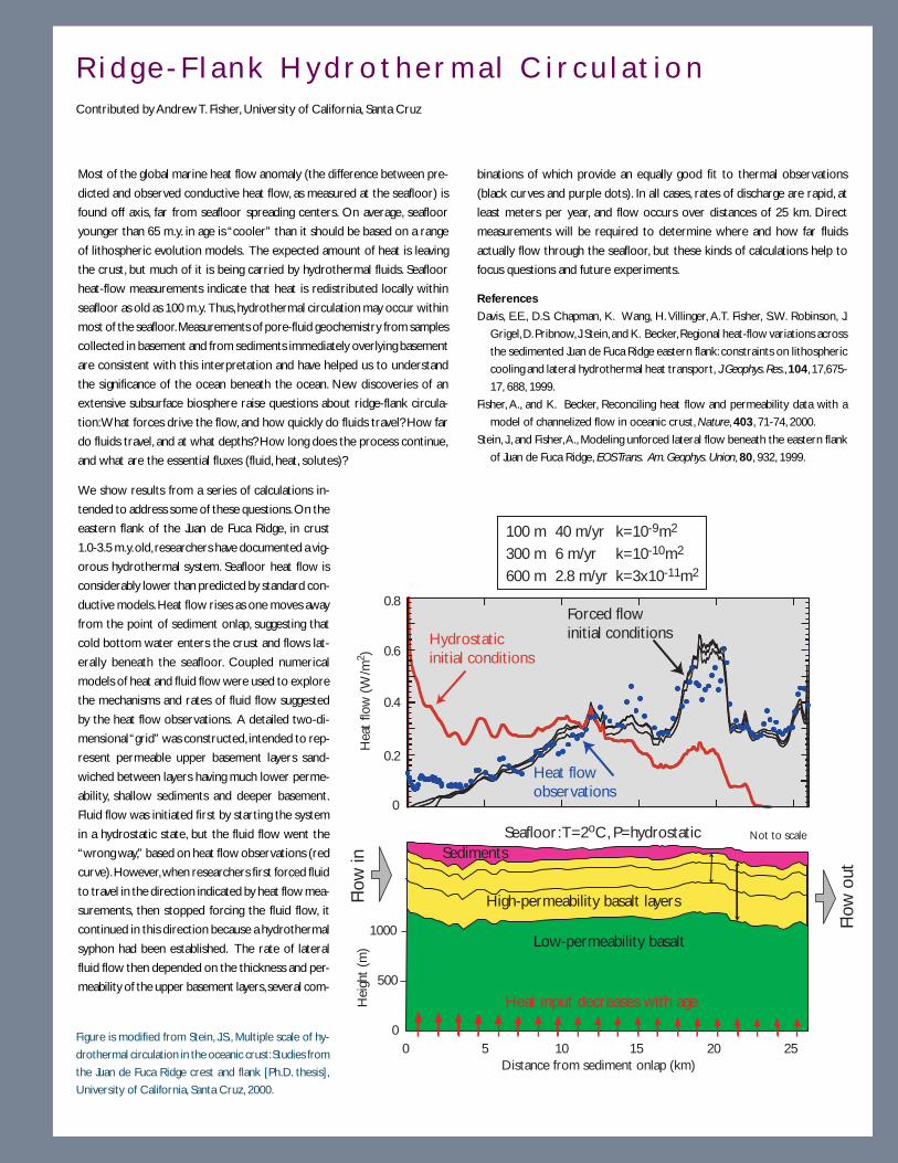
111
Most of the global marine heat flow anomaly (the difference between pre-
dicted and observed conductive heat flow, as measured at the seafloor) is
found off axis, far from seafloor spreading centers. On average, seafloor
younger than 65 m.y. in age is “cooler” than it should be based on a range
of lithospheric evolution models. The expected amount of heat is leaving
the crust, but much of it is being carried by hydrothermal fluids. Seafloor
heat-flow measurements indicate that heat is redistributed locally within
seafloor as old as 100 m.y. Thus, hydrothermal circulation may occur within
most of the seafloor. Measurements of pore-fluid geochemistry from samples
collected in basement and from sediments immediately overlying basement
are consistent with this interpretation and have helped us to understand
the significance of the ocean beneath the ocean. New discoveries of an
extensive subsurface biosphere raise questions about ridge-flank circula-
tion: What forces drive the flow, and how quickly do fluids travel? How far
do fluids travel, and at what depths? How long does the process continue,
and what are the essential fluxes (fluid, heat, solutes)?
We show results from a series of calculations in-
tended to address some of these questions. On the
eastern flank of the Juan de Fuca Ridge, in crust
1.0-3.5 m.y. old, researchers have documented a vig-
orous hydrothermal system. Seafloor heat flow is
considerably lower than predicted by standard con-
ductive models. Heat flow rises as one moves away
from the point of sediment onlap, suggesting that
cold bottom water enters the crust and flows lat-
erally beneath the seafloor. Coupled numerical
models of heat and fluid flow were used to explore
the mechanisms and rates of fluid flow suggested
by the heat flow observations. A detailed two-di-
mensional “grid” was constructed, intended to rep-
resent permeable upper basement layers sand-
wiched between layers having much lower perme-
ability, shallow sediments and deeper basement.
Fluid flow was initiated first by starting the system
in a hydrostatic state, but the fluid flow went the
“wrong way,” based on heat flow observations (red
curve). However, when researchers first forced fluid
to travel in the direction indicated by heat flow mea-
surements, then stopped forcing the fluid flow, it
continued in this direction because a hydrothermal
syphon had been established. The rate of lateral
fluid flow then depended on the thickness and per-
meability of the upper basement layers, several com-
binations of which provide an equally good fit to thermal observations
(black curves and purple dots). In all cases, rates of discharge are rapid, at
least meters per year, and flow occurs over distances of 25 km. Direct
measurements will be required to determine where and how far fluids
actually flow through the seafloor, but these kinds of calculations help to
focus questions and future experiments.
References
Davis, E.E., D.S. Chapman, K. Wang, H. Villinger, A.T. Fisher, S.W. Robinson, J.
Grigel, D. Pribnow, J. Stein, and K. Becker, Regional heat-flow variations across
the sedimented Juan de Fuca Ridge eastern flank: constraints on lithospheric
cooling and lateral hydrothermal heat transport, J. Geophys. Res., 104, 17,675-
17, 688, 1999.
Fisher, A., and K. Becker, Reconciling heat flow and permeability data with a
model of channelized flow in oceanic crust, Nature, 403, 71-74, 2000.
Stein, J., and Fisher, A., Modeling unforced lateral flow beneath the eastern flank
of Juan de Fuca Ridge, EOS Trans. Am. Geophys. Union, 80, 932, 1999.
R i d g e - F l a n k H y d r o t h e r m a l C i r c u l a t i o nContributed by Andrew T. Fisher, University of California, Santa Cruz
0
500
1000
Seafloor: T=2oC, P=hydrostatic
Hei
ght
(m)
Flow
in
Flow
out
Not to scale
Sediments
Low-permeability basalt
High-permeability basalt layers
0 5 10 15 20 25Distance from sediment onlap (km)
Heat input decreases with age
0.8
0.6
0.4
0.2
0
Hydrostatic initial conditions
100 m 40 m/yr k=10-9m2
300 m 6 m/yr k=10-10m2
600 m 2.8 m/yr k=3x10-11m2
Forced flowinitial conditions
Hea
t flo
w (
W/m
2 )
Heat flow observations
Figure is modified from Stein, J.S., Multiple scale of hy-
drothermal circulation in the oceanic crust: Studies from
the Juan de Fuca Ridge crest and flank [Ph.D. thesis],
University of California, Santa Cruz, 2000.
112
The relative importance of sources and sinks of fluid remains poorly understood at subduction zones. Fluids
contained in the subducting basement and sediments, and in the subduction wedge that commonly forms
above the trench, are expelled at various depths under the influence of increasing pressure and temperature.
The water carried into subduction zones is trapped in the pores of unconsolidated sediment and bound in
hydrous minerals. It is released as the sediments dewater and lithify and as the subducted crust dehydrates.
Some fluids penetrate into the mantle, influencing global geodynamics and mantle geochemistry.
Fluid venting in many settings has been found to be highly episodic, however, currently we have little under-
standing of the life cycle of transient events or the fundamental driving mechanisms responsible for them.
Fluid flow depends strongly on the permeability of the crust, which is controlled by factors such as grain size,
fracture aperture and pore-fluid pressure. These properties are sure to be transient, anisotropic, and highly
heterogeneous. Transient fluid expulsion includes hydrothermal venting at ridge crests, cold venting at sub-
duction margins, mud and serpentine diapirism along active and passive margins, gas expulsion leading to
pockmarks and slope failure, and diffuse venting in all settings. Understanding the forces driving episodic fluid
venting is essential to developing accurate models of coupled hydrological, geological and biological pro-
cesses of submarine hydrothermal systems.
What i s the in f luence o f f lu id f low on geo log ica l processes a t and be low thesea f loor?
Fluids flowing through the seafloor influence a wide range of geological processes, and these influences feed
back into fluid flow. Fluids in fault zones deposit cements, driving permeability down and fluid pressure up.
This process may result in brittle failure of the crust, generating a catastrophic increase in permeability.
Water carried by the crust into subduction zones influences the strength of the host rock and lubricates
seismically active faults. Water carried to greater depths serves as a fluxing agent in the production of mobile
hydrous minerals and melt for arc volcanoes. Fluids seeping through sediments in a variety of continental
margin settings carry hydrocarbons including methane, which at high pressures and low temperatures, com-
bines with water to form vast accumulations of gas hydrate. And in all subseafloor environments, over a
surprisingly broad range of temperatures, pressures and chemistries, the subsurface ocean supports an ex-
tensive microbial population comprising the deep biosphere.
Mid-ocean ridges. Some of the most spectacular examples of fluid flow through Earth’s crust occur at mid-
ocean ridges, where water is driven through and reacts with highly permeable rock. Temperatures are
commonly 300° to 350°C and sometimes exceed 400°C. Fluid density contrasts that result in buoyancy-
driven flow can be enormous. Driving forces and chemical activity can be enhanced by phase separation,
either at sub- or super-critical conditions. Consequences of circulation include rapid exchange of elements
and heat between the crust and oceans, deposition of large mineral deposits at the seafloor, and nourishment
of unique animal communities at seafloor vents (Figure 17).
One of the fundamental gaps in our understanding of the relationship between fluid flow and geological
systems is the influence of ridge-crest hydrothermal circulation on the architecture of oceanic lithosphere.
There must be complex feedbacks between energy and mass sources, evolving permeability structure, the
distribution of intrusive and extrusive rocks, the importance of faulting, and the stresses associated with
seafloor spreading. Which factors dominate heat, fluid, and solute transport at the ridge-crest? Does axial
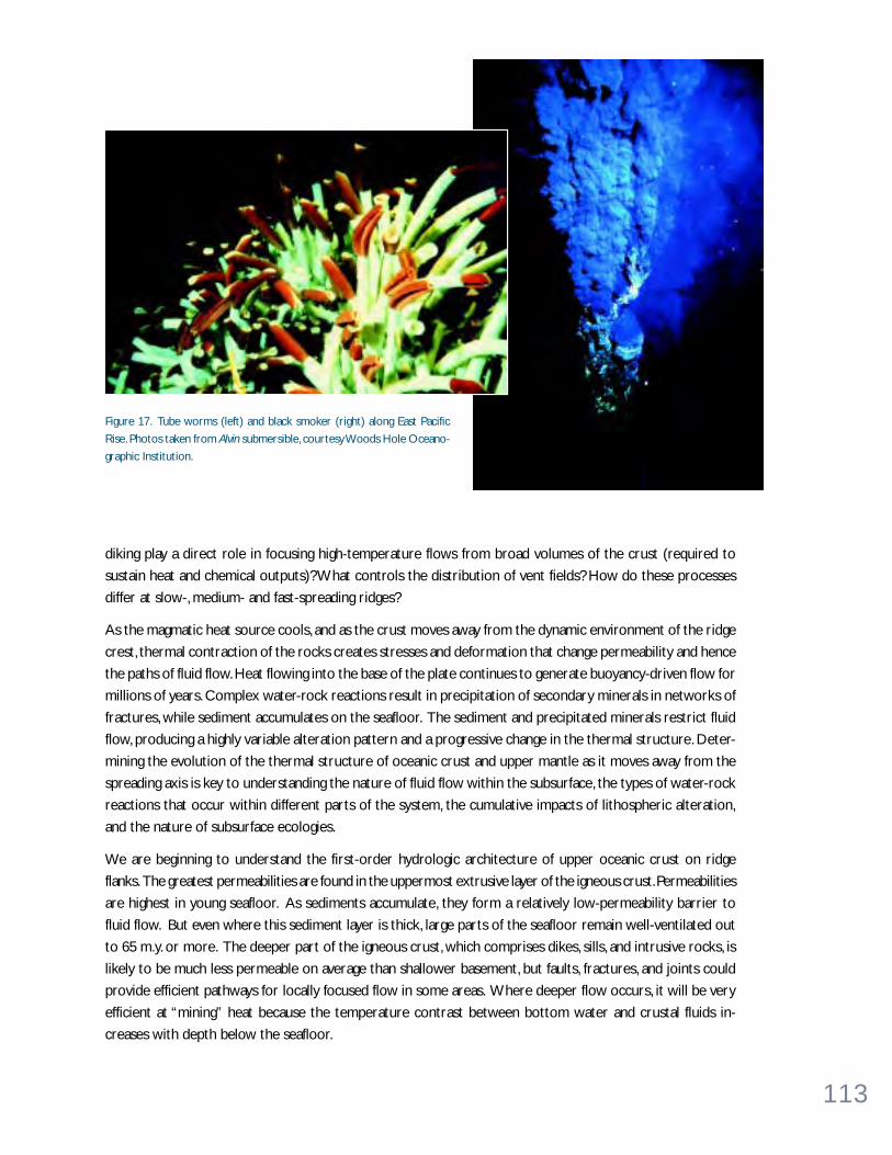
113
diking play a direct role in focusing high-temperature flows from broad volumes of the crust (required to
sustain heat and chemical outputs)? What controls the distribution of vent fields? How do these processes
differ at slow-, medium- and fast-spreading ridges?
As the magmatic heat source cools, and as the crust moves away from the dynamic environment of the ridge
crest, thermal contraction of the rocks creates stresses and deformation that change permeability and hence
the paths of fluid flow. Heat flowing into the base of the plate continues to generate buoyancy-driven flow for
millions of years. Complex water-rock reactions result in precipitation of secondary minerals in networks of
fractures, while sediment accumulates on the seafloor. The sediment and precipitated minerals restrict fluid
flow, producing a highly variable alteration pattern and a progressive change in the thermal structure. Deter-
mining the evolution of the thermal structure of oceanic crust and upper mantle as it moves away from the
spreading axis is key to understanding the nature of fluid flow within the subsurface, the types of water-rock
reactions that occur within different parts of the system, the cumulative impacts of lithospheric alteration,
and the nature of subsurface ecologies.
We are beginning to understand the first-order hydrologic architecture of upper oceanic crust on ridge
flanks. The greatest permeabilities are found in the uppermost extrusive layer of the igneous crust. Permeabilities
are highest in young seafloor. As sediments accumulate, they form a relatively low-permeability barrier to
fluid flow. But even where this sediment layer is thick, large parts of the seafloor remain well-ventilated out
to 65 m.y. or more. The deeper part of the igneous crust, which comprises dikes, sills, and intrusive rocks, is
likely to be much less permeable on average than shallower basement, but faults, fractures, and joints could
provide efficient pathways for locally focused flow in some areas. Where deeper flow occurs, it will be very
efficient at “mining” heat because the temperature contrast between bottom water and crustal fluids in-
creases with depth below the seafloor.
Figure 17. Tube worms (left) and black smoker (right) along East Pacific
Rise. Photos taken from Alvin submersible, courtesy Woods Hole Oceano-
graphic Institution.

114
Rifted and Subducting Margins. Along continental margins, fluids are continuously on the move because
of the slow consolidation of sediments transported onto and into the margins. Fluids are also added to the
system by the dewatering of subducted slabs in active margins. Generally low permeabilities lead to disequi-
librium between production and drainage, and hence to overpressured conditions. Variations in permeability,
and in rates of deformation, loading, and fluid production may to lead to large variations in pore pressure and
rates of flow. Locally pressures can approach lithostatic levels, and fluid flow can be highly compartmentalized
or focused.
At each step, fluid fluxes distilled from the downgoing slab influence fundamental processes. At the shallow-
est depths, water and carbon fluxes influence the formation and destruction of gas hydrates, and may support
a deep, subsurface biosphere as well as the chemosynthetic vent communities observed in forearc regions. At
greater depths, excess pore fluid pressures moderate the strength of faults and influence the hazards associ-
ated with great earthquakes of the seismogenic zone. At still greater depths the presence of water influences
magma production that often results in explosive arc volcanism. Quantifying the significance of fluids in these
systems requires that we resolve the magnitude and controls on specific fluxes. Excess fluid pressures, gas
hydrate formations and large-scale slope-failure structures have also been identified along passive margins,
but we do not know the extent that continental groundwater contributes to fluid fluxes in these settings.
A number of important questions are unresolved. What is the role of water in controlling deformational
style at active margins (e.g., ductile vs. brittle; distributed vs. fault-concentrated)? How do chemical fluxes
influence the alteration of the margin, and how does this, together with deformation, influence permeability
and the relative importance of distributed and fracture-focused flow? How large are fluxes from great depths?
How much fluid is returned back to the ocean, and how much is transported to greater depths to serve as a
fluxing agent for upper mantle serpentinization and melt production, and ultimately to contribute to mantle
heterogeneity? How does lithospheric alteration influence magmatic and volcanic processes above subduc-
tion zones? How does water influence seismic rupture, and how do earthquakes influence fluid flow through
the generation or release of pore-fluid pressures within the rupture zone, the generation of pressures through
ground acceleration, or the generation of permeability? Episodic events, possibly associated with major earth-
quake rupture and accompanying ground motion, may dominate in some subduction zones. What is the
relative importance of transient vs. steady state hydrologic processes?
The hydrologic regimes of passive margins are poorly understood globally, but fluid pressures in excess of
hydrostatic are known to influence slope stability in some settings. Margin fluxes influence sediment diagen-
esis, the shapes of margins by way of mechanical and chemical erosion, the migration and accumulation of
hydrocarbons including gas and gas hydrates, and geochemical exchange between the crust and the oceans.
At many passive margins, hydrologic regimes may be linked to meteoritic systems on land, with flow driven by
topographic head. These systems are extensive, spanning from onshore, across continental shelves, and to
continental slopes and continental rises. Critical parameters involving these systems include fluid composi-
tions, sediment/rock alteration histories, lateral pressure gradients, and formation permeabilities.

115
What are the magn i tude , d i s t r ibut ion and tempora l var i ab i l i t y o f mass ,therma l and chemica l f luxes to and f rom the crusta l ocean?
The role of fluids as agents of change is a common thread that links many of the outstanding questions
involving the oceanic lithosphere’s life cycle, from creation through aging to subduction and entry into the
upper mantle. Hydrothermal fluid fluxes are so large that a volume equivalent to the global ocean is circulated
through the seafloor once every ~6.0 m.y. Fluxes of fluids and solutes from active and passive continental
margins are very poorly constrained, but are likely to be large in many settings. Collectively these fluxes
(coupled fluid, heat, mass) and associated chemical reactions between seawater and oceanic rocks lead to
fundamental interactions between the lithosphere and the overlying ocean. One critical goal of active margin
research is to determine the budgets of volatiles such as water, methane and carbon dioxide, as they enter,
traverse, and exit subduction zones. Subduction carries water and other volatiles to progressively higher
pressures and temperatures.
Alteration budgets for the crust and upper mantle need to be quantified at all stages of the life cycle of an
oceanic plate, from its birth at a spreading center to beyond the time at which the plate is subducted, over the
full range of spreading rates and in various sedimentation regimes. The cycling of seawater through the ocean
crust and mantle must be understood in terms of global cycles of water, carbon, oxygen, metals and other
elements. These fluxes also need to be resolved in terms of specific lithospheric properties. For example, the
rates of cycling at mid-ocean ridges should depend fundamentally on plate spreading rates. As oceanic crust
ages, early high-temperature alteration can be overprinted by lower temperature reactions. These processes
likely lead to a crustal section that is extremely heterogeneous in its mineralogy and chemical composition.
Water-rock reactions that result in black smoker fluids (Figure 18) emanating from the seafloor are thought
to occur in relatively shallow circulation systems driven by magmatic heat sources. A great deal has been
learned about crustal alteration through sampling of vent fluids and upper crust and by experiments and
Days Since 1 April 1991
0 10 20 30 300 600 900 1200 1500 1800 2100 2400200
400
Tem
pera
ture
in °
C
0
700
Cl i
n m
mol
es/k
g
0
110
H2S
in m
mol
es/k
g
Figure 18. Plot of temperature, Cl and H2S from hydrothermal
vent “A” at 9°46.5’N along the East Pacific Rise. A volcanic erup-
tion had occurred at that site just prior (weeks at most) to diving
with Alvin. Data are from the period April 1, 1991 through Decem-
ber 1997. Note the dramatic chemical changes that occur in the
vent fluid compositions following the volcanic eruption; the sys-
tem had not yet stabilized nearly seven years later. The value on
the y-axis is the seawater value for reference, where appropriate.
The low Cl and high H2S early on reflect the vapor phase nature of
these fluids. With time, the Cl gradually increases and the tem-
perature and H2S decrease. Data are from Von Damm, K.L.,
S.E. Oosting, R. Kozlowski, L.G. Buttermore, D.C. Colodner,
H.N. Edmonds, J.M. Edmond and J.J. Grebmeier, Evolution of the
East Pacific Rise hydrothermal vent fluids following a volcanic
eruption, Nature, 375, 47-50, 1995, and from Karen Von Damm,
University of New Hampshire (unpublished).
116
modeling. Based on these studies, a model has been developed that predicts the types of alteration reactions
and resulting elemental exchanges between fluids and rocks from the time seawater enters the crustal
section until it discharges at high-temperature hydrothermal vents. The true nature of the reaction zone (the
conceptual region where fluids develop their chemical signatures through high-temperature reactions and
the metals that ultimately are concentrated at the seafloor in massive sulfide deposits are extracted), how-
ever, is unknown. The lack of samples from these depths has limited our ability to understand processes such
as phase separation and the speciation of solutes and metals in fluids along the transport pathways. In addi-
tion, recent tantalizing evidence of microbial activity in rock samples suggests that bacteria may play an
important role in crustal alteration. Fluid fluxes on ridge flanks have been estimated to be five to ten times
larger than those on ridge crests, but the chemical impacts of ridge-flank circulation are very poorly con-
strained. Some ridge-flank fluxes rival riverine sources or sinks in magnitude, but others are completely
unknown.
What i s the extent and d i s tr ibut ion o f b io log ica l ac t i v i ty wi th in the crustand where the crusta l and b lue oceans meet?
The existence of a subseafloor biosphere is intimately tied to fluid flow. Fluids cycle nutrients, provide heat
and may contribute to physical transport of genetic material within sediments and basement rocks. The
extent of Earth’s deep, subseafloor biosphere and the character of the “extremeophiles” populating it, how-
ever, are largely unexplored. Initial results from scientific ocean drilling indicate that microbial ecosystems
thrive in both oceanic crust and in deep (more than 750 m), subsea sediments—regions thought to be barren
only 10 to 20 years ago (Figure 19). The discovery of novel microorganisms and metabolisms in the subseafloor
operating in physical isolation from the more highly evolved organisms and mechanisms in the overlying
ocean has opened up an exciting new frontier of research.
The need to examine subseafloor microbial ecosystems more closely is a priority. Studies of microbial popu-
lations, pore-water chemistry and organic-chemical composition over ranges of sub-bottom depths in differ-
ent tectonic settings will enhance our understanding as to how and to what extent the deep biosphere takes
part in global biogeochemical cycling. Drilling in hydrothermal discharge zones (both focused and diffuse) will
provide needed samples from a wide range of temperatures over relatively short distances. Exploration of
subduction zones will elucidate bacterial involvement in the remobilization of materials from descending
plates and about responses of communities to fluids migrating from greater depths. Examination of microbial
populations around seafloor mud mounds and other sites of hydrocarbon-related diagenetic activity will
provide information about the role of bacteria as sinks for fossil fuels. Studies at methane-hydrate boundaries
will provide information about the long-term stability of such deposits and about global budgets for green-
house gases. Carbon and redox budgets for the deep bacterial community are completely unknown. If micro-
bial communities within sediments intercept reduced substances ascending with fluids from the sediment-
hard rock interface, this process could have substantial effects on climate and atmospheric composition.
Macrofauna clustered around vent sites are now being characterized (focused/diffuse, hot/warm/cool, long-
lived/short-lived). Nearly every new vent field adds to the catalog of previously unknown species (and some-
times, genera), whose relations to known animals are poorly understood. How do vent communities colonize

117
new discharge sites (see Figure 11 on page 76)? How are their larvae transported across vast distances? How
do they derive nourishment during periods when they are between vent sites? Why are these some species
found at more than one kind of site and others that are extremely restricted (spatially, temporally)?
Subseafloor fluid sampling may allow the discovery of organisms that will extend the accepted temperature
and pressure limits of life or prove more ancient phylogenetically than those currently known. The possibility
of primitive cellular groups or physical arrangements in which genetic information is freely exchanged to
accomplish the metabolism of what would normally be considered an individual organism has been postu-
lated for subsurface refugia but not taken beyond the speculative phase. In serving as physical substrata (and
even nutritional substrates) for the formation of microbial mats and stably close associations between cells,
the abundant mineral surfaces that characterize the crustal ocean could stabilize or facilitate genetic ex-
change as it is understood to occur between modern organisms and envisioned to occur between more
primitive cells.
Recognition of the crustal ocean as a potentially vast and unexplored extension of the known biosphere, and
provision of suitable facilities to explore it, provides unprecedented opportunity for modeling and experi-
mental ventures into the realm of the origins and early evolution of life on this planet and possibly elsewhere.
The hypothesis that life originated at hydrothermal vents has been with us for two decades; a general consen-
Figure 19. Bacterial abundances as
a function of subbottom sediment
depth as seen in ODP boreholes
down to ~ 750 mbsf. Figure re-
printed with permission from
Parkes, R.J., B.A. Cragg and P.
Wellsbury, Recent studies on bac-
terial populations and processes in
subseafloor sediments: A review,
Hydrogeol. Jour., 8, 11-28, copyright
Springer-Verlag, 2000.
102 104 106 108 1010
1000
100
10
1
0.1
0.01
Bacterial Numbers (cm-3)
Depth(mbsf)

118
sus on the merits of the idea has been reached. Next to come will be dedicated conceptual and experimental
tests of the hypothesis, based on new information emerging from interdisciplinary studies of the crustal
ocean. On-axis study at hydrothermal vent sites will be essential, as extensive hydrothermal activity is be-
lieved to have dominated the Archean ocean (see Deep Biosphere box on opposite page). But the impor-
tance of the rest of the contemporary crustal ocean—extensive off-axis zones, sedimented regimes and
basaltic glass—cannot be underestimated. These areas also provide permissive conditions for the evolution
of life and its chemical precursors, as well as a refuge from modern processes, from predation by highly
evolved organisms and enzymes to irradiative assault that would otherwise erase the existence of primitive
organisms or consortia on this planet. They also may best resemble crustal zones on other planets (Mars)
and moons (Europa), where much speculation ensues regarding the possible existence or fossilization of
microbial life. Study of Earth’s crustal ocean is now seen as the best option available to the scientific commu-
nity for unraveling the mystery most central to humankind—the origins and early evolution of life.
What are the impacts o f f lu id f luxes and subsea f loor communi t ies onminera l , chemica l and b io log ica l resources?
Polymetallic sulfide deposits are found on mid-ocean ridges, on axial and off-axis volcanoes and seamounts, in
sedimented rifts adjacent to continental margins and in subduction-related backarc environments. Land-
based massive sulfide deposits and those found on the seafloor are products of the same geological and
geochemical processes, and many analogies can be drawn. The discovery of ore-grade gold deposits in a
submarine caldera (Miyouin Knolls in the Izu volcanic arc) and active submarine Kuroko-type iron formation
(Panarea in the Aeolian arc) are exciting examples of the economic potential associated with subseafloor fluid
flow that is just being recognized.
While the economic potential of seafloor hydrothermal deposits is difficult to assess without a better under-
standing of their distribution, size and bulk composition, these modern, actively forming seafloor deposits are
excellent natural laboratories for understanding the genesis of volcanogenic massive sulfide deposits. A
major advantage of the study of modern seafloor hydrothermal systems is that the composition of the end
member ore-forming fluids can be measured—a prerequisite for geochemical modeling and mass balance
calculations. Furthermore, detailed studies of the regional setting and geochemistry of seafloor deposits can
identify important tectonic and petrologic controls on the occurrence of economically more attractive (e.g.,
gold-rich) massive sulfide deposits in the geologic record. This knowledge can be applied directly to identify
promising tectonic settings for land-based mineral deposit exploration.
Organic carbon is an important component of the subseafloor ocean. It supports much of the life there and
migrates through the fluid flow system as a medium of energy exchange. In its migration it is occasionally
trapped and accumulates to form economically important energy resources. In other settings it escapes to
the ocean and the atmosphere where it may, under the right conditions, cause sudden, large (4° to 7°)increases in global temperatures (see Global Warming box on page 28). The oil exploration industry has
concentrated its research efforts on discovering the concentrated source beds capable of producing large
volumes of hydrocarbon fluids and on determining how these fluids migrate through and are trapped within
the subseafloor ocean. There is still much to be learned about the basic rates of gas and oil production
through both physical and biological processes and of the constraints on its movement through and out of
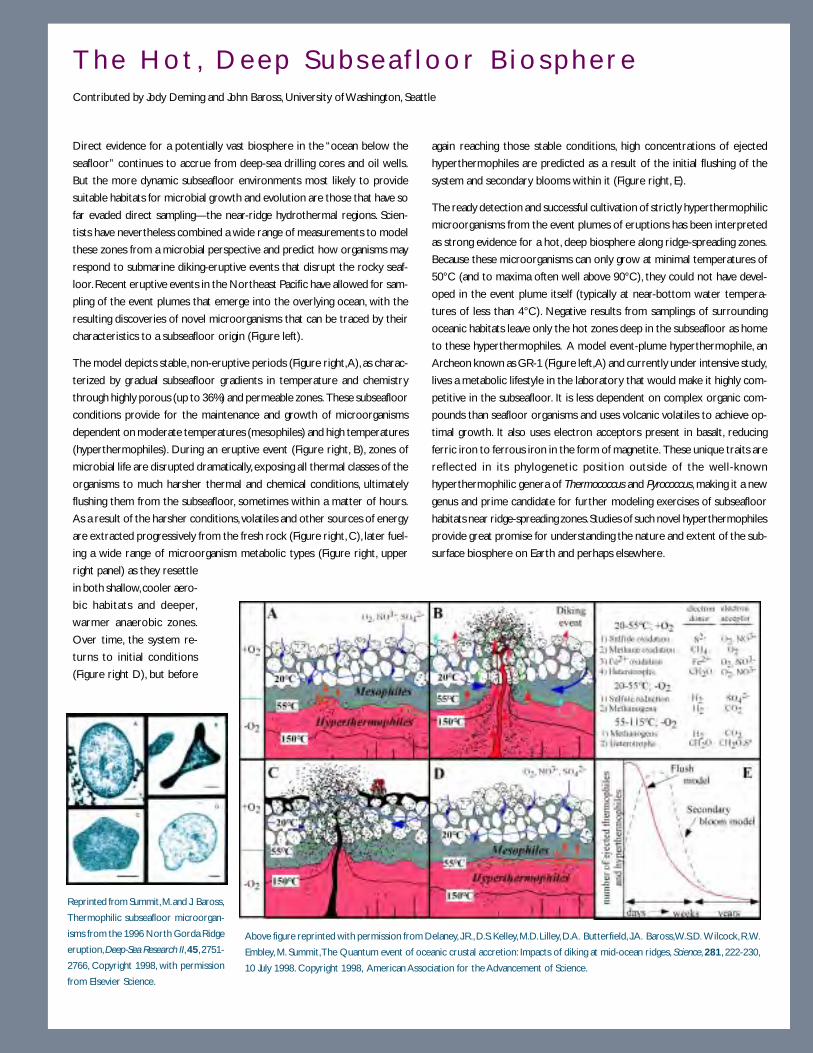
119
T h e H o t , D e e p S u b s e a f l o o r B i o s p h e r eContributed by Jody Deming and John Baross, University of Washington, Seattle
Direct evidence for a potentially vast biosphere in the “ocean below the
seafloor” continues to accrue from deep-sea drilling cores and oil wells.
But the more dynamic subseafloor environments most likely to provide
suitable habitats for microbial growth and evolution are those that have so
far evaded direct sampling—the near-ridge hydrothermal regions. Scien-
tists have nevertheless combined a wide range of measurements to model
these zones from a microbial perspective and predict how organisms may
respond to submarine diking-eruptive events that disrupt the rocky seaf-
loor. Recent eruptive events in the Northeast Pacific have allowed for sam-
pling of the event plumes that emerge into the overlying ocean, with the
resulting discoveries of novel microorganisms that can be traced by their
characteristics to a subseafloor origin (Figure left).
The model depicts stable, non-eruptive periods (Figure right, A), as charac-
terized by gradual subseafloor gradients in temperature and chemistry
through highly porous (up to 36%) and permeable zones. These subseafloor
conditions provide for the maintenance and growth of microorganisms
dependent on moderate temperatures (mesophiles) and high temperatures
(hyperthermophiles). During an eruptive event (Figure right, B), zones of
microbial life are disrupted dramatically, exposing all thermal classes of the
organisms to much harsher thermal and chemical conditions, ultimately
flushing them from the subseafloor, sometimes within a matter of hours.
As a result of the harsher conditions, volatiles and other sources of energy
are extracted progressively from the fresh rock (Figure right, C), later fuel-
ing a wide range of microorganism metabolic types (Figure right, upper
right panel) as they resettle
in both shallow, cooler aero-
bic habitats and deeper,
warmer anaerobic zones.
Over time, the system re-
turns to initial conditions
(Figure right D), but before
again reaching those stable conditions, high concentrations of ejected
hyperthermophiles are predicted as a result of the initial flushing of the
system and secondary blooms within it (Figure right, E).
The ready detection and successful cultivation of strictly hyperthermophilic
microorganisms from the event plumes of eruptions has been interpreted
as strong evidence for a hot, deep biosphere along ridge-spreading zones.
Because these microorganisms can only grow at minimal temperatures of
50°C (and to maxima often well above 90°C), they could not have devel-
oped in the event plume itself (typically at near-bottom water tempera-
tures of less than 4°C). Negative results from samplings of surrounding
oceanic habitats leave only the hot zones deep in the subseafloor as home
to these hyperthermophiles. A model event-plume hyperthermophile, an
Archeon known as GR-1 (Figure left, A) and currently under intensive study,
lives a metabolic lifestyle in the laboratory that would make it highly com-
petitive in the subseafloor. It is less dependent on complex organic com-
pounds than seafloor organisms and uses volcanic volatiles to achieve op-
timal growth. It also uses electron acceptors present in basalt, reducing
ferric iron to ferrous iron in the form of magnetite. These unique traits are
reflected in its phylogenetic position outside of the well-known
hyperthermophilic genera of Thermococcus and Pyrococcus, making it a new
genus and prime candidate for further modeling exercises of subseafloor
habitats near ridge-spreading zones. Studies of such novel hyperthermophiles
provide great promise for understanding the nature and extent of the sub-
surface biosphere on Earth and perhaps elsewhere.
Above figure reprinted with permission from Delaney, J.R., D.S. Kelley, M.D. Lilley, D.A. Butterfield, J.A. Baross, W.S.D. Wilcock, R.W.
Embley, M. Summit, The Quantum event of oceanic crustal accretion: Impacts of diking at mid-ocean ridges, Science, 281, 222-230,
10 July 1998. Copyright 1998, American Association for the Advancement of Science.
Reprinted from Summit, M. and J. Baross,
Thermophilic subseafloor microorgan-
isms from the 1996 North Gorda Ridge
eruption, Deep-Sea Research II, 45, 2751-
2766, Copyright 1998, with permission
from Elsevier Science.
120
the subseafloor. The continued movement of oil exploration into deeper waters, where little data exist on
either the source beds or the reservoir rocks, affords the academic research community an opportunity to
develop new partnerships with this industry. There are shared interests in the organic source, the rates of
production and degradation, the rates of migration, migration pathways and the ultimate fate of organic
matter in the subseafloor system. Seismic images of the subseafloor world acquired by industry will point the
way for exploration of this realm. Technology developed by industry will aid us in sample recovery. In turn,
our basic research on the processes which create, alter and move hydrocarbons will be of direct benefit to
the exploration industry.
Enormous quantities of hydrocarbons are stored in deep marine sediment as solid gas hydrate and free gas
bubbles (see Gas Hydrates box on opposite page). This ocean carbon reservoir may contain 15 to 20 times
more carbon than the entire terrestrial biosphere. Marine gas hydrates are not concentrated exclusively in
layers, but are found mostly dispersed in sediment pore space and are distributed over thousands of square
kilometers in considerable water depths. The economic potential of gas hydrates, as well as the technical
feasibility of their extraction, is unknown. In addition, it is increasingly apparent that gas hydrates play a role in
the cycling of carbon on Earth’s surface, and the stability and movement of gas hydrate is greatly influenced by
fluid flow. Gas hydrates may be a future energy resource, a catalyst for mass wasting on continental margins
and also a substrate for an unique subseafloor biosphere.
Before the discovery of the subseafloor biosphere, bacteria isolated from hydrothermal environments had
already made a big impact on biotechnology, for example in providing enzymes for the polymerase chain
reaction that has galvanized molecular genetics. Some hydrothermal bacteria can not only just survive but
also are biochemically active at temperatures up to at least 120°C and there may be bacteria able to be active
at even higher temperatures. This is significant because it suggests that bacteria are likely to be present
several kilometers beneath seafloor. In addition, bacteria may be involved in the formation of fossil fuels at
depth as the “oil window” occurs between 100° to 150°C and large bacterial populations emerge with
production fluids from some oil reservoirs. It also looks likely that the deep biosphere will provide an even
more diverse source of bacteria than the hydrothermal environments and as a result have a much greater
scientific and biotechnological impact.
As more is discovered about the organisms and metabolic processes that occur in the crustal ocean and at its
mixing interface with overlying seawater, new biological and molecular resources for society will emerge.
Confidence in this prediction comes from recent success along these lines: microorganisms cultured from
hydrothermal vents have yielded enzymes and processes already on, or under development for, the biotech-
nology market. DNA-modifying enzymes from hyperthermophilic Archaea discovered at hydrothermal vents
are now produced and sold commercially. Industrial investment in identifying additional high-temperature
catalytic enzymes from hyperthermophilic microorganisms for the engineering of specialty chemicals remains
high. The tolerance of >5 mM concentrations of cadmium and parallel precipitation of the metal by a meso-
philic vent bacterium has drawn attention to the organism as a prime candidate for bioremediation applica-
tions. The significant ongoing exploration of the ocean for metabolic byproducts of medical interest (new
classes of antibiotics and other pharmaceuticals) will logically be extended to the ocean’s subsurface, as
increasing numbers of subsurface organisms and genes become available for byproduct screening.

121
B u r n i n g I c e : G a s H y d r a t e s f ro m t h e O c e a n F l o o rContributed by Marta Torres and Anne Trehu, Oregon State University
Gas hydrates resemble compacted snow, contain large amounts of natural
gas, and occur at many places under the ocean floor including Oregon’s
continental slope. These unusual solids consist of “cages” of water mol-
ecules that trap methane and other gases, which originate from the de-
composition of organic material in ocean sediments. Gas hydrates form in
the temperature and pressure conditions common on continental margins;
thus the locations of known or inferred gas hydrates are worldwide.
Gas hydrates from continental margins are receiving significant scientific
and economic attention because they could be of major societal relevance.
While the total energy reserve stored in gas hydrates is still poorly known,
they may comprise the largest fossil fuel reservoir on Earth. In addition,
Methane is a potent greenhouse gas and the release of the large volumes
stored in hydrate deposits owing to decreases in ocean depth (causing a
decrease in pressure) or increases in temperature may significantly influ-
ence the global climate. Recent studies, for example, suggest that gas hy-
drates may have contributed to some of the past episodes of global warm-
ing recorded in Earth’s geologic history.
A spectacular massive methane hydrate deposit off the coast of Oregon
has recently been the focus of research by an international team of investi-
gators from the US, Germany, Canada and Japan. At this site, known as
Hydrate Ridge, methane hydrates are located at the seafloor as well as in
the subsurface. Massive carbonates formed from oxidation of methane are
also present and record past hydrate dissociation. This site lies less than 50
miles west of Newport, OR, making it very accessible for repeated detailed
studies. Very large quantities of gas hydrates are also exposed on the seaf-
loor in the Gulf of Mexico on the Mississippi shelf. They are formed from
the upward migration of fluids saturated with methane and other trace
gases and have been observed to be unstable with the passage of warm
water eddies. From the ubiquitous seismic evidence of gas hydrates on
continental shelves world wide we may expect to find more examples of
such sites.
Long-term goals are: (1 )to understand the geology of the system, (2) quan-
tify the amount of methane present (3) measure the energy and chemical
fluxes associated with the hydrates and (4) evaluate the impact of methane
hydrates on the marine environment. Seismic imaging has revealed wide-
spread hydrate and gas in the subsurface and a complicated plumbing sys-
tem bringing fluids to the seafloor. Current and planned research includes
measuring chemical and fluid fluxes at the seafloor and drilling by ODP, and
using other platforms to calibrate remote sensing techniques and docu-
ment subsurface biogeochemical processes. Further progress will require
development and implementation of new technology to permit retrieval of
gas hydrates at in situ conditions and long-term, real-time observations of
geophysical, geochemical and biological processes.
References
Suess, E., M.E. Torres, G. Bohrmann, R.W. Collier, J. Greinert, P. Linke, G. Rehder,
A. Trehu, K. Wallmann, G. Winckler, E. Zuleger, Gas hydrate destabilization:
enhanced dewatering, benthic material turnover, and large methane plumes
at the Cascadia convergent margin, Earth and Plan. Sci. Let., 170, 1-15, 1999.
Trehu, A., M. Torres, G. Moore, E. Suess, G. Bohrmann, Dissociation of gas
hydrates in response to slumping and folding on the Oregon continental
margin, Geology, 27, 939-942, 1999.
Methane plume in lower water column resulting from
gas discharge at the seafloor. Seismic reflection line
across northern summit of Hydrate ridge. Subsur-
face reflection parallel to the seafloor indicates the
widespread presence of hydrate.
Because of the large amount of methane in gas
hydrates, they have been called “burning ice.”
122
W H AT M A K E S P RO G R E S S P O S S I B L E N OW ?Recent technical advances that have made possible the detailed exploration of the seafloor have been accom-
panied by investigations of the ocean below the seafloor. There has also been a serendipitous confluence of
technical capabilities, scientific interest and public curiosity about ocean environments, and a new realization
that the ocean below the seafloor must be better understood in order to address a wide range of questions.
The early stages of this new wave of exploration began about 20 years ago with the discovery of large benthic
communities surrounding hydrothermal vents. Similar communities were found on continental margins. Si-
multaneous developments in ocean drilling technology allowed selected crustal environments to be drilled,
sampled, examined and actively measured. Several large seismic events along active margins, and documented
relationships among fluid flow, fluid pressure and earthquakes have demonstrated the importance of under-
standing linkages within the seismogenic zone. Significant progress in understanding fluid transport in systems
with varying porosity and time scales has been detailed in the oil reservoir and hydrological literatures,
providing a wealth of insights available for transfer to those studying the complex oceanic subsurface. Grow-
ing understanding of the potential influence of gas hydrates on global carbon budgets, and their role in climate
change, has sparked additional research efforts. Public awareness of the importance of these relationships is
growing.
Additional technical advances came in the form of computing (both hardware and software), communica-
tions, video, sampling and submersible technology. Finally, we are beginning to establish long enough records
(observational and sampling) at individual sites so that we can begin to document the dynamic behavior of
complex fluid-rock systems. Some of these observations have come from repeated visits to sites so that they
could be photographed and sampled, but other critical results have come from temporary and more perma-
nent seafloor observatories (see CORK box on opposite page). It is as if hydrologists had been limited to
observing and sampling the Mississippi River once or twice a year, but suddenly were permitted to monitor
the river constantly, to evaluate its flows, observe responses to rain events and urbanization, record fluid
chemistry and survey biological communities. The overarching realization is that fluid flow and associated
processes and properties are inherently transient and interdependent, requiring a new approach to resolve
fundamental problems. Detailed, multidisciplinary, continuous, active and passive experiments are required to
understand the dynamics of complex geological systems, and the oceanographic community is now prepared
to undertake these kinds of experiments. The study of the subseafloor ocean is about to take a quantum leap
forward.
123
Data logger for internal toolstring Instrument
platform andguide for
wireline reentry
Pressurerecording package
Fluid sampling ports
SeafloorReentrysystem
Zone Ahydraulicsamplingport
Zone Bhydraulicsamplingport
Zone Chydraulicsamplingport
drilled hole
Packer(inflates to seal
off part of hole)
Packer
Packer
16" casing
Zone B
Zone C
Zone A
Removable toolstring (thermistors, tiltmeters,
seismometers, etc.)
Hydraulic conduits
Advanced CORK System
Reamed hole
CORK Sub se a f l oo r Hyd rogeo lo g i c a l E xpe r imen t sContributed by Keir Becker, University of Miami and Earl E. Davis, Geological Survey of Canada
Fluid circulation in subseafloor formations profoundly affects a wide range
of Earth processes. Hydrothermal circulation controls heat and chemical
balances and possibly subsurface microbiological communities in young
oceanic crust. Dewatering in subduction settings is intimately related to
earthquake cycles and carbon cycling. Utilizing boreholes to understand
these hydrogeological systems in situ by direct sampling and borehole ex-
periments has long been a key goal of the Deep Sea Drilling Project and the
Ocean Drilling Program. DSDP/ODP holes left open to the oceans—the
typical case through 1991—provided hydrological shunts to the natural
circulation systems, in essence presenting perturbation experiments. In some
cases the downflow of ocean bottom water into the hole can be used to
constrain natural conditions. More often, however, drilling-induced circula-
tion that can persist for years in open holes completely obscures natural
processes.
To effectively use boreholes as in situ hydrological laboratories, then, re-
quires sealing them to allow recovery from drilling-induced perturbations.
This need motivated development of the CORK (Circulation Obviation
Retrofit Kit) hydrogeological observatory (Davis et al., 1992). From 1991
to 1997, several CORKs were successfully deployed in settings where a
hydrogeologically active formation was overlain by a less permeable forma-
tion. Each CORK corresponded to a natural seal and allowed reestablish-
ment of equilibrium conditions and processes in the subseafloor forma-
tion. The installations have been revisited with manned or unmanned
submersibles months and years after deployment for recovery of pressure
and temperature data, reprogramming, and installation of long-term fluid
sampling and microbiological filtering experiments (see photo).
A new generation of “Advanced CORKs” will be able to seal multiple zones
in a single hole, more closely corresponding to natural hydrogeological
structures and opening new opportunities for subseafloor hydrogeological
observatories (see diagram). The new designs will allow deployment of an
enhanced range of long-term instrumentation, with configurations specifi-
cally tailored to study microbiology, gas hydrates or seismogenesis in addi-
tion to more standard temperature and pressure monitoring. The initial
deployments for two distinct engineering approaches to such multi-seal
installations are scheduled for 2001. Two wireline instrumented multi-packer
systems or “Wireline CORKs” will be installed in Holes 504B and 896A on
the southern flank of the Costa Rica Rift utilizing Scripps Institution of
Oceanography’s wireline Control Vehicle. A few months later, the first ODP
“Advanced CORKs,” or instrumented multi-packer casing systems, are
scheduled to be installed during ODP Leg 196 at two sites in the Nankai
Trough in the western Pacific.
References
Davis, E.E., K. Becker, T. Pettigrew, B. Carson, and R. MacDonald, CORK: a
hydrologic seal and downhole observatory for deep-ocean boreholes, Proc.
ODP, Init. Repts., 139, 43-53, 1992.
THE CORK IN HOLE 1026BREENTRY CONE AND CORK DEPLOYED JULY, 1996, LEG 168
MICROBIOLOGICAL FILTERING COLUMN DEPLOYED OCTOBER, 1997PHOTOGRAPHED OCTOBER, 1997, FROM DSV ALVIN
FUNDING: NATIONAL SCIENCE FOUNDATION, GEOLOGICAL SURVEY OF CANADA, JOIDES
LANDINGPLATFORMIN REENTRY
CONE
TOP OF DATA LOGGER
CORK BODYFLUID
SAMPLINGVALVE
COWEN/JOHNSON
MICRO-BIOLOGICALFILTERING
124
W H AT I S R E Q U I R E D F O R P RO G R E S S ?The discovery of the fluid realm within the seafloor was based on a new paradigm for Earth behavior and
evolution (plate tectonics) and the development of new technology for Earth monitoring (mapping, submersibles,
drilling, instrumentation). Our understanding of the dynamics of fluid flow within oceanic sediments and
basement will depend in the future on our technical ability to image, sample, monitor and model complex
systems. To image the ocean floor and the subseafloor in great detail and monitor the ocean just above the
seafloor over wide regions will require development of, and access to, sophisticated seafloor mapping tech-
niques, submersibles and remotely operated vehicles, as well as automated underwater survey vehicles.
Subseafloor imaging is needed to describe the physical setting of the subseafloor ocean and to properly site
detailed sampling efforts, from the scale of meters to kilometers, down to nanometers to millimeters, the
scale relevant to a microbe’s size.
We have sampled the subseafloor ocean where it exits the crust in hydrothermal plumes, but to understand
its circulation within the crust, we must drill through the overlying sediments and into the crust itself. We
need to penetrate into several critical environments, but drilling, sampling, testing and monitoring technology
requires improvement before the entire seafloor is accessible. Working on young-crust, bare-rock systems
remains extremely difficult. Drilling holes deeper than about one kilometer into the seafloor is challenging in
any setting because debris from drilling and cavings from the walls of the hole tend to clog drilling tools. Riser
drilling will be needed to penetrate deep into the oceanic crust and tap the very region where earthquakes
occur in subduction zones. Once holes are drilled and cased, borehole and seafloor observatory technolo-
gies will be needed to power, monitor and test these installations, and to record and communicate results to
surface ships and to shore. The development of two-way communications, power and control networks will
bring in a new era of direct experiments and passive monitoring of detailed time-series dynamics both at and
within the seafloor.
Making sense out of the large amounts of data sure to accompany the new era of exploration and testing will
require two additional developments. First, we need to learn to manage (store, access, cross-reference) large
data sets so that they are accessible to a broad community. This will allow truly collaborative, international,
interdisciplinary science to be accomplished. Second, we need to learn to apply sophisticated coupled models
to help us interpret the new samples and data that will be collected. In some cases, this will require develop-
ment of new codes and solution techniques, but in other cases, it will require mainly that scientists take a
broad, open view of the observations, and apply basic concepts to a range of temporal and spatial scales.
125
One of the great accomplishments of the plate tectonics revolution forty years ago was the recognition that
we live on a dynamic planet. Earth is changing on a variety of temporal scales, from the millions of years
required to open and close ocean basins or form mountain ranges to the few seconds it takes for a devastat-
ing tsunami-generating earthquake or explosive volcanic eruption to completely alter the local landscape.
These geologic processes have a complex, and still poorly understood, influence on the biosphere, hydro-
sphere and atmosphere.
The interaction of ocean crustal processes with the ocean itself takes place through the cycling of sea water
through the crust. The physical, chemical and biological impact of this cycling is the primary focus of the
preceding theme chapter. Here we focus on the solid crust itself, its tectonic interactions with the continents,
and its recycling through the mantle back to the crust’s surface as volcanoes and newly formed seafloor.
Plate tectonics provides a very powerful, quantitative framework for study of the “solid Earth cycle” depicted
in Figure 20. In the 1970s and early 1980s, a major focus of research in the marine geosciences was the use of
this new paradigm to investigate the kinematics of plate motions, and to explore the first-order geological
implications of the plate tectonic cycle. Thus, regional-scale bathymetric and magnetic studies were carried
out and used with satellite gravity maps to reconstruct the spreading history of all the major ocean basins
over the past 200 million years. Models of the thermal evolution of the oceanic lithosphere were developed
that successfully predicted the variation in seafloor depth with age, as well as the subsidence history of rifted
continental margins. Plate reconstructions helped to investigate the relative motions of hot spots and to
explore the consequences of plate motions on continental tectonics, from the evolution of the San Andreas
Fault system in western North America to the uplift of the Himalayas.
L I T H O S P H E R ED Y N A M I C S O F O C E A N I C
A N D M A R G I N S
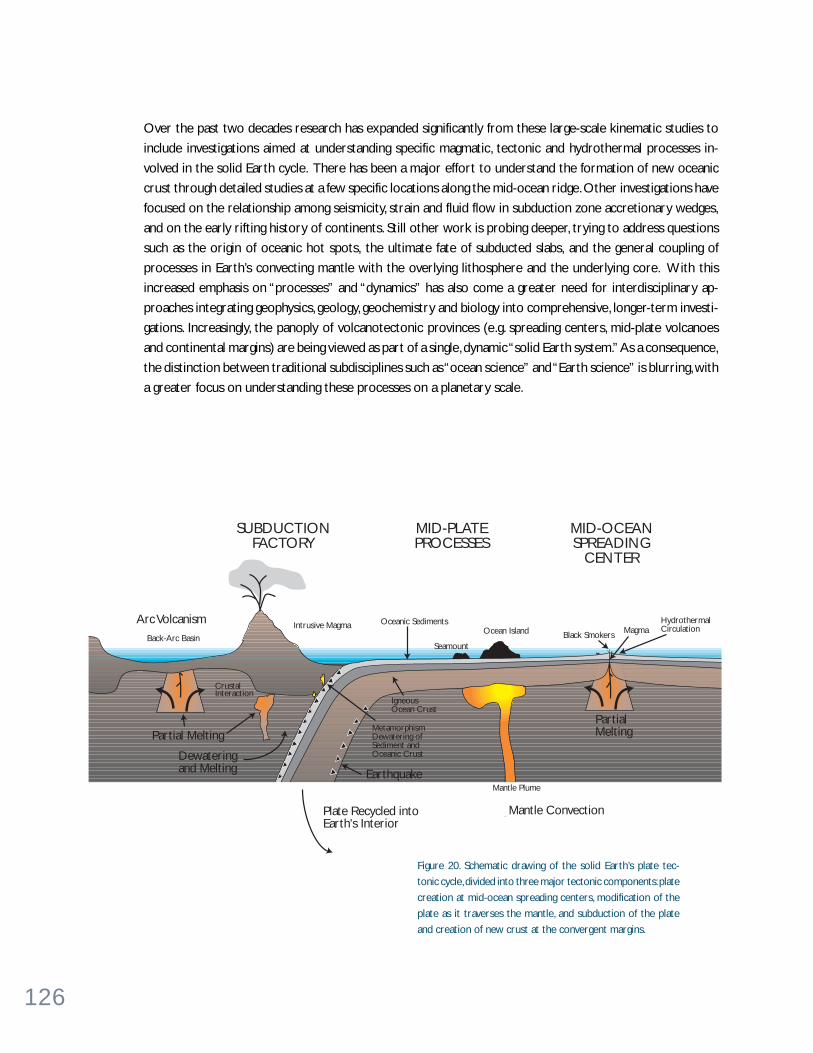
126
Over the past two decades research has expanded significantly from these large-scale kinematic studies to
include investigations aimed at understanding specific magmatic, tectonic and hydrothermal processes in-
volved in the solid Earth cycle. There has been a major effort to understand the formation of new oceanic
crust through detailed studies at a few specific locations along the mid-ocean ridge. Other investigations have
focused on the relationship among seismicity, strain and fluid flow in subduction zone accretionary wedges,
and on the early rifting history of continents. Still other work is probing deeper, trying to address questions
such as the origin of oceanic hot spots, the ultimate fate of subducted slabs, and the general coupling of
processes in Earth’s convecting mantle with the overlying lithosphere and the underlying core. With this
increased emphasis on “processes” and “dynamics” has also come a greater need for interdisciplinary ap-
proaches integrating geophysics, geology, geochemistry and biology into comprehensive, longer-term investi-
gations. Increasingly, the panoply of volcanotectonic provinces (e.g. spreading centers, mid-plate volcanoes
and continental margins) are being viewed as part of a single, dynamic “solid Earth system.” As a consequence,
the distinction between traditional subdisciplines such as “ocean science” and “Earth science” is blurring, with
a greater focus on understanding these processes on a planetary scale.
Arc Volcanism
Partial Melting
Dewateringand Melting
Back-Arc Basin
Intrusive Magma
CrustalInteraction
MetamorphismDewatering ofSediment andOceanic Crust
Plate Recycled intoEarth's Interior
Earthquake
PartialMelting
Mantle Convection
SUBDUCTIONFACTORY
MID-PLATEPROCESSES
MID-OCEANSPREADING
CENTER
IgneousOcean Crust
Oceanic Sediments
Seamount
Ocean Island MagmaHydrothermalCirculation
Black Smokers
Mantle Plume
Figure 20. Schematic drawing of the solid Earth’s plate tec-
tonic cycle, divided into three major tectonic components: plate
creation at mid-ocean spreading centers, modification of the
plate as it traverses the mantle, and subduction of the plate
and creation of new crust at the convergent margins.

127
W H AT A R E T H E B I G P RO B L E M S ?In this section we highlight five areas of research that can contribute significantly to fundamental, and long-
standing, questions in geodynamics. These include (1) determining the role of oceanic lithosphere and mantle
plumes in the circulation and compositional evolution of Earth’s mantle, (2) developing a general theory for
melting and mantle transport processes in the oceanic crust and mantle, (3) testing the ophiolite model by
drilling the first complete oceanic crustal section, (4) investigating the mechanisms and controls on lithos-
pheric deformation and faulting by studying active seismogenic zones, and (5) determining the time scales of
magmatic and tectonic processes operative in the oceans through the establishment of long-term seafloor
observatories. In each case we believe the opportunity exists for significant advances, even breakthroughs, in
our understanding of these problems over the next decade.
Crust -mant le c i rcu la t ion sys tem
Processes that create and modify the ocean basins play a central role in altering the composition and physical
behavior of the mantle. The first stage of this process is the chemical depletion of the upper mantle, produc-
ing oceanic crust at mid-ocean ridges. Chemical and thermal heterogeneities formed on the spreading ridges
and during tens of millions of years of lithospheric aging and alteration are later inserted into both the upper
and lower mantle during subduction. Some portion of the elements added to the crust on-axis (e.g., Li, B, Rb,
Cs, Sr, U, Mg) are later extracted in subduction zones by melting or dewatering of the down-going slab. The
rest is incorporated into the mantle for long-term storage and may return to Earth’s surface at hot spots.
Thus, to understand the crust-mantle circulation system, we need to more accurately determine the compo-
sition of the material that is subducted, and understand the processes occurring at the trench and beneath
the island arc that modify subducted material. We also need to better understand the physical dimensions of
mantle heterogeneity, how long heterogeneities exist in the mantle despite convection, and how the evidence
for that mantle heterogeneity, through hot spots and other upwellings, reaches the surface.
Subduction zone cycling. The composition and volume of material being subducted at a trench strongly
affects the dynamics of the forearc, and the eruptive products and explosivity of the volcanic arc. We are
currently in an early stage of understanding the forcing functions that trace and balance mass, volatiles and
energy through this primary Earth system. Cycling of mass, volatiles and energy through the shallower part of
this system can be evaluated by (1) drilling in the forearc and lower-plate crust, (2) monitoring of hydrother-
mal vents and diapiric upwelling zones in forearcs, (3) sampling of arc volcanoes and backarc volcanism, and
(4) determining the composition, physical properties and PT history of arc lower crust and upper mantle via
study of tectonically exhumed arc sections, investigations of mantle fragments in active arcs, and seismic
investigation of active arcs. Both passive and active seismic experiments are critical for imaging the structure
and velocity distribution through an active subduction system, but very few “modern” experiments have been
undertaken. Geochemical tools are well-developed for studying the volcanic output in arcs (see Subduction
Recycling box on page 128). These can be used to evaluate the variation of input fluxes for the global arc
system, after “calibration” of the geochemical signals with respect to quantified input fluxes in at least one
location.
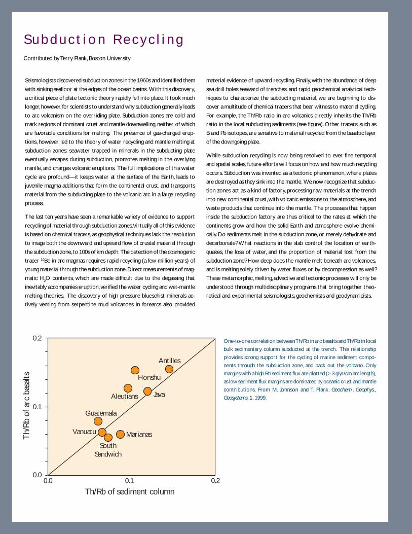
128
Seismologists discovered subduction zones in the 1960s and identified them
with sinking seafloor at the edges of the ocean basins. With this discovery,
a critical piece of plate tectonic theory rapidly fell into place. It took much
longer, however, for scientists to understand why subduction generally leads
to arc volcanism on the overriding plate. Subduction zones are cold and
mark regions of dominant crust and mantle downwelling, neither of which
are favorable conditions for melting. The presence of gas-charged erup-
tions, however, led to the theory of water recycling and mantle melting at
subduction zones: seawater trapped in minerals in the subducting plate
eventually escapes during subduction, promotes melting in the overlying
mantle, and charges volcanic eruptions. The full implications of this water
cycle are profound—it keeps water at the surface of the Earth, leads to
juvenile magma additions that form the continental crust, and transports
material from the subducting plate to the volcanic arc in a large recycling
process.
The last ten years have seen a remarkable variety of evidence to support
recycling of material through subduction zones. Virtually all of this evidence
is based on chemical tracers, as geophysical techniques lack the resolution
to image both the downward and upward flow of crustal material through
the subduction zone, to 100s of km depth. The detection of the cosmogenic
tracer 10Be in arc magmas requires rapid recycling (a few million years) of
young material through the subduction zone. Direct measurements of mag-
matic H2O contents, which are made difficult due to the degassing that
inevitably accompanies eruption, verified the water cycling and wet-mantle
melting theories. The discovery of high pressure blueschist minerals ac-
tively venting from serpentine mud volcanoes in forearcs also provided
Th/
Rb
of a
rc b
asal
ts
Th/Rb of sediment column
Antilles
Honshu
Java
Marianas
Aleutians
Guatemala
Vanuatu
SouthSandwich
0.00.0 0.1 0.2
0.1
0.2 One-to-one correlation between Th/Rb in arc basalts and Th/Rb in local
bulk sedimentary column subducted at the trench. This relationship
provides strong support for the cycling of marine sediment compo-
nents through the subduction zone, and back out the volcano. Only
margins with a high Rb sediment flux are plotted (> 3 g/yr/cm arc length),
as low sediment flux margins are dominated by oceanic crust and mantle
contributions. From M. Johnson and T. Plank, Geochem., Geophys.,
Geosystems, 1, 1999.
material evidence of upward recycling. Finally, with the abundance of deep
sea drill holes seaward of trenches, and rapid geochemical analytical tech-
niques to characterize the subducting material, we are beginning to dis-
cover a multitude of chemical tracers that bear witness to material cycling.
For example, the Th/Rb ratio in arc volcanics directly inherits the Th/Rb
ratio in the local subducting sediments (see figure). Other tracers, such as
B and Pb isotopes, are sensitive to material recycled from the basaltic layer
of the downgoing plate.
While subduction recycling is now being resolved to ever fine temporal
and spatial scales, future efforts will focus on how and how much recycling
occurs. Subduction was invented as a tectonic phenomenon, where plates
are destroyed as they sink into the mantle. We now recognize that subduc-
tion zones act as a kind of factory, processing raw materials at the trench
into new continental crust, with volcanic emissions to the atmosphere, and
waste products that continue into the mantle. The processes that happen
inside the subduction factory are thus critical to the rates at which the
continents grow and how the solid Earth and atmosphere evolve chemi-
cally. Do sediments melt in the subduction zone, or merely dehydrate and
decarbonate? What reactions in the slab control the location of earth-
quakes, the loss of water, and the proportion of material lost from the
subduction zone? How deep does the mantle melt beneath arc volcanoes,
and is melting solely driven by water fluxes or by decompression as well?
These metamorphic, melting, advective and tectonic processes will only be
understood through multidisciplinary programs that bring together theo-
retical and experimental seismologists, geochemists and geodynamicists.
S u b d u c t i o n R e c y c l i n gContributed by Terry Plank, Boston University
129
Determining the mass balance through a subduction system will allow us to evaluate what processes have
been important in forming continental crust; whether continental crustal mass increases, decreases or stays
the same; and whether convergence will lead to tectonism and mountain-building at a particular location. The
geochemical and geophysical tools for addressing these problems exist, and we expect substantial progress to
be made in the next decade.
Hot spots as samples of plume circulation. Hot spot volcanism provides samples from the deep Earth
that are the most direct evidence that the mantle is chemically, isotopically and thermally heterogeneous.
This heterogeneity is maintained, despite convective mixing of the mantle, possibly via input of subducted
materials on a short time scale. Many investigators feel that hot spots are the surface manifestation of
buoyant plumes rising from the lower mantle. If so, they are a fundamental part of Earth’s basic heat engine.
Compared to the present day, this process may have been even more significant at certain times in the past.
For example, during the Cretaceous, massive plume-type volcanism led to the eruption of many large igneous
provinces (or LIPS), as indicated by formation of major oceanic plateaus of similar age.
With an improved understanding of how hot spots sample the mantle, we can obtain a chemical map to
complement the increasingly sophisticated models we are now producing of the physical flow system. In the
foreseeable future, a combination of increasingly high-resolution seismic images and plate-kinematic recon-
structions of the positions of ancient subducted slabs will permit the recovery of major features of the
mantle flow system on time scales of 108 years. When combined with chemical information from hot spot
lavas of various ages, we will have powerful constraints for understanding the physical and chemical dynamics
of the deep interior.
Many basic questions must first be answered concerning plumes and LIPs if we are to better understand the
thermal structure and upwelling dynamics of mantle plumes. How large are plumes? What are the relative
roles of thermal and chemical heterogeneities in plume buoyancy? From what depth do they originate? What
flow do they entrain? What is the rate of upwelling in plumes, and how much is their ascent perturbed by flow
in the surrounding mantle? If plumes come from the lower mantle, how do the phase transitions at approxi-
mately 670 and 410 km depth affect their diameter and upwelling velocity? How do plumes interact with
both the continental and oceanic lithosphere? What causes the large differences in flux between plume-type
volcanism in LIPs and that in the less voluminous present-day, hot spot volcanism? It will be necessary to
carry out careful seismic imaging experiments and modeling studies to ascertain this information. These
must be combined with satellite gravity mapping, extensive sampling, thermal subsidence determinations, and
deep drilling into some of the LIPs to understand their ultimate role in Earth’s dynamics.

130
Melt ing and mel t t ranspor t
Igneous activity is the dominant process of mass transfer between Earth’s interior and the crust. More than
20 km3 of igneous crust is formed annually along the vast mid-ocean ridge system, accounting for over 90% of
the global volcanic activity. In the distant past, these rates may have been greater by more than a factor of four
and, at times, vast outpourings of lava led to the formation of “large igneous provinces” (LIPs) in both oceanic
and continental settings. LIP creation, along with increased rates of seafloor spreading, affected the volume of
the ocean basins resulting in the long-term increase in sea level and the creation of vast shallow seas (Figure
21). The combined effects of LIP- and rapid oceanic crust formation appear to have had a long-term, direct
effect on global climate warming and an indirect effect on the way that nutrients were cycled and carbon was
sequestered as sea levels rose in the early Cretaceous. Not until the early part of the Cenozoic did increases
in continental weathering rates (as indicated by the strontium isotope record in Figure 21) appear to draw
down the high levels of CO2 in the atmosphere of the Cretaceous and early Cenozoic.
Magmatic activity also brings heat and volatiles from the mantle and drives hydrothermal circulation in the
oceanic crust, which in turn provides the energy and nutrients to support unique, chemosynthetically based
biological communities on (or below) the seafloor (see The Ocean Below the Seafloor chapter and Figure 11
on page 76). Subduction of oceanic lithosphere into the mantle at convergent margins is associated with
additional igneous activity, forming the arc volcanoes that rim the Pacific and which are the most explosive
and dangerous form of volcanic activity on the planet. Arc magmatism is also a primary means of continental
crust formation.
One of the most important and poorly understood aspects of volcanism is the remarkable upward focusing
of magmatic activity from broad melting regions in the mantle, several hundred km in lateral dimensions, into
discrete eruptive centers. This focusing is crucial because it concentrates mass and energy transfer from the
mantle to the crust, greatly magnifying thermal and chemical gradients which drive hydrothermal and biologi-
cal processes. Thus, beneath mid-ocean ridges, melt forms in a region ~ 200 km wide, but rises to form
igneous oceanic crust and seafloor volcanism in a region less than 10 km wide. At fast-spreading ridges, this
volcanic structure is “two-dimensional,” as it is essentially continuous for 1000s of km parallel to the ridge
axis. In addition, especially at slow-spreading ridges, delivery of melt is focused in three dimensions, with most
melt delivered from the mantle to the base of the crust at the centers of “magmatic segments” spaced at ~ 50
km intervals along the ridge axis. Three-dimensional focusing of melt transport from the mantle to Earth’s
surface is also observed in island arcs, where linear arrays of contemporaneous, discrete volcanic centers are
formed; in large igneous provinces, with eruptions from both fissures and discrete volcanoes, probably under-
lain by radial dike swarms emanating from a mantle plume axis; and in hot spot chains, where sequential,
discrete volcanic islands are formed.
The dynamics of both solid convection and melt flow networks may be central to understanding how melt is
focused beneath these different volcanic systems, and what factors control the variation in behavior from hot
spot to arc to spreading ridge. What leads to focused magmatic centers, and what are the patterns of solid
mantle flow in different geodynamic settings? What mechanisms of melt transport (diffuse porous flow, fo-
cused porous flow, or transport in fractures) dominate in different settings? How do these factors affect the
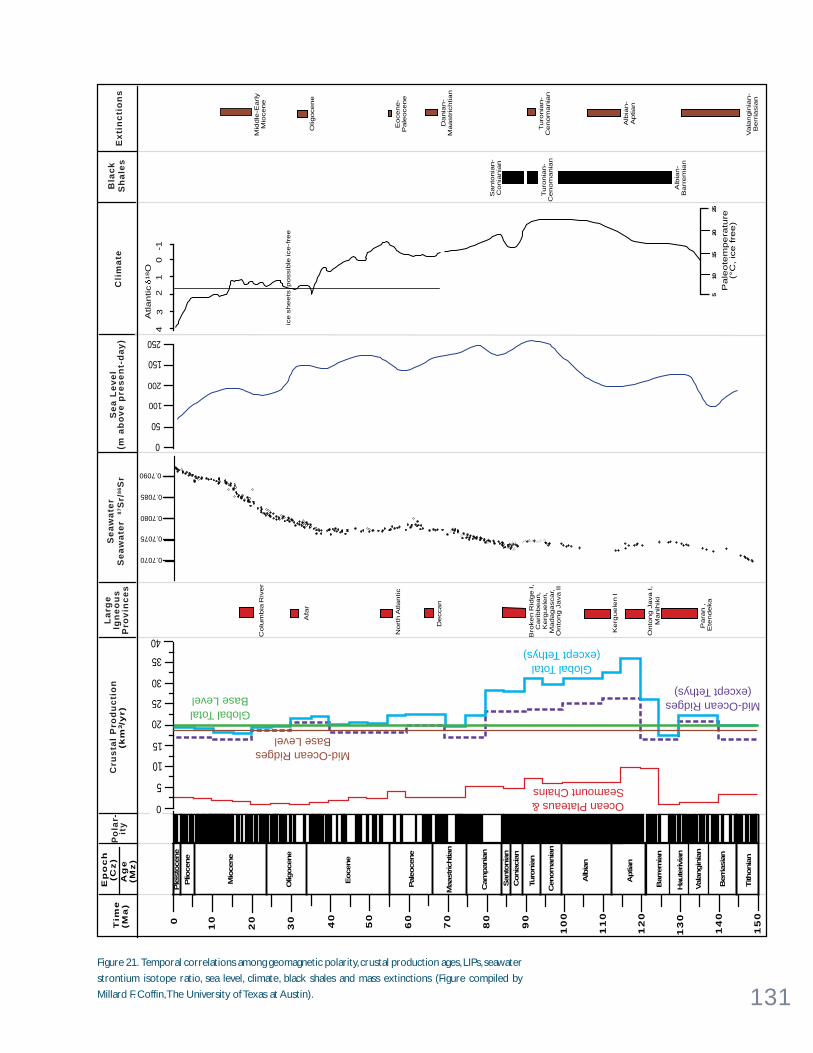
131
15
0
14
00
20
50
60
70
80
90
10
0
11
0
12
0
13
0
10
30
40
Maa
strich
tian
Nort
h A
tlantic
Kerg
uele
n I
Para
n,
Ete
ndeka
Santo
nia
n-
Conia
nia
n
Turo
nia
n-
Cenom
ania
n
Alb
ian-
Barr
em
ian
50
100
150
200
250
43
21
0-1
ice s
heets
possib
le ic
e-f
ree
510
1520
25
Pa
leo
tem
pe
ratu
re(°
C,
ice
fre
e)
Mid
dle
-Early
Mio
cene
Olig
ocene
Eocene-
Pale
ocene
Dania
n-
Maastr
ichtian
Turo
nia
n-
Cenom
ania
n
Alb
ian-
Aptian
Vala
ngin
ian-
Berr
iasia
n
Atla
ntic
18O
0
Tim
e(M
a)
Ep
oc
h(C
z)
Ag
e(M
z)
35
30
25
20
15
10
(km
3/y
r)
0
40 Bro
ken R
idge I,
Caribbean,
Kerg
uele
n,
Madagascar,
Onto
ng J
ava II
Deccan
Colu
mbia
Riv
er
0.7090
0.7085
0.7080
0.7070
0.7075
5
Se
a L
ev
el
(m a
bo
ve
pre
se
nt-
da
y)
Se
aw
ate
rS
ea
wa
ter
87S
r/8
6S
rL
arg
eIg
ne
ou
sP
rov
inc
es
Cli
ma
teB
lac
kS
ha
les
Ex
tin
cti
on
sP
ola
r-it
yC
rus
tal
Pro
du
cti
on
Ple
isto
cene
Plio
cene
Mio
cene
Olig
oce
ne
Eoce
ne
Pal
eoce
ne
Cam
pan
ian
San
tonia
nC
onia
cian
Turo
nia
n
Cen
om
ania
n
Alb
ian
Aptia
n
Bar
rem
ian
Hau
terivi
an
Val
angin
ian
Ber
rias
ian
Tith
onia
n
Ocean Plateaus &Seamount Chains
Mid-Ocean RidgesBase Level
Global TotalBase Level Mid-Ocean Ridges
(except Tethys)
Global Total(except Tethys)
Afa
r
Onto
ng J
ava I,
Manih
iki
Figure 21. Temporal correlations among geomagnetic polarity, crustal production ages, LIPs, seawater
strontium isotope ratio, sea level, climate, black shales and mass extinctions (Figure compiled by
Millard F. Coffin, The University of Texas at Austin).

132
composition and spatial organization of magmatic products? How does magmatism affect the geotherm, and
vice versa? These questions lie at the heart of our understanding of how the oceanic crust, arc volcanoes, and
hot spot islands are formed.
Because of their relative simplicity, and the unique window they provide into the composition and thermal
structure of the upper mantle, mid-ocean ridges will continue to be the focus of many petrologic and geo-
physical studies of oceanic igneous processes. There is general agreement on a basic theory in which melting
beneath ridges is driven by adiabatic decompression (upwelling) of mantle material, in response to plate
spreading. Within this conceptual framework, investigators are now focusing on magmatism in other (more
complex) oceanic settings, including convergent margins, oceanic hot spots, oceanic plateaus and rifted mar-
gins to address more difficult questions regarding melt extraction mechanisms, source heterogeneity, and the
mechanisms of accretion of igneous crust (Figure 22).
With recent advances in geophysical imaging techniques, mantle geochemistry, and the computational capa-
bility to characterize the structure of complex natural phenomena and to model three-dimensional geodynamic
systems, the topic of melting and melt transport is poised for major breakthroughs in the coming decade.
Arrays of ocean bottom seismometers with broadband sensors and the capability of deployments of a year
or longer will allow experiments to be carried out to illuminate the nature of diapiric mantle upwelling and
the spatial organization of melt conduits beneath ridges, plumes and arcs. Coincident with these seismic
arrays, magnetotelluric stations, measuring the electrical conductivity of the mantle to depths up to 200 km,
can provide critical additional constraints on melt connectivity and the influence on mantle rheology. A few
such experiments, such as the MELT experiment at the East Pacific Rise spreading ridge (see Imaging Mantle
Flow box on page 134) and the ICEMELT experiment where a hot spot and the Mid-Atlantic Ridge are
juxtaposed in Iceland, have recently been completed with great success. They provide an excellent template
which can easily be exported to different geodynamic settings. New geochemical tools, such as uranium
decay series disequilibria studies, will be used to place important constraints on the melting process. Addi-
tional work, from field mapping, drilling and laboratory experiments, will be required to determine whether
melt migration and focusing can be explained by flow in microscopic pores along crystal grain boundaries, or
whether large, more focused melt pathways are required. By integrating geophysical, geochemical and rheo-
logical constraints, a predictive model of melting and melt migration is within reach in the coming decade.
This predictive model can be used to understand the factors controlling mantle flow and the geotherm in
different tectonic environments and those leading to melt focusing, and to gain insight into the more general
problem of spontaneous spatial organization in all natural fluid flow systems.
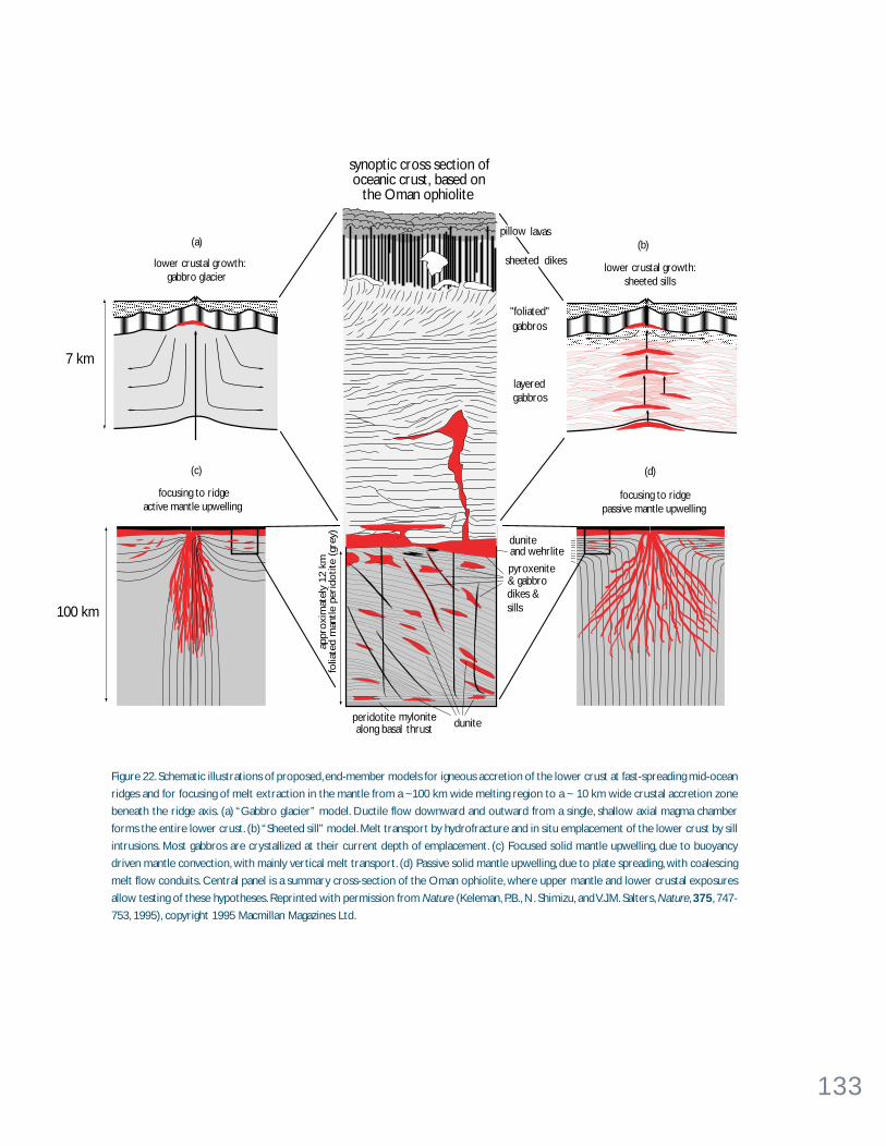
133
peridotite mylonitealong basal thrust
pyroxenite& gabbrodikes & sills
dunite
duniteand wehrlite
(c)
focusing to ridgeactive mantle upwelling
focusing to ridgepassive mantle upwelling
(d)
lower crustal gabbros
(a)
lower crustal growth:gabbro glacier
lower crustal growth:sheeted sills
(b)
100 km
7 km
appr
oxi
mat
ely
12 k
mfo
liate
d m
antle
peri
dotite
(gr
ey)
layeredgabbros
"foliated"gabbros
sheeted dikes
pillow lavas
synoptic cross section of oceanic crust, based on
the Oman ophiolite
Figure 22. Schematic illustrations of proposed, end-member models for igneous accretion of the lower crust at fast-spreading mid-ocean
ridges and for focusing of melt extraction in the mantle from a ~100 km wide melting region to a ~ 10 km wide crustal accretion zone
beneath the ridge axis. (a) “Gabbro glacier” model. Ductile flow downward and outward from a single, shallow axial magma chamber
forms the entire lower crust. (b) “Sheeted sill” model. Melt transport by hydrofracture and in situ emplacement of the lower crust by sill
intrusions. Most gabbros are crystallized at their current depth of emplacement. (c) Focused solid mantle upwelling, due to buoyancy
driven mantle convection, with mainly vertical melt transport. (d) Passive solid mantle upwelling, due to plate spreading, with coalescing
melt flow conduits. Central panel is a summary cross-section of the Oman ophiolite, where upper mantle and lower crustal exposures
allow testing of these hypotheses. Reprinted with permission from Nature (Keleman, P.B., N. Shimizu, and V.J.M. Salters, Nature, 375, 747-
753, 1995), copyright 1995 Macmillan Magazines Ltd.
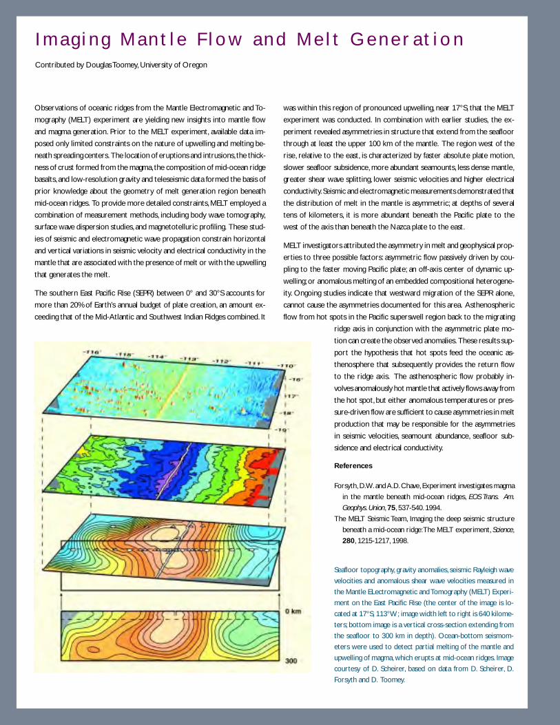
134
Observations of oceanic ridges from the Mantle Electromagnetic and To-
mography (MELT) experiment are yielding new insights into mantle flow
and magma generation. Prior to the MELT experiment, available data im-
posed only limited constraints on the nature of upwelling and melting be-
neath spreading centers. The location of eruptions and intrusions, the thick-
ness of crust formed from the magma, the composition of mid-ocean ridge
basalts, and low-resolution gravity and teleseismic data formed the basis of
prior knowledge about the geometry of melt generation region beneath
mid-ocean ridges. To provide more detailed constraints, MELT employed a
combination of measurement methods, including body wave tomography,
surface wave dispersion studies, and magnetotelluric profiling. These stud-
ies of seismic and electromagnetic wave propagation constrain horizontal
and vertical variations in seismic velocity and electrical conductivity in the
mantle that are associated with the presence of melt or with the upwelling
that generates the melt.
The southern East Pacific Rise (SEPR) between 0° and 30°S accounts for
more than 20% of Earth’s annual budget of plate creation, an amount ex-
ceeding that of the Mid-Atlantic and Southwest Indian Ridges combined. It
was within this region of pronounced upwelling, near 17°S, that the MELT
experiment was conducted. In combination with earlier studies, the ex-
periment revealed asymmetries in structure that extend from the seafloor
through at least the upper 100 km of the mantle. The region west of the
rise, relative to the east, is characterized by faster absolute plate motion,
slower seafloor subsidence, more abundant seamounts, less dense mantle,
greater shear wave splitting, lower seismic velocities and higher electrical
conductivity. Seismic and electromagnetic measurements demonstrated that
the distribution of melt in the mantle is asymmetric; at depths of several
tens of kilometers, it is more abundant beneath the Pacific plate to the
west of the axis than beneath the Nazca plate to the east.
MELT investigators attributed the asymmetry in melt and geophysical prop-
erties to three possible factors: asymmetric flow passively driven by cou-
pling to the faster moving Pacific plate; an off-axis center of dynamic up-
welling; or anomalous melting of an embedded compositional heterogene-
ity. Ongoing studies indicate that westward migration of the SEPR alone,
cannot cause the asymmetries documented for this area. Asthenospheric
flow from hot spots in the Pacific superswell region back to the migrating
ridge axis in conjunction with the asymmetric plate mo-
tion can create the observed anomalies. These results sup-
port the hypothesis that hot spots feed the oceanic as-
thenosphere that subsequently provides the return flow
to the ridge axis. The asthenospheric flow probably in-
volves anomalously hot mantle that actively flows away from
the hot spot, but either anomalous temperatures or pres-
sure-driven flow are sufficient to cause asymmetries in melt
production that may be responsible for the asymmetries
in seismic velocities, seamount abundance, seafloor sub-
sidence and electrical conductivity.
References
I m a g i n g M a n t l e F l o w a n d M e l t G e n e r a t i o nContributed by Douglas Toomey, University of Oregon
Seafloor topography, gravity anomalies, seismic Rayleigh wave
velocities and anomalous shear wave velocities measured in
the Mantle ELectromagnetic and Tomography (MELT) Experi-
ment on the East Pacific Rise (the center of the image is lo-
cated at 17°S, 113°W; image width left to right is 640 kilome-
ters; bottom image is a vertical cross-section extending from
the seafloor to 300 km in depth). Ocean-bottom seismom-
eters were used to detect partial melting of the mantle and
upwelling of magma, which erupts at mid-ocean ridges. Image
courtesy of D. Scheirer, based on data from D. Scheirer, D.
Forsyth and D. Toomey.
Forsyth, D.W. and A.D. Chave, Experiment investigates magma
in the mantle beneath mid-ocean ridges, EOS Trans. Am.
Geophys. Union, 75, 537-540. 1994.
The MELT Seismic Team, Imaging the deep seismic structure
beneath a mid-ocean ridge: The MELT experiment, Science,
280, 1215-1217, 1998.
135
The compos i t ion o f the lower ocean ic crust and nature o f the ocean ic Moho
Oceanic crust covers over 50% of Earth’s surface, yet the composition of the lower oceanic crust and the
nature of the oceanic Moho remain largely unknown. The deepest, continuous drill hole into the oceanic
crust extends only slightly more than 2000 m below the seafloor, less than one third of the way through a typical
geophysically defined oceanic crustal section. The 1971 ophiolite model defined at the Penrose Conference
for oceanic crust associated the lower oceanic crust with a thick plutonic sequence of gabbros and the oceanic
Moho with a transition from these igneous rocks to mantle peridotite. The identification of the Moho with
the base of the gabbro section is the linchpin on which estimates of the volume of past and present basaltic
volcanism in the oceans is based, and on which most current models of ocean crustal formation are built.
While the ophiolite model for the oceanic crust has been widely accepted and applied for nearly 30 years, it
has never been directly tested with in situ sampling of the lower oceanic crust. Our knowledge of the geologi-
cal structure, physical properties and alteration history of about two-thirds of the oceanic crust has been
only inferred. Data include geophysical measurements, sampling of infrequent and incomplete exposures of
deeper crustal rocks, usually in or near oceanic fracture zones, and sampling and measuring ophiolites, sec-
tions of presumed oceanic crust that have been tectonically exposed on land. Recent geological mapping and
sampling along mid-ocean ridges have revealed striking differences in structure between fast and slow spreading
ridges which were not foreseen based on observations of ophiolites.
These observations have revived speculation that serpentinite may be a significant component of the lower
oceanic crust as originally proposed by Harry Hess in 1962. Hess believed that the relatively uniform depth
of the Moho in the ocean basins did not reflect the thickness of the igneous crust but instead represented an
alteration boundary in the shallow mantle between serpentinized and unserpentinized peridotite. If the
Moho is an alteration boundary in some locations (e.g., along slow spreading ridges) but an igneous boundary
at others (e.g., fast spreading ridges) how can this be reconciled with the composition of magmas erupting at
oceanic spreading ridges, which show remarkably little chemical variation with spreading rate? Geophysical
observations also reveal many features (i.e., depth to Moho, seismic velocity of the lower crust) which are
largely independent of spreading rate. This paradox, and the validity of the ophiolite model, will only be
resolved by direct, in situ sampling of the lower oceanic crust and Moho with drilling. Neither offset-section
drilling, as currently carried out by the Ocean Drilling Program, nor studies of ophiolites, can provide the
intact and tectonically undisrupted sections, or the integrated history of fluid flux and alteration, necessary to
address this question.
Uncertainty over the composition of the lower oceanic crust and Moho, which has now existed for more
than 30 years, has proven to be a major obstacle to advancing our understanding of a variety of problems. For
example, the recovery of a complete oceanic crustal section is essential if we are to:
• determine the structure, composition, mineralogy and in situ physical properties of the oceanic crust and
the geological nature of the seismic Moho;
• constrain estimates of present and past magma production from the oceanic mantle;
• develop models of oceanic crustal formation, especially of the lower oceanic crust;
• determine the deformation history of the crust;

136
• establish a standard lithologic section for correlation with major seismic discontinuities in the oceanic
crust and upper mantle;
• measure the bulk composition and alteration history of the oceanic crust in order assess the geochemical
mass balances at ridges and subduction zones;
• constrain the extent to which seawater-oceanic crust chemical exchanges are microbially mediated
• determine the source of marine magnetic anomalies;
• determine the net and long-term buffering capacity of the oceanic crust in controlling the composition of
seawater.
Drilling a complete oceanic crustal section has been a goal of marine geologists since the days of the MOHOLE
Project in the 1950s, and has been repeatedly articulated in scientific planning documents ever since. For
nearly half a century the technology to achieve this goal has not existed and ocean drilling has been limited to
only the uppermost few km of the oceanic crust. However, with the oil industry now rapidly moving beyond
the edge of the continental shelf and drilling in deeper and deeper water, this situation is rapidly changing.
Several riser-equipped drillships capable of operating in water depths of >2000 m are now operational and
Chevron has just completed a well in 2352 m of water in the Gulf of Mexico. This technological breakthrough
has finally brought the goal of sampling the lower oceanic crust and Moho within reach.
Mechan i sms and contro l s on l i thospher ic de format ion and fau l t ing
Tectonic stresses deform the crust and upper mantle. When these stresses exceed the strength of rock,
faulting occurs. The resulting earthquakes, especially those that occur in subduction zone settings or along
transform faults, can be large and destructive. Plate tectonics provides a quantitative framework within which
lithospheric deformation and faulting can be understood, and a first-order explanation for the global distribu-
tion of both seismicity and earthquake mechanisms. Increasingly, investigations are focusing on the deforma-
tion process itself, and the still poorly understood interplay among tectonic stress, rock rheology, fluid distri-
bution and faulting. Critical questions include: How do large faults slip at unexpectedly low stress levels? Why
do some faults lock, eventually leading to large earthquakes, while others slip nearly aseismically? What is the
origin of low-angle detachment faults? How is regional stress localized and magnified so as to initiate faults?
Studies in the oceans, and along their margins, will play a critical role in addressing these fundamental ques-
tions in the coming decade. Some types of faults are restricted to oceanic settings. For example, megathrusts
associated with subducting plates occur almost exclusively in a submarine setting. In addition, because of the
simpler rheology and geological history of oceanic lithosphere compared to that of continents, the oceans
provide a unique natural laboratory within which to study all kinds of deformation processes. With the
rapidly advancing technology for carrying out detailed geological and geophysical studies on the seafloor, and
for long-term, in situ monitoring of fluid pressures, fluxes and chemistry, temperature, seismicity and strain,
there are exciting opportunities for advances in several important areas.
Seismogenesis in subduction zone megathrusts. Subduction zone megathrusts (Figure 23) produce
the largest and potentially most destructive earthquakes and tsunamis. Despite the societal importance of
these great earthquakes, little is known about the seismogenic zone that produces them. What factors are

137
responsible for generating earthquakes in one area and not in others? What processes control how fre-
quently large earthquakes occur? What properties of an active fault system might be measured to better assess
seismic risk?
The Coulomb failure model has provided a successful conceptual framework for studies of accretionary
subduction zones. This model predicts the response of the sedimentary wedge to changing geometry, and
explains so-called out-of-sequence faults at the back part of a growing wedge. However, this model does not
explain the origin of the low-angle thrust fault, or detachment zone, which forms the base of the wedge. This
fault develops along flat-lying sedimentary layers and appears to slip at unexpectedly low stress levels. This
has been called the “low stress paradox,” and it is not unique to subduction zones. Instead, it is a fundamental
problem in understanding lithospheric deformation in a variety of tectonic settings, including major continen-
tal strike-slip faults like the San Andreas system. Evidence suggests that many of these major crustal faults fail
at resolved shear stresses an order of magnitude lower than would be predicted from laboratory measure-
ments of the strength of crustal rocks. Various explanations have been proposed to account for these “weak
faults” including the presence of low-strength material in the fault zone or the existence of high fluid pres-
sures. Some have questioned whether such a paradox really exists. The resolution of this problem is a
necessary prerequisite for developing a physical theory relating far-field tectonic stresses to the local stress
field, and the nucleation and propagation of seismic rupture.
An ideal natural laboratory to study the faulting process is found along subduction zones where the oceanic
crust descends into the mantle. This zone lies within a forearc where sediments undergo compaction,
lithification and dehydration as they underthrust at a low angle. The low angle of thrusting means that factors
that control the partitioning of strain, the flow of water and other volatiles, the formation and behavior of
faults, and the onset of earthquake-generating slip, are all relatively accessible (often at depths of less than 8-
10 km), as compared to other types of major crustal faults.
5
10
15
Km
0
20
25
30
Image SeismogenicZone Using
Earthquakes andArtificial Sources
Determine the Seaward Limit of the Seismogenic Zone
DetermineIncoming Material
Flux
Measure Surface Deformation
Seismogenic Zone
Predict Nature ofDeeply Recycled Materials
0 10
km
Onshore Measurements
Predict Nature of Materials in Seismogenic Zone
Figure 23. Schematic drawing of a subduction zone, showing (in asterisks) the approxi-
mate location of the seismogenic zone. Also shown are onshore offshore experiments.
VE = 2X. Figure courtesy of Casey Moore, University of California, Santa Cruz.
138
To understand the dynamics of subduction zone earthquakes it is necessary to go to a currently active
seismogenic system to:
• relate patterns of seismicity with seismic images of the main zone of thrusting, using such tools as regional
ocean bottom seismograph networks, two-dimensional and three-dimensional seismic data and, ultimately,
drilling;
• establish which parts of the thrust are locked and which are slipping, utilizing onshore and offshore geodesy,
detailed seismic arrays, strain meters and drilling;
• determine the fluxes of solids and fluids through the subduction zone with drilling, surface experiments,
geochemistry, and seismic and electromagnetic imaging of the subduction system;
• monitor change in seismicity, strain and fluid flux in the seismogenic zone;
• determine the nature and behavior of the materials in the seismogenic zone.
This kind of comprehensive study of a subduction zone megathrust, in concert with laboratory experiments
and theoretical modeling, will help define the processes that control earthquake cycles, and improve esti-
mates of seismic risk for major population centers located near oceanic subduction zones.
Mechanics of extensional faulting in oceanic lithosphere and at passive continental margins. A
growing body of observational evidence has shown that when continents rift, deformation is concentrated
on a few extremely large faults that apparently accommodate displacements of up to several hundred kilome-
ters. The continental lithosphere in some places has been stretched to four times its initial extent, often on
what appear to be large, low-angle listric-type (shallowing with depth) normal faults similar to those which
have been mapped in areas like the Basin and Range Province in the western United States.
The existence of large, low-angle normal faults which accommodate large amounts of slip has been contro-
versial for many years. Although the geological evidence for these faults in various regions of active extension
is compelling, their existence cannot be explained by classic studies of fault mechanics. If the maximum
principal stress in these extensional settings is approximately vertical, slip on planes shallower than 30° would
conflict with the Coulomb failure criterion. This low-angle slip theory is supported by seismic observations
in regions of active continental extension, such as the Aegean, where seismicity indicates that strain is being
accommodated on high-angle, planar normal faults. This has lead to speculation that these faults initiate as
steep planar faults which rotate to a shallower dip as displacement increases, or that they “roll-over” at the
surface so that they dip gently near the surface but dip more steeply at depth. An even more puzzling
problem is why these faults form at all. The integrated strength of the lithosphere, which is relatively well
known from observations of plate flexure and laboratory measurements of rock mechanics, is five to ten
times greater than even the largest estimates of the forces available to drive plate motions. Thus, in order to
form these faults, and to accommodate a large component of plate motion for up to a few million years, a
mechanism must be found to either concentrate and magnify these tectonics stresses, or to locally reduce the
strength of the lithosphere.
The answers to these long-standing and fundamental questions of fault mechanics and crustal deformation
will probably be found in the oceans. Here it is possible to study faulting occurring within an active exten-
sional setting, with a much simpler crustal and lithospheric rheology, and geological history, than in most
continental regions. The recent discovery of what may be low-angle detachment faults along some slow-
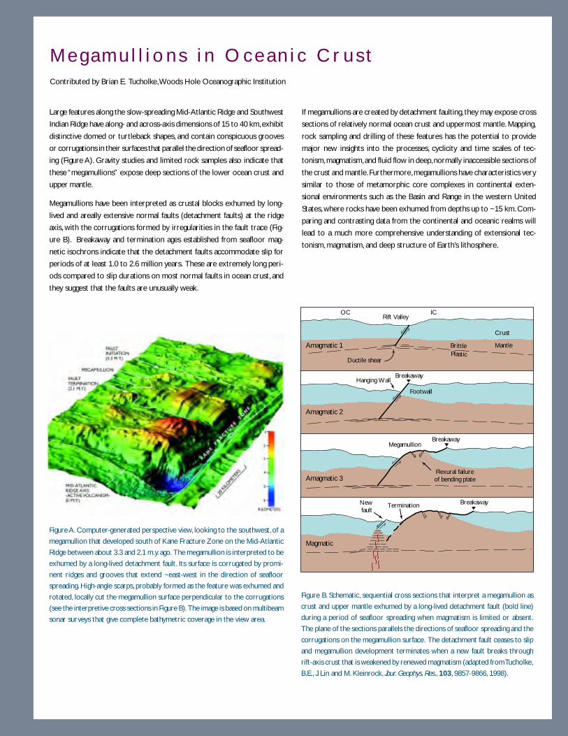
139
Large features along the slow-spreading Mid-Atlantic Ridge and Southwest
Indian Ridge have along- and across-axis dimensions of 15 to 40 km, exhibit
distinctive domed or turtleback shapes, and contain conspicuous grooves
or corrugations in their surfaces that parallel the direction of seafloor spread-
ing (Figure A). Gravity studies and limited rock samples also indicate that
these “megamullions” expose deep sections of the lower ocean crust and
upper mantle.
Megamullions have been interpreted as crustal blocks exhumed by long-
lived and areally extensive normal faults (detachment faults) at the ridge
axis, with the corrugations formed by irregularities in the fault trace (Fig-
ure B). Breakaway and termination ages established from seafloor mag-
netic isochrons indicate that the detachment faults accommodate slip for
periods of at least 1.0 to 2.6 million years. These are extremely long peri-
ods compared to slip durations on most normal faults in ocean crust, and
they suggest that the faults are unusually weak.
If megamullions are created by detachment faulting, they may expose cross
sections of relatively normal ocean crust and uppermost mantle. Mapping,
rock sampling and drilling of these features has the potential to provide
major new insights into the processes, cyclicity and time scales of tec-
tonism, magmatism, and fluid flow in deep, normally inaccessible sections of
the crust and mantle. Furthermore, megamullions have characteristics very
similar to those of metamorphic core complexes in continental exten-
sional environments such as the Basin and Range in the western United
States, where rocks have been exhumed from depths up to ~15 km. Com-
paring and contrasting data from the continental and oceanic realms will
lead to a much more comprehensive understanding of extensional tec-
tonism, magmatism, and deep structure of Earth’s lithosphere.
M e g a m u l l i o n s i n O c e a n i c C r u s tContributed by Brian E. Tucholke, Woods Hole Oceanographic Institution
BreakawayTerminationNewfault
Magmatic
BreakawayMegamullion
Amagmatic 3
Breakaway
Amagmatic 2
Rift Valley
BrittlePlastic
Ductile shear
Amagmatic 1
Crust
Mantle
OC IC
Flexural failureof bending plate
Hanging Wall
Footwall
Figure A. Computer-generated perspective view, looking to the southwest, of a
megamullion that developed south of Kane Fracture Zone on the Mid-Atlantic
Ridge between about 3.3 and 2.1 m.y. ago. The megamullion is interpreted to be
exhumed by a long-lived detachment fault. Its surface is corrugated by promi-
nent ridges and grooves that extend ~east-west in the direction of seafloor
spreading. High-angle scarps, probably formed as the feature was exhumed and
rotated, locally cut the megamullion surface perpendicular to the corrugations
(see the interpretive cross sections in Figure B). The image is based on multibeam
sonar surveys that give complete bathymetric coverage in the view area.
Figure B. Schematic, sequential cross sections that interpret a megamullion as
crust and upper mantle exhumed by a long-lived detachment fault (bold line)
during a period of seafloor spreading when magmatism is limited or absent.
The plane of the sections parallels the directions of seafloor spreading and the
corrugations on the megamullion surface. The detachment fault ceases to slip
and megamullion development terminates when a new fault breaks through
rift-axis crust that is weakened by renewed magmatism (adapted from Tucholke,
B.E., J. Lin and M. Kleinrock, Jour. Geophys. Res., 103, 9857-9866, 1998).

140
spreading mid-ocean ridges provide a particularly exciting opportunity to address these problems (see
Megamullions box on page 139). It should be possible to find examples of currently active detachment fault
systems along a slow spreading mid-ocean ridge. In this very young, unsedimented crust the upper and lower
crustal blocks and the intervening detachment surface can be readily mapped and sampled by submersible or
dredging. Seismic and seafloor geodetic instrumentation can monitor motion along the fault and determine if
slip is occurring on very low angle faults. Finally, drilling can sample the active fault zone and determine if
processes such as serpentinization are responsible for the localization of strain along the detachment surface.
The insight provided by a comprehensive study of this kind could lead to a new theory of faulting and a
resolution of the lithospheric strength paradox that applies to both continental and oceanic crustal tectonics.
Transform faulting. The relatively simple tectonic setting of oceanic transform faults make them an attrac-
tive target for studies of earthquake fault mechanics. Oceanic transform faults show the peculiar behavior
that although low resolved shear stresses are found on active transform faults, high shear strength (10 to 100
times the stress drops of typical transform earthquakes) characterize fracture zones beyond the transforms.
This high shear strength is capable of supporting scarps 1 km or higher along fracture zones. This system
represents an extreme example of the generalization that low recurrence rates often show the greatest
stress drops, in an environment where apparently nothing changes except the slip rate.
Another unusual feature of oceanic transforms is the occurrence of “slow” earthquakes. These events are
characterized by slow, low-frequency deformation prior to the initiation of high-frequency deformation. The
two components of rupture can occur on spatially associated but distinct faults. These slow earthquakes
appear to occur most frequently along transform faults and this peculiar rupture mechanism may be related
to the presence of serpentine in the upper mantle.
Transform-fault studies will require seismic arrays, careful imaging, seafloor geodesy, geochemical sampling
and drilling, as well as carefully placed long-term observatories.
T ime sca les o f magmat ic and tecton ic processes
During the past four decades the ocean basins have been mapped and sampled with an increasingly sophisti-
cated array of tools. These tools have enabled scientists to develop and refine the plate tectonic paradigm, as
well as discover seafloor hydrothermal vents with their unique biological communities. They also have pro-
vided the data to accurately reconstruct the tectonic history of all of the major ocean basins over the past
200 million years. While we have made great strides in recent years in spatially characterizing the seafloor,
and determining its evolution on geologic time scales, we are just beginning to study volcanic, tectonic and
hydrothermal processes on the shorter, and more societally relevant, time scales, which characterize these
processes. We now realize that in many cases comparatively rare, large events such as earthquakes, landslides
or volcanic eruptions may dominate changes in the landscape. Without the ability to document and study
these short-lived events we will never be able to fully understand how the oceanic crust is formed and
evolves over time, or how the associated magmatic, tectonic, hydrothermal and biological processes are
linked.
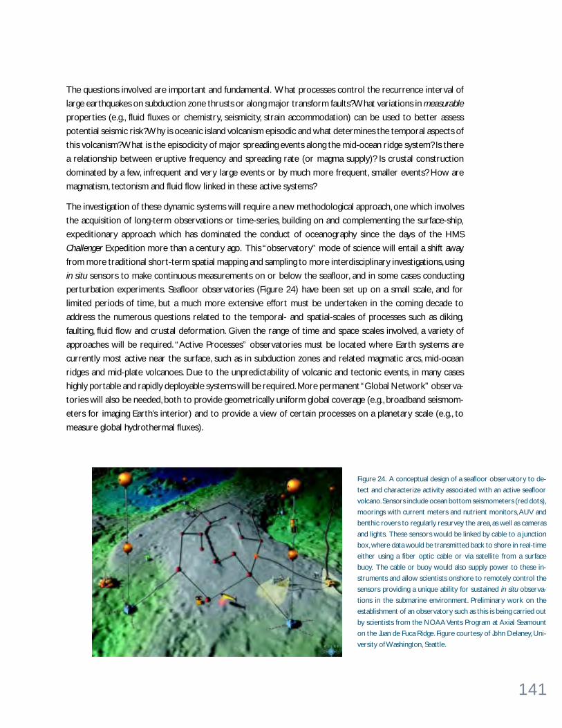
141
The questions involved are important and fundamental. What processes control the recurrence interval of
large earthquakes on subduction zone thrusts or along major transform faults? What variations in measurable
properties (e.g., fluid fluxes or chemistry, seismicity, strain accommodation) can be used to better assess
potential seismic risk? Why is oceanic island volcanism episodic and what determines the temporal aspects of
this volcanism? What is the episodicity of major spreading events along the mid-ocean ridge system? Is there
a relationship between eruptive frequency and spreading rate (or magma supply)? Is crustal construction
dominated by a few, infrequent and very large events or by much more frequent, smaller events? How are
magmatism, tectonism and fluid flow linked in these active systems?
The investigation of these dynamic systems will require a new methodological approach, one which involves
the acquisition of long-term observations or time-series, building on and complementing the surface-ship,
expeditionary approach which has dominated the conduct of oceanography since the days of the HMS
Challenger Expedition more than a century ago. This “observatory” mode of science will entail a shift away
from more traditional short-term spatial mapping and sampling to more interdisciplinary investigations, using
in situ sensors to make continuous measurements on or below the seafloor, and in some cases conducting
perturbation experiments. Seafloor observatories (Figure 24) have been set up on a small scale, and for
limited periods of time, but a much more extensive effort must be undertaken in the coming decade to
address the numerous questions related to the temporal- and spatial-scales of processes such as diking,
faulting, fluid flow and crustal deformation. Given the range of time and space scales involved, a variety of
approaches will be required. “Active Processes” observatories must be located where Earth systems are
currently most active near the surface, such as in subduction zones and related magmatic arcs, mid-ocean
ridges and mid-plate volcanoes. Due to the unpredictability of volcanic and tectonic events, in many cases
highly portable and rapidly deployable systems will be required. More permanent “Global Network” observa-
tories will also be needed, both to provide geometrically uniform global coverage (e.g., broadband seismom-
eters for imaging Earth’s interior) and to provide a view of certain processes on a planetary scale (e.g., to
measure global hydrothermal fluxes).
Figure 24. A conceptual design of a seafloor observatory to de-
tect and characterize activity associated with an active seafloor
volcano. Sensors include ocean bottom seismometers (red dots),
moorings with current meters and nutrient monitors, AUV and
benthic rovers to regularly resurvey the area, as well as cameras
and lights. These sensors would be linked by cable to a junction
box, where data would be transmitted back to shore in real-time
either using a fiber optic cable or via satellite from a surface
buoy. The cable or buoy would also supply power to these in-
struments and allow scientists onshore to remotely control the
sensors providing a unique ability for sustained in situ observa-
tions in the submarine environment. Preliminary work on the
establishment of an observatory such as this is being carried out
by scientists from the NOAA Vents Program at Axial Seamount
on the Juan de Fuca Ridge. Figure courtesy of John Delaney, Uni-
versity of Washington, Seattle.
142
W H AT M A K E S P RO G R E S S P O S S I B L E N OW ?Powerful new tools are now becoming available for studies in the oceans that offer unprecedented opportu-
nities for future research into the dynamics of the solid Earth. These include:
• High-resolution seafloor imaging systems, and dating techniques for young volcanic rocks. This allows
marine geologists to construct geological maps of the seafloor with a resolution comparable to those
available to geologists on land.
• Increasingly sophisticated drilling technology, including the capability to drill while controlling borehole
fluid pressure. This technology will allow the drilling of significantly deeper holes than has been possible to
date, and permit drilling in previously inaccessible areas along our continental margins.
• Advances in analytical techniques, and the development of powerful new isotope and trace element
geochemical methods, for studying the composition of the mantle and mantle melting processes.
• Explosion of GPS geodesy, and the ongoing development of seafloor geodetic techniques. This development
allows the quantification of tectonic motions and crustal deformation with centimeter-scale resolution on
the seafloor.
• Major advances in seismic imaging capabilities. These capabilities range from three-dimensional seismic
reflection studies of sedimentary and crustal structure, to the development and availability in large numbers
of ocean bottom seismometers for use in both active crustal studies and long-deployment teleseismic
investigations.
• The complementary information on crust and mantle properties provided by electromagnetic techniques
offers a new means of constraining dynamic processes. Magnetotelluric techniques can probe deep into the
oceanic mantle and are sensitive to conductive phases such as partial melt and dissolved hydrogen. Controlled
source techniques can measure the conductivity of the oceanic crust to look at issues as diverse as
hydrothermal circulation and serpentinization of the lower crust in new ways.
• Technological advances in microprocessors, data storage capabilities, and telecommunications, making it
feasible to establish permanent geophysical observatories on the seafloor with real-time data telemetry
back to shore from anywhere in the world’s oceans.
143
W H AT I S R E Q U I R E D F O R P RO G R E S S ?A major challenge for the future is how to foster the development of new technology, and how to maintain
this instrumentation, and the technical expertise to operate it, in the present funding climate. High-resolution
multibeam bathymetry, side-scan imaging systems, and advanced seafloor sampling capabilities (submersibles,
ROV, AUV, drilling) are essential for detailed seafloor geological studies. Multichannel seismics and large arrays
of OBS/OBH are required for imaging crustal and upper mantle velocity structure in three-dimensions.
Broadband seismic instruments will be needed for passive teleseismic imaging of deep Earth structure. Long-
deployment OBS, repeat seismic surveys, and seafloor geodetic instruments (e.g., tiltmeters and strainmeters)
will be required to monitor seismicity and crustal deformation in active tectonic areas. Heat flow measure-
ments are needed to provide constraints on subseafloor fluid flow. This is particularly crucial near active
volcanic zones. But, in these areas large local thermal gradients and the presence of cracked rock ensure that
individual measurements are not representative. Methods must be found to collect more regionally repre-
sentative data sets. Geochemical and petrological studies of volcanic and plutonic rocks, hydrothermal alter-
ation, and venting of fluids on the sea floor are essential to understanding geochemical cycling in subduction
systems and hot spots, determining the nature of the lower oceanic crust, and constraining the dynamics of
melt transport and igneous crustal accretion. There is also a continuing need for well-constrained geodynamic
models which carefully examine the range of possible behavior of simplified physical systems characterized by
variation of a few, key variables. These models have been, and will continue to be, crucial tools in understand-
ing available data and inspiring new observational programs. High P-T experimental work, especially on physi-
cal properties, with particular emphasis on the rheology of lower crust and upper mantle materials as a
function of melt and/or volatile content, has proven to be a very valuable and growing field in the past five
years, and we anticipate continued, rapid progress in this area.
Ocean drilling is an essential tool for future studies of the oceanic lithosphere and continental margins.
Drilling provides samples of subsurface rocks and fluids, and the opportunity to measure in situ physical
properties of the oceanic crust and lithosphere that cannot be obtained in any other way. “Conventional”
ocean drilling from a JOIDES Resolution-type platform will remain crucial. This type of drilling is required for
sampling the upper portion of the oceanic crust, especially on older seafloor where it is buried by sediment,
for obtaining “time series” samples along ancient hot spot tracks, for sampling the submerged parts of arc
volcanic lineaments, and for investigating the post-rift subsidence history of many continental margins. Deep
drilling (depths of 6 to 8 km below the seafloor) with a well-control capability (e.g., a deep water riser
system) is needed to attack many fundamental questions such as the composition of the lower oceanic crust
and Moho, the nature of the seismogenic zone in subduction zones, and the nature of continental margins in
areas that might contain hydrocarbons. The technological breakthrough to allow deep drilling provides a
great new scientific opportunity. But, there are many challenges too, such as finding the best way to make this
new capability available as a research tool, and supporting the much larger effort required for predrilling
surveying, site characterization, and post-drilling investigations. The scale of effort required will be substantial
and argues for a large, decade-long commitment and the involvement of the broader international commu-
nity in a jointly managed and funded program along the lines of the current Ocean Drilling Program. We
highlight this requirement because of the necessity for renewed international commitment to deep sea
drilling early in the coming decade.
144
We need to establish seafloor observatories to make long-term observations, and to study short-lived volca-
nic and tectonic events. It is anticipated that a variety of approaches will be taken, from simple, relatively
inexpensive autonomously recording observatories, to observatories with real-time data telemetry capabili-
ties either via satellite from moored ocean buoys or using fiber optic cables from shore-based stations. This
increasing emphasis on long-term studies, and investigating short-lived events, will require changes in the way
in which marine research is conducted. NSF must develop sufficient budgetary flexibility to mobilize a re-
sponse effort rapidly (within days or a few weeks at most) following a significant volcanic or tectonic event.
NSF must also provide long-term funding for time-series measurements at observatory sites over periods
longer than a typical two- or three-year grant.
Increasingly, individual geologic provinces in the oceans (mid-ocean ridges, mid-plate volcanoes, subduction
zones) are being viewed as part of a single, dynamic “solid Earth system.” Many processes (arc magmatism,
seismogenic zone behavior, continental rifting and hot spot magmatism) cross the land-sea interface. Al-
though most of the mid-ocean ridge system is under water, sometimes it is easiest to study where it lies
above sea level in places like Iceland or in ophiolites. Similarly, drilling from island platforms may provide the
most cost-effective way to address some questions about subduction zones or hot spot chains, despite the
fact that these are largely submarine features. Imaging deep Earth structure will require seismic stations both
on land and on the seafloor. The most efficient use of future resources will require close collaboration
between land and marine geoscientists, and their funding sponsors.
145
C O N C L U S I O N S
The oceans play a critical role in global systems that control Earth’s environment. Physical, chemical and
biological processes that take place in the oceans and modulate the environment are tightly linked. These
processes control life in the seas, effect large transfers of energy, drive the pulse of climate change, impact the
surrounding land masses, and respond to perturbations taking place outside the oceanic sphere. The impor-
tance of the oceans to society is rapidly growing, as is our need to understand the science of the physical,
chemical, geological and biological processes operating in them. As the human impact on Earth’s environment
increases, the need to gain a fuller understanding of these oceanographic processes becomes all the more
urgent. By building on the knowledge gained in the past few decades, and by making the necessary tools
available to the research community, this scientific challenge can be met.
The individual oceanographic disciplinary reports have emphasized the large gains we have made over the
past several decades in our appreciation of the complexity of oceanographic processes and point to the
exciting opportunities made possible both by our increased understanding and by increases in technical
capability. The findings and recommendations of this report support this view, but also emphasize the inter-
disciplinary nature of oceanographic studies. Future research in the oceans will require a more fully inte-
grated approach, an increased emphasis on long-term monitoring and measuring, and further development of
sophisticated numerical models.
The following paragraphs outline the major findings of this report and conclude with recommendations that
are critical to advancing our understanding, and that will benefit society.
146
An increased knowledge of the ocean fluxes that drive climate will be essential for evaluating
climate change and for planning how to respond to, or ameliorate, this trend. Atmosphere-ocean
exchanges of heat, fresh water, carbon, nutrients and other trace chemicals are not yet understood accurately
enough for climate assessment and prediction. While all these fluxes are changing significantly with time,
regulation of the carbon flux is central to climate stabilization plans.
Understanding the impact of oceanic events in one region upon processes in another region
thousands of miles away is an important research challenge. Basic understanding of regional ocean
dynamics has been achieved (in equatorial, mid-latitude, coastal and high-latitude ocean regions) yet knowl-
edge of the couplings among these regions remains rudimentary. The remarkable and publicly recognized
success in El Niño prediction paves the way for reliable prediction of climate oscillations at higher latitudes.
Oscillations such as the Pacific Decadal Oscillation, the North Atlantic Oscillation and the Antarctic Circum-
polar Wave have far-reaching impacts on ecosystems and human activity.
There is strong and compelling evidence of climate-biology-chemistry coupled fluctuations
that require a more quantitative understanding. Strong linkages are observed between large-scale
variations in climate and populations of marine organisms. The mechanisms involved are still obscure and
need intensive interdisciplinary investigation.
The oceans play a key role in the emerging study of the linkages between climate and human
health. Although the climate drivers may lie far away, their impacts are felt most dramatically within the
coastal zone where human influence is also strong. For example, the linkages between cholera dynamics and
the El Niño-Southern Oscillation have been identified in data from Bangladesh, and Indian Ocean tempera-
ture anomalies have been used to forecast Rift Valley fever epidemics in Kenya. The use of remote sensing of
temperature combined with ocean color provides the key to further progress here. There are numerous
instances of possible human health impacts from the changes now being forced in coastal waters, including
the long range transport of noxious organisms in ships’ ballast water. An opportunity exists to greatly
increase our knowledge of pathogens and parasites in the ocean and in identifying, predicting and ameliorat-
ing their impacts on human health and the health of marine ecosystems.
It is now possible to create new, science-based observing programs that can meet the climate
challenge. Global climate is changing more rapidly than at any time in the past 8,000 years. Our knowledge
of ocean biological, chemical and physical fields is growing, but does not yet provide an adequate baseline for
observing and predicting this change. The challenge to observe, understand, predict and possibly ameliorate
climate change is one of the most fundamental in all the ocean sciences. Advances in technology, if pursued
with vigor, can meet the challenge posed by climate change by moving beyond ship observations alone.
F I N D I N G S

147
Radically new platforms are now available which could address the long-standing shortage of ocean observa-
tions. Development of miniaturized optical, chemical and electronic sensors provides the tools for observing
the three-dimensional structure of ocean physics, biology and chemistry. Satellite observations of the ocean
have led to rapid advances in understanding and will continue to do so. New buoy, satellite, instrumented
drifters and remotely operated vehicles, coupled with cabled installations on the seafloor, can help to meet
society’s growing information needs.
Advances in observing and understanding critically important, abrupt Earth episodes as di-
verse as earthquakes, eruptions beneath the sea or harmful algal blooms on the surface ocean,
will require new modes of long-term observation. There is growing realization that important pro-
cesses that affect the oceans, and the seafloor below, are dominated by short-lived, episodic events. In order
to characterize change in the oceans a systematic long-term observation program is required.
New advances in ocean numerical modeling will greatly enhance understanding and prediction
on time and space scales important to society. Crucial physical effects have now been identified that
have seriously limited the accuracy of model prediction in the recent past. By taking advantage of rapid
advances in computing technology, and of new data streams from powerful observing programs, great ad-
vances will be made. Assimilation of new observations, both in situ and satellite-based, into computer models
is increasingly successful, and is blending with the design of new observational programs. Developments in
the theory of time-variable ocean circulation and atmospheric interaction give hope of a deeper understand-
ing of climate change, ecosystem development and the rapidly changing biogeochemical cycles.
Fundamental advances in knowledge of the turbulent mixing of the ocean on all scales will
result in new understanding of a host of problems ranging from water-mass conversion to
predator-prey interactions. Turbulence at all scales, from millimeters to Earth’s radius, acts on physical
circulation, climate and ecosystem dynamics. This immense scale range poses significant challenges in both
modeling and observation, with notable progress being made at traditional boundaries in scale.
Marine ecosystems are dynamic systems that do not hover about a long-term equilibrium
point. New knowledge indicates that marine ecosystems may not be inherently stable, but may be shifted to
new states by a range of impacts, including human forcing. Nonlinear interactions among populations, and
between organisms and the abiotic environment, can cause surprising changes in ecosystem states over short
time periods. Rapid changes from one ecosystem state to another are often caused by strong interactions
among organisms in a community, or by multiple weak interactions. Such transitions can be caused by thresh-
old population densities required for successful fertilization, by outbreaks of pathogens and toxic algal blooms,
by invasions of exotic species into new habitats or through a sequence of predator-prey interactions. In the
absence of a better predictive capability, this fundamentally nonlinear ecosystem behavior poses significant
risks for intentional manipulations of the oceans to increase local or regional fertility or to sequester carbon.
148
Interaction of ocean circulation with behaviorally controlled movements of organisms main-
tains the spatial connections and persistence of marine populations. Marine organisms both drift
with, and swim in, the sea. The understanding of linkages among sub-populations, which both drift and
migrate, in a changing ocean circulation is a critical area of study over scales ranging from estuaries to oceanic
fisheries. New ocean chemical and molecular biological techniques have revolutionized the study of life cycles
in the ocean and allow separate and continuous populations to be discriminated for the first time. The
powerful new molecular biological and chemical tools will continue to have enormous impact on the evalu-
ation of marine populations and bring great benefit to mankind.
The complexity of ocean physical circulation may now be approached with sufficient detail and
understanding to shed new light on the transport of material, and the fluctuations of ecosys-
tems, important to mankind. Better union between physical forcing functions and biological and mate-
rial processes promises rapid advancement in understanding. The ability to incorporate biological and chemi-
cal processes into the new class of ocean models will advance rapidly, with great benefit to the study of
important ecosystems.
An increased knowledge of the linkages at ocean margins is essential to guide human develop-
ment in coastal regions. There is clear evidence of the regulation of water, chemical and sediment fluxes
by mankind on a scale that now equals or exceeds the fluxes of nature. The impact of natural and anthropo-
genic material fluxes on the coastal margins is an important area of study. Material and population exchanges
among land, estuaries, continental shelves and the deep ocean are essential to the biology, physics, geology
and chemistry of the ocean.
Evidence for the existence of bacterial communities deep below the ocean floor is an extraor-
dinary and exciting indication of the extremes of life. Yet, the size of this population, its rate of growth
and its unusual adaptations remain highly controversial and an important and challenging area of study. The
nature and extent of biological activity within ocean crust, and the impact of these sub-seafloor communities
on physical, chemical and biological processes is one of the most exciting, new frontier areas of ocean-science
research.
Fluids flowing through and below the seafloor influence a wide range of microbial and geologi-
cal processes. This field offers important opportunities for discovery in microbial ecology as well as the
impact of biotic and abiotic processes on the alteration history of oceanic crust, the composition of the
oceans and the thermal evolution of the lithosphere. The role of fluids (water and magma) in geochemical
cycling between the solid earth, hydrosphere and atmosphere will be another important new avenue of
research in the coming decade.
149
Advances in geophysical imaging, geochemical tracing and geodynamical modeling, coupled
with the renaissance of deep ocean drilling technologies, will lead to major breakthroughs in
understanding Earth’s dynamic evolution. These technical advances set the stage for major scientific
advances in understanding oceanic upper mantle dynamics and the role of the oceanic lithosphere and mantle
plumes in the circulation and compositional evolution of Earth’s mantle, crust, oceans and atmosphere.
The transition from passive observation of the ocean to deliberate, controlled experiments
with tracers has been of enormous benefit. The changes in the ocean created by mankind can now not
only be detected and assessed, but the insights gained have led to an important new class of small-scale,
deliberate tracer and biogeochemical perturbation experiments. A notable challenge is to use both inten-
tional and unintentional manipulations to better understand the biogeochemical workings of the oceans.
Particularly important is the need to develop means of scaling results from spatially and temporally limited
manipulations to provide insights and confidence limits for larger-scale oceanographic processes.
An important task in the next decade will be to train a new generation of ocean researchers
who must have the skills for mastery of their discipline, and yet be imbued with the knowledge
and desire to solve interdisciplinary problems of high order. Understanding of the coupled physical,
chemical, biological and geological processes occurring in the oceans will require novel, interdisciplinary
research approaches, and the training of a new generation of students who are able to effectively attack
problems from a truly amalgamated perspective.

150
R E C O M M E N DAT I O N S
Access to the Sea
A substantial, well-coordinated, multi-agency fleet replacement plan is needed to maintain
United States leadership in sea-going capabilities in the coming decades. Almost all the funda-
mental discoveries in ocean science have come from direct observation of the sea with increasingly sophis-
ticated research and drilling vessels that can support advanced scientific teams. Maintaining a modern,
well-equipped research fleet is the most basic requirement for a healthy and vigorous research program in
the ocean sciences. The research fleet must include a range of capabilities including highly specialized vessels,
such as sophisticated drillships and their associated tools, which allow sampling deep below the seafloor. The
anticipated mix of research demands large vessels capable of mounting interdisciplinary studies both near to
and far from land and supporting remotely operated vehicles and submersibles as well as versatile small- and
intermediate-sized ships for studying the coastal ocean.
New Technolog ies
The profound impact of new technologies for executing novel experiments and for capturing
new data from the ocean is a theme that runs throughout this report. Their success justifies a
vigorous effort in technology development, implementation and support in all areas of ocean
science. Ships alone do not represent scientific capability; it is the novel ocean-observing technologies
installed and operated on and around them that brings the needed advances. These new tools include
sophisticated, remotely operated and autonomous vehicles, powerful acoustic and photographic imaging and
mapping systems, and physical and chemical sensors for making in situ measurements. The information revo-
lution is driving sophisticated data assimilation, and advances in computing have led to the development of
more realistic and reliable ocean models. The technological feasibility of using a combination of fixed and
mobile observing systems to study change in the ocean, and on the seafloor below, has been demonstrated.
These successes allow articulation of needed technological capabilities:
• Solving the problem of ocean sampling on space and time scales appropriately tuned to
the process being investigated is key to success. Important oceanographic processes often take
place at scales that are difficult to observe and nearly impossible to incorporate in large-scale models.
They range from episodic convection or small-scale turbulence to global-scale ocean circulation. New
proxy indicators, new sampling and observation strategies, and new technologies must be developed
to adequately measure and understand these processes.
• New fixed (cabled or moored buoy) and mobile (ROV, AUV, drifter) ocean-observing systems
are an essential complement to ships and satellites, and must be deployed if critical events
are to be captured. No one technological approach can give synoptic, high-resolution or continuous
views of the whole ocean or the seafloor below. This new class of platforms is recently available. There
is an urgent need to develop sensors and sampling strategies to optimize the mix of these new platforms
with ships and remote sensing in removing critical data gaps.

151
• Long-term monitoring of the ocean is essential for basic research. The need for long-term
monitoring is highlighted by every scientific theme presented in this report. The lack of
extensive, more-or-less continuous time-series measurements in the oceans is probably one of the most
serious impediments to understanding of long-term trends and cyclic changes in the oceans and in global
climate, as well as episodic events such as major earthquakes, volcanic eruptions or submarine landslides.
We recommend strong support for the development, deployment and maintenance of long-term observing
systems.
Data Ass imi l a t ion
A continuing effort must be made to improve databases, and ready access to these databases,
by the scientific community. The continued improvement in the techniques and mechanisms by which
data are collected, controlled for quality, made available to researchers, analyzed and archived must go hand
in hand with oceanographic research and with developing and deploying new ocean monitoring systems.
Rapid data assimilation is also a critical aspect of developing and using predictive ocean models that are
rapidly and repeatedly updated with synoptic observations.
Mode l Deve lopment
A continued emphasis is needed on the development of models in all their many applications,
and a special effort is needed in developing models that link different parts of the ocean sys-
tem. Almost all oceanographic research themes involve some aspect of computer modeling. The need for
model development and improvement can only grow in the future. Models have proved essential in determin-
ing the relative importance of variables in complex, nonlinear systems that have multiple positive and negative
feedbacks. Linked models that tie together, for example, physical, geological, biological or chemical systems,
show great promise and are likely to grow in importance in oceanographic research. Interactions between
such modeling efforts and field programs will aid in both designing observation strategies and in evaluating
outcomes.
Per turbat ion Exper iments
A vigorous exploration of a new class of controlled perturbation experiments could provide
unique scientific information not available through conventional observation. A powerful new
class of highly successful ocean perturbation experiments has emerged that holds great promise. For ex-
ample, deliberate tracer injections have enabled observations of mixing. Other examples include geochemical
tracers to determine flow paths and fluxes of submarine hydrothermal systems. The controlled fertilization
of areas of the surface ocean with truly minute amounts of iron can be used to study both CO2 uptake and
ecosystem dynamics and is a new variant of a well-known type of perturbation experiment in agriculture and
ecology. The establishment of marine reserves, or sanctuaries, is also a form of perturbation experiment that
deserves to be carefully exploited with predictive models and time-series observations.

152

153

154
Sponsored by the National Science Foundation through an
award to the University Corporation for Atmospheric Research
Joint Office for Science Support.
Editing and design by Geosciences Professional Services, Inc.
March 2001