old town saticoy - californiasustain.scag.ca.gov/documents/ventura_saticoy_vision_plan.pdf · 2 |...
TRANSCRIPT

OLD TOWN SATICOYVISION PLAN
17 MAY 2013
S A RG E N TS A RG E N TTOW N P L A N N I N G L O S A N G E L E S | B E R K E L E Y | A L B U Q U E R Q U E

TABLE OF CONTENTS
INTRODUCTION 1
A. WHAT WE SAW AND HEARD 2B. PLAN VISION 4
I. LAND USE AND COMMUNITY CHARACTER 8
A. EXISTING CONDITIONS & OPPORTUNITIES 8B. GOALS AND POLICIES 12C. PRELIMINARY CONCEPTS 19
II. PUBLIC SPACE AND COMMUNITY AMENITIES 32
A. EXISTING CONDITIONS 32B. GOALS AND POLICIES 35C. PRELIMINARY CONCEPTS 36
III. CIRCULATION, WALKABLE STREETS, AND TRANSIT 44
A. EXISTING CONDITIONS 44B. GOALS AND POLICIES 47
C. PRELIMINARY CONCEPTS 51
IV. CITY AND COUNTY COORDINATION 62
A. EXISTING CONDITIONS 62B. GOALS AND POLICIES 62C. PRELIMINARY CONCEPTS 62
V. INDICATORS AND OUTCOMES 63
VI. POTENTIAL FUNDING SOURCES 65
APPENDIX: STREET SECTIONS 66

PREFACEIn April 2010, in conjunction with a screening for a General Plan Amendment (GPA) for several parcels
in Saticoy, the Board of Supervisors directed the Planning Division to seek available grant funds to update
the Saticoy Area Plan. Pursuant to this direction, the Planning Division submitted a grant proposal to
the Southern California Association of Governments (SCAG) in October 2010 through its Compass
Blueprint grant program. SCAG funded the County’s proposal and work on this grant began in Spring
2012 under the direction of Sargent Town Planning.
The SCAG grant is focused solely on Old Town Saticoy and does not include all land within the Saticoy
Area Plan. Work under this grant includes the following:
• Community outreach program;
• Multi-modal circulation analysis and improvement plan, including phasing and funding options;
• Land use proposals, including a mixed-use zone with appropriate development standards and
regulations;
• Public Health and Sustainability analyses; and
• Draft Development Standards for Old Town Saticoy.
California Sustainable Communities Planning Grant funds
To complete the Saticoy Area Plan revisions, the Planning Division was awarded a grant from the Sustainable
Growth Council - California Sustainable Communities Planning Grant and Incentive Program. Work
under this grant began in October 2012 and will be completed no later than October 2015.
Tasks will include final incorporation of Area Plan changes, zone changes, map updates, and design
guidelines for Old Town Saticoy. In addition to these activities, the Planning Division will prepare a
comprehensive update for the entire Saticoy Area Plan, including areas located outside Old Town Saticoy,
which will include the following:
• Preparation of baseline condition data and maps;
• Analysis of land use, circulation, zoning, and design standards for the areas outside of Old Town
Saticoy;

• Continued community outreach throughout project implementation;
• Cultural resources survey;
• Traffic study and coordination with the Ventura County Transportation Commission regarding a
long-term transit plan;
• Coordination with the City of Ventura on infrastructure changes and/or changes to policies
necessary to implement the Area Plan and conform with the City’s new Wells /Saticoy Community
Plan;
• Coordination with the County Public Health Division to ensure public health and wellness issues
are integrated into the analysis; and
• Revisions to permitting forms/procedures to implement the Saticoy Area Plan and/or related
zoning code changes.
The final product will be a comprehensive update to the Saticoy Area Plan.
S A RG E N T TOWN PLANNING | 1
INTRODUCTIONThe County of Ventura, the community of Saticoy, and the City of Ventura have identified the need to update the
Saticoy Area Plan, the heart of which is Old Town Saticoy, with a focus on physical and economic revitalization
while respecting the heritage and physical qualities that built Saticoy’s original success as an agricultural hub
in Ventura County. After years of decline and disinvestment, Old Town is poised for rebirth as a civic and
commercial center of community life for the residents and businesses of Old Town, the unincorporated Saticoy
area, and the larger Saticoy and Wells communities of east Ventura.
Saticoy is currently characterized by declining buildings, dead-end roads, intermittent sidewalks, limited
transit service, and a scarcity of local jobs. The rail line that once brought commerce and hope to Old Town is
dormant, and the highway that replaced it as the major means of access now divides the community, serving as
a physical barrier between housing and jobs.
At the same time, Saticoy presents a valuable opportunity for economic revitalization. Key opportunities
include rebuilding and repositioning Old Town as a thriving commercial and civic center of community life for
the area, and renovating and improving the housing stock of the Old Town neighborhood. Vacant and under-
utilized parcels – particularly in the southeasterly portion of Old Town – also present significant opportunities
for the development of new jobs-producing businesses and development. This Plan seeks to carefully set the
stage for reinvestment by better connecting surrounding neighboroods to Old Town, improving resident access,
mobility, and safety within Old Town, increasing opportunities for employment and affordable housing, and
reigniting a sense of community pride and optimism for the future.
This Draft Vision Plan presents the work that was generated during the Internal Design Charrette in
preparation for the August 23, 2012 Community Workshop. It summarizes existing conditions, including
input received from stakeholders and community members; recommends goals and policies; and provides
a number of alternative circulation, public space, and land use scenarios for Old Town Saticoy. These
scenarios are based on the Background Evaluation and Technical Report prepared by the Sargent Town
Planning team, discussions with County of Ventura staff, input received during the stakeholder interview
process, and public comments collected during the August 1, 2012 and August 23 Community Workshops.
This document will provide the basis for the subsequent Area Plan Recommendations document, as
refined in response to County input and direction prior to the Area Plan update.

2 | O L D TOW N S AT I C OY A R E A P L A N
A. WHAT WE SAW AND HEARDThe County and consultant team conducted a
significant outreach effort that included:
• Meeting with a wide range of stakeholders
to hear their concerns and hopes for Old
Town, including Saticoy residents and business
and property owners, the Ventura County
Transportation Commission (VCTC), the
Ventura County Sheriff ’s Office, the City
of Ventura, representatives of the Boys &
Girls Club, and members of the Saticoy
Neighborhood Council.
• Meeting with members of the community in
a series of workshops, including a morning
“Food Pantry” outreach meeting attended by
over 100 Saticoy residents, a meeting with over
50 Saticoy teenagers, and an evening workshop
attended by more then 30 community members.
In these meetings the team presented diagrams
of Old Town and initial observations and input
to spark discussion and inform additional input.
Comments received during these outreach meetings
tended to fall within four categories and are
summarized as follows:
I. LAND USE AND COMMUNITY CHARACTER
• Saticoy’s Town Center should be more
visible and attractive from Wells Road.
• In a number of areas there are incompatible
land uses located adjacent to one another,
including noxious industrial uses very
near residences. These have the potential
to negatively affect public health and to
undermine the value of both properties.
• New development, especially housing,
should be compatible with Saticoy’s small-
town character.
• The appropriate jobs-housing balance for
the community needs to be determined,
and then implemented through the Area
Plan.
• Saticoy needs more local serving
commercial businesses and more local jobs.
• Saticoy is perceived by outsiders as a
dangerous place.
Los Angeles Avenue dead-ends at the County-owned storm drain-age right-of-way.
Sidewalks are discontinuous and missing from key locations such as bus stops.
I N T RO D U C T I O N

S A RG E N T TOWN PLANNING | 3
II. PUBLIC SPACES AND COMMUNITY AMENITIES
• Saticoy Park is hidden, access is limited
and inconvenient, and people don’t feel
safe there. Park bathrooms are also hidden,
dark, and often locked.
• Saticoy needs more comfortable and safe
public gathering places.
• The Town Center lacks good lighting, as
well as street furniture, including benches
and trash cans.
• The existing County Library is in an very
inconvenient location on the edge of town
and needs a larger, more central location.
III. CIRCULATION AND TRANSIT
• Old Town needs better pedestrian, bicycle,
and automobile connections to surrounding
areas and other parts of town.
• Old Town’s numerous dead end and
missing streets make it difficult to get in
and out of Saticoy, as well as to get around
town.
Existing view of Saticoy Park. Houses along the south edge of the park face away from the Park.
• Most Saticoy streets lack sidewalks and
crosswalks, making it uncomfortable and
dangerous to walk around town.
• Automobiles drive too fast on Saticoy’s
wide streets and need to be slowed down.
• Saticoy needs safer and more comfortable
bus stops, both for Gold Coast Transit and
for school busses.
IV. CITY AND COUNTY COORDINATION
• The City of Ventura’s Extraterritorial
Water Policy needs to be revised to allow
for a water supply that is adequate to serve
the proposed uses.
• Differences in the land uses and intensities
in City and County plans should be
reconciled.
Underutilized parcel at the corner of Wells Road and Violeta Street.
I N T RO D U C T I O N

4 | O L D TOW N S AT I C OY A R E A P L A N
B. PLAN VISIONThe intent of this Plan is to contribute to a better
quality of life for Saticoy’s residents, better access to
economic opportunity, and stronger property values
within Saticoy by:
• Making Old Town Saticoy more cohesive and
better connected to surrounding neighborhoods
and the rest of the City and County of Ventura.
• Providing a more complete range of residential
choices and, commercial and civic amenities.
• Expanding the range and number of local jobs.
• Creating a safe, comfortable and healthy
environment that promotes more walking and
cycling, and encourages greater use of transit
services.
• Adjusting land use patterns to provide residents
with greater protection from poor air quality
Building on the input received from the community,
this Plan will inform the Saticoy Area Plan as it
relates to Old Town Saticoy in terms of four vision
categories:
I. LAND USE AND COMMUNITY CHARACTER
Restoring, improving, and expanding the
offerings of Saticoy’s commercial Town Center
as a destination for residents and visitors;
addressing Saticoy’s hodgepodge of uses
while introducing compatible new residential,
commercial, and industrial development;
improving and expanding housing choices
without adding “high density housing”; and
consolidating and growing Saticoy’s industrial/
employment base.
Cultivating a sense of community and a sense
of place by promoting development that is
consistent with the community’s character, while
encouraging more representation from Saticoy
on agency committees, councils, and other
elected and volunteer bodies.
Encouraging sustainable strategies and
measures, including stormwater management,
energy efficiency, water efficiency, green
building, and access to renewable energy.
Convenient town-scale shopping environment.Special buildings on key corner lots can announce the Town Center to passing motorists.
I N T RO D U C T I O N

S A RG E N T TOWN PLANNING | 5
II. PUBLIC SPACES AND COMMUNITY AMENITIES
Improving Saticoy’s public space network
with new and improved parks, plazas, and
other public gathering places and enhancing,
expanding, and/or relocating important
community facilities, such as the Saticoy branch
of the Ventura County Library.
III. NETWORK OF COMPLETE STREETS
Stitching Saticoy’s circulation network back
together and better connecting Old Town to
its surroundings, rebalancing the street network
in favor of pedestrian and bicycle safety, and
improving support for transit service and
facilities - especially for transit-dependent
populations.
IV. CITY AND COUNTY COORDINATION
Coordinating with the City of Ventura to
address issues of water services, infrastructure
investment, consistent land use plans, and
potential future annexation.
The above vision topics are described in further detail
in the chapters that follow, with each chapter devoted
to one of these categories. Together with the input
received from the stakeholders and the community,
the goals of these four categories have been translated
into a Vision Plan (see Figure 1, following page)
that responds directly to the existing conditions and
opportunities of the project area, and the expressed
preferences of the community.
.
The old Saticoy Train Depot building offers an opportunity for adaptive reuse – perhaps even as the County Library.
A tree-lined residential street encourages walking and supports strong property values.
I N T RO D U C T I O N

6 | O L D TOW N S AT I C OY A R E A P L A N
I. TOWN CENTERLos Angeles Avenue is extended north to Snap-
dragon Street, Telephone Road is extended to Los
Angeles Avenue, and the “S Curve” connection
between Telephone Road and Aster Street is
removed. The parcels north of Telephone, cre-
ated by the S-curve removal, become developable
parcels for single family houses, while the parcels
to the south can be infilled with commercial and/
or mixed-use buildings.
Vacant parcels in the Town Center are infilled
with pedestrian-oriented, mixed-use buildings
that face and are directly accessed from the side-
walk, on Violeta or Los Angeles Streets. Park-
ing is accommodated with on-street parking and
shared parking lots in the centers of the blocks.
The Farmers & Merchants Bank Building is
adaptively reused and the vacant land adjacent is
improved as a town center park or plaza. Parking
is accommodated on the street or in nearby shared
surface lots.
A linear park or community garden is introduced
along the County-owned stormwater pipe right-
of-way between Los Angeles Avenue and Alelia
Avenue, and on sliver parcel to the south as well if
the County can acquire that property.
LL
d
A
VVB
A commercial building fronting Los Angeles Av-
enue it is built on the east side of Wells Road just
south of Rosal Lane.
Commercial buildings are developed on the
northerly corners of Nardo Street and Los Ange-
les Avenue, together forming a gateway into Old
Town Saticoy.
A traffic island is introduced at the intersection
of Nardo Street and Wells Road to provide a
location for a gateway element to announce Old
Town Saticoy to passing motorists.
II. NEIGHBORHOODVacant parcels - particularly along Aster Street -
are infilled with single family houses or duplexes.
Options for better connections to Saticoy Park are
explored.
Open space is introduced adjacent to the Saticoy
Community Center.
Alelia Avenue is extended to Aster Street, as ei-ther a vehicular street or a pedestrian passage.
OO
C
J
TTC
AAD
CCF
AAE
AA
oG
VVH
OOI
A Draft Vision Plan illustration, Figure 1, opposite, illustrates a series of physical changes that might occur over
time if the initiatives outlined above are implemented. It is meant to convey only one example of what Old
Town could look like in the future. There are innumerable variations that could emerge over time.
The potential changes associated with the Draft Vision Plan depicted below are organized into four land
use categories that have been proposed for Old Town. These four categories include the Town Center, the
Neighborhood, the Mixed-Use District, and the Industrial/Employment District. The Vision Plan describes
each of these land uses in detail. A number of potential reconfigurations of parks, streets and other public
spaces are also illustrated. Please see Section II (Public Space and Community Amenities) and Section III
(Circulation, Walkable Streets, and Transit) for descriptions and discussions of those potential changes, and
some of the ways in which they might benefit the community.
I N T RO D U C T I O N
AA
tK

S A RG E N T TOWN PLANNING | 7
III. MIXED-USE DISTRICT
Multi-family housing might replace the industrial
uses on the north side of Nardo Street between
Los Angeles Avenue and Alelia Avenue.
Multi-family housing can be provided at the
southern terminus of Alelia Avenue.
The old train depot is refurbished and adaptively
reused, possibly as the County Library, with a
civic park around it as a central gathering space.
IV. INDUSTRIAL/EMPLOYMENT DISTRICTCampanula Avenue is extended across the rail-
road tracks to Nardo Street.
South of Rosal Lane to the east of Alelia new
industrial/employment uses may be developed on
the currently vacant land.
Over time, the existing houses along the south
side of Nardo Street might be replaced by em-
ployment uses in order to create a contiguous
industrial zone south of the railroad tracks.
Figure 1. Old Town Saticoy Vision Plan
CCOMML
MMM
TTN
SS
i
P
Railroad Right-of-Way
Railroad Right-of-WayB
C
E
G
H
I
J
L
M
N
P
Q
OOQ
K
I N T RO D U C T I O N
IV.
II.
I.
III.
D
F
O
A
Aster StreetAster StreetL
os An
geles Aven
ue
Los A
ngeles A
venu
e
Alelia A
venu
eA
lelia Aven
ue
Am
apola A
venu
e
Am
apola A
venu
e
Clavel A
venu
eC
lavel Aven
ue
Azahar StreetAzahar Street
Violeta Street
Violeta Street
NardoStreetNardoStreet
Rosal LaneRosal Lane
Cam
pan
ula A
venu
eC
amp
anu
la Aven
ue
Snapdragon StreetSnapdragon Street
Wells R
oad
Wells R
oad
Telephone RoadTelephone Road
n

8 | O L D TOW N S AT I C OY A R E A P L A N
I. LAND USE AND COMMUNITY DESIGN ENVISIONED COMMUNITY CHARACTER
A. EXISTING CONDITIONS & OPPORTUNITIESOld Town Saticoy’s lands use patterns and
community design character have become
jumbled over time, presenting a challenge to
Saticoy’s becoming a vibrant and successful place.
Chief among these are:
• Land Use. In many locations rather
incompatible land uses are located adjacent
to one another - often industrial uses next
to housing - and such adjacencies tend to
undermine the value of both properties. In
addition, there is currently little opportunity
for new commercial, multi-family, and
industrial development – largely due to
the City of Ventura’s water policies, which
severely limit new construction options (see
Chapter IV for more information).
• Urban Character. Old Town is a mix
of vacant lots, houses, small commercial
buildings and industrial businesses, with little
design cohesion and no coherent image from
Wells Road. Much of the existing housing
in the Old Town Neighborhood is in need of
reinvestment and repair.
• Safety. Saticoy is generally perceived by
outsiders as a dangerous place to visit and
live, and many residents are not comfortable
being out in public after dark. Fast traffic
and no sidewalks on several streets add to the
feeling of an unsafe environment.
• Jobs and Housing. Old Town has many
more residents than it offers jobs. Both
County Policy and good community design
suggest policies that will encourage economic
development to produce new local jobs.
1. Land Use. The Plan Area contains four
basic land use types: commercial/retail,
industrial, civic, and residential, the latter
consisting primarily of lots zoned for
occupation by one or two families.
There are three areas of Old Town, in
particular, where incompatible uses are
located adjacent to one another.
View looking west down Violeta Street from Los Angeles Avenue. The Farmers and Merchants Bank building is on the left.

S A RG E N T TOWN PLANNING | 9
a. Saticoy’s Town Center. There are
a number of locations in the Town
Center (see Figure 1.1 on the following
page) where single-family houses
are interspersed with retail buildings,
limiting the potential for an inviting,
walkable shopping environment. There
are also locations where housing is next
door to industrial uses that generate
noise, odor and fumes that negatively
affect the residential environment.
b. Nardo Street. There is a strong contrast
between older, primarily one-story,
single-family houses on the south side of
the street and a jumble of business uses
and larger buildings on the north side,
including industrial sheds and multi-
family housing.
c. Azahar Street. Like Nardo Street,
Azahar Street is lined by a great variety
of building types, sizes, and uses. The
south side of the street is lined mostly
by industrial buildings with industrial
uses. East of Alelia Avenue, the north
side of Azahar Street is lined primarily
by single-family residences, while
west of Alelia Avenue its north side
is lined primarily by commercial and
retail buildings that are built close to
and accessed directly from the adjacent
sidewalk.
d. Publicly Owned Properties: There
are a number of parcels within the
Plan Area that are owned by public
agencies. The County of Ventura owns
the parcels occupied by Saticoy Park and
the Community Center. The Ventura
County Transportation Commission
(VCTC) owns the property within the
railroad right-of-way and on both sides
of the tracks, leasing to the various
tenants that occupy the parcels.
I . L A N D U S E A N D C O M M U N I T Y C H A R AC T E R
Looking east from Telephone Road towards Aster street demon-strates the unresolved character of Wells Road.
Looking west down Nardo Street ,with single-family houses on one side of the street and a light industrial building on the other.

10 | O L D TOW N S AT I C OY A R E A P L A N
2. Urban Character. The physical design
character of Saticoy – that is, the character-
defining combinations and compositions
of streetscapes, lot frontages, building
placement, scale and type, signage and
other elements – can be generally defined
according to four basic Character Areas (see
Figure 1.1):
a. Town Center. This area is generally
perceived to be – and has historically
been – the commercial and social center
of Saticoy, and a center of activity of
the eastern communities of the City
of Ventura. Buildings are primarily
“main street commercial” types, with
shopfront frontages giving the area
a decidedly small town commercial
character. The few houses that occur
within this area could easily be adapted
to non-residential uses, as is common
in many small California town centers.
On-street parking occurs along both
sides of these streets in angled spaces,
reinforcing the “small town main street”
character.
I . L A N D U S E A N D C O M M U N I T Y C H A R AC T E R
Legend
1. Town Center
2. Neighborhood
3. Industrial
4. Highway Unknown
Plan Boundary
Figure 1.1. Existing Land Use Character Areas.
Railroad Right-of-Way
Railroad Right-of-Way
Aster StreetAster Street
Los A
ngeles A
venu
e
Los A
ngeles A
venu
e
Alelia A
venu
eA
lelia Aven
ue
Am
apola A
venu
e
Am
apola A
venu
e
Clavel A
venu
eC
lavel Aven
ue
Azahar StreetAzahar Street
Violeta Street
Violeta Street
NardoStreetNardoStreet
Rosal LaneRosal Lane
Cam
pan
ula A
venu
eC
amp
anu
la Aven
ue
Snapdragon StreetSnapdragon Street
Wells R
oad
Wells R
oad
Telephone RoadTelephone Road
n

S A RG E N T TOWN PLANNING | 11
b. Neighborhood. Development along
Aster Street, Violeta Street east of
Los Angeles Avenue, the north side of
Azahar Street, and the south side of
Nardo Street, and the remaining small
north-south streets generally share a
similar residential character. Buildings
are mainly one- and two-story, houses
and duplexes, set back from the street
behind front yards often enclosed by
low front yard fences and walls. On-
street, parallel parking occurs along
both sides of these streets. Sidewalks,
street trees and streetlights normally
associated with neighborhood streets are
only sporadically present.
c. Industrial. Development along
the railroad tracks consists of larger
industrial buildings, many with blank
walls, opaque security fencing, and
large portions of the site dedicated to
parking or outdoor storage/assembly
areas. Buildings accommodate a range
of storage, automobile repair, other light
manufacturing uses of various sizes.
On-street parking is typically present
along both sides of the street.
d. Unresolved. The area generally within
100 to 200 feet of SR 118 (Wells Road)
has no particular urban character. Some
buildings have a main street commercial
character, but the pattern of small
buildings located between or behind
parking lots and landscaped berms
projects an image that is neither good
quality “highway commercial” nor in
character with the rest of Town Center.
On-street parking is prohibited along
SR 118 (Wells Road).
A concern heard repeatedly from the community
was the fear that new development – especially
multi-family housing – would detract from
Saticoy’s small town character or increase the
potential for crime and other anti-social behavior.
Keys to avoiding the further disintegration of the
essential small town character of Saticoy - and
to promoting its restoration and revival - may
include the enabling of a) new multi-family
housing in town-scale, house-form buildings, and
b) new neighborhood serving commercial uses
and multi-family housing in town-scale mixed-
use buildings within and around the edges of the
Town Center.
Violeta Street in the Neighborhood. Violeta Street in the Town Center.
I . L A N D U S E A N D C O M M U N I T Y C H A R AC T E R

12 | O L D TOW N S AT I C OY A R E A P L A N
B. GOALS AND POLICIESOld Town Saticoy becomes an attractive and healthy, place to live. Its public spaces of streets and parks
is regenerated and made safe and accessible to residents. Missing and incomplete streets are filled in and
improved over time, and neighborhood traffic is slowed through various network improvement and traffic-
calming measures. A range of well-designed building types that provide a range of housing choices, com-
mercial amenities and jobs in a walkable neighborhood setting are enabled and promoted.
GENERAL / COMMUNITY WIDE
Goal 1. A community that contains a well-balanced distribution of land uses, providing jobs, commerce,
recreation, and residential opportunities for its residents.
Policies:
1.1. Ensure that land development occurs in conformance with the Land Use Map (Figure
1.3) which was developed in accordance with land use goals in the Saticoy Area Plan.
1.2. Apply zones in conformance with the Land Use Map (Figure 1.3) and the goals and
policies of the Saticoy Area Plan.
1.3. Separate and/or buffer incompatible land uses.
1.4. Resolve existing land use conflicts between residential and industrial districts through
gradual changes to land use patterns.
1.5 Preserve and enhance the community by matching development policies with circulation
and/or land use maps and design standards.
1.6 Discretionary development shall be reviewed and conditioned to assure compatibility with
adjacent land uses. Attention shall be focused on provisions for small-scale community
spaces, landscaping, pedestrian amenities on public streets, circulation, site and building
design, drainage, parking, and utilization of water conservation methods.
Commercial buildings face and are accessed from the adjacent side-walk and provide pedestrian-friendly frontages.
Continuous sidewalks, street trees, street lights, and street furni-ture.
I . L A N D U S E A N D C O M M U N I T Y C H A R AC T E R

S A RG E N T TOWN PLANNING | 13
1.7 Provide an appropriate jobs/housing balance that considers adjacent residential areas
within the City’s Saticoy/Wells Community Plan.
1.8 Ensure that growth occurs in a manner consistent with the ability of service agencies to
provide quality services.
1.9 Whenever feasible, establish policies and standards for Saticoy that are consistent with
City of Ventura’s development standards.
1.10 Establish a cooperative policy with the City of Ventura that would provide basic services
that support development policies and standards in the Area Plan.
Goal 2. A flexible and efficient land use plan that provides economic opportunities for Saticoy businesses
and residents.
Policies:
2.1. Provide visual “gateways” at the north and south entrances to Saticoy to make the
commercial Town Center more visible and welcoming to residents and non-residents of
Saticoy.
2.2. In appropriate locations, create areas that allow a flexible mixture of residential and
commercial use.
2.3. Within mixed use districts, employ design guidelines or standards to establish a consistent
character for that district, and to ensure compatibility between adjoining uses.
2.4. Develop a cohesive Town Center commercial district within the area historically used
for commerce along Los Angeles Avenue, which may also incorporate housing in forms
compatible with the Town Center character..
One-story commercial buildings.Adaptive reuse of a gasoline station – a transformation that could occur to the existing gas station on the southeast corner of Violeta Street and Los Angeles Avenue.
I . L A N D U S E A N D C O M M U N I T Y C H A R AC T E R

14 | O L D TOW N S AT I C OY A R E A P L A N
Example of semi-rural town gateway
2.5. To help support the economic vitality of the Town Center, locate new, higher-intensity
residential development directly adjacent to the planned commercial district.
2.6. Establish a land use pattern that provides an adequate economic base to help fund needed
services, improvements and long-term maintenance in Saticoy.
2.7 Encourage the development of a local farmers market within the Town Center through
zoning and public space design.
Goal 3. A community that retains and enhances its cultural resources and historic identity.
Policies:
3.1. Encourage the preservation and reuse of significant historic buildings - including the
Farmers and Merchants Bank and the train depot - to accommodate commercial and/or
civic uses frequented by Saticoy residents.
3.2. Retain and enhance the historic, small-block grid pattern of Saticoy within its residential
and commercial areas.
I . L A N D U S E A N D C O M M U N I T Y C H A R AC T E R

S A RG E N T TOWN PLANNING | 15
Context-sensitive, town-scale, house-form infill development. Community meeting in Old Town.
I . L A N D U S E A N D C O M M U N I T Y C H A R AC T E R
Goal 4. A safe, healthy and sustainable community.
Policies:
4.1. Help reduce the incidence and fear of crime through environmental design (CPTED)
strategies – such as natural surveillance, territorial reinforcement, natural access control,
and lighting - that are incorporated into the Land Use Map, Circulation Map, and Design
Guidelines/Standards.
4.2 Provide development standards that foster resource conservation through efficient site
design, compatible mixed-use development, utilization of water conservation methods,
and the use of low-impact development techniques and sustainable materials.
4.3 Retain and enhance a land use pattern that provides a compact mixture of residential,
commercial, and industrial uses that foster a reduction in transportation costs and
GHG emissions.
4.4 Improve residents’ health by creating an environment that promotes more walking and
cycling and that reduces use of vehicles for daily activities.
4.5 Improve safety and air quality in residential areas by providing truck routes that
directly serve industrial properties and that limit truck traffic within residential areas.
4.6 Continue to allow small-animal husbandry in Old Town Saticoy.
4.7 Design critical infrastructure to be operable during a 100-year flood event.
4.8 Encourage the establishment of community gardens and farmers markets by specifying
zones where they are allowed.

16 | O L D TOW N S AT I C OY A R E A P L A N
An example of one of Saticoy’s incomplete sidewalks. Saticoy Park is cut off from and not visible from surrounding neighborhood streets, leading to an unsafe atmosphere.
RESIDENTIAL
Goal 5. A diversity of housing types with options for tenure, size/design, and affordability.
Policies:
5.1. Create Saticoy Community Development Standards for residential development that
allow for a diversity of housing types while preserving and enhancing the historic
small-town character of Saticoy.
5.2. Encourage the development of special needs housing, (such as senior housing), within
or adjacent to the Town Center.
5.3 Residential development, including mixed use development, should incorporate
pedestrian and/or vehicular circulation systems that are consistent with the Circulation
Map (Figure 3.2).
Goal 6 Preserved and enhanced residential neighborhoods located within the northern portion of Old
Town Saticoy.
Policies:
6.1. Review and condition discretionary residential development to ensure that appropriate
provisions are made for shared recreation, landscaping, street amenities, and on-site
pedestrian circulation.
6.2. Preserve and enhance the character of existing residential areas planned for residential use
within Old Town Saticoy.
6.3 Craft neighborhood development standards and design guidelines that ensure that
Saticoy’s historic small-town scale and character is maintained and enhanced.
6.4. Encourage the maintenance and restoration of existing housing stock.
I . L A N D U S E A N D C O M M U N I T Y C H A R AC T E R

S A RG E N T TOWN PLANNING | 17
Goal 7. New mixed-use areas that expand housing opportunities within Old Town Saticoy.
Policies:
7.1. Mixed use development shall be limited to a mix of residential and compatible commercial
uses and designed to accommodate a residential density of 15 to 20 dwelling units/acre.
7.2. Ensure compatibility of residential and commercial uses in mixed use areas through the use
of zoning and design standards.
COMMERCIAL
Goal 8A. A well designed, economically vital commercial district in Old Town Saticoy that meets the daily
shopping and service needs of Saticoy residents and visitors.
Goal 8B. Small scale commercial facilities located within mixed-use and industrial areas of the community.
Policies:
8.1. Ensure that commercial uses are compatible with nearby residential uses through site
planning and building design, and as required by new mixed-use development standards
and guidelines.
8.2. Encourage development of “micro-businesses” within commercial or mixed-use areas.
8.3. Commercial and mixed-use development shall be subject to a Planned Development or
Conditional Use Permit to assure compatibility with adjacent uses and conformance with
the Old Town Saticoy development standards and design guidelines. Such review shall
give careful attention mitigation of nuisance factors.
8.4. Co-locate small parks/plazas with active commercial or civic uses within the Town Center
to encourage social interaction and foster a sense of community.
Community gardens promote health and community benefits, in-cluding increased physical activity, access to affordable healthy food, positive social interaction, and local economic activity.
Bicycle lanes on key streets promote sustainable alternative modes of transportation for residents while decreasing air pollution.
I . L A N D U S E A N D C O M M U N I T Y C H A R AC T E R

18 | O L D TOW N S AT I C OY A R E A P L A N
8.5. Locate and design commercial facilities to promote ease of access and circulation to
community serving retail for motorists, pedestrian and bicyclists.
8.6. Existing highway-oriented strip commercial development should not be expanded
unless it is redesigned for compatibility with goals, policies and standards established for
development in Old Town Saticoy.
8.7. Increase and enhance commercial development within the Town Center by using shared
or on-street parking to meet parking requirements to the maximum extent feasible.
INDUSTRIAL
Goal 9A. Well located and designed industrial uses that do not negatively impact nearby residential and
commercial uses, especially those that provide job opportunities for Saticoy residents.
Goal 9B. Industrial development that is consistent with a sustainable jobs/housing balance within Saticoy
and its immediate surrounding neighborhoods.
Policies:
9.1. Retain and expand light to medium industrial development opportunities within the
southeast portion of Old Town.
9.2 Relocate incompatible industrial uses whenever feasible, from the Town Center to nearby
planned industrial districts.
9.3 Assure that industrial development is compatible with adjacent uses by requiring that
they obtain a Planned Development or Conditional Use Permit and comply with the
design guidelines/standards established for Old Town Saticoy. Such review shall give
careful attention to landscaping, signage, access, site and building design, low-impact
design principles, drainage, parking and circulation, community connectivity, fencing and
mitigation of nuisance factors.
9.4 Prohibit industrial development that poses a significant risk to people or the environment,
and that cannot be adequately buffered from adjacent residential areas.
9.5 Where separation distances are insufficient to protect the residential uses from visual, audio
or other nuisances and air-borne intrusion, require buffers between new or expanding
industrial uses and planned residential areas.
9.6 Do not route truck traffic associated with industrial use through residential neighborhoods
unless no other option is available.
9.7 Prohibit “M-3” zoning in Old Town Saticoy.
9.8 Minimize impacts to neighboring land uses and the environment caused by industrial
development.
I . L A N D U S E A N D C O M M U N I T Y C H A R AC T E R

S A RG E N T TOWN PLANNING | 19
C. PRELIMINARY CONCEPTSEach increment of new development in Old
Town should improve the quality, character,
and value of Saticoy to better serve the needs of
Saticoy’s residents and business owners. This is
accomplished by:
1. Introducing new development that improves
the balance between jobs and housing and
that attracts a diverse population to Saticoy,
including senior citizens.
2. Enhancing Old Town’s visibility and image
along Wells Road so that passing motorists
perceive it as an attractive place to stop,
shop, and dine at local businesses.
4. Introducing multi-family housing that
better accommodates Saticoy’s families
in buildings - such as duplexes, triplexes,
quadplexes, and courtyard housing - that are
in scale and character with existing single-
family and two-family scale buildings: .
5. Employing Crime Prevention Through
Environmental Design (CPTED) strategies
to help reduce the incidence and fear of
crime and thereby improve the quality of
life of its residents.
• Introducing clear sight lines into parks
from surrounding streets and buildings.
• Avoiding entrapment and reducing
isolation, especially of Saticoy Park,
Nardo Street, and Aster Street.
Minimizing concealed and isolated
routes by completing the disconnected
street network. Options may include
extending Los Angeles Avenue
to Snapdragon Street, connecting
Campanula Avenue to Nardo Street,
Connecting Alelia Avenue to Aster
Street, connecting Aster Street through
Saticoy Park.
• Promoting a more varied and flexible
land use mix by introducing mixed-use
and live/work buildings in the Town
Center and Residential Mixed-Use
District.
• Generating more neighborhood social
activity by introducing easily accessible
and visible parks, locating community
amenities such as the County Library
in the center of town, creating
walkable, tree-lined, well-lit streets,
Neighborhood-scale multi-family housing.A one-story commercial building with street-facing windows.
I . L A N D U S E A N D C O M M U N I T Y C H A R AC T E R

20 | O L D TOW N S AT I C OY A R E A P L A N
6. Adjusting Old Town Saticoy’s existing
land use patterns (see Figure 1.2)
according to a combination of the existing,
underlying urban character and the intended
outcome of transforming Old Town Saticoy
into a walkable and bikeable place that
provides inviting residential streets to live
and successful commercial and industrial
businesses to patronize and work:
• Expand the size of the Town Center.
• Preserve existing residential uses and
character in the neighborhood in the
northern portion of Old Town Saticoy.
and encouraging buildings that provide
“eyes on the street” with large windows
and pedestrian-oriented frontages such as
porches, stoops, and shopfronts.
• Providing adequate lighting on streets and
within alleys.
• Creating a sense of community ownership
of public spaces through good quality
maintenance and management.
• Avoiding the “fortress” mentality by
requiring buildings that face and are
accessed from the street and are monitored
by neighbors and passing pedestrians.
Legend
AE-40 - Agricultural Exclusive
CPD - Commercial Planned Development
M1 - Industrial Park
M2 - Industrial Park
M3 - Industrial Park
R1 - Residential (6,000 sf )
R2 - Residential (7,000 sf )
Plan Boundary
Figure 1.2. Existing County of Ventura Zoning Map (Source: Ventura County Non-Coastal Zoning Ordinance).
I . L A N D U S E A N D C O M M U N I T Y C H A R AC T E R
Railroad Right-of-Way
Railroad Right-of-Way
Aster StreetAster StreetL
os An
geles Aven
ue
Los A
ngeles A
venu
e
Alelia A
venu
eA
lelia Aven
ue
Am
apola A
venu
e
Am
apola A
venu
e
Clavel A
venu
eC
lavel Aven
ue
Azahar StreetAzahar Street
Violeta Street
Violeta Street
NardoStreetNardoStreet
Rosal LaneRosal Lane
Cam
pan
ula A
venu
eC
amp
anu
la Aven
ue
Snapdragon StreetSnapdragon Street
Wells R
oad
Wells R
oad
Telephone RoadTelephone Road
n

S A RG E N T TOWN PLANNING | 21
7. Developing building development standards
and design guidelines that shape the
massing, scale, and design of new buildings
in forms compatible with Saticoy’s intended
character, and that encourage sustainable
development strategies, such as on-site
stormwater management, energy efficiency,
water efficiency, green building, and access to
renewable energy.
• Designate Old Town’s southeast portion, up to
the railroad tracks, for industrial uses.
• Assign the areas between the Town Center, the
neighborhood to the north, and the southeast
industrial area to multi-family housing and
limited commercial uses.
There are a number of ways that these
adjustments could be implemented. Four possible
scenarios for how the above land use areas could
be distributed are illustrated in Figure 1.3, Figure
1.4, Figure 1.5, and Figure 1.6. The character
of each of the four land use areas is described in
further detail on pages 26-29.
I . L A N D U S E A N D C O M M U N I T Y C H A R AC T E R
A new mixed use building provides retail on the ground floor and off ice uses on the second floor.
A new quadplex building with the massing and scale of a very large house.

22 | O L D TOW N S AT I C OY A R E A P L A N
IND
LAND USE ALTERNATIVE 1
Extend the Town Center to the Plan Area’s
southern boundary and, south of Azahar Street,
onto the parcels along the east side of Los
Angeles Avenue. Require new buildings along
Violeta Street and Los Angeles Avenue to
provide ground floor shopfront frontages that
are designed to accommodate retail uses, but
could also be occupied by office uses if there is no
market for retail; upper floors may be occupied by
residential or office uses.
Designate Old Town’s southeast portion for new
industrial uses and/or a place for existing light
industrial uses currently located north of the
railroad tracks to relocate. In the long term, the
existing houses and duplexes in this area would
be replaced by industrial uses. However, if these
uses remain, new adjacent industrial uses would
need to be ones that do not produce loud noises
or strong odors.
In order to provide more housing within Old
Town Saticoy, introduce a Residential Mixed-Use
District that accommodates moderate to high
density residential uses along both sides of Azahar
Street east of Alelia Avenue and south of the
railroad tracks along Alelia Avenue.
EEA
DD
i
B
II
T
C
A
B
C
F
Legend
Town Center
Neighborhood
Residential Mixed-Use District
Industrial/Employment District
Industrial Overlay
Plan Boundary
D
Figure 1.3. Proposed Land Use Alternative 1
E
I . L A N D U S E A N D C O M M U N I T Y C H A R AC T E R
Aster StreetAster Street
Los A
ngeles A
venu
e
Los A
ngeles A
venu
e
Alelia A
venu
eA
lelia Aven
ue
Am
apola A
venu
e
Am
apola A
venu
e
Clavel A
venu
eC
lavel Aven
ue
Azahar StreetAzahar Street
Violeta Street
Violeta Street
NardoStreetNardoStreet
Rosal LaneRosal Lane
Cam
pan
ula A
venu
eC
amp
anu
la Aven
ue
Snapdragon StreetSnapdragon Street
Wells R
oad
Wells R
oad
Telephone RoadTelephone Road
Railroad Right-of-Way
Railroad Right-of-Way
n
S A RG E N T TOWN PLANNING | 23
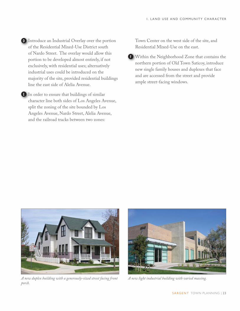
Introduce an Industrial Overlay over the portion
of the Residential Mixed-Use District south
of Nardo Street. The overlay would allow this
portion to be developed almost entirely, if not
exclusively, with residential uses; alternatively
industrial uses could be introduced on the
majority of the site, provided residential buildings
line the east side of Alelia Avenue.
In order to ensure that buildings of similar
character line both sides of Los Angeles Avenue,
split the zoning of the site bounded by Los
Angeles Avenue, Nardo Street, Alelia Avenue,
and the railroad tracks between two zones:
Town Center on the west side of the site, and
Residential Mixed-Use on the east.
Within the Neighborhood Zone that contains the
northern portion of Old Town Saticoy, introduce
new single family houses and duplexes that face
and are accessed from the street and provide
ample street-facing windows.
A new light industrial building with varied massing. A new duplex building with a generously-sized street facing front porch.
IID
IIE
WWF
I . L A N D U S E A N D C O M M U N I T Y C H A R AC T E R

24 | O L D TOW N S AT I C OY A R E A P L A N
LAND USE ALTERNATIVE 2
Create a larger Town Center than in Alternative
1 by extending it to the Plan Area’s southern
boundary and east to Alelia Avenue, incorporating
the site bounded by Los Angeles Avenue, Nardo
Street, Alelia Avenue, and the railroad tracks.
Require new buildings along Violeta Street and
Los Angeles Avenue to provide ground floor
shopfront frontages that accommodate retail uses
and, if there is no market for retail, office uses.
Designate an area in the southeast portion to
accommodate Old Town’s new industrial uses
and/or a place for existing light industrial uses to
relocate. In the long term, replace the existing
houses and duplexes in this area with industrial
uses. However, if the residential uses remain,
ensure that new adjacent industrial uses are
compatible with the existing residential uses
from the standpoint of noise and odor.
Accommodate moderate to high density housing
along the east side of Alelia Avenue, south of the
railroad tracks in a new Residential Mixed-Use
District. In the long term, replace the existing
boat storage building and possibly even some or
all of the houses along the south side of Nardo
Street with higher density housing.
Expand the size of the Neighborhood zone by
extending it south to the railroad tracks.
CC
11A
DDB
AAC
EED
A
C
D
Legend
Town Center
Neighborhood
Residential Mixed-Use District
Industrial/Employment District
Plan Boundary
Figure 1.4. Proposed Land Use Alternative 2
B
I . L A N D U S E A N D C O M M U N I T Y C H A R AC T E R
Aster StreetAster Street
Los A
ngeles A
venu
e
Los A
ngeles A
venu
e
Alelia A
venu
eA
lelia Aven
ue
Am
apola A
venu
e
Am
apola A
venu
e
Clavel A
venu
eC
lavel Aven
ue
Azahar StreetAzahar Street
Violeta Street
Violeta Street
NardoStreetNardoStreet
Rosal LaneRosal Lane
Cam
pan
ula A
venu
eC
amp
anu
la Aven
ue
Snapdragon StreetSnapdragon Street
Wells R
oad
Wells R
oad
Telephone RoadTelephone Road
Railroad Right-of-Way
Railroad Right-of-Way
n

S A RG E N T TOWN PLANNING | 25
LAND USE ALTERNATIVE 3
Create a Town Center zone that is slighlty larger
than the existing CPD zone – but smaller than
that of Alternatives 1 and 2 – that extends to the
parcels along the east side of Los Angeles Avenue
south of Azahar Street. As with the previous two
alternatives, require new buildings along Violeta
Street and Los Angeles Avenue to provide ground
floor shopfront frontages that accommodate retail
and, if there is no market for retail, office uses.
Designate an industrial area larger than the one in
Alternatives 1 and 2 that extends to Alelia Avenue
to the east that accommodates Old Town’s new
industrial uses and/or provides a place for existing
light industrial uses to relocate. In the long term,
replace the existing houses and duplexes in this
area with industrial uses. However, as long as the
residential uses within the area remain, ensure
that adjacent industrial uses are compatible with
the existing residential uses.
Introduce moderate density residential uses along
both sides of Azahar Street east of Alelia Avenue
and within the southwest portion of the Plan
Area between Alelia Avenue and Wells Road.
Introduce new single family houses and duplexes
within the Neighborhood zone.
CC
t
A
DD
A
B
II
b
C
IID
A
B
D
C
Legend
Town Center
Neighborhood
Residential Mixed-Use District
Industrial/Employment District
Plan Boundary
C
I . L A N D U S E A N D C O M M U N I T Y C H A R AC T E R
Figure 1.5. Proposed Land Use Alternative 3
Railroad Right-of-Way
Railroad Right-of-Way
Aster StreetAster Street
Los A
ngeles A
venu
e
Los A
ngeles A
venu
e
Alelia A
venu
eA
lelia Aven
ue
Am
apola A
venu
e
Am
apola A
venu
e
Clavel A
venu
eC
lavel Aven
ue
Azahar StreetAzahar Street
Violeta Street
Violeta Street
NardoStreetNardoStreet
Rosal LaneRosal Lane
Cam
pan
ula A
venu
eC
amp
anu
la Aven
ue
Snapdragon StreetSnapdragon Street
Wells R
oad
Wells R
oad
Telephone RoadTelephone Road
n

26 | O L D TOW N S AT I C OY A R E A P L A N
LAND USE ALTERNATIVE 4
Keep the Town Center the same size as
Alternative 1 by extending it to the Plan Area’s
southern boundary and east to Alelia Avenue.
As with Alternative 1, require new buildings
along Violeta Street and Los Angeles Avenue
to provide ground floor shopfront frontages that
accommodate retail and office uses.
Designate the area south of Rosal Lane for new
industrial uses and/or a place for existing light
industrial uses to relocate.
Introduce moderate to high density housing
between Azahar Street and Rosal Lane in a
new Residential Mixed-Use District that also
accommodates some commercial and live/work
uses. In the shorter term, relocate the light
industrial uses along the south side of Azahar
Street and replace them with commercial, mixed-
use, live/work, and or entirely residential uses; in
the long term, replace/relocate the existing light
industrial uses along the north side of Nardo
Street with moderate to high density housing.
Expand the size of the Neighborhood zone by
extending it south to Azahar Street.
KK
AAA
DD
i
B
EED
AC
D
Legend
Town Center
Neighborhood
Residential Mixed-Use District
Industrial/Employment District
Plan Boundary
Figure 1.6. Proposed Land Use Alternative 4
B
I . L A N D U S E A N D C O M M U N I T Y C H A R AC T E R
II
b
C
Railroad Right-of-Way
Railroad Right-of-Way
Aster StreetAster Street
Los A
ngeles A
venu
e
Los A
ngeles A
venu
e
Alelia A
venu
eA
lelia Aven
ue
Am
apola A
venu
e
Am
apola A
venu
e
Clavel A
venu
eC
lavel Aven
ue
Azahar StreetAzahar Street
Violeta Street
Violeta Street
NardoStreetNardoStreet
Rosal LaneRosal Lane
Cam
pan
ula A
venu
eC
amp
anu
la Aven
ue
Snapdragon StreetSnapdragon Street
Wells R
oad
Wells R
oad
Telephone RoadTelephone Road
n

S A RG E N T TOWN PLANNING | 27
I . L A N D U S E A N D C O M M U N I T Y C H A R AC T E R
This new light industrial building clad with a variety of materials is an example of a building that could be built in the Industrial/Employment District.
This live/work building with large, street-facing windows is an example of a building that could be built in the Residential Mixed-Use District.

28 | O L D TOW N S AT I C OY A R E A P L A N
Town Center
The Town Center is the historic commercial
and social center of Old Town Saticoy. “Main
street commercial” buildings with shopfront
frontages give the area a decidedly small town
commercial character. The few houses that
exist within this area could easily be adapted
to non-residential uses.
Intended Physical Character. New buildings
are generally “block-form”, some up to 3
stories tall, most with shopfronts built up to
and accessed from the sidewalk to activate the
sidewalk with pedestrian oriented commercial
activity. Most upper stories are expressed in
simple volumes to define the street space and
enhance the small scale of Saticoy’s Town
Center.
Intended Streetscape and Public Spaces.
Buildings face wide sidewalks with
commercial frontages such as galleries, arcades,
and shopfronts, and sometimes with stoops
or dooryards at residential ground floors.
Street trees, planted in tree wells, reinforce
the human scale of the Town Center. Street
furniture, including benches and trash cans,
are provided at key locations.
Intended Circulation and Parking. Streets
remain two lanes in each direction with on-
street parking on both sides of the street.
Intersection bulb-outs and crosswalks are
provided at corners to help slow vehicular
speeds and to shorten the pedestrian
crossing distances.
Parking consists of shared spaces located
behind buildings supplementing the on-street
supply as necessary. Parking requirements are
low due to the number of nearby residences
and good transit service.
Intended Land Use Range. Buildings are
generally occupied with ground floor retail
and live-work uses that support an active,
pedestrian environment. Second and third
stories are occupied by residential, retail, office,
institutional, and public services uses.
One of Ventura County’s other f ine, small-town “main streets”, in Santa Paula. Very similar scale to Saticoy.
Town Center streets are public spaces for socializing, shopping, parking, and driving slowly.
I . L A N D U S E A N D C O M M U N I T Y C H A R AC T E R

S A RG E N T TOWN PLANNING | 29
Neighborhood
The Neighborhood is comprised of single
family houses and duplexes that are set back
from the street behind front yards that are
often enclosed by low front yard fences, walls,
or hedges.
Intended Physical Character. New buildings
are house-form dwellings up to 2 stories
in height with front yards between the
sidewalk and the building. They are scaled
and designed to be compatible in scale and
character with the existing and historic
houses. Front entries and windows - from
the “public rooms” of the house on the ground
floor - face the street to enhance the sense of
neighborliness and security.
Intended Streetscape and Public Spaces.
Houses and duplexes with porches and stoops
face traditional, tree-lined streets. Street trees,
planted in continuous planters between the
sidewalk and street reinforce the human scale
of the neighborhood, while providing shade
for pedestrians and bicyclists. On streets
where the existing sidewalk is built next to
the curb, parking lane tree planters in the
parking lanes may be introduced – not only
providing shade and a human scale, but also
reducing the real and perceived width of the
street, helping to slow vehicular traffic to
safer speeds.
Intended Circulation and Parking. Streets
remain two lanes in each direction with
parallel parking on both sides. Parking
consists of on-street spaces for visitors, with
off-street parking for residents in the rear
half of the lots, shielded from the view of the
public right-of-way and accessed from alleys
wherever they are present.
Intended Land Use Range. Lots are
occupied with single-family, two-family, and
home occupation uses.
Pedestrians welcomed by residential entries and buffered from traff ic by parkways, trees and parked cars.
“House-form” and “town-scale” multi-family housing f its right into neighborhood.
I . L A N D U S E A N D C O M M U N I T Y C H A R AC T E R

30 | O L D TOW N S AT I C OY A R E A P L A N
Mixed-Use District
The Mixed-Use District designation is
applied to areas currently occupied by a jumble
of building types and uses, including large-
footprint industrial buildings, smaller scale
commercial and industrial buildings, and
single family dwellings. Over time, the Mixed-
Use District becomes a vibrant, multi-use
environment that accommodates higher density
housing (up to 15 to 20 du/acre) and limited
commercial uses, all within comfortable, safe
walking distance of the Town Center.
Intended Physical Character. New buildings
are up to 3 stories in height with residential
uses separated from the sidewalk by a small
front yard, and mixed-use buildings built up to
and accessed from the adjacent sidewalk.
Intended Streetscape and Public Spaces.
Residential buildings with porches and stoops
and mixed-use buildings with arcades and
shopfronts face traditional, tree-lined streets.
Street trees are provided in sidewalk planters
and/or parking lane tree planters, providing
shade and a human scale to the street, while
reducing the real and perceived width of
the street, helping to slow vehicular traffic
down.
Intended Circulation and Parking. Streets
remain two lanes in each direction with on-
street parking on both sides of the street.
Parking is located on the street and in on-site
lots located behind buildings.
Intended Land Use Range. Buildings are
occupied primarily with residential and live-
work uses, although retail and commercial uses
are allowed, particularly along Los Angeles
Avenue.
A vibrant mixed-use neighborhood provides walkable streets and a convenient open space.
Town Center streets are public spaces for socializing, shopping, parking, and driving slowly.
I . L A N D U S E A N D C O M M U N I T Y C H A R AC T E R

S A RG E N T TOWN PLANNING | 31
Industrial/Employment District
The Industrial designation applies to
areas that appear best suited for a variety
of moderate to intense industrial and
manufacturing activity, by their location
adjacent to such existing uses, their access to
Highway 118, and their separation from future
residential uses. These areas are envisioned as
being primarily composed of large and varied
buildings, with substantial activity from large
cargo vehicles and in some cases outdoor
storage and other operations.
Intended Physical Character. New buildings
are up to 2 stories or 50 feet in height and
may be located anywhere on the lot, as
determined by the function of the industrial
activity. Outdoor storage and loading areas are
screened from street views whenever feasible.
Intended Streetscape and Public Spaces.
Ground floor industrial frontages, including
loading docks and front yards, shape the
utilitarian streetscape. Sidewalks are
provided for pedestrian access and street
trees are present to provide shade, while also
accommodating the needs of large service and
delivery vehicles.
Intended Circulation and Parking. Streets
remain two lanes in each direction with on-
street parking on both sides of the street.
Parking consists of on-street spaces and/or on-
site spaces, preferably located behind or along
the side of buildings.
Intended Land Use Range. Buildings
are occupied with ground floor industrial,
manufacturing, office, and small-scale service
and retail uses. Upper floors may be occupied
with industrial, manufacturing, and office uses.
Noxious industrial uses that generate noise
and odors are not permitted within 250 feet
of residential uses. Buildings located next to
residential uses must provide an appropriate
landscape buffer between the two uses.
Pedestrians welcomed by residential entries and buffered from traff ic by parkways, trees and parked cars.
“House-form” and “town-scale” multi-family housing f its right into neighborhood.
I . L A N D U S E A N D C O M M U N I T Y C H A R AC T E R
32 | O L D TOW N S AT I C OY A R E A P L A N
A. EXISTING CONDITIONS Old Town Saticoy’s public space network
includes Saticoy Park, the street network
throughout Old Town, and a number of
community gathering places, including the
Saticoy Community Center, the County Library,
the Boys & Girls Club, and three churches (see
Figure 2.1).
Primary concerns regarding these spaces, as
articulated repeatedly by community members
during the outreach process, include:
II. PUBLIC SPACE AND COMMUNITY AMENITIES ENVISIONED PUBLIC SPACE TRANSFORMATION
Figure 2.1. Existing Public Spaces Diagram
• Saticoy Park is hidden, inconvenient
(bathrooms are often locked), access is
extremely limited, and people don’t feel safe
there.
• Most streets lack sidewalks, street trees, street
lights, and the Town Center lacks benches
and trash cans.
• Saticoy needs comfortable and safe public
gathering places and the existing County
Library needs a larger and more central
location.
D
Legend
Saticoy Park and newBoys & Girls Club
Saticoy Community Center
Existing Church
Existing County Library
Plan Boundary
C
B
D
g
A
A
B
C
C
C
Railroad Right-of-Way
Railroad Right-of-Way
Aster StreetAster Street
Los A
ngeles A
venu
e
Los A
ngeles A
venu
e
Alelia A
venu
eA
lelia Aven
ue
Am
apola A
venu
e
Am
apola A
venu
e
Clavel A
venu
eC
lavel Aven
ue
Azahar StreetAzahar Street
Violeta Street
Violeta Street
NardoStreetNardoStreet
Rosal LaneRosal Lane
Cam
pan
ula A
venu
eC
amp
anu
la Aven
ue
Snapdragon StreetSnapdragon StreetW
ells Road
Wells R
oad
Telephone RoadTelephone Road
n

S A RG E N T TOWN PLANNING | 33
I I . O P E N S PAC E A N D C O M M U N I T Y A M E N I T I E S
1. Parks and Open Space. Saticoy Park, Old
Town Saticoy’s only existing park, is hidden
and largely cut off from the surrounding
neighborhood. The only direct access is from
the dead ends of Aster Street on the east and
west sides of the park, and it is surrounded
on all sides by either the backs or sides of
properties. As a result, “eyes on the park” –
the most basic form of security and safety for
a neighborhood park – are almost entirely
absent.
While Saticoy Park is the only park within
Old Town Saticoy, the City of Ventura’s Fritz
Huntsinger Youth Sports Complex – which
provides two youth softball/baseball fields, a
regulation baseball field, and two soccer fields
– is within a half-mile of Old Town Saticoy,
although pedestrian access from Saticoy to the
Sports Complex is not ideal. The presence
of these nearby recreational fields suggests an
opportunity to rethink how open space in Old
Town Saticoy, including Saticoy Park, might
be located, used, and accessed in the future.
For example, it may be appropriate to plan for
smaller parks and open space amenities within
the Saticoy community, (e.g., linear parks,
pocket parks, etc.), while working to enhance
safer access to nearby larger community
facilities.
2. Street Trees and Street Lights. Saticoy’s
existing streets lack regular patterns of shade
trees and street lighting that are normally
present in residential neighborhoods and
commercial districts. Street trees are sparse
within the Plan Area; a notable exception
being along Nardo Street and Alelia Avenue,
where street trees have recently been planted
by the developer in front of the Indoor
Boat and RV Storage building. Existing
Ventura County policies stipulate that
adjacent property owners are responsible for
maintenance of street trees, which is clearly
one factor in the sparse and random pattern of
these amenities.
Saticoy’s streets are wide and lack sidewalks, street trees, and streetlights.
View of the entrance to Saticoy park from Violeta Street.

34 | O L D TOW N S AT I C OY A R E A P L A N
I I . O P E N S PAC E A N D C O M M U N I T Y A M E N I T I E S
Kids playing in the street. Kids playing in the park.
Street lights, maintained by Southern
California Edison, are located throughout the
Plan area, but consist of automobile-oriented
cobra head type fixtures that are spaced far
apart typically with one or two fixtures per
block. In urbanized, unincorporated areas
such as Old Town Saticoy, better street
lighting is only available within County
Service Areas, where special assessments are
collected to pay for the street lights.
With the exception of a few of trash cans
in the Town Center, street furnishings are
absent.
3. Community Gathering Places. There are
a number of civic venues and community
gathering places within the Plan Area,
including the Saticoy Community Center,
several churches, and the County Library.
The Saticoy Community Center is located
near the Town Center and is heavily used,
but is adjacent to commercial uses that create
air quality and noise impacts. The existing
library building is infested with termites, is
too small, and is isolated at the edge of town.
There is significant community interest in
a new location for the library in or near the
Town Center, and Library staff is actively
seeking grants to acquire a new building.
S A RG E N T TOWN PLANNING | 35
I I . O P E N S PAC E A N D C O M M U N I T Y A M E N I T I E S
B. GOALS AND POLICIESShaded, inviting public streets and parks generate a safe, attractive, walkable environment, slow down
automobile traffic to safer speeds, establish a unique identity for each street and neighborhood area, promote
healthy lifestyles, and increase property values.
Goal 10. Public spaces and community amenities sized and located to provide convenient and responsive
services, recreation, and social opportunities to Saticoy residents.
Policies:
10.1 Encourage the development and maintenance of public spaces and community
amenities– including parks, pocket parks, plazas, library, community center, community
garden(s), walking paths, planting of street trees, placement of street lights, etc. – that
meet the needs of Saticoy residents.
10.2 Locate and design public spaces and community amenities to provide for safe and easy
access for pedestrians, transit users, and vehicles.
10.3 Encourage the development of public spaces and community amenities within the Town
Center.
10.4 Encourage public-private partnerships that support the creation and maintenance of
public spaces and community facilities, including street trees and street lights.
10.5 Encourage the development of multi-use community amenities, particularly within
mixed-use or commercial districts.

36 | O L D TOW N S AT I C OY A R E A P L A N
C. PRELIMINARY CONCEPTSSaticoy’s public streets are improved to better
accommodate pedestrians and increase access to
open space and community gathering places.
Several of the alternatives described in the
sections below involve modifications to Saticoy
Park. The deed for the Park, originally granted
in 1966, may restrict some of these alternatives.
Additional research and discussions will be
required to determine what is ultimately feasible.
1. Parks and Open Space. Access to Saticoy
Park is improved and, over time, new open
spaces are introduced throughout Old Town
Saticoy. Potential alternative strategies
include:
• Alternative A: Leave Saticoy Park in its
current configuration and location, but
enhance connectivity through the park by
connecting Aster Street, along the western
edge of the park, to the existing parking
lot south of the park; convert the County-
owned storm drain right-of-way between
Alelia Avenue and Los Angeles Avenue to
a pedestrian linear park; and introduce a
pedestrian passage between Violeta Street
and Saticoy Park along the abandoned
Amapola Avenue right-of-way (see Figure
2.2).
• Alternative B: Leave Saticoy Park in
its current configuration and location,
but enhance connectivity to the park by
connecting the existing parking lot to
Alelia Avenue along the County-owned
storm drain right-of-way; extend Alelia
Avenue to Aster Street; and introduce a
linear park along the County-owned storm
drain right-of-way between Alelia Avenue
and Los Angeles Avenue (see Figure
2.3).
• Alternative C: Increase the number and
types of parks within Old Town Saticoy
with the goals of maintaining at least the
same amount of park area that currently
exists in Saticoy Park; bring park space to
the center of Old Town Saticoy, closer to
residences and businesses; and create parks
that are visible from adjacent sidewalks and
buildings (see Figure 2.4).
Single family houses with porch frontages face a neighborhood park, providing “eyes on the park.”.
A plaza provides a place for entertainment.
I I . O P E N S PAC E A N D C O M M U N I T Y A M E N I T I E S

S A RG E N T TOWN PLANNING | 37
Once an equivalent amount of park space
is generated outside of Saticoy Park, the
size of Saticoy Park could be reduced.
Alternatively, a portion of Saticoy Park
could be sold to fund the purchase of the
additional park space. Potential new open
spaces include neighborhood parks, plazas,
tot lots, and community gardens that are
generally located adjacent to community
amenities such as the Saticoy Community
Center, a relocated County Library, and/or
the Boys & Girls Club. An example of the
phasing of such a transformation is shown
in Figure 2.5.
A tree-filled park provides benches to sit and relax as well as a bocce ball court for more active play.
Easy access to neighborhood parks encourage residents to lead physically active lifestyles.
I I . O P E N S PAC E A N D C O M M U N I T Y A M E N I T I E S

38 | O L D TOW N S AT I C OY A R E A P L A N
Figure 2.2. Saticoy Park Alternative A
Introduce a new parking lot along the west edge of Saticoy Park, which also provides a route for autos to reach Alelia Avenue. Provide rows of street trees along both sides of the parking lot.
Convert the parking lot along the south edge of Saticoy Park to a one-way drive with parallel parking on its north side and street trees along both sides. Combined with above-mentioned parking lot, the parking space count remains approximately the same as the existing condition.
Insert a pedestrian passage between the northern terminus of Amapola Avenue and Saticoy Park.
Convert the existing storm drain pipe right-of way between Los Angeles Avenue and Alelia Avenue and property just to the south of it to
IA
B
park space. Potential park uses include a skateboard park or community garden.
To provide safer pedestrian access add crosswalks at the intersection of Los Angeles Avenue and the proposed Telephone Road extension; at Los Angeles Avenue and Violeta; Violeta and Alelelia; and Violeta Street and Amapola Avenue.
Add signage that better advertises the presence of Saticoy Park at all entries to the park: Aster Street west; Aster Street east, Aleleia Avenue and pedestrian passage at end of Amapola Avenue.
Introduce street trees and other streetscape improvements along surrounding streets.
Boys & Girls Club Building
TE
Ap
F
Ii
G
IC
wD
A
BD
FF
G
Aster Street
C
E
E
E
G
G
Violeta Street
Alelia A
venu
e
Am
apola A
venu
e
Los A
ngeles A
venu
e
FFE
I I . O P E N S PAC E A N D C O M M U N I T Y A M E N I T I E S
H
H
n

S A RG E N T TOWN PLANNING | 39
Figure 2.3. Saticoy Park Alternative B
Keep the parking lot along the south side of Saticoy Park in its current configuration and introduce street trees along both sides of the parking lot.
Convert the storm drain pipe right-of way between Los Angeles Avenue and Alelia Avenue to a linear park.
Introduce crosswalks at the intersections of: Los Angeles Avenue and the proposed Telephone Road extension; Los Angeles Avenue and Violeta Street; Violeta Street and Alelelia Avenue; Violeta Street and Amapola Avenue; and Alelia Avenue at the storm pipe right-of-way.
Add signage that better advertises the presence of Saticoy Park at the entry to the park from Aster Street east and at the entrance to the park from Aleleia Avenue.
A
bB
Introduce street trees and other streetscape improvements along surrounding streets.
Extend Alelia Avenue north to Aster Street, either as a vehicular street or as a pedestrian passage. Implementing this would require acquiring private property.
Boys & Girls Club building.
Ii
E
F
IC
AD
A
D
E
Aster Street
BC
C
C
E
E
Violeta Street
Alelia A
venu
e
Am
apola A
venu
e
Los A
ngeles A
venu
e
C
F
C D
I I . O P E N S PAC E A N D C O M M U N I T Y A M E N I T I E S
G
G
n

40 | O L D TOW N S AT I C OY A R E A P L A N
Figure 2.4. Alternative C: Illustrative Plan showing Old Town Saticoy’s parks and streetscape improvements.
A
B
C
D
E
E F
G
A neighborhood park is introduced next to the
Saticoy Community Center. The Saticoy Branch
of the Ventura County Library could be located
within or adjacent to the park, potentially reusing
existing structures.
A park is developed around the old train depot.
The building is refurbished and adaptively re-
used, possibly to provide an new location for the
County Library branch.
A park is developed around the Farmers & Mer-
chants Bank Building.
Aster Street is extended through Saticoy Park.
AA
A
T
B
The northern and western portions of Saticoy
Park are subdivided, if allowed, into develop-
able lots suitable for infill development of
single family houses and/or duplexes.
Saticoy park’s southeast portion remains as a
smaller park that continues to accommodate
the Boys and Girls Club building, with a park-
ing lot just to the west of it.
A community garden is introduced along the
County-owned storm drain pipe between Los
Angeles Avenue and Alelia Avenue.
TE
F
AG
AC
AD
I I . O P E N S PAC E A N D C O M M U N I T Y A M E N I T I E S
n

S A RG E N T TOWN PLANNING | 41
Phase 2. The linear park on the County-owned storm drain pipe right-of-way is expanded onto the properties to the south of it and a park is developed around the Farmers and Mer-chants Bank building. The area of the two new parks is 0.5 acres, bringing the total new park space up to 1.3 acres, and to total of all park space to 4.4 acres.
Figure 2.5. Illustration of potential open space phasing.
The process for bringing parks that are visible
from adjacent streets and buildings and are closer
to the center of town occurs in phases and is
contingent on maintaining an equivalent amount
of park space. The below example , which
demonstrates how this process could unfold,
actually increases the amount of park space from
Phase 3. A new park is introduced at the southwest corner of Alelia Avenue and Violeta Street, adding an additional 0.5 acres of recreational space. With the expanded open space complete, Aster Street can be extended through Saticoy Park and the size of Saticoy Park can be reduced to aa 1.0 acre area. The resulting net park area would be 3.6 acres.
Existing Condition with an area of approximately 3.1 acres.
Phase 1. Parks are introduced on the County-owned stormdrain pipe right-of-way and adjacent to the old Saticoy Depot. The area of the two new parks is 0.8 acres.
3.1 acres to 3.8 acres. The loss of Saticoy Park’s
softball field is offset by the proximity of the
Fritz Huntsinger Youth Sports Complex (which
provides ample recreational fields), as well as the
provision of safe, visible, easily accessible parks in
the center of town.
I I . O P E N S PAC E A N D C O M M U N I T Y A M E N I T I E S

42 | O L D TOW N S AT I C OY A R E A P L A N
2. Street Trees and Street Lights. Street trees
are introduced throughout Old Town Saticoy,
with different tree species planted on key
streets to give each street its own unique
character and sense of place(see Figure 2.6).
Figure 2.6. Proposed Street Tree Plan. Different tree species are shown with different symbols.
I I . O P E N S PAC E A N D C O M M U N I T Y A M E N I T I E S
Railroad Right-of-Way
Railroad Right-of-Way
Aster StreetAster Street
Los A
ngeles A
venu
e
Los A
ngeles A
venu
e
Alelia A
venu
eA
lelia Aven
ue
Am
apola A
venu
e
Am
apola A
venu
e
Clavel A
venu
eC
lavel Aven
ue
Azahar StreetAzahar Street
Violeta Street
Violeta Street
NardoStreetNardoStreet
Rosal LaneRosal Lane
Cam
pan
ula A
venu
eC
amp
anu
la Aven
ue
Snapdragon StreetSnapdragon StreetW
ells Road
Wells R
oad
Telephone RoadTelephone Road
n

S A RG E N T TOWN PLANNING | 43
DE
F
Legend
Saticoy Park and Boys & Girls Club
Saticoy Community Center
Existing Church
Potential Library Location: Old Saticoy Hardware Building
Potential Library Location: Old Train Depot
Potential Library Location: New Park
Plan Boundary
C
B
E
D
F
A
A
B
C
C
C
Figure 2.7. Proposed Community Gathering Locations. Red symbols indicate new community gathering places.
3. Community Gathering Places. Existing
community gathering places, such as the
Saticoy Community Center, are maintained
or improved where necessary. The County
Library is relocated from the east end of
Violeta Street to the Town Center. Possible
locations include the Old Saticoy Hardware
Store building, the old the train depot, “and
vacant or underutilized parcels adjacent to the
railroad tracks (see Figure 2.7).
New community gathering places - identified
with red symbols on the diagram below
- are strategically located to enhance and
expand existing spaces. Locating such open
spaces adjacent to active civic or commercial
amenities - such as the library, community
center, coffee shop, etc - is a strong strategy for
leveraging the value of the public investment
in open space amenities, and in ensuring the
safety of such space by attracting residents to
use them at all hours of the day and evening.
I I . O P E N S PAC E A N D C O M M U N I T Y A M E N I T I E S
Railroad Right-of-Way
Railroad Right-of-Way
Aster StreetAster Street
Los A
ngeles A
venu
e
Los A
ngeles A
venu
e
Alelia A
venu
eA
lelia Aven
ue
Am
apola A
venu
e
Am
apola A
venu
e
Clavel A
venu
eC
lavel Aven
ue
Azahar StreetAzahar Street
Violeta Street
Violeta Street
NardoStreetNardoStreet
Rosal LaneRosal Lane
Cam
pan
ula A
venu
eC
amp
anu
la Aven
ue
Snapdragon StreetSnapdragon Street
Wells R
oad
Wells R
oad
Telephone RoadTelephone Road
n

44 | O L D TOW N S AT I C OY A R E A P L A N
III. CIRCULATION, WALKABLE STREETS, AND TRANSIT ENVISIONED MOBILITY TRANSFORMATION
A. EXISTING CONDITIONSOld Town Saticoy’s original street and
block pattern consists of simple rectilinear,
pedestrian-scaled block. However the
connectivity and walkability is compromised
by truncations causing dead end streets, the
general absence of sidewalks, sparse streetscape
elements such as street trees and street lights,
and a range of circulation barriers that inhibit
efficient pedestrian and vehicular circulation.
Key deficiencies, as articulated by the
community during the outreach process,
include:
• Lack of convenient vehicular or pedestrian
connections and numerous dead-end streets
make circulation within Old Town and access
to surrounding areas difficult.
• The lack of sidewalks and crosswalks in Old
Town making it uncomfortable,inconvenient
and unsafe to walk around town.
• Automobiles drive too fast on Saticoy’s wide
streets and make pedestrians feel unsafe.
• Saticoy needs better bus stops, both for Gold
Coast Transit and for school busses.
• Saticoy’s alleys are in poor condition.
1. Street Network.
There are a range of circulation barriers – to
vehicles, pedestrians, and cyclists – within
and around the Plan Area (see Figure 3.1),
including:
• The partially buried County drainage
pipe that runs along the Telephone
Road alignment between Aster Street
and Saticoy Park severs a number of
streets, most notable Los Angeles
Avenue.
• Saticoy Park, which is substantially cut
off from the surrounding neighborhood.
• The railroad tracks east of Alelia
Avenue.
View of existing bus stop on Los Angeles Avenue. Telephone Road does not currently extend into Old Town Saticoy’s commercial town center.

S A RG E N T TOWN PLANNING | 45
• Wells Road (State Route 118), a wide
thoroughfare with only two traffic signals –
at Telephone Road and Nardo Street.
• Rosal Lane, at which Old Town’s north-
south streets terminate.
• Azahar Street at Wells Road, which currently
terminates into a parking lot at its west end
preventing both vehicular and pedestrian
traffic from accessing Wells Road.
All of these are “full stop” barriers to cars, and
several are also barriers to bikes and pedestrians
(i.e., there is no way to pass through), as distinct
from the subtler but just as discouraging
pedestrian and bicycle “barriers” represented by
Figure 3. 1 Circulation Barriers.
I I I . C I RC U L AT I O N , WA L K A B L E S T R E E T S , A N D T R A N S I T
A
B
C
Legend
Existing Streets
Network Interruptions
Major Barriers
Saticoy Park
Existing Drainage Pipe R.O.W.
Railroad R.O.W.
Plan Boundary
SSA
RRC
EE
C
B
Railroad Right-of-Way
Railroad Right-of-Way
Aster StreetAster Street
Los A
ngeles A
venu
e
Los A
ngeles A
venu
e
Alelia A
venu
eA
lelia Aven
ue
Am
apola A
venu
e
Am
apola A
venu
e
Clavel A
venu
eC
lavel Aven
ue
Azahar StreetAzahar Street
Violeta Street
Violeta Street
NardoStreetNardoStreet
Rosal LaneRosal Lane
Cam
pan
ula A
venu
eC
amp
anu
la Aven
ue
Snapdragon StreetSnapdragon Street
Wells R
oad
Wells R
oad
Telephone RoadTelephone Road
n

46 | O L D TOW N S AT I C OY A R E A P L A N
I I I . C I RC U L AT I O N , WA L K A B L E S T R E E T S , A N D T R A N S I T
the current “rural industrial” design character of
Saticoy’s streets, which are not very conducive
to modes other than driving.
2. Bicycle Network. There are a number of
existing bike lanes that run adjacent to the Old
Town Saticoy area, including:
• Class II bike lanes along Telephone Road
west of Wells Road and along Wells Road
north of Telephone Road.
• A Class I bike lane west of the Plan Area
along the west side of Brown Barranca
between Telephone Road and the Santa
Paula Branch Line railroad tracks.
However there are no striped bicycle lanes
provided in the internal street network of the
Plan Area.
In addition, the City of Ventura Bicycle Master
Plan, which encourages improvements to
bicycle facilities within the City and its sphere
of influence, recommends a number of future
bike lanes, paths, and routes near the Plan Area,
including:
• Bike paths on Wells Road and along the
Santa Paula Branch Line railroad right-of-
way.
• Bike lanes along Darling Road east of Wells
Road.
• A bike route along Darling Road east of
Wells Road.
3. Sidewalks. Sidewalks generally present only in
the Town Center along Los Angeles Avenue,
Violeta Street, Wells Road, and Alelia Avenue.
They are also present along the south side of
Violeta Street and along Nardo Street east
of Alelia Street. Additional discontinuous
pedestrian sidewalk sections have been built
in front of individual houses in the residential
neighborhoods.
4. Parking. On-street angled and parallel parking
is provided throughout the Old Town Saticoy
area. The angled parking spaces are located
primarily in the commercial core of the Old
Town area on Violeta Street, Los Angeles
Avenue, and Azahar Street, while parallel
parking is provided along the residential and
industrial streets.
5. Alleys. Though not part of the local road
network and therefore not maintained by the
County of Ventura, Old Town Saticoy’s alleys
are generally in need of repaving and lighting.
Existing angled parking along Azahar Street. The very wide street facilitates this parking resource.
The street and sidewalk along Alelia Avenue come to an abrupt stop.

S A RG E N T TOWN PLANNING | 47
B. GOALS AND POLICIESDesign Guidelines are introduced in the Saticoy Area Plan to guide the transformation over time of Saticoy’s
streets, which make up the great majority of Saticoy’s public open space by area, into comfortable safe places for
walking, biking, playing, and visiting with neighbors. Once funding sources – including grants and/or assess-
ment districts – are identified and obtained, targeted and phased street improvements, including the introduc-
tion of comfortable sidewalks, shade trees, attractive front yards, and frequent crosswalks, are implemented to
enhance the walkability and ease of access to Saticoy businesses and civic venues, to provide better access to
transit, to slow vehicular traffic down, and to support and enhance the value of all of Saticoy’s properties.
Goal 11. An adequate, safe, and interconnected circulation system to serve Saticoy, including connections
between Saticoy and surrounding communities.
Policies:
11.1 Require that all public and private development contribute to circulation network
improvements in conformance with the Circulation Map (Figure 3.2).
11.2 Complete Saticoy’s street network by adding missing internal links and key connections
to surrounding areas.
11.3 Minimize the use of Highway 118 for internal trips within Saticoy by adding and
improving north/south road connections.
11.4 Require all development to provide adequate tactical access in accordance with the
Ventura County Fire Protection District and City standards.
Bulb-outs, crosswalks, and street trees are envisioned along Azahar Street west of Alelia Avenue to help slow traff ic, shorten pedestrian crossing distances, and transform the character from industrial to neighborhood center.
I I I . C I RC U L AT I O N , WA L K A B L E S T R E E T S , A N D T R A N S I T

48 | O L D TOW N S AT I C OY A R E A P L A N
Goal 12. A circulation network that is sized and designed to support planned land uses and economic
development and activity within Saticoy.
Policies:
12.1 Prioritize the completion of Los Angeles Avenue, as well as the extension of Telephone
Road east to L.A. Avenue, in order to provide safe, convenient and attractive access to
Saticoy, and facilitate the redevelopment of its Town Center commercial district.
12.2. Prepare and adopt Development Standards that guide the development of a pedestrian
circulation network within the Town Center that includes wide sidewalks, pedestrian-
scaled street lights, street furniture, street trees, and trash receptacles.
12.3. Prepare and adopt Development Standards that guide the development of a circulation
network within residential areas that includes sidewalks and other pedestrian walkways
with street lights and street trees, and vehicular roadways as narrow as practical to help
reduce vehicular speeds and improve pedestrian safety.
12.4. Establish circulation patterns that minimize through and truck traffic within planned
residential areas.
12.5 Within industrial areas, provide roadways wide enough to accommodate heavy truck
traffic.
12.6 On-street parking should be provided within all commercial and residential areas, and
where feasible in industrial areas.
12.7 Provide provisions in the Old Town’s Development Standards that encourage the
minimization of curb cuts that cross heavily used pedestrian routes by providing access
to off-street parking lots via internal alleys/lanes, utilizing grouped entry/access drives, or
providing access from roadways with less pedestrian traffic.
Bulb-outs and crosswalks slow traff ic and provide shorter, safer pedestrian street crossings. Example in Camarillo.
Example of simple street furnishings and informal, low water use, low maintenance landscaping.
I I I . C I RC U L AT I O N , WA L K A B L E S T R E E T S , A N D T R A N S I T

S A RG E N T TOWN PLANNING | 49
A simple bus stop with a bench, shelter, lighting, and signageBus service is currently provided to Saticoy and would benefit from more comfortable waiting and boarding locations.
Goal 13. A circulation network that balances the needs of all users, including pedestrians, bicycles, and
vehicles.
Policies:
13.1. Prepare and adopt Development Standards that guide the development of a street
network that enhances pedestrian safety in residential areas by incorporating sidewalks
and crosswalks as well as traffic calming measures.
13.2 The pedestrian network shall meet ADA requirements.
13.3 The bikeway network should link neighborhoods, civic/community facilities, commercial
districts, transit locations, and recreational opportunities within Saticoy and between
Saticoy and the City of Ventura.
Goal 14. Sufficient transit services and facilities to support proposed land use patterns and projected
demand.
Policies:
14.1. Ensure that land use and design standards (e.g., Area Plan designations, zoning, and
parking requirements) adjacent to the rail station are compatible with potential future
commuter/freight rail services.
14.2 Support improvements to transit service and facilities, especially for transit-dependent
populations.
14.3 Continue to work with Gold Coast Transit to ensure that a bus transit network serves
the Town Center and provides service to local and regional employment and educational
centers.
I I I . C I RC U L AT I O N , WA L K A B L E S T R E E T S , A N D T R A N S I T

50 | O L D TOW N S AT I C OY A R E A P L A N
14.4 Support transit development in the Town Center by preparing and adopting
Development Standards that guide the introduction of the necessary infrastructure
for transit use, such as pedestrian and bicycle connections, crosswalks at street corners,
bicycle storage racks, and transit stop amenities.
14.5 Encourage large industrial or commercial developments to implement transportation
demand management strategies, such as subsidized transit passes and vehicle sharing
programs.
Goal 15. A circulation network that helps to maintain and improve the health of Saticoy residents.
Policies:
15.1. Create a community environment that promotes more walking and cycling.
15.2 Improve air quality through the reduced use of automobiles.
15.3 Improve air quality within residential areas by establishing adequate separations between
residential and industrial uses that generate truck traffic.
15.4 Help ensure safety on public streets through appropriate lighting placement and design.
A neighborhood street lined by street trees, sidewalks, and dwell-ings with that face and are accessed from the street.
An urban sidewalk with street trees planted in tree wells.
I I I . C I RC U L AT I O N , WA L K A B L E S T R E E T S , A N D T R A N S I T

S A RG E N T TOWN PLANNING | 51
C. PRELIMINARY CONCEPTSIn most traditional American towns the majority
of public open space is the neighborhood streets
themselves which - with comfortable sidewalks,
shade trees, attractive front yards, frequent
crosswalks and relatively slow traffic - are good
places for walking, biking, playing and visiting
with one’s neighbors. With the introduction
of targeted and phased street improvements
to enhance Saticoy’s existing streetscape
environments, the walkability and ease of access
to Saticoy businesses and civic venues – and hence
the values of all of Saticoy’s properties – could be
significantly improved over time. Recommended
improvements include:
• Connecting Saticoy to surrounding areas
to the north, west, and south, as well as
opening up dead-end streets within Old
Town Saticoy.
• Infilling missing sidewalks, prioritizing
segments within and near the Town Center
and along stretches surrounding bus stops
(Gold Coast and school bus).
• Adding more street lights to help create a safer
nighttime environment.
• Planting street trees to create a sense of place,
encourage slower driving speeds, and make the
pedestrian environment more comfortable and
attractive.
• Providing street furniture, including benches
and trash cans, particularly within the Town
Center.
• Providing on-street parking wherever feasible.
• Implementing traffic-calming measures – such
as bulb-outs, bike lanes, and perpendicular
on-street parking – to slow driving speeds and
create buffers between pedestrians and moving
traffic, especially along Azahar Street and
Nardo Street.
• Creating mechanisms and incentives for
local businesses to contribute to streetscape
improvements within Saticoy’s Town Center.
The designs of these improvements would be
guided by Development Standards developed
for Old Town Saticoy. Individual components
of this transformation include:
A bulbout planter narrows the roadway. A continuous sidewalk, street trees, and pedestrian-scaled street lights provide an inviting pedestrian environment.
I I I . C I RC U L AT I O N , WA L K A B L E S T R E E T S , A N D T R A N S I T

52 | O L D TOW N S AT I C OY A R E A P L A N
1. Street Network. Saticoy’s circulation net-
work is stitched back together, both internally
(see Figure 3.2 and accompanying notes, op-
posite) and to its surroundings.
Working with Caltrans, a median is intro-
duced in Wells Road from Nardo Street to
Telephone Road, and the intersection of Wells
Road and Violeta Street is improved with the
introduction of a traffic signal. The traffic
signal stops northbound Wells Road traffic to
allow southbound traffic to turn left onto Vi-
oleta Street and to enable traffic from Violeta
Street to safely turn north onto Wells Road.
View of gate at southern end of Amapola Avenue. When the va-cant land is developed, Amapola Avenue should be extended.
View of County-owned storm water drainage right-of-way. Telephone Road could extend directly to Los Angeles Avenue.
I I I . C I RC U L AT I O N , WA L K A B L E S T R E E T S , A N D T R A N S I T

S A RG E N T TOWN PLANNING | 53
Figure 3.2. Proposed Circulation Map
AB
C
C
I
G
Legend
New Street Connection within Existing Right-of-Way
New Street Connection within Existing Right-of-Way (Outside Plan Area)
New Street Connection within Private Property
New Street Connection (Outside Plan Area)
New Median
New Gateway Island
Plan Boundary
JSATICOY
PARK
F
E
D
I I I . C I RC U L AT I O N , WA L K A B L E S T R E E T S , A N D T R A N S I T
Extend Los Angeles Avenue across the existing
County-owned stormwater pipe right-of-way.
Extend Telephone Road to Los Angeles
Avenue and remove the “S Curve” connection
between Telephone Road and Aster Street.
Extend Alelia Avenue and Amapola Avenue
southward.
Work with Caltrans to introduce a planted
median in Wells Road.
Work with Caltrans to update the intersection
of Wells Road and Violeta Street and introduce
a traffic signal.
A
A
B
Create a pedestrian connection between
Azahar Street and Wells Road by removing a
portion of the existing fence that lines the west
side of the existing parking lot.
Work with the City of Ventura to extend
Snapdragon Street west to Wells Road.
As feasible, extend Campanula Avenue across
the railroad tracks to Nardo Street.
Extend Alelia Avenue north to Aster Street, as
a vehicular street or a pedestrian passage.
Once additional park space is introduced
within Old Town Saticoy, consider connecting
Aster Street through Saticoy Park, if allowed.
WE
A
F
C
WD
WG
AH
I
J
H
Railroad Right-of-Way
Railroad Right-of-Way
Aster StreetAster Street
Los A
ngeles A
venu
e
Los A
ngeles A
venu
e
Alelia A
venu
eA
lelia Aven
ue
Am
apola A
venu
e
Am
apola A
venu
e
Clavel A
venu
eC
lavel Aven
ue
Azahar StreetAzahar Street
Violeta Street
Violeta Street
NardoStreetNardoStreet
Rosal LaneRosal Lane
Cam
pan
ula A
venu
eC
amp
anu
la Aven
ue
Snapdragon StreetSnapdragon StreetW
ells Road
Wells R
oad
Telephone RoadTelephone Road
n

54 | O L D TOW N S AT I C OY A R E A P L A N
2. Bicycle Network. In conformance with
the City of Ventura Bicycle Master Plan,
which provides a plan for improving and
expanding bicycle facilities within the City
and its sphere of influence, two bike paths
are introduced (see Figure 3.3):
• The Class I Santa Paula Branch Line Bike
Path along the Railroad Right-of-way;
• A Class II Bike Lane along Wells Road.
As Old Town’s streets are traffic-calmed
(once funding sources are acquired) through
the introduction of corner bulb-outs,
crosswalks, and street trees, vehicular speeds
Figure 3.3. Proposed Bicycle Improvements
Legend
Santa Paula Branch Line Class I Bike Path
Wells Rd. Class II Bike Lane
New Green Space
Plan Boundary
I I I . C I RC U L AT I O N , WA L K A B L E S T R E E T S , A N D T R A N S I T
can be reduced to approximately 25 mph, a
speed at which separate bike lanes become
unnecessary.
Railroad Right-of-Way
Railroad Right-of-Way
Aster StreetAster Street
Los A
ngeles A
venu
e
Los A
ngeles A
venu
e
Alelia A
venu
eA
lelia Aven
ue
Am
apola A
venu
e
Am
apola A
venu
e
Clavel A
venu
eC
lavel Aven
ue
Azahar StreetAzahar Street
Violeta Street
Violeta Street
NardoStreetNardoStreet
Rosal LaneRosal Lane
Cam
pan
ula A
venu
eC
amp
anu
la Aven
ue
Snapdragon StreetSnapdragon Street
Wells R
oad
Wells R
oad
Telephone RoadTelephone Road
n

S A RG E N T TOWN PLANNING | 55
Figure 3.4. Proposed Sidewalk Network
3. Sidewalks. Once funding sources are obtained,
missing sidewalks are introduced throughout Old
Town Saticoy. In most locations, existing sidewalk
widths and alignments are continued. In several
locations – where existing sidewalks are missing
along most of the length of a street or where new
street connections are introduced – new curbs are
built (see Figure 3.4).
Legend
Existing Sidewalks
New Sidewalks
New Sidewalks (curb moved)
New Green Space
Plan Boundary
Community Amenities
Saticoy Park and Boys & Girls Club
Saticoy Community Center
Existing Church
Existing County Library
Potential Library Locations
C
B
E
D
A
E E
A
B
C
C
C
D
I I I . C I RC U L AT I O N , WA L K A B L E S T R E E T S , A N D T R A N S I T
Railroad Right-of-Way
Railroad Right-of-Way
Aster StreetAster Street
Los A
ngeles A
venu
e
Los A
ngeles A
venu
e
Alelia A
venu
eA
lelia Aven
ue
Am
apola A
venu
e
Am
apola A
venu
e
Clavel A
venu
eC
lavel Aven
ue
Azahar StreetAzahar Street
Violeta Street
Violeta Street
NardoStreetNardoStreet
Rosal LaneRosal Lane
Cam
pan
ula A
venu
eC
amp
anu
la Aven
ue
Snapdragon StreetSnapdragon Street
Wells R
oad
Wells R
oad
Telephone RoadTelephone Road
n

56 | O L D TOW N S AT I C OY A R E A P L A N
Legend
Suburban sidewalks
Urban Sidewalks
New Green Space
Plan Boundary
Figure 3.5. Proposed Sidewalk Types
E
E
A
B
C
C
C
D
Community Amenities
Saticoy Park and Boys & Girls Club
Saticoy Community Center
Existing Church
Existing County Library
Potential Library Locations
C
B
E
D
A
E
Two types of sidewalks are recommended (see
Figure 3.5 on following page):
• Neighborhood sidewalks where relatively
narrow sidewalks are separated from the
street either with continuous street tree
planters or by parking lane tree planters.
• Town Center sidewalks that generally extend
from the building frontage to the curb with
street trees planted in tree wells, or in parking
lane planters when widening sidewalks and
adding tree planters is cost prohibitive.
In addition, existing crosswalks in the Town
Center are enhanced and missing ones are
introduced along routes that lead to community
venues such as Saticoy Park, the Saticoy
Community Center, and the Library.
Finally, pedestrian-scaled streetlights are
introduced on all streets; alleys are lit by lights
from adjacent properties.
I I I . C I RC U L AT I O N , WA L K A B L E S T R E E T S , A N D T R A N S I T
Railroad Right-of-Way
Railroad Right-of-Way
Aster StreetAster Street
Los A
ngeles A
venu
e
Los A
ngeles A
venu
e
Alelia A
venu
eA
lelia Aven
ue
Am
apola A
venu
e
Am
apola A
venu
e
Clavel A
venu
eC
lavel Aven
ue
Azahar StreetAzahar Street
Violeta Street
Violeta Street
NardoStreetNardoStreet
Rosal LaneRosal Lane
Cam
pan
ula A
venu
eC
amp
anu
la Aven
ue
Snapdragon StreetSnapdragon Street
Wells R
oad
Wells R
oad
Telephone RoadTelephone Road
n

S A RG E N T TOWN PLANNING | 57
A Neighborhood sidewalk with street trees planted in continuous planters.
A wide, urban (Town Center) sidewalk lined by a lush streetscape and active storefronts.
Example of Town Center sidewalk with parking lane planter and crosswalk
Example of Town Center sidewalk located immediately adjacent to the street, with street trees in parking lane planters.
Example of Neighborhood sidewalk with street trees and pedes-trian scale streetlights.
Example of Neighborhood sidewalk with sidewalk separated from street by continuous planter.
I I I . C I RC U L AT I O N , WA L K A B L E S T R E E T S , A N D T R A N S I T

58 | O L D TOW N S AT I C OY A R E A P L A N
4. Parking. Parking is located on the street
or within parking lots, the design guided
by the Old Town Saticoy Development
Standards.
a. On-street parking is either parallel,
angled, or a combination of the two
(see Figure 3.6) and is recommended as
follows:
• Angled parking in the Town Center
is preserved on both sides of the street
along Violeta Street, Los Angeles
Avenue, and Azahar Street.
• Angled parking is introduced along
the south side of Nardo Street, east
of Alelia Avenue, with the north side
remaining parallel. This conversion
of existing parallel parking to angled
parking provides additional on-street
parking, while helping to slow car
traffic on these streets by narrowing the
width of the traffic lanes.
• If a park is introduced on the southwest
corner of Violeta Street and Alelia
Avenue (see Chapter II), angled
parking could be introduced along the
west side of Alelia Avenue between
Violeta Street and Azahar Street to
provide additional parking for the park.
If even more parking is needed, angled
parking could also be provided on both
sides of the street, however this would
require widening the street width from
50 feet to 60 feet – a project that could
be implemented concurrently with the
construction of the park.
• The rest of Old Town Saticoy’s on-
street parking is parallel. Along streets
where there the sidewalk is built right
next to the curb and there is therefore
not enough room to plant street trees,
parking lane tree planters (see below
image) may be introduced in between
parking spaces. This strategy also
narrows the width of the street, helping
to slow cars down.
b. Additional parking within the Town
Center is introduced at the center of the
block in shared surface lots or along the
sides of buildings. Parking lots may be
informal, even paved with gravel. Parking
lots that are visible from the street are
screened from view by low walls and/or
landscape.
Parking lane tree planters allow the insertion of street trees with-out narrowing sidewalks or moving existing curbs and gutters.
Where parking lots abut sidewalks a wall - shown here with built-in seating and vine trellises - screens the parking from street view.
I I I . C I RC U L AT I O N , WA L K A B L E S T R E E T S , A N D T R A N S I T

S A RG E N T TOWN PLANNING | 59
A simple parking lot paved with gravel enhances the semi-rural, small-town character.
Figure 3.6. Proposed on-street parking.
Legend
Angled Parking
Parallel Parking
New Gateway Medians
Plan Boundary
SATICOY
PARK
I I I . C I RC U L AT I O N , WA L K A B L E S T R E E T S , A N D T R A N S I T
Railroad Right-of-Way
Railroad Right-of-Way
Aster StreetAster Street
Los A
ngeles A
venu
e
Los A
ngeles A
venu
e
Alelia A
venu
eA
lelia Aven
ue
Am
apola A
venu
e
Am
apola A
venu
e
Clavel A
venu
eC
lavel Aven
ue
Azahar StreetAzahar Street
Violeta Street
Violeta Street
NardoStreetNardoStreet
Rosal LaneRosal Lane
Cam
pan
ula A
venu
eC
amp
anu
la Aven
ue
Snapdragon StreetSnapdragon Street
Wells R
oad
Wells R
oad
Telephone RoadTelephone Road
n

60 | O L D TOW N S AT I C OY A R E A P L A N
5. Pedestrian and Bicycle Priorities. Once
funding sources are acquired, pedestrian
and bicycle improvements, including
new sidewalks, street trees, street lights,
crosswalks at certain intersections, street
furniture at certain locations, and bicycle
lanes on certain streets, are prioritized as
follows (see Figure 3.7):
a. First priority improvements are
proposed along Violeta Street and
Saticoy’s Town Center in order to
provide better access to Old Town
Saticoy’s bus stops and community
venues as well as to the Town Center.
b. Second priority improvements are
proposed primarily along neighborhood
streets that are lined with residences
that front them (as apposed to streets
that are lined by the sides of houses)
in order to provide better access to
the streets where the first priority
improvements have already been
implemented.
c. Third priority improvements are
proposed along the remainder of the
streets.
See the Appendix (Street Sections) for more
detailed street design recommendations.
6. Alleys. Though not part of the local
street network, Old Town’s alleys may be
improved by property owners or developers.
The Development Standards that are
developed for Old Town Saticoy will
provide standards for how these alleys are
improved. Potential improvements include
regrading and introducing gravel, repaving
with asphalt, or introducing a 10 foot wide
asphalt lane flanked on either side by gravel.
A bulb-out reduces pedestrian crossing distances, slows turning cars down, and provides a place for landscape and street furniture.
A bulb-out at the intersection of two neighborhood streets
I I I . C I RC U L AT I O N , WA L K A B L E S T R E E T S , A N D T R A N S I T

S A RG E N T TOWN PLANNING | 61
Bus Stop Improvements
First Priority
Bicycle Improvements
First Priority
Second Priority
Figure 3.7. Pedestrian and Bicycle Priorities Diagram.
E F
A
B
C
C
C
D
Community Amenities
Saticoy Park and Boys & Girls Club
Saticoy Community Center
Existing Church
Existing County Library
Potential Library Location: Old Saticoy Hardware Building
Potential Library Location: Old Train Depot
C
B
E
D
F
A
Legend
Streetscape Improvements
First Priority
Second Priority
Third Priority
Plan Boundary
Crosswalk Improvements
First Priority
Second Priority
I I I . C I RC U L AT I O N , WA L K A B L E S T R E E T S , A N D T R A N S I T
Railroad Right-of-Way
Railroad Right-of-Way
Aster StreetAster Street
Los A
ngeles A
venu
e
Los A
ngeles A
venu
e
Alelia A
venu
eA
lelia Aven
ue
Am
apola A
venu
e
Am
apola A
venu
e
Clavel A
venu
eC
lavel Aven
ue
Azahar StreetAzahar Street
Violeta Street
Violeta Street
NardoStreetNardoStreet
Rosal LaneRosal Lane
Cam
pan
ula A
venu
eC
amp
anu
la Aven
ue
Snapdragon StreetSnapdragon Street
Wells R
oad
Wells R
oad
Telephone RoadTelephone Road
n

62 | O L D TOW N S AT I C OY A R E A P L A N
A. EXISTING CONDITIONS Saticoy is an unincorporated area under the jurisdiction of the County of Ventura, but lies within the Sphere
of Influence of the City of Ventura, hence the expectation of both jurisdictions is that Saticoy will eventually
be annexed to the City of Ventura. There is no schedule for such annexation, and there is no plan for it in
the near future. Through a consultative planning process, the goal would be that upon annexation the area
would conform as closely as practical to the City’s development standards.
Posing a significant challenge to the development of any new mixed-use or residential development in
Saticoy is the City of Ventura’s current extraterritorial water policy. The City is the designated purveyor of
water service for Saticoy, and its policies currently limit water service to a 3/4-inch water meter per parcel.
This is adequate to serve a house or a very small industrial facility, but is totally inadequate for any multi-
family or significant commercial or industrial development.
Coordination with the City will also be needed to ensure that standards for circulation, landscaping, and
design are consistent with the City’s own planning for the Saticoy/Wells Community.
B. GOALS AND POLICIESGoal 16. A coordinated and consistent approach to land use, design, circulation, and public facilities and
services, within the Saticoy community.
Policies:
16.1. Provide adequate opportunities for communication, review, and comment by the
City of Ventura on land use and development issues and projects within the Saticoy
community.
16.2. Work with the City of Ventura to ensure adequate levels of public services are provided
to the Saticoy community for both existing and future growth and development.
C. PRELIMINARY CONCEPTSThe County of Ventura and City of Ventura work together to transform Old Town Saticoy into a more
cohesive, better connected, safer, more walkable, more complete in its residential, commercial, and civic
offerings, while contributing to a higher quality of life for its residents and increasing values of all properties
within Saticoy.
IV. CITY AND COUNTY COORDINATION ENABLING CHANGE
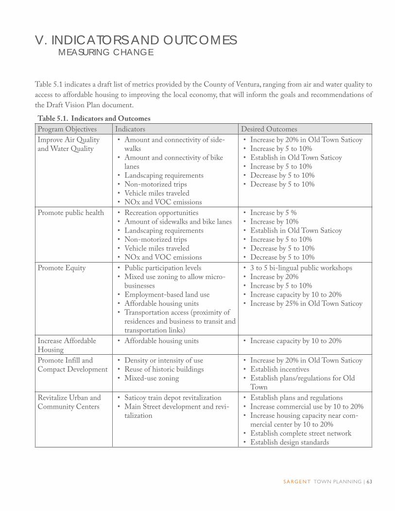
S A RG E N T TOWN PLANNING | 63
Table 5.1 indicates a draft list of metrics provided by the County of Ventura, ranging from air and water quality to
access to affordable housing to improving the local economy, that will inform the goals and recommendations of
the Draft Vision Plan document.
Table 5.1. Indicators and Outcomes
Program Objectives Indicators Desired Outcomes
Improve Air Quality and Water Quality
• Amount and connectivity of side-walks
• Amount and connectivity of bike lanes
• Landscaping requirements• Non-motorized trips• Vehicle miles traveled• NOx and VOC emissions
• Increase by 20% in Old Town Saticoy• Increase by 5 to 10%• Establish in Old Town Saticoy• Increase by 5 to 10%• Decrease by 5 to 10%• Decrease by 5 to 10%
Promote public health • Recreation opportunities• Amount of sidewalks and bike lanes• Landscaping requirements• Non-motorized trips• Vehicle miles traveled• NOx and VOC emissions
• Increase by 5 %• Increase by 10%• Establish in Old Town Saticoy• Increase by 5 to 10%• Decrease by 5 to 10%• Decrease by 5 to 10%
Promote Equity • Public participation levels• Mixed use zoning to allow micro-
businesses• Employment-based land use• Affordable housing units• Transportation access (proximity of
residences and business to transit and transportation links)
• 3 to 5 bi-lingual public workshops• Increase by 20%• Increase by 5 to 10%• Increase capacity by 10 to 20%• Increase by 25% in Old Town Saticoy
Increase Affordable Housing
• Affordable housing units • Increase capacity by 10 to 20%
Promote Infill and Compact Development
• Density or intensity of use• Reuse of historic buildings• Mixed-use zoning
• Increase by 20% in Old Town Saticoy• Establish incentives• Establish plans/regulations for Old
Town
Revitalize Urban and Community Centers
• Saticoy train depot revitalization• Main Street development and revi-
talization
• Establish plans and regulations• Increase commercial use by 10 to 20%• Increase housing capacity near com-
mercial center by 10 to 20%• Establish complete street network• Establish design standards
V. INDICATORS AND OUTCOMES MEASURING CHANGE

64 | O L D TOW N S AT I C OY A R E A P L A N
V. I N D I C ATO R S A N D O U TC O M E S
Table 5.1. Indicators and Outcomes
Program Objectives Indicators Desired Outcomes
Protect Natural Re-sources and Agricultural Lands
• Retain adjacent protected and/or conserved open space and agricul-tural lands
• Retain 100% of protected lands
Reduce Automobile Usage and Fuel Con-sumption
• Amount and connectivity of side-walks
• Amount and connectivity of bike lanes
• Landscaping requirements• Non-motorized trips• Vehicle miles traveled• NOx and VOC emissions• Electric vehicle fueling stations• Transportation access (proximity of
residences and business to transit and transportation links)
• Increase by 20% in Old Town Saticoy• Increase by 5 to 10%• Establish in Old Town Saticoy• Increase by 5 to 10%• Decrease by 5 to 10%• Decrease by 5 to 10%• Establish zoning regulations• Increase proximity by 5 to 20%
Improve Infrastructure Systems
• Amount and connectivity of side-walks
• Amount and connectivity of bike lanes
• Electric vehicle fueling stations• Water & sewer infrastructure
• Increase by 20% in Old Town Saticoy• Increase by 5 to 10%• Establish zoning regulations• Modify City regulations that limit ac-
cess to urban water and sewer systems
Promote Water Con-servation
• Water conservation policies• Landscaping requirements
• Establish policies in Area Plan• Establish regulations for low-water
consumption landscaping
Promote Energy Ef-ficiency and Conserva-tion
• Water conservation policies• Electric vehicle fueling stations• Solar panels• Transportation access (proximity of
residences and business to transit and transportation links)
• Establish conservation policies• Establish zoning regulations• Establish incentives for industrial zones• Increase proximity by 5 to 20%
Strengthen the Econ-omy
• New construction• Employment based land use• Main Street development and revi-
talization
• Increase housing construction by 10%• Increase industrial capacity by 5 to 10%• Increase commercial capacity by 5 to
20%

S A RG E N T TOWN PLANNING | 65
Table 6.1 lists potential funding sources that could be used to implement some of the transformations described
in this Plan.
Table 6.1. Potential Transportation Funding Sources
Funder Program Description
CalTrans Transportation Planning Grant Program: • Environmental Justice
Category• Rural or Small Ur-
ban Transit Planning Studies Category
• Potentially other cat-egories
All grants focus on multi-modal and bicycle/pedestrian trans-portation planning and design for major corridors such as Wells Road; they do not fund capital improvements. The Environmen-tal Justice Program is focused on low-income communities such as Saticoy. The Rural or Small Urban Transit Planning Studies Program is focused on smaller towns like Saticoy.
CalTrans, Divi-sion of Local Assistance
Safe Routes to School (SR2S) Program
The 2012 funding cycle awarded $48.5 million for 139 capital and educational projects statewide. Most grants were awarded for areas geographically surrounding or leading to a school. For Saticoy, where most children are bused to off-site schools, it could be possible to apply for SR2S grant money to access school bus stops, although in the 2012 funding list it is not clear if other grant projects have done this. Alternatively, Saticoy could still apply for SR2S funding for crossings of Wells to access nearby Saticoy Elementary School, since bussing arrangements could change in the future and some students may attend this school.
Federal High-way Adminis-tration, ad-ministered by CalTrans
Safe Routes to School (SRTS) Program
The Federal Safe Routes to School (SRTS) Program, which pro-grams projects into the Federal Transportation Improvement Pro-gram (FTIP), was most recently funded with a funding cycle in 2011, but could release an additional funding cycle in the future.
California Department of Forestry and Fire Protection
California ReLeaf Grants are offered to meet the critical need of creating and sus-taining healthy communities in California by providing funding for an array of urban forestry efforts that range from education and outreach to tree-planting projects.
VI. POTENTIAL FUNDING SOURCES IMPLEMENTING CHANGE

66 | O L D TOW N S AT I C OY A R E A P L A N
APPENDIXSTREET SECTIONS
Collisions between vehicles and other vehicles,
pedestrians, and bicyclists kill around 40,000 people
annually in the United States. In general, lower street
speeds reduce risks of injury from collisions. Many
studies have shown that the likelihood of injury or
death to a pedestrian, bicyclist, or vehicle occupant in
the event of a collision increases exponentially with
speed. The survivability of such collisions at vehicular
speeds of 25 m.p.h. or less is very high, while that of
collisions at speeds of 35 m.p.h. or greater is very low.
A pedestrian environment that feels unsafe also
discourages pedestrian activity. Accordingly, this Plan
incorporates a number of strategies to improve both
the perception and the reality of transportation safety.
Key examples of such recommendations include
better cross-walks and reduced crossing distances for
pedestrians across busy streets, traffic calming features
such as corner bulbouts and medians; and better
designed bicycle and pedestrian facilities throughout.
Through the systematic application of such
techniques – some as part of capital improvement
projects, some associated with routine maintenance,
and some as conditions of development permits –
Old Town Saticoy’s existing streets, which currently
favor the automobile, can be transformed into
“complete streets” that provide safe access to all users
– pedestrians, bicyclists, motorists, and transit riders –
of all ages and abilities.
A network of such streets would make it easy and
pleasant to walk to shops, bicycle to work, and access
transit, thus helping to implement key objectives of
County policy – local economic development, local
jobs/housing balance, reduction of GHG emissions,
encouragement of alternative transportation modes –
which the current street network prevents.
These improvements would be administered by
Development Standards that provide alternative
street network and infrastructure standards for Old
Town Saticoy. As funding sources become available,
these guidelines, would provide the framework for
implementing these improvements.
These application of these strategies to the Saticoy’s
existing streets is illustrated in Figure A.1 and the
pages that follow.

S A RG E N T TOWN PLANNING | 67
3
1
9
8
11
7
5
6
4
I0
Legend
Violeta Street in the Town Center
Violeta Street in the Neighborhood
Los Angeles Avenue in the Town Center
Los Angeles Avenue North of Violeta Street
Azahar Street at Train Depot
Azahar Street East of Train Depot
Nardo Street
Plan Boundary
3
2
1
6
5
4
7
Alelia Avenue Between Violeta Street and Azahar Street
Alelia Avenue South of Azahar Street
Amapola Avenue
Clavel Avenue
Campanula Avenue
10
9
8
12
11
212
Figure A.1. Proposed Street Newtork.
Railroad Right-of-Way
Railroad Right-of-Way
Aster StreetAster StreetL
os An
geles Aven
ue
Los A
ngeles A
venu
e
Alelia A
venu
e
Alelia A
venu
e
Am
apola A
venu
e
Am
apola A
venu
e
Clavel A
venu
eC
lavel Aven
ue
Azahar StreetAzahar Street
Violeta Street
Violeta Street
NardoStreetNardoStreet
Rosal LaneRosal Lane
Cam
pan
ula A
venu
eC
amp
anu
la Aven
ue
Snapdragon StreetSnapdragon Street
Wells R
oad
Wells R
oad
Telephone RoadTelephone Road
n

68 | O L D TOW N S AT I C OY A R E A P L A N
VIOLETA STREET IN THE TOWN CENTER
Proposed street section for Violeta Street between Wells Road and Los Angeles Avenue
1
Existing view of Violeta Street looking east towards Los Angeles Avenue.
Violeta Street remains two lanes in each
direction with angled parking on both sides
of the street. Parking lane tree planters are
introduced at regular intervals to help reduce
the perceived width of the street. Intersection
bulbouts and crosswalks are introduced at
corners to help slow vehicular speeds and to
shorten the pedestrian crossing distance.
Example of outdoor eating and gathering area in a Town Center.
A P P E N D I X

S A RG E N T TOWN PLANNING | 69
A P P E N D I X
VIOLETA STREET IN THE NEIGHBORHOOD2
Proposed street section for Violeta Street between Los Angeles Avenue and Clavel Road
Existing view of Violeta Street at Amapola Avenue looking west.
Violeta Street east of Los Angeles Avenue
remains two lanes in each direction with
parallel parking on both sides. Parking
lane tree planters are introduced between
parallel parking spaces to reduce the real and
perceived width of the street in order to help
slow vehicular traffic down and introduce an
urban forest along the street.
Example of street with a similar character that is envisioned for Violeta Street.

70 | O L D TOW N S AT I C OY A R E A P L A N
A P P E N D I X
LOS ANGELES AVENUE IN TOWN CENTER3
Proposed street section for Los Angeles Avenue between Nardo Street and the new Telephone Road extension
Existing view of Los Angeles Avenue looking north towards Violeta Street.
Los Angeles Avenue north of Nardo
Street remains two lanes in each direction
with angled parking on both sides of the
street. Tree planters are introduced at
regular intervals. Intersection bulb-outs
and crosswalks are introduced at corners to
help slow vehicular speeds and to shorten
the pedestrian crossing distance. Street
furniture, including benches and trash cans are
introduced throughout.
Example of a main street lined with street trees, bulb-outs, and street furniture.

S A RG E N T TOWN PLANNING | 71
A P P E N D I X
LOS ANGELES AVENUE NORTH OF VIOLETA STREET
4
Proposed street section for Los Angeles Avenue between Nardo Road and Wells Road
Existing view of Los Angeles Avenue looking south from Aster Street.
Los Angeles Avenue is extended across the
existing County-owned storm drain pipe to
Darling Road. It consists of two lanes in
each direction with parallel parking on both
sides of the street. Wide, continuous planters
are introduced between the sidewalk and the
curb.
Example of two lane street flanked by continuous planters and streets between the sidewalk and the curb.

72 | O L D TOW N S AT I C OY A R E A P L A N
A P P E N D I X
AZAHAR STREET AT TRAIN DEPOT5
Proposed street section of Azahar Street in front of the train depot
Existing view of Azahar Street at Alelia Avenue looking east with the train depot to the right
Azahar Street remains two lanes in each
direction. Angled parking is introduced on
the south side of the street in front of the
old train depot with a sidewalk immediately
adjacent to the curb. Parallel parking is
introduced on the north side with parking
lane tree planters located between parallel
parking spaces.
Example of street in Fillmore with similar character that is envi-sioned for Azahar Street in front of the train depot.

S A RG E N T TOWN PLANNING | 73
A P P E N D I X
AZAHAR STREET EAST OF TRAIN DEPOT6
Proposed street section for Azahar Street east of the train depot
Existing view of the east end of Azahar Street
Azahar Street east of the train depot parcel
remains two lanes in each direction with its
south curb moved northward to narrow the
width of the street and increase the depth of
the properties between Azahar Street and the
railroad right-of-way – making these shallow
properties more suitable for development.
Parking lane tree planters located between
parallel parking spaces are introduced along
the north side of the street.
Example of a street lined with live-work units, street trees, and pedestrian-scaled street lights.

74 | O L D TOW N S AT I C OY A R E A P L A N
A P P E N D I X
NARDO STREET7
Proposed street section of Nardo Street
Existing view of Nardo Street looking West towards Alelia Av-enue.
Nardo Street remains two lanes in each
direction. In order to calm traffic,
perpendicular parking is introduced along one
side of the street with intermittent parking
spaces designated as street tree planters.
Parking lane tree planters located between
parallel parking spaces are introduced along
the other side of the street.
Example of street with similar character that is envisioned for Nardo Street.

S A RG E N T TOWN PLANNING | 75
A P P E N D I X
ALELIA AVENUE BETWEEN VIOLETA STREET AND AZAHAR STREET
8
Proposed street section for Alelia Avenue between Violeta Street and Azahar Street
Existing view of Alelia Avenue looking south from Violeta Street
Alelia Avenue between Violeta Street and
Azahar Street remains two lanes in each
direction, with parking introduced on both
sides of the street – angled if a park is
introduced at the corner of Violeta Street
and Alelia Avenue, parallel if no park is
introduced.
Example of street with houses facing the park across the street.

76 | O L D TOW N S AT I C OY A R E A P L A N
A P P E N D I X
ALELIA AVENUE SOUTH OF AZAHAR STREET9
Proposed street section for Alelia Avenue south of Azahar Street.
Existing photo of Alelia Avenue looking south from Nardo Street.
Alelia Avenue south of Azahar Street and
north of Violeta Street remains two lanes
in each direction with parallel parking on
both sides. Parking lane tree planters are
introduced between parallel parking spaces on
both sides of the street.
Example of street in Fillmore with street trees and parallel park-ing on both sides of the street.

S A RG E N T TOWN PLANNING | 77
A P P E N D I X
AMAPOLA AVENUE10
Proposed street section for Amapola Avenue.
Existing photo of Amapola Avenue looking south towards Azahar Street.
Amapola Avenue remains two lanes in each
direction with parallel parking on both sides
of the street. Parking lane tree planters are
introduced between parallel parking spaces on
both sides of the street.
Example of street with street trees and parallel parking on both sides of the street.

78 | O L D TOW N S AT I C OY A R E A P L A N
A P P E N D I X
CLAVEL AVENUE11
Proposed street section for Clavel Avenue.
Existing view of Clavel Avenue looking south from Violeta Street.
Clavel Avenue remains two lanes in each
direction with parallel parking on both
sides. Sidewalks with continuous street tree
planters between the sidewalk and the curb
are introduced along the entire length of the
street.
Example of residential street in Fillmore with continuous planter and mature street trees.

S A RG E N T TOWN PLANNING | 79
A P P E N D I X
CAMPANULA AVENUE12
Proposed street section for Campanula Avenue.
Existing photo of Campanula Avenue looking south form the northern edge of the Plan Area boundary.
Campanula Avenue remains two lanes in each
direction. Sidewalks with continuous street
tree planters between the sidewalk and the
curb are introduced along the west side of the
street, while the shoulder on the east side of
the street is retained.
Example of a residential street as the edge of town. Sidewalks and street trees are introduced on one side of the street.