one-shot way nding method for blind people via ocr and
TRANSCRIPT

One-Shot Wayfinding Method for Blind Peoplevia OCR and Arrow Analysis with a 360-degree
Smartphone Camera
Yutaro Yamanaka1, Seita Kayukawa2, Hironobu Takagi3, Yuichi Nagaoka4,Yoshimune Hiratsuka5, and Satoshi Kurihara1
1 Graduate School of Science and Technology, Keio University, Kanagawa, Japan2 Waseda University, Tokyo, Japan
3 IBM Research - Tokyo, Tokyo, Japan4 Tokyo Independent Living Support Center for the Visually Impaired, Tokyo, Japan
5 Department of Ophthalmology, Juntendo University School of Medicine, Tokyo,Japan
Abstract. We present a wayfinding method that assists blind people indetermining the correct direction to a destination by taking a one-shotimage. Signage is standard in public buildings and used to help visitors,but has little benefit for blind people. Our one-shot wayfinding methodrecognizes surrounding signage in all directions from an equirectangularimage captured using a 360-degree smartphone camera. The method an-alyzes the relationship between detected text and arrows on signage andestimates the correct direction toward the user’s destination. In otherwords, the method enables wayfinding for the blind without requiringeither environmental modifications (e.g. Bluetooth beacons) or prepa-ration of map data. In a user study, we compared our method with abaseline method: a signage reader using a smartphone camera with astandard field of view. We found that our method enabled the partici-pants to decide directions more efficiently than with the baseline method.
Keywords: Visual impairment · signage · OCR · arrow detection
1 Introduction
Signage is standard in public buildings and shows directions toward points of in-terest to help visitors find their way [14], but it has little benefit for blind people.Recent studies have proposed assistive technologies that can recognize signageinformation (e.g. text or pictograms on signage) by combining a smartphonecamera and computer vision technologies such as optical character recognition(OCR) [2, 29]. One difficulty for blind people in using such signage recognitionsystems is taking pictures with the appropriate framing and aiming the cameratoward a sign quickly and accurately [15, 24]. Thus, blind users sometimes can-not obtain required information from these systems. In this situation, it can bedifficult for them to distinguish whether the reason is a lack of signage in theenvironment or incorrect camera framing.
Author Version
2 Y. Yamanaka et al.
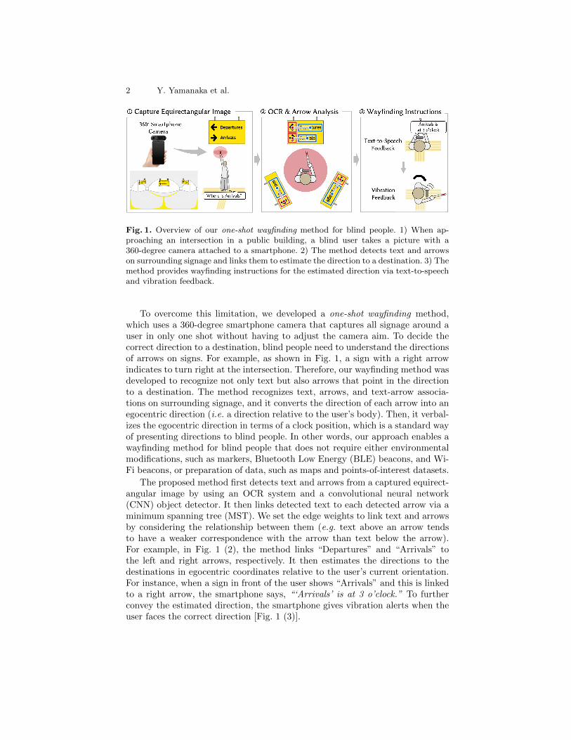
Fig. 1. Overview of our one-shot wayfinding method for blind people. 1) When ap-proaching an intersection in a public building, a blind user takes a picture with a360-degree camera attached to a smartphone. 2) The method detects text and arrowson surrounding signage and links them to estimate the direction to a destination. 3) Themethod provides wayfinding instructions for the estimated direction via text-to-speechand vibration feedback.
To overcome this limitation, we developed a one-shot wayfinding method,which uses a 360-degree smartphone camera that captures all signage around auser in only one shot without having to adjust the camera aim. To decide thecorrect direction to a destination, blind people need to understand the directionsof arrows on signs. For example, as shown in Fig. 1, a sign with a right arrowindicates to turn right at the intersection. Therefore, our wayfinding method wasdeveloped to recognize not only text but also arrows that point in the directionto a destination. The method recognizes text, arrows, and text-arrow associa-tions on surrounding signage, and it converts the direction of each arrow into anegocentric direction (i.e. a direction relative to the user’s body). Then, it verbal-izes the egocentric direction in terms of a clock position, which is a standard wayof presenting directions to blind people. In other words, our approach enables awayfinding method for blind people that does not require either environmentalmodifications, such as markers, Bluetooth Low Energy (BLE) beacons, and Wi-Fi beacons, or preparation of data, such as maps and points-of-interest datasets.
The proposed method first detects text and arrows from a captured equirect-angular image by using an OCR system and a convolutional neural network(CNN) object detector. It then links detected text to each detected arrow via aminimum spanning tree (MST). We set the edge weights to link text and arrowsby considering the relationship between them (e.g. text above an arrow tendsto have a weaker correspondence with the arrow than text below the arrow).For example, in Fig. 1 (2), the method links “Departures” and “Arrivals” tothe left and right arrows, respectively. It then estimates the directions to thedestinations in egocentric coordinates relative to the user’s current orientation.For instance, when a sign in front of the user shows “Arrivals” and this is linkedto a right arrow, the smartphone says, “‘Arrivals’ is at 3 o’clock.” To furtherconvey the estimated direction, the smartphone gives vibration alerts when theuser faces the correct direction [Fig. 1 (3)].
One-Shot Wayfinding Method for Blind People 3
To evaluate the usability of our method, we performed a user study witheight blind people. To provide a baseline system, we implemented a simple sig-nage reader system that uses the RGB camera built into a smartphone (nota 360-degree camera). We asked the participants to find the correct directionto a destination by using either the proposed system or the baseline system.To evaluate the effectiveness of each system’s interface, we designed a Wizard-of-Oz-style [17] study using images for which our algorithm worked successfully.Because of the COVID-19 outbreak, we conducted the user study in a laboratoryspace that reproduced wayfinding decision-making situations in public buildingsby using pre-captured images from places such as an international airport anda railway station. We observed that the proposed system enabled the partici-pants to determine directions with a smaller amount of rotation than with thebaseline system. The participants’ feedback also supported our hypothesis thatthe proposed system is useful for wayfinding tasks in public buildings. On thebasis of our findings, we discuss future directions to develop a more flexible andcomfortable wayfinding system for public buildings.
2 Related Work
2.1 Indoor Navigation and Wayfinding System for Blind People
Navigating large and unfamiliar public buildings (e.g. international airports, rail-way stations, and shopping centers) is a challenging task for blind people [12, 13].Thus, researchers have proposed various types of indoor navigation systems forblind people. Most of these systems provide turn-by-turn navigation instructionsby using localization technologies (e.g. Bluetooth Low Energy (BLE) beacons [3,30], ultra-wide band (UWB) [4], and Wi-Fi [10]) or environment databases (e.g.images [32] and maps [22]). While these navigation or wayfinding systems canprovide accurate wayfinding instructions, they require installing sensors or codein the environment or constructing a database of the environment.
To implement a wayfinding or navigation system that does not require addi-tional sensors or databases, recent research using computer vision has enabledsystems that can recognize useful information for wayfinding (e.g. doors [8], flatfloors [11], pictograms and text on signage [29, 35]). However, sign locations donot always correspond to the route to a destination. For example, a sign witha right arrow indicates that the destination is to the right, not at the sign’slocation. To overcome this limitation, we propose a wayfinding method that canrecognize not only text but also arrows that show the direction to a destination.By analyzing the relationship between detected text and arrows, the methodgives blind users egocentric directions toward their destinations.
2.2 Environment Recognition via Smartphone Camera
With the expansion of smartphone usage in the blind people community [25],various smartphone camera-based recognition systems have been proposed to
4 Y. Yamanaka et al.
help blind users obtain information on their surroundings (e.g. object [1, 2, 6,18, 29, 38], text [1, 2, 6, 38], and signage [29, 31]). However, it is still challengingfor blind users to capture an entire target object with a smartphone camera [15,24]. While capture-assistance systems using audio [15, 21, 33, 37] or vibration [21]have been proposed, standard smartphone cameras require blind users to rotatethem and face them toward objects. Having blind people change their orientationmay cause them to lose their way and become disoriented [16]. We thus use a360-degree smartphone camera, which can capture all surrounding signage inone shot, for wayfinding tasks; we call this one-shot wayfinding.
3 Design: One-Shot Wayfinding Method
Here, we describe our wayfinding method design specifically for the followingtypical situation: Blind pedestrians walk through a public building such as anairport, railway station, or shopping center. They walk along the tactile pavingsin the building but is unfamiliar with the route. Thus, when they approache atactile paving intersection, they cannot decide which direction to take.
3.1 One-Shot Wayfinding method with 360-degree Camera
While there are smartphone-based assistive technologies that can recognize in-formation on the surroundings via a smartphone camera [2, 29, 18, 6, 38, 1, 31,37], it is challenging for blind users to point a camera toward a target and cap-ture its entirety [15, 24]. When blind users cannot obtain required informationwith such technologies, it can be difficult for them to distinguish whether thereason is a lack of signage in the environment or incorrect camera framing.
Therefore, we attach a 360-degree camera to a smartphone. Compared withbuilt-in smartphone cameras with a standard field of view (FoV), 360-degreecameras have three advantages: (1) they can capture all surrounding signage(including directly behind) in one shot, (2) they can capture the whole of eachsign (i.e. no text is cut off), and (3) they do not require aiming. This is whywe call our method a one-shot wayfinding. In other words, it can distinguishwhether there is signage around a user with only one camera shot.
3.2 Wayfinding Instructions via OCR and Arrow Analysis
The combination of a 360-degree camera and OCR can recognize text appearingaround a user, including non-signage text (e.g. posters and signboards). However,reading out all text can cognitively overwhelm the user [26]. In addition, signlocations do not always correspond to the route to a destination. For example,when a user approaches an intersection and a sign with a right arrow is in front ofthe user, it indicates that the destination is to the right, not at the sign location[Fig. 1]. In this situation, the system should tell the user to turn right.
To overcome these limitations, we designed our wayfinding method to detectnot only text but also arrows on signage. The method then links detected text to
One-Shot Wayfinding Method for Blind People 5
each detected arrow by considering their spatial relationship, through a processwe call arrow analysis. By using the linking results, the method recognizes onlysignage text and estimates the egocentric direction to each destination [Sec. 4].It then instructs the user on the correct direction to the destination.
4 Implementation
Our one-shot wayfinding method consists of two components: (1) a web APIthat performs equirectangular image preprocessing, arrow detection, OCR, andarrow analysis; and (2) a smartphone interface that estimates egocentricdirections to destinations and provides wayfinding instructions. For our userstudy with blind people, we attached an Insta360 ONE6, which can capture 7K(6912 × 3456 pixels) equirectangular images, to an iPhone6 7. Captured imagesare horizontally corrected by the camera’s built-in gyroscope. As a result, blindusers can capture equirectangular images horizontally without concern for thesmartphone’s angle and rotation. After capturing an image, the method sendsit to the web API on our server.
4.1 Equirectangular Image Preprocessing
Because equirectangular images are spatially distorted and unsuitable for arrowdetection, the method first converts a captured image into cubemap images(1728 × 1728 pixels). The method converts the equirectangular image into fivecubemap images having 18-degree horizontal overlaps. The method uses the fivecubemap images for arrow detection, and the original equirectangular image andthe back cubemap image for OCR.
4.2 Arrow Detection and OCR
The method detects arrows by using the YOLOv3 object detector [28]. To trainthe arrow detection model, we collected 1140 arrow images taken in public spacesfrom Open Images Dataset [20] and Flicker API8 (only Creative-Commons-licensed images). We annotated the collected images with bounding boxes andfour types of arrow labels (straight, down, right, or left). The method detectsbounding boxes of arrows from the five cubemap images and obtains their posi-tions in the equirectangular image coordinate system. Because of the cubemapimages’ overlaps, the method may detect the same arrow twice from differentcubemap images. In that case, it picks the bounding box with the higher confi-dence value.
The method detects text on the captured equirectangular image by using anOCR package from Google Cloud Vision API9. As each end of the equirectan-gular image may contain separated text from behind the user, the method also
6 https://www.insta360.com/product/insta360-one/7 https://support.apple.com/kb/sp7058 https://www.flickr.com/services/api/9 https://cloud.google.com/vision/docs/ocr/
6 Y. Yamanaka et al.
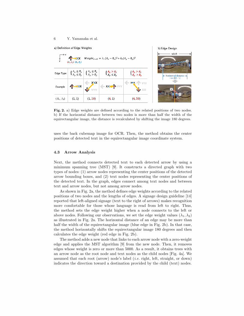
Fig. 2. a) Edge weights are defined according to the related positions of two nodes.b) If the horizontal distance between two nodes is more than half the width of theequirectangular image, the distance is recalculated by shifting the image 180 degrees.
uses the back cubemap image for OCR. Then, the method obtains the centerpositions of detected text in the equirectangular image coordinate system.
4.3 Arrow Analysis
Next, the method connects detected text to each detected arrow by using aminimum spanning tree (MST) [9]. It constructs a directed graph with twotypes of nodes: (1) arrow nodes representing the center positions of the detectedarrow bounding boxes, and (2) text nodes representing the center positions ofthe detected text. In the graph, edges connect among text nodes and betweentext and arrow nodes, but not among arrow nodes.
As shown in Fig. 2a, the method defines edge weights according to the relatedpositions of two nodes and the lengths of edges. A signage design guideline [14]reported that left-aligned signage (text to the right of arrows) makes recognitionmore comfortable for those whose language is read from left to right. Thus,the method sets the edge weight higher when a node connects to the left orabove nodes. Following our observations, we set the edge weight values (λ1, λ2)as illustrated in Fig. 2a. The horizontal distance of an edge may be more thanhalf the width of the equirectangular image (blue edge in Fig. 2b). In that case,the method horizontally shifts the equirectangular image 180 degrees and thencalculates the edge weight (red edge in Fig. 2b).
The method adds a new node that links to each arrow node with a zero-weightedge and applies the MST algorithm [9] from the new node. Then, it removesedges whose weight is zero or more than 5000. As a result, it obtains trees withan arrow node as the root node and text nodes as the child nodes [Fig. 4a]. Weassumed that each root (arrow) node’s label (i.e. right, left, straight, or down)indicates the direction toward a destination provided by the child (text) nodes.
One-Shot Wayfinding Method for Blind People 7
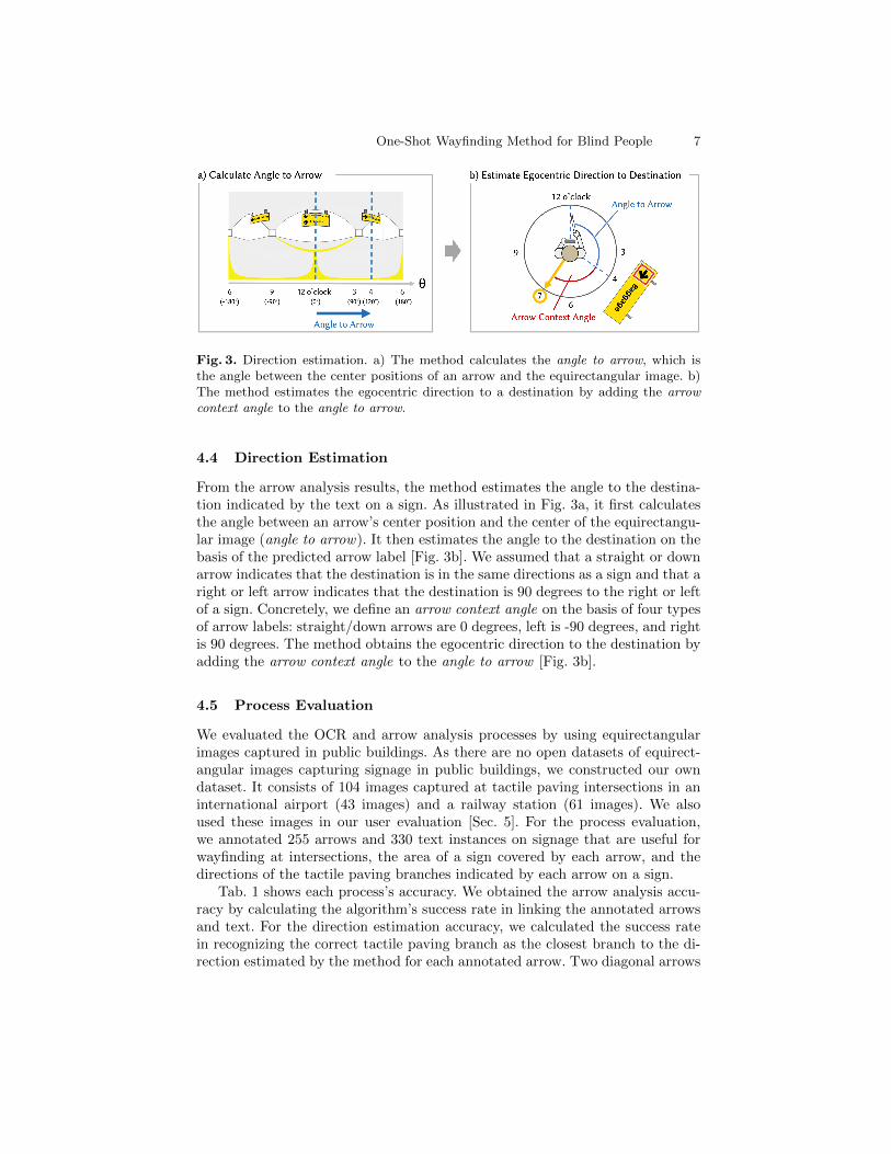
Fig. 3. Direction estimation. a) The method calculates the angle to arrow, which isthe angle between the center positions of an arrow and the equirectangular image. b)The method estimates the egocentric direction to a destination by adding the arrowcontext angle to the angle to arrow.
4.4 Direction Estimation
From the arrow analysis results, the method estimates the angle to the destina-tion indicated by the text on a sign. As illustrated in Fig. 3a, it first calculatesthe angle between an arrow’s center position and the center of the equirectangu-lar image (angle to arrow). It then estimates the angle to the destination on thebasis of the predicted arrow label [Fig. 3b]. We assumed that a straight or downarrow indicates that the destination is in the same directions as a sign and that aright or left arrow indicates that the destination is 90 degrees to the right or leftof a sign. Concretely, we define an arrow context angle on the basis of four typesof arrow labels: straight/down arrows are 0 degrees, left is -90 degrees, and rightis 90 degrees. The method obtains the egocentric direction to the destination byadding the arrow context angle to the angle to arrow [Fig. 3b].
4.5 Process Evaluation
We evaluated the OCR and arrow analysis processes by using equirectangularimages captured in public buildings. As there are no open datasets of equirect-angular images capturing signage in public buildings, we constructed our owndataset. It consists of 104 images captured at tactile paving intersections in aninternational airport (43 images) and a railway station (61 images). We alsoused these images in our user evaluation [Sec. 5]. For the process evaluation,we annotated 255 arrows and 330 text instances on signage that are useful forwayfinding at intersections, the area of a sign covered by each arrow, and thedirections of the tactile paving branches indicated by each arrow on a sign.
Tab. 1 shows each process’s accuracy. We obtained the arrow analysis accu-racy by calculating the algorithm’s success rate in linking the annotated arrowsand text. For the direction estimation accuracy, we calculated the success ratein recognizing the correct tactile paving branch as the closest branch to the di-rection estimated by the method for each annotated arrow. Two diagonal arrows

8 Y. Yamanaka et al.
ArrowOCR
Arrow Direction Overalldetection analysis estimation performance
(%) (%) (%) (%) (%)
International airport 88.0 55.2 90.0 83.6 45.7Railway station 85.7 58.4 60.0 85.0 41.1
Total 86.7 57.3 70.9 84.5 42.7
Table 1. Summary of process evaluation results.
Fig. 4. a) Success case: all text linked to the appropriate arrow. b) Failure case 1:narrow space between arrows, 9 of 104 images. c) Failure case 2: wide space separatingtext, 33 of 104 images.
were also included in the failed cases of the arrow detection. The table also liststhe method’s overall performance as defined by the success rate in linking thetext and the correct tactile paving branch. Fig. 4 shows examples of the OCRand arrow analysis results. In Fig. 4a, the method linked text on sign to the ap-propriate arrow. On the other hand, we observed many failure cases. One causeof failure was incorrect arrow and text detection. The detection performance,especially for OCR, was worse for small text and arrows. Another cause wassignage design: the arrow analysis accuracy decreased when there was a narrowspace between arrows (Fig. 4b) or a wide space separating text (Fig. 4c). Wewill discuss possible solutions to improve each process’s accuracy in Sec. 7.2.
4.6 User Interface
Wayfinding Instructions The method provides wayfinding instructions to theuser via text-to-speech and vibration feedback. After estimating the direction oftext, the smartphone first reads out instructions in terms of clock positions.For example, suppose the user inputs “Arrivals” to the smartphone, and theestimated direction to “Arrivals” is 120 degrees to the right of the user’s currentorientation. In this case, the smartphone calculates the clock position of theestimated direction and says, “Arrivals is at 4 o’clock.‘’ Loomis et al. showedthat instructions given with clock positions can help blind people navigate to aspecific destinations [23].
While text-to-speech feedback can provide clear information for blind people,it is difficult for them to slightly adjust their orientation [30]. Accordingly, wedesigned an interface combining audio and vibration alerts. The smartphonegives vibration alerts when the user is facing the expected direction. The currentorientation is obtained with the smartphone’s built-in gyroscope.
One-Shot Wayfinding Method for Blind People 9
Smartphone Interface The smartphone interface has three buttons: (1) Recordbutton located at the top pf the smartphone screen: Used to register destination-related keywords via speech input. (2) Capture button located in the bottom left:Used to capture an equirectangular image while holding the camera overhead.(3) All button located in the bottom right: Used to hear readout of all textlinked to arrows. The user can push this button when the smartphone does notread out any audio instructions related to the registered keywords. On the basisof audio feedback, the user can register new keywords or conclude that there isno useful signage around the user.
5 User Study
To evaluate the effectiveness of our wayfinding method interface, we performeda user study with eight blind participants: five legally blind people and threetotally blind people (P3. P5, and P6), as listed in Tab. 2. They all consideredthemselves to have good orientation and mobility skills. Seven participants (P1–P4, P6–P8) regularly used a white cane, and P5 as their navigation aids and P5owned a guide dog. In this study, we compared our one-shot wayfinding systemagainst a baseline system: a signage reader using a smartphone camera with astandard field of view (FoV).
5.1 Experimental Setup
User Study in Laboratory Space We performed our study in a laboratoryspace rather than public buildings given the restriction under the COVID-19 pan-demic situation. We used equirectangular images pre-captured at tactile pavingintersections in public buildings [Sec. 4.5]. For each captured image, we laid tac-tile paving on the laboratory floor to reproduce the real intersections captured atthose points. To focus on evaluating the effectiveness of each interface for signage-recognition-based wayfinding, we designed a Wizard-of-Oz-style study [17] usingequirectangular images for which our algorithm worked successfully [Sec. 5.1].
Proposed System When a user pushed the “capture button” [Sec. 4.6], the sys-tem obtained the smartphone’s orientation relative to the tactile paving via thesmartphone’s gyroscope. Using this orientation, the system shifted the equirect-angular image to match the direction and the center of the image. We arguethat this process reproduced the scenario of a user capturing an equirectangularimage at a tactile paving intersection in a public building. Next, the system sentthe shifted image to the web API to get wayfinding instructions.
Baseline System Inspired by smartphone camera-based recognition applica-tions for visually impaired people [2, 18, 29, 31], we implemented a simple sig-nage reader system using a smartphone camera with a standard FoV as thebaseline system. To operate in the laboratory space, the baseline system used

10 Y. Yamanaka et al.
Demographic information Task accuracy (%) SUS score
ID Eyesight Age Proposed Baseline Proposed Baseline
P1 Legally blind 43 100 50 60 80
P2 Legally blind 46 100 50 90 65
P3 Totally blind 48 87.5 87.5 72.5 62.5
P4 Legally blind 52 100 75 62.5 85
P5 Totally blind 41 87.5 62.5 75 30
P6 Totally blind 47 87.5 87.5 95 82.5
P7 Legally blind 55 100 87.5 90 82.5
P8 Legally blind 39 87.5 100 82.5 20
Mean 46.4 93.8 75.0 78.4 63.4
SD 5.4 6.7 18.9 13.1 25.3
Table 2. Demographic information of our participants, task accuracy, and SUS scorefor each system.
pre-captured equirectangular images and the pre-obtained results of arrow de-tection and the OCR for these images. During the wayfinding task, the systemobtained the smartphone’s current orientation via its gyroscope sensor. It thenread out the registered text and all arrow labels within the pre-defined FoV(horizontal FoV: 100 degrees; vertical FoV: 80 degrees) around the smartphone’sdirection. When more than one arrow label was within the FoV, the system readout the labels in order from top left to bottom right.
Dataset For the Wizard-of-Oz-style study, we picked eight pairs of equirectan-gular images for which our algorithm worked successfully from the dataset usedfor the process evaluation [Sec. 4.5] and asked participants to perform wayfind-ing tasks with either the proposed or baseline system for each pair of images.We chose pairs with (1) the same building (an airport or a station), (2) the samedirection on the target sign (right, left, forward, or backward from the partic-ipant’s orientation during image capture), and (3) the same number of tactilepaving branches at the intersection (three or four). The participants were di-vided into two groups, X and Y, and the dataset was divided into two groupsof images, A and B. Group X completed the wayfinding tasks for image groupA with the proposed system and image group B with the baseline, while groupY used the opposite system for each of A and B. The order of the systems andimages was randomized for each participant.
5.2 Task
We asked the participants to choose the pre-defined correct direction from thetactile paving branches on the floor with either the proposed or baseline sys-tem. The participants held the smartphone with one hand and their white cane
One-Shot Wayfinding Method for Blind People 11
with the other. At the beginning of each task, the experimenter registered thedestination and gave the phone to the participants. We asked them to find thecorrect tactile paving branch to the destination (e.g. “Please select the tactilepaving branch to ‘Arrivals.’ ”). The participants used each system to decide thecorrect direction and reported verbally that they had completed the task if theyfound the correct branch.
To provide egocentric clock-position-based instructions correctly, we instructedthe participants to capture images while keeping the camera’s horizontal direc-tion with the user’s face direction. The proposed system could continuouslyobtain the smartphone’s current angle relative to the initial angle when the usercaptured the image by using the smartphone’s gyroscope. Therefore, the vibra-tion feedback can correctly convey the estimated direction to users even if thesmartphone’s direction and the face direction are misaligned.
5.3 Procedure
After obtaining informed consent (IRB approved) from the participants, we firstadministered a questionnaire on demographics and navigation habits. Next, wedescribed the two systems (proposed and baseline) and conducted a short train-ing session (15–20 minutes) to familiarize the participants with each system.Then, we asked the participants to perform wayfinding tasks with either theproposed or baseline system. As they performed the tasks, the interfaces andthe dataset (dataset A and B described in Sec. 5.1) were changed in a counter-balanced order. After all tasks were completed, we interviewed the participants.The task process took around 20 minutes, while the whole experiment tookapproximately 90 minutes per participant.
5.4 Metrics
Task Accuracy and Task Completion Time We defined the rate of successin deciding the correct tactile paving branch as the task accuracy. In addition,during the main session, we measured the task completion time for each task.Note that the proposed system estimated the correct direction by using theweb API for every task, but the baseline system used pre-obtained results forarrow detection and OCR and thus required no processing time to read signage.One of the study’s main goals was to evaluate the effectiveness of each system’sinterface. Therefore, in measuring the task completion time with the proposedsystem, we both included and excluded the processing time.
Rotation Efficiency We measured the amount of rotation (yaw angle) of eachsystem during each task with the smartphone’s gyroscope. We then obtainedthe rotation efficiency by calculating the absolute difference between the partic-ipant’s rotation and the angle between the participant’s initial orientation andthe correct tactile paving branch. Lower rotation efficiency values mean thatparticipants could decide the correct direction without extra rotation. Because
12 Y. Yamanaka et al.
the rotation efficiency became too large when the participants chose the wrongdirection, we only calculated it for cases of success.
Interview After completing all the tasks, we asked participants to rate foursentences by using a 7-point Likert scale ranging from “1: strongly disagree” to“7: strongly agree”, with 4 denoting “neutral.”
Q1: “I decided the direction confidently with the proposed/baseline/no system.”10
Q2: “The proposed/baseline system helped me in wayfinding.”
Q3: “The proposed/baseline system was easy to use.”
Q4: “I felt comfortable with the proposed/baseline system.”
We also asked the participants to rate each item on the system usabilityscale (SUS) [7]. Finally, we asked open-ended questions about the advantagesand disadvantages of each system, and we asked for suggestions to improve eachsystem.
6 Results
6.1 Overall Performance
Task Accuracy Tab. 2 lists the task accuracy of each interface for each partici-pant. Five of the eight participants had a higher task accuracy with the proposedsystem than with the baseline system. Though the average task accuracy of theproposed system (93.8%; 60/64) was higher than that of the baseline (75%;48/64), we found no significant differences between them (p = 0.057).
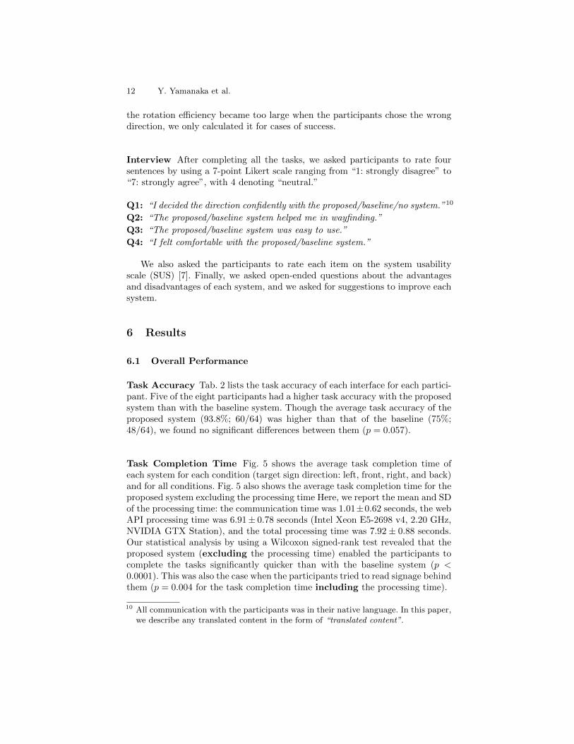
Task Completion Time Fig. 5 shows the average task completion time ofeach system for each condition (target sign direction: left, front, right, and back)and for all conditions. Fig. 5 also shows the average task completion time for theproposed system excluding the processing time Here, we report the mean and SDof the processing time: the communication time was 1.01±0.62 seconds, the webAPI processing time was 6.91± 0.78 seconds (Intel Xeon E5-2698 v4, 2.20 GHz,NVIDIA GTX Station), and the total processing time was 7.92 ± 0.88 seconds.Our statistical analysis by using a Wilcoxon signed-rank test revealed that theproposed system (excluding the processing time) enabled the participants tocomplete the tasks significantly quicker than with the baseline system (p <0.0001). This was also the case when the participants tried to read signage behindthem (p = 0.004 for the task completion time including the processing time).
10 All communication with the participants was in their native language. In this paper,we describe any translated content in the form of “translated content”.
One-Shot Wayfinding Method for Blind People 13
Fig. 5. Task completion time, with bars showing 95% confidence intervals and p-valuesfor a Wilcoxon signed-rank test on the task completion time. ** and * indicate 0.005and 0.05 levels of significance, respectively.
Rotation Efficiency The mean, SD, and 95% confidence interval of the ro-tation efficiency for each system were as follows: mean = 66.6, SD = 94.3, and95% confidence interval = 40.1˜93.1 for the proposed system; mean = 110.1, SD= 98.3, and 95% confidence interval = 81.6˜138.7 for the baseline system. Whenwe compared each system’s results by using a Mann-Whitney test, we observed asignificant difference (p = 0.00095) in the rotation efficiency. This result showedthat participants using the proposed system found the correct direction withoutextra rotation as compared with the baseline system.
Video Observation The video recordings enabled us to analyze the partici-pants’ behavior when they chose the wrong tactile paving branch. Four partic-ipants using the proposed system (P3, P5, P6, and P8) sometimes selected thewrong branch when the system estimated that the correct direction was betweentwo branches (4 failure cases /64 total trials). On the other hand, six participantsusing the baseline system (P2–P7) sometimes chose the wrong branch when thesystem read out multiple arrow labels.
System Ratings Tab. 2 lists the SUS scores for each participant. Six of theeight participants gave a higher SUS score to the proposed system than to thebaseline system. Fig. 6 summarizes the results for the Likert scale questions.For all questions, the proposed system received positive ratings (i.e. the medianrating was more than four). Participants who valued the baseline system more onQ4 (comfort) mainly pointed out the weight of the proposed system. We describethe detailed comments on the usability of each system in a later section.
6.2 Qualitative System Feedback
Six of the eight participants (P3–P8) agreed that our signage reader systems(both proposed and baseline) can be useful in wayfinding decision-making situ-ations: A1:“I am not confident in walking alone in public spaces, so I would like

14 Y. Yamanaka et al.
Fig. 6. Summary of Likert scale responses (1: strongly disagree to 7: strongly agree).
to use a system that reads signage to tell me the direction to my destination.”(P3); and A2:“It would be easier to move with confidence if the system read thesignage in unfamiliar places.” (P4)
Six participants (P2, P3, P5–P8) gave positive feedback on our one-shotwayfinding system because it does not require users to change their orientationand scan surrounding signage: A3:“Rotating on the spot with the second (base-line) system destroyed my mental map. I appreciated the first (proposed) sys-tem because it did not require me to turn my body in various directions.” (P5);and A4:“The 360-degree camera made it possible to determine directions with-out moving and rotating, and I thought it could be used in buildings I have nevervisited.” (P8) However, P4 preferred to face his camera toward surrounding sig-nage: A5:“I found the first (baseline) system natural and easy to use because itread the signage in the direction I was facing.” (P4)
Six participants (P2, P3, P5–P8) appreciated the proposed system’s wayfind-ing instructions with integrated clock-position-based audio feedback and vibra-tion feedback: A6:“The second (proposed) system allowed me to intuitively andaccurately understand the direction. On the other hand, with the first (baseline)system, I took more time to think about the direction to the destination after fac-ing the sign direction.” (P2); A7:“The vibration feedback of the first (proposed)system gave me confidence that I was facing the correct direction. The directionalfeedback of the second (baseline) system was vague, and I was not confident in mydirection after rotating.” (P7); and A8:“The directional instructions using theclock position instantly gave me a clear vision of the direction I needed to face. Ithought the vibration feedback would be useful for determining the direction evenwhere there are no landmarks such as tactile paving.” (P6)
Five participants (P3–P7) gave negative feedback on the baseline because itsometimes read out multiple arrow labels: A9:“When the first (baseline) systemread out multiple arrow labels, I had to figure out which one was the true directionto the destination.” (P4) In contrast, P1 preferred the baseline system’s simpleaudio instructions (“turn right/left”) to the proposed system’s clock-positioninstructions: A10:“It was difficult for me to understand the clock-position direc-tions of the first (proposed) system, while the second (baseline) system’s direc-tional instructions were easy to understand intuitively.” (P1)
Regarding suggestions to improve our systems for use in public buildings,we obtained the following comments: A11:“I want to check the direction when I
One-Shot Wayfinding Method for Blind People 15
walk along a road and reach an intersection.” (P3); and A12:“I want to checkmy direction when I lose confidence while walking on tactile paving.” (P6)
Half the participants (P2, P4–P6) mentioned that the proposed system withthe 360-degree camera was heavy: A13:“The camera was so heavy that walkingwith it all the time was a burden.” (P4) Finally, one participant mentioned thelimitation of the user study in a laboratory space as compared with real-worlduse: A14:“It was difficult to get a true feel for the usability of both systems withoutusing them in a real environment.” (P3)
7 Discussion
7.1 Effectiveness of One-Shot Wayfinding Method
The results showed that the task accuracy of the proposed system (93.8%) washigher than that of the baseline (75%), with p = 0.057. In addition, the proposedsystem significantly reduced the extra rotation as compared with the baselinesystem [Sec. 6.1]. The participants also agreed that the proposed system had anadvantage in not requiring users to change their orientation and scan surround-ing signage [A3–A4]. Participants’ feedback on the interface also supported theproposed system’s effectiveness [A6–A8].
Regarding the rotation effectiveness, users with the baseline system had todecide correct positions on the basis of arrow reading results, but the proposedsystem directly provides the correct direction from arrow analysis results. Weargue that this accounted for the difference in the task completion time. Ex-cluding the processing time, the proposed system’s task completion time [Fig. 5]was significantly shorter than that of the baseline system. Moreover, when thetarget sign was located behind the participant’s initial position, the proposedsystem’s task completion time, including the processing time, was significantlyshorter than that of the baseline [Fig. 5].
7.2 Toward More Accurate Wayfinding Systems
For the Wizard-of-Oz-style study, we used equirectangular images for which ouralgorithm worked successfully from the dataset. However, through the processevaluation [Sec. 4.5], We observed that our algorithm can be improved for real-world usage, and further evaluation in various environments is needed. The arrowdetection and OCR performance was a bottleneck for the wayfinding method’saccuracy. Specifically, the accuracy, particularly for OCR, decreased when sig-nage was far away from the user. To improve the detection accuracy, we willconsider designing an interface that guides the user close to a sign by usingarrow or signage detection [34, 35] results and then allows them to retake theequirectangular image at a place close to the target sign.
As listed in Tab. 1, while our graph-theory-based arrow analysis methodachieved relatively high accuracy at an international airport (90.0%), its ac-curacy at an railway station was only 60.0%. The method analyzes arrows by
16 Y. Yamanaka et al.
considering only the relative positions of arrows and text. To improve the ar-row analysis, we will consider using signage boundaries or CNN-based computervision techniques such as document layout analysis [5].
While our direction estimation process achieved 84.5% task accuracy, theestimation accuracy decreased when a sign did not directly face the 360-degreecamera. To increase direction estimation accuracy, one possible solution wouldbe to detect surrounding cues such as the directions of tactile paving branchesfrom the captured images [36] and use these results for direction estimation.
7.3 Future System Design
Processing Time Reduction We found no significant differences in the overalltask completion time between the proposed system (including the processingtime) and the baseline system [Fig. 5]. Regarding the processing time, we expectto exploit the ever-improving processing power of CPUs and GPUs and the ever-increasing communication bandwidth. We will also design faster algorithms andfind a better edge-cloud balance to reduce the processing time.
User Interface Design While the proposed system’s overall performance waspositive, we also found opportunities to improve the user interface. Six partici-pants preferred the proposed system, which automatically estimates the correctdirection [A3–A4], but P4 gave the baseline system a higher SUS score becauseit allows users to estimate the correct direction from arrow detection results[A5]. While many participants commented postiively on the proposed system’sclock-position-based instructions [A6 and A8], P1 found them difficult to under-stand [A10]. We argue that the requirements for a wayfinding system dependon the user’s orientation and mobility (O&M) skills, familiarity with the targetpublic building, and individual preferences. We aim to further explore varioustypes of interface options, including sonification method [27], 3D spatialized au-dio [23], vibration patterns [16, 19], and shape-changing devices [16], to providemore suitable wayfinding instructions to users.
7.4 Limitation of Laboratory-Based User Study
As P3 commented [A14], we agree that there are many differences between ourstudy in a laboratory space and a real-world study in public buildings. First, ina public building, the user would have to stop at a tactile paving intersection tocapture images. The lab-based study, which used pre-captured images, did notreproduce this procedure. Second, in complex buildings that repeatedly requirewayfinding tasks, users may choose the wrong direction. The lab-based studymissed an opportunity to understand how users recover from errors in wayfindingtasks. Third, the acoustic environment in public buildings is hardly reproduciblein a laboratory study, which prevents the use of techniques such as echolocation(e.g. the direction of wide-open spaces) and sound landmarks (e.g. escalators).Thus, we need to confirm the system’s practical usability in public buildings
One-Shot Wayfinding Method for Blind People 17
that facilitate echolocation and other senses. To explore more suitable interfacesand algorithms in a real-world setting, we will conduct a study in which blindparticipants are asked to approach a specific goal turn-by-turn in a public spaceby recognizing signage with our method.
8 Conclusion
We proposed a one-shot wayfinding method that uses a 360-degree smartphonecamera to recognize all signage around a blind user. The method analyzes therelationship between detected text and arrows on signage and estimates theegocentric direction to a destination. It provides text-to-speech feedback of theestimated direction on the basis of clock positions and gives vibration alerts whenthe user faces the indicated direction. A user study with eight blind participantsin a laboratory revealed that the proposed system enabled them to choose thecorrect tactile paving branch to a destination more efficiently than with a base-line system. The proposed system significantly reduced the extra rotation, andthe task completion time excluding the processing time was significantly shorterthan that of the baseline system. While the participants’ feedback supportedour hypothesis that the proposed method is useful for wayfinding tasks, we alsorecognized the need for a real-world user study in public buildings. The proposedmethod has the possibility of assisting users in unknown places without requir-ing either environmental modifications like distributed beacons or preparation ofmaps or points-of-interest datasets. We hope to explore this possibility furtherand make the technology practical to help blind people with daily activities.
ACKNOWLEDGMENTS
We would like to thank all participants who took part in our user study. We wouldalso thank Japan Airport Terminal Co., Ltd. and East Japan Railway Company.This work was supported by AMED (JP20dk0310108, JP21dk0310108h0002),JSPS KAKENHI (JP20J23018), and Grant-in-Aid for Young Scientists (EarlyBird, Waseda Research Institute for Science and Engineering, BD070Z003100).
References
1. Bespecular. (2016), https://www.bespecular.com2. Seeing ai. (2017), https://www.microsoft.com/en-us/seeing-ai3. Ahmetovic, D., Gleason, C., Ruan, C., Kitani, K., Takagi, H., Asakawa, C.: Navcog:
A navigational cognitive assistant for the blind. In: MobileHCI (2016)4. Alnafessah, A., Al-Ammar, M.A., Alhadhrami, S., Al-Salman, A., Al-Khalifa, H.S.:
Developing an ultra wideband indoor navigation system for visually impaired peo-ple. IJDSN 12, 403–416 (2016)
5. Augusto Borges Oliveira, D., Palhares Viana, M.: Fast cnn-based document layoutanalysis. In: ICCVW (2017)
18 Y. Yamanaka et al.
6. Bigham, J.P., Jayant, C., Ji, H., Little, G., Miller, A., Miller, R.C., Miller, R.,Tatarowicz, A., White, B., White, S., Yeh, T.: Vizwiz: Nearly real-time answers tovisual questions. In: UIST (2010)
7. Brooke, J.: Sus: a “quick and dirty’usability. Usability evaluation in industry p. 189(1996)
8. Fiannaca, A., Apostolopoulous, I., Folmer, E.: Headlock: A wearable navigationaid that helps blind cane users traverse large open spaces. In: ASSETS (2014)
9. Gabow, H.N., Galil, Z., Spencer, T., Tarjan, R.E.: Efficient algorithms for findingminimum spanning trees in undirected and directed graphs. Combinatorica 6(2)(1986)
10. Gallagher, T., Wise, E., Li, B., Dempster, A.G., Rizos, C., Ramsey-Stewart, E.: In-door positioning system based on sensor fusion for the blind and visually impaired.In: IPIN (2012)
11. Garcia, G., Nahapetian, A.: Wearable computing for image-based indoor naviga-tion of the visually impaired. In: WH. A (2015)
12. Guentert, M.: Improving public transit accessibility for blind riders: A train stationnavigation assistant. In: ASSETS (2011)
13. Guerreiro, J.a., Ahmetovic, D., Sato, D., Kitani, K., Asakawa, C.: Airport accessi-bility and navigation assistance for people with visual impairments. In: CHI (2019)
14. Guidelines, I.H.F.: Wayfinding guidelines international health facility guidelines(2016), http://www.healthfacilityguidelines.com/GuidelineIndex/Index/Wayfinding-Guidelines
15. Jayant, C., Ji, H., White, S., Bigham, J.P.: Supporting blind photography. In:ASSETS (2011)
16. Kayukawa, S., Tatsuya, I., Takagi, H., Morishima, S., Asakawa, C.: Guiding blindpedestrians in public spaces by understanding walking behavior of nearby pedes-trians. IMWUT 4(3) (2020)
17. Kelley, J.F.: An iterative design methodology for user-friendly natural languageoffice information applications. TOIS 2(1), 26–41 (1984)
18. Ko, E., Ju, J.S., Kim, E.Y.: Situation-based indoor wayfinding system for thevisually impaired. In: ASSETS (2011)
19. Kuribayashi, M., Kayukawa, S., Takagi, H., Asakawa, C., Morishima, S.:Linechaser: A smartphone-based navigation system for blind people to stand inline. In: CHI (2021)
20. Kuznetsova, A., Rom, H., Alldrin, N., Uijlings, J., Krasin, I., Pont-Tuset, J., Ka-mali, S., Popov, S., Malloci, M., Kolesnikov, A., Duerig, T., Ferrari, V.: The openimages dataset v4: Unified image classification, object detection, and visual rela-tionship detection at scale. IJCV 128(7), 1956–1981 (2020)
21. Lee, K., Hong, J., Pimento, S., Jarjue, E., Kacorri, H.: Revisiting blind photographyin the context of teachable object recognizers. In: ASSETS (2019)
22. Li, B., Munoz, J.P., Rong, X., Xiao, J., Tian, Y., Arditi, A.: Isana: Wearablecontext-aware indoor assistive navigation with obstacle avoidance for the blind.In: ECCVW (2016)
23. Loomis, J.M., Lippa, Y., Klatzky, R.L., Golledge, R.G.: Spatial updating of loca-tions specified by 3-d sound and spatial language. JEP:LMC 28(2), 335 (2002)
24. Manduchi, R., Coughlan, J.M.: The last meter: Blind visual guidance to a target.In: CHI (2014)
25. Pal, J., Viswanathan, A., Song, J.H.: Smartphone adoption drivers and challengesin urban living: Cases from seoul and bangalore. In: IHCI (2016)
26. Paneels, S.A., Olmos, A., Blum, J.R., Cooperstock, J.R.: Listen to it yourself!evaluating usability of what’s around me? for the blind. In: CHI (2013)
One-Shot Wayfinding Method for Blind People 19
27. Presti, G., Ahmetovic, D., Ducci, M., Bernareggi, C., Ludovico, L., Barate, A.,Avanzini, F., Mascetti, S.: Watchout: Obstacle sonification for people with visualimpairment or blindness. In: ASSETS (2019)
28. Redmon, J., Farhadi, A.: Yolov3: An incremental improvement. arXiv (2018)29. Saha, M., Fiannaca, A.J., Kneisel, M., Cutrell, E., Morris, M.R.: Closing the gap:
Designing for the last-few-meters wayfinding problem for people with visual im-pairments. In: ASSETS (2019)
30. Sato, D., Oh, U., Naito, K., Takagi, H., Kitani, K., Asakawa, C.: Navcog3: Anevaluation of a smartphone-based blind indoor navigation assistant with semanticfeatures in a large-scale environment. In: ASSETS (2017)
31. Shen, H., Coughlan, J.M.: Towards a real-time system for finding and reading signsfor visually impaired users. In: ICCHP (2012)
32. Treuillet, S., Royer, E.: Outdoor/indoor vision based localization for blind pedes-trian navigation assistance. IJIG 10, 481–496 (2010)
33. Vazquez, M., Steinfeld, A.: Helping visually impaired users properly aim a camera.In: ASSETS (2012)
34. Wang, S., Tian, Y.: Indoor signage detection based on saliency map and bipartitegraph matching. In: ICBBW (2011)
35. Wang, S., Tian, Y.: Camera-based signage detection and recognition for blindpersons. In: ICCHP (2012)
36. Yamanaka, Y., Takaya, E., Kurihara, S.: Tactile tile detection integrated withground detection using an rgb-depth sensor. In: ICAART (2020)
37. Zhao, Y., Wu, S., Reynolds, L., Azenkot, S.: A face recognition application forpeople with visual impairments: Understanding use beyond the lab. In: CHI (2018)
38. Zhong, Y., Lasecki, W.S., Brady, E., Bigham, J.P.: Regionspeak: Quick compre-hensive spatial descriptions of complex images for blind users. In: CHI (2015)