op§¨¦ - town.northborough.ma.us · foundation of his house can be seen along the mentzer trail....
TRANSCRIPT

OP9
OP85
OP135 OP30
£¤20
§̈¦290
§̈¦495
§̈¦495
·
MT. PISGAH
September 2016
COLD HARBOR
JUBILEE
EDMUND HILL WOODS
YELLICK & SUASCO
STIRRUP BROOK
WATSON PARK
CRANE SWAMP
JUNIPER BROOK
COMMUNITY PRESERVATION FUNDS WERE USED IN PART FOR CONSTRUCTION OF THE TRAILS AND PRINTING OF THE MAPS.
TOWN OF NORTHBOROUGHMAJOR TRAILS
GREEN STREET
ASSABET PARK


!
!
!
!
!!
!
!
!!
!!
!!
!
!
!
!
!
!
!!
!!
!
!
!
!
!
!
!!
!!
!!
!!
!!
!!
!
!
!
!
!
!
!
!
!
!
"
"
!(
D
D
D
D
D
D
D
!(
South View
North View
P
BERLINNORTHBOROUGH
Ball
Hill
Roa
d
How
ard Street
Linden Street
Green Str
eet
Smith
Road
Derby Road
Lym
an R
oa
d
!.
!.
Mentzer Trail
Tyler
Trail
Berli
n Ro
ad Tr
ail
Bennett Tra il
Ho
ward Brook Trail
South Gorge Trail
South R idg e L oop
Howard
Ridge T
rail
Vernal
Po
ol Tra il
Lo o p Trai
l
Sou th
Overlook T
r.
Su mmi tTrail
Aqueduct
Berlin
Road Tr
ailNo
rth G
orge T
rail
Devi n
e Tr
ail
Ball Hill Road Trail
North
Overl
ook
Trail
Sparrow T r ail .41 Mi
.27 Mi.19 Mi
.76 Mi
.62
Mi
.16 Mi
.42
Mi
.34
Mi
.40 M
i
.29
Mi
.90
M
i
Fisher
Trail
Green
Stree
t Tr ai
l
MassWildlifeProperty
Howar
d Broo
k
Sparro
w Tra
il
#0
Mt. Pisgah Summit
PFields are
Private Property,Not Open to the
Public
Please stay on traileasement
Mount PisgahNorthborough & Berlin MA
O0 0.25 0.50.125 Miles
!( Parking!e Information" BridgeD Private Trail
Mileage EndpointPondWetland
Stream! ! Aqueduct
RoadSVT Devine CR & Trail EasementTown of BerlinTown of NorthboroughMassWildlife
P

T he Mt. Pisgah complex of lands is a region including parts of Boylson, Berlin, Bolton, and Northborough. The land is wild, rural,
and quiet, with few roads through the surrounding area. Along with an extensive trail system, several beautiful vistas provide looks at the surrounding landscape. The Linden Street access point offers sweeping views across the hay fields to the rising woodlands of Mt. Pisgah. Along the trails, a brook tumbles down the ridge, giving the impression of places farther north.
TRAIL HIGHLIGHTSFrom the Smith Road parking area, the Mentzer trail is the main nature path. Follow it through wooded areas and notice a wide variety of tree species. The Mentzer trail crosses the Berlin Road Trail, an old cart path that is evidenced by its greater width.
At the Tyler trail junction, cross over bare rocks to the North View from which you can see in the distance Bear Hill in Waltham and the Prudential and Hancock build-ings in Boston. The North View sits atop the face of the ridge, the steepest rock face in the area; the highest point is marked with a USGS marker embedded in a small boulder, just before signs pointing to the summit.
From the North View, follow the Tyler Trail to the South View which faces more southeast, and overlooks Hudson; the Marlboro water tower is in the distance.
From Linden Street, the Devine trail passes through a privately owned conservation restriction via a trail ease-ment and provides access to the conservation land and trails in the town of Berlin. A brook follows closely along the North Gorge Trail and a bridge made of stone slabs crosses the brook near a stand of pine trees.
ECOLOGICAL SIGNIFICANCE/HABITATThe Mt. Pisgah area is one of the largest conserva-tion areas in this part of the state and provides con-nectivity to a wildlife corridor that stretches west to the Wachussett reservoir watershed protection area, and north all the way to the New Hampshire border and beyond. With this large an area providing wildlife habitat, animals are seen here that are not usually seen in other
MOUNT PISGAHCONSERVATION AREA
LAND PROTECTION NEEDSThe greater Mt. Pisgah landscape is comprised of approximately 5,000 acres. Land here is still contained in fairly large tracts (many properties contain 50-100+ acres), and much of this is still managed woodland and farmland. The rural roads carry little traffic and hence lessen their barrier effect for wildlife. However, increasing development pressure, both in scale and pace, is rapidly fragmenting the ecological integrity of the landscape, and the window of opportunity to protect it is shrinking. The number of homes built in this region in the last five years has ex-ploded, and the size of these homes has grown significantly. These factors have detrimental im-pacts on this rural economy; they drive the cost of land up, and, ultimately, tempt landowners to sell their properties for development. Protecting properties at the landscape scale is the most efficient and ecologically sound approach to preserving biodiversity. SVT will continue working with landowners and municipalities in the Mt. Pisgah region to protect the area's im-portant resources.
CURRENT LAND USEHiking and mountain biking are two of the primary activities on the extensive trail system through the Mt. Pisgah Conservation Area. Hunting is permitted on the Town of Northbor-ough land, by permit only, and on the Mass Fish & Game property. For information on hunting season dates visit: http://mass.gov/dfwele/dfw/dfwpdf/dfw_hunting_dates.pdf
Please note that the Mount Pisgah Conservation Area is comprised of several different land owners and managers. They all welcome you to enjoy the trails for walking, skiing, snowshoeing, nature study, photography, and other quiet activities. Biking and dog walking are not allowed on the trail easement through the Devine CR. Please carry out every-thing you carry in and respect all posted rules and regulations.
Town of Berlin Conservation CommissionBerlin Town Hall23 Linden StreetBerlin, MA 01503
Town of Northborough Conservation Commission Northborough Town Hall63 Main StreetNorthborough, MA 01532
Trails Subcommittee of the Northborough Open Space CommitteeNorthborough Town Hall63 Main StreetNorthborough, MA 01532
Massachusetts Department of Fish & GameCentral Wildlife DistrictDivision of Fisheries & Wildlife211 Temple StreetWest Boylston, MA 01583
Sudbury Valley Trustees18 Wolbach RoadSudbury, MA 01776www.svtweb.org
DIRECTIONS Linden Street, Berlin: From Route 495 take exit 26 to Route 62 West, toward Berlin/Clinton. Pass through the center of Berlin and bear left onto Linden Street at the flashing yellow light. Follow Linden Street for 1.1 miles to a small parking area on the left, approxi-mately 250 feet past the intersection with Derby Road.
Smith Road, Northborough: From Route 495 take exit 26 to Route 62 West, toward Berlin/Clinton. Pass through the center of Berlin and bear left onto Linden Street at the flashing yellow light. Follow Linden Street for 1.6 miles and turn left onto Ball Hill Road. Follow the road, which becomes Smith Road, for 1.3 miles. A small parking lot will be on the left.
RULES AND REGULATIONS
conservation areas, including bobcat, black bear, and moose. Howard Brook, which flows through the area, is home to native Brook trout.
Much of Mt. Pisgah is forested. Within the Devine prop-erty, habitats also include wetlands, uplands, hay fields, and large open meadows.
LAND USE HISTORYMuch of the Mt. Pisgah region was farm land. The Sparrow trail and the Mentzer trail are named for two families who were dairy farmers here for many gen-erations. Both owned parts of the hill. The Mentzer farmhouse still stands on Green Street, not far from Northborough center. The surrounding land was and continues to be primarily agricultural. Other trails are named for past residents of the area including Tyler and Bennett.
The Bennett trail is named for the Bennett family, also farmers. Where the brook crosses the trail the remains of an old farm wagon can be seen. The iron rims of the wheels are about four feet in diameter.
The Tetreault family also farmed the area, and knew of a hermit who lived in the woods. The remains of the stone foundation of his house can be seen along the Mentzer trail. Betty Tetreault, whose father farmed the land, is a longtime member of the Northborough Conservation Commission Trails Committee which builds and main-tains many of the trails in town.
ACQUISITION AND CONSERVATIONThe Mt. Pisgah area comprises four pieces of conser-vation land; the two central properties are managed by the conservation commissions in the towns of Berlin and Northborough. To the south is Mass Dept. of Fish & Game property, and to the north is the Devine Conservation Restriction (CR), privately owned property, with a CR retained by SVT and the Town of Berlin.
Part of the Berlin town land as well as the entire Devine CR had been in the Devine family for generations and was operated as a farm. The owners needed to sell, and commissioned an appraisal which was based on a subdivi-
sion of five lots, with possible further development. SVT was able to put together a conservation deal between SVT, the town of Berlin, and a private buyer to protect this property. The Devine family generously agreed to a bargain price, and the private buyer agreed to purchase 35 acres, subject to a conservation restriction. The town of Berlin, working through SVT, purchased the remaining 48 acres, including co-holdership of the CR, and a parking area/trail easement to access the rear of the property. The project was completed in December, 2004.
FORESTRYMt. Pisgah supports a high diversity trees. Over 30 dif-ferent species have been identified, including White pine, Red oak, American beech, Sugar maple, Red maple, Black birch, White pine White oak, American chestnut and hophornbeam, named for its fruit’s similar appearance to hops. Dead standing trees provide nesting and sleeping cover for wildlife. Beechnuts and acorns provide food for white-tailed deer, wild turkeys, squirrels and several song-birds. The Chestnut blight, an introduced fungus, killed the large old chestnut trees that grew in this area. From the roots and stumps, new trees sprout and re-grow, some reaching a height of 20 to 30 feet before succumbing to the blight. Many small chestnut trees can be seen through-out the area, recognized by their deeply serrated leaves.
GEOLOGY AND SOILSMt. Pisgah is comprised of bedrock with a layer of glacial till. As you progress to the top of Mt. Pisgah the soils become shallow and are much closer to bedrock at the highest points of the property. At the South View, glacial striations can be seen in the bedrock; these deep scratches show the direction of the glacier’s path as it scoured its way through the area.
Mount Pisgah itself is a heterogeneous mixture of several different rock types. The most dominant type is mafic gneiss. Mixed in are marble, garnets, and white silliman-ite crystals, indicating that the rocks surrounding Mount Pisgah were at one time buried nearly 15 km (that’s half the thickness of the crust!) and heated up to tempera-tures in excess of 600 degrees Celsius before returning to their present location at the surface in Northborough and Berlin.
Illustration by Joyce Dwyer
18 Wolbach RoadSudbury, MA 01776
978-443-5588www.svtweb.org
Illustration by Joyce Dwyer
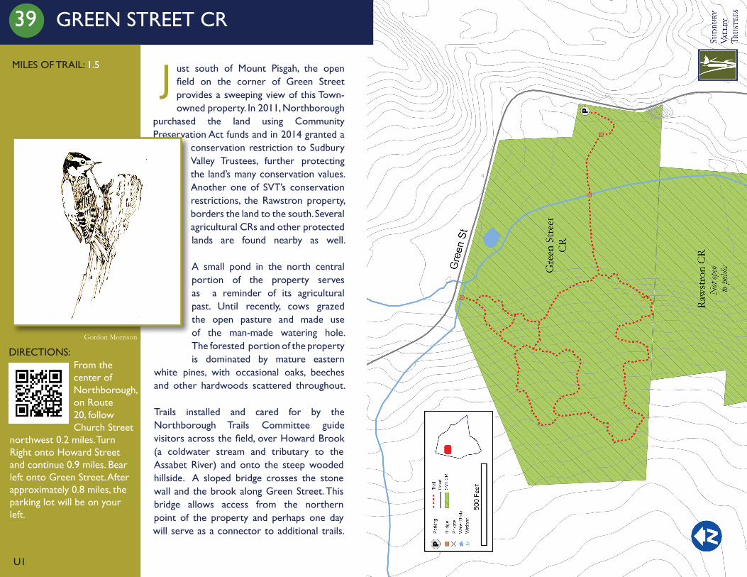
39 GREEN STREET CR
MILES OF TRAIL: 1.5
DIRECTIONS:
U1
From the center of Northborough, on Route 20, follow Church Street
northwest 0.2 miles. Turn Right onto Howard Street and continue 0.9 miles. Bear left onto Green Street. After approximately 0.8 miles, the parking lot will be on your left.
J ust south of Mount Pisgah, the open field on the corner of Green Street provides a sweeping view of this Town-owned property. In 2011, Northborough
purchased the land using Community Preservation Act funds and in 2014 granted a
conservation restriction to Sudbury Valley Trustees, further protecting the land’s many conservation values. Another one of SVT’s conservation restrictions, the Rawstron property, borders the land to the south. Several agricultural CRs and other protected lands are found nearby as well.
A small pond in the north central portion of the property serves as a reminder of its agricultural past. Until recently, cows grazed the open pasture and made use of the man-made watering hole.The forested portion of the property is dominated by mature eastern
white pines, with occasional oaks, beeches and other hardwoods scattered throughout.
Trails installed and cared for by the Northborough Trails Committee guide visitors across the field, over Howard Brook (a coldwater stream and tributary to the Assabet River) and onto the steep wooded hillside. A sloped bridge crosses the stone wall and the brook along Green Street. This bridge allows access from the northern point of the property and perhaps one day will serve as a connector to additional trails.
Gordon Morrison
IA
IA
§̈¦290§̈¦290
RICE A
VE
WHITN
EY ST
BEARFOOT RD
COLBURN ST
HUDS
ON ST
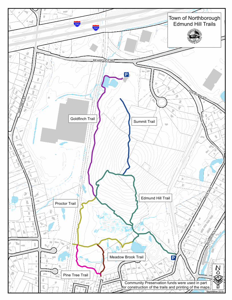
Goldfinch Trail Summit Trail
Proctor Trail
Meadow Brook Trail
Edmund Hill Trail
September 2016
Pine Tree Trail
Town of NorthboroughEdmund Hill Trails
·Community Preservation funds were used in part for construction of the trails and printing of the maps.

IA
IA
IA
IA
!5
!5
Solomon Pond
Assab
etRi
ver
£¤20HUDSON ST
MAIN ST
RICE A
VE
COLBURN ST
BEARFOOT RD
DEACON STSOLOMON POND RD
LITTL
E PON
D RD
BOUNDARY ST
OWL'S POINTPICNIC AREA
BEAVER POINTPICNIC AREA
BIRD SO
NG TRAIL
OLD FARM TRAIL
COYO TETR
AIL
TALL
GRASS TRAIL
Town of NorthboroughYellick & SuAsCo Trails·
0 500250 Feet
Community Preservation funds were used in part for construction of the trails and printing of the maps.
SEPT 2016
STIRRUP BROOKTRAIL

IA
IA
ALGONQUIN REGIONAL
HIGH SCHOOL
M a r l b o r o u g hM a r l b o r o u g h
£¤20
BARTLETT ST
MAIN STHEMLOCK DR
LYMA
N ST
£¤20
Town of NorthboroughStirrup Brook Trail·
Community Preservation funds were used in part for construction of the trails and printing of the maps.
September 2016

!e
!(
"
"
!e!(!(
!(
!e
!( !e
!(
!(
"
"
PNORTHBOROUGH
SOUTHBOROUGH
WESTBOROUGH
MARLBOROUGHBart lett Street
Lyman Street P
P
Bige lowRoad
Haskell St
§̈¦495
!(30
Hospital Road
Crane Swamp
ChauncyLake
LittleCraneSwamp
WalnutHill
CedarHill
RockHill
Aqueduct
P
Wal
ker
St
W
achuset t ViewDr
Lyman
Street
WaterTanks
Beeman RoadP
P
P
Talbot
Trail
Hill
Trai
lC
rane
Sw
amp Tr
ail
Col e Trail Eas t
Talbot Road
SawinkFarm
MWRATreatment
Plant
Sim
aran
oD
rive
PlantationTrail
Saw ink Loop
Conne
ctor
Trai lSmith
St
Fore
st
Ced
arH
illTr
ail
Ce d
arLittle C
ha uncyTrail
WatsonPark
Co
leTr
ailW
est
Crane E sker
Trai
l
Lyman Spur
Crane
Swam
pTrail
CST
LittleChauncy
Pond
Cedar Hill Road
War
d
Road
North borough Road
Talbot T rail
Cra
neSw
amp
Trai
l
MW
RA
Road
O
Crane SwampRegional Trails
0 0.25 0.5 Miles
TrailWestborough Charm BraceletTemporarily Closed for Construction
!( Parking!e Kiosk" Bridge
RailroadPondWetlandSudbury Valley TrusteesDepartment of Fish & GameDCR-Water Supply ProtectionDept of Agricultural ResourcesState HospitalMunicipalSouthborough Open Land Foundation
P
Map by Sudbury Valley Trustees March 2016 www.svtweb.org
SVT wishes to thank its partner, DCR, for permission to maintain trailsthrough their property.
Trail Closedfor Construction

T he Crane Swamp Conservation Area includes 2,225 acres of open space straddling the borders of Northborough, Westborough,
Southborough, and Marlborough. The centerpiece is a high quality 400-acre red maple swamp. The swamp is surrounded by a complex of open fields, wet meadows, ponds, pine plantations, and oak-pine forests, with Cedar Hill to the west and Walnut Hill to the northeast. Such a diverse, high quality and expansive conservation area is a unique treasure in Metrowest Boston.
The properties are owned by a variety of Massachusetts state agencies as well as the Sudbury Valley Trustees (SVT). SVT protected 101 acres of Sawink Farm Res-ervation at the border of Northborough and Westbor-ough in 1992 and the 88-acre drumlin of Cedar Hill in Northborough in 1993. The Department of Conserva-tion and Recreation (DCR) owns Crane Swamp, Little Crane Swamp, and much of Walnut Hill, just north of Sawink Farm Reservation. Westborough State Hospital land extends from Lyman Street to Chauncy Pond, and the Massachusetts Division of Fish & Game owns land which runs west to the Assabet River. Furthermore, the protected watershed helps to preserve the public water supply for 2.5 million people.
This mosaic of different habitats provides for a rich ar-ray of plants and animals, including state-listed species, interior-sensitive forest birds, and species which need to range some distance throughout the year for survival. Wildlife species known to inhabit the conservation area include bobcat, coyote, Red fox, Eastern Cottontail rabbits, Snowshoe hare, White-tailed deer, Barred Owl, Ruffed Grouse, American Woodcock, Spotted turtles and Monarch butterflies.
The four communities of Marlborough, Southborough, Westborough, and Northborough, together with Sudbury Valley Trustees and the Westborough Conservation Land Trust (WCLT) worked with the Massachusetts Water Resources Authority (MWRA) to develop an intercon-nected trail network. Prior to construction of MWRA’s new water treatment plant at Walnut Hill, SVT maintained a connecting trail around the north end of Crane Swamp. As part of the plant construction, the MWRA recreated
CRANE SWAMP REGIONAL TRAILS
LAND PROTECTION NEEDS
Despite the thousands of acres of protected lands within and around Crane Swamp, the development of other lands in the vicinity could put the area’s environmental integrity at risk. Because of the locations of major traffic arter-ies like I-495 and Routes 9 and 135, the towns of Westborough, Southborough, and North-borough have been experiencing tremendous development pressure in recent decades. Some of the most heavily developed areas of Westbor-ough exist in very close proximity to the swamp, and pollutants ranging from roadway and parking area fluid runoff to lawn chemicals take their toll on natural areas. Atlantic white cedar swamp habitat, which is rare in Massachusetts, may be particularly susceptible to the pollution caused by adjacent land uses.
Private land to the northwest of Cedar Hill is vulnerable to development, as is land to the south and southeast of Sawink Farm. Protection of these would create an additional buffer to the most sensitive habitat areas within this complex of lands.
Sudbury Valley Trustees (SVT) is a regional land trust dedicated to the protection of the natural resources and wildlife habitat of the Sudbury, Assabet and Concord river basin. SVT carries out its work through land acquisition and stew-ardship, advocacy, and education throughout a 36-town region. SVT protects and cares for over 100 properties of conservation land that include wetlands, sensitive habitats, trails and other open spaces. SVT reservations are open to the public free of charge. Please consider joining SVT as a member. For more information see www.svtweb.org.
and improved the trail connection around the north side of the swamp. SVT and the WCLT are working on a co-operative agreement with the DCR to establish additional connector trails across the top of Walnut Hill.
CULTURAL HISTORY
The Assabet River powered mills and factories produced wool, cotton, shoes, hats, and bicycles; however, most of the landscape was devoted to agriculture. These were farming communities into the 1930s. Dairies, apple and peach orchards, market gardens, and later greenhouses for carnations were the dominant agricultural commodities.
The four small hills in the area are drumlins, elongated hills of glacial drift. These hills were more commonly used for grazing and fruit trees because the soils are too stony and poorly drained for good crop production. The more level soils, particularly those that remain open today, were probably crop or hay fields supporting local dairy farms and market gardens.
The tract of land now known as Sawink Farm was deeded to Edmund Brigham by his father in August 1762. The son built a house, barn and other buildings there, creating one of early Westborough’s primary farms. The farm in-cluded pastureland for cows, some cropland, and perhaps a wood lot – typical assets of a subsistence farm at the time. The farm went through a succession of owners, including the Walker family, who gave their name to the street that bisects the farm. Michael Sawink inherited the farm from his parents in the late 1940s. Michael wanted to see his land remain as open space. He gifted 35 acres in Northborough to SVT. SVT purchased 66 acres in Westborough with funds provided by Lawrence Walkup, another local farmer. The old house and outbuildings on the two acre tract in the middle of the SVT property are still owned by the Sawink Trust.
CONSERVATION MANAGEMENT
You will observe radical habitat alterations on the south slope of Cedar Hill. Sudbury Valley Trustees is restoring and maintaining early successional shrub habitat on 18 acres. This habitat management is for the benefit of birds
that prefer shrub habitat for nesting and feeding. This management will also benefit other wildlife, butter-flies and insects.
Historically in New England, disturbances like wind, fire, flood, and activities of Native Americans and European settlers – burning, farming, grazing and logging- cre-ated large and small forest openings. Grasses or shrubs dominated during early succession. Many wildlife species, especially birds, require shrubland habitat for foraging, nesting, and cover. Shrublands were part of a dynamic landscape of diverse habitat types. As one opening revert-ed to forest, another was created, so shrubland bird popu-lations were maintained. Availability of early successional shrubland habitat in New England is declining, as former agricultural lands succeed to forest or are developed. These shrubland species are experiencing more consis-tent declines than species that breed in mature forest. For example, six of the ten most rapidly declining bird species in Massachusetts, according to the National Breeding Bird Survey, are early successional species (Brown Thrasher, Eastern Meadowlark, Eastern Towhee, Northern Bob-white, American Kestrel and Field Sparrow). Birds ben-efiting from this management at Cedar Hill include the Eastern Towhee and the Blue-winged Warbler.
SVT is also working to combat the invasion of alien plants. We will be doing selective herbiciding of invasive plants in the newly cleared area. Our ultimate goal is to foster growth of native shrubs, such as Arrowwood and Highbush blueberry. You may notice a cleared patch in the woods on the north slope of Cedar Hill, near large Sugar maple trees. This is an area in which we are experimenting with the removal and control of Japanese barberry, an invasive shrub.
Illustration by Joyce Dwyer
18 Wolbach RoadSudbury, MA 01776
978-443-5588www.svtweb.org
Illustration by Joyce Dwyer
We welcome you to enjoy the trails for walking, skiing, snowshoeing, nature study, photogra-phy, and other quiet activities. Please carry out everything you carry in.
In order to protect this natural area, the following are prohibited: • Motorized Vehicles • Hunting or Trapping* • Camping • Bicycling** • Fires • Disposing of Trash or Yard Waste • Cutting or Removing Plants * Hunting is allowed on state Fish & Game land ** Bicycling is allowed on state Fish & Game land
RULES AND REGULATIONS
DIRECTIONS
Cedar Hill, Marlborough/NorthboroughFor the north entrance, take Route 495 to exit 23C (Simarano Drive exit). Continue to the lights at the end of the exit ramp. Take a left at the lights onto Simarano Drive. Continue to another set of lights and take a right onto Cedar Hill Street. Parking for the reservation is at the Scholastic Book Fairs at 360 Cedar Hill Street. The entrance will be on your left across from Forest Street. There is ample parking, labeled with SVT signs, immediately on your right. A trail easement, marked by posts and SVT markers leads around the wetlands and to a kiosk behind Scholastic Book Fairs.Sawink Farm, WestboroughFrom route 495 take the route 9 west exit 34B. Follow route 9 west approximately 1.1 miles to the route 30 east (E. Main St.) exit. Bear right onto East Main Street. Continue approximately one mile to Walker Street on the left. Turn left on Walker Street and continue down the hill to the SVT sign and a small grass parking lot on the right.
IA
IA
ST135
SOUT
H ST
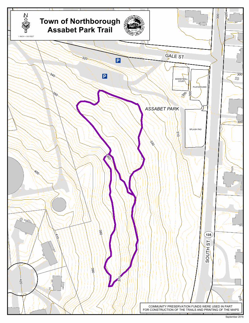
GALE ST320
310
330
340
350
360
370
380
390
400
410
420
300
300
300
310
300
300
300
September 2016
BASKETBALLCOURT
COMMUNITY PRESERVATION FUNDS WERE USED IN PART FOR CONSTRUCTION OF THE TRAILS AND PRINTING OF THE MAPS
SPLASH PAD
PLAYGROUND
ASSABET PARK
Town of NorthboroughAssabet Park Trail·
1 INCH = 100 FEET

IA
£¤20
W MAIN
ST
WEST ST
CHURCH ST
CRAW
FORD
ST
LINCO
LN S
T
PLEASANT ST
FISHER ST
BREW
ER ST
PINEHAVEN DR
INCREASE WARD DR
Town of NorthboroughCold Harbor Trail
·Community Preservation funds were used in part for construction of the trails and printing of the maps.
September 2016
Beav
er Loop

Town of NorthboroughJubilee Trail·
0 15075Feet
Community Preservation funds were used in part for construction of the trails and printing of the maps.
September 2016
JUBILEE RD
CRAWFORD ST
WEST MAIN ST