open geospatial consortium meteorology and oceanography ... · •a first proposal for the time...
TRANSCRIPT
Copyright © 2009, Open Geospatial Consortium, Inc.Copyright © 2009, Open Geospatial Consortium, Inc.
Open Geospatial Consortium Open Geospatial Consortium
Meteorology and Oceanography Meteorology and Oceanography
Domain Working Group Domain Working Group
progress report progress report
Thirteenth Workshop on Meteorological Operational Systems
ECMWF November 2011
Marie-Françoise Voidrot-Martinez, Co-chair OGC Met Ocean DWG

Helping the World to Communicate
Geographically
Copyright © 2009 Open Geospatial Consortium
The questions….
• What
– OGC
– Interoperability
• Why a Met Ocean Domain Working Group
• How
• Where are we ? : progress report

Helping the World to Communicate
Geographically
Copyright © 2009 Open Geospatial Consortium
3
What is the Open Geospatial Consortium : OGC ? What is the Open Geospatial Consortium : OGC ?
• A non-profit international organization founded in 1994,
• Develop publicly available interface standards for geospatial
data and services
• Based on consensus from governments, private Industry,
Academia, NGOs
• Some standards fast tracked in ISO
• The aim : ensure interoperability for geospatial data and
services
Copyright © 2009 Open Geospatial Consortium, Inc.

Helping the World to Communicate
Geographically
Copyright © 2009 Open Geospatial Consortium
Interoperability
INTEROPERABLE
BARRIERS
Interoperability allows to open your information system
- In input : to meteorological or non meteorological data
- In output : towards other informations systems
Helping the World to Communicate
Geographically
Copyright © 2009 Open Geospatial Consortium
© 2010 Open Geospatial Consortium, Inc.
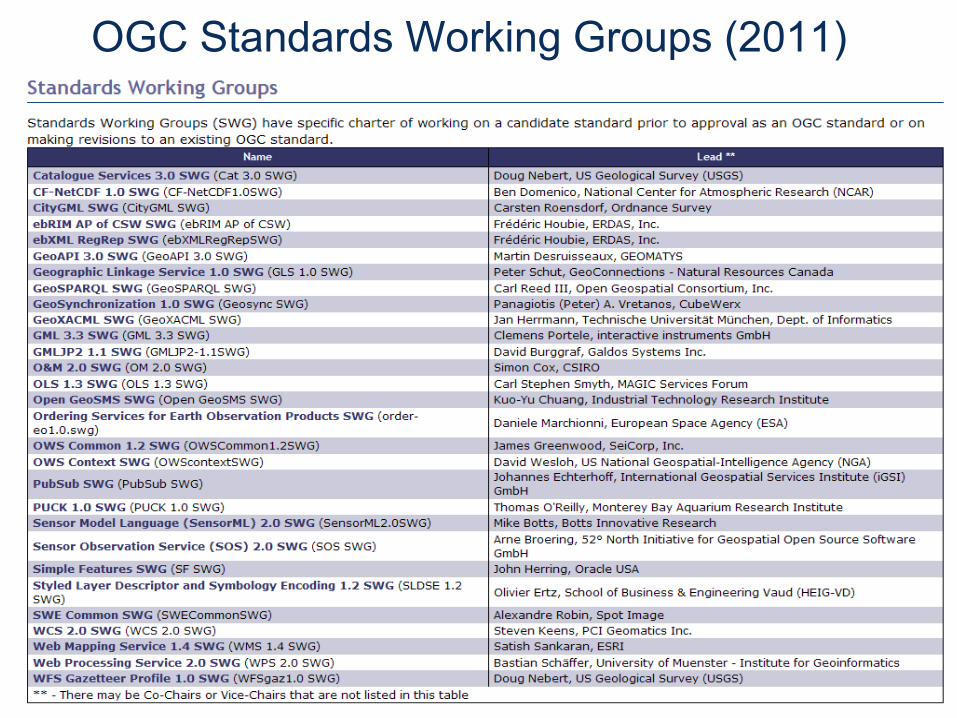
OGC Standards Working Groups (2011)
Helping the World to Communicate
Geographically
Copyright © 2009 Open Geospatial Consortium
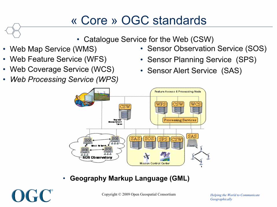
« Core » OGC standards
• Web Map Service (WMS)
• Web Feature Service (WFS)
• Web Coverage Service (WCS)
• Web Processing Service (WPS)
• Sensor Observation Service (SOS)
• Sensor Planning Service (SPS)
• Sensor Alert Service (SAS)
• Catalogue Service for the Web (CSW)
• Geography Markup Language (GML)

Helping the World to Communicate
Geographically
Copyright © 2009 Open Geospatial Consortium
© 2010 Open Geospatial Consortium, Inc.
OGC Domain Working Groups (2011)
Copyright © 2009, Open Geospatial Consortium, Inc.

Helping the World to Communicate
Geographically
Copyright © 2009 Open Geospatial Consortium
Why
1. INSPIRE recommends to use ISO or OGC standards
2.After some WS implementations in Met services, it
appeared clearly that these implementations present a
very high risk to be non interoperable
IF
we don’t agree on best practices recommendations

Helping the World to Communicate
Geographically
Copyright © 2009 Open Geospatial Consortium
Met Ocean Domain Working Group
• 2007 : proposal from the ECMWF MOS workshop to do a
workshop on the use of GIS/OGC standards in Met
• 2008 : GIS/OGC standards in Met workshop recommended to
create a Met Ocean DWG within OGC
• 2009 :
– April : Creation of the Met Ocean Domain Working Group within OGC,
rapidly extended to Oceanography
A public email list open to everyone (OGC member or not) set up :
https://lists.opengeospatial.org/mailman/listinfo/meteo.dwg
A twiki space set up :
http://external.opengis.org/twiki_public/bin/view/MeteoDWG/WebHome
– December : MoU between OGC and WMO

Helping the World to Communicate
Geographically
Copyright © 2009 Open Geospatial Consortium
Met Ocean Domain Working Group
• 2010/2011 : Works
1. Communication towards OGC Standard Working Groups
2. Communication towards the Met Ocean Community
3. Modelling activities
4. WMS best practices
5. Interoperability experiments (« to test solutions in reality »)
Helping the World to Communicate
Geographically
Copyright © 2009 Open Geospatial Consortium
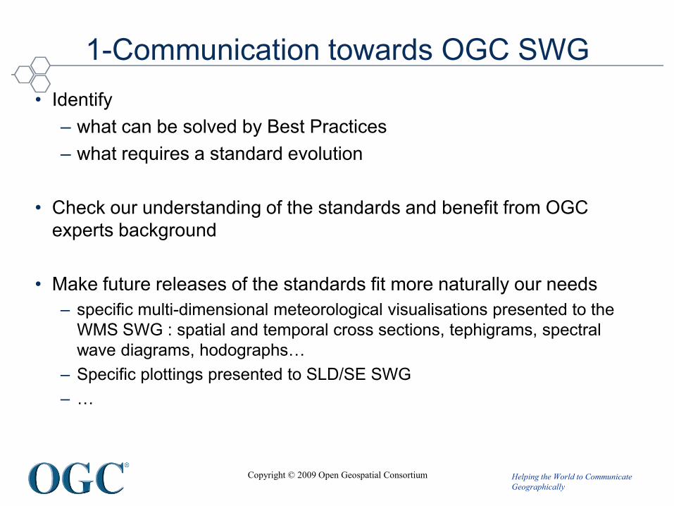
1-Communication towards OGC SWG
• Identify
– what can be solved by Best Practices
– what requires a standard evolution
• Check our understanding of the standards and benefit from OGC
experts background
• Make future releases of the standards fit more naturally our needs
– specific multi-dimensional meteorological visualisations presented to the
WMS SWG : spatial and temporal cross sections, tephigrams, spectral
wave diagrams, hodographs…
– Specific plottings presented to SLD/SE SWG
– …

Helping the World to Communicate
Geographically
Copyright © 2009 Open Geospatial Consortium
WMO / Met Ocean DWG main Interests
• WMS – Currently Proactive
– Time – proposals now documented
– Elevation
– Map Projections
– SLD/SE – Aviation SigWx and standard WMO Plots Use Cases
– Tiling – WMTS now a separate standard – jigsaw edges
• Conceptual Modelling - Currently Proactive
– WXXM
– GML3.2.1, KML2.2
• WCS/WFS –- Currently Reactive
– 4D, CRS,
– payload formats,
– vector vs raster
• CSW – compatibility with ISO23950, OpenSearch - Currently Reactive
• O&M, SWE increasing in importance - Currently Passive

Helping the World to Communicate
Geographically
Copyright © 2009 Open Geospatial Consortium
2- Communication towards the Met Ocean
community
• In workshops (ECMWF, EGOWS, GIS/OGC
standards in met…,)
• Via the twiki,
• Via the email list,
• Via the teleconferences
Helping the World to Communicate
Geographically
Copyright © 2009 Open Geospatial Consortium
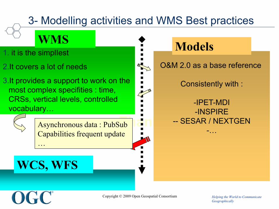
3- Modelling activities and WMS Best practices
Thank you
1. it is the simplIest
2.It covers a lot of needs
3.It provides a support to work on the
most complex specifities : time,
CRSs, vertical levels, controlled
vocabulary…
WMS
O&M 2.0 as a base reference
Consistently with :
-IPET-MDI
-INSPIRE
-- SESAR / NEXTGEN
-…Asynchronous data : PubSub
Capabilities frequent update
…
WCS, WFS
Models

Helping the World to Communicate
Geographically
Copyright © 2009 Open Geospatial Consortium
3- Modelling : INSPIRE : Three drafts
• Atmospheric Conditions –Meteorological Features draft
• http://inspire.jrc.ec.europa.eu/documents/Data_Specifications/INSPIRE_DataS
pecification_AC-MF_v2.0.pdf
• Sea Regions draft
• http://inspire.jrc.ec.europa.eu/documents/Data_Specifications/INSPIRE_DataS
pecification_SR_v2.0.pdf
• Oceanographic geographic Feature draft :
• http://inspire.jrc.ec.europa.eu/documents/Data_Specifications/INSPIRE_Data
Specification_OF_v2.0.pdf
End of review and testing :
21 Octobre 2011Will impact European
Implementations of web servers
for environnemental providers
Helping the World to Communicate
Geographically
Copyright © 2009 Open Geospatial Consortium
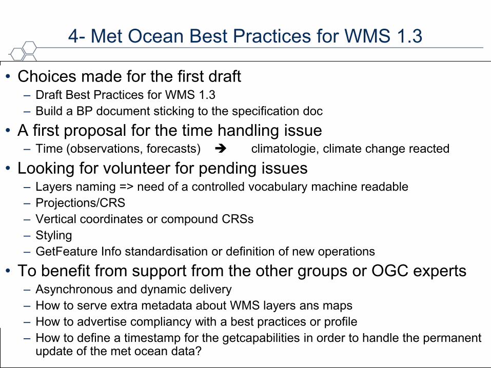
4- Met Ocean Best Practices for WMS 1.3
• Choices made for the first draft– Draft Best Practices for WMS 1.3
– Build a BP document sticking to the specification doc
• A first proposal for the time handling issue– Time (observations, forecasts) climatologie, climate change reacted
• Looking for volunteer for pending issues – Layers naming => need of a controlled vocabulary machine readable
– Projections/CRS
– Vertical coordinates or compound CRSs
– Styling
– GetFeature Info standardisation or definition of new operations
• To benefit from support from the other groups or OGC experts– Asynchronous and dynamic delivery
– How to serve extra metadata about WMS layers ans maps
– How to advertise compliancy with a best practices or profile
– How to define a timestamp for the getcapabilities in order to handle the permanent update of the met ocean data?
Helping the World to Communicate
Geographically
Copyright © 2009 Open Geospatial Consortium
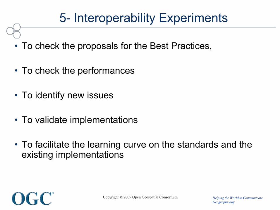
5- Interoperability Experiments
• To check the proposals for the Best Practices,
• To check the performances
• To identify new issues
• To validate implementations
• To facilitate the learning curve on the standards and the existing implementations
Helping the World to Communicate
Geographically
Copyright © 2009 Open Geospatial Consortium
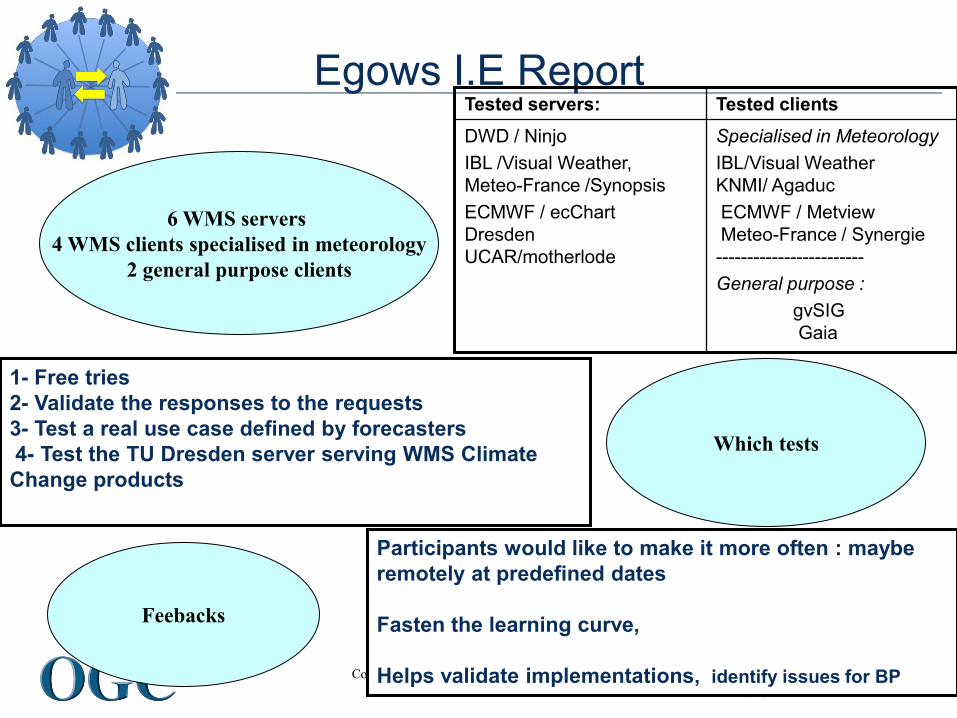
Egows I.E ReportTested servers: Tested clients
DWD / Ninjo
IBL /Visual Weather,
Meteo-France /Synopsis
ECMWF / ecChart
Dresden
UCAR/motherlode
Specialised in Meteorology
IBL/Visual Weather
KNMI/ Agaduc
ECMWF / Metview
Meteo-France / Synergie
------------------------
General purpose :
gvSIG
Gaia
1- Free tries
2- Validate the responses to the requests
3- Test a real use case defined by forecasters
4- Test the TU Dresden server serving WMS Climate
Change products
Which tests
Feebacks
Participants would like to make it more often : maybe
remotely at predefined dates
Fasten the learning curve,
Helps validate implementations, identify issues for BP
6 WMS servers
4 WMS clients specialised in meteorology
2 general purpose clients

Helping the World to Communicate
Geographically
Copyright © 2009 Open Geospatial Consortium
Metview WMS Client – KNMI satellite and radar layersType of product : Radar composite image overlayed on top of Geostationnary Satellite
WMS implementation issues : time definition, transparency

Helping the World to Communicate
Geographically
Copyright © 2009 Open Geospatial Consortium
Metview WMS Client – Meteo-France satellite and radar layersType of product : Radar composite image overlayed on top of Geostationnary Satellite
WMS implementation issues : time definition, threshold for the radar echos, transparency

Helping the World to Communicate
Geographically
Copyright © 2009 Open Geospatial Consortium
Ninjo Client- Meteo-France radar layer Type of product : Radar product
WMS implementation issues : time definition
Helping the World to Communicate
Geographically
Copyright © 2009 Open Geospatial Consortium
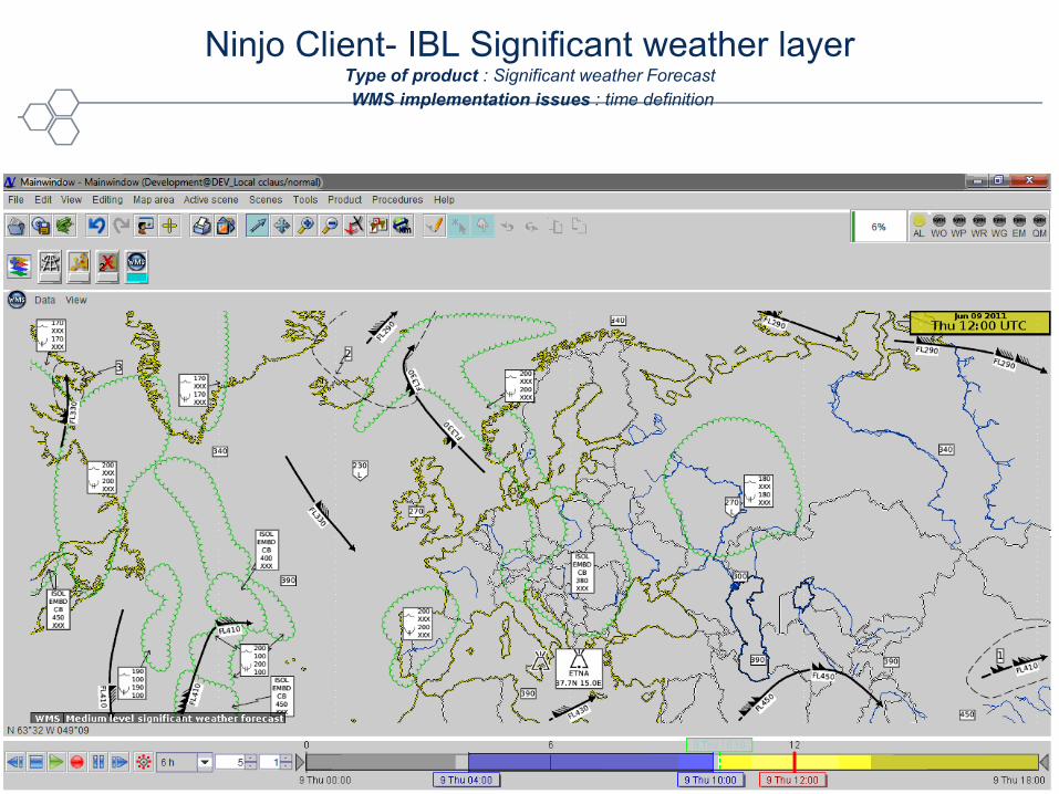
Ninjo Client- IBL Significant weather layerType of product : Significant weather Forecast
WMS implementation issues : time definition

Helping the World to Communicate
Geographically
Copyright © 2009 Open Geospatial Consortium
Ninjo Client- ECMWF WMS layersExtreme Forecast Index
Type of product : climate change simulations
WMS implementation issues : time definition, transparency

Helping the World to Communicate
Geographically
Copyright © 2009 Open Geospatial Consortium
Ninjo Client- KNMI satellite layer with legend Type of product : Satellite product
WMS implementation issues : time definition, transparency
Helping the World to Communicate
Geographically
Copyright © 2009 Open Geospatial Consortium
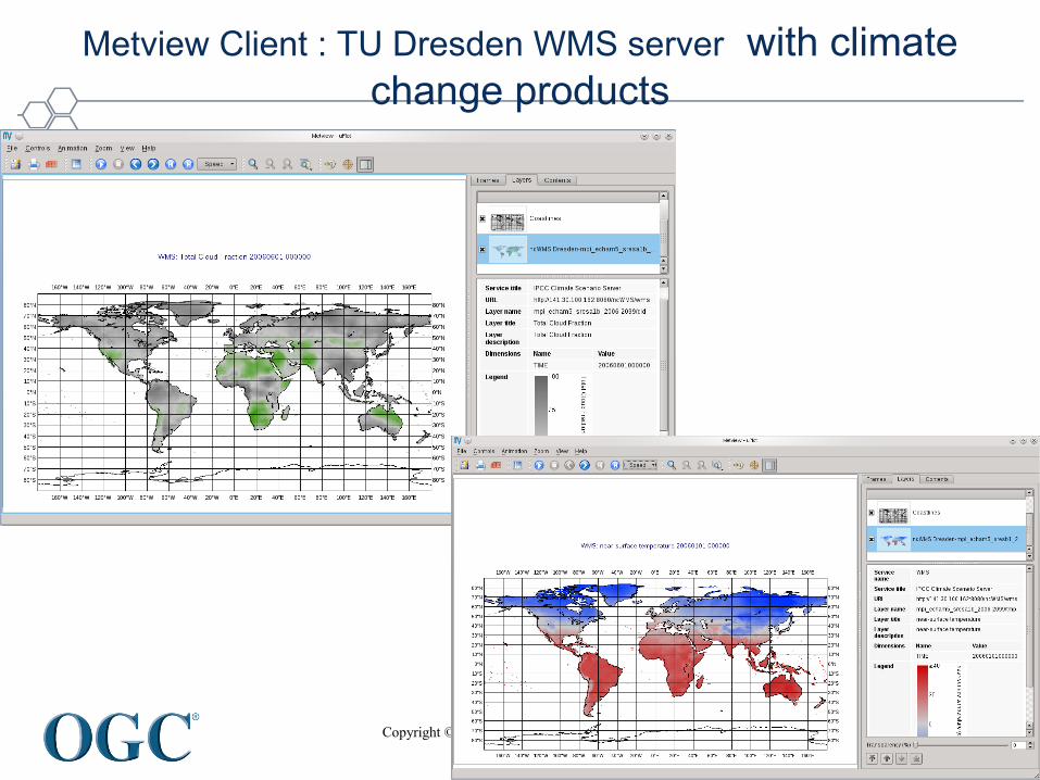
Metview Client : TU Dresden WMS server with climate
change products

Helping the World to Communicate
Geographically
Copyright © 2009 Open Geospatial Consortium
ECMWF
IHM layer
Graphic layer
Fat Client
Data layer
Data Server
RMDCN
Internet
OGC Webservices
IHM Layer
Client
Graphic layer
Data layer
Server
Validation
comparing a WMS with a fat client display
Helping the World to Communicate
Geographically
Copyright © 2009 Open Geospatial Consortium
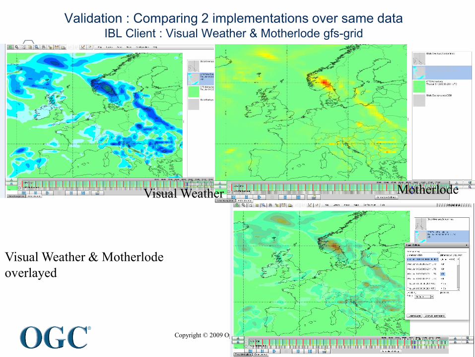
Validation : Comparing 2 implementations over same dataIBL Client : Visual Weather & Motherlode gfs-grid
Visual Weather Motherlode
Visual Weather & Motherlode
overlayed
Helping the World to Communicate
Geographically
Copyright © 2009 Open Geospatial Consortium
Roadmap
Helping the World to Communicate
Geographically
Copyright © 2009 Open Geospatial Consortium
Next steps
• Met Ocean DWG telecon: check the twiki
• Next OGC Technical Comittee in Brussels, End November 2011 : a new best practices wording for the time handling, then vertical levels, …
• A 4th Workshop on the use of GIS/OGC Standards in Meteorology maybe in NOAA Washington next spring (to be confirmed)
• More Experiments
Helping the World to Communicate
Geographically
Copyright © 2009 Open Geospatial Consortium
Conclusion
• Public Websites :
– OGC : (Standards, Programs, Press and Events announcements…)http://www.opengeospatial.org/
– Met Ocean DWG Twiki :http://external.opengeospatial.org/twiki_public/bin/view/MetOceanDWG/WebHome
– Met Ocean DWG email list :https://lists.opengeospatial.org/mailman/listinfo/meteo.dwg
• Meetings, Teleconferences
The working means are efficient
The charter is done, the OGC-WMO MoU is there
We need manpower

Helping the World to Communicate
Geographically
Copyright © 2009 Open Geospatial Consortium
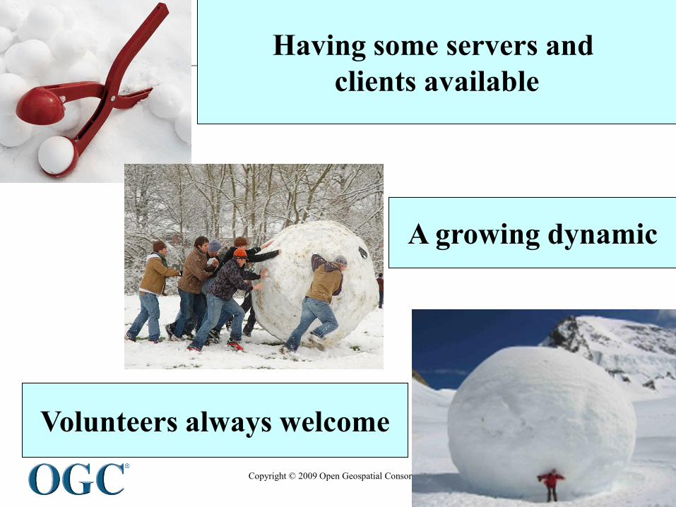
A blooming of servers
Helping the World to Communicate
Geographically
Copyright © 2009 Open Geospatial Consortium
Having some servers and
clients available
A growing dynamic
Volunteers always welcome