open spaces as learning places water... · web viewcold water retains dissolved oxygen better than...
TRANSCRIPT

KeyRed writing: added or altered textBlue Writing: still needs revisionsBlack writing: original text from OSaLP
OPEN SPACES AS LEARNING PLACESTABLE OF CONTENTS
INTRODUCTION..............................................................................................................1How to Use This Manual...............................................................................................3
RIVER UNIT..................................................................................................................159Classroom Activities..................................................................................................168Outdoor Activities......................................................................................................175Focus Activities.........................................................................................................177Handouts, Worksheets & Review Sheets...................................................................182
POND/UNIT...................................................................................................................195Classroom Activities..................................................................................................207Outdoor Activities......................................................................................................214Focus Activities.........................................................................................................220Handouts, Worksheets & Review Sheets...................................................................225
CITED REFERENCES.................................................................................................286
INTRODUCTION
This document is a unique educational resource. It is the Watersheds as Learning Places curriculum guide, which is a subset of the Open Spaces as Learning Places, a New Haven based environmental education program created by the Urban Resources Initiative (URI). Inside its pages you will find a synthesis of the lessons learned through years of hands-on experience with New Haven students and current educational theories.
This Watersheds as Learning Places curriculum guide contains hands-on activities and experiments based around understanding urban watersheds and aquatic ecosystems. Over the course of these lessons students will explore New Haven’s rivers, ponds, and estuaries.
New Haven Urban Resources Initiative Open Spaces as Learning Places was developed by the New Haven Urban Resources Initiative (URI). URI is a non-profit organization that works in partnership with the Yale School of Forestry and Environmental Studies and community groups to revitalize New Haven neighborhoods. The primary vehicle to achieve this mission is the Community Greenspace program, which supports community restoration and stewardship of vacant lots, public parks, and other urban open spaces. URI also engages in school and youth outreach programs, which are aimed at educating students in New Haven public schools about the urban ecosystem and their role as stewards. Since URI was founded in 1991, URI staff, board members and Yale School of Forestry and Environmental Studies interns have engaged in a variety of environmental education initiatives. In fact, since 1991, URI has worked with more than 2,500 students from 20 schools to study wildlife and ecosystems, create nature trails and beautify and restore their school grounds and neighborhoods.
Despite the success of these endeavors in educating local youth and training interns, there was a belief amongst the URI staff and its board that an educational program that directly utilized URI’s greenspace sites would create an important synergy between the Greenspace and education programs. That is, exposing students to these ecologically unique spaces represented an invaluable learning experience and, in turn, this usage would increase the value of the Greenspace program. As a URI board member and the coordinator of many of URI’s prior educational endeavors, Susan Foster Swensen was the ideal person to develop this initiative. Her unique understanding of the goals of URI and the tools needed to produce an effective EE program guided her in the creation of Open Spaces as Learning Spaces, a program that exposes students from a variety of New Haven schools to their local open spaces, including a URI greenspace site.

In the spring of 2001, under the guidance of Ms. Foster Swensen and a Yale School of Forestry and Environmental Studies intern, URI piloted the Open Spaces program at Worthington Hooker and East Rock Elementary schools. The tremendous response from both teachers and students led to the addition of URI staff (Mary Alice Lassiter and Justin Pegnataro) to continue instruction at many New Haven schools from 2001 – 2008.
Rather than using traditional examples of large-scale, distant environmental phenomena such as “the hole in the ozone layer” or “the rainforests in Brazil” as curricular material, Open Spaces as Learning Places aims to connect New Haven youth to their local environment. Additionally, the program also teaches students the scientific knowledge that they need to understand the implications of environmental hazards such as the introduction of contaminants into the water system or the elimination of a species from the food web. In 2007, working closely with New Haven Board of Education Science Curriculum Supervisor, Richard Therrien, URI staff began to intensively train 6th grade teachers on both the river and pond units from the Open Spaces as Learning Places curriculum, as these particular units best meet the science standards established by the New Haven Board of Education. These two units comprise this Watersheds as Learning Places curriculum guide. Four other units from the Open Spaces as Learning Places curriculum (nature in the schoolyard, a vacant lot, a local park, and a cemetery) can be downloaded for free from the URI website (www.yale.edu/uri).
HOW TO USE THIS MANUAL
Each unit begins with a Unit Summary that briefly describes that unit’s materials. This summary will help you to quickly locate specific activities or handouts. The units all contain the following seven components:
1. Learning Objectives and Standards. The objectives for each unit are grouped according to the type of assessment tool provided for evaluating student achievement (see additional information on assessment below). Some objectives may be achieved through a series of lessons, while others are specific to certain activities. The learning objectives were designed to reflect the standards of the New Haven Public Schools’ (NHPS) Curriculum Framework. Following the list of objectives is a standards table that links each unit activity to the NHPS sixth grade content and performance standards that it addresses. (The NHPS Curriculum Framework incorporates both national and Connecticut state standards, and is available on the Internet at <http://www.nhps.net>). The Standards are grouped by subject area and are numbered according to the NHPS Curriculum Framework.
2. Background Information. These pages provide you, the teacher, with information about the general ecological concepts presented in the unit. Not only will the background information provide you with a deeper understanding of the material to be covered in the unit, it can be used as a reference for extending the curriculum activities.

3. Activities. The units all include three lessons: Classroom, Outdoor and Focus. Each lesson is designed to take about 1½ to 2 hours. Within the lessons are a series of activities. For each of these activities, there is a short objective statement, the approximate amount of time needed to perform the activity, a list of materials, and instructions for preparing and conducting the activity.
4. Handouts and Worksheets. Throughout the curriculum, you will be referred to handouts and worksheets that correspond with specific activities. Handouts contain additional information that you or your students may need to conduct an activity. They are pages that can be collected after an activity and re-used in another class. Worksheets are to be photocopied and distributed to students for them to complete. Worksheets can be collected and used to assess student performance.
5. Assessment and Review Sheets. You will find an assessment after the end of the focus lesson and one or more review sheets at the end of each unit. These can be used for student assessment. The exercises on the Review sheets correspond to the learning objectives for each unit, and review many of the important concepts covered in the unit. Appropriate times to use the review sheets (as homework or completed as a class or with partners) are noted in the curriculum. An alternative way to use these sheets is to group them together and administer them as a test at the end of the unit.

Watersheds asLearning Places
RIVER UNIT

RIVER UNIT SUMMARYThe river unit makes regional connections, showing how watersheds join together urban communities and suburban towns to open space areas. Students study stream dynamics to see how water shapes the Earth’s surface. After learning that water is a limited resource, students identify sources of pollution that threaten local rivers. After a canoe trip on a nearby river, the children explore adjacent wetland habitats rich with wildlife, gaining an appreciation for the importance of these natural areas to people, animals and the whole environment.
LEARNING OBJECTIVES............................................................................................161CONTENT STANDARDS CHARTS………………..BACKGROUND INFORMATION................................................................................166CLASSROOM ACTIVITIES..........................................................................................168
The Water Planet.........................................................................................................168The Water Cycle..........................................................................................................169New Haven's Rivers and Harbor……………………………………….
Watershed Boundaries…………………………………………Dig In (Embedded Performance Task)……………………………….

Freshwater Model........................................................................................................170Fred the Fish................................................................................................................171
OUTDOOR ACTIVITIES...............................................................................................174Canoe Trip...................................................................................................................175
FOCUS ACTIVITIES.....................................................................................................177River Cutters................................................................................................................177
ASSESSMENT................................................................................................................181River Rhythms.............................................................................................................181
HANDOUTS, WORKSHEETS & REVIEW SHEETS..................................................182Form 1.1 River Canoeing Permission SlipHandout 4.1 Fred the Fish.......................................................................................182Handout 4.3 River Features Handouts....................................................................187Worksheet 4.1 Mobius Ring....................................................................................188
Worksheet 4.4 Green Map Worksheet Worksheet 4.2 River Poetry.....................................................................................190Review Sheet 4.1 River Review..............................................................................191Review Sheet 4.2 Wonderful Watersheds...............................................................193
RIVER UNIT: LEARNING OBJECTIVES
Assessment
Students demonstrate their writing skills through the composition of a poem about the river that they visited.
Worksheets/Reviews
Students demonstrate understanding that water can exist in a solid, liquid and gaseous state. They will be able to identify examples of water in each of the three states. Review Sheet 4.1-River Review
Students can describe the water cycle. Worksheet 4.1-Mobius Ring

Students can identify and describe the way that human actions change the environment, including deforestation and erosion, pollution, the construction of dams and tide-gates. Review Sheet 4.2-Wonderful Watersheds
Students demonstrate an understanding of river ecosystems and the organisms that inhabit them. Review Sheet 4.1-River Review
Students describe the function of water in the process of erosion and creation of rivers. Review Sheet 4.2-Wonderful Watersheds
Classroom Performance
Students listen and respond to presentations by looking at the speaker and asking relevant questions.
Students understand that freshwater is an important resource provided by the environment that meets the needs of human beings and that its supply is finite.
Students can identify the consequences of pollution on the quality of life for all (humans and wildlife).
Students recognize that the interconnectedness of the environment means that human actions may have unanticipated effects.
Students use their observation skills in the classroom and out of doors.
Students recognize the impacts that urbanization has had on New Haven’s environment including the filling in of wetlands.
Students work cooperatively with their peers to meet new challenges, including paddling together in a canoe.
Students observe the function of water in the formation of a variety of landscape features.
Students demonstrate cooperation and respect for peers (with like and with different skill levels) when paddling in a canoe.
Students demonstrate competency in paddling a canoe.

Students work cooperatively as a member of a team on challenges that include tracking wildlife in the park and creating “rivers” in the classroom.
Students contribute to discussions on the trade-offs and consequences associated with technological solutions to human problems (such as dams) on the environment.
Students can relate fractions to pictures and vice versa.


RIVER UNIT: BACKGROUND INFORMATIONIn the river unit, students see that the local environment is connected to distant communities by watersheds. The children use models to explore large-scale concepts, learning how water cycles through natural systems and reshapes the environment. They manipulate watershed models by introducing human factors that alter and degrade river and wetland areas. Field study reinforces watershed concepts and helps students develop an appreciation for the beauty and vulnerability of river systems. Students learn how their actions impact the natural world and recognize that they have the power to make a difference.
Earth is called the water planet because 71% of its surface is covered with water. Water exists in many different forms and in many different places. Depending on the temperature, water can be a liquid, a solid or a gas. There are two main kinds of water: saltwater which is found in oceans, seas and saltwater lakes and marshes; and freshwater which is in ponds, lakes, streams, rivers, freshwater wetlands and underground. Only 3% of Earth’s water is freshwater (the remaining 97% is saltwater) with most of it frozen in ice caps and glaciers (80% of all freshwater) or unavailable because it is too far underground, polluted or trapped in soil. A very small amount (only 0.00003% of the total amount of water on Earth) represents clean, freshwater found in surface water or groundwater aquifers. The majority of our drinking water (95%) comes from groundwater — water that has infiltrated the soil and percolated down to the saturated zone beneath the water table. The average American uses 200 gallons of water per day.
Water is a finite resource and a major limiting factor for life on Earth. The water that we have today is all we will ever have. Water circulates back and forth from the atmosphere to Earth’s surface. Water evaporates into the atmosphere, condenses to clouds, comes down as precipitation and then follows many different routes. Water runs off or falls directly into surface water, infiltrates and percolates down to become groundwater or is taken up by plants before transpiration returns it to the atmosphere. Pollution threatens water quality as water cycles through natural systems heavily impacted by humans. Construction sites, factories, paved surfaces, storm drains, lawns and farms are human-related features that degrade the aquatic environment with sediments, fertilizers, chemicals, trash, gasoline and oil.
Wetlands are natural environmental purifiers that improve water quality by acting as sediment traps and by filtering out and absorbing many pollutants. Wetlands also help recharge groundwater aquifers and provide flood control by capturing, storing, and slowly releasing storm runoff. In addition, wetlands offer coastal protection, serving as buffer zones between open water and land. Filled with nutritious food and protective cover, wetlands represent incredibly productive habitats for a wide range of plants and animals, including many endangered species.
Wetlands are delineated based on: 1) hydric (saturated) soils; 2) hydrophytic (water tolerant) plants; and, 3) a distinct hydrologic pattern in which the water level rises periodically to just above or just below the ground’s surface. Historically, wetlands were viewed as wasted lands - soggy, inaccessible, mosquito-infested areas that stood in the

way of progress and development. A lot of effort went into draining, dredging and filling wetlands to transform them into “useful” property. In recent years, wetlands have started to be recognized as an asset to people, wildlife and the environment as a whole. Federal and state legislation now supports the need to protect, preserve and manage these important natural resources.
Water in wetlands, lakes, ponds, rivers, streams and underlying groundwater is connected to the surrounding landscape. The drainage area between ridges or topographic high points is called a watershed. Gravity forces precipitation that does not infiltrate the soil to flow downhill and run off into waterways in the watershed. Harmful human activities in the interconnected watershed can have far reaching effects that degrade surface water areas and underground aquifers.
Identifying sources of pollution is the first step in controlling pollution. Some pollution, known as point source pollution comes from specific sources such as outfalls (drains, pipes, industrial discharge, etc.). Other kinds of pollution arise from widespread sources and are called nonpoint source pollution (pesticides, road runoff).
Water reshapes the landscape as it flows through a watershed. The moving and scraping of rock and soil as water runs over land is called erosion. Over time, distinctive morphologic features emerge as a watercourse carves the landscape. The source or the beginning of a river is often associated with a spring, wetland or melting snow and ice. The mouth of a river or its destination might be a pond, lake, wetland, stream or ocean. Time and terrain affect the shape of a river. Faster flowing, younger streams at higher elevations tend to take a straighter course, while slower, older rivers on flatter terrain follow a wavy pattern made up of s-shaped curves called meanders. Occasionally, a river bisects a meander for a shorter, less circuitous route, creating an isolated body of water known as an oxbow lake. Watersheds often exhibit a dendritic drainage pattern with smaller waterways connecting like branches to a larger river at the heart of the watershed. These large watercourses usually flow into a bay or an ocean or join up with another river that eventually connects to the ocean. A stream or river that feeds into another waterway is called a tributary.
Earth’s surface is continuously being reshaped by water. The hydrologic cycle is an integral part of stream dynamics and the changing landscape. It balances precipitation, runoff, evaporation, transpiration and groundwater recharge through percolation and infiltration. Within a watershed, water connects human communities to natural systems, creating a balance that is essential to life. Harmful human practices tip the scale, degrading the environment in ways that impact global vitality.
RIVER UNIT:CLASSROOM ACTIVITIESCLASSROOM ACTIVITY ONE
Title: The Water PlanetObjectives: Students will develop an understanding of the distribution of water and
recognize freshwater as a limited resource.Time: 15 minutesMaterials: Clear gallon container, clear plastic cup, clear half-cup measure, water, salt,
inflatable globe, ice cubes and a thermos of hot waterPreparation: Fill the gallon container with water.Procedure: Begin by explaining that Earth is called the water planet because two-thirds to three-
quarters of it is covered by water. Toss the globe around to different students and have them freeze after catching it with both hands. Check to see if their fingers are touching water. Show them how much water is on the planet by pointing out that every time the globe was caught, a student’s hand was on water.
Discuss how water exists in many different forms and in many different places. Depending on the temperature, water can be a liquid (point to the gallon jug), a solid (hold up the ice cubes) or a gas (open up the thermos to let out some steam). Frozen water is found in cold places on the tops of mountains and at the polar ice caps (point to the globe) and water as a gas is all around us in the atmosphere (wave your hands). Ask the students to think of places where there is liquid water (ponds, lakes, rivers, streams, ocean, seas, underground, etc.)
Describe how there are two main kinds of water on Earth, saltwater and freshwater. Ask the students where you find saltwater (oceans, seas, saltwater lakes, etc.). Tell them that 97% of all the water on the planet is salt. Toss the globe around again to show how much of Earth is covered by saltwater. When you check hands on the globe to see if they are on water, identify the location of the fingers and specify if they are touching fresh or saltwater.
Show that freshwater is a limited resource by using the gallon container of water as a model for all the water on Earth. Remind the students that only three percent is freshwater. Pour one-half cup water from the gallon container into the measuring cup, telling them that the water in the measuring cup represents all the freshwater on the planet. Add some salt to the gallon jug to emphasize that most of the water is salt and only a little is fresh. Ask the students if they would like a drink of water from the gallon jug of saltwater. Explain that saltwater can only be used as drinking water when the salinity has been removed. The process is time consuming and costly.
Point out that not only is a very small percentage of the Earth’s water fresh but most of the freshwater is not easily accessible. Two-thirds of the freshwater on our planet is frozen (pour one-third of the water from the measuring cup into the plastic cup), some is in the atmosphere (remove some water from the plastic cup) and other freshwater is underground (take out a little more water). Hold up the plastic cup that now contains a very small amount of liquid and explain that the water remaining in the cup represents the freshwater found in ponds, lakes, rivers and streams. Explain that this water is the easiest to get to as a source of drinking water but ask the students if they think it is all clean enough to drink (No!).
Conclude by stating that freshwater is a limited resource that must be protected and conserved.

Adapted from Project Wild Aquatic, pp. 7-9
CLASSROOM ACTIVITY TWO
Title: The Water CycleObjectives: Students will learn that the water cycling throughout the Earth’s systems is a
finite resource.Time: 10 minutesMaterials: Water cycle poster, Mobius ring worksheet (Worksheet 4.1), scissors and
tapePreparation: Make a sample water cycle Mobius ring by cutting along the two dark
lines on the handout to create three strips of paper. Tape the bottom of strip #1 to the top of strip #2 and tape the bottom of strip #2 to the top of strip #3. Give the long paper strip a half twist before taping the top of strip #1 to the bottom of strip #3.
Procedure: Explain that our water supply is finite. What we have today is the same water we had
billions of years ago and it is all we will ever have. Use the poster to illustrate the water cycle. Describe how water is constantly on the
move, circulating back and forth from the atmosphere to Earth’s surface. Discuss how water evaporates into the atmosphere, condenses to clouds, falls as precipitation and then follows many different routes (runs off or falls directly into surface water, infiltrates to become ground water, or is used by plants before transpiration returns it to the atmosphere, etc.).
Show students the Mobius ring model for the water cycle. Explain how the twist in the ring illustrates water’s continuous movement throughout Earth’s systems. Challenge them to think of other natural cycles that would be well represented by a Mobius ring.
Give each student a handout, scissors and tape. Show them how to construct a water cycle Mobius ring by connecting the three strips with a twist before making a loop.
Adapted from WetNet, pp. 24-28
CLASSROOM ACTIVITY THREE
Title: New Haven’s Rivers and HarborObjectives: The students will gain an understanding of New Haven’s three rivers and
harbor through using the New Haven Green MapTime: 15 minutesMaterials: New Haven Green MapsPreparation: NoneProcedure:
Pass out New Haven Green Maps and Green Map worksheets (Worksheet 4.4) to the students. Students may work individually or in small groups to complete this exercise.
Explain to the students that the New Haven Green Map is a map of New Haven’s open spaces and environmental resources. The map was designed to help New

Haven residents to make environmentally friendly lifestyle choices and discover great ways to get involved in the urban ecology of their City.
On the back side of the map there is information about New Haven’s watersheds, urban wildlife, and history of New Haven Harbor. Ask the students to take a moment to read the back of their maps.
Once the students have finished reading the information on the back of their maps ask them to turn their map to the front side. Explain that maps are created on a coordinate grid. At the bottom and top of the map (x axis) are letters starting at A and ending at J. On the side edges of the map (y axis) are numbers starting at 1 and ending at 10. The grid allows a map user to identify a general location of a place on the map. For example the New Haven Green is found on the border between G4 and G5. The map also has small rectangle symbols of different colors. While they are also labeled with a letter and number code, they are not part of the coordinate grid. The rectangle labels correspond to the legend on the right hand side of the map. The letter and number code on each symbol can be looked up on the left hand side of the map. They mark New Haven’s environmental resources and open spaces. For example the symbol with AA28 on it marks the Kids Rainbow Greenspace.
Ask the students to fill out their Green Map worksheet using their maps and the information on the back side.
CLASSROOM ACTIVITY FOUR
Title: Watershed BoundariesObjectives: Students will learn how geographic features define watershed boundaries.Time: 20 minutesMaterials: Plastic bins, sand, plastic wrap, spray bottles, blue food coloringPreparation: Fill the plastic bins with an inch thick layer of sand. Fill two spray bottles
with water and add blue food coloring.Procedure:
Explain to the students that a watershed is an area of land that drains into a single river system. Snowmelt, rain, freshwater springs, and swamps are all types of surface water that are drained by watersheds. When the ground becomes saturated, water runs off along the surface. It flows from high elevations to low elevations and eventually into a river or the ocean. Often the water drains in a branching pattern that resembles a tree. This drainage pattern is called dendritic. Smaller streams that flow into a larger river are called tributaries.
Explain to the students that they are going to be building a watershed in their bins. The students can now create hills, mountains, and valleys with the sand in the box. This activity works best if the hills and other landscape features are toward the upstream end of the box.
Once the features are made have the students lay sheets of plastic wrap on the land. Be sure the plastic wrap conforms to the landscape features they just created.
Now prop up the upstream end of the box with a book. This will ensure the water drains from a higher elevation to a lower elevation.

The students are now ready to spray their watershed model to simulate rain. Ask them to predict what path the water droplets will take when the model is sprayed. Then spray the model and see if the students’ predictions are right.
Have the students draw the watershed they just created. Be sure they include any rivers, tributaries and landscape features, such as hills and valleys, that are in their watershed model.
At the end of the activity, throw away the plastic wrap, but pour the sand back into its bag to be reused for other activities in this curriculum.
Adapted from The Watercourse and the Yellowstone Association
CLASSROOM ACTIVITY FIVE
Title: Dig InObjectives: Students will design an experiment in which they measure the absorbency
and percolation rates of different substrates.Time: 2 to 3 class periodsMaterials: Sand, topsoil, clay (cat litter), plastic bottles, 100mL graduated cylinders,
electrical tape, nylon mesh, measuring cupsPreparation: See Dig In manualProcedure: See Dig In manual
Created by The Connecticut Department of Education
CLASSROOM ACTIVITY SIX
Title: Freshwater ModelObjectives: Students will study the effects of erosion and pollution on freshwater
systems as they watch precipitation run off into surface water or infiltrate to become groundwater.
Time: 15 minutesMaterials: Plastic container, pea size pebbles, food coloring, spray bottles, scissors,
indoor/outdoor carpet, water and topsoil.Preparation: Cut carpet into four strips, three inches wide and long enough to fit across
the width of the plastic container. Fill two spray bottles with water and add several drops of blue food coloring to each bottle.
Procedure: Divide the class in half and set up two models so that smaller groups of children can
observe the demonstration. Construct a model of a hill sloped down towards a river by pouring a two-inch layer
of pebbles into the bottom of the plastic container. Angle the pebbles to create a rock mound on one side and a pebble free area on the other. Explain that when it rains, water sometimes runs off the surface into rivers, ponds, storm drains, etc. If it is very hot, water evaporates into the air and when it is cold, precipitation freezes. Often water percolates down through the soil where it can be used by plants or settles into rocky areas beneath the soil to become groundwater. Tell the children that in built

environments with paved roads, parking lots and sidewalks, water cannot infiltrate the way it does in more natural areas. On impermeable surfaces, precipitation forms puddles and eventually evaporates or runs off directed to one side or into a storm drain.
Explain to the students that they will use the model to observe the movement of water underneath Earth’s surface. Make it rain by squirting blue water on the rocky side of the model until there is approximately one inch of water on the bottom. Point out how water percolates down through the rocky zone by moving around the pebbles. Have the students look at the container from the side. They should see blue water filling up the spaces between the pebbles and seeping into the open river area. Be sure they understand that the water is not being absorbed by the rocks, it is moving around the pebbles downwards and sideways. The transverse movement is filling the river with water. Explain that the saturated area at the bottom of the model is the groundwater and that the line along the top of the groundwater is the water table.
Discuss how 95% of drinking water comes from groundwater. Explain that people drill down through the ground to the water table to access freshwater beneath Earth’s surface. Describe how drinking water in New Haven comes from surface water found in reservoirs, but many towns outside of New Haven rely on underground wells and need to use the same process that was demonstrated in the model.
Show the students how groundwater becomes polluted by adding a few drops of yellow food coloring to the model. Make it rain some more to show how pollution percolates through the model. Drill a well and ask the students what color the water will be if the groundwater has become polluted. Explain that it is much harder to clean up polluted groundwater than surface water.
Now make the model more realistic by adding a thin layer of soil on top of the pebbles and placing two strips of indoor/outdoor carpeting side by side across the dirt mound. Explain that when water is sprayed on the model some of it will infiltrate the soil through the small spaces between dirt particles and continue to move down through the rocks. The rest of the water will stay on top running off the hill into the river. Remind the students of the park visit when they observed the effects of erosion on sloped surfaces (Outdoor Activities Five and Seven, Park Unit). When it rains, water takes soil with it as it flows downhill. Ask them if they remember how moss and other woodland plants helped to lock in the soil and reduce erosion. Explain that their model of a hillside with plants is similar to the park. Make it rain to show how the river gets only slightly dirty when soil is trapped by plants. Remove the carpet to demonstrate erosion on a bare slope. As the students watch the river fill with dirt, ask them how erosion impacts the animals living and breathing in the water.
Have the students think about long-term successional change as a water area slowly fills in with sediment, becoming a wetland, a field, and finally, a forest.
Tell the students they will explore river and wetlands during their upcoming field trip. Prepare them for the canoe trip by discussing safety concerns and logistics.
Adapted from AWRA Poster Series
CLASSROOM ACTIVITY SEVEN

Title: Fred the FishObjectives: Students will learn about different types of water pollution and their
influence on stream inhabitants as they follow the adventures of a young fish on his journey downstream through areas impacted by human development.
Time: 15 minutesMaterials: Fred the Fish handouts (Handout 4.1), scissors, tape, light colored sponges,
metal nut, string, plastic container, water, pencils, clear plastic cups, soil, sugar packets, pancake syrup, salt, punched paper holes, detergent, red food coloring and green food coloring
Preparation: Cut two sponges into the shape of a fish. Push the string through the fish from the top to the bottom of the fish. Attach the metal nut to the string so it hangs below the fish. Cut the other end of the string and tie it to a pencil. Fill the aquarium two-thirds full with water and position the fish midway in the tank by rolling up the string on the pencil. Repeat with the second sponge and aquarium. Punch out one-half cup colored dots (litter) and pour into two plastic cups. Fill two sets of plastic cups one-quarter full with soil, sugar packets (fertilizer), pancake syrup (oil) and salt. Mix one-half cup water with a few drops of detergent and pour into two separate cups. Place a red bottle of food coloring (sewage) in two plastic cups and a green bottle of food coloring (toxic waste) in two other cups. The end result should be two sets of eight plastic cups containing soil, sugar, pancake syrup, salt, paper dots, sudsy water, red food coloring and green food coloring. Read through the handout to become familiar with the script.
Procedure: Divide the class in half so that smaller groups may observe two separate
demonstrations. Count the number of students, thinking through how the materials will be distributed so that every child has a chance to add pollution to the tank (doubling up students to one cup is fine). Have fun with the activity and feel free to be very dramatic!
Start out by introducing Fred the Fish. Explain that Fred is a young fish, impatient with his life in the pristine environment of his protected stream at the nature preserve. Fred is bored and wants an adventure. He imagines that life is much more exciting downstream and wants to leave home. In fish years, Fred is a teenager and like most teenagers, Fred is about to get himself into trouble. Big trouble! Shake Fred around a few times in the tank to show how fast he can swim. Stress how clean the water is in the protected stream at the nature preserve.
Follow the script elaborating along the way. Add pollutants according to the story, having one child at a time come forward with a cup. Divide the contents of a cup between two students as needed. Be careful to limit the drops of food coloring to three or four to avoid a huge mess. At each stop, point out how humans have degraded the environment. Explain that in some of the scenarios, polluting the stream was unintentional and the people responsible were not even aware of what they had done. Ask the students how Fred looks after each pollutant is added so they feel the impact of environmental degradation on living creatures.
At the end when all the materials have been added, ask the students, “How is Fred?” The answer may likely be that “Fred is Dead!” Conclude by commenting on how Fred was fine in a site protected from human influence. As he ventured downstream,

areas became increasingly developed and he could not escape the impact of human change. Talk about ways that people can improve the environment after it has been polluted.
ADAPTED FROM WATER, STONES, AND FOSSIL BONES, PP. 54-57
RIVER UNIT:OUTDOOR ACTIVITYOUTDOOR ACTIVITY ONE
Title: Canoe TripObjective: Students will enjoy an outdoor adventure, experiencing first-hand the
wonders of local waterways and wetlands.Time: 45 minutesMaterials: Canoes, lifejackets, paddles, and park department permission slipsPreparation: Several months in advance, schedule a canoeing date with the New Haven
Parks Department Outdoor Adventure Coordinator (including a rain date) by calling (203) 946-6768. Notify your principal of the trip and schedule bus transportation. To participate on the trip childrens’ parents or guardians must sign and return the Parks Department permission slip. The permission slip (River Form 1.1) is found in the handout section of the River Unit.
Procedure: While half of the class is hiking, the other half goes out in canoes with the New
Haven Parks Department’s Ranger Program after a safety talk by the Riverkeeper. While paddling, children are encouraged to observe the landscape and look for wildlife. Be sure to point out natural features and human influences that relate to program topics (introduced and invasive species, litter, construction, erosion, etc.). After the canoe trip, the group goes on a hike.
RIVER UNIT:FOCUS ACTIVITIESFOCUS ACTIVITY ONE
Title: River CuttersObjectives: Students will create a river model that speeds up time to show thousands of
years of change in seconds. They will see how water shapes the landscape through erosion and connects communities by watersheds. Students will identify river features and learn about the far-reaching impact of non-point and point source pollution.
Time: 90 minutesMaterials: River Features handouts (Handout 4.3), river and wetland maps, large plastic
bins with covers, Fine grained sand, half-gallon containers, wood blocks, poster board, food coloring (red, blue, yellow and green), Q-tips, water, plastic cups, plastic

coffee stirrers with two holes, Monopoly houses, spray bottles, wire, clear acetate, Ziploc bags, bucket, sponge, scissors, safety goggles, mask and large spoon
Preparation: (1) pour 14 cups of fine grained sand into the large plastic bins. Add water until
the sand is saturated. Allow the sand to settle for 15 to 30 minutes and drain off excess water before using. 2) Prepare the dripper system by cutting segments of wire the length of the coffee stirrers. Push them through one of the holes in each stirrer and then bend the stirrer slightly. Take the plastic cups and cut a small notch on opposite sides of the rim. Rest a bent stirrer over the top of one of the notches on each cup. Mix several drops of blue food coloring with water in half-gallon containers. Fill each cup with the blue water.
(2) Create 20 labels for each group of students by cutting poster board into three by three by one inch (3 x 3 x 1 inch) triangles.
(3) Make dams for the model by cutting clear acetate into three-inch by one-inch rectangles. Fold each rectangle in half and cut a small notch in the top of each fold.
(4) Set up watershed development by separating Monopoly houses into clusters of 20 and placing them in Ziploc bags, one for each group of the students.
(5) Prepare “pollution” by breaking Q-tips in half and soaking the cotton tops in food coloring to create 20 to 30 colored Q-tip halves in yellow, green and red.
(6) Get ready to simulate inclement weather by filling the spray bottles with water.Procedure: Separate students into small groups of four to six children. Cluster the desks together
so they are facing each other. Before distributing materials, introduce the activity by discussing how water shapes
the landscape through erosion. The students will create a river model that speeds up time, showing thousands of years of change in seconds. They will see a river cut through the landscape, moving materials as it flows downstream. Describe how the Colorado River created the Grand Canyon through years of erosion, moving and scraping rock and soil to slowly carve out a huge ravine. Relate the discussion to the canoe trip and explain that local rivers are changing New Haven’s landscape through the same process. Explain that their models will show how the shape of a river changes over time.
Define the term, watershed, as the entire area that drains into a river. Demonstrate by placing your knuckles together and holding your elbows up high with your hands down low. Have the students pretend that where your knuckles meet is a river. Ask them where the water would go if it rained on your hands (where the knuckles come together). Explain that any water falling anywhere from your elbows down to your hands would flow down to your knuckles. The area that drains into your knuckles is your river’s watershed. Have someone else stand next to you with his/her hands in the same position and one elbow touching your elbow. Ask where water would go if it rained on the other person (where his/her knuckles meet). Now pretend it is raining on both of you and ask where the water would flow (water would drain to one side or the other depending on where it fell). Explain that you have created watersheds for two separate rivers. Have a third person stand next to you on your other side with his/her hands in the same position and one elbow touching your other elbow.

Compare the three watersheds that you have created to New Haven’s three rivers. Explain that the person on your right side represents the West River watershed, you are the Mill River and the student on your left is the Quinnipiac River watershed. Distribute Greater New Haven maps with the different watersheds shaded in. Point out that a watershed connects communities and different towns. Tell them its raining and point to various places on the map to show them that water runs off into different rivers depending on where it falls.
Distribute River Features handouts and maps of the river the students visited during their canoe trip. Describe the source (start) and the mouth (end) of a river and ask the students to point out the source and the mouth of their local river. Note that the Mill River joins up with the Quinnipiac but eventually all three rivers drain into New Haven Harbor and Long Island Sound. Explain that a river that flows into another river is its tributary. Describe a meandering river by asking students if they have ever visited a water park. Compare the snake like curves of the waterslide to the meanders of a river. See if they can find meanders on the map of their local river. Explain that a young, fast-flowing river is straight but as a river gets older and slows down, it starts to meander. Sometimes a meander gets so large that the river takes a shortcut, by-passing the curve. An area of water is left behind which is called an oxbow lake. Many ponds in New Haven were created when people straightened rivers, cutting off meanders as they moved the soil. Define other river features (delta, braided pattern, etc.), referring to the handout.
Tell the children that they will create their own rivers in a plastic tub. They will observe changes in the river and label any features they happen to see. Pass out 20 cardboard triangles to each group explaining that they will use these as labels. Each group will create a different river and no two rivers will be the exactly the same. Two features that all the rivers will have in common are a source and a mouth. Ask them to make up labels by writing source and mouth on two separate triangles. Explain that they will stick these labels in the appropriate position in their river models.
Distribute a bin of fine grained sand to each group. Emphasize that even though the material is safe, the students should not touch the earth. The activity is based on careful observation and they will be told when they should manipulate their model.
Set up the models by placing a block under one side of each bin to create a slope. At the top of the slope, place a dripper system. Suck on one end of the straw to create a constant drip (also possible to submerge the straw completely, removing all air to create a siphon). Adjust the curve in the straw to slow down (straighten) or speed up (bend) the flow of the dripper system. Three drops per second is a good flow rate. Stress to the students that they should not touch the dripper system. Explain that the cup is the source of their river that might represent a spring, wetland, melting glacier, etc. Surface runoff and ground water recharge a river to keep it flowing. The entire bin is the drainage area or watershed for their river.
Ask the students to label the features as their river develops. Be sure they have marked the source and the mouth. Monitor dripper systems closely, keeping the cups full and the flow constant. Show them erosion by pointing out earth being transported by the blue water. Encourage them to share their observations.

After five to ten minutes, reposition the straw to the other side of the cup to start a second river. Soak up excess water with a sponge if “New Haven Harbor/Long Island Sound” starts to take over their model.
Wait five to ten minutes and then add a dam to create a reservoir for drinking water. Bend the clear acetate into the shape of an arrow (notch-side up) and press it down firmly into an upstream section of the river. Explain that water is very powerful so they should expect to see it eventually break down or bypass their dam. Allow students to visit other groups in an orderly fashion.
After another five to ten minutes, distribute bags of Monopoly houses to each group. Tell them that people are moving into their watershed and they should develop the area with Monopoly houses. They need to think carefully about the placement of their buildings. People like to live near water in beachfront homes and in houses near lakes. They might want to create communities with churches and schools. There may be isolated farms in upstream areas and factories closer to developed sections. Emphasize that the group needs to work together to create their special watershed.
When the students have finished developing their watershed, explain that the people that moved in are polluting the area. Remind them of non-point and point source pollution and the different types of pollutants that affected Fred the Fish. Explain how sometimes people do not realize how their actions degrade the environment while in other cases polluters are purposefully violating the law. Tell the children that this activity will show the far-reaching effects of pollution. Rotate among the groups, adding different colored Q-tips to the watershed models. Specify the source of pollution each time you add a Q-tip (someone wants the greenest lawn and sprays pesticides, factories are dumping waste in the river, people change their car’s oil and dump it down the storm drain, etc.). Challenge the students to come up with their own scenarios.
Warn the students that a huge rainstorm is approaching. Squirt the watershed models with the spray bottles to simulate rain. Note that pollution is seeping into the river, past homes all the way to Long Island Sound. Rotate among the groups, asking the students to point to homes that are safe from pollution. Spray water again to be sure that pollution does not flow towards the designated houses. Explain that water flows downstream so homes are affected by pollution from far away as well as in the immediate vicinity. Ask them where New Haven would be in their watershed. Remind them that the City is next to the harbor. Point out that many different towns are connected to New Haven by watersheds. Negative actions in these adjacent towns impact New Haven because it is located so far downstream. Have them look closely at the surface water areas used for drinking water that are now filled with pollution and at Long Island Sound which is multicolored. Ask them if they would go for a swim or eat fish from water that was that polluted.
Cover and remove the bins and other materials. Ask each group to describe their watershed to the rest of the class by summarizing how they developed the area and what their reactions were to it becoming polluted. Encourage all members of a group to participate in the discussion.
Adapted from GEMS – River Cutters

**Note: While the Rivercutters activity requires a substantial amount of preparation, it is well worth the effort. Teachers consistently comment on its success.
At the end of this lesson the teacher may choose to assign the River Review and Wonderful Water review sheets.
RIVER UNIT:ASSESSMENTASSESSMENT ONE
Title: River RhythmsObjectives: Students will record their thoughts about the river unit and write poetry for a
deeper expression of their feelings.Time: Conducted between last day of River Unit and first day of Golf Course Unit.Materials: Nature journal, pencil and River Poetry worksheet (Worksheet 4.2)Preparation: NoneProcedure:
Give each student the corresponding Poetry handout. In the first part of the assignment, the students are asked to brainstorm and reflect on their experiences and feelings related to the river unit. After organizing their ideas, they are asked to write a Haiku poem about the river that they visited. It may be necessary for the teacher to go over the worksheet with the students and do a short lesson on Haiku poetry.
*Note: Facilitator/Teacher should have students put the worksheets into their nature journals on the last day of the River Unit. Assignments should be collected, corrected, and a classroom discussion should be held before the start of the next Unit.

RIVER UNIT:HANDOUTS, WORKSHEETS & REVIEW SHEETS
River Form 1.1Canoeing Permission Slip

RIVER HANDOUT 4.1 Fred the Fish
Script1. Imagine a clean river flowing through a nature preserve. In this river lives Fred the
Fish. HOW IS FRED? Fred is a young fish, and is impatient with his life in the pristine environment of his protected stream in the nature preserve. Fred is bored and wants an adventure. He imagines that life is much more exciting downstream and he wants to leave home. In fish years, Fred is a teenager, and like most teenagers, Fred is about to get himself into trouble. Big trouble!
2. Fred leaves home and travels downstream. He swims into farm country. He passes a freshly plowed field, when it begins to rain and some soil erodes into the river. (Dump soil into water.) HOW IS FRED?
3. Fred keeps swimming downstream. He nears a suburban housing development. Some fertilizer from the houses’ lawns washed into the river. (Add sugar to water.) The fertilizer makes all the plants in the river grow very fast and thick. Eventually, the river water ran out of the nutrients the plants needed, and so they died and are starting to rot. Their decomposition is using up some of Fred’s oxygen! HOW IS FRED?
4. Fred feels like he has to get outta there! He swims away and under a highway bridge. Some of the cars traveling across the bridge are leaking oil, although their drivers don’t know it. Rain washes the oil into the river. (Pour in the pancake syrup.) HOW IS FRED?
5. It is starting to get very cold and ice is forming on the bridge over Fred’s river. City trucks spread salt on the road to melt the ice and prevent traffic accidents. The rain is now washing salty slush into the river. (Put salt in the water.) HOW IS FRED?
6. Fred keeps swimming and passes a city park. Some picnickers didn’t throw their trash into the garbage can, and wind blows it into the river. (Sprinkle confetti into the water.) HOW IS FRED?
7. There are several factories in the city. Although regulations limit the amount of pollution the factories are allowed to dump into the river, the factories don’t always follow the rules. (Pour in soapy water.) HOW IS FRED?
8. The city’s wastewater treatment plant is located along this stretch of the river. A section of the treatment plant is broken down and some raw sewage is leaking into the river. (Squirt two drops of red food coloring into the water.) HOW IS FRED?
9. Finally, Fred swims past a hazardous waste dump located on the bank next to the river. Rusty barrels of toxic chemicals are leaking and the rain washes these poisons into the river. (Squirt two drops of blue or green food coloring into the water.) HOW IS FRED?

RIVER HANDOUT 4.3 River Features Handouts

ing1
3
RAIN
orSNOW
This is how clouds are formed.
Water precipitation may RUN OFF ALONG THE GROUND into lakes, ponds, streams and wetlands.
2 3
Water vapor in air cools and becomes a liquid. This is called condensation.
When there is too much condensation, the liquid water falls.
This is called precipitation.
Depending on the temperature, this precipitation may be
RIVER WORKSHEET 4.1 Mobius Ring

Water precipitation may soak further down into the water table. This water is called GROUND WATER
Water precipitation may soak into the ground and be used by plants
or
When surface water is exposed to the air, some of it will return to the vapor (gas) state. When water goes from liquid to vapor, it is called EVAPORATION.
The water that is used by plants is also returned to vapor through TRANSPIRATION
456

RIVER WORKSHEET 4.4 Green Map Worksheet
Name______________
In this activity, you will be using the New Haven Green Map to better understand New Haven’s three rivers and harbor. The New Haven Green Map marks places that are important to New Haven’s environment. Some of these places are parks, others places include recycling centers, museums, environmental schools, and historical places. Please open up your New Haven Green Map and read the information on the back of the map, then use the map to answer the questions on this worksheet.
1. New Haven is known for its many beautiful parks. Find and give the coordinates for the following parks:______ New Haven Green______ West River Memorial Park______ East Rock Park, College Woods
2. Find the West, Mill, and Quinnipiac Rivers and follow them with your finger to see the communities they flow through.
3. Locate your school on the map. Identify all of the places marked with Green Map Icons (see legend on the right side of the map) within walking distance of your school. List them by name below.
_________________
_________________
_________________
_________________
_________________
_________________
4. The New Haven Green and Water Street are further away from New Haven Harbor today than they were in 1748. How is this possible?

RIVER WORKSHEET 4.2 River Poetry
Name________________
We have spent three classes exploring rivers. We learned about how a river is formed, the effects of pollution on river ecosystems, the water cycle and much more. We also paddled on one of New Haven’s three rivers.
Your nature journal assignment for this week has two parts. First, take some time to write about what you learned and how you felt about the river unit. Second, take these ideas and use them to write a poem following the directions given below.
PART 1In your journal, write down:
(1) Your thoughts about the river unit. You can include your feelings about the canoe trip, classroom activities or any other special experiences you had.
(2) Share something new that you learned about rivers.
PART 2Use the ideas that you just wrote about to write a haiku poem about the river that you visited with your class. Haiku is one of the most important form of traditional Japanese poetry. Haiku poems are three lines. The first line is 5 syllables, the second line is 7 syllables and the last line is five syllables.
Below are two examples of Haiku poems. Try counting the syllables as you read each line. Are they both 5-7-5?
A giant firefly:that way, this way, that way, this --and it passes by.--Issa (1762-1826) .Leaves falling slowlyRed, Yellow and Orange fallLike rain from the sky
33

REVIEW SHEET 4.1 River ReviewName________________
Fill in the blanks with the correct words. Hint: there are more words than there are blanks.
oxygen more liquid less solid salt
Fish breath ________________________that is dissolved in the water.When we put water in the freezer it turns to ice. Ice is a ____________.The world’s seas and oceans are filled with __________________water.We drink fresh water. There is _________fresh water on the planet than salt water.
New Haven Wildlife Match the clue to the animal that it describes
Clue New Haven Animal
I am the only marsupial (I carry my babies in a Raccoonpouch) in North America.
I am an omnivore who often gets into peoples Squirreltrash. I look like a masked bandit!
I am an herbivore who spends much of my time Opossumcollecting nuts and burying them.
I am a large herbivore who can run quite quickly. SkunkIf I am a male I have antlers.
When another animal threatens me, I spray Deerthem with my scent.
34

REVIEW SHEET 4.1 River Review (cont.)
ANSWER SHEET
Fill in the blanks with the correct words. Hint: there are more words than there are blanks.
oxygen more liquid less solid salt
Fish breath OXYGEN that is dissolved in the water.When we put water in the freezer it turns to ice. Ice is a SOLID.The world’s seas and oceans are filled with SALT water.We drink fresh water. There is LESS fresh water on the planet than salt water.
New Haven Wildlife Match the clue to the animal that it describes
Clue New Haven Animal
I am the only marsupial (I carry my babies in a Raccoonpouch) in North America.
I am an omnivore who often gets into peoples Squirreltrash. I look like a masked bandit!
I am an herbivore who spends much of my time Opossumcollecting nuts and burying them.
I am a large herbivore who can run quite quickly. SkunkIf I am a male I have antlers.
When another animal threatens me, I spray Deerthem with my scent.
35

RIVER REVIEW SHEET 4.2 Wonderful Watersheds
Label the Watershed Write a big “T” beside one of the river tributaries. Write a big “M” where there is a meander in the river. Circle the right answer:
Will the rain that falls at drain [INTO] or [AWAY] from the river?
Answer the questions by looking at the drawing of the watershed.
If the farmer on the FARM pollutes the river where she is, will the pollution reach the town?
________________________________________________________________What will happen to the river if the trees that are next to it are all cut down?
________________________________________________________________Will the amount of water flowing into the TOWN increase or decrease if somebody builds a dam at the FARM?
________________________________________________________________
36
X
FARM FOREST
X
TOWN
RIVER REVIEW SHEET 4.2 Wonderful Watersheds (cont.)
ANSWER SHEET
Label the Watershed Write a big “T” beside one of the river tributaries. Write a big “M” where there is a meander in the river. Circle the right answer:
Will the rain that falls at drain [INTO] or [AWAY] from the river?
Answer the questions by looking at the drawing of the watershed.If the farmer on the FARM pollutes the river where she is, will the pollution reach the town?Yes, the pollution will reach the town.
What will happen to the river if the trees that are next to it are all cut down?The river will become cloudier because the soil will erode and wash into the river.
Will the amount of water flowing into the TOWN increase or decrease if somebody builds a dam at the FARM?The amount of water flowing into the town will decrease if somebody builds a dam at the farm.
37
FARMFOREST
X
TOWN
T
M
X

Watersheds asLearning PlacesPOND UNIT
38

POND UNIT: SUMMARYThis unit ties together concepts from previous lessons in a pond ecosystem study. The children use physical, chemical and biological measurements to analyze water quality. As they sample pond life, students observe food webs, metamorphosis and adaptations to the different pond habitats. The students see successional change and learn how the overlapping ecosystems surrounding ponds provide valuable edge habitat for wildlife. The children discover that the open spaces around ponds are linked by watershed to other open space areas, creating a wildlife corridor from inland sections to the shore.
LEARNING OBJECTIVES..................................................................................................................198CONTENT STANDARDS CHARTS……………………………………CLASSROOM ACTIVITIES..........................................................................................207
Pond Habitats...............................................................................................................207What Is Water?............................................................................................................208(N)ice Trick.................................................................................................................209The Disappearing Trick...............................................................................................209Drink Some Air............................................................................................................210Water Bookmarks........................................................................................................210Water’s Tense Skin......................................................................................................211Erupting Colors............................................................................................................212Water Volcano.............................................................................................................212
Pond Study Introduction..............................................................................................213OUTDOOR ACTIVITIES...............................................................................................214
Let’s Get Physical........................................................................................................214Cool Chemistry............................................................................................................216Best Biology................................................................................................................217
FOCUS ACTIVITIES.....................................................................................................220Aquatic adaptations.....................................................................................................220Wetland wonders.........................................................................................................221
ASSESSMENT................................................................................................................224Water Quality Analysis................................................................................................224
Handouts, Worksheets & Review Sheets........................................................................225Information Sheet 1.1 Pond Field Trip…………………………….
Information Sheet 1.2 Water Quality Test InstructionsHandout 5.1 Pond Life.............................................................................................225Handout 5.2 Pond Animals......................................................................................228Handout 5.3 Pond Assessment……………………………………………………….Worksheet 5.1 Pond Assessment.............................................................................231Worksheet 5.2 Pond Life.........................................................................................232Review Sheet 5.1 Pond Parts...................................................................................233Review Sheet 5.2 Magical Metamorphosis.............................................................235
39

Review Sheet 5.3 Pond Measurement.....................................................................237Review Sheet 5.4 Amazing Adaptations.................................................................239
POND UNIT: OBJECTIVESWorksheets/Reviews
Students can describe the metamorphosis of insects and amphibians. Review Sheet 5.2: Magical Metamorphosis
Students can describe water in the different physical states of matter: solid (ice), liquid, gas (vapor). Review Sheet 5.1: Pond Parts
Students can recognize the different habitats in a pond: surface film, water’s edge, pond bottom, open water. Review Sheet 5.1: Pond Parts
Students can identify the equipment used to measure temperature, turbidity and depth of a pond. Review Sheet 5.3: Pond Measurements
Students are able to identify similarities and differences among aquatic invertebrates. Review Sheet 5.4: Amazing Adaptations
Students can describe the adaptations of various animals to different pond habitats. Review Sheet 5.4: Amazing Adaptations
Classroom Performance
Students can describe the effects of surface tension in water.
Students observe the relative densities of hot and cold water.
Students observe ecotones and discuss their importance for wildlife diversity.
Students are able to present water quality data orally to their classmates.
Students are able to record their observations of organisms in the pond aquarium.
Students can discuss the interactions and interdependence of organisms in a pond ecosystem.
40

Students are able to formulate hypotheses about the health of the pond ecosystem and can use the water quality data to evaluate and modify their hypotheses.
Students apply their observations of the structures and functions of the anatomy of pond animals to create accurate figure drawings.
41

42

43

44

POND: BACKGROUND INFORMATIONIn this unit, students are introduced to ponds as blue open spaces that are surrounded by a variety of habitat for many wildlife species. Where two ecosystems meet, there is an overlap of living and nonliving components from the different areas. The process and the results of this interaction are called the edge effect. The greatest wildlife diversity often occurs in overlapping sections, or ecotones, where organisms common to both ecosystems are brought together. Humans tend to create harsh boundaries between ecosystems by mowing right up to the edge of a forest or a pond. A softer edge that connects ecosystems with low-growing shrubs, tall grass and other vegetation provides important cover for wildlife near more open areas.
The pond unit focuses on the pond ecosystem in a detailed study that ties together ecological concepts from previous units. Students assess system health using physical, chemical and biological indicators. They learn about human and natural influences that affect water quality. The students look at the surrounding landscape and discover that open spaces are interconnected within watersheds, creating wildlife corridors from inland areas to the shore.
A pond is a shallow body of water with a muddy bottom that has rooted plants growing from shore-to-shore. Because the depth is so shallow, water temperatures are fairly uniform from top to bottom but will change as air temperature fluctuates. The pond is composed of four habitats: surface film, water’s edge, bottom, and open water. Pond creatures are adapted or designed to live in specific parts of a pond.
The surface film is the habitat of many air-breathing creatures and floating plants and animals. Many animals that live on the surface film are able to walk on water because water molecules (H2O) are attracted to each other and are held together by surface tension. Other organisms hang beneath the surface film. The water’s edge is the richest habitat in the pond with the greatest diversity of plant and animal life. Here, organisms easily find light, cover, food and oxygen. Many emergent plants that are rooted in the bottom extend out of the water at the pond’s edge. The pond’s bottom is dark, low in oxygen and covered with organic debris from decaying plants and animals. Many animals burrow in the muddy bottom for warmth and protection. Bacteria that help recycle nutrients also live at the bottom of the pond. Large, free-swimming animals (turtles, birds and fish) and microscopic, floating plants live in the open water. The open water is where plants are no longer rooted in the pond’s bottom. Most ponds do not have a genuine open water zone because plants extend from shore-to-shore in shallow bodies of water.
Ponds are nurseries for many insects and amphibians that hatch from eggs laid in water, and start out looking quite different from how they will appear as adults. The transformation process from egg to mature adult is called metamorphosis. There are two kinds of insect metamorphosis: incomplete and complete. Incomplete metamorphosis consists of three stages: egg; nymph; and, adult. The nymph looks like a wingless adult that molts as it outgrows its exterior skeleton. Some nymphs have gills to facilitate underwater breathing. The nymph stage may extend for years, lasting even longer than the adult phase. Damselflies, dragonflies, mayflies, cicadas and grasshoppers undergo incomplete metamorphosis. Complete metamorphosis consists of four stages: egg, larva, pupa, and adult. Eighty-seven percent of insects undergo complete metamorphosis
45

including moths, butterflies, bees, wasps, ants, beetles and flies. The egg hatches into a larva that does not resemble the adult. When the larva has finished feeding and growing, it rests in the pupa stage. During this time, the body is reorganized and adult organs slowly form.
Frogs, toads, salamanders and newts undergo amphibian metamorphosis, consisting of egg, larva (tadpole) and adult stages. For example, when a frog egg hatches, a drab colored tadpole, well-camouflaged with the bottom of a pond, emerges with a flattened tail for swimming, gills for underwater breathing and a rounded mouth for scraping algae. As the tadpole matures, it grows legs with webbed feet, lungs replace the gills and the tail is absorbed. The adult frog is gray, green or brown to blend in with vegetation, has eyes on top of its head and a wide, gaping mouth to capture live prey.
In addition to life cycle changes, the pond ecosystem experiences daily, seasonal and long-term changes. Temperature varies throughout the day, dependent on the level of the sun. Oxygen levels change as well as. Even though warm water holds less oxygen than cold water, oxygen levels tend to increase during the daytime hours when plants are releasing oxygen through photosynthesis. The changing conditions affect animals in different ways. Cold-blooded animals have body temperatures that vary with external temperatures. They become sluggish when it is cold and more active when it is warm. Warm-blooded animals maintain constant body temperatures despite external conditions.
There are many seasonal changes in a pond. Warm water is less dense (or lighter) than cold water. Water is most dense at 39.2 degrees Fahrenheit (4 degrees Celsius). The top layer of a pond is warmer during the summer, but as the water starts to cool in the fall, the temperature at the surface begins to match the temperatures of the lower layers. As it cools to 39.2 degrees, the dense surface water sinks to the bottom of the pond. The water continues to cool until it nears freezing. At this point, the density decreases because ice is less dense than water. Fish and aquatic invertebrates swim in the warmer waters insulated by the ice. As the spring sun melts the ice, the deep, warmer water “turns over” and circulates nutrients throughout the pond. These biannual mixings are called overturns.
Pond succession is an example of a natural process that creates long-term change in a pond. A pond may fill in over time and become a meadow and eventually a forest. When aquatic plants and animals die, they add to the decaying organic matter on the bottom of the pond. These materials start to fill in the pond, making it shallower. In addition, the decomposing organic material provides nutrients that facilitate increased plant growth. Over time, these plants die, thereby continuing the process. The pond gradually fills in to become a marsh, swamp or bog. The wetland eventually dries out as plants use up the water and add more matter to the area. In time, a forest replaces the former pond.
Although succession is a natural process, humans can speed it up. When fertilizer enters a body of water via run off from lawns and farms, more plants grow, eventually die and start to fill in the water area. This excessive input of nutrients is called eutrophication. Feeding waterfowl at a pond has the same effect. Increased food supply leads to increased waste. The nutrient base in the water is enriched, plant growth increases and the pond fills in. Humans can also slow down succession by dredging ponds, cutting down trees and mowing grass.
46

Water quality can be evaluated using physical, chemical and biological indicators. When water is very cloudy or turbid, the sun cannot penetrate through the surface, thereby precluding plant growth. Water clarity is important to system health because plants produce oxygen that pond life needs for respiration. Turbid water generally has a great deal of suspended particulate matter. These materials can clog gills, which inhibits breathing in aquatic organisms. If suspended particles fall, they can cause the pond to fill in, becoming more shallow over time. With decreasing depth, the water temperature begins to more closely match the air temperature. Dissolved oxygen (DO) levels are temperature dependent and vary throughout the year. Cold water retains dissolved oxygen better than warm water does. Many pond organisms have stringent temperature requirements and cannot survive in warm, shallow waters with low oxygen levels. Another limiting factor is pH, which measures the percentage of hydrogen ions in a solution. Most pond life prefers water with a pH between 6.5 and 8.5. Acidic water has a pH below 7, a pH of 7 is neutral and alkaline water has a pH between 8 and 14. Acid rain lowers pH levels. Acid rain is produced when sulfur dioxide and nitrogen oxides from automobiles and factories mix with water in the atmosphere.
The different organisms in water are a biological indicator of water quality. The biotic index uses aquatic animals to determine the health of a pond. Water quality is measured by classifying organisms according to their pollution tolerance. Some species can only live in clean water. The presence of these organisms is an indicator of good water quality. Biological diversity is another indicator of water quality. Diverse systems have a wide range of plants and animals. Biological diversity is important because it allows for more complex food webs and ecosystem interactions.
POND UNIT: CLASSROOM ACTIVITIESCLASSROOM ACTIVITY ONE
Title: Pond HabitatsObjectives: Students will be introduced to the focus on ponds in the pond unit and will
learn about pond habitats and species composition. Time: 15 minutesMaterials: Aquatic ecosystem posterPreparation: Cut out and mount pictures and photographs on poster-board.Procedure: Introduce the pond unit by using the example of a golf course as a place in the city
where students might find ponds. Despite clearing, mowing, digging, building and the use of pesticides and fertilizers, golf courses offer valuable habitat to many wildlife species. Animals can find field, forest and water areas at a golf course. In particular, golf courses offer a great deal of edge habitat for wildlife species that seek out open areas with nearby cover for hiding from danger. Some golf courses add wildlife enhancements (nest boxes, birdfeeders etc.) and make an effort to use native plantings. One of the best spots to observe wildlife is where golfers least like to be, in the water hazards or ponds.
Explain that the focus of this unit is to study what lives in a pond and why. Ponds are shallow bodies of water with plants growing from shore to shore. Careful observation
47

reveals that there are four different parts to a pond: the surface film, the water’s edge, the bottom and the open water. These pond habitats offer food, shelter, water and space to different types of organisms. The inhabitants of the different pond zones are adapted or designed to live where they live. (1) The surface film at the top of a pond is the habitat of many air-breathing
creatures and floating plants and animals.(2) The water’s edge towards the side of a pond is the richest habitat with the
greatest diversity of plant and animal life. Here, organisms easily find light, cover, food and oxygen. Many emergent plants that are rooted in the bottom with their leaves extending above the water’s surface are found in this zone.
(3) The pond’s bottom is generally covered with organic debris from decaying plants and animals. Many animals burrow in the muddy bottom for warmth and protection.
(4) The open water is where large, free-swimming animals (turtles, birds, fish, etc.) and microscopic, floating plants are found.
Many animals start their life out in water even though they leave the pond as adults. Ponds are nurseries for baby animals going through a series of growth stages called metamorphosis. Insects and amphibians undergo metamorphosis and look very different as they develop from egg to adult. There are two kinds of insect metamorphosis: incomplete and complete. (1) Incomplete metamorphosis consists of three stages: egg, nymph and adult. The
nymph looks like a wingless adult. The nymph molts as it grows, shedding its exoskeleton and growing a new one. Often, because eggs hatch in water, the nymphs have gills to facilitate underwater breathing.
(2) Complete metamorphosis consists of four stages: egg, larva, pupa and adult. The egg hatches into a larva that does not resemble the adult. The larva lives in a different habitat and when it has finished feeding and growing, it rests in the pupal stage. The body is reorganized and the adult emerges. Ask the students if they can name the different developmental stages (egg, caterpillar, chrysalis and butterfly). Explain that 87% of insects undergo complete metamorphosis.
(3) Frogs, toads, newts and salamanders undergo amphibian metamorphosis. See if the children know the different growth stages. Explain how a tadpole hatches from an egg and breathes with gills, grows back legs and then front legs, develops lungs and loses its tail. Be sure to point out how the drab colored tadpole is adapted to conditions at the bottom of the pond where it scrapes algae with its round mouth. An adult frog with its large gaping mouth and eyes on top of its head hunts for live prey at the water’s edge. It can take more than five years for a bullfrog tadpole to reach maturity.
CLASSROOM ACTIVITY TWO
Title: What Is Water?Objectives: Students will learn about the composition of water.Time: 5 minutesMaterials: NonePreparation: None
48

Procedure: Explain that now that they have learned about the structure and function of pond
habitats it is important to take a closer look at the water that pond inhabitants depend on for survival.
Tell the students that the chemical equation for water is H2O. Water is made up of two elements: hydrogen and oxygen. Hydrogen is symbolized with an “H”, oxygen is symbolized with an “O”. Water has more hydrogen than oxygen. In fact, there are twice as many hydrogen atoms as oxygen atoms in a water molecule (H “2” O). A water molecule is the unit of all three atoms. Draw a picture of the molecule to show how it looks like a teddy bear – the face is the oxygen atom and the ears are the two hydrogen atoms.
Remind the students how temperature affects water causing it to be a liquid, solid or gas. Heat makes water molecules move about rapidly. As the molecules collide with one another, individual particles are thrust into the air as water vapor. Cool temperatures cause water molecules to move about more slowly, packing them together. Water molecules gather in clouds until they fall to the ground as precipitation. When water freezes, molecules bond together and form ice.
CLASSROOM ACTIVITY THREE
Title: (N)ice TrickObjective: Students will examine how animals can live in a frozen pond.Time: 5 minutesMaterials: Clear plastic cups, water and ice cubes Preparation: Fill plastic cups with water.Procedure: Students work in small groups. Give each group an ice cube and a glass of water.
Ask the children what will happen when they place an ice cube in the glass of water. Have them see that the ice cube stays near the top of the water. Ice floats because it is less dense than water. The water molecules expand and lock together to form ice crystals when they freeze. The empty space between the molecules makes ice less dense (or lighter) than water.
Ask the children if they have ever gone fishing in the winter. Explain that only the top layer of the pond/lake is frozen allowing animals to swim under the protection of the ice. If ice were denser than water it would sink and the pond/lake would freeze from the bottom up. Pond life would not be able to survive cold winter months.
Adapted from Water Science, p. 18
CLASSROOM ACTIVITY FOUR
Title: The Disappearing TrickObjective: Children will learn that water is a solvent.Time: 5 minutesMaterials: Clear plastic cups, water, sugar and plastic spoonsPreparation: Fill cups with water.
49

Procedure: Students work in small groups. Distribute cups, spoons and sugar to each group.
Explain that a solvent helps dissolve things, and water is a useful solvent. Ask the children what they think will happen when they add a teaspoon of sugar to a glass of water and stir (the sugar will disappear). Have them check if it really disappears by tasting the water. They can tell that the sugar is hidden in the water because the water tastes sweet. Water cannot dissolve things without a limit and will get “full” when it becomes saturated. Ask the children what will happen when they add another spoon of sugar. And another? And another? Eventually, the sugar will settle to the bottom and the water will become cloudy.
Explain that water dissolves both helpful and harmful substances. Plants use the nutrients dissolved in water to grow but toxic chemicals can be a hidden threat when they are dissolved in water. Sometimes the poisons are only detected when the water is saturated.
Adapted from Water Science, pp. 20-21
CLASSROOM ACTIVITY FIVE
Title: Drink Some AirObjectives: Students will understand that the solvency of water is vital to aquatic life.Time: 5 minutesMaterials: Plastic cup and cold waterPreparation: Fill a cup with cold waterProcedure: Place a glass of cold water in a sunny spot. Tell the children to look at it in an hour or
so. The children will see bubbles coming out of the water. This is the oxygen being released by the warm water.
Explain that bubbling water (water in a racing river) holds more oxygen because it is constantly being mixed with air. Fish breathe underwater by inhaling dissolved oxygen. Oxygen is a gas and the water dissolves it. Cold, fast moving water holds more dissolved oxygen than warm water. That is why certain fish (salmon, trout etc.) need cold, running water to survive.
Adapted from Water Science, pp. 20-21
CLASSROOM ACTIVITY SIX
Title: Water BookmarksObjectives: Students will learn about capillary action.Time: 5 minutesMaterials: Scissors, coffee filters, water soluble felt-tip markers, tape, clear plastic cups
and waterPreparation: Cut coffee filters into long strips and fill plastic cups with waterProcedure:
50
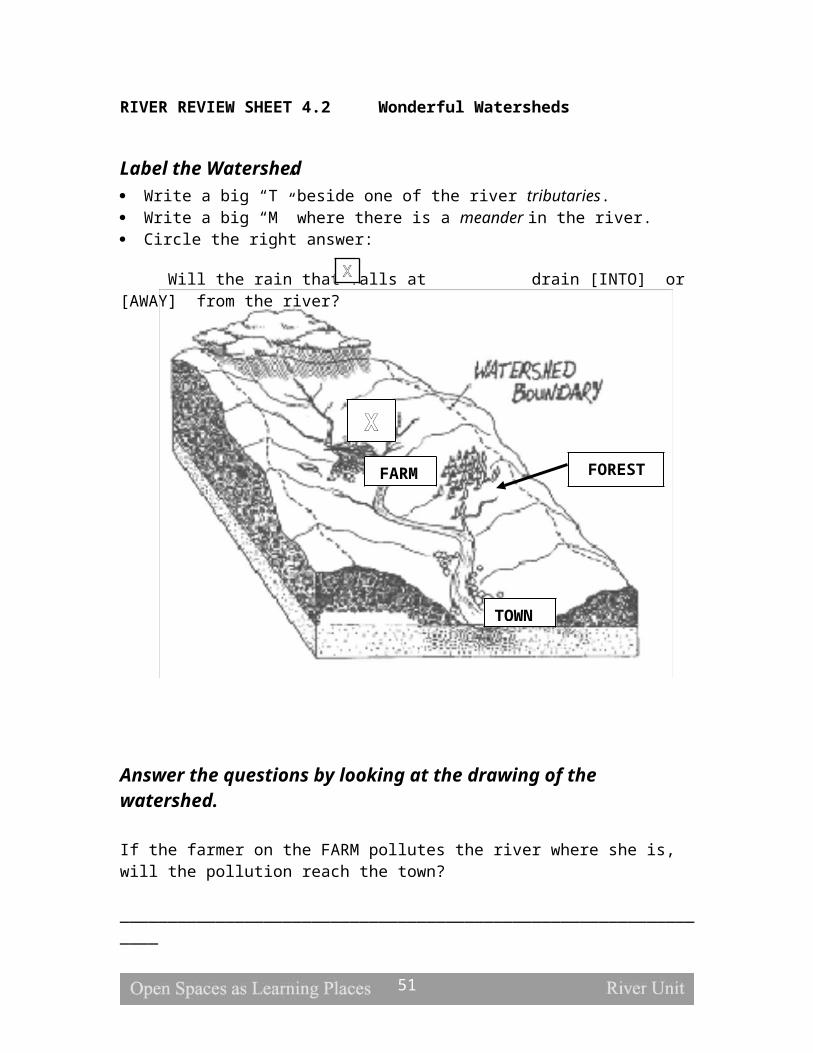
Ask the children what a plant needs to survive (water, air, sunlight, nutrients and space). Ask them how a tall tree takes the water to its leaves (through its roots). Explain that trees have “straws” inside of them that “suck up” the water from the tree’s roots. These “straws” are really narrow tubes in the roots and stems of plants. Water is attracted to the cell walls of the tubes and sticks to the sides. At the same time, water molecules are attracted to each other, creating an upward movement as the molecules follow each other up the cell wall. This movement in the tubes, called capillary action, takes water and dissolved nutrients from the roots to other parts of the tree.
Tell the students to use a felt-tip marker to put a big dot or design about one inch from the bottom of the strip. Fold the paper over the edge of a plastic cup of water so that the end of the paper just touches the water. Watch the water climb up the strips and spread the design.
Explain that paper is made of tiny fibers with little air spaces between them. Water molecules move up these air spaces in the same way that molecules are pulled up by capillary action in the tubes of a plant.
Adapted from Water Science, pp. 28-29
CLASSROOM ACTIVITY SEVEN
Title: Water’s Tense SkinObjectives: Students will examine surface tension and understand how certain aquatic
invertebrates can walk on water.Time: 5 minutesMaterials: Plastic cups, water, pennies, eyedroppers, pie tins, pepper shakers and liquid
detergentPreparation: Fill plastic cups and pie tin half full with water.Procedure: Discuss how water has a high surface tension. Water molecules are attracted to each
other, cling together and are not easily broken apart. Because of this, some objects can lay on top of water without breaking through the surface.
Demonstrate how water molecules cling to one another by giving each student a penny and some water. Ask the children how many drops of water they think can fit on a penny. Use the eyedropper to slowly add water on top of a penny. The droplets keep adding up until they bulge, in a convex shape, over the top of the penny. Eventually, the force of gravity becomes greater than the surface tension and the water spills over on the side of the penny.
Describe water tension in a pond. Remind the students of the four pond habitats (surface film, water’s edge, bottom and open water). Inhabitants of the surface film live above and below the top of the water, relying on surface tension to keep them suspended. Many invertebrates (water strider, marsh treader, fish spider etc.) can walk on the surface of a pond without breaking through the water’s skin because they are very light and have long legs to help distribute their weight. Other surface inhabitants (mosquito larvae etc.) cling to the surface film, hanging from below.
51

Show how liquid detergent can break the bond between water molecules. Sprinkle pepper on top of a plastic plate filled with water to illustrate how surface tension keeps the pepper afloat. Pour a small amount of liquid soap down the side of the pan and watch the pepper sink. The soap is hydrophilic (water loving) causing the water molecules to grab on to the soap instead of each other and the surface tension is broken.
Adapted from Water Science, p. 25 and Mudpies to Magnets, p. 40
CLASSROOM ACTIVITY EIGHT
Title: Erupting ColorsObjectives: Students will learn about hydrophobic and hydrophilic substances.Time: 5 minutesMaterials: Plastic plate, whole milk, food coloring and liquid detergent Preparation: NoneProcedure: Having students work in small groups, give each group a plastic plate and a box of
food coloring. Pour milk in the pie tins until the bottom is covered. Ask the students to add three to four drops of each color of the dye to the milk. Caution them not to shake the tin.
Create an explosion of color by adding a drop of detergent to the center of the drops of food coloring. The activity is nicknamed, “The OOH AHH Experiment” because there is a wave of eruptions that goes on and on.
Explain to the students that milk contains both water and fat. Fat is hydrophobic (water hating) and does not mix well with water. Detergent is both hydrophobic and hydrophilic. One side of detergent grabs on to water and the other side grabs on to fat. The detergent’s affinity for both water and fat creates a churning motion that results in an explosion of color.
Adapted from Science Arts, p. 98
CLASSROOM ACTIVITY NINE
Title: Water VolcanoObjectives: Students will learn about density variation with temperature.Time: 5 minutesMaterials: Plastic container, food coloring, boiling hot water, cold water, ice cubes and
two glass vials with caps.Preparation: Fill the aquarium three quarters full with cold water and add some ice
cubes to make the water even colder.Procedure: Show the students that hot water is less dense than cold water with an experiment.
Fill a small vial with hot water and add a few drops of food coloring. Screw on the cap and shake the bottle well. Place the bottle on the bottom of the tank. Ask the
52

children what will happen when the hot water is released into the tank. Unscrew the cap and watch the colored hot water rise to the surface. The hot water from the bottle is lighter, or less dense, than the cold water, so it shoots to the top of the tank.
Relate the experiment to a pond that undergoes fall and spring overturns. Tell the children that water is the densest at 39.2 degrees Fahrenheit (4.0 degrees Celsius). Remind them that less dense things float and those that are denser sink. In winter, an ice-covered pond is coldest at the top. As spring approaches, the ice melts and the cold surface water sinks to the bottom of the pond. The spring overturn stirs up nutrients from the bottom of the pond and brings down oxygenated water from the surface. Ask the children if they have gone swimming in a pond or lake during the summer and noticed that the water is warmer at the top. As temperatures turn colder during the fall months, the surface water cools to 39.2 degrees. This temperature is when water is the densest so it sinks to the bottom of the pond. The fall overturn churns up the water, mixing nutrients and oxygen once again.
Check the tank to see if the hot water has cooled, mixed with the cold water and sunk.
Adapted from The Science Book Of Water, pp. 14-15
CLASSROOM ACTIVITY TEN
Title: Pond Study IntroductionObjectives: Students will be introduced to different physical, biological and chemical
indicators of water quality.Time: 10 minutesMaterials: NonePreparation: Prepare for the pond field trip by scheduling bus transportation to a local pond or to an alternate field station such as the Whitney Water Center. Students will also need a field trip permission slip signed by their parents.Procedure: Schedule bus transportation to one of the local ponds listed on the Pond Field Trip
information sheet (Information Sheet 1.1). Alternately you can schedule to visit the Whitney Water Center. Contact information and addresses are contained on the information sheet.
Provide an overview of the pond study by explaining that the students will investigate the water quality of a pond. Explain that they will sample and measure the pond to gather information about the health of the ecosystem. The students will use physical, biological and chemical indicators to determine the water quality of the pond. The results will be compiled and analyzed back in the classroom.
Explain about the methods students will use. One half of the class will gather physical information by measuring temperature, depth and turbidity, and chemical data by testing the water for dissolved oxygen, nitrates, ammonia and pH (Outdoor Activities One and Two). The other half of the class will obtain biological information by sampling the pond with nets to determine species composition and diversity (Outdoor Activity Three). The roles will then be reversed.
Introduce each of the characteristics to be measured in the water. Water temperature is important to aquatic organisms because it determines how much oxygen can
53

dissolve in the water. Depth is an important factor in what fish live in the pond. Turbidity is the measure of how cloudy the water is. Cloudy water blocks the sun and affects the plants that live in the water. Dissolved oxygen is important to gilled animals because they require dissolved oxygen to breath underwater. High levels of nitrates and ammonia are often the result of chemical or natural fertilizers. They can cause rapid plant and algae growth in a pond. When the plants die and rot, the decomposition process uses up the dissolved oxygen in the pond. Without dissolved oxygen the fish in the pond will die. pH is a measure of how acidic or alkaline a solution is. It is measured on a scale of 0 to 14. The exact middle of the scale, seven, is neutral. Numbers lower than seven are acidic. Numbers higher than seven are alkaline. An example of an acid is vinegar. Vinegar has a pH of three. Bleach is an example of an alkaline and has a pH of 13. Some fish species are tolerant to a wide range of pH while others are very sensitive to small changes in pH. The presence of aquatic organisms can also indicate the quality of the water. Some species of organisms cannot tolerate pollution while others can live in very polluted water. If a pond contains pollution sensitive organisms then the water quality must be at a level they can tolerate. These sensitive organisms are called indicator species because their presence provides information about the quality of the water. In addition if many species of organisms are present in the biologic sample it is also an indicator of good water quality. The presence of many kinds of organism is called biologic diversity and is a characteristic scientists use to determine the health of aquatic and terrestrial ecosystems.
At the end of this lesson the teacher may choose to assign the Pond Parts and Magical Metamorphosis Review Sheets.
POND UNIT: OUTDOOR ACTIVITIES
OUTDOOR ACTIVITY ONE
Title: Let’s Get PhysicalObjectives: Students will learn about the physical indicators of pond system health.Time: 15 minutes Materials: Thermometer, Secchi disc, hip boots, Pond Study worksheet (Worksheet
5.1), pencils, canoe, measuring tape, small weight and measuring stickPreparation: Drop off canoe before class or perform center pond measurements ahead
of time.Procedure: The facilitator should take the measurements and quickly talk the students through the
activity. Tell the students that together, the group will start out gathering data about the physical conditions of the pond by measuring the depth, temperature and turbidity near the shore, one quarter of the way across and in the middle of the pond. The data will be recorded and analyzed back in the classroom.
54

Describe how depth influences what can live and grow in a pond. In shallow waters, temperature is higher, oxygen is lower and rooted plants take hold. In deeper conditions, floating plants replace emergent plants and there is more of a temperature gradient with colder water retaining more dissolved oxygen. Have the students guess the depth of the pond. Use the measuring stick and weighted measuring tape to determine the depth at the three locations. Ask the students to think about how depth affects the types of animals that live in the pond. Remind them of the pond habitats, explaining that larger animals live in the open water zone where the water is deepest. At the water’s edge, a variety of organisms including those undergoing metamorphosis find cover in the thick vegetation. The conditions at the bottom vary according to depth with sunlight unable to penetrate deeper waters. The surface of a pond changes too as emergent plants thrive in shallow waters.
Temperature is another physical indicator. Many organisms can only survive in a narrow range of temperatures. Ask the children to guess the temperature of the water at the three data collection locations and compare their estimates with the actual readings after measuring the water. Talk about the different factors that influence water temperature (air temperature, overhanging vegetation, depth etc.). Animals need oxygen for respiration. Cold water retains dissolved oxygen better than warm water but there is actually the greatest demand for oxygen in warm, shallow waters where activity is the highest.
Discuss why turbid or cloudy water is harmful to pond life. When water is very cloudy the sun cannot penetrate through the surface, thereby precluding plant growth. Because plants produce oxygen that pond life needs for respiration, water clarity is important for system health. Turbid water generally has a great deal of suspended particulate matter. These materials can cover the gills of fish, amphibians and invertebrates, which inhibits breathing. As suspended particles fall, they can cause a pond to fill in. Remind the students of succession and the pattern of development that causes natural systems to change over time. Determine the turbidity of the water by lowering the Secchi disc until it can no longer be seen clearly and measure the distance. Discuss the results and ask the students what would make a pond cloudy (erosion, run off, algae, decaying materials etc.)
Point out to the students that the pond ecosystem illustrates natural dynamics and the interrelatedness of abiotic and biotic components. Everything is connected!
Be sure to record the data from this activity so it cam be used later to assess the water quality of the pond.
Adapted from Wonders Of Wetlands, pp. 174-187
OUTDOOR ACTIVITY TWO Title: Cool Chemistry Objectives: Students will test chemical indicators of pond health.Time: 15 minutesMaterials: Pond Study worksheet (Worksheet 5.1), pencils, Pond Water Tour test kitsPreparation: None
55

Procedure: Tell the students that together, the group will perform chemical tests on the pond
water to determine dissolved oxygen, nitrate, ammonia and pH levels. See Water Quality Test Instructions (Information Sheet 1.2) for instructions on each of the following chemical tests.
Students test for dissolved oxygen (DO) in the water using the procedure and materials in Pond Water Tour. Explain the importance of DO in the pond. Remind them that DO is vital for respiration and that cold water retains DO better than warm water. DO levels vary throughout the year and tend to be lower in the summer because they are temperature dependent. DO also fluctuates during a 24 hour period with levels being higher during the day when plants release oxygen through photosynthesis. A high DO number is a sign of a healthier pond.
Students test for nitrates in the water using the procedure and materials in Pond Water Tour. Describe how an influx of nutrients such as nitrates (NO3) from fertilizer run off causes plants to grow at an enormous rate. This is called an algal bloom. The algae release a lot of oxygen at first. As the algae continue to grow, they block out sunlight, preventing photosynthesis. When algal growth exceeds nutrient availability, there is a rapid die-off. Bacteria that rely on oxygen for survival decompose the dead plants and animals. The decomposers’ heavy use of oxygen creates an oxygen debt in the water. Water with no DO is anoxic. No organisms can survive in anoxic waters. This excessive input of nutrients is called eutrophication. Although excessive nutrients are detrimental, nutrients are vital for plant growth. A healthy pond will have an intermediate level of nitrates.
Students test for ammonia in the water using the procedure and materials in Pond Water Tour. Explain the implications of high ammonia in the water. Decomposition of plant material and human and animal waste produces ammonia (NH3) as nutrients are released. Like nitrates, moderate ammonia levels are important to fuel plant growth. Excessive levels of ammonia (raw sewage, animal waste etc.) can cause algal blooms.
Students test for pH using the materials in the Pond Water Tour. Explain that pH values are important chemical indicators of water quality. The pH measures the percentage of hydrogen ions in the solution. When water has a pH below 7, it is considered acidic. Acid rain lowers pH levels. It is caused by the mixing of sulfur dioxide and nitrogen oxides from automobiles and factories with water from the atmosphere. Alkaline water has a pH between 8 and 14. A pH of 7 is neutral. Most organisms prefer water with a pH between 6.5 and 8.5. Have students compare the pH of water to lemon juice and soapy water (or any other acidic and basic solutions).
Be sure to record the data from this activity so it cam be used later to assess the water quality of the pond.
Adapted from Pond Water Tour and Wonders of Wetlands, pp. 174-187
OUTDOOR ACTIVITY THREE
Title: Best Biology
56

Objectives: Students will examine biological diversity and indicator species.Time: 30 minutesMaterials: Pond nets, plastic bucket, Pond Life handouts (Handout 5.1), Pond Study
worksheet (Worksheet 5.1), pond life flashcards, and pencils.Preparation: NoneProcedure:The facilitator should take the samples and quickly talk the students through the activity. Tell the students that together, the group will use nets and strainers to determine what
lives in the pond. They will sample the different pond habitats to obtain a good representation of pond inhabitants.(1) Explain that the different organisms in the water are a biological indicator of
water quality. Water quality is measured by classifying organisms according to their pollution tolerance. Some species can live only in clean water. The presence of these organisms is an indicator of good water quality. Students will use the biotic index as they sort through their samples:
- Class 1 (pollution intolerant) animals include stoneflies, clams, caddisflies, aquatic beetles and mayfly nymphs.
- Class 2 (moderately tolerant) animals include black flies, crayfish, damselfly nymphs, dragonfly nymphs, fingernail clams and flatworms.
- Class 3 (pollution tolerant) animals include leeches, midges, limpets, rat-tailed maggots and mosquito larva.
(2) Biological diversity is another indicator of water quality. Diverse systems have a wide range of plants and animals. Biological diversity is important because it allows for more complex food webs and ecosystem interactions.
Set limits for the activity and demonstrate the proper “sweeping and scooping” technique for sampling the different pond habitats. Show pond life flashcards to give the students an idea of what they might catch. Caution them to think small! Frogs and turtles are wonderful but aquatic invertebrates are even more exciting because they reveal valuable information about water quality. If the students still need more convincing, tell them they will be using the samples to set up an aquarium in the classroom and in order for the tank to look like the pond, it should contain a wide range of specimens.
Fill the bucket with clear pond water. Tell the children to bring their nets over to the bucket when they think they have caught something. The facilitator or the student will carefully remove the organism from the net and add it to the bucket.
Distribute nets to the students and let them start sampling. Float among the children, instructing them to look for the slightest movement in the net as well as actual creatures. If the sampling becomes chaotic, start looking through the buckets with the students to keep them focused.
Using the handouts and worksheets, record the results and assess the health of the pond from the diversity and class of organisms caught. Explain that a summary of the findings will be reported to the rest of the class back at school.
Be sure to record the data from this activity so it cam be used later to assess the water quality of the pond.
57
Adapted from Education Goes Outdoors, pp. 173-178
POND UNIT: FOCUS ACTIVITIESFOCUS ACTIVITY ONE
Title: Aquatic AdaptationsObjectives: Students will learn about pond adaptations for survival through researching
and drawing aquatic organisms.Time: 30 minutesMaterials: pond life flashcards, Pond Animals handouts (Handout 5.2), Pond Life
Observation Sheets (Worksheets 5.2), Preparation: noneProcedure: Discuss the challenges of a pond and how pond life is adapted to the habitat in which
it lives. Living creatures improve their chance of survival with special behavioral and structural features that make them better suited to their environment (variations in color, protection, movement, feeding, breathing, reproduction, etc.).
Split the class into small groups. Give each group an pond life flashcard. Tell the group to read the back of the card to learn about their creature. Ask them to pay attention to their special characteristics and habitat requirements. Relate animal adaptations to human inventions (snorkel, oars, jet ski, scuba gear, etc.), letting the students know that nature did it first.
Distribute the Pond Observation Worksheets and have the students draw their creature and then describe their adaptations and special characteristics.
Alternately this activity can be done with live creatures caught from the pond trip. If you choose this extension, you will require small containers to hold the animals. Be sure to return the pond animals to their home within two days.
Adapted from Critters, pp. 101
FOCUS ACTIVITY TWO
Title: Wetland WondersObjectives: Students will learn the value of wetlands and estuariesTime: 10 minutesMaterials: nonePreparation: noneProcedure:
Describe the characteristics of estuaries and freshwater wetlands, their value and the ecosystem services they provide, and the need for their conservation. Estuaries are bodies of water and their surrounding coastal habitats typically found where rivers meet the sea. Estuaries harbor unique plant and animal communities because their waters are brackish—a mixture of fresh water draining from the land and salty seawater. In and around New Haven, Long Island Sound,
58
New Haven Harbor, the lower portions of New Haven’s rivers, and the City’s salt marshes are all estuaries. Freshwater wetlands are places where the land is covered by shallow freshwater: marshes, ponds, the edges of large lakes and rivers, and low-lying areas that flood regularly. Wetlands provide habitat to many different species of plants and animals. Species that require freshwater wetlands to survive and reproduce include amphibians such as frogs, toads, and salamanders, skunk cabbage, duckweed, and many species of aquatic invertebrates .
Describe the following ecosystem services that estuaries and freshwater wetlands provide.
1) Wetlands are storm breakers and flood-busters. They are buffer zones between inland areas and large bodies of water. They act like shallow bowls that slow down, soak up and retain water.
2) Wetlands are resting places for migrating birds with a rich supply of food and cover that allow long distance travelers to refuel before continuing on their journey.
3) Wetland plants absorb nutrients and help cycle them through the system. The nutritious vegetation is an important food source for other living things.
4) Wetlands are breeding areas for many wildlife species. Fertile wetlands act as nurseries that shelter, protect and nourish developing animals.
5) Wetlands keep the water supply clean by straining out silt, sediment and debris.6) Wetlands are natural filtering systems that trap small impurities to reduce
concentrations of nutrients and toxins in the water.7) Wetlands trap, neutralize and promote the decomposition of many toxic
substances.8) Wetlands purify the environment by removing harmful substances and releasing
oxygen through photosynthesis.9) Wetlands help mix nutrients and oxygen into the water.10) Wetlands provide critical habitat for a wide range of living things including
many rare and endangered species.11) Wetlands are winter vacation spots for migrating birds.
Describe how in recent years, people have started to appreciate the importance of estuaries and freshwater wetlands. New Haven’s landscape with its three rivers and its shoreline includes many wetland areas. In the past, wetlands were viewed as wastelands – soggy, inaccessible places that were breeding areas for mosquitoes. Wetlands were filled-in, dredged and channelized. Tidegates were installed on the rivers to control the floodwaters and tidal influence that kept adjacent wetland areas fed with water. People now recognize that tidal flushing improves water quality and controls invasive plants such as Phragmites australis that tend to dominate disturbed marshy areas. In fact, wetlands benefit overall system health by filtering out sediments and removing impurities. People also understand that wetlands actually reduce flooding by slowing down storm waters and acting as buffer zones. Most importantly, wetlands provide valuable habitat
59

for a wide range of plant and animal species. Rapid urbanization left New Haven with little open space. Most of its remaining natural areas are wetlands. Wetlands protection legislation is now in place, reinforced by public education programs designed to raise awareness of the importance of these areas to humans and wildlife. New management strategies reflect lessons learned from past mistakes.
Adapted from Wonders of Wetlands, pp. 85-86
At the end of this lesson the teacher may choose to assign the Amazing Adaptations Review Sheets.
POND UNIT: ASSESSMENTASSESSMENT ONE
Title: Water Quality AnalysisObjectives: Students will assess the health of the pond ecosystems through a water
quality analysis of physical, chemical and biological indicators.Time: 15 minutesMaterials: Pond Assessment worksheets (Worksheet 5.1) and Pond Assessment
handouts (Handout 5.3), data recorded from the pond field tripPreparation:Procedure: Organize the students into pond study groups. Pass out the pond assessment handout
(Handout 5.3) and worksheet (Worksheet 5.1). Assign a specific test for each group to analyze. For example, one group may analyze the dissolved oxygen data collected from the pond while another group looks at the classes of aquatic invertebrates found. Each group should read the information relating to their test on the handout and compare their data to the charts and information in the handout. Students then should answer the questions on the pond assessment worksheet relating to their test.
Have the groups present their water quality data and conclusions to the rest of the class. Analyze and compare the results of the physical, chemical and biological studies. Talk about human and natural influences on the two sites and relate the discussion to the pond findings. Draw conclusions as a class from the data analysis about the health of the pond ecosystems.
Have the students complete the worksheet on their own after the class has presented their conclusions. Be sure the students can back their conclusions up using their data and the information on the pond assessment handout.
60

POND UNIT:HANDOUTS, WORKSHEETS & REVIEW SHEETS
Information Sheet 1.1 Pond Field Trip Information
Lake WintergreenDescription: Just on the New Haven/Hamden border, Lake Wintergreen is part of West Rock State Park. Surrounded by wooded trails the lake provides habitat to many species of plants and animals. The pond is used for fishing, canoeing and Kayaking. The trails are used fro hiking and dog walking.
Directions: Turn onto Wintergreen Avenue. Follow Wintergreen Avenue until you pass Wintergreen Magnet School on the left. Turn Right on to Main Street. The parking lot for the lake is at the bottom of the hill.
Maltby lakesDescription: Owned by the South Central Regional Water Authority, the Maltby Lakes are resovoirs part of the public water supply and public recreation. While there is no swimming of fishing allowed, people who purchase a RWA permit are allowed to hike the many trails surrounding the lake. To use this field site for the pond field trip you must make a reservation with the South Central Regional Water Authority.Directions: The lakes are located on Route 34, off Derby Avenue, on the Orange/West Haven border.Contact: To reserve the use of the Maltby lakes call 203-777-1142Brochure: http://www.scrcog.org/Trails_files/TrailMapRWAMaltby.pdf
Whitney Water CenterDescription: The Regional Water Authority offers a wide variety of water science programs at the Whitney Water Center, an innovative environmental education center. At the Water Center, we offer hands-on education programs to school classes, scouts and other groups. Address: 945 Whitney Avenue in Hamden near the New Haven town line.Contact: To make a reservation to visit the Water Center call 203-777-1142
61

Information Sheet 1.2 Water Quality Test Instructions
Cool Chemistry: Water Quality Test Instructions
Dissolved Oxygen TestFill glass tube with black cap to top with pond water. drop in two DO test tablets and cap bottle. Shake for four minutes and wait for color. Refer to the poster chart for a reading.
Nitrate TestFill test bag to line C. Add Nitrate 1 tab and shake until dissolved. Then add tablet 2 and shake until dissolved. Refer to color chart for reading
Ammonia TestFill bag to line C add two ammonia test tabs roll down bag and shake for three minutes. Refer to color chart for reading
pH Test
62
POND HANDOUT 5.1 Pond Life
WATER’S EDGE
Name Adaptation
Description
Giant Water Bug
Reproduction Male carries eggs on his back to protect them. (Also found on the Surface Film)
Sunfish Coloration Speckled pattern serves as camouflage.Protection Spiky lateral fin wards off predators.Shape
Water Boatman
Movement Oar-like legs propel the boatman through the water.
Coloration Air taken at the surface makes the boatman appear silvery.
Breathing Captures an air bubble which serves as an underwater oxygen tank.
Scud Movement Swims on its side.Pond Snail Protection Hard shell protects snail from predators and fast-moving
water.Mayfly and Damslfly Nymphs
Breathing Gills on their backs help with underwater breathing.
Frog Breathing Absorb oxygen through their porous skin. Tadpoles have gills for underwater breathing.
Movement Webbed feet help propel through water.Coloration Natural colors serve as camouflage.Reproduction Many eggs ensure survival of some offspring. Deposits
on vegetation keep eggs stable.Water Snake Movement Streamlined body allows snake to slither though water.
Coloration Color patter helps the snake blend in with vegetation.Pond Lily Breathing Stomata (responsible for gas exchange) on the top, rather
than on the bottom of the leaf allow for breathing in water. Greasy surface prevents water from entering stomata. “Straws” transfer oxygen from the leaf to the submerged parts of the plant.
Great Blue Heron
Movement Long legs are good for wading.
Feeding Dagger-like beak pierces prey.Arrowhead Breathing Tubes extend through stem to transfer oxygen.
63

POND HANDOUT 5.1 Pond Life (cont.)
SURFACE FILM
Name Adaptation
Description
Water Scorpion
Feeding A stinger is used to paralyze prey before eating.
Water Scorpion
FeedingBreathing
Strong front legs for seizing prey.Snorkle-like tube for breathing underwater.
Water Strider
Movement Body is lighter than the water’s surface, allowing the strider to “walk on water”.Legs are spread out to better distribute the strider’s weight.
Diving Beetle
Breathing Beetle gathers a bubble of air to take underwater. This bubble is like a “scuba tank”.
Whirligig Beetle
Vision The eye is divided into tow parts so that the beetle can see above and below the water at the same time.
Mosquito Larva
Breathing Larva hangs from the water’s surface, extending a breathing tube above the water.
Duckweed Movement Duckweed are free-floating plants. They can “go with the flow” of the water.
BOTTOM
Name Adaptation
Description
LeechMovement Move by “looping” – alternately attaching the mouth
sucker and the tail sucker to the surface.Coloration Dull color camouflages the leech against the bottom silt.
Dragonfly Nymph
Feeding Scoop-like mouth covers chewing mouthparts and extends to capture prey.
Movement Moves through the water via anal propulsion (sucks water through its mouth and expels it).
Bullhead Catfish
Protection Sharp spine on the top and side fins.
Feeding Barbels (chin whiskers) act as sensory organs to help fish find food.
Crayfish Coloration Dull color helps camouflage the nocturnal bottom-dwellers.
Reproduction Female carries fertilized eggs.Tadpole Breathing Tadpoles have gills for underwater breathing. These are
64

lost during metamorphosis.Coloration Drab color and limited movement keep tadpoles well
camouflaged.Caddisfly Larva
Protection Larvae live in tube-like encasements made from leaves, sand twigs or bark.
GOLF COURSE HANDOUT 5.1 Pond Life (cont.)
OPEN WATER
Name Adaptation
Description
Large Mouth Bass
Feeding Large mouth allows fish to surround prey with its mouth.
Yellow Perch Coloration Two-toned coloration protects perch from predators above and below (light colored belly and dark back).
Northern Pike Movement Torpedo-shaped body allows the pike to move rapidly through the water.
Turtle Protection Hard shell protects the turtle.Kingfisher Feeding Dagger-like beak helps with feeding.Ducks Movement Webbed feet help with swimming in water.
Feeding Sieve-like beak filters out aquatic plants and animals.
65
POND HANDOUT 5.2 Pond Animals
Painted Turtle (Chrysemys picta)The eastern painted turtle is a water turtle commonly found in ponds, lakes, marshes and slow flowing rivers. It is a basking turtle often seen in large groups, sunbathing on logs and rocks. The red and yellow markings on its 4-7 inch top shell or carapace give it a painted appearance and its webbed feet make it an excellent swimmer. The painted turtle is an omnivore, eating both animals (insects, snails, slugs, crayfish, leeches, mussels, tadpoles, frogs, fish and dead animals) as well as plants (duckweed, algae and lily pads). The young eat mostly meat.
During cold winter months, the painted turtle hibernates, burying itself in the mud at the bottom of bodies of water. After mating in the spring, the female travels on shore to lay 5 to 10 eggs in a shallow hole that she digs with her hind legs. The young hatch in about 10 to 11 weeks and find their way to water. Painted turtles, especially the young, are vulnerable to predation by skunks, raccoons, opossums, birds, snakes and some other large turtles.
Garter Snake (Thamnophis sirtalis)The eastern garter snake is a harmless, very common snake in North America that is found in a wide range of habitats including woodlands, fields, marshes, pond and stream edges. It is a diurnal snake that has adapted well to humans and can be spotted during daylight hours sunning itself or hunting for earthworms in gardens, yards, vacant lots and parks. The garter snake also feeds on frogs, toads, tadpoles, fish and small mammals.
It is a medium-sized gray, black or greenish snake with three yellowish stripes down its back. It is named for its resemblance to the striped garters men used to wear to hold up their socks. When frightened, garter snakes flatten their bodies to the ground or emit a foul smelling musk from their vent glands.
The garter snake hibernates in large groups during cold winter months, finding refuge in holes, mud, rock crevices, uprooted trees, rotted wood and house foundations. It mates soon after emergence in early spring and is viviparous, giving birth typically to 14 to 40 live young from June to August. As the snake grows, it molts periodically by rubbing against rough surfaces to pull off the old skin. Since the snake has no eyelids, the skin extends over its eyes, leaving eye imprints on the shed skin.
66

POND HANDOUT 5.2 Pond Animals (cont.)
Red-Spotted Newt (Notophthalmus viridescens)The red-spotted newt is a rough skinned, brownish-green, 3 to 4 inch amphibian with black and red spots. It is found in weedy areas of ponds, lakes, marshes, ditches and shallow, slow-moving streams. The flattened tail, shaped like a keel, helps it swim through the water as it hunts for eggs, larvae and adult insects and other small aquatic animals.
Breeding takes place in the water with the female laying 200 to 375 eggs attached singly to aquatic plants. A gilled larva emerges after a few weeks and remains in the water for about 3 months. Eventually, gills are absorbed and it crawls onto land to begin its terrestrial stage as a red eft. The juvenile is bright red-orange with a few black spots. It lives in the moist litter, feeding on small insects and other animals. Highly toxic skin secretions of the red eft, ten times more toxic than that of an adult, protect it from predation on land. The eft hibernates under logs and debris during the winter. After 4 to 5 years, the red eft returns to its aquatic existence as a mature adult, staying active throughout the seasons except for particularly cold times when it becomes semi-active.
Bullfrog (Rana calesbeiana)The bullfrog is the largest frog in North America, growing up to 8 inches in length. The bullfrog is moist skinned with a nearly all green body and fully webbed back feet for swimming and jumping. The sex of a bullfrog can be determined by comparing the size of the tympanum or external ear of the frog to the size of the eye. The tympanum is a round circle located on the side of the head near the eye. In males, it is much larger than the eye but, in females, it is the same size or smaller than the eye. During breeding season, the male bullfrog’s throat is yellow while the female’s is white.
The bullfrog lives in or close to the water its whole life, seeking out weedy areas with emergent vegetation along the edges of ponds and lakes. It hunts aggressively for small animals, fish, other frogs, salamanders, newts, young turtles, snakes, small birds, mice, crayfish, insects, snails and spiders. During the summer breeding season, the males defend territories and call to females with a booming “jug-o-rum”. The females lay large jelly-like masses of 12,000 to 20,000 eggs that hatch as tadpoles in 5 to 20 days. The gilled young are wholly aquatic with flattened tails for swimming and small scraping mouths for feeding on algae. As the tadpole matures into an adult, it grows four legs, lungs replace the gills and it develops a large gaping mouth with a long, sticky tongue for catching prey. Metamorphosis takes up to three years. Tadpoles remain semi-active during the winter while adult frogs hibernate underground or underwater during colder months.
67

POND HANDOUT 5.2 Pond Animals (cont.)
Green Frog (Rana clamitans)The green frog is a common frog in freshwater ponds, lakes, creeks and streams. It is 3 inches long, green to brown in color with dark blotches. A pair of ridges, one on each side of its back, distinguishes a green frog from a bullfrog. During breeding season in late spring, its “tchung” call sounds like the twang of a loose banjo string. Eggs are deposited in floating masses of jelly attached to underwater twigs and stems. The eggs hatch in just 3 to 6 days and remain as tadpoles for 1 to 2 years.
Green frogs can be spotted in or at the edge of water, hiding in shoreline vegetation during the daytime. They are terrestrial feeders, hunting mostly at night for insects and their larvae, worms, small fish, crayfish and other crustaceans, newts, spiders, small frogs and mollusks. Green frogs hibernate underground or underwater during the winter.
Crayfish (Cambarus bartoni)The crayfish is a freshwater crustacean common in streams, lakes and ponds that is closely related to a lobster. A hard exoskeleton covers its head, thorax and its segmented body. The head has two pairs of sensory antennae and a pair of eyes on movable stalks. The appendages of the thorax include four pairs of walking legs. The crayfish also has a pair of claw-bearing pincers that are used for cutting, capturing food, attack and defense. Under its abdomen, the crayfish has specialized food handling “legs”, bailers to cycle water over its gills and five pairs of swimmerets. These “legs” can be regenerated if broken off.
A crayfish hides itself under rocks or logs during the daytime and is most active at night when it feeds on snails, algae, insect larvae, worms, tadpoles and water plants. Crayfish often create burrows with above-ground mud chimneys. Most crayfish live only 2 years so there is a high volume of reproduction. In spring, fertilization and egg laying take place. A female is said to be “in berry” when she is carrying a cluster of 10 to 800 fertilized eggs on her swimmerets until they hatch a few weeks later. The young molt as they outgrow their hard outside skeleton. For a few days following each molt, crayfish have soft exoskeletons that offer little protection from predation.
Sunfish (Lepomis)The sunfish is a flat-sided, deep-bodied, 4 to 6 inch fish that is widely distributed in North America. It feeds on insects, crustaceans and other small animals found in weedy, freshwater ponds and lakes. It spawns in colonies during the summer with males using their fins to fan out saucer-shaped nests on the water’s bottom. Bluegill and Pumpkinseed sunfish are especially common and quite similar in appearance. Pumpkinseed’s red spot on each gill cover distinguishes it from the Bluegill.
68

POND HANDOUT 5.3 Pond Assessment Handout
pH: is a measure of how acidic or alkaline a solution is. The scale ranges from 0 as most acidic to 14 as most basic. At both ends of the scale you will notice that there are very dangerous chemicals such as battery acid and ammonia. Fish will tolerate a pH range of 4.6 to 11, but will thrive in water with a pH of 6.5 to 9.0.
________________________________________________________________________Dissolved Oxygen: Oxygen, just like CO2 gas in soda can dissolve into water. This is essential to gilled animals that live in the water because they require oxygen to live. Dissolved oxygen is measured in parts per million or PPM. 1.0PPM is a very low amount of dissolved oxygen and is too little to support fish; 9.0PPM is a very high level of dissolved oxygen and can support an abundant fish population.
69

POND HANDOUT 5.3 Pond Assessment Handout
Some animals can tolerate pollution better than others. Below are a list of common aquatic invertebrates found in New Haven ponds and lakes. You will notice that they are divided into three classes. Class one organisms require clean water to live in. Class two can tolerate some degree of pollution and class three can live in very polluted water. Remember that class two and three can live in clean water too, but a class one organism would not be able to live in polluted water. Another way to determine how healthy a water source is to look at the number of different organisms found living in it. If you find many different ones you are probably looking at animals living in healthy water, if you only find a few then it may be unhealthy.
70

POND WORKSHEET 5.1 Pond Assessment Worksheet Class:___________
Let’s Get Physical It is important to describe the physical conditions of the pond, such as the depth, temperature and turbidity, as these things all affect the types of plants and animals that we will observe. We are going to use a tape measure to measure the depth of the pond, a thermometer to measure the temperature of the pond, and a secchi disk to measure the cloudiness or tubidity of the pond. Choose someone in the group to record your measurements in the table below.
While the teacher collects the measurements, you may want to think about the following questions:
Is shallow water cooler or warmer than deeper water? Where do you think the water is deepest in the pond? What are some things that may influence the water temperature?
Do you think cloudy water affects plant growth? Why?
Do you think the pond has changed over time? How?
Near Shore One Quarter of the way
across
Middle
Depth of the Pond
Temperature
Secchi Disk Depth
71

POND WORKSHEET 5.1 Pond Assessment Worksheet
Using the information we collected during our pond field trip and from our in class discussion of ponds, please comment on the following health characteristics Lake Wintergreen's pond ecosystem. Use specific examples from the fact sheets to support your answers.
Chemical questionspH1.What was the pH of the water? __________
2. Is that acidic, neutral, or basic? __________
3. Can the water support fish life, and if so will they tolerate or thrive in these conditions?
Dissolved oxygen4. Was the amount of dissolved oxygen in the water high, medium or low? ___________
5. How much is that in parts per million (PPM)? _______________
6. Is this amount of oxygen in the water enough to support fish life? Discuss the health of the fish living at Lake wintergreen in relation to the amount of dissolved oxygen in the water.
Biological questions
7. How many different kinds of aquatic creatures were caught? ___________
8. How many were class one creatures? ______9. How many were class two creatures? ______10. How many were class three creatures? ______
72

POND WORKSHEET 5.1 Pond Assessment Worksheet
11. By looking at the number of different kinds of aquatic invertebrates caught and their tolerance to pollution, would you say the water at Lake Wintergreen is clean, lightly polluted, or heavily polluted? Please use specific examples of animals and their class to support your answer.
12. As a whole, using the information from the chemical and biological tests you conducted and the information from class, do you think that Lake Wintergreen is a healthy ecosystem or an unhealthy one? Mention briefly the three tests conducted and your conclusions for each test to support your answer.
73

POND WORKSHEET 5.2 Pond Life
OBSERVATION SHEET
Read the back of your pond life flashcard to learn details about your organism. Draw a detailed picture of it with the correct number of legs, antennae, shape of the body etc.
Describe any special features that make your pond creature better adapted to life in a pond. Be sure to think about how it moves, breathes, eats, stays safe etc.
74

POND REVIEW SHEET 5.1 Pond Parts
Draw a line from each habitat to the right part of the pond.
Which part of the pond do you think will have the highest temperature?
Wacky WaterDepending on its temperature, water may be a solid, liquid or gas. Can you connect these pictures to the word that describes its state?
SOLID
LIQUID
GAS
Water’s Edge
Surface
Film
Pond Bottom
Open Water
75

POND REVIEW SHEET 5.1 Pond Parts (cont.)
ANSWER SHEET
Draw a line from each habitat to the right part of the pond.
Which part of the pond do you think will have the highest temperature? WATERS EDGE
Wacky WaterDepending on its temperature, water may be a solid, liquid or gas. Can you connect these pictures to the word that describes its state?
SOLID
LIQUID
GAS
Water’s Edge
Surface
Film
Pond Bottom
Open Water
76

GOLF COURSE REVIEW SHEET 5.2 Magical Metamorphosis
We have talked about a number of different animals that go through metamorphosis. Some go through complete metamorphosis (like a butterfly) and others go through incomplete metamorphosis (like a dragonfly).Below are pictures of the different stages of dragonfly metamorphosis and butterfly metamorphosis. You have two challenges:
(1) Try to number the pictures so that they are in the correct order.(2) Try to label each picture using the words in the box below.
Hint: The first stage of butterfly metamorphosis is done for you.
DRAGONFLY METAMORPHOSIS (incomplete metamorphosis)
#____This is called the
____________
#____ This is called the _____________
#_____This is called the
____________
BUTTERFLY METAMORPHOSIS (complete
adult butterfly larva pupaegg nymph adult dragonfly
#_____This is called the chrysalis, or the ____________
# 1 This is called the egg
#_____This is called the ____________
#_____This is called the caterpillar, or the _____________
77

POND REVIEW SHEET 5.2 Magical Metamorphosis (cont.)
ANSWER SHEET
We have talked about a number of different animals that go through metamorphosis. Some go through complete metamorphosis (like a butterfly) and others go through incomplete metamorphosis (like a dragonfly).Below are pictures of the different stages of dragonfly metamorphosis and butterfly metamorphosis. You have two challenges:
(1) Try to number the pictures so that they are in the correct order.(2) Try to label each picture using the words in the box below.
Hint: The first stage of butterfly metamorphosis is done for you.
DRAGONFLY METAMORPHOSIS (incomplete metamorphosis)
# 1 This is called the EGG
# 3 This is called the ADULT DRAGONFLY
# 2This is called theNYMPH
BUTTERFLY METAMORPHOSIS (complete
adult butterfly larva pupaegg nymph adult dragonfly
# 3 This is called the chrysalis, or the PUPA
# 1 This is called the egg
# 4 This is called the ADULT BUTTERFLY
# 2 This is called the caterpillar, or the LARVA
78

POND REVIEW SHEET 5.3 Pond Measurement
When the class visited the pond, we used all kinds of special instruments to measure different things about the pond. See if you can remember which instrument was used for each measurement.
Match the instrument to what it measures.
The pH of the water (whether it is acidic or basic).
The temperature of the water.
The turbidity (or cloudiness) of the water.
The depth of the water.
79

POND REVIEW SHEET 5.3 Pond Measurement (cont.)
ANSWER SHEET
When the class visited the pond, we used all kinds of special instruments to measure different things about the pond. See if you can remember which instrument was used for each measurement.
Match the instrument to what it measures.
The pH of the water (whether it is acidic or basic).
The temperature of the water.
The turbidity (or cloudiness) of the water.
The depth of the water.
80

GOLF COURSE REVIEW SHEET 5.4 Amazing Adaptations
Name one adaptation that each of these pond critters has that helps it to live in the pond.
1. One of the adaptations that a tadpole has to help it survive in the pond is
________________________________________________
2. One of the adaptations that a pond snail has to help it survive in the pond is
____________________________________________________
3. One of the adaptations that water boatman has that helps it to survive in the pond is
____________________________________________________
4. One of the adaptations that the water strider has that helps it to survive in the pond is
__________________________________________
81

GOLF COURSE REVIEW SHEET 5.4 Amazing Adaptations (cont.)
ANSWER SHEET
Name one adaptation that each of these pond critters has that helps it to live in the pond.
5. One of the adaptations that a tadpole has to help it survive in the pond is
Tadpoles have gills for underwater breathing. Drab color and limited movement keep tadpoles well camouflaged.
6. One of the adaptations that a pond snail has to help it survive in the
pond is
Hard shell protects snail from predators and fast-moving water
7. One of the adaptations that water boatman has that helps it to survive in the pond is
Oar-like legs propel the boatman through the water. Air taken at the surface makes the boatman appear silvery. Captures an air bubble which serves as an underwater oxygen tank.
8. One of the adaptations that the water strider has that helps it to survive in the pond is
Body is light and allows the strider to “walk on water”Biting mouthparts allow it to catch prey
Legs are spread out to better distribute the strider’s weight
82

CITED REFERENCES
Allen, Maureen Murphy et al. (1989). Critters. Fresno, CA: AIMS Education Foundation.
American WaterResources Association Poster Series: middle school. (1992). Lincoln, NE: Nebraska Groundwater Foundation.
Ardley, Neil. (1991). The Science Book of Water. New York: Harcourt Brace Jovanovich, Publishers.
Dig In. Connecticut Department of Education: Bureau of Curriculum and Instruction.
Johns, Frank A. et al. (1986). Education goes outdoors. Menlo Park, CA: Addison-Wesley Publishing Co.
Kaufman, K. & Bergman. (1989). River Cutters. Berkley, CA: Great Explorations in Math and Science (GEMS).
Kesselheim, A.S. et al. (1995). Wow! The Wonders of Wetlands. St. Michaels, MD: Environmental Concern Inc. and Bozeman, MT: The watercourse.
Kohl, Mary Ann and Potter, Jean. (1993). Science Arts. Bellingham, WA: Bright Ring Publishing.
Lind, K. K. (Ed.). (1991). Water, Stones, and Fossil Bones. Washington D.C.: National Science Teachers Association.
Project wild aquatic. (1987). Boulder, CO: Western Regional Environmental Education Council.
Seed, Deborah. (1992). Water Science. USA: Addison-Wesley Publishing Co.
The pond water tour: the hands-on test kit and mini curriculum for exploring lakes, streams, and ponds. (2001). USA: Lamotte Co.
The Watercourse and The Yellowstone Association. (1995). Developed by: The Watercourse and The Yellowstone Association.
Wetnet: An environmental curriculum dealing with wetlands. (1992). Developed by: The Adirondack Teacher Center, The Adirondack Park Visitor Interpretive Centers and the Adirondack Park Institute, Inc.
83
Williams, Robert A. et al. (1987). Mudpies to magnets: a preschool science curriculum.
Mt. Rainier, MD: Gryphon House, Inc.
84