order jo 7930 - federal aviation...
TRANSCRIPT

U.S. Departmentof Transportation
Federal Aviation
Administration
Initiated By: AJV−0 Distribution: ZAT−793; ZAT−464; ZAT−423 (External)Vice President, Mission Support Services
Order JO 7930.2P
Notices to Airmen
(NOTAM)
April 3, 2014
An electronic version of this publication is on the internet at http://www.faa.gov/atpubs


Distribution: ZAT-721, ZAT-464 Initiated By: AJV-0 Vice President, Mission Support Services
This order prescribes air traffic control procedures and phraseology for use by personnel providing
air traffic control services. Controllers are required to be familiar with the provisions of this order that
pertain to their operational responsibilities and to exercise their best judgment if they encounter
situations not covered by this order.
Effective Date:
April 3, 2014
Air Traffic Organization Policy
SUBJ: Notices to Airmen (NOTAM)
ORDER
JO 7930.2P

DIRECTIVE NO.RECORD OF CHANGESJO 7930.2P
CHANGETO
BASICSUPPLEMENTS
OPTIONAL
CHANGETO
BASICSUPPLEMENTS
OPTIONAL
FAA Form 1320−5 (6−80) USE PREVIOUS EDITION

JO 7930.2P4/3/14
Explanation of Changes E of C−1
Notices to Airmen (NOTAM)
Explanation of Changes
Effective: April 3, 2014
a. 1−1−7. REVISIONS
The acronym NADIN is defined as National AirspaceData Interchange, and revisions to JO 7930.2 are nowpublished on the publication cycle.
b. 1−3−6. TSA
This paragraph has been deleted to comply withestablished procedures.
c. 1−4−6. DEFINITIONS
A subparagraph, has been added for LocationDesignators defining the meaning of locationdesignator.
d. 3−3−5. TAXIWAY IDENTIFICATION
The descriptive words BTN (between) and ANDwere added to signify a segment of a taxiway.
e. 4−2−1. NOTAM COMPOSITION
Flight Service has been removed as the onlyresponsible party for handling NOTAMs for part timefacilities.
f. 4−4−3. CANCELING PUBLISHEDNOTAM DATA
Deletes Note under Paragraph 4-4-3b.
g. 4−5−2. NOTAM SERVICE MESSAGES
Service Messages examples have been updated toinclude a date/time group.
h. 6−1−4. AIRCRAFT OPERATIONS6−1−6. PARACHUTE
JUMPING/SKYDIVING (PJE)6−1−7. UNMANNED ROCKETS,
UNMANNED FREE BALLOONS, HOT AIR
BALLOONS, AND HIGH ALT BALLOONS6−1−8. OTHER AIRSPACE ACTIVITIES
The use of alternative description (optional)describes the center of the activity. This changebrings JO 7930.2N into compliance with other ATOand FAA orders.
i. 7−1−1. GENERAL
Deletes Paragraph 7-1-1e. Snow NOTAMsrequirements are in Chapter 5.
j. 8−1−3. TEMPORARY OR PERMANENTFDC NOTAMS
Paragraph 8-1-3 was changed to Military NOTAMsin the “N” rewrite. FDC NOTAMs are in Chapter 7.
k. 9−2−1. REQUEST FOR CANADIANNOTMS FROM THE CANADIAN NOTAMSYSTEM
This change removes the statement for receiving onlyNOTAM data for Canadian aerodromes of firstlanding (airports for clearing Customs andImmigration) and now states that the USNS (UnitedStates NOTAM System) receives NOTAM data fromCanada. The disclaimer urging users to contact theCanadian Web site for the most current NOTAMsremains.
l. APPENDIX D−ICAO DIFFERENCE FORTHE UNITED STATES
Cardinal Directions have been added to the list ofwords that are used often in domestic NOTAMs butare not recognized ICAO directions.
m. Entire Publication
Additional editorial/format changes are made wherenecessary.


JO 7930.2P4/3/14
iTable of Contents
Table of Contents
Chapter 1. General
Section 1. Introduction
1-1-1. PURPOSE 1-1-1. . . . . . . . . . . . . . . . . . . . . . . . . . . . . . . . . . . . . . . . . . . . . . . . . . . . . . . . .
1-1-2. AUDIENCE 1-1-1. . . . . . . . . . . . . . . . . . . . . . . . . . . . . . . . . . . . . . . . . . . . . . . . . . . . . . .
1-1-3. WHERE TO FIND THIS ORDER 1-1-1. . . . . . . . . . . . . . . . . . . . . . . . . . . . . . . . . . . .
1-1-4. CANCELLATION 1-1-1. . . . . . . . . . . . . . . . . . . . . . . . . . . . . . . . . . . . . . . . . . . . . . . . . .
1-1-5. EXPLANATION OF CHANGES 1-1-1. . . . . . . . . . . . . . . . . . . . . . . . . . . . . . . . . . . . .
1-1-6. DISTRIBUTION 1-1-1. . . . . . . . . . . . . . . . . . . . . . . . . . . . . . . . . . . . . . . . . . . . . . . . . . .
1-1-7. REVISIONS 1-1-1. . . . . . . . . . . . . . . . . . . . . . . . . . . . . . . . . . . . . . . . . . . . . . . . . . . . . . .
1-1-8. EFFECTIVE DATE 1-1-1. . . . . . . . . . . . . . . . . . . . . . . . . . . . . . . . . . . . . . . . . . . . . . . . .
Section 2. Scope
1-2-1. PURPOSE 1-2-1. . . . . . . . . . . . . . . . . . . . . . . . . . . . . . . . . . . . . . . . . . . . . . . . . . . . . . . . .
1-2-2. PROCEDURAL APPLICATIONS 1-2-2. . . . . . . . . . . . . . . . . . . . . . . . . . . . . . . . . . . .
1-2-3. AVOIDANCE OF DUPLICATION 1-2-2. . . . . . . . . . . . . . . . . . . . . . . . . . . . . . . . . . . .
Section 3. Accountable Organizations
1-3-1. AIR TRAFFIC ORGANIZATION 1-3-1. . . . . . . . . . . . . . . . . . . . . . . . . . . . . . . . . . . .
1-3-2. TECHNICAL OPERATIONS SERVICES 1-3-1. . . . . . . . . . . . . . . . . . . . . . . . . . . . . .
1-3-3. FLIGHT INSPECTION SERVICES 1-3-2. . . . . . . . . . . . . . . . . . . . . . . . . . . . . . . . . . .
1-3-4. OFFICE OF AIRPORT SAFETY AND STANDARDS 1-3-2. . . . . . . . . . . . . . . . . . .
1-3-5. FLIGHT STANDARDS SERVICE 1-3-2. . . . . . . . . . . . . . . . . . . . . . . . . . . . . . . . . . . .
1-3-6. AIRPORT MANAGEMENT 1-3-2. . . . . . . . . . . . . . . . . . . . . . . . . . . . . . . . . . . . . . . . .
Section 4. Terms of Reference
1-4-1. WORD MEANINGS 1-4-1. . . . . . . . . . . . . . . . . . . . . . . . . . . . . . . . . . . . . . . . . . . . . . . .
1-4-2. NOTES 1-4-1. . . . . . . . . . . . . . . . . . . . . . . . . . . . . . . . . . . . . . . . . . . . . . . . . . . . . . . . . . . .
1-4-3. EXAMPLES 1-4-1. . . . . . . . . . . . . . . . . . . . . . . . . . . . . . . . . . . . . . . . . . . . . . . . . . . . . . .
1-4-4. REFERENCES 1-4-1. . . . . . . . . . . . . . . . . . . . . . . . . . . . . . . . . . . . . . . . . . . . . . . . . . . . .
1-4-5. MANUAL CHANGES 1-4-1. . . . . . . . . . . . . . . . . . . . . . . . . . . . . . . . . . . . . . . . . . . . . . .
1-4-6. DEFINITIONS 1-4-1. . . . . . . . . . . . . . . . . . . . . . . . . . . . . . . . . . . . . . . . . . . . . . . . . . . . .
Chapter 2. Aeronautical Information Services
Section 1. Aeronautical Information System
2-1-1. GENERAL 2-1-1. . . . . . . . . . . . . . . . . . . . . . . . . . . . . . . . . . . . . . . . . . . . . . . . . . . . . . . .
2-1-2. DISSEMINATION OF AIRMEN INFORMATION 2-1-1. . . . . . . . . . . . . . . . . . . . . .
2-1-3. PUBLICATION CRITERIA 2-1-1. . . . . . . . . . . . . . . . . . . . . . . . . . . . . . . . . . . . . . . . . .
2-1-4. NOTICES TO AIRMEN PUBLICATION 2-1-2. . . . . . . . . . . . . . . . . . . . . . . . . . . . . .
2-1-5. FORWARDING DATA 2-1-2. . . . . . . . . . . . . . . . . . . . . . . . . . . . . . . . . . . . . . . . . . . . . .
2-1-6. CHART/PUBLICATION ERRORS OR OMISSIONS 2-1-2. . . . . . . . . . . . . . . . . . . .
2-1-7. ADMINISTRATIVE MESSAGES 2-1-3. . . . . . . . . . . . . . . . . . . . . . . . . . . . . . . . . . . . .
2-1-8. ADDRESSING CORRESPONDENCE 2-1-3. . . . . . . . . . . . . . . . . . . . . . . . . . . . . . . .
2-1-9. NFDC ORGANIZATION 2-1-3. . . . . . . . . . . . . . . . . . . . . . . . . . . . . . . . . . . . . . . . . . . .
2-1-10. THE NATIONAL FLIGHT DATA DIGEST (NFDD) 2-1-3. . . . . . . . . . . . . . . . . . .

JO 7930.2P 4/3/14
ii Table of Contents
Paragraph Page2-1-11. COMPUTER PRINTOUTS 2-1-3. . . . . . . . . . . . . . . . . . . . . . . . . . . . . . . . . . . . . . . . .
Section 2. NOTAM System
2-2-1. NOTAM CLASSIFICATION 2-2-1. . . . . . . . . . . . . . . . . . . . . . . . . . . . . . . . . . . . . . . . .
Chapter 3. General Operating Procedures
Section 1. General
3-1-1. TIE-IN STATIONS 3-1-1. . . . . . . . . . . . . . . . . . . . . . . . . . . . . . . . . . . . . . . . . . . . . . . . .
3-1-2. NOTAM RESPONSIBILITIES 3-1-1. . . . . . . . . . . . . . . . . . . . . . . . . . . . . . . . . . . . . . .
3-1-3. NOTAM LOG 3-1-1. . . . . . . . . . . . . . . . . . . . . . . . . . . . . . . . . . . . . . . . . . . . . . . . . . . . . .
3-1-4. FDC PRESIDENTIAL, SPECIAL SECURITY INSTRUCTIONS, OR EMERGENCY AIR TRAFFIC RULES TFRs 3-1-1. . . . . . . . . . . . . . . . . . . . . . . . . . . . . .
Section 2. Coordination
3-2-1. COORDINATION WITH OTHER FACILITIES 3-2-1. . . . . . . . . . . . . . . . . . . . . . . .
3-2-2. FILING NOTAM INFORMATION WITH FSSs 3-2-1. . . . . . . . . . . . . . . . . . . . . . . . .
3-2-3. PASSING NOTAM DATA BY PART-TIME FSS FACILITIES 3-2-1. . . . . . . . . . . .
3-2-4. NON-FEDERAL FACILITIES 3-2-1. . . . . . . . . . . . . . . . . . . . . . . . . . . . . . . . . . . . . . .
Section 3. Use of Terms
3-3-1. USE OF CONTRACTIONS AND ABBREVIATIONS 3-3-1. . . . . . . . . . . . . . . . . . .
3-3-2. EXPRESSION OF TIME IN THE NOTAM SYSTEM 3-3-1. . . . . . . . . . . . . . . . . . .
3-3-3. UNITS OF MEASUREMENT 3-3-1. . . . . . . . . . . . . . . . . . . . . . . . . . . . . . . . . . . . . . . .
3-3-4. RUNWAY IDENTIFICATION 3-3-1. . . . . . . . . . . . . . . . . . . . . . . . . . . . . . . . . . . . . . .
3-3-5. TAXIWAY IDENTIFICATION 3-3-1. . . . . . . . . . . . . . . . . . . . . . . . . . . . . . . . . . . . . . .
3-3-6. APRON IDENTIFICATION 3-3-2. . . . . . . . . . . . . . . . . . . . . . . . . . . . . . . . . . . . . . . . .
Chapter 4. NOTAM D Procedures
Section 1. General
4-1-1. ACCEPTING NOTAM D INFORMATION 4-1-1. . . . . . . . . . . . . . . . . . . . . . . . . . . .
4-1-2. NATIONAL NOTAM OFFICE RELATIONSHIPS 4-1-1. . . . . . . . . . . . . . . . . . . . . .
Section 2. Preparing NOTAMs for Dissemination
4-2-1. NOTAM COMPOSITION 4-2-1. . . . . . . . . . . . . . . . . . . . . . . . . . . . . . . . . . . . . . . . . . .
4-2-2. NOTAM ACCOUNTABILITY 4-2-2. . . . . . . . . . . . . . . . . . . . . . . . . . . . . . . . . . . . . . . .
Section 3. Coding and Transmission of NOTAMs
4-3-1. PREPARATION FOR TRANSMISSION 4-3-1. . . . . . . . . . . . . . . . . . . . . . . . . . . . . . .
4-3-2. AUTOMATIC DATA PROCESSING (ADP) CODES 4-3-1. . . . . . . . . . . . . . . . . . . .
4-3-3. NOTAM TRANSMISSION 4-3-1. . . . . . . . . . . . . . . . . . . . . . . . . . . . . . . . . . . . . . . . . . .
4-3-4. TRANSMISSION OF NOTAMs EXCEEDING 20 LINES 4-3-1. . . . . . . . . . . . . . . .
4-3-5. CONFIRMING ACCEPTANCE BY THE NOTAM SYSTEM 4-3-1. . . . . . . . . . . . .
4-3-6. TRANSMISSION BY ANOTHER FACILITY 4-3-1. . . . . . . . . . . . . . . . . . . . . . . . . .
4-3-7. RETRIEVING DOMESTIC NOTAMs 4-3-1. . . . . . . . . . . . . . . . . . . . . . . . . . . . . . . . .
Section 4. Canceling/Extending NOTAMs

JO 7930.2P4/3/14
iiiTable of Contents
Paragraph Page4-4-1. EXTENDING NOTAM DURATION 4-4-1. . . . . . . . . . . . . . . . . . . . . . . . . . . . . . . . . .
4-4-2. CANCELLATION OF NOTAMs 4-4-1. . . . . . . . . . . . . . . . . . . . . . . . . . . . . . . . . . . . . .
4-4-3. CANCELING PUBLISHED NOTAM DATA 4-4-1. . . . . . . . . . . . . . . . . . . . . . . . . . .
Section 5. Computer-Generated NOTAM Service�Messages
4-5-1. MONITORING 4-5-1. . . . . . . . . . . . . . . . . . . . . . . . . . . . . . . . . . . . . . . . . . . . . . . . . . . .
4-5-2. NOTAM SERVICE MESSAGES 4-5-1. . . . . . . . . . . . . . . . . . . . . . . . . . . . . . . . . . . . . .
Chapter 5. NOTAM Criteria
Section 1. Movement Area NOTAMs
5-1-1. ORIGINATORS OF AERODROME NOTAMs 5-1-1. . . . . . . . . . . . . . . . . . . . . . . . .
5-1-2. HANDLING REPORTED AERODROME CONDITIONS 5-1-1. . . . . . . . . . . . . . .
5-1-3. MOVEMENT AREA INFORMATION 5-1-1. . . . . . . . . . . . . . . . . . . . . . . . . . . . . . . .
5-1-4. REPORTING FIELD CONDITIONS 5-1-5. . . . . . . . . . . . . . . . . . . . . . . . . . . . . . . . . .
5-1-5. AERODROME FACILITIES 5-1-11. . . . . . . . . . . . . . . . . . . . . . . . . . . . . . . . . . . . . . . . .
5-1-6. WORK IN PROGRESS 5-1-12. . . . . . . . . . . . . . . . . . . . . . . . . . . . . . . . . . . . . . . . . . . . . .
Section 2. Lighting Aid and Obstruction NOTAMs
5-2-1. LIGHTING AIDS 5-2-1. . . . . . . . . . . . . . . . . . . . . . . . . . . . . . . . . . . . . . . . . . . . . . . . . . .
5-2-2. TOWER LIGHT OUTAGES 5-2-2. . . . . . . . . . . . . . . . . . . . . . . . . . . . . . . . . . . . . . . . .
5-2-3. OBSTRUCTIONS 5-2-3. . . . . . . . . . . . . . . . . . . . . . . . . . . . . . . . . . . . . . . . . . . . . . . . . .
5-2-4. MOORED BALLOONS AND KITES 5-2-4. . . . . . . . . . . . . . . . . . . . . . . . . . . . . . . . .
Section 3. NAVAID NOTAMs
5-3-1. GENERAL 5-3-1. . . . . . . . . . . . . . . . . . . . . . . . . . . . . . . . . . . . . . . . . . . . . . . . . . . . . . . .
5-3-2. REPORTING NAVAID MALFUNCTIONS 5-3-1. . . . . . . . . . . . . . . . . . . . . . . . . . . .
5-3-3. UNPROGRAMMED EXTENDED SHUTDOWNS 5-3-1. . . . . . . . . . . . . . . . . . . . .
5-3-4. NAVAID MAINTENANCE SHUTDOWNS 5-3-1. . . . . . . . . . . . . . . . . . . . . . . . . . . .
5-3-5. UNMONITORED NAVAIDs 5-3-1. . . . . . . . . . . . . . . . . . . . . . . . . . . . . . . . . . . . . . . . .
5-3-6. INSTRUMENT LANDING SYSTEM STATUS 5-3-1. . . . . . . . . . . . . . . . . . . . . . . . .
5-3-7. NAVAID CONDITIONS 5-3-2. . . . . . . . . . . . . . . . . . . . . . . . . . . . . . . . . . . . . . . . . . . . .
5-3-8. HOURS OF OPERATION 5-3-5. . . . . . . . . . . . . . . . . . . . . . . . . . . . . . . . . . . . . . . . . . .
Section 4. Communications Outlets NOTAMs
5-4-1. GENERAL 5-4-1. . . . . . . . . . . . . . . . . . . . . . . . . . . . . . . . . . . . . . . . . . . . . . . . . . . . . . . .
5-4-2. REPORTING COMMUNICATIONS OUTLET MALFUNCTIONS 5-4-1. . . . . . .
5-4-3. COMMUNICATION OUTLET CONDITIONS 5-4-1. . . . . . . . . . . . . . . . . . . . . . . . .
Section 5. Services NOTAMs
5-5-1. GENERAL 5-5-1. . . . . . . . . . . . . . . . . . . . . . . . . . . . . . . . . . . . . . . . . . . . . . . . . . . . . . . .
5-5-2. CHANGES TO PUBLISHED SERVICES 5-5-1. . . . . . . . . . . . . . . . . . . . . . . . . . . . . .
5-5-3. HOURS OF OPERATION 5-5-1. . . . . . . . . . . . . . . . . . . . . . . . . . . . . . . . . . . . . . . . . . .
5-5-4. WEATHER AND WEATHER REPORTING EQUIPMENT 5-5-3. . . . . . . . . . . . . .
5-5-5. MICROBURST/WINDSHEAR DETECTION SYSTEM 5-5-4. . . . . . . . . . . . . . . . .
5-5-6. RADAR SERVICES 5-5-4. . . . . . . . . . . . . . . . . . . . . . . . . . . . . . . . . . . . . . . . . . . . . . . . .
5-5-7. AUTOMATIC DEPENDENT SURVEILLANCE BROADCAST (ADSB) SERVICES 5-5-5. . . . . . . . . . . . . . . . . . . . . . . . . . . . . . . . . . . . . . . . . . . . . . . . . . . . . .

JO 7930.2P 4/3/14
iv Table of Contents
Chapter 6. Airspace NOTAMs
Section 1. Airspace
Paragraph Page6-1-1. GENERAL 6-1-1. . . . . . . . . . . . . . . . . . . . . . . . . . . . . . . . . . . . . . . . . . . . . . . . . . . . . . . .
6-1-2. SPECIAL ACTIVITY AIRSPACE (SAA) 6-1-1. . . . . . . . . . . . . . . . . . . . . . . . . . . . . .
6-1-3. AIRSPACE AND ALTITUDE RESERVATIONS 6-1-2. . . . . . . . . . . . . . . . . . . . . . . .
6-1-4. AIRCRAFT OPERATIONS 6-1-2. . . . . . . . . . . . . . . . . . . . . . . . . . . . . . . . . . . . . . . . . .
6-1-5. AERIAL REFUELING 6-1-4. . . . . . . . . . . . . . . . . . . . . . . . . . . . . . . . . . . . . . . . . . . . . .
6-1-6. PARACHUTE JUMPING/SKY DIVING (PJE) 6-1-4. . . . . . . . . . . . . . . . . . . . . . . . .
6-1-7. UNMANNED ROCKETS, UNMANNED FREE BALLOONS, HOT AIR BALLOONS, AND HIGH ALT BALLOONS 6-1-5. . . . . . . . . . . . . . . . . . . .
6-1-8. OTHER AIRSPACE ACTIVITIES 6-1-5. . . . . . . . . . . . . . . . . . . . . . . . . . . . . . . . . . . .
Section 2. Other Aeronautical Information
6-2-1. GENERAL 6-2-1. . . . . . . . . . . . . . . . . . . . . . . . . . . . . . . . . . . . . . . . . . . . . . . . . . . . . . . .
Chapter 7. FDC NOTAM Procedures
Section 1. Transmitting FDC NOTAM Data
7-1-1. GENERAL 7-1-1. . . . . . . . . . . . . . . . . . . . . . . . . . . . . . . . . . . . . . . . . . . . . . . . . . . . . . . .
7-1-2. FDC NOTAM NUMBERING 7-1-1. . . . . . . . . . . . . . . . . . . . . . . . . . . . . . . . . . . . . . . .
7-1-3. TEMPORARY OR PERMANENT FDC NOTAMs 7-1-1. . . . . . . . . . . . . . . . . . . . . .
7-1-4. INTERIM IFR FLIGHT PROCEDURES 7-1-1. . . . . . . . . . . . . . . . . . . . . . . . . . . . . .
7-1-5. TEMPORARY FLIGHT RESTRICTIONS 7-1-3. . . . . . . . . . . . . . . . . . . . . . . . . . . . .
7-1-6. AIR DEFENSE EMERGENCY 7-1-4. . . . . . . . . . . . . . . . . . . . . . . . . . . . . . . . . . . . . .
7-1-7. SPECIAL DATA 7-1-4. . . . . . . . . . . . . . . . . . . . . . . . . . . . . . . . . . . . . . . . . . . . . . . . . . . .
7-1-8. LASER LIGHT ACTIVITY 7-1-5. . . . . . . . . . . . . . . . . . . . . . . . . . . . . . . . . . . . . . . . . .
Section 2. Cancellation/Expiration
7-2-1. FDC NOTAM EXPIRATION 7-2-1. . . . . . . . . . . . . . . . . . . . . . . . . . . . . . . . . . . . . . . . .
7-2-2. CANCELING FDC NOTAMs 7-2-1. . . . . . . . . . . . . . . . . . . . . . . . . . . . . . . . . . . . . . . .
7-2-3. FDC NOTAM LIST 7-2-1. . . . . . . . . . . . . . . . . . . . . . . . . . . . . . . . . . . . . . . . . . . . . . . . .
7-2-4. RETRIEVING FDC NOTAMs 7-2-1. . . . . . . . . . . . . . . . . . . . . . . . . . . . . . . . . . . . . . .
Chapter 8. Military NOTAMs
Section 1. General
8-1-1. MILITARY FACILITIES 8-1-1. . . . . . . . . . . . . . . . . . . . . . . . . . . . . . . . . . . . . . . . . . . . .
8-1-2. SUBMISSION OF MILITARY DATA FOR PUBLICATION 8-1-1. . . . . . . . . . . . . .
8-1-3. MILITARY NOTAMS NOT MEETING CRITERIA 8-1-1. . . . . . . . . . . . . . . . . . . . .
Section 2. Military NOTAM Dissemination
8-2-1. MILITARY NOTAMs 8-2-1. . . . . . . . . . . . . . . . . . . . . . . . . . . . . . . . . . . . . . . . . . . . . . .
8-2-2. ALASKAN MILITARY NOTAMs 8-2-1. . . . . . . . . . . . . . . . . . . . . . . . . . . . . . . . . . . . .
Section 3. Military NOTAM Retrieval
8-3-1. MILITARY NOTAM AVAILABILITY 8-3-1. . . . . . . . . . . . . . . . . . . . . . . . . . . . . . . . .

JO 7930.2P4/3/14
vTable of Contents
Paragraph Page8-3-2. RETRIEVING FDC NOTAMs 8-3-1. . . . . . . . . . . . . . . . . . . . . . . . . . . . . . . . . . . . . . .
8-3-3. SERVICE MESSAGES 8-3-1. . . . . . . . . . . . . . . . . . . . . . . . . . . . . . . . . . . . . . . . . . . . . .
8-3-4. MILITARY NOTAM CRITERIA FOR MILITARY NOTAM SYSTEM 8-3-1. . . . .
Chapter 9. International NOTAMs
Section 1. General Procedures
9-1-1. RETRIEVING INTERNATIONAL NOTAMs 9-1-1. . . . . . . . . . . . . . . . . . . . . . . . . .
9-1-2. INTERNATIONAL NOTAM DATA FORMAT 9-1-1. . . . . . . . . . . . . . . . . . . . . . . . .
9-1-3. USNSGENERATED SERVICE MESSAGES 9-1-2. . . . . . . . . . . . . . . . . . . . . . . . . . .
Section 2. Procedures For Canadian NOTAMs
9-2-1. REQUEST FOR CANADIAN NOTAMs FROM THE CANADIAN NOTAM SYSTEM 9-2-1. . . . . . . . . . . . . . . . . . . . . . . . . . . . . . . . . . . . . . . . . . . . . . .
Appendices
Appendix A. International NOTAM (Q) Codes Appendix A-1. . . . . . . . . . . . . . . . . . . . . . . . . . . . . . . . . .
Appendix B. National Weather Service (NWS) Radiosonde/HIBAL Flights Appendix B-1. . . . . . . . . .
Appendix C. FCC Field Office Fax Numbers Appendix C-1. . . . . . . . . . . . . . . . . . . . . . . . . . . . . . . . . . . .
Appendix D. ICAO Difference for the United States Appendix D-1. . . . . . . . . . . . . . . . . . . . . . . . . . . . .


JO 7930.2P4/3/14
1−1−1Introduction
Chapter 1. General
Section 1. Introduction
1−1−1. PURPOSE
This order prescribes procedures used to obtain,format, and disseminate information on unanticip-ated or temporary changes to components of, orhazards in, the National Airspace System (NAS) untilthe associated aeronautical charts and relatedpublications have been amended. The Notice toAirmen (NOTAM) system is not intended to be usedto advertise data already published or charted.
1−1−2. AUDIENCE
The primary audience for this order is any officeresponsible for originating NOTAMs. The secondaryaudience is those who use aeronautical information.
1−1−3. WHERE TO FIND THIS ORDER
This order is available on the Federal AviationAdministration (FAA) website at http://faa.gov/air_traffic/publications andhttp://employees.faa.gov/tools_resources/orders_notices/.
1−1−4. CANCELLATION
FAA Order JO 7930.2N, Notices to Airmen(NOTAM) dated August 22, 2013, and Changes, arecanceled.
1−1−5. EXPLANATION OF CHANGES
The significant changes to the basic order will bepublished and included in the Explanation of Changepage(s). It is advisable to retain the page(s)throughout the duration of the basic order. If furtherinformation is desired, direct questions through the
appropriate facility/service area staff to SystemOperations Services, Flight Services, Safety andOperations Policy Group.
1−1−6. DISTRIBUTION
This order is distributed to selected offices inWashington headquarters, service area offices, theWilliam J. Hughes Technical Center, the MikeMonroney Aeronautical Center, and air trafficoperations field offices and facilities.
1−1−7. REVISIONS
a. The contents of this order will be periodicallyreviewed and updated, as required by NationalAirspace Data Interchange Network (NADIN),General Notices (GENOTs), and order changes.Changes/orders are published on the publicationscycle.
b. Any changes to this order must be submitted tothe VP, Mission Support Services, attn.: ATCProcedures Office, AJV-11:
1. Personnel should submit recommendedchanges in procedures to facility management.
2. Recommendations from other sources shouldbe submitted through appropriate FAA, military, orindustry/user channels.
3. Procedural changes will not be made to thisorder until the operational system software has beenadapted to accomplish the revised procedures.
1−1−8. EFFECTIVE DATE
This order is effective April 3, 2014.


JO 7930.2P4/3/14
1−2−1Scope
Section 2. Scope
1−2−1. PURPOSE
Authorized personnel assigned to facilities thatcollect, originate, and/or disseminate NOTAMs mustbe familiar with the provisions of this order thatpertain to their operational responsibilities.
a. The United States NOTAM Office (USNOF) isthe authority ensuring NOTAM formats. To ensureNOTAMs are issued consistent with NOTAM policy,submitters must comply with USNOF personneldirections.
b. All NOTAMs will be processed, stored, anddistributed by the United States NOTAM System(USNS).
c. NOTAMs must have one of the followingkeywords as the first part of the text. A keyword isused to make it easier to sort and locate the specificdata needed.
RWY, TWY, APRON, AD, OBST, NAV, COM,SVC, AIRSPACE, ODP, SID, STAR,CHART,DATA, IAP, VFP, ROUTE, SPECIAL SECURITY or (O).
NOTE−Examples of keywords (RWY, TWY, APRON, AD, OBST,NAV, COM, SVC) are shown in chapter 5; AIRSPACE inchapter 6; (IAP, ODP, SID, STAR, ROUTE, and SPECIAL)relating to instrument flight procedures in chapter 7.
1. RWY (Runway). Keyword used to describe atemporary change or hazard associated with landingand takeoff surfaces to include runway lighting,markings, signage, and other airport services orattributes associated with a specific runway.
2. TWY (Taxiway). Keyword used to describea temporary change or hazard pertaining to taxiway,taxiway lighting, markings, and signage.
3. APRON (Apron/Ramp). Keyword used todescribe a temporary change or hazard associatedwith an apron or ramp, apron/ramp lighting,markings, and signage.
4. AD (Aerodrome). Keyword used to describea temporary change or hazard or potential hazard onor within 5 statute miles of an airport, heliport,helipad, or maneuvering area that is not associatedwith a specific movement area surface. Such hazardsmay include, (but are not limited to), aerodrome
closures, lighting not associated with a specificmovement area surface, aerodrome services (fuel,customs, ARFF), helicopter platforms, wildlifehazards, and meteorological equipment (windindicators) or services.
5. OBST (Obstructions). Keyword used todescribe a temporary change or hazard caused by amoored balloon, kite, tower, crane, stack, obstruc-tion, obstruction lighting outage, obstruction status,or telecommunication tower light outage.
6. NAV (Navigation Aids). Keyword used todescribe a temporary change or hazard caused by thechanges in the status of ground-based radionavigational aids and Global Navigation SatelliteSystems (GNSS) (except for area navigation (RNAV)approach anomalies).
7. COM (Communications). Keyword used todescribe a temporary change or hazard caused bycommunication outlet commissioning, decommis-sioning, outage, unavailability, and air-to-groundfrequencies.
8. SVC (Services). Keyword used to describe atemporary change or hazard associated with changein service levels, such as operating hours, air trafficmanagement services, or airport services.
9. AIRSPACE (Airspace). Keyword used todescribe an airspace restriction or activity warningwhich impacts, restricts, or precludes use of airspace.
10. ODP (Obstacle Departure Procedure).Keyword used when a NOTAM applies to a textual orgraphic obstacle departure procedure.
11. SID (Standard Instrument Departure).Keyword used when a NOTAM applies to a publishedstandard instrument departure.
12. STAR (Standard Terminal Arrival).Keyword used when a NOTAM applies to a publishedstandard terminal arrival.
13. CHART (Chart). Keyword used to describea U.S. Government chart correction, followed byname of chart and word “CORRECT” that becomeseffective before the next publication cycle.
14. DATA (Data). Keyword used to describe atemporary change or hazard associated with a data setchange followed by the name of the data set to be

JO 7930.2P 4/3/14
1−2−2 Scope
changed; for example U.S. DOD DAFIF, DACS, orNFD.
15. IAP (Instrument Approach Procedure).Keyword used when a NOTAM applies to a publishedinstrument approach procedure.
16. VFP (Visual Flight Procedure). Keywordused when a NOTAM applies to visual flightprocedures such as Charted Visual Flight Procedureand RNAV Visual Flight Procedure.
17. ROUTE (Route). Keyword used to describea temporary change or hazard or change associatedwith published ATS routes and related information.
18. SPECIAL (Special). Keyword used when aNOTAM applies to a special instrument flightprocedure.
19. SECURITY (Security). Keyword used forDepartment of State advisories, Special FederalAviation Regulations (SFARs), advisories of nationalemergency, national security actions, special securityinstructions, air defense identification zone (ADIZ)procedures.
NOTE−Keyword SECURITY is not used for NOTAMs that describea defined restricted area or TFR. Such NOTAMs would usekeyword AIRSPACE.
20. (O) − Other Aeronautical Information.Aeronautical information received from any author-ized source that may be beneficial to aircraftoperations and does not meet defined NOTAMcriteria. Any such NOTAM will be prefaced with“(O)” as the keyword following the locationidentifier.
NOTE−Keyword (O) should not be used for NOTAMs pertaining toa movement area as described in this Order.
d. (U) – Unverified. (U) is used preceding akeyword as described in paragraph 5-1-2.
e. The United States Department of Defense(DOD) will append the keywords IAP, SPECIAL,ODP, SID, and STAR with “U. S. DOD” to indicatethat a published procedure is for military use only (notfor civil use). For example, STAR U. S. DOD, SID U.S. DOD, IAP U. S. DOD.
1−2−2. PROCEDURAL APPLICATIONS
Apply the procedures in this order except when otherprocedures are contained in a Letter of Agreement orother appropriate FAA documents, provided theyonly supplement this order and that any standardsthey specify are not less than those in this order.FAA Order JO 7210.3, Facility Operation andAdministration, contains administrative proceduresfor developing and executing those letters anddocuments.
1−2−3. AVOIDANCE OF DUPLICATION
Before issuing a NOTAM on any NOTAM criteria
data, check all appropriate charts and publications to
assure the information does not duplicate or fall
within the published data. Do not issue a NOTAM on
information that duplicates or falls within published
data unless a NOTAM is required by a Certificate of
Waiver or Authorization from Title 14, Code of
Federal Regulations (CFR) issued by the FAA.

JO 7930.2P4/3/14
1−3−1Accountable Organizations
Section 3. Accountable Organizations
1−3−1. AIR TRAFFIC ORGANIZATION
a. All air traffic employees, regardless of position,must immediately report any situation or conditionconsidered hazardous to flight to an air traffic facilityfor appropriate action.
NOTE−Situations that present an immediate hazard should bereported to the air traffic control (ATC) facility mostconcerned. Other situations should be reported on a firstpriority basis to the flight service station or appropriateaccountable organization.
b. Air traffic personnel must accept all airmeninformation regardless of source or subject matter,provided the occurrence is no more than 3 days in thefuture. Obtain the name, title (if appropriate),address, and telephone number of the personfurnishing the information and forward all data to theappropriate tie-in FSS.
NOTE−Forwarding the NOTAM data to the tie-in FSS does notrelieve the forwarding facility from the responsibility ofcoordinating the information with other affected ATCfacilities.
c. The party that originates the NOTAM on behalfof the accountable organization is responsible for theaccuracy, origination, and cancellation of theNOTAM. FSS personnel receiving NOTAM inform-ation that requires action by another FSS mustforward the information to that FSS for appropriateaction.
d. The certified source is responsible for thecorrect classification and format of the NOTAM andfor ensuring that facilities affected by the NOTAMare aware of the new NOTAM.
e. FSS specialists/Flight Services Program Opera-tions specialists are responsible for issuing a NOTAMthat is not covered in any example or NOTAM criteriain FAA Order JO 7930.2. Advise the USNOF whenthis type of NOTAM is being issued.
NOTE−Before issuing this type of NOTAM, a discussion with aUSNOF NOTAM specialist must take place to coordinateformats and adhere to standard NOTAM procedures as bestas possible.
f. System Operations Services, Flight Services,has the responsibility to ensure that data submittedcomplies with the policies, criteria, and formatscontained in this order. This responsibility isdelegated to the Safety and Operations Policy Group.
g. Mission Support Services, AeronauticalNavigation Products (AeroNav Products) isresponsible for originating Flight Data Center (FDC)NOTAMs for revisions to standard instrumentapproach procedures (SIAP), air traffic service (ATS)routes, textual and graphic departure procedures(both ODPs and SIDs), and special instrument flightprocedures. AeroNav Products may originateNOTAMs regarding navigational aid (NAVAID)restrictions in accordance with FAA Order 8200.1,United States Standard Flight Inspection Manual.
h. Mission Support Services, Airspace Services, isresponsible for the development of policy guidanceregarding standard terminal arrival routes (STAR).STAR NOTAMs are originated by the Air RouteTraffic Control Center (ARTCC) (See paragraph7-1-4f).
i. USNOF executes the operational compliancefunction. When operational personnel of the USNOFdetermine that NOTAM information submitted is notin compliance with the criteria or procedures asprescribed, they must call this to the attention of thetransmitting party. USNOF will forward unresolvedissues to the Flight Services Program Operations forclarification and further action. The USNOF isresponsible for operating the NOTAM system.USNOF originates NOTAMs, as needed.REFERENCE−FAA Order JO 7930.2, Para 4−1−2 , National NOTAM OfficeRelationships
NOTE−NOTAM office phone numbers: (888) 876-6826;(540) 422-4262. FAX number is (540) 422-4298.
1−3−2. TECHNICAL OPERATIONSSERVICES
The Technical Operations Services, OperationsCenter manager, or representative, is responsible for:
a. Originating NOTAM information forshutdown, restoration, or any condition that affectsthe operations of NAVAIDs, frequencies, or other

JO 7930.2P 4/3/14
1−3−2 Accountable Organizations
electronic aids that affect safety of flight. Thisincludes forwarding data of programmed changes inthe NAS, such as frequency changes,commissioning/decommissioning, etc.
b. Coordinating with appropriate air trafficfacilities prior to shutdown or changes that affectsafety of flight.
NOTE−Technical Operations personnel are expected to submitapproval requests for routine maintenance shutdownssufficiently in advance to assure that approval will bereceived with ample time for issuance of a NOTAM 5 hoursbefore a shutdown will occur.
1−3−3. FLIGHT INSPECTION SERVICES
NOTAMs regarding NAVAID restriction are initiatedby Flight Inspection Services under FAAOrder 8200.1, United States Standard FlightInspection Manual. Facility classification based onflight inspection results is the responsibility of theflight inspector.
1−3−4. OFFICE OF AIRPORT SAFETY ANDSTANDARDS
The Office of Airport Safety and Standards isresponsible for enforcing the airport management
responsibilities as outlined in the Code of FederalRegulations (CFR).
REFERENCE−FAA Order 5010.4, Airport Safety Data Program, and 14 CFR Parts 139and 157.
1−3−5. FLIGHT STANDARDS SERVICE
The Flight Technologies and Procedures Division,AFS-400, is responsible for development of policyguidance and procedures for the origination,tracking, and cancellation of NOTAMs relating toinstrument flight procedures. This policy is containedin FAA Order 8260.19, Flight Procedures andAirspace, and applies to the following: SIAPs, ATSroutes, textual and graphic ODPs, SIDs, and specialinstrument flight procedures. (See paragraph 1−3−1for procedures addressing STAR NOTAMs.)
1−3−6. AIRPORT MANAGEMENT
Specific airport management responsibilities areoutlined in 14 CFR Parts 139 and 157. Airportmanagers are required to abide by applicableprovisions of these and pertinent regulationsregardless of application of any procedure in thisorder.

JO 7930.2P4/3/14
1−4−1Terms of Reference
Section 4. Terms of Reference
1−4−1. WORD MEANINGS
As used in this order:
a. “Must” means a procedure is mandatory.
b. “Should” means a procedure is recommended.
c. “May” or “need not” means a procedure isoptional.
d. “Will” indicates futurity, not a requirement forapplication of a procedure.
e. “Must not” means a procedure is prohibited.
f. Singular words include the plural.
g. Plural words include the singular.
h. Miles means nautical miles unless otherwisestated.
1−4−2. NOTES
Statements of fact of an introductory or explanatorynature and relating to the use of directive materialhave been identified and worded as NOTE.
1−4−3. EXAMPLES
Any illustration used which serves to explain subjectmaterial is identified as an EXAMPLE. They arerepresentative of the format discussed in eachsection. Not all components of the NAS will beillustrated with an example.
1−4−4. REFERENCES
When another paragraph of this order is referenced inthe text, the referenced paragraph number will beprinted out in full. When a paragraph is referenced ina Reference subparagraph, the referenced para-graph’s title, followed by its number, will be printedin regular type. When other documents and directivesare referenced in a Reference subparagraph, thedocument/directive and the paragraph number will beprinted in regular type. All references to other FAAorders reflect the current edition of the order.
1−4−5. MANUAL CHANGES
When revised, reprinted, or additional pages areissued, they will be marked as follows:
a. Each revised or additional page will show thechange number and effective date of the change.
b. Vertical lines in the margin of the text will markthe location of substantive procedural, operational, orpolicy changes; that is, when material which affectsthe performance of duty is added, revised, or deleted.
1−4−6. DEFINITIONS
The terms below as used in this order are defined inthis section.
a. Accountable Organization. The accountableorganization is responsible for accurately reportingthe condition considered to be a hazard or potentialhazard to flight operations. Reporting the conditionmust be accomplished by ensuring that proceduresare developed to establish NOTAM origination andcoordination responsibilities.
b. Accountability Location. This is the locationidentifier of the location in the NOTAM computerthat keeps track of the NOTAM numbering.
c. Aeronautical Information. Any informationconcerning the establishment, condition, or change inany component (facility, service, or procedure of, orhazard) of the NAS. This information is publishedand/or disseminated by means of aeronautical charts,publications, and/or NOTAMs.
d. Airport Operating Certificate. A certificateissued by the FAA, pursuant to 14 CFR Part 139, toairports serving or expected to serve scheduled aircarrier operations in aircraft with a seating capacityof more than thirty passengers. These airports aremaintained and operated in accordance with anAirport Certification Manual (ACM) prepared byairport management and approved by the FAA.
e. Alaska Supplement. See Supplement.
f. Center Area NOTAM (CAN). CANs areNOTAMs issued on airway changes, temporary flightrestrictions (TFR) and laser light activity that fallwithin an ARTCCs airspace. CANs will be issued inthe FDC format by the USNOF.

JO 7930.2P 4/3/14
1−4−2 Terms of Reference
g. Certified Airport. An airport certificatedunder 14 CFR Part 139. These airports are soindicated in the airport/facility directory.
h. Certified Source. The party whoenters/submits a NOTAM to the USNS using anapproved direct entry tool or interface.
i. Chart Supplement. See Supplement.
j. Distribution. Forwarding of NOTAM informa-tion from the USNS to NADIN.
k. Fix/Radial/Distance (F/R/D). Is a VORidentifier followed by 3-digit degrees magnetic and3-digit distance in nautical miles with no spacesbetween characters (SAC360020 would be360-degree radial, 20NM from SAC).
l. Flight Data Center (FDC) NOTAM. FDCNOTAMS are normally used to disseminate safety offlight information relating to regulatory material aswell as to all Instrument Flight Procedures and areissued through the USNOF.
m. Limited Airport Operating Certificate. Acertificate issued by the FAA, pursuant to 14 CFRPart 139, to airports serving or expected to serve onlyunscheduled air carrier operations in aircraft withseating capacity of more than thirty passengers.These airports are maintained and operated inaccordance with Airport Certification Specification .
n. Movement Area. The term Movement Area asused for the purpose of NOTAMs include Runways,Taxiways, Ramps, Aprons, helipads and maneuver-ing areas.
o. NOTAM D. A notice distributed by means oftelecommunications containing informationconcerning the establishment, condition, or change inany aeronautical facility, service, procedure, orhazard, the timely knowledge of which is essential topersonnel concerned with flight operations.
p. NOTAM Originator. The party who submits aNOTAM to the USNS using an approved interfaceand is accountable for the NOTAM coordination.
q. Pacific Chart Supplement. See Supplement.
r. Reduced. Used to denote possiblecommunications problems that may prevent datafrom being delivered. If the data is received, it isgood; therefore, it is reliable. However, when thecoverage is reduced, the data may not be received, orthere may be a loss of signal during flight; once thatsignal is received again it is deemed usable.
s. Supplement (Alaska, Pacific).
1. Alaska. This chart supplement is a jointcivil-military flight information publication designedfor use with other flight information publications, enroute charts, Alaska Terminal publication, USAFTACAN charts covering Alaska and portions ofsouthwestern and northwestern Canada, WorldAeronautical Charts, and sectional aeronauticalcharts. The Supplement contains an airport/facilitydirectory of all airports (including certificated(14 CFR Part 139) airports shown on en route chartsand those required by appropriate agencies),communications data, navigational facilities, specialnotices, and procedures applicable to the area of chartcoverage.
2. Pacific. This chart supplement is a civil flightinformation publication, designed for use with flightinformation publications, en route charts and thesectional aeronautical chart covering the State ofHawaii and that area of Pacific served byU.S. facilities. The Supplement contains anairport/facility directory of all airports (includingcertificated (14 CFR Part 139) airports open to thepublic and those requested by appropriate agencies),communications data, navigational facilities, specialnotices and procedures applicable to the Pacific area.
t. Tie-In Station. A flight service stationdesignated to provide prescribed services for civil,military, national and international facilities; forexample, NOTAM purposes and flight informationmessages.
u. Location Designator. Used to designate eitheran affected airport, center, or facility.

JO 7930.2P4/3/14
2−1−1Aeronautical Information System
Chapter 2. Aeronautical Information Services
Section 1. Aeronautical Information System
2−1−1. GENERAL
The system for disseminating aeronautical informa-tion is made up of two subsystems, the AeronauticalInformation System (AIS) and the NOTAM System.The AIS consists of charts and publications. TheNOTAM system is a telecommunication system andwill be discussed in later paragraphs.
2−1−2. DISSEMINATION OF AIRMENINFORMATION
Airmen information is disseminated by the followingmethods:
a. Aeronautical charts depicting permanentbaseline data:
1. IFR Charts:
(a) Enroute High Altitude Contermin-ous U.S.
(b) Enroute Low Altitude Contermin-ous U.S.
(c) Alaska Charts.
(d) Pacific Charts.
2. U.S. Terminal Procedures:
(a) Departure Procedures (DPs).
(b) Standard Terminal Arrivals (STARs).
(c) Standard Instrument Approach Proced-ures (SIAPs).
3. VFR Charts:
(a) Sectional Aeronautical Charts.
(b) Terminal Area Charts (TAC).
(c) World Aeronautical Charts (WAC).
b. Flight information publications outliningbaseline data:
1. Notices to Airmen Publication (NTAP).
2. Airport/Facility Directory (AFD).
3. Pacific Chart Supplement.
4. Alaska Supplement.
5. Alaska Terminal.
6. Aeronautical Information Manual (AIM).
2−1−3. PUBLICATION CRITERIA
The following conditions or categories of informa-tion should be forwarded to the National Flight DataCenter (NFDC) for inclusion in the flight informationpublications and charts. Time critical delays,corrections, or changes to previously published datathat cannot be republished before occurrence must beissued as a NOTAM, providing they meet the criteriaset forth in this order.
a. NAVAIDs. Commissioning, decommission-ing, restrictions, frequency changes, changes inmonitoring status and monitoring facility used in theNational Airspace System (NAS). NAVAID outageNOTAMs must remain active until the NAVAID isreturned to service or decommissioned.
b. Commissioning, decommissioning, changes inhours of operation of FAA air traffic control facilities.
c. Surface areas/airspace. Changes in hours ofoperations.
d. Remote Communication Outlets and RemoteCommunication Air Ground. Commissioning, de-commissioning, changes in voice control ormonitoring facility.
e. Weather reporting stations. Commissioning,decommissioning, failure, nonavailability or unreli-able operations.
f. Public airports. Commissioning, decommis-sioning, openings, closings, and abandonment.
g. Airport Rescue Fire Fighting (ARFF) capabil-ity. Restrictions to air carrier operations.
h. Changes to runway identifiers, dimensions,threshold placements, and surface compositions.
i. NAS lighting systems. Commissioning, decom-missioning, outages, change in classification oroperation.

JO 7930.2P 4/3/14
2−1−2 Aeronautical Information System
2−1−4. NOTICES TO AIRMENPUBLICATION
a. NTAP is published by Mission SupportServices, ATC Products and Publications, every 28days.
b. Data of a permanent nature can be published inthe Notices to Airmen Publication as an interim stepbetween publication cycles of the AFD andaeronautical charts.
c. The Notices to Airmen Publication is dividedinto four parts:
1. Notices in Part 1 are provided by ATCProducts and Publications. This part containsselected FDC NOTAMs that are expected to be ineffect on the effective date of the publication. Thispart is divided into three sections:
(a) Section 1, Airway NOTAMs, reflectingairway changes that fall within an ARTCCs airspace.
(b) Section 2, Procedural NOTAMs.
(c) Section 3, General NOTAMs, containingNOTAMs that are general in nature and not tied to aspecific airport/facility (for example, flight advisor-ies and restrictions, open duration Special SecurityInstructions and Special Flight Rules Area.
2. Part 2, provided by NFDC, contains Part 95Revisions, Revisions to Minimum En Route IFRAltitudes and Changeover Points.
3. Part 3, International NOTAMs, is dividedinto two sections.
(a) Section 1, International Flight Prohibi-tions, Potential Hostile Situations, and ForeignNotices.
(b) Section 2, International Oceanic AirspaceNotices.
4. Part 4, Graphic Notices, compiled by ATCProducts and Publications from data provided byFAA service area offices and other lines of business,contains special notices and graphics pertaining toalmost every aspect of aviation; such as, militarytraining areas, large scale sporting events, air showinformation, Special Traffic Management Programs(STMPs) and airport−specific information. This partis comprised of 6 sections:
(a) Section 1, General.
(b) Section 2, Special Operations.
(c) Section 3, Airport and Facility Notices.
(d) Section 4, Major Sporting and Entertain-ment Events.
(e) Section 5, Airshows.
(f) Section 6, Special Notices.
NOTE−Notices in Parts 3 and 4 of the NTAP are submitted to andprocessed through ATC Products and Publications, notNFDC. Cutoff dates and requirements for notices inParts 3 and 4 are in the NTAP.
2−1−5. FORWARDING DATA
a. When notice is received of a temporarycondition which is expected to be corrected beforeinformation can be published, issue a NOTAM if itmeets criteria.
b. NOTAM or aeronautical information concern-ing an extended (more than 30 days) shutdown orclosure affecting components of the NAS must beforwarded in advance of the occurrence to the NFDC.NFDC must publish data received in accordance withexisting policies, criteria, and publication cutoffdeadlines. The schedule of publication cutoff dates iscontained in the AFD.
c. When time does not permit notification toNFDC by mail, forward the data via administrativemessage, FAX, or contact the appropriate NFDCsection by telephone during administrative hours.
d. Information received by NFDC for publicationthat meets publication criteria and will be current onthe effective date of the next available AFDpublication or aeronautical chart will be published.
2−1−6. CHART/PUBLICATION ERRORS OROMISSIONS
a. Managers must review each edition of theNotices to Airmen Publication, the Airport/FacilityDirectory, and other publications and charts to ensurethat all required data is included and correct. InformNFDC promptly of errors or omissions in anypublication or chart. Notification of errors in theNTAP parts three and four should be sent to ATCProducts and Publications.
b. Managers must review all current NOTAMsissued by their facility on a quarterly basis forcurrency.

JO 7930.2P4/3/14
2−1−3Aeronautical Information System
c. If NOTAMs are published or more than 90 daysold, the accountable organization must be contactedfor possible cancellation.
2−1−7. ADMINISTRATIVE MESSAGES
All data forwarded to the NFDC via telecommunica-tions for publication must be forwarded to theWashington Headquarters TelecommunicationsCenter (RWA), attention Aeronautical InformationManagement.
EXAMPLE−GG KRWAYAYX121543 KDCAYFYX DCA001ATTN Aeronautical Information ManagementTHE FOLLOWING INFORMATION IS SUBMITTEDFOR PUBLICATION IN THE NEXT ISSUE OF THENOTICES TO AIRMEN AND OR OTHERPUBLICATIONS AS REQUIRED. DCA VASI RWY 17COMISSIONED. ATCT HOURS 0900−1900. SIMEONEMANAGER FSS.
2−1−8. ADDRESSING CORRESPONDENCE
All correspondence to be mailed to the NFDC forpublication must be addressed to:
Federal Aviation AdministrationAeronautical Information ManagementNational Flight Data Center800 Independence Avenue, S.W.Washington, D.C. 20591
2−1−9. NFDC ORGANIZATION
The NFDC is divided into the following sectionslisted below. Questions and data should be referreddirectly to the appropriate section.
a. Airports and NAVAIDs Sectiontelephone: (202) 385−7474.
b. Procedures and Airspace Section,telephone: (202) 385−7473.
c. Cartographic Standards Section,telephone: (202) 385−7456.
d. Aeronautical Information Management:
1. Toll Free: (866) 295-8236
2. Fax: (202) 385−7616.
e. Web Page: https://nfdc.faa.gov.
2−1−10. THE NATIONAL FLIGHT DATADIGEST (NFDD)
The NFDD is used to transmit data from NFDC tochart and publication producers. It may be used toupdate records. However, it must not be used as abasis to cancel NOTAMs.
2−1−11. COMPUTER PRINTOUTS
Computer printouts listing all navigational aids andpublic use civil landing areas by flight plan area maybe obtained from Aeronautical Information Manage-ment.


JO 7930.2P4/3/14
2−2−1NOTAM System
Section 2. NOTAM System
2−2−1. NOTAM CLASSIFICATION
When changes occur so rapidly that time does notpermit issuance on a chart or in an appropriatepublication, they are publicized as NOTAMs.Originators of airmen information are expected toinform the NFDC in sufficient time before theeffective dates of changes to permit publishing ofaeronautical data on the various charts or in theappropriate publications. NOTAMs are classifiedinto four groups in accordance with instructions inthis order. The groups are:
a. NOTAM D. Information that meets the criteriaof this order and requires wide dissemination viatelecommunication and pertains to en routenavigational aids, civil public-use airports listed inthe AFD, facilities, services, and procedures.
b. FDC NOTAM. Flight information that is
normally regulatory in nature including, but notlimited to, changes to IFR charts, procedures, andairspace usage.
c. Pointer NOTAM. Issued by a flight servicestation to highlight or point out another NOTAM;such as an FDC or Parachute Jump Exercise (PJE)NOTAM. This type of NOTAM will assist users incross-referencing important information that may notbe found under an airport or NAVAID identifier.Keywords in pointer NOTAMs must match thekeywords in the NOTAM D that is being pointed out.Keywords in pointer NOTAMs related to temporaryflight restrictions (TFR) must be AIRSPACE. (Seechapter 6 for an example.)
d. Military NOTAM. NOTAMs pertaining toU.S. Air Force, Army, Marine, Navy, and CoastGuard navigational aids/airports that are part of theNAS.


JO 7930.2P4/3/14
3−1−1General
Chapter 3. General Operating Procedures
Section 1. General
3−1−1. TIE−IN STATIONS
a. Flight Service Program Office must designatean FSS as tie−in point for NOTAM purposes for allfacilities in the NAS. The facilities assigned shouldnormally be within the confines of the FSS’s flightplan area.
b. Letters of agreement between facilities or otheragencies and the FSS should be executed to assureproper handling of NOTAMs.
c. The tie−in FSS is responsible for forwardingthe NOTAM data to the NFDC for publication inaccordance with the procedures in this order.
3−1−2. NOTAM RESPONSIBILITIES
a. The party that enters the NOTAM data isresponsible for classifying, formatting, and inform-ing the controlling facility and other facilities/officesaffected by the aid, service, or hazard contained in thenew NOTAM.
b. Any office which receives information isresponsible for the accuracy, currency, and validityof the NOTAM. When an office receives informationthat is outside their area of responsibility, they willinform the accountable organization.
c. FSSs must accept all aeronautical information.Information obtained from other than authorizedpersonnel must be confirmed before issuance.NOTAM data received from state inspectors or statecontracted inspectors must be confirmed by airportmanagers or appropriate authority before issuance ofNOTAMs except in case of data that presents animmediate hazard to aircraft operations. If a NOTAMis issued without confirmation, advise the airportmanager as soon as possible. In case of conflictbetween airport management and the named stateairport inspector, contact FAA regional airportspersonnel for resolution. Conditions requiring aNOTAM should be coordinated with the appropriateair traffic facilities.
REFERENCE−FAA Order JO 7930.2, Para 5−1−2 , Handling Reported AerodromeConditions
d. ARTCCs are responsible for forwarding FDCand special activity airspace (SAA) NOTAMinformation to the affected terminal facilities.REFERENCE−FAA Order JO 7930.2, Para 6−1−2 , Special Activity Airspace (SAA)
3−1−3. NOTAM LOG
FSS air traffic managers must ensure that NOTAMsoriginated by their facility and FDC NOTAMsreceived must be accounted for as follows:
a. Log all NOTAMs on a locally approved formcontaining at least the same data for eachaccountability (NOTAM file) location. Informationto include on the form: Month, Facility, NOTAMNumber, Condition Description, Transmitted by/DTG, and Canceled by/DTG.
b. Incoming FDC NOTAMs and cancellationsmust be logged on a locally approved form,containing at least the same data. Information toinclude on the form: FDC NOTAM Receipt Log,NOTAM Number, Sending Facility, AffectedFacility, Number Canceled by, and Remarks. TheRemarks section should contain enough informationto identify the location and NAS component affected.
c. Electronic NOTAM logs are acceptable and canreplace any paper log.
d. When you receive an FDC NOTAM and theprevious number(s) have not been received, obtainthe NOTAM on request-reply.REFERENCE−FAA Order JO 7930.2, Para 7−2−4 , Retrieving FDC NOTAMs
3−1−4. FDC PRESIDENTIAL, SPECIALSECURITY INSTRUCTIONS, OREMERGENCY AIR TRAFFIC RULES TFRs
a. The USNOF must send Title 14 CFR, Part 91,Section 139, Emergency Air Traffic Rules;Section 141, Flight Restrictions in the Proximity ofthe Presidential and Other Parties; Part 99, Section 7,Special Security Instructions NOTAMs; and anyrevisions, modifications, or cancellations, directly toall flight service stations via NADIN using the flightservice group address of “KXXXAFSS.”

JO 7930.2P 4/3/14
3−1−2 General
b. Upon receipt of these messages, the watchsupervisor at each flight service station hub or parentfacility must ensure that the NOTAM is received ateach of their subordinate facilities. The hub or parentfacility must notify the USNOF within 15 minutes byreceipt message to “KDZZNAXX.” The receiptmessage must include:
1. R.
2. The FDC number, including the letters FDC.
3. The initials of the watch supervisor.
NOTE−Only the hub or parent facility need to acknowledge theNOTAM. For automation processing, the receipt messagemust adhere to the following format: R FDC 4/1234 XX
c. The USNOF must make a record of all receiptmessages received.
d. If no receipt message is received by the USNOFwithin 90 minutes of issuance of the FDCPresidential, Special Security Instructions, or Emer-gency Air Traffic Rules NOTAM, the USNOF willfollow−up with a phone call to the facility watchsupervisor.
e. The watch supervisor of the flight servicestation must be responsible for:
1. Logging the Presidential, Special SecurityInstructions, or Emergency Air Traffic Rules FDCNOTAM in the facility log.
2. Notifying the specialists on duty that aPresidential, Special Security Instructions, or Emer-gency Air Traffic Rules FDC NOTAM has beenissued.
3. Putting the Presidential, Special SecurityInstructions, or Emergency Air Traffic Rules FDCNOTAM in the facility status information area.
4. As part of the FSS supervisor’s watchchecklist, the watch supervisor must check the FDClist that is issued twice a day by the USNOF to ensurethat every Presidential, Special Security Instructions,or Emergency Air Traffic Rules FDC NOTAM hasbeen received in the facility.
5. If no supervisory personnel are on duty and acontroller−in−charge (CIC) is assigned to theseduties, emergency situations and/or inflight servicesas defined in FAA Order JO 7110.10, Flight Services,must take precedence over compliance with thesupervisory duties contained in this paragraph.
NOTE−The purpose of this procedure is to ensure that:1. All flight service specialists know about the Presidential,Special Security Instructions, or Emergency Air TrafficRules TFRs so that pilots are briefed appropriately.2. All affected air traffic facilities receive immediatenotification when these TFRs are issued.

JO 7930.2P4/3/14
3−2−1Coordination
Section 2. Coordination
3−2−1. COORDINATION WITH OTHERFACILITIES
When a shutdown or an outage/closure of acomponent of the NAS will affect another facility’soperation, the facility serving as the approval/controlling authority must coordinate with otherfacilities concerned.
3−2−2. FILING NOTAM INFORMATION WITHFSSs
NOTAM information should not be filed with an FSSprior to 3 days before the expected condition is tooccur. A NOTAM must be transmitted as soon aspractical but not more than 3 days before theexpected condition is to occur.
3−2−3. PASSING NOTAM DATA BYPART−TIME FSS FACILITIES
a. Before closing, part-time facilities must givethe following NOTAM data to the FSS responsiblefor handling their NOTAMs during the period thefacility is closed:
1. Any known NOTAMs that will requiredissemination during the hours the facility is closed.
2. All current NOTAMs.
b. Immediately upon resuming the daily opera-tion, part−time facilities must obtain all the abovedata as well as pertinent FDC NOTAMs issued.
3−2−4. NON−FEDERAL FACILITIES
a. NOTAMs on non-Federal facilities that arepart of the NAS are distributed through the FAANOTAM system. Letters of agreement covering FSSnotification procedures for these facilities should beexecuted whenever possible.
REFERENCE−14 CFR Part 171 outlines owner/operation responsibilities.
b. NOTAMs on non-Federal facilities that are notpart of the NAS are not distributed in the FAANOTAM system. FSSs receiving data on thesefacilities must notify the appropriate TechnicalOperations Service Area Director as well asAeronautical Information Management.


JO 7930.2P4/3/14
3−3−1Use of Terms
Section 3. Use of Terms
3−3−1. USE OF CONTRACTIONS ANDABBREVIATIONS
a. Contractions and abbreviations designated forICAO usage as specified in FAA Order JO 7340.2,Contractions, must be used in the NOTAM system.Where an ICAO contraction is not listed, plain text isrequired. See Appendix D for a list (not all inclusive)of ICAO differences – words that are allowable in aNOTAM even though it is not ICAO compliant.
b. For indicating abbreviated days of the week, ahyphen may be used to indicate successive days oreach day can be specified individually separated by asingle space; for example, MON-FRI means Mondaythrough Friday, whereas MON WED FRI meansMonday, Wednesday, and Friday.
c. The Pilot/Controller Glossary must be used todefine terms in the NOTAM system.
d. Location identifiers used in the NOTAMsystem are those contained in FAA Order JO 7350.8,Location Identifiers.
e. Contractions and abbreviations published oninstrument flight procedure charts may be used in thetext of FDC NOTAMs relating to approach anddeparture procedures.
f. Contractions written in the singular formdecode to mean both the singular and plural.
3−3−2. EXPRESSION OF TIME IN THENOTAM SYSTEM
a. The day begins at 0000 and ends at 2359.
b. Times used in the NOTAM system areCoordinated Universal Time (UTC/Zulu) unlessotherwise stated, and must be stated in 10 digits forthe year, month, day, hour, and minute (YYMM-DDHHMM).
c. Sunrise-Sunset (SR-SS) is allowed whendescribing a daily schedule.
3−3−3. UNITS OF MEASUREMENT
Specify the unit of measurement in distance, height,altitude, or weight. When using an abbreviation, do
not add a space between the measurement and theunit of measurement.
EXAMPLES−500FT12500LB5NM
3−3−4. RUNWAY IDENTIFICATION
a. List the runway identifications in clockwiseorder beginning from the 1 o’clock position.
b. Identify runways with the prefix RWYfollowed by magnetic bearing indicator.
EXAMPLE−RWY 3/21RWY 3RWY 21
c. The Department of Defense must specify therunway identification as it is published.
EXAMPLE−RWY 08
d. Parallel runways are differentiated by using therunway designators.
EXAMPLES−RWY 3LRWY 3CRWY 3R
e. Where the magnetic bearing indicator has notbeen established, identify the runway to the nearesteight points of the compass. The forward slash “/” isused to separate runway pair designators and shouldnot be used elsewhere to mean “and.”
EXAMPLES−RWY NE/SW CLSDRWY N/S N 200 FT CLSD
3−3−5. TAXIWAY IDENTIFICATION
a. Identify taxiways with the prefix TWYfollowed with the taxiway designator letter orletter/number as assigned.
1. Describe a taxiway that does not have anassigned designator as adjacent to a runway ordirection from runway.
EXAMPLE−SHD TWY PARL TWY ADJ RWY 9/27 CLSD

JO 7930.2P 4/3/14
3−3−2 Use of Terms
2. When a cardinal direction is used to describea taxiway condition, the word describing thedirection must be spelled out in full to ensure that thecardinal direction is not mistaken for a taxiwaydesignator; for example, “EAST,” “WEST,”“SOUTHWEST.”
b. Keyword TWY may be followed by designator“ALL.”
EXAMPLES−ACY TWY ALL CLSD
DEN TWY ALL EDGE LGT WEST OF RWY 16L/34ROUT OF SERVICE
SHD TWY ALL EDGE LGT OUT OF SERVICE
NOTE−This can also be used when an airport has only one taxiwayor apron. See Paragraph 4-2-1, NOTAM Composition.
c. For multiple taxiways, each taxiway need not beprefaced with contraction TWY;
1. Taxiway segments must be separated fromeach taxiway or taxiway segment with a comma andpreceded by contraction TWY followed by thetaxiway designator. The use of BTN and ANDsignifies a segment, i.e., TWY B BTN TWY B10 ANDTWY B8.
EXAMPLE−DCA TWY B3,C CLSD
2. Taxiway segments separated by a commawill share only the condition; for example, multiplesegments separated by commas may share thecondition CLSD or WORK IN PROGRESS SNOWREMOVAL.
EXAMPLE−DEN TWY B1, B2, F, TWY B BTN TWY B10 AND TWYB8 CLSD
NOTE−1. The originator may originate multiple NOTAMs toensure clarity.
2. The use of the virgule “/” to separate large segments isnot authorized.
3−3−6. APRON IDENTIFICATION
Identify aprons with the prefix APRON followedwith the apron designator.
EXAMPLES−DCA DCA APRON ALL CLSD
FAI FAI APRON TERMINAL RAMP FICON PATCHYTHIN SN
NOTE−“ALL” can be used at airports that have more than oneapron to indicate all aprons are affected equally, OR wherethere is only one apron, to indicate its condition.

JO 7930.2P4/3/14
4−1−1General
Chapter 4. NOTAM D Procedures
Section 1. General
4−1−1. ACCEPTING NOTAM DINFORMATION
FSS facilities must accept and document allaeronautical information regardless of source,provided the occurrence is no more than 3 days in thefuture. Information from other-than-authorizedauthorities must be verified prior to NOTAMissuance.
4−1−2. NATIONAL NOTAM OFFICERELATIONSHIPS
a. The USNOF is charged with monitoring theUSNS. The USNOF must monitor the NOTAMsystem for compliance with the criteria andprocedures set forth in this order. When questionsarise on NOTAM dissemination, formats, contrac-tions, or other aspects of the distribution system, theUSNOF should be consulted. The USNOF is theauthority to ensure NOTAM formats. To ensureNOTAMs are issued consistent with policy, NOTAMoriginators and certified sources must comply withUSNOF personnel guidance.
b. Discrepancies in procedures or format must berecorded, and Aeronautical Information Manage-ment must forward a list of the discrepancies toFlight Services, Safety and Operations Support,Operational Procedures, and the service area office.
c. Editing:
1. The USNOF may edit any NOTAM (exceptFDC NOTAMs relating to instrument flightprocedures) that does not conform to the formatsand/or examples contained in this order. The contentsof a NOTAM must not be changed without notifyingthe originating facility.
NOTE−FDC NOTAMS relating to instrument approach anddeparture procedures are originated by the MissionSupport Services – Aeronautical Products Office under theFlight Standards Service policy contained in FAAOrder 8260.19, chapter 2, section 6. ARTCCs must ensurethe origination of NOTAMs pertaining to a StandardTerminal Arrival (STAR).
2. Should the USNOF edit a NOTAM andchange the intent, the NOTAM must be canceled bythe issuing facility and reissued as a new NOTAM,after consultation with the USNOF.


JO 7930.2P4/3/14
4−2−1Preparing NOTAMs for Dissemination
Section 2. Preparing NOTAMs for Dissemination
4−2−1. NOTAM COMPOSITION
NOTE−For FDC NOTAM examples, see chapter 7.
a. NOTAMs must contain these elements from leftto right in the following order:
1. An exclamation point (!).
2. Accountability (the identifier of the account-ability location; for example, JFK, FDC, CARF).
3. Location designator (the identifier of theaffected facility or location – located AFTER theNOTAM number).
4. Keyword.
5. Attribute, activity, or surface designator(s)(when needed).
NOTE−A surface designator is required with keywords RWY,TWY, and APRON.
6. Surface segment (when needed).
7. Facility, feature, service, system, and/orcomponents thereof (when needed).
8. Location description (when needed).
9. Lower limit/upper limit, or height, whenneeded. Limits must be specified as SFC (surface).Up to 17,999, express in feet MSL; for example,275FT, 1225FT (MSL must not be written). For18,000 and above, express in in flight levels (FL); forexample, FL180, FL550, or UNL (unlimited).Heights AGL may be added in parentheses (125FTAGL).
10. Condition. The changed condition or statusbeing reported, when needed; for example: CLSD,OUT OF SERVICE, NOT AVBL, NOT LGTD,FLAGGED, OBSC, UNREL, ON CONS.
11. Reason (when needed).
12. Remarks (optional). Other informationconsidered important to the pilot.
13. Schedule, if needed. A single NOTAM maybe originated for a scheduled condition/activity thatwill recur during the effective period. Specify theschedule between the condition/activity and theeffective time string. The days of the week must be
specified before the scheduled time. The term“DAILY” indicates the event will occur at the sametime during the stated time period. The NOTAMeffective time and expiration time must becompatible with the scheduled time.
14. Effective/expiration time. A 10-digitdate-time group (YYMMDDHHMM) must be usedto indicate the effective time and expiration time ofthe NOTAM. The effective time and expiration timemust be separated by a hyphen “-.” The effective timeindicates the date/time a condition will exist or begin.The expiration time is the expected return to service,return to normal status time, or the time the activitywill end.
(a) If the NOTAM duration is uncertain, theapproximate expiration time must be indicated byusing a date-time group followed immediately by“EST” (estimate). Any NOTAM which includes an“EST” must be canceled or replaced before theexpiration time specified in the NOTAM, as theNOTAM will not auto-expire. FDC NOTAMsrelating to instrument flight procedures must notbe canceled and reissued. (Reference FAAOrder 8260.19, chapter 2, section 6.)
(b) When a NOTAM is originated toadvertise a permanent condition that will bepublished in a publication, chart or database,“PERM” should be inserted as the expiration date inlieu of a 10-digit date-time group. The NOTAMoriginator is responsible for canceling the NOTAMupon publication.
(c) If neither “EST” nor “PERM” is used, theNOTAM will auto-expire at the expiration date.
b. NOTAMs issued when the condition of anumber of facilities, NAVAIDs, services, or landingareas/runways are related to the same event (forexample, date/time, facility closing, part−timing,runway closures, etc.) must be issued as separateNOTAMs.
c. Each NOTAM concerning a specific aid,service, or hazard must be a complete reportincluding all deviations unless reference is made toother restrictions already published.
d. If information is published elsewhere and isstill valid, reference must be made to that publication

JO 7930.2P 4/3/14
4−2−2 Preparing NOTAMs for Dissemination
with the statement, “PLUS SEE (publication).” ANOTAM issued not stating “PLUS SEE (publica-tion)” indicates the NOTAM replaces previouslypublished similar data.
e. NOTAMs must state the abnormal status of acomponent of the NAS and not the normal status. Theonly exception is for data that has been published andis being replaced; for example, RWY 9/27 OPEN.
4−2−2. NOTAM ACCOUNTABILITY
Maintain separate accountability (NOTAM file) foreach location whose weather report is disseminatedvia WMSCR and for the location of the tie-in FSS.
a. Issue NOTAMs for an FAA-monitored weatherreporting location whose report is disseminated viaWMSCR under the location identifier of the weatherreport.
b. Issue all other NOTAMs under the locationidentifier of the tie-in FSS. This includes NOTAMs
for weather reporting locations whose report is notdisseminated via WMSCR.
REFERENCE−FAA Order JO 7930.2, chapter 2, Aeronautical InformationServices
c. Make NOTAM accountability changes by mail,administrative message, or FAX when knownsufficiently in advance. When the publishedaccountability for a NOTAM is incorrect, change itby issuing a NOTAM under the publishedaccountability. As soon as practicable after issuance,contact the USNOF by telephone or message andrequest they make the accountability change in theUSNS tables. Issue all subsequent NOTAMs underthe corrected accountability. If there are any currentNOTAMs for the location, cancel and reissue thoseNOTAMs under the new accountability after theUSNS tables have been changed. NotifyAeronautical Information Management of anyNOTAM accountability changes.

JO 7930.2P4/3/14
4−3−1Coding and Transmission of NOTAMs
Section 3. Coding and Transmission of NOTAMs
4−3−1. PREPARATION FORTRANSMISSION
In order to ensure that NOTAMs are processed anddistributed properly, data for transmission must becoded as prescribed in this order.
4−3−2. AUTOMATIC DATA PROCESSING(ADP) CODES
The ADP equipment is programmed to accept andbegin processing a NOTAM upon receipt of the ADPcode.
4−3−3. NOTAM TRANSMISSION
a. The following examples illustrate the propercoding of NOTAM data for transmission by stationsentering their own NOTAM data in the system.
EXAMPLE−AISR Format:GG KDZZNAXX131345 KPIRYFYX!PIR PIR NAV VOR OUT OF SERVICE1306151200-1311302359
b. The following example illustrates the propercoding of NOTAM data for transmission by a stationentering NOTAM data into the system for a tie-inlocation.
EXAMPLE−AISR Format:GG KDZZNAXX131345 KPIRYFYX!EKN W22 AD AIRPORT CLSD1307040000-1307061200
c. When two or more new NOTAMs orcancellations, or combinations of new NOTAMs andcancellations are transmitted in the same message,they must be separated by the ADP code and a newline.
EXAMPLE−AISR Format:GG KDZZNAXX131500 KABQYFYX!ABQ C04/003!ABQ ABQ RWY 8/26 CLSD 1307040000-1307061200!ABQ C02/057
NOTE−No confirmation will be received on cancellations.
4−3−4. TRANSMISSION OF NOTAMsEXCEEDING 20 LINES
If the text of a NOTAM is expected to exceed 20 lines,you must call the USNOF (1−888−876−6826) forassistance in composition and guidance.
4−3−5. CONFIRMING ACCEPTANCE BYTHE NOTAM SYSTEM
a. When a new NOTAM is accepted into theNOTAM file, a copy of the NOTAM with theNOTAM number will be returned back to theoriginating facility and sent to WMSCR fordistribution.
EXAMPLE−(Confirmation)
GG KDENYFYX131346 KDZZNAXX!DEN 04/003 DEN NAV VOR OUT OF SERVICE1307040000-1307061200
b. If the NOTAM is rejected, a USNS-generatedservice message will be relayed back to the facility oforigin indicating the reason for rejection as shown inParagraph 4−5−2, NOTAM Service Messages.
4−3−6. TRANSMISSION BY ANOTHERFACILITY
When unable to transmit a NOTAM directly into thesystem due to equipment failure or other situation,relay the information to another facility and requestthat the data be transmitted into the system.
4−3−7. RETRIEVING DOMESTIC NOTAMs
Domestic NOTAMs must be retrieved via NationalAirspace Data Interchange Network (NADIN) usingthe following formats:
a. When the location identifier and number areknown:
AISR Format:GG KDZZNAXX041503 KTUSYFYX)SVC RQ DOM LOC=CID NT=02/020

JO 7930.2P 4/3/14
4−3−2 Coding and Transmission of NOTAMs
b. When the accountability identifier and numberare known:
AISR Format:GG KDZZNAXX051612 KYNGYFYX)SVC RQ DOM ACC=FOD NT=03/040
c. To request all NOTAMs for a given location:AISR Format:GG KDZZNAXX
061832 KBZNYFYX)SVC RQ DOM LOC=DSM
d. To request all NOTAMs for a given accountab-ility:
AISR Format:GG KDZZNAXX061832 KBZNYFYX)SVC RQ DOM ACC=FOD

JO 7930.2P4/3/14
4−4−1Canceling/Extending NOTAMs
Section 4. Canceling/Extending NOTAMs
4−4−1. EXTENDING NOTAM DURATION
a. When there is a need to extend an existingNOTAM time duration, cancel the original NOTAM,and reissue the data as a new NOTAM with the newtime.
4−4−2. CANCELLATION OF NOTAMs
a. To cancel a NOTAM, use the same NOTAM/serial number assigned to the original NOTAM by theUSNS computer, preceded by the letter “C.” If theserial number of a NOTAM cancellation is invalid(number not in a master file), no action is taken withinthe NOTAM system. A cancellation must receive thesame dissemination as the NOTAM it cancels. Do notcarry the NOTAM text in the cancellation.
EXAMPLE−!ABC C05/005
b. Stations canceling NOTAMs must check theNOTAM data to ensure the NOTAM’s deletion.Retransmit cancellations not acted upon.
c. Cancel NOTAMs containing erroneous inform-ation, and reissue. Originate a new NOTAM whendata is received amending a current NOTAM, andcancel the previous NOTAM.
4−4−3. CANCELING PUBLISHED NOTAMDATA
a. When data appearing in a NOTAM is printedcorrectly in a publication or on a chart, cancel theNOTAM. The cancellation must be formatted in thefollowing manner:
EXAMPLE−!ABC C05/005 PUBLISHEDOr!DEF C06/006 CHARTED
NOTE−A cancellation which is transmitted without an explanationmeans the NOTAM is canceled; for example, !GHIC07/007
b. NOTAMs must remain current until the data ispublished in one or more of the following, with theexception of NAVAID NOTAMs, which must remainin effect until the NAVAID is returned to service ordecommissioned:
1. Airport/Facility directory.
2. En route low altitude charts.
3. En route high altitude charts.
4. Terminal procedures publications.
NOTE−FDC NOTAMs relating to instrument approach andobstacle departure procedures and airways must remaincurrent until published in the Terminal ProceduresPublication or applicable en route chart.
5. Supplements (Alaska and Pacific).
6. Charts (VFR):
(a) Sectional charts.
(b) World aeronautical charts.
(c) Terminal area charts.
NOTE−The Notice to Airmen Publication (NTAP) conveysNOTAMs to the public until printed correctly onpublications listed in subparagraph b above. The NTAPdoes not cancel NOTAMs but may supplement briefings.The NTAP must not be used as a basis to cancel NOTAMs.
c. NOTAMs concerning Army airfield operations,in addition to the above listed sources, must beresearched in the Army Aviation Flight InformationBulletin, if applicable.


JO 7930.2P4/3/14
4−5−1Computer−Generated NOTAM Service Messages
Section 5. Computer−Generated NOTAMService Messages
4−5−1. MONITORING
a. All input transmissions from a facility aremonitored by the USNS computer for the presence ofan ADP code. The validity of the station identifier,format, and times are also checked before the USNScomputer assigns a number and updates the NOTAMmaster file.
b. Errors in the station identifier or the format willresult in a computer−generated service messagebeing sent to the facility of origin. (See paragraph4-5-2 for examples). The service message willidentify the NOTAM parameter which was in error.A rejection (R) requires corrective action as soon aspossible.
c. When a NOTAM is rejected, it is not distributed.It will not be stored in the NOTAM master file, andit will not be available by request−reply. Errormessages are not stored in the master file.
4−5−2. NOTAM SERVICE MESSAGES
If data is entered incorrectly, it will be rejected. Eachrejection will be preceded with a service message(SVC) explaining the cause for the rejection. Beloware some examples of the type of reject messagesreceived.
a. Invalid accountability location for a specificaffected facility and missing keyword.
EXAMPLE−GG KCLEYFYX071356 KDZZNAXX!SVC LOCATION NOT VALID FOR CLE CLE LNNFUEL NOT AVBL 1307040000-1307061200EST
b. Invalid NOTAM accountability location.
EXAMPLE−GG KRDUYFYX071402 KDZZNAXX!SVC NOTAM D ACCOUNTABILITY NOT FOUND NLNLNN RWY CLSD 1307040000-1307061200
c. Invalid affected location.
EXAMPLE−GG KCLEYFYX071333 KDZZNAXX!SVC NOTAM (D) LOCATION NOT FOUND CLE VBVRWY 4 CLSD 1307040000-1307061200
d. Invalid input format.
EXAMPLE−GG KDRIYFYX252321 KDZZNAXX!SVC INVALID SPACE BEFORE ACCOUNTABILITY
e. Unclear times.
EXAMPLE−GG KCOUYFYX081822 KDZZNAXX
!UNCLEAR DURATION OR EFFECTIVE TIME MCIMCI NAV VOR OUT OF SERVICE1301251330-1301251500EST
NOTE−The NOTAM was inserted after 1330 on the 25th of Januaryand the NOTAM system cannot determine whether theNOTAM is for the present day after the fact. The NOTAMmust be reissued with a new effective and expiration time.
EXAMPLE−GG KOAKYFYX232323 KDZZNAXX!UNCLEAR DURATION OR EFFECTIVE TIME OAKOAK NAV DME OUT OF SERVICE1301231630−1301230000
NOTE−The time of 0000 can only be used as an effective time. TheNOTAM must be issued with a correct expiration time.
EXAMPLE−GG KCXOYFYX191632 KDZZNAXX!UNCLEAR DURATION OR EFFECTIVE TIME CXOCXO AD AIRPORT CLSD 1301262300 1301261600
NOTE−Any NOTAM issued with an expiration time less than thebeginning time must have a ten-digit date/time group laterthan the effective time.


JO 7930.2P4/3/14
5−1−1Movement Area NOTAMs
Chapter 5. NOTAM Criteria
Section 1. Movement Area NOTAMs
5−1−1. ORIGINATORS OF AERODROMENOTAMs
a. Airport management is responsible forobserving and reporting the condition of theaerodrome services, facilities, and movement area.The FSS air traffic managers must coordinate withappropriate airport managers to obtain a list ofairport employees who are authorized to originateNOTAMs.
b. At public airports without an airport manager,the FSS air traffic manager must coordinate with theappropriate operating authority to obtain a list ofpersons delegated to provide NOTAM information.
NOTE−Letters of agreement should be executed between airportmanagement and ATC facilities outlining procedures to beused for originating NOTAMs.
5−1−2. HANDLING REPORTEDAERODROME CONDITIONS
a. Copy any information received verbally, andrecord the name, title (if appropriate), address, andtelephone number of the person submitting theinformation. Information obtained from other thanan authorized airport or FAA employee must beconfirmed before issuance. If you are informed of orobserve a condition that affects the safe use of amovement area, relay the information to the airportmanagement for action.
NOTE−This includes data received from airport inspectors.
b. If unable to contact airport management,classify and issue a NOTAM publicizing the unsafecondition always stating the condition and includingthe word “UNSAFE;” for example, RWY number orTWY letter or letter/number “UNSAFE DISABLEDACFT.” Inform airport management of the actiontaken as soon thereafter as practical.
EXAMPLE−!CRW CRW RWY 15/33 UNSAFE BREAKS IN ASPHSOUTHEAST END 1304030730-1307011500EST
!PIE CLW RWY 16/34 UNSAFE DISABLED ACFT1303251800-1303261000EST
NOTE−Only airport management can close any portion of anairport.REFERENCE−14 CFR Part 139
c. (U) – Unverified aeronautical information (foruse only where authorized by letters of agreement).Movement area or other information received thatmeets NOTAM criteria and has not been confirmedby the airport manager or designee. If Flight Serviceis unable to contact airport management, FlightService must forward (U) NOTAM information to theUSNS. Subsequent to USNS distribution of a (U)NOTAM, Flight Service will inform airport manage-ment of the action taken as soon as practical. Anysuch NOTAM will preface the keyword with “(U)”and must include the condition and cause.
EXAMPLE−!ORT 6K8 (U) RWY 7/25 UNSAFE ABANDONEDVEHICLE 1310122330-1310130300EST
5−1−3. MOVEMENT AREA INFORMATION
a. When the condition includes a limitation,follow the condition with “TO” or “EXC;” forexample, “CLSD EXC SKI” or “CLSD TOTRANSIENT.”
b. Originate a NOTAM D for the followingreported conditions:
1. Aerodrome conditions.
EXAMPLES−!PRC A09 AD AIRPORT CLSD1310122330-1310131300
!AOO P45 AD AIRPORT CLSD TO TRANSIENT1310122330-1310131300EST
!BET BET AD AIRPORT CLSD EXC SKI1310122330-1310131300EST
!LOU EKX AD AIRPORT CLSD EXC 1 HR PPR DAILYSS-SR 1311221500-1312221100
!AOO 29D AD AIRPORT CLSD EXC PPR MON−FRI

JO 7930.2P 4/3/14
5−1−2 Movement Area NOTAMs
0330−1430 1310120330-1310171430
!BUF D67 AD AIRPORT CLSD EXC HI−WING ACFT1310122330-1310131300!KVC KVC AD AIRPORT CLSD 1310122330-PERM
!O88 O88 AD HELIPORT CLSD 1310122330-PERM
!DAY O12 AD SEAPLANE BASE CLSD1309041400−1309041800
!AKA AKA AD AIRPORT OPEN 1309041800-PERM
NOTE−AKA airport was published as being closed.
EXAMPLE−!CLE 15G AD AIRPORT NOW PUBLIC1309041800-PERM
NOTE−15G is now open to the public and a public-use airport.
EXAMPLE−!CLE 15G AD AIRPORT NOW PRIVATE1309041800-PERM
NOTE−15G is now closed to the public and is no longer apublic-use airport. The NFDC must contact the USNOF tohave 15G deleted from the NOTAM tables after the NOTAMhas been canceled.
2. Commissioning of a movement area orportions thereof. State the type of surface, length andwidth of the surface, lighting status, and declareddistances.
(a) Lighting status; for example, LGTD,NOT LGTD.
(b) Length and declared distances requiredfor only runway commissioning.
TBL 5−1−1
Movement Area - Surface
ASPH Asphalt/tarmacadam
CONC concrete
GRVL gravel
DIRT dirt
SOD sod
TBL 5−1−2
Movement Area - Lighting
LGTD lighted
NOT LGTD unlighted
EXAMPLES−!ICT ICT RWY 1L/19R COMMISSIONED 10301FT X150FT CONC LGTD. DECLARED DISTANCES: RWY1L TORA 10301 TODA 10301 ASDA 10301 LDA 10301.RWY 19R TORA 10301 TODA 10301 ASDA 10301 LDA10301 1310122330−PERM
!ICT ICT TWY M8 COMMISSIONED 500FT X 75FTCONC LGTD 1310122330 - PERM
3. Closure of a movement area or portionthereof.
EXAMPLES−!BNA BNA APRON NORTH APRON CLSD1309041800-1309062200EST
!BNA BNA APRON NORTH APRON EAST SIDE CLSD13111221500-1312220700
!TYS TYS TWY A3, A4, A5 CLSD1309041800-1309062200EST
!TYS TYS TWY A BTN TWY A2 AND TWY A3 CLSD1311221500-1312220700
!EKX EKX TWY ALL CLSD1309041800-1309062200EST
!DFW DFW TWY JS SOUTH 200FT, TWY ER WEST OFTWY K CLSD 1309041800-1309062200EST
!DFW DFW TWY P BTN TWY EL AND TWY B, TWY PBTN TWY A AND TWY ER, TWY ER BTN RWY 17C/35CAND TWY Q CLSD 1309041800-1309062200EST
!BNA BNA RWY 36 CLSD 1309131300−1309132000EST
!BDL BDL RWY 6/24 CLSD EXC 1 HR PPR203−627−3001 1309131300−1309132000EST
NOTE−Runways 6 and 24 are closed except by 1 hour priorpermission from that telephone number during the timesstated.
(a) Permanent closure (decommissioning).State the surface description and the condition“CLSD” with expiration time “PERM.”
EXAMPLES−!TYS TYS TWY C CLSD 1309041800-PERM!ICT MEJ RWY 17/35 CLSD 1310122330-PERM
4. Operational limitations on the use of anyportion of a runway, a taxiway, a ramp, an apron or awaterway. Weight bearing capacity of a runway canbe changed only by authorization of the Manager,Airports Division (appropriate region).

JO 7930.2P4/3/14
5−1−3Movement Area NOTAMs
EXAMPLE−!BNA M54 RWY 18/36 CLSD TO JET ACFT1309131300−1309132000EST
NOTE−Runways 18 and 36 are closed to jet aircraft.
EXAMPLE−!BIG BIG RWY 9/27 CLSD TO ACFT MORE THAN13500LB 1309131300−1309132000EST
NOTE−Runways 9 and 27 are closed to all aircraft weighing morethan 13,500 pounds. Do not use class of aircraft whenclosing runways. Always use aircraft weight.
EXAMPLES−!ICT 3K7 RWY 17/35 CLSD TO ACFT MORE THAN4000LB 13112114501311211700EST
!CMH CMH RWY 10R/28L CLSD EXC ACFT MORETHAN 12000LB 10 MIN PPR DAILY 1330-22001311211330-1311212200EST
!GNV 31J RWY 10/28 EAST 3800FT CLSD EXC ACFTMORE THAN 12500LB DAILY 1200−21001311211200-1311212100EST
!CLE CLE RWY 16/34 CLSD TO ACFT WINGSPANMORE THAN 70FT AND TO ACFT TAIL HEIGHTMORE THAN 49FT 1309131300−1309132000EST
NOTE−Runways 16 and 34 are closed to aircraft with a wingspanmore than 70 feet and is also closed to aircraft with tailheight more than 49 feet.
EXAMPLES−!CLT CLT RWY 5 CLSD TO LDG ACFT 1306110300 –206112100EST
!PDX PDX RWY 3 CLSD TO DEPARTING ACFT1306110300-1306112100EST
!DAY I17 RWY 8/26 CLSD TO TGL1309131300−1309132000EST
5. Changes to usable runway length anddeclared distances.
(a) When a runway condition restricts orprecludes the use of any portion of a runway resultingin a change to the declared distances, include thepublished take-off run available (TORA), take-offdistance available (TODA), accelerated stop distanceavailable (ASDA), and landing distance available(LDA) in the NOTAM. Ensure that a second NOTAMis originated for the reciprocal runway with alldeclared distances if any value has changed. Declareddistances can only be authorized by the FAA Office
of Airport Safety and Standards, Airport DesignDivision, AAS−100.EXAMPLES−!MKC MKC RWY 19 THR DISPLACED 300FT NOTSTD MARKING. DECLARED DISTANCES: TORA 6827TODA 6827 ASDA 6827 LDA 6527.1306010300–1307141600EST
!MKC MKC RWY 1 DECLARED DISTANCES: TORA6827 TODA 6827 ASDA 6527 LDA 6527.1306010300–1307141600ESTNOTE−Runway 19 threshold is displaced 300 feet, therefore theRunway 19 landing LDA is shortened by 300 feet. The LDAand ASDA for Runway 1 are also shortened by 300 feet.EXAMPLES−!ORD ORD RWY 28 THR DISPLACED 1500FT.DECLARED DISTANCES: TORA 13001 TODA 13001ASDA 13001 LDA 11501. 1306110300–1306130600EST
!ORD ORD RWY 10 DECLARED DISTANCES: TORA13001 TODA 13001 ASDA 11501 LDA 11501.1306110300–1306130600ESTNOTE−A temporary structure becomes a controlling obstacle tothe approach of Runway 28 and departure of Runway 10resulting in the Runway 28 threshold being displaced 1500feet resulting in changes to declared distances to Runways10 and 28.EXAMPLE−!CLT CLT RWY 5/23 NORTHEAST 500FT CLSD.DECLARED DISTANCES: RWY 5 TORA 7002 TODA7002 ASDA 7002 LDA 7002 RWY 23 TORA 7002 TODA7002 ASDA 7002 LDA 7002.1306110300–1306112100ESTNOTE−Construction on Runway 5 requires 500 feet to be closed toprotect a construction area thus changing declareddistances to Runways 5 and 23.EXAMPLE−!MEM MEM RWY 9/27 WEST 500FT CLSD TODEPARTING ACFT. DECLARED DISTANCES: RWY 9TORA 8446 TODA 8446 ASDA 8446 LDA 8446 RWY 27TORA 8946 TODA 8946 ASDA 8246 LDA 8246.1306110300–1306112100ESTNOTE−The west 500 feet of Memphis’ Runway 9 is closed. Aircraftwill enter the runway and depart Runway 9 from anintersecting taxiway. Because the NOTAM uses bothrunways as the runway designator, if any declared distancehas changed, all declared distances for both runways mustbe included in the NOTAM.
(b) In the event the published TORA, TODA,ASDA, and LDA need to be reported without

JO 7930.2P 4/3/14
5−1−4 Movement Area NOTAMs
reference to the runway condition that caused thechange, report declared distances or changes topublished declared distances. For example, when thepublished runway length is changed, report thedeclared distances, or erroneous declared distancesthat were published and need to be corrected.
EXAMPLE−!CLT CLT RWY 5/23 DECLARED DISTANCES: RWY 5TORA 7502 TODA 7502 ASDA 7202 LDA 7202. RWY 23TORA 7502 TODA 7502 ASDA 7202 LDA 7202.1307140300–PERM
NOTE−A temporary or permanent situation at an airport withnon-standard Runway Safety Areas or Object Free Arealeads to defining declared distances.
EXAMPLE−!JAX JAX RWY 8/26 DECLARED DISTANCES: RWY 8TORA 10000 TODA 10500 ASDA 10000 LDA 10000.RWY 26 TORA 10000 TODA 10000 ASDA 10400 LDA11000. 1306110300–PERM
NOTE−A NOTAM is required to correct an error in theAirport/Facility Directory (A/FD) until the next A/FDpublication date.
EXAMPLE−!JAX JAX RWY 8/26 NOW 10000FT X 150FT.DECLARED DISTANCES: RWY 8 TORA 9000 TODA9500 ADSA 9000 LDA 9000. RWY 26 TORA 9000TODA 9000 ASDA 9400 LDA 10000.1306110300–PERM
6. Change of runway identification.
EXAMPLE−!SJN SJN RWY 13/31 CHANGED TO RWY 14/321308151200−PERM
7. Change of traffic pattern.
EXAMPLE−!PRC PRC RWY 3L RIGHT PATTERN DAILY1300-1800 1309151300-1309201800
8. Runway Visual Range (RVR). When origin-ating a NOTAM on RVR, RVR touchdown (RVRT),RVR midpoint (RVRM), and RVR rollout (RVRR),the originator may specify the runway pairdesignators, if applicable, only when the entire RVRsystem is out of service.
EXAMPLES−!BWI BWI RWY 10/28 RVR OUT OF SERVICE1310090815-1310151500
!BWI BWI RWY 10 RVR OUT OF SERVICE1310090815-1310151500
9. Surface Markings and Signage.
(a) Exclamation point (!).
(b) Accountability.
(c) Airport designator.
(d) Keyword. Specify the keyword for thetype of surface on which the sign/marking is located.
(e) Surface designator. Specify the designat-or of the surface on which the sign/marking is located.
(f) Geographical Relationship of surfacefrom relevant intersection/point of reference,(NORTH OF, EAST OF), if needed.
(g) Name of sign/surface marking.
(h) Sign/surface marking location fromusers’ perspective (LEFT/RIGHT SIDE), as needed.
(i) Condition. For example, NOT STD, NOTLGTD, OBSC.
(j) Remarks (optional).
(k) Schedule, if needed.
(l) Effective time/expiration time.
EXAMPLES−!IAD IAD TWY U7 HOLDING POSITION SIGN FORRWY 1L/19R NOT LGTD 1305112300-1305131200EST
!MBS MBS TWY ALL SURFACE PAINTED HOLDINGPOSITION SIGNS NOT STD DUE TO REPAINTING1309271200-1309302300EST
10. Other reportable conditions. The airportoperator must ensure that a NOTAM is submitted forconditions considered to be hazardous or potentiallyhazardous to the aircraft operator. Permanent changesin surface conditions must be coordinated forpublication in accordance with Paragraph 2−1−3,Publication Criteria.
EXAMPLES−!MLT MLT RWY 16/34 NOT MARKED1311121450-1401051800EST
!MDW MDW RWY 31C ENGINEERED MATERIALARRESTING SYSTEM NOT STD1305141320-1305202200EST!MDW MDW RWY 31C ENGINEERED MATERIALARRESTING SYSTEM OUT OF SERVICE1309151335-1309301200EST
!ILI ILI AD CARIBOU NEAR MOVEMENT AREAS1309251300-1309262200EST

JO 7930.2P4/3/14
5−1−5Movement Area NOTAMs
!CAK CAK AD BIRD ACTIVITY NORTWEST SIDE1309151335-1309301200EST
!FAI FAI RWY 2R/20L SOUTH 2600FT FROST HEAVES1302271930-1304302200EST
!ORT TSG RWY 12/30 NUMEROUS 5IN CRACK1312050100-1404301700EST
!TAL TAL RWY 6/24 WEST 1000FT 4IN RUTS1312051400-1403301200EST
NOTE−NOTAM format for temporary field conditions (FICON)caused by weather phenomena, such as ruts in a snowcovered runway, are covered in Paragraph 5-1-4,Reporting of Field Conditions.
5−1−4. REPORTING FIELD CONDITIONS
Field condition (FICON) NOTAMs are used to reportsurface conditions, braking action, and frictionvalues on runways, taxiways, and aprons/ramps.Keyword AD must not be used with descriptorFICON.
a. FICON. Insert “FICON” after the surfacedesignator(s) and surface segments, and before thefield condition.
b. Pilot-reported field conditions. During periodswhen field conditions are not being monitored, aFICON NOTAM may be originated for a pilot-repor-ted condition. The words “PILOT REPORTED”must precede the word “FICON.”
REFERENCE−AC 150/5200−28, Notices to Airmen (NOTAMs) for Airport Operators
c. Reporting surface conditions.
1. Coverage. Do not express the condition interms of percentage of coverage. Use the word“PATCHY” to describe a contaminant that covers 25percent or less of the reported portion of the surface.
2. Use the term “DRY” to describe a surface thatis neither wet nor contaminated. A FICON NOTAMmust not be originated for the sole purpose ofreporting a dry runway. A dry surface must bereported only when there is need to report conditionson the remainder of the surface.
3. Use the term “WET” to describe a surface thatis neither dry nor contaminated but has visibledampness, moisture, and/or water less than ⅛ inch indepth.
4. A surface condition must be reported in eachFICON NOTAM when reporting the condition onany part of the surface; for example, edges, remaininglength.
d. Reporting contaminant depths.
1. Use the word “THIN” for reporting contam-inant depths of less than ⅛ inch.
2. The contaminant depth is specified in feetand inches.
TBL 5−1−3
Reportable Depth Measurements
Use value “1/8IN” to report ⅛ inch
Use value “1/4IN” to report > ⅛ inch to and including ¼inch
Use value “1/2IN” to report > ¼ inch to and including ½inch
Use value “3/4IN” to report > ½ inch to and including ¾inch
Use value “1IN” to report > ¾ inch to and including 1 inch
(a) When 1 inch is reached, report values inmultiples of 1 inch and discontinue the use offractions. When a snow depth of 35 inches is reached,report values in multiples of feet only. Round depthsgreater than 1 inch to the next higher reportable depth.
(b) Report the highest depth of the contamin-ant along the reported portion of the surface.
(c) The runway contaminants for which depthis mandatory when reporting runway surfaceconditions are specified in TBL 5−1−4. The contam-inant depth is optional for taxiway and apron/rampconditions.
e. Reporting the contaminants.
1. Only the contaminants marked with an “*”are to be accompanied by a depth. When reporting arunway condition, a depth is mandatory with thosecontaminants marked by an asterisk, “*”, inTBL 5−1−4.
TBL 5−1−4
Reportable Contaminants
Water* (⅛ inch and greater)
Frost
Slush*
Ice
Wet ice

JO 7930.2P 4/3/14
5−1−6 Movement Area NOTAMs
Water* over ice
Wet snow*
Wet snow* over ice
Dry snow*
Dry snow* over ice
Compacted snow
Water* over compacted snow
Wet snow* over compacted snow
Dry snow* over compacted snow
Ash*
Mud*
Rubber
Oil
Sand
REFERENCE−AC 150/5200−28, Notices to Airmen (NOTAMs) for Airport Operators
2. PLOWED, SWEPT. The terms “PLOWED”and “SWEPT” are used to describe a surface that hasbeen plowed or swept and has a surface condition thatis different than the surrounding area. If other than thefull width or length is treated, report the width and/orlength and the condition of the treated portion of thesurface. The treatment is omitted when the entiresurface has been treated. When known, thesurrounding area items will be specified as“REMAINDER.”
3. Use the term “SANDED” after the surfacecontaminant to report when a surface has beensanded.
4. Use the terms “DEICED LIQUID” or“DEICED SOLID” after the surface contaminant toreport the presence of liquid or solid deicing material,as this may have operational significance to the pilot.
5. Use the term “DRIFT” to describe one ormore drifts. When the drifts are variable in depth,report the greater depth.
6. Use the terms “SNOWBANKS,” “BERMS,”or “WINDROWS” after the surface condition.Snowbanks must be assumed to be at the edge of amovement surface or, when plow/sweeper is used, atthe edge of the plowed/swept area.
7. Use the term “RUTS” to report ruts in acontaminant after the surface contaminant.
8. Use the word “REMAINDER” to provideadditional information about the surface condition.
For example, the runway surface conditions varysignificantly on one end of the runway or a runwayhas been treated, resulting in differing fieldconditions on the untreated parts of the surface.
f. Observation time. Every FICON NOTAM musthave the time that the conditions were observed. Ifunable to obtain a time, use the time when theNOTAM information is given to the flight servicespecialist.
g. CONDITIONS NOT MONITORED. When thefield conditions will not be monitored, follow themost recent observation with the words “CONDI-TIONS NOT MONITORED (date/time)(date/time).” The time parameters specified must fallwithin the effective/expiration times.
h. Effective time/expiration time. FICON NOT-AMs are considered temporary, therefore anestimated expiration time for FICON NOTAMs mustnot exceed 24 hours from the effective time, except:
1. When the reported contaminant is RUBBER,SAND, or OIL.
2. When appended with remarks “CONDI-TIONS NOT MONITORED.”
3. When the FICON is “PILOT REPORTED,”the expiration time must not exceed 12 hours. Unlessthe NOTAM is canceled, the NOTAM willauto-expire, therefore “EST” is not permitted. The“PILOT REPORTED FICON” NOTAM must notcancel or otherwise affect a NOTAM advertising“CONDITIONS NOT MONITORED.”
i. The following are example NOTAMs (notinclusive):
1. Snow and ice.
EXAMPLE−!FOE FOE RWY 13/31 FICON WET ICE OBSERVEDAT 1301040230 CONDITIONS NOT MONITORED1301040300-1301041045. 1301040253-1301041115EST
NOTE−The field conditions are not monitored from 0300UTC-1045UTC. The airport operator expects to have a newNOTAM submitted by 1115UTC.
EXAMPLE−!FOE FOE RWY 13/31 PILOT REPORTED FICON1/2IN WET SN OVER ICE OBSERVED AT 1301040738.1301040745-1301041115
NOTE−A pilot has reported a field condition that was observed at0738UTC during a period when a NOTAM was in effect

JO 7930.2P4/3/14
5−1−7Movement Area NOTAMs
stating “CONDITIONS NOT MONITORED.” The NOT-AM originator entered the PILOT REPORTED FICONNOTAM into the NOTAM system at 0745UTC andestablished an expiration time that matches the expirationtime of the NOTAM advertising CONDITIONS NOTMONITORED. The originator must not establish anexpiration time that exceeds 12 hours.
EXAMPLE−!MIV MIV RWY 10/28 FICON 1/4IN DRY SN OVER ICEOBSERVED AT 1312201200.1312201202-1312201600EST
NOTE−Millville Runway 10/28 has ¼ inch of dry snow over ice.The depth of the ice layer is not reported. The conditionswere observed at 1312201200.
EXAMPLE−!MOT MOT TWY C, C1, C6, D BTN RWY 13/31 ANDTWY C FICON 1/2IN DRY SN OVER ICE OBSERVEDAT 1312202200. 1312202203-1312210000EST
NOTE−Minot Airport has reported a number of taxiways to have½ inch of dry snow over ice. The depth of the dry snow hasbeen reported, however the depth of the contaminant is notrequired when reporting the conditions of taxiways oraprons/ramps. In this example, the depth of the dry snow isnot required.
EXAMPLE−!OQU OQU RWY 16/34 FICON ICE SANDEDOBSERVED AT 1311132112.1311132115-1311140600EST
NOTE−Quonset State’s runway 16/34 is ice covered and has beensanded.
2. Plowed/swept.
EXAMPLE−!OQU OQU RWY 16/34 FICON DRY PLOWED 100FTWIDE REMAINDER 1/2IN WET SN OVER ICEOBSERVED AT 1311132112.1311132115-1311140600EST
NOTE−Quonset State’s runway 16/34 is wider than 100 feet andthe area inside the center 100 feet has been plowed and isfree of contaminants. The remainder of the runway iscovered with ½ inch of wet snow over ice.
EXAMPLE−!FAI INR RWY 16/34 FICON 4IN WET SN PLOWED50FT WIDE REMAINDER 18IN WET SN OBSERVEDAT 1311132300. 1311132300-1311141200EST
NOTE−McKinley National Park Airport runways 16/34 have beenplowed 50 feet wide, which is less than the full runwaywidth, and is covered by 4 inches of wet snow. At the highest
measurement of the remainder of the runway, which has notbeen plowed, is covered with 17.5 inches of snow, which isrounded up to 18 inches.
EXAMPLE−!OQU OQU RWY 16/34 FICON WET PLOWED 100FTWIDE REMAINDER 1/2IN WET SN OVER ICEOBSERVED AT 1311132112.1311132115-1311140500EST
NOTE−Quonset State’s runway is wider than 100 feet and the areainside the center 100 feet is wet. The ½ inch of wet snowover ice is outside of the plowed area.
EXAMPLE−!FAI FAI RWY 1/19 NORTH 2700FT FICON PATCHYCOMPACTED SN SWEPT 75FT WIDE REMAINDER8IN DRY SN OBSERVED AT 1310131530.1310131530-1310131930EST
NOTE−Fairbanks’ Runway 1/19 is wider than 75 feet. A portion ofthe runway 2700 feet in length and 75 feet wide has beenswept. The swept area has compacted snow while theremainder of the runway has 8 inches of dry snow.
EXAMPLE−!MOT MOT TWY ALL FICON DRY PLOWED 50FTWIDE REMAINDER DRY SN OBSERVED AT1312202200. 1312202200-1312210900EST
NOTE−Minot Airport taxiways were plowed 50 feet wide and aredry The part that has not been plowed has dry snow. Thedepth of the dry snow is not required for conditions ontaxiways.
EXAMPLE−!OQU OQU RWY 16/34 FICON COMPACTED SNPLOWED 75FT WIDE REMAINDER 1/2IN WATEROVER COMPACTED SN OBSERVED AT 1311132112.1311132120-1311141000EST
NOTE−Quonset State Airport’s Runway 16/34 has been plowed 75feet wide. The plowed portion is covered by compactedsnow The area that has not been plowed has ½ inch waterover compacted snow. The depth is not reported forcompacted snow.
3. Snowbanks.
EXAMPLE−!OQU OQU RWY 16/34 FICON COMPACTED SN 12INSNOWBANKS OBSERVED AT 1311132112.1311132120-1311141000EST
NOTE−Quonset State’s runway 16/34 has been plowed and sweptin its entirety; therefore, neither “PLOWED” nor“SWEPT” is used. The runway is covered with compactedsnow and has 12 inch snowbanks.

JO 7930.2P 4/3/14
5−1−8 Movement Area NOTAMs
EXAMPLE−!BTV BTV RWY 15/33 FICON COMPACTED SNPLOWED 100FT WIDE 24IN BERM OBSERVED AT1310091411. 1310091415-1310092200EST
NOTE−Burlington International Airport’s Runway 15/33 has beenplowed 100 feet wide leaving compacted snow on therunway. The depth of the compacted snow is not reported,however 24 inch berms are also observed along the edgesof the surface.
EXAMPLE−!BGR BGR TWY ALL FICON WET 4FT SNOWBANKOBSERVED AT 1312121149.1312121200-1312130000EST
NOTE−Bangor International Airport reports all taxiways as beingwet with snowbanks reaching 4 feet in depth.
4. Ice.
EXAMPLE−!MKC MKC RWY 1/19 NORTH 2000FT FICON ICEREMAINDER 1IN SLUSH OBSERVED AT 1302241100.13022241107-1302241700EST
NOTE−The north 2000 feet of Kansas City Downtown Airport’srunway 1/19 is covered with ice. The remainder has 1 inchof slush.
EXAMPLE−!MEM MEM APRON FEDEX FEEDER RAMP WEST700FT FICON ICE OBSERVED AT 1311220815.1311220818-1311221200EST
NOTE−The west 700 feet of the FedEx Feeder Ramp at MemphisInternational Airport is covered with ice. The depth of iceis not reported.
EXAMPLE−!ENA BGQ RWY 7/25 WEST 1200FT FICON PATCHYICE REMAINDER WET OBSERVED AT 1301311910.1301311919-1302010400EST
NOTE−The west 1200 feet of runways 7/25 are covered by patchyice. The remainder of runways 7/25 has visible moisture,described as “WET.”
EXAMPLE−!ENA BGQ RWY 7/25 FICON 1/2IN WET SN OVER ICEPLOWED 50FT WIDE REMAINDER 2IN WET SNOVER COMPACTED SN OBSERVED AT 1301311910.1301311915-1302010400EST
NOTE−The full length of Big Lake airport runways 7/25 have beenplowed 50 feet wide. The plowed portion has ½ inch of wetsnow over ice while the remainder of the runway has
2 inches of wet snow over compacted snow. Contaminantdepths are not reported for ice or compacted snow.
EXAMPLE−!CLE CLE RWY 10/28 FICON 1/2IN WATER OVER ICEOBSERVED AT 1310241700.1310241707-1310250100EST
NOTE−Cleveland’s runway10/28 has water exceeding ¼ inch upto but not exceeding ½ inch of water over ice observed onthe runway. Contaminant depths exceeding ¼�inch to andincluding ½ inch are reported as ½ inch.
5. Wet.
EXAMPLE−!CLE CLE RWY 10/28 FICON WET OBSERVED AT1311231400. 1311231400- 1311241400EST
NOTE−Cleveland’s runway 10/28 has visible moisture but lessthan ⅛ inch of water.
6. Frost.
EXAMPLE−!JNU JNU TWY ALL FICON FROST OBSERVED AT1309132315. 1309132315-1309140400EST
NOTE−Frost is observed on all taxiways at Juneau Airport.
7. Snow.
EXAMPLE−!DLG 5HO RWY 16/34 FICON PATCHY COMPACTEDSN OBSERVED AT 1309131520.1309131527-1309141527EST
NOTE−Hope Runway 16/34 is 25 percent or less covered withcompacted snow. The depth of the compacted snow is notreported.
EXAMPLE−!ENA CLP RWY 8/26 FICON THIN WET SNOBSERVED AT 1312132300.1312132310-1312142300EST
NOTE−Clarks Point’s runway 8/26 is covered by less than ⅛ inchof wet snow.
EXAMPLE−!ANI ANI RWY 10/28 FICON 2IN DRY SN OVERCOMPACTED SN OBSERVED AT 1311132000.1311132004-1311132200EST
NOTE−Aniak’s Runway 10/28 is covered by 2 inches of dry snowover compacted snow. The depth of compacted snow is notreported.
EXAMPLE−!MEM MEM APRON FEDEX FEEDER RAMP FICON

JO 7930.2P4/3/14
5−1−9Movement Area NOTAMs
DRY SN OBSERVED AT 1312292345.1312292348-1312300200EST
NOTE−The FedEx Feeder ramp at Memphis International Airportis covered by dry snow. The depth of the contaminant on anapron/ramp is not required.
EXAMPLE−!BNA BNA APRON AIR CARGO APRON EAST 500FTFICON PLOWED 1IN WET SN OBSERVED AT1312202000. 1312202003-1312210400EST
NOTE−The east 500 feet of Nashville Airport’s Air Cargo apronhas been plowed. An inch of wet snow has accumulatedsince being plowed.
8. Slush.
EXAMPLE−!TYS TYS TWY ALL EXC TWY G FICON SLUSHOBSERVED AT 1312231220.1312231220-1312231400EST
NOTE−All of the taxiways at the McGhee Tyson Airport, excepttaxiway G, are covered by slush. The depth off thecontaminant is not required when reporting the conditionsof taxiways or aprons/ramps. In this example, the depth isnot required.
9. Drift.
EXAMPLE−!SFF SFF RWY 3R/21L FICON 4IN DRY SN 9IN DRIFTOBSERVED AT 1311071900.1311071906-1311080001EST
NOTE−Spokane’s Felt Field’s Runway 3R/21L is covered with4 inches of dry snow and 9 inch snow drifts.
EXAMPLE−!AVP AVP RWY 4/22 FICON DRY 5IN DRIFTOBSERVED AT 1312201600.1312201609-1312210400EST
NOTE−The Wilkes Barre/Scranton International Airport’s Run-way 4/22 is contaminant free, however there are 5 inchsnow drifts on the surface.
10. Sanded.
EXAMPLE−!MGW MGW RWY 18/36 FICON ICE SANDEDOBSERVED AT 1311021254.1311021300-1311031300EST
NOTE−Morgantown Municipal Airport’s Runway 18/36 is coveredby ice and has been treated with sand. The depth of ice isnot reported.
EXAMPLE−!YAK YAK RWY 11/29 FICON THIN DRY SN OVER ICESANDED 80FT WIDE OBSERVED AT 1312061524.1312061530-1312062000EST
NOTE−Yakutat Airport’s Runway 11/29 is covered with less than⅛�inch dry snow over ice and has been sanded 80 feet wide.The depth of dry snow is reported, however the depth of iceis not reportable.
11. Deiced.
EXAMPLE−!IAD IAD RWY 12/30 FICON WET DEICED LIQUIDOBSERVED AT 1312172057.1312172100-1312180800EST
NOTE−Dulles International Airport’s Runway 12/30 is wet andhas been treated with a liquid deicing chemical.
EXAMPLE−!IAD IAD RWY 12/30 FICON DRY DEICED SOLID100FT WIDE REMAINDER ICE OBSERVED AT1312172058. 1312172100-1312180800EST
NOTE−Dulles International Airport’s Runway 12/30 is dry 100ftwide as result of a solid deicing material being applied. Theremainder of the runway is covered with ice. The depth ofthe ice is not reported.
12. Miscellaneous (ruts, soft edge, mud, ash,rubber).
EXAMPLE−!TAL TAL RWY 6/24 FICON COMPACTED SN 3INRUTS W 1000FT OBSERVED AT 1312051352.1312051400-1312061400EST
NOTE−Ralph Calhoun Memorial Airport’s Runway 6/24 iscovered with compacted snow. Airport activity has created3 inch ruts in the west 1000 feet of the runway. The depthof the compacted snow is not reportable.
EXAMPLE−!TAL TAL RWY 6/24 FICON WET SOFT EDGESOBSERVED AT 1311051615.1311051622-1311061600EST
NOTE−Ralph Calhoun Memorial Airport’s Runway 6/24is wet andhas soft edges.
EXAMPLE−!ENA ENA RWY 1R/19L NORTH 700FT FICON 2INMUD OBSERVED AT 1310132135.1310132140-1310140600EST
NOTE−Kenai Municipal Airport’s Runway 1R/19L north 700 feetis covered with 2 inches of mud.
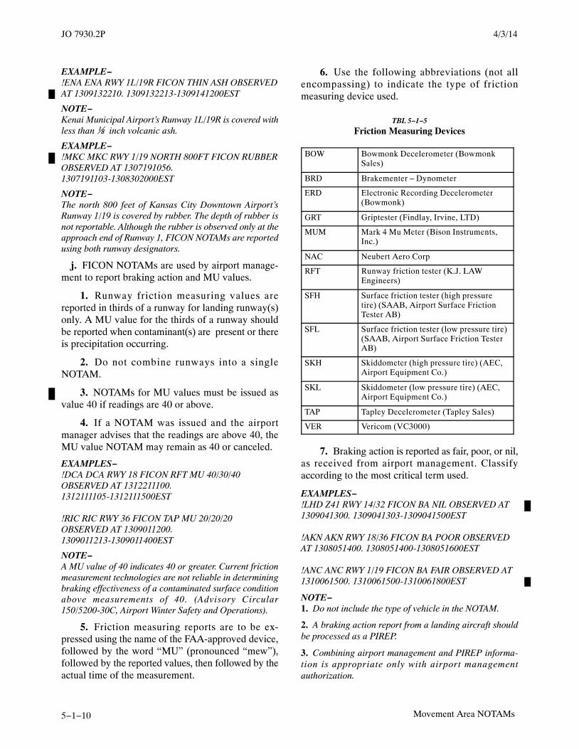
JO 7930.2P 4/3/14
5−1−10 Movement Area NOTAMs
EXAMPLE−!ENA ENA RWY 1L/19R FICON THIN ASH OBSERVEDAT 1309132210. 1309132213-1309141200EST
NOTE−Kenai Municipal Airport’s Runway 1L/19R is covered withless than ⅛ inch volcanic ash.
EXAMPLE−!MKC MKC RWY 1/19 NORTH 800FT FICON RUBBEROBSERVED AT 1307191056.1307191103-1308302000EST
NOTE−The north 800 feet of Kansas City Downtown Airport’sRunway 1/19 is covered by rubber. The depth of rubber isnot reportable. Although the rubber is observed only at theapproach end of Runway 1, FICON NOTAMs are reportedusing both runway designators.
j. FICON NOTAMs are used by airport manage-ment to report braking action and MU values.
1. Runway friction measuring values arereported in thirds of a runway for landing runway(s)only. A MU value for the thirds of a runway shouldbe reported when contaminant(s) are present or thereis precipitation occurring.
2. Do not combine runways into a singleNOTAM.
3. NOTAMs for MU values must be issued asvalue 40 if readings are 40 or above.
4. If a NOTAM was issued and the airportmanager advises that the readings are above 40, theMU value NOTAM may remain as 40 or canceled.
EXAMPLES−!DCA DCA RWY 18 FICON RFT MU 40/30/40OBSERVED AT 1312211100.1312111105-1312111500EST
!RIC RIC RWY 36 FICON TAP MU 20/20/20OBSERVED AT 1309011200.1309011213-1309011400EST
NOTE−A MU value of 40 indicates 40 or greater. Current frictionmeasurement technologies are not reliable in determiningbraking effectiveness of a contaminated surface conditionabove measurements of 40. (Advisory Circular150/5200-30C, Airport Winter Safety and Operations).
5. Friction measuring reports are to be ex-pressed using the name of the FAA-approved device,followed by the word “MU” (pronounced “mew”),followed by the reported values, then followed by theactual time of the measurement.
6. Use the following abbreviations (not allencompassing) to indicate the type of frictionmeasuring device used.
TBL 5−1−5
Friction Measuring Devices
BOW Bowmonk Decelerometer (BowmonkSales)
BRD Brakementer – Dynometer
ERD Electronic Recording Decelerometer(Bowmonk)
GRT Griptester (Findlay, Irvine, LTD)
MUM Mark 4 Mu Meter (Bison Instruments,Inc.)
NAC Neubert Aero Corp
RFT Runway friction tester (K.J. LAWEngineers)
SFH Surface friction tester (high pressuretire) (SAAB, Airport Surface FrictionTester AB)
SFL Surface friction tester (low pressure tire)(SAAB, Airport Surface Friction TesterAB)
SKH Skiddometer (high pressure tire) (AEC,Airport Equipment Co.)
SKL Skiddometer (low pressure tire) (AEC,Airport Equipment Co.)
TAP Tapley Decelerometer (Tapley Sales)
VER Vericom (VC3000)
7. Braking action is reported as fair, poor, or nil,as received from airport management. Classifyaccording to the most critical term used.
EXAMPLES−!LHD Z41 RWY 14/32 FICON BA NIL OBSERVED AT1309041300. 1309041303-1309041500EST
!AKN AKN RWY 18/36 FICON BA POOR OBSERVEDAT 1308051400. 1308051400-1308051600EST
!ANC ANC RWY 1/19 FICON BA FAIR OBSERVED AT1310061500. 1310061500-1310061800EST
NOTE−1. Do not include the type of vehicle in the NOTAM.
2. A braking action report from a landing aircraft shouldbe processed as a PIREP.
3. Combining airport management and PIREP informa-tion is appropriate only with airport managementauthorization.

JO 7930.2P4/3/14
5−1−11Movement Area NOTAMs
5−1−5. AERODROME FACILITIES
Issue a NOTAM if any aerodrome service availabilityhas changed from that which is published.
a. Certified Aircraft Rescue and Fire Fighting(ARFF).
1. Issue a NOTAM D on airports (not runways)certificated under 14 CFR Part 139, when notified byairport management that required ARFF equipmentis inoperative/unavailable and replacement equip-ment is not available. Except as indicated inparagraph 5-1-5a 3, airport management has 48 hoursto replace or substitute equipment before the indexchanges. Air carriers and others must be notified thatARFF equipment is out of service. Each NOTAMmust have an expiration time as obtained from airportmanagement. If unable to obtain an expiration time,add 48 hours to the time of receipt and advise airportmanagement.
NOTE−The ARFF Index for each certificated airport is publishedin the A/FD, which lists indices and ARFF equipmentrequirements.
2. At certificated airports listed in the A/FD, thecertificate holder (airport management) is requiredto notify air carriers by NOTAM when requiredARFF equipment is inoperative/unavailable andreplacement equipment is not available immediately.If the required Index level of capability is not restoredwithin 48 hours, airport management is required tolimit air carrier operations.
REFERENCE−Title 14 CFR Part 139
EXAMPLES−!FTW FTW AD ARFF VEHICLE OUT OF SERVICEINDEX UNCHANGED 1310242100-1310262100EST!FTW FTW AD ARFF VEHICLE OUT OF SERVICE1310021200-1310121200EST
3. If the ARFF vehicle is still out of service after48 hours, the airport manager must notify the FSS ofa temporary index change and approximate durationtime.
EXAMPLE−!FTW FTW AD ARFF NOW INDEX A1309072300-1309092300EST
NOTE−Even though the ARFF index is now A, four or less Index Baircraft may still operate into Fort Worth.
4. If the ARFF Index is listed in the A/FD as Aand the ARFF vehicle is out of service, the NOTAMswould be issued using the following format:
EXAMPLES−!STS STS AD ARFF NOT AVBL1310021200-1310121200EST
!STS STS AD AIRPORT CLSD TO AIR CARRIER MORETHAN 30 PAX 1310021200-1310121200EST
b. Fuel services.
EXAMPLES−!ARM ARM AD FUEL 100LL NOT AVBL1311011200-1311041800EST
!CLE CLE AD MOBILE JET A FUEL NOT AVBL1311041600-1311151800EST
!LAX LAX AD HYDRANT FUEL NOT AVBL1312011200-1312312359
c. MU-Friction Measuring Device.
EXAMPLE−!MSP MSP AD FRICTION MEASURING DEVICE OUTOF SERVICE 1309141000-1309211000EST
d. Customs Services. Describe the change ofservices by using “CUSTOMS,” followed by plainlanguage.
EXAMPLE−!BDL BDL AD CUSTOMS PROCESSING DELAYEDDUE TO CAPACITY, INTERNATIONAL CARRIERSMAY EXPERIENCE SIGNIFICANT DELAYS INCLEARING CUSTOMS, CONTACT AIRPORTMANAGEMENT AT XXX-XXX-XXXX1310021200-1310121200EST
e. Aerodrome beacon (ABN). If either of the lightsis out of service, the whole system is down.
EXAMPLE−!SPA SPA AD ABN OUT OF SERVICE1310021200-1310121200EST
f. Wind direction equipment, including windcones, wind direction indicator, wind sock, etc.
EXAMPLES−!ACY ACY AD WDI NOT LGTD1308151200-1308152000
!SGF SGF AD WINDCONE NOT LGTD1310051430-1310101200
!ACY ACY AD WDI FOR RWY 4 NOT LGTD1311221500-1311251200
!MCI MCI AD WDI NOT AVBL

JO 7930.2P 4/3/14
5−1−12 Movement Area NOTAMs
1309070700-1309101500
!BKL BKL AD WIND SOCK NOT AVBL1303010600-1303071200EST
!DEN DEN AD WDI LEFT SIDE RWY 17L OUT OFSERVICE 1303010600-1303071200
5−1−6. WORK IN PROGRESS
Any NOTAM associated with work in progress on oradjacent to a runway, taxiway, apron/ramp, oraerodrome must be formatted as follows:
a. Exclamation point (!).
b. Accountability.
c. Airport designator.
d. Keyword. RWY, TWY, APRON, or AD.
e. Surface name/designator. Specify the name/designator of the surface on which the work is beingconducted.
f. Surface segment description must be specifiedin feet or from a specific point to point; for example,BTN TWY A AND TWY B.
NOTE−A surface segment differs from the optional plain languagedescription of the work areas in that the surface segmentdescription can be captured and depicted graphically in adigital environment. The optional plain languagecomments will be delivered in text form only.
g. Condition or activity; “WORK IN PRO-GRESS.”
NOTE−Any NOTAM associated with snow/ice removal must bedescribed as “WORK IN PROGRESS (reason);” forexample, SNOW REMOVAL, ICE REMOVAL. Airportoperators must ensure this NOTAM remains active onlywhen actual snow and ice removal operations are takingplace.
h. Reason (optional). The work area may bedescribed in plain language text after the reason byspecifying the area by cardinal direction in
relationship to the work area, by an intersection, ordistance from an intersection.
i. Remarks, if needed.
j. Schedule, if needed; for example, “DAILY1200-1800.”
k. Effective time/expiration time.
EXAMPLES−!IAD IAD RWY 1L/19R WORK IN PROGRESSRESURFACING 1309070700-1309101500
!SBY SBY TWY E BTN RWY 5/23 AND TWY A WORKIN PROGRESS TRENCHING 1309070700-1309101500
!SBY SBY TWY E BTN RWY 5/23 AND TWY A WORKIN PROGRESS TRENCHING SOUTH SIDE1309070700-1309101500
!MEM MEM APRON FEDEX FEEDER RAMP WORKIN PROGRESS RESURFACING WEST HALF1309070700-1309101500
!CHO CHO RWY 3/21 WORK IN PROGRESS RWY LGTREPLACEMENT NORTHEAST TWY E1309070700-1309101500
!IAD IAD RWY 1L/19R WORK IN PROGRESSMOWING ADJ NORTHEAST 500FT1309070700-1309101500
!IAD IAD RWY 1L/19R WORK IN PROGRESSMAINTENANCE VEHICLES EAST SIDE OF RWY1309070700-1309101500
!ICT ICT AD ALL SURFACES WORK IN PROGRESSSNOW REMOVAL 1312070700-1312101500EST
!MCI MCI RWY 1L/19R WORK IN PROGRESS SNOWREMOVAL 1312070700-1312101500
!DSM DSM TWY D4, D5, D6, TWY B BTN RWY 13/31AND TWY D, TWY D WEST OF RWY 5/23 WORK INPROGRESS SNOW REMOVAL1312070700-1312101500
!FAI FAI APRON EAST RAMP WORK IN PROGRESSSNOW REMOVAL EAST HALF1312070700-1312101500EST

JO 7930.2P4/3/14
5−2−1Lighting Aid and Obstruction NOTAMs
Section 2. Lighting Aid and Obstruction NOTAMs
5−2−1. LIGHTING AIDS
Originate NOTAMs on lighting aids for public-usecivil landing areas listed in the A/FD. NOTAMSregarding lighting aids are originated as follows:
a. Approach light systems (ALS). Only use therunway direction for which the equipment pertains.
1. When commissioning approach light sys-tems, indicate the exact type of system; for example,MALSR, MALSF, etc.
2. Once commissioned and published, approachlight systems need only be shown as ALS.
EXAMPLES−!ANB EUF RWY 36 ALS DECOMMISSIONED1306011300-PERM
!ANB EUF RWY 18 ALS OUT OF SERVICE1310112300-1310131200EST
!CLE CLE RWY 6L ALS OUT OF SERVICE EXCSSALR 1307112300-1307131200EST
b. Lead off /lead on lights.
NOTE−Lead off and lead on light will be the standardizedverbiage for lead off/on lights which are sometimesreferred to as turnoff lights.
EXAMPLES−!IAD IAD RWY 1C LEAD OFF LGT FOR TWY Y4 OUTOF SERVICE 1309112300-1309131200EST
!IAD IAD RWY 1C LEAD ON LGT FOR TWY Y9 OBSC1305112300-1305131200EST
c. Runway status light system.
EXAMPLE−!MCO MCO RWY 18L RUNWAY STATUS LGT SYSTEMOUT OF SERVICE 1300111200-1303311830EST
1. Runway entrance lights.
EXAMPLES−!PHL PHL TWY ALL RUNWAY ENTRANCE LGT FORRWY 9L SOUTH SIDE OUT OF SERVICE1302011200-1302031500EST
!PHL PHL TWY K5, K6, T RUNWAY ENTRANCE LGTFOR RWY 9L OUT OF SERVICE1311232300-1315251200EST
2. Take-off hold lights.
EXAMPLE−!BWI BWI RWY 28 TKOF HOLD LGT OUT OFSERVICE 1311232300-1315251200EST
d. Sequence flashing lights/runway alignmentindicator lights.
EXAMPLES−!ANB EUF RWY 18 SEQUENCED FLASHING LGTOBSC 1305112300-1305131200EST
!ANB EUF RWY 18 RAI LGT OUT OF SERVICE1305112300-1305131200EST
e. Visual approach lighting.
1. Visual approach slope indicator (VASI).
EXAMPLES−!SBY SBY RWY 5 VASI OUT OF SERVICE1309111200-1309131200EST
!RIC RIC RWY 22 VASI LEFT SIDE OUT OF SERVICE1305112300-1305131200EST
!BTL BTL RWY 13 VASI UNUSABLE 5 DEG LEFT OFCOURSE 1311041400-1312301930
2. Precision approach path indicator (PAPI).
EXAMPLE−!IAD IAD RWY 1L PAPI OUT OF SERVICE1311031200-131142200EST
3. Runway end identifier lights.
EXAMPLE−!DCA DCA RWY 18 RUNWAY END IDENTIFIER LGTOUT OF SERVICE 1305112300-1305131200EST
4. Threshold lights (THR LGT).
EXAMPLES−!SAV SAV RWY 27 THR LGT OUT OF SERVICE1305112300-1305131200EST
f. Runway edge lights (EDGE LGT).
1. When commissioning runway edge lightsystems, indicate the exact type of system; forexample, LIRL, MIRL, HIRL, etc.
2. Once commissioned and published, runwayedge lights must only be shown as EDGE LGT.
EXAMPLE−!BNA BNA RWY 13/31 EDGE LGT OUT OF SERVICE1305112300-1305131200EST
3. Runway lights obscured due to snow and ice.

JO 7930.2P 4/3/14
5−2−2 Lighting Aid and Obstruction NOTAMs
EXAMPLE−!BTV BTV RWY 15/33 EDGE LGT OBSC1310131300−1310141300EST
NOTE−1. All runway 15/33 edge lights are completely obscured.The reason for the obscuration should not be reported.
2. Lights that are partially obscured should not bereported.
g. Runway centerline light (RCLL).
EXAMPLE−!ATL ATL RWY 8R/26L RCLL OUT OF SERVICE1305112300-1305131200EST
h. Touchdown zone lights (TDZ LGT).
EXAMPLE−!ATL ATL RWY 8R TDZ LGT OUT OF SERVICE1305112300-1305131200EST
i. Runway lead-in lighting system (RLLS).
EXAMPLE−!DCA DCA RWY 18 RLLS OUT OF SERVICE1305112300-1305131200EST
j. Airport lighting total power failure.
EXAMPLE−!SPA SPA AD LGT ALL OUT OF SERVICE1305112300-1305131200EST
k. Pilot-controlled lighting (PCL) frequencywhen it controls approach lights or runway lights.
EXAMPLES−!SBY SBY SVC PCL ALL OUT OF SERVICE1305112300-1305131200EST
!JLN JLN SVC PCL RWY 18/36 EDGE LGT OUT OFSERVICE 1305112300-1305131200EST
!ANB EUF SVC PCL RWY 18 VASI OUT OF SERVICE1305112300-1305131200EST
!JLN JLN SVC PCL RWY 18 ALS OUT OF SERVICE1305112300-1305131200EST
!JLN JLN SVC PCL RWY 18/36 OUT OF SERVICE EXCLOW INTST 1305112300-1305131200EST
NOTE−If the lights are set on continuous as result of the PCLoutage, the PCL OUT OF SERVICE NOTAM must becanceled and a new NOTAM originated regarding thecondition/status of the affected lighting system.
EXAMPLES−!BFD 8G5 SVC PCL RWY 14/32 COMMISSIONEDFREQ 122.7 DAILY 0200-11001305110200-1305131100EST
!SBY SBY SVC PCL FREQ CHANGED TO 122.81305112300-PERM
NOTE−PCL frequency need not be an ATC frequency.
l. Taxiway lighting.
1. Taxiway edge lights.
EXAMPLE−!SHD SHD TWY K, L EDGE LGT OUT OF SERVICE1305112300-1305131200EST
2. Runway lights obscured due to snow and ice.
EXAMPLE−!ROA ROA TWY E CL LGT BTN TWY E1 AND RWY15/33 OUT OF SERVICE 1305112300-1305131200EST
3. Runway guard lights.
EXAMPLE−!MCI MCI TWY ALL RUNWAY GUARD LGT FOR RWY1L/19R OUT OF SERVICE1305112300-1305131200EST
4. Stop bar lights.
EXAMPLE−!SEA SEA TWY C STOP BAR LGT FOR RWY 16R/34LAND FOR EAST SIDE RWY 16L/34R OUT OFSERVICE 1305112300-1305131200EST
5. Taxiway lights obscured due to snow and ice.
EXAMPLE−!BTV BTV TWY C EDGE LGT OBSC1310131300−1310141300EST
NOTE−1. OBSC can be used to describe the physical state ofairport infrastructure, including signs and markings.
2. All taxiway C edge lights are completely obscured.The reason for the obscuration should not be reported.
3. Lights that are partially obscured should not bereported.
5−2−2. TOWER LIGHT OUTAGES
a. The NOTAM text for telecommunicationantenna tower light outages must be formatted asfollows:
1. Exclamation point (!).
2. Accountability.
3. Location designator.
4. Keyword “OBST.”
5. Specify the attribute “TOWER LGT.”
6. The FCC antenna structure registration(ASR) number in parentheses (if known).

JO 7930.2P4/3/14
5−2−3Lighting Aid and Obstruction NOTAMs
7. Obstruction location by latitude and longit-ude to the nearest one hundredth of a second.
8. Plain language location in parentheses.
(a) When the tower is within 5SM of anairport, describe the plain language location in feet ornautical miles using 16 points of compass from aspecified location on the airport; for example, (2NMSSW ACY) (.5NM E APCH END RWY 18) (2000FTSSE DEP END RWY 20).
(b) When the tower is within 500 feet eitherside of the centerline of a charted helicopter route (see14 CFR Section 77.23), or 5SM or more from anairport and more than 200 feet AGL, describe theplain language location by using the bearing,distance, and aerodrome designator of the nearestpublic-use airport; for example, (12NM SSW SPA).
9. Specify the altitude MSL with the unit ofmeasurement (FT).
10. In parentheses, specify the height with theunit of measurement and reference datum (AGL).
NOTE−Height of tower lights on terrain (hills) are identified asMSL only.
11. Specify the condition “OUT OF SER-VICE.” A light condition of OUT OF SERVICErefers to a top light or flashing obstruction lightregardless of its position.
12. Effective time/expiration time.
(a) When a notice of light outage is receivedwithout an expiration time, inform the sponsor thatyou will be adding 15 days to the current time for theexpiration time, at which time the NOTAM will beauto canceled. Advise the sponsor that a NOTAMmust be canceled in the event that the return-to-ser-vice time is earlier than 15 days.
(b) When a tower light outage NOTAM isauto canceled after 15 days, the canceled NOTAM,including the tower’s ASR number will be forwardedto the appropriate FCC field office.
NOTE−Appendix C lists FCC Field Office FAX numbers.
EXAMPLES−!GSP GSP OBST TOWER LGT (ASR 1234567)345313.12N0815744.34W (3NM SSW SPA) 1528FT(564FT AGL) OUT OF SERVICE1310291200-1311131200
!PWK PWK OBST TOWER LGT (ASR 1234567)420651.07N087546.27W (12NM N PWK) 1049FT(330FT AGL) OUT OF SERVICE1309151600-1309301600
b. Commercial tower light operators must reportthe operating status of tower lights and ensure that aNOTAM is originated via a direct entry tool orcontacting FSS.
5−2−3. OBSTRUCTIONS
a. Obstructions include cranes, stacks, windturbines, non-FCC towers, powerlines, etc. Anyfailure or malfunction which affects a top light orflashing obstruction light regardless of its position isa condition for a NOTAM.
b. The NOTAM text for obstructions must beformatted as follows:
1. Exclamation point (!).
2. Accountability.
3. Location designator.
4. Keyword “OBST.”
5. Specify the attribute; for example,“CRANE,” “STACK,” “AIRCRAFT TAIL,”“BUILDINGS,” etc.
6. Obstruction location by fix/radial/distance orlatitude and longitude to the nearest second.
7. Plain language location in parentheses.
(a) When the obstruction is within 5SM of anairport, describe the plain language location in feet ornautical miles using 16 points of compass from aspecified location on the airport; for example,(.5NM E APCH END RWY 18) (2000FT SSE DEPEND RWY 20).
(b) When the obstruction is within 500 feeteither side of the centerline of a charted helicopterroute, or 5SM or more from an airport and more than200 feet AGL, describe the plain language location byusing the bearing, distance, and aerodrome designat-or of the nearest public-use airport; for example,(12NM SSW SPA)
8. Specify the altitude MSL with the unit ofmeasurement (FT).
9. In parentheses, specify the height with theunit of measurement and reference datum (AGL).
10. Specify the condition; for example, “NOTLGTD,” “LGTD,” “FLAGGED.”

JO 7930.2P 4/3/14
5−2−4 Lighting Aid and Obstruction NOTAMs
11. Effective time/expiration time.
EXAMPLES−!RDU N52 OBST CRANE 345140N0804506W (1.44NMSW N52) 580FT (195FT AGL) NOT LGTD1311292300-1311302300
!BGR 60B OBST WIND TURBINE 452315N0701346W(18.4NM SW 60B) 2820FT (410FT AGL) NOT LGTD1311302330-13121752359EST
!ZOB ZOB OBST WIND TURBINE FARM WITHINAREA DEFINED AS 4NM RADIUS OF452315N0701346W 2820FT (410FT AGL) NOT LGTD1311302330-13121752359
5−2−4. MOORED BALLOONS AND KITES
Upon receipt of a waiver to 14 CFR Part 101, but notmore than 3 days prior to the event, issue a NOTAMcontaining the following information in the followingorder:
a. Exclamation point (!).
b. Accountability.
c. Location designator.
d. Keyword “OBST.”
e. The type of obstruction; for example“MOORED BALLOON,” “KITE.”
f. Description of area impacted; for example, anautical mile radius of a NAVAID, fix/radial/dis-tance, or latitude and longitude to the nearest second.
g. Plain language location in parentheses.
1. When the obstruction is within 5SM of anairport, describe the plain language location in feet or
nautical miles using 16 points of compass from aspecified location on the airport; for example,(.5NM E APCH END RWY 18) (2000FT SSE DEPEND RWY 20).
2. When the obstruction is within 500 feet eitherside of the centerline of a charted helicopter route (seereference), or 5SM or more from an airport and morethan 200 feet AGL, describe the plain languagelocation by using the bearing, distance, andaerodrome designator of the nearest public-useairport; for example, (12NM SSW SPA)
h. Specify the altitude MSL with the unit ofmeasurement (FT).
i. In parentheses, specify the height with the unitof measurement and reference datum (AGL).
j. Specify the condition, if needed; for example,“LGTD,” “FLAGGED.”
k. Schedule, if needed; for example, DAILY1200-1800 or DAILY SR-SS.
l. Effective time/expiration time.
EXAMPLES−!SJT SJT OBST MOORED BALLOON WITHIN AREADEFINED AS 1NM RADIUS OF SJT 2430FT (510FTAGL) FLAGGED 1309251400−1309261400EST
!SJT SJT OBST MOORED BALLOON WITHIN AREADEFINED AS 1NM RADIUS OF 400720N0943105W(30NM NE SJT) 2350FT (431FT AGL) LGTDFLAGGED 1310271700-1311051200
!ABQ ABQ OBST KITE WITHIN AREA DEFINED AS1NM RADIUS OF ABQ020002 5860FT (505FT AGL)DAILY SR-SS 1310011900−1310112100EST

JO 7930.2P4/3/14
5−3−1NAVAID NOTAMs
Section 3. NAVAID NOTAMs
5−3−1. GENERAL
Technical Operations personnel must ensure theorigination of NOTAM Ds concerning NAVAIDs forwhich they are responsible.
5−3−2. REPORTING NAVAIDMALFUNCTIONS
Known or reported malfunctions of a navigational aidmust be reported to Technical Operations orappropriate personnel.
5−3−3. UNPROGRAMMED EXTENDEDSHUTDOWNS
Unprogrammed, extended facility shutdowns orother unanticipated outages that are expected to lastmore than 30 days must be promptly reported toNFDC by administrative message or FAX. Whenpossible, the expected duration of the shutdown is tobe included in the message.
NOTE−Except for emergency shutdowns, technical operationspersonnel are expected to give at least 1 hour notice.
5−3−4. NAVAID MAINTENANCESHUTDOWNS
Information concerning maintenance shutdown ofNAVAIDs that are part of the NAS must be handledas follows:
a. Routine maintenance shutdown. When pos-sible, approval should be obtained sufficiently inadvance of the proposed shutdown time to allowdissemination of a NOTAM at least 5 hours before ashutdown will occur. A routine maintenanceshutdown request must not be denied because of aninability to issue a NOTAM 5 hours in advance of theshutdown.
b. Emergency shutdown. When possible, obtain atleast 1 hour advance notice so that appropriatedissemination may be made before shutdown.
c. Extended maintenance shutdown. Notify theNFDC sufficiently in advance to permit publicationof the information prior to the shutdown date. When
this is not possible, disseminate a NOTAM no morethan 3 days before the shutdown.
5−3−5. UNMONITORED NAVAIDs
a. All VOR, VORTAC, and ILS equipment in theNAS have automatic monitoring and shutdownfeatures in the event of malfunction.
b. When a navigational aid’s operational statuscannot be monitored at the controlling or monitoringfacility, but all indications or reports are the facilityis operating normally, Technical Operations person-nel must ensure the origination of a NOTAM placingthe aid in an unmonitored status.
c. When issuing a NOTAM describing a facility asunmonitored, do not use the category of monitor, onlythe word “UNMONITORED.”
EXAMPLE−DCA LDN NAV VOR UNMONITORED
d. If the NAVAID is reported as being out ofservice, the unmonitored NOTAM must be canceled.
5−3−6. INSTRUMENT LANDING SYSTEMSTATUS
a. Category 2 and/or 3 approaches are automatic-ally canceled or not authorized when a NOTAM hasbeen issued for any fundamental component neededfor the approaches. Those components are theglidepath, localizer, approach lighting system, andthe runway edge lights.
b. Category 2 and/or 3 approaches may not beauthorized due to the failure of additional equipment,such as the outer marker inner marker, locator at theouter marker, distance measuring equipment, se-quence flashing lights/runway alignment indicatorlights, touchdown zone lights, runway centerlinelights, RVR touchdown, RVR midpoint, and RVRrollout. The determination of impact to highercategory ILS operations will be made by theTechnical Operations Control Center specialist inaccordance with the guidance contained inFAA Order 6750.24, and a separate NOTAM requestfor loss of ILS category will be made if the equipmentfailures warrant this action.

JO 7930.2P 4/3/14
5−3−2 NAVAID NOTAMs
EXAMPLES−!ATL ATL NAV ILS RWY 8L CAT 2 NA1311251600-1311251900EST
!ATL ATL NAV ILS RWY 8L CAT 3 NA1311251600-1311251900EST
!ATL ATL NAV ILS RWY 8L CAT 2/3 NA1311251600-1311251900EST
5−3−7. NAVAID CONDITIONS
a. Originate a NOTAM D for commissioning,decommissioning, outages, or unmonitored status ofNAVAIDs that are part of the NAS. The NOTAMmust be canceled by the originator.
b. Restrictions to NAVAIDs are normally pub-lished by segment; for example, 020-055 degreeradials. To correct a given segment, cancel theoriginal NOTAM and issue a completely newNOTAM. Add “PLUS SEE (publication)” whenother restrictions to the NAVAID are published. Theabsence of this statement from the NOTAM indicatesthat all other restrictions have been canceled.
EXAMPLES−!SAV SAV NAV VOR RADIALS 010-030 BEYOND 35NMSFC-2000FT UNUSABLE 1311251600-1311251900EST
!PNC PER NAV VOR RADIALS 045-060 SFC- 2000FTUNUSABLE 1311011200-1311011600EST
!FMN RSK NAV VOR RADIALS 090-180 BEYOND25NM SFC-5000FT, AND RADIALS 270-300 BEYOND25NM SFC-5000FT, AND RADIALS 300-360 BEYOND35NM SFC-4000FT UNUSABLE1311011200-1311011600EST
c. Instrument Landing Systems (ILS).
1. Distinguish components of an ILS fromnonprecision approach NAVAIDs by preceding thecomponent with “ILS” followed by “RWY” and therunway number (including single ILS airports).
EXAMPLES−!SHV SHV NAV ILS RWY 32 110.3 COMMISSIONED1311251600-PERM
!SUS SUS NAV ILS RWY 8R SNOOP LOM OUT OFSERVICE 1311011200-1311011600EST
!SHV SHV NAV ILS RWY 5 DECOMMISSIONED1311251600-PERM
!DCA DCA NAV ILS RWY 18 DME OUT OF SERVICE1311011200-1311011600EST
!DTW DTW NAV ILS RWY 30 LOC RETURN TOSERVICE 1311251600-1311251900EST
!CDR CDR NAV ILS RWY 2 FAN MKR OUT OFSERVICE 1311011200-1311011600EST
!ANB EUF NAV ILS RWY 18 GP SFC-768FTUNUSABLE 1311251600-1311251900EST
!CDR CDR NAV ILS RWY 2 GP/OM/MM OUT OFSERVICE 1311011200-1311011600EST
!DEN DEN NAV ILS RWY 35L UNRELBROADCASTING HAZARDOUS MISLEADINGINFORMATION 1311011200-1311011600
NOTE−This NOTAM states the ILS for RWY 35L is unreliablebecause it is broadcasting Hazardous MisleadingInformation.
2. Snow and ice accumulation in the vicinity ofglide slope antennas may affect facility performanceto the extent that it is inoperative. When this occurs,Technical Operations personnel at the glide slopelocation are required to initiate appropriate NOTAMD action. Technical operations personnel mustmonitor snow conditions to determine whenconditions permit use of the glide slope and initiateaction to cancel the restricting NOTAM.
EXAMPLE−!DCA DCA NAV ILS RWY 18 GP OUT OF SERVICE1301051615-1301052015EST
d. Simplified directional facility.
EXAMPLE−!LOU AAS NAV SIMPLIFIED DIRECTIONALFACILITY RWY 23 OUT OF SERVICE1301051615-1301052015EST
e. Localizer type directional aid (LDA).
EXAMPLES−!DCA DCA NAV LOCALIZER TYPE DIRECTIONALAID RWY 18 OUT OF SERVICE1301051615-1301052015EST
!EKN EKN NAV LOCALIZER TYPE DIRECTIONALAID OUT OF SERVICE 1301051615-1301052015EST
NOTE−The LDA at the airport is out of service.

JO 7930.2P4/3/14
5−3−3NAVAID NOTAMs
f. VOR/DME.
EXAMPLES−!OJC OJC NAV VOR/DME 113.0/CH 77COMMISSIONED 1304131800-PERM
!OJC OJC NAV VOR/DME DECOMMISSIONED1312012300-PERM
!OJC OJC NAV VOR OUT OF SERVICE1310230100-1310311230EST
!OJC OJC NAV DME OUT OF SERVICE1301010001-1301051230EST
!OJC OJC NAV VOR UNREL BROADCASTINGHAZARDOUS MISLEADING INFORMATION1303011200-1303151830EST
g. VORTAC.
1. VORTAC (all components, VOR/DME/TACAN).
EXAMPLES−!GSO GSO NAV VORTAC 116.2/ CH 109COMMISSIONED 1304131800-PERM
!GSO GSO NAV VORTAC DECOMMISSIONED1304131800-PERM
!OJC OJC NAV VORTAC OUT OF SERVICE1304131800-1304301200
2. VOR out of service (DME/TACAN opera-tional).
EXAMPLE−!GSO GSO NAV VOR OUT OF SERVICE1304131800-1304301200
3. DME out of service (VOR operational/TACAN out).
EXAMPLE−!GSO GSO NAV TACAN OUT OF SERVICE1310230100-1310311230EST
NOTE−When the DME portion of a VORTAC fails or is removedfrom service for maintenance, the TACAN automaticallybecomes inoperative.
4. TACAN azimuth out of service (VOR/DMEoperational).
EXAMPLE−!GSO GSO NAV TACAN AZM OUT OF SERVICE1310230100-1310311230EST
5. VOT (VOR Test Facility).
EXAMPLE−!SBY SBY NAV VOT OUT OF SERVICE1310242000-1310250300EST
6. VOR Receiver Checkpoint.
EXAMPLES−!MWA MWA NAV VOR AIRBORNE REC CHECKPOINTOUT OF SERVICE 1310242000-1310250300EST
!BTL BTL NAV VOR GROUND REC CHECKPOINTOUT OF SERVICE 1310242000-1310250300EST
!LRD LRD NAV VOR GROUND REC CHECKPOINTFOR TWY A OUT OF SERVICE1310242000-1310250300
NOTE−There are two separate Ground Receiver Checkpoints forLRD VOR at (LRD), Laredo, Texas.
h. TVOR.
1. TVORs serving one airport, and not associ-ated with airway structure, must have NOTAMsissued using the associated airport identifier as theaffected facility.
EXAMPLE−!ILN ILN NAV MXQ VOR OUT OF SERVICE1310242000-1310250300EST
2. TVORs serving more than one airport, orassociated with airway structure, must have NOT-AMs issued using the TVOR identifier as the affectedfacility.
EXAMPLE−!DAY XUB NAV VOR OUT OF SERVICE1310242000-1310250300EST
i. NDB or LOM as follows:
1. Terminal NDBs. Those NDBs located on orserving only that airport must have NOTAMs issuedusing the associated airport as the affected facility.
EXAMPLE−!DCA DCA NAV GTN NDB OUT OF SERVICE1310242000-1310250300EST
2. If an NDB serves more than one airport, issuea NOTAM using the identifier of the NDB as theaffected facility.
EXAMPLE−!MIV PNJ NAV NDB OUT OF SERVICE1309241430-1309241700EST
NOTE−PNJ serves TEB and CDW.
3. LOM outages.

JO 7930.2P 4/3/14
5−3−4 NAVAID NOTAMs
(a) LOM serving one airport must be issuedwith the three−letter identifier of the airport as theaffected location.
EXAMPLES−!SBY SBY NAV ILS RWY 32 COLBE LOM OUT OFSERVICE 1309241430-1309241700EST
!SUS SUS NAV ILS RWY 8R SNOOP LOM OUT OFSERVICE 1309241430-1309241700EST
NOTE−Except in Alaska, collocated LOMs are assignedfive-letter names. All other NDBs are assigned three-letteridentifiers.
(b) LOM serving more than one airport mustbe issued under the three-letter identifier of eachairport that it serves. This procedure may requirecoordination with other facilities.
EXAMPLES−!MCI MCI NAV ILS RWY 9 HUGGY LOM OUT OFSERVICE 13010241300-1310241700EST
!FLV FLV NAV HUGGY NDB OUT OF SERVICE1311241300-1311241700EST
NOTE−In the above examples, Huggy NDB serves as a LOM torunway 9 at Kansas City Intl (MCI). It also serves FortLeavenworth/Sherman AAF (FLV), Kansas, as an NDB.
j. NAVAID identification change.
EXAMPLE−!IND IND NAV VORTAC ID CHANGED TO VHP1301011200-PERM
k. Global Positioning System (GPS).
1. All global positioning system pseudo−random noise (PRN) GPS satellite outages will bereported directly to the USNOF by the Air ForceSpace Command (AFSPACECOM) monitoringfacility. The USNOF will issue NOTAMs under theaccountability “GPS” with a location of “GPS.”When these NOTAMs get distributed internationally,the USNOF changes the designator “KNMH.”
EXAMPLE−!GPS GPS NAV PSUEDO RANDOM NOISE 16 OUTOF SERVICE 1309231600−1309242300EST
NOTE−1. Global positioning system pseudo−randomnoise (PRN) number 16 is out of service fromSeptember 23, 2013, at 1600 until September 24, 2013,at 2300.
2. Use standard request/reply procedures to obtain allcurrent GPS NOTAMs.
EXAMPLES−GG KDZZNAXX121413 KDCAYFYX)SVC RQ DOM LOC=GPSorGG KDZZNAXX121413 KDCAYFYX)SVC RQ INT LOC=KNMHorORIGIN: PRECEDENCE:GG TIME:ACK:NADDR:KDZZNAXXTEXT:)SVC RQ INT LOC=KNMH
NOTE−GPS operations are included in the AeronauticalInformation Manual.
2. All GPS interference testing NOTAMs willbe reported to the USNOF by Technical OperationsATC Spectrum Engineering Services, SpectrumAssignment and Engineering Services. The USNOFwill format NOTAMs under the accountability“GPS” with an affected location of the associatedcenter.
EXAMPLE−!GPS ZAB NAV GPS SIGNAL WITHIN A CONESHAPED AREA DEFINED AS A CIRCLE CENTEREDAT 310535N0930350W (AEX 251.4 RADIAL AT30.5NM) DECREASING IN AREA WITH A DECREASEIN ALTITUDE DEFINED AS:270NM RADIUS OF 310535N0930350W FL400-UNL, 220NM RADIUS OF 310535N0930350W FL250, 150NM RADIUS OF 310535N0930350W 10000FT,110NM RADIUS OF 310535N0930350W 4000FT AGL, 50NM RADIUS OF 310535N0930350W 50FT AGLUNREL DAILY 0600−1200 1311160600−1311191200EST
NOTE−Spectrum Assignment and Engineering Services willnotify the flight service station with the new NOTAMinformation.
l. Wide Area Augmentation System (WAAS).WAAS area-wide NOTAMs are originated whenWAAS assets are out of service and impact theservice area. The term “MAY NOT BE AVBL”indicates that due to ionospheric conditions, lateralguidance may still be available when verticalguidance is unavailable. Under certain conditions,both lateral and vertical guidance may be unavail-able. USNOF distributes these as FDC NOTAMswhen a WAAS asset failure affects a large area, or as

JO 7930.2P4/3/14
5−3−5NAVAID NOTAMs
Center NOTAMs if all airports with RNAVapproaches within a center’s boundary do not haveWAAS availability. USNOF utilizes templatesprovided by Technical Operations, WAAS Opera-tions. All events must reflect an effective time andexpiration time.
1. Unscheduled loss of signal or service.
EXAMPLES−!FDC FDC NAV WAAS NOT AVBL 1311160600−1311191200EST
!FDC ZAN NAV WAAS SIGNAL NORTH OF LINEDEFINED AS 6800N14000W TO 5400N16000W MAYNOT BE AVBL. WAAS USERS SHOULD CONFIRMRAIM AVAILABILITY FOR IFR OPERATIONS IN THISAREA. T-ROUTES IN THIS SECTOR NOT AVBL. ANYREQUIRED ALTERNATE AIRPORT IN THIS AREAMUST HAVE AN APPROVED INSTRUMENTAPPROACH PROCEDURE OTHER THAN GPS THATIS ANTICIPATED TO BE OPERATIONAL ANDAVAILABLE AT THE ESTIMATED TIME OF ARRIVALAND WHICH THE AIRCRAFT IS EQUIPPED TO FLY.1304210800-1304242000EST
2. Ionosphere storm conditions.
EXAMPLES−!FDC FDC NAV WAAS VNAV/LPV/LP MINIMA MAYNOT BE AVBL 1306111330-1306141930EST
!FDC FDC NAV WAAS VNAV/LPV MINIMA NOTAVBL, WAAS LP MINIMA MAY NOT BE AVBL1306021200-1306031200EST
3. Scheduled loss of signal or service.
EXAMPLES−!FDC FDC NAV WAAS NOT AVBL1312041015-1312082000EST
!FDC ZAN NAV WAAS SIGNAL NORTH OF LINEDEFINED AS 7000N15000W TO 6400N16400W MAYNOT BE AVBL. WAAS USERS SHOULD CONFIRMRAIM AVAILABILITY FOR IFR OPERATIONS IN THISAREA. T-ROUTES IN THIS SECTOR NOT AVBL. ANYREQUIRED ALTERNATE AIRPORT IN THIS AREAMUST HAVE AN APPROVED INSTRUMENTAPPROACH PROCEDURE OTHER THAN GPS THATIS ANTICIPATED TO BE OPERATIONAL ANDAVAILABLE AT THE ESTIMATED TIME OF ARRIVALAND WHICH THE AIRCRAFT IS EQUIPPED TO FLY.1304210800-1304242000EST
m. Ground Based Transceiver (GBT) when usedas a published ground based navigation aid; forexample, as used for CAPSTONE.
1. When a GBT is out of service and/or expectedby Technical Operations personnel to be out ofservice, issue a NOTAM D.
2. The identifier used for the issuance ofNOTAMs must be the three−letter identificationwhere the GBT is located.
3. A GBT service is comprised of FlightInformation Service Broadcast (FIS-B) and TrafficInformation Service Broadcast (TIS-B). When one ofthese broadcasts is out of service and/or expected byTechnical Operations personnel to be out of serviceissue a NOTAM D.
EXAMPLES−!BET BET NAV GROUND BASED TRANSCEIVER OUTOF SERVICE 1312070800-1312101800EST
!ANI ANI NAV GROUND BASED TRANSCEIVER OUTOF SERVICE 1309211600-1309211900EST
n. Ground Based Augmentation System (GBAS).Originate NOTAMs when the GBAS is out of servicefor maintenance reasons or predicted to be out ofservice. GBASs are operated by non-federal serviceproviders.
1. Unscheduled loss of signal or service.
EXAMPLES−!IAH 05/087 IAH NAV GROUND BASEDAUGMENTATION SYSTEM OUT OF SERVICE1309211600-1309211900EST
!EWR EWR NAV GLS RWY 4R, RWY 4L, RWY 11, RWY22R, RWY 22L OTS 1307182135-1307182200
2. Predicted loss of signal or service.
EXAMPLE−!IAH IAH NAV GLS NOT AVBL1302101944-1302102001
NOTE−When all the GBAS are not available
5−3−8. HOURS OF OPERATION
Changes in the hours of operation of a NAVAID dueto other than seasonal daylight time changes.
EXAMPLE−!SBY SBY NAV ILS RWY 32 UNMONITORED DAILY0200-0900 1310140200-1310160900EST


JO 7930.2P4/3/14
5−4−1Communications Outlets NOTAMs
Section 4. Communications Outlets NOTAMs
5−4−1. GENERAL
Technical Operations personnel must ensure theorigination of NOTAM D concerning communica-tion outlets for which they are responsible.
5−4−2. REPORTING COMMUNICATIONSOUTLET MALFUNCTIONS
Known or reported malfunctions of a communicationoutlet must be reported to Technical Operations orappropriate personnel.
5−4−3. COMMUNICATION OUTLETCONDITIONS
Originate a NOTAM for conditions pertaining to theoperation of communications outlets that are part ofthe NAS when an outage occurs or when a scheduledshutdown is expected as follows:
a. Commissioning, decommissioning, outage, orunavailability of communications outlets for thefollowing:
EXAMPLES−!GSO GSO COM COMMON TRAFFIC ADVISORYFREQUENCY 122.8 COMMISSIONED1306111330-PERM
!PGD PGD COM LOCAL CTL 118.9, GROUND CTL121.0 COMMISSIONED 1310031200-PERM
1. All published ATC frequencies and allcommunication frequencies will be issued with theaffected frequency when out of service.
EXAMPLE−!INW INW COM REMOTE COM OUTLET 122.6 OUTOF SERVICE 1307121330-1307151930EST
NOTE−Winslow’s other frequency 255.4 is still operating. Ifboth were out of service, the NOTAM would be “INW COMREMOTE COM OUTLET OUT OF SERVICE.”
EXAMPLES−!DCA PSK COM CLEARANCE DELIVERY 121.7 OUTOF SERVICE 1305101330-1305131330EST
!BNA MBT COM GROUND COM OUTLET 135.075OUT OF SERVICE 1306111330-1306141930EST
!ENA ENA COM LOCAL AIRPORT ADVISORY 121.3OUT OF SERVICE 1307091530-1307142230EST
NOTE−Local Airport Advisory frequency out of service.
EXAMPLE−!DDC DDC COM REMOTE AIRPORT ADVISORY122.7 NOT AVBL 1307091530-1307142230EST
2. If several frequencies are out, but one is stilloperating, issue the out-of-service frequencies in oneNOTAM.
EXAMPLES−!DCA PSK COM REMOTE COM OUTLET OUT OFSERVICE 1307091530-1307142230EST
!FAI FAI COM FISH REMOTE COM OUTLET 122.2,121.5, 255.4 OUT OF SERVICE1310140200-1310160900EST
!IPT IPT COM VOR VOICE OUT OF SERVICE1310140200-1310160900EST
!DCA OKV COM REMOTE TRANSMITTER/RECEIVEROUT OF SERVICE 1310140200-1310160900EST
!GCK GCK COM REMOTE COM AIR TO GROUNDOUT OF SERVICE 1310140200-1310160900EST
b. En Route Flight Advisory Service (EFAS).
1. Outage of communications outlets must beadvertised as a separate NOTAM for each outlet.
EXAMPLES−!CRW CRW COM EN ROUTE FLIGHT ADVISORYSERVICE OUTLET 122.0 OUT OF SERVICE1310140200-1310160900EST
!BGR BGR COM EN ROUTE FLIGHT ADVISORYSERVICE OUTLET 133.925 OUT OF SERVICE1310140200-1310160900EST
2. Commissioning or non-availability of a newoutlet.
EXAMPLES−!CRW CRW COM EN ROUTE FLIGHT ADVISORYSERVICE OUTLET NOT AVBL1310140200-1310160900EST
!CRW CRW COM EN ROUTE FLIGHT ADVISORYSERVICE OUTLET 133.925 COMMISSIONED1310140200-PERM

JO 7930.2P 4/3/14
5−4−2 Communications Outlets NOTAMs
NOTE−Individual outlet NOTAMs must be issued by the FSSfacility that has NOTAM responsibility for the outlet afternotification by the flight watch control station (FWCS)broadcast facility.

JO 7930.2P4/3/14
5−5−1Services NOTAMs
Section 5. Services NOTAMs
5−5−1. GENERAL
a. Technical Operations personnel must ensurethe origination of NOTAM D concerning themalfunction or degradation of FAA maintainedsystems and/or equipment.
b. Air traffic personnel must ensure the origina-tion of NOTAM D concerning changes to air trafficservices and capabilities.
5−5−2. CHANGES TO PUBLISHEDSERVICES
a. The party that issues the NOTAM is responsiblefor formatting the information correctly.
b. Originate a NOTAM for conditions pertainingto the following conditions:
1. Commissioning, decommissioning, or out-age of TWRs, APPs, RAPCONs, FSSs, and ARTCCsthat are part of the NAS.
EXAMPLE−!ROA ROA SVC TWR COMMISSIONED1301050001-PERM
2. Hazardous In flight Weather AdvisoryService (HIWAS). HIWAS is considered a servicebecause it is broadcast and not a two-waycommunication system.
(a) Outage of HIWAS service outlets must beadvertised as a separate NOTAM for each outlet.
EXAMPLE−!LYH LYH SVC HAZARDOUS INFLIGHT WEATHERADVISORY SERVICE OUTLET OUT OF SERVICE1303300100-1304051200EST
(b) Commissioning or non-availability of anew HIWAS outlet.
EXAMPLE−!LYH LYH SVC HAZARDOUS INFLIGHT WEATHERADVISORY SERVICE OUTLET COMMISSIONED1303300100-PERM
3. Automatic Terminal Information Service(ATIS).
EXAMPLE−!DEN DEN SVC ATIS NOT AVBL1303300100-1303312300EST
NOTE−ATIS service is not available at Denver InternationalAirport.
EXAMPLE−!DEN DEN SVC ATIS 134.025 NOT AVBL1303300100-1304031700EST
NOTE−ATIS service from 134.025 is not available; however, ATISservice is being provided from another frequency.
4. En Route Flight Advisory Service (EFAS).When EFAS is not available for other than equipmentmalfunction.
EXAMPLE−!CLE CLE SVC EN ROUTE FLIGHT ADVISORYSERVICE NOT AVBL 1304010200-1304101200EST
5−5−3. HOURS OF OPERATION
Disseminate the following conditions as NOTAMs:
a. Change in the hours of operation of an air trafficcontrol facility or service.
EXAMPLES−!ROA ROA SVC TWR CLSD1312061330-1312151200EST
!GNV 31J SVC TWR CLSD MON-FRI 0300 -1215, SAT 2300-1430, SUN 0100-16001310140300-1310301600EST
!CXO ZHU SVC DEL RIO APP CLSD1308091800-1308100300EST
NOTE−Approach controls located within multiple ARTCCairspace must have a separate NOTAM for each ARTCC.
EXAMPLES−!CKB ZOB SVC CLARKSBURG APP CLSD1310100600-1310101400EST
!CKB ZDC SVC CLARKSBURG APP CLSD1310100600-1310101400EST
!CKB ZID SVC CLARKSBURG APP CLSD1310100600-1310101400EST
b. Establishment of a temporary air traffic controltower. Specify the frequency(ies) to be used and, ifnecessary, how the frequency(ies) are to be used.
EXAMPLE−!PBF PBF SVC TEMPO TWR 121.0 DAILY 1400-21001309221400-1310222100EST

JO 7930.2P 4/3/14
5−5−2 Services NOTAMs
NOTE−Services for a temporary tower are available between1400 and 2100 daily from September 22, 2013, toOctober 22, 2013, and frequency 121.0 will be used tocontrol aircraft on all movement areas and traffic patterns.
EXAMPLE−!PBF PBF SVC TEMPO TWR LOCAL CTL 121.0DAILY 1400-2100 1310031400-1310232100EST
NOTE−Services for a temporary tower are available between 1400and 2100 daily from October 3, 2013, to October 23, 2013,and frequency 121.0 will be used to control arriving anddeparting aircraft from the designated runway(s) only.Taxiing will be at pilot’s discretion.
EXAMPLE−!PBF PBF SVC TEMPO TWR LOCAL CTL 121.0GROUND CTL 121.7 MON-FRI 1400-21001310241400-1310282100EST
NOTE−Services for a temporary tower are available Monday-Fri-day 1400- 2100 from October 24 to October 28, 2013;frequency 121.0 will be used to control arriving anddeparting aircraft from the designated runway(s), and121.7 will be used for controlling taxiing aircraft.
EXAMPLE−!PBF PBF SVC TEMPO TWR LOCAL CTL/CLEARANCE DELIVERY 121.0 FRI SAT 1400-21001311041400-1311052100EST
NOTE−Services for a temporary tower are available Friday,November 4 and Saturday, November 5, 2013, between1400 and 2100, and frequency 121.0 will be used to controlarriving and departing aircraft from the designatedrunway(s) and for issuing clearances.
c. Total failure of an air traffic facility (forexample, loss of communications, NAVAID monitor-ing, etc.).
1. Air route traffic control centers (ARTCC).
EXAMPLE−!DCA ZDC SVC WASHINGTON ARTCC OUT OFSERVICE 1312061100-1312101200
2. Approach control.
EXAMPLES−!DCA ZDC SVC GREENSBORO APP OUT OFSERVICE 1309280900-1310011200EST
!MCN ZTL SVC GREENSBORO APP OUT OFSERVICE 1309280900-1309302200EST
NOTE−If an approach control area covers two or more ARTCCs,a NOTAM has to be issued for each ARTCC.
3. Flight service stations.
EXAMPLE−!MIA ZMA SVC MIAMI FSS OUT OF SERVICE1310021520-1310202359EST
NOTE−If a flight service station’s flight plan area covers two ormore ARTCCs, a NOTAM has to be issued for eachARTCC.
4. Air traffic control towers.
EXAMPLE−!GSO GSO SVC TWR OUT OF SERVICE1310130500-1310152300EST
d. Traffic delays due to Presidential and otherparties’ aircraft operations.
1. Traffic delays required by the arrival and thedeparture of Presidential aircraft.
2. Transmit the NOTAM at least 8 hours inadvance. The time period the NOTAM will be ineffect will normally be 15 minutes before to15 minutes after the arrival and the departure times.Avoid any reference to Presidential activities.
EXAMPLES−!LIT LIT SVC ATC DLA 1310131800−1310131830EST
!LIT LIT SVC ATC DLA 1310132100−1310132130EST
NOTE−Presidential aircraft includes the aircraft and theentourage of the President, the Vice President, or otherpublic figures designated by the White House.REFERENCE−FAAO JO 7210.3, Chapter 5. Section 1, Presidential Aircraft, andFAAO 2100.6, Flight Restrictions in the Proximity of the Presidential andOther Parties
e. Traffic Management Program Alerts.
1. When requested by the associated arrivalARTCC TMU, issue an alerting NOTAM for eachairport where an arrival/departure reservation isrequired. NOTAMs should be in the self-cancelingformat whenever possible.
EXAMPLES−!ORL ORL SVC TFC MANAGEMENT PROGRAMALERT SEE NTAP RESERVATION REQUIRED1310211400-1310270200EST
!LAL LAL SVC TFC MANAGEMENT PROGRAMALERT SEE TFC MANAGEMENT MSGRESERVATION REQUIRED DAILY 1300-18001310221300-1311041800EST
NOTE−Details of each traffic management program are published

JO 7930.2P4/3/14
5−5−3Services NOTAMs
in Part 4 of the NTAP or included in a special trafficmanagement program advisory message.
2. When a flow control message (for example,arrival delays, ground stops, ground delays, airborneholding, etc.) is received from the Air Traffic ControlSystem Command Center (ATCSCC), the tie-in FSSfor the affected airport(s) must issue a NOTAM(s) inthe self-canceling format.
EXAMPLES−!JFK JFK SVC TFC MANAGEMENT PROGRAMALERT SEE ATCSCC MSG1310231900-1310232300EST
!JFK JFK SVC TFC MANAGEMENT PROGRAMALERT SEE ATCSCC MSG1310232300-1310240100EST
5−5−4. WEATHER AND WEATHERREPORTING EQUIPMENT
a. Technical Operations personnel, responsible forsystem monitoring, must ensure the origination ofNOTAMs on Federal AWOS-3 systems as follows:
1. Total system failure (which includesdate-time code failures).
2. Altimeter setting is reported as “missing.”AWOS-3 weather reports will be disseminated withmissing report elements including altimeter settings.The letter “M” will appear on the operator’s terminalin place of any missing elements. No report will bedisseminated when there is a total system failure.
3. Inaccurate/unreliable sensor readings.
4. When malfunctions or discrepancies arereported to a facility, they must be verified by any ofthe following methods:
(a) A certified observer, airport manager, orfixed base operator at the observation site.
(b) Reports regarding a given observation bytwo pilots within 2 miles of the airport prior to theobservation.
(c) Technical operations personnel.
5. When verified, issue a NOTAM and notifythe responsible technical operations office of thediscrepancy, unless they reported the outage. Ifnotified of system failure or other irregularity byother than a technical operations office that cannot beverified by the methods given above, forward the
information to technical operations office forresolution. Accept NOTAM cancellation informa-tion only from the responsible technical operationsoffice.
6. Disseminate the following conditions asNOTAM:
(a) Commissioning or decommissioning ofweather reporting. When commissioning an auto-mated system which has a frequency/telephonenumber, include that information in the NOTAM andspecify the system nomenclature.
EXAMPLES−!DAN DAN SVC AWOS−3 COMMISSIONED120.3/202−426−8000 1312140700-PERM
!DRT DRT SVC AWOS DECOMMISSIONED1312140700-PERM
!PBF PBF SVC WX REPORTING DECOMMISSIONED1312140700-PERM
(b) When reporting a failure or unavailabilityof weather reporting, do not specify the systemnomenclature.
EXAMPLE−!DAN DAN SVC AUTOMATED WEATHERBROADCAST SYSTEM ALTIMETER SETTING NOTAVBL 1312140700-1312141200EST
NOTE−The AWOS−3 altimeter setting is being reported as“missing” on the weather report.
EXAMPLES−!DDC DDC SVC WX REPORTING NOT AVBL DAILY0600−2200 1312140600-1312142200EST
!PBF PBF SVC WX REPORTING NOT AVBL1312140700-1312141200EST
NOTE−The non−automated weather reporting service provided bythe FAA or the NWS is not available as published.
(c) AWOS unreliable/inaccurate elements.
EXAMPLES−!MLC MLC SVC AUTOMATED WEATHERBROADCAST SYSTEM ALTIMETER SETTING UNREL1311040800-1311141200EST
!PWA PWA SVC AUTOMATED WEATHERBROADCAST SYSTEM CEILING UNREL1309172300-1309301200EST
!COU COU SVC AUTOMATED WEATHERBROADCAST SYSTEM WIND UNREL

JO 7930.2P 4/3/14
5−5−4 Services NOTAMs
1312140700-1312141200EST
!SJT SJT SVC AUTOMATED WEATHER BROADCASTSYSTEM T UNREL 1312140700-1312141200EST
!DRI DRI SVC AUTOMATED WEATHER BROADCASTSYSTEM CEILING AND VIS UNREL1312140700-1312141200EST
NOTE−An element (for example, ceiling, visibility, wind,temperature, dew point, and altimeter setting) dissemin-ated in the weather report as unreliable and/or inaccuratewill be described in the NOTAM as UNREL.
(d) Outage of HIWAS service outlets must beadvertised as a separate NOTAM for each outlet.
EXAMPLES−!DAN DAN SVC AUTOMATED WEATHERBROADCAST SYSTEM 120.3 OUT OF SERVICE1303311200-1304032200EST
!LOZ LOZ SVC AUTOMATED WEATHERBROADCAST SYSTEM 119.075 RETURN TO SERVICE1304061200-PERM
NOTE−The failure of the telephone line and/or circuit used forconnection to WMSCR must not be the basis for a NOTAM.
b. Accept NOTAM information on ASOS onlyfrom the NWS Weather Forecast Office. The personon duty, Meteorologist in Charge or Lead Forecaster,at the NWS Weather Forecast Office is responsiblefor requesting NOTAMs to be issued regardingASOS system malfunctions. When malfunctions ordiscrepancies of an ASOS system are reported to afacility, they will be reported to the NWS WeatherForecast Office. ASOS NOTAMs do not get issuedusing the same criteria as the AWOS systems, as they(ASOS) are monitored and maintained by the NWSand not the FAA. Accept ASOS NOTAM cancella-tion information only from the NWS WeatherForecast Office.
EXAMPLE−!INT INT SVC ASOS COMMISSIONED134.725/352-799-5881 1312140700-1312141200EST
5−5−5. MICROBURST/WINDSHEARDETECTION SYSTEM
Technical Operations personnel must ensure theorigination of NOTAM D concerning microburst/
windshear detection systems, such as low-levelwindshear alert system, terminal Doppler weatherradar and weather system processor.
EXAMPLES−!IAD IAD SVC MICROBURST/WINDSHEARDETECTION SYSTEM NOT AVBL1312010930-1312021700EST
!ATL ATL SVC MICROBURST/WINDSHEARDETECTION SYSTEM FOR RWY 10/28 NOT AVBL1312010930-1312151330EST
5−5−6. RADAR SERVICES
The Technical Operations personnel must ensure theorigination of NOTAM D concerning radar outages.List the service restrictions with reference to thenearest NAVAID.
a. Radar services for en route facilities aredescribed using “SECONDARY SURVEILLANCERADAR.” The identifier used for the issuance ofNOTAMs for en route facilities must be the name ofthe secondary surveillance radar site affected.
EXAMPLE−!CRW CRW SVC SECONDARY SURVEILLANCERADAR OUT OF SERVICE1309121700-1309131700EST
b. Radar services for terminal facilities aredescribed using “GROUND CONTROL AP-PROACH,” “SECONDARY SURVEILLANCERADAR,” “SURFACE MOVEMENT RADAR,”“PRECISION APPROACH RADAR,” and “TER-MINAL AREA SURVEILLANCE RADAR,”spelled in full. Use SSR, spelled in full, to describeradar services for en route facilities. Locationdesignators used for the issuance of NOTAMs forterminal facilities must be the aerodrome designator.
EXAMPLE−!MSP MSP SVC SURFACE MOVEMENT RADAR OUTOF SERVICE 1309221300-1309221700EST
c. The contraction phrase “RADAR SVC” mustnot be used. When describing the radar service, do notuse the model number.
EXAMPLE−!SFO SFO SVC PRECISION RUNWAY MONITOR OUTOF SERVICE 1311071345-1311071900EST

JO 7930.2P4/3/14
5−5−5Services NOTAMs
5−5−7. AUTOMATIC DEPENDENTSURVEILLANCE BROADCAST (ADS-B)SERVICES
Technical Operations personnel must ensure theorigination of NOTAM D concerning ADS-Bservices.
a. ADS-B services are comprised of the FlightInformation Service Broadcast (FIS-B) and theTraffic Information Service Broadcast (TIS-B).
b. The location designator used for the NOTAMmust be the three-letter aerodrome or ARTCCdesignator of the associated service volume.
c. When an ADS-B service is reduced, the servicecondition must be NOTAMed as “REDUCED,”meaning there may be gaps in the service due to loss
of signal, but the information when received isaccurate.
EXAMPLES−!CXO ZHU SVC FLIGHT INFORMATION SERVICEBROADCAST REDUCED 1302011300-1302031500EST
!SDF SDF SVC TRAFFIC INFORMATION SERVICEBROADCAST REDUCED 1303011200-1303031200EST
d. When the service is not available as result of aservice volume network being out of service, theservice condition will be NOTAMed as NOT AVBL.
EXAMPLE−!PHL PHL SVC TRAFFIC INFORMATION SERVICEBROADCAST NOT AVBL 1304031700-1304041200
NOTE−See paragraph 5−3−7 for disruption of ground-basedtransceivers used as navigational aids.


JO 7930.2P4/3/14
6−1−1Airspace
Chapter 6. Airspace NOTAMs
Section 1. Airspace
6−1−1. GENERAL
A NOTAM D may be originated for the followingconditions:
a. Change in the hours of operation of a surfacearea due to other than seasonal daylight time changes.
b. Only those surface areas identified in theairspace section of the AFD as part time are subjectto change by NOTAM. All others can be changedonly through rulemaking action.
EXAMPLES−!HEF HEF AIRSPACE CLASS E SFC AREA HRCHANGED TO DAILY 0730−17001308010730-1309011700
!LYH LYH AIRSPACE CLASS D SFC AREA HRCHANGED TO MON-FRI 0615−2100, SAT 0830−1700,SUN 1000−1900 1310010615-1310121900
6−1−2. SPECIAL ACTIVITY AIRSPACE(SAA)
A NOTAM must be entered through SAMS toactivate special use airspace if activated by NOTAMonly or at other than published times for those SAAthat contain a NOTAM provision in their legaldescription, under the appropriate ARTCC(s):
a. SAA, for the purpose of this manual, includesspecial use airspace (restricted area, militaryoperations area (MOA), warning area, and alert areaairspace), instrument and visual military trainingroutes, aerial refueling tracks and anchors.
1. A NOTAM must be in effect to activate SAAat other than published or charted times for thoseareas that contain a NOTAM provision (“BYNOTAM,” “INTERMITTENT BY NOTAM,” or“OTHER TIMES BY NOTAM”) in their times of uselegal description per FAA Order 7400.8, Special UseAirspace, Flight Information Publications, andrelated Government charting, or if that SAA can onlybe activated by NOTAM. A NOTAM must not beused to make other changes to the charted lateraldimensions or which would exceed the lower orupper published altitude limits.
2. NOTAMs for SAA activation andcancellation for uncharted and unpublished timesmust be originated by the appropriate controllingagency, with the overlying ARTCC as the affectedlocation, using the appropriate accountability ofSUAE, SUAC, and SUAW, corresponding to theFAA service areas, east, central and west,respectively.
b. NOTAMs originated for SAA will containinformation in the following order:
1. An exclamation point (!).
2. Accountability.
3. Location designator (ARTCC).
4. Keyword “AIRSPACE.”
5. Description of activity, if needed.
6. Description of area impacted; for example,the name of a published area (“CRYPT NORTHMOA”), a nautical mile radius of a latitude/longitudeor fix-radial distance, or an area defined bylatitude/longitude or fixes.
7. Lower limit/upper limit; for example,5000FT-16000FT (as specified in paragraph 4−2−1)
8. Remarks (optional). Other information con-sidered to be important to the pilot.
9. Schedule (optional).
10. Date/time the activity will begin and end.
EXAMPLE−!SUAC ZMP AIRSPACE CRYPT NORTH MOA5000FT-16000FT 1307150400−1307150600
c. Lights Out/Night Vision Goggle Operations inMOAs. Upon notification of a lights out/Night VisionGoggle operation in an authorized MOA (as listed inFAA exemption 7960), issue a NOTAM containinginformation as specified in paragraph 6-1-3b above.
EXAMPLE−!SUAW ZLA AIRSPACE LGT OUT/NIGHT VISIONGOGGLE TRAINING DESERT AND REVEILLENORTH/SOUTH MOA SFC-9000FT AVOIDANCEADVISED 1312070200-1312070500
NOTE−NOTAMs for LIGHT OUT/NIGHT VISION GOGGLE

JO 7930.2P 4/3/14
6−1−2 Airspace
operations are scheduled times only, identified 48 hours inadvance.
6−1−3. AIRSPACE AND ALTITUDERESERVATIONS
a. Central Altitude Reservation Function (CARF)airspace and altitude reservation NOTAMs must betransmitted by the USNOF to the NADIN system fordistribution. The information will be stored in theUSNS database and available for request/reply. If thealtitude reservation affects international airspace, itwill be sent and stored as an international NOTAM.
b. Airspace and altitude reservation NOTAMsmust contain information in the following order:
1. An exclamation point (!).
2. Accountability “CARF.”
3. Location designator (ARTCC).
4. Keyword “AIRSPACE.”
5. Description of activity; for example, “STA-TIONARY AIRSPACE RESERVATION.”
6. Description of area impacted; for example, anautical mile radius of a latitude/longitude orfix/radial/distance, or an area defined by latitude/lon-gitude or fixes.
7. Lower limit/upper limit.
8. Reason (optional).
9. Remarks (optional). Other information con-sidered to be important to the pilot.
10. Schedule (optional).
11. Effective time/expiration time.
NOTE−If the area impacts more than one ARTCC, originate aNOTAM for each ARTCC.
12. Airspace and Altitude reservation in-volving a single ARTCC.
EXAMPLE−!CARF ZNY AIRSPACE STATIONARY AIRSPACERESERVATION WITHIN AREA DEFINED AS 100NMRADIUS OF FJC360020 5500FT−FL2701311131500−1311131700
13. Airspace and Altitude reservationinvolving two or more ARTCCs.
NOTE−If CARF reserved airspace covers two or more ARTCCs, a
CARF NOTAM may be issued for each ARTCC as shownbelow.
EXAMPLES−!CARF ZDC AIRSPACE STATIONARY AIRSPACERESERVATION WITHIN AREA DEFINED AS 50NMEITHER SIDE OF A LINE FROM ILM TO CRE5500FT-16000FT 1310131300−1310151300
!CARF ZJX AIRSPACE STATIONARY AIRSPACERESERVATION WITHIN AREA DEFINED AS 50NMEITHER SIDE OF A LINE FROM ILM TO CRE5500FT-16000FT 1310131300−1310151300
!CARF ZAN AIRSPACE STATIONARY ALTITUDERESERVATION WITHIN AREA DEFINED AS:6507N14746W 6644N14747W 6642N14629W6507N14701W TO POINT OF ORIGIN, AND 52NMRADIUS OF 6730N14656W, AND 9NM RADIUS OF6508N14729W SFC-UNL 1301250400-1301251400
!CARF ZJX AIRSPACE STATIONARY ALTITUDERESERVATION WITHIN AREA DEFINED AS3312N08125W 3257N08132W 3229N08144W3225N08126W 3240N08119W TO POINT OF ORIGIN8000FT -17000FT AIR REFUELING DAILY 1830-05001302171830-1302210500
c. Missile firing and offshore airspacereservations. ARTCCs must issue as a NOTAMmissile firing exercises and offshore airspacereservations. These NOTAMs must be transmitted asan international NOTAM to the USNOF as depictedbelow.EXAMPLE−GG KDZZNAXX220302 KZOAZRZXFNNNN/YY NOTAMN Q) KZOA/QWMLM/IV/NBO/E/000/999/3411N12456WA) KZOAB) 1103240351 C) 1103240455E) AIRSPACE WATER OPERATIONS WITHIN AREADEFINED AS 3411N12456W 3451N12322W3426N12319W 3417N12453W TO POINT OF ORIGINNONPARTICIPATING PILOTS ARE STRONGLYADVISED TO AVOID THE ABOVE AREAS. IFRTRAFFIC UNDER ATC JURISDICTION SHOULDANTICIPATE REROUTING IN VICINITY OF IMPACTS.F) SFC G) UNL
6−1−4. AIRCRAFT OPERATIONS
a. Upon receipt of a waiver to 14 CFR Part 91, butnot more than 3 days prior to the event, issueNOTAMs for air shows, demonstrations, andaerobatics areas and other airspace activities.

JO 7930.2P4/3/14
6−1−3Airspace
1. The NOTAM must contain information in thefollowing order:
(a) An exclamation point (!).
(b) Accountability.
(c) Location designator.
(d) Keyword “AIRSPACE.”
(e) Description of activity; for example,“AIRSHOW ACFT,” “AEROBATIC AREA.”
(f) Description of area impacted; forexample, a nautical mile radius of a latitude/longitudeor fix/radial distance, or an area defined bylatitude/longitude or fixes.
(g) Alternate description (mandatory). Inparentheses, specify an alternate description of theactivity center as follows:
(1) Use the nearest VOR/DME orVORTAC when the activity is 25NM or less from theNAVAID.
(2) Use the nearest public-use airportwhen the activity is more than 25NM from the nearestVOR/DME or VORTAC.
(h) Lower limit/upper limit; for example,SFC-9000FT.
(i) Remarks (optional). Other informationconsidered to be important to the pilot.
(j) Schedule (optional).
(k) Effective time/expiration time.
EXAMPLES−!MIV MIV AIRSPACE AIRSHOW ACFT WITHIN AREADEFINED AS 5NM RADIUS OF MIV SFC-10000FTAVOIDANCE ADVISED 1308122100-1308122300
!SAV SAV AIRSPACE DEMONSTRATION ACFTWITHIN AREA DEFINED AS 5NM RADIUS OF SAVSFC-15000FT AVOIDANCE ADVISED1311122100-1311122300
!DSM DSM AIRSPACE AEROBATIC ACFT WITHINAREA DEFINED AS 6NM RADIUS OF FOD068025(5NM S CAV) SFC-4500FT AVOIDANCE ADVISED1312291200-1312292200
!SGF SGF AIRSPACE AEROBATIC AREA WITHINAREA DEFINED AS 3NM RADIUS OF SGF3000FT-8500FT AVOIDANCE ADVISED
1312301400−1312301800
2. Obtain the following information from therequestor:
(a) Name, address, and telephone number ofthe person requesting authorization or giving notice.
(b) Identification of the aircraft to be used.
(c) Aircraft radio frequencies available.
b. Upon receipt of FAA authorization, but notmore than 3 days prior to the event, issue NOTAMsfor unmanned aircraft. The NOTAM text will includea description of the area.
1. Use the following data in the formation of theNOTAM for Unmanned Aircraft operations.
(a) An exclamation point (!).
(b) Accountability.
(c) Location designator (ARTCC).
(d) Keyword “AIRSPACE.”
(e) Description of activity; for example,“UNMANNED ACFT.”
(f) Description of area impacted; forexample, a nautical mile radius of a latitude/longitudeor fix/radial distance, or an area defined bylatitude/longitude or fixes.
(g) Alternate description (optional). Analternate description of the center of the activity maybe specified in parenthesis.
(h) Lower limit/upper limit; for example,SFC-9000FT.
(i) Remarks (optional). Other informationconsidered to be important to the pilot.
(j) Effective time/expiration time.
NOTE−FAA authorization will be a Certificate of Authorization orWaiver, Special Airworthiness, or similar. Ensure NOTAMoriginator is aware of this.
EXAMPLE−!DCA ZDC AIRSPACE UNMANNED ACFT WITHINAREA DEFINED AS 10NM RADIUS OF AML223010(10NM SW IAD) SFC-5000FT1310251000−1310251200EST
!HHR ZLA AIRSPACE UNMANNED ACFT WITHINAREA DEFINED AS 10NM RADIUS OF 3238N11436W(NYL) SFC-10000FT 1312122100−1312122300EST

JO 7930.2P 4/3/14
6−1−4 Airspace
2. Unmanned aircraft operations involving twoor more ARTCCs.
EXAMPLES−!CLE ZOB AIRSPACE UNMANNED ACFT WITHIN ANAREA DEFINED AS EKN049007 ESL188014ESL187034 EKN170016 TO POINT OF ORIGIN12000FT-15000FT 1311291600−1311300800EST
!DCA ZDC AIRSPACE UNMANNED ACFT WITHINAREA DEFINED AS EKN049007 ESL188014ESL187034 EKN170016 TO POINT OF ORIGIN12000FT-15000FT 1311291600−1311300800EST
NOTE−Use of ARTCC identifiers as the Affected Location forUnmanned Aircraft NOTAMs will ensure pilots receive theinformation for flight plan routes in the same Centerairspace. Additional Pointer NOTAMs may be issued asnecessary
6−1−5. AERIAL REFUELING
a. Coordinate a NOTAM for published andestablished routes as follows.
1. IFR. The ARTCC must notify the tie-in FSSat least 2 hours in advance when an established IFRaerial refueling track will be activated if any of theactivity will be conducted outside restricted/warningor Class A airspace.
2. VFR. The scheduling activity must notify thetie−in FSS in advance when an established VFRrefueling track will be activated if any of the activitywill be conducted outside restricted/warning areas.
EXAMPLE−!ABQ ABQ AIRSPACE AR115 ACT DAILY 0200−05001309020200−1309070500
b. Originate a NOTAM for random tracks that areoutside restricted/warning areas. NOTAM Ds will beused for special refueling tracks/anchors outsideClass A airspace so as to define the refueling area asspecifically as mission security will allow.
REFERENCE−FAAO JO 7610.4, Para 10-6-6, Special Exercises, and Para 10-6-7, IssueNOTAM
EXAMPLE−!MCN ZTL AIRSPACE RANDOM AERIAL REFUELINGTRACK WITHIN AREA DEFINED AS 5NM EITHERSIDE OF LINE FROM MGM087050 TO MGM2720657000FT-9000FT 1305061200-1305061500
6−1−6. PARACHUTE JUMPING/SKY DIVING(PJE)REFERENCE−FAAO JO 7210.3, Chapter 18, Section 4. Parachute Jump Operations
a. The NOTAM must contain information in thefollowing order:
1. An exclamation point (!).
2. Accountability.
3. Location designator.
4. Keyword “AIRSPACE.”
5. Description of activity; “PJE.”
6. Description of area impacted; for example, anautical mile radius of a latitude/longitude orfix/radial/distance, or an area defined by latitude/lon-gitude or fixes.
7. Alternate description (optional). If the area isdescribed by other than the airport designator or (a)below, follow the description by including analternate description in parentheses in relation to:
(a) The nearest VOR in terms of radial/DMEwhen the center of the active activity is 25NM or lessfrom a VOR; or
(b) The nearest airport, town, or city if thenearest VOR is more than 25NM from the center ofthe drop zone.
8. Lower limit/upper limit; for example,SFC-9000FT.
9. Remarks (optional). Other information con-sidered to be important to the pilot.
10. Schedule (optional).
11. Effective time/expiration time.
b. Also obtain the following information:
1. Name, address, and telephone number of theperson requesting authorization or giving notice.
2. Identification of the aircraft to be used.
3. Aircraft radio frequencies available.
EXAMPLES−(VOR F/R/D 25NM or less from center of drop zone)!DSM DSM AIRSPACE PJE WITHIN AREA DEFINEDAS 3NM RADIUS OF DSM149009 SFC-10000FT1309211400−1309211600EST
(VOR F/R/D more than 25NM from center of drop zone)!DCA ZDC AIRSPACE PJE WITHIN AREA DEFINED

JO 7930.2P4/3/14
6−1−5Airspace
AS 2NM RADIUS OF GVE097019 (10 E LKU)SFC-12000FT 1311301200−1311301600EST
(On airport)!CHO CHO AIRSPACE PJE WITHIN AREA DEFINEDAS 5NM RADIUS OF CHO SFC-10000FT1309231400−1309231800EST
NOTE−Activities that will prohibit the use of airspace will requirethe issuance of an FDC NOTAM by the USNOF.
REFERENCE−14 CFR Section 91.137
6−1−7. UNMANNED ROCKETS,UNMANNED FREE BALLOONS, HOT AIRBALLOONS, AND HIGH ALT BALLOONS
a. Upon receipt of a waiver to 14 CFR Part 101, butnot more than 3 days prior to the event, originate aNOTAM containing information in the followingorder:
1. An exclamation point (!).
2. Accountability.
3. Location designator.
4. Keyword “AIRSPACE.”
5. Description of activity; for example, “HIGHALT BALLOON,” “HOT AIR BALLOONS.”
6. Description of area impacted; for example, anautical mile radius of an airport designator,latitude/longitude or fix/radial/distance, or an areadefined by latitude/longitude or fixes.
7. Alternate description (optional). Inparentheses, specify an alternate location descriptionas follows:
(a) Reference to the nearest public-use airportwhen the center of the activity is 25NM or less fromthe nearest public-use airport.
(b) Reference to the nearest public-useairport when the center of the activity is more than25NM from the nearest VOR/DME or VORTAC.
8. Lower limit/upper limit; for example,SFC-9000FT.
9. Remarks (optional). Other informationconsidered to be important to the pilot, includingdirection of flight.
10. Schedule (optional).
11. Effective time/expiration time.
EXAMPLES−!ICT ICT AIRSPACE UNMANNED ROCKET WITHINAREA DEFINED AS 4NM RADIUS OF ICT190024SFC-FL250 1308181200-1308182000EST
!CDC MTU AIRSPACE UNMANNED ROCKET WITHINAREA DEFINED AS 2NM RADIUS OF 4008N11007WSFC-FL250 131214100-1312141400EST
(Pointer NOTAM)!CDC 12/049 CDC AIRSPACE SEE MTU 12/045UNMANNED ROCKET 1312140400-1312141400EST
b. For unmanned free balloons the forecastedtrajectory and estimated time to cruising altitude or60,000 feet standard pressure altitude, whichever islower.
EXAMPLES−!ABQ ABQ AIRSPACE HIGH ALT BALLOONABQ180020 SFC-FL600 SOUTHBOUND1310251700-1310251800EST
!DEN DEN AIRSPACE HIGH ALT BALLOONDVV180030 (32NM S DEN) SFC-10000FTEASTBOUND 1311181800-1311181900EST
!LAN 13M AIRSPACE HOT AIR BALLOON WITHINAREA DEFINED AS 2NM RADIUS OF 13M SFC-1500FT 1312291600−1312291800EST
!ABQ ABQ AIRSPACE HOT AIR BALLOONS 8NMRADIUS OF ABQ SFC-8000FT 1310141400−1310141830EST
NOTE−Activities that will prohibit the use of airspace will requirethe issuance of an FDC NOTAM by the USNOF.REFERENCE−14 CFR Section 91.137
6−1−8. OTHER AIRSPACE ACTIVITIES
The NOTAM must contain information in thefollowing order:
a. An exclamation point (!).
b. Accountability.
c. Location designator.
d. Keyword “AIRSPACE.”
e. Description of activity; for example,“GLIDERS,” “HANG GLIDERS,” “LGT OUTTRG,” “SPACE REENTRY,” “ROCKET LAUNCHACTIVITY,” “BLASTING,” “BLOWINGSMOKE” or “PYROTECHNIC DMSTN.”

JO 7930.2P 4/3/14
6−1−6 Airspace
f. Description of area impacted; for example, anautical mile radius of the airport designator,latitude/longitude or fix/radial/distance, or an areadefined by latitude/longitude or fixes.
g. Alternate description (optional). In parentheses,specify an alternate location description as follows:
1. Reference to the nearest public-use airportwhen the center of the activity is 25NM or less fromthe nearest public-use airport.
2. Reference to the nearest public-use airportwhen the center of the activity is more than 25NMfrom the nearest VOR/DME or VORTAC.
h. Lower limit/upper limit; for example,SFC-9000FT.
i. Remarks (optional). Other informationconsidered to be important to the pilot.
j. Schedule (optional).
k. Effective time/expiration time.
EXAMPLES−!DEN BRK AIRSPACE HANG GLIDERS WITHIN AREADEFINED AS 2NM RADIUS OF BRK205018SFC-10000FT 1312141400-1312141830EST
!CDC CDC AIRSPACE GLIDERS WITHIN AREADEFINED AS 2NM RADIUS OF MTU2700050 (5NM EU69) SFC-10000FT 1312141400-1312141830EST
!CDC ZLC AIRSPACE GLIDERS WITHIN AREADEFINED AS MTU227054 MTU250060 MTU 256049MTU227039 TO POINT OF ORIGIN 8000FT-12000FTDAILY 1800-0200 1310041800-1310240200EST
!FXE FXE AIRSPACE PYROTECHNICDEMONSTRATION WITHIN AREA DEFINED AS 2NMRADIUS OF FXE360001 SFC – 1500FT1307042300-1307050300
!DMN DMN AIRSPACE LGT OUT TRAINING WITHINAREA DEFINED AS DMN307017 DMN052030.6DMN071029.9 DMN212016 TO POINT OF ORIGIN5000FT–12000FT AVOIDANCE ADVISED1305060300-1305060600
!RFD RFD AIRSPACE LGT OUT TRAINING WITHINCLASS D SFC AREA 1305060300-1305060600
!ICT ICT AIRSPACE ROCKET LAUNCH ACTIVITYWITHIN AREA DEFINED AS 4NM RADIUS OFICT190024 SFC-FL250 1308181200-1308182000

JO 7930.2P4/3/14
6−2−1Other Aeronautical Information
Section 2. Other Aeronautical Information
6−2−1. GENERAL
a. Aeronautical information received from any
authorized source that may be beneficial to aircraft
operations and does not meet defined NOTAM
criteria. Any such NOTAM will be prefaced with
“(O)” as the keyword following the location
identifier.
b. The term “(O)” refers to a NOTAM received
from any authorized source that may be beneficial to
aircraft operations and does not meet defined
NOTAM criteria.


JO 7930.2P4/3/14
7−1−1Transmitting FDC NOTAM Data
Chapter 7. FDC NOTAM Procedures
Section 1. Transmitting FDC NOTAM Data
7−1−1. GENERAL
FDC NOTAMs refer to information that is normallyregulatory in nature and includes, but is not limited to,the following:
a. Interim IFR flight procedures.
1. Air traffic service route changes.
2. Instrument flight procedure changes toinclude special instrument flight procedures, stand-ard instrument approach procedures (SIAP), textualand graphic obstacle departure procedures (ODP),standard instrument departures (SID), and standardterminal arrivals (STAR). Refer to FAAOrder 8260.19, Flight Procedures and Airspace, forpolicy guidance and procedures for the issuance,tracking, and cancellation of FDC NOTAMs relatingto instrument flight procedures.
3. Airspace changes in general.
b. Temporary flight restrictions.
1. Disaster/hazard areas.
2. Aerial Demonstrations.
3. Hijacking.
c. Flight restrictions in the proximity of thePresident and other parties.
NOTE−Presidential aircraft includes the aircraft and theentourage of the President, the Vice President, or otherpublic figures designated by the White House.
REFERENCE−FAAO JO 7210.3, Chapter 5, Section 1. Presidential Aircraft
d. 14 CFR Part 139 certificated airport conditionchanges.
e. Air defense emergencies.
f. Emergency flight rules.
g. Substitute airway routes.
h. Special data.
i. U.S. Government charting corrections
j. Laser activity.
7−1−2. FDC NOTAM NUMBERING
FDC NOTAM numbers are assigned consecutivelyby the USNS, beginning with 0001 each year. Theyear of issuance and the serial number are separatedby a forward slash; for example, 3/1323.
7−1−3. TEMPORARY OR PERMANENT FDCNOTAMs
a. Instrument flight procedure FDC NOTAMsmay, at the direction of the Aeronautical NavigationProducts Office (AeroNav Products) and FlightInspection Services Group personnel, be used foreither temporary or permanent conditions.
b. NOTAMS for temporary conditions must beidentified by the addition of “EST” following theexpiration date/time group. NOTAMs for permanentconditions must be identified by inserting “PERM” inlieu of an expiration date/time group.
7−1−4. INTERIM IFR FLIGHT PROCEDURES
These procedures are originated by FAA flightoperations and flight inspection and procedurespersonnel and are transmitted to USNOF. When theserevisions cannot be published in advance of theireffective dates, USNOF transmits them as FDCNOTAMs. The applicable keyword (ODP, SID,STAR, CHART, DATA, IAP, VFP, ROUTE, orSPECIAL) will be included immediately followingthe location identifier designator. Changes toair traffic service routes are issued as an FDC CenterArea NOTAM(s).
a. Airway changes involving a single state and oneor more ARTCCs will be issued with the identifier ofthe ARTCCs and the two-letter state code.EXAMPLES−!FDC x/xxxx ZFW OK..ROUTE ZFW ZKC.V140 SAYRE (SYO) VORTAC, OK TO TULSA (TUL)VORTAC, OK MEA 4300. 1305041000-1306302359EST
!FDC x/xxxx ZKC OK..ROUTE ZFW ZKC.V140 SAYRE (SYO) VORTAC, OK TO TULSA (TUL)VORTAC, OK MEA 4300. 1305041000-1306302359EST
NOTE−These affected routes are contained within a single state(OK).

JO 7930.2P 4/3/14
7−1−2 Transmitting FDC NOTAM Data
b. Airway changes involving two to threeARTCCs and multiple states will be issued undereach of the ARTCC’s location identifier.
EXAMPLES−Two ARTCCs:!FDC x/xxxx ZBW ROUTE ZBW ZNY.V1 HARTFORD (HFD) VORTAC, CT TO DIXIE INT, NJMEA 3000. 1305011200-1312111200EST
!FDC x/xxxx ZNY ROUTE ZBW ZNY.V1 HARTFORD (HFD) VORTAC, CT TO DIXIE INT, NJMEA 3000. 1305011200-1312111200EST
Three ARTCCs:!FDC x/xxxx ZBW ROUTE ZBW ZNY ZDC.V1 HARTFORD (HFD) VORTAC, CT TO WATERLOO(ATR) VORTAC, DE MEA 3000.1305011200-1312111200EST
!FDC x/xxxx ZNY ROUTE ZBW ZNY ZDC.V1 HARTFORD (HFD) VORTAC, CT TO WATERLOO(ATR) VORTAC, DE MEA 3000.1305011200-1312111200EST
!FDC x/xxxx ZDC ROUTE ZBW ZNY ZDC.V1 HARTFORD (HFD) VORTAC, CT TO WATERLOO(ATR) VORTAC, DE MEA 3000.1305011200-1312111200EST
c. Airway changes involving four or moreARTCCs will be issued under FDC as the affectedlocation.
EXAMPLE−Four or more ARTCCs:!FDC x/xxxx FDC ROUTE ZBW ZNY ZDC ZJX.V1 HARTFORD (HFD) VORTAC, CT TO CRAIG (CRG)VORTAC, FL MEA 4000. 1305011200-1312111200EST
d. Standard instrument approach procedure(SIAP) and special instrument flight procedureformat:
EXAMPLES−!FDC 2/9700 DIK ODP DICKINSON - THEODOREROOSEVELT RGNL, DICKINSON, ND. TAKEOFFMINIMUMS AND (OBSTACLE) DEPARTUREPROCEDURES AMDT 1...DEPARTURE PROCEDURE:RWY 25, CLIMB HEADING 250 TO 3500 BEFORETURNING LEFT. ALL OTHER DATA REMAINS ASPUBLISHED. THIS IS TAKEOFF MINIMUMS AND(OBSTACLE) DEPARTURE PROCEDURES, AMDT 1A.1305011200-PERM!FDC 2/9997 DAL IAP DALLAS LOVE FIELD,DALLAS, TX ILS OR LOC RWY 31R, AMDT 5...CHART NOTE: SIMULTANEOUS APPROACHAUTHORIZED WITH RWY 31L. MISSED APPROACH:
CLIMB TO 1000 THEN CLIMBING RIGHT TURN TO5000 ON HEADING 330 AND CVE R-046 TO FINGRINT/CVE 36.4 DME AND HOLD. CHART LOC RWY31L. THIS IS ILS OR LOC RWY 31R, AMDT 5A.1305011200-PERM
!FDC 2/0416 GXY IAP GREELEY-WELD COUNTY,GREELEY, CO. ILS OR LOC RWY 34, AMDT 2...RNAV (GPS) RWY 27, ORIG...RNAV (GPS) RWY 34,ORIG...CIRCLING: MDA 5140/HAA 443 CAT A.TEMPORARY OIL WELL 4839 MSL 1.16 NM N OFRWY 16. 1305011200-1312111200EST
!FDC x/xxxx JNU SPECIAL JUNEAUINTERNATIONAL, JUNEAU, AK. LDA-2 RWY 8AMDT 9 PROCEDURE TURN NA.1305011200-1312111200EST
e. Graphic ODP and SID NOTAMs are initiated byMission Support Services, AeroNav Products, whenconditions warrant. When SIDs serve multipleairports, a separate NOTAM must be issued for eachaffected airport. Use the following format:
EXAMPLE−!FDC x/xxxx DFW SID DALLAS/ FORT WORTH INTL,DALLAS, TX. PODDE THREE DEPARTURE....CHANGE NOTES TO READ: RWYS 17C/R, 18L/R: DONOT EXCEED 240KT UNTIL LARRN. RWYS 35L/C,36L/R: DO NOT EXCEED 240KT UNTIL KMART1305011200-1312111200EST
f. STAR NOTAMs are initiated by the ARTCC inwhose airspace the STAR originates and issued byUSNOF when conditions warrant. When STARsserve multiple airports, a separate NOTAM must beissued for each affected airport. Use the followingformat:
EXAMPLE−!FDC x/xxxx DCA STAR RONALD REAGANWASHINGTON NATIONAL,WASHINGTON, DC.WZRRD TWO ARRIVAL...SHAAR TRANSITION:ROUTE FROM DRUZZ INT TO WZRRD INT NOTAUTHORIZED. AFTER DRUZZ INT EXPECT RADARVECTORS TO AML VORTAC1305011200-1312111200EST
NOTE−1. Permanent changes to graphic ODP, SID, STAR, andspecial charted procedures must not be effected viaNOTAM. The appropriate 8260 or 7100 series form mustbe submitted to affect permanent charting changes.
2. NOTAMs on ODPs, SIDs and STARs will be carried onthe system until published in the Terminal ProceduresPublication (TPP). At that time, the originating agencymust cancel the NOTAM.

JO 7930.2P4/3/14
7−1−3Transmitting FDC NOTAM Data
7−1−5. TEMPORARY FLIGHTRESTRICTIONS
a. Through system interface, the NOTAM re-questor must forward the NOTAM informationdirectly to the USNOF for FDC NOTAM issuanceand to the FSS nearest the incident site forcoordination purposes. The USNOF disseminatesFDC NOTAMs, and the FSS must act as“coordination facility” for preflight briefings for theARTCC. The NOTAM must contain information inthe following order:
1. An exclamation point (!).
2. Accountability location.
3. ARTCC designator/location (mandatory)followed by the state abbreviation.
4. Keyword “AIRSPACE.”
5. City/state, if needed.
6. Description of activity; for example, “TEM-PORARY FLIGHT RESTIRCTION.”
7. Description of area impacted; for example, anautical mile radius of a latitude/longitude orfix/radial distance, or an area defined by latitude/lon-gitude or fixes.
8. Alternate description. In parentheses, specifyarea impacted in reference to a fix/radial/DME:
9. Altitudes impacted. Must include lower limitand upper limit.
10. Reason or purpose (optional).
11. Remarks (optional). Other information thatis required or considered to be important to the pilot.
(a) The phrase “PURSUANT TO 14 CFRSECTION 91.XXX” (the appropriate paragraph andsubparagraph number) (plain language text, asneeded).
(b) The FAA coordination facility andcommercial telephone number.
12. Schedule of activity, if needed.
13. Effective time/expiration time.
EXAMPLES−!FDC x/xxxx (ARTCC id) (state code)..AIRSPACE(city/state)..TEMPORARY FLIGHT RESTRICTIONSWITHIN AREA DEFINED AS 10NM RADIUS OF
2920N/09020W (FIX/RADIAL/DME) SFC-FL180(altitude AGL, if needed) (reason)PURSUANT TO 14CFR SECTION 91.137(a)(2) TEMPORARY FLIGHTRESTRICTIONS ARE IN EFFECT ONLY RELIEFAIRCRAFT OPERATIONS UNDER DIRECTION OF(agency in charge) ARE AUTHORIZED IN THEAIRSPACE (Agency name and telephone number) OR(frequency) IS IN CHARGE OF THE OPERATION.(Agency name and telephone number) OR (frequency) ISIN CHARGE OF ON SCENE EMERGENCY RESPONSEACTIVITIES. (Coordination facility)(schedule, if needed)1309141200-1309282200EST
!FDC x/xxxx ZLC MT.. AIRSPACE MISSOULA, MT..TEMPORARY FLIGHT RESTRICTIONS WITHIN AREADEFINED AS 3NM RADIUS OF 4653N/11352W (3NMRADIUS OF MSO 076 RADIAL AT 8.6NM)SFC-10000FT FIRE FIGHTING AIRCRAFTOPERATIONS PURSUANT TO 14 CFR SECTION91.137(A)(2) TEMPORARY FLIGHT RESTRICTIONSARE IN EFFECT. MONTANA DNRC MISSOULADISPATCH TELEPHONE 406-829-7070 OR FREQ133.20/WEST RIVERSIDE FIRE IS IN CHARGE OFTHE OPERATION. SALT LAKE/ZLC/ARTCCTELEPHONE 801-320-2560 IS THE FAACOORDINATION FACILITY DAILY 1300-14001308241300-1310151400EST
!FDC x/xxxx (ARTCC id) (state code)..AIRSPACE(city/state)..TEMPORARY FLIGHT RESTRICTIONSWITHIN AREA DEFINED AS 5NM RADIUS OF4650N/11400W (F/R/D)SFC-(upper limit MSL) (reason)PURSUANT to 14 CFR SECTION 91.137(a)(3). (Agencyand telephone number) OR (frequency) IS IN CHARGEOF THE OPERATION.(coordination facility). DAILYSR-SS 1308241300-1310151400EST
NOTE−Do not use the 1−800−WX−BRIEF telephone number forthe flight service stations.
b. Flight restrictions in the proximity of thePresident or other parties (14 CFR Section 91.141)will be issued only in response to requests from theWashington headquarters of the U.S. Secret Servicethrough coordination with System OperationsServices, System Operations Security, SystemOperations Support Center (SOSC). After normalduty hours, the request for issuance of temporaryflight restriction must be coordinated with the dutyofficer, Washington Operations Center Complex.The duty officer will contact the designated SOSCrepresentative. In the event the SOSC representativesare unavailable, the duty officer will coordinate theNOTAM request with the Systems Operations

JO 7930.2P 4/3/14
7−1−4 Transmitting FDC NOTAM Data
Security, Air Traffic Security Coordinator. Opera-tional requirements may necessitate a change informat to Presidential TFRs at any time.
EXAMPLE−!FDC x/xxxx ZFW TX..AIRSPACE FLIGHTRESTRICTIONS DALLAS, TX (mo-dy-yr) WITHINAREA DEFINED AS 1NM RADIUS OF325321N/0964835W (CVE 085 RADIAL 4.8NM)SFC-2100FT (1500FT AGL) PURSUANT TO TITLE 14SECTION 91.141 OF THE CODE OF FEDERALREGULATIONS, AIRCRAFT FLIGHT OPERATIONSARE PROHIBITED UNLESS OTHERWISEAUTHORIZED BY ATC (remainder of text in plainlanguage, as needed) 1312051400-1312051600EST
NOTE−1. Multiple areas may be specified in one NOTAM whenthe areas are in the same ARTCC airspace.
2. The requirement for one effective period per NOTAM iswaived for NOTAMs advertising flight restrictions in theproximity of the President or other parties. See paragraph4−1−2.
EXAMPLE−!FDC x/xxxx ZAU MN IA ..AIRSPACE FLIGHTRESTRICTIONS MINNEAPOLIS, MN TO DECORAH,IA (mo-dy-yr) WITHIN AREAS DEFINED AS:30NM EITHER SIDE OF A LINE FROM445244N0931318W (MSP 142 RADIAL 1.1NM) TO440137N0922930W (RST012 RADIAL AT 15.3NM)SFC-FL180, 30NM RADIUS OF 431756N0914756W(UNKN271011.5) SFC-FL180, 10NM RADIUS OF431756N0914756W (UNKN271011.5) SFC-FL180,PURSUANT TO 49 USC 40103(B), THE FEDERALAVIATION ADMINISTRATION (FAA)CLASSIFIES…(remainder of text in plain language, asneeded) 1308152015 – 1308152130EST
7−1−6. AIR DEFENSE EMERGENCY
When an air defense emergency is declared andEmergency Security Control of Air Traffic (ESCAT)has been implemented, an FDC NOTAM will beissued in accordance with procedures in FAA OrderJO 7610.4, Special Operations, Chapter 6, Emer-gency Security Control of Air Traffic. NOTAMsadvertising an air defense emergency must useaccountability FDC, location designator FDC, and bepreceded by keyword “SECURITY.”
REFERENCE−FAAO JO 7610.4, Chapter 6, Emergency Security Control of Air Traffic(ESCAT), and Appendix 17, Emergency Security Control of Air Traffic(ESCAT).
NOTE−The following example FDC NOTAM is for guidance
purposes only. Although the information contained in thisexample could conceivably cover all facets of anemergency situation, it does not mean that the informationcontained covers all emergency actions that might beplaced into effect by the military when the provisions of theESCAT are implemented.
EXAMPLE−!FDC xx/xxx FDC SECURITY AIR DEFENSEEMERGENCY DECLARED THROUGHOUT THEUNITED STATES AND POSSESSIONS. THEEMERGENCY SECURITY CONTROL OF AIRTRAFFIC (ESCAT) HAS BEEN IMPLMENTED. UNTILFURTHER ADVISED, NO AIRCRAFT WILL BEALLOWED TO OPERATE WITHIN THE AIRSPACEOVERLYING THE FOLLOWING AREAS: THEPACIFIC COASTAL ADIZ, THE SOUTHERN BORDERDOMESTIC ADIZ, THE GULF OF MEXICO COASTALADIZ, THE ATLANTIC COASTAL ADIZ, THEALASKAN DOMESTIC ADIZ, THE ALASKAN DEWIZ,THE GUAM COASTAL ADIZ, AND THE HAWAIIANCOASTAL ADIZ UNLESS THE AIRCRAFTPROPOSING TO OPERATE WITHIN THE ABOVEAREAS HAVE A PRIORITY ASSIGNMENT OF “ONE”OR “TWO” IN ACCORDANCE WITH THE WARTIMEAIR TRAFFIC PRIORITY LIST FOR MOVEMENT OFAIRCRAFT CONTAINED IN SECTION FIVE OF THEESCAT PLAN. ALL PILOTS, REGARDLESS OFPRIORITY, CIVIL OR MILITARY, CHECK WITH THENEAREST FAA OR MILITARY OPERATIONS FACILITYTO DETERMINE CURRENT RESTRICTIONS ANDOBTAIN AN AIR TRAFFIC CONTROL CLEARANCEFROM FAA 1302151200-1303301800EST
7−1−7. SPECIAL DATA
When time does not permit the publishing of specialdata NOTAMs (for example, Department of Stateinformation, special air traffic programs, etc.), anFDC NOTAM will be issued under the affectedlocation of “ZZZ” by the USNOF, using the keyword“SECURITY.” The NOTAM will be canceled only atthe request of the originating office representative.
EXAMPLE−!FDC ZZZ SECURITY..SPECIAL NOTICE..THISNOTICE IS TO EMPHASIZE THAT BEFOREOPERATING IN OR ADJACENT TO IRANIANAIRSPACE ALL U.S. AIRMEN AND OPERATORSSHOULD BE FAMILIAR WITH CURRENTCONDITIONS IN THE MIDDLE EAST. THE U.S.DEPARTMENT OF STATE HAS ISSUED A TRAVELWARNING FOR IRAN ADVISING, IN PART, THAT THEU.S. GOVERNMENT DOES NOT CURRENTLYMAINTAIN DIPLOMATIC OR CONSULARRELATIONS WITH THE ISLAMIC REPUBLIC OF

JO 7930.2P4/3/14
7−1−5Transmitting FDC NOTAM Data
IRAN. ANY U.S. OPERATOR PLANNING A FLIGHTTHROUGH IRANIAN AIRSPACE SHOULD PLAN INADVANCE AND HAVE ALL CURRENT NOTAMS ANDAERONAUTICAL INFORMATION FOR ANYPLANNED FLIGHT 1311011200-1403301800EST.
7−1−8. LASER LIGHT ACTIVITY
The service area office where the laser activity willoccur must notify the USNOF via telephone(888) 876−6826 or FAX (540) 422-4298 within7 days of a proposed activity. Additionally, servicearea offices, when coordinated with their respectiveATC facilities, may delegate notification responsibil-ity. The USNOF will transmit the appropriate FDCNOTAM. If the event is canceled prior to thescheduled ending date/time, the service area office ortheir designee must notify the USNOF to cancel theNOTAM. The NOTAM must contain information inthe following order:
a. An exclamation point (!).
b. Accountability designator.
c. ARTCC designator (mandatory) followed bythe state abbreviation.
d. Keyword “AIRSPACE.”
e. City/state.
f. Description of activity; for example, “LASERLIGHT ACTIVITY.”
g. Description of area impacted; Describe the areausing radius and latitude/longitude.
h. Alternate description. In parentheses, specifyarea impacted in reference to a fix/radial/DME.
i. Altitudes impacted. Must include lower limitand upper limit.
j. Schedule of activity, if needed.
k. Effective time/expiration time.
l. Remarks (optional). Other information con-sidered to be important to the pilot.
EXAMPLES−!FDC x/xxxx (ARTCC id) (state code)..AIRSPACE(city/state)..LASER LIGHT DEMONSTRATION WITHINAREA DEFINED AS (description of area) (alternatelocation description, if needed) SFC-5000FT (schedule,if needed) LASER LIGHT BEAM MAY BE INJURIOUSTO PILOTS’/PASSENGERS’ EYES WITHIN ______FEET VERTICALLY AND ______ FEET LATERALLYOF THE LIGHT SOURCE. FLASH BLINDNESS ORCOCKPIT ILLUMICATION MAY OCCUR BEYONDTHESE DISTANCES. (Name of facility)/(id)(type offacility) (telephone number) IS THE FAACOORDINATION FACILITY 1311041200-1312301900EST
!FDC x/xxxx (ARTCC id) (state code)... AIRSPACE(city/state)..LASER RESEARCH WITHIN AREADEFINED AS (description of area) (alternate locationdescription, if needed) SFC-8000FT (schedule if needed)AT AN ANGLE OF ______ DEGREES, FROM THESURFACE, PROJECTING UP TO ______ FEET AVOIDAIRBORNE HAZARD BY 5 NAUTICAL MILES. THISBEAM IS INJURIOUS TO PILOTS’/AIRCREWS’ ANDPASSENGERS’ EYES. (Name of facility)/(id)(type offacility) (telephone number) IS THE FAACOORDINATION FACILITY 1311041200-1312301900EST
!FDC x/xxxx (ARTCC id) (state code)..AIRSPACE(city/state)..AIRBORNE TO GROUND LASERACTIVITY WITHIN AREA DEFINED AS(latitude/longitude or fix/radial/distance) TO(latitude/longitude or fix/radial/distance) SFC-7000FTAVOID AIRBORNE HAZARD BY 5 NAUTICAL MILES.THIS BEAM IS INJURIOUS TO PILOTS’/AIRCREWS’AND PASSENGERS’ EYES. (Name of facility)/(id)(typeof facility) (telephone number) IS THE FAACOORDINATION FACILITY (schedule, if needed)1311041200-1312301900EST


JO 7930.2P4/3/14
7−2−1Cancellation/Expiration
Section 2. Cancellation/Expiration
7−2−1. FDC NOTAM EXPIRATION
The NOTAM issuing authority is responsible forcanceling FDC NOTAMs.
7−2−2. CANCELING FDC NOTAMs
a. The issuing authority must issue a cancellationto an FDC NOTAM before the expiration time. AnFDC NOTAM must be issued to cancel an FDCNOTAM and must be stated to the originator of theFDC NOTAM when the original FDC NOTAM isreceived.
b. When a new FDC NOTAM is issued to corrector in any way change a previously issued FDCNOTAM, a new NOTAM will be issued and aseparate cancellation NOTAM will be issued tocancel the old NOTAM.
EXAMPLE−!FDC FDC CANCEL 0/1181 MSP!FDC FDC CANCEL 0/1605 POM
7−2−3. FDC NOTAM LIST
Twice each day, the USNS transmits a list of FDCNOTAM numbers issued during the previous 12 and24 hours. The list is transmitted as a numbered FDCNOTAM between 0515 and 0545 and between 1715and 1745 UTC. The 0500 list is a summary of thepreceding 12 hours. The 1700 list is a summary of thepreceding 24 hours. Each previous list is canceled bya separate FDC NOTAM.
7−2−4. RETRIEVING FDC NOTAMs
a. Upon issuance, all FDC NOTAMs or FDCNOTAM cancellations are given all circuit distribu-
tion and are stored in the USNS. FDC NOTAMsremain in the USNS for the duration of their validity.FDC NOTAM cancellations remain in the USNS for72 hours after transmission.
b. FDC NOTAMs and FDC NOTAM cancella-tions may be retrieved via request/reply. To minimizeresponse delays, each FDC NOTAM and FDCNOTAM cancellation to be retrieved should berequested individually.
1. To retrieve an individual FDC NOTAM bynumber:
(a) When the location identifier and numberare known:
EXAMPLE−AIS:GG KDZZNAXX DTG KFODYFYX)SVC RQ FDC LOC=CID NT=0/2735
(b) When only the number is known:
EXAMPLE−GG KDZZNAXX DTG KFODYFYX)SVC RQ FDC NT=0/2735
2. To request all FDC NOTAMs for a givenlocation:
EXAMPLE−GG KDZZNAXX DTG KCOUYFYX)SVC RQ FDC LOC=MCI
NOTE−All facilities must use their particular equipment’skeyboard equivalent of the closed parenthesis or equalsymbol as appropriate.


JO 7930.2P4/3/14
8−1−1General
Chapter 8. Military NOTAMs
Section 1. General
8−1−1. MILITARY FACILITIES
NOTAMs pertaining to U.S. Air Force, Army, andNavy navigational aids that are part of the NAS mustreceive dissemination in the civil system in additionto dissemination in the military system.
8−1−2. SUBMISSION OF MILITARY DATAFOR PUBLICATION
Military aeronautical data affecting FAA
publications must be submitted to the FAA throughthe responsible military authority.
8−1−3. MILITARY NOTAMS NOT MEETINGCRITERIA
All military NOTAMs that do not meet the criteriaoutlined in this chapter will be distributed inaccordance with local agreements or within themilitary NOTAM system only.


JO 7930.2P4/3/14
8−2−1Military NOTAM Dissemination
Section 2. Military NOTAM Dissemination
8−2−1. MILITARY NOTAMs
Department of Defense (DOD) NOTAMs are storedin the FAA NOTAM database. Most of thesefacilities are assigned to a tie-in FSS for NOTAMpurposes.
NOTE−1. Some Army airfields are not assigned to a tie-in FSS.Army aeronautical data and NOTAMs are not necessarilypublished in FAA publications.
2. Publication of NOTAM data in the DOD FlightInformation Publication (FLIP) is justification forNOTAM cancellation.
8−2−2. ALASKAN MILITARY NOTAMs
Select Alaskan military facility NOTAMs may bedisseminated in the FAA NOTAM system via thetie-in FSS. The military base operations musttransmit NOTAM data into the Defense InternetNOTAM Service and, at a minimum, coordinate withtie-in FSS.


JO 7930.2P4/3/14
8−3−1Military NOTAM Retrieval
Section 3. Military NOTAM Retrieval
8−3−1. MILITARY NOTAM AVAILABILITY
a. All military NOTAMs are stored in the USNSdata base. While current, they may be retrieved byboth AFTN subscribers and FAA facilities viarequest/reply.
b. Refer to the DOD Flight Information Publica-tion (En Route), IFR, or VFR Supplements todetermine whether NOTAM service is provided fora facility.
c. Military NOTAMs are entered in the militarysystem using the following NOTAM format:
EXAMPLE−GG KDZZNAXX281131 KVPS(M0719/13 NOTAMNQ) KZFW/QMXLC//////A) KLTSB) 201308071256C) 201310302359E) TWY C BETWEEN TWY G AND TWY B CLSD
NOTE−Refer to ICAO 8126 Amdt 2 for international Q codes. TheDOD may supplement ICAO Q codes based on militarynecessity.
8−3−2. RETRIEVING FDC NOTAMs
Formats for retrieving military NOTAMS viaNADIN are as follows:
a. A request for a single NOTAM for a givenlocation:
EXAMPLE−SVC B:GG KDZZNAXX DTG KDCAYFYX)SVC RQ MIL ACC=KADW NT= M0134/00
b. A request for all military NOTAMs for a givenlocation:
EXAMPLE−SVC B:GG KDZZNAXX DTG KSJTYFYX)SVC RQ MIL LOC=KNGP
c. A request for all military NOTAMs for multiplelocations (maximum of eight):
EXAMPLE−SVC B:GG KDZZNAXX DTG KEKNYFYX)SVC RQ MIL LOC=KADW,KDAA,KNGP,KNGU,KNUW,KHST,KHIF
NOTE−All facilities must use their particular equipment’skeyboard equivalent of the closed parenthesis or equalsymbol as appropriate.
d. To review all NOTAMs for a joint-use airport(for example, CHS), both civil (CHS) and military(KCHS) NOTAMs must be retrieved.
e. To request all NOTAMs for a given locationfrom all files (domestic, FDC, international, andmilitary) that meets the military NOTAM criteria:
EXAMPLE−SVC B:GG KDZZNAXX DTG KEKNYFYX)SVC RQ MIL LOC= KADW
8−3−3. SERVICE MESSAGES
a. Receipt of the USNS generated service message“NOTAMS FOUND 0” indicates that there are nomilitary NOTAMs on file for the number or locationrequested.
b. The following is an example of a receipt of theUSNS cancellation of a military NOTAM.
EXAMPLE−SVC B:GG KDZZNAXXDTG KADWMYYYY/YY NOTAMC M0142/13A) KADW
8−3−4. MILITARY NOTAM CRITERIA FORMILITARY NOTAM SYSTEM
Military units issue NOTAMs pertaining to theirbases and airspace based on the guidelines set forth inAir Force Instruction Interservice Publication11-208/AR 95-10/OPNAVINST 3721.20D, DoDNotice to Airmen (NOTAM) System.


JO 7930.2P4/3/14
9−1−1General Procedures
Chapter 9. International NOTAMs
Section 1. General Procedures
9−1−1. RETRIEVING INTERNATIONALNOTAMs
a. Appendix A, International NOTAM (Q) Codes,contains the NOTAM codes used for internationalNOTAMs.
b. International NOTAM offices that provideNOTAMs to the U.S. NOTAM office are listed inICAO DOC 7383 and the FAA International FlightInformation Manual.
c. International NOTAMs transmitted and re-ceived by the U.S. NOTAM Office are stored in theUSNS, and while current, may be retrieved by bothAeronautical Fixed Telecommunication Networksubscribers and FAA facilities via request/ reply. Allfacilities must use their particular equipment’skeyboard equivalent of the closed parenthesis or theequal symbol as appropriate.
d. The USNOF issues international NOTAMsconcerning the OMEGA and GPS systems as well ascertain special activity airspace for ARTCCs; that is,ARTCC and CARF altitude reservations (ALTRVs)and warning areas. Warning areas and ALTRVs arefiled under the associated ARTCC ICAO locationindicator (KZBW, KZHU, KZJX, KZLA, KZMA,KZNY, KZOA, KZSE, PAZA, PHZH, or TJZS).Information concerning permanent, long-term gener-al data and selected foreign advisories are storedunder KFDC location indicator. OMEGA and GPSinformation is stored under KNMH. These NOTAMsare numbered consecutively by location beginningwith A0001 each year. The NOTAM number and
year of issuance are separated by a forward slash; forexample, A0211/00, A0002/00.
EXAMPLE−GG KSEAYFYX 041749 KDZZNAXX) SVC RQ INT LOC=KZSE NT=A0007/13040105 KZSE(A0007/13 NOTAMNQ) KZSE/QRRCA//////A) KZSEB) 1301042100C) 1301050100E) AIRSPACE W460B ACTF) SFCG) 2000FTNOTAMs FOUND 1
NOTE−The above is an example of the reply after Seattle FSSrequested an international NOTAM from the U.S. NOTAMSystem computer. The request was for Seattle Air RouteTraffic Control Center (ARTCC) International NOTA MA0007/12 and received the data from the computer. TheNOTAM was issued on January 4 at 0105 UTC. Theaffected location was Seattle ARTCC (KZSE) with aneffective time of January 4 at 2100UTC (B) and goodthrough January 5 at 0100 UTC (C). The condition wasthat Warning Area W460B will be active during those timesstated and for an altitude of surface (F) to 2000 feet MSL(G). There was only one NOTAM found.
9−1−2. INTERNATIONAL NOTAM DATAFORMAT
a. The format of international NOTAMs with setfields and information is shown in TBL 9−1−1.
TBL 9−1−1
International NOTAM Format
Fields:
181906 MYNNYNYX (A0202/00 NOTAMN MYNN 0011182315 0011200200 2315 0200DAILY
RWY 05/23CLSD
Explanation
A B C D E
DTG ofIssuance
Address of theIntl NOTAMOffice
NOTAMnumber
Contract fora new NOT-AM
Affectedlocation
EffectiveTime
Expirationtime
Daily times Conditions

JO 7930.2P 4/3/14
9−1−2 General Procedures
NOTE−NOTAMR (NOTAM replacement) and NOTAMC (NOTAMcancellation) are valid contractions and will be followedby another NOTAM number that is being replaced orcanceled.
b. Formats for retrieving international NOTAMsvia NADIN are as follows:
1. A request for a single NOTAM for a givenaccountability identifier:
EXAMPLE−SVC B:GG KDZZNAXX042100 KDCAYFYX)SVC RQ INT ACC= MYNNYNYX NT=A0211/13Reply:GG KDCAYFYX 042105 KDZZNAXX)SVC RQ INT ACC= MYNNYNYX NT=A0211/13181906 MYNNYNYX A0211/00 NOTAMNQ) MYNA/QMRLC/IV/NBO/A/000/999/2502N07728W005A) MYNNB) 1311181730C) PERME) RWY 05 CLSD TO BOTH LDG AND DEP ACFTBUT MAY BE USED FOR TAX.
NOTE−The Bahamas International NOTAM office issued a newNOTAM numbered A0211 and it was the 211th NOTAMissued for 2013. This NOTAM affected Nassau Internation-al Airport (MYNN) with a start time of November 18, 2013,at 1730 UTC and will be permanent. The condition is thatRunway 5 is closed to both landing and departing aircraftbut may be used for taxiing.
2. A request for all international NOTAMs fora given location:
EXAMPLE−SVC B:GG KDZZNAXX DTG KDCAYFYX)SVC RQ INT LOC=CYUL
3. A request for a single international NOTAMissued in the KFDC series:
EXAMPLE−SVC B:GG KDZZNAXX DTG KDCAYFYX)SVC RQ INT ACC=KFDC NT=A0174/13
4. A request for a single oceanic airspaceNOTAM for a given domestic ARTCC:
EXAMPLE−SVC B:GG KDZZNAXX DTG KDCAYFYX)SVC RQ INT ACC=KZNY NT=A0135/13
5. A request for all oceanic airspace NOTAMsfor a given domestic ARTCC:
EXAMPLE−SVC B:GG KDZZNAXX DTG KDCAYFYX)SVC RQ INT LOC=KZNY
6. A request for multiple international locations:AISR: (separated by a comma with no spaces)
EXAMPLE−GG KDZZNAXX DTG KDCAYFYX)SVC RQ INTLOC=EGGN,EDDF,LIIA,EGPX,SBRJ,MYNN,MKJK
9−1−3. USNS-GENERATED SERVICEMESSAGES
a. Receipt of the message “NOTAMS FOUND 0”indicates that there are no international NOTAMs onfile for the number or location requested.
b. The following is an example of a receipt of theUSNS cancellation of an international NOTAM.
EXAMPLE−SVC B:GG KDZZNAXXDTG KDENFNNNN/YY NOTAMC A2041/13A) KDEN

JO 7930.2P4/3/14
9−2−1Procedures For Canadian NOTAMs
Section 2. Procedures For Canadian NOTAMs
9−2−1. REQUEST FOR CANADIAN NOTAMsFROM THE CANADIAN NOTAM SYSTEM
a. The USNS receives NOTAM data fromCanada. The USNS cannot confirm that they have allNOTAM data; therefore, you are urged to contact theCanadian Web site for the most current andup-to-date NOTAM data.
http://www.flightplanning.navcanada.ca
NOTE−Altitude reservations will be input by Canada utilizing FIRACCOUNTABILITIES.
TBL 9−2−1
FIRs
EDMONTON CZEG GANDER CZQX
MONCTON CZQM MONTREAL CZUL
TORONTO CZYZ VANCOUVER CZVR
WINNIPEG CZWG
b. Canadian NOTAMs are available via theNADIN system from the Canadian NOTAM System
Computer for automated retrieval. The following isthe format for the request/reply message to theCanadian system:
EXAMPLE−Request:GG CYZZQQNI151245 KDCAYFYX NOTAMQ CYXS
Reply:GG KDCAYFYX 151248 CYHQYNYNRE NOTAMQ 151245 KDCAYFYX
− SUMMARY CYXS 01151248 −000019 NOTAMN CYXS PRINCE GEORGE CYXS NDBX 260 U/S TIL 0001151845000022 NOTAMN CYXS PRINCE GEORGE CYXS ILSU/S 0001182100 TIL 0001192100000023 NOTAMN CYXS PRINCE GEORGE FUELUNAVAILABLE− END OF SUMMARY −
NOTE−The maximum number of locations that may be requestedis 4; for example, NOTAMQ CYUL CYXE CYYT CYYC.


JO 7930.2P4/3/14
Appendix A−1International NOTAM (Q) Codes
Appendix A. International NOTAM (Q) Codes
This appendix is to be used to interpret the contents of coded international NOTAMs. A NOTAM code groupcontains five letters.
a. The first letter is always the letter “Q” to indicate a code abbreviation for use in the composition ofNOTAMs.
b. The second and third letters identify the subject being reported. (See Second and Third Letter DecodeTables).
c. The fourth and fifth letters identify the status of operation of the subject being reported. (See Fourth andFifth Letter Decode Tables).
Second and Third Letter Decode Tables
ATM Airspace Organization (A)Code Signification Uniform Abbreviated PhraseologyAA Minimum altitude (specify en route/crossing/safe) mnm altAC Class B, C, D, or E Surface Area ctrAD Air defense identification zone adizAE Control area ctaAF Flight information region firAH Upper control area utaAL Minimum usable flight level mnm usable flAN Area navigation route rnav rteAO Oceanic control area ocaAP Reporting point (specify name or coded designator) repAR ATS route (specify) ats routeAT Terminal control area tmaAU Upper flight information region uirAV Upper advisory area udaAX Significant point sigAZ Aerodrome traffic zone atz
CNS Communications and Surveillance Facilities (C)
Code Signification Uniform Abbreviated PhraseologyCA Air/ground facility (specify service and frequency) a/g facCB Automatic dependent surveillance — broadcast (details) ads−bCC Automatic dependent surveillance — contract (details) ads−cCD Controller-pilot data link communications (details) cpdlcCE En route surveillance radar rsrCG Ground controlled approach system (GCA) gcaCL Selective calling system (SELCAL) selcalCM Surface movement radar smrCP Precision approach radar (PAR) (specify runway) parCR Surveillance radar element of precision approach radar system
(specify wavelength)sre
CS Secondary surveillance radar (SSR) ssrCT Terminal area surveillance radar (TAR) tar

JO 7930.2P 4/3/14
Appendix A−2 International NOTAM (Q) Codes
Second and Third Letter Decode Tables (continued)
AGA Facilities and Services (F)Code Signification Uniform Abbreviated PhraseologyFA Aerodrome adFB Friction measuring device (specify type) Friction measuring deviceFC Ceiling measurement equipment ceiling measurement eqptFD Docking system (specify AGNIS, BOLDS, etc.) dckg systemFE Oxygen (specify type) oxygenFF Fire fighting and rescue fire and rescueFG Ground movement control gnd mov ctlFH Helicopter alighting area/platform hel alighting areaFI Aircraft de−icing (specify) acft de−iceFJ Oils (specify type) oilFL Landing direction indicator ldiFM Meteorological service (specify type) metFO Fog dispersal system fog dispersalFP Heliport heliportFS Snow removal equipment snow removal eqptFT Transmissometer (specify runway and, where applicable, designat-
or(s) of transmissometer(s))transmissometer
FU Fuel availability fuel avblFW Wind direction indicator wdiFZ Customs/immigration Cust/immigration
CNS GNSS Services (G)Code Signification Uniform Abbreviated PhraseologyGA GNSS airfield-specific operations (specify operation) gnss airfieldGW GNSS area-wide operations (specify operation) gnss area
CNS Instrument and Microwave Landing System (I)Code Signification Uniform Abbreviated PhraseologyIC Instrument landing system (specify runway) ilsID DME associated with ILS ils dmeIG Glide path (ILS) (specify runway) ils gpII Inner marker (ILS) (specify runway) ils imIL Localizer (ILS) (specify runway) ils locIM Middle marker (ILS) (specify runway) ils mmIN Localizer (not associated with ILS) locIO Outer marker (ILS) (specify runway) ils omIS ILS Category I (specify runway) ils cat IIT ILS Category II (specify runway) ils cat IIIU ILS Category III (specify runway) ils cat IIIIW Microwave landing system (MLS) (specify runway) mlsIX Locator, outer (ILS) (specify runway) ils loIY Locator, middle (ILS) (specify runway) ils lm

JO 7930.2P4/3/14
Appendix A−3International NOTAM (Q) Codes
Second and Third Letter Decode Tables (continued)
AGA Lighting Facilities (L)Code Signification Uniform Abbreviated PhraseologyLA Approach lighting system (specify runway and type) alsLB Aerodrome beacon abnLC Runway centre line lights (specify runway) rcllLD Landing direction indicator lights ldi lgtLE Runway edge lights (specify runway) redlLF Sequenced flashing lights (specify runway) sequenced flg lgtLG Pilot−controlled lighting pclLH High intensity runway lights (specify runway) high intst rwy lgtLI Runway end identifier lights (specify runway) rwy end id lgtLJ Runway alignment indicator lights (specify runway) rai lgtLK Category II components of approach lighting system (specify runway) category II components alsLL Low intensity runway lights (specify runway) low intst rwy lgtLM Medium intensity runway lights (specify runway) medium intst rwy lgtLP Precision approach path indicator (specify runway) papiLR All landing area lighting facilities ldg area lgt facLS Stopway lights (specify runway) stwlLT Threshold lights (specify runway) thr lgtLU Helicopter approach path indicator hapiLV Visual approach slope indicator system (specify type and runway) vasisLW Heliport lighting heliport lgtLX Taxiway centre line lights (specify taxiway) twy cl lgtLY Taxiway edge lights (specify taxiway) twy edge lgtLZ Runway touchdown zone lights (specify runway) rtzl
AGA Movement and Landing Area (M)Code Signification Uniform Abbreviated PhraseologyMA Movement area mov areaMB Bearing strength (specify part of landing area or movement area) bearing strengthMC Clearway (specify runway) cwyMD Declared distances (specify runway) declared distMG Taxiing guidance system tgsMH Runway arresting gear (specify runway) ragMK Parking area prkg areaMM Daylight markings (specify threshold, centre line, etc.) day markingsMN Apron apronMO Stopbar (specify runway) ragMP Aircraft stands (specify) acft standMR Runway (specify runway) rwyMS Stopway (specify runway) swyMT Threshold (specify runway) thrMU Runway turning bay (specify runway) rwy turning bayMW Strip/shoulder (specify runway) Strip/shoulderMX Taxiway(s) (specify) twyMY Rapid exit taxiway (specify) Rapid exit twy

JO 7930.2P 4/3/14
Appendix A−4 International NOTAM (Q) Codes
Second and Third Letter Decode Tables (continued)
COM Terminal and En Route Navigation Facilities (N)Code Signification Uniform Abbreviated PhraseologyNA All radio navigation facilities (except...) all rdo nav facNB Nondirectional radio beacon ndbNC DECCA deccaND Distance measuring equipment (DME) dmeNF Fan marker fan mkrNL Locator (specify identification) lNM VOR/DME vor/dmeNN TACAN tacanNO OMEGA omegaNT VORTAC vortacNV VOR vor
Other Information (O)Code Signification Uniform Abbreviated PhraseologyOA Aeronautical information service aisOB Obstacle (specify details) obstOE Aircraft entry requirements acft entry rqmntsOL Obstacle lights on ... (specify) obst lgtOR Rescue coordination centre rcc
ATM Air Traffic Procedures (P)Code Signification Uniform Abbreviated PhraseologyPA Standard instrument arrival (specify route designator) starPB Standard VFR arrival stc vfr arrPC Contingency procedures contingency procPD Standard instrument departure (specify route designator) sidPE Standard VFR departure stf vfr depPF Flow control procedure flow ctl procPH Holding procedure hldg procPI Instrument approach procedure (specify type and runway) instr apch procPK VFR approach procedure vfr apch procPL Flight plan processing (filing and related contingency) fplPM Aerodrome operating minima (specify procedure and amended
minimum)opr minima
PN Noise operating restriction noise opr restrictionsPO Obstacle clearance altitude and height (specify procedure) oca ochPR Radio failure procedure rdo failure procPT Transition altitude or transition level (specify) ta/trlPU Missed approach procedure (specify runway) missed apch procPX Minimum holding altitude (specify fix) mnm hldg altPZ ADIZ procedure adiz proc

JO 7930.2P4/3/14
Appendix A−5International NOTAM (Q) Codes
Second and Third Letter Decode Tables (continued)
Navigation Warnings: Airspace Restrictions (R)Code Signification Uniform Abbreviated PhraseologyRA Airspace reservation (specify) airspace reservationRD Danger area (specify) ..d..RM Military operating area moaRO Overflying of ... (specify) overflyingRP Prohibited area (specify) ..p..RR Restricted area (specify) ..r..RT Temporary restricted area (specify area) tempo restricted area
ATM Air Traffic and VOLMET Services (S)Code Signification Uniform Abbreviated PhraseologySA Automatic terminal information service atisSB ATS reporting office aroSC Area control centre accSE Flight information service fisSF Aerodrome flight information service afisSL Flow control centre flow ctl centreSO Oceanic area control centre oacSP Approach control service appSS Flight service station fssST Aerodrome control tower twrSU Upper area control centre uacSV VOLMET broadcast volmetSY Upper advisory service (specify) upper advisory ser
Navigation Warnings: Warnings (W)Code Signification Uniform Abbreviated PhraseologyWA Air display air displayWB Aerobatics aerobaticsWC Captive balloon or kite captive balloon/kiteWD Demolition of explosives demolition of explosivesWE Exercises (specify) exerWF Air refueling air refuelingWG Glider flying gld flyWH Blasting blastingWJ Banner/target towing banner/target towingWL Ascent of free balloon ascent of free balloonWM Missile, gun or rocket firing Missile/gun/rocket/frngWP Parachute jumping exercise, paragliding, or hang gliding Pje/paragliding/hang glidingWR Radioactive materials or toxic chemicals (specify) pjeWS Burning or blowing gas burning or blowing gasWT Mass movement of aircraft mass mov of acftWU Unmanned aircraft formation fltWV Formation flight formation fltWW Significant volcanic activity formation fltWY Aerial survey model flyingWZ Model flying model flying

JO 7930.2P 4/3/14
Appendix A−6 International NOTAM (Q) Codes
Fourth and Fifth Letter Decode Tables
Availability (A)Code Signification Uniform Abbreviated PhraseologyAC Withdrawn for maintenance withdrawn maintAD Available for daylight operation avbl day opsAF Flight checked and found reliable fltck okayAG Operating but ground checked only, awaiting flight check opr but gnd ck only, awaiting fltckAH Hours of service are now…(specify) hr serAK Resumed normal operations okayAL Operative (or reoperative) subject to previously published limita-
tions/conditionsOpr subj previous cond
AM Military operations only mil ops onlyAN Available for night operation avbl night opsAO Operational oprAP Available, prior permission required avbl, pprAR Available on request avbl o/rAS Unserviceable u/sAU Not available (specify reason if appropriate) not avblAW Completely withdrawn withdrawnAX Previously promulgated shutdown has been canceled promulgated shutdown cnl
Changes (C)Code Signification Uniform Abbreviated PhraseologyCA Activated actCC Completed cmplCD Deactivated deactivatedCE Erected erectedCF Operating frequency(ies) changed to opr freq changed toCG Downgraded to downgraded toCH Changed changedCI Identification or radio call sign changed to Ident/rdo call sign changed toCL Realigned realignedCM Displaced displacedCN Canceled cnlCO Operating oprCP Operating on reduced power opr reduced pwrCR Temporarily replaced by tempo rplcd byCS Installed instlCT On test, do not use on test, do not use

JO 7930.2P4/3/14
Appendix A−7International NOTAM (Q) Codes
Fourth and Fifth Letter Decode Tables (continued)
Hazard Conditions (H)Code Signification Uniform Abbreviated PhraseologyHA 1) Poor
2) Medium/Poor
3) Medium
4) Medium/Good
5) Good
Braking action is ... ba is…
HB Friction coefficient is ... (specify friction measurement deviceused)
friction coefficient is
HC Covered by compacted snow to depth of cov compacted snow depthHD Covered by dry snow to a depth of cov dry snow depthHE Covered by water to a depth of cov water depthHF Totally free of snow and ice free of sn and iceHG Grass cutting in progress grass cutting inprHH Hazard due to (specify) hazard dueHI Covered by ice cov iceHJ Launch planned ... (specify balloon flight identification or pro-
ject code name, launch site, planned period of launch(es)−date/time, expected climb direction, estimate time to pass 18 000 m(60 000 ft), or reaching cruise level if at or below 18 000 m(60 000 ft), together with estimated location)
launch plan
HK Bird migration in progress bird migration inprHL Snow clearance completed sn clr cmplHM Marked by marked byHN Covered by wet snow or slush to a depth of cov wet sn/slush depthHO Obscured by snow obscured by snHP Snow clearance in progress sn clr inprHQ Operation canceled ... (specify balloon flight identification or
project code name)opr cnl
HR Standing water standing waterHS Sanding in progress sanding inprHT Approach according to signal area only apch according signalHU Launch in progress ... (specify balloon flight identification or
project code name, launch site, date/time of launch(es), estimatedtime passing 18 000 m (60 000 ft), or reaching cruising level if ator below 18 000 m (60 000 ft), together with estimated location,estimated date/time of termination of the flight, and planned loc-ation of ground contact when applicable)
launch inpr
HV Work completed work cmplHW Work in progress wipHX Concentration of birds bird concentrationHY Snow banks exist (specify height) sn banks hgtHZ Covered by frozen ruts and ridges cov frozen ruts and ridges

JO 7930.2P 4/3/14
Appendix A−8 International NOTAM (Q) Codes
Fourth and Fifth Letter Decode Tables (continued)
Limitations (L)Code Signification Uniform Abbreviated PhraseologyLA Operating on auxiliary power supply opr aux pwrLB Reserved for aircraft based therein reserved for acft based thereinLC Closed clsdLD Unsafe unsafeLE Operating without auxiliary power supply opr wo aux pwrLF Interference from interference fmLG Operating without identification opr without identLH Unserviceable for aircraft heavier than u/s acft heavier thanLI Closed to IFR operations clsd ifr opsLK Operating as a fixed light opr as f lgtLL Usable for length of...and width of... usable len…/wid…
LN Closed to all night operations clsd to all ngt opsLP Prohibited to prohibited toLR Aircraft restricted to runways and taxiways acft restricted to rwy and twyLS Subject to interruption subj intrpLT Limited to ltd toLV Closed to VFR operations clsd vfr opsLW Will take place will take placeLX Operating but caution advised due to opr but ctn advised due to
Other (XX)Code Signification Uniform Abbreviated PhraseologyXX Where 4th and 5th letter Code does not cover the situation, use XX
and supplement by plain language(plain language following theNOTAM Code)

JO 7930.2P4/3/14
Appendix B−1National Weather Service (NWS) Radiosonde/HIBAL Flights
Appendix B. National Weather Service (NWS)Radiosonde/HIBAL Flights
B−1. NWS RADIOSONDE/HIBAL FLIGHTS
Use the procedures in this appendix for National Weather Service (NWS) radiosonde balloon releases.
B−2. NWS RADIOSONDE BALLOON RELEASES
a. Issue as Aeronautical Information at least 30 minutes prior to the release of a NWS radiosonde balloon underthe following conditions:
1. Delayed Release. A radiosonde balloon that will be released later than the scheduled times of 1130or 2330 UTC.
2. Special Observations. A release that will be made at times other than those specified for the scheduledobservations (1130 or 2330 UTC).
b. The Aeronautical Information must contain the following information:
1. The balloon release time.
2. The time the balloon is expected to reach 10,000 MSL, using an average rate of climb of 800 feet perminute.
c. The locations of radiosonde balloon release points are listed in the Airport/Facility Directories.


JO 7930.2P4/3/14
Appendix C−1FCC Field Office Fax Numbers
Appendix C. FCC Field Office Fax Numbers
STATE FAX STATE FAX
ALABAMA 770−279−4633 MONTANA 425−820−0126
ALASKA 907−271−6359 NEBRASKA 816−313−1655
ARIZONA 619−557−7158 NEVADA 510−732−1633
ARKANSAS 504−834−9230 NEW HAMPSHIRE 617−770−2408
CALIFORNIA 619−557−7158 NEW JERSEY 215−752−2363
510−732−6015 212−620−3718
562−865−0736 NEW MEXICO 303−969−6556
COLORADO 303−969−6556 NEW YORK 716−551−3817
CONNECTICUT 617−770−2408 212−620−3718
DELAWARE 215−752−2363 NORTH CAROLINA 770−279−4633
301−206−2896 NORTH DAKOTA 847−298−5403
DISTRICT OF COLUMBIA 301−206−2896 OHIO 248−471−6131
FLORIDA 813−348−1581 OKLAHOMA 972−907−1738
770−279−4633 OREGON 425−820−0126
GEORGIA 770−279−4633 360−418−4256
HAWAII 808−671−3352 PENNSYLVANIA 215−572−2363
IDAHO 425−820−0126 RHODE ISLAND 617−770−2408
ILLINOIS 847−298−5403 SOUTH CAROLINA 770−279−4633
INDIANA 847−298−5403 SOUTH DAKOTA 651−774−5087
IOWA 816−313−1655 303−969−6556
KANSAS 816−313−1655 TENNESSEE 770−279−4633
KENTUCKY 248−471−6131 TEXAS 972−907−1738
847−298−5403 713−983−6897
LOUISIANA 504−834−9230 UTAH 619−557−7158
MAINE 617−770−2408 510−732−1633
MARYLAND 301−206−2896 VERMONT 617−770−2408
MASSACHUSETTS 617−770−2408 VIRGINIA 301−206−2896
248−471−6131 757−546−1357
MICHIGAN 651−774−5087 WASHINGTON 425−820−0126
248−471−6131 WEST VIRGINIA 301−206−2896
MINNESOTA 847−298−5403 WISCONSIN 847−298−5403
MISSISSIPPI 504−834−9230 651−774−5087
MISSOURI 816−313−1655 WYOMING 303−969−6556
These FAX numbers are not for public information. These numbers are for service area field offices. Some statesare covered by multiple field offices/numbers. If unable to send to any of the above numbers, send a FAX to theCommunications Crisis Management Center of the FCC at 202−418−2813, ATTN: COM Center.


JO 7930.2P4/3/14
Appendix D−1ICAO Difference for the United States
Appendix D. ICAO Difference for the United States
Below is a listing (not all inclusive) of words that we use frequently in a domestic NOTAM, but are not recognizedICAO contractions.
ARFF – Airport Rescue and Fire Fighting
ARTCC – Air Route Traffic Control Center
ATCSCC – Air Traffic Control System Command Center
BC – Back Course
Cardinal DirectionsNORTH, NORTH NORTHEAST, NORTHEAST, EAST NORTHEAST, EAST, EAST SOUTHEAST,
SOUTHEAST, SOUTH SOUTHEAST, SOUTH, SOUTH SOUTHWEST, SOUTHWEST, WESTSOUTHWEST, WEST, WEST NORTHWEST, NORTHWEST, NORTH NORTHWEST
NOTE−When using cardinal directions to describe an alternate location (airspace) or plain language location (obstructions), thecontraction is allowable.
FDC – Flight Data Center
FICON – Field Condition
Friction Testers:BOW, BRD, ERD, GRT, MUM, RFT, RT3, SFH, SFL, SKH, SKL, TAP, VER, NAC
LB – Pounds
LOM – Compass locator at ILS outer marker
IN – Inch
MU – Friction value representing runway surface conditions
NA – Not Authorized
NTAP – Notice to Airmen Publication
ORIG – Original
RVRM – Runway Visual Range Midpoint
RVRR – Runway Visual Range Rollout
RVRT – Runway Visual Range Touchdown
SAA – Special Activity Airspace
SSALR – Short Approach Lighting System with Runway Alignment Indicator Lights
4/3/14 JO 7930.2N CHG 1

JO 7930.2P 4/3/14
Appendix D−2 ICAO Difference for the United States
STAR – Standard Terminal Arrival
TFR – Temporary Flight Restriction
VASI – Visual Approach Slope Indicator
WAAS – Wide Area Augmentation System
3/15/077110.65R CHG 2JO 7930.2N CHG 1 4/3/14


U.S. DepartmentOf Transportation
Federal AviationAdministration
800 Independence Ave., S.W.
Washington, D.C. 20591
FORWARDING SERVICE REQUESTED
Official Business
Penalty for Private Use $300

Federal AviationAdministration
JO 7930.2P4/3/14
Initiated By: AJV−0Vice President, Mission Support Services
BRIEFING GUIDEFE
DERAL AVI ATI O
N
AD
MI N I S T RAT IO
N
U.S. DEPARTMENT OF TRANSPORTATIONFEDERAL AVIATION ADMINISTRATION

4/3/14JO 7930.2P
Briefing GuideBG−2
Table of Contents
ParagraphNumber
Title Page
1−1−7 REVISIONS . . . . . . . . . . . . . . . . . . . . . . . . . . . . . . . . . . . . . . . . . . . . . . . . . . . 3
1−3−6 TRANSPORTATION SECURITY ADMINISTRATION (TSA) . . . . . . . . . . 3
1−4−6 DEFINITIONS . . . . . . . . . . . . . . . . . . . . . . . . . . . . . . . . . . . . . . . . . . . . . . . . . 4
3−3−5 TAXIWAY IDENTIFICATION . . . . . . . . . . . . . . . . . . . . . . . . . . . . . . . . . . . . 4
4−2−1 NOTAM COMPOSITION . . . . . . . . . . . . . . . . . . . . . . . . . . . . . . . . . . . . . . . . 5
4−4−3 CANCELING PUBLISHED NOTAM DATA . . . . . . . . . . . . . . . . . . . . . . . . . 5
4−5−2 NOTAM SERVICE MESSAGES . . . . . . . . . . . . . . . . . . . . . . . . . . . . . . . . . . 6
6−1−4 AIRCRAFT OPERATIONS . . . . . . . . . . . . . . . . . . . . . . . . . . . . . . . . . . . . . . 7
6−1−6 PHARCHUTE JUMPING/SKY DIVING (PJE) . . . . . . . . . . . . . . . . . . . . . . . 7
6−1−7 UNMANNED ROCKETS, UNMANNED FREE BALLOONS, HOT AIRBALLOONS, AND HIGH ALT BALLOONS . . . . . . . . . . . . . . . . . . . . . . . . 7
6−1−8 OTHER AIRSPACE ACTIVITIES . . . . . . . . . . . . . . . . . . . . . . . . . . . . . . . . . 7
7−1−1 GENERAL . . . . . . . . . . . . . . . . . . . . . . . . . . . . . . . . . . . . . . . . . . . . . . . . . . . . 9
8−1−3 TEMPORARY OR PERMANENT FDC NOTAMS . . . . . . . . . . . . . . . . . . . . 9
9−2−1 REQUEST FOR CANADIAN NOTAMS FROM THE CANADIANNOTAM SYSTEM . . . . . . . . . . . . . . . . . . . . . . . . . . . . . . . . . . . . . . . . . . . . . 9
APPENDIX D ICAO DIFFERENCE FOR THE UNITED STATES . . . . . . . . . . . . . . . . . . . 10

4/3/14 JO 7930.2P
Briefing Guide BG−3
1. PARAGRAPH NUMBER AND TITLE: 1-1-7. REVISIONS
2. BACKGROUND: JO 7930.2N, Change 1, contains sections and paragraphs that are rewritten or rewordedto improve understanding and meet the needs of the National Airspace System (NAS). Acronyms are spelled outto ensure all in the Air Traffic Organization (ATO), the Federal Aviation Administration (FAA), and supportingorganizations understand the meaning of the sections.
3. CHANGE:
OLD NEW1-1-7. REVISIONS 1-1-7. REVISIONSThe contents of this order will be periodicallyreviewed and updated, as required by NADINGENOTs and order changes. Changes/orders arepublished as needed. Suggestions for revisionshould be forwarded through the appropriatefacility/service area staff, to System OperationsServices, Flight Services, Safety and OperationsPolicy Group.
a. The contents of this order will be periodicallyreviewed and updated, as required by NationalAirspace Data Interchange Network (NADIN),General Notices (GENOTs), and order changes.Changes/orders are published on thepublications cycle.
Add b. Any changes to this order must be submittedto the VP, Mission Support Services, attn.: ATCProcedures Office, AJV-11:
Add 1. Personnel should submit recommendedchanges in procedures to facility management.
Add 2. Recommendations from other sourcesshould be submitted through appropriate FAA,military, or industry/user channels.
Add 3. Procedural changes will not be made to thisorder until the operational system software hasbeen adapted to accomplish the revisedprocedures.
1. PARAGRAPH NUMBER AND TITLE: 1-3-6. TRANSPORTATION SECURITYADMINISTRATION (TSA)
2. BACKGROUND: JO 7930.2N, Change 1, contains sections and paragraphs that are rewritten or rewordedto improve understanding and meet the needs of the National Airspace System (NAS). Acronyms are spelled outto ensure all in the Air Traffic Organization (ATO), the Federal Aviation Administration (FAA), and supportingorganizations understand the meaning of the sections.
3. CHANGE:
OLD NEW1-3-6. TRANSPORTATION SECURITYADMINISTRATION (TSA)
Delete

4/3/14JO 7930.2P
Briefing GuideBG−4
The TSA Aviation Command Center initiatesrequests to establish temporary flight restrictionsrequired by hijack situations. These requests arenormally made to the service area office; however,these requests may be made directly to air trafficfacilities.
Delete
1−3−7. AIRPORT MANAGEMENT 1−3−6. AIRPORT MANAGEMENT
1. PARAGRAPH NUMBER AND TITLE: 1−4−6. DEFINITIONS
2. BACKGROUND: JO 7930.2N, Change 1, contains sections and paragraphs that are rewritten or rewordedto improve understanding and meet the needs of the National Airspace System (NAS). Acronyms are spelled outto ensure all in the Air Traffic Organization (ATO), the Federal Aviation Administration (FAA), and supportingorganizations understand the meaning of the sections.
3. CHANGE:
OLD NEW
1−4−6. DEFINITIONS 1-4-6. DEFINITIONSThe terms below as used in this order are defined inthis section.
The terms below as used in this order are defined inthis section.
a through t No change
Add u. Location Designator. Used to designateeither an affected airport, center, or facility.
1. PARAGRAPH NUMBER AND TITLE: 3-3-5. TAXIWAY IDENTIFICATION
2. BACKGROUND: JO 7930.2N, Change 1, contains sections and paragraphs that are rewritten or rewordedto improve understanding and meet the needs of the National Airspace System (NAS). Acronyms are spelled outto ensure all in the Air Traffic Organization (ATO), the Federal Aviation Administration (FAA), and supportingorganizations understand the meaning of the sections.
3. CHANGE:
OLD NEW3-3-5. TAXIWAY IDENTIFICATION 3-3-5. TAXIWAY IDENTIFICATION
Title through b Note Title through b Notec. For multiple taxiways, each taxiway need not be
prefaced with contraction TWY;.c. For multiple taxiways, each taxiway need not be
prefaced with contraction TWY;
1. Taxiway segments must be separated fromeach taxiway or taxiway segment with a comma andpreceded by contraction TWY followed by thetaxiway designator.
1. Taxiway segments must be separated fromeach taxiway or taxiway segment with a comma andpreceded by contraction TWY followed by thetaxiway designator. The use of BTN and ANDsignifies a segment, i.e., TWY B BTN TWY B10AND TWY B8.

4/3/14 JO 7930.2P
Briefing Guide BG−5
1. PARAGRAPH NUMBER AND TITLE: 4-2-1. NOTAM COMPOSITION
2. BACKGROUND: JO 7930.2N, Change 1, contains sections and paragraphs that are rewritten or rewordedto improve understanding and meet the needs of the National Airspace System (NAS). Acronyms are spelled outto ensure all in the Air Traffic Organization (ATO), the Federal Aviation Administration (FAA), and supportingorganizations understand the meaning of the sections.
3. CHANGE:
OLD NEW4-2-1. NOTAM COMPOSITION 4-2-1. NOTAM COMPOSITIONNOTE−For FDC NOTAM examples, see chapter 7.
NOTE−For FDC NOTAM examples, see chapter 7.
a. Before closing, part-time facilities must givethe following NOTAM data to the FSS responsiblefor handling their NOTAMs during the period thefacility is closed:
a. NOTAMs must contain these elements fromleft to right in the following order:
a1 through a8 No change
9. Lower limit/upper limit, or height, whenneeded. Limits must be specified as SFC (surface).Up to 17,999, express in feet MSL; for example,275FT, 1225FT (MSL must not be written). For18,000 and above, express in in flight levels (FL);for example, FL180, FL550, or UNL (unlimited).Heights AGL may be added in parentheses.
9. Lower limit/upper limit, or height, whenneeded. Limits must be specified as SFC (surface).Up to 17,999, express in feet MSL; for example,275FT, 1225FT (MSL must not be written). For18,000 and above, express in in flight levels (FL);for example, FL180, FL550, or UNL (unlimited).Heights AGL may be added in parentheses (125FTAGL).
1. PARAGRAPH NUMBER AND TITLE: 4-4-3. CANCELING PUBLISHED NOTAM DATA
2. BACKGROUND: JO 7930.2N, Change 1, contains sections and paragraphs that are rewritten or rewordedto improve understanding and meet the needs of the National Airspace System (NAS). Acronyms are spelled outto ensure all in the Air Traffic Organization (ATO), the Federal Aviation Administration (FAA), and supportingorganizations understand the meaning of the sections.
3. CHANGE:
OLD NEW4-4-3. CANCELING PUBLISHED NOTAMDATA
4-4-3. CANCELING PUBLISHED NOTAMDATA
Title through b6(c) No change

4/3/14JO 7930.2P
Briefing GuideBG−6
NOTE-1. NOTAMs for Prohibited Areas P-40, P-49, andP-56, even if published on a chart, will not be deletedfrom the database. This would include any publishedFDC (TFR) NOTAMs in the Washington, DC, SpecialFlight Rules Area.
Delete
2. The Notice to Airmen Publication (NTAP) conveysNOTAMs to the public until printed correctly onpublications listed in subparagraph b above. TheNTAP does not cancel NOTAMs but may supplementbriefings. The NTAP must not be used as a basis tocancel NOTAMs.
NOTE−The Notice to Airmen Publication (NTAP) conveysNOTAMs to the public until printed correctly onpublications listed in subparagraph b above. TheNTAP does not cancel NOTAMs but may supplementbriefings. The NTAP must not be used as a basis tocancel NOTAMs.
1. PARAGRAPH NUMBER AND TITLE: 4-5-2. NOTAM SERVICE MESSAGES
2. BACKGROUND: JO 7930.2N, Change 1, contains sections and paragraphs that are rewritten or rewordedto improve understanding and meet the needs of the National Airspace System (NAS). Acronyms are spelled outto ensure all in the Air Traffic Organization (ATO), the Federal Aviation Administration (FAA), and supportingorganizations understand the meaning of the sections.
3. CHANGE:
OLD NEW4-5-2. NOTAM SERVICE MESSAGES 4-5-2. NOTAM SERVICE MESSAGES
Title through a No change
a. Invalid accountability location for a specificaffected facility and missing keyword.
a. Invalid accountability location for a specificaffected facility and missing keyword.
EXAMPLE-GG KCLEYFYX071356 KDZZNAXX!SVC LOCATION NOT VALID FOR CLE CLE LNNFUEL NOT AVBL
EXAMPLE-GG KCLEYFYX071356 KDZZNAXX!SVC LOCATION NOT VALID FOR CLE CLE LNNFUEL NOT AVBL 1307040000-1307061200EST
b. Invalid NOTAM accountability location. b. Invalid NOTAM accountability location.
EXAMPLE-GG KRDUYFYX071402 KDZZNAXX!SVC NOTAM D ACCOUNTABILITY NOT FOUNDNLN LNN RWY CLSD
EXAMPLE-GG KRDUYFYX071402 KDZZNAXX!SVC NOTAM D ACCOUNTABILITY NOT FOUNDNLN LNN RWY CLSD 1307040000-1307061200
c. Invalid affected location. c. Invalid affected location.EXAMPLE-GG KCLEYFYX071333 KDZZNAXX!SVC NOTAM (D) LOCATION NOT FOUND CLEVBV RWY CLSD
EXAMPLE-GG KCLEYFYX071333 KDZZNAXX!SVC NOTAM (D) LOCATION NOT FOUND CLEVBV RWY 4 CLSD 1307040000-1307061200
d. Invalid cancellation Delete

4/3/14 JO 7930.2P
Briefing Guide BG−7
EXAMPLE-GG KBUFYFYX081822 KDZZNAXX!SVC XXXXXXX DATE TIMECANCELED NOTAM NOT ON FILE FOR ABOVEACCOUNTABILITY BGM C01/050
Delete
NOTE-X Field is internal USNS data.
Delete
e. Invalid input format. d. Invalid input format.
f. Unclear times. e. Unclear times.EXAMPLE-GG KCOUYFYX081822 KDZZNAXX
!UNCLEAR DURATION OR EFFECTIVE TIME MCIMCI NAV VOR OUT OF SERVICE1301251330-1301251500EST
EXAMPLE-GG KCOUYFYX081822 KDZZNAXX
!UNCLEAR DURATION OR EFFECTIVE TIME MCIMCI NAV VOR OUT OF SERVICE1301251330-1301251500EST
NOTE-The NOTAM was inserted after 1330 on the 25th ofJanuary and the NOTAM system cannot determinewhether the NOTAM is for the present day after thefact. The NOTAM must be reissued either with a neweffective time.
NOTE-The NOTAM was inserted after 1330 on the 25th ofJanuary and the NOTAM system cannot determinewhether the NOTAM is for the present day after thefact. The NOTAM must be reissued with a neweffective and expiration time.
1. PARAGRAPH NUMBER AND TITLE:6-1-4. AIRCRAFT OPERATIONS6-1-6. PARACHUTE JUMPING/SKY DIVING (PJE)6-1-7. UNMANNED ROCKETS, UNMANNED FREE BALLOONS, HOT AIR BALLOONS, AND HIGH ALT BALLOONS6-1-8 OTHER AIRSPACE ACTIVITIES
2. BACKGROUND: JO 7930.2N, Change 1, contains sections and paragraphs that are rewritten or rewordedto improve understanding and meet the needs of the National Airspace System (NAS). Acronyms are spelled outto ensure all in the Air Traffic Organization (ATO), the Federal Aviation Administration (FAA) and supportingorganizations understand the meaning of the sections.
3. CHANGE:
OLD NEW6-1-4. AIRCRAFT OPERATIONS 6-1-4. AIRCRAFT OPERATIONS
Title through a1(f) No change
(g) Alternate description (mandatory). Inparentheses, specify an alternate description of theactivity center as follows:
(g) Alternate description (optional). Analternate description of the center of the activitymay be specified in parenthesis.
a1(g) (1) through b1(f) No change
b1(h) through b1(j) Note No change

4/3/14JO 7930.2P
Briefing GuideBG−8
EXAMPLES−!DEN ZDV AIRSPACE UNMANNED ACFT WITHINAREA DEFINED AS 50NM EITHER SIDE OF LINEFROM GLD TO LAA 14000FT-16000FT1312131300−1312151300EST
Delete
!IAD ZDC AIRSPACE UNMANNED ACFT WITHINAREA DEFINED AS 10NM RADIUS OF AML223010(10NM SW IAD) SFC-5000FT1310251000−1310251200EST
!PRC ZLA AIRSPACE UNMANNED ACFT WITHINAREA DEFINED AS 10NM RADIUS OF3238N11436W(NYL) SFC-10000FT 1312122100−1312122300EST
!DCA ZDC AIRSPACE UNMANNED ACFT WITHINAREA DEFINED AS 10NM RADIUS OF AML223010(10NM SW IAD) SFC-5000FT1310251000−1310251200EST
!HHR ZLA AIRSPACE UNMANNED ACFT WITHINAREA DEFINED AS 10NM RADIUS OF3238N11436W (NYL) SFC-10000FT1312122100−1312122300EST
OLD NEW6-1-6. PARACHUTE JUMPING/SKY DIVING(PJE)
6-1-6. PARACHUTE JUMPING/SKY DIVING(PJE)
Title through 6-1-6 a 1-6 No change
7. Alternate description (mandatory). If the areais described by other than the airport designator or(a) below, follow the description by including analternate description in parentheses in relation to:
7. Alternate description (optional). If the area isdescribed by other than the airport designator or (a)below, follow the description by including analternate description in parentheses in relation to:
OLD NEW6-1-7. UNMANNED ROCKETS,UNMANNED FREE BALLOONS, HOT AIRBALLOONS, AND HIGH ALT BALLOONS
6-1-7. UNMANNED ROCKETS,UNMANNED FREE BALLOONS, HOT AIRBALLOONS, AND HIGH ALT BALLOONS
Title through a 1-6 No change
7. Alternate description (mandatory). If the areais described by other than the airport designator or(a) below, follow the description by including analternate description in parentheses in relation to:
7. Alternate description (optional). If the area isdescribed by other than the airport designator or (a)below, follow the description by including analternate description in parentheses in relation to:
(a) Reference to the nearest public-use airportwhen the center of the activity is 25NM or less fromthe nearest public-use airport.
(a) Reference to the nearest public-use airportwhen the center of the activity is 25NM or less fromthe nearest public-use airport.
(b) Reference to the nearest public-use airportwhen the center of the activity is more than 25NMfrom the nearest VOR/DME or VORTAC
(b) Reference to the nearest public-use airportwhen the center of the activity is more than 25NMfrom the nearest VOR/DME or VORTAC.
OLD NEW6-1-8. OTHER AIRSPACE ACTIVITIES 6-1-8. OTHER AIRSPACE ACTIVITIES
Title through f No change
g. Alternate description (mandatory). Inparentheses, specify an alternate locationdescription as follows:
g. Alternate description (optional). Inparentheses, specify an alternate locationdescription as follows:

4/3/14 JO 7930.2P
Briefing Guide BG−9
1. PARAGRAPH NUMBER AND TITLE: 7-1-1. GENERAL
2. BACKGROUND: JO 7930.2N Change 1 contains sections and paragraphs that are rewritten or reworded toimprove understanding and meet the needs of the National Airspace System (NAS). Acronyms are spelled out toensure all in the Air Traffic Organization (ATO), the Federal Aviation Administration (FAA), and supportingorganizations understand the meaning of the sections.
3. CHANGE:
OLD NEW7-1-1. GENERAL 7-1-1. GENERAL
Title through d No changes
e. Snow conditions affecting glide slopeoperations
Delete
Paragraphs e through k Re−letter f through k
1. PARAGRAPH NUMBER AND TITLE: 8-1-3. TEMPORARY OR PERMANENT FDC NOTAMs
2. BACKGROUND: JO 7930.2N, Change 1, contains sections and paragraphs that are rewritten or rewordedto improve understanding and meet the needs of the National Airspace System (NAS). Acronyms are spelled outto ensure all in the Air Traffic Organization (ATO), the Federal Aviation Administration (FAA), and supportingorganizations understand the meaning of the sections.
3. CHANGE:
OLD NEW8-1-3. TEMPORARY OR PERMANENT FDCNOTAMs
8−1−3. MILITARY NOTAMS NOTMEETING CRITERIA
1. PARAGRAPH NUMBER AND TITLE: 9-2-1. REQUEST FOR CANADIAN NOTAMs FROM THECANADIAN NOTAM SYSTEM
2. BACKGROUND: JO 7930.2N, Change 1, contains sections and paragraphs that are rewritten or rewordedto improve understanding and meet the needs of the National Airspace System (NAS). Acronyms are spelled outto ensure all in the Air Traffic Organization (ATO), the Federal Aviation Administration (FAA), and supportingorganizations understand the meaning of the sections.
3. CHANGE:
OLD NEW9-2-1. REQUEST FOR CANADIAN NOTAMsFROM THE CANADIAN NOTAM SYSTEM
9-2-1. REQUEST FOR CANADIAN NOTAMsFROM THE CANADIAN NOTAM SYSTEM
a. The USNS receives NOTAM data from Canadaonly on those aerodromes of first landing (airportswhere you must clear into the country with Customsand Immigration). The USNS cannot confirm thatthey have all NOTAM data; therefore, you areurged to contact the Canadian website for the mostcurrent and up-to-date NOTAM data.
a. The USNS receives NOTAM data fromCanada. The USNS cannot confirm that they haveall NOTAM data; therefore, you are urged tocontact the Canadian Web site for the most currentand up-to-date NOTAM data.

4/3/14JO 7930.2P
Briefing GuideBG−10
http://www.flightplanning.navcanada.ca http://www.flightplanning.navcanada.ca
NOTE−Altitude reservations will be input by Canada utilizingFIR ACCOUNTABILITIES.
NOTE−Altitude reservations will be input by Canada utilizingFIR ACCOUNTABILITIES.
TBL 9−2−1
FIRsTBL 9-2-1
FIRs
See Table See Table
CZOM CZQM
1. PARAGRAPH NUMBER AND TITLE: Appendix D. ICAO Difference for the United States
2. BACKGROUND: JO 7930.2N, Change 1, contains sections and paragraphs that are rewritten or rewordedto improve understanding and meet the needs of the National Airspace System (NAS). Acronyms are spelled outto ensure all in the Air Traffic Organization (ATO), the Federal Aviation Administration (FAA), and supportingorganizations understand the meaning of the sections.
3. CHANGE:
OLD NEW
Appendix D. ICAO Difference for theUnited States
Appendix D. ICAO Difference for theUnited States
Title thru BC – Back Course No change
Add Cardinal Directions – NORTH, NORTHNORTHEAST, NORTHEAST, EASTNORTHEAST, EAST, EAST SOUTHEAST,SOUTHEAST, SOUTH SOUTHEAST,SOUTH, SOUTH SOUTHWEST,SOUTHWEST, WEST SOUTHWEST, WEST,WEST NORTHWEST, NORTHWEST,NORTH NORTHWEST
Add NOTE−When using cardinal directions to describe an alternatelocation (airspace) or plain language location (obstructions),the contraction is allowable.
FDC – Flight Data Center No change
FICON – Field Condition No change
Friction Testers: BOW, BRD, ERD, GRT, MUM,RFT. SFH, SFL, SKH, SKL, TAP, VER, NAC
Friction Testers: BOW, BRD, ERD, GRT, MUM,RFT, RT3, SFH, SFL, SKH, SKL, TAP, VER, NAC