otic file cop - defense technical information center · 1 3909 halls ferry road, vicksburg ......
TRANSCRIPT
OTIC FILE CoPPROCEEDINGS
OF THE 50TH MEETING OF THEi i- COASTAL ENGINEERING RESEARCH BOARD
15-17 November 1988
VIRGINIA BEACH, VIRGINIA
Hosted by
US Army Engineer Division, North Atlanticand
US Army Engineer District, Norfolk
In4
00
~I~Z ~ FEB~b
-- j._. ",' " .. November 1989
Viginia Beach Final Report
Approved For Public Release; Distribution Unlimited
Prepared for DEPARTMENT OF THE ARMYVN US Army Corps of Engineers
Washington, DC 20314-1000Published by Coastal Engineering Research Center
US Army Engineer Waterways Experiment Station1 3909 Halls Ferry Road, Vicksburg, Mississippi 39180-6199
0 0I2I
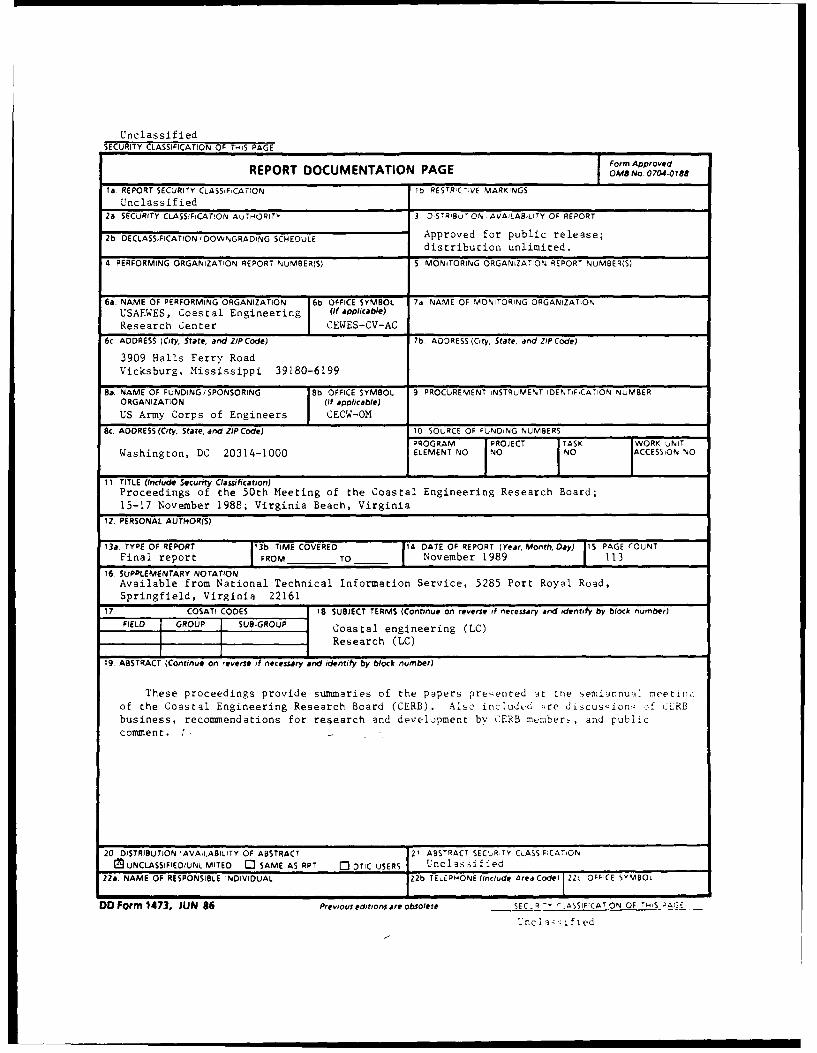
UnclassifiedSECURITY CLASSIFICATION OF THS PAGE
Form ApprovedREPORT DOCUMENTATION PAGE OMB No 0704.0188
ta REPORT SECURITY CLASSIFiCA7iON lb RESTRIC-,VE MARKINGS
Unclassified2a SECURITY CLASSIFICATION AUTHIORITY 3 1 STRIBuT ON AVAILABILITY OF REPORT
2b DECLASSIFICATION/ DOWNGRADiNG SCHEDULE Approved for public release;
distribution unlimited.
4 PERFORMING ORGANIZATION REPORT NUMBER(S) 5 MONITORING ORGANiZAT
ON REPORT NuMBER(S)
6a. NAME OF PERFORMING ORGANIZATION 16b. OFFICE SYMBOL 7a NAME OF MONITORING ORGANIZATIONUSAEWES, Coastal Engineering (If applicable)
Research Center CEWES-CV-AC
6c. ADDRESS (City, State, and ZIP Code) 7b ADDRESS (City, State. and ZIP Code)
3909 Halls Ferry RoadVicksburg, Mississippi 39180-6199
8a. NAME OF FUNDING/SPONSORING 8b OFFICE SYMBOL 9 PROCUREMENT INSTRUMENT IDENTIFCATION NUMBERORGANIZATION (If applicable)
US Army Corps of Engineers CECW-OM
8c. ADDRESS (City, State, and ZIP Code) 10 SOURCE OF FUNDING NUMBERS
PROGRAM PROJECT TASK WORK UNITWashington, DC 20314-1000 ELEMENT NO NO NO ACCESSION NO
11 TITLE (include Security Classification)Proceedings of the 50th Meeting of the Coastal Engineering Research Board;
15-17 November 1988; Virginia Beach, Virginia
12 PERSONAL AUTHOR(S)
13a. TYPE OF REPORT 13b TIME COVERED 14 DATE OF REPORT (Year, Month, Day) 15 PAGE COUNTFinal report FROM TO November 1989 113
16. SUPPLEMENTARY NOTATIONAvailable from National Technical Information Service, 5285 Port Royal Road,
Springfield, Virginia 22161
17 COSATI CODES IS SUBJECT TERMS (Continue on reverse of necessary and identify by block number)
FIELD GROUP SUB-GROUP Coastal engineering (LC)
Research (LC)
19 ABSTRACT (Continue on reverse if necessary and identify by block number)
These proceedings provide summaries of the papers presented 3t the semiannu-l1 rmeetin:
of the Coastal Engineering Research Board (CERB). Also includ-d -,re discusicns of CERB
business, recommendations for research and development by CERB maiber-, and public
commen t.
20 DISTRIBUTION 'AVAILABILITY OF ABSTRACT 121 ABSTRACT SEC'R,TY CLASS:FICATON[UNCLASSIFIED/UNLUMITED C SAME AS RPT C3 DTIC USERS LUncl asified
22a. NAME OF RESPONSIBLE INDIVIDUAL 22b TELEPHONE (Include Area Codel 22C OFFICE SYMBOL
DD Form 1473, JUN 86 Previous editions are obsolete SEC - R -Y '-ASSIF;CAT ON OF '-,S -G;
'nci a';i fied
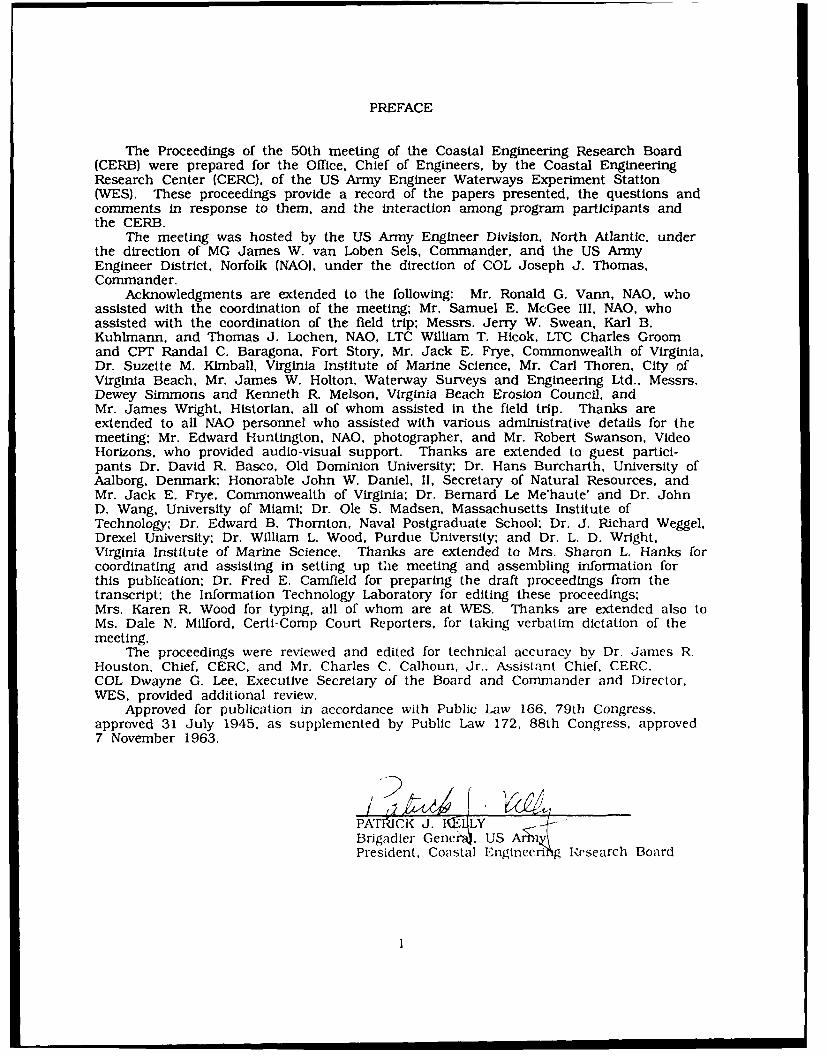
PREFACE
The Proceedings of the 50th meeting of the Coastal Engineering Research Board(CERB) were prepared for the Office, Chief of Engineers, by the Coastal EngineeringResearch Center (CERC), of the US Army Engineer Waterways Experiment Station(WES). These proceedings provide a record of the papers presented, the questions andcomments in response to them, and the interaction among program participants andthe CERB.
The meeting was hosted by the US Army Engineer Division. North Atlantic, underthe direction of MG James W. van Loben Sels, Commander, and the US ArmyEngineer District, Norfolk (NAO), under the direction of COL Joseph J. Thomas,Commander.
Acknowledgments are extended to the following: Mr. Ronald G. Vann, NAO, whoassisted with the coordination of the meeting; Mr. Samuel E. McGee III, NAO, whoassisted with the coordination of the field trip; Messrs. Jerry W. Swean, Karl B.Kuhlmann, and Thomas J. Lochen, NAO, LTC William T. Hicok, LTC Charles Groomand CPT Randal C. Baragona, Fort Story, Mr. Jack E. Frye, Commonwealth of Virginia,Dr. Suzette M. Kimball, Virginia Institute of Marine Science, Mr. Carl Thoren, City ofVirginia Beach, Mr. James W. Holton, Waterway Surveys and Engineering Ltd., Messrs.Dewey Simmons and Kenneth R. Melson, Virginia Beach Erosion Council, andMr. James Wright, Historian, all of whom assisted in the field trip. Thanks areextended to all NAO personnel who assisted with various administrative details for themeeting; Mr. Edward Huntington, NAO, photographer, and Mr. Robert Swanson, VideoHorizons, who provided audio-visual support. Thanks are extended to guest partici-pants Dr. David R. Basco, Old Dominion University: Dr. Hans Burcharth, University ofAalborg, Denmark; Honorable John W. Daniel, II, Secretary of Natural Resources, andMr. Jack E. Frye, Commonwealth of Virginia; Dr. Bernard Le Me'haute' and Dr. JohnD. Wang, University of Miami. Dr. Ole S. Madsen, Massachusetts Institute ofTechnology; Dr. Edward B. Thornton, Naval Postgraduate School; Dr. J. Richard Weggel.Drexel University; Dr. William L. Wood, Purdue University; and Dr. L. D. Wright,Virginia Institute of Marine Science. Thanks are extended to Mrs. Sharon L. Hanks forcoordinating and assisting in setting up the meeting and assembling information forthis publication; Dr. Fred E. Camfield for preparing the draft proceedings from thetranscript: the Information Technology Laboratory for editing these proceedings;Mrs. Karen R. Wood for typing, all of whom are at WES. Thanks are extended also toMs. Dale N. Milford, Certi-Comp Court Reporters, for taking verbatim dictation of themeeting.
The proceedings were reviewed and edited for technical accuracy by Dr. James R.Houston, Chief, CERC, and Mr. Charles C. Calhoun, Jr., Assistant Chief, CERC.COL Dwayne G. Lee, Executive Secretary of the Board and Commander and Director,WES, provided additional review.
Approved for publication in accordance with Public Law 166. 79th Congress,approved 31 July 1945, as supplemented by Public Law 172, 88th Congress, approved7 November 1963.
PATdCK J. 1--LYBrigadier Gene . USPresident, Coastal Eigineeri g Research Board
= . , ,i I I1
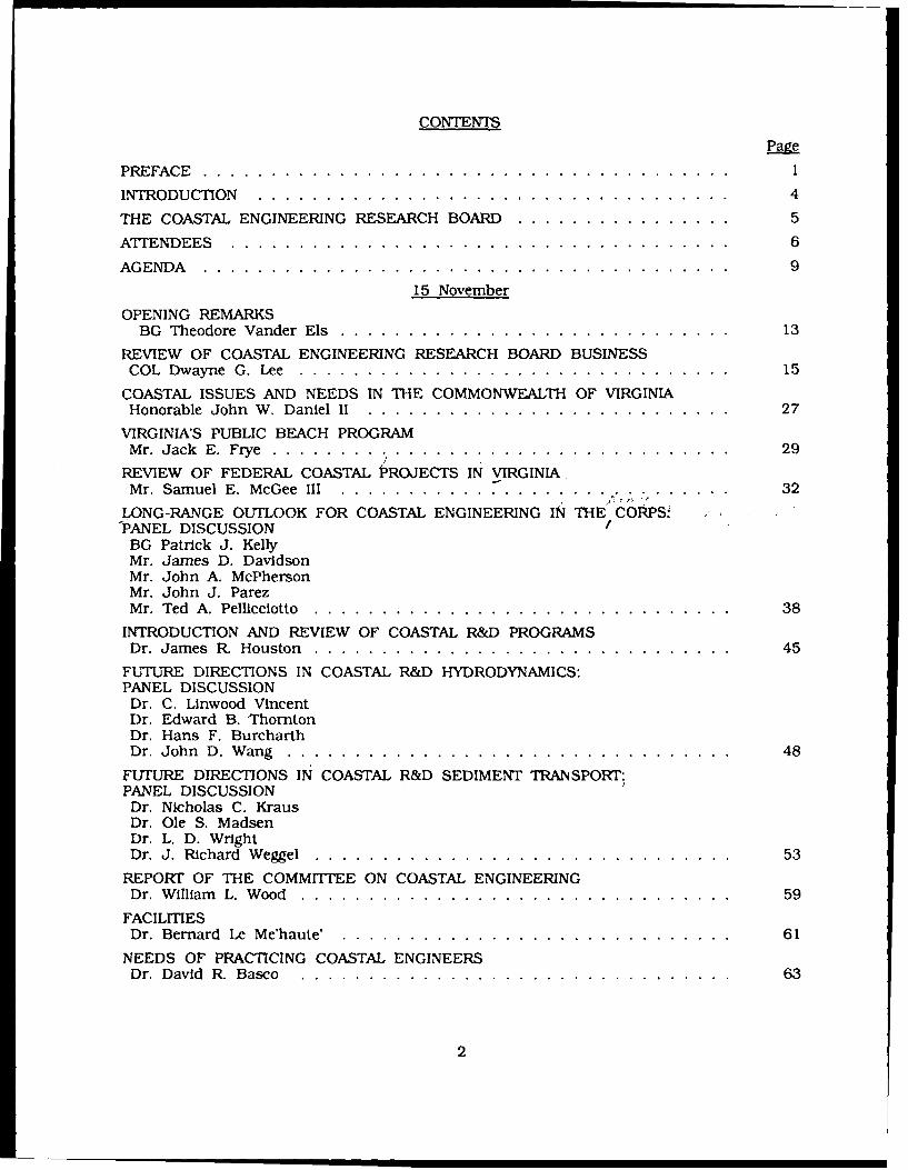
CONTENTSPage
PREFACE . . . . . . . . . . . . . . . . . . . . . . . . . . . . . . . . . . . . . . . 1
INTRODUCTION .. ..................... ... ... ... ... 4
THE COASTAL ENGINEERING RESEARCH BOARD ................ 5
ATTENDEES . . . . . . . . . . . . . . . . . . . . . . . . . . . . . . . . . . . . . 6
AGENDA . . . . . . . . . . . . . . . . . . . . . . . . . . . . . . . . . . . . . . . 9
15 November
OPENING REMARKSBG Theodore Vander Els ............................. 13
REVIEW OF COASTAL ENGINEERING RESEARCH BOARD BUSINESSCOL Dwayne G. Lee ................................ 15
COASTAL ISSUES AND NEEDS IN THE COMMONWEALTH OF VIRGINIAHonorable John W. Daniel II ........................... 27
VIRGINIA'S PUBLIC BEACH PROGRAMM r. Jack E. Frye . . . . . . . . . . . . . . ... . . . . . . . . . . . . . . . . . 29
REVIEW OF FEDERAL COASTAL PROJECTS IN VIRGINIAMr. Samuel E. McGee III ............................. 32
LONG-RANGE OUTLOOK FOR COASTAL ENGINEERING IN THE CORPS.IPANEL DISCUSSION /
BG Patrick J. KellyMr. James D. DavidsonMr. John A. McPhersonMr. John J. ParezMr. Ted A. Pellicciotto . . ... . .. ... .. . ... .. . ... .. . .. . .. 38
INTRODUCTION AND REVIEW OF COASTAL R&D PROGRAMSDr. James R. Houston ............................... 45
FUTURE DIRECTIONS IN COASTAL R&D HYDRODYNAMICS:PANEL DISCUSSIONDr. C. Linwood VincentDr. Edward B. ThorntonDr. Hans F. BurcharthDr. John D. W ang .. ... ... ... . .. ... .. . .. . ... .. . . .. . 48
FUTURE DIRECTIONS IN COASTAL R&D SEDIMENT TRANSPORT:PANEL DISCUSSIONDr. Nicholas C. KrausDr. Ole S. MadsenDr. L. D. WrightDr. J. Richard W eggel ........... ...... ... ...... ... .. 53
REPORT OF THE COMMITTEE ON COASTAL ENGINEERINGDr. W illiam L. W ood .. ... ... ... ... . .. ... ... ... .. . ... 59
FACILITIESDr. Bernard Le Me'haute' . . ............................ 61
NEEDS OF PRACTICING COASTAL ENGINEERSDr. David R. Basco . . . . . . . . . . . . . . . . . . . . . . . . . . . . . . . . 63
2
CONTENTS (Concluded)
Page
FUTURE DIRECTIONS IN COASTAL STRUCTURE DESIGN CRITERIA'Dr. Steven A. Hughes ............................... 65
THE NATIONAL SCIENCE FOUNDATION RESEARCH CENTER'S PROGRAMDr. Dag Nummedal ................................. 68
PUBLIC COMMENT ................................. 72
-JOINT LOGISTICS-QVER-THE-SHORE BRIEFING,CPT(P) James N. Marino ................................. 74
FINAL DISCUSSION AND RECOMMENDATIONSMembers of the Board ............................... 76
FUTURE CERB MEETINGS ............................. 79
CLOSING REMARKSBG Patrick J. Kelly .. ... ........................... 80
APPENDIX ABIOGRAPHIES OF SPEAKERS/AUTHORS ..................... Al
APPENDIX B
RESEARCH AND OTHER NEEDS OF PRACTICING ENGINEERS ........... B1
APPENDIX CRECOMMENDATION LETTERS ........................... C1
AOcesSion For
NqTIS GIRA&IDTIC TABUnannounced [
justification
Distribut ionl/
Availability Codes
Avail and/orD s t Special
3
INTRODUCTION
The 50th Meeting of the Coastal Engineering Research Board (CERB) was held at
the Sheraton Beach Inn in Virginia Beach, Virginia, on 15-17 November 1988. It was
hosted by the US Army Engineer Division, North Atlantic (NAD), under the direction of
MG James W. van Loben Sels, Commander, and the US Army Engineer District,
Norfolk (NAO), under the direction of COL Joseph J. Thomas, Commander.
The Beach Erosion Board (BEB), forerunner of the CERB, was formed by the Corps
in 1930 to study beach erosion problems. In 1963, Public Law 88-172 dissolved the
BEB by establishing the CERB as an advisory board to the Corps and designating a
new organization, the Coastal Engineering Research Center (CERC), as the research arm
of the Corps. The CERB functions to review programs relating to coastal engineering
research and development and to recommend areas for particular emphasis or suggest
new topics for study. The Board's four military and three civilian members officially
meet twice a year at a particular coastal Corps District or Division to do the following:
a. Disseminate information of general interest to Corps coastal Districts andDivisions.
b. Obtain reports on coastal engineering projects in the host (local) District orDivision; receive requests for research needs.
c. Provide an opportunity for State and private institutions and organizations toreport on local coastal research needs, coastal studies, and new coastalengineering techniques.
d. Provide a general forum for public inquiry.
e. Provide recommendations for coastal engineering research and development.
Presentations during the 50th CERB meeting dealt with long-range research needs in
coastal engineering. Documented in these proceedings are summaries of presentations
made at the meeting, discussions which followed these presentations, and
recommendations by the Board. A verbatim transcript is on file at CERC.
4
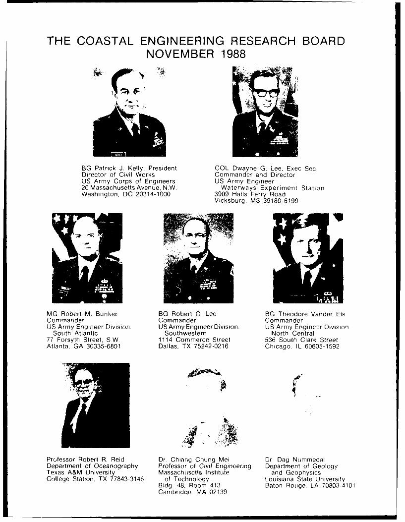
THE COASTAL ENGINEERING RESEARCH BOARDNOVEMBER 1988
BG Patrick J. Kelly, President COL Dwayne G. Lee, Exec SecDirector of Civil Works Commander and DirectorUS Army Corps of Engineers US Army Engineer20 Massachusetts Avenue, N.W. Waterways Experiment StationWashington, DC 20314-1000 3909 Halls Ferry Road
Vicksburg, MS 39180-6199
MG Robert M. Bunker BG Robert C. Lee BG Theodore Vander ElsCommander Commander CommanderUS Army Engineer Division, US Army Engineer Division, US Army Engincer Division.
South Atlantic Southwestern North Central77 Forsyth Street, S.W. 1114 Commerce Street 536 South Clark StreetAtlanta, GA 30335-6801 Dallas, TX 75242-0216 Chicago, IL 60605-1592
Professor Robert R. Reid Dr Chiang Chung Mei Dr Dag NummedalDepartment of Oceanography Professor of Civil Engineering Department of GeologyTexas A&M University Massachusetts Institute and GeophysicsCollege Station, TX 77843-3146 of Technology Louisiana State University
Bldg 48, Room 413 Baton Rouge. LA 70803-4101Cambridge, MA 02139
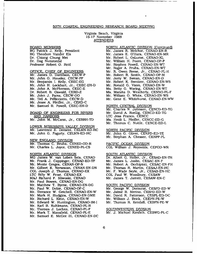
50TH COASTAL ENGINEERING RESEARCH BOARD MEETING
Virginia Beach, Virginia15-17 November 1988
ATTENDEES
BOARD MEMBERS NORTH ATLANTIC DIVISION (Continued)BG Patrick J. Kelly, President Mr. James R Melchor, CENAO-EN-RBG Theodore Vander Els Mr. James E. O'Hara, CENAO-EN-MRDr. Chiang Chung Mei Mr. Robert L. Osborne, CENAO-XLDr. Dag Nummedal Mr. William H. Poore, CENAO-OP-PProfessor Robert 0. Reid Mr. Stephen Powell, CENAO-EN-WT
Mr. Roger A. Pruhs, CENAO-EN-WTOFFICE, CHIEF OF ENGINEERS Mr. R. Owen Reese, Jr., CENAO-PL-HMr. James D. Davidson, CECW-P Mr. Robert R Smith, CENAO-OP-MMr. John G. Housley, CECW-PF Mr. Jerry W. Swean, CENAO-EN-DMr. Benjamin I. Kelly, CEEC-EG Mr. Robert K. Sweitzer, CENAO-EN-WSMr. John H. Lockhart. Jr., CEEC-EH-D Mr. Ronald G. Vann, CENAO-EN-WMr. John A. McPherson, CEEC-E Ms. Betty G. Waring, CENAO-EN-WTDr. Robert B. Oswald, CERD-Z Ms. Marsha D. Weatherly, CENNO-PL-FMr. John J. Parez, CECW-OO Mr. William 0. White, CENAO-EN-WSMr. Ted A. Pellicciotto, CECW-D Mr. Gene E. Whitehurst, CENAO-EN-WWMr. Jesse A. Pfeiffer, Jr., CERD-CMr. Samuel B. Powell, CEEC-EH-D NORTH CENTRAL DIVISION
Mr. Charles N. Johnson, CENCD-ED-TGBOARD OF ENGINEERS FOR RIVERS Mr. David A. Roellig, CENCD-ED-TG
AND HARBORS LTC Jess Franco. CENCCMr. John M. McCann, Jr., CEBRH-TD Ms. Heidi L. Pfeiffer, CENCC-ED-G
Mr. Thomas C. Nuttle, CENCE-ED-LLOWER MISSISSIPPI VALLEY DIVISIONMr. Lawrence E. Dement, CELMN-ED-HC NORTH PACIFIC DIVISIONMr. John G. Fogarty, CELMN-ED-HC Mr. John G. Oliver, CENPD-ED-TE
Mr. Stephan A. Chesser. CENPP-PLNEW ENGLAND DIVISIONMr. Thomas C. Bruha, CENED-OD-R PACIFIC OCEAN DIVISIONMr. Charles L. Joyce, CENED-PL-CS COL William J. Reynolds, CEPOD-WR
NORTH ATLANTIC DIVISION SOUTH ATLANTIC DIVISIONMG James W. van Loben Sels, CENAD Dr. Albert G. Holler, Jr., CESAD-EN-THMr. Frank J. Coppinger, CENAD-ED-TF Mr. James L. Joslin. CESAC-EN-FMr. Monte Greges, CENAN-OP-N Mr. Robert A. Occhipinti, CESAC-EN-FHMr. Gilbert K. Nersesian, CENAN-EN-DN Mr. Thomas R Martin, CESAJ-EN-HCCOL Joseph J. Thomas, CENAO-EX Mr. F. Wade Seyle, Jr., CESAS-EN-HCLTC Billy W. Frost, CENAO-EX COL Paul W. Woodbury, CESAWMAJ Richard F. Sliwoski, CENAO Mr. James T. Jarrett, CESAW-EN-CMr. Paul Bowen, CENAO-EN-DGMr. Matthew T. Byrne, CENAO-EN-DG SOUTH PACIFIC DIVISIONMr. Paul W. Dobie, CENAO-OP-C Mr. George W. Domurat, CESPD-ED-WMr. Terrance W. Getchell, CENAO-EN-W Mr. Jaime R. Merino, CESPD-ED-WMr. Mark H. Hudgins, CENAO-EN-DME Mr. David R. Patterson. CESPL-ED-DCMr. Richard L. Klein, CENAO-EN-W Mr. William J. Brick, CEEPN-PE-WMr. Edward W. Huntington, CENAO-IM-I Mr. Thomas R Kendall, CESPN-PE-WMr. Karl B. Kuhlmann, CENAO-PL-RMr. Thomas J. Lochen. CENAO-PL-F SOUTHWESTERN DIVISIONMr. Mark T. Mansfield, CENAO-PL-E Mr. J. Michael Kieslich. CESWG-PL-CMr. Samuel E. McGee Ill, CENAO-EN-DC
6
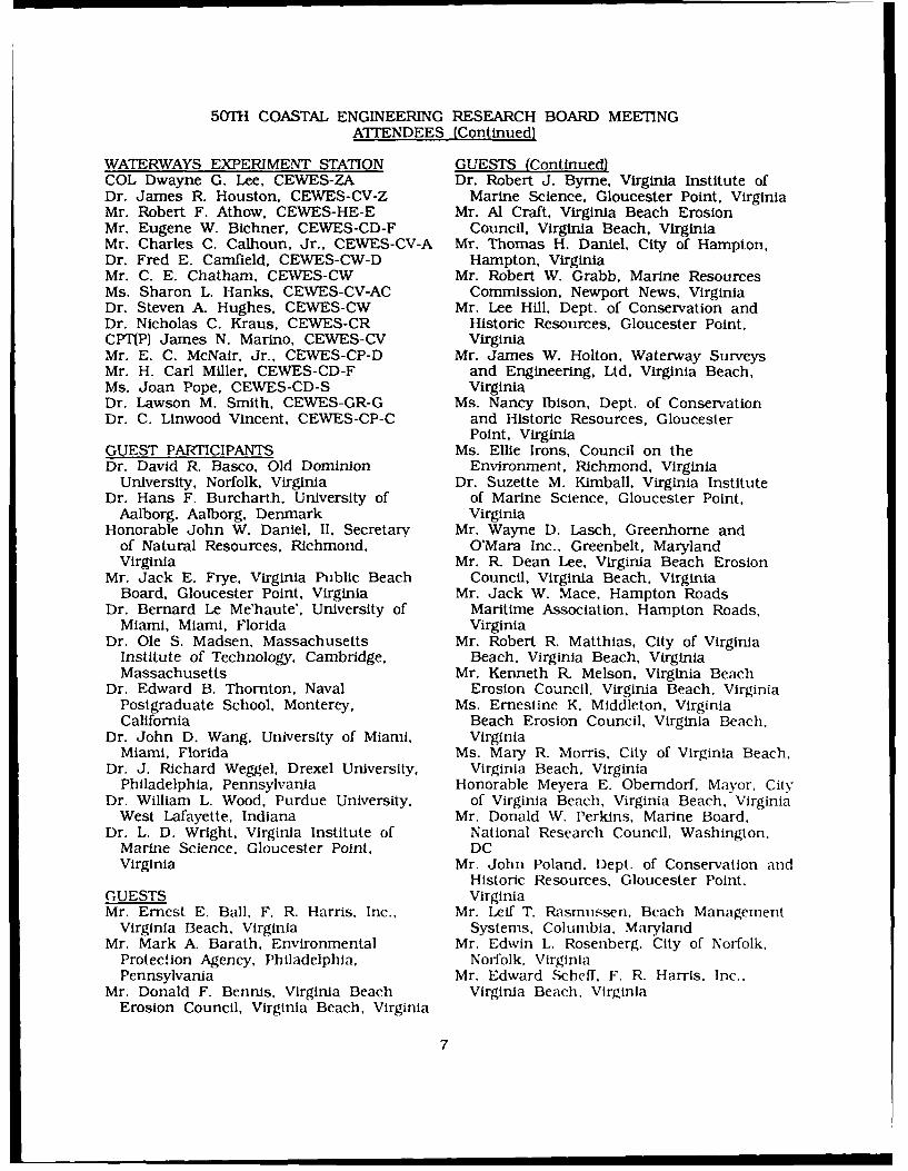
50TH COASTAL ENGINEERING RESEARCH BOARD MEETINGATTENDEES (Continued)
WATERWAYS EXPERIMENT STATION GUESTS (Continued)COL Dwayne G. Lee, CEWES-ZA Dr. Robert J. Byrne, Virginia Institute ofDr. James R. Houston, CEWES-CV-Z Marine Science, Gloucester Point, VirginiaMr. Robert F. Athow, CEWES-HE-E Mr. Al Craft, Virginia Beach ErosionMr. Eugene W. Bichner, CEWES-CD-F Council, Virginia Beach, VirginiaMr. Charles C. Calhoun, Jr., CEWES-CV-A Mr. Thomas H. Daniel, City of Hampton,Dr. Fred E. Camfield, CEWES-CW-D Hampton, VirginiaMr. C. E. Chatham, CEWES-CW Mr. Robert W. Grabb, Marine ResourcesMs. Sharon L. Hanks, CEWES-CV-AC Commission, Newport News, VirginiaDr. Steven A. Hughes, CEWES-CW Mr. Lee Hill, Dept. of Conservation andDr. Nicholas C. Kraus, CEWES-CR Historic Resources, Gloucester Point,CPT(P) James N. Marino, CEWES-CV VirginiaMr. E. C. McNair, Jr., CEWES-CP-D Mr. James W. Holton, Waterway SurveysMr. H. Carl Miller, CEWES-CD-F and Engineering, Ltd. Virginia Beach,Ms. Joan Pope, CEWES-CD-S VirginiaDr. Lawson M. Smith, CEWES-GR-G Ms. Nancy Ibison, Dept. of ConservationDr. C. Linwood Vincent, CEWES-CP-C and Historic Resources, Gloucester
Point, VirginiaGUEST PARTICIPANTS Ms. Ellie Irons, Council on theDr. David R. Basco, Old Dominion Environment, Richmond, Virginia
University, Norfolk, Virginia Dr. Suzette M. Kimball, Virginia InstituteDr. Hans F. Burcharth, University of of Marine Science, Gloucester Point,
Aalborg, Aalborg, Denmark VirginiaHonorable John W. Daniel, It, Secretary Mr. Wayne D. Lasch, Greenhorne and
of Natural Resources, Richmond, O'Mara Inc.. Greenbelt, MarylandVirginia Mr. R- Dean Lee, Virginia Beach Erosion
Mr. Jack E. Frye, Virginia Public Beach Council, Virginia Beach, VirginiaBoard, Gloucester Point, Virginia Mr. Jack W. Mace, Hampton Roads
Dr. Bernard Le Me'haute', University of Maritime Association. Hampton Roads,Miami, Miami, Florida Virginia
Dr. Ole S. Madsen, Massachusetts Mr. Robert R. Matthias, City of VirginiaInstitute of Technology, Cambridge, Beach, Virginia Beach, VirginiaMassachusetts Mr. Kenneth R. Melson, Virginia Beach
Dr. Edward B. Thornton, Naval Erosion Council, Virginia Beach, VirginiaPostgraduate School, Monterey, Ms. Ernestine K. Middleton, VirginiaCalifornia Beach Erosion Council, Virginia Beach.
Dr. John D. Wang, University of Miami, VirginiaMiami, Florida Ms. Mary R. Morris, City of Virginia Beach,
Dr. J. Richard Weggel, Drexel University, Virginia Beach. VirginiaPhiladelphia, Pennsylvania Honorable Meyera E. Oberndorf, Mayor. City
Dr. William L. Wood, Purdue University, of Virginia Beach. Virginia Beach, VirginiaWest Lafayette, Indiana Mr. Donald W. Perkins, Marine Board,
Dr. L. D. Wright, Virginia Institute of National Research Council, Washington,Marine Science, Gloucester Point, DCVirginia Mr. John Poland. Dept. of Conservation and
Historic Resources, Gloucester Point.GUESTS VirginiaMr. Ernest E. Ball. F. R. Harris. Inc., Mr. Leif T. Rasmussen. Beach Management
Virginia Beach. Virginia Systems, Columbia, MarylandMr. Mark A. Barath, Environmental Mr. Edwin L. Rosenberg, City of Norfolk.
Protection Agency, Philadelphia. Norfolk. VirginiaPennsylvania Mr. Edward Scheff, F. R. Harris, Inc.,
Mr. Donald F. Bennis, Virginia Beach Virginia Beach. VirginiaErosion Council, Virginia Beach, Virginia
7

50TH COASTAL ENGINEERING RESEARCH BOARD MEETINGAT'IENDEES (Concluded)
GUESTS (Continued) COURT REPORTERDr. S. Jonathan Siah, Greenhome and Ms. Dale N. Milford, Certi-Comp Court
O'Mara, Inc., Greenbelt, Maryland Reporters, Inc., Jackson. MississippiMr. G. Dewey Simmons, Virginia Beach
Erosion Council, Virginia Beach, AUDIO-VISUALVirginia Mr. Mark Montgomery, Video Horizons,
Mr. Carl A. Thoren, City of Virginia Norfolk, VirginiaBeach, Virginia Beach, Virginia
Mr. John B. Walsh, Waterway Surveysand Engineering, Virginia Beach,Virginia
Mr. Donald T. Williams, City of VirginiaBeach, Virginia Beach, Virginia
Ms. Barbara M. Wrenn, Deputy Secretaryof Natural Resources, Richmond,Virginia
8
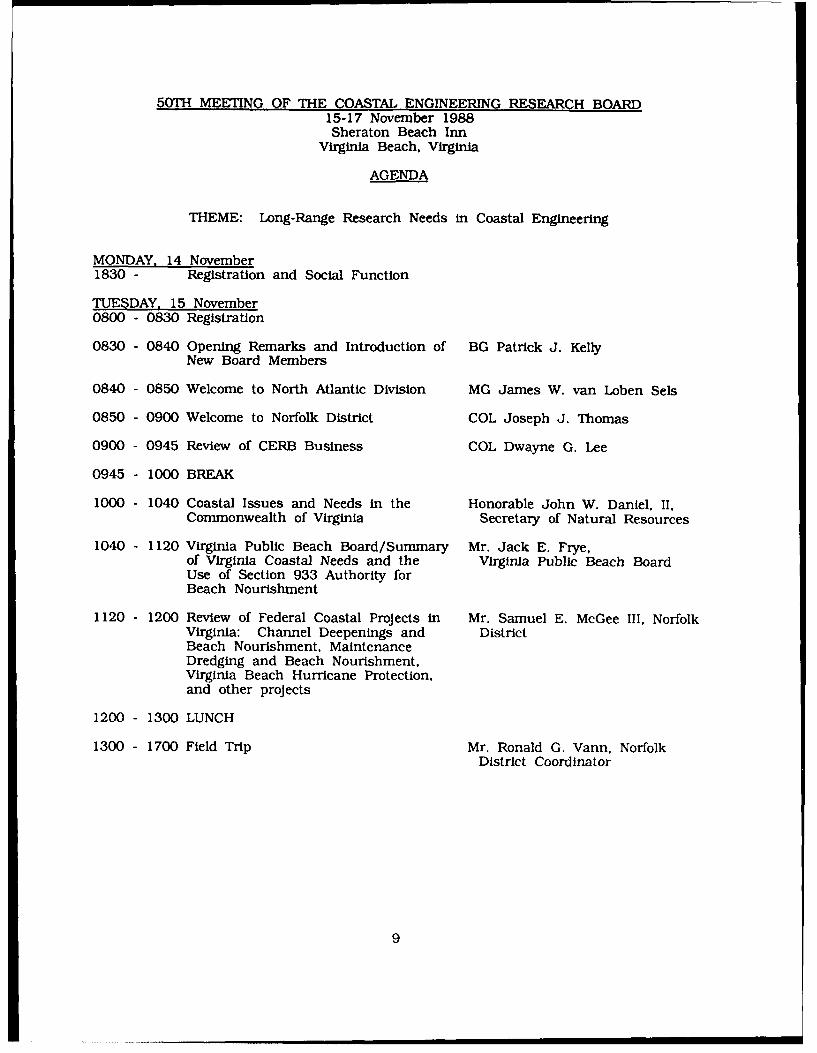
50TH MEETING OF THE COASTAL ENGINEERING RESEARCH BOARD15-17 November 1988Sheraton Beach Inn
Virginia Beach, Virginia
AGENDA
THEME: Long-Range Research Needs in Coastal Engineering
MONDAY, 14 November1830 - Registration and Social Function
TUESDAY, 15 November0800 - 0830 Registration
0830 - 0840 Opening Remarks and Introduction of BG Patrick J. KellyNew Board Members
0840 - 0850 Welcome to North Atlantic Division MG James W. van Loben Sels
0850 - 0900 Welcome to Norfolk District COL Joseph J. Thomas
0900 - 0945 Review of CERB Business COL Dwayne G. Lee
0945 - 1000 BREAK
1000 - 1040 Coastal Issues and Needs in the Honorable John W. Daniel, II,Commonwealth of Virginia Secretary of Natural Resources
1040 - 1120 Virginia Public Beach Board/Summary Mr. Jack E. Frye,of Virginia Coastal Needs and the Virginia Public Beach BoardUse of Section 933 Authority forBeach Nourishment
1120 - 1200 Review of Federal Coastal Projects in Mr. Samuel E. McGee III, NorfolkVirginia: Channel Deepenings and DistrictBeach Nourishment, MaintenanceDredging and Beach Nourishment,Virginia Beach Hurricane Protection,and other projects
1200 - 1300 LUNCH
1300 - 1700 Field Trip Mr. Ronald G. Vann, NorfolkDistrict Coordinator
9
Site 1 - Virginia Beach
Hurricane Protection Project, Seawall Design, Beach, Norfolk DistrictDunes and Interior Drainage
55-Foot Channel Deepening Section 933 Report Norfolk District
City of Virginia Beach Perspective on Coastal Needs City of Virginia Beach
Site 2 - Rudee Inlet
Inlet Processes, Dredging Program, and Virginia Beach Director, Virginia BeachNourishment Project Erosion Commission
Rudee Inlet Federal Navigation Project and Impact on Norfolk DistrictAdjacent Shoreline
Site 3 - Fort Story
Commander's Briefing on Military Coastal Engineering Commander, Fort StoryIssues
LAC-V-30 Military Hovercraft Demonstration 11 th TransportationBattalion
Briefing on the Historical Significance of the Cape Mr. James Wright,Henry Lighthouse which is the First Civil Works HistorianProject Authorized by the US Congress
Break and Refreshments
Site 4 - Lynnhaven Inlet
Briefing on the Successful Use of Maintenance Norfolk DistrictDredging for Beach Nourishment at Lynnhaven Inlet
1700 - Social Hour and Dinner
10

AGENDA (Continued)
WEDNESDAY, 16 NovemberBG Patrick J. Kelly
0830 - 0845 Opening Remarks
0845 - 1000 Long-Range Outlook for Coastal Mr. James D. Davidson, DeputyEngineering in the Corps Chief, Planning Division
Mr. John A. McPherson, AssistantChief, Engineering Division
Mr. John J. Parez, Operationsand Readiness Division
Mr. Ted A. Pellicciotto, AssistantChief, Dredging Division
1000 - 1020 BREAK
1020 - 1040 Introduction and Review of Coastal Dr. James R. Houston, CERCR&D Program
1040 - 1700 Future Directions in Coastal R&D
1040-1210 Hydrodynamics (Waves, currents, Dr. C. Linwood Vincent, CERC,Panel wave/structure interaction, Moderatorstorm surge, tidal circulation, etc.) Dr. Edward B. Thornton, Naval
Postgraduate SchoolDr. Hans E. Burcharth,
University of Aalborg, DenmarkDr. John D. Wang, University of
Miami
1210 - 1310 LUNCH
1310 - 1440 Sediment Transport (longshore, Panelnavigation channel shoaling, erosion, Dr. Nicholas C. Kraus, CERC,beach fills, etc. Moderator
Dr. Ole S. Madsen,Massachusetts Institute of
TechnologyDr. J. Richard Weggel, Drexel
UniversityDr. L. Donelson Wright, Virginia
Institute of Marine Science
1440 - 1500 BREAK
1500 - 1545 Instrumentation (National Research Dr. William L Wood, PurdueCouncil Study) University
1545 - 1700 Facilities Dr. Bernard Le Me'haule',University of Miami
11

AGENDA (Concluded)
THURSDAY, 17 November
0800 - 0805 Opening Remarks BG Patrick J. Kelly
0805 - 0830 Structure Design Criteria Dr. Steven A. Hughes, CERC
0830 - 0845 Report on the Workshop for Dr. David R. Basco, OldPracticing Coastal Engineers Dominion University
0845 - 0915 National Science Foundation Science Dr. Dag Nummedal. Louisiana
and Technology Centers State University
0915 - 0945 Public Comment
0945 - 1000 Joint Logistics-Over-The-Shore Briefing CPT(P) James N. Marino, CERC
1005 - 1015 BREAK
1015 - 1115 Board Recommendations CERB
1141 - 1130 Closing Business and Remarks BG Patrick J. Kelly
1130 ADJOURN
12
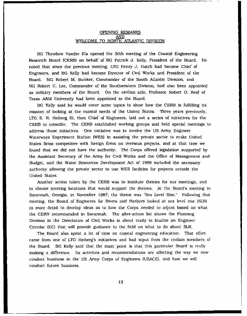
OPENING REMARKSAND
WELCOME TO NORTH ATLANTIC DIVISION
BG Theodore Vander Els opened the 50th meeting of the Coastal Engineering
Research Board (CERB) on behalf of BG Patrick J. Kelly, President of the Board. He
noted that since the previous meeting, LTG Henry J. Hatch had become Chief of
Engineers, and BG Kelly had become Director of Civil Works and President of the
Board. MG Robert M. Bunker, Commander of the South Atlantic Division, and
BG Robert C. Lee, Commander of the Southwestern Division, had also been appointed
as military members of the Board. On the civilian side, Professor Robert 0. Reid of
Texas A&M University had been appointed to the Board.
BG Kelly said he would cover some topics to show how the CERB Is fulfilling its
mission of looking at the coastal needs of the United States. Three years previously.
LTG E. R. Heiberg 11. then Chief of Engineers, laid out a series of initiatives for the
CERB to consider. The CERB established working groups and held special meetings to
address those initiatives. One initiative was to involve the US Army Engineer
Waterways Experiment Station (WES) in assisting the private sector to make United
States firms competitive with foreign firms on overseas projects, and at that time we
found that we did not have the authority. The Corps offered legislation supported by
the Assistant Secretary of the Army for Civil Works and the Office of Management and
Budget, and the Water Resources Development Act of 1988 included the necessary
authority allowing the private sector to use WES facilities for projects outside the
United States.
Another action taken by the CERB was to institute themes for our meetings, and
to choose meeting locations that would support the themes. At the Board's meeting in
Savannah, Georgia, in November 1987, the theme was "Sea Level Rise." Following that
meeting, the Board of Engineers for Rivers and Harbors looked at sea level rise (SLR)
in more detail to develop ideas as to how the Corps needed to adjust based on what
the CERB recommended in Savannah. The after-action list shows the Planning
Division in the Directorate of Civil Works is about ready to finalize an Engineer
Circular (EC) that will provide guidance to the field on what to do about SLR.
The Board also spent a lot of time on coastal engineering education. That effort
came from one of LTG Heiberg's initiatives and had input from the civilian members of
the Board. BG Kelly said that the main point is that this particular Board is really
making a difference. Its activities and recommendations are affecting the way we now
conduct business in the US Army Corps of Engineers (USACE), and how we will
conduct future business.
13

MG James van Loben Sels welcomed the CERB to North Atlantic Division. He
noted that he was a previous Board member. He said there remained great challenges
facing the Corps and the public, and there were real-world issues on our coasts. We
are looking at another set of problems in storm protection and coastal erosion, in
fixing problems we thought we fixed before. He noted he was encouraged to see the
interest in education from Corps staff because the experience level and talent we have
on our staff is an increasing problem as we face retirements and competition in the
work place for talented employees.
COL Joseph J. Thomas welcomed the CERB to Norfolk District. He thanked the
City of Virginia Beach. the Erosion Council, and the Hampton Roads Maritime
Association for their participation. He noted that Norfolk District is deeply involved in
coastal issues and the cost-sharing environment has increased the need for long-rangeresearch and technology sharing in coastal engineering. The cost-share partners want
to share the best information and take a larger role in the decision-making process as
a basis for their continued participation.
COL Thomas said that although Districts are not tasked with a research mission,Norfolk District has taken advantage of opportunities to increase coastal engineering
knowledge in areas such as navigation channel design, stability of bars constructedwith dredged material, and beach nourishment. During the Norfolk Harbor deepening
studies, the leading edge of available technology in ship hydrodynamics, offshore
surveying methods, and sediment stability measurements was used. From those efforts,it was learned that there is a continuing need for further research in those and other
areas. There is a need for field verification studies, improved design methods andformulae, and engineer manuals for use by Districts and other field operating agencies.
He noted that the District has worked closely with CERC and other research
organizations, and will continue to support this close relationship because of the
mutual interest in developing sound coastal engineering procedures.
14
REVIEW OF COASTAL ENGINEERING RESEARCH BOARD BUSINESSCOL Dwayne G. Lee, Executive Secretary
Coastal Engineering Research BoardCommander and Director
US Army Engineer Waterways Experiment StationVicksburg, Mississippi
At the last CERB meeting in Oconomowoc, Wisconsin, we were directed to formalize
the action item list, and this has been done. The list for the last Board meeting is
on Page 21. The Board members have been given the status of action items from the
Corpus Christi through Savannah Board meetings. The action item list will be updated
prior to each meeting and provided to the Board as read-ahead material.
I am now going to cover the status of the action items from the last Board
meeting. Item 1 is the charge to formalize the action item list. Item 2 concerns the
education program for Corps coastal specialists proposed by Dr. James R. Houston,
Chief, CERC, at the last meeting. LTG Heiberg had charged CERC with developing a
plan after he reviewed the Board's recommendations on the need for an educational
program for Corps specialists. The Board endorsed the plan presented by Dr. Houston
and charged CERC with formalizing the proposed education program so it could be
staffed in Headquarters (HQUSACE). In addition, CERC was charged with exploring the
feasibility of expanding the program (Item 3).
CERC formalized the plan after the last Board meeting, and the plan was sent
under the signature of the Acting President of the Board, BG Kelly, to the Director of
Civil Works for staffing in HQUSACE. A short time later, BG Kelly was appointed
Director of Civil Works. The plan was staffed by Planning Division, HQUSACE.
Comments on the plan came from the Training and Development Branch, Personnel
Office, HQUSACE. The Training Branch recommended, before a program be considered,
that it conduct both a thorough job analysis to determine skills needed by Corps
specialists and a training needs survey to determine deficiencies in training. The
Training Branch would then develop an education and training program to satisfy
identified deficiencies.
Dr. Houston met with personnel from the Training Branch and reiterated the
extensive groundwork by the Board to establish the need and composition of the plan.
He noted the Working Group established by the Board conducted six regional meetings
with coastal specialists to establish education needs. This was followed by two detailed
education and training surveys that went to all coastal Districts and Divisions under
the signature of LTG Hatch. The Board then reviewed the recommendations of the
Working Group and results of the surveys. These results, coupled with the Board's
15

own observations of deficiencies in the Corps' coastal engineering expertise, led to theBoard's recommendation to the Chief of Engineers that an education program be
adopted.
The Training Branch directed Dr. Houston to Mr. Lloyd Duscha, Deputy Director,Engineering and Construction Directorate, and the proponent for education and training
of engineers and scientists in the Corps, since a proponent outside the Personnel Officeis needed to initiate a program. Dr. Houston met with Mr. Duscha and explained theplan in detail. After discussion, Mr. Duscha asked Dr. Houston to prepare paperworkto take the proposed program before the Corps Training Issues Committee thatMr. Duscha chairs. The proposed program was presented to the Training Issues
Committee last week, and approval is pending.We have explored the feasibility of expanding the program to participants from the
private sector, state and local governments, foreign nationals, and military officers.Participants from the private sector and state and local governments can attend
government courses on a cost reimbursable basis after all government personnelrequests are met (i.e. they can complete classes that are not filled). The WESGraduate Institute currently has personnel from the private sector and localgovernments attending classes in Vicksburg under these ground rules. There may beproblems with the Corps directing these individuals to particular universities, so if theprogram proves viable in the Corps after the pilot test at Texas A&M, we mayrecommend opening the program to any university willing to teach required courses of
the program.Foreign nationals could attend this program under the Exchange Visitor Program of
the State Department. Approval would be required by the Assistant Secretary of theArmy for Civil Works. Again, inclusion of foreign nationals could be instituted whenthe pilot effort proves the program viable and the program is opened to otheruniversities. It is likely the program would prove popular to foreign nationals. CERC
has received inquiries over the last year from countries such as Korea, Brazil, andMalaysia concerning education and training in coastal engineering.
The participation of the military officers in this program was an interesting concept
raised by BG Vander Els. CPT(P) James Marino of CERC is one of the few military
officers in the Army with an advanced degree in coastal engineering. He received amasters degree in coastal engineering from the University of Florida under an ArmyEducational Requirements Board assignment.
We conducted a survey of all Corps Districts and Divisions to determine if
Commanders saw a need for officers with advanced degrees in coastal engineering.Page 22 is a fact sheet and documentation prepared by CPT(P) Marino on the results
of the survey. The responses indicated eight out of nine coastal Divisions saw need
16
for uniformed coastal specialists. South Pacific Division (SPD), North Central Division
(NCD), and North Atlantic Division (NAD) indicated it would be ideal to have one officer
in each of their Districts so trained. New England Division (NED) responded that a
graduate program for coastal engineers is "much more appropriate for our civilian work
force." A major problem seems to be that field offices currently have far fewer officers
assigned than they need. Many might like officers with advanced degrees in coastal
engineering if they were fully staffed with officers to meet all their needs.
If the Board believes having military officers in the education program is warranted,
the next step would be to recommend this action to the US Army Engineer School
through LTG Hatch. The Engineer School would be the proponent of the program in
the military personnel system of the Army if it concluded the program had a high
priority versus other training and education needs in the Army. It is likely the
process of establishing a program would be a lengthy one.
A panel at our last meeting addressed the topic of coastal Research and
Development (R&D) on the Great Lakes. They discussed the recommendations of the
Ann Arbor Workshop on Great Lakes Coastal Erosion Research Needs. NCD was
tasked with prioritizing and coordinating research needs in the Great Lakes from a
USACE perspective (Item 4). The Division has been in contact with Dr. Parsons of the
University of Michigan, and has added NCD's support for the upcoming second
workshop on research needs to help set priorities on future Great Lakes coastal
engineering research. The Michigan Sea Grant College Program is acting as the
sponsor for this effort. The next workshop will be held on 30 November after results
of the Great Lakes field experiments of September 1988 become known. These were
comprehensive experiments involving many participants including CERC, NCD, and
several universities, and were similar in organization to the experiments conducted
previously at Duck, North Carolina (Duck '85 and SUPERDUCK). CERC researchers
have been invited and will participate in the workshop.
Another action item from our last meeting was to consider the possibility of
establishing a Great Lakes Technical Information Center as a repository for Great Lakes
coastal information (Item 5). NCD has identified the International Joint Commission as
a logical repository, if a central location is desired. However, the various universities
with Sea Grant affiliations in the Great Lakes region already collect coastal information.
A great deal of duplication would result from a central location. Researchers would
probably continue to use the local sources of information. The concept of a central
repository will be explored further by NCD at the forthcoming Great Lakes Coastal
Research Workshop.
As directed at our last meeting (Item 6). a technical information meeting was
convened on I - 2 August between NCD (Buffalo and Detroit Districts), WES (CERC,
17
Hydraulics, and Environmental Laboratories), US Army Cold Regions Research and
Engineering Laboratory (CRREL), Hydrologic Engineering Center (HEC). National Oceanic
and Atmospheric Administration (NOAA's) Great Lakes Environmental Research
Laboratory (GLERL), and the Environment Canada. The purpose of the meeting was to
exchange information concerning a procedural approach to assess the capabilities of
existing numerical models for the Great Lakes basin. The meeting concentrated on
regulating Lake Ontario water levels. Possible improvements to the regulation plan
were identified. WES was asked to undertake further hydraulic analyses of the adverse
current problems in the St. Lawrence River. CRREL will develop and implement the
Ice Forecasting System Model, including a real-time data system for the St. Lawrence
River. HEC will develop improvements in statistical water supply determinations with
applications in making the regulation plan's water supply indicator more sensitive to
changes in conditions. They will also develop software for interacting with the
St. Lawrence River Ice model and Lake Ontario water supply forecasting model.
GLERL/NOAA will develop a Large Lake Basin Model and water supply forecast.
There was a request at our last meeting to assess the state of instrumentation
needs to support coastal engineering R&D (Item 7). CERC has supported, over the
past 18 months, a study by the Marine Board of the National Research Council (NRC)
to address this problem. Dr. William L. Wood of Purdue University, who was the Vice
Chairman of the NRC study, will report on the preliminary findings tomorrow afternoon.
I reported at our last meeting that legislation was pending which would create a
2-year demonstration program for providing technical assistance, on a non-exclusive
basis, to any United States firm which is competing for, or has been awarded, a
contract for planning, design, or construction of a project outside the United States.
The United States firm must provide funds to cover all costs of such assistance. That
legislative language was included in the Water Resources Development Act of 1988 and
now has been passed. This legislation may accommodate the need discussed at
several Board meetings for CERC to aid United States firms in competition with foreign
firms that have access to their national laboratories. I also reported that the Assistant
Secretary of the Army for Civil Works had worked for initiation of the Construction
Productivity Advancement Research Program, which provides for cost shared R&D
between the Corps and non-Federal entities including state and local governments,
universities, and the private sector. The legislation has authorized funding of $3.0
million for the current FY.
Finally, CERC ended a record year on 30 September with income up over
35 percent. The greatest Increase came in reimbursable work which was itp over
45 percent. The General Investigations funded Coastal Engineering R&D Program had
its first increase this decade with funding up over 5 percent in FY 88. Contracting by
18

CERC was up almost 45 percent with high levels of contracting in the new Dredging
Research Program.
Now I would like to turn the floor over to Mr. John Oliver from North Pacific
Division and chairman of the Automated Coastal Engineering (ACES) pilot committee for
a short update on ACES.
Mr. Oliver presented an update on the ACES program. He reported that there had
been five workshops during the summer on the first ACES package of eight
applications. Seven new applications were introduced into the basic ACES group
during the last fiscal year. Work has continued on developing the basic hardware
platform. Programs have been getting increasingly more complex. The ACES hardware
group is recommending a 386 machine configuration that will cost from $13,000 to
$20,000 per District. The Disk Operating System that is commonly used now will
have to be modified to take full advantage of this machine. With the consensus of
the CERB, the ACES group would like to recommend to coastal Districts that they
consider purchasing this kind of equipment in their future program of equipmentpurchases. This would make their equipment compatible with software development
that we have planned over the next several years.
Mr. Oliver said that they recommended concentrating on a single basic hardware
platform for ACES. With concurrence of the Board, they would like to make a
recommendation on that platform to the Districts.
DISCUSSION
Referring back to the training initiative, COL Lee said that approval had just beenreceived the previous day, and that deliberations were now underway on Just when tostart the first session of that program. Tentatively, the program will start in the fallof 1990. There are two reasons for starting at that time. First, it will take sometime to advertise the existence of the program to Corps Districts so that potentialcandidates are aware of the opportunity. Secondly, Texas A&M University would like alittle more lead time to prepare to teach the courses included in the program.
BG Kelly asked for a review of the program. Dr. Houston said that under thecurrent structure, the students would spend 9 months on campus at Texas A&MUniversity taking all the basic courses needed in coastal engineering. They would thenspend 3 months at CERC, including some time at the Field Research Facility, takingcourses in physical and numerical modeling, and field measurements. They would alsowork on a project. Dr. Houston said that a minimum of six students would probablybe required to make it a viable program. The maximum number would probably be adozen. About six to eight students would be a reasonable expectation. Initially theprogram would probably be offered once every three years.
Dr. Met said that although it is difficult to estimate the number of students in thebeginning. the number of students could very well exceed six as the program goes on.He asked if there was any advantage to having the program every year. Dr. Houstonsaid that in the current long-term training program of the Corps he did not anticipateenough students for offering the program every year, but as the program becomesestablished it might attract more students. The Corps has a certain number of spaces
19

in long-term training, and they are spread across a number of disciplines. Otherdisciplines could perhaps start similar programs.
Dr. Nummedal asked if the proposed training program would meet the needs ofmilitary personnel. COL Lee replied that no alteration of the program was proposed.However, the Army has a well-established procedure and process for determining theArmy's needs for educating its officer corps, how academic programs are established,and how officers compete and are selected for those assignments. Whether or not thisprogram will be identified as a potential program for training military personnel issomething the Corps needs to take under careful consideration. The process will notbe universally accepted, and the program will not meet unanimous approval. It willtake a long time to achieve results, either positive or negative. BG Vander Els addedthat they did not want to tamper with some fundamental courses in the discipline, butthe Army needs to know why they should be spending money to send uniformedpersonnel to study a particular discipline.
Dr. Oswald raised the question of other people who might be interested in theprogram, if Texas A&M advertised its availability. Dr. Houston said that it wasprobable that other students would be interested, and that there was an advantage toTexas A&M of being able to guarantee a specific program. A question was raisedabout other people attending the three-month session at CERC, and it was noted thatwas a possibility. It is possible that some Corps employees who already haveadvanced degrees may Just want to attend the three-month session under a short-termtraining assignment.
BG Kelly noted that on the military side, the Corps does need military officerstrained in coastal engineering so that we have some talent in that particular discipline.They will have to do some work to explain why, because he feels that they do needthem.
Mr. McCann asked if the proposed program would be an add-on or would becompeting with other programs for available long-term training spaces. Dr. Houstonsaid it is part of the current long-term training program. but he noted that the majorfocus is to give people a strong fundamental technical background in coastalengineering, so It would probably complement a program like the Planning Associates.
20

ACTION ITEMSFROM 49TH COASTAL ENGINEERING RESEARCH BOARD [CERB) MEETING
ProposedAction
Item Agent
1. Formalize action item list, maintain status of item, and CERC
provide to each CERB member as part of his read-ahead material.
2. Formalize the education proposal for USACE coastal engineers CERC
and submit to Corps of Engineers Civil Works for HQ staffing.
3. Explore feasibility of expanding USACE coastal engineers CERC
education course to private sector, university, foreign,
and/or uniformed participants.
4. Prioritize and coordinate research needs of USACE in the NCD
Great Lakes from a USACE perspective.
5. Explore possibilities and merits of establishing a Great NCD
Lakes Technical Information Center as a repository for Great
Lakes coastal information.
6. Convene a technical information meeting between NCD, WES, WES
HEC, and the Great Lakes Environmental Research Laboratory to
exchange information concerning a procedural approach to assess
the capabilities of existing numerical models for the Great
Lakes basin.
7. Assess the state of instrumentation needs to support coastal CERC
engineering R&D and report back to CERB in November 1988.
21

FACT SHEET
USAEWES, CEWES-CVCPT(P) Marino/2010
31 October 1988
SUBJECT: Education of Military Port/Coastal Engineers in USACE
PURPOSE: To determine the need for the education of active-duty military officers inport/coastal related disciplines for USACE.
FACTS:
1. Military port/coastal engineers played important roles in both the Pacific andEuropean Theaters in WWII, in Korea, in Vietnam and in the Falkland Islands.
2. The number of officers holding graduate degrees or specialty training in theport/coastal engineering field cannot be simply determined from Headquarters,Department of the Army.
a. Discussions with members of the Professional Development Branch at TAPAdisclosed that there is no code to identify these officers.
b. A manual search through each officer's file would have to be conducted todetermine any graduate or specialty training in this field.
3. Scheduling of formal training in this field will not take place at TAPA until the USArmy Engineer School proponent presents its requirements. TAPA is presently changingthe Army Educational Requirements Board (AERB) to the Army EducationalRequirements System (AERS). A significant change in the process is the constantmentoring that will be established between the student, TAPA, and the gaining activity.
4. The curricula of a typical graduate coastal engineering program and a waterresources/hydrology program coincide for approximately one half of the total courseload (Encl 1). It is feasible to take one additional semester in either specialty toobtain a second degree in either respective field.
5. Survey forms were sent to each Division (Encl 2). Of the 9 coastal Divisions, 8have indicated a desire for port/coastal engineering trained military officers in theirrespective Districts (Encl 3). One Division (NED) can identify needs, but does notbelieve formal education in this field is appropriate for its officers.
6. Seventeen Districts desire to have one or more officers trained in the port/coastalengineering field (Encl 3).
7. These officers would be used in the Planning, Operations, Engineering, Resident,and Emergency Actions offices in the Districts (Encl 3).
8. There is no clear preference as to the choice of training desired, whether it becivil-schooling, WES Graduate Institute, or a short course (Encl 3).
9. Eight Divisions find a valid need for military officers to be trained in this field inboth peace and war-time scenarios
22
Specific requirements include:
a. Emergency actions.b. Hurricane damage and mitigation of coastal effects.c. Dredging of ports and harbors in Third World scenarios.d. Wartime contract administration services.e. Logistics planning.f. Theater of operations development planning.g. Mobilization planning.h. Infrastructure development.i. Logistics-Over-The-Shore. port construction, and amphibious operations.J. Liaison with the Navy and MTMC with respect to design and construction
requirements.k. The Port Readiness Program.1. Navigation.m. Rehabilitation of ports and channels.n. Foreign Military Sales MILCON.
23

GRADUATE CURRICULA COMPARISON
PORT/COASTAL ENGINEERING WATER RESOURCES/HYDROLOGY(University of Florida) (Texas A&M University)
MATCHING
Principles of Engineering Analysis I I Statistics in Research IPrinciples of Engineering Analysis II IStatistics in Research IIOpen Channel Flow I Hydraulics of Open ChannelsIntermediate Fluid Dynamics i Computational Fluid DynamicsResearch I Research
DIFFERING
Port and Harbor Engineering I HydrologyOcean Waves I: Linear Theory I Hydraulic EngineeringCoastal Processes IWater Resources DevelopmentTidal Inlet Engineering IWater Resources Systems EngineeringLittoral Processes I Methods of Improvement for Construction
Management.Sediment Transport ISelected Field and Lab Problems ICoastal and Offshore Structures I
24

CEWES-CV-Z 4 August 1988
MEMORANDUM FOR: ALL USACE DISTRICT/DIVISION COMMANDERS
FROM: COMMANDER, USAE WATERWAYS EXPERIMENT STATION
SUBJECT: Graduate Education of Active-Duty Military in Coastal/Port Engineering
1. At the last USAE Coastal Engineering Research Board (CERB) meeting, the Directorof Civil Works requested an assessment of the need for educating active-duty militaryofficers in the field of coastal/port engineering. Since most coastal engineering needsof the Army are within the Corps, our initial assessment is being restricted to USACE.I would appreciate your response to the following questions and any comments you feelappropriate to add to the subject.
2. Questions:
a. What percentage of work, either in man-hours and/or dollars, is port orcoastal related (to include dredging requirements), in your respective District/Division?
b. If you had a military officer with a coastal/port engineering degree, wherewould you utilize him - planning, engineering, con-ops or in a field/resident office?
c. Based on your workload, do you desire to have any of your officers trained incoastal/port engineering? If so, how many?
d. If you believe that training one c- more of your officers in coastal/port engineering is beneficial, would you prefer that:
(1) He attend a fully funded civilian graduate program prior to arriving atthe District/Division?
(2) He attend courses at the USAE Waterways Experiment Station's GraduateInstitute, either prior to or during his District assignment?
(3) He attend a coastal engineering short course operated out of theHuntsville Division?
e. Based on your experience, what military requirements, both wartime andpeacetime, do you see as possible uses for an officer with a coastal/port engineeringbackground?
3. Your response by 31 August 1988 would be greatly appreciated so we can discussthis at the next CERB meeting in October. Responses may be sent via On-Tyme(CORPS.CEWES-CV-Z1) or hard copy to Commander, USAE Waterways ExperimentStation, ATTN: CEWES-CV, P.O. Box 631, Vicksburg, MS 39181-0631. Point ofcontact for any questions or discussion related to this subject isCPT(P) James N. Marino, CEWES-CV, (601) 634-2010.
//signed//DWAYNE G. LEEColonel, Corps of EngineersExecutive Secretary
25

DISTRICT/DIVISION RESPONSE MATRIX
QUESTIONS:A: Percentage of work port or coastal related in District/Division?
B: Where would you utilize officer w/coastal degree - planning, engineering, con-ops,or in a field/resident office?
C: How many could you use?
D: Training preferred: 1-fully-funded; 2-WES; 3-short courses
E: Requirements, peacetime - wartime?
DIVISION/DISTRICT A B C D E
NED 50% PECO 1 3 NO
NAD 35% E,CO I/DIST 3,2 YES
NAP 65% DEP DE 1 2,3 YES
NAO 50% P 1 N/A NO
NAB **$ CO,E,P 1 3 YES
SAD 31% P.E,CO 1,2 YES
SAJ 43% P.E 2 1.2,3 YES
SAS 20% E,O 1 2,3 YES
LMVD
LMN 50% RO,P.E 1 1 YES
LMM 4% P,E 0 N/A YES
SWD
SWT 1% 0 0 3 YES
SWL 3% CO 1 2,3 YES
SWG 80% DEP,PCO 1 3,2 YES
SPD 21% PE,EA 2 1,2.3 YES
NPD 15% PE.CO 2 2.1.3 YES
NCD 20% ALL 3 1,3 YES
POD -- I -- YES
ORD 0% " N/A N/A N/A N/A
MRD 0% N/A 0 N/A YES
HND N/A E 0 N/A YES
EUD 00/0 N/A 0 N/A --
P - Planning CO - Con-ops - 80ME - Engineering RO - Resident OfficeO - Operations EA - Emergency ActionsDEP DE - Deputy District Engineer DEP - Deputy
26

COASTAL ISSUES AND NEEDS IN THE COMMONWEALTH OF VIRGINIAHonorable John W. Daniel, II
Secretary of Natural ResourcesCommonwealth of Virginia
Richmond, Virginia
Historically, land use planning has been left to the discretion of local rather than
state governments. The realization of the potential detrimental effects of uncontrolled
growth on natural resources provides an impetus for state involvement in those
matters. Because resource protection goals frequently are long-range and encompass
large geographic areas, state involvement can help determine appropriate resource
protection measures, provide technical and financial assistance, and remove some of the
competitiveness from local land use decisions.
In an effort to address the adverse impact of shoreline development on the water
quality and water resources of our coastal zone, the 1988 Virginia General Assembly
enacted the Chesapeake Bay Preservation Act. The Act creates the Chesapeake Bay
Local Assistance Department to provide technical assistance to localities in Tidewater
Virginia to help them incorporate general water quality protection measures into their
comprehensive plans, and zoning and subdivision ordinances.
The Department is governed by the Chesapeake Bay Local Assistance Board .nade
up of representatives of each of Tidewater's nine planning Districts, and will help
localities define Chesapeake Bay Preservation Areas and provide criteria for use by local
governments in their planning, zoning, and subdivision activities. The criteria will
incorporate such measures as performance standards, best management practices, and
various planning and zoning concepts.
Along with the Preservation Act, the 1987 Chesapeake Bay Agreement stands as a
testament to the leadership and desire to protect and preserve our coastal resources.
The Agreement contains goals and commitments for protection of living resources;
enhancement of water quality; management of the environmental consequences of
population growth and development: development of public access to the Bay; and
increased public information and participation.
The Agreement section which addresses population growth and development provides
state and Federal agencies with a mandate -- and an opportunity -- to lead the way
in developing, demonstrating, and practicing the best methods for minimizing the
negative environmental impacts associated with development. By the year 2000.
Virginia's population will be 6.6 million, a 17 percent increase over the 1985
population of 5.7 million. Greater demands will be placed on our land area,
transportation networks, water sources, forests, waste disposal systems, game and
wildlife, and recreational areas.
27
The Agreement commits the Bay states, the District of Columbia, Environmental
Protection Agency, and the Federal Government to develop a set of policies and
guidelines to reduce the impacts of development on water quality and living resources
and to evaluate all state and Federal projects in light of their potential impacts on
water quality and living resources. Likewise, the development of a toxins reduction
strategy, and enhanced protection of wetlands, coastal sand dunes, and riverine forest
buffers are mandated.
A major step in Virginia's effort to clean up the Bay was achieved with the
passage of legislation banning phosphate laundry detergents. Virginia is also leading
the nation in restrictions, approved by the 1987 General Assembly, on the use of
marine paints containing tributyltin (TBT). TBT is a toxic pesticide which prevents
barnacles and other organisms from growing on boat hulls, but according to studies.
can harm or kill a variety of aquatic life, including oysters and other shellfish.
An Important part of the Bay Agreement is the stipulation of the development of a
Bay-wide wetlands protection policy. Since the enactment of the Virginia Wetlands Act,
the destruction of our tidal wetlands has been reduced significantly, but some estimate
the loss of Virginia's nontidal wetlands has been as high as 57,000 acres -- or seven
percent of the total -- in the last 30 years. The 1989 Virginia General Assembly will
consider nontidal wetlands legislation -- intended to discourage the avoidable elimination
of wetlands -- which was carried over from its last session.
Measures to increase anadromous fish stocks are being developed. The decline of
these species have been attributed to several causes including over-fishing. pollution,
climatic conditions, and elimination of upstream spawning habitat sites. Currently,
hundreds of miles of breeding grounds are blocked by a few dams.
The Agreement is an excellent example of intergovernmental cooperation and of the
leadership, energy and dollars that we are investing in our coastal areas. It points
out that no matter how careful we have been in the past or the role we play, we are
going to have to do a better job of protecting our coastal resources.
DISCUSSION
Dr. Nummedal noted that most of Virginia's marshes are currently in balancebetween the current rate of sea level rise and the amount of sediment that comes inand accretes those marshes. He asked what would be in store for Virginia's marshesin the future if the rate of sea level increases. Mr. Daniel said that clearly somemarshes are going to drown, but there is not a great deal that can be done aboutthat particular fact. It is necessary to educate people with respect to the value ofthose resources, and to try to address those things that we do have some control over.
28
VIRGINIA'S PUBLIC BEACH PROGRAM:SUMMARY OF VIRGINIA COASTAL NEEDS AND THE USE OF
SECTION 933 AUTHORnIY FOR BEACH NOURISHMENTJack E. Frye
Division of Soil and Water ConservationDepartment of Conservation and Historic Resources
Gloucester Point, Virginia
The Commonwealth of Virginia has been blessed with over 5,000 miles of tidal
shoreline. Approximately 740 miles are sandy beach. The 23 locally controlled public
beach sites account for 24 miles (3.2%) of the 740 miles of sandy beach.
Established in 1980, the Board on Conservation and Development of Public
Beaches (Public Beach Board) administers a 50-50 matching grant fund to localities for
public beach enhancement. The eight member Board is composed of 6 Governor
appointees and ex-officio representatives from the Virginia Department of Conservation
and Historic Resources and the Virginia Marine Resources Commission. The Board is
instrumental in coordinating the Commonwealth's beach management and development
program.
Sand Resource Inventory
Beginning in 1981, the Commonwealth began a research effort to delineate beach
quality sand deposits in the lower Chesapeake Bay. Since then, the search area has
been expanded to include the nearshore shelf adjacent to the City of Virginia Beach.
The Sand Resource Inventory has identified over 150 million cu yds of beach quality
material. Data collection takes into account the various environmental factors, both
biological and physical, in evaluating a potential site.
Wave Data Collection Program
Little continuous wave data are available for the Lower Chesapeake Bay and
Atlantic Coast of Virginia. An effort is underway to begin a continuous data collection
program to provide the necessary data for improving coastal engineering and wave
modeling efforts. Presently, the Commonwealth is funding this program with a
combination of Federal Coastal Zone Management funds and state and local funds.
The Commonwealth is interested in Joining with the Corps of Engineers to become a
part of the Field Wave Gauging Program to collect long-term, nearshore wave data.
Chesapeake Bay Shoreline Study
The Chesapeake Bay Shoreline Study is a cooperative project of the Commonwealth
of Virginia and the Corps. The purpose of the project is to examine closely the
effectiveness of gapped offshore breakwaters and the headland concept for shoreline
erosion control. If successful, these structures may reduce the cost of shoreline
erosion control while maintaining a more natural shoreline environment than that
which results from continuous structures.
29

Federal Navigation Projects and Section 933 Opportunities
The Norfolk District Corps of Engineers is tasked with responsibility for
maintaining the navigable channels for the Port of Hampton Roads and the nation's
largest concentration of military installations. Federal navigation projects offer excellent
opportunities for localities to receive large quantities of suitable sand. In addition,
Section 933 of the Water Resources Development Act of 1986 provides the opportunity
for 50-50 Federal cost-sharing for beach nourishment from Federal navigation dredging
projects.
As part of the dredging of the Cape Henry Channel in 1989, 964,000 cu yds of
sand will be placed along 4 miles of Virginia Beach under an approved Section 933
study. This will be the first Section 933 Federal cost-share project in the United
States.
Planning is underway to dredge Virginia's Norfolk Harbor Channels to 55 ft in the
early 1990's. This greater depth would provide an estimated 5 million cu yds of
suitable beach sand. Section 933 studies are already underway on nine beaches in
four localities.
Beneficial Dredged Material Usage
The Commonwealth is interested in working with the Corps of Engineers to
improve the use of suitable dredged material for beach renourishment, feeder beaches,
nearshore stockpiles, and offshore berms. The need for careful planning to provide
adequate long-range disposal and maximum usage of suitable material is becoming
increasingly evident.
DISCUSSION
BG Kelly requested comments from Mr. Davidson and Mr. Pellicciotto.Mr. Davidson said that the Corps had a draft EC giving policy guidelines on coastalsystems analysis and regional shore protection efforts, which directs the Corps effortstowir.-j analyzing the beneficial effects of a comprehensive nature. The EC states, "Ouranalysis will extend beyond the project site, provide a comprehensive view of shorelinebounded by natural limits to significant littoral transport and associated beachprocesses." Mr. Pellicciotto said that a lot of states are asking for beneficial use ofdredged sand. The Corps is working very closely with the states to see, economicallyand environmentally, what to do with the sand. Upland sites for placement of dredgedmaterial are difficult to find. The Corps has organized a long-term management ofdredged material committee to look into this. The Corps is looking at the beneficialuse of dredged sand, and is working on solutions to try to help states and localities.
Dr. Mei asked Mr. Frye who receives the wave data that are collected. Mr. Fryesaid that right now the data are being collected by Old Dominion University and theVirginia Institute of Marine Science. Right now the data collection is in its earlystages. The biggest issue is the development of hydrodynamic models, and some deep-water wave gages are needed to provide input to the models, and gages are needed atnumerous nearshore sites for model calibration.
Dr. Nummedal asked if the sand in potential borrow sites is clean enough to bemoved right onto the beaches or is there a significant amount of mud that could bean environmental problem. Mr. Frye said that the sand is usually very clean, butthere are a few sites that have 3 to 6 percent silts and clays. In a very few casesthere is some overburden of finer material that would not be suitable. He said some
30
of the deposits have a large area of surface expression so there would be very littleturbidity in a direct beach nourishment project. The Virginia Institute of MarineScience is doing most of the analysis of borrow material.
BG Vander Els asked if a sinking fund had been established to fund this kind ofproject, and Mr. Frye said that had not been done. He said there had been somediscussions about revolving funds for private-property shoreline development, similar towhat the State of Maryland has, but that is still in the discussion stage.
Mr. Pfeiffer noted that the Corps has two ongoing studies of interest. One studythat CERC and Mobile District have underway is concerned with placing dredgedmaterial on offshore berms, including feeder berms: the other study is a 3-year studybeing conducted by the Corps and the National Marine Fishery Service on the use ofdredged material to create wetlands. The latter study is almost complete.
A question was asked about how potential offshore borrow sites were selected, andwhether these sites included disposal areas previously used for dredged material.Mr. Frye indicated that some such sites were considered, and Corps data basesprovided information on materials that were placed in those areas. There were alsoprevious Corps studies on locating sources of sand. Studies conducted by the VirginiaInstitute of Marine Science used side-scan sonar to Identify surface features,geophysical techniques to look at configurations of the subsurface, and coring in areasthat looked promising. One deposit off Sandbridge, Virginia, for example, has a largequantity of readily accessible, beach-quality sand in about 35 ft of water.
31
REVIEW OF FEDERAL COASTAL PROJECTS IN VIRGINIASamuel E. McGee III
US Army Corps of EngineersNorfolk District
Norfolk, Virginia
The passage of the Water Resouzces Development Act (WRDA) of 1986 has
presented a great challenge to the Norfolk District and other Corps Districts to design
and construct safe and economical navigation, shore protection and flood control
projects. In order to meet this challenge, we have found it necessary to use the very
leading edge of coastal and ocean technology and in some cases to actually advance
the state of the art in these fields. The large amount of engineering and design work,
while at times quite a burden, has also afforded us an unusual opportunity to work
closely with WES, CERC, and other research oriented agencies in exploring and
advancing new methods. Although the time and scope of this paper is too limited to
cover all of these interesting and important cases, I will present a brief look at several
of the cases which have coastal and ocean engineering relevance.
The largest single project in terms of engineering and scientific effort is the Norfolk
Harbor and Channels Deepening project. We began work on the General Design
Memorandum (GDM) in 1982 and upon completion in 1986 the GDM included the
results of studies on offshore channel design, estuarine and offshore sedimentation,
underwater highway tunnel protection, offshore construction methods, and the use of
dredged material for beach nourishment for both ocean and bay beaches on the
Virginia coast.
In the case of ocean channel design, we found the basic design criteria to be
inadequate for assessing large ship response to the wave climate of the project area.
The Maritime Administration's Computer Aided Operations Research Facility, in
cooperation with their contractors and university research support, developed ship
hydrodynamic models and computer simulation models to evaluate the design
alternatives. These investigations, while achieving designs with a higher confidence
level than the subjective procedures in the design manual, should be considered as a
possible basis for further research in this field and most certainly should be considered
for field verification studies and operational analysis. Because of other ongoing work,
this type of follow-up study is difficult and often impossible to accomplish with the
available District resources.
In order to evaluate life-cycle project costs and environmental impacts, it was
necessary to determine estimated changes in sedimentation and shoaling, salinity, tidal
range, and currents in the bay and estuarine areas of the project and for the Atlantic
Ocean Channel. Much of this investigation was accomplished by WES using both
physical and numerical modeling methods. The result of these studies and the
confidence level in the results are considered to be very good for the areas covered by
32

the Chesapeake Bay physical model. The results for sedimentation predictions for theAtlantic Ocean Channel are more subjective due to the state of the available technology
for offshore waters. The determination and prediction of shoaling and sedimentation inoffshore channels is another area suitable for future coastal research and fieldverification studies. Such studies could be accomplished as a cooperative effort
between the field agency (the District) and the research agency.The design and construction of navigation channels located a substantial distance
offshore, nearly 20 miles in the case of the Atlantic Ocean Channel, have presentedreal challenges in the field of bathymetric surveying and mapping. Norfolk District hasdeveloped and routinely uses electronic positioning systems that are accurate andreliable at these distances and in cooperation with the National Ocean Service hasadopted tidal zoning methods essential for establishing repeatable bathymetric surveys.In addition to developing this offshore survey capability, Norfolk District has also addedside-scan sonar capability and seismic (sub-bottom) profiling capability to the array ofremote sensing tools available to our engineers and scientists. These tools are usednot only for design but throughout the construction and monitoring of many of our
projects.Although not a coastal engineering issue in the usual sense, the Chesapeake Bay
Bridge Tunnel, Thimble Shoal Tunnel tube presented us with an interesting engineeringtask. This tunnel tube was originally designed to use a 10 ft common earth fill cover.Because it has a limiting elevation of -63 ft mean low water and the basic project has
a -55 ft plus overdepth elevation, the tunnel cover required a modified design. A largenumber of possible supplemental covers ranging from precast reinforced concrete toflexible concrete block matting were evaluated for such factors as stability and responseto wave induced motion, ship induced motion, and anchor penetration and dragging.The result of these investigations was a recommendation to use a rock blanket
approach due to ease of construction and maintenance and relative cost.Because a significant portion of the dredged material in the Chesapeake Bay and
Atlantic Ocean Channel is good quality sand that is suitable for beach nourishment,this alternative was extensively investigated during the GDM process. Of particularinterest were the availability and performance characteristics of dredging equipmentcapable of such work in the wave climate of the project area. In response to this. anengineering report was prepared outlining the problems and needs associated withbeach nourishment work and an evaluation of the available construction plant to meetthose needs. This report indicates that much of the available plant is sensitive towaves, not just in terms of wave height but to the wave period as well. In this area,further research into dredging and transport methods as they relate to the coastal
environment would be beneficial. It would be especially useful for District navigationchannel designers to have an engineer manual with a compilatio- of pertinent data
33

and suitable design criteria for the design of beach fill projects using dredged material
from adjacent navigation projects.
Both the Commonwealth of Virginia and Fort Story indicated a strong desire to use
dredged material from the Norfolk Harbor Deepening project for nourishment of eroding
shorelines. In response to this interest, Norfolk District directed the preparation of a
series of coastal engineering reports for specific segments of the Atlantic Ocean and
Chesapeake Bay shorelines. These reports used both available data and new field
investigations to determine erosion patterns, erosion rates, littoral transport, and native
beach material characteristics. Extensive geotechnical investigations of the channel
sediments were also analyzed to determine suitable channel borrow areas for each
beach that was investigated. Engineering reports were prepared for Sandbridge Beach,
Virginia Beach, Fort Story (Cape Henry), East Ocean View Beach, and West Ocean View
Beach (Willoughby Spit). These reports have enabled the local sponsors to better
evaluate the options and, subsequent to the enactment of the WRDA of 1986 and in
accordance with Section 933 of that Act, to pursue the concept of cost shared beach
nourishment in connection with the deepening project.
Detailed coastal engineering evaluation of potential beach nourishment sites can be
a costly and time consuming endeavor. Large dredging and nourishment projects of
500,000 cu yds or greater can generally support and justify the expense and timenecessary for a thorough engineering and geotechnical analysis. A need exists,
however, for a simpler "cookbook" approach for the evaluation of beach nourishment for
smaller-scale projects and, in particular, for Operations and Maintenance (0&M) projects
of less than 100,000 cu yds. It would be most helpful for Districts to have a means
for evaluating small projects to determine the suitability of the material, the expected
performance and stability of the beach nourishment, and, of course, the cost
effectiveness of the endeavor.
During the field trip portion of the program you will have the opportunity to see
first hand the details of the Virginia Beach Hurricane Protection Project, the status of
several Section 933 beach nourishment investigations, the Rudee Inlet Project and how
that material has been used to combat erosion, and the recent successful use of
dredged material from the Lynnhaven Inlet Project to rebuild nearly a mile of totally
eroded beach. The details of these projects will be discussed at their respective
stops during the field trip.In closing, it is appropriate to again acknowledge the successful collaboration over
the past few years between Norfolk District and the research oriented agencies and to
look forward to the many new opportunities for continued progress in the increasingly
important area of coastal and ocean engineering and research.
Numerous specific technical reports on the topics mentioned above and related
topics are available directly from the National Technical Information Service (NTIS) or by
request from Norfolk District.
34

REFERENCES
1. Murden, W. R., 'The Development of New Dredging Procedures," a thesis presentedto the School of Business Administration, Heed University, July 6, 1978.
2. US Army Corps of Engineers, "Baltimore Harbor and Channels, Maryland andVirginia, Combined Phase I and It General Design Memorandum," Baltimore District,Baltimore, Maryland, August 1981.
3. US Army Corps of Engineers, "Beach Nourishment with Dredged Material, PolicyStudy 81-0110," Engineer Institute for Water Resources, Water Resources SupportCenter, Fort Belvoir, Virginia, December 1981.
4. US Army Corps of Engineers, "Beneficial Environmental Aspects of the Corp'sDredging Program," 34th meeting of the Environmental Advisory Board, Washington, DC,March 1983.
5. US Army Corps of Engineers, "Construction Methods and Cost Estimates ofDredged Material Alternatives for Thimble Shoal and Atlantic Ocean Channels, NorfolkHarbor and Channels, Virginia," prepared by Waterway Surveys & Engineering, Ltd., forNorfolk District, Norfolk, Virginia, March 1986.
6. US Army Corps of Engineers, "Construction Methods and Related Costs for BeachNourishment From Offshore Borrow, Virginia Beach, Virginia," prepared by the SandhenCorporation for Norfolk District, Norfolk, Virginia, November 1981.
7. US Army Corps of Engineers, "Digest of Water Resources Policies and Authorities(Chapter 13), Engineer Pamphlet 1165-2-1," Washington, DC, 30 June 1983.
8. US Army Corps of Ervineers, "Engineering and Design, Deep Draft NavigationProject Design, Engi- .- Regulation 1110-2-1404," Washington, DC, 24 September 1981.
9. US Army C, 7- of Engineers, "Engineering and Design, Hydraulic Design of DeepDraft Navigation Projects, Engineer Manual 1110-2-1613," Washington, DC, 7 April1983.
10. US Army Corps of Engineers, "Engineering Study for Disposal of Dredged MaterialFrom Atlantic Ocean Channel on Sandbridge Beach Between Back Bay and Dam Neck,"prepared by Waterway Surveys & Engineering, Ltd., for Norfolk District, Norfolk.Virginia, April 1986.
11. US Army Corps of Engineers, "Engineering Study for Disposal of Dredged MaterialFrom Atlantic Ocean Channel on Virginia Beach Between Rudce Inlet and Fort Story,"prepared by Waterway Surveys & Engineering, Ltd., for Norfolk District, Norfolk,Virginia, March 1986.
12. US Army Corps of Engineers, "Feasibility Study for Disposal of Dredged Materialfrom Norfolk Harbor Channel Deepening on Fort Story Beaches at Cape Henry, VirginiaBeach, Virginia," prepared by Waterway Surveys & Engineering, Ltd., for NorfolkDistrict, Norfolk, Virginia, June 1984.
13. US Army Corps of Engineers, "Norfolk Harbor and Channels, Virginia, GeneralDesign Memorandum I," Norfolk District, Norfolk, Virginia, June 1986.
35

14. US Army Corps of Engineers, "Preliminary Design for Disposal of Dredged Materialfrom Thimble Shoal Channel on East Ocean View Beaches, Norfolk, Virginia," preparedby Waterway Surveys & Engineering, Ltd., for Norfolk District, Norfolk, Virginia, July1984.
15. US Army Corps of Engineers, "Preliminary Design for Disposal of Dredged Materialfrom Thimble Shoal Channel on West Ocean View Beaches, Norfolk, Virginia," preparedby Waterway Surveys & Engineering, Ltd., for Norfolk District, Norfolk, Virginia, June1984.
16. US Army Corps of Engineers, "Recovery and Stockpiling Sand from the OffshoreZone for Beach Nourishment Purposes, Virginia Beach, Virginia," Norfolk District,Norfolk, Virginia, June 1976.
17. US Army Corps of Engineers, "Shore Protection Manual, in 2 Volumes," CoastalEngineering Research Center, Waterways Experiment Station, Vicksburg, Mississippi,1984.
18. US Congress, "Norfolk Harbor and Channels, Virginia, House Document 99-85 In3 Volumes," Washington, DC, July 1985.
19. US Congress, 'Water Resources Development Act of 1976, (Section 145 of PublicLaw 94-587)," Washington. DC, October 1976.
20. US Congress, 'Water Resources Development Act of 1976, (Section 933 of PublicLaw 99-662)," Washington, DC, October 1986.
DISCUSSION
Channel design difficulties were discussed in more detail. The Corps' ChannelDesign Manual gives a number of subjective things that have to be considered, butdoes not tell a design engineer how to add up those factors. The factors include thepitch, yaw. roll, heave and sway motions of the vessel, and the squat and trim of thevessel underway. These factors are not directly additive. They are looking at dredginga fairly narrow channel in fairly deep water: this could be a 60-ft channel in waterthat is 50 to 52 ft deep. If all the factors are added up, depending on waveconditions selected for design, you could get a 75-ft depth requirement for all-year, all-weather operation. Choosing different depths between 60 and 75 ft would allowoperation for different percentages of the time. The problem is how to make thatdetermination. The technical information on just how a particular ship responds indeep water to a particular wave climate is not all that good. When ships had smallerdrafts, once they cleared a bay the water was deep enough for navigation. Withdeeper-draft ships, the channel has to extend some distance across the shelf, maybeup to 100 miles in the Gulf of Mexico. This requires providing a dredged channel anddredging in conditions that the Corps has not dredged in before.
Studies of ship motion were discussed. Some fairly common commercial vesselsare being looked at. They were mainly concerned with ship response, and looked athydrodynamics with respect to the alignment of the channel. The best channelalignment from the standpoint of bathymetry is not the best in terms of sea state,because it exposes the beam of the ship to northeast wave patterns which induce, orcan induce, a fairly large rolling motion. Because they are dealing with bulk carrierswith a fairly wide beam, this has the effect of a substantial increase in channel depthrequirements. This turned out to probably be the key design criteria in their case.
BG Kelly asked about the status of the Norfolk Deepening Project. The Districthas completed almost all of the dredging of the first element that was agreed to withthe Commonwealth of Virginia. Mr. McGee reported dredging was completed in theNorfolk Harbor channel and the Thimble Shoal channel, and was almost complete inthe channel to Newport News. The state and the shipping agencies were planning to
36

have the channels in operational use the following month. The material from theNorfolk Harbor channel and the channel to Newport News was placed in the CranyIsland disposal area. The material from the Thimble Shoal channel was all taken tothe Dam Neck ocean disposal site.
37
PANELLONG-RANGE OUTLOOK FOR COASTAL ENGINEERING IN THE CORPS
BG Patrick J. Kelly, ModeratorPresident, Coastal Engineering Research Board
Director of Civil WorksUS Army Corps of Engineers
Mr. James D. DavidsonDeputy Chief, Planning Division
Directorate of Civil Works
Mr. John A. McPhersonAssistant Chief, Engineering Division
Directorate of Engineering and Construction
Mr. John J. ParezOperations and Readiness Division
Directorate of Civil Works
Mr. Ted A. PellicciottoAssistant Chief, Dredging Division
Directorate of Civil Works
BG Kelly noted that for FY 89 the coastal engineering basic research program
would have a 5 percent growth. Basic dollars for R&D. discounting for inflation, have
decreased over the years. So, for the first time in FY 89, the R&D has a real term
growth. When LTG Hatch was CERB President, he reviewed that declining R&D
budget, and was hopeful that he could do something about that. Last spring's
testimony for the FY 89 budget did, in fact, convince Congress to put more money in
the basic coastal engineering R&D budget. BG Kelly said today's discussion of theCERB meeting would be where we need to put that money, and that has a big input
into that whole process. He said that the Corps had a Research and Development
Committee which sets priorities for R&D needs in dollars. He noted that he wore twohats, as President of the CERB and as Director of Civil Works. He said he would be
wearing both hats as he listened to the presentations.
Mr. Davidson said we define "engineering" as used in the title of this Board, CERB,
in the broadest possible terms. Planning is one facet in the continuum of engineering
activities that range from planning, to design, to construction, to operation andmaintenance. Our involvement with the activities of the Board (and all coastal matters)
is by definition up front.
Factors which will influence planning in the next five years include:
a. By the year 2000, 85 percent of the US population will live within 50 miles ofone of the coasts, including the Great Lakes,
b. Sea level will continue to rise, although the rate is open to some debate,
c. The economy of imports and exports will govern the development of our ports,
d. Ocean dumping will be restricted for environmental reasons, and
38
e. The Federal interest in navigation, flood control, and other purposes will be
dictated by the state of the economy.
The Corps' traditional missions of flood control, navigation, and shore protection
have had a new look since the passage of the Water Resources Development Act
(WRDA) of 1986. Changes in cost sharing have made our partnerships with the local
sponsors a more complicated process.
The Corps has been concerned with two kinds of coastal projects: navigation and
shore protection. As we learn more about the coastal processes we are broadening our
view of the coast as a complicated interactive system. In our navigation projects we
must be concerned with more than type, size, and number of vessels which can safely
and economically transit an inlet or harbor entrance, shore protection projects must be
concerned with storm effects of surge, inundation, and wave forces. We must fully
recognize the interaction of these two basic types of prcjects so that our total
multipurpose objectives can be realized.
The potential future damages resulting from sea level rise (SLR) must be present
worthed; effects that may not be realized for maybe 50 years means that projects
planned to accommodate a future SLR cannot be justified for construction today.
However, we must plan our projects so that a future SLR can be accommodated.
There are 251 feasibility reports at the Washington level (most of which were
authorized by PL 99-662); of these, 70 involve projects in the coastal region with a
total value of over $3.3 billion. Increasing population and development pressures in
the coastal regions will likely increase the demand for coastal projects in the years
ahead.
Our greatest challenge will be how to plan and implement coastal projects at a
time of increased local cost sharing and shrinking Federal resources. Initiative '88
makes a start in finding ways to accomplish our planning more efficiently.
Complicated interactive coastal problems need to be looked at comprehensively, not
piecemeal. Multipurpose projects will be the rule rather than the exception. The
Coast of California Storm and Tidal Wave Study and the Coast of Florida Erosion and
Storm Effects Study are a type of study which can integrate the various problems: we
expect more of this type of study in the future.
Mr. McPherson said coastal engineering is a relatively young discipline. In recent
years development of new techniques and expansion of the knowledge horizons appears
to be accelerating. This presentation addresses areas of recent and continuing
development including wave theory and dynamic interaction of waves and their
environment; sediment motion and its movement along shore, onshore and offshore:
effects of structures on coastal processes and their reaction to coastal processes;
dredging and dredge material disposal- the art of modeling erodible sacrificial sand
structures; and the art of modeling ship movements for wrious channel configurations.
Continuing development in these and other related areas in the future will be shaped
39
by changing needs and mission responsibilities perceived by present and future Corps
leadership. Our attempt here is to report where we are presently going in the above
areas and speculate on future development in the face of increasing development along
our coasts and the probability of increasing relative SLR and climate change. The
consequences of present trends and future development on Corps navigation, flood
control and shore protection missions may also be hypothesized.
Mr. Parez said the Operations and Maintenance (O&M) mission of the Corps has a
continuing relationship with coastal engineering. There are almost 900 projects in the
"Channel and Harbor" category that have been constructed and are now operated and
maintained by the Corps. They consume about $500 million of the total O&M budget
of $1.4 billion. There is an ongoing need for coastal engineering in maintaining the
channels and structures associated with these projects. This need is addressed on an
individual project basis by means of the engineering and design requirements.
Generically, coastal engineering in the O&M program has had a number of initiatives,
including Repair, Evaluation, Maintenance and Rehabilitation (REMR), Monitoring
Completed Coastal Projects (MCCP), Dredging Research Program (DRP), LIDAR helicopter
bathymetry, CODAR remote sensing, Dolosse demonstration, etc.
The inventory of coastal projects is not getting smaller. Projects are getting older
and dollars are getting scarcer. Maintenance requirements will continue into the
future, but dollars will not necessarily keep pace. Resources need to be allocated to
the highest priority needs. Coastal engineering can help alleviate the funding problem
through innovative, and hopefully, less expensive means of repair.
In making Mr. Charles Hummer's presentation, Mr. Pellicciotto said that at the 44th
meeting of the CERB in Sausalito, California, the Chief of Engineers. LTG Heiberg,
charged the Board to recommend ways that R&D could generate significant payoffs for
the Corps. One area identified for such an approach was to integrate the needs of
the Corps dredging program into future R&D, with an emphasis on integrating coastal
engineering into this effort. A review of subsequent Board meetings clearly shows both
the Coastal Engineering Research Center (CERC) and the Dredging Division responded
both with speed and substance to meeting this challenge. In preparing for this
presentation, Mr. Hummer reviewed the proceedings of the intervening meetings and
found that a major portion of each meeting addressed the successes the Corps has
made in integrating coastal and the dredging functions. In his view, a large part of
both the timeliness and substance of the response is due to the focus which the
Corps has placed on the dredging program in the form of a single emphasis
management structure dedicated to all forms and phases of the dredging programs. In
each CERB meeting, the Chief of the Dredging Division played a major role in the
presentations. We can look at this success in attacking a new initiative in some
exciting new programs, with pride and satisfaction.
40
Probably the most notable initiative adopted as a result of LTG Helberg's charge is
the DRP. The Board has been fully informed of the direction and substance of that
program from the outset. The DRP has a year of operational experience and is
beginning to produce discrete reports which will serve to focus and define the work
effort as the program matures. He noted that of the 26 original work units in the
program, 8 are directly related to research into coastal engineering, with a number of
the other requiring the expertise of coastal engineers. The management of the program
rests with the CERC, although the work is spread among other Corps labs, and in one
instance to one of our coastal Districts. The results to date are encouraging and
confirm the vision of LTG Heiberg in identifying the synergism of one of the Corps
major programs, dredging, and that of coastal engineering.
Dredging as a major mission of the Corps has been a continuing subject before the
CERB. The Dredging Division has become a technical monitor for each of the coastal
engineering research programs, thereby maximizing both the focus and synergism of the
two programs. Emphasis and redirection of some of the ongoing work units are
reflected in this closer liaison. The research community has become more involved and
participatory in the dredging management and operational aspects which account for
the largest part of both the new construction dredging and maintenance dredging
programs. He said we are seeing some major products which will have payoffs both
for the research programs as well as a major and predominant mission of the Corps.
He gave a status report on initiatives related to dredging.
Dredging Research Program
As mentioned earlier, the DRP has one full year of operation and preliminary
results are very encouraging. The second year is funded at the requested level and we
are optimistic that a year from now we will have some definitive results to report. We
have five technical monitors and three advisors to oversee the program. The Chief,
Dredging Division, serves as Chief Technical Monitor. In addition, we have established
a Field Review Group, with subject assignments, to insure continuing field input into
the evaluation of work products and the direction of the program.
Underwater Berms
Mobile Harbor: The construction of underwater berrns and subsequent monitoring
is progressing well. The berm concept was largely the brainchild of Mr. Hummer's
predecessor, Mr. Bill Murden who first brought it to the attention of the Board at the
45th meeting held in Alaska. The Mobile Harbor berms are the largest initiative in
this area. The feeder berm which has an extensive monitoring program, has shown no
movement prior to the September-October storms. We are awaiting post-storm surveys.
which are now scheduled for December. In 1989. monitoring the berms is being
conducted as part of the DRP. Continuing hydrographic or bathymetric surveys are
anticipated, some 5 are planned in 1989. Real-time continuous current and wave data
will also continue. In the case of the stable berm at Mobile, the test section Is now
41
complete. This stable berm will ultimately involve over 19 million cu yds of dredged
material from the Mobile Harbor Improvement Project authorized by the WRDA of 1986.
Initial results are encouraging as they relate to the enhancement of fisheries resources.
One post-construction survey Is complete. Sub-bottom profiling, side-scan sonar, and
conventional acoustic hydrographic survey were all accomplished. The fully processed
data is not yet available, but preliminary analysis indicated that we were successful in
constructing an intact designed bottom feature.
New York: The construction of beach feeder berms at Gilgo Beach and Lido Beach
have shown some preliminary success. In July 1987, some 410,000 cu yds of sand
was placed parallel to the beach in 16 ft of water at both locations. In the case of
the Gilgo Beach berm, the berm had an average elevation of 5 ft with some mounding
up to 9 ft. Successive surveys In October 1987 indicated some of the top of the berm
had been eroded with a loss of 10,000 cu yds, in December 1987, nearly 280,000 cu
yds had been lost from the mound, with an additional loss of 3,000 cu yds one
month later. The December surveys showed a mound only 1 to 2 ft high. Studies
will continue to monitor the mound and try to determine the fate of the material.
There was no data available on the Lido Beach berm when this presentation was
prepared.
Galveston: Construction of the berm at South Padre Island is scheduled to begin
this month. Approximately 450,000 cu yds will be used to construct this berm.
Again, the initial features and reaction over time will be monitored.
Beneficial Uses of Dredged Material Workshops
The Dredging Division, WES, and the Galveston District joined forces in conducting
the fifth workshop on beneficial uses of dredged material. The workshop was held last
April and was a resounding success.
Mr. Pellicciotto said he was pleased to report the coastal engineering/dredging
cooperative efforts initiated under the auspices of the CERB have been very fruitful and
will continue into the future. The Dredging Division of the Civil Works Directorate will
continue to provide the focus on the dredging program and the interface with the
coastal research programs. Much of what is done in the future will be a direct result
of the comprehensive programs started in the last three years. There are, however,
several identified coastal R&D work units the Dredging Division particularly endorses;
namely, the simulation of coastal processes in shallow tidal inlets and sediment
transport consequences of such inlets. A number of shallow draft projects in the
southeastern part of the nation experience continuing rapid shoaling. These projects are
marginal in terms of obtaining annual maintenance funds on the basis of the levels of
commercial traffic. None the less, they have important local and regional economic
impacts. A better understanding of the physics and processes could solve both design
and mitigating structural questions. Similarly, downstream erosion of beaches
continues to be a major problem. Research initiatives in these areas could ameliorate
42
the continued competition for maintenance dredging funds and assist in the beneficial
disposal of the sands removed from the inlets. He recommends favorable consideration
by the Board on both of these initiatives.
DISCUSSION
BG Vander Els asked what the panel viewed as the appropriate role of HQUSACEand the CERB in leading the formulation and propounding changes in the socialdesirability and political acceptability of coastal engineering projects. Mr. Davidsonreferred to a previous statement by Mr. Frye that social acceptability should be one ofthe primary considerations on Section 933 projects. Perceived environmental costs arepart of the social acceptability. Perhaps the Board may look closer at the trade-offbetween economic costs and environmental costs of dredged material placement. TheCorps goes through that trade-off process on every harbor project we undertake.BG Kelly asked if the Planning Division was revising plan formulation approaches anddirectives in looking at those criteria. It was generally agreed that formulation criteriawill continue to be based on net economic benefits, and it Is uncertain right now asto how to define a lot of benefits in quantitative economic terms that we can deal withaccording to our codes and standards.
Dr. Nummedal asked if there was any specific effort as part of the MCCP Programto directly document how money spent on that program has beneficial impact on futureconstruction, and to use that information in future testimony for congressional budgetauthorizations. Mr. Parez said that they try to emphasize that in testimony toCongress, and believe a strong research effort is needed to support the O&M program.Dr. Nummedal said that Congress appears to be in the mood to support research, andhad just approved a long-term, five-year budget request for the National ScienceFoundation (NSF).
BG Kelly asked about the Corps' commitment on monitoring; what projects are theCorps supposed to be monitoring, what projects should the local sponsor monitor, andis there a document to codify the program. He also asked how much O&M funding inFY 89 is devoted to monitoring coastal projects; and do we have a system, laid out inan EC that takes feedback from the monitoring program and provides designinformation to the Districts. Mr. Lockhart said that the Corps had changed themanagement approach for the MCCP Program. A panel of field representatives attendsthe program review. Beach erosion control projects that are not part of O&M havebeen eliminated, and the focus has changed to navigation projects. Mr. Lockhart saidthere was no document to codify that, and BG Kelly said we need to do that.Mr. Lockhart said that they had done that indirectly in a letter asking for projectnominations. Funding for the MCCP Program in FY 89 is $1.6 million. The Corpshas started to produce some reports from the program. There are plans for one ofthe R&D work units to evaluate data from the MCCP Program and develop proceduresfor improving design or operational procedures. It was noted that there is not aformalized feedback system. BG Kelly said that further work needs to be done onlaying out MCCP, and perhaps at the next CERB meeting we need to report on whatwe have done to clarify that area.
Dr. Nummedal noted that his understanding was that MCCP funding could only beused after the project had been completed, but many investigators have expressed adesire to start the monitoring during construction. He thought it would be helpful ifmonitoring was allowed to start during construction.
Dr. Mel asked that the CERB be given a status report on the DRP. He alsoasked what the final decisions had been in selecting the main tasks of the program,and what the rationale was for the decisions. Mr. McNair noted that a bulletin hadbeen issued in August 1988 that lays out some of the research program and goes oversome of the selecting criteria.
BG Kelly noted that the CERB could have a special meeting devoted to review theDRP in Washington. DC. for a half-day or a day. Dr. Mel noted the DRP was a
43
major program in coastal engineering research when compared to NSF or Sea Grantfunding in that area.
Prof. Reid asked what particular area In the DRP Program might produce somebreakthroughs. Mr. McNair noted that a possible area was sediment transport as itdeals with placement of material in open-water disposal areas. The DRP will belooking at boundary layer mechanics and instruments to measure, confirm, and verifyour approaches to our hypothesis. We will be looking at methods for predicting thefate of the material both in the short term, immediately after placement, and in thelong term, which could be months or years after placement. We are developingmonitoring techniques for monitoring open-water sites, and data sets to use inadjusting our numerical models and procedures.
Prof. Reid asked if the R&D would include ways of improving the monitoring ofsediments. Mr. Pellicciotto said that one big aspect of the program is the techniquesand the equipment to be used for monitoring. Production meturs are being testedright now to determine how much material is really going into the disposal sites.Mr. Pfeiffer added that another area where the Corps anticipates savings is in theknowledge of the material itself. Multi-million dollar claims have often stemmed fromthat, when material to be dredged has not been identified properly. Better equipmentand more efficient dredging is another area of potential savings. An unmannedmonitoring and reporting system is another area being looked at.
Dr. Met asked if there were plans to get the dredging industry more involved inthe DRP. Mr. Pellicciotto said that when they have their bi-annual meeting theyinclude the dredging industry. It is a joint Corps/National Dredging AssociationMeeting featuring various guest speakers from HQUSACE and the field. The dredgingindustry is asked for their input on the types of equipment and techniques that areneeded. Some contractors deal in dredging on a different scale such as dredging foraggregates, and they have a desire to make use of some of the dredged material. Weare talking to the National Aggregate Association. He thinks that the dredging industrywill have some good roles in the program.
BG Kelly noted that we had 20-year hindcast modeling for the east and westcoasts, and 30-year hindcast for the Great Lakes. He asked if there was a reason wedid not have 30-year hindcasts for east and west coasts. Mr. Lockhart said that theperiods of record were originally for 20 years. The Great Lakes was done first, andthen the east and west coasts. We then went back to the Great Lakes and updatedthose to 30 years, and now we are planning to update the east and west coasts sincewe have more data. A 30-year record will give a good prediction for a 60-year eventand a fair idea for a 100-year frequency projection.
BG Kelly asked about discussions on modeling. He said he would like the CERBto look at the whole area of modeling because the trends clearly are that we probablywill get more and more involved in mathematical modeling to describe our processes.He said the Board would like some advice on when they might need to address that.He asked if the new supercomputer would facilitate addressing and moving from 2- to3-dimensional models. Dr. Houston pointed out that the different CERB meetingsconcentrate on different topics, for example the next CERB meeting is concentrating onshoreline erosion and restoration, and that might be an appropriate forum to discussshoreline change modeling. COL Lee said the new supercomputer would provide moreassured and cheaper access to a supercomputer, and will make 3-D modeling a morerealistic alternative to consider. Dr. Oswald said that the supercomputer is a tool toaid us; but we really have to develop the 3-D models.
Dr. Oswald added it's very clear that some of the basic research that must go onis developing a clear understanding of the whole dynamics. from source to propagationand losses. We are doing engineering solutions for which we do not fully understandthe boundary conditions, and we are doing it with empirical data: and yet we miss theopportunity to continue to collect that data and we continue to use the sameengineering models without adequate understanding of what we are doing. He said heviewed the supercomputer, our Investment in R&D developed models that will run onthat, and the correlation of those with real data, as being the key to the future. Thefact we do not have it now means we do not have solutions to problems which 20years from now we will have to go back and refix again because we did not fullyunderstand them now.
44

INTRODUCTION AND REVIEW OF COASTAL R&D PROGRAMSDr. James R. Houston
Chief, Coastal Engineering Research CenterUS Army Engineer Waterways Experiment Station
Vicksburg, Mississippi
I am going to discuss the Corps' research program in coastal engineering as a
framework for this afternoon's detailed discussions of long-range coastal engineering
R&D. Many of you may not be familiar with this program. Knowledge of the program
is Important since productive discussion of long-term R&D requires understanding of
resources expected to be available to address long-term problems.
The mission of the Coastal Engineering Research Center (CERC) is R&D in coastal
engineering. Part of CERC's mission is to solve particular problems identified by Corps
field offices. This work is funded on a cost reimbursable basis by the field offices.
Another part of CERC's mission is to address more general problems through applied
research funded directly from the Headquarters, Corps of Engineers. In both cases,
the R&D is very applied and related specifically to the missions of the Corps of
Engineers. Congress has indicated that basic research is a mission of the National
Science Foundation (NSF) and not the Corps and thus the Corps' R&D is to be applied
R&D and specifically mission related.
There are a variety of R&D programs in the general area of coastal engineering.
CERC manages the General Investigations (GI) funded Coastal Engineering R&D
Program, Field Data Collection Program, Monitoring Completed Coastal Projects Program,
Dredging Research Program (DRP), and reimbursable work for Corps field offices. In
addition, CERC performs work in programs managed by other Corps labs. All of these
programs have specific goals established by the field and Headquarters.
The R&D Program of the Corps is user driven. There are yearly reviews of the
Coastal Engineering R&D Program by a Field Review Group of personnel from coastal
Districts; Technical Monitors that represent the major functional Divisions of
Headquarters, Corps of Engineers; and the civilian members of the CERB. These
reviewers are polled on priorities of work efforts in the Coastal Engineering R&D
Program. The Technical Monitors base final work priorities on the reviewer
recommendations and their own national perspective of needs. Thus, CERC implements
a program defined and prioritized by the field and Headquarters.
CERC's mix of work has changed dramatically over recent years as the Corps' workload has changed. In the early 1970's, 90 percent of CERC's budget was in the GI
funded Coastal Engineering R&D Program. This year less than 25 percent of CERC's
budget came from this Program. CERC's R&D Program has changed from one
concerned with general coastal problems to one concerned primarily with specific
problems in the Corps. This trend will apparently continue into the future, although
declines in the GI funded R&D Program may have been halted through the efforts of
45

LTG Hatch and the Directorate of Research and Development. There were funding
declines in actual dollars every year of this decade for the program until it bottomed
out in FY 87.
Research in the Corps has advanced in recent years through new research
initiatives. For example. the Repair, Evaluation, Maintenance, and Rehabilitation
Program was a major six-year program to address the problems of aging infrastructure
in the Corps. CERC performed considerable research on rehabilitation of Corps coastal
structures under this Program. The DRP is a major new finite length program to
reduce the cost of dredging operations in the Corps through R&D. Many specific
problems in the Corps have generated R&D funding that advances coastal engineering.
For example, the Dolosse Project is a major project to advance understanding of
problems related to concrete armor units on breakwaters. This project was funded as
a part of a rehabilitation project for the damaged Crescent City. California, breakwater.
CERC made stress, strain, and movement measurements over two winter seasons on
actual dolosse armor units placed as a part of the rehabilitation project.
A major new initiative of the Corps promises to greatly advance construction
technology in the Nation. The Construction Productivity Advancement Research (CPAR)
Program is a new program in FY 89 to advance construction productivity in the United
States through partnership between non-Federal entities (including state and local
governments, universities, and corporations) and the Corps. Efforts in this Program
will be cost shared between the participants. Ideas which advance construction
technology in coastal engineering and have potential to advance the competitiveness of
the US construction industry in the world would be candidates for funding under this
Program. Since many programs of the NSF emphasize the teamwork of academia and
the private sector, CPAR offers the opportunity for the Corps. private sector, and
academia to join forces to increase the competitiveness of the United States in world
markets.
Looking into the future, it appears the Nation will be faced with a wide variety of
coastal related problems. Much of the funding available to address these problems will
be funding provided to address specific aspects of the problems. Funding to consider
more general problems is expected to be limited and may decline in inflation adjusted
dollars over the long term. New programs such as the DRP and CPAR offer
considerable potential to advance the field of coastal engineering.
DISCUSSION
BG Vander Els said the presentation indicated that coastal engineering R&D is verydependent for its health on the Civil Works Program. He noted that many coastalprojects are in question because of the dimension, for example, of recreation which iscurrently politically unacceptable. Part of the political unacceptability relies on theeconomic feasibility. The methodology for that economic feasibility was not etched instone. Perhaps we should consider a sub-working group of the civilian side of the
46

CERB to at least study and analyze how our current economic feasibility andmethodology may be deficient. They might look at land use policies at various levelsof the political structure.
BG Kelly said those were comments we would probably be addressing as we gofrom one administration to another. Different administrations advocate different areasof emphasis, and one does indeed see change. The Reagan administration advocated"high payoff items" which were basically navigation, flood control, and storm-damageprevention. That does not mean the Corps does not have the authority or capabilityto address other project purposes. He said that land use is an area that the CERBprobably needs to take a look at.
Dr Mel noted that funding for coastal field data collection (CFDC) has remained afairly constant percentage of CERC's overall budget, while the funding for GI hassteadily decreased. He asked if some of the CFDC money could be converted to GIfunding. Dr. Houston noted that the Corps has strongly supported increasing theresearch funding, but Congress and OMB make the decisions on the final budget. TheCFDC funding is a different kind of funding than the GI funding. They requireseparate Justification and testimony. We do try to integrate the two programs.However, if we take money from one program, it cannot be transferred in-house to theother program.
Mr. Pfeiffer said that the proposed Corps budgets for the next three or four yearshave increases for the CFDC Program to expand the program to an all-coast wave dataprogram. He noted that Congress finds it easy to cut research budgets because thereis no strong constituency supporting the programs. He feels that there is aconstituency for the new CPAR Program.
Dr. Oswald said that in the 1980's there was a coupling of the research programto the customers needs so that it is not now an isolated research program. Thecustomers also are recognizing the capability of CERC.
BG Kelly noted that besides CPAR, there is existing authorization that allows us tocost share with public entities. We could easily cost-share research with the statesthat would have advocates for the research. He thinks that this is a new area thatwe should explore. He thinks it has a lot of merit, and we should look in thatparticular direction.
Mr. Pfeiffer said that the State of Alaska has already come forward, and is havingdiscussions with Cold Regions Research and Engineering Laboratory and other Corpslabs. They would be pleased to provide details to the Commonwealth of Virginia ifthey have an interest.
47
PANELFUTURE DIRECTIONS IN COASTAL R&D HYDRODYNAMICS PANEL
Dr. C. Linwood Vincent, ModeratorCoastal Engineering Research Center
US Army Engineer Waterways Experiment StationVicksburg, Mississippi
Dr. Edward B. ThorntonNaval Postgraduate School
Monterey, California
Dr. Hans BurcharthUniversity of Aalborg Denmark
Dr. John D. WangUniversity of Miami
Ocean Engineering DivisionMiami, Florida
Dr. Vincent spoke on critical research needs in the area of wind-wave prediction.
Most often, wave height, period, and direction characteristics are the important
parameters that determine whether a particular engineering solution is practical or
economically feasible. The current capability to predict wave parameters was reviewed,
and it is concluded that, at best, a skill score of 20 - 30 percent seems supportable.
Such errors can translate into a 100 percent or higher misestimate in armor weight.
The ability to model waves numerically has been significantly enhanced by the
enormous increase in computing power. Unfortunately, a primary problem is a lack of
definitive, scientific quality data with which to pin down such critical constraints as
the rate of wave growth with fetch or time, the response of the waves to turning
winds, and the effect of different bottom materials. Consequently, research into the
physics of the basic processes are hampered because it is not possible to distinguish
between basic processes. The problem is complex because the wave field typically
evolves over large areas of ocean over a long time period. In coastal areas the
problems are then complicated by irregular bathymetry and variations in bottom
materials.
The outlook for improvements for the general ocean model problem in the short
term is not particularly good because of the absence of synoptic scale data over the
oceans at sufficient density to rigorously check the models. For the past decade,
satellite oceanography was thought to be the path for improvement, but It would
appear that it will be more than a decade before a major impact will be felt. For the
coastal wave problem the prognosis is better. A combination of in situ buoys coupled
with wind input from the National Weather Service NEXRAD radar system should
provide significantly improved input for coastal forecast and hindcast models not
available for the general ocean problem.
48

Dr. Thornton reviewed critical Asearch needs in the area of wave and nearshore
dynamics. Waves are usually an important design parameter for coastal engineering
projects, and are often determined by transforming deep-water wave data, either
measured or hindcasted. Improvements are needed in 1) the measurement and
analysis techniques to improve directional resolution (<5 deg.); 2) the transformation
models to efficiently include spectral refraction-diffraction; and 3) the transformation
model(s) need to be verified, which has never been done adequately.
Nearshore dynamics includes the prediction of wave and current processes, which
are the input to the prediction of littoral drift and morphological changes. Our
knowledge of nearshore dynamics has been accelerated by the success of large-scale
field experiments such as Nearshore Sediment Transport Study (NSTS) (over planar
beaches) and to a lesser extent the DUCK experiments (over complicated bathymetry).
There is a need to improve our knowledge of dynamical processes over barred and
more complicated three-dimensional bathymetry. It is suggested a comprehensive field
measurement program be conducted, and the Field Research Facility at Duck, North
Carolina, is an excellent site. The experiment should include an intensive processes
study combined with a longer monitoring program. Emphasis should be given to
obtaining a better understanding of rip currents, vertical mean flow structure, swash,
and breaking wave processes. Greater resources (instrumentation) than previous
experiments are required to obtain adequate vertical and horizontal spatical resolution.
Coordination with other agencies and collaboration with academic institutions would be
necessary.
Dr. Burcharth discussed wave structure Interaction needs in breakwater research.
He said most breakwaters and many sea walls and groins are rubble-mound structures
with armor layers made of randomly placed rocks or concrete units. Many serious
failures and consequent loss of money have been seen in recent years despite decades
of breakwater research. Appearing now are unexpected demands for costly repairs and
maintenance. Clearly the design procedures used so far are too often Inadequate and
need to be improved significantly through research. Basically both loads and structural
response are stochastic in nature which means that uncertainty related to important
parameters must be evaluated and the design must be based on exceedence risk
criteria. This calls for a tremendous amount of parametric studies with repeated tests.
Traditionally, only the hydraulic stability of breakwaters has been studied in hydraulic
models simply by visual observation of the movements/displacements of the blocks as a
function of the sea state. However, breakwaters often fail due to breakage of the
armor units at sea states much milder than those causing hydraulic Instability. Thus,
an improved design procedure must include evaluation of both hydraulic stability and
mechanical integrity. In this respect, it will be necessary through research to establish
relationships between sea states and stresses in structural membci i for a number of
typical breakwater configurations. Both model studies with instrumented armor units
49

and field studies are needed. Early deterioration of concrete is often due to inadequate
mix specifications or to inadequate production procedures. Optimum prescriptions for
concrete are closely related not only to availability of raw materials but also to the
shape and size of the concrete armor units which again are related to the stability of
the breakwater. This illustrates the need for development of an "integrated design
procedure" where all these major aspects are taken into account. Surely, this will also
make it easier to make an optimum choice between the many existing types of armor
units. but more important it will form the basis for the development of new and better
units requiring less repair and maintenance expenditure.
Numerical modeling of breakwaters is in progress but is confined partly because it
is based on deterministic calculations of armor unit/layer response and partly because
no good description of the kinematics of the incoming breaking waves exists. Thus,
research related to the kinematics of breaking waves is also important for further
developments of coastal structures.
Dr. Wang discussed long-range research needs in storm surge and circulation
modeling. He said the objective of storm-surge modeling is primarily to determine
hydrodynamic loads, whereas circulation modeling describes the transport and mixing of
a waterborne substance.
Research needed to improve storm-surge modeling include: studies of the surface
wind-wave-current boundary layer in shallow water, rigorous treatment of the physics of
flooding and drying, develop better performing absorbing lateral cross-shore boundary
conditions to improve numerical predictions and reduce computational effort, determine
effects of curvilinear grids on accuracy, and evaluate three-dimensional effects on
current fields. Circulation modeling can greatly benefit from research on: transport in
the surface wind-wave-current boundary layer, bottom boundary layer dynamics,
residual currents and parameterizations of turbulence in stratified flows. In both
modeling areas, efforts to improve numerical techniques should continue with
development of irregular grid methods and high accuracy schemes. For these
purposes, it is desirable to create a super computer facility for model development and
applications.
Modeling must be supported by data. There is a strong need for synoptic
prototype flux observations, e.g. regional coastal monitoring networks of tracer
movement. As measurement technology becomes more sophisticated and expensive.
there is need for an Instrument pool, e.g.. acoustic doppler current profilers, network of
"tracerometers".
DISCUSSION
Dr. Met said all the speakers pointed out very important, pressing needs in coastalengineering research that he believes can only be accomplished by the joint effort ofresearchers at CERC and outside the Corps. He said that in addition to looking for
50
more funding to strengthen CERC's GI program, we need to find ways to stimulateoutside researchers to work on problems that are important to the Corps and thecoastal engineering profession in general. An example is the wave forecasting/hindcasting task, described by Dr. Vincent, which is of fundamental importance tocoastal geophysicists and engineers as a whole. That sort of task requires largeparticipation from both within and without the Corps. Dr. Vincent said we are tryingto develop good working relationships with NASA and the Weather Service to developwithin the United States a wave forecasting/hindcasting group that would encompasspeople in universities and government agencies. This area has not received muchattention, and it is difficult to find very much strength remaining in universities.There are a lot of programs that should be strengthened and a lot of researchers thatshould be supported to improve an area that has very significant economic impact.The people involved in this area are working together informally. There are problemsin trying to formalize it because of institutional loyalties and rivalries.
Dr. Mel said all problem areas, are of interest, including wave-current interactions,circulations, and storm surges, and all researchers recognize the importance and theincompleteness of the present status. The problem is a lack of research funding.CERC can serve an important function, together with the leadership of the Corps, tostimulate more support from the NSF, or perhaps through the Army Research Office(ARO), and also by collaborating with activities such as the Office of Naval Research(ONR), to make coastal engineering research a much more viable activity.
Dr. Thornton said about three years ago there were only 3 ONR contractors onnearshore processes compared to 25 or more investigators 10 or 15 years ago. Thingsare improving, but without research funding, the investigators will get out of thecoastal enginecring business, leaving no new engineers trained in the field. The reallong-term concern is the loss of the cadre needed in the future.
Dr. Oswald said funding has declined over the last three years for ARO individualinvestigator programs. There is very little new money. There have been a number ofactions, such as the University Research Initiative at the direction of the Office of theSecretary of Defense. Several centers of excellence were funded, and that took moneyout of the ARO program. Also, because ARO has been functioning under the ArmyMaterial Command (AMC), they tended to take an AMC role. He said he wouldcontinue to raise the issue of support to the total Army, including the Corps. Theirability to respond is going to be totally dependent on available new money. He saidhe would take this on as a charge, to obtain support from ARO. BG Kelly noted thatthree years ago the Corps looked at other agencies for possible research funding, andapproached ONR without success. He suggested we might get together with ONRabout similar interests and cooperative research. Dr. Oswald said he would look intoboth ONR and ARO funding possibilities.
Dr. Nummedal said he would make a short presentation later about the NSFstructure of science and technology centers, and also the engineering research centers.which are set up to facilitate cooperation between multiple universities, universities andIndustry, or, as a third option, universities, government agencies, and industry. Thereis the potential to address many of the concerns just addressed within of some suchcooperative venture. In spite of funding adversities, there are Investigators who havesucceeded in making enormous advances in our understanding of coastal engineeringand coastal dynamics. We are presently looking at questions that were not eventhought of as questions 20 years ago. Concepts that were theoretically proposed 30 to40 years ago were not known to be important processes until 10 or 15 years ago.
Dr. Thornton said right now there is big interest in 3-D aspects of problemsbecause they are important in sediment transport, particularly with suspendedsediments. A number of models have evolved recently that do not have data withwhich to test them. A lot will depend on instrumentation that needs to be developed:right now instrumentation is lagging behind.
Dr. Nummedal referred to a remark by Dr. Wang on in instrument facility andasked if he viewed that as a pool of equipment at a particular geographic area thatpeople can tap into, or a cooperative venture similar to the Universities NationalOceanographic Laboratories System (UNOLS). Dr. Wang said he thought thecomparison with UNOLS was good. The emphasis is on having a pool not only ofinstruments, but people who know how to use those Instruments because techniques
51

are getting more and more complicated. The instruments themselves are expensive andhe noted that a lot of sophisticated instrumentation is not being used full time at theowning institutions.
Prof. Reid said he thought the use of remote sensing for assessing phenomenashould be explored further. Satellite imagery is used to assess surface currents indeeper water. He said the effects of stratification should also be addressed.
Dr. Oswald made reference to model scouring, and asked how the interface betweenwater and sand was treated. He asked if it was a sharp interface, or if there was agradiant in which there was sediment in suspension. He referred to transportproblems, and said the state of the interface would be important because it providesthe first vehicle from which transport begins. Dr. Thornton said that the nermeabilitywould be an important aspect and was sure consideration of th. oradi -L wasincluded.
Dr. Kraus noted there were a number of large field experiments in the late '70':'and early '80's. They included the NSTS, conducted over a period of five years in theUnited States, and the Nearshore Environment Research Center (NERC) project inJapan, also over a period of five years. He noted that NSTq9 Lad field experimentationas its major effort, while the NERC study was an integrated project of field studies,numerical modeling, and laboratory modeling with a primary goal of developingnumerical predictive models. NSTS was directed towards nearshore hydrodynamics anddid have better, more comprehensive basic research results in the field work. Dr.Kraus added that the last three years of the NERC project were concentrated onengineering projects such as detached breakwaters, jetties, and groins. He feels CERCshould continue the emphasis on field experimentation applied to engineering projects.
Mr. Jarrett referred back to Dr. Wang's presentation and said he agreed with theemphasis on small storm surges, and the impact of the smaller storms on the coast isimportant in regard to the Section 933 Program, in terms of what damage reductionwill be realized. He said generally, the beach fill that will be obtained from navigationprojects is going to be relatively small, so we need to concentrate on the impacts ofthat type of fill on storm damage reduction.
BG Kelly asked if that was being addressed in an EC. Mr. Lockhart said theywere working toward that, but did not have guidance at that time.
52

PANELFUTURE DIRECTIONS IN COASTAL R&D SEDIMENT TRANSPORT PANEL
Dr. Nicholas C. Kraus. ModeratorCoastal Engineering Research Center
US Army Engineer Waterways Experiment CenterVicksburg. Mississippi
Dr. Ole Secher MadsenRalph M. Parsons Laboratory
Massachusetts Institute of TechnologyCambridge, Massachusetts
Dr. L. D. WrightVirginia Institute of Marine Science
College of William and MaryGloucester Point, Virginia
Dr. J. Richard WeggelDepartment of Civil and Architectural Engineering
Drexel UniversityPhiladelphia, Pennsylvania
Dr. Kraus began the session by saying that CERC serves as the applied research
arm of the US Army Corps of Engineers and the Federal Government in the area of
coastal sediment transport. Calls for assistance or information on problems related to
coastal sediment transport and nearshore morphology change are received daily from
Corps District offices, Government agencies, private industry, and universities. These
problems cover a broad range, including shore protection, navigation channel
maintenance at inlets and entrances, sediment shoaling in harbors, and prediction of
the fate of disposed dredged material. Most projects in support of Corps field elements
are completed at CERC within the relatively short time of one or two years, but often
even shorter duration "fast track" studies must be completed over the course of a few
weeks to a few months. Field elements must also be provided with tools to solve
these problems in-house.
Field elements and technical monitors at the Office, Chief of Engineers (OCE). thus
tend to advocate and support research that provides immediate products to the user,
i.e., activities that are low-risk and yield tangible results. There are indeed numerous
such products and incremental improvements to be made in existing techniques, and
these can be readily implemented in the field through the recent proliferation of
advanced desktop computers. The question that arises is how, in this climate of
urgency and emphasis on fast payoffs, can a long-tern research program in sediment
transport research be conducted? This question Is particularly worthy of consideration,
if It Is believed, as I believe, that most of the 'easy' problems in sediment transport
processes have been solved. If we are to make any kind of leap forward, a continued
and coherent long-term research program is required.
53
There are precedents for the support of high-risk applied research at CERC, such
as the DUCK85 and SUPERDUCK field data collection projects. These projects provided
data to satisfy specific requirements of research work units, enabled development and
testing of field instrumentation and measurement techniques, and were a vehicle for
training of CERC and Corps District personnel. It should be recognized that such
applied research activities, possibly of high-risk nature and which may produce results
needed by the coastal research program itself and not necessarily by field elements, are
essential in order to break past barriers hindering progress in coastal sediment
transport. Breakthroughs are necessary for the development of truly improved products
to serve CERC's clients as well as to expand the knowledge of the CERC research
staff.
Fortunately, the conduct and direction of long-term research programs can be
guided by the needs of CERC activities which respond to field elements. Numerical
modeling of shoreline and beach morphology change is an example. Newly developed
models, for which CERC has been a world leader, have in recent years been used in
mission-support projects on all coasts of the United States. Improvement of existing
models is required and is demanded by the field as the level of sophistication of
designers, planners, and the public increases. In this example, areas in which
continuous and long-term research is needed include: cross-shore distribution of
longshore sediment transport: generalization of transport predictive relations to include
the effects of irregular waves, tidal flows, wind-generated currents, and long-period wave
motion, threshold for sediment movement and the limiting depth for significant
sediment movement: and transport phenomena at structures, including scour, bypassing,
and transmission.
Other examples of long-term research programs can be given in the areas of
physical modeling, sediment shoaling and scour around structures, inlet processes,
beach nourishment, and deeper water projects such as treated by the DRP. In all
these areas, a core long-term research program in coastal sediment transport must be
maintained which serves as a source of relevant, correct, and advanced knowledge in
support of CERC's clients.
Dr. Madsen stressed the importance of establishing a rational approach to sediment
transport in the coastal environment as one that proceeds from 1) simple, yet
physically realistic predictive model formulations through 2) carefully controlled
laboratory experiments; to 3) the ultimate verification/testing of the predictive model
through field application. The premise of this presentation is that a rational approach
to coastal sediment transport is called for if the state of the art is to be significantly
improved.
Initiation of sediment movement under waves Is used as an example of the success
of a rational approach, as defined here, and points out that some level of
understanding of and ability to predict the characteristics of turbulent bottom boundary
54

layer flows is a prerequisite for a rational approach to coastal sediment transport
problems. For this reason, the state of the art of predicting turbulent wave and wave-
current bottom boundary layer flows is briefly reviewed, before turning attention to theresponse of movable bottom sediments to the turbulent flow above.
Available experimental results on wave-generated bottom bedforms (ripples) and
sediment transport rates are critically reviewed. For the geometry of bottom bedforms,
evidence of the influence of scale effects is presented, while the quantitative accuracyof experimentally determined transport rates, and, therefore, also the predictive
relationships derived from these, is questioned. In particular, it is pointed out that
experimental evidence suggests a net transport of sediment in the direction opposite the
direction of wave advance for nonlinear waves propagating over a rippled bed, a featurenot predicted by any existing quantitative sediment transport relationship for wave-
dominated coastal waters.A long-term research program on the rational formulation of sediment transport in
near-coastal waters is outlined including necessary supporting experimental laboratoryinvestigations. It is concluded that long-term stable funding sources for predictive
model developments, and carefully planned and conducted laboratory and field
investigations must replace the previously fragmented approach, if real advances in the
state of the art of predicting sediment transport processes in the coastal zone are to
be made.Dr. Wright said over the past decade, rigorous models have been developed for
predicting the transport of sediments in coastal, estuarine, and harbor environments.
However, the accuracy of these models in predicting real transport modes and rates
remains seriously limited by deficiencies in our knowledge of the workings of natural,
as opposed to idealized or laboratory, transport systems. In order for modelers to be
provided with reaistic sets of assumptions, boundary conditions and estimates of
critical coefficients (e.g. drag coefficients, threshold criteria for sediment entrainment),field-based experimental research is needed over the next decade in three major areas:(1) dynamics of coastal and estuarine benthic boundary layers; (2) dynamics of cohesive
sediment transport: and (3) processes responsible for across-isobath sediment transport
on natural shorefaces.
(I) Benthic Boundary Layer Dynamics
In shallow environments, boundary layer structure and quantities such as bed
shear stresses and drag coefficients can vary appreciably due to spatial and temporalvariations in bed roughness, sediment transport, stratification, wave-current interactions.
and flow accelerations. Field experiments are required to evaluate the relative
contributions of these effects.
(2) Cohesive Sediment Dynamics
The physical, chemical, biological, and geological processes which erode, transport
and deposit fine-grained cohesive sediments are poorly understood. Comprehensive field
55
studies are needed to test the existing body of theory on cohesive sediment transport
and to advance theory.
(3) Cross-Shore Transport Processes
Simple, laboratory-derived models which account for onshore/offshore sand transport
solely in terms of shoaling waves are inadequate for describing processes on natural
shorefaces. Field data indicate that the direction and rate of transport may be
dominated by other factors, including wind-generated net flows, wave groupiness and
long (infragravity) waves, and wave-current interactions. Our field data base must be
greatly expanded before reliable predictive models can be constructed.
Dr. Weggel said coastal sediment transport problems can be approached from
several different aspects: the "microscopic" or "scientific" approach which seeks to
develop a basic understanding of the physics of sediment transport including
mathematical description of fluid flow and the fluid's interaction with sediment particles,
and the "macroscopic" or "engineering" approach which seeks to predict scour and
deposition patterns and sediment transport rates in order to design engineering works.
(Obviously, some engineers have been working on the "microscopic" approach just as
there have been scientists working on the "macroscopic" approach.) The situation is
not unlike the relationship between fluid mechanics and hydraulics during the early
years of this century. In an analogy to fluid mechanics and hydraulics, the two
approaches are destined to merge since a better understanding of the mechanics of
sediment transport must lead to better predictions of sediment movement and dispersal
for engineering applications. It is the essence of engineering, "getting the job done,"
that does not allow engineers to wait for science to provide them with a complete
understanding of the sediment transport phenomenon; on the other hand, it is
inevitable that science will eventually provide many of the answers needed by
engineers.
Historically, the scientific view has been concerned with problems such as:
initiation of sediment motion under waves, wave boundary layers, boundary shear
stresses, development of and evolution of bedforms, sediment entrainment into flows.
and sediment concentration distributions within the water column together with
sediment transport. The engineering view has been concerned with the gross and net
quantities of sediment movement, the net direction of transport, friction factors resulting
from bedforms, and how sediment is redistributed over an area in response to
changing wave and flow conditions.
The advent of the computer and our ability to numerically model many of the
phenomena governing sediment transport will provide the methods for making
engineering predictions in the future: in fact, we are already doing just that.
Engineering problems amenable to solution by computers include: predicting longshore
transport rates and the distribution of that transport across the surf zone shore-
normal sediment transport and the response of beach profiles to changing wave
56
conditions; synthetic generation of wave and longshore transport data to predict
shoreline evolution and to simulate the operations of sand bypassing systems; coupled
longshore and shore-normal transport simulations; and the patterns of sedimentation
and scour In the vicinity of tidal inlets.
DISCUSSION
Prof. Reid said that both Dr. Madsen and Dr. Wright had emphasized theimportance of the boundary layer between what is truly a fluid and what is compactedsediment. We need to understand the physics of the moving material between thefluid and solid which Is neither fluid nor solid. He asked how this was handled inthe models. Dr. Wright replied there is currently no theory covering cohesive sedimentdynamics. One of the most promising approaches is called Mixing Theory, and isbeing used at Old Dominion University where it is considered in terms of subcontinualof fluids and solids. These kinds of approaches are promising. A marriage betweenthe empirical information and the theory is still a long ways off.
Dr. Madsen said the stratification effect has been incorporated in some modelsusing atmospheric boundary layer results to parameterize it. However, no one hasstudied sediment transport data to determine if these coefficients really apply.Experiments measuring sediment in suspension and the effect of having sediment insuspension actually give contradictory results. When the sediment is heavy enough togive a significant gradient in density, stratification is an important effect. Prof. Reidsaid he also had horizontal gradients in mind, which control the true dynamics of themoving fluid.
Dr. Nummedal said some thought should be given to exactly how to set prioritiesfor particular research tasks that are of maximum benefit to the Corps of Engineersand its missions. He said recommendations should be kept in mind by CERCprincipal investigators submitting proposals to the next program review. In reference tothe onshore/offshore sediment exchange between the beach and feeder berms, he askedDr. Wright what parameters were most needed for site selection. Also, if a feederberm is in place, what instrumentation is needed, and what do we need to determinefrom the monitoring program?
Dr. Wright replied the forces dominating onshore and offshore transport are neededin order to adequately model the behavior of a feeder berm. It is necessary to deploya tripod designed to measure responses under storm conditions, to include a profilingarray of current measurements, simultaneously with suspended sediment arrays. Afterwe determine a location, and the berm is in place, if we simply want to know whetherthe berm is moving onshore or offshore, we could take periodic surveys with highresolution side-scan sonar. If we need to know when It is moving onshore and movingoffshore, then we need more advanced measurements, perhaps using high-resolutionsonar altimeters over a long period of time. The technology is feasible and accessible.
Dr. Mei said there is much we do not know about the dynamics of cohesivesediments. He said the Dutch have a program on this which involves not only fieldstudies in the Dutch estuaries, but also efforts of physical chemists who are lookinginto the microscopic behavior of cohesive sediments. This kind of integrated researchseems to be necessary, and he knows of smaller scale efforts in Japan and France aswell. He asked how much effort in the DRP was devoted to cohesive sedimentdynamics. Mr. McNair said there was a group of work units in the DRP whichaddressed that particular question. Dr. Kraus said the FY 89 funding on thatresearch was $190,000. with most of the work being done in the Hydraulics Lab atWES and some work at universities. Mr. McAnally of the Hydraulics Lab has been atDelft to look at the Dutch work. Another problem is the mixture of cohesive andclastic materials which is common, for example, in New England. When the materialis deposited at offshore sites, the material's electrolytic properties change because thefluid is changing, and that is a time-dependent problem. He said they were workingwith the Dredged Activity Monitoring System (DAMOS) out of New England Division,
57
which has several years of environmental data, and we have joined with them toextend that into the physical study of cohesive sediment.
Dr. Nummedal referred back to Dr. Weggel's earlier presentation, and said peoplewith the appropriate economic background need to look at some examples of Corpsprojects and put some actual dollar values on the research. BG Kelly said he hadgiven Dr. Oswald that task, and said that Mr. Davidson might help. He said we needto find the National Economic Development approach, and he thinks that has a lot ofmerit.
BG Kelly asked how much of the dredged material is mud. It was Indicated thatthis was about 40 percent. There was some discussion of mud not being useablematerial. Mr. Pfeiffer noted that they have routinely said that 90 percent of thematerial is clean.
58
REPORT OF THE COMMITTEE ONCOASTAL ENGINEERING MEASUREMENT SYSTEMS
Dr. William L. WoodSchool of Civil Engineering
Purdue UniversityWest Lafayette, Indiana
In June 1986, a nine person committee was appointed by the National Research
Council's Commission on Engineering and Technical Systems, Marine Board, to
undertake a two-year study of the present state and future needs of coastal
measurement systems. The committee was composed of Warren W. Denner (chairman),
Science Applications International Corporation, William L. Wood (vice-chairman), Purdue
University; David G. Aubrey, Woods Hole Oceanographic Institution; Odgen Beeman,
Ogden Beeman and Associates, Inc.; Eugene H. Harlow, Soros Associates; Edward B.
Thornton, Naval Postgraduate School: Robert 0. Reid, Texas A&M University; Nolan C.
Rhodes, Port of Corpus Christi Authority; and Richard W. Sternberg, University of
Washington. The committee was charged with the tasks of: assessing the needs for
coastal data and measurement systems: determining the availability and suitability of
existing instrumentation and measurement systems: and developing a set of
recommendations regarding instrumentation and measurement system development. The
committee was also responsible for providing guidance on development priorities.
In general, the committee agreed that there is a pressing need for development of
instruments and measurement systems. To stimulate this development there is a
perceived need for resource commitment at the national level. Presently, the user
community is too small to attract much industry interest in developmental technology.
Although the annual expenditure on instrument and measurement systems development
is relatively small, the economic impact of data potentially obtainable from these
systems is vast. The committee also recognized that development of instruments and
measurement systems is, at present, carried out on a small scale and is usually driven
by individual research needs. Therefore, availability and suitability of existing systems
is often unknown to much of the potcntial user community. There is need for better
coordination at the national level and for a forum to provide information, collaboration.
and interaction on coastal measurement systems development.
The committee agreed to a number of findings regarding specific development of
coastal instruments and measurement systems. The committee also found that some
existing conceptual and mathematical models need theoretical improvement and rigorous
field testing (in an interactive fashion), while better physically based models are derived
and field tested. All of these findings are presently under review prior to publication
of the final report.
59

DISCUSSION
Mr. Jarrett said that in addition to the need for data, we need to emphasize theaccuracy of it, or at least an identification of where the data comes from. He thinksthat the wide variability we get, in some of the empirical equations and relationshipsthat we work with from day to day. results from the type of information fed into therelationships. He said that in addition to the instrumentation, there is a need forstandarization of the methods used to collect the data. Dr. Wood noted that there isa section in the report on data. One emphasis is on data standards for certaincategories of data that are going to have universal use. He said that perhaps anational facility could be used as a calibration type of facility so that we could havean intercomparison when new instruments and techniques come on line.
Mr. Powell said that they have recently reorganized cooperation between the Corps,the Bureau of Reclamation, and the Tennessee Valley Authority on instrumentation. Healso mentioned the need for more field verification for the numerical models.
BG Kelly mentioned that one possible way of making instrumentation available tothose needing it was to extend COASTNET to various non-Corps activities. He feelsCERC needs to take the lead. Dr. Houston mentioned the possibility of usingARPANET, that CERC is not on right now, but that a lot of universities have access toit. However, it is not a secure network. He said that there could be advantages bothways because there are instruments that CERC would like to borrow. Dr. Woodmentioned that they had tried to cover the international framework as well as theUnited States, and had sent out a survey to all the labs they identified worldwide.
Mr. Pfeiffer mentioned instrumentation being developed at Delft to measure sedimenttransport. He also mentioned the new directional wave gage being worked on at CERCand the helicopter LIDAR bathometer being developed jointly with the Canadians.Dr. Oswald suggested that the CERB might write a letter to the Director of theNational Bureau of Standards requesting help in developing appropriate instrumentation.BG Kelly asked about PIANC, and Mr. Calhoun replied that he was not aware of anyparticular working group on instrumentation. BG Kelly suggested that we should lookat PIANC because it Included all of the leading countries in coastal engineering.
60
FACILITIESDr. Bernard Le Me'haute'
Ocean Engineering DivisionRosenstiel School of Marine and Atmospheric Science
University of MiamiMiami, Florida
The purpose of this presentation is an attempt to answer some of the questions
raised by Dr. Robert W. Whalin, Technical Director, WES, in his address to the CERB
in 1985 concerning the possible extension of CERC facilities and experimental R&D.
The speaker feels that experimental hydraulics in general and in coastal
engineering, in particular, has been neglected during the last two decades. The
reasons for this neglect are given. One is the development of mathematical modeling.
However, it is to be realized that the accuracy of mathematical modeling is limited by
the gaps and uncertainties in the functional relationships which are used in these
models, and that these gaps can only be filled by basic experimental research. The
pros and cons of computers vs. scale models are presented.
The fundamental problems requiring experimental research in coastal engineering are
reviewed, with emphasis on the most pressing problems encountered on the US
coastline.
Ideas for feasibility studies for unique experimental facilities are proposed. These
facilities should preferably not duplicate other exisiting. other foreign or US laboratories.
New technological developments allow pioneering research unattained by past
experimenters. The financial aspects of investing in experimental facilities and their
staffing is presented.
Existing US policies and practice are critically reviewed and the role of CERC and
US leadership in coastal engineering is stressed. The importance of reassessing CERC
as an international center of excellence in pioneering experimental research in the
Corps of Engineers is emphasized as the most practical and only solution in the US
context, provided it acts as a catalyst for academic involvement and it helps the
private sector as well.The pros and cons of alternate solutions are discussed. The dictate of research
needs by the District engineers is also discussed in relation to researcher's initiatives
in experimental investigations.
DISCUSSION
Dr. Nummedal asked if the problem really wasn't a proliferation of private small-scale initiatives instead of industry making an effort to themselves sponsor one majorlab. Dr. Le Me'haule' said that the private sector has limited its investment because aworld-class facility will not pay off. Only the Federal government can afford thisbecause It's a matter of size. The Federal government can make a longer-terminvestment.
61

Dr. Nummedal asked if there was a fundamental difference in foreign labs,supported by their governments, and CERC which is under the Department of Defense(DOD). that makes it difficult to structure our laboratory. Dr. Le Me'haute' said theprivate sector has been helped by development money which has come from the DOD,and he thinks it should be an asset rather than a liability. Dr. Oswald noted thatthe Water Resources Development Act of 1988 makes the facilities available to theprivate sector.
Dr. Met said he shared the opinion that we need a long-range commitment toresearch in coastal engineering. However, he said he does not foresee any labbecoming a national laboratory for a long time. Dr. Le Me'haute' said he waspresenting his view as a scientist, which he feels is shared by many of his colleagues,that we should have a coastal engineering laboratory; not only first-class, but the bestin the world. He realizes that this is a difficult task. He feels that we need to havevision beyond an economic return.
Dr. Houston pointed out that our facilities are constructed through a revolving orsinking fund in the Corps which has to be paid back. It has to be paid back withinflation included, i.e., based on the current replacement cost. At WES, the economicreturn is important, just like in private industry. That puts a lot of constraints onwhat we can afford. COL Lee added that there is only one building at WES that isnot funded from the revolving fund; all the rest of the facility and fixed plant at WESis under the revolving fund. The supercomputer is an exception because it is anArmy supercomputer located at WES. Mr. Pfeiffer said there is no way we could builda $27 million facility out of revolving fund money.
62
NEEDS OF PRACTICING COASTAL ENGINEERSDr. David R. Basco
Professor of Civil Engineering andDirector, the Coastal Engineering InstituteOld Dominion University, Norfolk, Virginia
The results of research and development conducted by the Coastal Engineering
Research Center (CERC) for the Chief of Engineers and the Corps' District Offices are
used by most consulting engineering firms practicing coastal engineering in this country
and around the world. The symbol of this is the Shore Protection Manual (SPM, 84)
that has become the bible and most worn reference on the bookshelves of professional
engineers.
We ask the question: What are the long-range needs (research, etc.) in coastal
engineering of engineers in private practice? The answers may be different than those
of the academic community, research scientists and research oriented engineers. But
they may be no less important since professional engineers must apply these same
research results in the planning, design, construction, and maintenance phases of
coastal projects. Therefore, we feel that input from a representative sample of
professional engineers is appropriate for this 50th meeting of the Coastal Engineering
Research Board (CERB) with the theme "Long-Range Research Needs in Coastal
Engineering."
To learn of these needs, we developed a questionnaire that included 50 questions
in the following categories:
PART I Background InformationA. Basic (Company) dataB. Consulting practice specialty areas in coastal engineeringC. Additional civil engineering activities, etc.
PART IIDesign and Consulting ServiceA Sources and availability of dataB. Scientific and engineering principles used in practiceC. Principles of balanced designD. Engineering services
PART III Perceptions of Coastal Problems
The questionnaire was mailed to approximately 40 companies in the Hampton
Roads area that were definitely known or expected to be engaged in civil/coastal
activities.
As a follow-up, a workshop was held to cover a list of topics that followed the
general outline of the questionnaire. The purpose was to provide information to the
consulting firms, to develop the questions and responses further, and to give those
participating some idea of the results.
The "needs" of this sample of private practitioners, as developed from the
questionnaire and workshop, will be presented in detail at the CERB meeting. Also
available will be the sample questionnaire. No results are presently available at this
time (October 7, 1988).
63
A full written report is in Appendix B.
DISCUSSION
Dr. Mei noted that Dr. Basco had singled out construction technology andmaintenance, including damage control, as two items that need to be emphasized inresearch. He said that is true, in addition to developing numerical models, physicalunderstanding, or even updating the Shore Protection Manual. These efforts areprobably of direct relevance to setting up design criteria. He thinks CERC could playa unique role in how to effect construction techniques, construction procedures, andconstruction management. He asked if there were any groups or teams that carry outthat sort of task. Dr. Basco made reference to the new CPAR Program. He also saidit is necessary to get the engineers and scientists out to where there is reallyconstruction going on. Dr. Mei added that most of us do research that improves thedesign criteria, but to start up an innovative construction technology program isprobably at least as important as setting up good design criteria as a part oftechnology transfer.
Dr. Nummedal referred back to comments Dr. Basco has made regarding seawalls.He agreed with the need for a study of seawalls because a lot of statements havebeen made without any foundation in facts. He asked about the local examples usedand Dr. Basco discussed the data that was shown. Dr. Nummedal noted thatDr. Kraus of CERC was compiling a book of papers looking at the data available onthe effect of seawalls.
64
FUTURE DIRECTIONS IN COASTAL STRUCTURE DESIGN CRITERIADr. Steven A. Hughes
Research Hydraulic EngineerCoastal Engineering Research Center
US Army Engineer Waterways Experiment StationVicksburg, Mississippi
All structural engineering design must result in one of the following situations:
a. The structure is over designed.
b. The structure is optimally designed.
c. The structure is under designed.
In the case of coastal engineering, structures that are under designed incur large costs
in maintenance and rehabilitation as wave action Inflicts damage to the structure. A
recent example is the Corps' Crescent City breakwater rehabilitation estimated to cost
about $3 to $4 million. Structures that are over designed for the environmental
conditions incur additional costs in initial construction. However, the uncertainties in
coastal structure design criteria make it difficult to judge whether a structure is over-
designed or optimally designed.
The fundamental goal of coastal structures research is to provide engineering
guidance for optimal design so that Federal dollars can be saved in construction,
maintenance, and rehabilitation, and local cost-shared dollars can be saved in
construction. Pursuit of this goal requires a projection of future trends in coastal
structures which then allows development of proper design criteria to accommodate
these trends.
Future Trends in Coastal Structures
Trend #1. Less new construction of large projects requiring coastal structures.
The Nation's coastal infrastructure is largely in place, however, there are exceptions to
this trend involving military construction and protection of selected coastal development.
Trend #2. More rehabilitation of existing structures because of deterioration, flawed
design criteria, or conditions in excess of the design event.
Trend #3. New, large projects will be built in developing third world countries.
Possible Corps mission may occur through the CPAR Program in cooperation with US
firms bidding on construction projects, or through support of military operations.
Trend #4. Evolutioa of structural types that are more easily constructed, less
expensive to maintain, and able to be altered if monitoring indicates the project is not
performing as intended.
Trend #5. Evolution of structural types which are not presently in common use
such as reef breakwaters, berm breakwaters, and tandem breakwaters.
Trend #6. Decreasing manpower to perform design and project management tasks
in the Federal Government.
65
Future Trends in Design Criteria
Future trends in structural design criteria must be in response to the above-stated
future trends in structures, as well as being driven by the goal of achieving optimal
design. The following are several projected trends in design criteria.
Trend #1. Criteria must be developed using irregular wave parameters to more
realistically represent the environmental forces.
Trend #2. Risk analysis must enter into the design process.
Trend #3. Design optimization must occur in order to reduce both initial and
follow-on costs.
Trend #4. Design criteria must be easy to use and well documented if manpower
declines in the skilled engineering professions.
Trend #5. Criteria need to be developed that includes the impacts when two or
more different types of structures are used together on a project.
Trend #6. Design criteria need to be developed for those types of structures that
are not presently used extensively, but which may be a preferred alternative in the
future.
Trend #7. Criteria focussing specifically on the problems inherent In rehabilitationneed to be developed and expanded in order to assure a dependable, functioning
structure requiring less repair and maintenance.
Although the above projected trends in coastal structures and structural design
criteria are not startling, there still remains the difficult challenge of providing the
optimal design path for the engineer. So long as there is a national need for
structural solutions to coastal problems, the Corps will have need for effective design
criteria, and until optimal design criteria are available, there remains great potential for
cost savings.
DISCUSSION
Dr. Nummedal asked how we could transfer the field experience of the existing poolof more senior engineers to the new. essentially computer-trained people coming out ofuniversities. Dr. Hughes said when new people join CERC, perhaps considerationshould be given to sending them to a District and putting them under the auspices ofa senior level coastal person who could pass on a lot of their experience andknowledge. We also might consider bringing in some senior field people to teach anapplications-oriented course of study. Dr. Nummedal indicated that company recruitersask university faculty the question, "How come geologists graduating today are nothaving the kind of field experience that they were used to seeing in people coming outof school?" They are considering some of the same remedies. BG Kelly saiduniversities should consider co-op programs as a good medium.
Mr. Domurat said that one difficulty is the location of the office itself, in beingable to hire people. He said Los Angeles District (SPL) has initiated an exchangeprogram between CERC and SPL. He thinks it's critical to have a young engineers'training program in the Districts. It is a program that rotates people through all thedifferent disciplines in the Corps. He thinks it is important for young engineers andscientists coming into CERC to go to a District for a certain period of time. If theyare going to work on R&D for Districts, they need to come in and realize what those
66

problems are and spend some time to get a better feel for what's really happening inthe field. BG Kelly indicated that WES might look at that. Dr. Oswald endorsed theidea of a cooperative exchange arrangement for new R&D people. He thinks though,that we have a lot of experts, with a lot of experience, who are reaching retirement.We may miss an opportunity. He thinks we should implement a program where weinterview to try and capture some of the lessons learned; the experience factor in someof the mistakes that were made and where something didn't work, where it did work,and what were the correct actions. We might do well to capture these on tape. It isa body of knowledge that you don't want to miss.
Dr. Hughes said that there was an oral history of Southern California projects putout by SPD. Several senior people gave a discussion and remembrance of the coastalworks. Dr. Oswald said that was what he was referring to, only to try to capture itin various categories.
Mr. Powell said he had seen a draft letter stating an intention of eliminating theGeneral Design Memorandum (GDM), and that would mean that people Involved withtech transfer are going to have to facilitate a much faster and a better design. In thefeasibility stage of a project, we do not need all of the detail, but we need to knowwhat the shape is and how much it is going to cost. It will take a lot of help fromthe research community, particularly as they enter into project studies and areassisting in that area. BG Kelly said they are looking at combining the feasibilityreport, which is the result of the planning process, with the GDM, which is theinitiation of the design process, because there is a lot of duplication.
BG Kelly said that we have to better define our cost estimates. We do not spendadequate time in defining cost estimates down to the feature level, and we end upwith many more busted cost estimates than we should have. The Corps, particularlythe Directorate of Engineering and Construction, needs to start putting together detailedcost data for different types of structures so that the Districts can go back to thatreservoir of history and be able to define better their costs. The new EngineerCircular coming out will require looking at costs all the way down to the subfeaturelevel. Dr. Hughes said that the intention was to Include that in the designoptimization loop. It is necessary tc consider the trade-off between risk and cost, andcost data would be needed there.
Dr. Oswald said that what they were talking about was establishing a computerdata-base system. This would need to be broken down by structure type and region.People needing the data could access the data base. He said he believed it was aHQUSACE function to maintain and gather the data, but the R&D people could workwith HQUSACE in developing the software program. BG Kelly referred this toMr. McPherson as an action item.
Mr. Lockhart noted that more effort will need to be put into developing accurateO&M costs. Costs cannot just be transferred from one site to another. Until we havegreater experience, we will need to do more model tests to develop costs.
67
THE NATIONAL SCIENCE FOUNDATION (NSF) RESEARCH CENTERS PROGRAMDr. Dag Nummedal
Department of Geology and GeophysicsLouisiana State University
Baton Rouge, Louisiana
Program Status and Funding
Since 1985 NSF has provided financial support for Engineering Research Centers
(ERC's). In the FY 89 proposed budget NSF is asking for additional funding to expand
this program with a series of new Science and Technology Centers (STC's). NSF asked
for $150 million, Congress appropriated $25 million. In making this dramatic cut
relative to the requested amount, Congress expressed support in principle for the STC's
but argued that the concept was not yet well enough developed to authorize the full
amount requested. NSF will resubmit a request for increased STC funding for FY 90,
and expect to issue a new call for proposals in January or February of '89.
Regardless of the short-term fate of STC and ERC funding, it is apparent from data
on NSF's long-term research support that the funding of STC's and other group
activities has shown a slow but steady increase. Most of this support has come at
the expense of such ill-fated programs as institutional support rather than support for
individual researchers. In FY 88 the total NSF support for centers and groups
amounted to $290 million.
NSF Director's Testimony to Congress, 23 March, 1988
Mr. Erich Block, Director of NSF, made the following remarks about STC and ERC
centers in his remarks to Congress during this year's budget hearings.
The budget was formulated based on a rate of growth which would double the
Foundation's budget over the next five years. This request reflects the administration's
desire to increase the rate of non-defense R&D growth, which, at present, is falling
significantly behind that of some of our major industrial competitors. NSF's budget
request is formulated around three themes: (1) education and human resources, (2)
disciplinary research and supporting facilities and (3) research centers and groups. The
principal arguments for enhanced funding in category 3 are that we must foster
broader interdisciplinary investigations and build stronger links between universities and
industry. The following quote from Mr. Block's testimony articulates some of the key
arguments for research centers.
'We have noted a gradual transition in the nature of scientific inquiry in
the last decade. Technologies such as satellite communication and
large-scale computing enable scientists to work with data sets of great
size and complexity. These and other tools have opened completely new
avenues of experimentation and illustrate the gradual shift to greater
interdisciplinary collaboration as well as the need for large-scale facilities
68

and sophisticated instrumentation. Such collaborative centers and large-
scale facilities must be assured a stable funding environment if they are
to direct their energies to producing high-quality science. It is simply
not cost-effective to "power-down" productive, large-scale activities simply
because of short-term vagaries in the funding cycle.
In this regard, I would point out that once again we have submitted
a draft 5-year authorization bill. It reflects the realization that long-
range planning must be accompanied by long-range commitment."
I may add here that the Congress this fall did approve a 5-year authorization bill
aimed at doubling NSF support over the next 5 years.
NSF sponsorship of research centers is based on the premise that this structure
enhances increased communication between the universities and industry. Such
structured linkage is especially important in the United States, where we have a basic
research system built around universities. This structure provides the strength of close
ties between research and teaching but also has the inherent weakness of sometimes
isolating universities from economic reality. The center concept is designed to overcome
this problem.
The NSF Engineering Research Centers, established in 1985, have succeeded in
fostering such collaboration, and each NSF dollar has been more that matched by
industrial contributions. Also, these centers have stimulated governmental interagency
cooperation. For example, the Plant Science Centers (FY 88 start-up) are jointly
supported by NSF and the Departments of Agriculture and Energy. It would appear
that these centers could provide a model for a potential research center including
components of the WES and appropriate universities.
Some concern has been expressed by many of our scientific colleagues about the
potential diversion of funds from disciplinary programs of NSF to these new centers.
For that reason let me finish this discussion with one more quote from Mr. Block's
Congressional testimony.
"The traditional organization of research in our universities into
disciplinary departments has been tremendously productive. It is still
the best single way of doing science. But it is not the only way.
Research groups crossing disciplinary lines, and interdisciplinary centers
tied closely to industry for more effective knowledge transfer provide
healthy diversity."
NSF Areas of "Emerging Research"
NSF funds high-quality research in essentially all areas of science and technology.
but the following topics have been highlighted in the FY 89 budget hearings.
69
SuperconductivityChaos TheoryBiotechnologyAntarctic ResearchComputer-aided Design and RoboticsResearch on Global Change
I have underlined the last two categories listed above because these themes clearly
cover many of the research topics we have discussed at past and present CERB
meetings. NSF encourages studies which focus on the planet Earth as a complex
system of interacting processes, both natural and man-induced. Clearly such coastal
engineering concerns as sea level rise, changing frequencies and paths of major storms,
earthquake zones, tsunami effects, etc., fall into this category. Equally relevant is
research leading to increased efficiency in computer-aided design of coastal structures.
Structure of Engineering Research and Science Technology Centers
'The goal of the engineering Centers program is to develop fundamental knowledge
in engineering fields that will enhance the international competitiveness of US industry
and prepare engineers to contribute through better engineering practice. Engineering
education and research must be firmly linked at the Centers."
Such centers are to be located at academic institutions because of the required
strong link between research and education. Cooperation between several institutions
is encouraged. Strong commitment from industry is required before NSF center funding
is considered. Such commitment is made in the form of industrial contributions of
money, equipment and people.
The STC's will differ from the ERC's in their overall objectives, but the structure is
likely to be very similar. Quoting from the NSF announcement, the STC's should"exploit opportunities in science and technology where the complexity of the research
problem requires the advantages of scale, duration and/or equipment and facilities that
can only be provided by a research center. Thus an STC should be a mechanism for
accomplishing significant results on a particular topic more effectively and in a more
timely manner than its participants could achieve as individual investigators." The
reason that I was asked to present this summary to the Board today is that the
Department of Geology and Geophysics at Louisiana State University (LSU) has just
this year participated in a major proposal effort for an STC. and funding of this
initiative right now looks very promising. The proposed STC would aim to develop an
overall "Process Model for Sedimentary Basins." The Center is based on computer
networking of scientists in divers geographic locations. The educational institutions
involved are Cornell, Columbia, MIT, Woods Hole and LSU. A number of industrial
companies are involved as well, including Schlumberger, AMOCO, ARCO, IBM,Landmark Computer Graphics and Petroleum Information Co., and others. The
flexibility of the computer networking is such that when students graduate and move
70

they may continue to participate in Center activities at their new work place.Likewise, the potential is great for inclusion of other universities, governmentallaboratories and industrial companies as the Center evolves.
This is not the place to describe in detail the structure and objective of this BasinResearch STC, except to point out that we believe, and so. clearly, does NSF, that anew structure of research centers based on networking rather than assembly of all theappropriate experts in the some building of bricks and mortar is the way that large-scale mission-oriented research will be accomplished during the next decades.Recommendation
The need for large-scale laboratory facilities and the multidisciplinary nature of mostcoastal engineering problems would seem to warrant the establishment of an integrative"center." I would recommend that the Corps establish an ad hoc committee toevaluate whether an ERC or STC, consisting of selected components of the WES andsome universities, might be an avenue for the establishment of a coastal engineeringresearch center.
DISCUSSION
It was noted that the commitment and participation of private industry is a veryimportant part of the NSF Centers. Dr. Mei asked if the strong possibility of industrysupport could be foreseen, given the climate of oil industry activity. Dr. Nummedalindicated that he sees indications that the interest is out there, and It is not limitedto the petroleum industry. Dr. Mei indicated that the type of approaches that CERCmay receive, e.g., to use facilities for model testing, may not be enough to form astrong component to justify creation of NSF Centers. Dr. Nummedal noted optionsavailable for collaboration between industry, government agencies, universities, and NSF,and recommended an ad hoc committee to evaluate those options.
Dr. Oswald noted that dialogue is reduced using computer-netted R&D, and askedhow that would be overcome with this particular center concept. Dr. Nummedal saidthat he had given that some thought, and that dialogue on the telephone or viacomputer link-ups seems to be the main component. He said that we are, in effect,already establishing very close working relationships with colleagues that have a similargoal, yet complementary expertise, regardless of the geographic location. He sees thenetworking concept as a logical extension.
Dr. Basco asked about the NSF Ocean Engineering Research Center at Texas A&M.Prof. Reid said that center was designated as an Offshore Technology Center. andprimarily addresses the needs of construction in deep water offshore. It was notedthat it does not include coastal engineering. The Center is a consortium betweenTexas A&M, the University of Texas, and private industry. BG Kelly said we mightlook at that as an after-action item.
71

PUBLIC COMMENT
Mr. James W. Holton of Waterway Survey and Engineering, Ltd. said outstandingbenefits of Corps R&D for the practicing engineer have been the SPM and the productsof the Dredged Material Research Program. However. improvements to design criteriaare still needed. He agreed with the need to monitor completed coastal projects. Hesuggested monitoring some of the private projects, some of which are not necessarilydesigned according to SPM criteria, as well as monitoring public-funded projects. Heemphasized the need to get research results out to the public for use in the privatesector. He said we need project monitoring plans so that monitoring is properlyconducted and does not lead to the wrong conclusions. He also said that datacollection needs to be well planned and controlled. He noted that practicing engineershave a major legal liability, and cannot predicate a design based on what one personhas published in a paper. If the criteria come from a document such as the SPM.then it can be defended. It is highly Important to take what is in published papersand consolidate it in periodic revisions to the SPM. When we have a high degree ofconfidence in research data, we need to incorporate it into design documents forpracticing engineers. He thinks there Is an urgent need for a comprehensive guidelinefor beach monitoring, spelling out the various areas that need to be monitored, theones that are essential and the ones that would be nice to have. He thinksmonitoring could be cost-shared as a cooperative research effort, and we could realizea high return for a modest cost. He also spoke favorably about the new DredgingResearch Program. BG Kelly asked Mr. McPherson to make special note of thecomments centering around monitoring completed projects.
Mr. Powell said that the O&M manual for cost-shared coastal projects is about dueto be published. It includes monitoring. He noted there would be a Corps TidalHydraulics Committee meeting the following week, and that the agenda would includedredging.
Dr. Burcharth made reference to economic optimization and the use of probabilisticdesign. He said we have the methods in hand, but we need to have the functionalrelationships between the parameters before we can actually quantify things. Stabilityformulas do not take into account many parameters. He feels that within the nextfive years, much more will be known about coastal structures.
Dr. Wang noted that we don't have the necessary data to evaluate numericalmodels. He said he had detected ambivalence about the models. He said he thinkswe need to establish some criteria for evaluating the performance of the models. Hesaid he recently chaired a committee under the Tidal Hydraulics Committee ofAmerican Society of Civil Engineers, and they have a report out addressing some of theproblems. BG Kelly said we would try, at each CERB meeting, to pick out a givennumerical model and integrate that into the program of the meeting. We would talkabout the model, where it stands, how we are coming, and problems thereof.
Mr. Johnson made an announcement regarding the 30 November meeting whichwould be held under the auspices of the University of Michigan. The meeting wouldbe on Great Lakes coastal erosion, and would review progress since last year'sworkshop, including discussion of the Great Lakes '88 experiment, and to develop acoordinated plan to attack the identified primary research needs for the next decade.A workshop held under the auspices of the International Joint Commission in Octoberaddressed data needs and research needs relevant to the effects of Great Lakes' waterlevel fluctuations onshore erosion processes. The Canadians claim, with respect totheir cohesive bluffs, that there is very little you can do in the way of lake levelregulation to alter the erosion processes. He said there is considerable need for abetter understanding of downcutting rates of the nearshore zone in these cohesive bluffprocesses, because it would appear that would determine your long-term recession ratesof your bluffs. BG Kelly asked if the Canadians would be willing to cost share theresearch because it Is a mutual concern. Mr. Johnson said he was sure that theywould.
Mr. Vann commented that field data acquisition is one of the more expensiveaspects of research. He said they found by standardizing the method In which theygather data, they gather very little single purpose data. They use the same data to
72

develop shoaling rates, to assess movements of sediments, and also use it during thebudget process in out-years. They use the same data to define what's going on in theenvironment itself as far as physical movements. They reuse the data successfullybecause they gather it in a prescribed manner, and that saves money.
LTC Franco said when the people in the field have a problem they go to theresearchers. He suggested that the researchers know what projects the field is workingon over a long period of time, and they should come to the field with some proposalsto try out or apply some of their techniques or postulates. Come in early in thepredesign stage, do some of the analysis, and go ahead and follow through with theconstruction. Projects are cost shared. He feels that cost-sharing partners would bewilling to cost share the monitoring. He said they might find opportunities to applysome of the models or approaches in the real world, and then provide data back tothe researchers.
Mr. Frye mentioned that the Section 933 policy is new and evolving, and that itholds a lot of promise. In regard to cost sharing, he thought that there were manyopportunities in Virginia. He feels the state and the Corps are working as a team,and that is going to continue and increase. He hopes that there will be a publicawareness that this is a team approach.
73
JOINT LOGISTICS-OVER-THE-SHORE BRIEFINGCPTIP) James N. Marino
Research and Development CoordinatorCoastal Engineering Research Center
US Army Engineer Waterways Experiment StationVicksburg, Mississippi
The CERC has become active, in recent times, in providing the Department of the
Army with a research and development capability in the area of coastal processes and
phenomena as related to Joint Logistics-Over-The-Shore (LOTS) Operations.
Providing a steady and reliable stream of logistical support to any theater of
operations is crucial. The Army considers its support structure as one of its potential
centers of gravity or key functions. If the center of gravity is defeated or collapses, all
could be lost. As 90 percent of our logistic support comes via sealift, it is essential
that there is a viable means to discharge and throughput those supplies. Many Third
World regions, such as parts of Southwest Asia and Central America, provide us with
little or limited existing port access. In those regions with ample port facilities, such
as Northern Europe, we can be denied access through various acts of war. Therefore,
it is essential that we are able to throughput cargo over an unimproved stretch of
coastline by conducting LOTS operations.
LOTS is just one of many Sustainment Engineering missions for the Corps of
Engineers. Predominant players in a Joint LOTS operation are the US Army
Transportation Corps, US Navy. US Army Corps of Engineers, and the US Army
Quartermaster Corps. Each arm has specific and detailed missions.
CERC conducted a Joint LOTS Technology Transfer Workshop (TTWI to determine
the engineering problems from the field operators and to insure that there would be no
duplication of effort in the engineering research and development community in terms
of solving those problems. Seventy-seven individuals from 27 different Department of
Defense agencies participated in the workshop. Nine key points were identified by the
participants, as follows:
a. Need for adequate dredging support.b. Priority of study to Southwest Asia, North Pacific, Central America, NATO.c. Need for a Sea-State database and planning model.d. Enhanced material handling and lighterage design.e. Ship motion compensation systems.f. Sea-State attenuation.g. Soil stabilization.h. Rapidly deployable poit.I. Use of remote-sensing for real-time and long-range planning.
One predominant factor which affected LOTS operation was the Sea State. It was
shown that all logistical throughput ceased when the ceiling of Sea State 2 (3 ft
waves, 12.7 knot winds) was reached.
The CERC staff took these identified problems and established two research and
development program goals. These goals were:
a. Determine the optimum means for LOTS site selection.
74
b. Maximize throughput a selected LOTS site.Specific work units were then developed to meet these goals. These work units
include efforts in 1) developing a Sea-State database, 2) developing a database forpredicting currents and water level fluctuation, 3) developing a real-time forecastingmodel, 4) developing a model for the evaluation of coastal environments, 5) development
of a LOTS simulation planning model to maximize throughput, and 6) the developmentof a rapidly deployable breakwater system. All of these packages are key to globaluse. These work units are all funded in the FY 88-94 budgets.
Additionally, CERC recognizes the need for engineering research and development inthe dredging arena. This problem is amplified in the more remote or less developedregions of the world. CERC has proposed a work unit to solve some of these
problems, but is presently unfunded. CERC hopes to glean ideas from some of thetechnology developed in the Civil Works-funded DRP for later use in a military-funded
program.
DISCUSSION
BG Kelly noted that Wilmington District needed a portable breakwater, and themilitary needed a portable breakwater, and there should be a lot of synergy.Mr. Jarrett commented that Wilmington District's involvement with the floatingbreakwater was through the Navy. The Navy had a similar program called COTS(Continuing Off-loading Transport System). The Navy was looking at the use of slopingfloat breakwaters as a means of providing protection for off-loading. He was not sureif LOTS was involved with that kind of transport and breakwater development, but theycould look at what the Navy and Wilmington District have done. The Navy hadproposed using existing barges, but the District found they were not structurally sound.The District would be interested in pursuing the development of specialized equipmentif they could get the money. Mr. Pellicciotto commented on the rapidly deployabledredge. He noted that the Dredging Division feel there are some good design conceptsto pursue. BG Kelly asked if TRADOC had a Required Operation Capabilities for that.COL Lee said to the best of his knowledge they did not. He added that the Corpshas a wartime responsibility for dredging in the theater of operations. BG Kelly saidthat the process for the research must go through TRADOC to establish therequirements, then the Army Material Command is t isked to do the research, whichcould be delegated back to the Corps. He said this has a lot of merit, and we needto pick up on it, and Mr. Pellicciotto was going to have to do that. Dr. Oswald saidthey needed to work with General Ross who is responsible for logistics, and is theproponent for this kind of R&D.
75

BOARD RECOMMENDATIONS
Dr. Mel said that given the scope of long-range research needs whicti are important
not only to the Corps' civil works, but also to military applications, he would like to
see us broaden the outlook on the philosophy of doing research in addition to
technology transfer. He thinks CERC cannot only do the most up to date research,
but can also become a catalyst to enhance the advancement of coastal engineering by
promoting better collaboration with the private sector, with other government agencies,
and with universities. He feels that this can be done on two different fronts. One is
constantly examining the optimum use of funds available to CERC, the other is
expanding the participation and the search for new funding support. He referred to
the prior discussions of funding support from NSF, the Office of Naval Research, and
the Army Research Office. He noted that CERC has a larger block of funding for
coastal research than other sources, and that can be more easily justified if CERC can
act as a catalyst to get expanded funding for the coastal engineering community.Dr Mel noted that the DRP is the largest integrated research program that really
touches upon all aspects of coastal engineering. He suggested more CERB involvement
In that program.
Dr. Nummedal said we need a stronger effort at setting priorities. He thought that
the presentations by Drs. Kraus and Hughes specifically set priorities. Dr. Kraus had
listed a series of items within the general field of sediment transport, and Dr.
Nummedal thought that this kind of list should be discussed internally at CERC to
further establish what the priorities should be. He thinks at the Spring Program
Review, an identification could be made as each work unit is reviewed as to whether
that work unit is viewed as part of the long-term or basic research objectives of CERC,
or whether It is a more applied, short-term, problem-solving type Issue. That was
done to some extent last Spring, but maybe that could be further strengthened.
Dr. Nummedal said that technology transfer between CERC and the Districts is
clearly a very important role, as has been pointed out at this and all prior CERB
meetings. He thinks that they all agree that it is an essential component, and that a
number of programs within CERC right now are making technology transfer more
efficient. He is particularly pleased with the initiative taking by CERC investigators to
invite engineers involved in specific project designs to come to CERC, and work with
CERC engineers and scientists, so that they have been parties to the creation of the
final report. He thinks that kind of close cooperation is extremely useful and
stimulating. He said that he wholeheartedly endorses rotational assignments of younger
engineers and scientists.
Dr. Nummedal said he agrees entirely with Dr. Met that CERC should be a catalyst
to stimulate further funding support from agencies such as NSF and ONR. He
stressed it is important when CERC is doing that, they not be perceived as competitors
76
with academic Institutions for NSF and ONR funds. He said that if they were
perceived as competitors, it could hinder increased funding for coastal engineering. He
said that establishing some sort of center, as he had alluded to earlier, might establish
CERC's role.
Dr. Nummedal referred to the point made earlier in the meeting by
Dr. Le Me'haute' about getting funding for large-scale programs, and made reference to
such things as the super collider and the deep-sea drilling project. He said we need
to look at the development that preceded the actual acquisition of funds for those
kinds of programs. Over the years, it has been very clear that none of them have
been funded without a fairly long-term establishment of consensus in the scientific
community as to what the priorities really are. Years of journal papers and
presentations at meetings that basically focus on a common set of problems of great
scientific significance mean that Congress hears nearly unanimous support when a
proposal for funding is considered. We may have failed in this regard, or may have
not attempted to unify the coastal scientific community into articulating what some of
the key priorities should be. He thinks that is an absolutely essential prerequisite
before we can expect any agency to put more funding into this kind of endeavor. He
thinks that there are various mechanisms available to do this.
Dr. Nummedal said that, both in getting funding and attracting young engineers
and scientists to work on coastal problems, it is extremely important to articulate some
vision as to where the discipline is going. We spend a lot of time discussing
particular projects, but that is not the exciting, intellectually stimulating question that
will attract a number of bright young scientists and engineers to work in coastal
engineering. We need to express things in terms of the intellectual excitement that
this discipline has in it. There were a number of presentations at this meeting that
contained elements of such visions for the future, but we need to get that out to the
community.
Dr. Nummedal noted that CPT Marino's presentation was the first one he has
heard on military applications, and CERC should clearly be involved in that area. He
thinks there are opportunities in this area, and some overlap with civil works
applications, and he hopes to hear presentations at future meetings on military needs
in coastal engineering.
Dr. Nummedal recommended that the Corps establish an ad hoc committee to look
into the establishment of a science and technology center structure for coastal science.
He also recommended that the Corps establish a committee of qualified economists,
including non-Corps members, to reevaluate the procedure we use to calculate benefit-
cost ratios. He said that some of the procedures used arc antiquated. and in light of
provisions in the Water Resources Development Act of 1986, this will be a very
opportune time to totally reevaluate that procedure. That is something that goes
beyond the expertise of the present Board. As a final recommendation, he supported
77
BG Kelly's suggestion for a data base where we have actual cost history of past Corps'
projects.
Prof. Reid noted the earlier comments concerning CERC acting as a catalyst for
coastal research. He said that the academic community should be made aware of
specific needs so that individuals having an interest might explore those areas and
seek funding. He also addressed the role of modeling, which is very important in both
structural design and shore processes, and briefly stated his perception of that role.
He said one must have a marriage between field programs, laboratory modeling
programs, and mathematical models. His perception of mathematical models is that
they are a way of taking measurements and extending them in space and time. There
are, in particular, certain predictive models. But most of our models, when used in
consort with laboratory measurements, are really interpolators in a very broad sense,
and he thinks we should keep that in mind. The models are no better than the data
fed into them. He reiterated the earlier statement by BG Kelly that the Board should
consider the topic at future meetings.
BG Kelly tasked the Board, in their written comments to him, to provide their
ideas and opinions on the various topics presented. He said that he would like their
own perspective on the long-range research needs, and what they feel should be the
priorities. He said that their thoughts would help him and Dr. Oswald as they set
priorities. There is a fixed amount of money, and they want to apply it where it has
the best impact. It does not all have to go to practical applications. It has been
pointed out at several CERB meetings that we cannot address the practical solutions
until we understand the basic processes, and they go hand-in-hand.
78
FUTURE CERB MEETINGS
BG Kelly said that at future CERB meetings he would like, as appropriate, a
discussion of models as they relate to the themes of the meetings. He asked COL
Lee, Executive Secretary of the Board, to present the proposed locations and themes for
the future meetings.
COL Lee said the next meeting was set for Wilmington, North Carolina, in May
1989, and the thought was to incorporate into the agenda of that meeting a discussion
on shoreline modeling efforts, both numerical and physical. This would include the
state of the art, or where we are in CERC in modeling those types of processes, as
well as some specific examples of models we have ongoing relative to that shoreline
modeling process.
The fall meeting in 1989 is scheduled for Los Angeles. The tentative theme is
Pacific Coastal and Navigation Challenges. That would be an opportunity to look at
harbor models, circulation models, continue the dialogue that we would start in
Wilmington on our state of the art, and use the Los Angeles-Long Beach Harbor
numerical model as a case study.
COL Lee also suggested putting together a briefing at WES for members of the
HQUSACE staff to discuss the whole area of hydraulic and coastal modeling. He
suggested sometime after the first of the year. Dr. Oswald said he would like that to
include the correlation between past model efforts and actual results.
The Board agreed with the plan to incorporate discussions on the models in future
meetings. BG Kelly asked Dr. Houston to consider which models would be appropriate
at each of the future Board meetings.
BG Kelly asked for consideration of a special Board meeting in the January-
February time frame to discuss the DRP. That was concurred in by the Board
members. He then requested suggestions for the locations and themes of the spring
and fall meetings in 1990.
Dr. Houston said the proposed location for the spring meeting in 1990 was Fort
Lauderdale. Florida, and the theme would be Coastal Inlets. The proposed location for
the fall meeting in 1990 was New Orleans, and the theme would be Coastal Flood
Protection. The Board members agreed to those themes and locations.
79
CLOSING REMARKS
BG Kelly appreciated the participation and the perspective on the topic of Long-
Range Research Needs from the outside community as well as from the Headquarters
staff, WES, and CERC. He thought there was a common theme of Interaction between
CERC, universities, private sector, and other Federal agencies, with CERC being the
catalyst. BG Kelly reiterated his need for input to set priorities.
BG Kelly thanked the Board members; the North Atlantic Division; the Norfolk
District, especially COL Thomas, his Deputy LTC Frost, Mr. Ron Vann, who acted as a
central coordinator to pull the meeting together, Mr. Sam McGee, who put together an
excellent field trip, Ms. Marsha Weatherly, who assisted in the adminstration of the
meeting, and all the other District employees involved. He thanked his Headquarters
staff, especially Mr. John Housley who is his point of contact; the WES staff, especiahiy
COL Lee, Dr. Houston, Mr. Charles Calhoun, and Ms. Sharon Hanks, tne CERB
administrative assistant.
BG Kelly complimented the Commonwealth of Virginia for their participation and
support, particularly the Secretary of Natural Resources, the Honorable John W. Daniel.
II, and Mr. Jack Frye, who gave us Section 933 guidance and input. He thanked the
City of Virginia Beach, especially the Honorable Meyera Oberndorf, Mayor,
Messrs. Bob Matthias, and Carl Thoren; the Virginia Beach Erosion Council, including
Dewey Simmons, its president, and Woody Holton, who provided public comment- and
the Hampton Roads Maritime Association, especially Mr. Jack Mace. He also thanked
Fort Story and LTC Hicok, the battalion commander who arranged and conducted the
presentation on LOTS during the field trip.
(The 50th meeting of the CERB was adjourned.)
80

APPENDIX A
BIOGRAPHIES OF SPEAKERS/AUTHORS
Al
DR. DAVID R. BASCO
Dr. Basco was a faculty member at Texas A&M University from 1969 to 1986 and
has recently joined Old Dominion University as Professor of Civil Engineering and
Director of the newly created Coastal Engineering Institute. He obtained his B.S. and
M.S. degrees in civil engineering from the University of Wisconsin n 1960 and 1962,
respectively, and his Ph.D. degree in civil engineering from Lehigh University in 1970.
In 1975-76, Dr. Basco was a visiting research professor at the Delft Technical
University, The Netherlands, and also an NSF Faculty Fellow at the International
Institute of Hydraulic Engineering in Delft. In 1982, Dr. Basco spent his sabbatical
leave at the Technical University of Denmark, Lyngby, Denmark, as a visiting research
professor. His current research interests are in water-wave mechanics and coastal
hydrodynamics, including wave breaking and dynamics of surf zones. He is also doing
research in fundamental aspe .. , of computational hydraulics and in dredging
engineering. Dr. Basco's professional experience has been as an engineer with the US
Bureau of Reclamation, Allis-Chalmers Manufacturing Company, the US Army Corps of
Engineers Waterways Experiment Station, the US Geological Survey, and in private
consulting practice as President of E2 0 Consultants, Inc. He has been an active
member of the ASCE, where he presently serves as Associate Editor for the Waterway
Port Coastal and Ocean Engineering Journal. He has authored over 60 conference and
journal papers and technical reports.
DR. HANS F. BURCHARTH
Dr. Burcharth received his M.S. degree in civil engineering from the Danish
Engineering Academy in Copenhagen in 1961. In 1969, after eight years as owner of
a consulting engineering company and part-time lecturer and researcher at the Danish
Engineering Academy and University of Copenhagen, he became Professor and head of
the Laboratory of Hydrodynamics, Port and Coastal Engineering in Aalborg, Denmark.
Since 1979 he has been Professor of Marine Civil Engineering and head of the
Department of Civil Engineering at the University of Aalborg. Dr. Burcharth is the
chairman of the Danish Governmental Committee for funding civil engineering basic
research. He is President of the Danish Society of Hydraulic Engineering and a
member of the Danish Academy of Technical Sciences. fie is Secretary of the PIANC
PTC If Working Group on Rubble-Mound Breakwaters. His research has focused on
statist' analysis of turbulence, wave grouping, material science, and breakwater
technology. He is internationally utilized as an expert and consultant in breakwater
engineering.
A3
JOHN W. DANIEL, II
Mr. Daniel, Secretary of Natural Resources, a newly-created cabinet post, has served
in state government in various capacities for the past twelve years. The Natural
Resources Secretariat was created by the 1986 General Assembly at the request of
Governor Baliles. Mr. Daniel served as Deputy Secretary of Commerce and Resources
before the reorganization that took effect on I July 1986. A Richmond native and a
graduate of the T. C. Williams School of Law of the University of Richmond, Mr.
Daniel served for five years as a staff attorney in the Division of Legislative Services
for the Commonwealth of Virginia and for four years as Special Assistant to the
Attorney General. Interest areas have included mining and energy, conservation and
natural resources, and environmental matters. Mr. Daniel served in the United States
Army Reserve from 1972-78. He is a member of the Virginia State Bar Association,
Board of Directors of the Kanawha Recreation Association, the Virginia Association of
Retarded Citizens, and the Greater Richmond Area Association of Retarded Citizens.
Mr. Daniel is married to the former Helen (Pat) Garland Ferguson, and they have two
children.
JAMES D. DAVIDSON
Mr. Davidson is the Deputy Chief, Planning Division, Directorate of Civil Works in
HQUSACE, Washington, DC. He has the responsibility for assisting the Chief of
Planning in the water resources planning for navigation, flood control, shore protection,
and other purposes nationwide. Mr. Davidson previously served as a branch chief in
the Planning Division, HQUSACE, a staff member of the Board of Engineers for Rivers
and Harbors (including a 1-1/2 year detail with the US Senate Environment and Public
Works Committee), a member of the Planning Division, South Pacific Division. He
began his career with the Corps in the Huntington District in 1962. Mr. Davidson
graduated from the University of Kentucky in 1959, did graduate studies in Water
Resources at the University of Illinois, and attended the Planning Associates program.
He is a registered professional engineer and land surveyor in Kentucky, and has
received the Meritorious Civilian Service Award.
JACK E. FRYE
Mr. Frye is a native Virginian. He received his B.S. degree in geology from
Virginia Tech and his M.S. degree in oceanography from Old Dominion University.
From 1978 through 1980, he taught Marine Geology and Physical Oceanography at the
Florida Institute of Technology in Jensen Beach. Since 1981, Mr. Frye has been with
the Virginia Department of Conservation and Historic Resources, Division of Soil and
A4
Water Conservation. From 1981 until October 1986, he served as an environmental
engineer, providing erosion control advice to private property owners on tidal waters.
In October 1986, he was promoted to Shoreline Programs Manager. He is
administrator and advisor to the Board on Conservation and Development of Public
Beaches, manages the Shoreline Erosion Advisory Service, and develops and coordinates
State shore erosion research efforts and projects with the Virginia Institute of Marine
Science, Old Dominion University, other State agencies, and the Federal Government.
DR. JAMES R. HOUSTON
Dr. Houston is Chief of the Coastal Engineering Research Center of the US Army
Engineer Waterways Experiment Station (WES). He has worked at WES since 1970 on
numerous coastal engineering studies dealing with explosion waves, harbor resonance,
tsunamis, sediment transport, wave propagation, and numerical hydrodynamics. He is
a recipient of the Department of the Army Research and Development Achievement
Award. Dr. Houston received a B.S. degree in physics from the University of California
at Berkeley, an M.S. oegree in physics from the University of Chicago, an M.S. degree
in coastal and oceanographic engineering, and a Ph.D. in engineering mechanics from
the University of Florida.
DR. STEVEN A. HUGHES
Dr Hughes is a research hydraulic engineer in the Wave Dynamics Division,
Coastal Engineering Research Center (CERC), US Army Engineer Waterways Experiment
Station. He Joined CERC in 1981 and has been involved in the Shore Protection
Manual revision, numerical modeling of shallow-water waves, wave coherence, wave
height distributions, remote sensing, image analysis, and instructing in workshops and
the Coastal Engineering Short Course. Since stepping aside as Chief of the Coastal
Processes Branch, his primary interests have been coastal scouring, movable-bed
modeling and wave phenomena. He received a B.S. degree in aerospace engineering
(1972) from Iowa State University of Science and Technology, an M.S. degree in coastal
and oceanographic engineering (1978), and a Ph.D. degree in civil engineering (1981)
from the University of Florida. He Is a registered professional engineer in the State of
Mississippi.
DR. NICHOLAS C. KRAUS
Dr. Kraus Is a senior research scientist in the Research Division, Coastal
Engineering Research Center (CERC), US Army Engineer Waterways Experiment Station.
He joined CERC 4n September 1984 and Is presently involved with numerical modeling
A5
of beach evolution; fundamentals of sand transport, including windblown sand; and
finite amplitude wave theory. Previously he was a senior research engineer at the
Nearshore Environment Research Center in Tokyo. Japan. Dr. Kraus received a B.S.
degree in physics from the State University of New York at Stony Brook and a Ph.D.
degree in physics from the University of Minnesota. He is a member of the American
Society of Civil Engineers, Japan Society of Civil Engineers, American Geophysical
Union, and Society of Economic Paleontologists and Mineralogists.
DR. BERNARD LE ME'HAUTE'
Dr. Le Mehaute" was born and educated in France, and obtained his Ph.D. degree
in hydrodynamics at the University of Grenoble in 1947. He was the first recipient of
the International Coastal Engineering Award of the American Society of Civil Engineers
in 1979 and served on the Coastal Engineering Research Board for 6 years (to July
1988). He is now a Professor of Applied Marine Physics at the Rosenstiel School of
Marine and Atmospheric Science.
DR- OLE S. MADSEN
Dr. Madsen gradu-7ted in January 1964 with a Masters degree in civil engineering
from the Technical University of Denmark with a specialty in coastal engineering. After
service in the Danish Army, he came to the United States in 1966 where is received
his Doctor of Science degree in hydrodynamics from the Civil Engineering Department
of the Massachusetts Institute of Technology (MIT) in October 1969. Following a two-
year period as oceanographer/mathematician with the US Army Coastal Engineering
Research Center in Washington, DC, he returned in January 1972 to MIT where he is
presently Professor of Civil Engineering at Ralph M. Parsons Laboratory.
CPT(P) JAMES N. MARINO
CPT(P) Marino has been at the Coastal Engineering Research Center (CERC) since
January 1987 after receiving a Master of Engineering degree in Coastal and
Oceanographic Engineering from the University of Florida, in December 1986. At
CERC, his duties include the management and coordination of the Joint Logistics-Over-
The-Shore program and conducting research and engineering analysis on tidal inlets,
coastal feeder berms and dredging. He, also, serves as the Military Research,
Development, Test & Evaluation Coordinator at CERC. CPT(P) Marino received his
commission and B.S. degree in engineering from the United States Military Academy at
West Point, NY, in 1978. He is a registered professional engineer in Virginia and
A6
Florida. He previously served as Commander of the 814th Engineer company in the
Federal Republic of Germany.
SAMUEL E. MCGEE Ill
Mr. McGee graduated in 1978 with a Bachelor of Science degree in civil engineering
from Old Dominion University in Norfolk, Virginia. At Old Dominion University he was
elected to membership in Chi Epsilon National Civil Engineering Honor Society. Prior
to entering the field of engineering, he served as an aviator in the US Army including
two 1-year assignments in Vietnam. He has served for the past 10 years as a civil
engineer with Norfolk District, US Army Corps of Engineers, principally in the field of
navigation project engineering and design. His most recent significant project
assignment was the preparation of the General Design Memorandum for the Norfolk
Harbor and Channels Deepening Project.
JOHN A. McPHERSON
Mr. McPherson currently serves as the Special Assistant for Civil Works to the
Chief of Engineering Division, Directorate of Engineering and Construction,
Headquarters. US Army Corps of Engineers, Washington, DC. As Assistant Chief,
Engineering Division, Mr. McPherson is responsible for supervising and managing all
engineering design activities relating to the Civil Works construction mission of the
Corps of Engineers. Prior to this assIldnment. he served 3-1/2 years as Chief,
Technical Engineering Branch, Engineering Division, Ohio River Division, Cincinnati,
Ohio. Mr. McPherson graduated in 1961 with a degree in civil engineering from
Michigan State University, East Lansing. Michigan. He is a registered professional
engineer in the Commonwealth of Pennsylvania.
DR. DAG NUMMEDAL
Dr. Nummedal has served as a full professor of geology at Louisiana State
University (LSU) since 1984, and was an assistant and associate professor from 1978-
1984. He is presently a member of NASA's Planetary Geology and Geophysics Advisory
Committee, and was a member of NASA's Planetary Geology Working Group, the
National Academy of Science's Committee on Engineering Implications of Changes in
Mean Sea Levels, and Chairman of the Coastal Sedimentation Research Group of the
Society of Economic Paleontologists and Mineralogists.
Dr. Nummedal joined the faculty at LSU after serving as a research scientists and
assistant director In the Coastal Research Division. Department of Geology, University of
South Carolina. 1,e also served as a consulting geologist in residence. Oxy-Cities
A7
Service Oil and Gas Company, Exploration Research Laboratory (1985); visiting scientist,
US Geological Survey, Center for Astrogeology (1981); visiting assistant professor,
Institute of Marine Science, the University of Texas at Austin (1980); and guest
investigator, Viking Lander Imaging Flight Team, Jet Propulsion Laboratory (1976).
A native of Drammen, Norway, Dr. Nummedal received his B.A. in 1965, and M.S.
in 1967 from the University of Oslo, Norway, and his Ph.D. in 1974 from the
University of Illinois, Champaign-Urbana. He is a member of numerous profession
organization including the Geological Society of America, the American Sedimentologists,
and the American Shore and Beach Preservation Association.
Dr. Nummedal is the author or co-author of over fifty professional papers, and
numerous technical reports. He has presented a large number of lectures, and has
served as a short course instructor including the Corps of Engineers course on
Applications of Engineering Geology to Coastal Projects.
JOHN J. PAREZ
Mr. Parez graduated from Marquette University with a degree in civil engineering in
1971. Upon graduation, he began working in the Chicago District Corps of Engineers
in the rotational training program. After completing the training program, he worked
in the Operations Division until 1979. From 1979 to 1986, he worked in the
Operations and Maintenance Branch of North Central Division. From 1986 to the
present time, Mr. Parez has worked in the Corps Headquarters as Chief, Management
and Budget Section of the Operations Branch.
TED A. PELLICCIOTITO
Mr. Pellicciotto is a graduate of the Missouri School of Mines and the University of
Missouri, earning degrees in Mining Engineering, Civil Engineering, and a Master's in
Construction and Management. He has been employed by the Illinois Division of
Highways in the construction and operation of state and Federal highways. He was a
design and construction engineer for the Pittsburgh Plate Glass Company, where he
was responsible for the turn-key operation of major chemical processing systems. He
began his Corps career in 1965 with the Norfolk District Construction Branch,
transferring to the Corps Headquarters in 1970, where he held positions in
construction, operations, and maintenance of water resource projects and emergency
management. His present position is with the Civil Works Dredging Division serving as
Deputy Chief of the Division.
A8
DR. EDWARD B. THORNTON
Dr. Thornton has been Professor of Oceanography at the Naval Postgraduate School,
Monterey, California, since 1969, where he teaches courses in Coastal Oceanography,
Wave Theory, and Signal Processing. Dr. Thornton graduated with a Ph.D. from the
University of Florida in Coastal and Oceanographic Engineering in 1969. He Is a
member of American Geophysical Union and ASCE for which he served on the Awards
and Coastal Engineering Technical Subcommittees. He presently serves on the National
Research Council Committee on Coastal Engineering Measurement Techniques.
Dr. Thornton has considerable consulting experience in coastal engineering. His
research has focused on field measurement and modeling of nearshore wave, current
and sediment processes, areas in which he has published numerous articles.
DR. C. LINWOOD VINCENT
Dr. Vincent is currently Senior Scientist and Program Manager for the four Coastal
Engineering Research Programs at the Coastal Engineering Research Center (CERC),
Waterways Experiment Station (WES). His positions in the past include Chief, Coastal
Branch, Wave Dynamics Division, Hydraulics Laboratory, WES; Chief, Coastal
Oceanography Branch, Research Division, CERC, Ft. Belvoir, VA. and Senior Scientist,
Research Division, CERC, WES. Dr. Vincent's research interests include ocean wave
mechanics, air-sea interaction, spectral wave modeling, and wave climatology. He has
also worked in the area of tidal inlet processes. Dr. Vincent has received an Army
Research and Development Achievement Award and The American Society of Civil
Engineers Walter L. Huber Prize for his wave research. Dr. Vincent has a B.A. in
mathematics, a M.S. and Ph.D. in environmental sciences (earth sciences) from the
University of Virginia.
DR. JOHN D. WANG
Dr. Wang received his M.S. degree in civil engineering from the Technical University
of Denmark, and a Ph.D. degree from the Massachusetts Institute of Technology. He
Is currently - professor of Applied Marine Physics and Ocean Engineering at the
University of Miami. His research interests are in the field of numerical modeling of
coastal processes including tides, wind and density driven currents, waves, and
substance transport.
A9
DR J. RICHARD WEGGEL
Dr. Weggel was born in Philadelphia, Pennsylvania, where he attended the
Philadelphia Public Schools, graduating from Frankford High School in June 1959. He
received his B.S. degree in civil engineering from the Drexel Institute of Technology in
June 1964. Following graduation, he taught static mechanics at Drexel. He obtained
his M.S. degree in 1966 and his Ph.D. degree in 1968 in civil engineering (hydraulics
and water resources) from the University of Illinois at Urbana-Champaign. Dr. Weggel
was Assistant Professor of Civil Engineering at the University of Illinois from September
1968 until February 1971, when he joined CERC in Ft. Belvoir, Virginia, as a
hydraulic engineer working on what was to become the Shore Protection Manual. In
March 1973. he became Special Assistant to the Commander and Director of CERC,
and in July 1977, he became Chief, Evaluation Branch, Engineering Division, CERC.
During his tenure at CERC, he contributed to the Shore Protection Manual and served
as a consultant to Corps of Engineer Districts and Divisions on coastal engineering
problems. In June 1983, he joined the faculty of the Department of Civil Engineering
at Drexel University as an Associate Professor. In September 1988, he was promoted
to the rank of Professor and became Head, Department of Civil and Architectural
Engineering.
DR. WILLIAM L. WOOD
Dr. Wood is Director of the Great Lakes Coastal Research Laboratory and a
Professor of Ocean Science and Engineering at Purdue University. He received his B.S.
degree in mathematics and physics from Michigan State University and his Ph.D. in
geophysics from Michigan State University. Dr. Wood's research is focused on coastal
hydrodynamics, sediment transport, boundary layer processes, and large lake dynamics.
Dr. Wood is a member of a number of professional and honor societies and currently
serves on the National Research Council's (NRC's) Committee on Coastal Engineering
Measurement and chairs the NRC's Committee on Coastal Erosion Zone Management.
Author of numerous professional publications, Dr. Wood is currently completing a book
in the series Livinv- With America's Coastlines: Lake Michigan's Coast.
DR- L. DONELSON WRIGHT
Dr. Wright was born in the United States in 1940. He obtained his Ph.D. degree
from the Coastal Studies Institute, Louisiana State University (LSU), in 1970: his M.A.
degree from the University of Sydney (Australia) in 1967: his B.A. from the University
of Miami in 1965. Since 1982, Dr. Wright has been Professor of Marine Science,
Virginia Institute of Marine Science, College of William and Mary. He was formerly
A10
Associate Professor and Head of the Coastal Studies Unit, University of Sydney, from
1974-1982. and Associate Professor, Coastal Studies Institute, LSU, from 1970-1974.
Dr. Wright's research specializations include: coastal and shoreface morphodynamics:
benthic boundary layer processes; nearshore and estuarine oceanography; sediment
transport processes; river mouth deltaic, and estuarine sedimentation.
All
APPENDIX B
RESEARCH AND OTHER NEEDS OF PRACTICING ENGINEERS
BI
RESEARCH AND OTHER NEEDS
OF
PRACTICING COASTAL ENGINEERS
by
Dr. David R. Basco, P.E.Professor of Civil Engineering and
Director, the Coastal Engineering InstituteOld Dominion University
Norfolk, Virginia23529-0242
Introduction
The results of research and development conducted by the Coastal Engineering Research Center (CERC)for the Chief of Engineers and the Corps' District Offices are also used by most consulting engineering firmspracticing coastal engineering in this country and around the world. The symbol of this is the Shore ProtectionManual (SPM, 1984) that has become the most worn reference on the bookshelves of professional engineers.
We ask the question: what are the long-range needs (research, etc.) in coastal engineering of engineers inprivate practice? The answers may be different than those of the academic community, research scientists andresearch oriented engineers. But they are no less important since professional engineers must apply these sameresearch results in the planning, design, construction and maintenance phases of coastal projects. Therefore,input from a representative sample of practicing engineers is appropriate for the 50th meeting of the CERB withthe theme: "Long-Range Research Needs in Coastal Engineering".
The local coastal/civil engineering community is spread throughout the Hampton Roads area (the cities of
Norfolk, Virginia Beach, Chesapeake, Portsmouth, Suffolk, Hampton, Newport News, etc.) and engages in avariety of activities (shoreline protection, port and harbor design, dredging engineering, etc.) dictated by thenumerous tidal waters that dominate the region. To learn of their needs we developed a Questionnaire(Appendix 1) with 50 questions in the following categories:
Part I - Background Information
Basic (company) dataSpecialty consulting practice areasAdditional civil engineering activities
Part I -Design and Consulting ServicesSources and availability of dataScientific and engineering principles used in practicePrinciples of balanced designEngineering Services
Part 111-Perceptions of Coastal Problems
• • • I I a I3

The Questionnaire was mailed to 22 firms (including one person offices) known to have previously dealt with
coastal problems'. Only 55% responded which was disappointing.As a follow-up, a Workshop was held to cover the list of topics within the Questionnaire. The purpose was
to provide information to the consulting firms, to develop the questions and responses further and to give those
participating some idea of the results. Eleven engineers attended the Workshop (See Agenda, Appendix II).The results from this relatively small sample of the coastal engineering community are presented below in
the form of general observations and recommendations which combine the (1) needs and apparent lack ofknowledge as evidenced by Questionnaire answers; (2) oral statements at the Workshop; and (3) the personalinterpretations of these findings by the writer. It is possible to summarize these results into four categories:
(1) Construction Technology and Methods;(2) Damage, Balanced Design and Economics;
(3) Seawalls and Beaches;(4) Project Monitoring and Case Studies; and
each is discussed in some detail below with no particular order of importance. Misinterpretations of the findingsare the sole responsibility of the writer.
Construction Technology and Methods
Little is written on the methods and techniques to construct coastal designs. Coastal engineering as aprofession beginning after the 2nd World War, has properly focused its research efforts on understanding nature,its forces and their implications for sizing structures and the impact of the structures on the environment. Almostno coordinated effort has been made in a systematic study of ways to build the resulting designs at the coast -
and more importantly - ways to improve construction methods to save overall construction costs. Construction
details are left totally up to marine contractors who have generally been able to use their own experience and/ortheir own ingenuity to produce results. There is little or no knowledge by designers about constructiontechnology and methods and vice versa. Since over 90% of costs for engineered projects are spent on materials,machines and labor for construction, it would seem prudent to seek ways to reduce costs of construction. Savings
of only a few percent through improved construction techniques and methods can mean savings of millions ofdollars on large projects. It was the general consensus that the CERC and the construction oriented research
arms of the Corps should begin a long term effort to improve general knowledge about technology and methods
of marine construction in the United States'When asked about their specific knowledge of tecbiques, range of methods, and ways to improve
construction technology, the following replies were receivea:
' It was also sent to 24 civil engineering firms not recognized in the coastal area and this was confirmed since
none responded.
'The Construction Productivity Advancement Research (CPAR) initiative of the WRD Act of 1988 is a small
step in the right direction.
B4
"There is not much information available""Need documentation of constructed projects by engineers""...more widespread dissemination of available techniques""...(my knowledge) of available construction methods is very poor""...need improved ways to access nearshore beach sands for beach renourishment""Need short courses, seminars and widespread dissemination of available techniques""(the key is)...how to get contractors to share their experience without giving away a competitive edge"
The Corps together with the universities, consultants and marine contractors must work together so that not onlyis current technology and methods well documented, but that improved methods are found and shared with allgroups.
Damage, Balanced Design and Economics
Because of the exceedance probability distributions for the two key design variables (wave heights and waterlevels), all constructed designs are likely to receive some damage from excessive energy levels over the courseof their design life. Damage plays a critical role in coastal design and damage is to be expected, recognized assuch when occurring and included in all coastal engineering cost analyses as a maintenance expense for repair.
For rubble structures with protective armor layer, excessive wave energy versus damage percentage curvesand tables have been developed (e.g. SPM, 1984, Vol II, Table 7-9, p. 7-211) along with a methodology tocombine with probability of exceedance curves to calculate damage repair costs for maintenance purposes. Asdesign wave energy levels increase for rarer storm events, initial construction costs increase, maintenance andrepair costs decrease and total costs (initial plus maintenance) take on a classic U-shaped curve. The minimumtotal cost is the result of a "balanced design" philosophy that recognizes damage and resulting maintenanceexpense as a integral part of all coastal designs. A crude analogy is the annual street, road and highwaymaintenance and repair expenditures at all government levels as a result of heavy traffic and winter/summer -freeze/thaw cycles.
Coastal structures are thus expected to receive some damage due to energy levels exceeding those used indesign, can be destroyed if the rare storms strike, but only (rarely) fail to perform their design function whenthe above takes place at energy levels below those used in design. All those associated with coastal relatedprojects would be wise to clearly define the use of the words damage, destroy and failure as related to functionalperformance of a given design.
Most of the engineers surveyed have never used the calculation procedures presented in the SPM to estimatemaintenance costs and total costs for rubble armored structures. However, most all do include some otherempirical method, or practical experience for maintenance costs in the processes. It was recommended thatefforts be made to examine real projects designed by the SPM methodology to learn of any general trends orguidelines for the minimum cost, probability of exceedance (i.e., recurrence intervals) values. This informationwould be for more useful than the guidelines now in the SPM.
Similar damage curves for other shore protection alternatives (hardfacing and soft defense, beach types)are also clearly needed if the same balanced design philosophy is to be useful to study total costs of allalternatives. Although extremely difficult to de'ine, some generally expected trends may still be attainable for
... . . w aaw.. m nim mmi Nliali m l k))5
use by the design engineer. The most immediate effect of sea level rise will be increased maintenance costs.It was also generally felt that the media, general public, and many coastal scientists (oceanographers,
geologists, biologists, etc.) are not aware of this fact of life of the coastal engineered environment. They calledupon the Corps to help educate and tell the complete story about coastal designs. Damage must not be equatedwith failure and we have only ourselves to blame for the public's misconception in this regard.
Another misconception is that regarding the Federal governments role in solving coastal problems. Thelimited range of benefits permissible under NED guidelines and resulting Federal B/C ratios for "...federalinterests" are almost never discussed in these terms. The general public, media and local interests (financial)for coastal projects almost all believe that the Corps is the only solution and theirs the only B/C ratio possible.If the intent of the WRD Act of 1986 is the eventual solution of more coastal problems by full "local" funding,then the Corps can play a big part by helping to educate all involved in this regard. A good place to begin wouldbe a case study report of an example with complete, documented cost information when a project "fully fundedby the locals" proved less costly in the long run.
There is no secret why this area is of interest and importance, for it would mean more work for the privatesector to help solve coastal problems in the U.S.. Simply put, a major, long-range need of practicing coastalengincers in the U.S. is more work! But it may also mean more economic, quicker solutions to local coastalrelated problems.
Seawalls and Beaches
Various allegations on the adverse effects of seawalls on beaches are claimed as common knowledge andattributed to "coastal scientists". Often, Dr. Orrin Pilkey, professor of geology at Duke University is quoted assaying "...seawalls actually increase erosion and destroy the beach" (e.g., Pilkey, The Virginia Pilot and LedgerStar, 01/03/87).
Professor Dean (1986) studied the nine allegedly adverse effects of seawalls on adjacent beaches and found
only three that could be supported by factual evidence from laboratory and field experience or theoreticalgrounds. The American Society of Civil Engineers recent International Symposium, COASTAL SEDIMENTS87 (May 12-14, New Orleans) addressed this topic in two sessions and a special panel discussion. In one paper,
based upon a literature survey of over 70 technical papers and reports, Kraus (1987, p. 955) concluded that littlequantitative, factually proven information is available.
On a shoreline with an historic, long term erosional trend, it can be scientifically demonstrated that theoffshore bathymetry, and resulting wave energy variation along the coastline is primarily responsible for a netimbalance in longshore sediment transport resulting in shoreline recession. To fail to consider longshorevariations in the offshore boundary conditions is to miss the most dominant factor in the process. Shorelines withno development, but dune lines relatively fixed by roads and other artifacts of man retreat at the same raterelative to a fired dune position as nearby, developed coastlines with seawalls and bulkheads. Only after theseawall is built, is it relatively easy for the general public to discern the shrinking beach width over time. Toplace the blame on the seawall for a local, long term erosional trend is a false, misconception that serves nouseful purpose to solve coastal problems. To this writer's knowledge, there is no scientific evidence to supportthe claim that a beach width shrinks faster in front of a seawall on a shoreline with a proven, long term erosionaltrend. Thre is no factual evidence to support the often quoted claim that "seawalls destroy beaches".
B6
In the Questionnaire we asked the following questions and received the response summarized beneath each:
43. How would you classify your knowledge on the effects of seawalls (bulkheads, etc) on adjacentbeaches?
[roughly split between adequate and inadequate.-]
44. Do you believe that "seawalls destroy beaches"?[roughly split between yes and no]
45. On a shoreline with a proven, long term erosional trend, and considering average yearly conditions, doesthe beach width shrink faster in front of a fixed dune or fixed seawall (bulkhead) position?
-two/thirds said shrinks faster in front of seawall --most of remainder said "don't know" -one said same rate, in front of both -
46. Does the US Army Corps of Engineers do an adequate job of helping the general public understandhow seawalls and beaches interest?
- 85% said no -- one response said "People like Orrin Pilkey are a lot more PR sensitive and vocal".
47. How can the Corps of Engineers do a better job to inform the public on the matter of seawalls andbeaches, including the exposure of false and misleading information?
- most votes for use of television- almost equal number for booklets, pamphlets, newspaper interviews, etc -- a few were in favor of the development of a video cassette -- none said "do nothing"
48. Does the Corps of Engineers do an adequate job of explaining the benefits of coastal projects long afterbuilt?
- over 90% said no.
From the above, we have concluded that the Corps must invest in long-term research to ascertain beyond
any shadow of a doubt, how seawalls interact with beaches. And, they must help to reeducate the public and thescientific and engineering community regarding those misconceptions that have arisen. To do and/or say nothing
gives the impression that all the negative, incorrect and false statements are correct which can only lead to more
costly and perhaps incorrect solutions to some coastal problems in the future. As one professional engineerwrote on his Questionnaire:
"The public sees coastal problems as environmental issues - not engineering. They also see theCorps trying to hurt the environment in their coastal plans. This is very bad as it does nothingto enhance engineering and technical knowledge of the coast".
B7
Prototype Monitoring
Finally, it was determined that practicing coastal engineers would be benefitted by more prototypemonitoring and technical guidelines on how a complete monitoring program should be conducted. This wasespecially true for determining how beaches perform after renourishment. One key variable seldom measuredis the local wave climate near the completed project. One may pose the question: what scale of coastalengineered project is deemed significant enough, to warrant the expense of a nearshore, directional wave gageinstallation before, dring and after construction to aid in design and to monitor performance? The professionneeds an inexpensive, shore-connected, directional, wave gaging system with fully operational microprocessingsoftware to routinely measure wave climates within 2000 ft of the coast.
The results of the prototype monitoring efforts should then become part of case studies useful as clearlyexplained examples of what has worked and what has not in coastal engineering. Reports, books and evenvideos disseminating these results on a large scale would be desirable.
Summary
The results of a Questionnaire and Workshop for practicing coastal engineers have produced the followingkey recommendations to the Coastal Engineering Research Board of the US Army, Corps of Engineers:
1. A long term effort should begin to improve both generil knowledge, and construction technology andmethods for coastal engineered projects. Even small savings on large scale projects can mean millionsof dollars in lowered construction costs to justify the research expenditures.
2. The role of damage in the balanced-design philosophy of coastal engineered projects must be understood
so that damage is not equated with failure. Generalized damage versus excessive energy levels for allshore protection alternatives (hardfacing, rubble and soft systems) should be developed so that rationalmethods to estimate maintenance costs associated with each alternative can be utilized.
3. The CERC must continue to invest in long-term research to determine, beyond any shadow of a doubt,what the truth is about how seawalls interact with beaches. When facts are brought to light to dispelprevious misconceptions, the Corps must help to re-educate the general public regarding the truth.
4. The CERC must continue to develop an inexpensive system for the routine measurement of waveclimate in coastal waters. Prototype monitoring efforts are incomplete without local wave data. It isrecommended that a few complete case studies be documented of what has worked and what does not -particularly in shore protection.
The professional engineers participating in this effort strongly supported the idea of a future AmericanSociety of Civil Engineers sponsored specialty conference for practicing coastal engineers with emphasis ondesign, construction and maintenance of coastal projects. It should include a review of the duties andresponsibilities of all registered professional engineers in all the "coastal states" of the United States. They feltthat many recent ASCE specialty conferences in the coastal area were more beneficial to scientists and research-
B8
academicians, then to practicing coastal engineers.As the Corps' Coastal Engineering Research Center evolves and plans its future research directions with
advice from the CERB, it would be the hope of the practicing professional engineers (and the writer) thatgreater future resources are allocated to the more applied end of the research-development spectrum to aidpracticing coastal engineers.
B9

APPENDIX CRECOMMENDATION LE'ITERS
Cl

TEXAS A&M UNIVERSITY
COLLEGE OF GEOSCIENCESCOLLEGE STATION. TEXAS 1U43-144
Reply toDep4riment of December 19, 1988OCEANOGRAPHY
Res Nov '88CERB meeting
Brigadier General Patrick J. KellyDirector of Civil WorksU.S. Army Corps of Engineers20 Massachusetts Avenue, N.W.Washington, D.C. 20314-1000
Dear General Kelly:
The following are my comments pertinent to the themeof the November 1988 CERB meeting- Long Range ResearchNeeds in Coastal Engineering. These comments: (a) reflectmy perception of the needs for a broad national effort foreffectively dealing with coastal problems; and (b) identifythose specific needs which I consider to be of highestpriority to the Corps of Engineers' mission in shore protec-tion and navigation.
In my view, the research needs in coastal engineeringfall in one of three general categories:
(1) Improvement of our understanding of fundamentalhydrodynamic processes in the coastal domain includingwave dynamics, wave-current interaction, fluid-sedimentinteraction, and fluid-structure interaction;
(2) Adequate data on nearshore water level variations,surface waves, currents, winds, sediment transport,morphological changes, structural behavior, and themeasurement system technology to acquire such data ona continuing basis, as well as special experimentsrequired to address certain aspects of item (1);
(3) Improvement of technology in the design and construc-tion of protective structures, and in the costeffectiveness of dredging and sediment by-passingoperations.
Item (3) clearly impacts dizctly on the primary mission ofthe Corps of Engineers in the coastal zone, but (1) and (2)must be addressed if significant advances are to be madein the Corps' ability to carry out its mission effectively.
C3

-2-
Implicit in (1) is the development of predictivecapabilities in respect to near shore wave modification,littoral currents, sediment erosion/accretion/transport,and structural stability in the presence of fluid dynamicforces. Such predictive capability should ultimately bemaniZfested in the form of mathematical models, whetherthey be simply a formula parameterizing some process or aniterrelationship between variables which allows one todescribe the space and time evolution of a process. Inany event one cannot have an adequate model without ade-quate understanding of the physics and adequate data bywhich to drive and verify it. Moreover the task of ad-dressing what constitutes adequate data is dependent notonly on the ultimate use to which it is to be put in de-sign or operations but also is dependent on understandingof processes, whose quantitative and conceptual aspectsare embodied in the adopted model. Thus the need for andthe adequacy of models really impacts on all three areas.
The above research needs are sufficiently broad inboth scope and demands on the available resources of anysingle agency that a truly coordinated national effortamong government agencies and the private sector is in-evitable. Examples of overlap in common interests onthe part of government agencies exists in the subject ofsurface waves. NOAA, ONR and CERC all have a vital int-erest in the Surface Waves Dynamics Experiment (SWADE).The proposed deployment by NDBC/NOAA of a grid of buoyson the continental shelf and slope off Chesapeake Bay in1990 could give much needed deep water data on waves andwinds for experiments at CERC facilities at Duck, N.C.This data could also be vital for verification of thephase I WIS predictions of wave spectra in that area.ONR's interests are in fundamental understanding ofwave-wave interaction over a broad spectrum in the effortto properly interpret satellite derived data and hope-fully this will encourage a renewed push to get NROSStype capability for wave and wind sensors back in theirplanning. Sattelite derived global winds, sea level andother surface data are definitely in the plan of the inter-national WOCE program, whose participants include UnitedStates (NSF), France, the United Kingdom, West Germany andJapan.
Much of our understanding of fundamentals of waveprocesses and sediment dynamics has come out of studiesby individual investigators via funding by NSF and ONR.
C4

-3-
This is also true of the development of models of such pro-cesses. These efforts are vital and must be encouraged bystressing the needs in this area at the level of the Nat-ional Research Council through its Marine Board. By thismechanism the voice of the scientific and engineering com-munity might be heard on Capitol Hill but only as documen-tation to support some collective interagency plan.
Much of the developments in structure technology overthe last few decades has come from overseas. Hopefullythe new CPAR program discussed by Dr. Houston will spursome renewed thrust by the U.S. in this area, assumingthat it does not come about at the cost of diminishingother efforts to strengthen our coastal studies programs.
The topic of Coastal Engineering Measurement systemswas recently addressed by a special ad hoc panel for thispurpose under the aegis of the Marine Board of the NationalResearch Council. Bill Wood summarized the charge to andconclusions of this panel at our November CERB meeting.While this topic addresses directly category (2) above,the panel dealt with its charge from the broader perspec-tive of the overall research needs in coastal engineering.In particular it identified the needs in the developmentof measurement systems for properly quantifiying thoseprocesses vital in dealing with sediment suspension andtransport as well as fluid structure interaction, andplaced high priority on acquisition of adequately re-solved information,'deep water directional wave spectraand the near shore data required to verify the use of newgeneration models of wave transformation. The presenta-tions of our recent CERB meeting confirms on the wholemany of the conclusions of the Marine Board panel but haveraised some additional issues with respect to the realitiesof funding and in particular the decline of support withinthe Corps dedicated to addressing the fundamental questionsof category (1) in favor of more emphasis on the praticalproblems of catagory (3).
My view is that a suitable mix of ongoing R&D on coas-tal problems in all three catagories is essential withinthe coastal engineering community as a whole. While thehighest priorities within the Corps of Engineers, mustcontinue to be given to programs which directly addressincreasing the cost effectiveness of construction, operat-ions and maintenance embodied in its mission, its re-search arm, CERC, must be given greater capability in takingon a leadership role in R&D for the community, which its
('5

-4-
name implies. If it is to serve a meaningful role ascatylist and focus for coastal engineering research andservice on a national (and hopefully international level),increased funding for basic research, wave data acquisition/archiving, and upgrading of its facilities and manpowerfor this purposemust be factored into a long range plan.While individual investigators at universities must continueto rely heavily on separate funding for basic researchthrough NSF, ONR and possibly other government agencies,such funding could be enhanced through collaborative pro-grams in which the facilities such as at Duck, N.C. serveas a focus for comprehensive field studies which couldlead to major break throughs in our understanding of thecoastal zone. In short we need more 'Super Duck Experi-ments' on a continuing basis and the cost no doubt sharedamong agencies. To do this effectively requires sellingat Congressional level a collaborative program amongagencies and the community, with attendant influx of newfunds. Large collaborative programs which are as import-ant as this to the coastal communities can be sold.
It is difficult to assign priorities to specificneeds related to the Corps mission in the coastal zone.The list is long and I an, not sure that my perception ofall the needs is all-inclusive. However based on whatI sense as vital I would put at the top of such a lists
o Continued acquisition of wave data (including direc-tional spectra) in the coastal and offshore regionsfor adequately quantifying wave climatology in diff-erent coastal regions and for verification of near-shore transformation models;
o Acquisition and analysis of changes in bottom pro-files under different wave conditions, sediment types,(cohesive and noncohesive) and shore or navigationalstructures;
o Development in the technology for monitoring sedimenttransport and verifying models thereof;
o Development in the technology and/or operationaltechniques for improving the efficiency of dredgingoperations for different sediment types;
o Development of the instrumentation required formonitoring the stresses and motions within rubblemound structures under a range of wave conditions; and
C6

-5-
o Continued studies which can give meaningful costbenefit information relevant to coastal projects.
In closing I am enclosing for your information a newsbrief about the NSF funded Engineering Research Center forOffshore Technology of the University of Texas and TexasA&M University. The principal thrust of this center willfocus on oil recovery in deep water and hence does notreally overlap with the role of CERC whose focus is oncoastal engineering. However the Offshore Technology Centerand its participating energy companies could serve thecoastal engineering community in providing additional off-shore wave data and related information.
Sprely,
Robert 0. ReidProfessor of Oceanographyand Member of CERB
mfr/RORInformation Copies tos
Col. D. G. Lee, Ex. Sec.Dr. 3. 1. HoustonDr. C. C. MeiDr. Dag NummendalDr. Win. Wood
Enclosure
C.7

Offshore technologycenter is launched
The National Science Foundation has The center also has drawn supportawarded Texas A&M University and the from 22 companies that have pledged toUniversity of Texas at Austin a grant to contribute $5 million in cash, equipmentdevelop new technologies for the extrac- and researchers.tion of oil and gas from deep offshore Texas A&M will contribute $5.5wells. The program is expected to draw$28 million in funding over the next five million, including $5 million for a re-
years. search building at the Texas A&M Uni-NSF officials announced in August versity Research Park. The facility will
the establishment of the Engineering house a 100-foot by 100-foot wave tankResearch Center for Offshore Technol- with a 12-foot depth. The tank also will
ogy to be based at Texas A&M. The have a 49-foot-deep pit with an adjust-
center, a joint venture between Texas able floor for tests on oil platform com-
A&M and UT Austin, will bring together puter models.researchers from both schools as well as UT Austin will contribute $1 millionindustry personnel from energy compa- in new equipment, 25,000 square feet ofnies to study novel approaches for oil laboratory space in Austin and time onrecovery at depths greater than 4,000 the school's supercomputer at Balconesfeet. In addition, the center will work to Research Center.establish a fundamental engineering and John E. Flipse, Cain Professor oftechnology base to ensure U.S. leader- Offshore Technology and associate dep-ship in offshore energy activities. uty chancellor of The Texas A&M Uni-
Currently, the technology does not versity System, will direct the center. UTexist to produce oil and gas at such Austin's Richard Miksad, chairman ofdepths depite estimates of sizable off- the Aerospace Engineering and Engi-shore reserves. For example, experts say neering Mechanics Department andthat the Gulf of Mexico alone has two Rohlic Regents Professor of Civil Engi-fields that may contain reserves equal to neering, will be associate director.the 24 billion barrels of oil orginally "The prospects of this venture arediscovered in Saudi Arabia. very great - not only for higher educa-
"We believe the NSF decision to tion, but also for the economic health andaward this grant here in Texas is a tribute development of Texas and the South-to the capabilities of the University of west," said William Livingston, UT'sTexas and Texas A&M University," vice president and dean ofgraduate stud-Texas A&M President William Mobley ies. "It is far-sighted and laudable thatsaid. "This is an outstanding example of the National Science Foundation hashow collaboration between and among decided to lend its very significant sup-higher institutions of higher learning in port to what we believe will be a verythe state can lead to a very significant and significant research center."positive impact." Officials said terms of the federal
According to officials, NSF will con- grant require the center to be in operationtribute about $1.5 million to the center within two years.this year, and additional federal fundingcould reach $16 million during the nextfive years. The level of support willdepend on future federal budgets as wellas on the sucess of research at the center,officials said.
C8

UNIVERSITE JOSEPH FOURIER CENTRE NATIONAL INsmrTT NATIONALGRENOBLE I OE LA RECHERCHE SCIENTIFIOUE POLYTECHNIOUE DE GRENOBLE
UFR de MW ftq EN.& do4 m jldMagt Ge Wmiiqsa
Institutdo M6caniquedo GrenobleDomaine UnveritairsB.P. no 53 X38041 GRENOBLE CEDEX
T6L (03) 782 5) November 28, 1988T66oopIur 3 7 682 50 01TMx: HYMEGRE 98066 F
BG Patrick KellyPresident, CERc/o Mrs. Sharon Ranks, CERBVicksberg, iss.Dear General Kelly,
It is a great pleasure to have taken part in the 60th CERD meeting at Virginia Beach.All Corps and external experts have thoughfully contributed to present a balanced view ofthe theme: Future Needs of Coastal Engineering Research. Paiistaking preparations byDr. Houston, Colonel Lee and their staff have again scored a resounding success.
As you requested, I attach my own list of priorities, on a separate sheet.While different people have different priorities, I am sure that among all our lis
one can find many topics that are common. It is therefore evident that the needs andchallenges are both great.
To exp dite the progress it is necessary that a concerted effort on the national scale belaunched. Above all, active participation must be solicited by three concerned parties: I).Field engineers and planners of the Corps districts. They are the implementors of coastaldesign and the antennas of the needs of coastal communities. They can provide the mostpertinent information for the immediate research needs which affect the design practise andconstruction techniques. H). CERC ' research staff. They are directly responsible for thecall of the district and have great responsibilities to traform the current state of the artin coastal sciences to immediate engineering applications. III) The research communitiesat large, in artademia, industries and government agencies, whose have been doing and cando works of long range significance to coastal engineering.
The Corps can be most proud of the achievements of groups I and I. As others and Ion CERB have advocated before, the Corps can do more to bring the existing capabiitiesin, and enhance the participation by, group TiI. This is not to say that people in groupM have been idle so far. On the contrary, they have contributed much in the past twentyyean. But the lack of a strong and direct collaborations with the Cotps in the form of long-term contracts means that not enough of the outside capakities is utilized towards basicsolutions of long-standing coastal enjgineering problems. This may at least slow down thetrer of knowledge. As one example, useful studies outside must appear in the literaturefifst before (JERO can use them. Two years paw by in this way. More unfortunately,many diffcult problems in coastal sediment transport have not 3een much advanct' in thepast twenty year, in contrast to spectacular developments in many other ields includingoffshore engineering. How is today's technique of beach nourishment diferent from those
C9

of bygone day.s? Are we not spending more and more money each year doing things thesame way? We need the Shore Protection Manual; we also need research that can greatlyimprove that manual.
To enable significant advances which bring long range benifits, I wish to reiterate thesuggestion that CERU and the Corps become once more the national agency not only forconducting research by its own staff, but also promoting research, both basic and applied,elsewhere in this country. This requires a vision and a plan of not just seeking new fundsto expand the facilities and capabilities of CERC which are already considerable for itsmission, but to help ignite the activities outside. In the long run I prefer not to buildCERC into a national super lab with all kinds of expensive equipments, which wouldfurther drain the available resources, but to have it follow the example of the NationalInstitute of Health.
As I recall when General Heiberg called for creative thinking about privatization,somewhere in our discussion was that new sources which may derive from privatizationshould partly directed to contract more basic research for which (ERO is less responsible.This item seems to have been vaporized in recent CERB meetings. In Norway, Franceand Taiwan, there are laws which direct some of the taxes by oil or shipping companiesto support research institutes, such as the Norwegian Marinc Center at the Universityof Trondheim, the Institut Francais du Petrole, and the Harbor Research Institute inTaichung. It would be great to plan at the beginning of privatization on how to deploysome the new income to contract research. Advocated here by someone from academia, isthis idea a conflict of interest?. From a long range point of view, I think not.
With best regards,
Sincerely yours
g.
Professor of Civil EngineeringRoom 48-411, Tel. (617) 253-2994
end
CIO(
Important research topics in coastal engineering
C. C. Mei
I. Research to improve design
1. Wave and current dynamics nearshore. Better understanding of the nonlin-
ear mechanism with emphasis on shallow water. Numerical modelng of nonlinear
and breaking waves. Experimental modelling.
2. Forces of large-amplitude waves on seawalls and breakwaters, piles... Wave-
overtopping, shock pressure. Theory and experiments.
3. Transport of noncohesive sediments. Basic understanding of turbulence
involving sedimnts. Theoretical modelling.
4. Cohesive sediemts: Physical chemistry, rheology, effects of salinity. Transi-
tion to turbulence. Transport of fluid mud in suspension by tides or by wind waves.
Effects of interfacial shear. Bulk transport by pressure gradient. Experiments in
laboratories. Field measurements. Theoretical modeling.
5. Experiments and theoretical modelling of long waves in harbor due to short
wind waves.
6. Forcast of wind waves with emphasis on transformation in shallow wave.
Connection with deep ocean wave-forceasting models.
7. Interaction of coastal structures with soil foundations in waves.
TH. emoting sensing
1. Develop new technology for sensing waves, currents and bathymetry in
shallow waters by satellite and by sonar.
IV. Research in coastal construction technology
1. Innovative designs (in addition to testing of existing designs) of coastal
structures. Seawalls, dolloses and breakwaters.
Cl
2. Modern management of coastal projects. Construction scheduling, proce-
dure, and planing.
3I. Dredging
1 Innovation of techniques for measurements and of tools for dredging. Trans-
port, dumping and reuse of dredged materials.
2. Environmental effects.
C12