outhern climate monitor - southern climate … · the southern climate monitor is available at ...
TRANSCRIPT

MARCH 2012 | VOLUME 2, ISSUE 3SOUTHERN CLIMATE MONITOR
IN THIS ISSUE:Page 2 to 3 March 12 Flash Flooding in Louisiana
Page 3 Drought UpdatePage 4 Southern U.S. Precipitation Summary for March
Page 5 Spring EquinoxPage 6 Southern U.S. Temperature Summary for March
Page 7 Climate Perspective and Station Summaries Across the South
The Southern Climate Monitor is available at www.srcc.lsu.edu & www.southernclimate.org

2
An Analysis of the 12 March 2012 Flash Flooding Event in SouthCentral LouisianaAmanda Billiot, Louisiana State University
SOUTHERN CLIMATE MONITOR, MARCH 2012
The first day of NOAA’s 2012 Flood SafetyAwareness week (March 1216) could not havecome at a more appropriate time for the residentsof Acadia, St. Martin, St. Landry, and LafayetteParishes in SouthCentral Louisiana. On March12, 2012 a localized severe flash flooding eventprompted Louisiana Governor Bobby Jindal todeclare a state of emergency for these fourparishes. According to the National WeatherService (NWS) in Lake Charles, the radarestimated that up to 15 inches of rain fell over aperiod of about 6 hours at some locations onMarch 12. However, the event was so localized innature that only three rain gauges recorded above3 inches for the event. The United StatesGeological Survey (USGS) rain gauge at BayouVermillion near Carencro, LA recorded a rainfalltotal of 14.18 inches, the cooperative observer(COOP) station in Carencro recorded 13.21inches, and the Butte La Rose COOP stationrecorded 8.03 inches. The total rainfall atCarencro was the highest 1day rainfall everrecorded at the COOP site, which has a recordthat extends back to 1986. The second highestrainfall total was 7.71 inches, or 5.50 inches lessthan what was recorded on March 12.
On the morning of the event, widespread showerand thunderstorm activity developed in the LakeCharles NWS warning area in SouthCentralLouisiana along an outflow boundary on thebackside of a mesoscale convective system(MCS) that moved west to east through the regionduring the nighttime hours. While some rainfallwas expected to occur behind the MCS, rainfall ofsuch an extreme magnitude was not forecast. Infact, the NWS in Lake Charles did not issue aflash flood warning prior to the onset of the event.However, once the rainstorm began, the NWSissued multiple flash flood warnings and
statements to inform residents and emergencymanagement of the imminent flooding situation.The thunderstorm development along the outflowboundary was characterized by training, or therepeated occurrence of storms over the sameregion. The training, combined with slow stormmotion and an abundance of moisture in theatmosphere, caused a dangerous situation todevelop for the residents of Acadia, St. Martin, St.Landry, and Lafayette Parishes, where theheaviest rainfall occurred.
The rainfall caused severe flash flooding in lowlying areas, and along Bayou Carencro. Accordingto reports from residents and rescue workers, thewater level inside homes located near the Bayouwas between 2 and 6 feet. The USGS gauge atBayou Vermillion near Carencro recorded a crestof over 22 feet, which is 5 feet above flood stage.The water level on the bayou during this eventbroke the previous record of 21.5 feet. The quicklyrising water caused dozens of people to betrapped inside their cars and portions of interstate
FIGURE 1 Observed Precipitation from March 12 at07:00 CDT to March 13 at 07:00 CDT. Flash flooding
occurred within the bull’seye of 10+ inches of rainfall inSouthCentral Louisiana. Source: Advanced
Hydrological Prediction Services (AHPS)http://water.weather.gov/precip/

DROUGHT CONDITIONSLuigi Romolo, Southern Regional Climate CenterDrought conditions in the Southern Regionimproved for the second consecutive month.Anomalously high precipitation in March has led tothe removal of all drought in Louisiana. Arkansas,Mississippi and Tennessee are also droughtfree.In Oklahoma, drought remains in the west, whilethe east has now been replenished with enoughrainfall to eradicate drought there. Similar
improvements occurred in eastern Texas. Droughtremains a big factor in western and northwesternTexas, where March rainfall totals were relativelylower than normal.
To the Right: Drought conditions in the SouthernRegion. Map is valid for March 2012. Image courtesy ofthe National Drought Mitigation Center.
SOUTHERN CLIMATE MONITOR, MARCH 2012
3
49 were shut down due to the presence of wateron the roadway. The Louisiana Department ofWildlife and Fisheries, the lead agency in chargeof search and rescue in Louisiana, rescued atleast 80 people from flooded homes and cars.Fortunately, there were no fatalities reported as aresult of the flooding. Despite the fact that theevent was not forecast in advance, the NWS andemergency management did an exceptional job ofkeeping the public safe and informed.
IMAGE 1 Flooded homes along Bayou Carencro inLafayette Parish, LA. Image courtesy of the Louisiana
Department on Wildlife and Fisheries (LDWF).

With the exception of Tennessee, and much ofeastern Texas, March was generally a wet monthfor the Southern Region. Precipitation values forthe month ranged from five to fifty percent ofnormal in western Texas and central Tennessee toover two hundred percent of normal in easternTexas, northern Louisiana, and northwesternArkansas. Texas recorded 3.15 inches (80.01 mm)for the month, making it their eighth wettest Marchon record (18952012). It also marks the first timesince September of 2010, that the state averagedover 3 inches (76.20 mm) of precipitation.Louisiana also recorded its eighth wettest Marchon record (18952012) with a state average
precipitation total of 8.56 inches (217.42 mm).Arkansas received slightly less, reporting 7.03inches (178.56 mm), making it their fifteenthwettest March on record (18952012). Oklahomaexperienced its sixth wettest March on record,with a state wide average precipitation of 4.89inches (124.21 mm). Mississippi reported 6.94inches (176.28 mm) of precipitation for the month,which was their twentyseventh wettest March onRecord (1895). The only drier than normal statefor the month was Tennessee, which reported astate average precipitation of 4.96 inches (125.98mm); their fiftyfourth driest March on record(18952012).
PRECIPITATION SUMMARYLuigi Romolo, Southern Regional Climate Center
SOUTHERN CLIMATE MONITOR, MARCH 2012
4
Total precipitation values (left) and The percent of 19712000 normal precipitation totals (right) for March 2012.

SOUTHERN CLIMATE MONITOR, MARCH 2012
5
EQUINOX STARTS SPRING, HELPS SET RELIGIOUS CALENDARBarry D. Keim, Louisiana State ClimatologistThe spring, or vernal, equinox is now upon us. Itoccurs at precisely at 12:14 am on March 20,2012. The word equinox literally means equaldays and equal nights. On this day, in theory,every location on the surface of the earthexperiences 12 hours of daylight and 12 hours ofdarkness not taking into account twilight. Thisoccurs because on this day, the earth’s tilt relativeto the sun is zero. Note that the earth is alwaystilted on its axis by 23.5 degrees, but the axial tiltleans neither away from, nor toward the sun, andall regions of the earth face the sun for 12 hours.This only occurs on two days of the year theequinoxes in late March and late September.Otherwise, the number of daylight hours varyacross earth, with higher latitudes having thebiggest extremes between winter and summerdaylight hours. In South Louisiana, daylight hoursrange from about 14 hours in late June to about10 hours in late December, with 12 hoursoccurring at the equinoxes. At Norman,Oklahoma, daylight hours are a bit longer in Juneat about 14.5 hours and a bit shorter at 9.5 hoursin December, with 12 hours occurring on theequinoxes.The equinox is used in the Iranian calendar, andothers, to mark the beginning of the new year, andis a holiday in many countries around the world.The equinox also has a special place in theChristian calendar. Easter Sunday is set on the
first Sunday after the first full moon after theMarch equinox. And of course, Mardi Gras andAsh Wednesday are then set accordingly. It alsomarks the first day of astronomical Spring, a timeto for planting, including in your garden. So breakout the shovels and enjoy this glorious time ofyear in South Louisiana.If you have any comments, complaints, orcompliments, feel free to email me [email protected].
This image is in the public domain and can befound at:
<http://www.photos.creativeuncut.com/viewimage/flowersdaffodils.html>

TEMPERATURE SUMMARYLuigi Romolo, Southern Regional Climate CenterMarch was an extremely warm month for theSouthern Region, with mean temperatures for themonth ranging from 3 to 15 degrees F (1.67 to8.33 degrees C) above normal. The highestanomalies occurred in northern Oklahoma andthroughout much of Arkansas and Tennessee. Theaverage mean temperature for the region was62.79 degrees F (17.11 degrees C), which makesit the second warmest March on record (18952012). This value is not surprising whenconsidering that four of the six states experiencedtheir warmest March since records began in 1895.These states include: Arkansas, which had anaverage March temperature of 62.00 degrees F
(16.67 degrees C), Mississippi, which had anaverage March temperature of 65.10 degrees F(18.39 degrees C), Oklahoma, which had anaverage March temperature of 59.30 degrees F(15.17 degrees C), and Tennessee, which had anaverage March temperature of 59.80 degrees F(15.44 degrees C). Louisiana experienced its thirdwarmest March on record (18952012), whileTexas experienced its sixth warmest March onrecord (18952012). The average Marchtemperature for Louisiana was 67.30 degrees F(19.61 degrees C), while for Texas it was 63.10degrees F (17.28 degrees C).
Average temperatures (left) and departures from 19712000 normal average temperatures (right) for March 2012,across the South.
SOUTHERN CLIMATE MONITOR, MARCH 2012
6
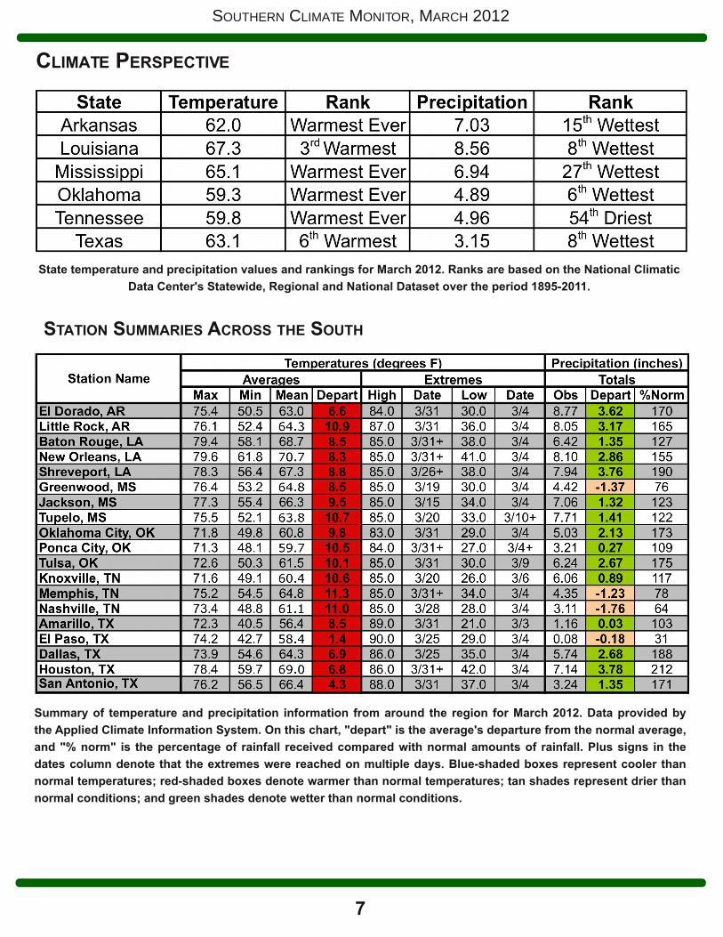
State temperature and precipitation values and rankings for March 2012. Ranks are based on the National ClimaticData Center's Statewide, Regional and National Dataset over the period 18952011.
CLIMATE PERSPECTIVE
STATION SUMMARIES ACROSS THE SOUTH
7
SOUTHERN CLIMATE MONITOR, MARCH 2012
Summary of temperature and precipitation information from around the region for March 2012. Data provided bythe Applied Climate Information System. On this chart, "depart" is the average's departure from the normal average,and "% norm" is the percentage of rainfall received compared with normal amounts of rainfall. Plus signs in thedates column denote that the extremes were reached on multiple days. Blueshaded boxes represent cooler thannormal temperatures; redshaded boxes denote warmer than normal temperatures; tan shades represent drier thannormal conditions; and green shades denote wetter than normal conditions.

8
SOUTHERN CLIMATE MONITOR, MARCH 2012
SOUTHERN CLIMATE MONITOR TEAM:Luigi Romolo, Regional Climatologist
Southern Regional Climate Center (LSU)
Charlotte Lunday, Student AssistantSouthern Climate Impacts Planning Program (OU)
Lynne Carter, Program ManagerSouthern Climate Impacts Planning Program (LSU)
Margret Boone, Program ManagerSouthern Climate Impacts Planning Program (OU)
Rachel Riley, Associate Program ManagerSouthern Climate Impacts Planning Program (OU)
Hal Needham, Research AssociateSouthern Climate Impacts Planning Program (LSU)
Barry Keim, State Climatologist for LouisianaCoPI, Southern Climate Impacts Planning Program (LSU)
Mark Shafer, Principal InvestigatorSouthern Climate Impacts Planning Program (OU)
Gary McManus, Associate State Climatologist forOklahoma
Southern Climate Impacts Planning Program (OU)
Kevin Robbins, DirectorSouthern Regional Climate Center (LSU)
Disclaimer: This is an experimental climateoutreach and engagement product. While wemake every attempt to verify this information, wedo not warrant the accuracy of any of thesematerials. The user assumes the entire risk relatedto the use of these data. This publication wasprepared by SRCC/SCIPP with support in partfrom the U.S. Department of Commerce/NOAA.The statements, findings, conclusions, andrecommendations are those of the author(s) anddo not necessarily reflect the views of NOAA
CONTACT USThe Monitor is an experimental climate outreach and engagement product of the Southern RegionalClimate Center and Southern Climate Impacts Planning Program. To provide feedback orsuggestions to improve the content provided in the Monitor, please contact us [email protected]. We look forward to hearing from you and tailoring the Monitor tobetter serve you. You can also find us online at www.srcc.lsu.edu and www.southernclimate.org.For any questions pertaining to historical climate data across the states of Oklahoma, Texas,Arkansas, Louisiana, Mississippi, or Tennessee, please contact the Southern Regional ClimateCenter at 225578502. For questions or inquiries regarding research, experimental tooldevelopment, and engagement activities at the Southern Climate Impacts Planning Program, pleasecontact us at 4053257809 or 2255788374.
Copyright © 2012 Board of Regents of the University of Oklahoma; Louisiana State University