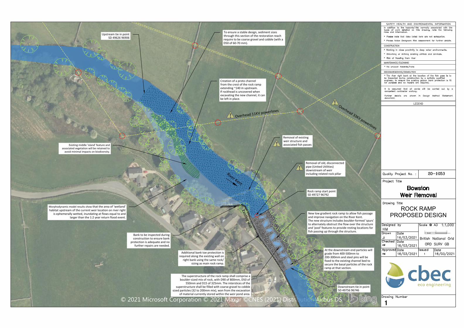
Removal of existingweir structure andassociated fish passes
Creation of a proto channelfrom the crest of the rock rampextending ~140 m upstream.If rockhead is uncovered whenexcavating the new channel, it canbe left in place.
Upstream tie in pointSD 49626 96906
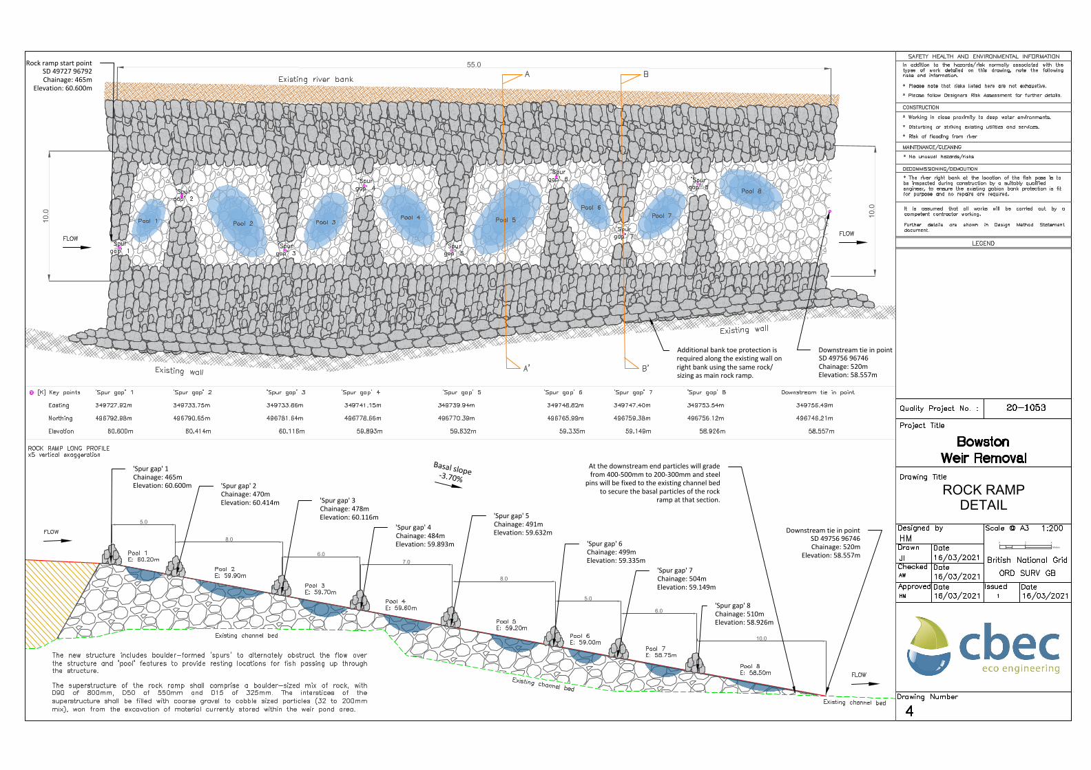
New low gradient rock ramp to allow fish passageand improve navigation on the River Kent.The new structure includes boulder-formed 'spurs'to alternately obstruct the flow over the structureand 'pool' features to provide resting locations forfish passing up through the structure.
To ensure a stable design, sediment sizesthrough this section of the restoration reachrequire to be coarse gravel and cobble (with aD50 of 60-70 mm).
Downstream tie in pointSD 49756 96746
Rock ramp start pointSD 49727 96792
Morphodynamic model results show that the area of ‘wetland’habitat upstream of the current weir location on river right
is ephemerally wetted, inundating at flows equal to andlarger than the 1:2 year return flood event.
Existing middle 'island' feature andassociated vegetation will be retained to
avoid minimal impacts on biodiversity.
The superstructure of the rock ramp shall comprise aboulder-sized mix of rock, with D90 of 800mm, D50 of
550mm and D15 of 325mm. The interstices of thesuperstructure shall be filled with coarse gravel to cobble
sized particles (32 to 200mm mix), won from the excavationof material currently stored within the weir pond area.
Removal of old, disconnectedpipe (United Utilities)downstream of weirincluding related rock pillar
Bank to be inspected duringconstruction to ensure bank
protection is adequate and nofurther repairs are needed.
Additional bank toe protection isrequired along the existing wall on
right bank using the same rock/sizing as main rock ramp.
Existing wall
At the downstream end particles willgrade from 400-500mm to200-300mm and steel pins will befixed to the existing channel bed tosecure the basal particles of the rockramp at that section.
AutoCAD SHX Text
Drawing Number
AutoCAD SHX Text
Designed by
AutoCAD SHX Text
16/03/2021
AutoCAD SHX Text
Checked
AutoCAD SHX Text
Approved
AutoCAD SHX Text
Drawn
AutoCAD SHX Text
16/03/2021
AutoCAD SHX Text
Date
AutoCAD SHX Text
Date
AutoCAD SHX Text
Date
AutoCAD SHX Text
Date
AutoCAD SHX Text
Issued
AutoCAD SHX Text
Drawing Title
AutoCAD SHX Text
Quality Project No. :
AutoCAD SHX Text
Project Title
AutoCAD SHX Text
Scale @ A3
AutoCAD SHX Text
16/03/2021
AutoCAD SHX Text
20-1053
AutoCAD SHX Text
Bowston
AutoCAD SHX Text
Weir Removal
AutoCAD SHX Text
1
AutoCAD SHX Text
1:1,000
AutoCAD SHX Text
British National Grid
AutoCAD SHX Text
ORD SURV GB
AutoCAD SHX Text
HM
AutoCAD SHX Text
JI
AutoCAD SHX Text
16/03/2021
AutoCAD SHX Text
AW
AutoCAD SHX Text
HM
AutoCAD SHX Text
1
AutoCAD SHX Text
SAFETY HEALTH AND ENVIRONMENTAL INFORMATION
AutoCAD SHX Text
In addition to the hazards/risk normally associated with the addition to the hazards/risk normally associated with the addition to the hazards/risk normally associated with the to the hazards/risk normally associated with the to the hazards/risk normally associated with the the hazards/risk normally associated with the the hazards/risk normally associated with the hazards/risk normally associated with the hazards/risk normally associated with the normally associated with the normally associated with the associated with the associated with the with the with the the the types of work detailed on this drawing, note the following of work detailed on this drawing, note the following of work detailed on this drawing, note the following work detailed on this drawing, note the following work detailed on this drawing, note the following detailed on this drawing, note the following detailed on this drawing, note the following on this drawing, note the following on this drawing, note the following this drawing, note the following this drawing, note the following drawing, note the following drawing, note the following note the following note the following the following the following following following risks and information.
AutoCAD SHX Text
CONSTRUCTION
AutoCAD SHX Text
* Please note that risks listed here are not exhaustive.
AutoCAD SHX Text
It is assumed that all works will be carried out by a is assumed that all works will be carried out by a is assumed that all works will be carried out by a assumed that all works will be carried out by a assumed that all works will be carried out by a that all works will be carried out by a that all works will be carried out by a all works will be carried out by a all works will be carried out by a works will be carried out by a works will be carried out by a will be carried out by a will be carried out by a be carried out by a be carried out by a carried out by a carried out by a out by a out by a by a by a a a competent contractor working. Further details are shown in Design Method Statement details are shown in Design Method Statement details are shown in Design Method Statement are shown in Design Method Statement are shown in Design Method Statement shown in Design Method Statement shown in Design Method Statement in Design Method Statement in Design Method Statement Design Method Statement Design Method Statement Method Statement Method Statement Statement Statement document.
AutoCAD SHX Text
LEGEND
AutoCAD SHX Text
MAINTENANCE/CLEANING
AutoCAD SHX Text
* No unusual hazards/risks
AutoCAD SHX Text
DECOMMISSIONING/DEMOLITION
AutoCAD SHX Text
* The river right bank at the location of the fish pass is to be inspected during construction by a suitably qualified engineer, to ensure the existing gabion bank protection is fit for purpose and no repairs are required.
AutoCAD SHX Text
* Working in close proximity to deep water environments.
AutoCAD SHX Text
* Disturbing or striking existing utilities and services.
AutoCAD SHX Text
* Risk of flooding from river
AutoCAD SHX Text
* Please follow Designers Risk Assessment for further details.
ALIGNMENT - BOWSTON WEIR - LONGSECTION
SCALE: H 1:100,V 1:20. DATUM: 56.000
x5 vertical exaggeration
56
57
58
59
60
61
62
63
64
65
56
57
58
59
60
61
62
63
64
65
Chainage
Existing Levels
Proposed Levels
250.000
255.000
260.000
265.000
270.000
275.000
280.000
285.000
290.000
295.000
300.000
305.000
310.000
315.000
320.000
325.000
330.000
335.000
340.000
345.000
350.000
355.000
360.000
365.000
370.000
375.000
380.000
385.000
390.000
395.000
400.000
405.000
410.000
415.000
420.000
425.000
430.000
435.000
440.000
445.000
450.000
455.000
460.000
465.000
470.000
475.000
480.000
485.000
490.000
495.000
500.000
505.000
510.000
515.000
520.000
525.000
530.000
535.000
540.000
545.000
550.000
61.895
61.795
61.644
61.806
61.581
61.482
61.396
61.819
61.992
61.850
61.837
61.895
62.184
62.460
62.474
62.616
62.586
62.563
62.539
62.516
62.505
62.499
62.445
62.391
62.356
62.271
62.160
62.248
62.292
62.294
62.292
62.260
62.124
61.940
61.753
61.473
61.110
59.856
60.095
59.679
59.305
59.362
59.528
59.590
59.597
59.583
59.569
59.102
58.928
58.754
58.633
58.618
58.594
58.557
58.521
58.484
58.447
58.411
58.374
61.895
61.853
61.811
61.769
61.728
61.686
61.644
61.602
61.561
61.519
61.477
61.435
61.394
61.352
61.310
61.268
61.226
61.185
61.143
61.101
61.059
61.018
60.976
60.934
60.892
60.851
60.809
60.767
60.725
60.684
60.642
60.600
60.414
60.229
60.043
59.857
59.671
59.486
59.300
59.114
58.929
58.743
58.557
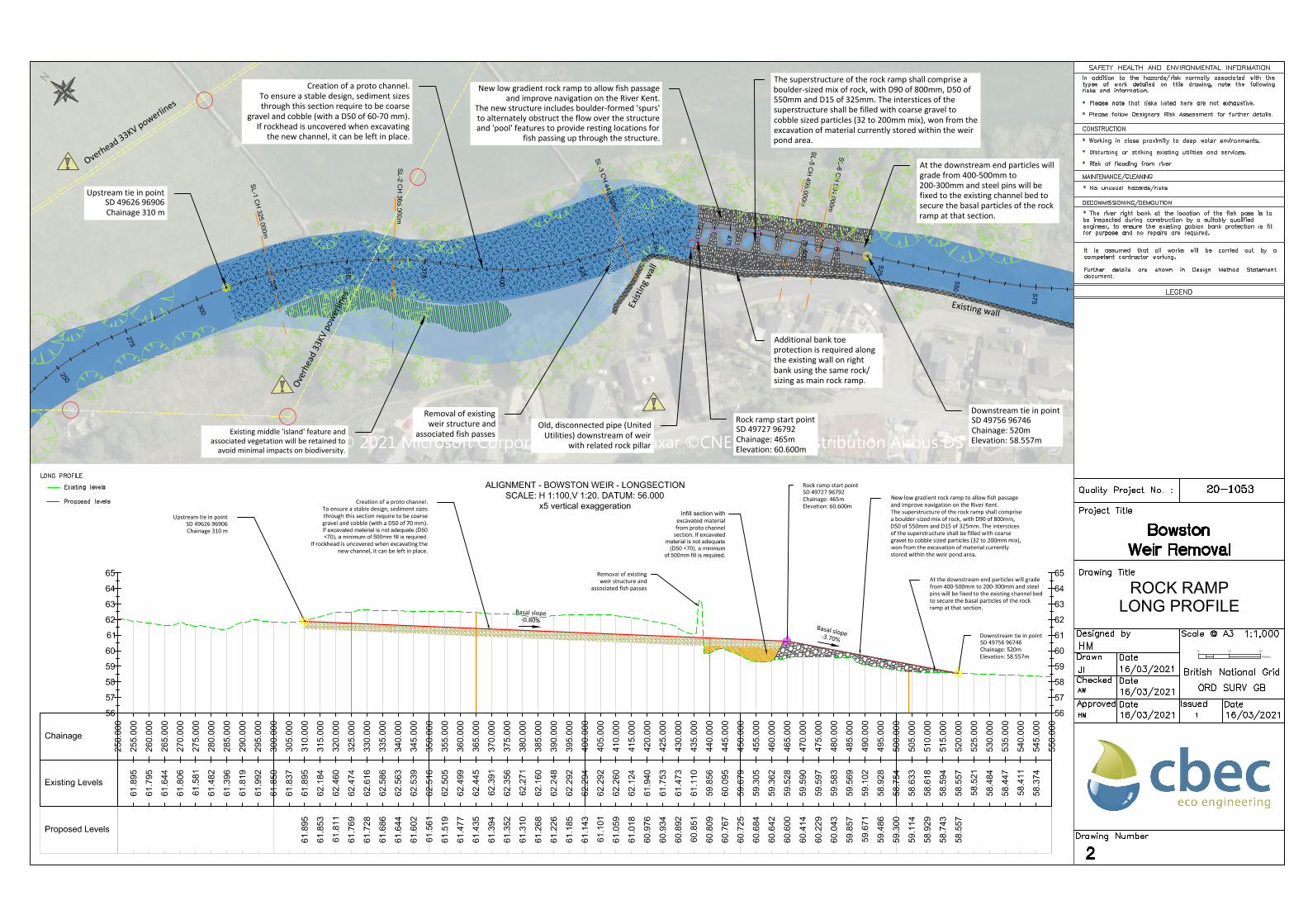
Removal of existingweir structure and
associated fish passes
Infill section with
excavated materialfrom proto channel
section. If excavated
material is not adequate
(D50 <70), a minimum
of 500mm fill is required.
New low gradient rock ramp to allow fish passageand improve navigation on the River Kent.The superstructure of the rock ramp shall comprisea boulder-sized mix of rock, with D90 of 800mm,D50 of 550mm and D15 of 325mm. The intersticesof the superstructure shall be filled with coarsegravel to cobble sized particles (32 to 200mm mix),won from the excavation of material currentlystored within the weir pond area.
Downstream tie in pointSD 49756 96746Chainage: 520mElevation: 58.557m
Creation of a proto channel.To ensure a stable design, sediment sizesthrough this section require to be coarsegravel and cobble (with a D50 of 70 mm).If excavated material is not adequate (D50
<70), a minimum of 500mm fill is required.
If rockhead is uncovered when excavating thenew channel, it can be left in place.
Upstream tie in pointSD 49626 96906Chainage 310 m
Rock ramp start pointSD 49727 96792Chainage: 465mElevation: 60.600m
Basal slope-3.70%
Basal slope-0.80%
At the downstream end particles will gradefrom 400-500mm to 200-300mm and steelpins will be fixed to the existing channel bedto secure the basal particles of the rockramp at that section.
Creation of a proto channel.To ensure a stable design, sediment sizesthrough this section require to be coarse
gravel and cobble (with a D50 of 60-70 mm).If rockhead is uncovered when excavating
the new channel, it can be left in place.
Upstream tie in pointSD 49626 96906Chainage 310 m
New low gradient rock ramp to allow fish passageand improve navigation on the River Kent.
The new structure includes boulder-formed 'spurs'to alternately obstruct the flow over the structureand 'pool' features to provide resting locations for
fish passing up through the structure.
Downstream tie in pointSD 49756 96746Chainage: 520mElevation: 58.557m
Rock ramp start pointSD 49727 96792Chainage: 465mElevation: 60.600m
Existing middle 'island' feature andassociated vegetation will be retained to
avoid minimal impacts on biodiversity.
The superstructure of the rock ramp shall comprise aboulder-sized mix of rock, with D90 of 800mm, D50 of550mm and D15 of 325mm. The interstices of thesuperstructure shall be filled with coarse gravel tocobble sized particles (32 to 200mm mix), won from theexcavation of material currently stored within the weirpond area.
Overhead 33KV powerlines
Old, disconnected pipe (UnitedUtilities) downstream of weir
with related rock pillar
Over
head
33K
V po
werli
nes
At the downstream end particles willgrade from 400-500mm to200-300mm and steel pins will befixed to the existing channel bed tosecure the basal particles of the rockramp at that section.
Additional bank toeprotection is required alongthe existing wall on rightbank using the same rock/sizing as main rock ramp.
Exist
ing w
all
Existing wall
AutoCAD SHX Text
Drawing Number
AutoCAD SHX Text
Designed by
AutoCAD SHX Text
16/03/2021
AutoCAD SHX Text
Checked
AutoCAD SHX Text
Approved
AutoCAD SHX Text
Drawn
AutoCAD SHX Text
16/03/2021
AutoCAD SHX Text
Date
AutoCAD SHX Text
Date
AutoCAD SHX Text
Date
AutoCAD SHX Text
Date
AutoCAD SHX Text
Issued
AutoCAD SHX Text
Drawing Title
AutoCAD SHX Text
Quality Project No. :
AutoCAD SHX Text
Project Title
AutoCAD SHX Text
Scale @ A3
AutoCAD SHX Text
16/03/2021
AutoCAD SHX Text
20-1053
AutoCAD SHX Text
Bowston
AutoCAD SHX Text
Weir Removal
AutoCAD SHX Text
2
AutoCAD SHX Text
1:1,000
AutoCAD SHX Text
British National Grid
AutoCAD SHX Text
ORD SURV GB
AutoCAD SHX Text
HM
AutoCAD SHX Text
JI
AutoCAD SHX Text
16/03/2021
AutoCAD SHX Text
AW
AutoCAD SHX Text
HM
AutoCAD SHX Text
1
AutoCAD SHX Text
N
AutoCAD SHX Text
Existing levels
AutoCAD SHX Text
Proposed levels
AutoCAD SHX Text
LONG PROFILE
AutoCAD SHX Text
SAFETY HEALTH AND ENVIRONMENTAL INFORMATION
AutoCAD SHX Text
In addition to the hazards/risk normally associated with the addition to the hazards/risk normally associated with the addition to the hazards/risk normally associated with the to the hazards/risk normally associated with the to the hazards/risk normally associated with the the hazards/risk normally associated with the the hazards/risk normally associated with the hazards/risk normally associated with the hazards/risk normally associated with the normally associated with the normally associated with the associated with the associated with the with the with the the the types of work detailed on this drawing, note the following of work detailed on this drawing, note the following of work detailed on this drawing, note the following work detailed on this drawing, note the following work detailed on this drawing, note the following detailed on this drawing, note the following detailed on this drawing, note the following on this drawing, note the following on this drawing, note the following this drawing, note the following this drawing, note the following drawing, note the following drawing, note the following note the following note the following the following the following following following risks and information.
AutoCAD SHX Text
CONSTRUCTION
AutoCAD SHX Text
* Please note that risks listed here are not exhaustive.
AutoCAD SHX Text
It is assumed that all works will be carried out by a is assumed that all works will be carried out by a is assumed that all works will be carried out by a assumed that all works will be carried out by a assumed that all works will be carried out by a that all works will be carried out by a that all works will be carried out by a all works will be carried out by a all works will be carried out by a works will be carried out by a works will be carried out by a will be carried out by a will be carried out by a be carried out by a be carried out by a carried out by a carried out by a out by a out by a by a by a a a competent contractor working. Further details are shown in Design Method Statement details are shown in Design Method Statement details are shown in Design Method Statement are shown in Design Method Statement are shown in Design Method Statement shown in Design Method Statement shown in Design Method Statement in Design Method Statement in Design Method Statement Design Method Statement Design Method Statement Method Statement Method Statement Statement Statement document.
AutoCAD SHX Text
LEGEND
AutoCAD SHX Text
MAINTENANCE/CLEANING
AutoCAD SHX Text
* No unusual hazards/risks
AutoCAD SHX Text
DECOMMISSIONING/DEMOLITION
AutoCAD SHX Text
* The river right bank at the location of the fish pass is to be inspected during construction by a suitably qualified engineer, to ensure the existing gabion bank protection is fit for purpose and no repairs are required.
AutoCAD SHX Text
* Working in close proximity to deep water environments.
AutoCAD SHX Text
* Disturbing or striking existing utilities and services.
AutoCAD SHX Text
* Risk of flooding from river
AutoCAD SHX Text
* Please follow Designers Risk Assessment for further details.
Chainage 325.000
Natural scale
60
61
62
63
64
60
61
62
63
64
Offset
Existing Levels
Proposed Levels
Chainage 365.000
Natural scale
60
61
62
63
64
65
60
61
62
63
64
65
Offset
Existing Levels
Proposed Levels
Chainage 440.000
Natural scale
58
59
60
61
62
63
64
65
58
59
60
61
62
63
64
65
Offset
Existing Levels
Proposed Levels
-14.315
-13.010
-10.670
-9.205
-7.781
-3.747
0.000
5.314
10.478
12.269
13.731
15.569
17.554
20.000
63.996
63.963
63.882
62.991
62.279
62.077
61.890
62.155
62.413
63.026
63.089
63.200
63.263
63.483
-11.910
-9.473
-6.920
-5.724
-4.577
-2.204
0.000
4.457
8.684
10.516
12.126
13.161
14.199
16.993
18.129
19.256
20.463
22.005
23.421
24.841
26.073
27.489
30.000
64.546
63.899
62.894
62.323
61.750
61.632
61.521
61.744
61.955
62.871
63.189
63.494
63.534
63.667
62.681
62.500
62.394
62.350
62.483
62.741
62.672
62.839
63.472
-19.500
-18.528
-17.362
-15.882
-13.716
0.000
5.975
8.193
9.589
10.646
12.000
63.438
63.137
62.897
62.599
61.516
60.830
61.336
62.311
62.703
63.000
63.984
63.996
63.963
63.882
63.001
62.652
62.382
62.513
62.904
62.552
63.026
63.089
63.200
63.263
63.483
64.546
63.899
62.875
62.651
62.620
62.577
62.430
62.600
62.763
62.998
63.189
63.494
63.534
63.667
62.681
62.500
62.394
62.350
62.483
62.741
62.672
62.839
63.472
63.438
63.137
62.897
62.599
62.429
59.884
61.555
61.000
61.000
62.411
PROPOSED DESIGN
SECTIONS
Meters
0 2 4
Creation of a proto channelwith simple geometry*
Retain ‘wetland’ habitatupstream of the weir.
Removal of existingweir structure and
associated fish passes
Creation of a proto channelwith simple geometry*
Creation of a proto channelwith simple geometry *
Existing'island' feature
* To ensure a stable design, sediment sizes through the proto channel sectionrequire to be coarse gravel and cobble (with a D50 of 70 mm). If excavated
material is not adequate (D50 <70), a minimum of 500mm fill is required.
If rockhead is undercover when excavating the new channel, it can be left in place.
In addition to the hazards/risk normally associated with the addition to the hazards/risk normally associated with the addition to the hazards/risk normally associated with the to the hazards/risk normally associated with the to the hazards/risk normally associated with the the hazards/risk normally associated with the the hazards/risk normally associated with the hazards/risk normally associated with the hazards/risk normally associated with the normally associated with the normally associated with the associated with the associated with the with the with the the the types of work detailed on this drawing, note the following of work detailed on this drawing, note the following of work detailed on this drawing, note the following work detailed on this drawing, note the following work detailed on this drawing, note the following detailed on this drawing, note the following detailed on this drawing, note the following on this drawing, note the following on this drawing, note the following this drawing, note the following this drawing, note the following drawing, note the following drawing, note the following note the following note the following the following the following following following risks and information.
AutoCAD SHX Text
CONSTRUCTION
AutoCAD SHX Text
* Please note that risks listed here are not exhaustive.
AutoCAD SHX Text
It is assumed that all works will be carried out by a is assumed that all works will be carried out by a is assumed that all works will be carried out by a assumed that all works will be carried out by a assumed that all works will be carried out by a that all works will be carried out by a that all works will be carried out by a all works will be carried out by a all works will be carried out by a works will be carried out by a works will be carried out by a will be carried out by a will be carried out by a be carried out by a be carried out by a carried out by a carried out by a out by a out by a by a by a a a competent contractor working. Further details are shown in Design Method Statement details are shown in Design Method Statement details are shown in Design Method Statement are shown in Design Method Statement are shown in Design Method Statement shown in Design Method Statement shown in Design Method Statement in Design Method Statement in Design Method Statement Design Method Statement Design Method Statement Method Statement Method Statement Statement Statement document.
AutoCAD SHX Text
LEGEND
AutoCAD SHX Text
MAINTENANCE/CLEANING
AutoCAD SHX Text
* No unusual hazards/risks
AutoCAD SHX Text
DECOMMISSIONING/DEMOLITION
AutoCAD SHX Text
* The river right bank at the location of the fish pass is to be inspected during construction by a suitably qualified engineer, to ensure the existing gabion bank protection is fit for purpose and no repairs are required.
AutoCAD SHX Text
* Working in close proximity to deep water environments.
AutoCAD SHX Text
* Disturbing or striking existing utilities and services.
AutoCAD SHX Text
* Risk of flooding from river
AutoCAD SHX Text
* Please follow Designers Risk Assessment for further details.
5.0
8.0
6.0
8.0
5.0
6.0
10.0
7.0
Basal slope-3.70%
10.0
55.0
10.0
ROCK RAMP
DETAIL
Meters
0 2 4
Downstream tie in pointSD 49756 96746Chainage: 520mElevation: 58.557m
Rock ramp start pointSD 49727 96792Chainage: 465m
Elevation: 60.600m
'Spur gap' 1Chainage: 465mElevation: 60.600m
Downstream tie in pointSD 49756 96746Chainage: 520m
The new structure includes boulder-formed 'spurs' to alternately obstruct the flow over new structure includes boulder-formed 'spurs' to alternately obstruct the flow over new structure includes boulder-formed 'spurs' to alternately obstruct the flow over structure includes boulder-formed 'spurs' to alternately obstruct the flow over structure includes boulder-formed 'spurs' to alternately obstruct the flow over includes boulder-formed 'spurs' to alternately obstruct the flow over includes boulder-formed 'spurs' to alternately obstruct the flow over boulder-formed 'spurs' to alternately obstruct the flow over boulder-formed 'spurs' to alternately obstruct the flow over 'spurs' to alternately obstruct the flow over 'spurs' to alternately obstruct the flow over to alternately obstruct the flow over to alternately obstruct the flow over alternately obstruct the flow over alternately obstruct the flow over obstruct the flow over obstruct the flow over the flow over the flow over flow over flow over over over the structure and 'pool' features to provide resting locations for fish passing up through structure and 'pool' features to provide resting locations for fish passing up through structure and 'pool' features to provide resting locations for fish passing up through and 'pool' features to provide resting locations for fish passing up through and 'pool' features to provide resting locations for fish passing up through 'pool' features to provide resting locations for fish passing up through 'pool' features to provide resting locations for fish passing up through features to provide resting locations for fish passing up through features to provide resting locations for fish passing up through to provide resting locations for fish passing up through to provide resting locations for fish passing up through provide resting locations for fish passing up through provide resting locations for fish passing up through resting locations for fish passing up through resting locations for fish passing up through locations for fish passing up through locations for fish passing up through for fish passing up through for fish passing up through fish passing up through fish passing up through passing up through passing up through up through up through through through the structure. The superstructure of the rock ramp shall comprise a boulder-sized mix of rock, with superstructure of the rock ramp shall comprise a boulder-sized mix of rock, with superstructure of the rock ramp shall comprise a boulder-sized mix of rock, with of the rock ramp shall comprise a boulder-sized mix of rock, with of the rock ramp shall comprise a boulder-sized mix of rock, with the rock ramp shall comprise a boulder-sized mix of rock, with the rock ramp shall comprise a boulder-sized mix of rock, with rock ramp shall comprise a boulder-sized mix of rock, with rock ramp shall comprise a boulder-sized mix of rock, with ramp shall comprise a boulder-sized mix of rock, with ramp shall comprise a boulder-sized mix of rock, with shall comprise a boulder-sized mix of rock, with shall comprise a boulder-sized mix of rock, with comprise a boulder-sized mix of rock, with comprise a boulder-sized mix of rock, with a boulder-sized mix of rock, with a boulder-sized mix of rock, with boulder-sized mix of rock, with boulder-sized mix of rock, with mix of rock, with mix of rock, with of rock, with of rock, with rock, with rock, with with with D90 of 800mm, D50 of 550mm and D15 of 325mm. The interstices of the of 800mm, D50 of 550mm and D15 of 325mm. The interstices of the of 800mm, D50 of 550mm and D15 of 325mm. The interstices of the 800mm, D50 of 550mm and D15 of 325mm. The interstices of the 800mm, D50 of 550mm and D15 of 325mm. The interstices of the D50 of 550mm and D15 of 325mm. The interstices of the D50 of 550mm and D15 of 325mm. The interstices of the of 550mm and D15 of 325mm. The interstices of the of 550mm and D15 of 325mm. The interstices of the 550mm and D15 of 325mm. The interstices of the 550mm and D15 of 325mm. The interstices of the and D15 of 325mm. The interstices of the and D15 of 325mm. The interstices of the D15 of 325mm. The interstices of the D15 of 325mm. The interstices of the of 325mm. The interstices of the of 325mm. The interstices of the 325mm. The interstices of the 325mm. The interstices of the The interstices of the The interstices of the interstices of the interstices of the of the of the the the superstructure shall be filled with coarse gravel to cobble sized particles (32 to 200mm shall be filled with coarse gravel to cobble sized particles (32 to 200mm shall be filled with coarse gravel to cobble sized particles (32 to 200mm be filled with coarse gravel to cobble sized particles (32 to 200mm be filled with coarse gravel to cobble sized particles (32 to 200mm filled with coarse gravel to cobble sized particles (32 to 200mm filled with coarse gravel to cobble sized particles (32 to 200mm with coarse gravel to cobble sized particles (32 to 200mm with coarse gravel to cobble sized particles (32 to 200mm coarse gravel to cobble sized particles (32 to 200mm coarse gravel to cobble sized particles (32 to 200mm gravel to cobble sized particles (32 to 200mm gravel to cobble sized particles (32 to 200mm to cobble sized particles (32 to 200mm to cobble sized particles (32 to 200mm cobble sized particles (32 to 200mm cobble sized particles (32 to 200mm sized particles (32 to 200mm sized particles (32 to 200mm particles (32 to 200mm particles (32 to 200mm (32 to 200mm (32 to 200mm to 200mm to 200mm 200mm 200mm mix), won from the excavation of material currently stored within the weir pond area.
AutoCAD SHX Text
SAFETY HEALTH AND ENVIRONMENTAL INFORMATION
AutoCAD SHX Text
In addition to the hazards/risk normally associated with the addition to the hazards/risk normally associated with the addition to the hazards/risk normally associated with the to the hazards/risk normally associated with the to the hazards/risk normally associated with the the hazards/risk normally associated with the the hazards/risk normally associated with the hazards/risk normally associated with the hazards/risk normally associated with the normally associated with the normally associated with the associated with the associated with the with the with the the the types of work detailed on this drawing, note the following of work detailed on this drawing, note the following of work detailed on this drawing, note the following work detailed on this drawing, note the following work detailed on this drawing, note the following detailed on this drawing, note the following detailed on this drawing, note the following on this drawing, note the following on this drawing, note the following this drawing, note the following this drawing, note the following drawing, note the following drawing, note the following note the following note the following the following the following following following risks and information.
AutoCAD SHX Text
CONSTRUCTION
AutoCAD SHX Text
* Please note that risks listed here are not exhaustive.
AutoCAD SHX Text
It is assumed that all works will be carried out by a is assumed that all works will be carried out by a is assumed that all works will be carried out by a assumed that all works will be carried out by a assumed that all works will be carried out by a that all works will be carried out by a that all works will be carried out by a all works will be carried out by a all works will be carried out by a works will be carried out by a works will be carried out by a will be carried out by a will be carried out by a be carried out by a be carried out by a carried out by a carried out by a out by a out by a by a by a a a competent contractor working. Further details are shown in Design Method Statement details are shown in Design Method Statement details are shown in Design Method Statement are shown in Design Method Statement are shown in Design Method Statement shown in Design Method Statement shown in Design Method Statement in Design Method Statement in Design Method Statement Design Method Statement Design Method Statement Method Statement Method Statement Statement Statement document.
AutoCAD SHX Text
LEGEND
AutoCAD SHX Text
MAINTENANCE/CLEANING
AutoCAD SHX Text
* No unusual hazards/risks
AutoCAD SHX Text
DECOMMISSIONING/DEMOLITION
AutoCAD SHX Text
* The river right bank at the location of the fish pass is to be inspected during construction by a suitably qualified engineer, to ensure the existing gabion bank protection is fit for purpose and no repairs are required.
AutoCAD SHX Text
* Working in close proximity to deep water environments.
AutoCAD SHX Text
* Disturbing or striking existing utilities and services.
AutoCAD SHX Text
* Risk of flooding from river
AutoCAD SHX Text
* Please follow Designers Risk Assessment for further details.
2.0m
0.3m
0.2m
Existing bed levels
Existing bed levels
'Spur gap 7'
0.3m
Basal level
Basal level
E
x
is
tin
g
w
a
ll
E
x
is
tin
g
w
a
ll
10.0
10.0
0.5m
'Pool 5'
[K]
1.0m
1.5m
1.0m
1.5m
ROCK RAMP
SECTIONS
Meters
0 0.75 1.5
Adjust rock ramp to existing bank
Adjust rock ramp to existing wall
Adjust rock ramp to existing bank
Key point for construction
Additional bank toe protection isrequired along the existing wall on
right bank using the same rock/sizing as main rock ramp.
Additional bank toe protection isrequired along the existing wall on
right bank using the same rock/sizing as main rock ramp.
Adjust rock ramp to existing wall
The superstructure of the rock ramp shall comprise aboulder-sized mix of rock, with D90 of 800mm, D50 of
550mm and D15 of 325mm. The interstices of thesuperstructure shall be filled with coarse gravel to cobble
sized particles (32 to 200mm mix), won from the excavationof material currently stored within the weir pond area.
AutoCAD SHX Text
Drawing Number
AutoCAD SHX Text
Designed by
AutoCAD SHX Text
16/03/2021
AutoCAD SHX Text
Checked
AutoCAD SHX Text
Approved
AutoCAD SHX Text
Drawn
AutoCAD SHX Text
16/03/2021
AutoCAD SHX Text
Date
AutoCAD SHX Text
Date
AutoCAD SHX Text
Date
AutoCAD SHX Text
Date
AutoCAD SHX Text
Issued
AutoCAD SHX Text
Drawing Title
AutoCAD SHX Text
Quality Project No. :
AutoCAD SHX Text
Project Title
AutoCAD SHX Text
Scale @ A3
AutoCAD SHX Text
16/03/2021
AutoCAD SHX Text
20-1053
AutoCAD SHX Text
Bowston
AutoCAD SHX Text
Weir Removal
AutoCAD SHX Text
5
AutoCAD SHX Text
1:60
AutoCAD SHX Text
British National Grid
AutoCAD SHX Text
ORD SURV GB
AutoCAD SHX Text
HM
AutoCAD SHX Text
JI
AutoCAD SHX Text
16/03/2021
AutoCAD SHX Text
AW
AutoCAD SHX Text
HM
AutoCAD SHX Text
1
AutoCAD SHX Text
Existing levels
AutoCAD SHX Text
Proposed levels
AutoCAD SHX Text
A
AutoCAD SHX Text
A'
AutoCAD SHX Text
B
AutoCAD SHX Text
B'
AutoCAD SHX Text
Chainage 504.000m Natural scale
AutoCAD SHX Text
Chainage 496.000m Natural scale
AutoCAD SHX Text
SAFETY HEALTH AND ENVIRONMENTAL INFORMATION
AutoCAD SHX Text
In addition to the hazards/risk normally associated with the addition to the hazards/risk normally associated with the addition to the hazards/risk normally associated with the to the hazards/risk normally associated with the to the hazards/risk normally associated with the the hazards/risk normally associated with the the hazards/risk normally associated with the hazards/risk normally associated with the hazards/risk normally associated with the normally associated with the normally associated with the associated with the associated with the with the with the the the types of work detailed on this drawing, note the following of work detailed on this drawing, note the following of work detailed on this drawing, note the following work detailed on this drawing, note the following work detailed on this drawing, note the following detailed on this drawing, note the following detailed on this drawing, note the following on this drawing, note the following on this drawing, note the following this drawing, note the following this drawing, note the following drawing, note the following drawing, note the following note the following note the following the following the following following following risks and information.
AutoCAD SHX Text
CONSTRUCTION
AutoCAD SHX Text
* Please note that risks listed here are not exhaustive.
AutoCAD SHX Text
It is assumed that all works will be carried out by a is assumed that all works will be carried out by a is assumed that all works will be carried out by a assumed that all works will be carried out by a assumed that all works will be carried out by a that all works will be carried out by a that all works will be carried out by a all works will be carried out by a all works will be carried out by a works will be carried out by a works will be carried out by a will be carried out by a will be carried out by a be carried out by a be carried out by a carried out by a carried out by a out by a out by a by a by a a a competent contractor working. Further details are shown in Design Method Statement details are shown in Design Method Statement details are shown in Design Method Statement are shown in Design Method Statement are shown in Design Method Statement shown in Design Method Statement shown in Design Method Statement in Design Method Statement in Design Method Statement Design Method Statement Design Method Statement Method Statement Method Statement Statement Statement document.
AutoCAD SHX Text
LEGEND
AutoCAD SHX Text
MAINTENANCE/CLEANING
AutoCAD SHX Text
* No unusual hazards/risks
AutoCAD SHX Text
DECOMMISSIONING/DEMOLITION
AutoCAD SHX Text
* The river right bank at the location of the fish pass is to be inspected during construction by a suitably qualified engineer, to ensure the existing gabion bank protection is fit for purpose and no repairs are required.
AutoCAD SHX Text
* Working in close proximity to deep water environments.
AutoCAD SHX Text
* Disturbing or striking existing utilities and services.
AutoCAD SHX Text
* Risk of flooding from river
AutoCAD SHX Text
* Please follow Designers Risk Assessment for further details.