overview of maryland’s upper air profilers - … of maryland’s upper air profilers ... • case...
TRANSCRIPT

Martin O’Malley, Governor | Anthony G. Brown, Lt. Governor | Robert M. Summers, Ph.D., Secretary
Overview of Maryland’s Upper Air Profilers
Dave Krask, ManagerMDE Air Monitoring Program
EPA/NACAA Monitoring MeetingJanuary 10, 2013
22
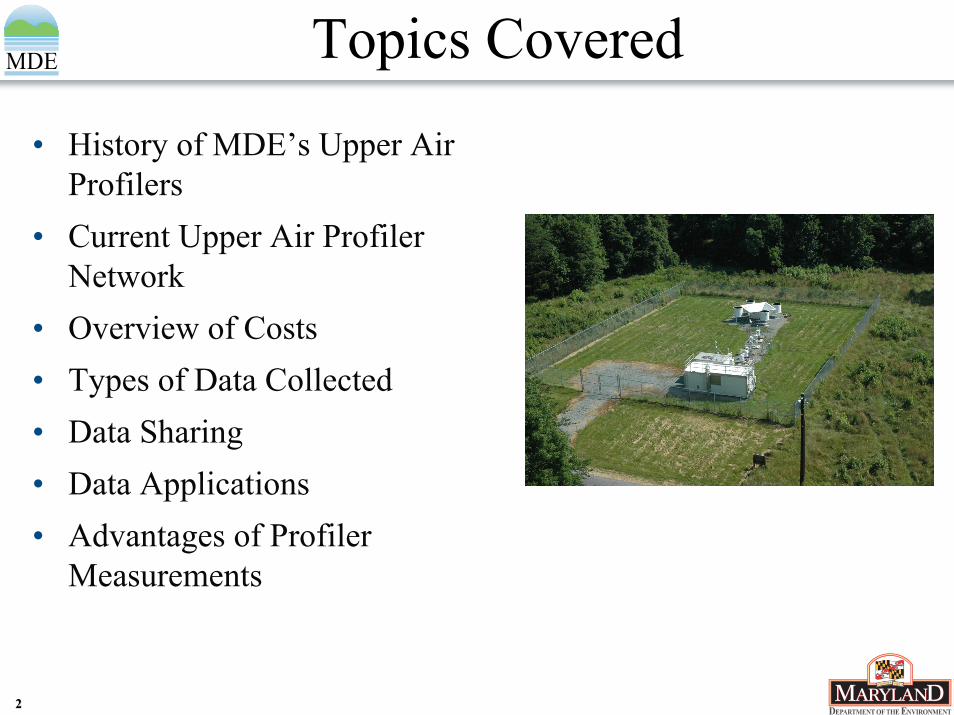
Topics Covered
• History of MDE’s Upper Air Profilers
• Current Upper Air Profiler Network
• Overview of Costs• Types of Data Collected• Data Sharing• Data Applications• Advantages of Profiler
Measurements
33
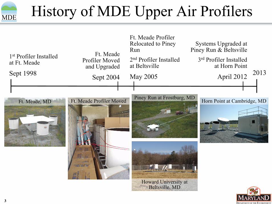
History of MDE Upper Air Profilers
Piney Run at Frostburg, MD
1st Profiler Installed at Ft. Meade
Sept 1998 2013
Ft. Meade Profiler Moved
and Upgraded
Sept 2004
Systems Upgraded at Piney Run & Beltsville
3rd Profiler Installedat Horn Point
April 2012
Ft. Meade Profiler Relocated to Piney Run2nd Profiler Installed at Beltsville
May 2005
Ft. Meade, MD
Howard University at Beltsville, MD
Ft. Meade Profiler Moved Horn Point at Cambridge, MD

44
MDE Upper Air Profiler Network
MDE RWP/RASS Network
Horn Point at Cambridge, MD
• Currently have three Radar Wind Profilers (RWP) with Radio Acoustic Sounding Systems (RASS)
• Upgraded Lower Atmosphere Profiler (LAP) -3000 Pulsed Doppler Radar• Howard University Campus at
Beltsville, MD• Piney Run Reservoir at
Frostburg, MD• Velocity Azimuth Display –
Boundary Layer (VAD-BL)• Horn Point at Cambridge, MD• New technology developed by
DeTect Inc.
Source: DeTect Inc.
55
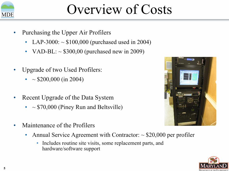
Overview of Costs• Purchasing the Upper Air Profilers
• LAP-3000: ~ $100,000 (purchased used in 2004)• VAD-BL: ~ $300,00 (purchased new in 2009)
• Upgrade of two Used Profilers: • ~ $200,000 (in 2004)
• Recent Upgrade of the Data System• ~ $70,000 (Piney Run and Beltsville)
• Maintenance of the Profilers• Annual Service Agreement with Contractor: ~ $20,000 per profiler
• Includes routine site visits, some replacement parts, and hardware/software support
66
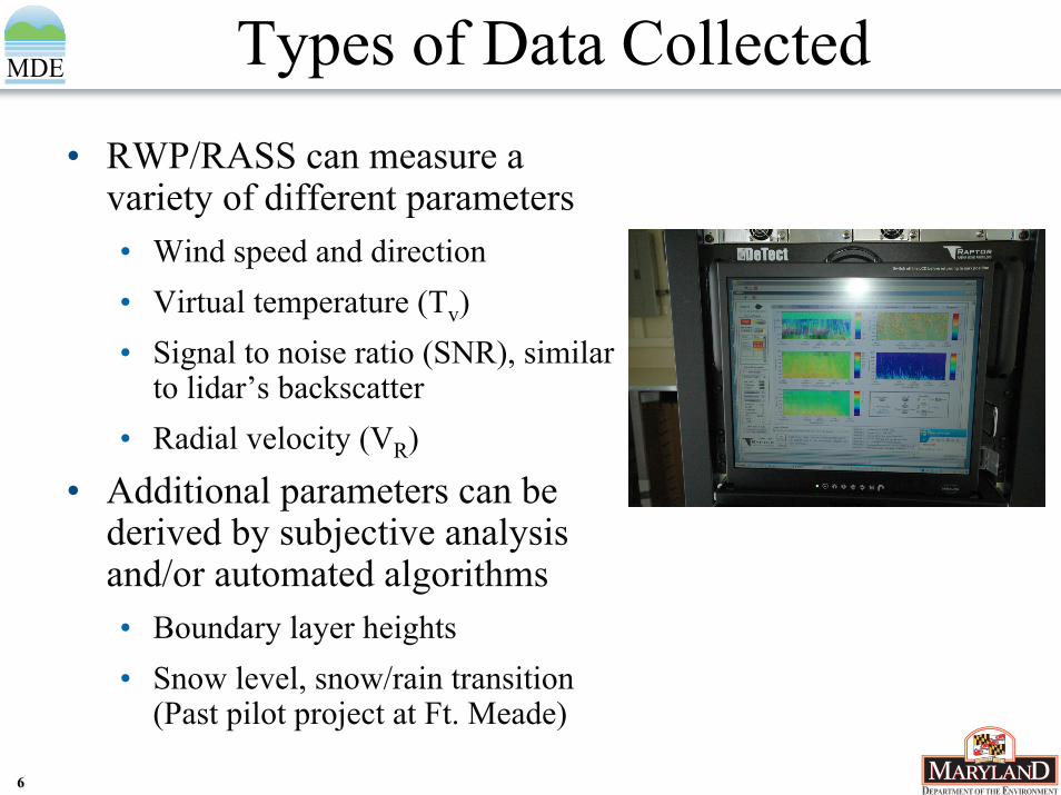
Types of Data Collected• RWP/RASS can measure a
variety of different parameters• Wind speed and direction• Virtual temperature (Tv)• Signal to noise ratio (SNR), similar
to lidar’s backscatter• Radial velocity (VR)
• Additional parameters can be derived by subjective analysis and/or automated algorithms• Boundary layer heights• Snow level, snow/rain transition
(Past pilot project at Ft. Meade)
77
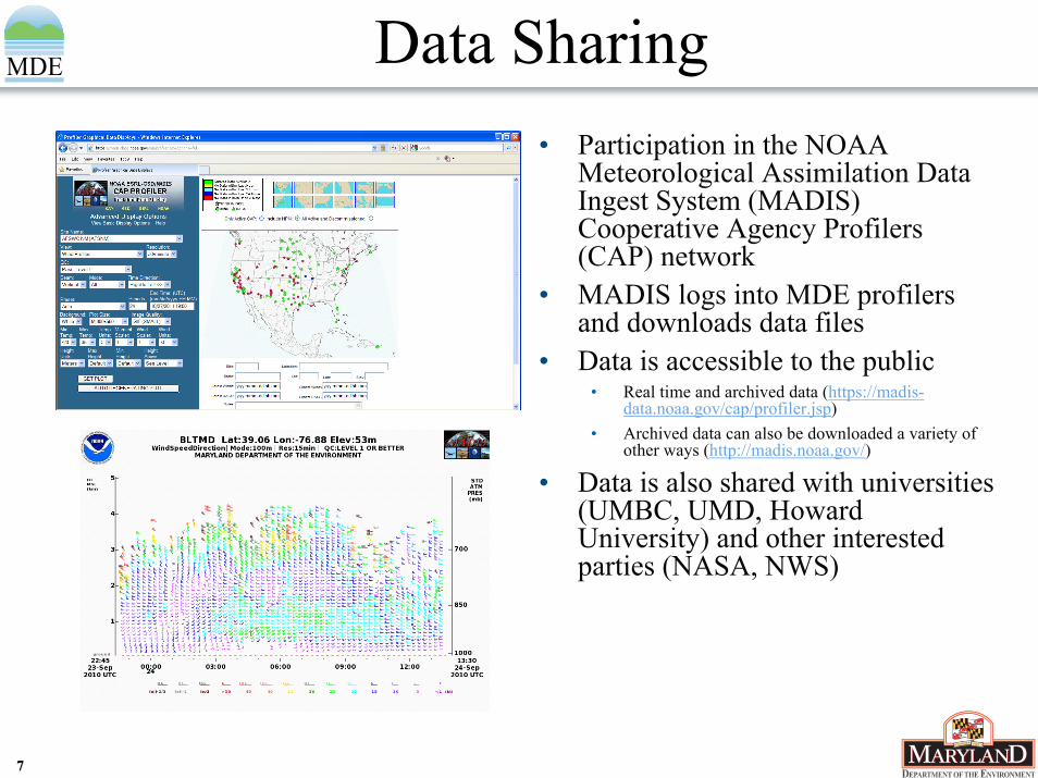
Data Sharing• Participation in the NOAA
Meteorological Assimilation Data Ingest System (MADIS) Cooperative Agency Profilers (CAP) network
• MADIS logs into MDE profilers and downloads data files
• Data is accessible to the public• Real time and archived data (https://madis-
data.noaa.gov/cap/profiler.jsp)• Archived data can also be downloaded a variety of
other ways (http://madis.noaa.gov/)
• Data is also shared with universities (UMBC, UMD, Howard University) and other interested parties (NASA, NWS)

88
Applications of Upper Air Data• Measurements are used in:
• Weather and air quality forecasting• Case study analyses• Identification of weather
phenomena such as mixing height evolution, frontal boundaries, nocturnal low level jets (NLLJ), recirculation, sea/bay breezes, precipitation events, etc.
• Development of the Maryland’s Ozone Conceptual Model
• Supporting field campaigns such as NOAA NEAQS and the NASA DISCOVER-AQ Mission
• Validating meteorological modeling used as input into photochemical modeling
Winds about 60 mph
Strong winds aloft from the southwest
UTC

99
Weather and Air Quality Forecasting
• Air Quality Forecasting• Presence of the NLLJ on
mornings prior to ozone exceedance days
• Evolution of planetary boundary layer (PBL) heights with an algorithm developed by UMBC
Wind Profiler at Beltsville, MD:Wind Speed & Wind Direction
July 6, 2012 at 9 PM – July 7, 2012 at 8 PM
NLLJ2 AM – 8 AM
Low PBL in the morning
Grows to 1.5m in the afternoon
1010
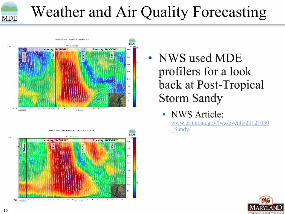
Weather and Air Quality Forecasting
• NWS used MDE profilers for a look back at Post-Tropical Storm Sandy• NWS Article:
www.erh.noaa.gov/lwx/events/20121030_Sandy/
1111
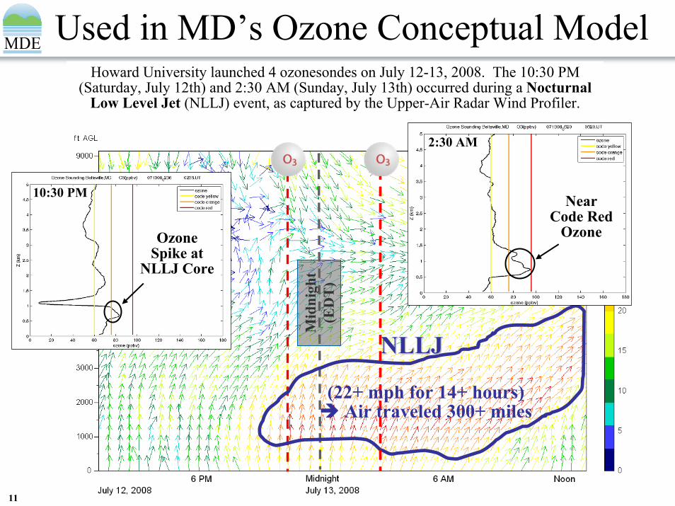
Used in MD’s Ozone Conceptual Model
July 12 | July 13, 2008
Howard University launched 4 ozonesondes on July 12-13, 2008. The 10:30 PM (Saturday, July 12th) and 2:30 AM (Sunday, July 13th) occurred during a Nocturnal
Low Level Jet (NLLJ) event, as captured by the Upper-Air Radar Wind Profiler.
Mid
nigh
t (E
DT
)
10:30 PM
Ozone Spike at
NLLJ Core
NLLJNLLJ
2:30 AM
NearCode Red
Ozone
(22+ mph for 14+ hours)Air traveled 300+ miles
1212
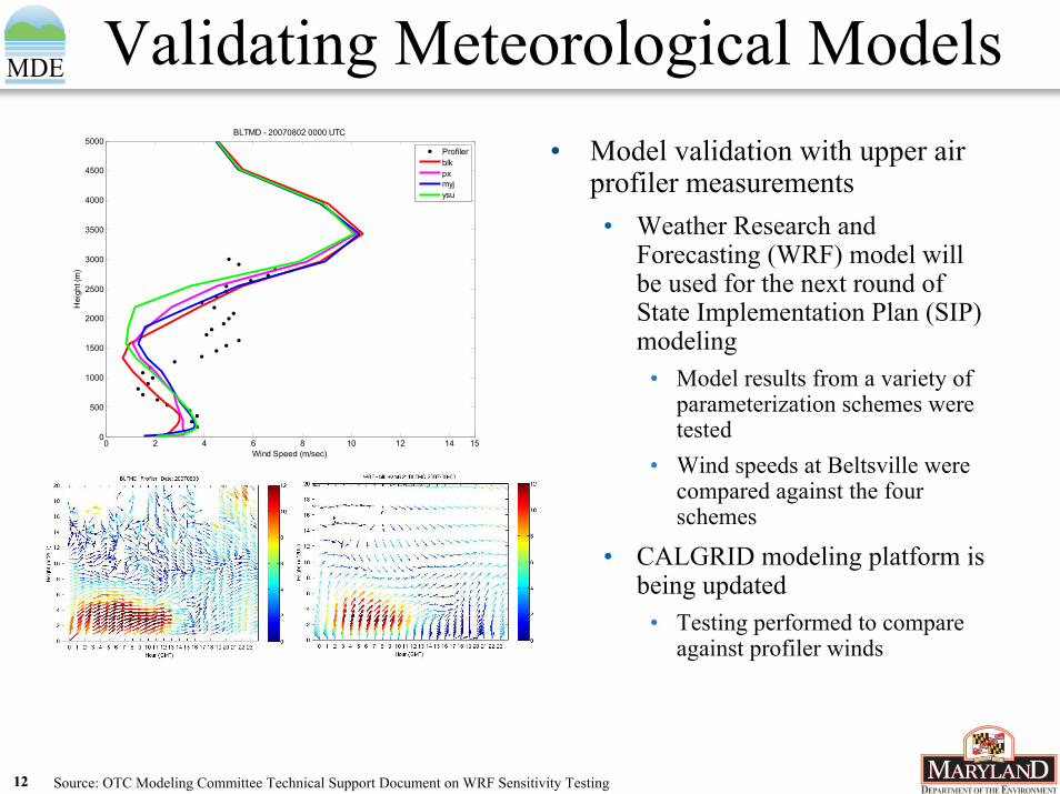
Validating Meteorological Models• Model validation with upper air
profiler measurements• Weather Research and
Forecasting (WRF) model will be used for the next round of State Implementation Plan (SIP) modeling
• Model results from a variety of parameterization schemes were tested
• Wind speeds at Beltsville were compared against the four schemes
• CALGRID modeling platform is being updated
• Testing performed to compare against profiler winds
0 2 4 6 8 10 12 14 150
500
1000
1500
2000
2500
3000
3500
4000
4500
5000
Wind Speed (m/sec)
Hei
ght (
m)
BLTMD - 20070802 0000 UTC
Profilerblkpxmyjysu
Source: OTC Modeling Committee Technical Support Document on WRF Sensitivity Testing

1313
Comparisons with Other Instrumentation
• A Vaisala CL51 ceilometer trial at Beltsville was carried out during NASA DISCOVER-AQ
• CL51’s boundary layer height detection was tested against boundary layer heights derived from profiler signal to noise ratio (SNR) and UMBC lidars
• Leosphere Wind Cube comparisons at Edgewood, MD, Beltsville and Horn Point
• Wind direction and speed comparisons are performed with ozonesondes to test profiler accuracy

1414
Advantages to Upper Air Measurements
• MDE has found measurements from our three upper air profilers with RASS to be extremely helpful in various ways• Weather and air quality forecasting• Development of Maryland’s Ozone Conceptual Model for explanation
of Mid-Atlantic weather and pollutant transport phenomena affecting air quality
• Observing the occurrence of the nocturnal low level jet (NLLJ) over Maryland
• Validation of meteorological modeling used in Maryland SIPs• Collaborations with federal agencies and universities
1515
Contacts
Dave KraskProgram Manager
Air Monitoring ProgramAir and Radiation Management Administration
Maryland Department of the Environment1800 Washington Boulevard | Baltimore, MD 21230
410-537-3000 | TTY Users: 1-800-735-2258www.mde.state.md.us
Martin O’Malley, Governor | Anthony G. Brown, Lt. Governor | Robert M. Summers, Ph.D., Secretary