oxfordshire fens project hinksey heights baseline report
TRANSCRIPT

Oxfordshire Fens Project
Hinksey Heights Baseline Report
David Morris
May 2019

Contents
1. Introduction ................................................................................................................ 1
1.1. Background ............................................................................................................. 1
1.2. Purpose and structure of this report ........................................................................ 1
2. Baseline study methods ........................................................................................... 3
2.1. Study overview and data management ................................................................... 3
2.2. Desk study ............................................................................................................... 3
2.3. Field survey ............................................................................................................. 4
2.4. Nomenclature .......................................................................................................... 6
3. Baseline study results .............................................................................................. 7
3.1. Topography and geomorphology ............................................................................. 7
3.2. Geology ................................................................................................................... 7
3.3. Hydrology ...............................................................................................................12
3.4. Hydrogeology .........................................................................................................14
3.5. Habitats and vegetation ..........................................................................................17
3.6. Biodiversity .............................................................................................................30
4. References ............................................................................................................... 35
Appendix 1. Photographs ............................................................................................... 36
Appendix 2. Site list ......................................................................................................... 40
Tables
Table 3.1. Description of bedrock units outcropping within and around the Hinksey Heights
study area ............................................................................................................................. 8 Table 3.2. Habitats within the surface water and groundwater catchments of the Hinksey
Heights study area ...............................................................................................................13 Table 3.3. Priority habitats within the Hinksey Heights project area ....................................17 Table 3.4. Summary of taxa recorded from the Hinksey Heights study area .......................30 Table A2.1. Explanation of legal and conservation statuses of taxa recorded from the
Hinksey Heights study area. ................................................................................................40 Table A2.2. List of taxa recorded from the Hinksey Heights study area. .............................41
Figures
Figure 1.1. Site plan of the Hinksey Heights project area ..................................................... 2 Figure 3.1.Topography and surface water catchment of Hinksey Heights project area ........ 9 Figure 3.2. Geology and groundwater catchment of Hinksey Heights project area .............10 Figure 3.3. Surface water and groundwater features of the Hinksey Heights project area ..11 Figure 3.4. Habitats within the surface water and groundwater catchments of the Hinksey
Heights project area ............................................................................................................16

Figure 3.5. Habitats of the Hinksey Heights project area .....................................................21 Figure 3.6. Priority habitats of the Hinksey Heights project area .........................................23 Figure 3.6. Legend to plant communities .............................................................................25 Figure 3.8. Vegetation of the Hinksey Heights project area .................................................26

Hinksey Heights Baseline Report
1
1. Introduction
1.1. Background
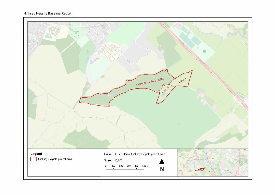
The Oxfordshire Fens Project is undertaking habitat restoration work to re-establish alkaline
fen at Hinksey Heights. The project area is located between the Hinksey Heights Golf Club
and North Hinksey (grid reference SP 493 043), situated in a valley draining the high
ground of the mid-vale ridge to the west of Oxford. A plan of the project area is provided in
Figure 1.1.
This report refers to the following units within the project area, shown in Figure 1.1:
• Harcourt Hill Scrub Local Wildlife Site – the mostly wooded valley designated as a Local Wildlife Site (LWS);
• Field 1 – an undesignated field at the eastern end of the valley; and
• Field 2 – an undesignated field in a smaller valley to the south of the LWS.
1.2. Purpose and structure of this report
The purpose of this report is to provide information gathered through desk study and field
survey to form a baseline understanding of the hydro-ecology and biodiversity of the project
area.
Section 2 of this report describes the methods followed and sources of information used for
the desk study and field survey undertaken. Section 3 presents the results of this work,
under the following topic headings:
• topography and geomorphology;
• geology;
• hydrology;
• hydrogeology;
• habitats and vegetation; and
• biodiversity.
Hinksey Heights Baseline Report
2
Figure 1.1. Site plan of the Hinksey Heights project area
Hinksey Heights Baseline Report
3
2. Baseline study methods
2.1. Study overview and data management
The baseline study of the project area comprised a desk study to gather background
information, with more detailed information gathered by field survey. The methods for these
elements are described below.
All biological records obtained during the desk study and made during the field survey were
entered into a Microsoft Access database set up for the study. All spatial data obtained or
created during the desk study and field survey were gathered in a GIS project in QGIS
(QGIS Development Team, 2019).
2.2. Desk study
The following sources of information were used for the desk study:
• Biological records:
- boundaries of LWS and proposed LWS made available by Thames Valley Environmental Records Centre (TVERC);
- biological records made available by TVERC in July 2018;
- biological records downloaded in March 2019 from the National Biodiversity Network Atlas (NBN, 2019);
- records of bryophytes recorded from the project area on 7th January 2018, obtained from the British Bryological Society; and
- records of fungi, vascular plants and invertebrates compiled by and obtained from Dr Judy Webb, collected at various dates up to 2018.
• Water quality data:
- results of water quality testing within the project area undertaken as part of the Freshwater Habitats Trust project Clean Water for Wildlife (Freshwater Habitats Trust, 2016), provided by Dr Jeremy Biggs.
• Spatial data:
- 2017 1m LiDAR Digital Terrain Model (DTM) obtained from the data.gov.uk portal;
- British Geological Society (BGS) bedrock and superficial geological mapping obtained through the BGS Web Mapping Service;
- The Ordnance Survey (OS) Open Data products Open Rivers and Terrain® 50;
- freely available background mapping such as OpenStreetMap; and
- Google Earth satellite imagery.
The above spatial data were used to:
• map the locations of watercourses and other hydrological features;
• calculate the topographical catchment of the project area, using the LiDAR DTM and the SAGA terrain analysis processing tools in QGIS;
Hinksey Heights Baseline Report
4
• map the habitats within the topographical catchment of the project area using Google satellite imagery, using the following broad habitats, based on the Phase 1 habitat classification (JNCC 2010) (cf. Section 2.3):
- broadleaved semi-natural woodland;
- broadleaved plantation woodland;
- scrub and hedgerows;
- neutral grassland;
- improved grassland;
- arable;
- amenity grassland;
- residential properties and gardens; or
- other buildings and hardstanding.
• redraw geological boundaries from the BGS 1:50,000 bedrock geological mapping by identifying topographic features from the LiDAR DTM.
2.3. Field survey
Field survey work comprised the following survey elements, the methods of each of which
are described below:
• hydrological walkover;
• botanical survey;
• habitat and vegetation survey; and
• invertebrate survey.
The hydrological walkover and botanical, habitat and vegetation surveys were undertaken
by David Morris, beginning 21st July 2018 and continuing over subsequent ad hoc visits to
April 2019. The invertebrate sampling was undertaken during a single visit to the project
area by Dr Judy Webb in July 2018.
Records of other taxonomic groups observed incidentally during site work, such as birds,
were also gathered over this period. Representative photographs of features of the project
area were collected, taken using an Olympus Tough® compact camera.
Hydrological walkover
The following surface water and groundwater features were recorded during site visits:
• bodies of open water, e.g. ponds;
• watercourses, e.g. ditches and streams;
• areas of diffuse groundwater discharge (seepages);
• areas of discrete groundwater discharge (springs); and
• deposits of calcite precipitated from groundwater (tufa).
Hinksey Heights Baseline Report
5
The direction of flow of watercourses was recorded. If springs showed evidence of tufa
formation or concentrations of iron oxide, then this was also recorded. Hydrological features
were recorded as waypoints using a Garmin eTrex® 10 handheld Global Positioning
System (GPS) unit (horizontal accuracy approximately 5m) or recorded on field maps.
Features were digitised in QGIS. Watercourse channels and the extents of ponds were
digitised using the LIDAR DTM.
Botanical survey
All stonewort, bryophyte and vascular plant taxa encountered during the survey were recorded, with separate lists compiled for the three units of the project area. Each taxon recorded was assigned a relative frequency using the DAFOR scale (Dominant, Abundant, Frequent, Occasional, Rare). The qualifier ‘local’ was added to indicate a heterogeneous distribution, e.g. LF for ‘locally frequent’.
Particular note was taken of the following vascular plant taxa:
• legally protected species listed on Schedule 8 of the Wildlife and Countryside Act 1981 (as amended); and
• plants of local or national conservation concern:
- species of principal importance, listed in accordance with Section 41 of the Natural Environment and Rural Communities (NERC) Act 2006;
- Nationally Rare or Nationally Scarce taxa (BSBI, 2017);
- taxa listed as Near Threatened, Vulnerable, Endangered or Critically Endangered on the vascular plant red lists for Great Britain (Cheffings et al., 2005) or England (Stroh et al., 2014); or
- taxa listed as rare or scarce in the administrative county of Oxfordshire (Killick et al., 2018).
Note was also taken of invasive non-native plant taxa, such as those listed on Schedule 9 of the Wildlife and Countryside Act 1981 (as amended), or other invasive or potentially invasive non-native plants.
Where a notable or invasive plant taxon occurred in a discrete population then a ten-figure grid reference of its location was recorded using a Garmin eTrex® 10 handheld GPS unit (horizontal accuracy approximately 5m) and ecological notes were recorded.
Habitat and vegetation survey
The methodology of the National Vegetation Classification (NVC) was followed to classify
the vegetation of the project area (Rodwell, 2006). Homogenous stands of vegetation were
mapped and assigned to units of the NVC, to sub-community where possible. Assignment
of units of the NVC was largely made in the field. Quadrat samples of stands were not
recorded. Some vegetation could not be assigned to units of the NVC and was assigned to
ad hoc units, e.g. disturbed, early successional or artificial habitats or stands of single
species not included in the NVC.
Vegetation mapping was detailed. Complex vegetation was mapped at a scale of
approximately 1:1,500, with stands resolved as polygon features if having an area greater
than approximately 1m2. Simpler vegetation, such as woodland, was mapped at a larger
scale. Mapping was undertaken using field survey maps produced in QGIS, comprising
Hinksey Heights Baseline Report
6
Google satellite imagery at an appropriate scale and overlain with 100m and 10m OS grids.
The survey maps were printed and annotated in the field, using a Garmin eTrex® 10
handheld GPS unit to locate positions (horizontal accuracy approximately 5m). Completed
field survey maps were scanned, and georeferenced and digitised in QGIS.
The survey aimed to cover the whole project area but areas supporting wetland habitats
were targeted. Areas not covered or not adequately covered during the survey, such as
peripheral areas of dry woodland, were mapped from Google satellite imagery and the
vegetation classified based on observations from nearby.
Stands were also assigned to the following broad habitats, based on the Phase 1 habitat
classification (JNCC, 2010) (cf. Section 2.2):
• broadleaved semi-natural woodland;
• broadleaved plantation woodland;
• scrub and hedgerows;
• neutral grassland;
• calcareous grassland;
• improved grassland;
• tall ruderal;
• fen, marsh and swamp;
• open water;
• arable;
• amenity grassland;
• residential properties and gardens; or
• buildings and hardstanding.
Results of the habitat and vegetation survey were evaluated to identify priority habitats (i.e.
habitats listed in accordance with Section 41 of the Natural Environment and Rural
Communities Act 2006, as being of principal importance for the conservation of biodiversity)
using the definitions provided by the Joint Nature Conservation Committee (Maddock,
2011).
Invertebrate survey
The invertebrate survey was undertaken by sweep netting during a single visit by Dr Judy
Webb in July 2018. The survey visited a limited area of the site and limited range of habitats
but aimed to give an initial indication of the diversity of species of true fly (Diptera)
associated with herbaceous fen and wet woodland. Craneflies (Tipulidae) and fungus gnats
(Sciaridae) collected were sent for determination to Alan Stubbs and Peter Chandler,
respectively, but invertebrates were otherwise identified by Dr Judy Webb.
2.4. Nomenclature
Nomenclature throughout this report follows the latest MapMate® species dictionary (Mapmate Limited, 2019), e.g. Stace (2010) for vascular plants.
Hinksey Heights Baseline Report
7
3. Baseline study results
This section presents baseline information about the Hinksey Heights project area,
gathered from desk study and field survey. This information is divided into the following
topics:
• topography and geomorphology;
• geology;
• hydrology;
• hydrogeology;
• habitats and vegetation; and
• biodiversity.
Photographs from the project area are provided in Appendix 1.
3.1. Topography and geomorphology
The topography of the project area is shown in Figure 3.1. The project area comprises a
narrow valley cut into the high ground of the mid-vale ridge to the west of Oxford. The valley
is open at the eastern end, with a long main valley oriented approximately west-south-west
to east-north-east, within the LWS, and a smaller valley joining from south-south-west. The
latter valley includes Field 2 and extends beyond the project area south into the golf course.
The project area varies in elevation from a low of approximately 60m above Ordnance
Datum (mAOD) along the A34 at its eastern end to approximately 110mAOD at the western
end of the main valley. The width of the main valley tapers from east to west, from
approximately 275m wide at the eastern end to 75m wide below the pond toward the west,
to approximately 25m wide at the western end of the project area.
There are numerous breaks in slope within the project area, particularly on the southern
slopes. The tops of the valleys are marked by well-defined escarpments, with slopes of
approximately 20-25%. This break in slope varies in elevation between 90-100mAOD on
the northern side and 90-95mAOD on the southern side. Most of the project area is on
slopes and there is no well-defined valley bottom until the ground opens out at the eastern
end, in the centre of the project area, and within the smaller southern valley. The slope of
the sides of the main valley through most of its length is approximately 10%, particularly on
the northern side which has a more consistent slope.
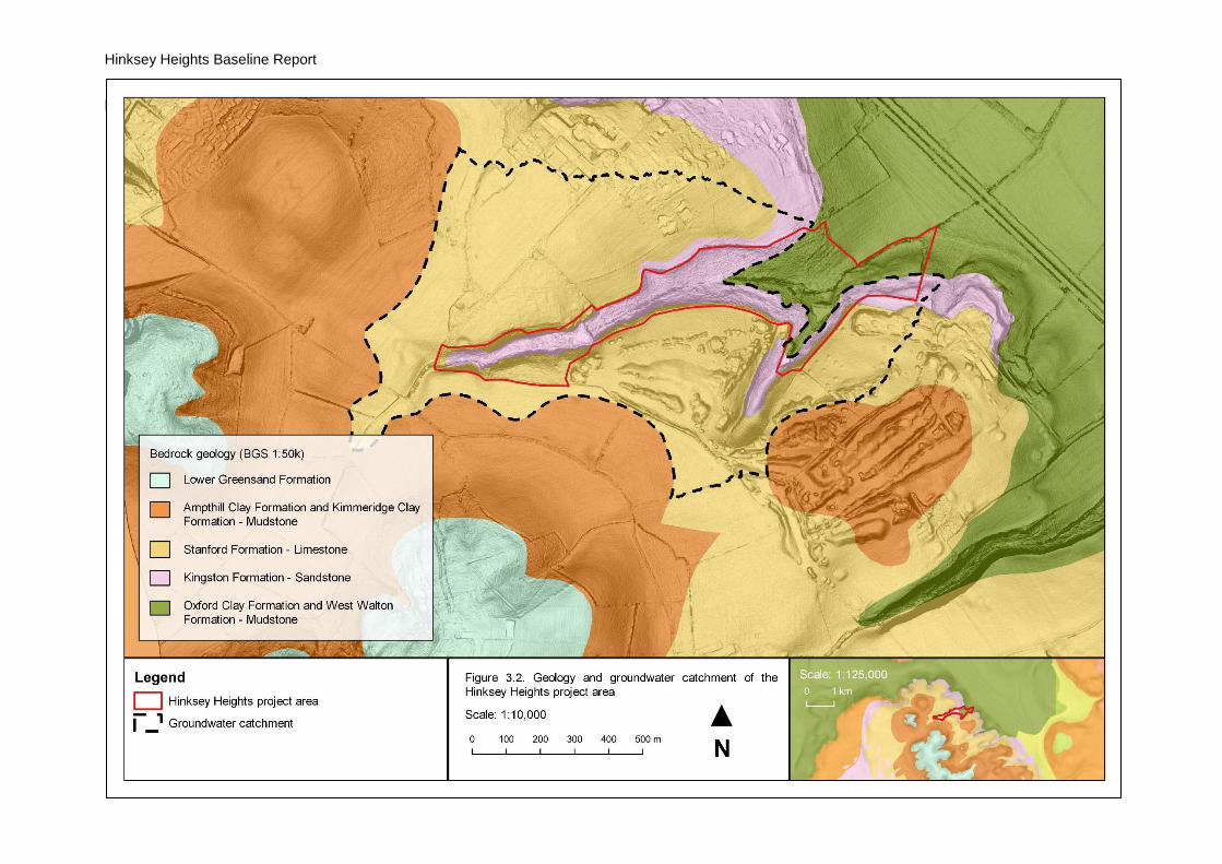
3.2. Geology
The geology of the project area is shown in Figure 3.2, modified from the BGS 1: 50,000
geological mapping. There are no superficial deposits mapped for the project area, but
there are extensive deposits of tufa (travertine) and peat within the main valley. Along the
slopes of the main valley are numerous very large solid concretions of tufa around springs,
as well as more diffuse deposits. The main stream through the valley (see Section 3.3) also
supports extensive tufa concretions along its banks, and there are several reaches where
Hinksey Heights Baseline Report
8
large tufa barrages have formed within the channel (Photograph 1, Appendix 1), mainly in
the lower, less modified reaches. The peaty deposits have not been investigated. Casual
observation suggests these are relatively shallow and loamy and, in many areas, form a
loose matrix with calcite precipitated by groundwater emergence.
The bedrock geology of the project area and its surroundings are dominated by Jurassic
rocks, summarised in stratigraphical sequence in Table 3.1. The bedrock formations
outcropping within the site largely belong to the Corallian Group. This is a complex
succession of interdigitating limestones, marls, sandstones, sands, siltstones, silts,
spiculites and mudstones, here represented by outcrops of the limestone of the Stanford
Formation above the valley and sandstone of the Kingston Formation along the valley
sides. The Oxford Clay Formation outcrops at lower elevations, forming the valley bottom in
the eastern part of the project area. The Kimmeridge and Ampthill Clay Formation outcrops
on the higher ground around the site, and the Lower Greensand Group forms the summits
of Boar’s Hill and Hurst Hill, to the south and west, respectively.
Table 3.1. Description of bedrock units outcropping within and around the Hinksey Heights study area (BGS, 2019)
Bedrock unit Lithological description
Lower Greensand Group
Mainly sands and sandstones (varying from well-sorted fine-grained to poorly sorted medium- to coarse-grained) with silts and clays in some intervals.
Kimmeridge and Ampthill Clay Formation
Mudstone
Stanford Formation
Generally medium-grained quartzose sands, locally fine- and coarse-grained, with carbonate cemented beds and doggers which are sandy limestone or calcareous sandstone; some beds of spiculitic sandstone which are relatively sand-free, shelly and/or ooidal limestone, sandy or silty mudstone, and calcareous mudstone. Strata are generally grey when fresh, weathering to brown or yellow.
Kingston Formation
Shell detrital limestones, ooidal limestone, coralline limestone, fossiliferous marls, and interbedded limestone, marl and mudstone.
Oxford Clay Formation
Mudstone

Hinksey Heights Baseline Report
9
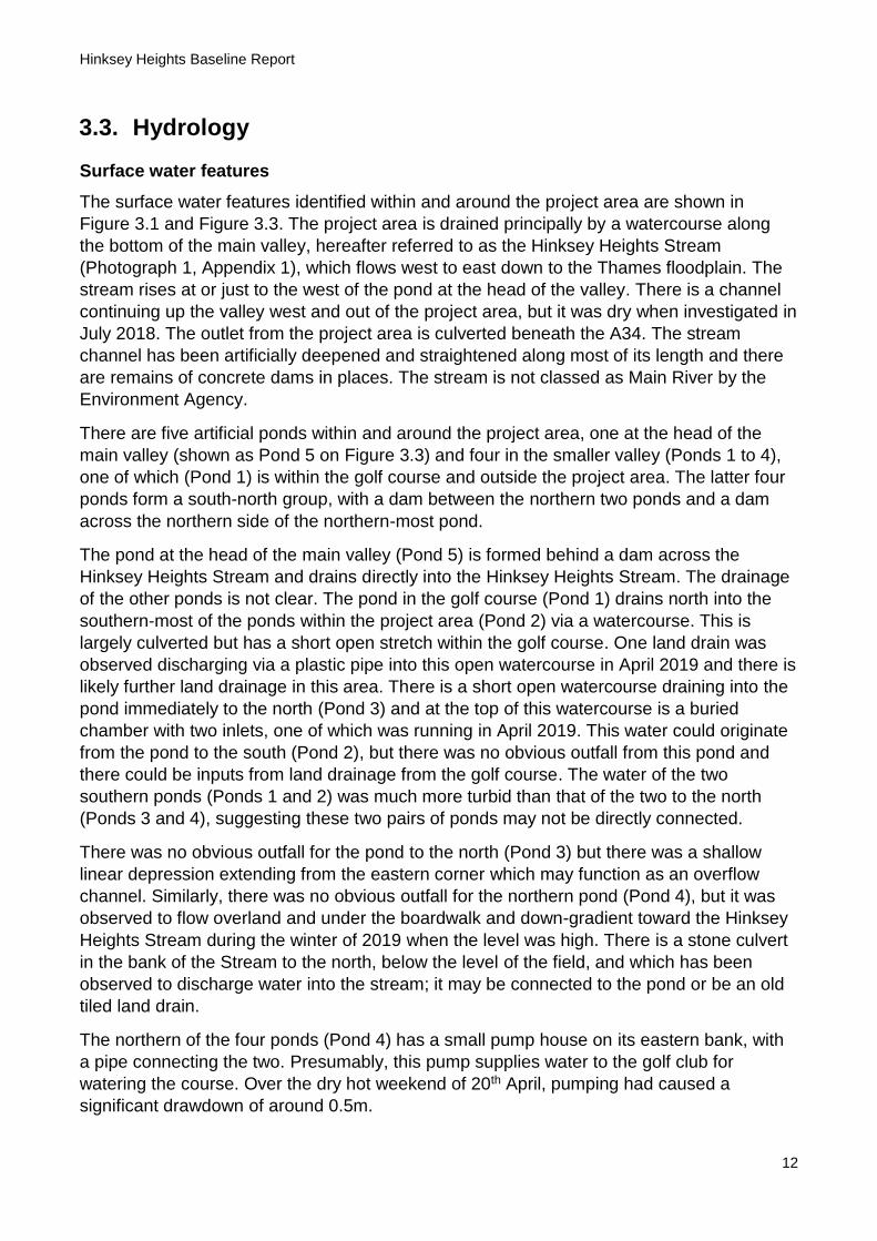
Figure 3.1.Topography and surface water catchment of Hinksey Heights project area
Hinksey Heights Baseline Report
10
Figure 3.2. Geology and groundwater catchment of Hinksey Heights project area

Hinksey Heights Baseline Report
11
Figure 3.3. Surface water and groundwater features of the Hinksey Heights project area
Hinksey Heights Baseline Report
12
3.3. Hydrology
Surface water features
The surface water features identified within and around the project area are shown in
Figure 3.1 and Figure 3.3. The project area is drained principally by a watercourse along
the bottom of the main valley, hereafter referred to as the Hinksey Heights Stream
(Photograph 1, Appendix 1), which flows west to east down to the Thames floodplain. The
stream rises at or just to the west of the pond at the head of the valley. There is a channel
continuing up the valley west and out of the project area, but it was dry when investigated in
July 2018. The outlet from the project area is culverted beneath the A34. The stream
channel has been artificially deepened and straightened along most of its length and there
are remains of concrete dams in places. The stream is not classed as Main River by the
Environment Agency.
There are five artificial ponds within and around the project area, one at the head of the
main valley (shown as Pond 5 on Figure 3.3) and four in the smaller valley (Ponds 1 to 4),
one of which (Pond 1) is within the golf course and outside the project area. The latter four
ponds form a south-north group, with a dam between the northern two ponds and a dam
across the northern side of the northern-most pond.
The pond at the head of the main valley (Pond 5) is formed behind a dam across the
Hinksey Heights Stream and drains directly into the Hinksey Heights Stream. The drainage
of the other ponds is not clear. The pond in the golf course (Pond 1) drains north into the
southern-most of the ponds within the project area (Pond 2) via a watercourse. This is
largely culverted but has a short open stretch within the golf course. One land drain was
observed discharging via a plastic pipe into this open watercourse in April 2019 and there is
likely further land drainage in this area. There is a short open watercourse draining into the
pond immediately to the north (Pond 3) and at the top of this watercourse is a buried
chamber with two inlets, one of which was running in April 2019. This water could originate
from the pond to the south (Pond 2), but there was no obvious outfall from this pond and
there could be inputs from land drainage from the golf course. The water of the two
southern ponds (Ponds 1 and 2) was much more turbid than that of the two to the north
(Ponds 3 and 4), suggesting these two pairs of ponds may not be directly connected.
There was no obvious outfall for the pond to the north (Pond 3) but there was a shallow
linear depression extending from the eastern corner which may function as an overflow
channel. Similarly, there was no obvious outfall for the northern pond (Pond 4), but it was
observed to flow overland and under the boardwalk and down-gradient toward the Hinksey
Heights Stream during the winter of 2019 when the level was high. There is a stone culvert
in the bank of the Stream to the north, below the level of the field, and which has been
observed to discharge water into the stream; it may be connected to the pond or be an old
tiled land drain.
The northern of the four ponds (Pond 4) has a small pump house on its eastern bank, with
a pipe connecting the two. Presumably, this pump supplies water to the golf club for
watering the course. Over the dry hot weekend of 20th April, pumping had caused a
significant drawdown of around 0.5m.
Hinksey Heights Baseline Report
13
The four ponds within the project area sustained high water levels throughout the dry
summer of 2018, and the northern two of the four ponds within the smaller valley (Ponds 3
and 4) have always been observed to have very clear water. With no significant surface
water inputs, the ponds therefore appear to be supplied by groundwater. Similarly, the
Hinksey Heights Stream runs year-round, and it is likely sustained by a significant base-flow
derived from groundwater.
In addition to the watercourses described above, there are several other watercourses
within and around the project area. Within the project area, additional watercourses
comprise small channels draining springs, such as on the slopes above the A34. Outside
the project area, watercourses are shown on maps near to the summit of Boar’s Hill to the
south-west, within the surface water catchment of the project area (Figure 3.1). These may
rise from springs at the junction of the Lower Greensand and Kimmeridge and Ampthill
Clays (Figure 3.2). They may feed into the surface drainage network flowing through the
main valley or could infiltrate to ground once they reach more permeable strata lower down.
Water quality
Water quality testing was undertaken by volunteers for the Freshwater Habitats Trust on
27th March 2016. A sample of water was collected from the Hinksey Heights Stream at the
eastern end of the main valley at approximately SP 49617 04435, and the nitrate (NO3-)
and phosphorus (P) were measured using simple solution-based kits provided by the
Freshwater Habitats Trust (further details of the sampling method are available at
https://freshwaterhabitats.org.uk/projects/clean-water/). The sample found concentrations of
0.02-0.05ppm and 0.2-0.5ppm of nitrate and phosphorus, respectively. These values
indicate no evidence of pollution.
Topographical catchment
The upslope area of the project area is shown in Figure 3.1. This topographical catchment
has an area of approximately 204ha, mostly comprising the area around Hinksey to the
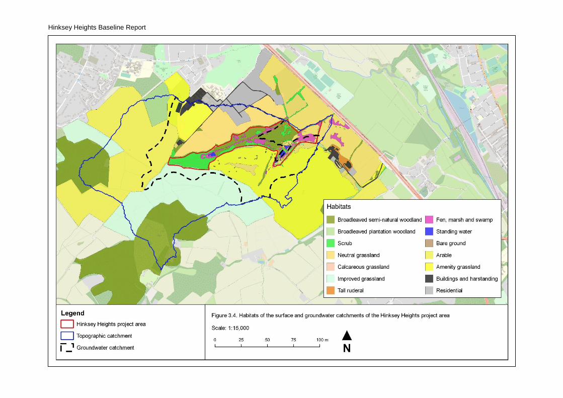
north and Boars Hill to the south. The habitats within the catchment are shown in Figure 3.4
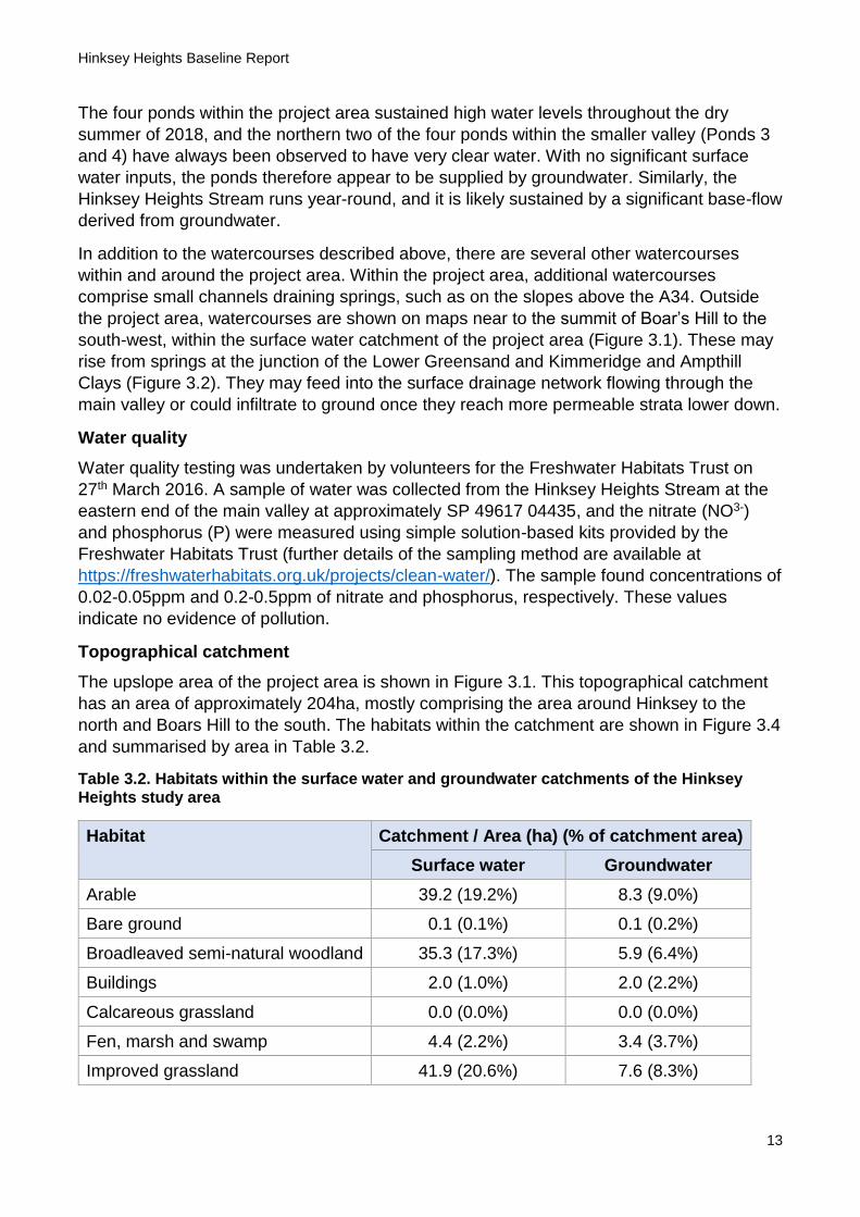
and summarised by area in Table 3.2.
Table 3.2. Habitats within the surface water and groundwater catchments of the Hinksey Heights study area
Habitat Catchment / Area (ha) (% of catchment area)
Surface water Groundwater
Arable 39.2 (19.2%) 8.3 (9.0%)
Bare ground 0.1 (0.1%) 0.1 (0.2%)
Broadleaved semi-natural woodland 35.3 (17.3%) 5.9 (6.4%)
Buildings 2.0 (1.0%) 2.0 (2.2%)
Calcareous grassland 0.0 (0.0%) 0.0 (0.0%)
Fen, marsh and swamp 4.4 (2.2%) 3.4 (3.7%)
Improved grassland 41.9 (20.6%) 7.6 (8.3%)
Hinksey Heights Baseline Report
14
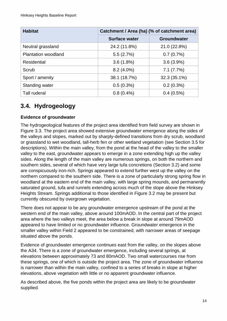
Habitat Catchment / Area (ha) (% of catchment area)
Surface water Groundwater
Neutral grassland 24.2 (11.8%) 21.0 (22.8%)
Plantation woodland 5.5 (2.7%) 0.7 (0.7%)
Residential 3.6 (1.8%) 3.6 (3.9%)
Scrub 8.2 (4.0%) 7.1 (7.7%)
Sport / amenity 38.1 (18.7%) 32.3 (35.1%)
Standing water 0.5 (0.3%) 0.2 (0.3%)
Tall ruderal 0.8 (0.4%) 0.4 (0.5%)
3.4. Hydrogeology
Evidence of groundwater
The hydrogeological features of the project area identified from field survey are shown in
Figure 3.3. The project area showed extensive groundwater emergence along the sides of
the valleys and slopes, marked out by sharply-defined transitions from dry scrub, woodland
or grassland to wet woodland, tall-herb fen or other wetland vegetation (see Section 3.5 for
descriptions). Within the main valley, from the pond at the head of the valley to the smaller
valley to the east, groundwater appears to emerge in a zone extending high up the valley
sides. Along the length of the main valley are numerous springs, on both the northern and
southern sides, several of which have very large tufa concretions (Section 3.2) and some
are conspicuously iron-rich. Springs appeared to extend further west up the valley on the
northern compared to the southern side. There is a zone of particularly strong spring flow in
woodland at the eastern end of the main valley, with large spring mounds, and permanently
saturated ground, tufa and runnels extending across much of the slope above the Hinksey
Heights Stream. Springs additional to those identified in Figure 3.2 may be present but
currently obscured by overgrown vegetation.
There does not appear to be any groundwater emergence upstream of the pond at the
western end of the main valley, above around 100mAOD. In the central part of the project
area where the two valleys meet, the area below a break in slope at around 79mAOD
appeared to have limited or no groundwater influence. Groundwater emergence in the
smaller valley within Field 2 appeared to be constrained, with narrower areas of seepage
situated above the ponds.
Evidence of groundwater emergence continues east from the valley, on the slopes above
the A34. There is a zone of groundwater emergence, including several springs, at
elevations between approximately 73 and 80mAOD. Two small watercourses rise from
these springs, one of which is outside the project area. The zone of groundwater influence
is narrower than within the main valley, confined to a series of breaks in slope at higher
elevations, above vegetation with little or no apparent groundwater influence.
As described above, the five ponds within the project area are likely to be groundwater
supplied.

Hinksey Heights Baseline Report
15
Hydrogeological catchment
There are no BGS records of boreholes within or near to the project area from which to infer
information about groundwater levels or flows. The nearest boreholes recorded within the
bedrock formations within the groundwater catchment of the project area are to the north in
Hinksey and to the south in the Boar’s Hill area and no groundwater strikes were recorded
from these.
The groundwater catchment of the project area is likely to be more limited than the surface
water catchment due to the presence of extensive outcroppings of the Kimmeridge and
Ampthill Clay Formation across the high ground to the west and south of the project area.
These relatively impermeable strata are likely to limit infiltration in the higher areas, with
relatively greater run-off compared to the more permeable strata of the Corallian Group
lower down. Recharge of springs on the northern slope of the main valley is therefore most
likely to occur within the fields between the main valley and Hinksey to the north. Springs
on the southern slopes are likely to be recharged mainly from the golf course to the south.
Flows within the Corallian Group will be confined below by the Oxford Clay, which is an
aquitard, and its outcropping in the eastern part of the valley largely corresponds with the
locations of springs. There does not appear to be any indication that groundwater flows
along the dip of the strata, i.e. north-west to south-east, springs being evenly distributed
around the project area. Flows therefore likely largely follow topography.
The valley of the project area forms the second in a north-to-south sequence of valleys
along the mid-vale ridge: Raleigh Park to the north, and Chilswell Valley and Limekiln
Copse to the south-east. These valleys support similar spring-fed wetlands and are at
similar elevations to the study, again corresponding to outcroppings of the Oxford Clay.
Given the similarity in elevation, the topographic watersheds between these valleys likely
also represent approximate groundwater divides.
The hydrogeological catchment of the spring-fed areas described above is shown in Figure
3.2. It has a total area of approximately 92ha. The habitats within the catchment are shown
in Figure 3.4 and summarised by area in Table 3.2.
Hinksey Heights Baseline Report
16
Figure 3.4. Habitats within the surface water and groundwater catchments of the Hinksey Heights project area

Hinksey Heights Baseline Report
17
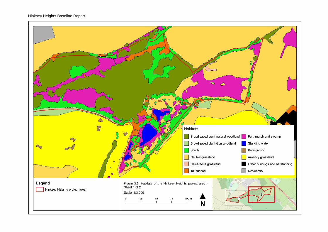
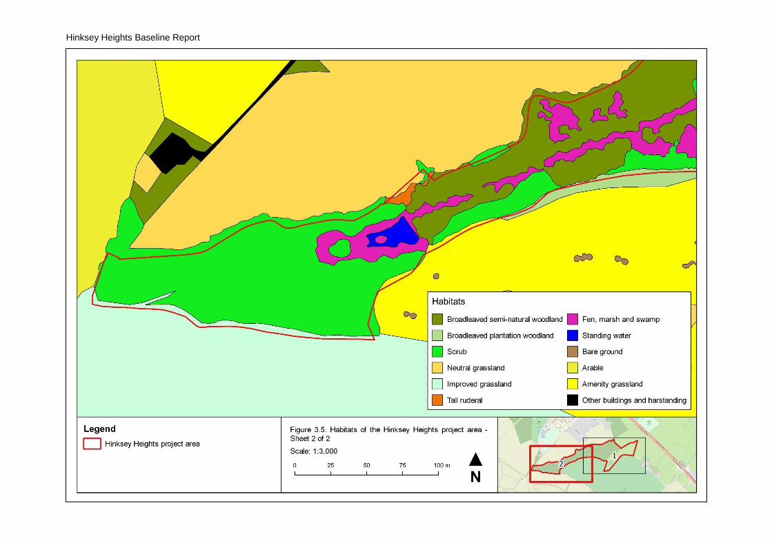
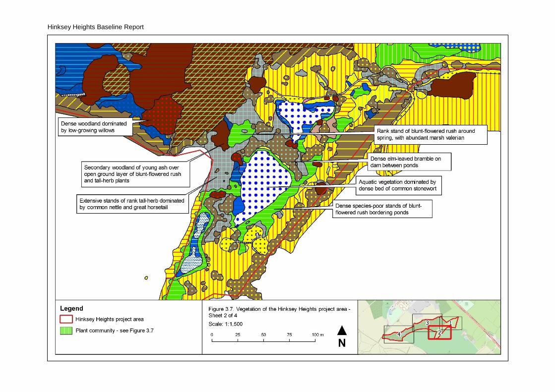
3.5. Habitats and vegetation
Summary
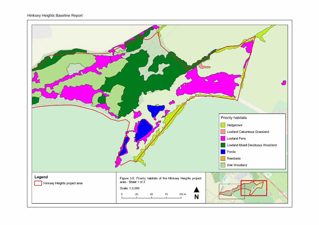
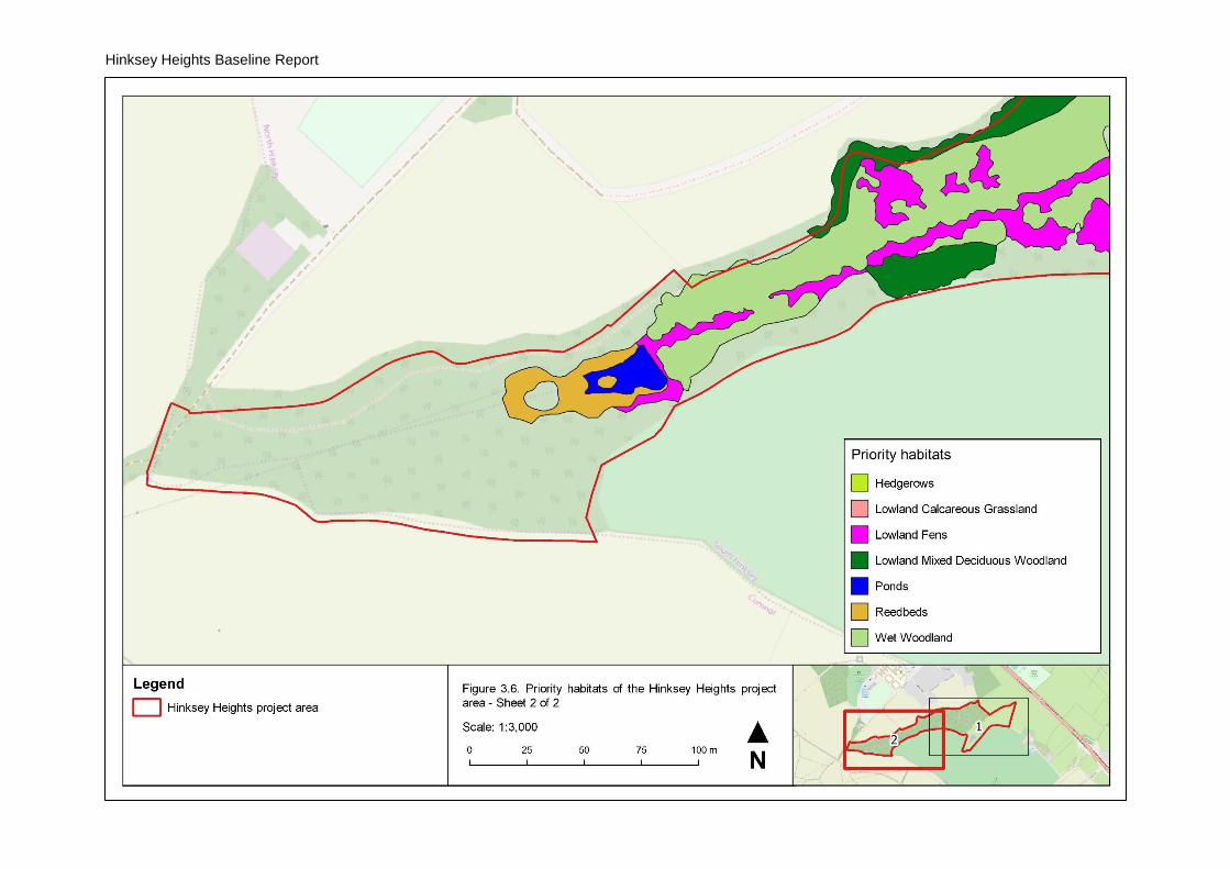
The habitats within the project area are shown in Figure 3.5. Seven priority habitats were
identified within the study area, summarised in Table 3.3 and shown in Figure 3.6. The
vegetation of the study area is shown in Figure 3.8 and described by broad habitat below.
The four ponds within the project area (see Section 3.3) comprise Ponds priority habitat as
at least Pond 4 supports common toad (Bufo bufo) and great crested newt (Triturus
cristatus) (see Section 3.6). As the four ponds are nearby and connected by suitable
terrestrial habitat, they are likely all used by one or both species.
Table 3.3. Priority habitats within the Hinksey Heights project area
Priority habitat Area (ha)
(% of project area)
Description
Hedgerows 0.45 (1.9%) Hedgerows bounding Field 1 and Field 2
Lowland Calcareous Grassland
0.04 (0.2%) Small stands in Field 1
Lowland Fens 3.59 (15.3%) Tall-herb and fen in areas of groundwater emergence across the project area
Lowland Mixed Deciduous Woodland
3.60 (15.3%) Ash (Fraxinus excelsior) woodland at the eastern end of the main valley and on higher ground around the valley
Ponds 0.59 (2.5%) The four ponds within the study area
Reedbeds 0.36 (1.5%) The stand of common reed (Phragmites australis) around the pond at the head of the main valley
Wet Woodland 4.22 (18.0%) Mixed woodland of ash and willows (Salix spp.) along the slopes of the main valley, within Harcourt Hill Scrubs LWS
Woodland and scrub
Most of the main valley is wooded (Sheets 3 and 4, Figure 3.8). The higher ground around
and at the head of the main valley, and a central area to the north of where the two valleys
meet, support dry woodland and scrub, dominated by ash (Fraxinus excelsior) and
hawthorn (Crataegus monogyna), respectively. Woodland along the edge of the golf course
has been planted.
Stands of woodland dominated by ash support an open shrub layer of hawthorn and hazel
(Corylus avellana), with a ground layer with abundant dog’s-mercury (Mercurialis perennis)
and wood false-brome (Brachypodium sylvaticum). Most stands were referred to W8e
Fraxinus excelsior-Acer campestre-Mercurialis perennis woodland, with frequent common
nettle (Urtica dioica) in the ground layer. Stands of scrub dominated by hawthorn were
referred to W21 Crataegus monogyna-Hedera helix scrub, including extensive mature
Hinksey Heights Baseline Report
18
stands at the head of the main valley (Sheet 4, Figure 3.8). The ground flora of this scrub
varies from eutrophic vegetation dominated by stinging nettle, referred to W21a Crataegus
monogyna-Hedera helix scrub, Hedera helix-Urtica dioica sub-community, to vegetation
similar to that of the ash woodland, with abundant dog’s-mercury or wood false-brome,
referred respectively to W21b Crataegus monogyna-Hedera helix scrub, Mercurialis
perennis sub-community and W21c Crataegus monogyna-Hedera helix scrub,
Brachypodium sylvaticum sub-community. The large stands of scrub of hawthorn scrub at
the head of the main valley support small glades with a richer ground layer of calcicoles
such as wild basil (Clinopodium vulgare) and wild liquorice (Astragalus glycyphyllos).
Scrub is also found around the periphery of Field 1 and forms a mosaic with grassland in
Field 2 (Sheets 1 and 2, Figure 3.8). In Field 2, there are dense stands of elm-leaved
bramble (Rubus ulmifolius), referred to W24 Rubus fruticosus-Holcus lanatus underscrub,
and less extensive stands of dewberry (Rubus caesius).
The slopes of the main valley are dominated by wet woodland, with a canopy of ash, crack
willow (Salix x fragilis sens. lat.), grey willow (S. cinerea) and white willow (S. alba). Willows
are dominant in most areas, with large trees along the northern slope. From World War II
aerial photography available via Google Earth® these trees appear to have originated from
planted stock, and in some areas rows of trees can still be discerned. The ground layer of
this wet woodland is dominated by tall herbs such as common nettle, common reed, great
horsetail (Equisetum telmateia), hemp agrimony (Eupatorium cannabinum) and lesser
pond-sedge (Carex acutiformis) (Photograph 8, Appendix 1). The canopy along the
northern side of the valley is very open, and in some areas are glades dominated by great
horsetail and lesser pond-sedge. This woodland vegetation was referred to W2a Salix
cinerea-Betula pubescens-Phragmites australis woodland, Alnus glutinosa-Filipendula
ulmaria sub-community. Although some of the nominate species of this plant community
are rare within examples within the project area, this is a broadly-defined woodland
vegetation type. Developing from herbaceous fen vegetation, its composition depends on
the antecedent vegetation and the proximity of tree species able to colonise.
Grassland
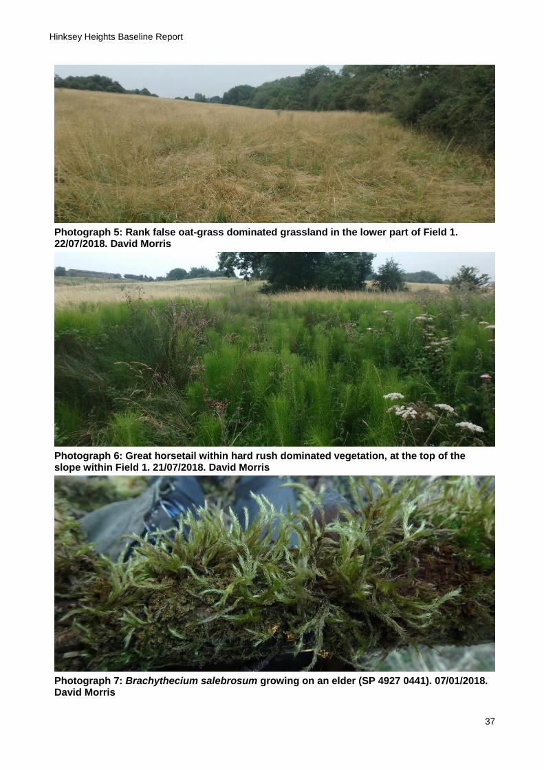
There are large areas of grassland within Field 1 and Field 2, largely comprising rank
species-poor neutral grassland swards dominated by bulky grasses such as cock’s-foot
(Dactylis glomerata), false oat-grass (Arrhenatherum elatius), tall fescue (Schedonorus
arundinaceus), tufted hair-grass (Deschampsia cespitosa) and Yorkshire fog (Holcus
lanatus), with abundant tall ruderal species such as common nettle and hogweed
(Heracleum sphondylium). The most extensive stands of grassland are dominated by false
oat-grass (Photograph 8, Appendix 1), referred to MG1 Arrhenatherum elatius grassland,
most frequently the weedy MG1b Arrhenatherum elatius grassland, Urtica dioica sub-
community.
Some stands of MG1 Arrhenatherum elatius grassland support calcicoles such as
pyramidal orchid (Anacamptis pyramidalis) and woolly thistle (Cirsium eriophorum), and
there are small stands of calcareous grassland dominated by upright brome (Bromopsis
erecta), referred to CG3 Bromus erectus grassland (Sheet 1, Figure 3.8). The largest such
stand is in Field 1 and supports small populations of the calcicoles dwarf thistle (Cirsium
acaule), cowslip (Primula veris), glaucous sedge (Carex flacca), hairy violet (Viola hirta),

Hinksey Heights Baseline Report
19
quaking grass (Briza media), salad burnet (Poterium sanguisorba) and spiny restharrow
(Ononis spinosa) (Photograph 2, Appendix 1). This stand is located on a break in slope so
that the soil is likely thinner than the surroundings, which support species-poor false oat-
grass grassland.
Tall-herb and fen
Tall-herb and fen are the most spatially complex habitats within the project area and are
described below by project area unit.
Harcourt Hill Scrub LWS
Species-poor stands of tall-herb dominated by common reed occupy most of the unwooded
parts of the main valley, within the LWS (Sheets 3 and 4, Figure 3.8). Like the wet
woodland described above this vegetation is found in the extensive zones of groundwater
seepage on the northern and southern slopes of the valley, including along the wayleave of
overhead electricity cables that run across the valley. Hemp agrimony is frequent
throughout most stands, in vegetation referred to S25a Phragmites australis-Eupatorium
cannabinum tall herb fen, typical sub-community. Tall-herb on the lower part of the slope on
the southern side of the valley is less dense and lesser pond-sedge is co-dominant and
common valerian (Valeriana officinalis) locally frequent.
The common reed-dominated tall-herb has not been cut for many decades and has
developed a thick layer of litter (Photograph 3, Appendix 1). Many areas therefore support
eutrophic vegetation with abundant cleavers (Galium aparine) and common nettle and
frequent woody nightshade (Solanum dulcamara). Where hemp agrimony is absent from
such tall-herb, usually in more elevated and drier areas, this vegetation has been referred
to S26 Phragmites australis-Urtica dioica tall herb fen.
Field 1
Wetland vegetation extends beyond the valley into Field 1, forming a sharply-defined
zonation of dry grassland in upslope and downslope areas with intermediate stands of fen
vegetation running mid-slope across the hillside (Sheet 1, Figure 3.8). Fen vegetation
comprises stands of lesser pond-sedge, referable to S7 Carex acutiformis swamp, species-
poor stands of blunt-flowered rush, referable to M22a Juncus subnodulosus-Cirsium
palustre fen meadow, typical sub-community, and vegetation in which meadowsweet
(Filipendula ulmaria) is codominant with blunt-flowered rush, referred to M27 Filipendula
ulmaria-Angelica sylvestris mire (Photograph 10, Appendix 1). The stands of M22 Juncus
subnodulosus-Cirsium palustre fen meadow occupy areas around springs and where water
accumulates in runnels, while M27 Filipendula ulmaria-Angelica sylvestris mire is present
on the flatter ground toward the top of the slope. Areas around springs and runnels are
more open with abundant Cratoneuron filicinum and marsh horsetail (Equisetum palustre)
and, locally, tufa deposits. The pattern of meadowsweet dominance is likely largely a result
of lack of grazing, the species increasing without regular cropping. Its restriction to areas of
less groundwater-influence could also be due to its sensitivity to iron (Snowden and
Wheeler, 1993) which would accumulate in springs and runnels.
The above fen vegetation is surrounded by zones of hard rush (Juncus inflexus), on the
upslope edge as scattered plants but as extensive stands referred to MG10b Juncus
Hinksey Heights Baseline Report
20
effusus-Holcus lanatus, Juncus inflexus sub-community on the downslope side. The forb
species are similar between this and the above fen vegetation, e.g. marsh thistle (Cirsium
palustre) and water mint (Mentha aquatica), but great horsetail is also abundant within this
zone (Photograph 6, Appendix 1). This zone likely indicates predominantly vertical rather
than lateral water table movements and more poorly aerated soils. Great horsetail is also
abundant upslope within some areas of false oat-grass dominated grassland and in tall
ruderal vegetation dominated by common nettle. The latter vegetation has been referred to
the ad hoc community OV24a Urtica dioica-Galium aparine community, typical sub-
community, Equisetum telmateia variant.
Field 2
Wetland vegetation within Field 2 continues the zone of groundwater seepage around the
valley slopes from the LWS east into Field 1, but this zone is much narrower than in the
other project area units (Sheet 2, Figure 3.8). The zonation of vegetation is similar to that
seen in Field 1, with upslope and downslope areas supporting dry grassland and an
intermediate sharply-defined zone of fen vegetation. Some of the wetland vegetation within
Field 2 appeared to be being colonised by scrub or coarser wetland species such as hard
rush and bulrush (Typha latifolia).
Species-poor stands of blunt-flowered rush are found around the margins of the three
ponds within Field 2 (and around Pond 1 within the golf course to the south) and around
springs on the slopes above the ponds. The stand around the springs to the north of Pond 3
supports abundant marsh valerian (Valeriana dioica), and some stands are quite open with
abundant Cratoneuron filicinum and, locally, tufa deposits.
There are extensive stands of tall ruderal vegetation dominated by common nettle and
great horsetail, particularly along the boundary with the golf course and around a spring
above the Hinksey Heights Stream in the northern part of Field 2.
Emergent and aquatic vegetation
Emergent and aquatic vegetation are restricted to the ponds within the project area. The
margins of the three ponds in Field 2 support dense stands of the tall emergent species
bulrush and common clubrush (Schoenoplectus lacustris), referred to S12 Typha latifolia
swamp and S9 Scirpus lacustris swamp, respectively. Associated species include purple
loosestrife (Lythrum salicaria), water mint and water plantain (Alisma plantago-aquatica).
The margins of the pond at the head of the main valley (Pond 5, Figure 3.3) are dominated
by dense emergent stands of common reed, referable to S4 Phragmites australis swamps
and reed-beds.
Aquatic vegetation is restricted to the two northern ponds within Field 2 (Pond 3 and Pond
4), comprising dense submerged beds of common stonewort (Chara vulgaris). The pond to
the south (Pond 2) may also support stoneworts but during survey work the water was
always much more turbid than the ponds to the north and it was not clear whether
vegetation on the bottom of the pond comprised stoneworts or other algae. The pond at the
head of the main valley (Pond 5) was observed to be very turbid and did not support any
aquatic vegetation.
Hinksey Heights Baseline Report
21
Figure 3.5. Habitats of the Hinksey Heights project area
Hinksey Heights Baseline Report
22
Hinksey Heights Baseline Report
23
Figure 3.6. Priority habitats of the Hinksey Heights project area
Hinksey Heights Baseline Report
24

Hinksey Heights Baseline Report
25
Figure 3.7. Legend to plant communities

Hinksey Heights Baseline Report
26
Figure 3.8. Vegetation of the Hinksey Heights project area
Hinksey Heights Baseline Report
27
Figure 3.8. Vegetation of the project area
Hinksey Heights Baseline Report
28
Figure 3.8. Vegetation of the project area

Hinksey Heights Baseline Report
29
Figure 3.8. Vegetation of the project area

Hinksey Heights Baseline Report
30
3.6. Biodiversity
Summary
Combining field survey records and records from other sources, a total of 535 taxa have
been recorded from the project area, a full list of which is provided in Appendix 2. Records
are summarised in Table 3.4 and further described below. The records are biased toward
plants and invertebrates are significantly under-represented. Some other groups are also
under-represented or absent, e.g. lichens and bats.
A total of 37 ‘notable’ taxa have been recorded, i.e. native species with an associated legal
or conservation status. This total includes 12 species that are of principal importance for the
conservation of biodiversity (formerly biodiversity action plan (BAP) species), including
cuckoo (Cuculus canorus), great crested newt and harvest mouse (Micromys minutus). For
a full explanation of legal and conservation statuses recorded, see Table A2.1, Appendix 2.
Table 3.4. Summary of taxa recorded from the Hinksey Heights study area
Taxonomic group Number of taxa Number of notable taxa
Fungi 62 0
Lichens 5 0
Non-lichenized fungi 57 0
Plants 306 13
Liverworts 10 0
Mosses 53 1
Stoneworts 1 0
Conifers 2 0
Ferns and allies 10 1
Flowering plants 230 11
Animals – invertebrates 112 3
Ants, bees, sawflies and wasps 3 0
Beetles 2 0
Bush crickets, crickets and grasshoppers 2 1
Butterflies and moths 10 0
Centipedes 4 0
Dragonflies and damselflies 4 0
Millipedes 5 0
Slugs and snails 29 0
True bugs 1 0
True flies 46 2
Woodlice 6 0
Animals - vertebrates 54 19
Amphibians 3 3
Birds 42 14
Mammals 9 1
Reptiles 1 1
Total 535 36
Hinksey Heights Baseline Report
31
Fungi
Lichens are under-represented in the site list, with only five recorded. Non-lichenized fungi
have been surveyed by members of the Fungus Survey of Oxfordshire and are therefore
better represented, with 57 species recorded. No notable taxa have been recorded, but
some such as stinking fan vault (Camarophyllopsis foetens), a species of calcareous
grassland, are uncommon nationally. Due to the diversity of habitats, there is likely to be a
much greater fungal diversity within the project area.
Non-vascular plants
One stonewort has been recorded from the project area, common stonewort, recorded
during the botanical survey. This species was found growing in dense colonies on the
bottoms of Ponds 3 and 4 (see Figure 3.3 for pond numbers). Aquatic vegetation was not
sampled using a grapple or other methods, and further stonewort species could be present
in the ponds.
Bryophytes (liverworts and mosses) have been surveyed by local members of the British
Bryological Society, recording totals of nine liverwort and 51 moss taxa. One further
liverwort and two further moss taxa were recorded during the botanical survey. The
bryophyte assemblages were typical for the kinds of habitats with the project area. Few
taxa associated with rich-fen habitat were recorded, i.e. the mosses Bryum
pseudotriquetrum, Cratoneuron filicinum and Fissidens adianthoides and the liverwort Pellia
endiviifolia. C. filicinum was abundant in springs in many areas and along the Hinksey
Heights Stream and P. endiviifolia was also abundant along the stream. Bryum
pseudotriquetrum and Fissidens adianthoides were rare, the former in small quantity in a
spring in Field 1 (SP 49774 04511), the latter on the banks of the Hinksey Heights Stream.
One notable bryophyte taxon was recorded, the Nationally Scarce moss Brachythecium
salebrosum. This species was recorded in 2018, growing on an elder (Sambucus nigra) on
the edge of tall-herb fen on the southern side of the main valley (SP 4927 0441;
Photograph 7, Appendix 1) and on a fallen log over the Hinksey Heights Stream (SP 4915
0443).
Vascular plants
The most speciose group recorded from the project area is vascular plants, with 2 conifers,
10 ferns and fern allies and 230 flowering plants recorded. For a site that is mostly wooded,
the diversity of vascular plants recorded reflects the range of additional habitats within the
project area, particularly the grassland, fen and ponds in the two fields at the eastern end of
the valley. Species recorded include a range of characteristic fen plants, e.g. blunt-flowered
rush, marsh valerian and purple moor-grass (Molinia caerulea), as well as those of
calcareous grassland and other non-wetland habitats, e.g. pyramidal orchid, upright brome
and wild liquorice.
Twelve notable vascular plant taxa have been recorded from the project area. Three
species that are scarce in the administrative county of Oxfordshire were recorded during
the botanical survey: distant sedge (Carex distans), purple moor-grass and southern
polypody (Polypodium interjectum). These species do not have any national legal or
conservation status. Distant sedge was recorded as one clump at the bottom of an area of
seepage in Field 1 (SP 49779 04508) and as three clumps at the eastern edge of Pond 4 in

Hinksey Heights Baseline Report
32
Field 2 (SP 49685 04376). In both locations plants grew in more open areas of blunt-
flowered rush dominated fen vegetation. Purple moor-grass was recorded as several
tussocks scattered along the top of the seepage at the southern (upper) edge of the
springline in the Field 1 (SP 49851 04430), in more open vegetation at the edge of tall-herb
dominated by blunt-flowered rush and meadowsweet. The fern southern polypody was
recorded within the LWS growing epiphytically on several trees, e.g. crack willow and crab
apple (Malus sylvestris). This species is likely under-recorded rather than genuinely scarce
in Oxfordshire (BSBI, 2019).
Nine further notable vascular plant species were recorded. Bluebell (Hyacinthoides non-
scripta) is listed on Schedule 8 of the Wildlife and Countryside Act 1981 (as amended) but
is protected only from commercial exploitation and is of no conservation concern. Two
species have been recorded that are listed as Vulnerable on the vascular plant red list for
England, lesser spearwort (Ranunculus flammula) and strawberry clover (Trifolium
fragiferum). Lesser spearwort was last recorded in 1985 and it is not known where it was
found. Strawberry clover was last recorded in 2010, in the short, trampled grassland to the
north of Pond 4 in Field 2.
Two wetland plants listed as Near Threatened on the vascular plant red list for England
have been recorded, common valerian and marsh valerian, recorded during the botanical
survey. Common valerian was found in common reed dominated tall-herb on the south side
of the main valley (SP 49465 04433), around the pond at the western end of the valley (SP
48963 04283) and in woodland elsewhere. Marsh valerian was recorded from small areas
of blunt-flowered rush dominated vegetation in Field 1 (SP 49831 04444) and Field 2 (SP
49593 04358), with many plants in the latter location. The non-wetland species quaking
grass, sanicle (Sanicula europaea), spiny restharrow and wild strawberry (Fragaria vesca)
are also listed as Near Threatened on the vascular plant red list for England and were
recorded during the botanical survey. Quaking grass and spiny restharrow were recorded
as small populations in the small area of calcareous grassland in Field 1, and sanicle and
wild strawberry were recorded in the ash woodland at the eastern end of the main valley,
within the LWS.
Invertebrates
There were limited records of invertebrates from the project area, with historic records of
centipedes and millipedes, dragonflies and damselflies, slugs and snails and woodlice.
Records for other groups, particularly true flies, were added during the invertebrate survey
in 2018.
The survey recorded 47 fly species, including the RDB2 flat-footed fly Seri obscuripennis.
The craneflies recorded comprise species that breed in wetlands, including several species
of calcareous wetlands, and the species recorded represent a good range for the limited
survey effort. Most of the fungus gnats recorded breed in the fruiting bodies of fungi and the
diversity recorded reflects the abundance and diversity of this food source within the project
area. One soldierfly species of herbaceous fen was recorded, the banded general
(Stratiomys potamida). This was swept from common reed dominated tall-herb on the south
side of the main valley, within the LWS.
Hinksey Heights Baseline Report
33
Nine butterflies have been recorded and include the silver-washed fritillary (Argynnis
paphia), which is local in Oxfordshire and was recorded during the invertebrate survey. The
only moth species recorded was the scarlet tiger (Callimorpha dominula), adults of which
were recorded during the invertebrate survey and larvae were found among tall-herb during
site work in April 2019. The scarlet tiger is a characteristic invertebrate of fens, though it is
also increasingly associated with gardens.
Amphibians and reptiles
Three amphibian and one reptile species have been recorded from the project area. There
are historic records of common frog (Rana temporaria) and great crested newt, while grass
snake (Natrix natrix) and toad were recorded during sitework in 2019. All these species are
listed on Schedule 5 of the Wildlife and Countryside Act 1981 (as amended), and great
crested newt is a European Protected Species. The three amphibians were recorded from
the ponds within the project area. Grass snake was seen at the edge of scrub and rough
grassland in Field 2, and several individuals were found in April 2019 during management
work under piles of reed on the south side of the main valley in the LWS (Photograph 4,
Appendix 1).
Birds
A total of 43 bird species were recorded during site work over 2018/19, 14 of which are
notable. Records of birds were also available from other sources, including of species
additional to those listed in Appendix 2, but it could not be determined whether they were
from the project area or the wider area.
The birds recorded were typical of the habitats present, with most associated with scrub
and woodland. These included marsh tit (Parus palustris) and song thrush (Turdus
philomelos), listed as Red on the list of Birds of Conservation Concern (BOCC), and
bullfinch (Pyrrhula pyrrhula) and dunnock (Prunella modularis), Amber listed. These species
are also species of principal importance. A small number of other species were recorded
from other habitats, such as reed bunting (Emberiza schoeniclus) recorded from common
reed dominated tall-herb in several locations around the LWS. Reed bunting is Amber listed
and a species of principle importance. Cuckoo, a species of principal importance and Red
listed, was recorded in late April 2019 from the western end of the main valley, where two
birds where heard calling.
As these records were made over autumn, winter and early spring, they likely do not
represent the full diversity of birds within the project area. While the records cannot be used
to determine breeding status, most of the species recorded are likely resident and could
breed within the project area. Some resident species recorded are unlikely to breed within
the project area, e.g. skylark (Alauda arvensis), which was only heard flying overhead. The
records include a small number of migrants, such as fieldfare (Turdus iliacus) which does
not breed in Oxfordshire, and others such as snipe (Gallinago gallinago), which is likely only
present outside the breeding season.
Mammals
A total of nine mammals were recorded during site work over 2018/19. Bats were seen on
site over this period, but the species could not be identified.

Hinksey Heights Baseline Report
34
Signs of badger, including entrances to setts, latrines and feeding signs, were observed
during 2018/19 in the scrub along the boundary with the golf course. Records from other
sources indicate historic presence of badger setts in the scrub at the western end of the
valley.
The presence of harvest mouse, a species of principal importance, was established during
site work over 2018/19. Several old nests were found in the large stand of common reed
dominated tall-herb on the south side of the main valley.
Invasive non-native species
Two non-native animals, grey squirrel (Sciurus carolinensis) and muntjac (Muntiacus
reevesi), have been recorded from the project area. These species are listed on Part I of
Schedule 9 of the Wildlife and Countryside Act 1981 (as amended).
No plants listed on Part II of Schedule 9 of the Wildlife and Countryside Act 1981 (as
amended) have been recorded. A small number of other invasive or potentially invasive
non-native plants have been recorded, however. Of these, small balsam (Impatiens
parviflora) is locally abundant in some parts of the main valley, including tall-herb
dominated by common reed on the north and south sides of the valley, and in some areas
of wet woodland and scrub.
Hinksey Heights Baseline Report
35
4. References
BGS, 2019. The BGS Lexicon of Named Rock Units. [Online] Available at:
https://www.bgs.ac.uk/lexicon/ [Accessed April 2019].
BSBI, 2017. National Status Checklist. [Online] Available at:
https://database.bsbi.org/object.php?objectid=2cd4p9h.b41gsgandclass=ChecklistInstance
[Accessed July 2017].
BSBI, 2019. BSBI maps. [Online] Available at: https://bsbi.org/maps [Accessed April 2019].
Cheffings, C. M. et al., 2005. The Vascular Plant Red Data List for Great Britain Species
Status 7: 1-116, Peterborough: Joint Nature Conservation Committee.
Eaton, M. et al., 2015. Birds of Conservation Concern 4: the population status of birds in the
United Kingdom, Channel Islands and Isle of Man. British Birds, Volume 108, pp. 708-746.
Freshwater Habitats Trust, 2016. Clean Water for Wildlife. [Online] Available at:
https://freshwaterhabitats.org.uk/projects/clean-water/ [Accessed May 2019].
JNCC, 2010. Handbook for Phase 1 Habitat Survey, Peterborough: Joint Nature
Conservation Committee.
Killick, H. J., Erskine, S. E., Lambrick, C. R. and Lee, E. M., 2018. Oxfordshire's Threatened
Plants. Pisces.
Maddock, A., 2011. UK Biodiversity Action Plan Priority Habitat Descriptions. [Online]
Available at: http://jncc.defra.gov.uk/page-5718 [Accessed May 2019].
Mapmate Limited, 2019. Mapmate v2.4.0.
NBN, 2019. National Biodiversity Network Atlas. [Online] Available at: https://nbnatlas.org
[Accessed March 2019].
QGIS Development Team, 2019. QGIS Geographic Information System. Open Source
Geospatial Foundation Project.
Rodwell, J. S., 2006. National Vegetation Classification: Users' Handbook, Peterborough:
Joint Nature Conservation Council.
Snowden, R. E. and Wheeler, B. D., 1993. Iron Toxicity to Fen Plant Species. Journal of
Ecology, 81(1), pp. 35-46.
Stace, C. A., 2010. New Flora of the British Isles. 3 ed. Cambridge: Cambridge University
Press.
Stroh, P. A. et al., 2014. A Vascular Plant Red List for England. Bristol: Botanical Society of
Britain and Ireland.

Hinksey Heights Baseline Report
36
Appendix 1. Photographs
Photograph 1: The Hinksey Heights Stream with in-channel tufa barrages. 07/01/2018. David Morris
Photograph 2: Calcareous grassland with cowslips in Field 1. 14/04/2019. David Morris
Photograph 3: Stand of common reed with thick layer of litter. 22/07/2019. David Morris
Photograph 4: Female grass snake encountered among reeds during site work. 14/04/2019. David Morris
Hinksey Heights Baseline Report
37
Photograph 5: Rank false oat-grass dominated grassland in the lower part of Field 1. 22/07/2018. David Morris
Photograph 6: Great horsetail within hard rush dominated vegetation, at the top of the slope within Field 1. 21/07/2018. David Morris
Photograph 7: Brachythecium salebrosum growing on an elder (SP 4927 0441). 07/01/2018. David Morris
Hinksey Heights Baseline Report
38
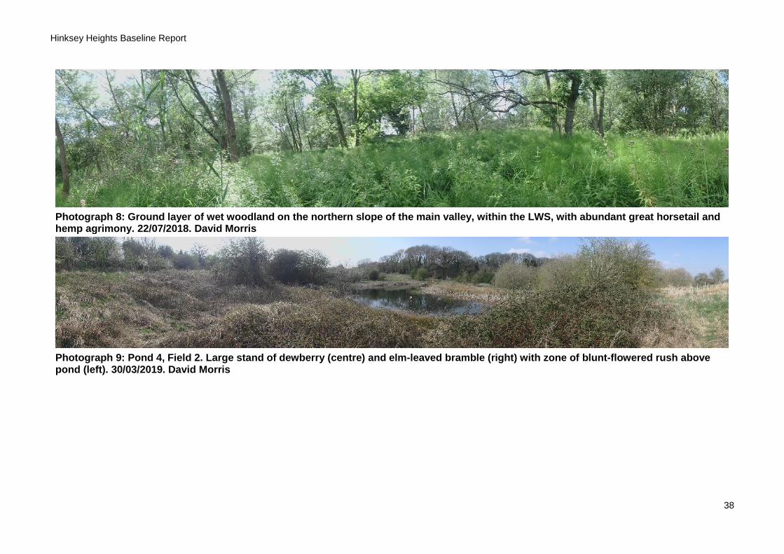
Photograph 8: Ground layer of wet woodland on the northern slope of the main valley, within the LWS, with abundant great horsetail and hemp agrimony. 22/07/2018. David Morris
Photograph 9: Pond 4, Field 2. Large stand of dewberry (centre) and elm-leaved bramble (right) with zone of blunt-flowered rush above pond (left). 30/03/2019. David Morris
Hinksey Heights Baseline Report
39
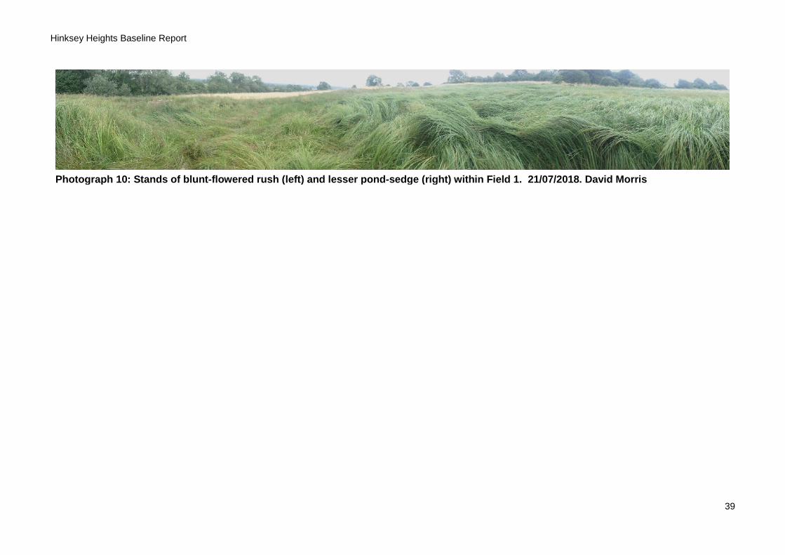
Photograph 10: Stands of blunt-flowered rush (left) and lesser pond-sedge (right) within Field 1. 21/07/2018. David Morris

Hinksey Heights Baseline Report
40
Appendix 2. Site list
Table A2.1. Explanation of legal and conservation statuses of taxa recorded from the Hinksey Heights study area.
Legal / conservation status
Description
Annex II Species (excluding birds) listed on Annex II of EC Directive Directive92/43/EEC (‘Habitats Directive’) (European Protected Species)
BOCC Amber, BOCC Red
Birds listed on the Birds of Conservation Concern (Eaton et al., 2014) as ‘amber’ or ‘red’, respectively
Eng NT, Eng VU Vascular plants listed on the vascular plant red list for England (Stroh et al., 2014) as Waiting List, Near Threatened or Vulnerable, respectively, as determined by assessment against International Union for the Conservation of Nature (IUCN) threat criteria. Plants listed as Vulnerable are considered at threat of extinction in England but not endangered. Plants listed as Near Threatened are considered not immediately threatened but could become threatened e.g. if previous declines continue.
Na Invertebrate species that do not fall within the Red Data Book categories but thought to occur in 30 or fewer 10km squares of the OS national grid, or for less well-recorded groups in seven or fewer vice counites
Nationally Scarce Taxa recorded in Britain from 15-100 10km squares of the OS national grid
Oxon RPR Plant taxa listed on the Oxfordshire rare plants register as rare or scarce in the administrative county of Oxfordshire (Killick et al., 2018)
RDB2, RDBK Invertebrate species listed in one of the Red Data Books as category 2 (Vulnerable) or K (unknown status), respectively
S41 Species of principal importance for the conservation of biodiversity in England, listed in accordance with Section 41 of the Natural Environment and Rural Communities Act 2006
Schedule 1 Birds listed on Schedule 1 of the Wildlife and Countryside Act 1981 (as amended). Birds listed on Schedule 1 are protected from disturbance during breeding, in addition to the protection afforded to all wild birds under the Act.
Schedule 5 Animals other than birds listed on Schedule 5 of the Wildlife and Countryside Act 1981 (as amended).
Schedule 8 Algae, fungi and plants listed on Schedule 8 of the Wildlife and Countryside Act 1981 (as amended). Wild populations of species listed on Schedule 8 are protected from commercial exploitation and/or the collecting of any part of a plant.
Schedule 9 Listed on Schedule 9 of the Wildlife and Countryside Act 1981 (as amended), a list of legally controlled invasive non-native species. Part I of Schedule 9 comprises a list of non-native animals naturalized in the wild in the UK that it is an offence to release into the wild. Part II a list of non-native algae, fungi and plants which it is illegal to plant or otherwise cause to grow in the wild.
Hinksey Heights Baseline Report
41
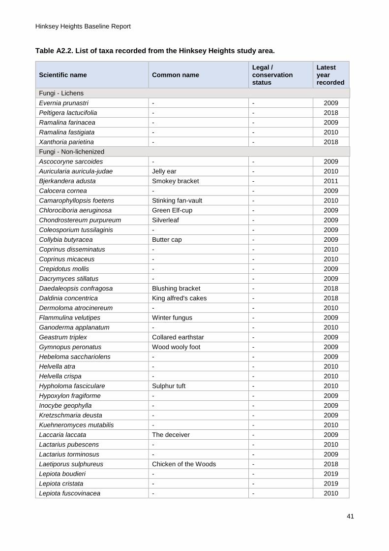
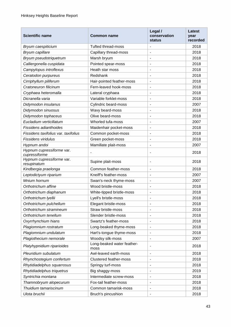
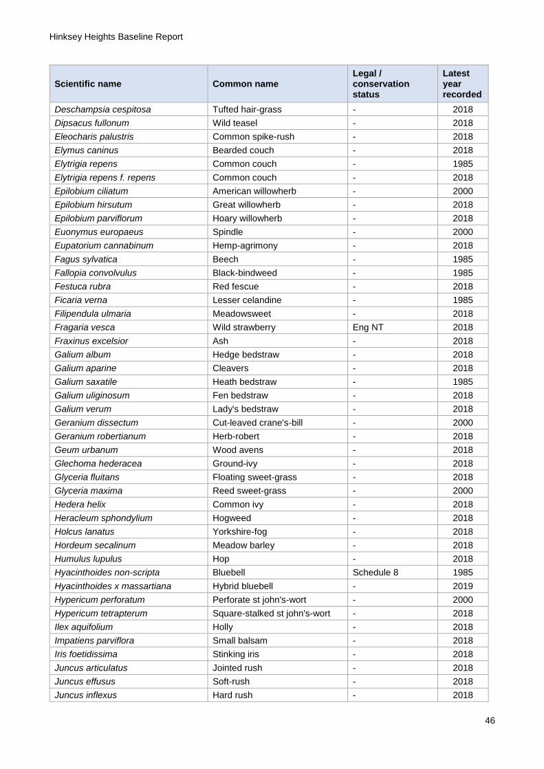
Table A2.2. List of taxa recorded from the Hinksey Heights study area.
Scientific name Common name Legal / conservation status
Latest year recorded
Fungi - Lichens
Evernia prunastri - - 2009
Peltigera lactucifolia - - 2018
Ramalina farinacea - - 2009
Ramalina fastigiata - - 2010
Xanthoria parietina - - 2018
Fungi - Non-lichenized
Ascocoryne sarcoides - - 2009
Auricularia auricula-judae Jelly ear - 2010
Bjerkandera adusta Smokey bracket - 2011
Calocera cornea - - 2009
Camarophyllopsis foetens Stinking fan-vault - 2010
Chlorociboria aeruginosa Green Elf-cup - 2009
Chondrostereum purpureum Silverleaf - 2009
Coleosporium tussilaginis - - 2009
Collybia butyracea Butter cap - 2009
Coprinus disseminatus - - 2010
Coprinus micaceus - - 2010
Crepidotus mollis - - 2009
Dacrymyces stillatus - - 2009
Daedaleopsis confragosa Blushing bracket - 2018
Daldinia concentrica King alfred's cakes - 2018
Dermoloma atrocinereum - - 2010
Flammulina velutipes Winter fungus - 2009
Ganoderma applanatum - - 2010
Geastrum triplex Collared earthstar - 2009
Gymnopus peronatus Wood wooly foot - 2009
Hebeloma sacchariolens - - 2009
Helvella atra - - 2010
Helvella crispa - - 2010
Hypholoma fasciculare Sulphur tuft - 2010
Hypoxylon fragiforme - - 2009
Inocybe geophylla - - 2009
Kretzschmaria deusta - - 2009
Kuehneromyces mutabilis - - 2010
Laccaria laccata The deceiver - 2009
Lactarius pubescens - - 2010
Lactarius torminosus - - 2009
Laetiporus sulphureus Chicken of the Woods - 2018
Lepiota boudieri - - 2019
Lepiota cristata - - 2019
Lepiota fuscovinacea - - 2010
Hinksey Heights Baseline Report
42
Scientific name Common name Legal / conservation status
Latest year recorded
Lycoperdon pyriforme Stump puffball - 2010
Macrotyphula juncea Slender club - 2009
Melanophyllum haematospermum Red-spored dapperling - 2009
Mycena galericulata - - 2018
Mycena galopus - - 2009
Mycena polygramma - - 2009
Paxillus involutus - - 2010
Phlebia tremellosa - - 2009
Phragmidium violaceum - - 2009
Pluteus cervinus - - 2010
Pluteus podospileus - - 2010
Pluteus salicinus - - 2011
Polyporus badius Bay polypore - 2018
Polyporus brumalis - - 2009
Polyporus varius - - 2019
Rutstroemia firma Little brown buttons - 2009
Stereum hirsutum - - 2009
Trametes gibbosa - - 2009
Trametes versicolor Turkey tail - 2009
Vuilleminia comedens - - 2009
Xerula radicata Rooting shank - 2010
Xylaria hypoxylon Candle snuff - 2010
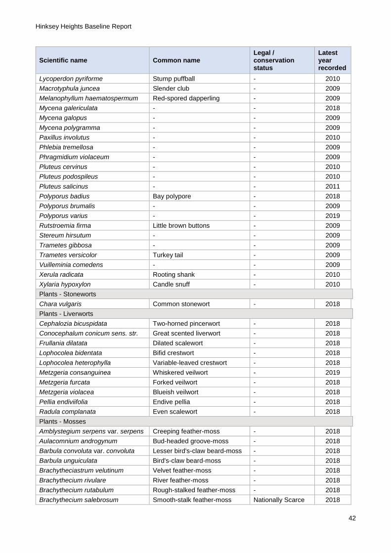
Plants - Stoneworts
Chara vulgaris Common stonewort - 2018
Plants - Liverworts
Cephalozia bicuspidata Two-horned pincerwort - 2018
Conocephalum conicum sens. str. Great scented liverwort - 2018
Frullania dilatata Dilated scalewort - 2018
Lophocolea bidentata Bifid crestwort - 2018
Lophocolea heterophylla Variable-leaved crestwort - 2018
Metzgeria consanguinea Whiskered veilwort - 2019
Metzgeria furcata Forked veilwort - 2018
Metzgeria violacea Blueish veilwort - 2018
Pellia endiviifolia Endive pellia - 2018
Radula complanata Even scalewort - 2018
Plants - Mosses
Amblystegium serpens var. serpens Creeping feather-moss - 2018
Aulacomnium androgynum Bud-headed groove-moss - 2018
Barbula convoluta var. convoluta Lesser bird's-claw beard-moss - 2018
Barbula unguiculata Bird's-claw beard-moss - 2018
Brachytheciastrum velutinum Velvet feather-moss - 2018
Brachythecium rivulare River feather-moss - 2018
Brachythecium rutabulum Rough-stalked feather-moss - 2018
Brachythecium salebrosum Smooth-stalk feather-moss Nationally Scarce 2018
Hinksey Heights Baseline Report
43
Scientific name Common name Legal / conservation status
Latest year recorded
Bryum caespiticium Tufted thread-moss - 2018
Bryum capillare Capillary thread-moss - 2018
Bryum pseudotriquetrum Marsh bryum - 2018
Calliergonella cuspidata Pointed spear-moss - 2018
Campylopus introflexus Heath star moss - 2018
Ceratodon purpureus Redshank - 2018
Cirriphyllum piliferum Hair-pointed feather-moss - 2018
Cratoneuron filicinum Fern-leaved hook-moss - 2018
Cryphaea heteromalla Lateral cryphaea - 2018
Dicranella varia Variable forklet-moss - 2018
Didymodon insulanus Cylindric beard-moss - 2007
Didymodon sinuosus Wavy beard-moss - 2018
Didymodon tophaceus Olive beard-moss - 2018
Eucladium verticillatum Whorled tufa-moss - 2007
Fissidens adianthoides Maidenhair pocket-moss - 2018
Fissidens taxifolius var. taxifolius Common pocket-moss - 2018
Fissidens viridulus Green pocket-moss - 2018
Hypnum andoi Mamillate plait-moss - 2007
Hypnum cupressiforme var. cupressiforme
- - 2018
Hypnum cupressiforme var. resupinatum
Supine plait-moss - 2018
Kindbergia praelonga Common feather-moss - 2018
Leptodictyum riparium Kneiff's feather-moss - 2007
Mnium hornum Swan's-neck thyme-moss - 2007
Orthotrichum affine Wood bristle-moss - 2018
Orthotrichum diaphanum White-tipped bristle-moss - 2018
Orthotrichum lyellii Lyell's bristle-moss - 2018
Orthotrichum pulchellum Elegant bristle-moss - 2018
Orthotrichum stramineum Straw bristle-moss - 2018
Orthotrichum tenellum Slender bristle-moss - 2018
Oxyrrhynchium hians Swartz's feather-moss - 2018
Plagiomnium rostratum Long-beaked thyme-moss - 2018
Plagiomnium undulatum Hart's-tongue thyme-moss - 2018
Plagiothecium nemorale Woodsy silk-moss - 2007
Platyhypnidium riparioides Long-beaked water feather-moss
- 2018
Pleuridium subulatum Awl-leaved earth-moss - 2018
Rhynchostegium confertum Clustered feather-moss - 2018
Rhytidiadelphus squarrosus Springy turf-moss - 2018
Rhytidiadelphus triquetrus Big shaggy-moss - 2019
Syntrichia montana Intermediate screw-moss - 2018
Thamnobryum alopecurum Fox-tail feather-moss - 2018
Thuidium tamariscinum Common tamarisk-moss - 2018
Ulota bruchii Bruch's pincushion - 2018

Hinksey Heights Baseline Report
44
Scientific name Common name Legal / conservation status
Latest year recorded
Ulota phyllantha Frizzled pincushion - 2019
Zygodon conoideus var. conoideus - - 2018
Zygodon viridissimus var. viridissimus
Green yoke-moss - 2018
Plants - Ferns and allies
Dryopteris affinis subsp. affinis - - 2018
Dryopteris carthusiana Narrow buckler-fern - 2018
Dryopteris dilatata Broad Buckler-fern - 2018
Dryopteris filix-mas Male-fern - 2018
Equisetum arvense Field horsetail - 2018
Equisetum fluviatile Water horsetail - 2000
Equisetum palustre Marsh horsetail - 2018
Equisetum telmateia Great horsetail - 2018
Polypodium interjectum Intermediate polypody Oxon RPR 2019
Polystichum setiferum Soft Shield-fern - 2018
Plants - Conifers
Taxus baccata Yew - 2000
X Cuprocyparis leylandii Leyland cypress - 2000
Plants - Flowering plants
Acer campestre Field maple - 2018
Acer pseudoplatanus Sycamore - 2000
Achillea millefolium Yarrow - 2018
Agrimonia eupatoria Agrimony - 2018
Agrostis capillaris Common bent - 2018
Agrostis stolonifera Creeping bent - 2018
Ajuga reptans Bugle - 2018
Alisma plantago-aquatica Water-plantain - 2018
Alliaria petiolata Garlic mustard - 2018
Alnus glutinosa Alder - 2018
Alopecurus pratensis Meadow foxtail - 2018
Anacamptis pyramidalis Pyramidal orchid - 2018
Anagallis arvensis Scarlet pimpernel - 2000
Angelica sylvestris Wild angelica - 2018
Anisantha sterilis Barren brome - 2000
Anthriscus sylvestris Cow parsley - 2018
Apium nodiflorum Fool's-water-cress - 2018
Arctium lappa Greater burdock - 2000
Arctium minus Lesser burdock - 2000
Arctium minus sens. lat. - - 2018
Arrhenatherum elatius False oat-grass - 2018
Arum maculatum Lords-and-ladies - 2019
Aster agg. Michaelmas daisy - 2018
Astragalus glycyphyllos Wild liquorice - 2018
Berberis vulgaris Barberry - 2018
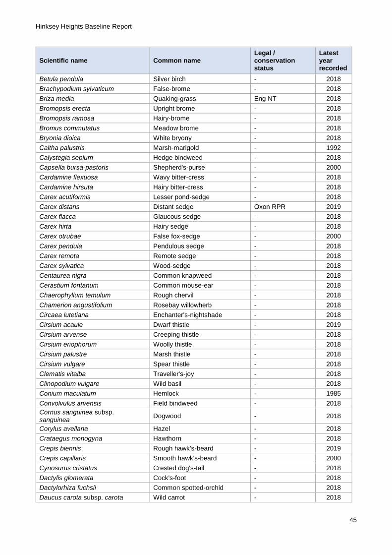
Hinksey Heights Baseline Report
45
Scientific name Common name Legal / conservation status
Latest year recorded
Betula pendula Silver birch - 2018
Brachypodium sylvaticum False-brome - 2018
Briza media Quaking-grass Eng NT 2018
Bromopsis erecta Upright brome - 2018
Bromopsis ramosa Hairy-brome - 2018
Bromus commutatus Meadow brome - 2018
Bryonia dioica White bryony - 2018
Caltha palustris Marsh-marigold - 1992
Calystegia sepium Hedge bindweed - 2018
Capsella bursa-pastoris Shepherd's-purse - 2000
Cardamine flexuosa Wavy bitter-cress - 2018
Cardamine hirsuta Hairy bitter-cress - 2018
Carex acutiformis Lesser pond-sedge - 2018
Carex distans Distant sedge Oxon RPR 2019
Carex flacca Glaucous sedge - 2018
Carex hirta Hairy sedge - 2018
Carex otrubae False fox-sedge - 2000
Carex pendula Pendulous sedge - 2018
Carex remota Remote sedge - 2018
Carex sylvatica Wood-sedge - 2018
Centaurea nigra Common knapweed - 2018
Cerastium fontanum Common mouse-ear - 2018
Chaerophyllum temulum Rough chervil - 2018
Chamerion angustifolium Rosebay willowherb - 2018
Circaea lutetiana Enchanter's-nightshade - 2018
Cirsium acaule Dwarf thistle - 2019
Cirsium arvense Creeping thistle - 2018
Cirsium eriophorum Woolly thistle - 2018
Cirsium palustre Marsh thistle - 2018
Cirsium vulgare Spear thistle - 2018
Clematis vitalba Traveller's-joy - 2018
Clinopodium vulgare Wild basil - 2018
Conium maculatum Hemlock - 1985
Convolvulus arvensis Field bindweed - 2018
Cornus sanguinea subsp. sanguinea
Dogwood - 2018
Corylus avellana Hazel - 2018
Crataegus monogyna Hawthorn - 2018
Crepis biennis Rough hawk's-beard - 2019
Crepis capillaris Smooth hawk's-beard - 2000
Cynosurus cristatus Crested dog's-tail - 2018
Dactylis glomerata Cock's-foot - 2018
Dactylorhiza fuchsii Common spotted-orchid - 2018
Daucus carota subsp. carota Wild carrot - 2018
Hinksey Heights Baseline Report
46
Scientific name Common name Legal / conservation status
Latest year recorded
Deschampsia cespitosa Tufted hair-grass - 2018
Dipsacus fullonum Wild teasel - 2018
Eleocharis palustris Common spike-rush - 2018
Elymus caninus Bearded couch - 2018
Elytrigia repens Common couch - 1985
Elytrigia repens f. repens Common couch - 2018
Epilobium ciliatum American willowherb - 2000
Epilobium hirsutum Great willowherb - 2018
Epilobium parviflorum Hoary willowherb - 2018
Euonymus europaeus Spindle - 2000
Eupatorium cannabinum Hemp-agrimony - 2018
Fagus sylvatica Beech - 1985
Fallopia convolvulus Black-bindweed - 1985
Festuca rubra Red fescue - 2018
Ficaria verna Lesser celandine - 1985
Filipendula ulmaria Meadowsweet - 2018
Fragaria vesca Wild strawberry Eng NT 2018
Fraxinus excelsior Ash - 2018
Galium album Hedge bedstraw - 2018
Galium aparine Cleavers - 2018
Galium saxatile Heath bedstraw - 1985
Galium uliginosum Fen bedstraw - 2018
Galium verum Lady's bedstraw - 2018
Geranium dissectum Cut-leaved crane's-bill - 2000
Geranium robertianum Herb-robert - 2018
Geum urbanum Wood avens - 2018
Glechoma hederacea Ground-ivy - 2018
Glyceria fluitans Floating sweet-grass - 2018
Glyceria maxima Reed sweet-grass - 2000
Hedera helix Common ivy - 2018
Heracleum sphondylium Hogweed - 2018
Holcus lanatus Yorkshire-fog - 2018
Hordeum secalinum Meadow barley - 2018
Humulus lupulus Hop - 2018
Hyacinthoides non-scripta Bluebell Schedule 8 1985
Hyacinthoides x massartiana Hybrid bluebell - 2019
Hypericum perforatum Perforate st john's-wort - 2000
Hypericum tetrapterum Square-stalked st john's-wort - 2018
Ilex aquifolium Holly - 2018
Impatiens parviflora Small balsam - 2018
Iris foetidissima Stinking iris - 2018
Juncus articulatus Jointed rush - 2018
Juncus effusus Soft-rush - 2018
Juncus inflexus Hard rush - 2018
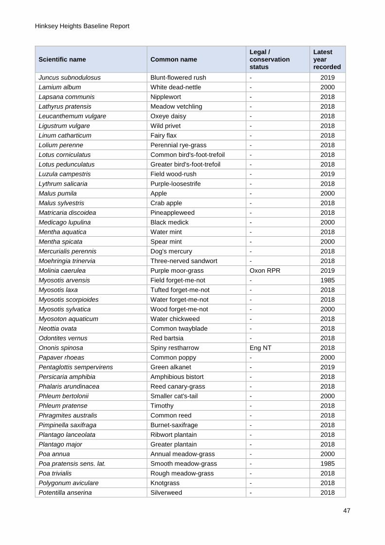
Hinksey Heights Baseline Report
47
Scientific name Common name Legal / conservation status
Latest year recorded
Juncus subnodulosus Blunt-flowered rush - 2019
Lamium album White dead-nettle - 2000
Lapsana communis Nipplewort - 2018
Lathyrus pratensis Meadow vetchling - 2018
Leucanthemum vulgare Oxeye daisy - 2018
Ligustrum vulgare Wild privet - 2018
Linum catharticum Fairy flax - 2018
Lolium perenne Perennial rye-grass - 2018
Lotus corniculatus Common bird's-foot-trefoil - 2018
Lotus pedunculatus Greater bird's-foot-trefoil - 2018
Luzula campestris Field wood-rush - 2019
Lythrum salicaria Purple-loosestrife - 2018
Malus pumila Apple - 2000
Malus sylvestris Crab apple - 2018
Matricaria discoidea Pineappleweed - 2018
Medicago lupulina Black medick - 2000
Mentha aquatica Water mint - 2018
Mentha spicata Spear mint - 2000
Mercurialis perennis Dog's mercury - 2018
Moehringia trinervia Three-nerved sandwort - 2018
Molinia caerulea Purple moor-grass Oxon RPR 2019
Myosotis arvensis Field forget-me-not - 1985
Myosotis laxa Tufted forget-me-not - 2018
Myosotis scorpioides Water forget-me-not - 2018
Myosotis sylvatica Wood forget-me-not - 2000
Myosoton aquaticum Water chickweed - 2018
Neottia ovata Common twayblade - 2018
Odontites vernus Red bartsia - 2018
Ononis spinosa Spiny restharrow Eng NT 2018
Papaver rhoeas Common poppy - 2000
Pentaglottis sempervirens Green alkanet - 2019
Persicaria amphibia Amphibious bistort - 2018
Phalaris arundinacea Reed canary-grass - 2018
Phleum bertolonii Smaller cat's-tail - 2000
Phleum pratense Timothy - 2018
Phragmites australis Common reed - 2018
Pimpinella saxifraga Burnet-saxifrage - 2018
Plantago lanceolata Ribwort plantain - 2018
Plantago major Greater plantain - 2018
Poa annua Annual meadow-grass - 2000
Poa pratensis sens. lat. Smooth meadow-grass - 1985
Poa trivialis Rough meadow-grass - 2018
Polygonum aviculare Knotgrass - 2018
Potentilla anserina Silverweed - 2018

Hinksey Heights Baseline Report
48
Scientific name Common name Legal / conservation status
Latest year recorded
Potentilla reptans Creeping cinquefoil - 2018
Poterium sanguisorba subsp. sanguisorba
Salad burnet - 2019
Primula veris Cowslip - 2019
Primula vulgaris Primrose - 2019
Prunella vulgaris Selfheal - 2018
Prunus avium Wild cherry - 2018
Prunus domestica Wild plum - 2018
Prunus spinosa Blackthorn - 2018
Pulicaria dysenterica Common fleabane - 2018
Quercus robur Pedunculate oak - 2018
Ranunculus flammula Lesser spearwort Eng VU 1985
Ranunculus repens Creeping buttercup - 2018
Rhamnus cathartica Buckthorn - 2018
Ribes nigrum Black currant - 1985
Ribes rubrum Red currant - 2018
Rosa arvensis Field-rose - 2018
Rosa canina agg. Dog-rose - 2018
Rosa x dumalis Rosa caesia x canina - 2018
Rubus caesius Dewberry - 2018
Rubus fruticosus agg. Bramble - 2000
Rubus ulmifolius Elm-leaved bramble - 2018
Rubus vestitus - - 2018
Rumex obtusifolius Broad-leaved dock - 2018
Rumex sanguineus Wood dock - 2018
Salix alba White willow - 2018
Salix caprea Goat willow - 1985
Salix cinerea Grey willow - 2018
Salix triandra Almond willow - 2018
Salix viminalis Osier - 2018
Salix x fragilis sens. lat. Hybrid crack-willow - 1985
Salix x multinervis Eared/grey willow hybrid - 2018
Sambucus nigra Elder - 2018
Sanicula europaea Sanicle Eng NT 2018
Schedonorus arundinaceus Tall fescue - 2018
Schedonorus giganteus Giant fescue - 2018
Schoenoplectus lacustris Common club-rush - 2018
Scorzoneroides autumnalis Autumn hawkbit - 2018
Scrophularia auriculata Water figwort - 2018
Scrophularia nodosa Common figwort - 2000
Senecio erucifolius Hoary ragwort - 2018
Senecio jacobaea Common ragwort - 2018
Silene dioica Red campion - 1985
Silene latifolia White campion - 1985
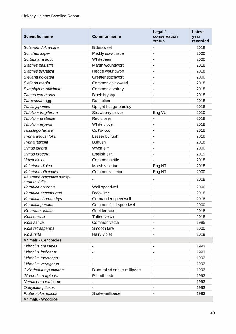
Hinksey Heights Baseline Report
49
Scientific name Common name Legal / conservation status
Latest year recorded
Solanum dulcamara Bittersweet - 2018
Sonchus asper Prickly sow-thistle - 2000
Sorbus aria agg. Whitebeam - 2000
Stachys palustris Marsh woundwort - 2018
Stachys sylvatica Hedge woundwort - 2018
Stellaria holostea Greater stitchwort - 2000
Stellaria media Common chickweed - 2018
Symphytum officinale Common comfrey - 2018
Tamus communis Black bryony - 2018
Taraxacum agg. Dandelion - 2018
Torilis japonica Upright hedge-parsley - 2018
Trifolium fragiferum Strawberry clover Eng VU 2010
Trifolium pratense Red clover - 2018
Trifolium repens White clover - 2018
Tussilago farfara Colt's-foot - 2018
Typha angustifolia Lesser bulrush - 2018
Typha latifolia Bulrush - 2018
Ulmus glabra Wych elm - 2000
Ulmus procera English elm - 2019
Urtica dioica Common nettle - 2018
Valeriana dioica Marsh valerian Eng NT 2018
Valeriana officinalis Common valerian Eng NT 2000
Valeriana officinalis subsp. sambucifolia
- - 2018
Veronica arvensis Wall speedwell - 2000
Veronica beccabunga Brooklime - 2018
Veronica chamaedrys Germander speedwell - 2018
Veronica persica Common field-speedwell - 2000
Viburnum opulus Guelder-rose - 2018
Vicia cracca Tufted vetch - 2018
Vicia sativa Common vetch - 1985
Vicia tetrasperma Smooth tare - 2000
Viola hirta Hairy violet - 2019
Animals - Centipedes
Lithobius crassipes - - 1993
Lithobius forficatus - - 1993
Lithobius melanops - - 1993
Lithobius variegatus - - 1993
Cylindroiulus punctatus Blunt-tailed snake-millipede - 1993
Glomeris marginata Pill millipede - 1993
Nemasoma varicorne - - 1993
Ophyiulus pilosus - - 1993
Proteroiulus fuscus Snake-millipede - 1993
Animals - Woodlice
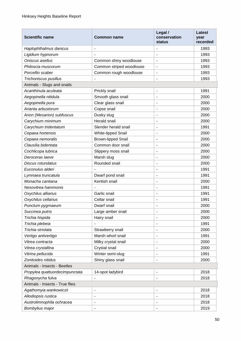
Hinksey Heights Baseline Report
50
Scientific name Common name Legal / conservation status
Latest year recorded
Haplophthalmus danicus - - 1993
Ligidium hypnorum - - 1993
Oniscus asellus Common shiny woodlouse - 1993
Philoscia muscorum Common striped woodlouse - 1993
Porcellio scaber Common rough woodlouse - 1993
Trichoniscus pusillus - - 1993
Animals - Slugs and snails
Acanthinula aculeata Prickly snail - 1991
Aegopinella nitidula Smooth glass snail - 2000
Aegopinella pura Clear glass snail - 2000
Arianta arbustorum Copse snail - 2000
Arion (Mesarion) subfuscus Dusky slug - 2000
Carychium minimum Herald snail - 2000
Carychium tridentatum Slender herald snail - 1991
Cepaea hortensis White-lipped Snail - 2000
Cepaea nemoralis Brown-lipped Snail - 2000
Clausilia bidentata Common door snail - 2000
Cochlicopa lubrica Slippery moss snail - 2000
Deroceras laeve Marsh slug - 2000
Discus rotundatus Rounded snail - 2000
Euconulus alderi - - 1991
Lymnaea truncatula Dwarf pond snail - 1991
Monacha cantiana Kentish snail - 2000
Nesovitrea hammonis - - 1991
Oxychilus alliarius Garlic snail - 1991
Oxychilus cellarius Cellar snail - 1991
Punctum pygmaeum Dwarf snail - 2000
Succinea putris Large amber snail - 2000
Trichia hispida Hairy snail - 2000
Trichia plebeia - - 1991
Trichia striolata Strawberry snail - 2000
Vertigo antivertigo Marsh whorl snail - 1991
Vitrea contracta Milky crystal snail - 2000
Vitrea crystallina Crystal snail - 2000
Vitrina pellucida Winter semi-slug - 1991
Zonitoides nitidus Shiny glass snail - 2000
Animals - Insects - Beetles
Propylea quattuordecimpunctata 14-spot ladybird - 2018
Rhagonycha fulva - - 2018
Animals - Insects - True flies
Agathomyia wankowiczii - - 2018
Allodiopsis rustica - - 2018
Austrolimnophila ochracea - - 2018
Bombylius major - - 2019

Hinksey Heights Baseline Report
51
Scientific name Common name Legal / conservation status
Latest year recorded
Chrysopilus asiliformis - - 2018
Chrysopilus cristatus - - 2018
Dicranophragma nemorale - - 2018
Diogma glabrata - - 2018
Ellipteroides lateralis - - 2018
Erioptera lutea - - 2018
Exechiopsis membranacea - - 2018
Gonomyia abscondita - RDBK 2018
Isoneuromyia semirufa - - 2018
Lipara lucens - - 2019
Macrocera angulata - - 2018
Molophilus appendiculatus - - 2018
Molophilus bifidus - - 2018
Molophilus corniger - - 2018
Molophilus medius - - 2018
Mycetophila abiecta - - 2018
Mycetophila adumbrata - - 2018
Mycetophila britannica - - 2018
Mycetophila curviseta - - 2018
Mycetophila marginata - - 2018
Mycetophila ocellus - - 2018
Mycetophila perpallida - - 2018
Mycetophila pictula - - 2018
Mycetophila stylatiformis - - 2018
Mycetophila trinotata - - 2018
Mycomya winnertzi - - 2018
Neolimonia dumetorum - - 2018
Nephrotoma analis - - 2018
Nephrotoma cornicina - - 2018
Opomyza florum - - 2018
Opomyza germinationis - - 2018
Paradelphomyia dalei - - 2018
Philophylla caesio - - 2018
Platurocypta testata - - 2018
Pseudolimnophila sepium - - 2018
Ptychoptera lacustris - - 2018
Rhipidia maculata - - 2018
Seri obscuripennis - RDB2 2010
Stigmatomeria crassicornis - - 2018
Stratiomys potamida Banded general - 2018
Tipula helvola - - 2018
Volucella zonaria - - 2018
Animals - Insects - True Bugs
Palomena prasina Common green shieldbug - 2018
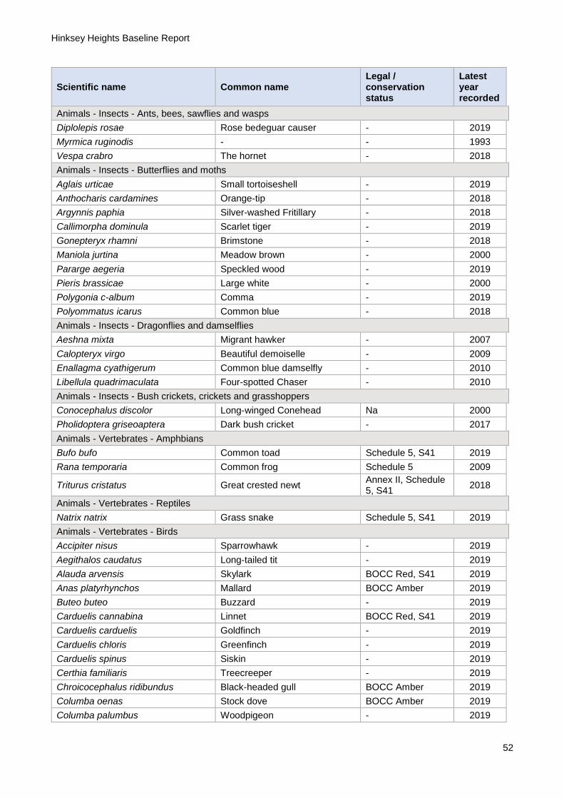
Hinksey Heights Baseline Report
52
Scientific name Common name Legal / conservation status
Latest year recorded
Animals - Insects - Ants, bees, sawflies and wasps
Diplolepis rosae Rose bedeguar causer - 2019
Myrmica ruginodis - - 1993
Vespa crabro The hornet - 2018
Animals - Insects - Butterflies and moths
Aglais urticae Small tortoiseshell - 2019
Anthocharis cardamines Orange-tip - 2018
Argynnis paphia Silver-washed Fritillary - 2018
Callimorpha dominula Scarlet tiger - 2019
Gonepteryx rhamni Brimstone - 2018
Maniola jurtina Meadow brown - 2000
Pararge aegeria Speckled wood - 2019
Pieris brassicae Large white - 2000
Polygonia c-album Comma - 2019
Polyommatus icarus Common blue - 2018
Animals - Insects - Dragonflies and damselflies
Aeshna mixta Migrant hawker - 2007
Calopteryx virgo Beautiful demoiselle - 2009
Enallagma cyathigerum Common blue damselfly - 2010
Libellula quadrimaculata Four-spotted Chaser - 2010
Animals - Insects - Bush crickets, crickets and grasshoppers
Conocephalus discolor Long-winged Conehead Na 2000
Pholidoptera griseoaptera Dark bush cricket - 2017
Animals - Vertebrates - Amphbians
Bufo bufo Common toad Schedule 5, S41 2019
Rana temporaria Common frog Schedule 5 2009
Triturus cristatus Great crested newt Annex II, Schedule 5, S41
2018
Animals - Vertebrates - Reptiles
Natrix natrix Grass snake Schedule 5, S41 2019
Animals - Vertebrates - Birds
Accipiter nisus Sparrowhawk - 2019
Aegithalos caudatus Long-tailed tit - 2019
Alauda arvensis Skylark BOCC Red, S41 2019
Anas platyrhynchos Mallard BOCC Amber 2019
Buteo buteo Buzzard - 2019
Carduelis cannabina Linnet BOCC Red, S41 2019
Carduelis carduelis Goldfinch - 2019
Carduelis chloris Greenfinch - 2019
Carduelis spinus Siskin - 2019
Certhia familiaris Treecreeper - 2019
Chroicocephalus ridibundus Black-headed gull BOCC Amber 2019
Columba oenas Stock dove BOCC Amber 2019
Columba palumbus Woodpigeon - 2019

Hinksey Heights Baseline Report
53
Scientific name Common name Legal / conservation status
Latest year recorded
Corvus corax Raven - 2019
Corvus corone Carrion crow - 2019
Corvus monedula Jackdaw - 2019
Cuculus canorus Cucko BOCC Red, S41 2019
Cyanistes caeruleus Blue tit - 2019
Dendrocopos major Great spotted woodpecker - 2019
Emberiza schoeniclus Reed bunting BOCC Amber, S41 2019
Erithacus rubecula Robin - 2019
Falco tinnunculus Kestrel BOCC Amber 2019
Fringilla coelebs Chaffinch - 2019
Gallinago gallinago Snipe BOCC Amber 2019
Gallinula chloropus Moorhen - 2019
Garrulus glandarius Jay - 2019
Milvus milvus Red kite Schedule 1 2019
Parus major Great tit - 2019
Parus palustris Marsh tit BOCC Red, S41 2019
Periparus ater Coal tit - 2019
Phasianus colchicus Pheasant - 2019
Phylloscopus collybita Chiffchaff - 2019
Pica pica Magpie - 2019
Picus viridis Green woodpecker - 2019
Prunella modularis Dunnock BOCC Amber, S41 2019
Pyrrhula pyrrhula Bullfinch BOCC Amber, S41 2019
Regulus regulus Goldcrest - 2019
Sylvia atricapilla Blackcap - 2019
Tachybaptus ruficollis Little grebe - 2019
Troglodytes troglodytes Wren - 2019
Turdus iliacus Redwing BOCC Red, Schedule 1
2019
Turdus merula Blackbird - 2019
Turdus philomelos Song thrush BOCC Red, S41 2019
Animals - Vertebrates - Mammals
Capreolus capreolus Roe deer - 2019
Meles meles Badger - 2019
Micromys minutus Harvest mouse S41 2019
Muntiacus reevesi Chinese muntjac Schedule 9 2019
Myodes glareolus Bank vole - 2019
Oryctolagus cuniculus Rabbit - 2019
Sciurus carolinensis Grey squirrel - 2019
Talpa europaea Mole - 2019
Vulpes vulpes Red fox - 2019