P1W6: North Sumatra-Mergui Basin Cross Border Case Study · \ഠThe Megui Basin is situated mainly in the deepwater with water depth range from 200 meters to 3 kilometers. The Mergui
16
An Overview and Progress Work , Thailand @ Labuan, Malaysia 5-7 September, 2012 P1W6: North Sumatra-Mergui Basin Cross Border Case Study
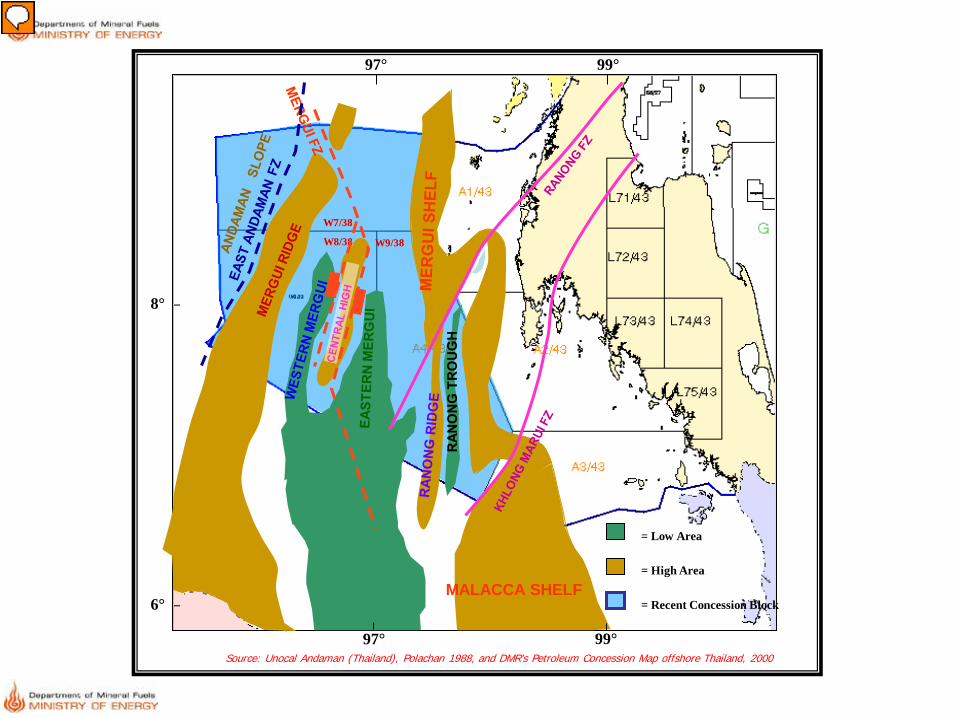
Regional map of Andaman Sea which located western offshore Thailand. This region is divided into shallow and deepwater part. The Megui Basin is situated mainly in the deepwater with water depth range from 200 meters to 3 kilometers. The Mergui basin has three main sub-basins: the Western Mergui, Eastern Mergui and Ranong Trough. The Western Mergui and Eastern Mergui sub-basins are separated by the Central High. Sedimentary thickness is estimated up to 10 km in depocenter. The Mergui Basin is the only one Tertiary basin in Thailand that sediment are ttruely marine origin. The basin connect to the North Sumatra to the south. Review of Regional of Nort Sumatra and Mer Gui Basin in Thailand side,
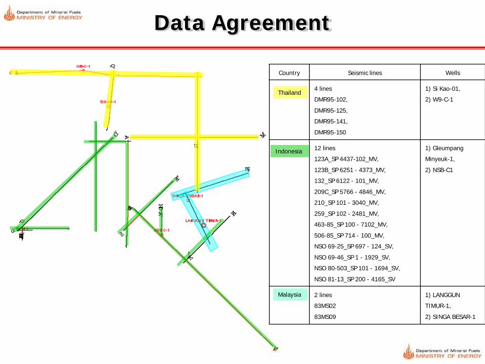
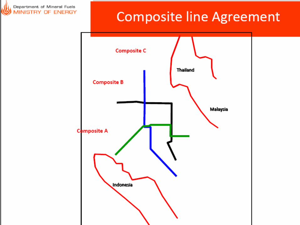
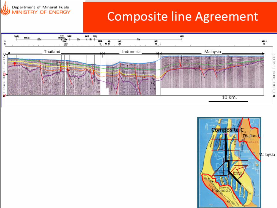
Data Agreement
Thailand
Indonesia
Malaysia
Country Seismic lines Wells
4 lines
DMR95-102,
DMR95-125,
DMR95-141,
DMR95-150
1) Si Kao-01,
2) W9-C-1
12 lines
123A_SP 4437-102_MV,
123B_SP 6251 - 4373_MV,
132_SP 6122 - 101_MV,
209C_SP 5766 - 4846_MV,
210_SP 101 - 3040_MV,
259_SP 102 - 2481_MV,
463-85_SP 100 - 7102_MV,
506-85_SP 714 - 100_MV,
NSO 69-25_SP 697 - 124_SV,
NSO 69-46_SP 1 - 1929_SV,
NSO 80-503_SP 101 - 1694_SV,
NSO 81-13_SP 200 - 4165_SV
1) Gleumpang
Minyeuk-1,
2) NSB-C1
2 lines
83MS02
83MS09
1) LANGGUN
TIMUR-1,
2) SINGA BESAR-1
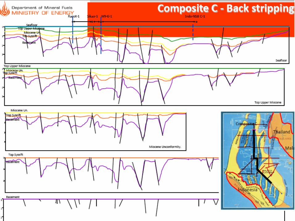
Basement
Top synrift
Miocene Unconformity
Top Upper Miocene
Sea Bed
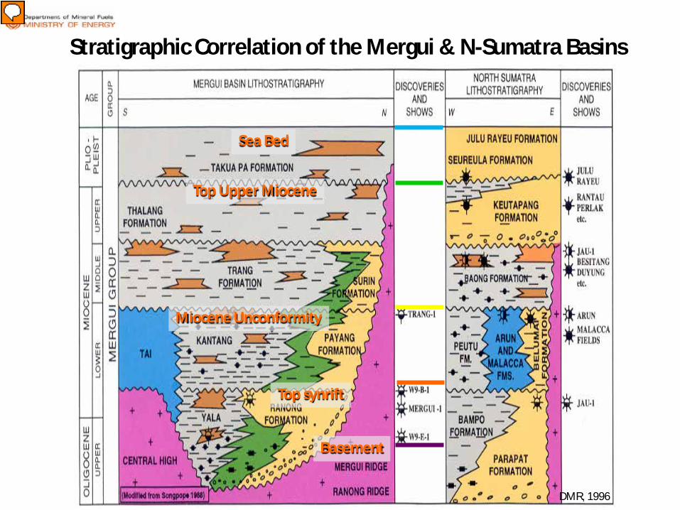
Stratigraphic Correlation of the Mergui & N-Sumatra Basins
DMR, 1996
Presenter
Presentation Notes
Ranong Formation is classified to be a good reservoir in the Mergui Basin. It was deposited by fluvio-deltaic and shore face sand whilst the Yala Formation is marine shale and turbidite facies. Kantang is dominantly deposited in deep marine shales in the basin center. Tai is a carbonate facies locally deposited around the structural high. Payang is mostly sandstone and shale of delta front round the basin margins. Trang is deposited in very low energy of bathyal environment whereas Surin is a shallow marine (delta front or offshore bar). Thalang is also deposited in very energy of lower bathyal environment. Takuapa is deposited in marine shelf at the lower part whilst shallow marine on the upper part.
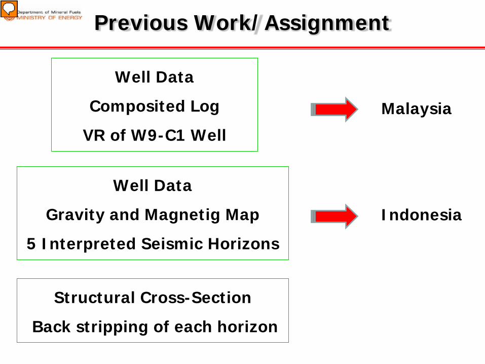
Previous Work/Assignment
Well Data
Gravity and Magnetig Map
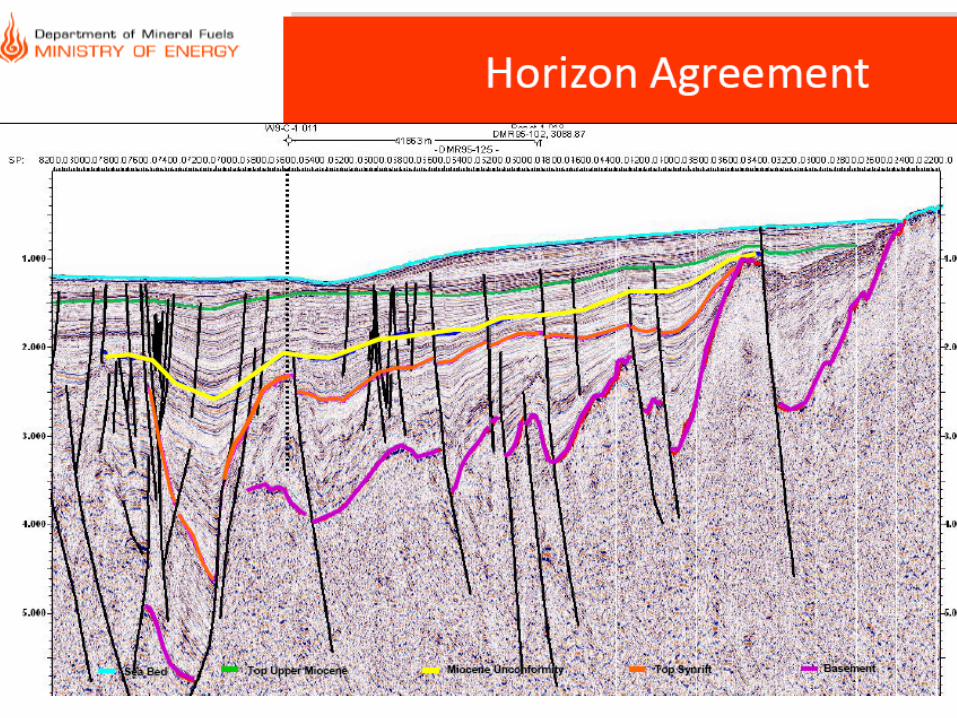
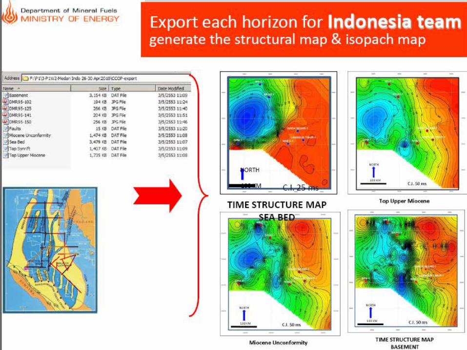
5 Interpreted Seismic Horizons
Indonesia
Well Data
Composited Log
VR of W9-C1 Well
Malaysia
Structural Cross-Section
Back stripping of each horizon
Presenter
Presentation Notes
Provide data to Malaysia to: Seismic facies Chronostratigraphic map Provide data to Indonesia Team to: Convert the time structure map to depth To make a 2D basin modeling Heat flow map, geothermal gradient & maturity map
Previous Work/Assignment
Well Data
Gravity and Magnetig Map
5 Interpreted Seismic Horizons
Indonesia
Well Data
Composited Log
VR of W9-C1 Well
Malaysia
Structural Cross-Section
Back stripping of each horizon
Presenter
Presentation Notes
Provide data to Malaysia to: Seismic facies Chronostratigraphic map Provide data to Indonesia Team to: Convert the time structure map to depth To make a 2D basin modeling Heat flow map, geothermal gradient & maturity map