pace park-n-ride in the village of woodridge study park-n-ride in the village of woodridge study ......
TRANSCRIPT

Pace Park-n-Ride in the Village of Woodridge Study
August 2016
Prepared for Pace Suburban Bus
Village of Woodridge Regional Transportation Authority
Prepared by T.Y. Lin International
Fish Transportation Group

Woodridge Park-n-Ride Study Page ii
Contents
1 Executive Summary ....................................................................................................................1
2 Introduction ...............................................................................................................................2
3 Woodridge Demographic Analysis and Travel Characteristics .......................................................4
4 Transit Service Analysis ............................................................................................................. 12
4.1 Pace I-55 Bus on Shoulder .......................................................................................................... 12
4.2 Pace Local Bus serving Woodridge ............................................................................................. 21
4.3 Metra Commuter Rail ................................................................................................................. 23
4.4 Pace Bus On Shoulder (BOS) in Relation to BNSF Service ........................................................... 29
4.5 Pace Vanpool and Rideshare ...................................................................................................... 30
5 Plans and Studies Review .......................................................................................................... 31
5.1 Regional....................................................................................................................................... 31
5.2 Local ............................................................................................................................................ 33
6 Study Findings and Location Criteria .......................................................................................... 35
6.1 Key Findings ................................................................................................................................ 35
6.2 Future Study ................................................................................................................................ 36
6.3 Location Criteria .......................................................................................................................... 36
6.4 Site Considerations ..................................................................................................................... 37
7 Site Selection Evaluation ........................................................................................................... 38
7.1 Site Characteristics ...................................................................................................................... 38
7.2 Site Evaluation ............................................................................................................................ 49
7.3 Conclusions and Next Steps ........................................................................................................ 51

Woodridge Park-n-Ride Study Page iii
Tables
Table 3-1: Woodridge Population ................................................................................................................. 4
Table 3-2: Woodridge Employment .............................................................................................................. 4
Table 3-3: Woodridge and Surrounding Municipalities Demographic Characteristics ................................. 5
Table 4-1: I-55 Express Route Operating Characteristics ............................................................................ 16
Table 4-2: Existing and Historical Ridership by Route................................................................................. 17
Table 4-3: Average Bus Trip Ridership and Capacity by Route ................................................................... 18
Table 4-4: BOS Park-n-Ride Facilities .......................................................................................................... 19
Table 4-5: Average Boarding Activity by Park-n-Ride ................................................................................. 20
Table 4-6: Pace Local Bus Route Operating Characteristics ........................................................................ 21
Table 4-7: Pace Feeder Bus Route Travel Times to Metra BNSF Stations................................................... 21
Table 4-8: BNSF Historical Weekday Boardings .......................................................................................... 23
Table 4-9: Metra Commuter Mode of Access ............................................................................................. 23
Table 4-10: Daily Woodridge Resident Commuter Rail Boardings by Metra Station ................................. 24
Table 4-11: Percentage of Total Boardings Made by Woodridge Residents .............................................. 26
Table 4-12: Mode of Access by Percentage to Metra Stations by Woodridge Residents .......................... 26
Table 4-13: Parking Utilization at Lisle, Belmont, and Downers Grove-Main St. Stations .......................... 27
Table 4-14: Permit Parking Waitlist at BNSF Stations ................................................................................. 27
Table 4-15: Park-n-Ride Facilities Serving Metra ........................................................................................ 28
Table 7-1: Summary of Characteristics for Potential Park-n-Ride Sites ...................................................... 40
Table 7-2: Site Evaluation Criteria and Ratings ........................................................................................... 50

Woodridge Park-n-Ride Study Page iv
Figures Figure 2-1: Village of Woodridge within Region ........................................................................................... 3
Figure 3-1: Transit Demand Index ................................................................................................................. 7
Figure 3-2: Woodridge Employee and Multi-Family Housing Counts ........................................................... 8
Figure 3-3: Where Woodridge Residents Work .......................................................................................... 10
Figure 3-4: Where Woodridge Employees Live .......................................................................................... 11
Figure 4-1: Pace BOS Routes ....................................................................................................................... 14
Figure 4-2: Pace BOS Downtown Destinations ........................................................................................... 15
Figure 4-3: Historic Ridership by Route ...................................................................................................... 17
Figure 4-4: Pace Local Routes that Serve Woodridge ................................................................................. 22
Figure 4-5: Woodridge Residents – Metra Destination Stations ................................................................ 25
Figure 7-1: Potential Park-n-Ride Site Locations ......................................................................................... 39
Figure 7-2: Site A - Centerpointe of Woodridge ......................................................................................... 41
Figure 7-3: Site B - Woodridge Plaza/Jewel/Vacant Lot ............................................................................. 43
Figure 7-4: Site C - Church Cluster .............................................................................................................. 45
Figure 7-5: Site D - The Grove Shopping Center ......................................................................................... 47

Woodridge Park-n-Ride Study Page 1
1 Executive Summary
This study examines the characteristics of the Pace I-55 Bus on Shoulder (BOS) service and Woodridge
demographic and travel characteristics with the intent of determining if an additional BOS park-n-ride
facility within the Village of Woodridge (Village or Woodridge) is warranted. The study assessed current
demographic and travel characteristics in the Woodridge area and reached a conclusion that a park-n-
ride facility within the Village would provide a viable transit alternative for reaching Downtown Chicago.
Based on the study results, Woodridge residents would be best served by a park-n-ride facility near I-
355 and 75th Street, although other locations could also provide viable locations. Four sites near this
interchange were evaluated. The Centerpointe of Woodridge northwest of 75th and Woodward Avenue
was selected as the preferred site for a potential park-n-ride facility. This site has a shopping center with
underutilized parking spaces that could be converted to park-n-ride use. The site has a number of
positive characteristics including quick access to I-355, signalized access, nearby high-density housing,
and an adjacent bicycle path. Another positive feature is that both Pace Routes 821 and a branch of 834
are adjacent to the site. Given the proximity of these local Pace routes, it may be possible to use the site
as a park-n-ride location for BOS service and as remote park-n-ride facility to serve the Metra BNSF line.
Once Pace has identified funding for the capital and operating components of this project, the next step
would be for Pace to approach the property owner about securing a lease to use the parking facility as a
park-n-ride. Upon successful negotiations, Pace will begin the service design to be followed by the
procurement process to purchase buses. After procurement, Pace would finalize minor site
improvements (ex. signage, lighting, and shelters) and develop a marketing plan before implementation.
If the site also is considered for use as a remote park-n-ride facility to connect to the Metra BNSF
service, Pace would need to finalize a service plan between the site and a Metra Station, which would
entail modifications to an existing Pace route or implementing a new route.

Woodridge Park-n-Ride Study Page 2
2 Introduction
The Village of Woodridge is situated along I-355 (Veterans Memorial Tollway) and extends south of I-55
(Adlai E. Stevenson Expressway (see Figure 2-1). Woodridge residents that commute via public
transportation to downtown Chicago primarily use the Metra BNSF Line and board at the Lisle, Belmont
or Downers Grove-Main St. Stations.
Pace expanded bus service on I-55 in 2012 with additional routes and Bus on Shoulder (BOS) service. The
expanded services resulted in increased reliability and reduced commuting times. The BOS service has
provided a viable transit option for accessing downtown Chicago with connections to the East Loop, the
Streeterville neighborhood, and the Illinois Medical District. The BOS route terminus at these locations is
a convenience as compared to transferring to a CTA bus after arriving in downtown Chicago by Metra.
The convenience has resulted in increased ridership which has grown significantly since initiation.
Although the Pace I-55 bus service passes through Woodridge, there presently are no park-n-ride
facilities that Woodridge residents can conveniently access. Village officials indicated that more transit
service is needed, specifically noting a need for transit connections to the I-55 BOS service and the
Metra BNSF Line.
This study examines the characteristics of the Pace I-55 BOS service and Woodridge demographic and
travel characteristics with the intent of determining if a park-n-ride facility within the Village of
Woodridge is warranted. Additionally, potential locations for new park-n-ride lots are discussed.
A new park-n-ride facility is intended primarily for users of the Pace I-55 BOS service. A secondary use
would be to serve as a remote park-n-ride lot for nearby Metra BNSF stations.

Woodridge Park-n-Ride Study Page 3
Figure 2-1: Village of Woodridge within Region
Woodridge Park-n-Ride Study Page 4
3 Woodridge Demographic Analysis and Travel Characteristics
Within this section, demographic and travel characteristics of Woodridge residents and workers are
reviewed for attributes that would support the use of public transportation, particularly the I-55 BOS
service.
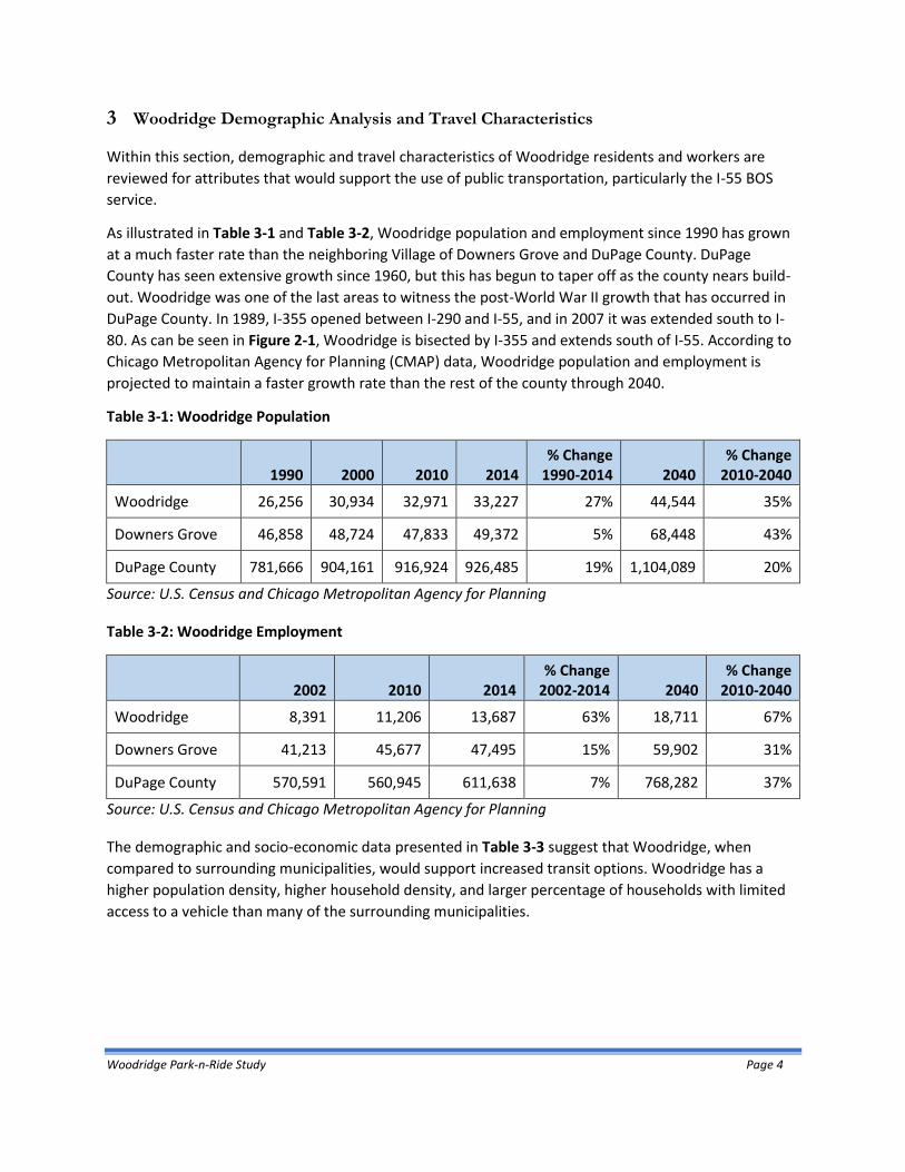
As illustrated in Table 3-1 and Table 3-2, Woodridge population and employment since 1990 has grown
at a much faster rate than the neighboring Village of Downers Grove and DuPage County. DuPage
County has seen extensive growth since 1960, but this has begun to taper off as the county nears build-
out. Woodridge was one of the last areas to witness the post-World War II growth that has occurred in
DuPage County. In 1989, I-355 opened between I-290 and I-55, and in 2007 it was extended south to I-
80. As can be seen in Figure 2-1, Woodridge is bisected by I-355 and extends south of I-55. According to
Chicago Metropolitan Agency for Planning (CMAP) data, Woodridge population and employment is
projected to maintain a faster growth rate than the rest of the county through 2040.
Table 3-1: Woodridge Population
1990 2000 2010 2014 % Change
1990-2014 2040 % Change
2010-2040
Woodridge 26,256 30,934 32,971 33,227 27% 44,544 35%
Downers Grove 46,858 48,724 47,833 49,372 5% 68,448 43%
DuPage County 781,666 904,161 916,924 926,485 19% 1,104,089 20%
Source: U.S. Census and Chicago Metropolitan Agency for Planning
Table 3-2: Woodridge Employment
2002 2010 2014
% Change 2002-2014 2040
% Change 2010-2040
Woodridge 8,391 11,206 13,687 63% 18,711 67%
Downers Grove 41,213 45,677 47,495 15% 59,902 31%
DuPage County 570,591 560,945 611,638 7% 768,282 37%
Source: U.S. Census and Chicago Metropolitan Agency for Planning
The demographic and socio-economic data presented in Table 3-3 suggest that Woodridge, when
compared to surrounding municipalities, would support increased transit options. Woodridge has a
higher population density, higher household density, and larger percentage of households with limited
access to a vehicle than many of the surrounding municipalities.

Woodridge Park-n-Ride Study Page 5
Table 3-3: Woodridge and Surrounding Municipalities Demographic Characteristics
Community
Bo
lingb
roo
k
Darie
n
Do
wn
ers
Gro
ve
Lisle
Nap
erville
Plain
field
Ro
me
oville
Wo
od
ridge
Du
Page
Co
un
ty
Land Area (Sq. mi.) 24.0 6.2 14.3 6.8 38.8 23.2 18.4 9.4 327.0
Acres 15,360 3,968 9,152 4,352 24,832 14,848 11,776 6,016 209,280
Population 74,112 22,251 49,372 22,626 144,108 40,641 39,675 33,227 926,485
Population Density (per Sq. Mi.)
3,088 3,589 3,453 3,327 3,714 1,752 2,156 3,535 2,833
Households (HH) 23,601 9,471 20,160 9,701 52,513 12,688 12,844 13,794 356,625
HH (per Acre) 1.5 2.4 2.2 2.2 2.1 0.9 1.1 2.3 1.7
Median HH Income $ 78,230 $ 77,188
$ 85,020
$ 74,041
$ 109,512
$ 111,536
$ 66,705
$ 77,164
$ 79,016
% Commuting on Public Transit
3.6% 3.4% 11.5% 7.5% 9.4% 2.6% 3.3% 4.2% 6.3%
% of Population Under 21
33.1% 22.9% 26.5% 24.7% 31.2% 37.2% 36.1% 25.3% 27.9%
% of Population Over 65
7.3% 19.2% 15.4% 12.9% 10.0% 6.0% 8.5% 9.3% 12.5%
% of Households with No Vehicle Available
2.7% 2.8% 5.9% 7.3% 3.2% 2.8% 0.5% 2.4% 4.0%
% of Households with 1 Vehicle Available
22.1% 33.3% 30.6% 34.4% 2.8% 15.5% 12.7% 34.6% 30.9%
Notes: Woodridge has a higher population density and more one-car households than surrounding municipalities.
The highest levels of transit ridership as the primary means of transportation to work are in municipalities located along the Metra BNSF line.
Source: Population, household, Income, commuting, and vehicle ownership data were collected from the U.S. Census American Community Survey 2014. Data on municipal land area (square miles and acres) was taken from geographic data from the 2010 Census Summary File 1. Population and household density fields were calculated by T.Y. Lin International.

Woodridge Park-n-Ride Study Page 6
Woodridge has similar characteristics to the surrounding municipalities, but the Village of Bolingbrook
provides one of the better comparisons due to its proximity to Woodridge and given that several BOS
park-n-ride lots are in Bolingbrook. The Village of Bolingbrook is serviced by existing Pace BOS routes
755, 850, and 851 and the Old Chicago, White Fence Farms, and Canterbury park-n-ride lots. The Old
Chicago and Canterbury park-n-ride lots are fully utilized.
Bolingbrook and Woodridge have several demographic indicators in common. Comparable demographic
indicators between the two municipalities include population density, median household income, senior
population, and households with no access to a vehicle. Woodridge has a higher percentage of residents
already using public transit for commute trips and a significantly higher percentage of households with
access to only one vehicle.
The percentage of population currently using public transit is lower in municipalities that are farther
from the Metra BNSF line. Downers Grove, Lisle, and Naperville which are all closer to the BNSF stations
have the highest percentage of population using this Metra service. However, the introduction of the I-
55 BOS service provides a viable transportation alternative for residents working in Downtown Chicago.
With improved park-n-ride opportunities, transit use for Woodridge residents and employees becomes
more feasible.
The Regional Transportation Authority (RTA) has developed a Transit Demand Index (TDI) that
incorporates data, including population density, senior and youth density, existing transit service,
automobile availability, and employment locations to assess demand for public transit. TDI is displayed
at the traffic analysis zone level, and darker shaded squares indicate higher demand for transit. On the
following page, Figure 3-1 illustrates that there is high demand for public transit located along I-355
near 75th Street and south of I-55.

Woodridge Park-n-Ride Study Page 7
Figure 3-1: Transit Demand Index

Woodridge Park-n-Ride Study Page 8
Source: Regional Transportation Authority The TDI analysis is further supported by information compiled by the Village staff highlighting
concentrations of employees and multi-family housing (see Figure 3-2). The employment centers at 75th
Street and south of I-55 suggest this market could be served by improved transit service. The quantity of
nearby multi-family housing units suggests a larger population that could support a feeder bus service to
the BNSF line.
Figure 3-2: Woodridge Employee and Multi-Family Housing Counts
Source: Village of Woodridge

Woodridge Park-n-Ride Study Page 9
The figures on the following two pages were prepared to show where Woodridge residents work, and
where commuters employed in Woodridge reside.
Figure 3-3 shows that nearly 1 out of 5 Woodridge residents in the workforce are employed in the City
of Chicago. This figure illustrates why so many Woodridge residents use the BNSF service, which will be
discussed in the next section. It also shows that there may be some demand for suburb to suburb
commuters. This type of service could be explored in the future.
Figure 3-4 indicates where workers employed in Woodridge reside. More than 10% of the workers come
from the City of Chicago. However, given the large population size of City of Chicago and its geographical
dispersion, this percentage may not represent a uniform demand for a reverse BOS service (outbound
from Chicago.) Similarly, the dispersed pattern of workers from other municipalities would not suggest a
large enough pattern to support a suburb to suburb commute

Woodridge Park-n-Ride Study Page 10
Figure 3-3: Where Woodridge Residents Work
Source: U.S. Census
Municipality Count Share
Chicago 3,330 18.1%
Downers Grove 1,065 5.8%
Naperville 1,059 5.8%
Woodridge 789 4.3%
Bolingbrook 675 3.7%
Lisle 563 3.1%
Oak Brook 397 2.2%
Aurora 371 2.0%
Schaumburg 346 1.9%
Lombard 327 1.8%
Where Woodridge Residents Work

Woodridge Park-n-Ride Study Page 11
Figure 3-4: Where Woodridge Employees Live
Source: U.S. Census
Municipality Count Share
Chicago 1,427 10.4%
Woodridge 789 5.8%
Bolingbrook 663 4.8%
Naperville 635 4.6%
Joliet 621 4.5%
Downers Grove 406 3.0%
Aurora 350 2.6%
Romeoville 306 2.2%
Plainfield 192 1.4%
Lisle 179 1.3%
Where Woodridge Workers Live

Woodridge Park-n-Ride Study Page 12
4 Transit Service Analysis
As stated in the previous section, the primary commute pattern for Woodridge residents that could be served by public transportation is inbound travel to Chicago in the morning and outbound from Chicago in the evening. In this section, the service on the BNSF and I-55 BOS is examined to suggest how the BOS service could best serve Woodridge residents.
4.1 Pace I-55 Bus on Shoulder
4.1.1 Background
Pace Routes 755 and 855 were the original commuter express routes providing service from Burr Ridge,
Bolingbrook, Romeoville and Plainfield, traveling to Chicago destinations including downtown Chicago
(Loop and North Michigan Avenue), Illinois Medical District (IMD), and University of Illinois – Chicago
(UIC). In November 2011, working with IDOT, the Illinois State Police, and the RTA and with a change in
state law, Pace launched a two-year pilot program known as Bus on Shoulder (BOS). The BOS was an
enhanced service to allow the operation of Pace Routes 755 and 855 on portions of the inside shoulder
of I-55. By allowing these routes to use the shoulder to bypass slow-moving or stopped motor vehicle
traffic, the speed of bus service was improved when the roadway was congested. Initially, there were
eight buses in the AM peak period in the northbound direction and eight buses in the PM peak
southbound direction.
To implement BOS, IDOT rebuilt the I-55 shoulders to accommodate heavy transit vehicles. Three sections of I-55, including both northbound and southbound directions, totaling about 15 miles, were designated for BOS operations:
1. Kedzie Avenue to Cicero Avenue (1 mile) 2. Cicero Avenue to Interstate 294 Interchange (8 miles) 3. County Line Road to Interstate 355 Interchange (6 miles)
With the ability of Routes 755 and 855 to operate on the shoulders and bypass congestion, Pace has
reported that on-time performance increased from less than 70 percent to over 90 percent and
ridership more than tripled1. As a result of this success, service was expanded in 2012 and 2013,
including extending route 755 to Chicago Union Station (CUS) and adding additional trips.
In 2014, the Illinois General Assembly enacted legislation to permanently allow BOS service and
additional service expansion and improvements occurred. The original Pace Route 855 was split into two
additional routes – Pace Routes 850 and 851 - to make service more efficient, resulting in a total four
Pace routes – 755, 850, 851, and 855.
1 www.pacebus.com

Woodridge Park-n-Ride Study Page 13
In August of 2014, changes were made to park-n-ride facilities in Romeoville. Temporary spaces at the
library and R.C. Hill Elementary School were replaced with a new park-n-ride at White Fence Farm in Ro-
meoville, doubling the number of parking spaces available. In the fall of 2014, additional BOS segments
were opened between Central Avenue and the Dan Ryan Expressway creating an approximately 20 mile
segment along the I-55 corridor. In 2016, Pace Routes 755 and 855 began serving a Larry’s Diner Park-n-
Ride at in Plainfield.
Since the launch of the BOS operation on the I-55 corridor in late 2011, ridership in this corridor has con-
tinued to grow dramatically with the first half of 2015 having increased 40% over the first half of 20142.
This growth is attributed in part to new Routes 850 and 851, as well as the opening of new BOS
segments between Central Avenue and the Dan Ryan Expressway.3
Pace BOS Routes near Woodridge that serve Downtown Chicago are shown on the following page in
Figure 4-1. A second figure, Figure 4-2, shows the Downtown Chicago destinations in greater detail.
2 Pace 2016 Suburban Service Budget
3 www.pacebus.com

Woodridge Park-n-Ride Study Page 14
Figure 4-1: Pace BOS Routes

Woodridge Park-n-Ride Study Page 15
Figure 4-2: Pace BOS Downtown Destinations

Woodridge Park-n-Ride Study Page 16
4.1.2 BOS Routes and Operating Characteristics
While the BOS bus service passes through Woodridge, there presently is no stop in Woodridge. The following summary provides a short description of the markets served by each BOS route. Pace Route 755 - Plainfield - IMD - West Loop Express Provides weekday rush hour express service between the Plainfield and Bolingbrook Park-n-Rides and the UIC, IMD, and CUS. The route serves Posted Stops Only along the entire route. Pace Route 850 - North Bolingbrook-East Loop Express Provides weekday rush hour service between the Park-n-Ride at Canterbury in Bolingbrook and the East
Loop in Chicago.
Pace Route 851 – South Bolingbrook-East Loop Express Provides weekday rush hour service between the Old Chicago Park-n-Ride in Bolingbrook and White Fence Farm Park-n-Ride in Romeoville and the East Loop in Chicago. Pace Route 855 - Plainfield-East Loop Express Provides weekday rush hour service between the Plainfield Village Center Park-n-Ride and Burr Ridge Park-n-Ride and the East Loop in Chicago.
The operating characteristics for the four Pace BOS routes are provided in Table 4-1. Service is provided
Monday through Friday in the inbound direction from about 5:00 AM until noon, and in the outbound
direction from about noon until 9:30PM.
Table 4-1: I-55 Express Route Operating Characteristics
Pace Route
Days of Service
Hours of Operation Number of Trips
Inbound Outbound Inbound Outbound
755 M - F 4:58 AM – 11:43 AM 12:04 PM – 8:28 PM 8 9
850 M - F 5:35 AM – 11:41 AM 11:57 AM – 8:47 PM 10 11
851 M - F 5:28 AM – 11:41 AM 11:57 AM – 8:56 PM 7 8
855 M - F 5:02 AM – 11:41 AM 11:57 AM – 9:26 PM 10 10
Source: Pace Route Schedules, 2016

Woodridge Park-n-Ride Study Page 17
Current and historical average weekday ridership for each route is presented in Table 4-2 and Figure 4-
3. Since BOS was initiated in late 2011, ridership has increased significantly. Service improvements were
made in 2012 – 2013 followed by route expansions in late 2014. Ridership continues to grow on all BOS
routes. With the ability to bypass congestion and highly utilized commuter parking at nearby Metra
stations, BOS service is a viable commute alternative.
Table 4-2: Existing and Historical Ridership by Route
Average February Weekday Ridership
BOS Route 2010 2011 2012 2013 2014 2015 2016
% 2012-2016
Change
755 39 32 75 134 253 310 483 544%
850 n/a n/a n/a n/a n/a 497 607 n/a
851 n/a n/a n/a n/a n/a 203 240 n/a
855 288 241 425 435 724 336 452 6.35%
Total 327 273 500 569 977 1346 1782 256%
BOS Initiated in 2011
Source: Pace
Source: Pace, 2016
Each route provides service to different park-n-ride lots along I-55. Examining the average boardings by
bus trip is a means to compare routes, determine current capacity, and forecast future service demand.
A current route at or near capacity indicates a demand for additional park-n-ride lots. Table 4-3 presents
average ridership and trip capacity by Pace route.
0
200
400
600
800
1,000
1,200
1,400
1,600
1,800
2,000
2010 2011 2012 2013 2014 2015 2016
An
nu
al R
ider
ship
Year
Pace Bus Route
755
850
851
855
TOTALS
Figure 4-3: Historic Ridership by Route

Woodridge Park-n-Ride Study Page 18
Table 4-3: Average Bus Trip Ridership and Capacity by Route
Pace Route
Average Ridership by Trip
% Bus Trip Capacity Used
Peak Bus Trip Capacity
Inbound Outbound
Inbound Outbound Inbound Outbound Time % Time %
755 28.9 27.5 59.0 56.0 5:54 AM 71% 4:30 PM 93%
850 34.0 29.6 69.3 60.4 7:01 AM 86% 4:23 PM 80%
851 25.6 22.6 52.2 46.1 6:34 AM 59% 4:33 PM 70%
855 35.2 36.0 71.8 73.4 5:58 AM 93% 3:30 PM 93%
Source: Pace, 2016
All four Pace routes average over 20 riders per trip, and most are close to or exceed 30 riders per trip.
This translates into a bus capacity of about 60% utilization. Maximum peak trips are also shown for each
route, indicating that there are several trips throughout the day that are near capacity. The overall
growth in BOS ridership and the high utilization numbers suggest that there continues to be demand for
BOS service, indicating a need for additional park-n-ride locations.
4.1.3 Future BOS Service
Pace would like to meet the growing BOS demand by adding additional park-n-ride facilities.4 The area
around the I-355 and I-55 interchange has a high concentration of employment. Employers in this area
have expressed interest in reverse transit commute to serve their employees. However, the I-55 BOS
service only operates as an inbound service in the morning and outbound in the evening.
IDOT is currently working on a plan to add a managed lane on I-55 from I-355 to I-90/94 (Dan Ryan
Expressway).5 The project is anticipated to include the addition of one lane in each direction within the
existing median of I-55. The managed lane could include an express toll lane, high occupancy vehicles
lane, or high occupancy toll lane.
Following the completion of the project, Pace buses will be able to travel in the managed lane for the
entire 25-mile corridor. The managed lane will allow Pace buses to travel at the same or at higher travel
speeds than the mainline traffic for the entire corridor by effectively managing congestion to optimize
traffic flow. However, the project is in the planning phase and specific determinations on bus related
facilities have not been made.
4.1.4 BOS Park-n-Ride Facilities
BOS routes presently connect to six park-n-ride facilities located within four different suburban
communities. As indicated in Table 4-4, all but one of the existing park-n-ride facilities are fully utilized.
There are over 700 official park-n-ride spaces, with an occupancy rate of 92 percent. Additionally, in a
4 Pace 2016 Suburban Service Budget
5 http://i55managedlaneproject.org/

Woodridge Park-n-Ride Study Page 19
utilization survey, automobiles were parking in areas not designated for parking (areas where parking is
not permitted, marked, or parked in adjacent areas). As BOS ridership has grown, so has park-n-ride
usage.
Table 4-4: BOS Park-n-Ride Facilities
Park-n-Ride Facility Municipality Pace
Ownership Capacity Usage % Usage BOS
Routes
Larry’s Diner Plainfield No 66 66 100% 755, 855
Plainfield Village Center Plainfield No 80 80 100% 755, 855
White Fence Farm Romeoville No 110 55 50% 851
Old Chicago Bolingbrook Yes 212 212 100% 755, 851
Canterbury Bolingbrook Yes 164 164 100% 850
Burr Ridge Burr Ridge Yes 75 75 100% 855
TOTAL 707 652 92%
Source: Pace, 2016; Note: excludes ADA spaces
The one park-n-ride lot that is not fully utilized is White Fence Farm in Romeoville. Prior to BOS, this park-n-ride lot was located at Spartan Square in downtown Romeoville. Historical data from Pace indicates that usage at Spartan Square ranged from about 15 to 30 vehicles. The Village of Romeoville began redeveloping Spartan Square, requiring park-n-ride spaces to be relocated to the library and R.C. Hill Elementary School, with about 35-45 spaces available. With the implementation of BOS, the temporary spaces were relocated to White Fence Farm, increasing capacity to 110 spaces. Current occupancy counts showed 55 vehicles, which is higher than the previous Romeoville park-n-ride lots. One contributing factor could be that the park-n-ride lot, while closer to I-55, is much further away from Romeoville residents. This increased travel distance to the park-n-ride may encourage a commuter to
drive versus use transit with park-n-ride. Three of the park-n-ride lots are owned by Pace and the other three are leased by Pace. For Pace-owned lots, Pace provides maintenance and overnight parking is allowed. For leased lots, Pace requires that the property owner maintain the lot and provide lighting. Security is not required and overnight parking is not allowed.

Woodridge Park-n-Ride Study Page 20
Table 4-5 presents average boarding activity at each park-n-ride lot, along with the approximate
distance to I-55.
Table 4-5: Average Boarding Activity by Park-n-Ride
Park-n-Ride Facility
Approx. Distance to I-55 (miles)
Average A.M. Boardings (All Trips) Average Boardings
per Parking Space 755 850 851 855
850/851/855
Combo Trips Total
Larry’s Diner 2.75 45 n/a n/a 81 7 133 1.9
Village Center 2.25 48 n/a n/a 59 7 114 1.4
White Fence Farm 1.75 n/a n/a 51 n/a 16 67 0.6
Old Chicago 0.50 126 n/a 48 n/a 5 179 0.8
Canterbury 2.25 n/a 235 n/a n/a 14 249 1.5
Burr Ridge 0.50 n/a n/a n/a 101 22 123 1.5
Source: Pace, 2016
With BOS passengers primarily originating from the six park-n-ride facilities and all but one fully utilized,
it would suggest that the current growth rate for the service will be limited by the capacity (available
spaces) of the existing park-n-ride facilities.
It is difficult to make conclusions regarding geographic and demographic characteristics that make each
park-n-ride lot successful due to a lack of rider origination data. For example, there is not survey data to
determine the distance or length of time that a park-n-ride commuter is willing to travel to a park-n-ride
facility. However, the success of the BOS ridership seems to reflect that commuters value the
importance of avoiding roadway congestion. Schedule, convenience and travel time also are important
factors in a commuter’s decision to use transit.
Proximity of the park-n-ride to I-55 is an important factor in minimizing travel time. Also, the park-n-ride
should be located close to clusters of residential areas to reduce the travel time to the facility. The
availability of parking is important, but of secondary concern to geographic attributes of the facility’s
location.

Woodridge Park-n-Ride Study Page 21
4.2 Pace Local Bus serving Woodridge
Pace feeder bus service is also used by Woodridge residents to connect to the BNSF stations. The Pace
feeder service that operates in Woodridge is shown in Figure 4-4. Table 4-6 lists feeder service
operating characteristics for the feeder service. Three routes (462, 820 and 821) provide shuttle service
to Metra BNSF stations. Route 834 provides service between Joliet and Downers Grove and operates
throughout the day and on weekends.
All four Pace feeder routes could potentially provide a connection between a new park-n-ride facility in
Woodridge and a Metra BNSF station. Sites in Woodridge along the four local Pace routes were selected
to determine travel times to the Metra stations (see Table 4-7). The actual times will vary depending
upon time of day and location of a remote park-n-ride facility. The estimated travel times suggest that a
new park-n-ride facility could potentially serve a BNSF station. The acceptable travel time for feeder bus
service should be less than 20 minutes. Some modifications of the present bus operations would likely
be needed in order for a route to serve as a feeder to a Metra BNSF station.
Table 4-6: Pace Local Bus Route Operating Characteristics
Existing Fixed Route
Days of Service Peak Frequency
Hours of Operation
Inbound Outbound
Route 462 Weekday 20 - 25 minutes 6: 00 AM - 7:50 AM 5:00 PM - 7:20 PM
Route 820 Weekday 50 - 60 minutes 5:10 AM – 7:40 AM 4:35 PM – 6:55 PM
Route 821 Weekday 20 -45 minutes 5: 50 AM - 7:40 AM 5:05 PM - 6:55 PM
Route 834
Weekday 25 - 40 minutes 5:00 AM - 7:30 PM 7:00 AM - 9:10 PM
Weekend 60 minutes all day 8:15 AM - 5:00 PM 10:00 AM - 6:30 PM
Source: Pace Route Schedules
Table 4-7: Pace Feeder Bus Route Travel Times to Metra BNSF Stations
Pace Route Origin Destination Peak Period Travel Time
Route 462 Belmont/63rd Downers Grove-Main St. Station 25-29 minutes
Route 820 Green Brian/Creek Lisle Station 17 minutes
Route 821 Janeswood/Woodridge Belmont Station 17 minutes
Route 834 75th/Woodward Downers Grove-Main St. Station 16-19 minutes
Source: Pace Route Schedules and T.Y. Lin International

Woodridge Park-n-Ride Study Page 22
Figure 4-4: Pace Local Routes that Serve Woodridge

Woodridge Park-n-Ride Study Page 23
4.3 Metra Commuter Rail
4.3.1 BNSF Service
The BNSF Line extends west from CUS to the Aurora Transportation Center, providing commuter rail
service to 25 stations along 37.5 route miles. In 2014, passenger trips on the BNSF totaled 16.7 million,
the highest ridership of any line in the Metra system. The BNSF Line has three tracks throughout its
length, high-speed track crossovers every four miles, and the ability to operate in either direction on any
track. Amtrak trains also operate along the BNSF tracks. The line is owned by BNSF Railway and is
operated under a purchase of service agreement with Metra. Metra operates 94 weekday trains and 46
weekend trains on the BNSF.
There are three BNSF stations in close proximity to Woodridge: Belmont, Lisle, and Downers Grove-
Main St. Weekday ridership at these three stations is shown in Table 4-8 as compared to the total
weekday boardings on BNSF Line. Table 4-9 list the mode of access to each of these three stations
nearest to Woodridge as compared to the mode of access for all riders of all Metra system lines.
Table 4-8: BNSF Historical Weekday Boardings
Year Lisle Belmont Downers Grove -
Main St. BNSF
2002 2,204 1,450 2,371 52,479
2006 2,472 1,414 2,328 55,439
2014 1,993 1,325 2,473 54,686
Source: Metra, Division of Strategic Capital Planning, 2002, 2006, and 2014
Table 4-9: Metra Commuter Mode of Access
Mode of Access Lisle Belmont
Downers Grove - Main St. BNSF
Metra System
Walk 8% 8% 22% 20% 23%
Bike 1% 0% 3% 2% 2%
Drive Alone 49% 65% 44% 50% 50%
Carpool 5% 7% 5% 6% 4%
Dropped Off 22% 13% 19% 16% 15%
Transit Bus 14% 6% 6% 6% 1%
Private Bus 1% 0% 1% 0% 2%
Other 0% 1% 1% 1% 1%
Source: Metra, Division of Strategic Capital Planning, 2014

Woodridge Park-n-Ride Study Page 24
A few Woodridge residents board at stations other than these three closest stations as shown in Table
4-10. Of the total number of commuters traveling from Woodridge, just over half are boarding at the
Belmont station and a quarter are boarding at the Lisle station. The Downers Grove-Main St. Station is
the third most-frequently use station.
Table 4-10: Daily Woodridge Resident Commuter Rail Boardings by Metra Station
Boarding Station Line Number Percent of Woodridge
Metra Riders
Belmont BNSF 312 51.7
Lisle BNSF 153 25.3
Downers Grove–Main St. BNSF 107 17.8
Fairview BNSF 8 1.3
Westmont BNSF 6 1.0
Clarendon Hills BNSF 4 0.7
Villa Park UP West 4 0.6
Galewood MW North 3 0.5
Naperville BNSF 3 0.4
Lemont Heritage 2 0.4
Orland Park – 153RD Rock Island 2 0.3
Total 604 100%
Source: Metra 2014 Origin-Destination Survey
While the Metra Heritage Corridor is close to southern Woodridge, service is limited on this line with
only three AM and four PM trains and therefore, has a low number of boardings by Woodridge
residents.

Woodridge Park-n-Ride Study Page 25
Figure 4-5 shows the home locations of Woodridge residents that access the Belmont, Lisle, and
Downers Grove-Main St. Stations. Generally, Woodridge residents using the Lisle Station primarily live
west of I-355 and north of Plainfield Road. Woodridge residents using the Belmont Station live
throughout the Village and north of I-55. Those using Downers Grove–Main St. generally live north of
Plainfield Road. Woodridge residents that live south of I-55 typically do not access any of these BNSF
stations.
Figure 4-5: Woodridge Residents – Metra Destination Stations

Woodridge Park-n-Ride Study Page 26
Table 4-11 illustrates the percentages of total boardings by Woodridge residents at the three highest
use BNSF stations. As previously mentioned, over 50% of Woodridge Metra commuters use the Belmont
Station, representing 24% of the station’s total users.
Table 4-11: Percentage of Total Boardings Made by Woodridge Residents
Station Total Boardings Woodridge Resident
Boardings Percentage
Belmont 1,325 312 24%
Lisle 1,993 153 8%
Downers Grove–Main St. 2,473 107 4%
Source: Metra 2014 Origin-Destination Survey
Table 4-12 shows the mode of access for Woodridge residents at the three BNSF stations closest to
Woodridge. The majority of commuters drive and park at the station, although a fairly high percentage
use Pace bus service, which may be due to the number of Pace routes that serve the station as well as
the highly utilized parking supply. Pace Route 820 provides connections between western Woodridge
and the Lisle station, Pace Route 821 between Woodridge and the Belmont station, and Pace Route 462
between Woodridge and Downers Grove-Main St. Station.
The Lisle station has a relatively low number of commuters who drive alone to the station, most likely
due to the lack of parking supply. Lack of parking supply is also an issue at the Belmont and Downers
Grove–Main St. Stations, but to a lesser extent. The parking supply and demand at these three stations
will be discussed in the next subsection.
Table 4-12: Mode of Access by Percentage to Metra Stations by Woodridge Residents
Boarding Station Drive Alone Dropped Off Pace Bus Carpool Other
Lisle 47% 31% 14% 7% 2%
Belmont 71% 11% 14% 4% 0%
Downers Grove–Main St. 71% 12% 9% 9% 0%
Source: Metra 2014 Origin-Destination Survey

Woodridge Park-n-Ride Study Page 27
4.3.2 Station Park-n-Ride Utilization
The total parking utilization rate for all BNSF stations is the highest of all Metra lines, with 94% “effective
occupancy” (assumes all permit spaces are full or unavailable to those without permits) of the more
than 14,000 total parking spaces counted in 2014 in the entire Metra system. Among the three primary
BNSF stations used by Woodridge residents, the parking lots are essentially full, as indicated in Table 4-
13.
Table 4-13: Parking Utilization at Lisle, Belmont, and Downers Grove-Main St. Stations
Station
Daily Permit Total (non-restricted)
% Occupied
Cap Use Cap Use Cap O-Use E-Use O-Use E-Use
Lisle 76 75 749 590 825 665 824 81% 100%
Belmont 515 495 388 325 903 820 883 91% 98%
Downers Grove-Main St. 542 493 383 306 925 799 876 86% 95%
Total 1,133 1,063 1,520 1,221 2,653 2,284 2,583 86% 97% Notes: E-Use (Effective Use): The parking utilization assuming that all permit spaces are full or unavailable to a
commuter without a permit. Metra prefers to rely on effective use as a barometer of parking utilization.
O-Use (Observed Use): The parking utilization observed for all types of parking.
Source: Metra Division of Strategic Capital Planning, 2014 There are a number of constraints to Woodridge residents’ ability to use commuter parking at the Lisle, Belmont, and Downers Grove-Main St. Stations:
Permit parking at Downers Grove-Main Street is only available to Downers Grove residents.
All spaces at the Lisle station are permit only (quarterly and daily permits).
There are more daily spaces than permit spaces at Belmont and Downers Grove-Main Street Stations. Daily lots operate on a first-come, first serve basis, and commuters may be unsure if daily spaces are available later in the morning. Commuters are less likely to drive to a station if there is a chance that they will not find a parking space.
Long waitlists for permits exist for all three stations, as shown in Table 4-14. Table 4-14: Permit Parking Waitlist at BNSF Stations
Station Permits Sold % Oversold No. on Waitlist Permits Available to
Lisle 837 43% 414
Residents/ Non-residents
Belmont 535 20% 980
Residents/ Non-residents
Downers Grove-Main St. 535 20% 804 Residents only
Total 1,907 2,198
Sources: Villages of Lisle and Downers Grove

Woodridge Park-n-Ride Study Page 28
4.3.3 Remote Park-n-Ride Facilities serving Metra
There are a number of examples of remote park-n-ride facilities where commuters connect to the Metra
BNSF service via Pace feeder bus routes. These lots are not owned or maintained by Metra or Pace, but
lease agreements are typically arranged by Metra or Pace and commuters can park for free. Feeder bus
routes are a part of Pace’s “community-based’ services that provide short-distance mobility within
communities and feeder connections to line-haul bus routes, CTA rail, and Metra commuter rail services.
Metra commuters who used Pace feeder bus routes to access the stations typically use a Metra/Pace
PlusBus Pass or Metra Link-Up Pass. Commuters whose employers offer a Transit Program may also be
able to purchase Link-Up or PlusBus through their benefit provider. Pace feeder bus service typically
provides three to five trips per peak period, although may not connect with every train during the peak
period. Travel time between the park-n-ride lots and Metra stations average about 15-20 minutes,
either directly or with a few stops along the route.
Table 4-15 provides information on park-n-ride facilities that are connected to Metra stations by Pace feeder bus routes. The larger park-n-ride lots also show the most use. These remote facilities have express bus travel times up to 20 minutes, which demonstrate that the remote lots can provide a viable option to parking at a Metra station. Table 4-15: Park-n-Ride Facilities Serving Metra
Location Naperville: St. Thomas the Apostle
Naperville: Community
Christian Church
Naperville: Wheatland
Salem Church
Naperville: 95th St.
Downers Grove:
Belmont/63rd
Downers Grove:
75th/Fairview
Leased By Pace Metra Metra Pace Pace Pace
Occupancy 2 42 75 119 1 5
Capacity 8 115 92 205 18 28
% Occupied 25% 37% 82% 58% 6% 18%
Connecting Pace Route
682 673 675 672 464 463
Express to Metra
Station?
Some trips Yes Yes Yes No No
Travel Time to Metra Station
12-14 15 20-21 18-21 12 15
*Occupancy data collected by Pace in April 2016
Source: Pace, 2016

Woodridge Park-n-Ride Study Page 29
4.4 Pace Bus On Shoulder (BOS) in Relation to BNSF Service
One advantage of using the BOS service for Woodridge residents would be that it provides connections
between travel markets that are not well served by the Metra BNSF service. Also, depending upon a
commuter’s residential location, it can provide a faster commute time than the Metra BNSF service plus
CTA bus ride for those that work in the east Loop or Streeterville areas. The BOS provides a direct
service to Streeterville, East Loop, IMD and UIC. Passengers using the BNSF service arrive at CUS in the
West Loop and would need to make additional transit to reach their destinations.
Comparing transit routes and times is very difficult as the commuter has many options to consider
including the frequency of service, boarding and alighting locations, travel times to and from stations,
and individual preference of riding transit versus a personal vehicle during peak travel times.
The BNSF service between Lisle and CUS is served by 9 trains in the morning (between 5:58am and
8:09am) with travel times that vary between 36 to 64 minutes. The average train travel time in the
morning is 45 minutes from the Lisle Station. The shorter travel times are express trains that stop at
Lisle, Belmont and Downers Grove - Main Street Stations and then travel without stopping at any other
inbound stations between these stops and CUS. The longer times involve stopping at most of the
stations between Lisle and CUS.
Presently the closest I-55 BOS service access is Pace Route 850 which stops in Bolingbrook at Boughton
Road and Preston Drive. There are eight buses on Route 850 that operate between 5:44 AM and 8:21
AM from this location and take between 57 to 69 minutes to reach the stop at Monroe and Wabash. The
average travel time between the two stops is 63 minutes. While the comparison of travel time between
the BNSF and BOS would seem to favor the BNSF, one must consider that a person using the BNSF would
have an additional 15 – 20 minute walk or bus ride to reach Monroe and Wabash from CUS. When
considering the additional walking or CTA bus time for riders using the BNSF service, the BOS service
provides a geographic advantage for those who work in the East Loop, Streeterville, UIC or IMD. The
direct connection to these locations is significant since a CTA bus connection or walking is additional
travel time and adds some complexity to a commute.
There also could be a location advantage for people that live closer to a park-n-ride facility versus the
BNSF line. The travel time from southern Woodridge to the BNSF, coupled with the lack of parking
availability at Metra lots, may add enough total commute time for Village residents so that BOS is the
preferred transit service over the BNSF.
Another advantage of the Pace BOS service is lower fare cost. The BOS fare is $4.00 one way plus no
parking fee versus a Metra fare of $6.25 one way plus Metra/Pace link up fare or parking fee.

Woodridge Park-n-Ride Study Page 30
4.5 Pace Vanpool and Rideshare
A secondary use for a park-n-ride lot could be for carpoolers and vanpoolers. A Pace park-n-ride facility
could be used as a meeting place for users of these services. It could also be used as overnight storage
for Pace vans.
Pace data shows that currently there are no Pace-sponsored vanpools serving Woodridge. There were,
however, 17 commuters who indicated interest in car or vanpooling to a destination in Woodridge.
Pace rideshare data (those registered on Pace’s rideshare database) included 30 commuters with an
origin address in Woodridge. About half of these are located east of I-355 between 75th and 83rd
Street, while the other half are located closer to 63rd Street between I-355 and IL Route 59. Rideshare
commuters located closer to I-55 might find a new BOS park-n-ride lot a more convenient place to meet.

Woodridge Park-n-Ride Study Page 31
5 Plans and Studies Review
Transportation investments are guided by regional and local plans. Improved access to public
transportation and an expansion of transportation options are consistent themes in the regional and
local planning documents. These plans provide additional context for this study and support creative
means to accomplish increased transit ridership. The discussion below addresses whether other ongoing
planning initiatives should be coordinated with this study.
5.1 Regional
Pace Fox Valley Market Analysis Report (2015)
This study evaluated resident perception of Pace service and identified population segments that are
most receptive to switching to transit use. While Woodridge was not in the study area, the results are
recent and applicable to transit use in general. Current Pace riders are more likely to be single, younger
and to have a lower household income. Over time, riders may abandon Pace for other modes of
transportation as their personal and professional circumstances change (e.g. marry, have children, job
change).
The study divided the population into latent class segments. The largest segment at 48% is the “car-
centric pragmatists” who exhibit a practical approach to mode choice and are highly educated. This
segment might be willing to shift to transit under the right circumstances if they perceive a time savings
or productivity advantage to using transit. Given that the proposed park-n-ride facility would likely draw
new riders to the Pace service, this would be one of the target users. Even though this group is almost
certain to have access to a car, they are not ideologically opposed to transit. They might be willing to
switch travel modes if they perceive the alternative to be faster, less stressful, or a more productive use
of their time. The development of a park-n-ride in Woodridge would be consistent with the findings of
this report.
Pace Cook DuPage Area Rapid Transit Investment Plan (2014)
This plan identifies a strategy for implementing an arterial rapid transit system (ART) in western Cook
County and DuPage County. ART system is different from BOS in that BOS systems use limited-access
roadways without signals. ART uses signal prioritization and queue jump lanes to improve route times.
While none of the ART routes would be in Woodridge, the local Woodridge routes would connect into
the new service. This plan provides a framework wherein BOS and ART would be complementary
solutions to improve regional transit.
Regional Transportation Authority Strategic Plan (2013)
The Strategic Plan outlines goals and objectives for creating a world-class regional public transportation
system that provides connections to employment, increases accessibility, and encourages transit-
oriented development. Recommendations include expanding service and targeting marketing efforts at
suburban employers near transit stations to grow suburb to suburb commutes. Long-term efforts
include partnering with real estate developers and municipalities to promote transit-friendly
communities and investments in transit priority treatments, such as transit signal priority and bus-on-
shoulder as a cost-efficient alternative to rail expansion. A park-n-ride solution in Woodridge is

Woodridge Park-n-Ride Study Page 32
consistent with the findings of this plan, and RTA continues to work to coordinate efforts and activities
between transit agencies and the municipalities they serve.
Chicago Metropolitan Agency for Planning GO TO 2040 (2010)
GO TO 2040 is organized into four themes as presented below. The plan recognizes expanded access to
public transportation as essential for the success of the region.
1) Livable Communities – Investments in communities that create more compact, walkable, and mixed-use development with a range of housing options is essential for the future of the region. Land use that emphasizes improved access to transit and other transportation alternatives can help to reduce congestion and transportation costs for residents throughout the region.
2) Human Capital – Investments in public transportation infrastructure help attract a talented workforce for communities and the region. Improved transportation access to employment centers is critical to support the regional investments being made in education and workforce development.
3) Efficient Governance – Coordinated efforts between municipal, regional, and state government on transportation and land use plans is essential to meeting the recommendations of the Go to 2040 Plan. Investments in transportation that transcend boundaries will improve economic vitality and environmental quality.
4) Regional Mobility – Improvements to economic, environmental, and quality of life conditions are dependent upon an expansion of the regional bus system and investments in Transit Oriented Development (TOD). Recommendations include an expansion of park-n-ride facilities, high quality bus stations, and express service on the region’s multi-modal corridors, including I-90.
The Chicago Metropolitan Agency for Planning (CMAP) has initiated a process to update the regional
plan. This planning effort called ON TO 2050 is underway and will be completed in 2018. This planning
effort is expected to continue to promote the expansion of the regional bus system and park-n-ride
facilities.
Pace Chicago-St. Louis Corridor Connecting Regional Bus Service Joliet Union Station (2003)
This report proposes four regional bus routes between Joliet Union Station to four connections. One
route would travel to Schaumburg via I-55 and I-355. Joliet Union Station provides connections to Metra
Rock Island District service, Metra Heritage Corridor service, and Amtrak. A feasibility study funded
through IDOT to determine service design, operating characteristics and potential funding is on hold
pending State of Illinois budget issues. A potential park-n-ride facility close to I-355 in Woodridge could
also provide an important connection to the Joliet Union Station/Schaumburg route. While this study
was completed prior to the initiation of BOS within the region, BOS would be consistent in advancing the
goal of improved regional bus transit connections.
Pace Transit Supporting Guidelines (revised 2013)
Pace has prepared Transit Supportive Guidelines that serve as a foundation for municipalities to assess
their regulations and standards in terms of how well they support transit service and access. The
guidelines suggest how barriers can be eliminated from a front door, to the bus, and the final

Woodridge Park-n-Ride Study Page 33
destination. The guidelines address both the public and private realm and support the development of a
park-n-ride facility. Use of these guidelines would be key in land use or access management changes
that would be needed upon implementation.
Pace Vision 2020 (2002)
The purpose of Pace Vision 2020 is to improve efficient mobility throughout northeastern Illinois to
meet the long range needs of the region by implementing new services and improved infrastructure.
Improvements include expanding line-haul expressway/tollway routes to improve inter-suburban
connections to transportation centers and major regional activity centers. Improved suburban mobility
will assist in achieving local and regional transportation, economic and quality of life goals.
5.2 Local
DuPage County Transit Plan (2011)
In 2002, the DuPage Mayors and Managers Conference (DMMC), representing the 36 cities and villages
within DuPage County, approved the DuPage Area Transit Plan. This plan developed a comprehensive
public transit network for DuPage County and established short-term, medium term, and long-term
implementation goals through the year 2020. In 2008, the DuPage Area Transit Plan Update was
commissioned to evaluate the progress of the plan and provide further guidance for the future. Due to
federal, state and local funding constraints following the 2008 recession as well as a policy shift away
from new service implementation and toward obtaining a state of good repair, the DuPage Area Transit
Plan Update is focused on the evaluation of existing transit service in DuPage County and near-term
improvements that are already under way. Long-term projects are recognized but are not evaluated due
to likely funding constraints - evaluation is thus deferred to the individual project studies.
The plan discussed a potential I-355 corridor express bus service between Bolingbrook and Schaumburg
via I-355. Also mentioned was an express bus service between Joliet and O’Hare International Airport via
I-355, although no planning efforts are currently underway. However, the potential for such a service
remains in consideration. This study should consider that the proposed park-n-ride facility could also
serve a future I-355 express service.
Village of Woodridge Comprehensive Plan (2007)
The Village’s Comprehensive Plan includes a goal to “seek the provision of reasonable access to public
transportation for Village residents” and a policy to “encourage” the expansion of Pace bus service in
Woodridge. This goal and policy is further elaborated on with the following:
Limited access to public transportation is an issue cited by many Woodridge residents and business owners.
This is especially an issue for commuters with evening and weekend service needs as the bus routes to the
Belmont Avenue (Downers Grove) and Lisle Metra stations only provide service during weekday, rush-hour
time periods. This affects access to the Village’s business parks and retail centers, including Seven Bridges.
The Village should be actively involved in the Pace South Cook County - Will County Initiative study process
and advocate for improved bus service for Woodridge residents. In addition to more frequent service to
Metra stations to the north, the Village could request a bus stop on Internationale Parkway, to provide bus
service to ProLogis Park Internationale Centre.

Woodridge Park-n-Ride Study Page 34
DuPage County Park-and-Ride Memorandum (2003)
This memorandum indicated that Metra ridership on the BNSF was limited due to a lack of parking
spaces. The memorandum identified seven potential sites for consideration as shared use park-n-ride
facilities to serve the BNSF. Locations were determined based on demographic analysis and Metra
ridership and station parking data. The sites were within existing retail development, seeking to link
retail and commuter trips. One of the facilities was located in Woodridge at the northwest corner of 75th
Street and Woodward Avenue. The study was not continued due to a lack of regional interest, however,
Naperville did pursue two sites, but the facilities were not implemented.
The background memorandum provides useful information on demand, location and site-specific
criteria.
Pace Passenger Facility and Park-n-Ride Guidelines (1991)
This document provides guidelines for locating and designing facilities. While somewhat out of date, it
does provides useful background on location siting criteria for a park-n-ride facility.

Woodridge Park-n-Ride Study Page 35
6 Study Findings and Location Criteria
This section discusses the viability of a park-n-ride facility in Woodridge that would provide a connection
to the Pace I-55 BOS service.
6.1 Key Findings
1. A park-n-ride transit market is present in Woodridge. Demographic data suggest that
Woodridge residents are more likely to use transit than people in surrounding municipalities.
The RTA Transit Demand Index indicates a high demand for transit along I-355 near 75th Street
and south of I-55. There is a high concentration of multi-family housing near I-355 and 75th.
2. There is an established segment of Woodridge residents who would benefit from park-n-ride.
Of the Woodridge residents that are employed, one of five work in Chicago. With 3,330
Woodridge residents working in Chicago and 603 (20%) of them using Metra, there is a
significant number (2,727) who may consider alternative transportation means.
3. Park-n-ride serves a growing transit need. With the ability to bypass congestion, the BOS
service has been growing since inception. The success of the I-55 BOS service is a strong
indicator that a park-n-ride facility would be used by Woodridge residents. The current BOS
service has a 60% utilization level with several trips at capacity. With over 700 park-n-ride
spaces and an overall occupancy rate of 92%, the number of park-n-ride spaces is limiting
growth on BOS service.
4. Park-n-ride has established its utility in the region. Park-n-ride performance nearby suggests
that it would be feasible. The Village of Bolingbrook, which is southwest of Woodridge has
several BOS park-n-ride facilities that have high utilization rates.
5. Park-n-ride complements, rather than competes with Metra. A new park-n-ride facility using
the BOS service is expected to attract new transit users. Some current BNSF users may be
attracted to the BOS service, but this would be a small number since the BNSF provides a faster
connection to the western part of the Downtown. Park-n-ride could complement Metra service
due to geographic conditions. Existing BOS Routes 850, 851 and 855 allow Pace to provide a
direct transit connection to the East Loop and Streeterville. Commuters using the BNSF would
need to transfer to CTA bus or use another mode to reach these locations which makes BOS a
competitive alternative in time savings and fare cost for these lakeside Chicago destinations. The
BOS park-n-ride facility should be located in southern Woodridge since this area is less likely to
use the BNSF service. BOS service could likely provide residents of southern Woodridge with a
faster and more convenient connection to these lakeside areas of downtown Chicago than using
the BNSF.
6. Residential density nearby is likely to support transit. The area around 75th Street has a higher
number of multi-family homes and a residential density that is more likely to support transit.
7. Proximity to I-355 / I-55 is key. The facility should be located as close as possible to I-355 so
that a bus can quickly access I-55.

Woodridge Park-n-Ride Study Page 36
8. Park-n-ride supports regional transit objectives. There is a long-term plan for a north-south
express bus service along I-355. A park-n-ride facility in Woodridge close to I-355 could provide
an important connection to access future I-355 service.
9. Park-n-ride facilities are flexible in meeting changing transit needs. The park-n-ride facility also
could serve as a staging or overnight parking area for Pace ridesharing and vanpool services.
6.2 Future Study
These study findings may be useful for other transit planning efforts. The following are suggested:
Census data, including general demographic trends, means of transportation to work, and
longitudinal employer-household dynamics (LEHD) from Figures 3-3 and 3-4 show that travel
trends in the west and southwest suburbs may be growing as employment locations change
over time. Pace should look more closely at these work trip patterns with the intent of providing
additional transit service.
Additional remote parking facilities or feeder bus service to serve Woodridge residents that
want to connect to the BNSF service are warranted.
Pace Route 755 is an existing BOS service along I-55 that provides a connection to UIC and IMD,
which are important destinations for transit users. These two locations are southwest of the
Loop and also require a CTA bus if a rider uses the BNSF Metra service. These are unique
markets that may need to be considered for future BOS connections from Woodridge.
Demographic data suggests that the Woodridge population is more likely to use transit than
surrounding municipalities. Additional study of transit needs for Woodridge residents and
workers is suggested to provide an in-depth and specific understanding of Woodridge’s transit
demand.
6.3 Location Criteria
The primary location criteria for a park-n-ride facility that would connect to I-55 BOS service are listed
below. Secondary location criteria should be considered for a park-n-ride facility that serves Metra BNSF
service.
Primary
Access to and from I-55
Ease of access for Woodridge residents to reach the facility.
Proximity to I-355 - There are long-term plans to provide express bus service along I-355.The park-n-ride should be located as close as possible to I-355 to potentially serve as a connection for future service.
The area around 75th Street has a higher population density that may be more likely to support transit.
Proximity to existing Pace BOS routes is not necessary. Given the current high utilization rates of the routes, it would be better to start a new route that originates from the proposed Woodridge park-n-ride.

Woodridge Park-n-Ride Study Page 37
Secondary (for BNSF access)
The closer to the station the better – It should be less than 2 miles from the station with a shuttle bus travel time under 10 minutes.
Woodridge residents primarily use the Belmont, Lisle and Downers Grove-Main St. Stations, in that order. Parking at all these locations is limited and hard to secure. Almost 25% of the boardings at Belmont involve Woodridge residents. Pace Route 834 travels through Woodridge and provides a reasonable travel time to the Downers Grove – Main St. Station. However, the bus is not timed to the Metra BNSF schedule.
Conclusion The park-n-ride should be located close to I-355 and 75th Street. A park-n-ride facility near this location
could be used by both the BOS service and as a shuttle to the Metra BNSF service. This location has the
potential to be served by an existing bus routes or a new route to shorten travel times.
The area around I-355 and Boughton Road should be considered as a secondary location. Woodward
Avenue and I-55 or Joliet Road and I-55 should not be considered since they are further from residential
locations and Woodridge residents are expected to be less likely to use them then the other two
location areas.
6.4 Site Considerations
The use of existing underutilized parking lots would be preferred over purchasing and
developing vacant or underutilized land.
Shopping centers, with underutilized parking, can provide very good shared use opportunities.
The shared use also can bring additional shoppers and spending to commercial stores.
Other land uses such as church parking lots also can provide an opportunity for shared use.
The zoning ordinance may have some restrictions that would need to be addressed to allow a
primary land use with available surplus parking spaces to be used as a park-n-ride facility.
Number of spaces preferred to establish a new facility is at least 50 with the ability to grow to at
least 200. A lower number of spaces would be a good candidate for a shared use facility in a
shopping center. A higher number would likely require a standalone parking facility.
Multiple sites in close proximity may need to be considered in order to secure enough spaces.
The site should accommodate bus circulation and stop amenities: shelter, pad, bench, message,
and warming.
The site should provide access for pedestrians and bicyclists.

Woodridge Park-n-Ride Study Page 38
7 Site Selection Evaluation
The area around I-355 and 75th is best suited for the location of a BOS park-n-ride facility to serve
Woodridge and other nearby residents. In this section, sites near this location are evaluated for their
suitability as a park-n-ride. The selection of a new park-n-ride site in Woodridge involves identifying
existing parking areas within underutilized commercial or institutional areas that could be converted to
a park-n-ride lot. Ideally, parking facilities should require minor improvements (passenger waiting areas
and bus staging). The ability to use an existing parking facility allows Pace to use minimal funding to
lease the facility and provide site improvements. In the early stage of implementation, Pace prefers to
test the market for the new service before a more permanent facility is put into place.
7.1 Site Characteristics
Based on the site location criteria and guidance provided in Section 6 and input from the project Steering Committee, four site areas were identified as potential locations, as shown in Figure 7-1. This criteria will also be used in Section 7.2 – Site Evaluation. Table 7-1 presents a summary of characteristics for each site based on the location criteria defined in Section 6.3. The four sites are:
A Centerpointe of Woodridge B Woodridge Plaza/Jewel-Osco/Vacant Lot C Cluster of Three Churches D The Grove Shopping Center

Woodridge Park-n-Ride Study Page 39
Figure 7-1: Potential Park-n-Ride Site Locations
Image Source: Google, 2016.

Woodridge Park-n-Ride Study Page 40
Table 7-1: Summary of Characteristics for Potential Park-n-Ride Sites
SITE A: CENTERPOINTE OF
WOODRIDGE B: WOODRIDGE PLAZA
/ JEWEL OSCO C: CHURCH
CLUSTER D: GROVE SHOPPING
CTR
Location NW Quadrant 75th & Woodward
SE AND SW Quadrant OF 75th & Janes
North of 75th / East of Woodridge Dr
NW Quadrant of 75th and Lemont Rd
Access to/from I-355
0.5 miles from JC Penney
0.5 miles from Woodridge Plaza + Jewel
1.5 miles from access to all three churches
1.5 miles from mid-point of shopping center
Existing Parking Inventory
JC Penney – 510; Hobby Lobby 162; Strip Mall 162
Jewel -230; Woodridge Plaza - 360
Prince of Peace -84; United Methodist Church - 148; Latter Day Saints -158
Total all lots located between both E-W access drives - 3220
Parking Spaces Available for P-n-R Lot
200+ spaces in JC Penney parking lot
200 spaces between Jewel & Woodridge Plaza
100 – Latter Day Saints, 80 – United Methodist, 40 – prince of Peace
>820 spaces: internal parking lots
Room for Future P-n-R Lot Expansion
Yes - use spaces from Hobby Lobby
Yes - vacant parcel to the south (approx. one acre site with circular drive)
No Yes - currently shopping center is not full and parking overbuilt.
Site Access 75th/Woodward; Woodward/Parking Lot Road
75th/Janes; movement across 75th at the main access drive is prohibited
Sites would be accessed via 75th Frontage Road and Woodridge Dr.
75th/Dunham; 75th/Lemont Rd;
Internal Circulation
Parking lots located near access drive and main roadways
Parking lots located near 75th/Janes
Frontage road access connects each church site
Parking lot access requires traveling into mall via site access roadways
Room for bus staging and passenger waiting
Yes – eastern outer area
Limited at Jewel and Plaza. Space available on vacant lot
Methodist Church is limited; some space at other churches
Yes
Bicycle and Pedestrian Access
Multi-use trail located south side of 75th. Sidewalks along roadways
Sidewalks along roadway
Bike path along Woodridge Dr. to Hobson Rd. Sidewalks along roadways
Multi-use trail on south side of 75th. Bike path on Dunham, north of 75th. Sidewalks along 75th.
Proximity to Pace Route 834 and Shuttle Route 821
Served by all Rt 821 trips via Woodward to 75th and served by some Rt 834 trips on 75th
Served by all Rt 834 trips on Janes to 75th and served by all Rt 821 trips on 75th
Not located on either Rt 821 or Rt 834
Served by some Rt 834 trips via 75th St.
Nearby Residential
MF (Windsor Lakes Apts.) located east of Woodward. SF located north of 71st
SF located south of Jewel and south & west of Woodridge Plaza
SF located east of Woodward and north of 71st
SF north, east and west of shopping center

Woodridge Park-n-Ride Study Page 41
7.1.1 Centerpointe of Woodridge
This site, shown in Figure 7-2, is located in the northwest quadrant of 75th Street and Woodward
Avenue, and east of I-355. Primary access is at the signalized intersection at the main entrance near
Woodward and Parking Lot Road. Pace Route 821 travels along Woodward, serving Centerpointe of
Woodridge via all trips. Pace Route 834 travels along 75th Street to the south of the shopping center,
providing service via some trips. An off-road multi-use path is located on the south side of 75th Street,
traveling east from Woodward Avenue. About 840 parking spaces are provided between JC Penney,
Hobby Lobby, and the retail center south of JC Penney.
Existing parking usage appears low, particularly nearest JC Penney, indicating that about 200 parking
spaces could be available for a park-n-ride lot. There is some landscaping and the parking surface
appears to have recently been resurfaced, which would minimize the need for any additional
infrastructure improvements. Space is available along the eastern edge of the lot to accommodate bus
staging and passenger waiting areas. Multi- and single-family residential is nearby to east and south.
Figure 7-2: Site A - Centerpointe of Woodridge
Image Source: Google, 2016.

Woodridge Park-n-Ride Study Page 42
J.C Penney Parking Lot
7.1.2 Woodridge Plaza / Jewel-Osco
These two sites are located south 75th Street, east and west of Janes Avenue, about half a mile west of I-
355. Primary access is via the signalized intersection of 75th Street and Janes Avenue. Access across
Janes Avenue from the access drives into each center is prohibited, which would need to be addressed.
Pace Route 834 travels north-south along Janes Avenue and then along 75th Street, with service
provided to both sites on all trips. Pace Route 821 provides service on all trips, traveling along 75th St. to
Janes Ave. Sidewalks are in place along both Janes Avenue and 75th Street. Approximately 230 parking
spaces are provided in the Jewel parking lot and about 360 spaces are provided in the Woodridge Plaza
parking lots. Parking spaces in the restaurant and banking out lots were excluded given their small size
and higher usage.
The western portion of the Jewel lot and the lot west of the bank in Woodridge Plaza appear to be
under-utilized and could provide about 200 park-n-ride spaces between both lots. A vacant lot,
approximately one acre in size, located to the south of Woodridge Plaza could provide an opportunity
for future expansion. It also provides a paved lot that could be currently used for parking. This lot is
shown on the tax records as being owned by Woodridge Plaza. However, Village officials indicate that it
is under separate ownership.

Woodridge Park-n-Ride Study Page 43
Figure 7-3: Site B - Woodridge Plaza/Jewel/Vacant Lot
Image Source: Google, 2016.
Left: Vacant Lot, Right: Woodridge Plaza

Woodridge Park-n-Ride Study Page 44
Jewel Osco
There is some landscaping and the parking surface appears to be in good condition at the Jewel lot,
while some of the pavement at Woodridge Plaza is in a useable but deteriorated condition. Single-family
residential is located south of Jewel and south and west of Woodridge Plaza. A disadvantage to this site
is the need to coordinate with two property owners and operationally serve multiple parking lots.
7.1.3 Church Cluster
Three churches within close proximity are located on the north side of 75th Street near Woodridge Drive:
Prince of Peace Lutheran Church
Woodridge United Methodist Church
Church of Jesus Christ of Latter Day Saints
The churches are about 1.5 miles west of I-355. The intersection of Woodridge Drive and 75th Street,
which is signalized, would be used for access to the three sites. None of the sites have direct signalized
access, but access from the adjoining roads should not be difficult. Both the Prince of Peace Lutheran
and Woodridge United Method Churches would be accessed via the 75th Street frontage road. The
frontage road is on the north side of 75th and bends around the property at the northeast corner of 75th
Street and Woodridge Drive. The Church of Jesus Christ of Latter Day Saints is located off of Woodridge
Drive.

Woodridge Park-n-Ride Study Page 45
Figure 7-4: Site C - Church Cluster
Image Source: Google, 2016.
A bike path is located on the west side of Woodridge Drive traveling from 83rd Street on the south to
Hobson on the north. Nearly 400 parking spaces are provided between the three churches. Since
weekday parking lot usage is typically low at churches, there could be more than 200 park-n-ride spaces
between all three churches.
Bus circulation at and between the three churches would be difficult. The Church of Latter Day Saints
and United Methodist Church have limited space for bus staging, due to the parking lot configuration
surrounding the churches. The parking lot at Prince of Peace Lutheran Church is a single large lot, which
would better accommodate bus staging. Buses would need to use the 75th Street and Woodridge Dive
intersection to connect to the three sites. Additional analysis would be needed to determine if buses
could actually access the sites. Also, additional travel time would be needed for bus circulation to all
three sites. There are no local bus routes adjacent to the site. Adjusting Routes 821 or 834 to serve the
site would be difficult.
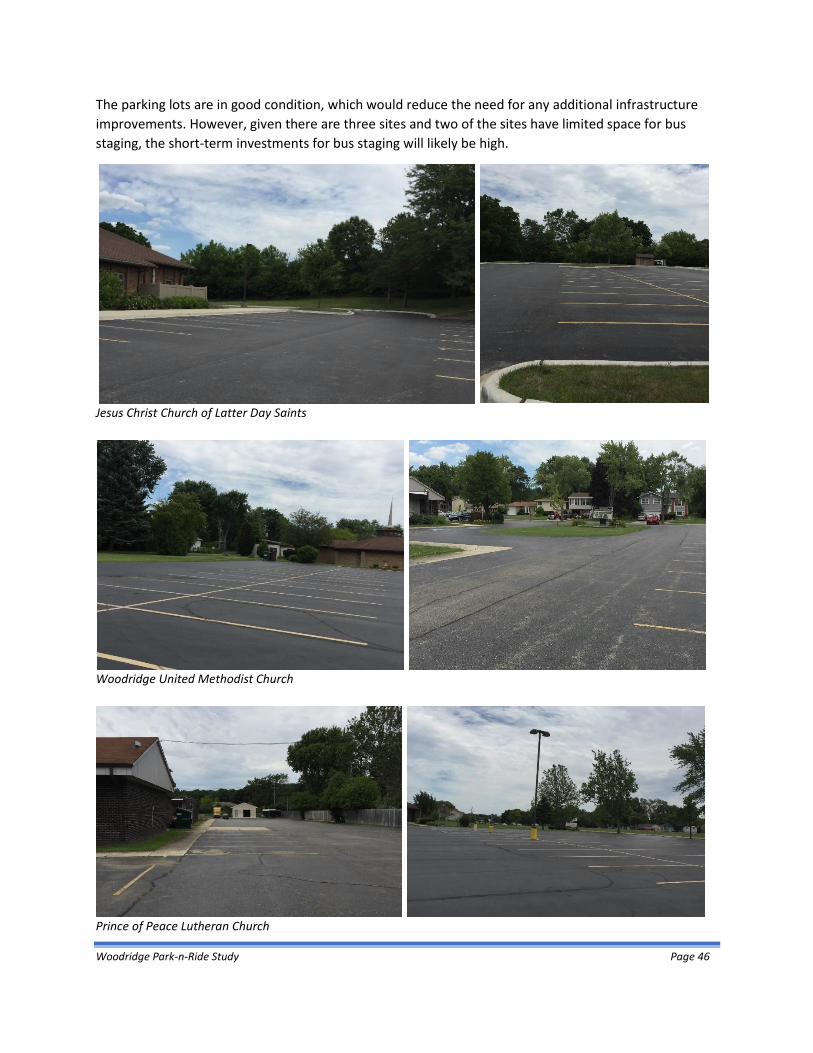
Woodridge Park-n-Ride Study Page 46
The parking lots are in good condition, which would reduce the need for any additional infrastructure
improvements. However, given there are three sites and two of the sites have limited space for bus
staging, the short-term investments for bus staging will likely be high.
Jesus Christ Church of Latter Day Saints
Woodridge United Methodist Church
Prince of Peace Lutheran Church

Woodridge Park-n-Ride Study Page 47
7.1.4 The Grove Shopping Center
The Grove Shopping Center, shown in Figure 7-5, is located in Downers Grove at the northwest corner of
75th Street and Lemont Road, about 1.5 miles east of I-355. Primary access could be via several
signalized intersections at 75th St & Dunham Rd, 75th St & Lemont Rd or Lemont Rd & site access drive
(north of 75th Street.)
Figure 7-5: Site D - The Grove Shopping Center
Image Source: Google, 2016.
The Grove Shopping Center is served by some trips on Pace Route 834 traveling east-west along 75th
Street, and then north-south along Lemont Road. An off-road multi-use path is located on the south side
of 75th Street. Over 3,000 parking spaces are provided at The Grove. This shopping center has vacant
stores, resulting in a very low utilization of parking spaces. There are several parking locations that do
not appear to be used, which could easily yield several hundred spaces for a park-n-ride lot, plus
accommodate future expansion. The parking surface is deteriorated, but useable. There is adequate
space for staging of transit vehicles. Pedestrian shelters would be needed, particularly give the large,
wide open parking area. Internal access to the parking area is via the shopping center roadways. Single-
family residential is located north and west of the shopping center.

Woodridge Park-n-Ride Study Page 48
The Grove Shopping Center
The Grove Shopping Center

Woodridge Park-n-Ride Study Page 49
7.2 Site Evaluation
Each site was evaluated based on criteria that was identified by the Steering Committee and as defined
in Section 6.3, as described below.
1. Proximity or travel time to I-355 and I-55 – Defined in the Study scope and purpose as a primary study criteria.
2. Availability of up to 200 parking spaces – This was the preferred amount parking identified in Section 6.
3. Future growth/expansion opportunities – Ability to provide more than 200 parking spaces would allow for future growth without relocating or adding additional sites.
4. Signalized access from primary roadway to park-n-ride lot – Protected access provides for safety and ease of bus operations.
5. Ease of internal site access – Considers the number of sites to be accessed and the ease in which vehicle can circulate within a site.
6. Proximity of Pace bus service – An adjacent Pace bus route could be adjusted to provide a shuttle to the Metra BNSF service. Pace Routes 834 and Route 821 are adjacent to some of the sites. While this makes these sites more advantageous, it should be noted that adjustments to these routes will be needed to allow the site to become a remote park-n-ride for the BNSF service.
7. Multi-modal connections – Access to the site by bicycles and pedestrians offers greater ridership potential.
8. Nearby residential land uses - Park-n-rides near residential areas are more likely to be successful since there is less travel time to reach the facility. Higher population density nearby also offers greater ridership potential.
9. Short-term investment needs – Initial investment needs considers pavement conditions and ability to provide for bus staging and passenger waiting areas.
10. Ease of contracting – The number of entities involved impacts the initial coordination/contracting efforts by Pace as well as on-going coordination regarding existing services and potential future changes.
11. Located in Woodridge – This Study is focused on service for Village of Woodridge residents.
Each site was evaluated based on these criteria, as presented in Table 7-2. A rating of high, medium, or
low was assigned per a qualitative assessment of how each site ranked to the evaluation criteria.
As indicated in this table, Centerpointe Plaza ranked as the highest priority for a new park-n-ride lot
location, with a total of 21 points. This ranking was a result of the proximity to I-355, availability of
adequate number of existing parking spaces and ability for future expansion, multi-modal connections,
high density residential located nearby, ease of site and internal access, and proximity of existing Pace
feeder bus routes.

Woodridge Park-n-Ride Study Page 50
Table 7-2: Site Evaluation Criteria and Ratings
CRITERIA
SITE
CENTERPOINTE OF
WOODRIDGE
WOODRIDGE PLAZA /
JEWEL OSCO CHURCH CLUSTER
THE GROVE SHOPPING
CENTER Proximity travel time to/from I-355/I-55
● ● ○ ◑ Available existing parking space (up to 200 spaces)
● ● ● ● Ability for future expansion ◑ ◑ ○ ● Signalized site access ● ◑ ○ ● Ease of internal site access ● ◑ ○ ○ Proximity of Pace feeder bus service ● ◑ ○ ◑ Bike/Ped Connections ● ◑ ● ◑ Nearby residential ● ● ◑ ◑ Minimal short-term investment needed ● ● ◑ ○ Ease of contracting (number of entities) ● ◑ ◑ ● Located in Woodridge ● ● ● ○ TOTAL SCORE 21 16 9 12 PRIORITY RECOMMENDATION High Medium Low Low
SCORING
● High, 2 points
◑ Medium, 1 point
○ Low, 0 points

Woodridge Park-n-Ride Study Page 51
7.3 Conclusions and Next Steps
The area around I-355 and 75th is the preferred location for an I-55 BOS park-n-ride facility. At this
location, the Centerpointe of Woodridge is the preferred site due to its proximity near this interchange
and site factors that support the development of park-n-ride service. Additionally, this site also has the
potential to also serve as a remote park-n-ride facility with connecting service to Metra BNSF stations.
Once Pace has identified funding for the capital and operating components of this project, the next step
would be for Pace to approach the property owner about securing a lease to use the parking facility as a
park-n-ride. Upon successful negotiations, Pace will begin the service design to be followed by the
procurement process to purchase buses. After procurement, Pace would finalize minor site
improvements (ex. signage, lighting, and shelters) and develop a marketing plan before implementation.
A final issue to be considered is if the site would be used as a remote park-n-ride facility to connect to
the Metra BNSF service. The adaption of an existing route or implementation of a new route would be
necessary to connect with the Metra services.