page 1 of 7 rim fire – preliminary fuel treatment effectiveness
TRANSCRIPT

Page 1 of 7
RIM FIRE – Preliminary Fuel Treatment Effectiveness Report
USDA Forest Service, Pacific Southwest Region, Stanislaus National Forest
DOI National Park Service, Pacific West Region, Yosemite National Park
_____________________________________________________________________________________
This report is intended to provide a very brief and preliminary look at the interactions between the Rim
fire and a select number of areas where management actions designed to mitigate the negative impacts
from wildfire and improve natural resource conditions were implemented over a period of several years
prior to the fire on the Stanislaus National Forest and Yosemite National Park. Each of these treatments
is designed to reduce the overall amount of fuel on site in a way that will reduce the intensity of
wildfires and allow suppression options. It is estimated that over 36,000 acres of these intentional
management actions were affected by the Rim fire, 17,222 acres on Stanislaus NF and approximately
18,863 acres on Yosemite NP. The following are just a few examples of what has been observed to date,
recognizing that these are preliminary observations and there are hazards in drawing conclusions until
the full assessment is complete. A more thorough scientific examination of the fuel treatment and
wildfire interactions is ongoing and will take several months to complete.
Figure 1. 2013 Rim fire in relation to various fuel reduction treatments conducted on the Stanislaus National Forest and Yosemite National Park
Rim Truck
Peach Growers
Bear Mt.
Hodgdon Meadow
Page 2 of 7
Background: The Rim fire started on August 17, 2013 on the Stanislaus NF about 20 miles east of
Sonora, California. Over the next several weeks it eventually moved to the north and east into Yosemite
National Park (NPS) and burned across more than 250,000 acres of both US Forest Service and NPS
Lands making it one of the largest fires in California history. Fire behavior exhibited was generally high
to extreme with the fire making runs of 30,000 to 50,000 acres on two consecutive days.
Rim Truck Fuel Break – This treatment is a cooperative effort of the Southwest Interface Team (SWIFT)
which is a local collaborative between federal, state, and local entities. The treatment is a 15 mile long
shaded fuel break with total treatment area estimated at 420 acres. The primary responsibility for
accomplishing the treatment was divided between
CalFire/Tuolumne County (11 miles) and Stanislaus
NF (4 miles). The treatment was designed to afford
the communities of Pine Mountain Lake, Groveland,
and Big Oak Flat some measure of protection from
wildfire coming out of the Tuolumne River drainage
which lies to the north of these communities. The
project was largely completed as of 2012 and was in
a maintenance regime where periodic upkeep was
needed on a recurring basis.
After the Rim fire started on August 17th, it progressed south into the Tuolumne River drainage and by August 19th had come out of the Tuolumne to the south towards Highway 120 and the community of Groveland. Firefighters were able to establish a dozer line within the existing fuel break
and were successful in holding the fire along the fuel break, effectively keeping it out of all communities it was designed to protect. From a September 3 news article: "The fuel breaks played a critical role in reducing the intensity of the fire in the Pine Mountain Lake community, their purpose was to reduce fuel loads and the work done the past five to seven years made the difference," said SWIFT coordinator Allen Johnson. Recounts of the firefighting efforts along the
portion of line where the Rim Truck fuel break
was utilized describe a difficult engagement
where the fire did spot over the fireline a
number of times but the open fuel condition
aided firefighters in containing those spots
where they occurred in the fuel break. At this
stage of our analysis, it appears that the fuel
Photo #2. Rim Truck fuel break where dozer line was
easily completed to support burn-out operations on
the 2013 Rim fire.
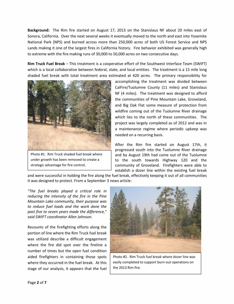
Photo #1. Rim Truck shaded fuel break where
under growth has been removed to create a
strategic advantage for fire control.

Page 3 of 7
Photo #3 – Peach Growers recreation cabins area where
firefighters were able to easily construct fireline and burn
out fuels (foreground) to protect the cabins as well as the
scenic and recreational values.
Photo #4 – Peach Growers fuel reduction area where Rim
fire approached with high intensity from untreated area
on downhill side of road (left) to an area recently thinned
above the road (right) where resulting fire intensities
were reduced as evidenced by needles still present in the
crowns.
break did serve as a feature from which safe and effective firefighting actions could be initiated from
and quite possibly had a significant role in the successful defense of these communities along the
southern edge of the Rim fire.
Peach Growers – This treatment area is
approximately 742 acres in size and is entirely
on Stanislaus NF land surrounding a summer
home tract with several leased cabins and a
developed campground. The project objective
was to reduce wildfire intensity and mitigate
the consequences of a potentially damaging
wildfire. Activities included mechanical
thinning of trees as well as hand thinning,
hand piling, tractor piling, burning of the piles,
as well as broadcast burning. In addition to
the treatment of the surrounding vegetation,
the area in and around the Forest Service
lease summer home tract was also treated in
consultation with the permit holders to
remove small diameter and insect attacked
trees in and around the cabins creating a more
open stand condition.
As the Rim fire approached from the west,
firefighters were able to effectively protect
the summer home group using dozer line
around the structures and burning out around
them. There has been mention by those
involved that they might not have been willing
to undertake the defense of these cabins had
it not been for the fuel treatments which
provided a safe place to work and a relatively
good chance of having a successful operation.
In addition to the success of the cabin
protection, the surrounding forest also saw
significant change in fire behavior as the fire
transitioned from very high intensity in
untreated stands to low or moderate intensity
as it entered stands were fuels reduction work
had occurred.
Page 4 of 7
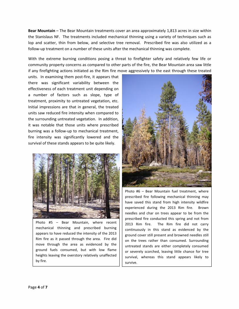
Photo #5 – Bear Mountain, where recent
mechanical thinning and prescribed burning
appears to have reduced the intensity of the 2013
Rim fire as it passed through the area. Fire did
move through the area as evidenced by the
ground fuels consumed, but with low flame
heights leaving the overstory relatively unaffected
by fire.
Photo #6 – Bear Mountain fuel treatment, where
prescribed fire following mechanical thinning may
have saved this stand from high intensity wildfire
experienced during the 2013 Rim fire. Brown
needles and char on trees appear to be from the
prescribed fire conducted this spring and not from
2013 Rim fire. The Rim fire did not carry
continuously in this stand as evidenced by the
ground cover still present and browned needles still
on the trees rather than consumed. Surrounding
untreated stands are either completely consumed
or severely scorched, leaving little chance for tree
survival, whereas this stand appears likely to
survive.
Bear Mountain – The Bear Mountain treatments cover an area approximately 1,813 acres in size within
the Stanislaus NF. The treatments included mechanical thinning using a variety of techniques such as
lop and scatter, thin from below, and selective tree removal. Prescribed fire was also utilized as a
follow-up treatment on a number of these units after the mechanical thinning was complete.
With the extreme burning conditions posing a threat to firefighter safety and relatively few life or
community property concerns as compared to other parts of the fire, the Bear Mountain area saw little
if any firefighting actions initiated as the Rim fire move aggressively to the east through these treated
units. In examining them post-fire, it appears that
there was significant variability between the
effectiveness of each treatment unit depending on
a number of factors such as slope, type of
treatment, proximity to untreated vegetation, etc.
Initial impressions are that in general, the treated
units saw reduced fire intensity when compared to
the surrounding untreated vegetation. In addition,
it was notable that those units where prescribed
burning was a follow-up to mechanical treatment,
fire intensity was significantly lowered and the
survival of these stands appears to be quite likely.
Page 5 of 7
Photos # 7 & 8. Examples of low to moderate fire behavior during the Hodgdon Prescribed Burn
(2012) which reduce fuels and later provided firefighters with the advantage of a safe stand and
defensible space for protecting structures from the 2013 Rim fire.
Hodgdon Meadow Residential Area - Hodgdon Meadow
is located within Yosemite National Park (YOSE) at the
western part of the park. Hodgdon Meadow has several
structures and infrastructure due to the District Office for
Yosemite being located here. Facilities include but are
not limited to; the District Office, employee housing,
sewage treatment plant, maintenance yards, NPS
campgrounds, the Entrance Gate and roads. The
Hodgdon Meadows Residential area was right in the main
path of the Rim Fire and was expected to be impacted by
the wildfire.
In the 1990’s Yosemite (YOSE) started an active
prescribed fire program around this area for reduction of
hazardous fuels. In 2001 and again in 2003 mechanical
treatment applications were applied along the road and
structures to further reduce the fuels. Most recently in
2011 and 2012 prescribed fires were conducted around
the north and east portions of Hodgdon Meadow (see
Photos 7 & 8). Total area of treatment is 1,066 acres in
size in and immediately adjacent to the residential area.
The 2011 prescribed fire was done in a collaborative
effort with the Stanislaus National Forest.
The two prescribed fire units had very little fuel accumulation following the fuel reduction treatments
within them. The two-year old unit (2011) was made up mostly of leaf litter and pockets of heavier fuels
that did not burn hot during the spring execution of the burn. The adjoining unit that was one-year old
(2012 burn) was nearly void of fuel and litter except the area that was excluded along the river during
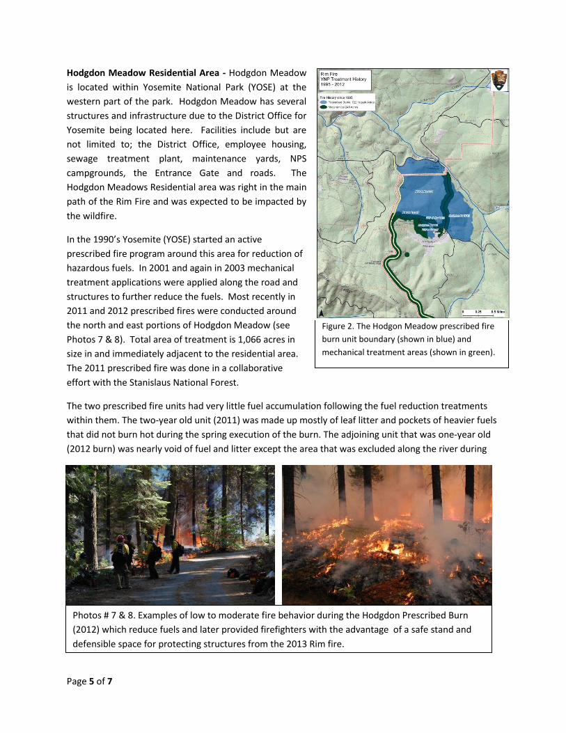
Figure 2. The Hodgon Meadow prescribed fire
burn unit boundary (shown in blue) and
mechanical treatment areas (shown in green).
Page 6 of 7
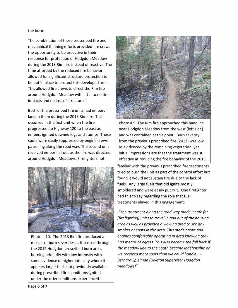
Photo # 9. The Rim fire approached this handline
near Hodgdon Meadow from the west (left side)
and was contained at this point. Burn severity
from the previous prescribed fire (2012) was low
as evidenced by the remaining vegetation, yet
initial impressions are that the treatment was still
effective at reducing the fire behavior of the 2013
Rim fire.
Photo # 10. The 2013 Rim fire produced a
mosaic of burn severities as it passed through
the 2012 Hodgdon prescribed burn area,
burning primarily with low intensity with
some evidence of higher intensity where it
appears larger fuels not previously available
during prescribed fire conditions ignited
under the drier conditions experienced
during the Rim fire.
the burn.
The combination of these prescribed fire and
mechanical thinning efforts provided fire crews
the opportunity to be proactive in their
response for protection of Hodgdon Meadow
during the 2013 Rim fire instead of reactive. The
time afforded by the reduced fire behavior
allowed for significant structure protection to
be put in place to protect this developed area.
This allowed fire crews to direct the Rim fire
around Hodgdon Meadow with little to no fire
impacts and no loss of structures.
Both of the prescribed fire units had embers
land in them during the 2013 Rim fire. This
occurred in the first unit when the fire
progressed up Highway 120 to the east as
embers ignited downed logs and stumps. These
spots were easily suppressed by engine crews
patrolling along the road way. The second unit
received ember fall-out as the fire was directed
around Hodgdon Meadows. Firefighters not
familiar with the previous prescribed fire treatments
tried to burn the unit as part of the control effort but
found it would not sustain fire due to the lack of
fuels. Any large fuels that did ignite mostly
smoldered and were easily put out. One firefighter
had this to say regarding the role that fuel
treatments played in this engagement:
“The treatment along the road way made it safe for
[firefighting] units to travel in and out of the housing
area as well as provided a viewing area to see any
smokes or spots in the area. This made crews and
engines comfortable operating in area knowing they
had means of egress. This also became the fall back if
the meadow line to the South became indefensible or
we received more spots than we could handle. –
Bernard Spielman (Division Supervisor Hodgdon
Meadows)”

Page 7 of 7
At this stage of the assessment it would appear that the treatments to Hodgdon Meadow over the
course of the last twenty years and the successful management of the fuels in this wildland urban
interface afforded firefighters an advantage in protecting this valuable area from the 2013 Rim fire.
Yosemite Fire Management
Yosemite National Park has a long standing history of managing fire for ecosystem health and promoting
the natural process of fire on the landscape. Yosemite has managed fires through prescribed fire
treatments, wildland fires for resource benefits and mechanical treatments in order to return fire in to a
healthy state back into these fire dependent vegetation communities. Restoring condition classes and
fire regimes to the landscape and making it possible for fire to maintain itself without negative impacts
to urban interface or the ecosystem has been part of the fire management objectives within the Park.
Yosemite fire management efforts have not included any treatments in the footprint of the Ackerson
fire which occurred in 1996 and was approximately 49,000 acres. The Rim Fire burned through this old
fire but due to the previous mosaic wildfire results where it burned through with the Ackerson Wildfire,
fire behavior and severity was reduced in this footprint during the Rim Fire.
Preliminary Report Completed By:
Morris Johnson, Research Fire Ecologist, USFS - Pacific Northwest Research Station, Pacific Wildland Fire Science Lab
Shelly Crook, Fire Planner, USFS – Stanislaus National Forest
Miranda Stuart, Fire Operations Specialist, NPS - Prescribed Fire Training Center
Frankie Romero, National Fire Use Program Manager, USFS – National Interagency Fire Center
Thanks to Allen Johnson from Southwest Interface Team (SWIFT) for Local Expertise and Knowledge