pai implementation for utilities based on...
TRANSCRIPT

Pete Ashmore Mike Beswick
PAI Implementation for Utilities
based on StruMap
Mike Beswick, Northgate Information Solutions +44 1905 758 106
http://www.northgate-is.com
http://www.strumap.co.uk
Pete Ashmore, Thames Water

Pete Ashmore Mike Beswick
Northgate Information Solutions
• Formed 1969
• Branded Northgate in 2000
• €500M Revenue
• 3,300 employees
• 25 UK offices + 6 International
• 4th largest software company in UK
• 3 Divisions ~ Outsourcing~ Software/Services~ HRS

Pete Ashmore Mike Beswick
Northgate StruMap Utility Industry Clients
StruMapClients Worldwide
(supported contracts)
9 of 12 Water & Sewerage Operators
5 Water Supply Only Companies
2 Electricity Operator
•Thames Pam Jaya – Jakarta, Indonesia
• PBAPP – Malaysia
• Teranganu – Malaysia
• LAP – Malaysia
• Jurukur Berjasa (StruMap Agent) - Malaysia
Pete Ashmore Mike Beswick
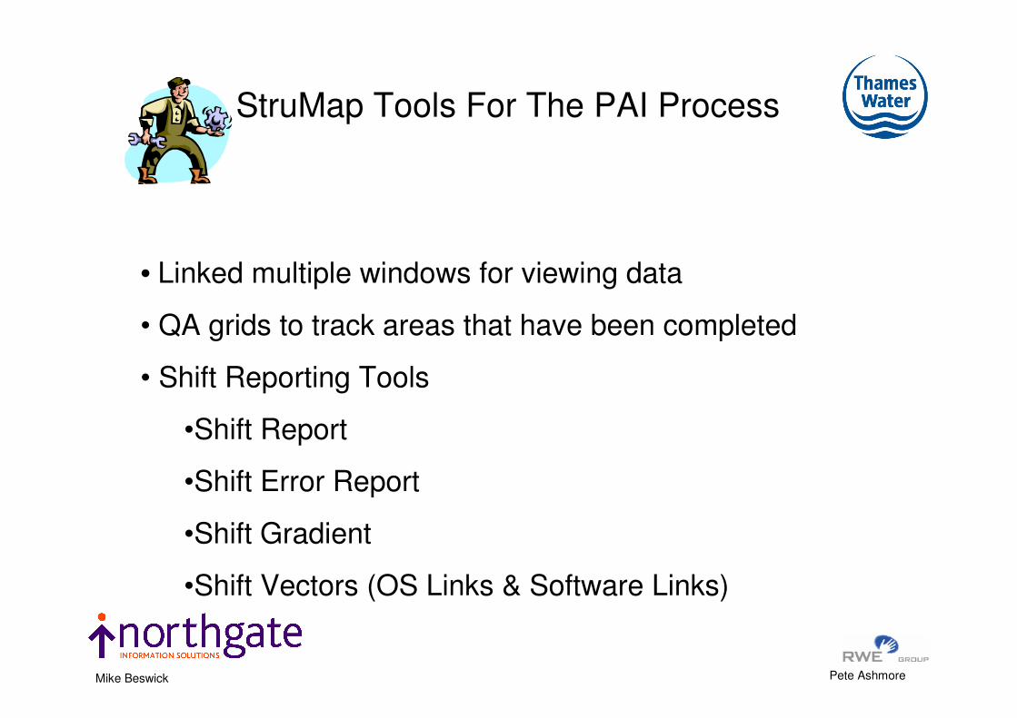
• Linked multiple windows for viewing data
• QA grids to track areas that have been completed
• Shift Reporting Tools
•Shift Report
•Shift Error Report
•Shift Gradient
•Shift Vectors (OS Links & Software Links)
StruMap Tools For The PAI Process

Pete Ashmore Mike Beswick
1.0M
1.5M
1.8M
Report gives Maximum shift
of span
Shift Report

Pete Ashmore Mike Beswick
Shift Theme

Pete Ashmore Mike Beswick
OS Link Vector
System Generated Link Vector
The difference in
magnitude of OS
link vectors and
System link vectors
for a given point if
the OS link is
discarded
Shift Error Report
Pete Ashmore Mike Beswick
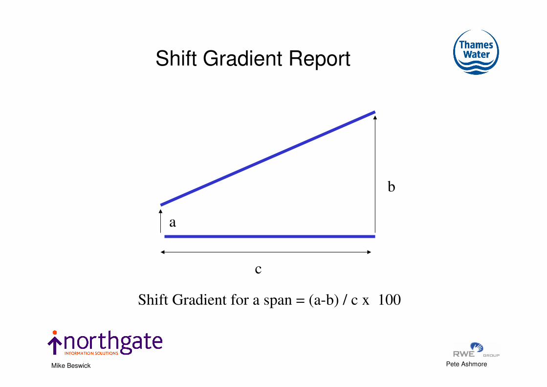
a
b
c
Shift Gradient for a span = (a-b) / c x 100
Shift Gradient Report

Pete Ashmore Mike Beswick
Theme – Shift Error

Pete Ashmore Mike Beswick
Navigate by Shift Gradient

Pete Ashmore Mike Beswick
Display OS Link Vectors

Pete Ashmore Mike Beswick
OS Link Vectors & System Shift Vectors

Pete Ashmore Mike Beswick
Shift Gradient + OS Link Vectors

Pete Ashmore Mike Beswick
StruMap Manual Fix-up Tools
• Move node
• Move node with connected links
• Move area maintaining connectivity
• Add vertex
• Delete vertex
• Fix complex geometries

Pete Ashmore Mike Beswick
StruMap PAI Implementations
• One U.K. Water only utility
• One independent data capture specialist in India
• Two U.K. Water and Waste Water utilities
Including…
Thames Water

Pete Ashmore Mike Beswick
Ordnance Survey move the bathroom so
Thames Water move the plumbingInsertion
Open Cut
Directional Drilling
Pete Ashmore Mike Beswick
• Thames Water – Overview
• Ordnance Survey – Data Supply to Thames
• Positional Accuracy Improvement Data Supply
• How does PAI affect Thames Water
• Finding and Evaluating a solution to PAI
• Implementation of the solution
• Matching the OS programme to Thames Water
INTRODUCTION

Pete Ashmore Mike Beswick
THE THAMES WATER AREA

Pete Ashmore Mike Beswick

Pete Ashmore Mike Beswick
• 98 Water Treatment Works
• 359 Sewage Treatment Works
• 31,280 Km of Clean Water Mains
• 77,626 Km of Sewers
• 11.8 million customers
• 200,000 Excavations each year
Facts about Thames Water
Pete Ashmore Mike Beswick
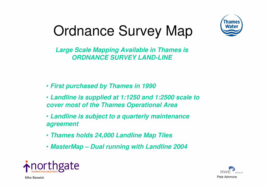
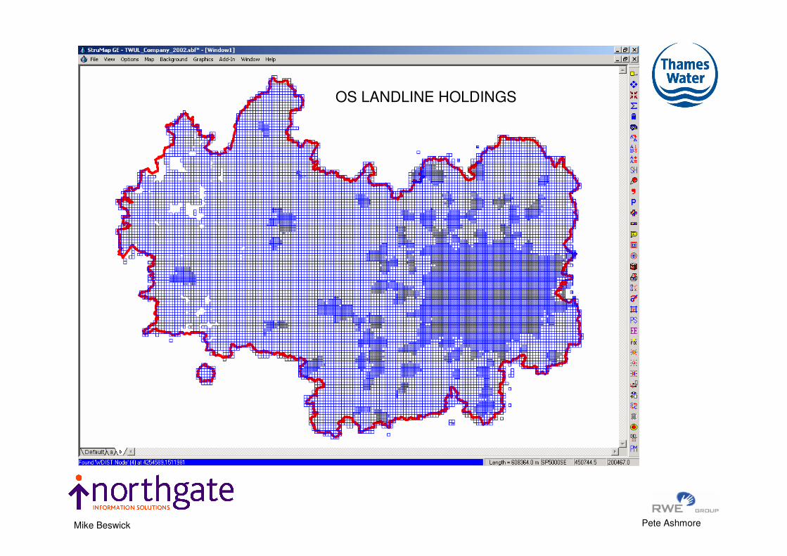
Large Scale Mapping Available in Thames is ORDNANCE SURVEY LAND-LINE
• First purchased by Thames in 1990
• Landline is supplied at 1:1250 and 1:2500 scale to cover most of the Thames Operational Area
• Landline is subject to a quarterly maintenance agreement
• Thames holds 24,000 Landline Map Tiles
• MasterMap – Dual running with Landline 2004
Ordnance Survey Map
Pete Ashmore Mike Beswick
OS LANDLINE HOLDINGS

Pete Ashmore Mike Beswick
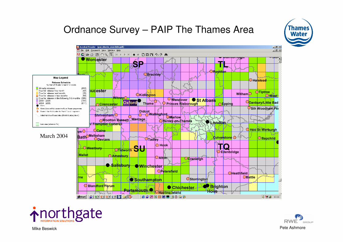
Ordnance Surveys
PAI Programme
Web Extract
March 2004
Pete Ashmore Mike Beswick
Ordnance Survey – PAIP The Thames Area
March 2004

Pete Ashmore Mike Beswick
Ordnance Surveys
PAI
Programme
Web Extract
Sept 2004

Pete Ashmore Mike Beswick
Ordnance Survey – PAIP The Thames Area
Sept 2004

Pete Ashmore Mike Beswick
Ordnance
Surveys
PAI
Programme
Web Extract
May 2005

Pete Ashmore Mike Beswick
Delivery of PAIP Maps to ThamesDate No Map sheets ANNUAL TOTAL TOTAL
02/10/2000 84
84 84
04/12/2001 41
41 125
15/10/2002 502
16/12/2002 932
1434 1559
17/02/2003 1
20/03/2003 7
24/04/2003 16
01/07/2003 1
25/07/2003 193
22/09/2003 233
04/12/2003 1
452 2011
06/02/2004 15
29/03/2004 356
28/04/2004 245
28/05/2004 241
28/06/2004 241
28/07/2004 701
24/08/2004 25
27/09/2004 386
14/10/2004 750
29/11/2004 152
21/12/2004 130
3242 5253
19/01/2005 1326
22/02/2005 991
29/04/2005 1356
26/05/2005 788
4461 9714
TOTAL TO DATE 9714

Pete Ashmore Mike Beswick
Annual PAIP Delivery To Thames Water
Date No Map sheets TOTAL
2000 84 84
2001 41 125
2002 1434 1559
2003 452 2011
2004 3242 5253
2005 4461 9714
TOTAL 9714

Pete Ashmore Mike Beswick
Light Grey 2000 – 2004
Dark Grey Jan 2005 – June 2005
Thames PAI Areas

Pete Ashmore Mike Beswick
Map
Creation
date Total links
Mean
Square
Positional
Shift
Maximum
Shift
Minimum
Shift
Average
Shift Block
tq0133 21112002 4072 3.91 10.79 0.01 3.10 tq03
tq0034 21112002 3444 3.77 8.51 0.01 3.38 tq03
tq0235 21112002 3117 4.04 11.63 0.01 3.60 tq03
sp2143 21112002 3993 3.8 198.6 0.0 1.6 sp24
sp2442 21112002 1226 2.2 35.5 0.0 0.7 sp24
OS PAI Statistics

Pete Ashmore Mike Beswick
HOW ARE THAMES DEALING WITH PAI
• Initially tried to Avoid loading / distributing the PAI map tiles.
• Investigated how Link Files provided by Ordnance Survey can be
used to reposition the Thames network data.
• Liase with Ordnance Survey on the problems related to Link Files
• PAI Pilot Project - Investigated the possibilities of obtaining software
that will automate the repositioning of the Thames network data.
• Investigate the changes to Address Point data resulting from PAI
• Bid for funding – Present Business Case to Projects Board
• User Test Software for acceptance into the Thames Water Estate
OCTOBER 2001 to March 2004

Pete Ashmore Mike Beswick
Objectives
• Identify a test area
• Develop a methodology for evaluation of test results
• Develop rules and standards – consistent assessment
• Identify possible solutions for evaluation
• Evaluate the results with the aim of full implementation
• Place Thames in a position to make sound business decisions
Thames PAI Pilot – Jan 03

Pete Ashmore Mike Beswick
Benchmark digitised to meet existing standards presently used in Update Centre
• Updates are captured using “heads up digitising methods”
• Networks follow OS features and are generally within the publichighway
• Features of the network that are transposed must remain within the original feature – a valve within a pathway must remain within that pathway.
• The overall cosmetic view of the network is to remain intact
• The transposed network meets the agreed tolerance of the set benchmark
Business Rules and Standards

Pete Ashmore Mike Beswick
• Transpose the networks in the test area
• Divide the transposed network into small sections for measurement
• Measure length of network within an agreed tolerance of the benchmark and set standards for deviation
• Create Benchmark – manual re-digitise the test area network
• Inspect network to ensure cosmetic appearance complies with setstandards
• Record time taken for basis of estimated costs
METHODOLOGY

Pete Ashmore Mike Beswick
Manual Shift
System Shift
Methodology
10M

Pete Ashmore Mike Beswick
Method Used 0.5 M
Buffer
1.0 M Buffer 1.5 M Buffer 2.0 M Buffer 3.0 M Buffer
No Transposition 64% 74.1% 86.9% 95.68% 99.4%
Method 1 68.5% 85.72% 94.81% 97.69% 99.46%
Method 2 81.72% 97.29% 99.38% 99.71% 99.9%
Method 3 81.96% 95.94% 98.64% 99.15% 99.87%
Method 4 84.97% 94.92% 98.18% 98.88% 99.79%
Method 5 87.39% 94.29% 97.45% 98.66% 99.53%
Method 6 73.65% 89.60% 96.20% 98.20% 99.70%
Method + Manual 83.91% 94.48% 98.03% 99.25% 100%
Transposition Comparisons

Pete Ashmore Mike Beswick
In House
• People
• Office Space
• Hardware
• Software & Software Support
• Business Process
• Communication with GIS users
• Data Distribution
• Timetable
• Key advantage – control of process
CHOICE OF PAI SOFTWARE or PAI SERVICE

Pete Ashmore Mike Beswick
External Service
• Contract agreement
• Detail of services provided
• Measurement of success or failure
• Programme management
• Data formats – is data conversion required
• People for Quality Assurance
• Internal communication
• Data Distribution
CHOICE OF PAI SOFTWARE or PAI SERVICE

Pete Ashmore Mike Beswick
SYSTEM Description Risk Areas
DataMasterNetwork and boundary update tool. Requires upgrade
to process PAI
Coordination of Data transfer to Eagle. Network SGX file
to be coordinated with MapManager for OS data
Eagle - Vision Oracle Database
Capacity to process increased data flow from
DataMaster. Present trickle feed indicates minimal risk
for data volume
Eagle BrowserClient browser for viewing network from Vision
Database and local cache
Syncronising the loading of Clean and Waste Network
with the revised OS map
LASS Properties data set of Thames land holdings
Polygon data will require amendment, this must be
carried out within LASS after revised OS map is loaded
to Eagle
GetMaps View Thames network and other utilites networkNo risk as other utilities data is viewed with its suppliers
OS map. Held as Tiff image
GISMOPrimary used as mobile GIS but does have desktop
use
Capacity to process increased data flow from
DataMaster. Present trickle feed indicates minimal risk
for data volume
Risk of AFR being given wrong incorrect geo ref between
data loads if out of sync with datamaster.
Netbase / Mapinfo Analytical tool of assets
Data is refreshed periodically from DataMaster, logistics
exercise to ensure networks and OS map loaded
together.
Point data that has been geo-reference from address
point may require to be re referenced if address point
moves outside of building poly
IMPACT ANALYSIS OF PAI ON CORPORATE GI SYSTEMS

Pete Ashmore Mike Beswick
THAMES WATER’S CHOICE
Automated Shift with Manual final
adjustment
IN HOUSE SOLUTION

Pete Ashmore Mike Beswick
StruMap
Datamaster
Eagle
(VISION*)
StruMap
Thamesview
StruMap OST
StruMap
CHAMP
RSG
StruMap
SUS2000
TES
Netbase
DATA
Eagle
Browser
GISMO
LASS
GetMaps
PipeSightMapInfo ESRI
Infoworks
GeoMedia Manual Link (FTE)
Automatic Link
GIS without DB
GIS with DB
The Full GI Picture in Thames

Pete Ashmore Mike Beswick
HOW DO YOU FIND AND AMEND
THE OTHER
The Challenge

Pete Ashmore Mike Beswick
CW & WW
Network
Data Set Locked
out for Edit
Edit Job
Network Update(existing) – Job Management
DATAMASTER – JOB MANAGEMENT

Pete Ashmore Mike Beswick
PAI Shift
Manual
Shift + QA
Manual
Shift + QA
Manual
Shift + QA
CW & WW
Network
Data Set Locked
out for Edit
DataMaster - PAI Network Update

Pete Ashmore Mike Beswick
Multiple Linked Windows

Pete Ashmore Mike Beswick
QA Grids + Manual
Edit – Theme of checked areas
100 Meter grid
Squares
QA GRIDS

Pete Ashmore Mike Beswick
Clean Water Network – Pre & Post Shift

Pete Ashmore Mike Beswick
CW Network before PAI
Pete Ashmore Mike Beswick
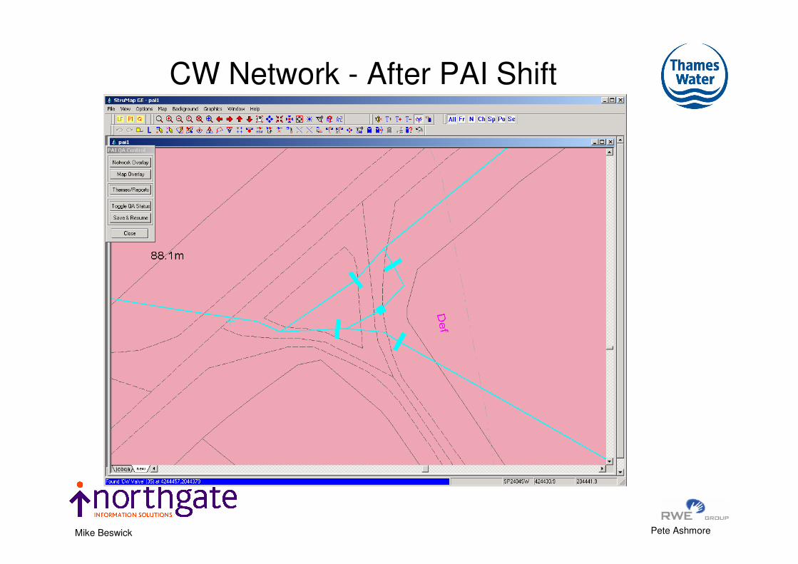
CW Network - After PAI Shift

Pete Ashmore Mike Beswick
Shift Error Report And Theme

Pete Ashmore Mike Beswick
Shift Report and Theme

Pete Ashmore Mike Beswick
Shift Gradient Report and Theme

Pete Ashmore Mike Beswick
• Clean Water Network
• Waste Water Network
• Operational Boundaries
• Site Boundaries
• Administration Boundaries
• Point Data – Excavations
• Address Point
• Environmental Boundaries
Thames Asset Information Subject to PAI

Pete Ashmore Mike Beswick
• Project funding approved
• Software supplier was chosen
• Software entered User Testing to transpose
• Ongoing learning and refinement of the process
• Coordination process for distributing transposed
data developed
• Coordinate transposition of other related data sets
• Communication to the Business users on progress
Implementation

Pete Ashmore Mike Beswick
Network Map Tiles for PAI
0
2000
4000
6000
8000
10000
12000
14000
16000
Backlog March 04 2004/5 2005/6
PAI Programme
1:1
250 M
ap
s
WW Network
CW Network
Thames Water see the software solution as the only viable
option given expected flows from OS
CONCLUSION

Pete Ashmore Mike Beswick
Waste Water Overview 2005

Pete Ashmore Mike Beswick
Clean Water Overview 2005

Pete Ashmore Mike Beswick
Progress

Pete Ashmore Mike Beswick
THANKYOU
ANY QUESTIONS ?