paleoseismic history of the dead sea fault zone
TRANSCRIPT

HAL Id: hal-01264171https://hal.archives-ouvertes.fr/hal-01264171
Submitted on 28 Jan 2016
HAL is a multi-disciplinary open accessarchive for the deposit and dissemination of sci-entific research documents, whether they are pub-lished or not. The documents may come fromteaching and research institutions in France orabroad, or from public or private research centers.
L’archive ouverte pluridisciplinaire HAL, estdestinée au dépôt et à la diffusion de documentsscientifiques de niveau recherche, publiés ou non,émanant des établissements d’enseignement et derecherche français ou étrangers, des laboratoirespublics ou privés.
Paleoseismic History of the Dead Sea Fault ZoneMustapha Meghraoui
To cite this version:Mustapha Meghraoui. Paleoseismic History of the Dead Sea Fault Zone. Encyclopedia of EarthquakeEngineering, 2015, �10.1007/978-3-642-36197-5_40-1�. �hal-01264171�

Paleoseismic History of the Dead Sea Fault Zone
Mustapha Meghraoui*Institut de Physique du Globe, CNRS-UMR 7516, Ecole et Observatoire des Sciences de la Terre, Université de Strasbourg,Strasbourg, France
Synonyms
Active faulting; Earthquake rupture; Seismicity; Seismic slip deficit; Slip rate; Trench investigations
Introduction
Major continental faults often constitute plate boundaries with transtensional and transpressional styles ofactive deformation. The repetition of large earthquakes with Mw > 7 along these faults is closelyassociated to the rate of activity between the plates and to the rupture segmentation over the lateQuaternary (Sieh 1996). In the last century, large earthquakes with surface ruptures have beendocumented on the San Andreas fault in California, the North Anatolian fault and East Anatolian faultin Turkey, the Alpine fault in New Zealand, and the northern Tibet transcurrent faults in China. Theobservation, description, and measurements of coseismic surface faulting constitute the basis for thedevelopment of earthquake geology and paleoseismic investigations (Yeats et al. 1997). Nevertheless,among all continental transform systems, the Dead Sea fault (DSF, Fig. 1) is an exception because of itsapparent last-century seismic quiescence and, therefore, variability of earthquake activity and faultingbehavior (Fig. 2).
The existence of a dense population with small and large urban areas throughout the successivecivilizations is the source for a continuous record of seismic events that favors a completed seismicitycatalogue for major earthquakes along the DSF (Ambraseys and Barazangi 1989; Amiran et al. 1994;Sbeinati et al. 2005; Ambraseys 2009). The instrumental seismicity (younger than 1900 A.D.) of thecontinental Dead Sea fault is of a relatively low level compared to other faults, such as the nearby EastAnatolian fault or North Anatolian fault. Indeed, the largest earthquake that took place in the last centuryis the 13 July 1927 with a local magnitude ML= 6.2 that caused severe damage in Jericho and Jerusalem.More recently, the Mw 7.3 Nuweiba earthquake that took place offshore and further south in the Gulf ofAqaba and northern Red Sea occurred as a reminder that large seismic events may be generated furthernorth along the DSF. The apparent quiescence and the lack of major seismic events with Mw > 6.0 onmost fault segments in the last centuries are in contradiction with the historical catalogue and relatedreport of faulting events over the last 3,000 years or so along the continental DSF (Guidoboni et al. 1994;Ambraseys and Jackson 1998; Sbeinati et al. 2005).
The understanding of earthquake rupture parameters and pattern of surface deformation is a criticalaspect for the identification of recurrent surface faulting and building of a paleoseismic history (McCalpin1996). Models of earthquake faulting were first based on the fault segmentation with persistent structuralboundaries and characteristic earthquake behavior that suggest the repetition of same size events withsimilar coseismic slip along strike (Sieh 1996;Wesnousky 2006). Field investigations on pre-instrumentalearthquakes using tectonic geomorphology, paleoseismology and archeoseismology along the DSFbenefit from the richness of the historical archives and seismicity catalogue (Agnon 2014). These field
*Email: [email protected]
Encyclopedia of Earthquake EngineeringDOI 10.1007/978-3-642-36197-5_40-1# Springer-Verlag Berlin Heidelberg 2015
Page 1 of 20

approaches tracing the past surface ruptures with related coseismic slip and other fault parameters providean estimate of seismic moment of past large earthquakes with the constraint of interseismic periods andlevel of seismic coupling along the DSF.
The aim of this entry is to describe the DSF as a transform plate boundary pointing out the rate of activedeformation, fault segmentation, and geometrical complexities as a control of earthquake ruptures. Thedistribution of large historical earthquakes from a revisited seismicity catalogue using detailedmacroseismic maps allows the correlation between the location of past earthquakes and fault segments.The recent results of paleoearthquake investigations (paleoseismic and archeoseismic) with a recurrenceinterval of large events and long-term slip rate are presented and discussed along with the identification ofseismic gaps along the fault. Finally, the implications for the seismic hazard assessment are also discussed.
Fig. 1 Plate boundaries (thick black lines) in the eastern Mediterranean pointing out the Dead Sea fault (DSF), East Anatolianfault (EAF), North Anatolian fault (NAF), and GPS data (Wdowinski et al. 2004; Reilinger et al. 2006; Gomez et al. 2007; LeBéon et al. 2008; Alchalbi et al. 2010; Al Tarazi et al. 2011; Mahmoud et al. 2013; Masson et al. 2015). The DSF is a boundarybetween Arabia plate to the east and the Sinai (Africa) plate to the west. GPS velocities are given with Arabia-fixed frame; faultsegments and offsets are in Fig. 3. Topography and bathymetry data is from SRTM 3-second-arc and GEBCO_08 grid
Encyclopedia of Earthquake EngineeringDOI 10.1007/978-3-642-36197-5_40-1# Springer-Verlag Berlin Heidelberg 2015
Page 2 of 20

The Dead Sea Transform: A Continental Plate Boundary
The DSF is a north–south trending continental plate boundary and transform crustal structure thatseparates the Arabian plate to the east from the African-Sinai plate to the west (Fig. 1). The left-lateral1,000-km-long fault exhibits a southern transtensional section that includes the Dead Sea until the Gulf ofAqaba, a central section characterized by the Lebanese restraining bend, and the northern section thatlimits to the west the Syrian coastal ranges (Garfunkel et al. 1981). The DSF results from the differentialnorthward movement of Arabia and Africa relative to Eurasia and connects the seafloor spreading of the
Fig. 2 Last-century instrumental seismicity (1900–2012, yellow circle) and historical seismicity (1365 B.C.–1900, red box)along the Dead Sea fault (see text for references therein). Focal mechanisms are from Harvard CMT. Note the last-centurylow-level background seismicity with respect to the significantly large historical earthquakes that illustrate the variability ofearthquake activity and faulting behavior. Topography and bathymetry data is from GEBCO_08 grid
Encyclopedia of Earthquake EngineeringDOI 10.1007/978-3-642-36197-5_40-1# Springer-Verlag Berlin Heidelberg 2015
Page 3 of 20

Gulf of Aqaba – Red Sea in the south to Anatolia in the north. Indeed, both plates drift north at a rate of18 mm/year for Arabia and at about 6 mm/year for Africa-Nubia (Reilinger et al. 2006). GPS campaignsfrom 1991 to 2011 on about 35 stations along all the DSF (computed for Arabia or Eurasia fixed) provide
Fig. 3 Dead Sea fault trace from the detailed mapping of individual segments using aerial and satellite photographs combinedwith field investigations. The fault detailed mapping is from the results of the APAME Project (APAME 2007). Various lateHolocene offsets from published works are indicated along with geological offsets (e.g., 107-km left-lateral offset of theerosion surface of late Jurassic units; see text for references). Topography data is from SRTM (3-arc-second)
Encyclopedia of Earthquake EngineeringDOI 10.1007/978-3-642-36197-5_40-1# Springer-Verlag Berlin Heidelberg 2015
Page 4 of 20

an average geodetic velocity field of�5 mm/year,� 4.7 mm/year, and�2 mm/year for the south, central,and north segments, respectively (Fig. 2). It is worth to mention that GPS measurements and lateQuaternary tectonic investigations across the NE trending Palmyride fold belt, a branch of the DSF inSyria, show less than 1 mm/year of active regional shortening along the NNW–SSE direction (Chaimovet al. 1990; Abou Romieh et al. 2009; Alchalbi et al. 2010). Dislocation models based on GPS profilesacross the fault reveal an average 11-km locking depth for the elastic crustal thickness along the fault zone(Wdowinski et al. 2004; Reilinger et al. 2006; Gomez et al. 2007; Le Béon et al. 2008; Alchalbiet al. 2010; Al Tarazi et al. 2011; Mahmoud et al. 2013; Masson et al. 2015). The crustal structuredepicted from deep seismic and gravity profiles, combined with the outcropping geology across the DeadSea basin and Araba valley, reaches from west to east from 26 to 39 km, indicating a small asymmetrictopography of theMoho discontinuity (Weber et al. 2009). Focal mechanisms of earthquakes and geodeticand tectonic observations characterize the stress and strain field which is in agreement with the left-lateralstrike-slip mechanism, even if locally main principal stress directions may rotate and show normal (DeadSea) or thrust mechanisms (Hofstetter et al. 2007; Palano et al. 2013). In the northern sector of the DSF,the stress field results from the complex tectonic interaction between the Arabian, Anatolian–Eurasian,and African-Sinai plates which occurs along the Hatay triple junction (Mahmoud et al. 2013).
The onset of the fault activity is not well constrained, but the largest recorded slip on the fault and sizeof the Dead Sea basin (>100 km in length when including the Jordan valley) provide some evidence. Left-lateral strike-slip motions are visible on all three sections, thanks to geologic and geomorphic offsetsalong the DSF (Fig. 3). Initially, Dubertret (1932), who adopted the continental drift theory as a possiblemode for structuring the Red Sea and the surrounding areas, proposed a model whereby the “Sinai block”drifted southward for 160 km along the DSF. Later on, a total of 107-km slip is estimated from the offset ofa Jurassic stratigraphic sequence and offset dikes dated to 20 Ma that result in a 4–7-mm/year slip rateduring 15–20 Myr along the southern section of the fault (Quennell 1958; Bartov et al. 1980; Garfunkelet al. 1981). Different authors suggest that the fault structure and left-lateral motion result from two maintectonic episodes with 65-km slip accumulating during the Miocene and 42-km post-Miocene slip. Thesouthern section of the plate boundary also probably functioned independently accumulating about 60 kmof pre-Pliocene slip, and offset basalts in the northern section document the post-Miocene–early Pliocene(5–6 Ma) displacement (Chaimov et al. 1990; Brew et al. 2001). The complex structure of the Lebaneserestraining bend and adjacent Palmyride fold belt may be responsible for the discrepancy in the fault offsetbetween the northern and southern sections of the DSF. Hence, the total southern offset becomespartitioned further north into fault-parallel slip and fold-perpendicular compression (e.g., Chaimovet al. 1990). The fault geometry and left-lateral behavior govern the kinematics of all segments, withauxiliary tectonic regimes such as pull-apart basins (Dead Sea, Hula and Ghab depressions) andshortening within the LRB.
ATectonic Fault Trace with Geometrical Complexities
The marks of Quaternary deformation are observable at all scale and on all sections along the DSF. Usingthe geological and geomorphological maps, the linear shape of the fault affecting late Pleistocene andHolocene deposits can be identified on Landsat, SPOT, and QuickBird satellite photographs as well as onaerial photographs.
The southernmost DSF zone crosses the western edge of the Gulf of Aqaba and extends further northfor about 40 km crossing fluvial and alluvial terraces of Avrona Playa and the Wadi Araba Valley. Severalfault branches may outcrop showing normal geometry in this area, but they may result from the slippartitioning on branches of the main DSF (Zilberman et al. 2005). To the north, except for the
Encyclopedia of Earthquake EngineeringDOI 10.1007/978-3-642-36197-5_40-1# Springer-Verlag Berlin Heidelberg 2015
Page 5 of 20

accumulation of sand dunes that conceals the fault zone around latitude 30�N, the fault can be seen toaffect successive stream channels and terraces. The northern half of the Wadi Araba fault exposesoutstanding tectonic geomorphology with linear fault scarps showing offset alluvial fans and channelsvisible until the southeastern edge of the Dead Sea (Barjous and Mikbel 1990). The southern end of theDSF meets the Gulf of Aqaba that shows NNE–SSW trending relay fault system with large pull-apartbasins in the sea bottom that may act as a geometrical barrier that limits the Wadi Araba fault zone to thesouth. Indeed, the Wadi Araba fault section is about 200-km long if we include the eastern edge of theDead Sea area (Fig. 4), it may constitute a single fault segment or two distinct segments if a majorgeometrical complexity (relay zone) is hidden below the mid-distance sand dunes.
The Dead Sea area has the characteristics of a large pull-apart basin (100-km long, 17-km wide) limitedby two north striking segments, the southern Wadi Araba fault zone and the northern Jordan valley faultsegment. The latter segment follows the Jordan River, extends from the Dead Sea (right bank of the JordanRiver) to the Tiberiade Lake and is made of a suite of 10–20-km-long subsegments (mostly on the leftbank of the Jordan River) for a total length of �110 km. In the valley, small pull-apart basins andrestraining bends limit the subsegments and show left-lateral slip of stream channels (Fig. 5; Ferry
Fig. 4 The�200-km-longWadiAraba fault section from the eastern edge of theDead Sea area to theAqabaGulf. The fault zone islinear exposing offset alluvial fans (west of Petra) and archeological features (Qasr Tilah); although the central part (about 30 km) isconcealed by sand dunes and may hide a main geometrical complexity, the fault section can be considered as a single fault segmentand may be at the origin of a characteristic earthquake with Mw �7.5. Topography data is from SRTM (3-arc-second)
Encyclopedia of Earthquake EngineeringDOI 10.1007/978-3-642-36197-5_40-1# Springer-Verlag Berlin Heidelberg 2015
Page 6 of 20

et al. 2007). Although the Tiberiade Lake shows no pull-apart structure, it is located west of the fault andcan be correlated further north to the Hula pull-apart (Heimann and Ron 1987).
The Lebanese restraining bend (LRB) is about 200-km-long positive flower structure, striking NE–SW,almost midway and on a right-stepping structure of the DSF (Fig. 3). Although the structure is made offour active fault branches, only the central Yammouneh fault is throughgoing and represents the maincontinuation of the DSF across the bend (Fig. 6; Gomez et al. 2003; Nemer et al. 2008). From the southernend of LRB, the westernmost Roum fault shows left-lateral strike-slip and vertical movements and isassociated with fresh fault scarps and pressure ridges which attest for recent coseismic ruptures. To thenorthwest and from the northernmost end of the LRB, other southwest trending fault branches with
Fig. 5 (a) Aerial photograph of the Jordan valley fault (red lines) exposing small pull-apart basins with left-lateral en echelonfault structures and stream channel offsets (at Ghor Katar), (b) detail of the Ghor Kabed pull-apart basin with high-resolutiontopography and fault branches affecting the Lisan lacustrine deposits (see also trench sites TK1 and TK2 in Ferry et al. 2007)
Encyclopedia of Earthquake EngineeringDOI 10.1007/978-3-642-36197-5_40-1# Springer-Verlag Berlin Heidelberg 2015
Page 7 of 20

reverse geometry seem to extend offshore (Elias et al. 2007). The Rachaya and Serghaya faults are theeasternmost fault branches showing left-lateral strike-slip movements associated with different geomor-phic expressions of young surface ruptures (fault scarps, mole tracks, pressure ridges) and cumulative left-lateral slip on stream channels, alluvial fans, and small pull-apart basins. The LRB constitutes a largegeometrical complexity as a result of the left-lateral block movements on the plate boundary.
The DSF northern section is made of two main north trending and linear segments that include theimpressive Ghab pull-apart depression. From the LRB, the section begins with the Al Boqueia pull-apartstructure (15-km long and 6-km wide) and extends with the �90-km-long and linear Missyaf segment
Fig. 6 Lebanon restraining bend with related fault branches and major earthquakes (stars) with M> 6.5 (Nemer et al. 2008).YF Yammouneh fault, SF Serghaya fault, RF Roum fault, RcF Rachaya fault, MY Missyaf fault, HB Hesbaya fault, HB Hulabasin, CM Chouf mountains, and CF Chouf fault. Main large historical earthquakes are indicated (star). Topography data isfrom SRTM (3-arc-second)
Encyclopedia of Earthquake EngineeringDOI 10.1007/978-3-642-36197-5_40-1# Springer-Verlag Berlin Heidelberg 2015
Page 8 of 20

until the Ghab pull-apart (Fig. 7; Brew et al. 2001; Meghraoui et al. 2003). The Ghab depression is 15 kmwide and is limited to the west by a �100-km-long fault segment that ends in the Amik basin and to theeast by the continuation of the Missyaf segment. The northern area of the Ghab depression shows apartition between strike-slip faults and normal faulting, where the NE trending Antakya and Latakiastrike-slip faults affect the western block and the Afrin fault “en echelon” system limits the eastern edge(Fig. 8; Gomez et al. 2007; Trifonov et al. 2012; Mahmoud et al. 2013). The northern end of the DSF andGhab fault segments also shows left-lateral stream offsets, but the fault trace enters the Amik basin andbecomes concealed below the young Quaternary sedimentation (Aky€uz et al. 2006). The �200-km-longMissyaf and Ghab fault segments show different sizes of left-lateral stream offsets with shutter ridges andare probably responsible of the 2,000-m-high topographic offset of the western coastal range.
The occurrence of large earthquakes along the DSF closely depends on the extent of fault segments andthe control of coseismic ruptures by the geometrical complexities. Large step overs and pull-apart basins(with width>5 km) and restraining bends may contribute to the arrest of earthquake ruptures and limit the
Fig. 7 Missyaf fault segment (yellow arrows) limited by the El Boquea and Ghab pull-apart basins, to the south and north,respectively (Meghraoui et al. 2003). Topography data is from SRTM (3-arc-second)
Encyclopedia of Earthquake EngineeringDOI 10.1007/978-3-642-36197-5_40-1# Springer-Verlag Berlin Heidelberg 2015
Page 9 of 20

length of coseismic faults and, hence, the size of earthquakes (Wesnousky 2006). Main tectonic structuresof the DSF such as the “en echelon” faults and basins of the Aqaba Gulf, the Dead Sea pull-apart basin, theHula pull-apart basin, the LRB (although coseismic fault ruptures may occur with the restraining bend),the Ghab depression, and the Amik basin may act as major geometrical complexities and end points oflarge earthquakes (Mw > 7).
Large Earthquakes and Episodic Seismicity
A unified parametric earthquake catalogue was compiled for the whole DSF and covering the periodbefore 2000 (APAME 2007). The parametric catalogue is accompanied by a descriptive document whichprovides the macroseismic historical information and references which have been used for the compila-tion of the former (Sbeinati et al. 2005; Ambraseys 2009). For the pre-instrumental period, macroseismicdata and a kriging technique were used to estimate macroseismic locations. In all, 1,000 earthquakes wereidentified and processed, to estimate position and uncertainty (Fig. 2).
Fig. 8 Northern Dead Sea fault (DSF) and its connection with the East Anatolian fault (EAF) with the LRB and Missyaf-ElGhab segments, Afrin fault branch, Karasu fault (KF), Karasu block (KB), Karatas-Osmaniye fault (KOF), and Cyprus Arc(CA). Large historical earthquakes and their extent along fault segments are marked by colored areas (Sbeinati et al., 2005). TheArabian, Anatolian, and African plates mark the triple junction. Large arrows are plate velocities from GPS results, and focalmechanisms are from Harvard CMT solutions. Topography data is from SRTM (3-arc-second)
Encyclopedia of Earthquake EngineeringDOI 10.1007/978-3-642-36197-5_40-1# Springer-Verlag Berlin Heidelberg 2015
Page 10 of 20

The catalogue shows that during the last century, seismic strain release of the DSF is curiously low withrespect to that expected for a plate boundary. The instrumental seismicity shows the localized occurrenceof shallow earthquakes (with a seismogenic layer�15-km depth) with most local magnitude ML between1 and 5.5 (Hofstetter et al. 2007; Bagh et al. 2014) and the largest event being the 11 July 1927, Ms 6.3 inthe Dead Sea area. Focal mechanism solutions show mostly strike-slip faulting, but normal faultingmechanisms occur also in regions of pull-apart basins, while some thrust mechanisms appear in theLRB. The seismicity is not equally distributed along strike, and some fault segments such as the Missyafand Jordan valley have seismic gaps (Fig. 2). Although taking place offshore in the Gulf of Aqaba, the22 November 1995 seismic event reached Mw 7.3 and illustrates the north–south trending, left-lateralstrike-slip mechanism with typical size of plate boundary earthquakes. Elnashai and El-Khoury (2004)combined the available instrumental and historical seismicity data of the continental DSF region toestimate the annual GR frequency–magnitude distribution. They found that for the instrumental seismic-ity, the frequency–magnitude distribution follows the relationship log N = 3.02–0.73 M, while thehistorical distribution follows log N = 14.8–2.73 M (Fig. 9). They noted that the seismicity of the last100 years has been lower than expected to accommodate the Arabia–Africa relative motion.
The pre-instrumental seismicity and in particular large earthquakes of the prehistorical (archeologicaland antiquities) and historical period in the DSF region are well described. Earthquakes and their relatedseverity of damage are reported by the different civilizations in wall inscriptions, manuscripts, poems,volumes of geographers, and mailed letters (Sbeinati et al. 2005; Finkbeiner et al. 2007; Ambraseys2009). The oldest earthquake is reported in �1365 B.C. from the description of the destruction of Ugaritcity in a letter sent by the governor Abilmiki of Tyre to the Pharaoh Amenophis IV (Akhenaton). Theearthquakes of 31 B.C., 115 A.D., 363 A.D., and 526 A.D. are among the well reported during the Romanand Byzantine era; the latter is revealed by the monks following the destruction of the Saint Simeonmonastery and nearby villages of northern Syria (also reported as the “legend of 1,000 lost villages” byhistorians). Large earthquakes reported in the medieval time (from eighth to sixteenth century) are amongthe well described, thanks to the Arab–Muslim civilization corroborated by the Crusader chroniclers. Theearthquake of 1,202 estimated to be Ms 7.5 affected Lebanon where several km-long surface faulting isreported as crossing villages in mountains (Ambraseys 2009). Other large earthquakes such as 749 A.D.,859 A.D., 910 A.D., 1033 A.D., 1137 A.D., 1156 A.D., 1170 A.D., and 1268 A.D. (with M > 7) wereresponsible of severe damage. Their detailed description in manuscripts allows a correlation to fault
0.5
−0.5
−1
−1.5
−2
−2.5
−3
−3.5
0
log
N
4 4.5 5 5.5 6Ms
6.5 7
A
B
7.5 8
Fig. 9 Magnitude/frequency relation for the instrumental period (A) log N = 3.02–0.73 M, and the historical distribution (B)follows log N = 14.8–2.73M (N is the number of earthquakes of a given magnitudeM or greater) for the Dead Sea fault area(Elnashai and Al-Khoury 2004)
Encyclopedia of Earthquake EngineeringDOI 10.1007/978-3-642-36197-5_40-1# Springer-Verlag Berlin Heidelberg 2015
Page 11 of 20

segments without large uncertainties and ultimately to faulting events in paleoseismic and archeoseismicinvestigations.
Paleo-archeo-earthquakes and the Rate of Slip
First accounts of seismic structures in geological deposits reported in the Lisan lacustrine deposits of theDead Sea describe continuous large earthquake sequences in the last 50 ka (El-Isa and Mustafa 1986;Marco et al. 1996). Recent studies describing obvious faulting outcrops and clear accounts of historicalearthquakes with surface ruptures generated a strong interest in the development of paleoseismicexcavations along fault strike.
The richness of archeological sites along the DSF constitutes an exceptional advantage for datingprehistorical earthquakes. Field investigations revealed left-lateral faulting of the following archeologicalsites: a total of 2.1-m offset walls of a Crusader castle during the 20 May 1,202 and 30 October 1,759earthquakes (Ellenblum et al. 1998); the cumulative 13.6-m offset of the Al Harif aqueduct since theRoman time, the most recent event being the 29 June 1,170 earthquake (Meghraoui et al. 2003); the 2.2-moffset wall of Qasr Tilah that can be related to an earthquake event in 608–826 A.D. (Klinger et al. 2000a);the offset Galei Kinneret city walls during the 18 January 749 earthquake (Marco et al. 2003); theminimum 1-m vertical slip of a qanat during the 1,068 earthquake on the southern DSF near Eilat(Zilberman et al. 2005); the cumulative offset of the Roman–Byzantine–Islamic Qasr Tilah site of thenorthern Araba valley during the 634 or 659/660, 873, 1,068, and 1,546 earthquakes (APAME 2007); atotal of�25 m of the�2000 B.C. Tell Sicantarla, Hittite road, and Roman walls, with�9-m offset duringthe 1,408 and 1,872 earthquakes (Altunel et al. 2009), and Tell Saidiyeh in �759 B.C., �1150 B.C.,�2300 B.C., and�2900 B.C. (Jordan Valley, Ferry et al. 2011). These archeo-seismological studies of theDSF are complemented with tectonic geomorphology and paleoseismic investigations that constrainpaleoearthquake faulting episodes and slip rates.
In trenches, radiocarbon dating brackets the 1,759 earthquake on the northern Jordan valley faultsegment and the Serghaya fault branch through 3D trenching with 0.5 and 2.5-m left-lateral slip,respectively (Gomez et al. 2003; Marco et al. 2005). The major 1,202 earthquake (Mw 7.6, Ambraseysand Jackson 1998) is bracketed in the northern Jordan valley at Beyt Zayda with 1.6-m left-lateral slip(Marco et al. 2005) and in the Lebanese segment of the DSF at the Yammouneh pull-apart basin (Fig. 7;Daëron et al. 2007; Nemer et al. 2008). Faulting of the 749 earthquake of the Jordan valley segment isresolved at Beyt Zayda (north of Tiberiade Lake) and Tell Saidiyeh (south Jordan valley) paleoseismicsites (Marco et al. 2005; Ferry et al. 2011). Paleoseismic trenches near the Al Harif aqueduct resolve threefaulting events in 160–510 A.D., 625–690 A.D., and 1010–1210 A.D., the latter being correlated with the1,170 large earthquake (Sbeinati et al. 2010). At the northern end of the DSF, faulting in trenches providesevidence for three historical earthquakes in 859, 1408, and 1872 A.D. (Aky€uz et al. 2006). The longestpaleoseismic records on the DSF are determined in the Jordan valley with a sequence of 12 coseismicsurface ruptures over the last 14 ka (Ferry et al. 2011) and 10–13 faulting events over the last 12 ka on theYammouneh fault of the DSF restraining bend in Lebanon (Daëron et al. 2007). Although the correlationwith individual fault segments is problematic, another source of earthquake records in the Dead Sea lakesediments and speleothems indicates a succession of seismites synchronous to historical earthquakes in1927, 1293, 1202/1212, 749, 551, 419, 33 A.D. and 31 B.C. and mid‐second century B.C. (Marcoet al. 1996; Kagan et al. 2011). From recent paleoseismic trenching, Klinger et al. (2015) identifiedfaulting events along the southern DSF in the Wadi Araba, which can be correlated with past earthquakesin 1458, 1212, 1068, and 363 A.D., in addition of one faulting event bracketed between 806 A.D. and1044 A.D., which can be correlated with the 972 earthquake.
Encyclopedia of Earthquake EngineeringDOI 10.1007/978-3-642-36197-5_40-1# Springer-Verlag Berlin Heidelberg 2015
Page 12 of 20
Slip rate: The succession of large earthquakes is totally dependent on the rate of deformation and slipalong the fault. Geologic and geomorphologic slip-rate estimates are mainly based on offsetgeomorphologic markers (e.g., stream channels, drainage basin, alluvial fans, terraces) and offsetarcheologic piercing points during an estimated time span that is usually determined using cosmogenic-isotopic dating. The characteristics of successive earthquake ruptures and coseismic displacementobtained from the geological and geomorphological offsets and paleoseismic studies on different faultsegments provide access to the long-term seismogenic clock and average timing for the recurrence oflarge seismic events.
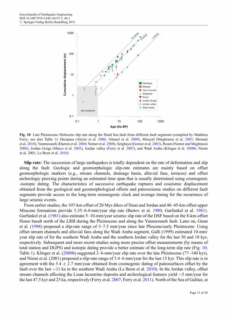
From earlier studies, the 107-km offset of 20 Myr dikes of Sinai and Jordan and 40–45-km offset upperMiocene formations provide 5.35–6.4-mm/year slip rate (Bartov et al. 1980; Garfunkel et al. 1981).Garfunkel et al. (1981) also estimate 5–10-mm/year seismic slip rate of the DSF based on the 8-km-offsetHoms basalt north of the LRB during the Pleistocene and along the Yammouneh fault. Later on, Ginatet al. (1998) proposed a slip-rate range of 3–7.5 mm/year since late Pliocene/early Pleistocene. Usingoffset stream channels and alluvial fans along the Wadi Araba segment, Galli (1999) estimated 10-mm/year slip rate of for the southern Wadi Araba and the southern Jordan valley for the last 50 and 18 kyr,respectively. Subsequent and more recent studies using more precise offset measurements (by means oftotal station and DGPS) and isotopic dating provide a better estimate of the long-term slip rate (Fig. 10;Table 1). Klinger et al. (2000b) suggested 2–6-mm/year slip rate over the late Pleistocene (77–140 kyr),and Niemi et al. (2001) proposed a slip-rate range of 3.4–6 mm/year for the last 15 kyr. This slip rate is inagreement with the 5.4 � 2.7 mm/year obtained from cosmogenic dating of paleosurfaces offset by thefault over the last �11 ka in the southern Wadi Araba (Le Beon et al. 2010). In the Jordan valley, offsetstream channels affecting the Lisan lacustrine deposits and archeological features yield �5 mm/year forthe last 47.5 kyr and 25 ka, respectively (Ferry et al. 2007; Ferry et al. 2011). North of the Sea of Galilee, at
1000
100
10
Cu
mu
lati
ve d
isp
lace
men
t (m
)
1
0.1
0.1
last coseismic
1 10
Age (Ka BP)
100 1000
Hacipasa
10 m
m/yr
5 mm/yr
1 mm/yr
Missyaf
Yam mouneh
Serghaya
Roum
Jordan Gorge
Jordan valley
Wadi Araba
Fig. 10 Late Pleistocene–Holocene slip rate along the Dead Sea fault from different fault segments (compiled by MatthieuFerry; see also Table 1): Hacipasa (Aky€uz et al. 2006; Altunel et al. 2009), Missyaf (Meghraoui et al. 2003; Sbeinatiet al. 2010), Yammouneh (Daeron et al. 2004; Nemer et al. 2008), Serghaya (Gomez et al. 2003), Roum (Nemer andMeghraoui2006), Jordan Gorge (Marco et al. 2005), Jordan valley (Ferry et al. 2007), and Wadi Araba (Klinger et al. 2000b; Niemiet al. 2001; Le Beon et al. 2010)
Encyclopedia of Earthquake EngineeringDOI 10.1007/978-3-642-36197-5_40-1# Springer-Verlag Berlin Heidelberg 2015
Page 13 of 20

Beyt Zayda, Marco et al. (2005) estimate a minimum 3-mm/year slip rate from a paleoseismic study and15-m-left-lateral offset stream channel during the last 5,000 years. Further north, the fault splays formedby the Yammouneh, Roum, Rachaya, and Serghaya faults revealed consistent slip rates across theLRB. The correlation of two �50-km-apart alluvial fan offsets along the Yammouneh fault by Daeronet al. (2004) yields 5.1� 1.3-mm/year slip rate during the late Pleistocene–Holocene. From stream offsets
Table 1 Late Quaternary slip rate along the DSF
Fault segment Method Time frameSlip rate(mm/year) References
DSF Geology 15–20 Myr 4–7 Quennell (1958)
Wadi Araba Geomorphology Late Pliocene/earlyPleistocene
3–7.5 Ginat et al. (1998)
Wadi Araba Geomorphology 141 kyr 5.4 � 2.74.5 � 0.98.1 � 2.9
Le Beon et al. (2010)
Northern Wadi Araba Geomorphology 77–140 kyr 2–6 Klinger et al. (2000b)
Northern Wadi Araba Geomorphology 15 kyr 3.4–6 Niemi et al. (2001)
Wadi Araba, Jordanvalley
Geomorphology 50 kyr18 kyr
1010
Galli (1999)
LRB (Yammounehfault)
Geomorphology Pleistocene 5–10 Garfunkel et al. (1981)
LRB (Yammounehfault)
Geomorphology 25 kyr 3.8–6.4 Daeron et al. (2004)
Roum fault Paleoseismic Holocene 0.86–1.05 Nemer and Meghraoui(2006)
DSTF Seismicity 1,000–1,500 year 1.5–3.5 Garfunkel et al. (1981)
Wadi Araba Geomorphology Pleistocene 4.7 � 1.3 Niemi et al. (2001)
Wadi Araba Geomorphology Pleistocene 2–6 Klinger et al. (2000b)
Hula basin Archeoseismic 2,000 year >2.8 � 0.2 Agnon (2014)
Jordan valley Paleoseismic Holocene 2.5 Marco et al. (2005)
Jordan valley Paleoseismic 5,000 year �3 Marco et al. (2005)
Jordan valley Geomorphology 47.5 kyr 4.7–5.1 Ferry et al. (2007)
Amik basin GeomorphologyPaleoseismic
Pleistocene 4.94 � 0.13 Karabacak et al. (2010)
Amik basin Archeoseismic 7 kyr 6 Altunel et al. (2009)
Missyaf PaleoseismicArcheoseismic
2,000 year 6.9 Meghraoui et al. (2003)
Missyaf Paleo-archeoseismic
3,500 year 4.9–6.3 Sbeinati et al. (2010)
LRB (Serghaya fault) Paleoseismic Holocene 1.4 � 0.2 Gomez et al. (2003)
LRB GPS 4 year 4.5 Gomez et al. (2007)
Northern DSF GPS 8 year 1.8–3.3 Alchalbi et al. (2010)
DSF triple junction GPS 3 year 1–2 Mahmoud et al. (2013)
DSF GPS 10 year 4.4 � 0.3 Reilinger et al. (2006)
Southern DSF GPS 4.3–5.3 Al Tarazi et al. (2011)
Southern DSF GPS 6 year 4.9 � 1.4 Le Béon et al. (2008)
Araba valley GPS 12 year 4.7 � 0.7 Masson et al. (2015)
Southern DSF GPS 7 year 3.3 � 0.4 Wdowinski et al. (2004)
Encyclopedia of Earthquake EngineeringDOI 10.1007/978-3-642-36197-5_40-1# Springer-Verlag Berlin Heidelberg 2015
Page 14 of 20

and paleoseismic trenching across the Roum fault, Nemer andMeghraoui (2006) estimate 0.86–1.05-mm/year slip rate during the last 10,510 years. With the Rachaya and Serghaya faults being considered aspertaining to the same fault system, a 1.4 � 0.2-mm/year slip rate during the Holocene is obtained fromoffset stream channels and paleoseismic studies (Gomez et al. 2003; Nemer et al. 2008). Further north, ontheMissyaf fault segment, the�13.6-m offset Al Harif Roman aqueduct analyzed using paleoseismic andarcheoseismic approach provides 4.9–6.3-mm/year slip rate during the last 4,300 years (Meghraouiet al. 2003; Sbeinati et al. 2010). Along with paleoseismic evidence of coseismic fault ruptures, thenorthern end of the DSF displays cumulative left-lateral offset stream channels and tells archeologicalfeature, and yields an average 6.07-mm/year slip rate during the last 7 kyr (Aky€uz et al. 2006; Altunelet al. 2009; Karabacak et al. 2010).
The Worrying Silence of a Major Continental Transform Fault
In a recent past, the low-level instrumental seismicity and temporal seismic quiescence of the DSFerroneously suggested inactive faulting implying serious underestimation of the earthquake hazard inthe Middle East. In contrast, large historical earthquakes (Mw > 7) equally distributed along the entirefault length indicate the zones with seismic quiescence during the last centuries (Fig. 2). This distributionappears as not random, and the accuracy of historical seismicity catalogue (APAME 2007) combined withthe fault-related geometrical complexities (see section “ATectonic Fault Trace with Geometrical Com-plexities”) and paleoseismic results (see also section “Paleo-archeo-earthquakes and the Rate of Slip”)suggests long periods of quiescence primarily on individual fault segments (Fig. 11). In fact, the long-termrate of active faulting and long record of past earthquakes, compared to the geodetic rate of activedeformation (GPS velocity rate), point toward the level of a significant seismic coupling on the Jordanvalley and Missyaf rupture segments of the DSF (Meghraoui et al. 2015).
A seismic slip deficit can be estimated from the comparison between the geodetic rate (deep off-faultdeformation) and fault slip rate taking into account the DSF segmentation, fault segment length,maximum size of historical earthquakes, and inferred coseismic slip distribution (from paleoseismologyand archeoseismology). The left-lateral slip obtained from the geodetic rate or tectonic rate of deformation(Meghraoui et al. 2003; Marco et al. 2005; Ferry et al. 2007; Alchalbi et al. 2010; Al Tarazi et al. 2011),compared to the seismic quiescence for large earthquakes in the last 1,000 years or so, implies�4.5-m slipdeficit which corresponds to the occurrence of aMw 7.4–7.5 along the fault. The interseismic time reaches952 � 115 years and 761 � 150 years for Mw 7.5–7.4 on the Jordan valley and Missyaf fault segments,respectively (Table 2; Meghraoui et al. 2015).
The identification of seismic gaps with temporal quiescence reaching 982 and 845 years (as per the year2015) on the Jordan valley andMissyaf fault segments, respectively, calls for an urgent earthquake hazardevaluation and related risk mitigation, especially in major urban areas. If the interevent times proposed byMeghraoui et al. (2015) are valid for other DSF segments as the Ghab and LRB, the occurrence of largeseismic events with M> 7 in 1,408 and 1759–1837 (Fig. 11; APAME 2007; Ambraseys 2009) suggests arelatively low seismic risk for these regions. An uncertainty remains, however, for the Wadi Araba faultsegments where the location and size of past earthquakes are poorly known. Although archeoseismic andgeomorphic studies of paleoearthquake markers document faulting events (Galli 1999; Klingeret al. 2000a; Zilberman et al. 2005; Le Beon et al. 2010; klinger et al. 2015), the 200-km-long and linearfault zone in the desert still needs more paleoseismic studies, especially because historical seismicity datais very limited and the correlation between past large earthquakes from catalogue (e.g., the 365 earthquakethat destroyed Petra; Ambraseys 2009) and faulting events is not straightforward.
Encyclopedia of Earthquake EngineeringDOI 10.1007/978-3-642-36197-5_40-1# Springer-Verlag Berlin Heidelberg 2015
Page 15 of 20

An attempt at seismic hazard evaluations including earthquake geology and paleoseismic data isprovided for the northern DSF in Syria and Lebanon and in northern Araba valley and the Jordan valleysegment (Al-Tarazi and Sandvol 2007). Preliminary results that include earthquake faulting parametersand paleoseismic data suggest a high level of hazard and risk along the DSF and on the Jordan valley andMissyaf fault segments in particular, where the peak ground acceleration (PGA) may reach 0.8 g. For thelong-term, 2,000-year-long period of observations, it is found that the frequency–magnitude distribution
Fig. 11 Historical large earthquakes (M > 6.4) correlated with each fault segment according to the detailed study ofearthquake damage area along the Dead Sea fault (Guidoboni et al. 1994; Ambraseys and Jackson 1998; Sbeinatiet al. 2005; Zilberman et al. 2005; APAME 2007; Finkbeiner et al. 2007; Ambraseys 2009). Gray segments belong to aMiddle Age earthquake sequence and southward migration along the fault. GPS velocities are obtained with Eurasia-fixedreference frame (Reilinger et al. 2006), and background topography/bathymetry is from GEBCO
Table 2 Fault parameters of the Jordan valley and Missyaf fault segments with slip rate and time interval Ti
FaultLength(km)
Width(km) Slip (m)
Seismic moment(N.m.)
Geodetic rate(mm/year)
Slip rate(mm/year) Ti (year)
Jordanvalley
110 12 4.5 � 1.5 2.0 1020 5 4.9 T = 952 �115
Missyafsegment
90 12 4.5 � 0.3 1.6 1020 3 5.9 T = 761 �150
Encyclopedia of Earthquake EngineeringDOI 10.1007/978-3-642-36197-5_40-1# Springer-Verlag Berlin Heidelberg 2015
Page 16 of 20

along the DSFZ is not only strongly nonlinear but also that seismicity is clustered in time (APAME 2007;Salamon 2010; Sbeinati et al. 2010).
Cross-references
▶Archaeoseismology▶Earthquake Mechanisms and Tectonics▶Earthquake Recurrence▶ Paleoseismic History of the North Anatolian Fault Zone▶ Paleoseismic History of the San Andreas Fault Zone▶ Paleoseismic Trenching▶ Paleoseismology▶ Seismic Hazard Characterization
References
Abou Romieh M, Westaway R, Daoud M, Radwan Y, Yassminh R, Khalil A, Al- Ashkar A, Loughlin S,Arrell K, Bridgland D (2009) Active crustal shortening in NE Syria revealed by deformed terraces ofthe River Euphrates. Terra Nova 21(6):427–437. doi:10.1111/j.1365-3121.2009.00896.x
Agnon A (2014) Pre-instrumental earthquakes along the Dead Sea Rift. In: Garfunkel Z et al (eds) DeadSea transform fault system: reviews, vol 6, Modern approaches in solid earth sciences. Springer,Dordrecht, p 207. doi:10.1007/978-94-017-8872-4_8
Aky€uz H, Altunel E, Karabacak V, Yalciner C (2006) Historical earthquake activity of the northern part ofthe Dead Sea fault zone, southern Turkey. Tectonophysics 426:281–293
Alchalbi A et al (2010) Crustal deformation in northwestern Arabia from GPS measurements in Syria:slow slip rate along the northern Dead Sea fault. Geophys J Int 180:125–135. doi:10.1111/j.1365-246X.2009.04431.x
Al Tarazi E, Abu Rajab J, Gomez F, Cochran W, Jaafar R, Ferry M (2011) GPS measurements of near‐field deformation along the southern Dead Sea fault system, G-cubed 12. Geochem Geophys Geosyst12(12):Q12021. doi:10.1029/2011GC003736
Al-Tarazi E, Sandvol E (2007) Alternative models of seismic hazard evaluation along the Jordan DeadSea transform. Earthquake Spectra 23(1):1–19
Altunel E, Meghraoui M, Karabacak V, Aky€uz S, Ferry M, Yalçiner Ç, Munschy M (2009) Archaeolog-ical sites (Tell and Road) offset by the Dead Sea fault in the Amik Basin, Southern Turkey. GeophysJ Int 179:1313–1329
Ambraseys NN (2009) Earthquakes in the Mediterranean and Middle East: a multidisciplinary study ofseismicity up to 1900. Cambridge University Press, Cambridge, MA, 947 p
Ambraseys N, Barazangi M (1989) The 1759 earthquake in the Bekaa valley: implications for earthquakehazard assessment in the eastern Mediterranean region. J Geophys Res 94:4007–4013
Ambraseys NN, Jackson JA (1998) Faulting associated with historical and recent earthquakes in theEastern Mediterranean region. Geophys J Int 133(2):390–406
Amiran D, Arieh E, Turcotte T (1994) Earthquakes in Israel and adjacent areas: macroseismic observa-tions since 100 BCE. Isr Expl J 44:260–305
APAME (2007) Archeoseismology and paleoseismology for the protection of cultural heritage andarcheological sites in the Middle East: the impact of large earthquakes on the archaeological sites
Encyclopedia of Earthquake EngineeringDOI 10.1007/978-3-642-36197-5_40-1# Springer-Verlag Berlin Heidelberg 2015
Page 17 of 20

and cultural heritage in the Middle East (Jordan, Lebanon, Syria and Turkey, APAME ECproject – ICA-CT-2002-10024 – Coordinator Mustapha Meghraoui, DG XII Brussels
Bagh S, Alhasan A, Tello S (2014) Local magnitude calibration of the syrian national digital seismolog-ical network. Seismol Res Lett 85:324–333. doi:10.1785/0220130021
Barjous M, Mikbel S (1990) Tectonic evolution of the Gulf of Aqaba – Dead Sea transform fault system.Tectonophysics 180:49–59
Bartov Y, Steinitz G, Eyal M, Eyal Y (1980) Sinistral movement along the Gulf of Aqaba – its age andrelation to the opening of the Red Sea. Nature 285:220–221
Brew G, Lupa J, Barazangi M, Sawaf T, Al Imam A, Zaza T (2001) Tectonic and geological evolution ofSyria. J Geol Soc Lond 158:665–674
Chaimov TA, Barazangi M, Al-Saad D, Sawaf T, Gebran A (1990) Crustal shortening in the Palmyridefold belt, Syria, and implications for movement along the Dead Sea fault system. Tectonics9:1369–1386
Daeron M, Benedetti L, Tapponnier P, Sursock A, Finkel RC (2004) Constraints on the post-25-ka sliprate of the Yammouneh fault (Lebanon) using in situ cosmogenic Cl-36 dating of offset limestone-clastfans. Earth Planet Sci Lett 227:105–119
Daëron M, Klinger Y, Tapponnier P, Elias A, Jacques E, Sursock A (2007) 12,000‐year‐long record of10 to 13 paleo‐earthquakes on the Yammouneh fault (Levant fault system, Lebanon). Bull Seismol SocAm 97(3):749–771
Dubertret L (1932) Les formes structurales de la Syrie et de la Palestine. CR Hebd Séances Acad Sci Paris195:9–20
El-Isa ZH, Mustafa H (1986) Earthquake deformations in the Lisan deposits and seismotectonic impli-cations. Geophys J R Astron Soc 86:413–424
Elias A, Tapponnier P, Singh SC, King GCP, Briais A, Daëron M, Carton H, Sursock A, Jacques E,Jomaa R, Klinger Y (2007) Active thrusting offshore Mount Lebanon: source of the tsunamigenicA.D. 551 Beirut-Tripoli earthquake. Geology 35:755–758
Ellenblum R, Marco S, Agnon A, Rockwell T, Boas A (1998) Crusader castle torn apart by earthquake atdawn, 20 May 1202. Geology 26:303–306
Elnashai AS, El-Khoury R (2004) Earthquake hazard in Lebanon. Imperial College Press, London/RiverEdge, 171 p
Ferry M, Meghraoui M, AbouKaraki N, Al-Taj M, Amoush H, Al-Dhaisat S, Barjous M (2007)A 48-kyr-long slip rate history for the Jordan Valley segment of the Dead Sea fault, Earth Planet. SciLett 260:394–406
FerryM,MeghraouiM, AbouKaraki N, Al-TajM, Khalil L (2011) Episodic behavior of the Jordan Valleysection of the Dead Sea fault from a 14-kyr-long integrated catalogue of large earthquakes. BullSeismol Soc Am 101(1):39–67. doi:10.1785/0120100097
Finkbeiner et al (2007) Catalogue of damage distribution due to historical earthquakes in the Middle East,APAME EC project – ICA-CT-2002-10024 – DG XII Brussels
Galli P (1999) Active tectonics along the Wadi Araba-Jordan Valley transform fault. J Geophys Res B[Solid Earth Planets] 104:2777–2796
Garfunkel Z, Zak I, Freund R (1981) Active faulting in the Dead Sea rift. Tectonophysics 80:1–26Ginat H, Enzel Y, Avni Y (1998) Translocated Plio-Pleistocene drainage systems along the Arava fault of
the Dead Sea transform. Tectonophysics 284:151–160. doi:10.1016/S0040-1951(97)00165-0Gomez F, Meghraoui M, Darkal AN, Hijazi F, Mouty M, Suleiman Y, Sbeinati R, Darawcheh R,
Al-Ghazzi R, Barazangi M (2003) Holocene faulting and earthquake recurrence along the Serghayabranch of the Dead Sea fault system in Syria and Lebanon. Geophys J Int 153:658–674
Encyclopedia of Earthquake EngineeringDOI 10.1007/978-3-642-36197-5_40-1# Springer-Verlag Berlin Heidelberg 2015
Page 18 of 20

Gomez F, Karam G, Khawlie M, McClusky S, Vernant P, Reilinger R, Jaafar R, Tabet C, Khair K,Barazangi M (2007) Global positioning system measurements of strain accumulation and slip transferthrough the restraining bend along the Dead Sea fault system in Lebanon. Geophys J Int168:1021–1028
Guidoboni E, Comastri A, Traina G (1994) Catalogue of ancient earthquakes in theMediterranean area upto the 10th century. ING Roma-SGA, Bologna, 504 pp
Heimann A, Ron H (1987) Young faults in the Hula pull-apart basin, central Dead Sea transform.Tectonophysics 141:117–124
Hofstetter R, Klinger Y, Amrat AQ, Rivera L, Dorbath L (2007) Stress tensor and focal mechanisms alongthe Dead Sea fault and related structural elements based on seismological data. Tectonophysics429(3–4):165–181
Kagan E, SteinM, Agnon A, Neumann F (2011) Intrabasin paleoearthquake and quiescence correlation ofthe late Holocene Dead Sea. J Geophys Res 116(B4). doi:10.1029/2010JB007452
Karabacak V, Altunel E, Meghraoui M, Aky€uz HS (2010) Field evidences from northern Dead Sea FaultZone (South Turkey): new findings for the initiation age and slip rate. Tectonophysics 480(1 –4):172–182
Klinger Y, Avouac JP, Dorbath L, Abou Karaki N, Tisnerat N (2000a) Seismic behaviour of the Dead Seafault along Araba valley, Jordan. Geophys J Int 142:769–782. doi:10.1046/j.1365-246x.2000.00166.x
Klinger Y, Avouac J-P, AbouKaraki N, Dorbath L, Bourles D, Reyss JL (2000b) Slip rate on the Dead Seatransform in northern Araba valley (Jordan). Geophys J Int 142:755–768
Klinger Y, Le Béon M, Al-Qaryouti M (2015) 5000 yr of paleoseismicity along the southern Dead Seafault. Geophys J Int 202:313–327
Le BéonM, Klinger Y, Amrat AQ, Agnon A, Dorbath L, Baer G, Ruegg JC, Charade O,Mayyas O (2008)Slip rate and locking depth from GPS profiles across the southern Dead Sea Transform. J Geophys Res113:1–19
Le Beon M, Klinger Y, Al-Qaryouti M, Meriaux AS, Finkel RC, Elias A, Mayyas O, Ryerson FJ,Tapponnier P (2010) Early Holocene and Late Pleistocene slip rates of the southern Dead Sea faultdetermined from Be-10 cosmogenic dating of offset alluvial deposits. J Geophys Res Solid Earth115(B11414):24
Mahmoud Y, Masson F, Meghraoui M, Cakir Z, Alchalbi A, Yavasoglu H, Yönl€u O, Daoud M,Ergintav S, Inan S (2013) Kinematic study at the junction of the East Anatolian fault and the DeadSea fault from GPS measurements. J Geodyn 67:30–39. doi:10.1016/j.jog.2012.05.006
Marco S, Stein M, Agnon A, Ron H (1996) Long-term earthquake clustering: a 50,000-year paleoseismicrecord in the Dead Sea Graben. J Geophys Res 101:6179–6191
Marco S, Hartal M, Hazan N, Lev L, Stein M (2003) Archaeology, history, and geology of the A.-D. 749 earthquake, Dead Sea transform. Geology 31:665–668
Marco S, Rockwell T, Heimann A, Frieslander U (2005) Late Holocene activity of the Dead Sea transformrevealed in 3D paleoseismic trenches on the Jordan Gorge segment, Earth Planet. Sci Lett 234:189–205
Masson F et al (2015) Variable behavior of the Dead Sea Fault along the southern Araba segment fromGPS measurements. Compet Rendus Geosci. doi:10.1016/j.crte.2014.11.001 (in press)
McCalpin JP (ed) (1996) Paleoseismology: San Diego. Academic, California, 588 pMeghraoui M et al (2003) Evidence for 830 years of seismic quiescence from palaeoseismology,
archaeoseismology and historical seismicity along the Dead Sea fault in Syria, Earth Planet. Sci Lett210:35–52
Meghraoui MR, Toussaint MF, Nguema-Edzang P (2015) Slip deficit and location of seismic gaps alongthe Dead Sea fault, Geophysical research abstracts, vol 17, EGU2015-5218. EGU General Assembly,Vienna
Encyclopedia of Earthquake EngineeringDOI 10.1007/978-3-642-36197-5_40-1# Springer-Verlag Berlin Heidelberg 2015
Page 19 of 20

Nemer T, Meghraoui M (2006) Evidence of coseismic ruptures along the Roum fault (Lebanon): apossible source for the AD 1837 earthquake. J Struct Geol 28:1483–1495
Nemer T, Gomez F, Al Haddad S, Tabet C (2008) Coseismic growth of sedimentary basins along theYammouneh strike-slip fault (Lebanon). Geophys J Int 175:1023–1039
Niemi TM, Zhang H, Atallah M, Harrison JBJ (2001) Late Pleistocene and Holocene slip rate of theNorthern Wadi Araba fault, Dead Sea Transform, Jordan. J Seismol 5:449–474
PalanoM, Paola Imprescia P, Gresta S (2013) Current stress and strain-rate fields across the Dead Sea faultsystem: constraints from seismological data and GPS observations. Earth Planet Sci Lett369–370(2013):305–316
Quennell AM (1958) The structural and geomorphic evolution of the Dead Sea rift. Q J Geol Soc Lond114:1–24
Reilinger R et al (2006) GPS constraints on continental deformation in the Africa‐Arabia‐Eurasiacontinental collision zone and implications for the dynamics of plate interactions. J Geophys Res111:B05411. doi:10.1029/2005JB004051
Salamon A (2010) Patterns of seismic sequences in the Levant – interpretation of historical seismicity.J Seismol 14:339–367. doi:10.1007/s10950-009-9168-9
Sbeinati MR, Darawcheh R, Mouty M (2005) The historical earthquakes of Syria: an analysis of largeseismic events from 1365 B.C. to1900 A.D. Ann Geophys 48:347–435
Sbeinati MR, Meghraoui M, Suleyman G, Gomez F, Grootes P, Nadeau M, Al Najjar H, Al-GhazziR (2010) Timing of earthquake ruptures at the Al Harif Roman Aqueduct (Dead Sea fault, Syria) fromarcheoseismology and paleoseismology, Special volume “Archaeoseismology and paleoseismology.In: Sintubin M, Stewart IS, Niemi TM, Altunel E (eds) Ancient earthquakes: geological society ofAmerica special paper, 471. doi:10.1130/2010.2471(20)
Sieh K (1996) The repetition of large-earthquake ruptures. Proc Natl Acad Sci 93:3764–3771Trifonov et al (2012) Neotectonics, recent geodynamics and seismic hazard of Syria. In: Transactions of
the geological institute, vol 598. GEOS, Moscow, 204 ppWdowinski SS, Bock YY, Baer GG, Prawirodirdjo LL, Bechor NN, Naaman SS, Melzer YY (2004) GPS
measurements of current crustal movements along the Dead Sea Fault. J Geophys Res 109(B5).doi:10.1029/2003JB002640
Weber M et al (2009) Anatomy of the Dead Sea transform from lithospheric to microscopic scale. RevGeophy 47:RG2002. doi:10.1029/2008RG000264
Wesnousky SG (2006) Predicting the endpoints of earthquake ruptures. Nature 444(7117):358–360Yeats RS, Sieh K, Allen CR (1997) The geology of earthquakes. Oxford University Press, New York,
568 ppZilberman E, Amit R, Porat N, Enzel Y, Avner U (2005) Surface ruptures induced by the devastating 1068
A.D. earthquake in the southern Arava valley, Dead Sea Rift, Israel. Tectonophysics 408:79–99
Encyclopedia of Earthquake EngineeringDOI 10.1007/978-3-642-36197-5_40-1# Springer-Verlag Berlin Heidelberg 2015
Page 20 of 20